1 Geography 1001: Climate & Vegetation Instructor: Andrés Holz Agenda for Lecture 11: T Oct 2 nd • Logistics –1 st Exam in 9 days! – Take advantage of my office hours – Students with documented excuses, please email me this week • Review Lecture 10 • Lecture 11 Review Lecture 9 Water Resources: • The Hydrologic Cycle • Our Water Supply – Water in the West Hydrologic Cycle Model Figure 9.1 Water Withdrawal by Sector Figure 9.21 Global Water Scarcity Figure 9.22
Transcript
1
Geography 1001:
Climate & Vegetation
Instructor: Andrés Holz
Agenda for Lecture 11: T Oct 2nd
• Logistics
– 1st Exam in 9 days!
– Take advantage of my office
hours
– Students with documented
excuses, please email me
this week
• Review Lecture 10
• Lecture 11
Review Lecture 9
Water Resources:
• The Hydrologic Cycle
• Our Water Supply
–Water in the West
Hydrologic Cycle Model
Figure 9.1
Water Withdrawal by Sector
Figure 9.21
Global Water Scarcity
Figure 9.22
2
Total water use (2000)
Figure 9.11
Total water use (2000)Drought throughout this last summer
• http://www.drought.unl.edu/dm/12_week.gif
Chapter 10:
Global Climate Systems
• Climate components & relationships
• Köppen Climate Classification
– Criteria
– Benefits & Drawbacks
• Köppen-Geiger Climate System
– Earth’s Climate Classification
Climate
• Climate is weather over time & space (i.e.
> 30 days)
• Climatology is the study of climate
• Climatic regions are areas with similar
weather statistics
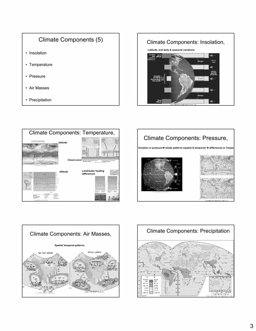
3
Climate Components (5)
• Insolation
• Temperature
• Pressure
• Air Masses
• Precipitation
Climate Components: Insolation,
Latitude, and daily & seasonal variations
Climate Components: Temperature,
latitude
altitude Land/water heating
differences
Cloud cover
Climate Components: Pressure,
Variation in pressure���� winds patterns (spatial & temporal) ���� differences in Temps
Climate Components: Air Masses,
Spatial/ temporal patterns
Climate Components: Precipitation
4
Precipitation in North America
Figure 9.6
Seasonal Pressure and Precipitation Patterns
Climate Relationships
Figure 10.3
Generalized Climate Regions
Figure 10.4
Köppen Climate Classification
• Empirical (data) system
• Began with heat zones in 1884
• Published first wall map in 1928
Köppen Classification:
hierarchical criteria
1. Average monthly temperatures
2. Average monthly precipitation
3. Total annual precipitation
Do you think that boundaries of this classification are “perfect”?
There are not perfect. Think of the scale…the whole planet!….
Thus, the trend is more important than the exact location of the
boundaries.
5
Köppen Classification: benefits &
drawbacks
• Benefits of this classification
– It correlates reasonably with actual world
– Standard worldwide and readily available data
• Drawbacks (doesn’t include)
– Winds, temps extremes, precipitation
intensity, amount of sunshine, cloud cover, or
net radiation
– The causes of precipitation or temperature
patterns
Köppen-Geiger Climate System
Figure 10.5
Classification Categories (based
purely on temperature criteria)
• (A) Tropical – equatorial and tropical
latitudes
• (C) Mesothermal – mid-latitudes, mild
winters
• (D) Microthermal – mid- and high-
latitudes, cold winters
Classification Categories (based
purely on temperature criteria)
• (E) Polar – high latitudes and polar regions
• (H) Highland – compares to lowlands at
the same latitude, highlands have lower
temperatures
• (B) Desert – permanent moisture deficits*
Köppen-Geiger Climate System
Figure 10.5
6
Sub-climates
• Within each climates, the subtypes are
based on precipitation gradients
Tropical Climates (A)
• Consistent day length and insolation input
produce consistently warm temperatures
• Inter Tropical Convergence Zone (ITZC)
brings rain as it shifts seasonally with the
high sun
• Warm ocean temperatures and unstable
maritime air masses
Tropical Climates
• Equatorial and tropical latitudes
– Tropical Rain Forest Climates – rainy all
year
– Tropical Monsoon Climates – 6 to 12
months rainy
– Tropical Savanna Climates – less than 6
months rainy
Precipitation
Gradient
Tropical Climates (A)
~36% of the earth’s
surface—the most
extensive climate
category.
Tropical Rain Forest
Figure 10.7
Tropical Monsoon
Figure 10.8
7
Tropical Savanna
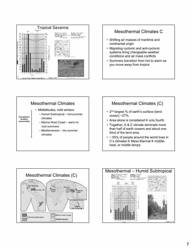
Figure 10.9
Mesothermal Climates C
• Shifting air masses of maritime and
continental origin
• Migrating cyclonic and anti-cyclonic
systems bring changeable weather
conditions and air mass conflicts
• Summers transition from hot to warm as
you move away from tropics
Mesothermal Climates
• Midlatitudes, mild winters
– Humid Subtropical – hot-summer
climates
– Marine West Coast – warm to
cool summers
– Mediterranean – dry-summer
climates
Precipitation
Gradient
(seasonality)
Mesothermal Climates (C)
• 2nd largest % of earth’s surface (land-
ocean) ~27%.
• Area alone is considered� only fourth.
• Together, A & C climate dominate more
than half of earth oceans and about one
third of the land area.
• ~ 55% of people around the world lives in
C’s climates� Meso-thermal� middle-
heat, or middle temps
Mesothermal Climates (C)
Figure 10.11
Mesothermal – Humid Subtropical
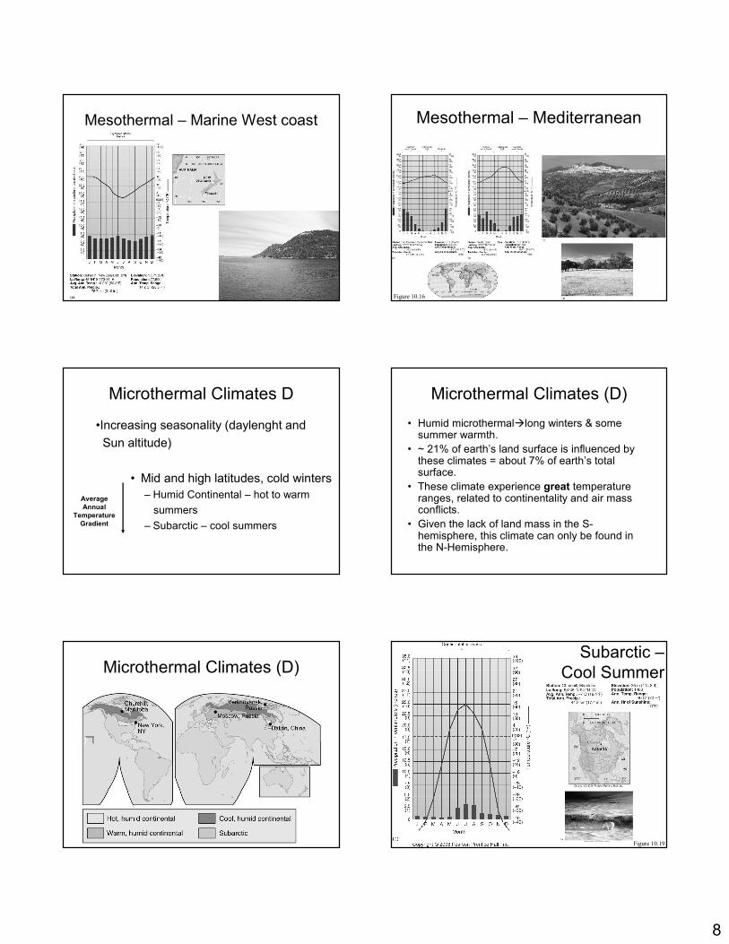
8
Mesothermal – Marine West coast
Figure 10.16
Mesothermal – Mediterranean
Microthermal Climates D
• Mid and high latitudes, cold winters
– Humid Continental – hot to warm
summers
– Subarctic – cool summers
Average
Annual
Temperature
Gradient
•Increasing seasonality (daylenght and
Sun altitude)
• Humid microthermal�long winters & some summer warmth.
• ~ 21% of earth’s land surface is influenced by these climates = about 7% of earth’s total surface.
• These climate experience great temperature ranges, related to continentality and air mass conflicts.
• Given the lack of land mass in the S-hemisphere, this climate can only be found in the N-Hemisphere.
Microthermal Climates (D)
Microthermal Climates (D)Subarctic –
Cool Summer
Figure 10.19
9
Polar and Highland Climates
• Extremes of day length between winter and
summer determine the amount of insolation
received
• Low Sun altitude even during the long summer
days is the principal climatic factor
• Light-colored surfaces of ice and snow reflect
substantial energy away from the ground
surface, thus reducing net radiation
Polar and Highland Climates
• High latitudes and polar regions
– Tundra – high latitude and high altitude
– Ice Cap and Ice Sheet – permanently frozen
– Polar Marine – oceanic association
• ~19% of earth’s total surface
• This climate have no true summer�average monthly temps never rises over above 50F
Polar Climates (E)
Arid and Semiarid Climates B
• Dry air in subtropical high-pressure
systems dominates
• Sometimes form in the rain shadow of
mountains
• Continental interiors, particularly central
Asia, are far from moisture bearing air
masses
Dry, Arid, and Semiarid Climates • Permanent moisture deficits
– Arid desert - less that about 35 cm (14 in.)
precipitation per year
– Semiarid steppe - less than about 60 cm (23.6
in) precipitation per year
– They occupy ~35% of earth’s; the most
extensive climate over land.
10
Dry, Arid, and Semiarid Climates (B)Desert Landscape