44
INTEGRATED FLOOD MANAGEMENT TOOLS SERIES MANAGEMENT OF FLASH FLOODS ISSUE 16 MAY 2012

integrated flood management tools series
management of flash floods
ISSUE 16 MAY 2012
The Associated Programme on Flood Management (APFM) is a joint initiative of the World Meteorological Organization (WMO) and the Global Water Partnership (GWP).
It promotes the concept of Integrated Flood Management (IFM) as a new approach to flood management. The programme is financially supported by the governments of Japan, Switzerland and Germany.
www.apfm.info
The World Meteorological Organization is a Specialized Agency of the United Nations and represents the UN-System’s authoritative voice on weather, climate and water.
It co-ordinates the meteorological and hydrological services of 189 countries and territories.
www.wmo.int
The Global Water Partnership is an international network open to all organizations involved in water resources management. It was created in 1996 to foster Integrated Water Resources Management (IWRM).
www.gwp.org
Integrated Flood Management Tools Series No.16
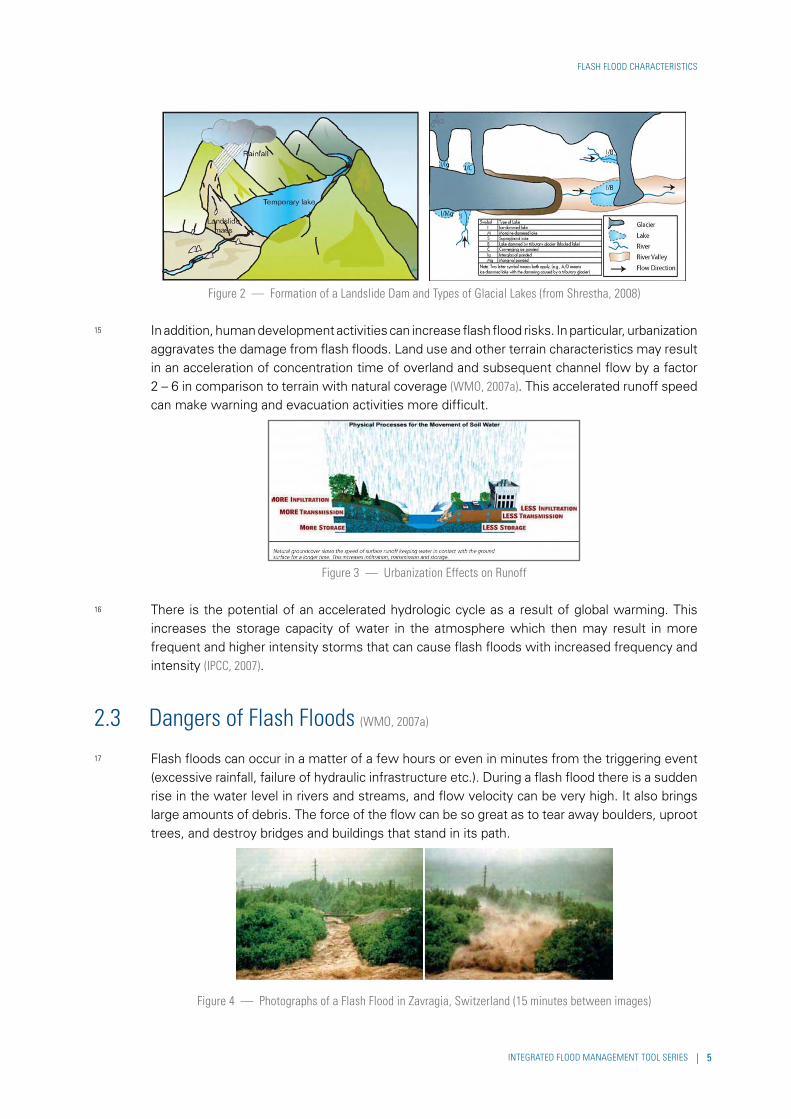
© World Meteorological Organization, 2012
Cover photo: Dai Water Festival, Yunnan, China, © and courtesy of Yunnan Tourism

To the reader
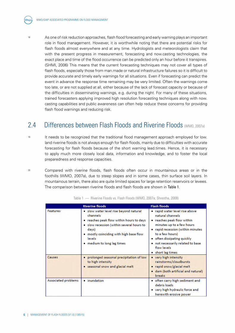
This publication is part of the “Flood Management Tools Series” being compiled by the Associated Programme on Flood Management. The “Management of Flash Floods” Tool is based on available literature, and draws findings from relevant works wherever possible.
This Tool addresses the needs of practitioners and allows them to easily access relevant guidance materials. The Tool is considered as a resource guide/material for practitioners and not an academic paper. References used are mostly available on the Internet and hyperlinks are provided in the References section.
This Tool is a “living document” and will be updated based on sharing of experiences with its readers. The Associated Programme on Flood Management encourages disaster managers and related experts engaged in flash flood management around the globe to participate in the enrichment of the Tool. For this purpose, comments and other inputs are cordially invited. Authorship and contributions would be appropriately acknowledged. Please kindly submit your inputs to the following email address: [email protected] under Subject:“Management of Flash Floods”.
Acknowledgements
This Tool makes use of the works of many organizations and experts, as listed in the references. The APFM Team is grateful to Mr. Robert Jubach of the Hydrologic Research Centre (HRC), San Diego, USA for a general review of this tool.
Disclaimer
The designations employed and the presentation of material in this publication do not imply the expression of any opinion whatsoever on the part of the Secretariat of the World Meteorological Organization concerning the legal status of any country, territory, city, or area, or of its authorities, or concerning the delimitation of its frontiers or boundaries.
INTEGRATED FLOOD MANAGEMENT TOOL SERIES

INTEGRATED FLOOD MANAGEMENT TOOL SERIES
executive summary
1 The purpose of this document is to provide an overview of the actions that can be taken to manage and minimize the potential impacts of flash floods. This tool aims to:
— Provide basic information about flash floods especially focusing on differences from riverine floods;
— Identify flash flood risk components and provide guidance to assess its risk;
— Provide perspectives of flash flood management strategies on how to reduce risks; and,
— Provide guidance to involve communities and individuals in flash flood management and risk reduction.
2 This management tool is written primarily for flood managers at various levels of government, specifically for National Meteorological and Hydrologic Services (NMHSs) and disaster management agencies for improvement of flash flood warning systems. It is not meant to be a comprehensive manual but only to highlight those important aspects for planning and management towards mitigation of the impacts of flash floods.
3 Due to its characteristics, it is difficult to address flash flood issues by traditional flood management approaches as used for low.land riverine floods. Integrated approaches as a combination of structural and non.structural measures are essential for successful flash flood management. This tool mainly focuses on the non-structural measures.
4 This tool is based on available literature, and draws findings from relevant works wherever possible. This Tool addresses the needs of practitioners and allows them to easily access relevant guidance materials. The Tool is considered as a resource guide/material for practitioners and not an academic paper.
5 This tool is based on the APFM Guidance on Flash Flood Management, which reported a flash flood pilot project in Central and Eastern Europe (WMO, 2007a). It is also recommended that the reader consult the Flash Flood Early Warning System Reference Guide (University Corporation for Atmospheric Research, 2010).


contents
1 INTRODUCTION 1
2 FLASH FLOOD CHARACTERISTICS 3
2.1 Flash Flood Definitions 32.2 Generation Mechanisms of Flash Floods 32.3 Dangers of Flash Floods 52.4 Differences between Flash Floods and Riverine Floods 6
3 FLASH FLOOD FISK ASSESSMENT 9
3.1 Risk Components 93.2 Assessing the Risk 103.3 Assessing Vulnerabilities 12
4 STRATEGIES FOR FLASH FLOOD MANAGEMENT 13
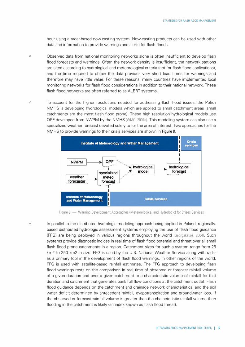
4.1 Structural Measures to Mitigate Flash Flood Hazards 144.2 Strategies for Exposure 154.2.1 Flash Flood Forecasting Considerations and Uncertainties 154.2.2 Flash Flood Forecasting Operational Examples 164.2.3 End-to-End Forecasting and Warning Systems 184.2.4 Flash Flood Warnings 194.2.5 Organizational Requirements 204.2.6 Spatial Planning 204.3 Strategies to Reduce Vulnerability 214.3.1 Participatory Planning 214.3.2 Planning Preparation 224.3.3 Challenges in Community Participation 234.3.4 Raising Awareness and Preparedness 234.3.5 Flood insurance 244.4 Requirements for a Flash Flood Management in a Legal and Institutional Framework 25
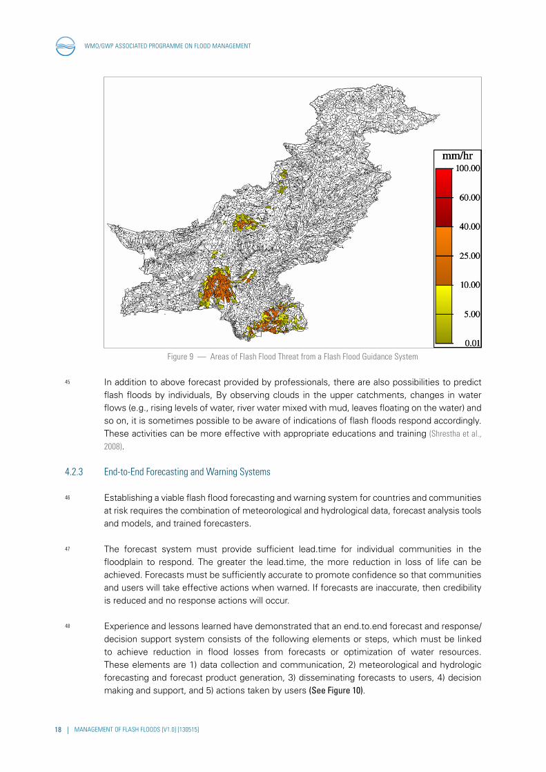
5 LOCAL LEVEL ACTIVITIES 27
5.1 Step 1 – Evaluation of Community Readiness 275.2 Step 2 – Creating a Planning Team 285.3 Step 3 – Public Consultation 285.4 Conditions for Success 29
6 CONCLUSIONS AND RECOMMENDATIONS 31
REFERENCES I
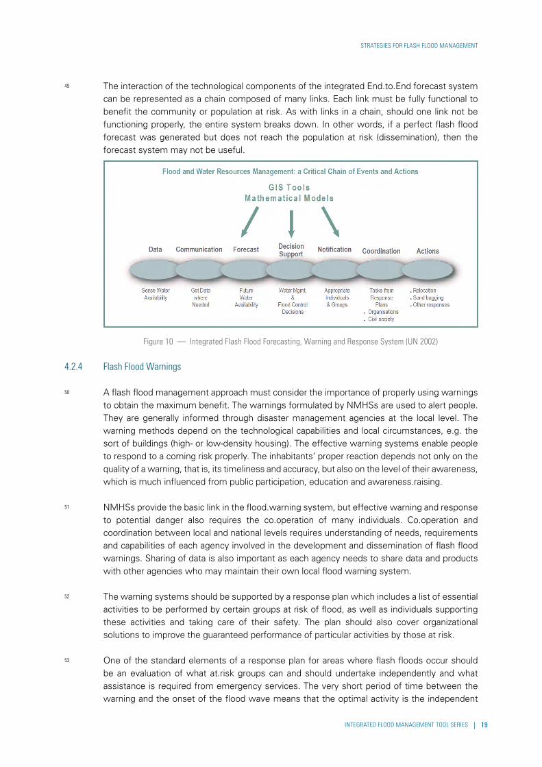
INTEGRATED FLOOD MANAGEMENT TOOL SERIES


INTEGRATED FLOOD MANAGEMENT TOOL SERIES | 1
1 introduction
6 A flash flood is a short and sudden local flood with great volume. It has a limited duration which follows within few (usually less than six) hours of heavy or excessive rainfall, rapid snowmelt caused by sudden increases in temperature or rain on snow, or after a sudden release of water from a dam or levee failure, or the break.up of an ice jam.
7 Flash flood forecasting and warning are basic measures implemented to reduce risks in flood prone areas. There are some difficulties in developing timely and accurate warnings due to localized and short lead times for flash floods. Many current forecasting technologies, specifically numerical weather prediction models, are not always appropriate for flash floods as they are run at inappropriate temporal and spatial scales and lack the high resolution data needed to improve the models. In order to deal with such difficulties special co.operation is required between NMHSs – the institutions that usually have responsibility for forecasting and providing warnings to their end users, including disaster management organizations. Training and education for users (e.g., general public) are important, in order for them to understand the meaning of the warnings and the appropriate response. Raising preparedness and awareness are essential factors to make non.structural measures more efficient. An appropriate approach should be selected based on the needs, requirements, and capacities of the users.
8 As a basis for better use of non.structural measures, a participatory approach can make local communities and residents understand their risks and responsibilities for flash flood management. For flash flood management actions to be effective, detailed planning is a key for participation of users such as local communities.
9 Flash flood management touches upon several sector-specific areas, so responsibilities and roles in each stage of management should be defined within solid legal and institutional framework. For flash floods, local communities especially have much more decisive responsibilities than those for riverine flood management.

2 | MANAGEMENT OF FLASH FLOODS [V1.0] [130515]
WMO/GWP ASSOCIATED PROGRAMME ON FLOOD MANAGEMENT
An important consideration for flash flood detection, forecast, and warning, is that, because of the short lead times and much localized impacts, flash flood management must focus on the mitigation and warning requirements to save lives. Generally speaking, there is little time to save property during a flash flood event.

INTEGRATED FLOOD MANAGEMENT TOOL SERIES | 3
2 flash flood characteristics
2.1 Flash Flood Definitions10 Characteristics of flash floods are captured in a variety of definitions: the WMO states that a flash
flood is: “A flood of short duration with a relatively high peak discharge”; the American Meteorological Society (AMS) defines flash floods as “A flood that rises and falls quite rapidly with little or no advance warning, usually as the result of intense rainfall over a relatively small area”. In terms of warnings, a flash flood is a local hydrometeorological phenomenon that requires: Both Hydrological and Meteorological expertise for real time forecasting/warning and knowledge of local, up to the hour information for effective warning (24/7 operation). Response time to flash floods is usually less than 6 hours. A flash flood is, in short, a sudden local flood of great volume and short duration which follows within a few (usually less than six) hours of heavy or excessive rainfall. Flash floods may also be caused as a result of a dam or levee failure, or the sudden release of water impounded by a landslide dam, ice jam in a river or as a result of a glacier lake outburst.
11 A major distinction of a flash flood from a riverine flood is the short basin response to rainfall that allows for very short lead time for detection, forecast and warning. In contrast, floods in larger rivers have a much longer lead time up to several days under certain local circumstances. Therefore, flash flood management requires more specific measures based on the characteristics of flash floods. This section provides an understanding of basic differences between flash floods versus riverine floods.
2.2 Generation Mechanisms of Flash Floods12 Flash floods caused by rainfall events are truly a hydrometeorological phenomenon. The amount
and location of rainfall is an important factor but the hydrologic characteristics of the ground surface are also important factors. These types of flash floods normally are associated with intense convective rainfall (see Figure 1). Heavy rain events are generally short-lived (from a few

4 | MANAGEMENT OF FLASH FLOODS [V1.0] [130515]
WMO/GWP ASSOCIATED PROGRAMME ON FLOOD MANAGEMENT
minutes to a few hours), but can be very intense such as 100 mm (or 100 Litres per square meter) in the span of a few hours or even less than an hour. Some hydrologic characteristics to be considered include the soil moisture (fraction of saturation), soil depth, soil permeability (can be affected by wildfires, frozen ground or compaction of the soil), land use/land cover (e.g., amount of vegetation, urbanization), size of the basin (most flash floods occur in small basins (less than 100 – 200 km2 in size), and basin slope (steep slopes generally result in greater runoff potential from rainfall events).It must be remembered that flash floods are possible under the right conditions even when soils are not saturated or even dry and so can occur even in drought conditions. In desert areas flash floods occur in channels (Wadi) where the propagation time of the flood wave by far exceeds the infiltration capacity of the dry soils. Under these conditions, excessive rainfall (greater than the soil water infiltration capacity) causes overland flow. In general, flash floods are particularly common in mountainous areas and desert regions. Flash floods are a potential threat in any area where the terrain is steep, surface runoff rates are high, streams flow occurs in constrained channels and severe convective rainfall prevail (WMO, 2008b). Topography characteristics can be an indicator for areas susceptible to flash floods (WMO, 2007a).
Figure 1 — Heavy Rainfall-induced Flash Flood (from Shrestha, 2008)
13 Another cause of flash floods – particularly in mountainous terrain outside the tropics– can be rain on snow events. If there is heavy snow on the ground, a sudden rise in temperature along with substantial rainfall can cause rapid snowmelt and consequently the formation of a snow.melt induced flash flood.
14 A flash flood may also result from a failure of dams, embankments, or other hydraulic infrastructures. Other causes might be glacier lake outbursts or outbursts of landslide dams. In 2008 there were more than 30 landslide dams caused by the 2008 Sichuan earthquake in China. In southern Sichuan, people living downstream of the landslide dams were forced to evacuate because of the threat of flash floods if the dams suddenly failed. In 2012, a whole village has been swept away as a result of a landslide dam burst in the Seti River basin in Western Nepal (see Figure 2).
INTEGRATED FLOOD MANAGEMENT TOOL SERIES | 5
FLASH FLOOD CHARACTERISTICS
Figure 2 — Formation of a Landslide Dam and Types of Glacial Lakes (from Shrestha, 2008)
15 In addition, human development activities can increase flash flood risks. In particular, urbanization aggravates the damage from flash floods. Land use and other terrain characteristics may result in an acceleration of concentration time of overland and subsequent channel flow by a factor 2 – 6 in comparison to terrain with natural coverage (WMO, 2007a). This accelerated runoff speed can make warning and evacuation activities more difficult.
Figure 3 — Urbanization Effects on Runoff
16 There is the potential of an accelerated hydrologic cycle as a result of global warming. This increases the storage capacity of water in the atmosphere which then may result in more frequent and higher intensity storms that can cause flash floods with increased frequency and intensity (IPCC, 2007).
2.3 Dangers of Flash Floods (WMO, 2007a)
17 Flash floods can occur in a matter of a few hours or even in minutes from the triggering event (excessive rainfall, failure of hydraulic infrastructure etc.). During a flash flood there is a sudden rise in the water level in rivers and streams, and flow velocity can be very high. It also brings large amounts of debris. The force of the flow can be so great as to tear away boulders, uproot trees, and destroy bridges and buildings that stand in its path.
Figure 4 — Photographs of a Flash Flood in Zavragia, Switzerland (15 minutes between images)
6 | MANAGEMENT OF FLASH FLOODS [V1.0] [130515]
WMO/GWP ASSOCIATED PROGRAMME ON FLOOD MANAGEMENT
18 As one of risk reduction approaches, flash flood forecasting and early warning plays an important role in flood management. However, it is worthwhile noting that there are potential risks for flash floods almost everywhere and at any time. Hydrologists and meteorologists claim that with the present progress in measurement, forecasting and now.casting technologies, the exact place and time of the flood occurrence can be predicted only an hour before it transpires. (SHMI, 2006) This means that the current forecasting techniques may not cover all types of flash floods, especially those from man.made or natural infrastructure failures so it is difficult to provide accurate and timely early warnings for all situations. Even if forecasting can predict the event in advance the response time remaining may be very limited. Often the warnings come too late, or are not supplied at all, either because of the lack of forecast capacity or because of the difficulties in disseminating warnings, e.g. during the night. For many of these situations, trained forecasters applying improved high resolution forecasting techniques along with now.casting capabilities and public awareness can often help reduce these concerns for providing flash flood warnings and reducing risk.
2.4 Differences between Flash Floods and Riverine Floods (WMO, 2007a)
19 It needs to be recognized that the traditional flood management approach employed for low.land riverine floods is not always enough for flash floods, mainly due to difficulties with accurate forecasting for flash floods because of the short warning lead.times. Hence, it is necessary to apply much more closely local data, information and knowledge, and to foster the local preparedness and response capacities.
20 Compared with riverine floods, flash floods often occur in mountainous areas or in the foothills (WMO, 2007a), due to steep slopes and in some cases, thin surface soil layers. In mountainous terrain, there also are quite limited spaces for large retention reservoirs or levees. The comparison between riverine floods and flash floods are shown in Table 1.
Table 1 — Riverine Floods vs. Flash Floods (WMO, 2007a; Shrestha, 2008)
t

INTEGRATED FLOOD MANAGEMENT TOOL SERIES | 7
FLASH FLOOD CHARACTERISTICS


INTEGRATED FLOOD MANAGEMENT TOOL SERIES | 9
3 flash flood fisk assessment
21 Before planning a flash flood management program, it is essential to identify risks caused by flash floods. The risks are composed of three elements – hazard, exposure, and vulnerability (WMO, 2006). This section discusses risk factors and provides guidance on how to assess each component, including considering various uncertainties involved in these assessments.
3.1 Risk Components22 Planning for the mitigation of loss of life and damage by choosing the proper methods to
reduce losses incurred by flash floods requires that an evaluation of the level of the flood risk in a given area be carried out. The risk level is contained in information on the impact of a flood of defined probability on people, the environment and property, i.e. it describes the potential losses that the flood may cause. Flood risk can be characterized in many ways, but, as mentioned previously, three elements are crucial – hazard, exposure, and vulnerability (Figure 5).
Figure 5 — Flood Risk Characterization (WMO, 2006)

10 | MANAGEMENT OF FLASH FLOODS [V1.0] [130515]
WMO/GWP ASSOCIATED PROGRAMME ON FLOOD MANAGEMENT
23 The hazard is defined as a flash flood magnitude which is defined by probability of occurrence. This information can be translated to inundation maps showing the areas at risk as well as depths of inundation and related water velocities. The exposure describes human activity and environment in the hazard zone (who and what are endangered by flash floods). The third parameter that characterizes the general notion of risk is the vulnerability of a given region to flood damage. Presently, various definitions of this parameter are applied depending on the needs. One of these concerns the susceptibility of a region to flood losses, which is defined via the geophysical, economic and societal attributes of a region.
3.2 Assessing the Risk24 In assessing hazard and exposure, a flash flood hazard map can show the likelihood of a flash
flood happening in a certain place at a certain time and its properties in the areas at risk. As a minimum, the maps include the borders of the area at risk of a “reference flood” - generally a flood of a defined probability of occurrence. Apart from the lines marking out the range of floods, risk maps often include information on the depth and velocity of the water, information on possible riverbank erosion, and on landslide terrains. Flood risk maps are generally developed using historical information, meteorological data and hydrological data and analysis of potential breakdowns of hydro.technological sites (Table 2).
25 Many countries develop flood risk maps for areas situated in floodplains. These maps are based on model analyses or historical floods. In order to deal with the differences between riverine floods and flash floods, flood risk maps should take the different sources of risk into consideration (e.g., not always simply areas of river overflows for flash floods).
Table 2 — Flood Risk Assessment Information Source

INTEGRATED FLOOD MANAGEMENT TOOL SERIES | 11
FLASH FLOOD FISK ASSESSMENT
Figure 6 — Example Hazard Risk Maps (Left: Gorzanów, Poland; Right: Sörenberg, Switzerland) (Zimmermann et. al., 2005)
26 It is normally difficult to assign a risk probability for glacier lake or landslide dam outbursts. These types of flash floods are not caused only by heavy rain but also by various other factors regarding the lakes and/or dams. In order to assess risk for such types of flash floods, the mechanisms which determine the hazard magnitude is essential. An example of hazard assessment is shown in Table 3 (RGSL, 2003).
27 A key consideration when evaluating risk for flash floods is impacts on tourists and other visitors who are generally not aware of the potential for flash floods in a given area (e.g., attraction to rivers in mountainous areas). These groups, therefore, can have a potential exposure to various types of flash floods as they do not have the knowledge and experience to foresee flash flooding under certain conditions.
Table 3 — Example Probabilities for Glacier Lake and Landslide Dam Outbursts (RGSL, 2003)

12 | MANAGEMENT OF FLASH FLOODS [V1.0] [130515]
WMO/GWP ASSOCIATED PROGRAMME ON FLOOD MANAGEMENT
3.3 Assessing Vulnerabilities1
28 In assessing vulnerabilities of a community (or region) to flash floods, it is difficult to develop a standard list of indicators that should be taken into consideration. These types of assessments depend on the needs, requirements, and goals of the vulnerability analysis. An evaluation of the many decision-making tasks for such an analysis is required2. Examples of these considerations include:
— What are the optimal locations for new infrastructure construction (levees, sirens, etc.) so as to minimize the vulnerability to flash flooding?
— What activities should be initiated to help social groups who are most vulnerable to flooding?
— What locations require particular attention in designing warning systems and response protocols?
29 The approaches described below in Table 4 are essentials for limiting the vulnerabilities of life and property in communities threatened by flash floods. The indications for evaluation show some elements proposed for the evaluation of these tactics.
Table 4 — Approaches for Vulnerability Assessments
1 WMO, 2007a
2 WMO, 2007a

INTEGRATED FLOOD MANAGEMENT TOOL SERIES | 13
4 strategies for flash flood management
30 The key characteristics of flash floods that should be taken into consideration when a management strategy is developed are: the assessment of the place, local scale of the event, and particularly the magnitude of the phenomenon, as well as the very short response time and the great threat to human lives. As noted in Chapter 2, the solutions developed for the management of riverine floods are not always appropriate when dealing with flash floods.
31 Flash flood protection measures can be categorized as structural and non.structural. These measures can complement each other, so it may be appropriate to consider both when evaluating a flash flood management approach. Although the typical structural measures, like the building of retention reservoirs and embankments, cannot always be adopted in areas susceptible to flash floods, small scale structural measures supplemented by non.structural measures can play an essential role in delaying the flow of water, allowing it to be locally retained, or diverting it from places where it could pose a threat to people or properties (WMO, 2007a). The different possible structural and non.structural measures that can be applied to the management of flash floods are shown in Figure 7.
32 In this section possible strategies are shown for each risk component (hazard, exposure, and vulnerability) as defined in Chapter 3. The section is partly based on information drawn from experience gained in WMO, 2007a.

14 | MANAGEMENT OF FLASH FLOODS [V1.0] [130515]
WMO/GWP ASSOCIATED PROGRAMME ON FLOOD MANAGEMENT
Figure 7 — (Flash) Flood Management Measures (Parker, 2000)
4.1 Structural Measures to Mitigate Flash Flood Hazards33 Structural measures can directly reduce the magnitude of flash flood hazards to some extent,
but are not always efficient or cost.effective. In some instances some structural measures can enhance the flash flood problem by shifting or increasing the hazard in other (e.g., downstream) locations. As mentioned previously, structural and non.structural measures can complement each other and both should always be considered when evaluating strategies in a flash flood management plan. This section focuses on the structural measures to mitigate the flash flood hazard. Various non.structural measures are discussed in the following sections which address the exposure and vulnerability risk components.
34 The structural measures that can be crucial in areas where flash floods occur can be divided into four distinct groups:
— Measures in the whole of the catchment area: These activities aim to delay the speed of surface run.off and limit the erosion, which in consequence leads to a reduction in flood impacts. Engineering work in this group includes: interference in the lay of the land (e.g. terraced farm crops, construction of stone walls on the baulk, promotion of correct farming strategies and practices (e.g. development of forested lands and pastures), and minor engineering procedures (stabilization of the beds of small streams via wooden or stone thresholds, reinforcing steep slopes, and stabilizing the bottoms and sides of drainage ditches). Non-structural measures such as spatial planning can also contribute to the hazard reduction throughout a flash flood prone catchment, appropriate planning can limit the impacts of increased runoff caused by urbanization.

INTEGRATED FLOOD MANAGEMENT TOOL SERIES | 15
STRATEGIES FOR FLASH FLOOD MANAGEMENT
— Regulating rivers and streams: Their aim is to control the water regime through limiting the slope of river and streambeds, while reinforcing the banks to limit erosion. The basic forms include: barriers made of wood, stone or gabions, wooden or stone thresholds, various types of anti.debris dams, as well as dikes and embankments to protect buildings. Many of these engineering projects are presently made with natural materials, so as to minimize impacts on the environment and the landscape. In urban areas, well.organized drainage systems, made up of channels, culverts, sewers etc., are meant to prevent floods by conveying storm water away (WMO, 2008b).
— Shaping retention: The aim in shaping retention is to reduce immediate flooding. In practice, many hydro. technological operations are used to increase a catchment.area’s retention. The most popular of these include, of course, various sorts of small reservoirs that collect water in a permanent or temporary fashion: retention reservoirs, dry reservoirs and polders. It is also possible to add small dikes and dams raised from local materials, and such structural measures as culverts under roads.
— River conservation: For a river valley to be prepared to redirect flood water, a river corridor must be shaped in the correct fashion so as to maintain a river corridor mainly concerned the river bed, control of its depth and slope, and care for the capacity of the valley (cutting down trees). These treat the water environment as a whole (including not just the lay of the land, but also its flora and fauna); they protect these elements and make use of those which abet activities to limit damage caused by floods.
35 Sometimes sediment disasters happen with flash floods simultaneously. Sediment management is also necessary to reduce the damage caused by flash floods (WMO, 2011). For flash floods caused by outbursts from landslide dams the construction of spillways to drain the pond water is an option used around the world. This approach has been successful in preventing flash floods (Shrestha, 2008).
4.2 Strategies for Exposure36 As shown in Figure 7, exposure to flooding can be generally reduced through structural (e.g.,
levees) and non-structural (e.g., forecasting and warning) adaptations. This section focuses on the non.structural adaptations measures of forecasting/warning and land use/planning exposure reduction. Flood forecasting and warning can play important roles in reducing exposure caused by flash floods. However flash flood forecasting can sometimes prove difficult because of the nature and characteristics of flash floods as mentioned in Section 2.2. This section discusses flash flood forecasting approaches with a focus on rainfall.induced flash flooding. The forecasting of flash floods caused by glacial lake outburst, manmade dam failures, and landslide dam failures provides a whole set of different problems and are not discussed here.
4.2.1 Flash Flood Forecasting Considerations and Uncertainties (WMO, 2007a)
37 The goal of a flash flood forecast approach is to provide timely and accurate information and data for the development of warnings to save lives (primarily) and property. This can be a difficult proposition as flash floods are a localized phenomenon and are therefore difficult to forecast both in terms of location and magnitude. Whether or not rainfall will result in the flooding to a given location depends not only on the quantity of the rainfall and degree of soil moisture in the catchment area (i.e. past rainfall), but also on the characteristics of the basin and the intended functioning of any hydraulic infrastructure. Modeling the phenomenon therefore requires
16 | MANAGEMENT OF FLASH FLOODS [V1.0] [130515]
WMO/GWP ASSOCIATED PROGRAMME ON FLOOD MANAGEMENT
meteorological, hydrological and a whole range of other data. Even if geographical features are considered to change little over time, it should be remembered that changes in upper basin and floodplain (e.g. deforestation, sealed constructions and agro.technical operations) can have a vital impact on the rainfall.runoff transformation, or on the stability of slopes.
38 From a meteorological perspective Quantitative Precipitation Forecast (QPF) has a possibility in order to deal with short time phenomena even though QPF has problems with accuracy. NMHSs try to provide warning before the occurrence of flash floods but there are severe limits in their flash flood forecasting capabilities when the resources needed (e.g., real.time hydrometeorological data and accurate meteorological and hydrologic models) are not available. Using a tool such as QPF for smaller regions can increase the warning lead time, but provides a great deal of uncertainty. But the use of QPF rainfall forecasts can be used in providing a longer term flash flood “outlook”, sometimes called a flash flood watch. The watch is not a warning but just a statement regarding the potential for flash flooding in the future (next 12.24 hours for example). From the hydrological perspective NMHSs often do not have the relevant exact and current geographic data at their disposal, and their calibration and verification capabilities of the relationship between rainfall and runoff are limited with respect to the density and availability of hydrometeorological data from any measurement networks. Thus forecasting flash floods by coupling meteorological and hydrologic models and data carries with it a great deal of uncertainties.
39 A local decision.maker responsible for flash management and warnings has to figure out how to make the best use of measurement and forecasting information provided to him/her. On the other hand, it is difficult for a local decision maker to judge how sufficient for the local needs. This condition is the most decisive issue in shaping the local flood.warning system (LFWS), in particular the components which supplement the national monitoring and forecast systems. The solution has to take into consideration not just the level of flood risk in a given terrain, but also the capabilities of the local communities.
4.2.2 Flash Flood Forecasting Operational Examples (WMO, 2007a)
40 The work of contemporary NMHS’s is based on a measurement system that includes a network of ground observation stations, a network of meteorological radars, and lightning detection systems. These systems are used by the services of individual countries, and the data they gather is supplemented by information from meteorological satellites, data from measurement sensors mounted on ships and airplanes, and measurement data from neighbouring countries. Meteorological forecasts are based on Numerical Weather Prediction Models (NWPM), and the key NWPM product for flash floods is QPF.
41 Rainfall-induced flash floods are caused mainly by localized convective precipitation (local convection or larger scale organized convection). Current NWPMs are usually not designed to predict such phenomena at these smaller scales. To capture this kind of flood, real.time analysis of actual precipitation intensities and accumulated amounts is needed, using a combination of in situ and remote sensing system (e.g., satellite. or radar.based rainfall) measurements. Normally the lead time for prediction of local convective events is very short. Modern now-casting systems (ultra-short-term forecasts) can provide forecasts for one hour or less. For example the Japan Meteorological Agency forecasts precipitation every 10 minutes up to one
INTEGRATED FLOOD MANAGEMENT TOOL SERIES | 17
STRATEGIES FOR FLASH FLOOD MANAGEMENT
hour using a radar-based now.casting system. Now-casting products can be used with other data and information to provide warnings and alerts for flash floods.
42 Observed data from national monitoring networks alone is often insufficient to develop flash flood forecasts and warnings. Often the network density is insufficient, the network stations are sited according to hydrological and meteorological criteria (not for flash flood applications), and the time required to obtain the data provides very short lead times for warnings and therefore may have little value. For these reasons, many countries have implemented local monitoring networks for flash flood considerations in addition to their national network. These flash flood networks are often referred to as ALERT systems.
43 To account for the higher resolutions needed for addressing flash flood issues, the Polish NMHS is developing hydrological models which are applied to small catchment areas (small catchments are the most flash flood prone). These high resolution hydrological models use QPF developed from NWPM by the NMHS (WMO, 2007a). This modeling system can also use a specialized weather forecast devoted solely to for the area of interest. Two approaches for the NMHS to provide warnings to their crisis services are shown in Figure 8.
Figure 8 — Warning Development Approaches (Meteorological and Hydrologic) for Crises Services
44 In parallel to the distributed hydrologic modeling approach being applied in Poland, regionally. based distributed hydrologic assessment systems employing the use of flash flood guidance (FFG) are being deployed in various regions throughout the world (Georgakakos, 2004). Such systems provide diagnostic indices in real.time of flash flood potential and threat over all small flash flood prone catchments in a region. Catchment sizes for such a system range from 25 km2 to 250 km2 in size. FFG is used by the U.S. National Weather Service along with radar as a primary tool in the development of flash flood warnings. In other regions of the world, FFG is used with satellite-based rainfall estimates. The FFG approach to developing flash flood warnings rests on the comparison in real time of observed or forecast rainfall volume of a given duration and over a given catchment to a characteristic volume of rainfall for that duration and catchment that generates bank full flow conditions at the catchment outlet. Flash flood guidance depends on the catchment and drainage network characteristics, and the soil water deficit determined by antecedent rainfall, evapotranspiration and groundwater loss. If the observed or forecast rainfall volume is greater than the characteristic rainfall volume then flooding in the catchment is likely (an index known as flash flood threat).
18 | MANAGEMENT OF FLASH FLOODS [V1.0] [130515]
WMO/GWP ASSOCIATED PROGRAMME ON FLOOD MANAGEMENT
Figure 9 — Areas of Flash Flood Threat from a Flash Flood Guidance System
45 In addition to above forecast provided by professionals, there are also possibilities to predict flash floods by individuals, By observing clouds in the upper catchments, changes in water flows (e.g., rising levels of water, river water mixed with mud, leaves floating on the water) and so on, it is sometimes possible to be aware of indications of flash floods respond accordingly. These activities can be more effective with appropriate educations and training (Shrestha et al., 2008).
4.2.3 End-to-End Forecasting and Warning Systems
46 Establishing a viable flash flood forecasting and warning system for countries and communities at risk requires the combination of meteorological and hydrological data, forecast analysis tools and models, and trained forecasters.
47 The forecast system must provide sufficient lead.time for individual communities in the floodplain to respond. The greater the lead.time, the more reduction in loss of life can be achieved. Forecasts must be sufficiently accurate to promote confidence so that communities and users will take effective actions when warned. If forecasts are inaccurate, then credibility is reduced and no response actions will occur.
48 Experience and lessons learned have demonstrated that an end.to.end forecast and response/decision support system consists of the following elements or steps, which must be linked to achieve reduction in flood losses from forecasts or optimization of water resources. These elements are 1) data collection and communication, 2) meteorological and hydrologic forecasting and forecast product generation, 3) disseminating forecasts to users, 4) decision making and support, and 5) actions taken by users (See Figure 10).
INTEGRATED FLOOD MANAGEMENT TOOL SERIES | 19
STRATEGIES FOR FLASH FLOOD MANAGEMENT
49 The interaction of the technological components of the integrated End.to.End forecast system can be represented as a chain composed of many links. Each link must be fully functional to benefit the community or population at risk. As with links in a chain, should one link not be functioning properly, the entire system breaks down. In other words, if a perfect flash flood forecast was generated but does not reach the population at risk (dissemination), then the forecast system may not be useful.
Figure 10 — Integrated Flash Flood Forecasting, Warning and Response System (UN 2002)
4.2.4 Flash Flood Warnings
50 A flash flood management approach must consider the importance of properly using warnings to obtain the maximum benefit. The warnings formulated by NMHSs are used to alert people. They are generally informed through disaster management agencies at the local level. The warning methods depend on the technological capabilities and local circumstances, e.g. the sort of buildings (high- or low-density housing). The effective warning systems enable people to respond to a coming risk properly. The inhabitants’ proper reaction depends not only on the quality of a warning, that is, its timeliness and accuracy, but also on the level of their awareness, which is much influenced from public participation, education and awareness.raising.
51 NMHSs provide the basic link in the flood.warning system, but effective warning and response to potential danger also requires the co.operation of many individuals. Co.operation and coordination between local and national levels requires understanding of needs, requirements and capabilities of each agency involved in the development and dissemination of flash flood warnings. Sharing of data is also important as each agency needs to share data and products with other agencies who may maintain their own local flood warning system.
52 The warning systems should be supported by a response plan which includes a list of essential activities to be performed by certain groups at risk of flood, as well as individuals supporting these activities and taking care of their safety. The plan should also cover organizational solutions to improve the guaranteed performance of particular activities by those at risk.
53 One of the standard elements of a response plan for areas where flash floods occur should be an evaluation of what at.risk groups can and should undertake independently and what assistance is required from emergency services. The very short period of time between the warning and the onset of the flood wave means that the optimal activity is the independent
20 | MANAGEMENT OF FLASH FLOODS [V1.0] [130515]
WMO/GWP ASSOCIATED PROGRAMME ON FLOOD MANAGEMENT
response of those at risk, both in terms of preparing for evacuation, and in the evacuation itself. Assistance from emergency services is based on organizing evacuation sites for people, equipments and animals, as well as safe evacuation paths.
4.2.5 Organizational Requirements
54 In order to achieve ideal flash flood forecasting and warning system, cooperation involving stakeholders is necessary.
55 NMHSs should maintain their ability of hydrological and meteorological observation and severe weather and flash flood forecasting and warning. They can also provide specific advisory services to local communities establishing local flash flood warning systems (WMO, 2007a).
56 Emergency services at the local level should cooperate with the NMHS so that people in the selected region can regularly receive forecasts and clear warnings. They also should be involved in the planning and implementation of methods of warning people to guarantee that warnings reach people whether it is day or night, and regardless of whether they are at home or out (WMO, 2007a).
57 The mass media can promote to spread the warnings in flash flood situations because of their high visibility in the community. This particularly applies to television stations and radio broadcasts (WMO, 2007a). Its effectiveness can not be ignored and should be included in planning, such as identification of which media are most accessible in the area at risk of flooding, defining the aims of co.operation with each of these, finding the best form of communication and co.operation and giving them an organizational framework (e.g., formal contracts).
4.2.6 Spatial Planning
58 Spatial planning can be an effective means of limiting the increase of flash flood exposures by limiting the flood damage potential. This is done by attenuating hazards through protecting natural retention in the catchment area including protecting areas put at flood risk by increases in upstream development and limiting the potential of negative environmental impacts from flooding through secondary hazards (e.g., chemical spills from factories, and mines, domestic oil storages, bacteriological spills from wastewater treatment plants or blackouts caused by flooded electric power infrastructure, etc.).
59 A condition for the efficacy of activities is the introduction of mechanisms to ensure cohesion between spatial management plans prepared on the basis of administrative districts and flash flood risk management plans, prepared on the basis of catchments. The key is to take into account information about flash flood hazard areas in spatial planning. It is important that a flash flood hazard map should be considered in spatial management plans.
60 Land-use regulation controls new construction in regions of high flood risk, and introduces necessary restrictions in regions of medium and low risk. These restrictions are on the one hand technical conditions for investments located in risk zones, ensuring them lower susceptibility to flooding, and on the other prohibitions on important sites - such as schools or hospitals-being located in flood risk areas, or those which could cause secondary hazards as noted previously.
INTEGRATED FLOOD MANAGEMENT TOOL SERIES | 21
STRATEGIES FOR FLASH FLOOD MANAGEMENT
61 The designations of legal responsibilities for spatial planning is of crucial importance as it sets out who will prepare flash flood hazard maps, and what specific regulations apply to the defined hazard areas. It also provides the mechanism by which to enforce regulations. In practice, at times there is a rather wide gap between local politicians (deciding on development plans), urban planners, and legislators (developing the regulations). As flash floods occur on relatively small spatial scales, the sense of joint responsibility to address the issue on all necessary levels needs to be fostered. That means that good cooperation is required to build capacities on the local level to integrate the development and flash flood risk perspectives in their spatial development plans and to provide adequate legal enforcement mechanisms.
62 Flood proofing also helps to reduce exposure. This is mainly done by homeowners. Flood proofing techniques are applied as part of the social aspects and stakeholder involvement of a management plan (WMO, 2006 and 2012).
4.3 Strategies to Reduce Vulnerability63 The effectiveness of the measures to reduce vulnerabilities can be ensured by properly
assessing vulnerability and identifying the underlying factors contributing to it. The efficiency of a warning and response system depends on the level of the awareness at the local level. Flash floods are localized hazards, so local cooperation and participation efforts are essential to reduce risk. Flash flood warning plays important role in vulnerability reduction (see Figure 7). The effectiveness of vulnerability reduction relies on awareness and preparedness of inhabitants in the flood plain. This section introduces a participatory approach to reducing risk (WMO, 2006).
64 Through a participatory approach, the local populations can have opportunities to learn the risks and realize each responsibility for risk reduction. This section shows the importance of participatory planning and provides the processes of participatory planning.
4.3.1 Participatory Planning
65 The various characteristics of flash floods mean that, if activities to limit the damage they cause are to be effective, they must be planned out accurately and efficiently. This is particularly true for those locations where such events are infrequent, or where hydrological/meteorological and/or land surface characteristics reduce the probability of a flash flood event. It is worth emphasizing this requirement, as at times local authorities or disaster management agencies believe that effective planning for flash floods is not always possible, because the course of the flash flood is too rapid and the effects are difficult to predict. However:
— The possibility of limiting danger to people’s lives and protecting their properties falls into the category of preventive activities, which should be taken up by residents, owners of buildings in areas at risk, and local authorities. This requires planning and co.ordination of activities.
— The ability to respond correctly to a quickly transpiring phenomenon depends on the knowledge and consciousness of the residents at risk, the users of the terrain and the disaster management agencies. This requires planning of simple advisory and educational activities, carried out systematically and over the course of years.
22 | MANAGEMENT OF FLASH FLOODS [V1.0] [130515]
WMO/GWP ASSOCIATED PROGRAMME ON FLOOD MANAGEMENT
— The effectiveness of the activities hinges on local groups devoting their time and/or money. The identification of the realistic capacities of the residents, owners of sites and the local self.government requires careful analysis and mutual understanding.
66 Plans at the local level should be initiated by self.government, but the planning process itself should be conducted with the participation of all those interested: those at risk, those who are competent in assisting risk reduction activities (e.g. crisis services, institutions overseeing the maintenance of rivers and streams, construction of dams, drainage, and forecasting services), as well as those who to some degree can help in limiting flash flood impacts (e.g., local NGO’s, mass media). Cooperation, discussion and contact between the groups at risk and professionals in drawing up plans bring many measurable advantages:
— They facilitate precise identification of areas at risk and reasons for this risk;
— They facilitate the finding of acceptable solutions that can be applied by various groups in preparedness, warning, response and damage clearance;
— They increase the knowledge and awareness of residents in the sphere of evaluating the scale of the danger, the various methods of counteracting damage, and behavior during a flood; and,
— They strengthen the credibility of the various groups taking part in the planning, and encourage the acceptance of the proposed solutions by the local population.
4.3.2 Planning Preparation
67 Before proceeding to work out a plan, the planning framework should be clarified. At this stage the basics and requirements of the planning should be established as noted in Table 5.
Table 5 — Planning Requirements
68 The plan is developed based on a consistent format, which includes elements of identifying pivotal problems by establishing goals to be reached, identifying possible solutions, and preparing a plan for implementation. An important aspect in the planning and implementation process of this plan is the consideration of a wide range of flood damage limitation methods. Such an approach is visible in the expectations of local communities, and in effect guarantees the optimal functioning of the whole flash flood damage limitation system. See Table 6.

INTEGRATED FLOOD MANAGEMENT TOOL SERIES | 23
STRATEGIES FOR FLASH FLOOD MANAGEMENT
Table 6 — Planning Processes
4.3.3 Challenges in Community Participation
69 Flash flood management planning with the participation of local communities can bring many difficulties. The main cause of these difficulties is the passivity of local communities in addressing and solving their own problems. This not only results from the conviction that only structural solutions can limit flash flood damage, but also from a lack of faith in having some effect on the surrounding reality. Another problem which could create difficulties in community participatory planning is the fact that NGOs, which can carry out certain tasks which might be difficult for local authorities can sometimes occupy a fairly weak position within a country or region – and this is particularly important when the plans concern large areas, where the direct participation of the inhabitants in their development is impossible. Additional problems arise in areas whose development has been blocked, or in poor regions. In such places people’s priority is the fight against poverty, unemployment and many other problems and only to a lesser extent securing themselves against flash floods. On the other hand, a great deal of unemployment means that these areas are systematically abandoned by young people, which makes these communities less dynamic and less likely to participate in planning activities.
4.3.4 Raising Awareness and Preparedness
70 The effectiveness of flood forecasting and warning and the involvement of local communities are contingent upon its wide promotion. The problem is how to make this information available to many groups in a strategic manner. All the more so given that it is not only the transmission of information that is necessary, but also a change in ways of thinking about flood preparedness and protection. The matter is further complicated by the fact that people are reluctant to invest to protect them from infrequent phenomenon such as flash floods. It is true that a risk is obvious to local authorities and inhabitants after a flash flood but sometimes memories are short so after a flood occurs the interest in awareness and preparedness programs begins to wane soon thereafter.
71 In order to solve the above.mentioned problems, the planning of awareness.raising activities should first precisely define the target group, then specify an appropriate topic for each group, and choose the most suitable approach.
— Activity Target Groups: Main target groups are administrative and self.governmental authorities, disaster management organizations, and people at the highest risk (this last group should be divided into adults and children, as well as into various occupational groups).

24 | MANAGEMENT OF FLASH FLOODS [V1.0] [130515]
WMO/GWP ASSOCIATED PROGRAMME ON FLOOD MANAGEMENT
— Topics: Topics should be clearly understandable, such as “Floods are inevitable”, “Everyone can reduce flood damage” and “Both structure and institutional measures can support residents and land.users in flood-risk areas”.
— Methods: The selection of the appropriate forms of information and education is an important component of the plan to increase knowledge and the consciousness of persons at risk (Table 7).
Table 7 — Education and Materials (WMO, 2007a)
72 For the people from outside of the area like as tourists the potential risks in the area are unclear. Local flooding sign which presents the risk by showing the depth or extent of historical event in the past can be effective for such people.
Figure 11 — Flash Flood Warning Sign (Colorado, USA)
4.3.5 Flood insurance
73 Flood insurance is one of the most important ways of sharing and spreading the cost of risk to cope with the aftermath of flooding events. It provides financial security against the potential risks of extreme events and allows reduction of the financial burden on the government in dealing with the rehabilitation after the flooding events. Flood insurance (or the applicability of the specific conditions of insurance policies) can serve as a means of encouraging behavior to reduce exposure to flood losses. More detail about risk sharing approaches including flood insurance is shown in Risk Sharing in Flood Management (WMO, 2009).
INTEGRATED FLOOD MANAGEMENT TOOL SERIES | 25
STRATEGIES FOR FLASH FLOOD MANAGEMENT
4.4 Requirements for a Flash Flood Management in a Legal and Institutional Framework
74 Where applicable, flash flood management needs to address several sector.specific areas of public law. In particular – disaster preparedness and mitigation, as well as natural resources management. Though the applicability of various laws and regulations must be evaluated on a case.by.case basis, they can provide a number of crucial functions in implementing government policies. In particular the laws and regulations:
— Define institutional roles and responsibilities;
— Determine and protect rights and obligations, both of institutions and individuals; and,
— Provide mechanisms for dispute management.
75 If implemented, the legal and institutional framework must clarify: — Responsibilities of each level of administration for flood preparedness planning, flood
monitoring and forecasting, raising public awareness for warnings and response, compensation, etc. ;
— The rights and obligations of individuals in protecting life and property against the effects of flash floods and in taking part in the decisions affecting their flood risk;
— Required authority for various parts of the administration to properly execute their functions
— (especially, enforcement of spatial planning decisions on the local level for flood risk reduction, access to private property for maintenance of any drainage system and flash flood response, enforcement of evacuation orders etc.);
— Liability issues if forecasts provided are inaccurate or warnings are inappropriate, and extent of forecasts and warnings to users (only to country and regional government and crisis management units or directly to individuals);
— Legal responsibility of government organizations when flash flood events and warnings are missed and/or there are false alarms; and,
— Judgment about the efficiency of putting into practice legal responsibility for NMHS and local government considering existing uncertainties in forecasting the magnitude, timing and potential consequences of flash floods.
76 A legal framework generally entails laws and regulations on disasters (natural and technological), life-saving (medical, chemical etc.), organization of specific services such as the NMHSs or Civil Defense, land use regulation as well as regulations on the activities of government and local councils of various ranks.
77 The forecasts and warnings NMHSs provide are the basis for putting disaster management services in a state of readiness. These services are normally not held liable for conveying forecasts and warnings, but they do have an “administrative” responsibility if they do not issue warnings. This may in practice lead to situations wherein the national service is conscious of the uncertainty that comes with forecasts, and thus disseminates warnings without regards to the true risk, in fear of the consequences of not informing those at risk.

26 | MANAGEMENT OF FLASH FLOODS [V1.0] [130515]
WMO/GWP ASSOCIATED PROGRAMME ON FLOOD MANAGEMENT
78 The uncertainty of forecasts is also caused by the fact that national services prepare forecasts and warnings for fairly large regions. This creates major decision problems for local governments, as they obliged to make independent evaluations of whether the forecast rain will fall in their region or not. Thus the attempts to find methodological solutions aim at more frequent and more accurate forecasts.
79 The most important role of the early-warning system is to put the disaster management services in a state of readiness, and set in motion response forces and measures via these services. In general, legal responsibility for the safety of inhabitants lies in the competencies of the local authorities, in it also putting individuals into a state of readiness and disseminating warnings. If a phenomenon spans a larger area, or the local authorities do not have enough resources and means at their disposal to counteract the effects, the co.ordination of activities in turned over to higher authorities.
80 Federal governments are usually responsible for the development of a legal and institutional framework. In addition to the flood management involves the competencies of several governmental departments, such as the Ministry of the Environment, the Ministry of Internal Affairs and the Ministry of Construction or Transport. Thus the clear definition of the roles of various institutions participating in this process at various levels of management is a task which cannot be overestimated. This concerns both legal instruments describing the range of their responsibility and those defining their mission, thus facilitating the cooperation of these institutions. The main fields that need settling in defining the competence of particular institutions are as follows:
— The framework of the planning process, including the above.mentioned relationships between food mitigation planning and spatial planning;
— Flash flood response as a component of a general framework for responding to natural and technological disasters; and,
— Economic tools (taxes, flood insurance, interventional funds, funds in support of preventive activities).

INTEGRATED FLOOD MANAGEMENT TOOL SERIES | 27
5 local level activities
81 Local activities have decisive roles in a flash flood management plan. Ensuring community support is not always easy and it is time.consuming in even the most favorable circumstances. Working with the communities always requires preparation and knowledge of methods to develop cooperation, including ways to minimize potential conflicts as much as possible.3
82 The first step in constructing a plan should therefore be the establishment of what support can be anticipated from both the decision.makers and the local community. This step must include an estimate of the readiness level of these groups to participate in the planning process, and their determination to increase the local flash flood security.
83 The next step should be to put together a coordinated team to develop a plan. Here, it is vital to determine the establishment of the team, i.e., to appoint individuals and institutions who should participate in the planning process, and to ensure the participation of the representatives of each of these key groups.
5.1 Step 1 – Evaluation of Community Readiness84 Before starting the plan development activities, it is necessary to confirm the condition
of awareness and preparedness of the local community. A good method of acquiring this information is to organize meetings devoted to flash flood matters, or to distribute surveys amongst the at.risk residents. The meeting goal should be to determine how the residents perceive the flash flood threat, what their potential involvement might be in developing a flash flood management plan, and what their level of confidence is in the institution initiating the plan.
3 WMO, 2007a

28 | MANAGEMENT OF FLASH FLOODS [V1.0] [130515]
WMO/GWP ASSOCIATED PROGRAMME ON FLOOD MANAGEMENT
85 Without an understanding of the danger by the residents, it is difficult to receive the required support for activities in flash flood management and gain information from this community, or assistance required to work out a good plan. Plan preparation should start with a flash flood education program.
86 In order to convince a community the usefulness of working out a plan by raising awareness, it is best to show positive examples – the result of similar activities that have been achieved in other locations make for good education materials. (WMO, 2008a).
5.2 Step 2 – Creating a Planning Team87 The criteria for choosing participants for the planning team should take the flood.protection need
of all inhabitants and owners of buildings into consideration. Decision making competencies and approaches change according to local conditions and capabilities.
88 The make.up of the team should include, apart from specialists, local leaders, residents and representatives of various at.risk populations as well as representatives of social organizations and all those who are interested in reducing flash flood damage. A requirement for continued participation in the planning team’s work should be regular attendance in organized meetings.
89 Organizing the work of a team made up of people from various groups, levels of education and knowledge, capacities, life experiences and personalities is very difficult. If it is poorly conducted there is a danger of causing disputes or aggravating the others on the planning team, thus discouraging participants from cooperating.
90 In order to avoid issues and conflicts, the below principles should be considered: — A team leader should be selected who has strong organizational skills and is strong in
mediating disputes;
— Team principles should be established wherein everyone can express their own position and freely criticize ideas; and,
— An appropriate report should be developed after every meeting and disseminated to all members of the group.
5.3 Step 3 – Public Consultation91 Regardless of how the representatives of the local community can be involved in the planning
process (in the framework of the planning team), it is important to give the local community access to information on problems which directly involve them, and to work out evaluation procedures for the prepared estimates and plans.
92 The most important steps of the planning process to be submitted for community consultation include:
— An analysis of the local flood risk;
— The proposed aims of the activities included in the plan and priorities; and,
— An analysis of the proposed solutions (an initial plan).

INTEGRATED FLOOD MANAGEMENT TOOL SERIES | 29
LOCAL LEVEL ACTIVITIES
93 So as to achieve the desired effect, i.e., to draw attention to the particular elements of a plan and gain as wide an acceptance as possible for it; it public consultation is required.
94 To ensure the participants’ influence on the decisions made in the planning process, disseminating information about the planned activities beforehand is a necessity.
95 Documents and materials put forward for consultation should be prepared in a form that is comprehensible to all and easily accessible. This may require the development of an approach that employs special procedures to consider and publicize the outcome of the consultations.
5.4 Conditions for Success96 The above described activities concentrate on a diagnosis of the state of awareness of a local
community, and ensuring its acceptance and participation in the planning process. This is an important condition for the success of the plan development process, but it is worth recalling that its completion does not always guarantee success. Preparing and carrying out a local flash flood management plan also requires that local governments have capacity in creating plans, organizing, human resources, and in cooperating with institutions, social organizations, and media, etc.

INTEGRATED FLOOD MANAGEMENT TOOL SERIES | 31
6 conclusions and recommendations
97 Flash floods are, by their characteristics, difficult to manage by traditional flood management approaches. Reducing the hazard requires the best mix of structural measures and non.structural measures to reduce impacts due to flash floods. The following need to be considered while developing a flash flood management plan.
— Flash flood forecasting and warning play an important role in the management of flash floods. However, it is still a challenge at times to give accurate and timely forecast and warning information to users. To deal with these problems appropriate technical approaches along with appropriate legal and institutional frameworks are required;
— Appropriate spatial planning can help to reduce exposures and lessen the magnitude of flash flood hazards;
— Participatory approaches enable local communities to be aware of flash flood risks and this increases the efficiency of flash flood management; and,
— An appropriate legal and institutional framework is necessary to develop a successful flood management plan. Especially when dealing with flash floods, the role of local disaster management organizations is most important. This means local disaster management organizations should be given appropriate powers and responsibilities both legally and institutionally.
98 With above recommendations, local participation should be considered carefully. The following steps should be taken in consideration for including local participation in the planning process.
— When starting the planning process, it is necessary to first evaluate local preparedness. If the local community is not aware of flash flood risks, strategies educational strategies should be developed using appropriate materials and teaching aids;
— The planning team should consist of representatives from all stakeholders; and,
— Meetings to include input from local communities needs a strategic planning type approach where everyone is encouraged to provide opinions. Documents and materials should be prepared in a form which is comprehensible for all participants who don’t have professional expertise.


INTEGRATED FLOOD MANAGEMENT TOOL SERIES | I
references
G Georgakakos, K.P., 2004: Mitigating Adverse Hydrological Impacts of storms on a Global Scale with High resolution, Global Flash Flood Guidance. Invited Paper – Abstracts Volume of International Conference on Storms/AMOS.MSNZ National Conference, Australian Meteorological Society, 5-9 July, 2004, Brisbane, Australia.
I IPCC, 2007: Climate Change 2007, the Fourth Assessment Report (AR4). United Nations Intergovernmental Panel on Climate Change (IPCC), Geneva, Switzerland. Available at: http://www.ipcc.ch/publications_and_data/publications_and_data_reports.shtml (last accessed 18 May 2012).
P Parker, D. J., 2000: Floods, Volume 1. London and New York: Routledge. ISBN/ISSN: 0.415.22743.7.
R RGSL, 2003: Methods of Glacier and Lake Inventory Compilation with Specific Reference to Hazard Assessment - Flintshire: Flintshire Reynolds Geo-sciences Limited (RGSL).
S SHMI (Slovak Hydrometeorological Institute), 2006: Forward Integration of Flood Warning in Areas Prone to Flash Floods. Country Report on the Third pilot area is located in the North.West of Slovakia in the Senica District around the town of Vrbovce, submitted to the Associated Programme on Flood Management. Available at: http://www.apfm.info/pdf/pilot_projects/Flash_Floods_Slovakia_Pilot.pdf (last accessed 18 May 2012).
Shrestha, A.B., Shah, S. H. and Karim, R., 2008: Resource manual on flash flood risk management - Module 1: Community-based Management. Kathmandu, Nepal: International Centre for Integrated Mountain Development (ICIMOD). Available at: http://books.icimod.org/index.php/search/publication/521 (last accessed 18 May 2012).
Shrestha, A.B., 2008: Resource Manual on Flash Flood Risk Management - Module 2: Non.Structural Measures. Kathmandu, Nepal: International Centre for Integrated Mountain Development (ICIMOD). Available at: http://books.icimod.org/index.php/search/publication/522 (last accessed 18 May 2012).
U United Nations, 2002: Guidelines for reducing flood losses. Geneva, Switzerland. Available at: http://www.unisdr.org/files/558_7639.pdf
University Corporation for Atmospheric Research, 2010: Flash Flood Early Warning System Reference Guide. Boulder, CO, USA. Available at: http://www.meted.ucar.edu/communities/hazwarnsys/haz_fflood.php (last accessed 18 May 2012).
W WMO, 2006: Social Aspects and Stakeholder Involvement in Integrated Flood Management. APFM Technical Document No. 4, Flood Management Policy Series, Geneva, Switzerland: World Meteorological Organization. Available at: http://www.apfm.info/pdf/ifm_social_aspects.pdf (last accessed 18 May 2012).
WMO, 2007a: Guidance on Flash Flood Management - Recent Experience from Central and Eastern Europe. APFM, Geneva, Switzerland: World Meteorological Organization. Available at: http://www.apfm.info/pdf/pilot_projects/APFM.CEE.Synthesis_web.pdf (last accessed 18 May 2012).
II | MANAGEMENT OF FLASH FLOODS [V1.0] [130515]
WMO/GWP ASSOCIATED PROGRAMME ON FLOOD MANAGEMENT
WMO, 2007b: Workshop on Community preparedness and public participation for Flash Flood Management in Europe (Krakow, Poland, 29.30 October 2007). Website of APFM, Geneva, Switzerland: World Meteorological Organization. Available at: http://www.apfm.info/cee_workshop.htm (last accessed 18 May 2012).
WMO, 2008a: Organizing Community Participation for Flood Management – A Tool for Integrated Flood Management Version 1.0. APFM Technical Document No. 4, Flood Management Tools Series, Geneva, Switzerland: World Meteorological Organization. Available at: http://www.apfm.info/pdf/ifm_tools/Tools_Organizing_Community_Participation_for_FM.pdf (last accessed 18 May 2012).
WMO, 2008b: Urban Flood Risk Management – A Tool for Integrated Flood Management Version 1.0. APFM Technical Document No. 6, Flood Management Tools Series, Geneva, Switzerand: World Meteorological Organization. Available at: http://www.apfm.info/pdf/ifm_tools/Tools_Urban_Flood_Risk_Management.pdf (last accessed 18 May 2012).
WMO, 2009: Risk Sharing in Flood Management – A Tool for Integrated Flood Management Version 1.0. APFM Technical Document No. 8, Flood Management Tools Series, Geneva, Switzerland: World Meteorological Organization. Available at: http://www.apfm.info/pdf/ifm_tools/Tools_Risk_Sharing_in_FM.pdf (lat accessed 18 May 2012).
WMO, 2011: Management of sediment-related risks – A Tool for Integrated Flood Management Version 1.0. APFM Technical Document No. 12, Flood Management Tools Series; Geneva, Switzerland: World Meteorological Organization. Available at: http://www.apfm.info/pdf/ifm_tools/Mud_flows_and_land_slides.pdf (last accessed 18 May 2012).
WMO, 2012: Flood Proofing – A Tool for Integrated Flood Management Version 1.0. APFM Technical Document No. 15, Flood Management Tools Series; Geneva, Switzerland: World Meteorological Organization. Available at: http://www.apfm.info/pdf/ifm_tools/ (last accessed 20 June 2012).
Z Zimmermann, M., Pozzi, A. and Stoessel, F., 2005: VADEMECUM: Hazard Maps and Related Instruments, The Swiss System and its Application Abroad, capitalization of experience. PLANAT, the Swiss national Platform Natural Hazards. Available at: http://www.planat.ch/fileadmin/PLANAT/planat_pdf/alle/R0580e.pdf (last accessed 18 May 2012).


Associated Programme on Flood Management c/o Climate and Water Department World Meteorological Organization
tel +41 (0) 22 730 83 58 fax +41 (0) 22 730 80 43 email [email protected] www.apfm.info
For more information, please contact:
World Meteorological Organization Communications and Public Affairs Office 7 bis, Avenue de la Paix – P.O. Box 2300 CH-1211 Geneva 2 – Switzerland
tel +41 (0) 22 730 83 14/15 fax 41 (0) 22 730 80 27 email [email protected] www.wmo.int
GWP Global Secretariat Drottninggatan 33 SE-111 51 Stockholm – Sweden
tel +46 8 522 126 30 fax +46-8 522 126 31 email [email protected] www.gwp.org


