Page 1
Centre for Advanced Spatial Analysis, University College LondonCentre for Advanced Spatial Analysis
Integrated Modelling of the Spatial Impacts
of Climate Change In Greater London
Michael Batty
University College London
[email protected]
www.casa.ucl.ac.uk
Megacities, Vulnerability and Global Climate Change:
FAPESP: City of São Paulo, July 20th – 22nd 2009
Page 2
Centre for Advanced Spatial Analysis, University College LondonCentre for Advanced Spatial Analysis
Outline
The Context: Climate Change London
Requirements for Modelling: Simplicity,
Communicating Simulation & Prediction, Robustness
The Integrated Assessment: Strings of Models
The Land Use Transport Model
A Demo of the Model
Climate Change in London: Integrated Assessment
Next Steps
Page 3
Centre for Advanced Spatial Analysis, University College LondonCentre for Advanced Spatial Analysis
Location in Europe and the UK:
South East England is the wider megalopolis, Greater
London is the 33 boroughs with about 7.7million
population
Our study so
far focuses on
Greater
London but will
be extended to
the wider
region in the
next phase
Page 4
Centre for Advanced Spatial Analysis, University College LondonCentre for Advanced Spatial Analysis
The Greater London Region consisting of 33 boroughs and 7.7million population
Page 5
Centre for Advanced Spatial Analysis, University College LondonCentre for Advanced Spatial Analysis
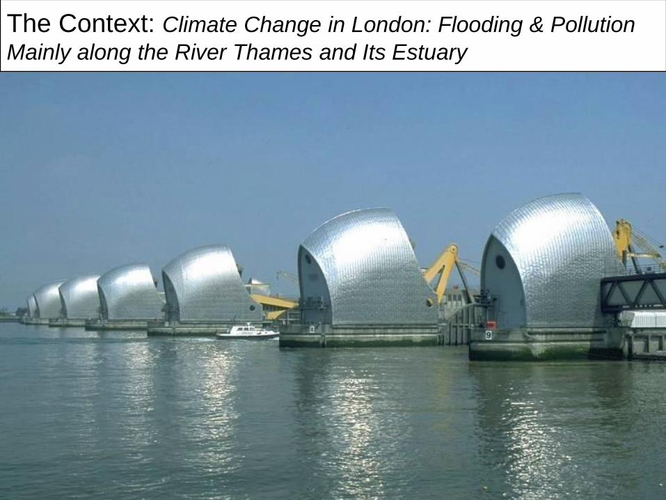
The Context: Climate Change in London: Flooding & Pollution
Mainly along the River Thames and Its Estuary
Page 6
Centre for Advanced Spatial Analysis, University College LondonCentre for Advanced Spatial Analysis
The Thames Barrier built from 1978 to 1984 in operation, likely
to be ineffective now by 2040? due to new predictions of sea
level rise but this is highly debatable …
Page 7
Centre for Advanced Spatial Analysis, University College LondonCentre for Advanced Spatial Analysis
Page 8
Centre for Advanced Spatial Analysis, University College LondonCentre for Advanced Spatial Analysis
Types of Prediction and Types of Models
The time horizon – short term to long term; obvious
uncertainties
In general the longer the time horizon for prediction, the
greater the uncertainty that detail in the model is
required.
Longer time horizons, simpler models
More robust models – an overused word – hardly every
defined – but little point in developing very detailed
and intricate models which require huge data
resources for very long term forecasting when detailed
data inputs are needed to forecast independently
Page 9
Centre for Advanced Spatial Analysis, University College LondonCentre for Advanced Spatial Analysis
Requirements: Simplicity, Accessibility,
Robustness
The model we will demonstrate here is for very long time
horizons – for 50 or 100 years when there are quite
well established predictions of physical change –
climate change, in our case rising sea levels.
Thus the model is comparative static – to forecast small
area population change that we assume adjusts over
50 or 100 years. Contestable of course.
The model also needs to be intelligible to a wide variety
of professionals and experts as well as informed
stakeholders. These stakeholders are uncertain, who
are they and how do they interact with the models?
Page 10
Centre for Advanced Spatial Analysis, University College LondonCentre for Advanced Spatial Analysis
The Integrated Assessment:
Our part in the integrated assessment is a land use
transport model to forecast small area population
change in Greater London as part of a series or
sequence of models designed to explore how more
global economic change translates into change in
population and how this is affected by rising sea levels.
The land use transport model sits between the aggregate
economic modelling and more detailed flood modelling
at the local scale.
Here is the sequence of models and we will return to this
sequence once I have outlined the LUTM & demoed it
Page 11
Centre for Advanced Spatial Analysis, University College LondonCentre for Advanced Spatial Analysis
The model sits lies at the core of a process of chaining
models together built by different groups and coming
from different traditions
The LUTM is in two layers – activity allocation and
physical location
LUTM
Page 12
Centre for Advanced Spatial Analysis, University College LondonCentre for Advanced Spatial Analysis
The Land Use Transport Model
Page 13
Centre for Advanced Spatial Analysis, University College LondonCentre for Advanced Spatial Analysis
The model is simple, highly visual – so that any informed
expert can use it or at least it can be demoed easily.
It is strongly coupled into GIS as mapping is central to
the visualisation – in fact all the GIS is purpose built
It is accessible, immediate and capable of being demoed
quickly
It is quite different from many of the current large scale
LUTM models like UrbanSim, more aggregate
This doesn’t mean it is better, far from it. It is different
and designed for a very different purpose. It is
designed to give structure to the process of very long
term forecasting and scenario setting
The easiest way is to demo it ….
Page 14
Centre for Advanced Spatial Analysis, University College LondonCentre for Advanced Spatial Analysis
To give a flavour of the model, I will show some screen
shots first
Page 15
Centre for Advanced Spatial Analysis, University College LondonCentre for Advanced Spatial Analysis
Page 16
Centre for Advanced Spatial Analysis, University College LondonCentre for Advanced Spatial Analysis
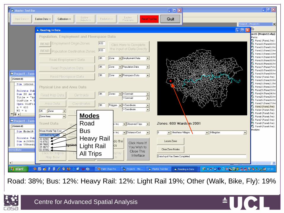
Modes
Road
Bus
Heavy Rail
Light Rail
All Trips
Road: 38%; Bus: 12%: Heavy Rail: 12%: Light Rail 19%; Other (Walk, Bike, Fly): 19%
Page 17
Centre for Advanced Spatial Analysis, University College LondonCentre for Advanced Spatial Analysis
Page 18
Centre for Advanced Spatial Analysis, University College LondonCentre for Advanced Spatial Analysis
Page 19
Centre for Advanced Spatial Analysis, University College LondonCentre for Advanced Spatial Analysis
Page 20
Centre for Advanced Spatial Analysis, University College LondonCentre for Advanced Spatial Analysis
Let us run the model… I need to go to my folder…
Page 21
Centre for Advanced Spatial Analysis, University College LondonCentre for Advanced Spatial Analysis
For a movie of all this go to our web sitehttp://www.casa.ucl.ac.uk/transportmodel/transportmodel.asp
Page 22
Centre for Advanced Spatial Analysis, University College LondonCentre for Advanced Spatial Analysis
You can find more about the Tyndall Cities Project on the
Tyndall Web site
http://www.tyndall.ac.uk/research/programme6/
But there is a launch event in London October 16th 2009
at the GLA …..
Page 23
Centre for Advanced Spatial Analysis, University College LondonCentre for Advanced Spatial Analysis
Ok let me step back and tell you more about the
integrated assessment:
• The Aggregate Economic Forecasting
• The Scenario Generator
• The Transport Network Analysis Module
• The LUTM
• The Local Development Model
• The Flooding Models
• The Aggregate Emissions Models
I am going to sketch just two of these models to give a
sense of how they are integrated
Page 24
Centre for Advanced Spatial Analysis, University College LondonCentre for Advanced Spatial Analysis
Scenario
Generator
LUTM
Local
Development
Generalised
Travel Costs
Let us unpack the LUTM process as there are really four
types of models/analytical tools here
Page 25
Centre for Advanced Spatial Analysis, University College LondonCentre for Advanced Spatial Analysis
Light Rail Generalised Costs from Heathrow Ward (minutes)
Page 26
Centre for Advanced Spatial Analysis, University College LondonCentre for Advanced Spatial Analysis
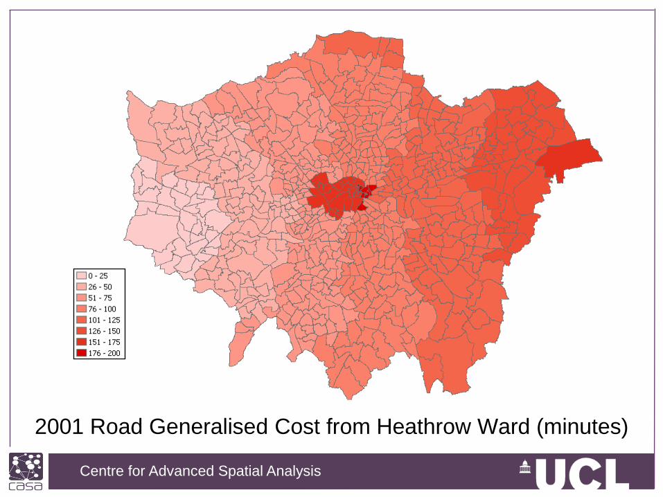
2001 Road Generalised Cost from Heathrow Ward (minutes)
Page 27
Centre for Advanced Spatial Analysis, University College LondonCentre for Advanced Spatial Analysis
• Reflect the cost of travel including:
– Monetary costs
– Time
• Differing calculations for public
and private transport
• Includes policy drivers:
– Cost of fuel
– Road user/congestion charging
– Ticket costs
– Service frequencies
• Allows modelling of both
geographical and economic costs
Generalised travel costThe ArcGIS Interface
Page 28
Centre for Advanced Spatial Analysis, University College LondonCentre for Advanced Spatial Analysis
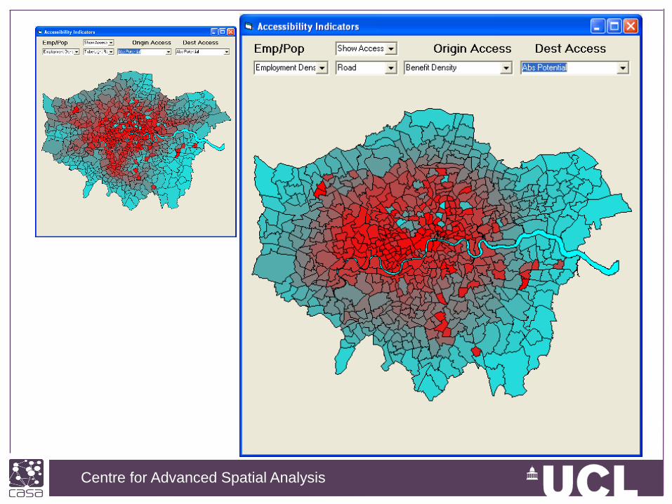
Accessibility from the LUTM model
Many different accessibility measures, 8 in all
Page 29
Centre for Advanced Spatial Analysis, University College LondonCentre for Advanced Spatial Analysis
Page 30
Centre for Advanced Spatial Analysis, University College LondonCentre for Advanced Spatial Analysis
Further work on networks
From our London database project which Andrew Crooks
and Duncan Smith talked about this morning
Bring the data in-house
Currently we have the
Road system in good
Detail with speeds etc
From TfL
Page 31
Centre for Advanced Spatial Analysis, University College LondonCentre for Advanced Spatial Analysis
The local development model
GIS layers at 50 metre resolution
Page 32
Centre for Advanced Spatial Analysis, University College LondonCentre for Advanced Spatial Analysis
Extending the formal project
The roll out of all these models will be accomplished in a
second phase of Tyndall which in fact is financed not
by NERC but by EPSRC under the ARCADIA project
http://www.ukcip-arcc.org.uk/
Page 33
Centre for Advanced Spatial Analysis, University College LondonCentre for Advanced Spatial Analysis
Next Steps
Extensions to the Gateway
Extending the model to generate employment
Disaggregating the Model to five population and five
employment groups
Developing the Land Use Constraints
Developing feedbacks from transport to land use
Extending the transport costs and travel time to
incorporate explicit energy use
Extending the location models to incorporate energy use
in work and home …….
Page 34
Centre for Advanced Spatial Analysis, University College LondonCentre for Advanced Spatial Analysis
Thanks, Any Questions?
Look at
http://www.casa.ucl.ac.uk/transportmodel/transportmodelmovie.html