67
Community Integrated Resource Planning Advisory Committee Meeting Nine June 27, 2013

Community Integrated Resource Planning
Advisory Committee
Meeting Nine June 27, 2013
Agenda
Welcome and Introductions Dr. John Brailsford, Facilitator
Presentation: Virgin River Program – Cooperative Recovery
Henry Maddux, Endangered Species Director Utah Department of Natural Resources
Presentation: 2013 Stewards of Water
Sterling Brown, Vice President of Public Policy Utah Farm Bureau Federation
Public Comment Meeting conclusion and adjournment
The Virgin River Program
“Cooperative Recovery”
Henry Maddux
Program Director

Signatory Partners
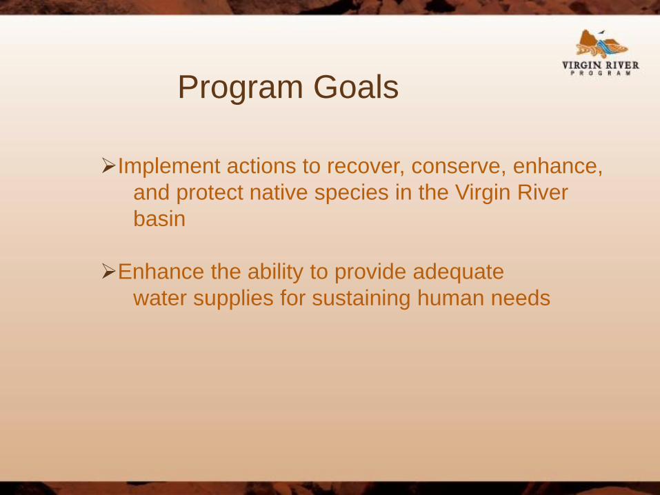
Program Goals
Implement actions to recover, conserve, enhance,
and protect native species in the Virgin River
basin
Enhance the ability to provide adequate
water supplies for sustaining human needs
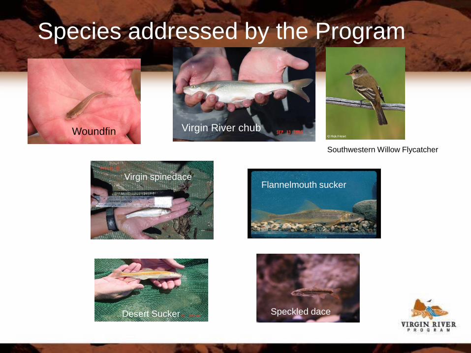
Species addressed by the Program
Woundfin Virgin River chub
Southwestern Willow Flycatcher
Virgin spinedace Flannelmouth sucker
Desert Sucker Speckled dace

Why are the natives struggling?
Loss of habitat Water
Native vegetation
Nonnative Species Red Shiner
Other nonnative fish
Tamarisk
Limiting Factors Temperature
Lack of turbidity

00
50,000
100,000
150,000
200,000
250,000
300,000
350,000
400,000
19
10
19
15
19
20
19
25
19
30
19
35
19
40
19
45
19
50
19
55
19
60
19
65
19
70
19
75
19
80
19
85
19
90
19
95
20
00
20
05
20
10
An
nu
al
Yie
ld (
Ac
re-F
ee
t)
Water Year
09406000 Virgin River near Virgin 1910-2012 Annual Yield (Acre-Feet)
<50% of Avg ≥50% &<65% ≥65% & <85%
≥85% &<115% ≥115% &<200% ≥200% of Avg

Actions for Recovery
Resolve conflicts between species conservation and human activities Restore water to the river channel Identify factors limiting native species populations
Put screens on diversions and ponds Maintain brood stock at hatcheries, stock fish into the river, monitor
populations Improve natural river processes
Remove tamarisk, re-vegetate with native species
Eliminate nonnative fishes from river Public outreach and education

Results of Program Communication and cooperation between federal, state, local regulatory
agencies and communities
Restored river flows in areas where water has been lacking
Maintaining populations of native and endangered species
Controlling nonnative species
Restoration and re-vegetation of Virgin River floodplain
Outreach and education to improve the publics view of the river
“I don't know what it cost to produce this calendar but it was worth it.
I sat my fourth grade team down and we discussed the calendar
and they were impressed with it's beauty and the information
it contained. We also appreciate the water fair you sponsor.
Thank you so much!!!” Dale Porter, Principal, Dixie Sun Elem.

Woundfin Captures @ Recovery Team Stations

Why the decline in Woundfin? Bloomington reach of the river – red shiner invasion
Above Washington Fields Diversion From 1968-1998 (30 years) there were only 6 years below 65% annual runoff
From 1998-present (15 years) there have been 9 years below 65% annual runoff and 6 of the 9 were below 50% annual runoff
In 2003, a sluicing event reduced fish numbers; numbers rebounded in 2003 and 2004
In 2007, ash from an upstream area burned by fire caused a major fish kill
Lack of good water years, too much or too little

Nonnative Eradication Efforts
Red shiner eliminated after 2008, but re-established in 2011 after flooding
Intensive mechanical and chemical efforts to remove unwanted fish
Multiple barriers have been constructed to aid eradication efforts
Fathead minnow from golf course ponds invaded the Santa Clara and Virgin rivers in 2011
Currently can’t treat downstream into Arizona due to lack of cooperation

Pumpback System
Designed to provide stored winter water to Hurricane Canal users and leave water in the river in summer for fish needs.
Additional flows will mitigate high summer temperatures limiting fish while not affecting senior agricultural water rights.

Quail
Creek
Diversion
Washington
Fields
Diversion
Pump
Station
Pah
Tempe
Hot
Springs
• Must meet water right of 86 cfs at WFD
• Two possible release points:
–Quail Creek Reservoir release
–Hydro-plant release
• Release from hydro-plant is
approximately 10 river miles upstream
• Hydroplant releases up to 27 cfs
Quail
Release
Hydroplant
Release
WCF
O
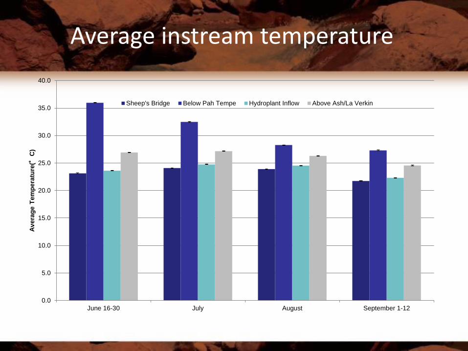
Average instream temperature
0.0
5.0
10.0
15.0
20.0
25.0
30.0
35.0
40.0
June 16-30 July August September 1-12
Av
era
ge T
em
pera
ture
(°C
)
Sheep's Bridge Below Pah Tempe Hydroplant Inflow Above Ash/La Verkin

Temperature and discharge metrics between Pah Tempe and Ash/LaVerkin
creeks June15-30
July August Sept 1-13
Summary
Average temperature difference (°C)
-9.03 -5.33 -1.97 -2.73 -4.47
Average percent difference (%)
-25.10
-15.48
-6.61 -9.42 -14.15
Difference in total hours ≥28°C
-292 -351 -298 -170.5 -1111.5
Difference in total hours ≥31°C
-384 -
472.4 -106 -34.7 -997.1
Average discharge from pumpback (cfs)
9.51 12.59 9.76 9.69 10.75
Average percent discharge from pumpback
28.07 26.34 10.98 14.64 20.69

Temperature metrics between Pah Tempe and above Ash/LaVerkin creeks
June 15-30
July August Sept1-13
Summary
Average temperature difference (°C)
-9.0 -5.3 -2.0 -2.7 -4.5
Average percent difference (%)
-25.1 -15.5 -6.6 -9.4 -14.2
Difference in total hours ≥28°C
-292 -351 -298 -171 -1112
Difference in total hours ≥31°C
-384 -472 -106 -35 -997

Fish Screens
Constructed in 2004-2005
Prevents fish from being lost to Washington Fields Canal system

Hatcheries, Stocking & Monitoring
Three hatcheries Dexter (N.M.) and Wahweap (UT) – produce woundfin and chub Bozeman (MT) - research
Stocking (Have targeted around 25,000/year but hope to increase number) 2012 – 5,000 woundfin stocked into the Virgin River 2011 – 1,034 woundfin stocked March, 30,000 stocked in October

Floodplain acquisition and protection
Confluence Park Presently about 350 acres protected as a nature park
Property owned by Washington County, conservation easements owned by Utah Division of Wildlife
Preservation of 100 yr. floodplain Program partners are acquiring properties within floodplain
Participants working to remove tamarisk and
revegtate areas

Revegetation/Restoration Efforts Working with many agencies over one hundred acres have been revegetated in the
past five years. Benefits of revegetation/restoration
Aesthetically pleasing
Keeps tamarisk and other nonnative plants out
Helps maintain floodplain processes
Protects from erosion damage
Helps wildlife
Reduces fire hazard

Virgin Spinedace
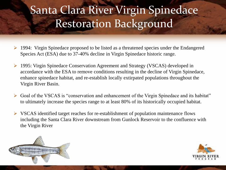
Santa Clara River Virgin Spinedace Restoration Background
1994: Virgin Spinedace proposed to be listed as a threatened species under the Endangered
Species Act (ESA) due to 37-40% decline in Virgin Spinedace historic range.
1995: Virgin Spinedace Conservation Agreement and Strategy (VSCAS) developed in
accordance with the ESA to remove conditions resulting in the decline of Virgin Spinedace,
enhance spinedace habitat, and re-establish locally extirpated populations throughout the
Virgin River Basin.
Goal of the VSCAS is “conservation and enhancement of the Virgin Spinedace and its habitat”
to ultimately increase the species range to at least 80% of its historically occupied habitat.
VSCAS identified target reaches for re-establishment of population maintenance flows
including the Santa Clara River downstream from Gunlock Reservoir to the confluence with
the Virgin River
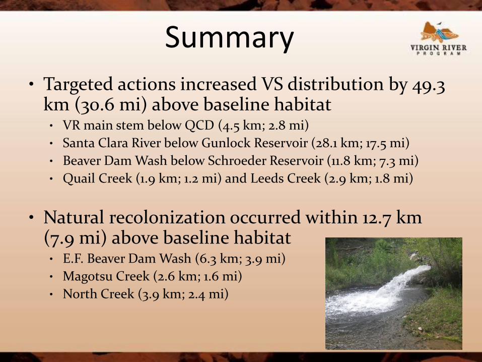
Summary
• Targeted actions increased VS distribution by 49.3 km (30.6 mi) above baseline habitat • VR main stem below QCD (4.5 km; 2.8 mi)
• Santa Clara River below Gunlock Reservoir (28.1 km; 17.5 mi)
• Beaver Dam Wash below Schroeder Reservoir (11.8 km; 7.3 mi)
• Quail Creek (1.9 km; 1.2 mi) and Leeds Creek (2.9 km; 1.8 mi)
• Natural recolonization occurred within 12.7 km (7.9 mi) above baseline habitat • E.F. Beaver Dam Wash (6.3 km; 3.9 mi)
• Magotsu Creek (2.6 km; 1.6 mi)
• North Creek (3.9 km; 2.4 mi)

Summary (Continued)
• The only loss of baseline habitat occurred within Ash Creek (4.0 km; 2.5 mi)
• Virgin Spinedace currently occupy 89% of historic habitat
• An additional 10.8 km (6.7 mi) of habitat outside of historic habitat has been naturally recolonized • Moody Wash (5.4 km; 3.4 mi) • Racer Canyon (1.0km; 0.6 mi) • La Verkin Creek (4.3 km; 2.7 mi)

Southwestern Willow Flycatcher
Empidonax traillii extimus
Breeding Biology -Eggs
-Clutch size 2–4 eggs
-Female incubates, 12–13 d
-Parental care -Male & female feed nestlings, 12–15 d
-Fledglings remain in territory 14+ d

0
2
4
6
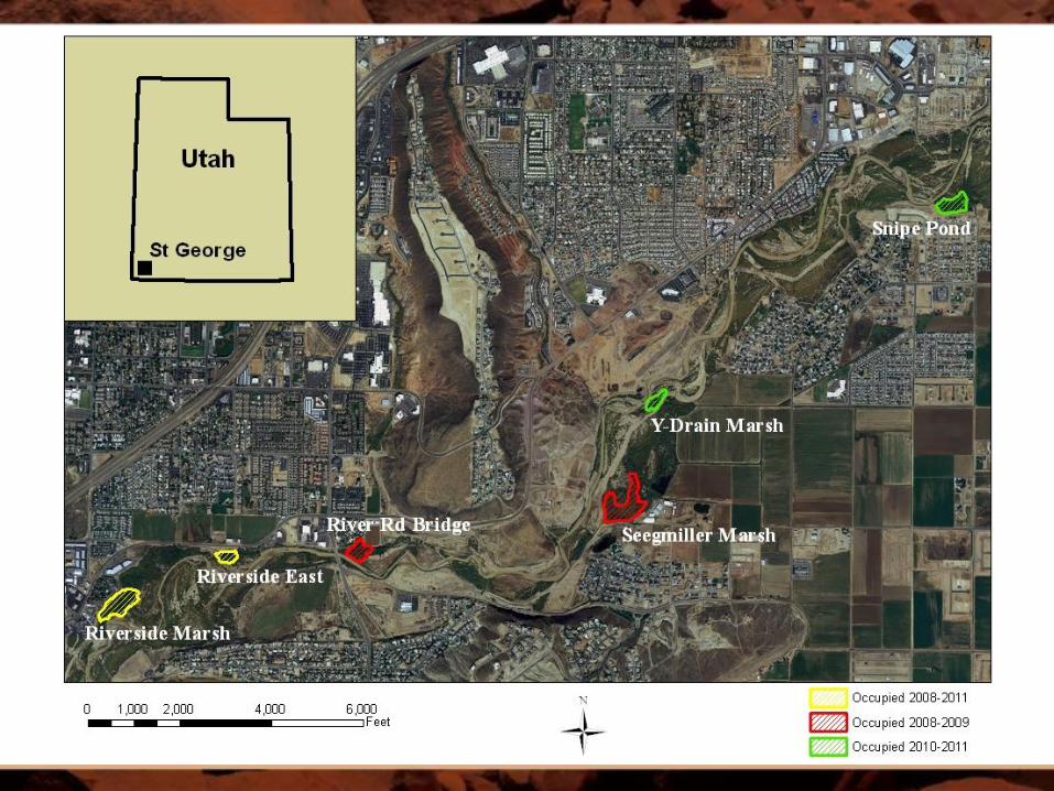
RiversideMarsh
SeegmillerMarsh
River RdBridge
RiversideEast
SnipePond
Y-DrainMarsh
Nu
mb
er
of
bre
ed
ing
fe
ma
les
2008
2009
2010
2011
2012
0
2
4
6
8
10
12
All Sites
SWFL numbers in St George, 2008-2012 Females shifted distribution, but no change overall
0 00 000 00

Nest Predation (2010-2012)
-41 % nests / year -Range 26-60 %; n = 56
-Predators unknown -Mostly avian?
-Nest video (2012) -1 predation event
-Brown-headed Cowbird

Riverside Marsh Restoration Area

Public Outreach/Education
Efforts continue in 2012
Education Weeks – four weeks during the year ~ 1,000 students seen
Washington County Water Fair & 4,000 calendars distributed
Presentations to city councils, various other groups Website Regular articles in local papers, news Aquarium in WCWCD building

Other community activities
Fish clearances for stream alteration projects
Program/UDWR internship 20 students over the past 5 years + 5 teachers have participated
Santa Clara/Virgin River Master Plans Planning documents that provide recommendations for floodplain usage
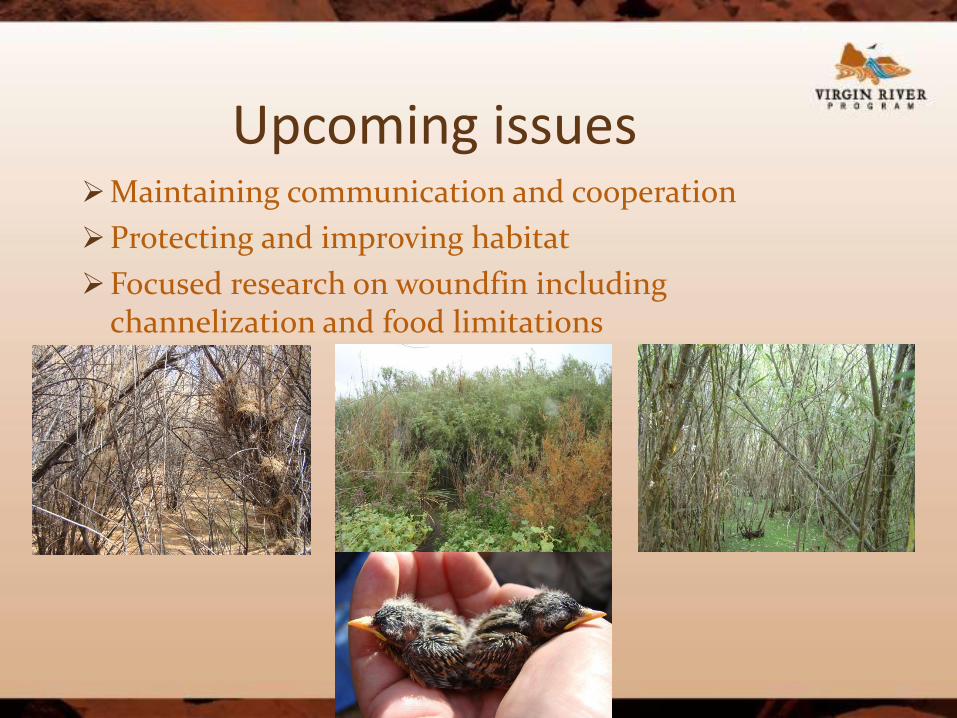
Upcoming issues Maintaining communication and cooperation
Protecting and improving habitat
Focused research on woundfin including channelization and food limitations

Cooperators

QUESTIONS?

2013 STEWARDS OF WATER
Sterling Brown
Vice President of Public Policy
Utah Farm Bureau Federation

Num
ber
of F
arm
s
Land in F
arm
s/R
anches
Cash R
eceip
ts
36th 26th 37th
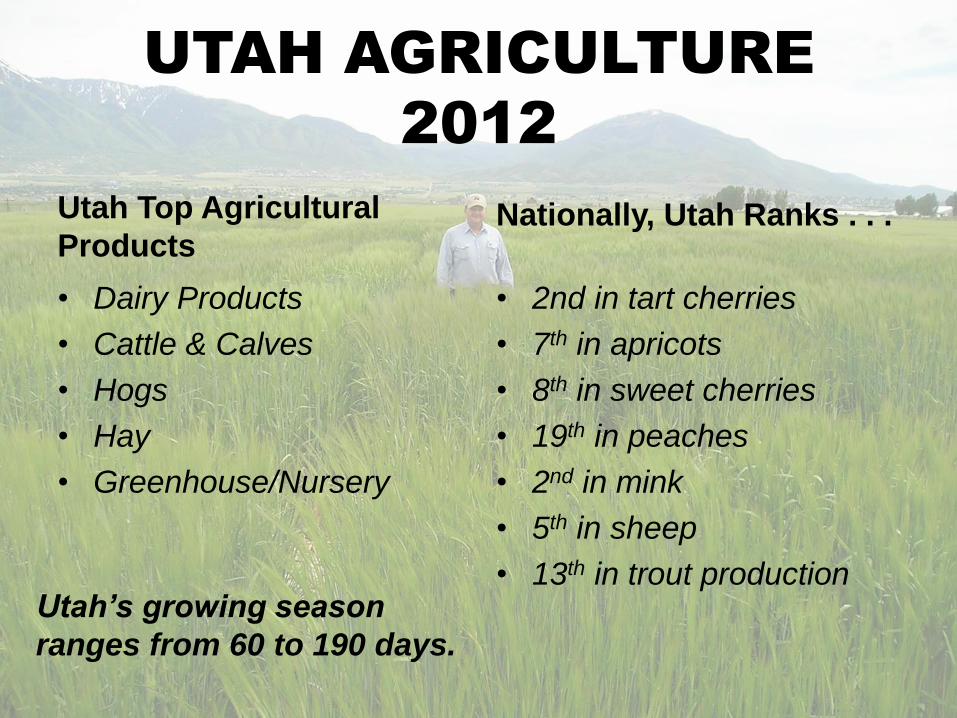
UTAH AGRICULTURE 2012
16,600
FARMS
RANCHES
11.1
MILLION
ACRES
$1.3
BILLION
UTAH AGRICULTURE
2012
Utah Top Agricultural
Products
• Dairy Products
• Cattle & Calves
• Hogs
• Hay
• Greenhouse/Nursery
Nationally, Utah Ranks . . .
• 2nd in tart cherries
• 7th in apricots
• 8th in sweet cherries
• 19th in peaches
• 2nd in mink
• 5th in sheep
• 13th in trout production
Utah’s growing season
ranges from 60 to 190 days.

AMERICANS PAY
THE LEAST
FOR FOOD
2012


UNITED STATES DEPARTMENT
OF AGRICULTURE
ESTABLISHED IN 1862

96%
4%
Total Federal
Budget
USDA's Budget
Total 2012 Federal Budget--$3.7 Trillion
USDA’s 2012 Budget--$145 Billion

74%
7%
13% 6%
USDA’s 2012 Budget
$145 Billion
Nutrition
Assistance
Conservation &
Forestry
Farm &
Commodity
All Other

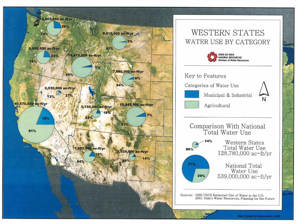
WATER TRANSFER
Agriculture Municipal & Individual
0
1
2
3
4
5
6
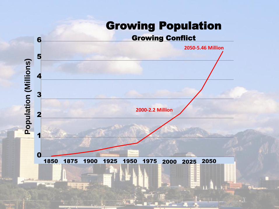
1850 1875 1900 1925 1950 1975 2000 2025 2050
Po
pu
lati
on
(M
illio
ns
) Growing Population
Growing Conflict
2000-2.2 Million
2050-5.46 Million
1850 1875 1900 1925 1950 1975 2000 2025 2050
6
5
4
3
2
1
0
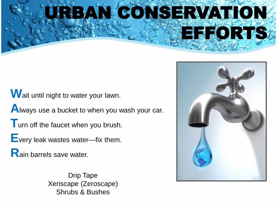
URBAN CONSERVATION
EFFORTS
Wait until night to water your lawn.
Always use a bucket to when you wash your car.
Turn off the faucet when you brush.
Every leak wastes water—fix them.
Rain barrels save water.
Drip Tape
Xeriscape (Zeroscape)
Shrubs & Bushes

Agriculture is a BIG user of water.

AGRICULTURE
CONSERVATION EFFORTS
Flood irrigation
vs. Sprinkler
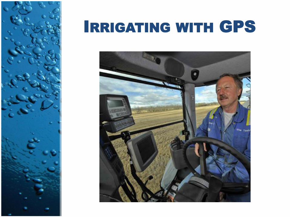
IRRIGATING WITH GPS

COOPERATIVE
AGREEMENTS

LASER LEVELING

LINING DITCHES & CANALS

Where will Utah find
enough water to double
the population while
maintaining a sustainable
agriculture industry?
Continued . . .

“We won’t! (long pause)
We must better utilize our
current water resources. We
can’t keep putting the same
amount of water on golf
courses, lawns and
entertainment venues.” --cow/calf and alfalfa grower in West Weber County

“There must be a significant
mindset shift away from
wanting and expecting green
grass everywhere and all year.
Too much emphasis is put on
landscape esthetics. We must
move towards more native and
drought tolerant landscape
plants.” --small grains grower in Cache Valley

“If God wants us to live here,
He must give us the water.
(laugh, laugh) It’s probably
going to come from agriculture.
As a result, agriculture will
have to take a back seat to
production, contributing to the
economy and way of life.” --turf grower in Washington County

“ We must use water wisely.
It’s there. We just need to
be better stewards of
existing water.” --cow/calf operator in Uintah County

U.S. BUREAU OF
RECLAMATION RESPONSE
Increase conservation, efficiency,
markets, and collaboration.
Improve technology and remove
institutional barriers and increase
interagency coordination.

AGRICULTURE CHALLENGES
GOING FORWARD
1. Converting Ag Water to
Municipal & Individual
2. Canal Safety & Liability
– Responsibility
– Safety & Maintenance
– Funding
– Communication &
Accountability
– Risk Management
3. Maintaining Water
Quality
4. Maintaining Rights to
Water on Public Lands
5. Water Development
6. Water Funding

Affordable, Abundant,
Safe Food and Fiber
Requires Abundant
WATER

WATER IS LIFE!

Public Comment

July 25 Governor’s Listening Session 7:00 – 9:00 p.m. Dixie State University, Dunford Auditorium 225 South 700 East, St. George August 15 Amelia Nuding, Western Resource Advocates 4:00-6:00 p.m. Washington County Water Conservancy District 533 E. Water Works Drive September 19 Jeremy Aguero, Applied Analysis 4:00-6:00 p.m. Washington County Water Conservancy District 533 E. Water Works Drive
Meeting Schedule

Meeting conclusion and adjournment
Thank you for attending


