Integrated State-Federal Partnership for Aquatic Resource Monitoring in the United States Anthony (Tony) R. Olsen USEPA NHEERL Western Ecology Division Corvallis, OR 97333 Email: [email protected]
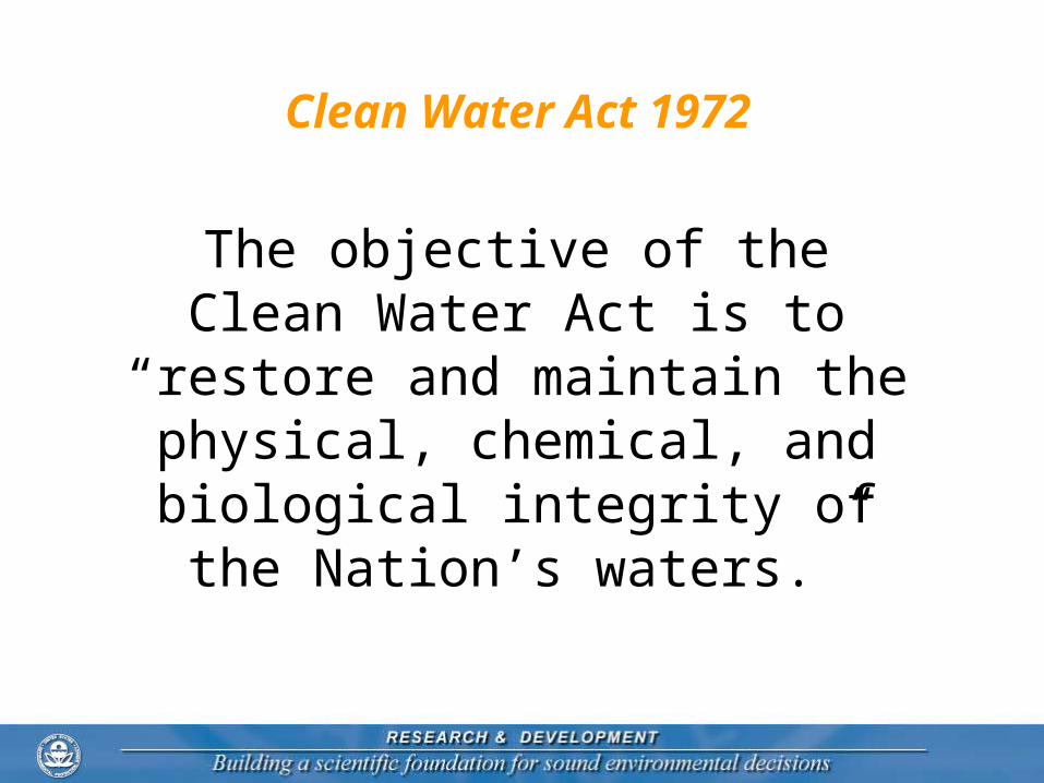
The objective of the Clean Water Act is to “restore and maintain the
physical, chemical, and biological integrity of the Nation’s waters.”
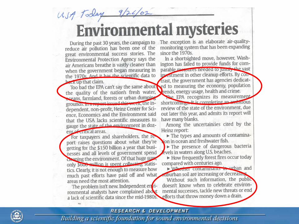
What GAO Found
“At least 15 federal agencies collect a wide variety of water quality data. Most notably, the U.S. Geological Survey operates several large water quality monitoring programs across the nation. States also play a key role in water quality data collection to fulfill their responsibilities under the Clean Water Act. In addition, numerous local watershed groups, volunteer monitoring groups, industries, and academic groups collect water quality data. In contrast, collection of water quantity data is more centralized, with three federal agencies collecting the majority of data available nationwide.”
What the National Water Quality
Monitoring Council (NWQMC) is Doing
About Issue
US EPA and State Relationship
• USEPA Office of Water has responsibility for National reporting Approving state monitoring plans Establishing national criteria and standards providing guidance on monitoring design and assessment
• States have responsibility for Establishing state standards and criteria Reporting on the status/trends of ALL waters in state Compiling list of ALL impaired waters (303(d) list) Completing TMDLs when required on impaired waters
Reporting Requirements for States and US EPA
• 305(b) report on the status and trends in all waters every two years for state and United States By designated use Support, partially support, threatened, do not support
• Integrated list of the status of every assessment unit (lake, stream reach, ….)
• 303(d) list of impaired assessment units requiring Total Maximum Daily Load analysis (TMDLs)
• TMDL development and monitoring
Integrated Report Guidance Listing Categories for Every “Waterbody”
1. Attaining standards for all designated uses
2. Attaining some designated uses, and insufficient or no data and information to determine if remaining uses are attained
3. Insufficient or no data and information to determine if any designated use is attained
4. Impaired or threatened for one or more designated uses but not needing a TMDL
a. TMDL has been completed
b. Expected to meet standards in a reasonable time
c. Not impaired by a pollutant
5. Impaired or threatened by pollutant(s) for one or more designated uses and requiring a TMDL
305 (b)Report
303(d)List
Aquatic Monitoring Components
• Aquatic resource classification Streams and rivers ; Great Rivers Lakes and reservoirs; Great Lakes Estuaries and coastal waters Wetlands Groundwater
• General types of monitoring Biological Chemical Physical Quantity
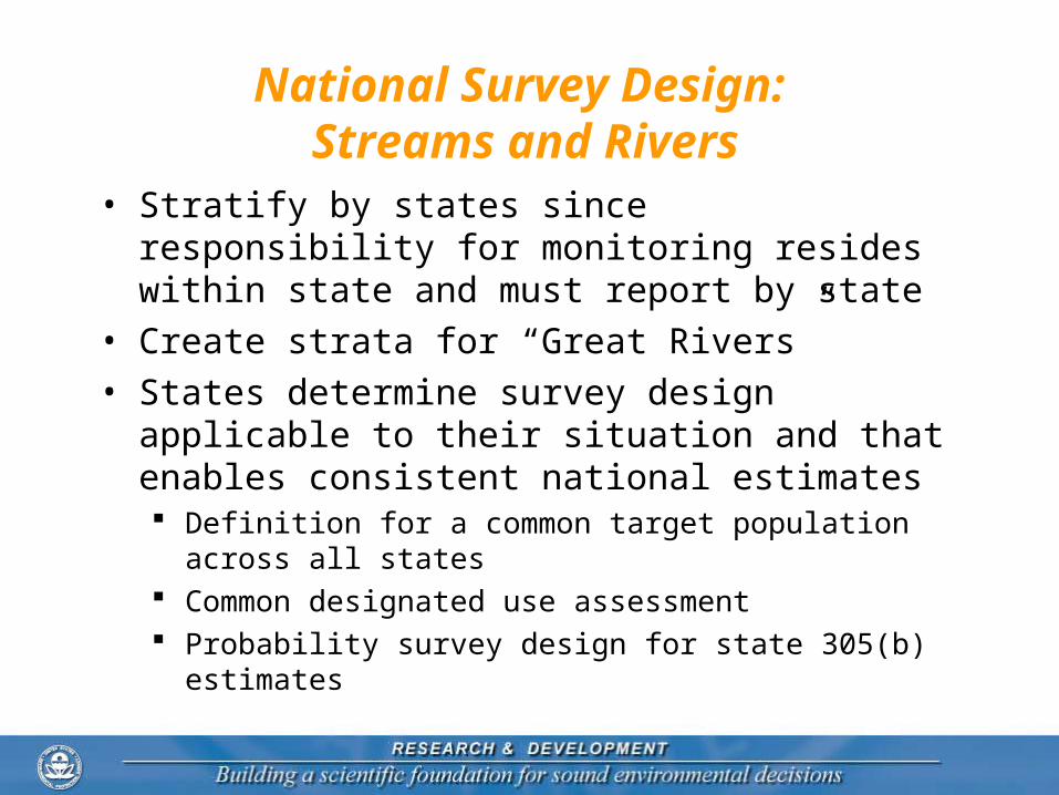
National Survey Design: Streams and Rivers
• Stratify by states since responsibility for monitoring resides within state and must report by state
• Create strata for “Great Rivers”• States determine survey design applicable to their
situation and that enables consistent national estimates Definition for a common target population across all states Common designated use assessment Probability survey design for state 305(b) estimates
Typical State Survey Design excluding Great Rivers Routine Biological, Chemical, Physical
• Ability to make estimates for 5-10 geographic subregions
• 5 year period to accumulate data on rotating basin or state-wide every-year basis
• Unequal probability selection will vary; may include Stream/river size (Strahler order) Omernik ecoregions Designated use or integrated list categories
• Special studies added to basic design 303(d) listing monitoring or TMDL monitoring Relationship studies with stressors Intensive monitoring for chemicals
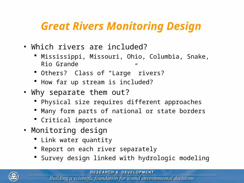
Great Rivers Monitoring Design
• Which rivers are included? Mississippi, Missouri, Ohio, Columbia, Snake, Rio Grande Others? Class of “Large” rivers? How far up stream is included?
• Why separate them out? Physical size requires different approaches Many form parts of national or state borders Critical importance
• Monitoring design Link water quantity Report on each river separately Survey design linked with hydrologic modeling
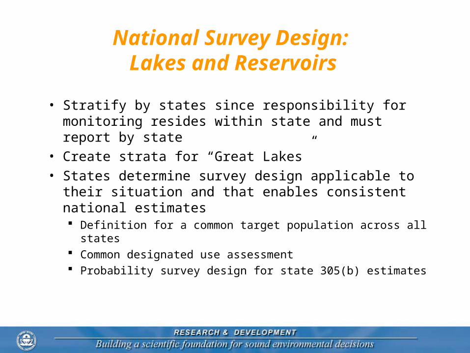
National Survey Design: Lakes and Reservoirs
• Stratify by states since responsibility for monitoring resides within state and must report by state
• Create strata for “Great Lakes”• States determine survey design applicable to their
situation and that enables consistent national estimates Definition for a common target population across all states Common designated use assessment Probability survey design for state 305(b) estimates
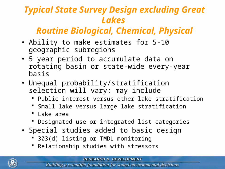
Typical State Survey Design excluding Great Lakes Routine Biological, Chemical, Physical
• Ability to make estimates for 5-10 geographic subregions
• 5 year period to accumulate data on rotating basin or state-wide every-year basis
• Unequal probability/stratification selection will vary; may include Public interest versus other lake stratification Small lake versus large lake stratification Lake area Designated use or integrated list categories
• Special studies added to basic design 303(d) listing or TMDL monitoring Relationship studies with stressors
Great Lakes
• Which lakes are included? Superior, Michigan, Huron, Erie, Ontario Should other lake important lakes be included
• Lake Tahoe, Salton Sea, Great Salt Lake, Lake Champlain?
• Approximately 270 lakes/reservoirs greater than 5,000 ha
• Why separate them out? National importance Require different monitoring
• Monitoring design Report on each one Spatial design Extensive use of lake modeling
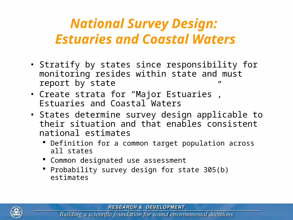
National Survey Design: Estuaries and Coastal Waters
• Stratify by states since responsibility for monitoring resides within state and must report by state
• Create strata for “Major Estuaries”, Estuaries and Coastal Waters
• States determine survey design applicable to their situation and that enables consistent national estimates Definition for a common target population across all states Common designated use assessment Probability survey design for state 305(b) estimates
Typical State Survey Design: exclude Major Estuaries
Routine Biological, Chemical, Physical• Stratify by estuaries and coastal waters• 5 year period to accumulate data on rotating basin
or state-wide every-year basis• Unequal probability/stratification selection will vary;
may include National Estuary Programs versus other estuaries estuarine area Shellfish beds, coral reefs Designated use or integrated list categories
• Special studies added to basic design 303(d) listing or TMDL monitoring Relationship studies with stressors
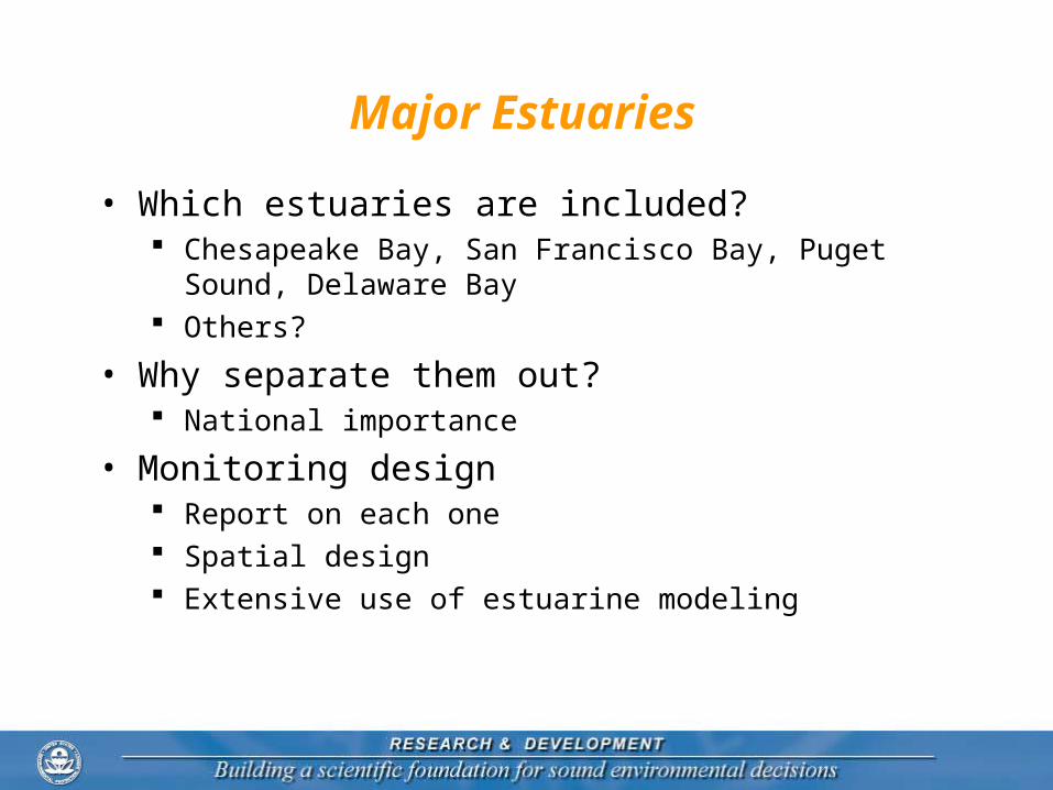
Major Estuaries
• Which estuaries are included? Chesapeake Bay, San Francisco Bay, Puget Sound,
Delaware Bay Others?
• Why separate them out? National importance
• Monitoring design Report on each one Spatial design Extensive use of estuarine modeling
National Survey Design: Wetlands
• Wetlands are difficult resource for monitoring Include prairie potholes, riverine wetlands, and extensive
wetlands (Everglades) Biological, physical and chemical parameters continue to
be subject to debate
• Monitoring extent (area) is high priority Separate monitoring design to address extent
• Monitoring wetland condition Stratify by state More research required before design can proceed
National Monitoring Infrastructure
• NWQMC is a step in the right direction• Time is ripe to create the infrastructure – increased
focus on aquatic monitoring• More quantitative assessments are being demanded
by Federal and state governments• Budget constraints give focus to cost-effectiveness• Scientific-defensibility is necessary if monitoring
results are to be accepted
Where are we now?
• NWQMC framework focus a single monitoring program Coordinate, collaborate with
other programs Sharing data
• Framework does not focus on Hierarchy: national – state –
local Explicit integration of
monitoring programs
Resource Type
States & Tribal
National
Streams . . Lakes
National Report
Great Rivers
Great Lakes
Columbia …. Ohio Superior … Erie
Consortiums
County, Local, Volunteer
AL ……… WY
NASQAN-NAWQA
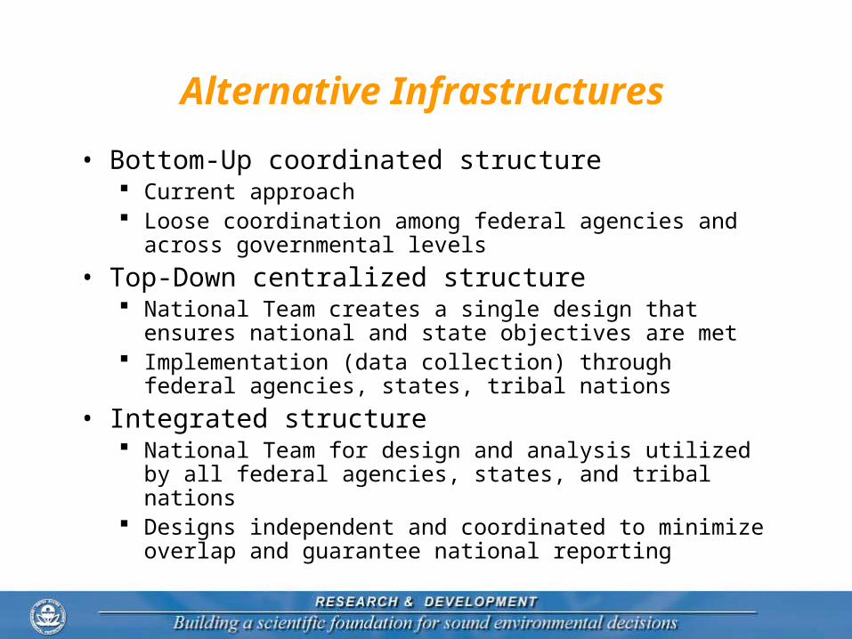
Alternative Infrastructures
• Bottom-Up coordinated structure Current approach Loose coordination among federal agencies and across
governmental levels
• Top-Down centralized structure National Team creates a single design that ensures
national and state objectives are met Implementation (data collection) through federal agencies,
states, tribal nations
• Integrated structure National Team for design and analysis utilized by all
federal agencies, states, and tribal nations Designs independent and coordinated to minimize overlap
and guarantee national reporting
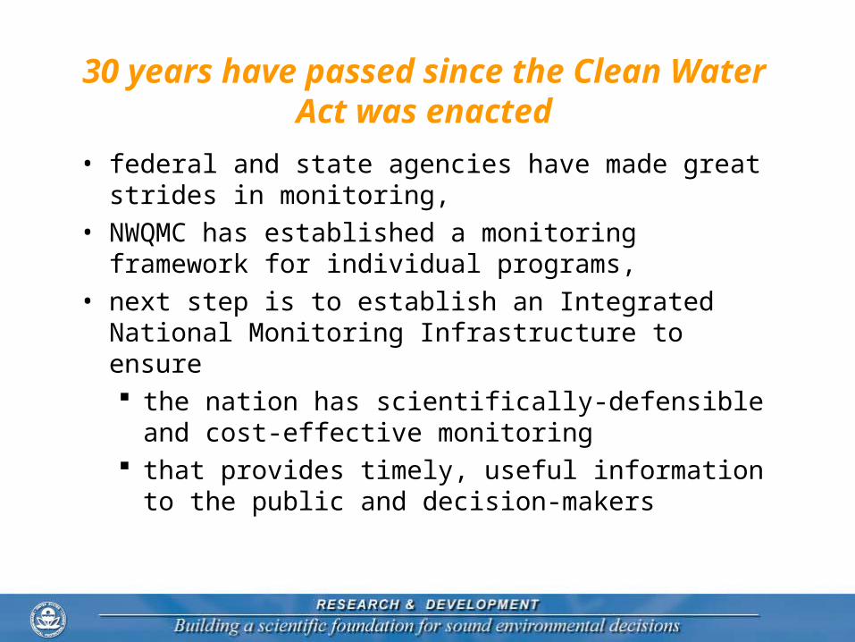
30 years have passed since the Clean Water Act was enacted
• federal and state agencies have made great strides in monitoring,
• NWQMC has established a monitoring framework for individual programs,
• next step is to establish an Integrated National Monitoring Infrastructure to ensure the nation has scientifically-defensible and cost-
effective monitoring that provides timely, useful information to the


![1 3 4 Reference: ZDHC wastewater guidelines, Pg. 9 ......2370-65-7 76057-124] 877-11-2 RepŒti 2B: 8260B, Dich ISO losn usEPA ISO 1 USEPA USEPA 1 "4 g. usEPA usEPA usEPA usEPA usEPA](https://static.documents.pub/doc/80x56/610e853285f7f7713133afc2/1-3-4-reference-zdhc-wastewater-guidelines-pg-9-2370-65-7-76057-124.jpg)


