TOPCON CORPORATION75-1 Hasunuma-cho, Itabashi-ku, Tokyo 174-8580, Japan
www.topcon.co.jp
- Bluetooth® word mark and logos are registered trademarks owned by Bluetooth SIG, Inc. and any use of such marks by Topcon is under license. - Other trademarks and trade names are those of their respective owners.
- Specifications may vary by region and are subject to change without notice.
- Bluetooth® word mark and logos are registered trademarks owned by Bluetooth SIG, Inc. and any use of such marks by Topcon is under license. - Other trademarks and trade names are those of their respective owners.
- Specifications may vary by region and are subject to change without notice.
TOPCON CORPORATION75-1 Hasunuma-cho, Itabashi-ku, Tokyo 174-8580, Japan
- Bluetooth® word mark and logos are registered trademarks owned by Bluetooth SIG, Inc. and any use of such marks by Topcon is under license. - Other trademarks and trade names are those of their respective owners.
- Specifications may vary by region and are subject to change without notice.
Your local Authorized Dealer is:
Your local Authorized Dealer is:
TOPCON CORPORATION75-1 Hasunuma-cho, Itabashi-ku, Tokyo 174-8580, Japan
www.topcon.co.jp
<Contact to>Topcon Sokkia India Private Limited
Unit No.101 to 106A, 1st Floor, ABW Tower, MG Road, Sector-25, IFFCO Chowk, Gurgaon, Haryana-122001.India
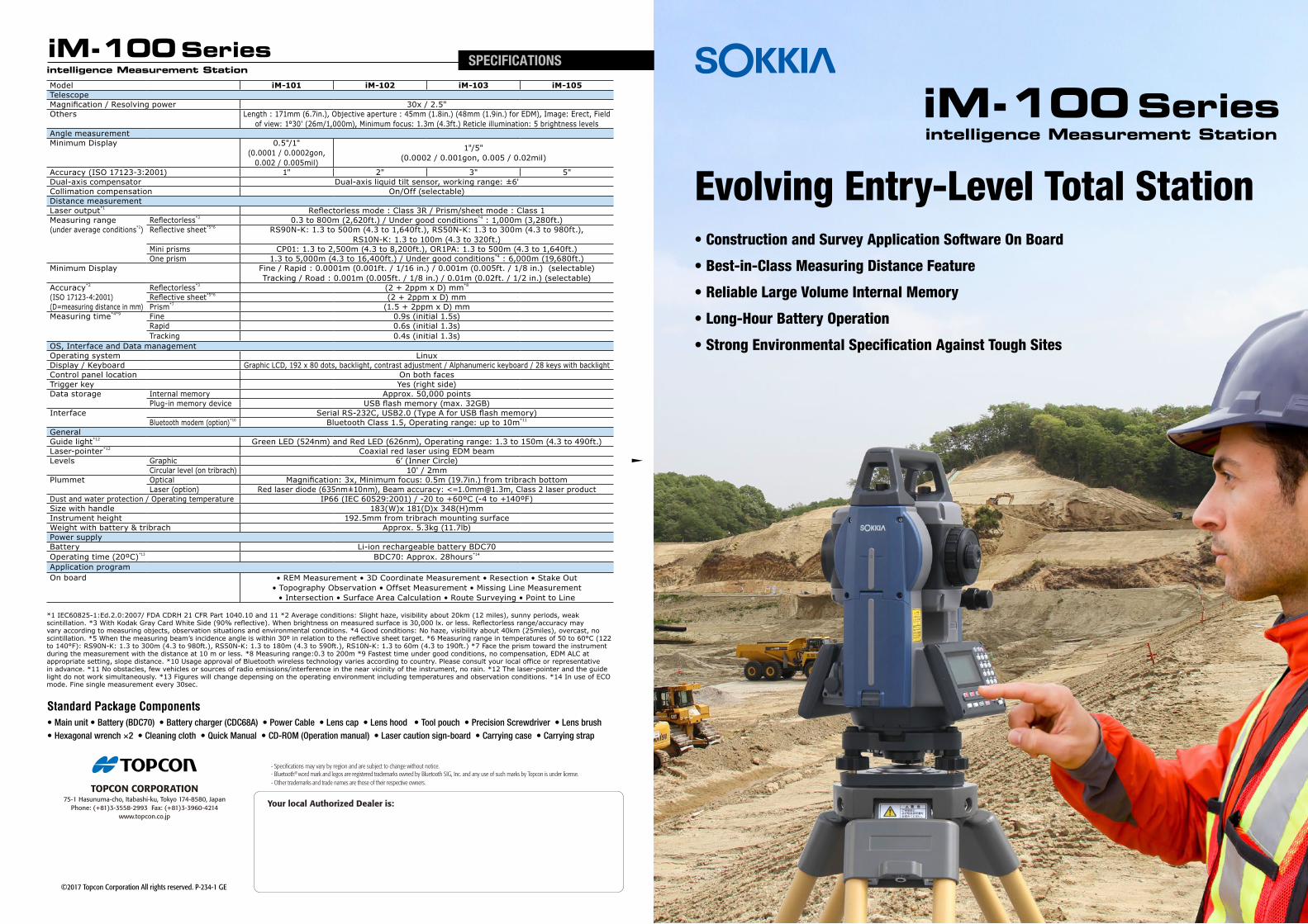
Accuracy (ISO 17123-3:2001) 1" 2" 3" 5"Dual-axis compensator Dual-axis liquid tilt sensor, working range: ±6'Collimation compensation On/Off (selectable)Distance measurementLaser output*1 Reflectorless mode : Class 3R / Prism/sheet mode : Class 1Measuring range Reflectorless*3 0.3 to 800m (2,620ft.) / Under good conditions*4 : 1,000m (3,280ft.)(under average conditions*2) Reflective sheet*5*6 RS90N-K: 1.3 to 500m (4.3 to 1,640ft.), RS50N-K: 1.3 to 300m (4.3 to 980ft.),
RS10N-K: 1.3 to 100m (4.3 to 320ft.)Mini prisms CP01: 1.3 to 2,500m (4.3 to 8,200ft.), OR1PA: 1.3 to 500m (4.3 to 1,640ft.)One prism 1.3 to 5,000m (4.3 to 16,400ft.) / Under good conditions*4 : 6,000m (19,680ft.)
(ISO 17123-4:2001) Reflective sheet*5*6 (2 + 2ppm x D) mm(D=measuring distance in mm) Prism*7 (1.5 + 2ppm x D) mmMeasuring time*4*9 Fine 0.9s (initial 1.5s)
OS, Interface and Data managementOperating system LinuxDisplay / Keyboard Graphic LCD, 192 x 80 dots, backlight, contrast adjustment / Alphanumeric keyboard / 28 keys with backlightControl panel location On both facesTrigger key Yes (right side)Data storage Internal memory Approx. 50,000 points
Plug-in memory device USB flash memory (max. 32GB)Interface Serial RS-232C, USB2.0 (Type A for USB flash memory)
Bluetooth modem (option)*10 Bluetooth Class 1.5, Operating range: up to 10m*11
GeneralGuide light*12 Green LED (524nm) and Red LED (626nm), Operating range: 1.3 to 150m (4.3 to 490ft.)Laser-pointer*12 Coaxial red laser using EDM beamLevels Graphic 6’ (Inner Circle)
Circular level (on tribrach) 10' / 2mmPlummet Optical Magnification: 3x, Minimum focus: 0.5m (19.7in.) from tribrach bottom
Laser (option) Red laser diode (635nm±10nm), Beam accuracy: <[email protected], Class 2 laser productDust and water protection / Operating temperature IP66 (IEC 60529:2001) / -20 to +60ºC (-4 to +140ºF)Size with handle 183(W)x 181(D)x 348(H)mm Instrument height 192.5mm from tribrach mounting surfaceWeight with battery & tribrach Approx. 5.3kg (11.7lb)Power supplyBattery Li-ion rechargeable battery BDC70Operating time (20ºC)*13 BDC70: Approx. 28hours*14
Application programOn board • REM Measurement • 3D Coordinate Measurement • Resection • Stake Out
• Topography Observation • Offset Measurement • Missing Line Measurement • Intersection • Surface Area Calculation • Route Surveying • Point to Line
*1 IEC60825-1:Ed.2.0:2007/ FDA CDRH 21 CFR Part 1040.10 and 11 *2 Average conditions: Slight haze, visibility about 20km (12 miles), sunny periods, weak scintillation. *3 With Kodak Gray Card White Side (90% reflective). When brightness on measured surface is 30,000 lx. or less. Reflectorless range/accuracy may vary according to measuring objects, observation situations and environmental conditions. *4 Good conditions: No haze, visibility about 40km (25miles), overcast, no scintillation. *5 When the measuring beam’s incidence angle is within 30º in relation to the reflective sheet target. *6 Measuring range in temperatures of 50 to 60°C (122 to 140°F): RS90N-K: 1.3 to 300m (4.3 to 980ft.), RS50N-K: 1.3 to 180m (4.3 to 590ft.), RS10N-K: 1.3 to 60m (4.3 to 190ft.) *7 Face the prism toward the instrument during the measurement with the distance at 10 m or less. *8 Measuring range:0.3 to 200m *9 Fastest time under good conditions, no compensation, EDM ALC at appropriate setting, slope distance. *10 Usage approval of Bluetooth wireless technology varies according to country. Please consult your local office or representative in advance. *11 No obstacles, few vehicles or sources of radio emissions/interference in the near vicinity of the instrument, no rain. *12 The laser-pointer and the guide light do not work simultaneously. *13 Figures will change depensing on the operating environment including temperatures and observation conditions. *14 In use of ECO mode. Fine single measurement every 30sec.
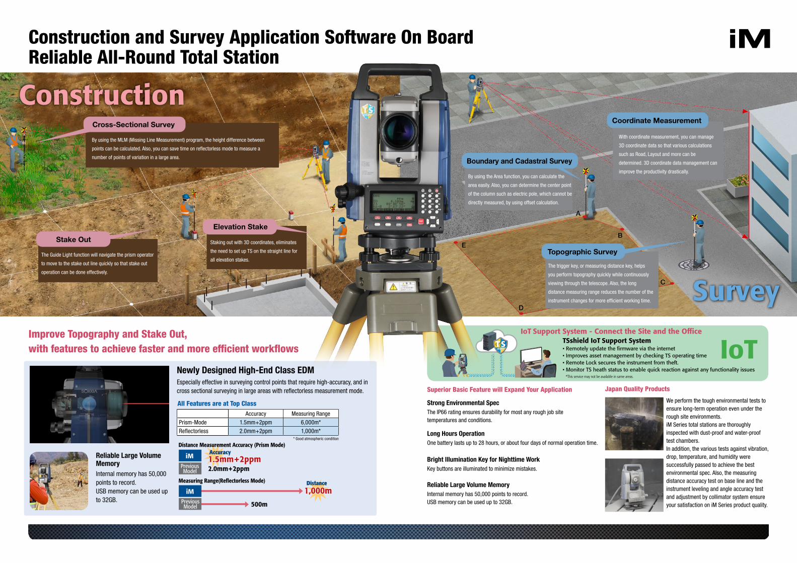
Newly Designed High-End Class EDM
Reliable Large Volume Memory
Accuracy Measuring Range
Prism-Mode 1.5mm+2ppm 6,000m*
Reflectorless 2.0mm+2ppm 1,000m*
All Features are at Top Class
Especially effective in surveying control points that require high-accuracy, and in cross sectional surveying in large areas with reflectorless measurement mode.
Internal memory has 50,000 points to record.USB memory can be used up to 32GB.
iMPreviousModel
PreviousModel
1,000m1,000m
1.5mm+2ppm1.5mm+2ppm2.0mm+2ppm
500m
iM
Distance Measurement Accuracy(Prism Mode)
Measuring Range(Reflectorless Mode) Distance
Accuracy
iMPreviousModel
1.5mm+2ppm1.5mm+2ppm2.0mm+2ppm
500m
iM
Distance Measurement Accuracy (Prism Mode)
Measuring Range(Reflectorless Mode)
Accuracy
1,000m1,000mDistance
PreviousModel
* Good atmospheric condition
• Remotely update the firmware via the internet • Improves asset management by checking TS operating time• Remote Lock secures the instrument from theft.• Monitor TS heath status to enable quick reaction against any functionality issues
TSshield IoT Support SystemIoT Support System - Connect the Site and the Office
IoT*This service may not be available in same areas.
Construction
A
B
C
D
E
Survey
Construction and Survey Application Software On BoardReliable All-Round Total Station
Superior Basic Feature will Expand Your Application Japan Quality Products
Strong Environmental Spec
Bright Illumination Key for Nighttime Work
Reliable Large Volume Memory
Long Hours Operation
Improve Topography and Stake Out, with features to achieve faster and more efficient workflows
The IP66 rating ensures durability for most any rough job site temperatures and conditions.
We perform the tough environmental tests to ensure long-term operation even under the rough site environments. iM Series total stations are thoroughly inspected with dust-proof and water-proof test chambers. In addition, the various tests against vibration, drop, temperature, and humidity were successfully passed to achieve the best environmental spec. Also, the measuring distance accuracy test on base line and the instrument leveling and angle accuracy test and adjustment by collimator system ensure your satisfaction on iM Series product quality.
Key buttons are illuminated to minimize mistakes.
Internal memory has 50,000 points to record.USB memory can be used up to 32GB.
One battery lasts up to 28 hours, or about four days of normal operation time.
By using the MLM (Missing Line Measurement) program, the height difference between
points can be calculated. Also, you can save time on reflectorless mode to measure a
number of points of variation in a large area.
The Guide Light function will navigate the prism operator
to move to the stake out line quickly so that stake out
operation can be done effectively.
Staking out with 3D coordinates, eliminates
the need to set up TS on the straight line for
all elevation stakes.
By using the Area function, you can calculate the
area easily. Also, you can determine the center point
of the column such as electric pole, which cannot be
directly measured, by using offset calculation.
With coordinate measurement, you can manage
3D coordinate data so that various calculations
such as Road, Layout and more can be
determined. 3D coordinate data management can
improve the productivity drastically.
The trigger key, or measuring distance key, helps
you perform topography quickly while continuously
viewing through the telescope. Also, the long
distance measuring range reduces the number of the
instrument changes for more efficient working time.