INTERIM REMEDIAL MEASURE WORK PLAN FOR BROWNFIELD CLEANUP PROGRAM 945 KENMORE AVENUE TONAWANDA, ERIE COUNTY, NEW YORK Prepared for: 945 KENMORE GROUP LLC APRIL 2015 REVISED JUNE 6, 2015 ___________________________________ Marie Nowak, Professional Engineer Nussbaumer & Clarke, Inc. For complete Interim Remedial Measure Work Plan, with Appendices, please visit document repository
Transcript
INTERIM REMEDIAL MEASURE WORK PLAN FOR BROWNFIELD CLEANUP
PROGRAM
945 KENMORE AVENUE TONAWANDA, ERIE COUNTY, NEW YORK
Prepared for:
945 KENMORE GROUP LLC
APRIL 2015
REVISED JUNE 6, 2015
___________________________________ Marie Nowak, Professional Engineer Nussbaumer & Clarke, Inc.
For complete Interim Remedial Measure Work Plan, with Appendices, please visit document repository
INTERIM REMEDIAL MEASURE WORK PLAN 945 KENMORE AVENUE, TONAWANDA, NEW YORK
i
INTERIM REMEDIAL MEASURE WORK PLAN TABLE OF CONTENTS
1.1 PURPOSE AND OBJECTIVE ..................................................................................................................... 1 1.2 PROJECT BACKGROUND AND SITE HISTORY ........................................................................................... 1
1.2.1 Remedial Investigation ................................................................................................................................ 2 1.2.2 Summary of Known Contaminants at the Site and Remedial Requirements ............................................... 6
1.3 SITE GEOLOGY/HYDROGEOLOGY ........................................................................................................... 7 1.4 PROJECT DESCRIPTION ......................................................................................................................... 7 1.5 PROJECT MANAGEMENT AND ORGANIZATION ......................................................................................... 7
1.5.1 Personnel...................................................................................................................................................... 8 1.5.2 Specific Tasks and Services ......................................................................................................................... 8 1.5.3 Project Schedule .......................................................................................................................................... 8
2.2.1 Project Coordination Meeting .................................................................................................................... 10 2.2.2 Pre-Excavation Survey and Underground Utilities Location ..................................................................... 10 2.2.3 Health and Safety Plan Development ........................................................................................................ 11
2.3 IRM ACTIVITIES .................................................................................................................................. 11 2.3.1 Building Demolition .................................................................................................................................. 11 2.3.2 Waste Characterization Testing and Additional Investigation of Pump Island.......................................... 11 2.3.3 Monitoring Well Decommissioning .......................................................................................................... 11 2.3.4 Examination of Soils Beneath the Eastern Building/Garage ..................................................................... 11 2.3.5 UST Removals ........................................................................................................................................... 12 2.3.6 Soil and Hydraulic Lift Excavation ........................................................................................................... 12 2.3.7 Soil Disposal .............................................................................................................................................. 12 2.3.8 Verification Sampling ................................................................................................................................ 13 2.3.9 Backfilling ................................................................................................................................................. 13 2.3.10 Progress Meetings and Citizen Participation ........................................................................................... 14
2.5 COMMUNITY AIR MONITORING ............................................................................................................. 15 2.6 DOCUMENTATION AND REPORTING ...................................................................................................... 15
INTERIM REMEDIAL MEASURE WORK PLAN 945 KENMORE AVENUE, TONAWANDA, NEW YORK
ii
INTERIM REMEDIAL MEASURE WORK PLAN TABLE OF CONTENTS, CONTINUED
LIST OF TABLES
TABLE 1 VOCS BY USEPA SW-846 METHOD 8260 (SOIL)
TABLE 2 SVOCS BY USEPA SW-846 METHOD 8270 (SOIL)
TABLE 3 METALS BY USEPA SW-846 METHODS 6010/7471A (SOIL)
TABLE 4 CYANIDE BY USEPA SW-846 METHOD 9012 (SOIL)
TABLE 5 PCBS BY USEPA SW-846 METHOD 8082 (SOIL)
TABLE 6 TRIP BLANKS AND EQUIPMENT BLANKS (FOR SOIL INVESTIGATION)
TABLE 7 GROUNDWATER DEPTHS IN SITE OVERBURDEN MONITORING WELLS
TABLE 8 VOCS BY USEPA SW-846 METHOD 8260 (GROUNDWATER)
TABLE 9 SVOCS BY USEPA SW-846 METHOD 8270 (GROUNDWATER)
TABLE 10 METALS BY USEPA SW-846 METHODS 6010/7471A (GROUNDWATER)
TABLE 11 CYANIDE BY USEPA SW-846 METHOD 9012 (GROUNDWATER)
TABLE 12 PCBS BY USEPA SW-846 METHOD 8082 (GROUNDWATER)
TABLE 13 TRIP BLANKS AND EQUIPMENT BLANKS (FOR GROUNDWATER INVESTIGATION)
TABLE 14 ANTICIPATED PROJECT SCHEDULE
LIST OF FIGURES
FIGURE 1-1 SITE LOCATION MAP
FIGURE 1-2 SITE OVERVIEW
FIGURE 1-3 SITE PLAN
FIGURE 2-1 PROPOSED IRM
LIST OF APPENDICES
APPENDIX A PREVIOUS STUDIES
APPENDIX B SUBLOGS AND WELL CONSTRUCTION DIAGRAMS
APPENDIX C HASP
APPENDIX D REFERENCE DOCUMENTS
1
1.0 INTRODUCTION 1.1 PURPOSE AND OBJECTIVE The purpose of this Interim Remedial Measure (IRM) Work Plan is to document planned remedial activities at the subject site located at 945 Kenmore Avenue in the Town of Tonawanda, Erie County, New York (Figure 1-1), referred to herein as “Site.” The entity 945 Kenmore Group LLC, acting as an innocent owner, has agreed to participate in the New York State Department of Environmental Conservation (NYSDEC) Brownfield Cleanup Program (BCP) and has entered into a Brownfield Cleanup Agreement (BCA) for remedial investigation/remedial action. This BCA was fully executed on August 26, 2014, following the submittal and NYSDEC acceptance of a BCP application for the Site. The Remedial Investigation (RI) designed as part of the BCA has been completed. This work plan includes a summary of the results of the RI that pertain to the proposed interim remedial measure design. A more detailed history of previous environmental work completed on-site is included in the Remedial Investigation Work Plan dated January 2015 (revised). The objective of the interim remedial measure (IRM) outlined in this work plan is to complete the remedial activities necessary in order to obtain a Certificate of Completion (COC) for a Track 2 Residential cleanup. 1.2 PROJECT BACKGROUND AND SITE HISTORY The 945 Kenmore Avenue Site encompasses approximately 0.552 acres in the Town of Tonawanda, Erie County, New York (Town of Tonawanda Parcel No. 78.34-3-15.1 in its entirety). The Site is described as developed land with one structure, located in a highly developed, predominantly residential and commercial area north of the City of Buffalo, New York (Figure 1-2). The Site and surrounding area were historically utilized for commercial and residential purposes. According to historical records, the Site was utilized as a gasoline station from at least 1950 to 1986 and as an automotive repair facility from at least 1958 to 2010; such operations included automotive body repair work from at least 1994 to 2010 (Figure 1-3). The Site included at least four pump islands and at least six underground storage tanks (USTs): two 5,000-gallon tanks, one 10,000-gallon tank, two 3,000-gallon tanks, and one 4,000-gallon tank. Based on the records reviewed, the number, location and disposition of USTs are unclear. Limited sampling associated with three tank removals (two 5,000-gallon tanks and one 10,000-gallon tank) identified volatile organic compounds (VOCs) at concentrations such that the NYSDEC indicated that remediation was warranted (Spill 9211433); however, it does not appear that remediation was completed. In addition, no information has been uncovered pertaining to the removals of the three remaining tanks. Furthermore, during a site inspection performed by the NYSDEC in 2013, associated with currently “active” Spill 1306828, the NYSDEC noted two suspected fill ports on-site. During a site inspection conducted by Lender Consulting Services, Inc. (LCS) on March 24-25, 2014, LCS confirmed that each of these two fill ports is currently connected to a UST. One of the tanks appeared to be mostly full of water, and the other tank contained what appears to be approximately two feet of used oil. No information has been discovered by LCS relative to the soil and groundwater conditions at the Site upon removal of the four known pump islands. However, observations made in 2011 during utility work along the front of the Site (adjacent to three of the former pump islands) included “very strong gasoline odors” along nearly the entire front of the Site along Kenmore Avenue (Spill 1104845). Other spills reported in the utility area along Kenmore Avenue, adjacent to the former pump islands, identified gasoline and lubricating oil compounds at concentrations above NYSDEC regulatory guidance at the time in soil samples submitted for analysis, as well as observations of a sheen on the soil (Spills 8600802, 9515189, and 9211433). Before completion of the Remedial Investigation as part of the BCP, only limited analytical data existed pertaining to the environmental quality of on-site soil and groundwater as a result of the historic gasoline station operations.
2
In addition, the environmental quality of soil and groundwater at the Site as a result of the historic automotive repair/auto body repair operations had been unknown prior to completion of the Remedial Investigation. Field observations suggested that environmental media had been impacted. In 2013, “floating oil, a heavy sheen, and pooled oil” were reported as “running off of” the concrete slab associated with a former building located on the western side of the Site (Spill 1306828). Upon demolition of this building, several historic hydraulic lifts were exposed in the ground, which appeared to be intact. LCS confirmed during a site inspection in March 2014 that there are at least four in-ground hydraulic lifts remaining within the building footprint. One of the lifts was surrounded by suspected heavy oil staining. During a site inspection performed as part of a Phase I Environmental Site Assessment by Hazard Evaluations, Inc. (HEI) in 2010, floor drains, a parts washer, and evidence of release was noted in this former building, including granular absorbent and oily staining surrounding a drum. Staining was also noted in the current building on the eastern portion of the Site during this inspection, as well as unlabeled drums, a floor drain, and poor housekeeping of hazardous/regulated materials. Evidence suggested that soils at the Site, and potentially groundwater, had been impacted by historic on-site gasoline station and automotive repair/auto body operations. Previous studies for the Site are included as Appendix A. Further investigation and potential remediation of soil and/or groundwater at the Site was required to assess current contaminant levels at the Site.
1.2.1 Remedial Investigation A Remedial Investigation (RI) completed according to the BCA was conducted at the Site from January through April 2015. The following section provides a summary of the RI. Refer to Figure 1-3 for the site and sample locations referenced below. Geophysical Survey On January 28, 2015, LCS oversaw completion of a geophysical survey at the Site by TREC Environmental, Inc. The geophysical survey report is the last document within Appendix A. Accessible exterior portions of the Site were surveyed using a combination of ground-penetrating radar (GPR) and utility-tracing instruments. According to the results, an unknown anomaly was identified west of the former building, proximate to South Irving Terrace, north adjacent to a former pump island location. According to verbal communication with TREC, no anomalies consistent with additional tanks were identified on-site. Utilities were also identified and were generally consistent with utility markings applied to the property through Dig Safely New York. Soil Investigation Soil samples were collected from February 10-12, 2015, with a truck-mounted percussion and hydraulically driven drive system equipped with an approximate 2-inch diameter, approximate 48-inch long macro-core sampler. Twenty test borings were completed (BCP BH1 through BCP BH20) (Figure 1-3). Soil samples were collected within each borehole continuously from the ground surface to a depth of approximately 20 feet below the ground surface (ft. bgs) for boreholes BCP BH1 through BCP BH19, and to a depth of approximately 5 ft. bgs for borehole BCP BH20. The planned termination depth of 20 ft. bgs was specified in the Remedial Investigation Work Plan. Borehole BCP BH20 was terminated at a depth of 5 ft. bgs due to the proximity of the natural gas utility. Any downhole equipment was decontaminated with an Alconox and tap water wash and tap water rinse between boreholes. The cutting shoes were decontaminated in a similar manner between collection of each sample.
INTERIM REMEDIAL MEASURE WORK PLAN 945 KENMORE AVENUE, TONAWANDA, NEW YORK
3
Upon opening of the sample liner, a section of each 2-foot interval of soil was immediately containerized to help prevent loss of volatiles. For soil which exhibited obvious evidence of VOC impact (i.e. odors and/or staining), the section of soil chosen for immediate containerization was that which appeared to be the most impacted within the 2-foot interval. Following soil classification, the remainder of each 2-foot interval of soil was placed in a separate sealable container and heated to allow any vapors to accumulate in the headspace. After several minutes, the container was opened slightly and the total volatile organic compound (VOC) concentration in air within the sample container was measured using a photoionization detector (PID). The physical characteristics of all soil samples were classified in general accordance with the Unified Soil Classification System (USCS) (Visual-Manual Method). A total of 189 soil samples were collected for geologic description. Fill material consisting of asphalt/concrete and gravelly sand was encountered within the borings completed proximate to the four former pump islands (BCP BH1, BCP BH3, BCP BH10, and BCP BH12) to a depth of approximately 1 ft. bgs. Fill material consisting of asphalt, asphalt-based gravel, silty sand, and/or gravelly sand was encountered within the borings completed within the historic “tank nest” (BCP BH4) and additional historic tank area southeast of the former building (BCP BH9) to a depth of approximately 10 ft. bgs. Fill material consisting of concrete and gravelly sand was encountered within the borings completed through the former building foundation (BCP BH17 through BCP BH19) to a depth of approximately 1 ft. bgs. Fill material encountered within the remainder of the borings completed consisted of asphalt and/or gravelly sand to a maximum depth of ~2 ft. bgs. The fill materials were underlain by native soils consisting of gravelly clay (gravel very minor) to the bottom of the test borings. Elevated PID readings and/or suspect petroleum-type odors were detected in the following soil samples: Former Pump Island Areas
BCP BH1 (~0.5-5 ft. bgs) BCP BH3 (~0.5-12 ft. bgs) BCP BH10 (~0.4-8 ft. bgs) BCP BH12 (~2-4 ft. bgs)
Historic Tank Nest and Additional Historic Tank Area
BCP BH4 (~2-10 ft. bgs) BCP BH9 (~2-10 ft. bgs)
Underneath Former Western Building
BCP BH17 (~0.5-4 ft. bgs) BCP BH19 (~2-4 ft. bgs)
Other Areas
BCP BH7 (~0.4-4 ft. bgs) Refer to the subsurface logs in Appendix B for soil classification for each sample interval, field observations, and PID measurements. Following labeling of the laboratory-supplied sample containers, selected samples were placed on ice. The samples were then submitted, under standard chain-of-custody, to a New York State Department of Health (NYSDOH) approved laboratory for analysis in accordance with the United States Environmental Protection Agency (USEPA) SW-846 Methods as summarized below.
INTERIM REMEDIAL MEASURE WORK PLAN 945 KENMORE AVENUE, TONAWANDA, NEW YORK
4
The following table summarizes the specific analytical testing performed and their respective sample locations.
Sample Location Analytical Testing Performed Justification for Sample SelectionBCP BH1 (~1-3 ft. bgs)
TCL and CP-51 list VOCs and TCL SVOCs
Field evidence of petroleum impact (former pump island locations)
BCP BH3 (~2-4 ft. bgs) BCP BH10 (~2-4 ft. bgs) BCP BH12 (~2-4 ft. bgs)
BCP BH4 (~6-8 ft. bgs) TCL and CP-51 list VOCs and TCL SVOCs
Field evidence of petroleum impact (historic tank nest)
BCP BH7 (~2-4 ft. bgs) TCL and CP-51 list VOCs and TCL SVOCs
Field evidence of petroleum impact
BCP BH6 (~6-8 ft. bgs)
TCL and CP-51 list VOCs and TCL SVOCs
Areas of former auto repair/auto body work BCP BH14 (~4-6 ft. bgs) BCP BH16 (~6-8 ft. bgs) BCP BH17 (~2-4 ft. bgs)
TCL and CP-51 list VOCs, TCL SVOCs, and PCBs
Areas of former auto repair/auto body work and in-ground hydraulic lifts
BCP BH18 (~2-4 ft. bgs) BCP BH19 (~2-4 ft. bgs) BCP BH2 (~0-2 ft. bgs)
TAL Metals, Cyanide, and PCBs
Areas of former auto repair/auto body work
BCP BH5 (~0-2 ft. bgs) BCP BH6 (~0-2 ft. bgs) BCP BH11 (~0-4 ft. bgs) BCP BH12 (~0-2 ft. bgs) BCP BH13 (~0-2 ft. bgs) BCP BH14 (~0-2 ft. bgs) BCP BH15 (~0-2 ft. bgs) BCP BH16 (~0-2 ft. bgs) BCP BH17 (~0-2 ft. bgs)
TAL Metals and Cyanide BCP BH18 (~0-2 ft. bgs) BCP BH19 (~0-2 ft. bgs)
BH = Borehole ft. bgs = feet below ground surface
TCL VOCs = Target Compound List volatile organic compounds via USEPA Test Method 8260 CP-51 list VOCs = Final Commissioner Policy-51 list volatile organic compounds via USEPA Test Method 8260
TCL SVOCs = Target Compound List semi-volatile organic compounds via USEPA Test Method 8270 TAL Metals = Target Analyte List metals via USEPA Test Method 6010/7471
Cyanide = Cyanide via USEPA Test Method 9012 PCBs = Polychlorinated biphenyls via USEPA Test Method 8082
In boreholes selected for VOC and SVOC analysis, which exhibited obvious evidence of petroleum impact, soil samples submitted for laboratory analysis were collected from the interval with the highest PID reading within each borehole. All boreholes exhibiting obvious evidence of petroleum impact were chosen for VOC and SVOC analysis with the exception of BCP BH9 – soil samples collected from within this borehole exhibited suspect petroleum-type odors at depths from approximately 2-10 ft. bgs; however, elevated PID readings were not detected. As this borehole was completed proximate to a UST that will be removed, any petroleum-impacted soils represented by BCP BH9 will be removed during the tank excavation.
INTERIM REMEDIAL MEASURE WORK PLAN 945 KENMORE AVENUE, TONAWANDA, NEW YORK
5
The analytical results for the soil samples and quality control samples collected and submitted for analysis, along with a comparison to the Part 375 Soil Cleanup Objectives (SCOs), are shown in Tables 1-6. According to the laboratory results, all soil samples submitted for laboratory analysis met the Part 375 SCOs for Track 2 Residential. In addition, all soil samples submitted for laboratory analysis met the Part 375 SCOs for unrestricted site use (Track 1) with the exception of VOCs in the following samples:
BH3 (~2-4 ft. bgs) BH4 (~6-8 ft. bgs) BH10 (~2-4 ft. bgs) BH7 (~2-4 ft. bgs)
Groundwater Investigation Five permanent groundwater monitoring wells were installed on-site during the RI; such included two wells in former pump island areas (BCP MW1 and BCP MW2), one well in the historic tank nest (BCP MW3), and two wells to the north of the former automotive repair operations, proximate to the northern Site boundary and adjacent residences (BCP MW4 and BCP MW5). The wells were installed on March 16-18, 2015. Monitoring wells BCP MW1 through BCP MW5 were installed over previously-completed boreholes BCP BH1, BCP BH10, BCP BH4, BCP BH8, and BCP BH14, respectively. Prior to well installation, each of these five former borings was over drilled utilizing a track-mounted percussion and hydraulically driven drive system equipped with an approximate 2-inch diameter, approximate 48-inch long macro-core sampler. Soil samples were collected within each borehole continuously from approximately 20 ft. bgs to the boring termination depth of 28 ft. bgs; no field evidence of obvious chemical impact was observed in any of the soil samples collected for inspection. Refer to Appendix B for the sublogs for these additional depths investigated. Any downhole equipment was decontaminated with an Alconox and tap water wash and tap water rinse between boreholes. The cutting shoes were decontaminated in a similar manner between collection of each sample. Following completion of each borehole, the annulus was widened to a depth of approximately 28 ft. bgs utilizing hollow augers. Any downhole equipment was decontaminated with a high pressure water wash between boreholes until no visible particulates remained. A well constructed of 2-inch inner diameter (ID) flush jointed Schedule 40 PVC screen and riser was emplaced within each boring. Fifteen feet of 0.010-inch factory slotted PVC screen was utilized in each well; this screen length was chosen such that the screen in each well would straddle the water table, in order to monitoring groundwater in the uppermost water bearing zone. At the time of the well installation, based on field observations, LCS estimated that the water table was located at a depth of approximately 19-20 ft. bgs. Following placement of the assembled screen and riser, the annular space of each borehole was backfilled. Generally, this included the placement of a sand filter pack consisting of Morie #00 sand around the well screen such that the sand extended approximately one foot above the top of the screen. Bentonite pellets were then placed above the sand filter to a depth of approximately 1 foot below the top of the casing, and tap water was poured over the pellets and they were allowed time to hydrate. A flush-mounted steel protective casing equipped with a 12 inch steel skirt was then placed over the riser. Refer to the attached well construction diagrams in Appendix B for additional details. The five newly installed overburden monitoring wells were developed prior to sampling to remove residual sediments and ensure good hydraulic connection with the water-bearing zone. The wells were developed on March 24, 2015, 6-8 days after installation to allow the concrete used in the protective casings to set. During development, each well was purged utilizing dedicated and disposable PVC bailers and a pump until each well went dry.
INTERIM REMEDIAL MEASURE WORK PLAN 945 KENMORE AVENUE, TONAWANDA, NEW YORK
6
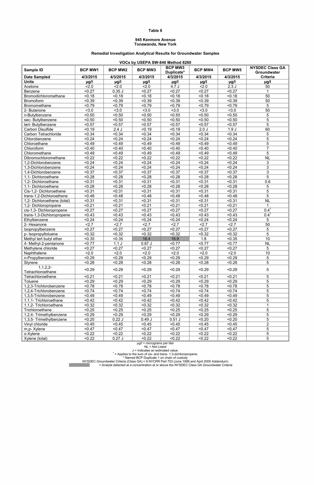
The wells were surveyed on March 20, 2015. Water level measurements were recorded on March 24, 2015, prior to purging the wells, for the purpose of developing an overburden isopotential map. Based on the survey data and the measured groundwater depths, presented in Table 7, groundwater in the shallow overburden was determined to be generally flowing outwards from the center of the Site (Figure 1-3); LCS suspects that groundwater flow on-site may not have reached static levels following the well installation at the time of groundwater depth measurement. LCS will measure groundwater depth in the wells again prior to the IRM in an attempt to better assess groundwater flow direction on-site; such will not affect the scope of the IRM. On April 1, 2015, the five newly installed wells were redeveloped in preparation for sampling. Each well was purged utilizing dedicated and disposable PVC bailers until each well went dry. The wells were sampled on April 3, 2015, after the wells had produced sufficient recharge for filling sample aliquots. Sample aliquots were collected in order of decreasing volatility. Dedicated and disposable PVC bailers, each equipped with a bottom check-valve, and dedicated polyethylene line were utilized during sampling. Following labeling of the laboratory-supplied sample containers, selected samples were placed on ice. The samples were then submitted, under standard chain-of-custody, to a New York State Department of Health (NYSDOH) approved laboratory for analysis for TCL and CP-51 list VOCs, TCL SVOCs, TAL Metals, Cyanide, and PCBs in accordance with USEPA SW-846 Test Methods 8260, 8270, 6010/7471, 9012, and 8082, respectively. The analytical results for the groundwater samples and quality control samples collected and submitted for analysis, along with a comparison to the NYSDEC Class GA Groundwater Criteria, are shown in Tables 8-13. According to the laboratory results, groundwater samples submitted for laboratory analysis met the NYSDEC Class GA Groundwater Criteria with the exception of the following:
Methyl tert butyl ether in BCP MW3 (Table 8) Iron in BCP MW2 through BCP MW5 (Table 10) Manganese in BCP MW1 through BCP MW4 (Table 10) Iron and Manganese (sum) in BCP MW1 through BCP MW5 (Table 10) Magnesium in BCP MW1 through BCP MW5 (Table 10) Sodium in BCP MW1 through BCP MW5 (Table 10)
1.2.2 Summary of Known Contaminants at the Site and Remedial Requirements According to the laboratory results, all soil samples submitted for laboratory analysis met the Part 375 SCOs for Track 2 Residential. In addition, all soil samples submitted for laboratory analysis met the Part 375 SCOs for Unrestricted site use (Track 1) with the exception of VOCs in samples collected from two of the four former pump island areas (BH3 and BH10), the historic tank nest area (BH4), and along a suspected utility trench on the north-central portion of the Site (BH7). According to the laboratory results, all groundwater samples submitted for laboratory analysis met the NYSDEC Class GA Groundwater Criteria with the exception of VOCs in BCP MW3, in which a relatively slight exceedance of MTBE was detected, and metals (collectively iron, manganese, and sodium) in BCP MW1 through BCP MW5. As the Site will be subject to a groundwater use restriction, the MTBE exceedance does not necessitate groundwater remediation. In addition, the metals exceedances (iron, manganese, and sodium) do not pose an environmental concern at the Site.
INTERIM REMEDIAL MEASURE WORK PLAN 945 KENMORE AVENUE, TONAWANDA, NEW YORK
7
Based on conversations with the NYSDEC, due to unacceptable nuisance characteristics (petroleum odors and elevated PID readings), the NYSDEC is requiring excavation of soils in the three former pump island areas along Kenmore Avenue, and an examination of soils in the former pump island area along South Irving Terrace (2-1). The NYSDEC indicated that soil excavation in the historic tank nest area, underneath the slab of the former western building, and along the utility trench on the north-central portion of the Site is not required; however, if impacted soils are identified during removal of the hydraulic lifts, these soils will require removal. The NYSDEC indicated that the underground communications line that travels north to south through the Site, through/proximate to a former pump island location along Kenmore Avenue, will not need to be terminated; rather, impacted soils can be excavated by hand at this utility. Removal of the two on-site USTs is also required. Lastly, the NYSDEC indicated that an examination of soils underneath the eastern building following demolition is required. Prior to initiation of subsurface work, the five permanent monitoring wells installed during the RI, along with a historic monitoring well located west adjacent to the Eastern Building, will be properly abandoned. 1.3 SITE GEOLOGY/HYDROGEOLOGY According to the Bedrock Geologic Map of New York State (1970), bedrock underlying the Site consists of the Upper Silurian Akron Dolostone and Salina Group; specifically, the Camillus, Syracuse, and Vernon Formations, described as shale, dolostone, salt, and gypsum. Thickness generally ranges between 400 and 700 feet. Bedrock was not encountered during the Remedial Investigation, during which select boreholes were advanced to a depth of approximately 28 ft. bgs. According to the Surficial Geologic Map of New York State (1988), surficial deposits in the area of the Site consist of lacustrine silt and clay. Lacustrine silt and clay deposits are characterized by generally laminated, generally calcareous silt and clay, and were deposited in proglacial lakes. There is potential land instability associated with these deposits. Thickness is variable, and generally ranges up to 330 feet. Sediments encountered during the Remedial Investigation consisted primarily of gravelly clay (gravel very minor). According to a topographic map, regional groundwater flow in the area of the Site is likely to be to the west, towards the Niagara River. 1.4 PROJECT DESCRIPTION This IRM Work Plan outlines the scope of work (SOW) for the Site, including the field activities, rationale and quality control/quality assurance basis for this scope of work. This work plan also includes an on-site worker and community health and safety plan (HASP) and community air monitoring plan (CAMP). A qualitative on-site and off-site public health exposure assessment will be submitted with the Final Engineering Report under separate cover. 1.5 PROJECT MANAGEMENT AND ORGANIZATION LCS will manage the Brownfield IRM activities on behalf of the property owner, including selection of subcontractors, the selection of which the property owner will approve. The NYSDEC will monitor the remedial activities to verify that the work is performed in accordance with the Brownfield Cleanup Agreement (BCA).
INTERIM REMEDIAL MEASURE WORK PLAN 945 KENMORE AVENUE, TONAWANDA, NEW YORK
8
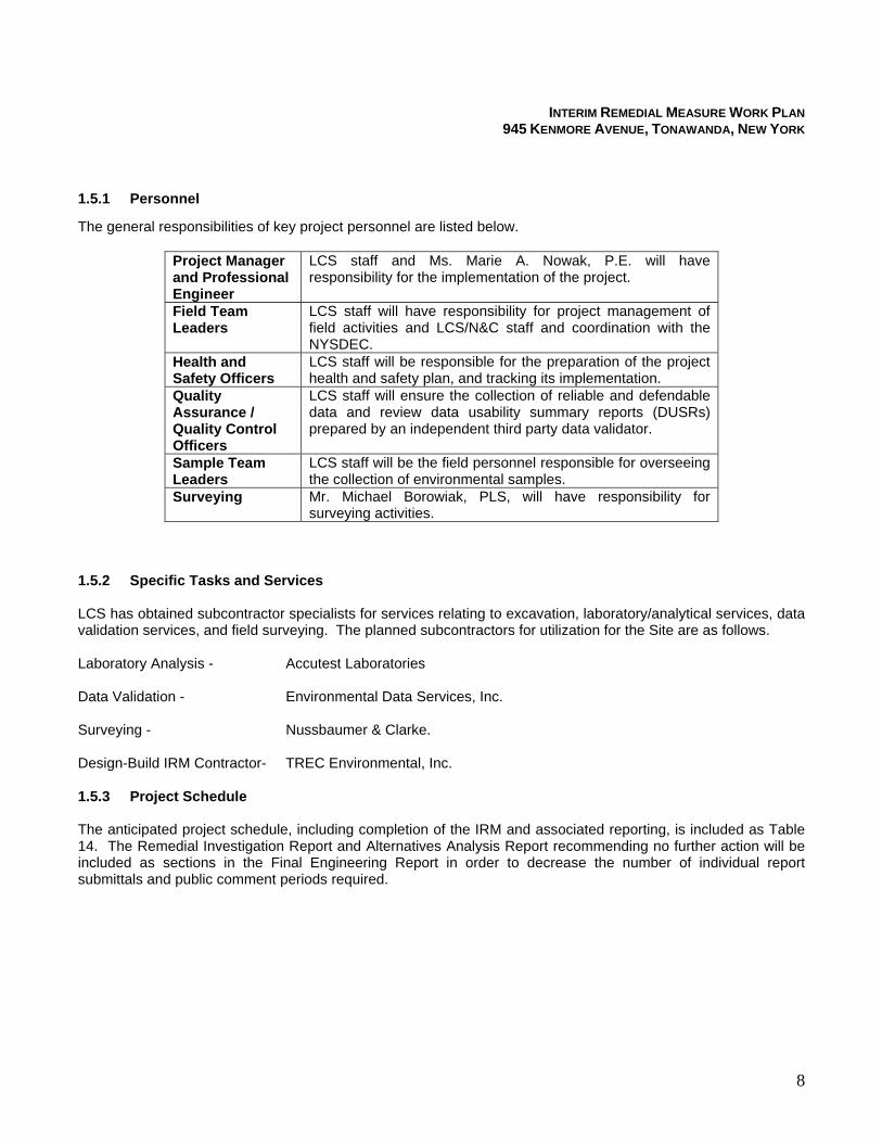
1.5.1 Personnel
The general responsibilities of key project personnel are listed below.
Project Manager and Professional Engineer
LCS staff and Ms. Marie A. Nowak, P.E. will have responsibility for the implementation of the project.
Field Team Leaders
LCS staff will have responsibility for project management of field activities and LCS/N&C staff and coordination with the NYSDEC.
Health and Safety Officers
LCS staff will be responsible for the preparation of the project health and safety plan, and tracking its implementation.
Quality Assurance / Quality Control Officers
LCS staff will ensure the collection of reliable and defendable data and review data usability summary reports (DUSRs) prepared by an independent third party data validator.
Sample Team Leaders
LCS staff will be the field personnel responsible for overseeing the collection of environmental samples.
Surveying Mr. Michael Borowiak, PLS, will have responsibility for surveying activities.
1.5.2 Specific Tasks and Services
LCS has obtained subcontractor specialists for services relating to excavation, laboratory/analytical services, data validation services, and field surveying. The planned subcontractors for utilization for the Site are as follows. Laboratory Analysis - Accutest Laboratories Data Validation - Environmental Data Services, Inc. Surveying - Nussbaumer & Clarke. Design-Build IRM Contractor- TREC Environmental, Inc. 1.5.3 Project Schedule
The anticipated project schedule, including completion of the IRM and associated reporting, is included as Table 14. The Remedial Investigation Report and Alternatives Analysis Report recommending no further action will be included as sections in the Final Engineering Report in order to decrease the number of individual report submittals and public comment periods required.
INTERIM REMEDIAL MEASURE WORK PLAN 945 KENMORE AVENUE, TONAWANDA, NEW YORK
9
2.0 INTERIM REMEDIAL MEASURES
As described in Section 1.2.2, analytical results to date have not identified soil contaminants at concentrations above the Part 375 SCOs for Track 2 Residential, and the concentrations of contaminants identified in groundwater on-site do not necessitate groundwater remedial activities. The Site will also be subject to a groundwater use restriction as part of an Environmental Easement for the site. The NYSDEC and NYSDOH are requiring excavation of soils in the three former pump island areas along Kenmore Avenue due to unacceptable nuisance characteristics, and an examination of soils in the former pump island area along South Irving Terrace (Figure 2-1). The NYSDEC indicated that soil excavation in the historic tank nest area, underneath the slab of the former western building, and along the utility trench on the north-central portion of the Site is not required; however, if impacted soils are identified during removal of the hydraulic lifts, the impacted soils will require removal. The NYSDEC indicated that the underground communications line that travels north to south through the Site, through/proximate to a former pump island location along Kenmore Avenue, will not need to be terminated; rather, impacted soils can be excavated by hand at this utility. Removal of the two on-site USTs is also required. Lastly, the NYSDEC indicated that an examination of soils underneath the eastern building following demolition is required. Prior to initiation of subsurface work, the five permanent monitoring wells installed during the RI, along with a historic monitoring well located west adjacent to the Eastern Building, will be properly abandoned. The soil samples collected from the Site during the RI and submitted for analysis met the Part 375 SCOs for Track 2 Residential. An IRM is proposed to mitigate risks to public health and the environment attributable to the in-ground hydraulic lifts and tanks present at the Site, which may function as sources of future releases on-site, and to expedite the redevelopment schedule by removing soil with an unacceptable degree of nuisance characteristics which would potentially need to be transported off-site for disposal during redevelopment. Based on the nature and extent of contamination, as indicated by the results of the Remedial Investigation, the most applicable remedial measure is source removal via excavation with off-site disposal. The proposed IRM will be performed as described in this work plan. 2.1 OBJECTIVES The objective of the IRM is to:
Eliminate the potential for exposure to impacted soil resulting from future releases from the in-ground hydraulic lifts and USTs remaining at the Site, by removing these sources;
Eliminate the potential for groundwater contamination resulting from future releases from the in-ground hydraulic lifts and USTs remaining at the Site, by removing these sources;
Eliminate the potential for VOCs to impact soil vapor on-site resulting from future releases from the in-ground hydraulic lifts and USTs remaining at the Site, by removing these sources; and
Expedite the redevelopment of the Site by removing soil with an unacceptable degree of nuisance characteristics.
The major components of the proposed IRM include (Figure 2-1):
Installation of temporary chain-link fencing around the perimeter of the Site; Installation of silt fencing/straw bales at the Site to reduce the potential for erosion; Demolition of the existing structure and rerouting/termination of the existing on-site subsurface utilities
required for demolition (to be completed by the property owner in accordance with all applicable regulations);
Completion of an additional borehole(s) at the former pump island location located along South Irving Terrace [to be completed during waste characterization drilling], to determine if soil excavation in this area is necessary;
INTERIM REMEDIAL MEASURE WORK PLAN 945 KENMORE AVENUE, TONAWANDA, NEW YORK
10
Removal of the five newly installed monitoring wells and one historic monitoring well present at the Site
(Figure 2-1) by pulling the casings while grouting according to NYSDEC CP-43 Groundwater Monitoring Well Decommissioning Policy (November 3, 2009).
Removal of the two existing on-site USTs (and any associated piping) as shown on Figure 2-1; Removal of the four existing in-ground hydraulic lift systems as shown on Figure 2-1; Removal and off-site disposal of soil exhibiting an unacceptable degree of nuisance characteristics in the
four pump island areas, fill port areas, and hydraulic lift areas, as shown on Figure 2-1; Completion of a test pit over the anomaly identified during the geophysical survey north adjacent to the
former pump island location along South Irving Terrace to a depth of approximately 6 ft. bgs, followed by tank removal if a tank is identified;
Inspection of soil underlying the garage structure following demolition by completion of two test pits to a depth of approximately 10 ft. bgs, followed by soil excavation if necessary; and
Placement and compaction of non-impacted soil from an off-site source(s) [i.e., Part 375 Unrestricted Use compliant] as backfill.
This Work Plan addresses the following tasks in detail:
Health and Safety Plan Development Pre-mobilization meetings, including a public meeting if requested by an interested party. Pre-excavation survey. Removal of in-ground hydraulic lift systems, monitoring wells, and USTs. Components of soil excavation and soil backfill. Dust, storm water, and erosion control measures required for minimizing potential releases of soils
outside the work zone during construction. Verification sampling. Equipment decontamination requirements. Off-site transportation and disposal of soil. Placement of backfill soils and gravel. Project documentation and schedule.
A detailed discussion of the tasks associated with implementation of the IRM is included in the following sections. 2.2 PRE-MOBILIZATION TASKS 2.2.1 Project Coordination Meeting If requested, a project coordination meeting will be held with representatives of the Project Team, including the remediation contractor and the designated NYSDEC and NYSDOH contact(s). The meeting will be held prior to the start of IRM activities to review responsibilities, personnel assignments, and construction details. LCS will prepare meeting minutes for distribution to attendees following the project coordination meeting. 2.2.2 Pre-Excavation Survey and Underground Utilities Location Prior to initiating subsurface work, a licensed NY State professional land surveyor will be responsible for establishing a temporary benchmark on-site for use in determining excavation depth. The surveyor will also survey elevation across the work area prior to and subsequent to excavation that will be used to determine excavation and backfill quantities.
INTERIM REMEDIAL MEASURE WORK PLAN 945 KENMORE AVENUE, TONAWANDA, NEW YORK
11
The remediation contractor will locate, with the assistance of utility companies, all active utility lines within the work area. The remediation contractor will contact the responsible utility companies to acquire depth and configuration information, and to inform them of the intended excavation work. Underground lines will be staked and marked with fluorescent paint. Any underground utilities not previously surveyed will be surveyed. If underground utilities are encountered during excavation activities, excavation will proceed no deeper than the top of bedding above the pipe. Care will be taken not to disturb buried utility lines. Hand removal may be required in the immediate vicinity of the utility. Any damage to utilities caused by the excavation or backfill work will be immediately repaired. 2.2.3 Health and Safety Plan Development A Site-Specific Health and Safety Plan (HASP) has been prepared by LCS in accordance with the requirements of 29 CFR 1910.120. The HASP will cover all on-site remediation activities. LCS will be responsible for the health and safety of its site workers. The remediation contractor is responsible for site control and the health and safety of its site workers. LCS’s HASP is located in Appendix C. The remediation contractor will be required to develop their own HASP. In addition, LCS or LCS’ designee will be responsible for the performance of community air monitoring, as discussed in the HASP. 2.3 IRM ACTIVITIES 2.3.1 Building Demolition Prior to initiation of excavation work, the existing building will be demolished in accordance with all applicable rules and regulations. The property owner will be performing this work directly; such is not described within this work plan. LCS and the NYSDEC will be on-site to observe the demolition. 2.3.2 Waste Characterization Testing and Additional Investigation of Pump Island Prior to initiation of excavation work, composite soil samples will be collected from the anticipated areas of excavation at the Site utilizing a direct-push Geoprobe drill rig and submitted for waste characterization analysis in accordance with the designated permitted solid waste disposal facility’s requirements in order to facilitate direct-loading of excavated soils into trucks for off-site disposal. Based on the anticipated excavation depths, test borings completed to facilitate sample collection will be completed to a depth of approximately 8 ft. bgs. Waste characterization samples will be analyzed in accordance with USEPA SW-846 methodology. Copies of the waste profile will be provided with each load of excavated soil leaving the Site, if required by the disposal facility. During the waste characterization drilling activities, LCS will also complete at least one test boring through the former pump island location along South Irving Terrace (Figure 2-1) to a depth of approximately 16 ft. bgs, to better assess (with NYSDEC concurrence) if soil excavation will be required in the area of this former pump island. Any excess soils generated during the waste characterization sample collection and additional investigation of the pump island will be stored in drums on-site for future off-site disposal. 2.3.3 Monitoring Well Decommissioning Prior to soil removal activities, the five permanent groundwater monitoring wells installed during the RI and a historic well located west of the Eastern Building (Figure 2-1) will be removed by pulling the casings while grouting according to NYSDEC CP-43 Groundwater Monitoring Well Decommissioning Policy (November 3, 2009). The removed casings will be disposed of in a dumpster as solid waste. Any excess soils and any removed well sands/bentonite will be stored in drums on-site for future off-site disposal.
INTERIM REMEDIAL MEASURE WORK PLAN 945 KENMORE AVENUE, TONAWANDA, NEW YORK
12
2.3.4 Test Pits Beneath the Eastern Building/Garage The soil removal activities will include completion of two test pits to a depth of approximately 10 ft. bgs beneath the eastern building/garage structure following its demolition (Figure 2-1). If underlying soils are exposed following demolition, the footprint of the building will be tarped such that any impacted soils will be covered until the remediation contractor’s arrival on-site to complete the test pits. Soil excavated from within the test pits will be examined for evidence of chemical impact and screened with a PID. Soil excavated from the test pits will be segregated and staged on plastic on-site, and will be covered. Following excavation of any obviously-impacted soils, one discrete soil sample biased towards the most obviously impacted area will be collected from within each test pit and submitted for laboratory analysis for TCL and CP-51 list VOCs, TCL SVOCs, TAL Metals, Cyanide, and PCBs in accordance with USEPA SW-846 Test Methods 8260, 8270, 6010/7471, 9012, and 8082, respectively. Following review of the analytical results, the NYSDEC will determine if any characterization testing of the stockpiled “clean” soil will be required in order to approve use of the soil as backfill for the test pits. Depending on costs for waste characterization, the stockpiled “clean” soil may be sent off-site for disposal with the stockpiled “dirty” soil, and the test pits backfilled with imported DER-10 compliant material. If backfilling with imported material is chosen, the test pits will be surrounded with temporary fencing and backfilled at the same time as the other areas to be excavated on-site. 2.3.5 UST Removals Prior to excavation of the four former pump island areas, the residual contents will be removed from the two USTs located to the northeast and southeast of the former Western Building (Figure 2-1), and the tanks and any associated piping will be removed. Any wastes from the tanks will be containerized into drums or a vacuum truck for off-site disposal. The tanks will be rendered free of petroleum vapors. The tanks will be staged on plastic on-site for cleaning of the interiors in preparation for off-site disposal/recycling. If petroleum-impacted soils are encountered during tank removal, they will be removed until the soils no longer exhibit nuisance petroleum odors and PID readings less than 50 ppm are reached. Excavation will not exceed 15 feet in depth. 2.3.6 Soil and Hydraulic Lift Excavation Following the tank removals, petroleum-impacted soils will be removed from the three former pump island areas along Kenmore Avenue and from the former pump island area along South Irving Terrace, if necessary, pending the results of the additional drilling investigation in that area (Figure 2-1). A test pit will also be completed to a depth of approximately 6 ft. bgs over the geophysical anomaly identified north adjacent to this former pump island location. The concrete pad associated with the former western building, the four in-ground hydraulic lift systems, and petroleum-impacted soil associated with the lifts will be removed at the same time. Soil excavation will continue until the soils no longer exhibit nuisance petroleum odors and PID readings less than 50 ppm are reached. Excavation will not exceed 15 feet in depth. Based on the results of the RI, the estimated lateral extent of excavation is presented on Figure 2-1. Excavation depth is anticipated to range between approximately 1 and 12 ft. bgs. Excavation sidewalls will be maintained as close to vertical as possible, except when necessary to comply with OSHA requirements. The lateral extent of excavation will be adjusted as determined by field observations and confirmatory sampling. A photoionization detector (PID) will be employed to assist in determining the excavation limits prior to verification sampling. If verification samples indicate soil concentrations above the Part 375 SCOs for Track 2 Residential, excavation will continue until soil concentrations are below the Part 375 SCOs for Track 2 Residential. Excavation off-site (i.e., into the streets) will not be completed. If/when unanticipated structures or debris or known tanks are uncovered that are not consistent with typical fill material (e.g., buried foundations, etc.), LCS will immediately notify the NYSDEC and will discuss an appropriate course of action.
INTERIM REMEDIAL MEASURE WORK PLAN 945 KENMORE AVENUE, TONAWANDA, NEW YORK
13
2.3.7 Soil Disposal Excavated soils (and stockpiled soils from the test pits underneath the garage structure) will be direct-loaded into dump trucks for off-site disposal. Care will be taken to minimize dust formation during loading. The excavation equipment will have sufficient boom length to allow for placement of soils into the truck bed. Side dumping (i.e., with a front-end loader) will only be permitted if fugitive dust can be consistently controlled within the Community Air Monitoring Plan action limits. If disposal transport truck scheduling necessitates stockpiling of excavated soils, the stockpiles will be covered with plastic tarp and ballast during non-working hours. Excavated areas will be left open pending the receipt of verification sampling indicating that the excavated areas meet the Part 375 SCOs for Track 2 Residential. Upon receipt of acceptable results, the excavated areas will be backfilled and the backfill will be compacted. Once backfill activities are substantially complete, heavy equipment demobilization and decontamination pad removal (if utilized) can occur. Operation of heavy equipment on the work site will be limited throughout the duration of the project to 8:00 a.m. through 5:00 p.m., Monday through Friday, excluding holidays. 2.3.8 Verification Sampling Verification sampling will be performed on the sidewalls and bottom of the excavated areas after lateral and vertical excavation limits have been achieved and the soils no longer exhibit nuisance petroleum odors and PID readings less than 50 ppm are reached, or the Site boundary has been encountered, or the NYSDEC agrees that no further excavation is required. Excavation will not exceed 15 feet in depth. In general, verification samples will be collected on each of the four sides of each excavated area and from the bottom of each excavated area (with the exception of the test pits to be completed underneath the Eastern Building upon demolition – Refer to Section 2.3.4). A minimum of one sample per 30 linear feet of sidewall and one sample for each 900 square feet of excavation bottom will be collected from each excavated area. If needed, the backhoe bucket will be used to assist in sample collection to avoid the need for confined space entry. As the excavation progresses, verification soil samples will be collected and submitted for laboratory analysis for CP-51 VOCs only, in accordance with USEPA SW-846 methodology. The laboratory will be required to furnish an equivalent ASP Category B deliverables package to facilitate data evaluation by a third-party validation expert. Sample handling will be conducted in general accordance with the procedures outlined in Section 4.0 of the RI Work Plan (January 2015, revised). Quality Assurance (QA) samples will be collected to support the verification sample data evaluation. The QA samples will include a minimum of one matrix spike, one matrix spike duplicate, and one blind duplicate per 20 verification samples. Equipment/rinsate blanks and trip blanks will not be necessary. Quality assurance and quality control sampling will be conducted in general accordance with the procedures outlined in Sections 3.4 and 5.0 of the RI Work Plan (January 2015, revised). Data reduction, validation, and reporting will be conducted in general accordance with the procedures outlined in Section 9.0 of the RI Work Plan (January 2015, revised). 2.3.9 Backfilling Excavated areas will be backfilled with imported fill material. Off-site sources intended for use as backfill will be approved by the NYSDEC prior to acceptance at the Site. Only materials originating from borrow sources which have already been deemed DER-10 compliant will be utilized, to avoid the need for sampling/chemical characterization of backfill material. Backfill materials will be maintained at a sufficient distance from the working face of the excavation to prevent contact or mixing with soils designated for removal. Wetting of the backfill soil during placement, spreading, and compaction will be performed if needed to control fugitive dust within the Community Air Monitoring Plan action limits.
INTERIM REMEDIAL MEASURE WORK PLAN 945 KENMORE AVENUE, TONAWANDA, NEW YORK
14
Backfilled areas will be compacted by approved compaction equipment. Standard proctor tests will be employed to establish a maximum compaction. Backfill originating from off-site sources will be compacted to achieve 95% of maximum dry density as determined by the Modified Proctor Test. The handling, spreading, and compacting of backfill will be directed toward obtaining a stable and homogeneous fill that is free of stratifications, lenses, or pockets. Backfill will not occur when soils are frozen or moisture content is too high/low to achieve compaction requirements. Admixing of wet soils with dry backfill material and addition of water will be permitted to achieve suitable moisture content if needed. 2.3.10 Progress Meetings and Citizen Participation Due to the anticipated short duration of IRM activities and the anticipation that the NYSDEC will be on-site periodically to inspect the work being performed, on-site progress meetings will not be held unless requested. The NYSDEC and NYSDOH will inform the remedial party if any fact sheet distribution or other citizen’s participation activities will need to be performed during the IRM. A copy of the executed IRM Work Plan will be placed in the document repository prior to the start of the IRM. 2.4 TEMPORARY CONTROLS Temporary controls will be employed for protection against off-site migration of soil and safety hazards during the IRM. These will include safety fencing, dust suppression, vapor/odor suppression, erosion/sedimentation control, and equipment staging and decontamination as further described below. 2.4.1 Safety Fencing
Temporary safety construction fencing (i.e., 3-foot high orange plastic or 6-foot chain link) will be placed around the outer perimeter of the excavations and work areas to distinguish the work zone and discourage trespassing. The fencing will not be removed until the excavation and backfilling work is complete. 2.4.2 Dust Suppression
Dust suppression during site excavation work will be an integral and critical component of the soil removal and soil backfill activities. During soil/ excavation and loading activities, if needed, the remediation contractor will apply a water spray across the excavation face and surrounding areas to mitigate airborne dust formation and migration. Water will also be sprayed as needed to control dust migration from the handling, placement, and compaction of backfill soils. Potable water for spraying will be mobilized to the site by the remediation contractor. Other dust suppression techniques that may be used to supplement the water spray include:
Applying water on haul roads
Hauling materials in properly tarped containers or vehicles
Restricting vehicle speeds on-site
Covering excavated areas and materials after excavation activity ceases
Reducing the excavation size and/or number of excavations Dust suppression techniques shall be employed if needed even if the community air monitoring results indicate particulate levels are below action levels. All reasonable attempts will be made to keep visible and/or fugitive dust to a minimum.
INTERIM REMEDIAL MEASURE WORK PLAN 945 KENMORE AVENUE, TONAWANDA, NEW YORK
15
2.4.3 Vapor/Odor Suppression Due to the highly developed commercial/residential area surrounding the site, vapor and odor suppression techniques may be required during excavation of contaminated soil. As a contingency, the remedial contractor will be prepared to spray BioSolve® vapor suppression foam, or a similar product, to limit vapors and odors emanating from the open excavation.
2.4.4 Erosion and Sedimentation Control
Provisions will be made for erosion and sedimentation control at the work perimeter. Continuous double-wall silt fencing will be installed prior to the initiation of excavation activities and will remain on the site perimeter until remediation activities have been completed. Hay bales may be installed on-site if needed to further reduce the potential for erosion. 2.4.5 Groundwater Management
Groundwater is present within overburden soils in the vicinity of the proposed excavation areas at depths greater than 20 ft. bgs. Therefore, groundwater management is not expected to be necessary during IRM activities. 2.4.6 Equipment Staging and Decontamination Prior to vehicles leaving the site they will be inspected and cleaned as necessary for the removal of visible material which could become dislodged from the exterior, including the tires/undercarriage. A self-contained decontamination station of sufficient size to decontaminate the largest piece of equipment leaving the Site will be established on-site (if deemed necessary). The decontamination station will be lined with 60-mil HDPE and a protective geotextile fabric. The perimeter will be bermed approximately six inches above existing grade and sloped for collection and pumping of decontamination water. Decontamination will be performed with a high-pressure washer located within the decontamination basin. Decontamination water will be pumped to drums for off-site disposal. At the end of excavation activities, all equipment leaving the Site that have been in direct contact with soil in the work area will be required to proceed through the decontamination station for removal of visible material from tires/undercarriage, etc. Vehicles not in significant contact with soil/fill spoils or excavations will be inspected prior to leaving the Site and decontaminated if necessary. Equipment that remains at the Site during the week and weekends will be left within the temporary fenced areas within the work zone. Alternately, for security purposes, equipment may be decontaminated and removed from the Site for temporary storage at a secured area. Area streets will also be cleaned if necessary to mitigate dust or mud from vehicles entering/leaving the Site. 2.5 COMMUNITY AIR MONITORING Real-time community air monitoring will be performed during IRM activities at the Site. A Community Air Monitoring Plan is included within LCS’s HASP in Appendix C. Community air monitoring will be performed in accordance with “New York State Department of Health Generic Community Air Monitoring Plan,” dated June 20, 2000. Particulate and VOC monitoring will be performed along the upwind and downward perimeter of the work area during subgrade excavation, grading, and soil handling activities in accordance with this plan. Weekly Community Air Monitoring Plan reports will be submitted to the NYSDOH Project Manager.
INTERIM REMEDIAL MEASURE WORK PLAN 945 KENMORE AVENUE, TONAWANDA, NEW YORK
16
2.6 DOCUMENTATION AND REPORTING
A construction observer will be on-site full-time during the remedial measures to document activities for the purposes of updating the Professional Engineer. The NYSDEC and NYSDOH will be kept informed of the progress of remedial activities.
2.6.1 Daily Monitoring Standard daily reporting procedures will include preparation of a daily report and, when appropriate, problem identification and corrective measures reports. Appendix D contains sample project documentation forms. Information that may be included on the daily report form includes:
Processes and locations of construction under way. Equipment and personnel working in the area, including subcontractors. Number and type of truckloads of soil/fill removed from the site. A description of off-site materials received, including any quality verification (certification)
documentation. Community air monitoring log
A problem identification report and a corrective measure report will be completed whenever major field problems are encountered and corrective measures may be necessary. The NYSDEC will be promptly notified of problems requiring modifications to this Work Plan prior to proceeding or completion of the construction item. Changes or additions will be noted in the Final Engineering Report.
The completed reports will be submitted to the NYSDEC as part of the Final Report and any time requested.
Photo documentation of the IRM activities will be prepared throughout the duration of the project as necessary to convey typical work activities and whenever changed conditions or special circumstances arise. Photos will be provided in digital format if requested, and will be included in the Final Engineering Report.
2.6.2 Progress Reports
Due to the anticipated brief nature of remedial activities and anticipation that the NYSDEC will be on-site periodically to inspect the work being performed, weekly and monthly progress reports will not be generated unless requested. The NYSDEC and NYSDOH will be provided informal updates as to the status of the remedial activities.
2.6.3 Final Engineering Report
Upon completion of the activities undertaken as described in this work plan, a final Remedial Investigation/Interim Remedial Measures/Alternatives Analysis Report will be generated for the Site. The final report will include a summary of the RI and IRM actions and investigation work completed, as well as all data generated relative to the Site and other information obtained as part of the implementation of the work plan (e.g., boring logs, well construction diagrams, detailed site plan documenting sampling locations, groundwater flow maps, analytical data, data usability reports, volumes and limits of contamination, etc.). A qualitative on- and off-site exposure assessment and receptor analysis, as well as an alternatives analysis, will be included in the final report. The final report will follow the Final Engineering Report template provided by the NYSDEC, with additions for the RI sections. As the Site will not attain a Track 1 COC, a Site Management Plan and Environmental Easement will also be prepared for the Site. The final report will be certified by the person with primary responsibility for day to day performance of the activities undertaken as part of the investigation. The final report will be submitted to the NYSDEC for their review and comment.
INTERIM REMEDIAL MEASURE WORK PLAN 945 KENMORE AVENUE, TONAWANDA, NEW YORK
17
2.7 PROJECT SCHEDULE The IRM field activities detailed above shall be completed within approximately 1 month or less, following approval of the Work Plan. Table 14 presents and overall project schedule for the performance of the IRM and subsequent reporting through attainment of the Certificate of Completion.
TABLES
Table 1
945 Kenmore Avenue Tonawanda, New York
Remedial Investigation Analytical Results for Soil Samples
VOCs by USEPA SW-846 Method 8260
Former Pump Island Areas and Tank Nest
Sample ID BH1 BH3 BH4 BH10 BH12 BH12 Duplicate Part 375 (Unrestricted) Soil
µg/kg = micrograms per kilogram J = Indicates an estimated value
NL = Not Listed Part 375 Soil Cleanup Objectives = New York State Department of Environmental Conservation 6 NYCRR Part 375 Environmental Remediation Programs, December 14, 2006
(375-6.8, Soil Cleanup Objective Tables) *= Based on the sum of the Total Xylene
BH12 Duplicate (2-4 ft. bgs) named BH8 (6-8 ft. bgs) on chain of custody = Analyte detected at a concentration at or above the Part 375 Soil Cleanup Objectives for Unrestricted Site Use
Exterior to Eastern Building and Former Western Building
Sample ID BH6 BH7 BH14 BH16 Part 375 (Unrestricted) Soil
µg/kg = micrograms per kilogram J = Indicates an estimated value
NL = Not Listed Part 375 Soil Cleanup Objectives = New York State Department of Environmental Conservation 6 NYCRR Part 375 Environmental Remediation Programs, December 14, 2006
(375-6.8, Soil Cleanup Objective Tables) *= Based on the sum of the Total Xylene
= Analyte detected at a concentration at or above the Part 375 Soil Cleanup Objectives for Unrestricted Site Use
Within Former Western Building Sample ID BH17 BH18 BH19 Part 375
µg/kg = micrograms per kilogram J = Indicates an estimated value
NL = Not Listed Part 375 Soil Cleanup Objectives = New York State Department of Environmental Conservation 6 NYCRR Part 375 Environmental Remediation Programs, December 14, 2006
(375-6.8, Soil Cleanup Objective Tables) *= Based on the sum of the Total Xylene
Table 2
945 Kenmore Avenue Tonawanda, New York
Remedial Investigation Analytical Results for Soil Samples
SVOCs by USEPA SW-846 Method 8270
Former Pump Island Areas and Tank Nest
Sample ID BH1 BH3 BH4 BH10 BH12 BH12 Duplicate Part 375 (Unrestricted) Soil
µg/kg = micrograms per kilogram J = Indicates an estimated value
NL = Not Listed 1 = 3-Methylphenol / 4-Methylphenol
Part 375 Soil Cleanup Objectives = New York State Department of Environmental Conservation 6 NYCRR Part 375 Environmental Remediation Programs, December 14, 2006 (375-6.8, Soil Cleanup Objective Tables)
BH12 Duplicate (2-4 ft. bgs) named BH8 (6-8 ft. bgs) on chain of custody
Exterior to Eastern Building and Former Western Building
Sample ID BH6 BH7 BH14 BH16 Part 375 (Unrestricted) Soil
µg/kg = micrograms per kilogram J = Indicates an estimated value
NL = Not Listed 1 = 3-Methylphenol / 4-Methylphenol
Part 375 Soil Cleanup Objectives = New York State Department of Environmental Conservation 6 NYCRR Part 375 Environmental Remediation Programs, December 14, 2006 (375-6.8, Soil Cleanup Objective Tables)
Within Former Western Building
Sample ID BH17 BH18 BH19 Part 375 (Unrestricted) Soil
µg/kg = micrograms per kilogram J = Indicates an estimated value
NL = Not Listed 1 = 3-Methylphenol / 4-Methylphenol
Part 375 Soil Cleanup Objectives = New York State Department of Environmental Conservation 6 NYCRR Part 375 Environmental Remediation Programs, December 14, 2006 (375-6.8, Soil Cleanup Objective Tables)
Table 3
945 Kenmore Avenue Tonawanda, New York
Remedial Investigation Analytical Results for Soil Samples
Metals by USEPA SW-846 Methods 6010/7471A
Exterior to Eastern Building
Sample ID BH2 BH5 BH5 Duplicate BH6 Eastern USA Background
mg/kg = milligrams per kilogram B = Indicates analyte found in associated method blank
NL = Not Listed NA = Not Available ND = Not Detected
* = New York State Background 1 = Hexavalent Chromium/Trivalent Chromium
2 = New York State Department of Environmental Conservation Memorandum – Technical and Administrative Guidance Memorandum: Determination of Soil Cleanup Objectives and Cleanup Levels, Appendix A, Table 4 (January 24, 1994 [Revised]) 3 = New York State Department of Environmental Conservation and New York State Department of Health Concentrations of Selected Analytes in Rural New York State Surface Soils: A Summary Report on the Statewide Rural Surface Soil Survey (August 2005)
4 = Values are 25th-75th percentiles; Table D-1 “Final data set for analytes detected in habitat areas” a = The Soil Cleanup Objective for this specific compound (or family of compounds) is considered to be met if the analysis for the total species of this contaminant is below the specific Soil Cleanup Objective.
Part 375 Soil Cleanup Objectives = New York State Department of Environmental Conservation 6 NYCRR Part 375 Environmental Remediation Programs, December 14, 2006 (375-6.8, Soil Cleanup Objective Tables) *** = Background levels for lead vary widely. Average levels in undeveloped, rural areas may range from 4- 61 mg/kg. Average background levels in metropolitan or suburban areas, or near highways, typically range between 200- 500 mg/kg.
BH5 Duplicate (0-2 ft. bgs) named BH4 (0-2 ft. bgs) on chain of custody
Exterior to Former Western Building Sample ID BH11 BH12 BH13 BH14 BH15 BH16 Eastern USA
Background Concentrations2
New York State “Habitat” Background
Concentrations3,4
Part 375 (Unrestricted) Soil
Cleanup Objectives
Part 375 (Residential) Soil
Cleanup Objectives Date Sampled 2/11/2015 2/11/2015 2/11/2015 2/11/2015 2/12/2015 2/12/2015 Sample Location 0-4 ft. bgs 0-2 ft. bgs 0-2 ft. bgs 0-2 ft. bgs 0-2 ft. bgs 0-2 ft. bgs Units mg/kg mg/kg mg/kg mg/kg mg/kg mg/kg mg/kg mg/kg mg/kg mg/kg Aluminum 13,100 16,500 10,600 14,900 15,300 14,300 33,000 5,950 – 12,750 NL NL Antimony <0.12 <0.11 <0.11 <0.12 0.14 B <0.11 NA NL NL NL Arsenic 3.7 4 4 3.5 5.2 3.3 3-12* 1.7 – 7.4 13 16 Barium 106 124 90.8 104 104 101 15-600 37 - 87 350 350 Beryllium 0.61 0.74 0.53 0.65 0.48 0.43 0-1.75 0.4 – 0.7 7.2 14 Cadmium 0.15 B 0.13 B 0.18 B 0.21 B 0.26 B 0.25 B 0.1-1 0.1 – 0.8 2.5 2.5 Calcium 72,500 37,600 85,600 26,400 41,000 34,300 130-35,000* 743 – 2,820 NL NL Chromium 17.9 20.7 13.6 17.2 16.6 15.4 1.5-40* 5.0 – 13.5 (1a/30a)1 (22a/36a)1 Cobalt 8.9 10.3 6.7 9.1 10.2 7.9 2.5-60* 3.2 – 8.5 NL NL Copper 18.2 19.9 18.9 13.9 12.7 15.3 1-50 6 – 15 50 270 Iron 20,200 26,800 16,300 22,600 24,700 19,800 2,000-550,000 8,770 – 19,800 NL NL Lead 11.6 17.9 14.3 24.5 18.6 23.5 *** 17 – 37 63 400 Magnesium 20,200 20,200 15,200 9,630 12,500 13,900 100-5,000 954 – 2,925 NL NL Manganese 472 497 494 550 938 385 50-5,000 147 – 650 1,600 2,000 Mercury 0.018 B 0.029 B 0.029 B 0.036 0.025 B 0.031 B 0.001-0.2 0.05 – 0.10 0.18 0.81 Nickel 20.8 23.7 16.2 16 16.8 16.6 0.5-25 4 – 17 30 140 Potassium 2,460 2,710 1,670 1,380 1,920 1,590 8,500-43,000* 286 – 949 NL NL Selenium <0.25 <0.23 <0.24 <0.25 <0.25 <0.24 0.1-3.9 1.2 – 2.6 3.9 36 Silver 0.061 B 0.055 B <0.042 0.060 B 0.099 B 0.088 B NA ND - ND 2.0 36 Sodium 314 B 257 B 246 B 127 B 170 B 185 B 6,000-8,000 57 – 111 NL NL Thallium 0.18 B <0.13 0.17 B <0.14 0.42 B 0.40 B NA NL NL NL Vanadium 25.9 29.2 21.7 30 24.5 23.9 1-300 12 – 23 NL NL Zinc 67.2 95 57.7 78.4 76.6 82 9-50 30 – 70 109 2,200
mg/kg = milligrams per kilogram B = Indicates analyte found in associated method blank
NL = Not Listed NA = Not Available
* = New York State Background 1 = Hexavalent Chromium/Trivalent Chromium
2 = New York State Department of Environmental Conservation Memorandum – Technical and Administrative Guidance Memorandum: Determination of Soil Cleanup Objectives and Cleanup Levels, Appendix A, Table 4 (January 24, 1994 [Revised]) 3 = New York State Department of Environmental Conservation and New York State Department of Health Concentrations of Selected Analytes in Rural New York State Surface Soils: A Summary Report on the Statewide Rural Surface Soil Survey (August 2005)
4 = Values are 25th-75th percentiles; Table D-1 “Final data set for analytes detected in habitat areas” a = The Soil Cleanup Objective for this specific compound (or family of compounds) is considered to be met if the analysis for the total species of this contaminant is below the specific Soil Cleanup Objective.
Part 375 Soil Cleanup Objectives = New York State Department of Environmental Conservation 6 NYCRR Part 375 Environmental Remediation Programs, December 14, 2006 (375-6.8, Soil Cleanup Objective Tables) *** = Background levels for lead vary widely. Average levels in undeveloped, rural areas may range from 4- 61 mg/kg. Average background levels in metropolitan or suburban areas, or near highways, typically range between 200- 500 mg/kg.
Within Former Western Building Sample ID BH17 BH18 BH19 Eastern USA
mg/kg = milligrams per kilogram B = Indicates analyte found in associated method blank
NL = Not Listed NA = Not Available
* = New York State Background 1 = Hexavalent Chromium/Trivalent Chromium
2 = New York State Department of Environmental Conservation Memorandum – Technical and Administrative Guidance Memorandum: Determination of Soil Cleanup Objectives and Cleanup Levels, Appendix A, Table 4 (January 24, 1994 [Revised]) 3 = New York State Department of Environmental Conservation and New York State Department of Health Concentrations of Selected Analytes in Rural New York State Surface Soils: A Summary Report on the Statewide Rural Surface Soil Survey (August 2005)
4 = Values are 25th-75th percentiles; Table D-1 “Final data set for analytes detected in habitat areas” a = The Soil Cleanup Objective for this specific compound (or family of compounds) is considered to be met if the analysis for the total species of this contaminant is below the specific Soil Cleanup Objective.
Part 375 Soil Cleanup Objectives = New York State Department of Environmental Conservation 6 NYCRR Part 375 Environmental Remediation Programs, December 14, 2006 (375-6.8, Soil Cleanup Objective Tables) *** = Background levels for lead vary widely. Average levels in undeveloped, rural areas may range from 4- 61 mg/kg. Average background levels in metropolitan or suburban areas, or near highways, typically range between 200- 500 mg/kg.
Table 4
945 Kenmore Avenue Tonawanda, New York
Remedial Investigation Analytical Results for Soil Samples
Cyanide by USEPA SW-846 Method 9012
Exterior to Eastern Building
Sample ID BH2 BH5 BH5 Duplicate BH6 Part 375 (Unrestricted) Soil
Cleanup ObjectivesDate Sampled 2/10/2015 2/10/2015 2/10/2015 2/10/2015 Sample Location 0-2 ft. bgs 0-2 ft. bgs 0-2 ft. bgs 0-2 ft. bgs Units mg/kg mg/kg mg/kg mg/kg mg/kg Cyanide 0.33 4 2.2 0.027 B 27
mg/kg = milligrams per kilogram B = Indicates analyte found in associated method blank
Part 375 Soil Cleanup Objectives = New York State Department of Environmental Conservation 6 NYCRR Part 375 Environmental Remediation Programs, December 14, 2006 (375-6.8, Soil Cleanup Objective Tables)
BH5 Duplicate (0-2 ft. bgs) named BH4 (0-2 ft. bgs) on chain of custody
Exterior to Former Western Building Sample ID BH11 BH12 BH13 BH14 BH15 BH16 Part 375
(Unrestricted) Soil Cleanup Objectives
Date Sampled 2/11/2015 2/11/2015 2/11/2015 2/11/2015 2/12/2015 2/12/2015 Sample Location 0-4 ft. bgs 0-2 ft. bgs 0-2 ft. bgs 0-2 ft. bgs 0-2 ft. bgs 0-2 ft. bgs Units mg/kg mg/kg mg/kg mg/kg mg/kg mg/kg mg/kg Cyanide <0.025 0.029 B <0.027 0.037 B 0.33 0.058 B 27
mg/kg = milligrams per kilogram B = Indicates analyte found in associated method blank
Part 375 Soil Cleanup Objectives = New York State Department of Environmental Conservation 6 NYCRR Part 375 Environmental Remediation Programs, December 14, 2006 (375-6.8, Soil Cleanup Objective Tables)
Within Former Western Building
Sample ID BH17 BH18 BH19 Part 375 (Unrestricted) Soil
Cleanup ObjectivesDate Sampled 2/12/2015 2/12/2015 2/12/2015 Sample Location 0-2 ft. bgs 0-2 ft. bgs 0-2 ft. bgs Units mg/kg mg/kg mg/kg mg/kg Cyanide 0.072 B 0.2 0.065 B 27
mg/kg = milligrams per kilogram B = Indicates analyte found in associated method blank
Part 375 Soil Cleanup Objectives = New York State Department of Environmental Conservation 6 NYCRR Part 375 Environmental Remediation Programs, December 14, 2006 (375-6.8, Soil Cleanup Objective Tables)
Table 5
945 Kenmore Avenue Tonawanda, New York
Remedial Investigation Analytical Results for Soil Samples
PCBs by USEPA SW-846 Method 8082
Exterior to Eastern Building
Sample ID BH2 BH5 BH5 Duplicate BH6 Part 375 (Unrestricted) Soil
µg/kg = micrograms per kilogram J = Indicates an estimated value
ND = Not detected Part 375 Soil Cleanup Objectives = New York State Department of Environmental Conservation 6 NYCRR Part 375 Environmental Remediation Programs, December 14, 2006
(375-6.8, Soil Cleanup Objective Tables) BH5 Duplicate (0-2 ft. bgs) named BH4 (0-2 ft. bgs) on chain of custody
Exterior to Western Building
Sample ID BH11 BH12 BH13 BH14 BH15 BH16 Part 375 (Unrestricted) Soil
Part 375 Soil Cleanup Objectives = New York State Department of Environmental Conservation 6 NYCRR Part 375 Environmental Remediation Programs, December 14, 2006 (375-6.8, Soil Cleanup Objective Tables)
Within Former Western Building
Sample ID BH17 BH18 BH19 Part 375 (Unrestricted) Soil
Part 375 Soil Cleanup Objectives = New York State Department of Environmental Conservation 6 NYCRR Part 375 Environmental Remediation Programs, December 14, 2006 (375-6.8, Soil Cleanup Objective Tables)
Table 6
945 Kenmore Avenue Tonawanda, New York
Remedial Investigation Analytical Results for Equipment Blanks and Trip Blanks
µg/l = micrograms per liter J = Indicates an estimated value
C. Metals by USEPA SW-846 Methods 6010/7471A Sample ID BCP EB1 Date Sampled 2/12/2015 Type Equipment Blank Units µg/l Aluminum 37.4 B Antimony <2.0 Arsenic <1.7 Barium <1.0 Beryllium <0.25 Cadmium <0.43 Calcium 352 B Chromium 4.6 B Cobalt <0.28 Copper <2.4 Iron 451 Lead <1.7 Magnesium 62.1 B Manganese 7.7 B Mercury <0.096 Nickel <0.50 Potassium <49 Selenium 2.6 B Silver <1.0 Sodium 570 B Thallium <1.7 Vanadium <0.51 Zinc <1.0
µg/l = micrograms per liter B = Indicates analyte found in associated method blank
D. Cyanide by USEPA SW-846 Method 9012 Sample ID BCP EB1 Date Sampled 2/12/2015 Type Equipment BlankUnits µg/l Cyanide <0.0025
µg/l = micrograms per liter
E. PCBs by USEPA SW-846 Method 8082 Sample ID BCP EB1 Date Sampled 2/12/2015 Type Equipment BlankUnits µg/l Aroclor 1016 <0.11 Aroclor 1221 <0.11 Aroclor 1232 <0.12 Aroclor 1242 <0.12 Aroclor 1248 <0.083 Aroclor 1254 <0.11 Aroclor 1260 <0.13 Total Aroclor ND
µg/l = micrograms per liter ND = Not Detected
Table 7
945 Kenmore Avenue Tonawanda, New York
Groundwater Depths in Site Overburden
Monitoring Wells Measured on March 24, 2015
Well Depth to Groundwater (feet below top of casing)
Name: BUFFALO NW (NY)Date: 08/07/12Scale: 1 inch = 2,000 ft.
Copyright (C) 2009 MyTopo
mpopek
Text Box
Figure 1-1 Site Location Map
mpopek
Callout
Site 945 Kenmore Avenue
mpopek
Text Box
mpopek
Text Box
Erie County On-Line Mapping Application
This map is a user generated static output from anInternet mapping site and is for reference only. Datalayers that appear on this map may or may not be
accurate, current, or otherwise reliable. 1,128
188.0
THIS MAP IS NOT TO BE USED FOR NAVIGATION
Legend
1:WGS_1984_Web_Mercator_Auxiliary_Sphere
Feet0 188.094.00 ERIE COUNTYDEPARTMENT OF ENVIRONMENT & PLANNING
OFFICE OF GIS
Streets and HighwaysInterstate
Primary State Road
Secondary State Road
County Road
Local Road
ParcelsMunicipal Boundaries2011_bdy
mpopek
Text Box
Figure 1-2 Site Overview
mpopek
Text Box
aerial imagery dated 2011
mpopek
Polygonal Line
mpopek
Callout
Boundaries of Site 945 Kenmore Avenue
mpopek
Callout
Eastern Building
mpopek
Callout
Western Building
mpopek
Callout
18 Fairmount Avenue Residence
mpopek
Callout
15 Irving Terrace Residence
mpopek
Callout
20 Irving Terrace Residence
mpopek
Callout
959 Kenmore Avenue Hanley Orthodontics
mpopek
Callout
956 Kenmore Avenue Kenmore Quality Care Dentistry, ALT Systems, Taoist Tai Chi Society, A.B.C.S., SEIU 1199 Upstate - The Healthcare Workers Union
mpopek
Callout
948 Kenmore Avenue George Palmer Studio
mpopek
Callout
938 Kenmore Avenue Sinatra's and apartments
mpopek
Callout
932 Kenmore Avenue Direct TV and apartments
mpopek
Callout
924 Kenmore Avenue Kenmore Eye Care
mpopek
Callout
914 Kenmore Avenue Yum My Thai (restaurant) and apartments
mpopek
Callout
919 Kenmore Avenue Law Offices of David F. Butterini
mpopek
Callout
15 Fairmount Avenue Residence
mpopek
Text Box
Town of Tonawanda
mpopek
Text Box
City of Buffalo
mpopek
Text Box
Village of Kenmore
mpopek
Text Box
mpopek
Text Box
mpopek
Text Box
1 INCH = 70 FEET
mpopek
Callout
926 Kenmore Avenue Undeveloped
Che
cked
by:
JM
RF
IGU
RE
1-3
- S
ITE
PL
AN
945
KE
NM
OR
E A
VE
NU
ET
ON
AW
AN
DA
, N
EW
YO
RK
LCS
Proj
ect #
14B
286.
26
Dra
wn
by: M
P
Appr
oxim
ate
Scal
e in
Fee
t
030
60
N
AP
PR
OX
IMA
TE
SIT
E B
OU
ND
AR
Y
EASTERNBUILDING
WESTERNBUILDING
(DEMOLISHEDIN 2012)
UNDERGROUND STORAGE TANKS
Permit: Install four tanks and four pumps (date unknown; likely before 1963based on permit sequence)Permit: Install one 5,000-gallon tank, two 3,000-gallon tanks, and 8 gasoline
dispensers (date unknown; likely before 1963 based on permit sequence)Permit: Replace one 4,000-gallon gasoline tank (dated July 21, 1975)
Permit: Remove two 3,000-gallon gasoline tanks, fill one 4,000-gallon gasolinetank with water, and install one 10,000-gallon gasoline tank (dated September29, 1980)Permit: Remove one 5,000-gallon gasoline tank and one 10,000-gallon gasolinetank (dated January 4, 1983)PBS 9-600023: Indicates that one 5,000-gallon gasoline UST and one 10,000-UST gallon gasoline UST were closed/removed on January 1, 1993.
KEY
FORMER PUMP ISLAND LOCATION
FILL PORT WITH UST
IN-GROUND HYDRAULIC LIFT
SUSPECTED LOCATION OF FORMER FIRE HYDRANT
Area of 5,000-gallon gasoline USTreportedly removed in December
1994. No record of soil remediation.
Former area of stockpiledcontaminated soil excavated
in 1993 from tank nest.
Area of 4,000-gallon gasolineUST reportedly "to be filled
with water" in 1980
HISTORICTANK NEST
ALL LOCATIONS ARE APPROXIMATEDRAWN-IN FEATURES ARE NOT TO SCALE
SITE UTILIZED AS A GASOLINE STATION FROM AT LEAST 1950 - 1986 AND ASAN AUTOMOTIVE REPAIR FACILITY FROM AT LEAST 1958 - 2010 (INCLUDEDAUTO BODY REPAIR FROM AT LEAST 1994 - 2010)
Area of one 5,000-gallon gasoline UST and one 10,000-gallongasoline UST reportedly removed in January 1993; and two3,000-gallon gasoline USTs reportedly removed in 1980. No
record of complete soil remediation.
Spill 1306828 - Reported September 1, 2013.Floating oil, heavy sheen, and pooled oilreported running off of concrete slab of
former building. Spill is "active." Numeroussuspected hydraulic lifts and fill ports noted
during spill inspection.
Spill 1104845 - Reported July 28, 2011.Petroleum-impacted soils discovered during
sewer work. "Very strong gasoline odors" reportedfrom twenty feet east of intersection almost to
eastern boundary of Site. One soil sample collectedfrom stockpile - no petroleum hydrocarbons
detected. Spill inactived on December 26, 2012.Reported zone of impact shown in green.
REPORTED ZONE OF IMPACT - SPILL 1104845
Spill 8600802 - Reported May 1, 1986.Gasoline-impacted soil and sheen discovered in six-foot
excavation around fire hydrant. Attributed to leak in dischargeline of 10,000-gallon UST in tank nest. Discharge line was
reportedly replaced and tank tested tight. Spill inactivated onMarch 19, 1987. No record of soil remediation in tank nest.
Spill 9515189 - Reported February 26, 1996.Discovery of petroleum-impacted soils during work on fire hydrant
water main. One soil sample collected - gasoline and lube oilcompounds identified above STARS guidance. Spill closed onFebruary 26, 1996 and continued under Spill Number 921143.
Spill 9211433 - Reported January 4, 1993.Petroleum-impacted soil discovered during removal of one 5,000-gallon UST and one 10,000-gallon UST
in tank nest. Limited sampling indicated "high" levels of volatile organic compounds (VOCs) which"warranted remediation." NYSDEC contractor reportedly could not advance test borings with a geoprobe to
assess contaminant levels due to type of backfill utilized. Therefore, one monitoring well on the southeasternportion of the tank nest was sampled for VOCs. VOCs were non-detected in groundwater sample collected
in December 1996. Spill was closed on December 16, 1996. No record of complete soil remediation.
BCP BH2
BCP BH3
BCP BH5
BCP BH6
BCP BH7
BCP BH9BCP
BH11
BCP BH12
BCP BH13
BCP BH15
BCP BH16
BCP BH17
BCP BH18
BCP BH19 BCP
BH20
VE
RIZ
ON
LIN
E
BCP MW4(BCP BH8)
BCP MW5(BCP BH14)
BCP MW1(BCP BH1)
BCP MW2(BCP BH10)
BCP MW3(BCP BH4)
PERMANENT MONITORING WELL (REMEDIAL INVESTIGATION)
HISTORIC MONITORING WELL
BOREHOLE (REMEDIAL INVESTIGATION)
589.93589.19
592.30
590.89590.77
589.93 GROUNDWATER ELEVATION (FT.) ON MARCH 24, 2015
Che
cked
by:
JM
RF
IGU
RE
2-1
- P
RO
PO
SE
D I
RM
945
KE
NM
OR
E A
VE
NU
ET
ON
AW
AN
DA
, N
EW
YO
RK
LCS
Proj
ect #
14B
286.
26
Dra
wn
by: M
P
Appr
oxim
ate
Scal
e in
Fee
t
030
60
N
AP
PR
OX
IMA
TE
SIT
E B
OU
ND
AR
Y
EASTERNBUILDING
WESTERNBUILDING
(DEMOLISHEDIN 2012)
UNDERGROUND STORAGE TANKS
Permit: Install four tanks and four pumps (date unknown; likely before 1963based on permit sequence)Permit: Install one 5,000-gallon tank, two 3,000-gallon tanks, and 8 gasoline
dispensers (date unknown; likely before 1963 based on permit sequence)Permit: Replace one 4,000-gallon gasoline tank (dated July 21, 1975)
Permit: Remove two 3,000-gallon gasoline tanks, fill one 4,000-gallon gasolinetank with water, and install one 10,000-gallon gasoline tank (dated September29, 1980)Permit: Remove one 5,000-gallon gasoline tank and one 10,000-gallon gasolinetank (dated January 4, 1983)PBS 9-600023: Indicates that one 5,000-gallon gasoline UST and one 10,000-UST gallon gasoline UST were closed/removed on January 1, 1993.
KEY
FORMER PUMP ISLAND LOCATION
FILL PORT WITH UST
IN-GROUND HYDRAULIC LIFT
SUSPECTED LOCATION OF FORMER FIRE HYDRANT
Area of 5,000-gallon gasoline USTreportedly removed in December
1994. No record of soil remediation.
Former area of stockpiledcontaminated soil excavated
in 1993 from tank nest.
Area of 4,000-gallon gasolineUST reportedly "to be filled
with water" in 1980
HISTORICTANK NEST
ALL LOCATIONS ARE APPROXIMATEDRAWN-IN FEATURES ARE NOT TO SCALE
SITE UTILIZED AS A GASOLINE STATION FROM AT LEAST 1950 - 1986 AND ASAN AUTOMOTIVE REPAIR FACILITY FROM AT LEAST 1958 - 2010 (INCLUDEDAUTO BODY REPAIR FROM AT LEAST 1994 - 2010)
Area of one 5,000-gallon gasoline UST and one 10,000-gallongasoline UST reportedly removed in January 1993; and two3,000-gallon gasoline USTs reportedly removed in 1980. No
record of complete soil remediation.
Spill 1306828 - Reported September 1, 2013.Floating oil, heavy sheen, and pooled oilreported running off of concrete slab of
former building. Spill is "active." Numeroussuspected hydraulic lifts and fill ports noted
during spill inspection.
Spill 1104845 - Reported July 28, 2011.Petroleum-impacted soils discovered during
sewer work. "Very strong gasoline odors" reportedfrom twenty feet east of intersection almost to
eastern boundary of Site. One soil sample collectedfrom stockpile - no petroleum hydrocarbons
detected. Spill inactived on December 26, 2012.Reported zone of impact shown in green.
REPORTED ZONE OF IMPACT - SPILL 1104845
Spill 8600802 - Reported May 1, 1986.Gasoline-impacted soil and sheen discovered in six-foot
excavation around fire hydrant. Attributed to leak in dischargeline of 10,000-gallon UST in tank nest. Discharge line was
reportedly replaced and tank tested tight. Spill inactivated onMarch 19, 1987. No record of soil remediation in tank nest.
Spill 9515189 - Reported February 26, 1996.Discovery of petroleum-impacted soils during work on fire hydrant
water main. One soil sample collected - gasoline and lube oilcompounds identified above STARS guidance. Spill closed onFebruary 26, 1996 and continued under Spill Number 921143.
Spill 9211433 - Reported January 4, 1993.Petroleum-impacted soil discovered during removal of one 5,000-gallon UST and one 10,000-gallon UST
in tank nest. Limited sampling indicated "high" levels of volatile organic compounds (VOCs) which"warranted remediation." NYSDEC contractor reportedly could not advance test borings with a geoprobe to
assess contaminant levels due to type of backfill utilized. Therefore, one monitoring well on the southeasternportion of the tank nest was sampled for VOCs. VOCs were non-detected in groundwater sample collected
in December 1996. Spill was closed on December 16, 1996. No record of complete soil remediation.
BCP BH2
BCP BH3
BCP BH5
BCP BH6
BCP BH7
BCP BH9BCP
BH11
BCP BH12
BCP BH13
BCP BH15
BCP BH16
BCP BH17
BCP BH18
BCP BH19 BCP
BH20
VE
RIZ
ON
LIN
E
PERMANENT MONITORING WELL (REMEDIAL INVESTIGATION)