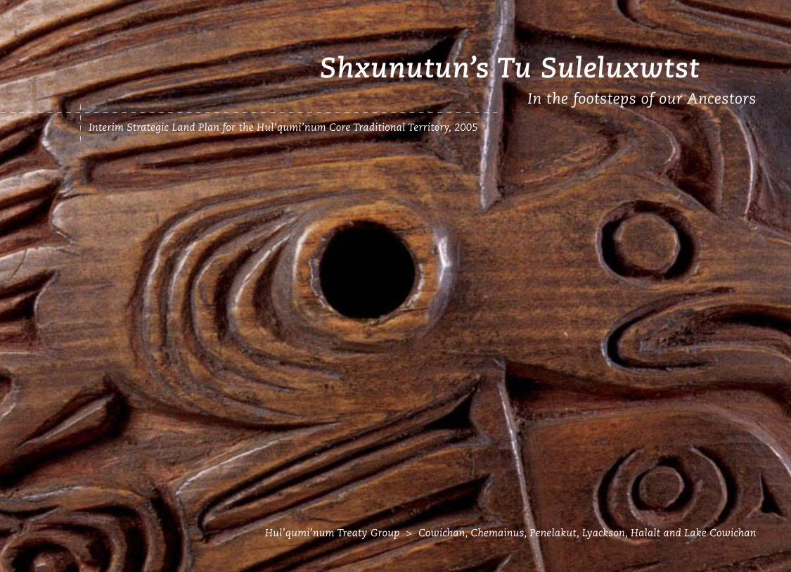
Interim Strategic Land Plan for the Hul’qumi’num Core Traditional Territory, 2005 Shxunutun’s Tu Suleluxwtst In the footsteps of our Ancestors Hul’qumi’num Treaty Group > Cowichan, Chemainus, Penelakut, Lyackson, Halalt and Lake Cowichan
Transcript
Interim Strategic Land Plan for the Hul’qumi’num Core Traditional Territory, 2005
Shxunutun’s Tu Suleluxwtst In the footsteps of our Ancestors
Hul’qumi’num Treaty Group > Cowichan, Chemainus, Penelakut, Lyackson, Halalt and Lake Cowichan
1. Introduction to Shxunutun’s Tu Suleluxwtst ...........................................................3
1.1 Purpose and Scope .............................................................................................................................4
This document is the interim strategic land and resources
plan for the Hul’qumi’num Core Traditional Territory. The
Hul’qumi’num Treaty Group (HTG) represents the Chemainus,
Cowichan, Lake Cowichan, Halalt, Lyackson and Penelakut
First Nations, whose traditional territory encompasses portions
of southern Vancouver Island, the Gulf Islands and the lower
Fraser River (See Figure 1, page 18).
1.1 Purpose and Scope The purpose of this land plan is to describe the Hul’qumi’num
people’s vision for how land and intertidal (beach) resources
should be used, managed and protected to sustain them
indefinitely and provide benefits for Hul’qumi’num people.
This document is intended as a foundation for discussion
about the future use and management of Hul’qumi’num land
and resources with all levels of government and third party
interests involved in land planning and resource use in
Hul’qumi’num territory.
This plan is not intended to be a definitive demonstration
of the extent of Hul’qumi’num historic or current use and
occupation of the core traditional territory for the purpose
of establishing aboriginal or other legal rights and title.
Pre-contact to present day occupation has been thoroughly
documented through other studies, reports, submissions, and
oral stories. All readers should understand that this document
has the specific and limited scope of land use planning and is
not intended to prove aboriginal rights or title.
This plan does not address marine resources in detail.
Planning for the marine environment is being conducted
under separate HTG processes.
1.2 Planning FrameworkThis plan provides Hul’qumi’num policy direction in the form
of resource management goals, objectives and strategies that
would apply across the whole traditional territory:
Resource management goals describe the future vision for
particular aspects of land or resources. Goals are broad aims
and apply to the entire territory.
Resource management objectives outline specific end results
that will help to achieve the goals. Objectives are usually
measurable and apply to particular areas or resource values.
Strategies are specific actions designed to achieve a resource
management objective.
Introduction to Shxunutun’s Tu Suleluxtst1
My vision for the future, regarding land and resources, sees First Nations living prosperously from what is rightfully ours.
For my vision, there is economic equality. Opportunity becomes available, and at long last, our people will be pulled from
poverty to live prosperous, healthy lives. — Rebecca James
Previous page photo (page 3) Le’tsus is an open weave basket. This basket is woven to hold clams or other seafood, the open weave allowing the contents to be washed and drained while in the basket. This basket is made of xpeyts’us (narrow branches of cedar) and sluwi’ (cedar inner bark). Photo by Gary Fiegehen, object A2358 courtesy of the Museum of Anthropology, UBC, Vancouver, Canada.
5
In addition to the general management direction provided
by resource management goals, objectives and strategies
(Section 7, page 29), this plan calls for more detailed, local
planning for 42 Hul’qumi’num Mustimuhw Intensive
Traditional Use Areas as described in Section 8 (page 79).
Hul’qumi’num Mustimuhw Intensive Traditional Use Areas are
landscapes that are especially important for traditional resource
harvesting, cultural use and activities, or are associated with
Hul’qumi’num oral traditions. This land plan recommends that
more detailed planning be undertaken within each of these
landscapes with appropriate third parties to address objectives
to protect important Hul’qumi’num values in each of these
areas, as identified in Section 8.2 (page 82).
1.3 Organization of this DocumentThis plan contains the following sections:
> Section 2 describes the process used to develop this plan.
> Section 3 is a statement of assertion of Hul’qumi’num rights
and title, and a brief description of the Hul’qumi’num Treaty
Group’s involvement in the treaty process.
> Section 4 provides a brief profile of the Hul’qumi’num people
and their territory.
> Section 5 presents a vision statement for land and resource
management in the territory.
> Section 6 recommends mechanisms by which the policy
direction contained in this plan can be implemented.
> Section 7 presents management directions for a range of
resource values, in the form of goals, objectives, and strategies,
following from a summary of community concerns and
Intensive Traditional Use Areas and objectives for these
special areas.
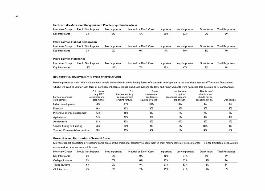
> Appendix I provides a statistical summary of the land plan
interview results.
> Appendix II lists the Hul’qumi’num individuals interviewed
for this process.
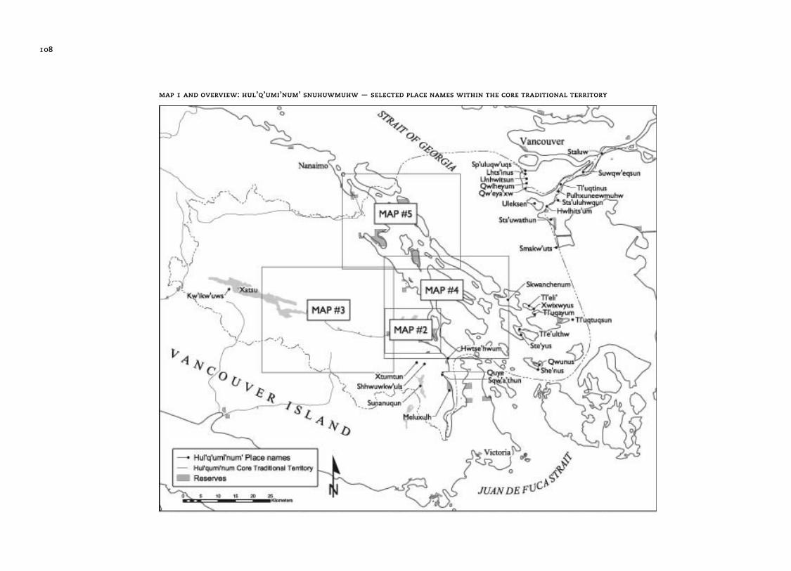
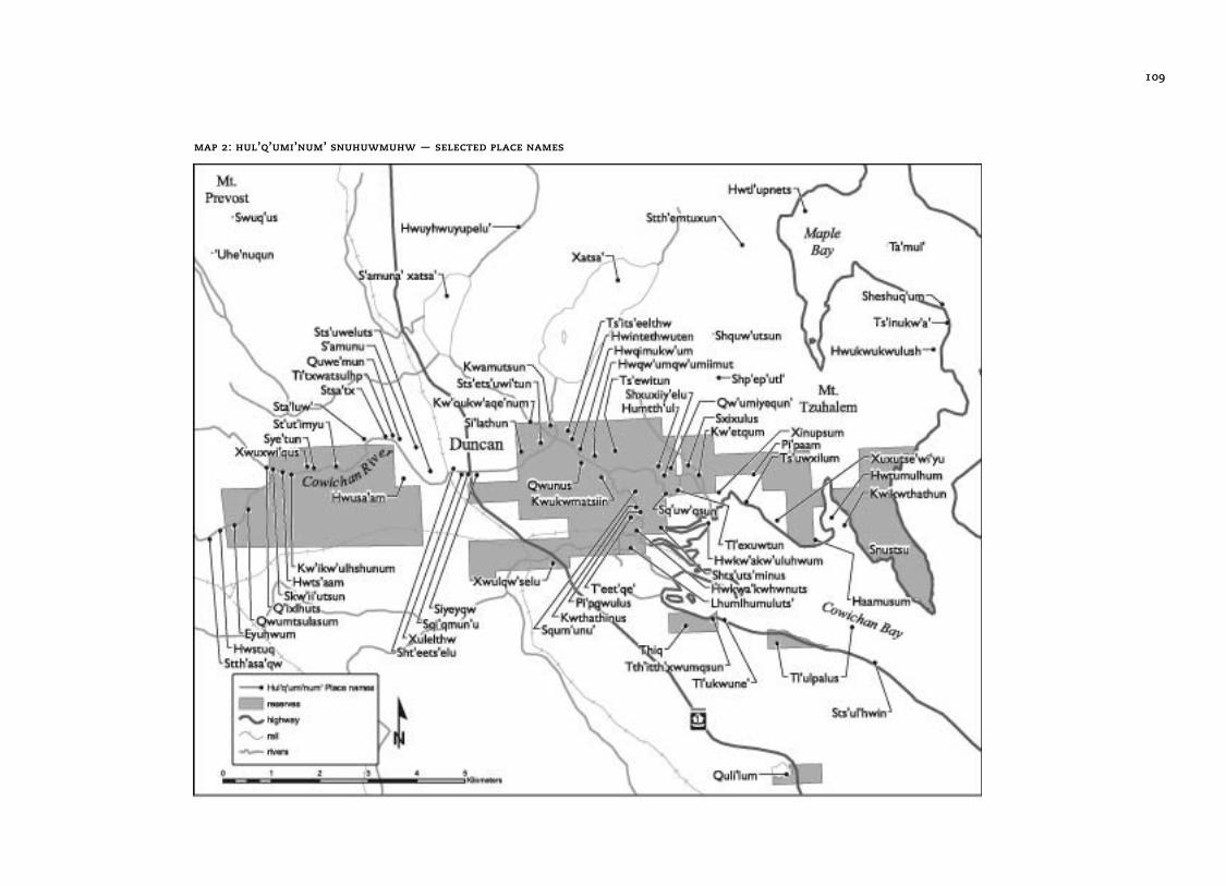
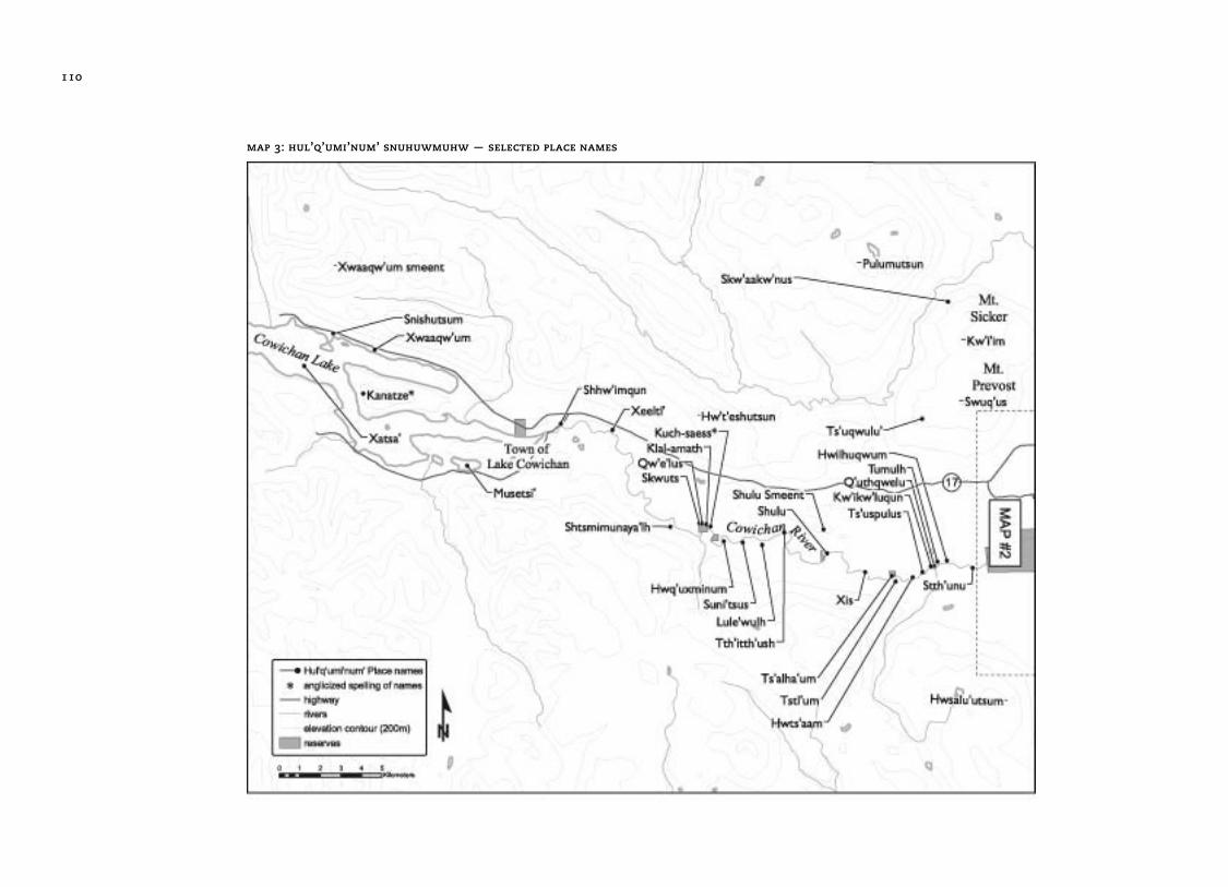
> Appendix III is a gazetteer of place names in Hul’qumi’num
Core Traditional Territory
A positive future for me would be for the tribes
to manage our resources including the land to
ensure that the generations to come will have
the opportunity to work and play and survive in
our own territory. I hope we design a model,
a community-based model, for our own people.
— ray harris
2 >Process for the
Development
of the Plan
8
2.1 Review of Land Use Plans and Planning ProcessesAs part of the research for the development of this land plan,
a review was undertaken of land use plans and planning
processes within Hul’qumi’num traditional territory.1 The
inventory included Crown strategic land use planning, parks
and protected area planning, intertidal area planning, Crown
forest land use planning, private forest planning, and land use
planning by Regional Districts, municipalities and the Islands
Trust. The purpose, scope and status of these plans and
planning processes were documented and copies of planning
documents compiled. This complex backdrop of plans
suggested that a strategic plan describing Hul’qumi’num
values and visions was required.
2.2 Land and Resources AssessmentAs part of its on-going research in support of HTG involvement
in the treaty process, the HTG commissioned a Land Selection
Study to help identify potential treaty settlement lands. The
Land Selection Study included an assessment of lands and
resources within the traditional territory for social and
economic values and uses. Volume I of the Land Selection
Study (Community Lands) dealt with the goal of assessing
lands for their social values and uses, such as housing and
community infrastructure. Volume II assessed the capability
of the land and resources to support a range of economic
development activities.2
The products of this second study were a report, GIS data, and
a map portfolio. Data sets and studies were collected and map
themes developed for each of the following resource areas:
• forests, including forestry and non-timber forest products;
• energy, including natural gas, coalbed methane, and
“green” energy sources;
• minerals, including non-metallic, industrial and aggregate;
• water, including groundwater and surface water;
• agriculture, including agricultural capability and
greenhouse potential;
• intertidal shellfish culture and capability;
• tourism, including land- and marine-based capability;
• real estate, including commercial, industrial, and
market housing; and,
• conservation, including plants, ecosystems, fisheries
and wildlife.
1 Dovetail Consulting Inc. 2002. Review of Land Use Plans and Planning Processes in the Hul’qumi’num Treaty Group Traditional Territory, HTG 128 pp. 2 Egan, B. 2003. Hul’qumi’num Land Selection Study. Volume 1: Community Lands. POLIS Project on Ecological Governance, U. VIC. 109 pp.
Kotaska, J. March 14, 2003. Hul’qumi’num Land Selection Study. Volume II: Land and Resource Assessment. POLIS Project on Ecological Governance, University of Victoria. 99 pp.
Process for the Development of the Plan2
I think that for a vision for the land and resources that sustainability is key. Governance is key. And that way we
really can present our own vision for the territory. — Bob Daniels
Previous page photo (page 7) Lhunutun is a mat creaser, a tool used along with a mat needle to weave bulrush mats. This mat creaser is carved from alder wood, with an ’ulhqi’ (snake) design. Photo by Gary Fiegehen, object Nbz844 courtesy of the Museum of Anthropology, UBC, Vancouver, Canada.
9
The HTG has also undertaken a cultural assessment of the
lands within the traditional territory, leading to the identification
of archaeological sites, historical lands, and traditional use
areas. This work builds upon a 5 year Traditional Use Study
(TUS) that has provided the HTG with detailed information on
the location, type and extent of traditional resource harvesting
and land use by Hul’qumi’num people, and a two year cultural
land selection study which detailed sacred and cultural sites.
These and other studies commissioned by the Hul’qumi’num
Treaty Group were used extensively in the preparation of
this land plan.
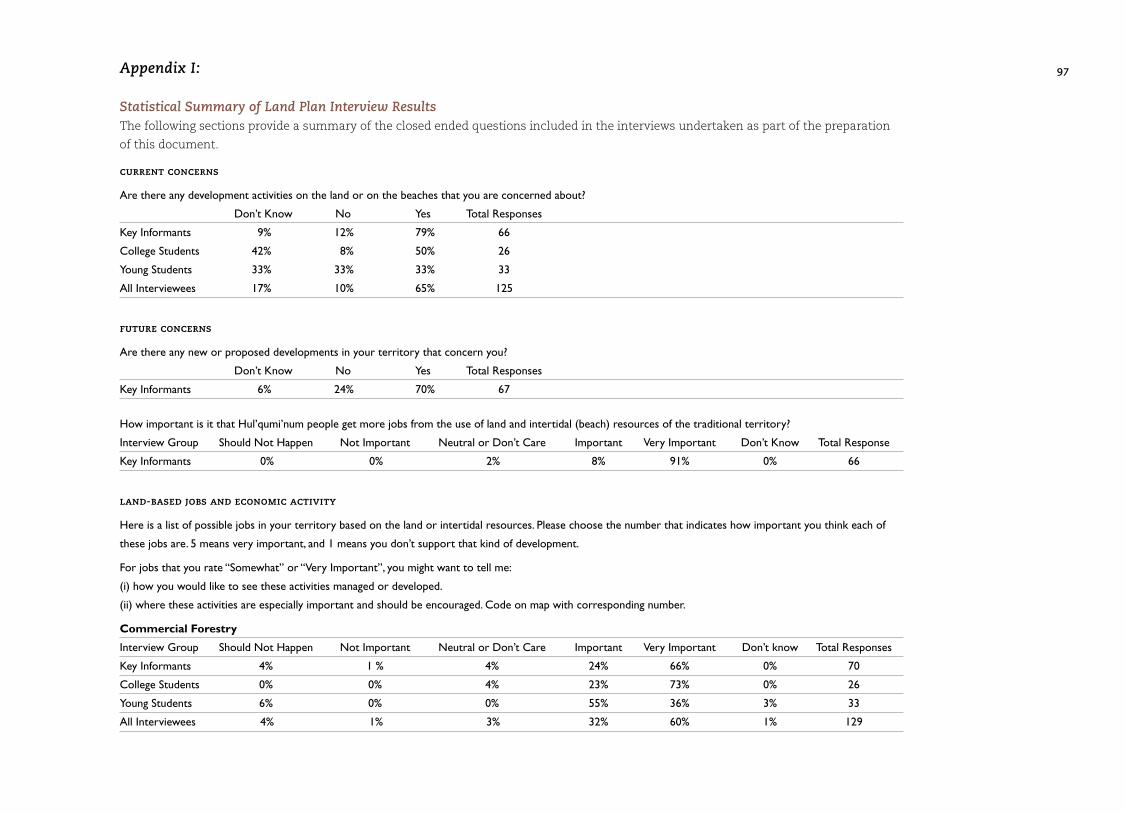
2.3 Land Plan InterviewsAs part of the land planning process, semi-structured inter-
views were conducted with 136 people from the six Nations
comprising the Hul’qumi’num Treaty Group. The purpose
of the interview process was to canvass the range of values,
perspectives and concerns of Hul’qumi’num people with
respect to land and resource management within HTG
traditional territory.
A structured interview questionnaire was used for each of
three interviewee groups. The three interview groups were Key
Informants, College Students, and Young Students. An interview
questionnaire was prepared for use with Key Informants, who
are Hul’qumi’num community representatives, Elders and
technical staff. The interview questionnaire was modified
for use with college and younger students. See Appendix II
(page 107) for a list of interviewees.
Lea Joe, Community Researcher, HTG, and community liaison
workers in each of the six communities conducted the interview
process between November 2002 and March 2003. Dovetail
Consulting Inc. provided overall coordination, with project
oversight from HTG by Brian Thom, Senior Negotiations
Support, and Robert Morales, Chief Negotiator. Results of the
interview process were compiled3 and an analysis of the
interview results was completed.4 Interviewees were also
invited to indicate their responses on a map where appropriate.
The results of spatial (mapped) responses were compiled in a
map portfolio.
The interview process results, along with other sources,
were used extensively to draft this land plan. This plan
contains extensive quotes from Hul’qumi’num people inter-
viewed as part of the land plan process. Appendix I (page 97)
contains a summary of responses to closed-end questions
from the land plan questionnaire.
3 Dovetail Consulting Inc. March 31, 2003. Hul’qumi’num Treaty Group Land Plan Study. Interview Results Summary, HTG 204 pp.4 Dovetail Consulting Inc. May 7, 2003. Hul’qumi’num Treaty Group Land Plan Study. Analysis of Community Perspectives on Land and Resource Management, HTG 111 pp.
A positive future would be First Nations having
control over their own land and resources,
and the right to develop those lands in any way
we see fit for their well-being and for future
generations. For me, that would be cleaning up
our beaches, healthy shellfish for our people to
eat, healthy forests, enough land for our people
to live to build homes, and protection of our
cultural sites.
— stephanie charlie
3 >Hul’qumi’num
Rights
and Title
12
The First Nations that comprise the Hul’qumi’num Treaty
Group assert the existence of Hul’qumi’num aboriginal title
over our land, and aboriginal rights throughout one-hundred
percent of the territory outlined in our Statement of Intent.
This aboriginal title and our aboriginal rights are based on
Hul’qumi’num law. Hul’qumi’num aboriginal title and rights
are recognized and affirmed in the Constitution of Canada,
and have been recognized frequently by the Canadian courts.
Oral histories connect Hul’qumi’num people to the land from
the beginning of time. Hul’qumi’num oral histories, part of the
oral traditions that have been carefully passed on by generations
of Hul’qumi’num Elders, clearly express the laws that root
Hul’qumi’num people in their traditional lands. At the start of
the world, the First Ancestors dropped from the sky on Swuq’us
(Mt. Prevost). These ancestors were powerful people. They
cleared the world of dangerous creatures and settled the
original villages throughout Hul’qumi’num territory. These
ancestors were imbued with the powers of transformation.
Humans could change to animals. Common things had
uncommon powers. Then the Transformer Xeel’s, arrived.
He went through the land making things as they are today.
He transformed the ancestors to the deer, to the cedar tree,
to the rocks that continue to be found in the land today.
He taught the Hul’qumi’num people about the respect and
obligations that were required to live in the world. His
transformations live on today in the animals and places in
the landscapes, which carry the history of his work in their
Hul’qumi’num names. Hul’qumi’num people recognize the
special connections they have to their territory and the
resources in it, as they are all descended from those same
original ancestors. Hul’qumi’num people are all related
to the living things and places that were touched by the
transformations of Xeel’s.
From time immemorial, Hul’qumi’num people have owned
their traditional territories. Hul’qumi’num place names
densely blanket the land. Every bay, every peninsula, every
rocky island, every bend in the rivers has a Hul’qumi’num
name which provides the keys to the extensive knowledge
needed to harvest and steward the resources of the territory
owned by Hul’qumi’num people. From the central, ancestral
villages, Hul’qumi’num people made extensive use of their
territories. The oral histories tell about the family-owned
hunting territories and fishing grounds. They tell about the
camas-root and berry grounds owned by women. They tell
I think my vision would be that all people have access to a certain portion of land for social needs, that there be land provided
overall for cultural purposes, that there be economic employment in regards to forestry or other sources. — Dora Wilson
Hul’qumi’num Rights and Title3
Previous page photo (page 11) S’unum is traditionally made of t’hum’unu’ (bone) and the rope attached is made of sthulq’ul’shutun (cedar bark). This particular harpoon, made of metal and horn, is from the Puneluxutth (Penelakut) Tribe, was collected in 1912. Photo by Gary Fiegehen, object courtesy of Royal BC Museum 2418, sea lion spear.
13
about the clam beds, hunting grounds, and fish weirs held in
common for the community to use. These ancestral titles
to the territories have never been extinguished. The rights to
harvest and be the stewards of these resources come from
the obligations created by the Transformer and will continue
into the future and forever.
The oral histories tell about the importance of sharing resources
with extended family members from other Coast Salish
communities. Hul’qumi’num people know their extended family
ties. They know how hereditary names, ceremonial masks and
privileges connect people to territories and resources throughout
the Coast Salish world. They tell about travels for fishing on
the Fraser River as far up as Yale, at Cape Mudge in the Strait
of Georgia, and in Knight Inlet. They tell about trips to the
mountains of the Mainland for hunting and gathering of
mountain goat wool. These oral histories recall the travels of
Hul’qumi’num people as far as the Interior of BC, and central
Oregon for trade, and participation in the complex economic
system of potlatching. They tell about the ancestors defending
their lands and resources from intruders, and of the principles
and practices of sharing the wealth of their productive resources
with their extended families and neighbours throughout the
Coast Salish world.
The richness of Hul’qumi’num ancestral lands made for many
wealthy generations of Hul’qumi’num people. Hul’qumi’num
people wish to continue the tradition of contributing to the
wealth of our society in ways that follow the laws taught in
our oral histories.
Our snuw’ey’ulh, or Hul’qumi’num laws, dictate that we have
an inalienable connection to one-hundred percent of our
traditional territory. They lay the foundation for how
Hul’qumi’num people must continue our obligations in our
relationship with the natural world, which is connected to us
through the First Ancestors. Respecting these obligations is
integral to the Hul’qumi’num way of life. It is the foundation
of our wealthy, healthy society.
We need to work together. They say “nuts’amaat,”
one mind, one body, one nation. We are six
nations strong.
— cyril livingstone
4 >Hul’qumi’num
People and
Territory
4.1 Hul’qumi’num Mustimuhw The Hul’qumi’num Treaty Group is an organization representing
six Coast Salish First Nations located on the southwest coast
of British Columbia. The six First Nations are the Cowichan,
Chemainus, Penelakut, Lyackson, Halalt and Lake Cowichan.
The communities share a common language, heritage, and
culture, as well as having close kinship ties. Hul’q’umi’num’ is
one of the Salishan languages spoken by Vancouver Island
Coast Salish communities between Qualicum and Malahat,
including the lands of the Hul’qumi’num Treaty Group
traditional territory.
The Hul’qumi’num people have inhabited the Cowichan and
Chemainus valleys, Gulf Islands, and the lower Fraser River
since time immemorial. The legends of the Hul’qumi’num
people recount that the first people fell from the sky, populated
the earth, and survived a catastrophic flood similar to one
mentioned in other ancient cultures.
Archaeological evidence of Hul’qumi’num habitation dates
back at least 5,000 years. Since these early times, the
Hul’qumi’num people thrived on the abundant resources of
the territory and developed a rich and complex culture built
upon fishing and gathering of freshwater and marine foods, as
well as hunting of land and marine mammals and birds. The
primary food of the Hul’qumi’num people is salmon, including
all five species of Pacific salmon. Other important marine
species are flounder, sole, skate, smelt, sturgeon, halibut, cod
and herring. Shellfish and seafood are extensively harvested,
including oysters, scallops, mussels, sea urchins, chitons, sea
cucumbers, crabs, and octopuses. Crab is especially important
as a food source. Land mammals such as deer and elk and
waterfowl are hunted extensively. A great variety of fruits and
vegetables are also harvested and dried for winter use. All trees
are used for various purposes. Cedar is especially important,
for canoes and house planks. The bark has been used extensively,
including for making cordage, baskets, mats and certain
articles of clothing and regalia. Western hemlock, Douglas-fir,
yellow cedar, western yew, dogwood and especially western red
cedar are used for longhouses and other purposes.
Over the long period of occupation, and the seasonal rounds
of fishing, hunting and gathering, Hul’qumi’num people
developed a profound and intimate connection with the land
and resources on which they lived and thrived. The whole of
the traditional territory is alive with the stories, place names
and history of the Hul’qumi’num people.5
5 Thom, B. 2005. Coast Salish Senses of Place. PhD Dissertation, Dept. of Anthropology, McGill U and Rozen, D. 1985. Place Names of the Island Halkomelem Indian People. M.A. Thesis, Department of Anthropology and Sociology, UBC.
16
Hul’qumi’num People and Territory4
We may lose who we actually are. I am concerned about that. I speak this borrowed language better than
I can speak my own. — Chuck Seymour
Previous page photo (page 15) Teyuwulh is a canoe used in competitive traditional canoe races. This particular one is a model of an eleven-man racing canoe. The head of the canoe depicts a carving of a bird head typical of the animal or bird motifs found on racing canoes. The bow of this canoe is painted yellow, showing the colours of it’s canoe club. Photo by Gary Fiegehen, object courtesy of Royal BC Museum 9008, model Salish racing canoe.
Although the size of the Hul’qumi’num population prior to
European contact in the mid 1800s is not known, it was likely
much larger than today. Hul’qumi’num population declined
sharply following contact with Europeans and the introduction
of diseases such as smallpox and influenza. The Hul’qumi’num
population is now growing rapidly. Between 1972 and 2005,
Hul’qumi’num population more than doubled from 2626 to
6196 persons. Approximately half the population is under
25 years of age (See Table 1 below).
Table 1: Table 1: Hul’qumi’num Communities, April 2005
FIRST ON OTHER OFF TOTAL NATION RESERVE RESERVE RESERVE POPULATION
Chemainus 597 117 370 1084
Cowichan 1917 204 1808 3929
Halalt 85 9 108 202
Lake Cowichan 12 0 2 14
Lyackson 16 21 143 180
Penelakut 476 42 269 787
Hul’qumi’num 3103 393 2700 6196Mustimuhw
The archaeological evidence suggests that there have been
some significant shifts in the pattern of village sites over the
millennia. The historic pattern shows major Hul’qumi’num
villages on Vancouver Island, Kuper Island, Valdes Island,
and the lower Fraser River, with extensive camps throughout
the territory. This pattern seems to have been preceded
centuries ago by a wide-spread distribution of village sites
throughout the Gulf Islands and Vancouver Island. The
creation of Indian reserves, and subsequent changes
constrained by government policy, represent another shift
in village occupation.
The Hul’qumi’num Elders have often spoken about the impor-
tant village sites lost in the last period of village resettlement.
Despite severe and ongoing alienation of land and resources,
Hul’qumi’num people retain a close connection to their
traditional territory. A 1991 survey reported that 23% of
Hul’qumi’num adults can still speak their language and 37%
can understand it when spoken by others. The majority (68%)
continue to participate in traditional aboriginal activities.6
4.2 Hul’qumi’num Territory For the purposes of negotiating a treaty with the governments of
British Columbia and Canada, the six First Nations represented
by the Hul’qumi’num Treaty Group have identified a “Statement
of Intent” (SOI) area covering ~350,000 hectares of southeastern
Vancouver Island, the Southern Gulf Islands, and extending to
the lower reaches of the Fraser River (See Figure 1, page 18).
The SOI area —referred to as the HTG Core traditional territory,
or simply Hul’qumi’num territory in this plan — is largely a
construct of the treaty process.
On Vancouver Island, the Hul’qumi’num territory includes most
or all of the following large watersheds — Nanaimo River,
Chemainus River, Cowichan Lake and River, Koksilah River,
and Shawnigan Lake. It also contains small portions of Nitinat,
Gordon, San Juan and the Jordan River watersheds. The territory
includes all of the southern Gulf Islands (Saltspring, Mayne,
Saturna, Galiano, Kuper, Thetis, Valdes, North and South Pender,
and smaller islets) and the southern most portion of Gabriola
Island. On the mainland, the territory includes the south arm
of the Fraser River and adjacent banks up to Douglas Island,
and the islands in the river, including Westham Island.
Hul’qumi’num territory is represented by three biogeoclimatic
zones within the Coast and Mountains physiographic region of
BC. Inland portions are Coastal Western Hemlock (CWH) and
Mountain Hemlock (MS), and coastal portions are Coastal
Douglas-fir (CDF).
The Coastal Western Hemlock biogeoclimatic zone is common
to the entire coastal region of British Columbia (11% of BC) and
most of the lower elevation portions of Vancouver Island. The
zone is characterized by cool summers and mild, wet winters.
Western hemlock and amabilis fir are the naturally dominant
species, with a component of western red cedar on wetter sites
and Douglas-fir on drier sites. Other common species are grand
fir, western white pine, bigleaf maple, red alder and black
cottonwood. Abundant rainfall and mild temperatures make
these forests the most productive in Canada.
Coastal Douglas-fir is a comparatively rare ecosystem type
(0.2% of BC), found mainly in the drier areas of southeastern
Vancouver Island, the Gulf Islands and the lower mainland
coast — most of which is within HTG traditional territory.
A mild Mediterranean climate supports natural forests
dominated by Douglas-fir. Garry Oak and arbutus are
abundant on drier sites.
4.3 Land Status and Alienation The process of colonization of Hul’qumi’num territory began
in the mid 1800s. In the late 1850s and early 1860s, the
colonial government in Victoria invited colonists to “purchase”
Hul’qumi’num lands in the Cowichan and Chemainus
districts. By July 1859, close to 10,000 acres was “sold” without
Hul’qumi’num consent. Colonization continued through the
1860s and 1870s, and although commitments were made by
then Governor of the Crown Colony, Sir James Douglas, to
compensate the Hul’qumi’num for the loss of their land,
compensation has never occurred and treaties were not
pursued.
In 1884, the Esquimalt and Nanaimo (E&N) Land Grant trans-
formed the land status of the territory. Under the terms of the
grant, approximately 800,000 hectares of land on southeastern
Vancouver Island were granted to private interests in exchange
for the construction of a railway from Esquimalt to Nanaimo.
The E&N Grant resulted in the alienation of approximately
250,000 hectares of Hul’qumi’num territory.
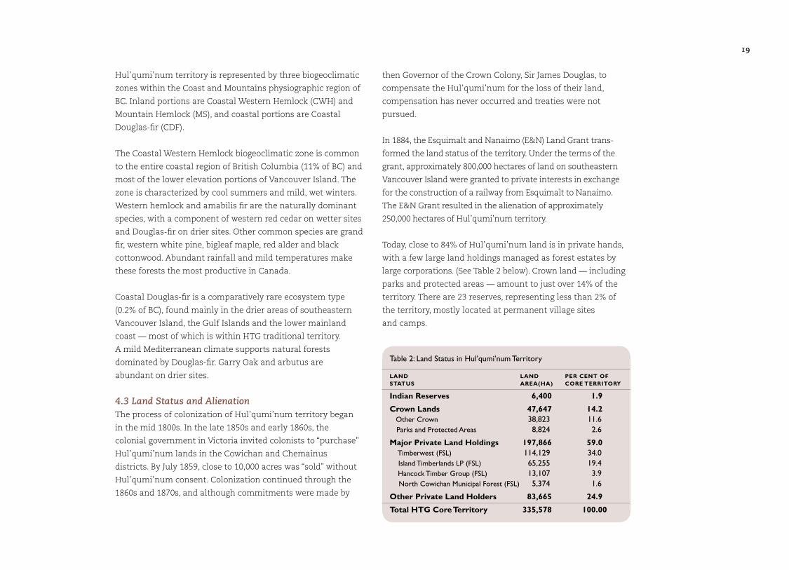
Today, close to 84% of Hul’qumi’num land is in private hands,
with a few large land holdings managed as forest estates by
large corporations. (See Table 2 below). Crown land — including
parks and protected areas — amount to just over 14% of the
territory. There are 23 reserves, representing less than 2% of
the territory, mostly located at permanent village sites
and camps.
Table 2: Land Status in Hul’qumi’num Territory
LAND LAND PER CENT OF STATUS AREA(HA) CORE TERRITORY
Indian Reserves 6,400 1.9
Crown Lands 47,647 14.2 Other Crown 38,823 11.6 Parks and Protected Areas 8,824 2.6
Major Private Land Holdings 197,866 59.0 Timberwest (FSL) 114,129 34.0 Island Timberlands LP (FSL) 65,255 19.4 Hancock Timber Group (FSL) 13,107 3.9 North Cowichan Municipal Forest (FSL) 5,374 1.6
Other Private Land Holders 83,665 24.9
Total HTG Core Territory 335,578 100.00
19
I’d like to see that all the resources are protected
and restored so that they’re there for the children
and grandchildren.
— joe seward
5 >Vision for the
Management
of Land and
Resources
22
The following is a proposed vision for the management of land
and resources in Hul’qumi’num traditional territory.
Hul’qumi’num Mustimuhw envision a future in which our
rights and responsibilities to own and steward our land are
recognized through a fair and just treaty. We retain a connection
to all of our ancestral lands and own the land we need to
support our growing population and meet our social, cultural
and economic needs.
We envision a future in which our land and sea resources are
abundant and healthy and our communities are vibrant and
strong: where our beaches and rivers are clean and healthy and
support abundant salmon, other fish and beach foods for our
communities; where our forests are managed wisely, to provide
jobs and benefits for Hul’qumi’num people while also protecting
wildlife and other values; where resources that have been
damaged or over-harvested in the past have been restored to
their former abundance and systems are in place to prevent
abuse and over-use; and where pollution and contamination
have been cleaned up.
We are all working together, actively managing all of our land
and resources to ensure that future Hul’qumi’num generations
will have the opportunity to work and play and prosper here in
our ancestral home. We must have the capacity and resources
to manage our resources sustainably, incorporating traditional
teachings with the best of modern management tools.
We must have jobs and economic prosperity for our people,
and the security that comes with it. Hul’qumi’num young
people are trained in all aspects of land and resource manage-
ment and are able to find good jobs at home in a supportive
environment to raise their families. We must do the work to
heal our communities, and pull our people from poverty to live
prosperous, healthy lives.
Hul’q’umi’num’ culture and language must be alive and
thriving within our communities. Our traditional teachings
will be passed on to our young people from the Elders. In this
vision, our culture is cherished and respected and our cultural
resources and sites are protected.
Our people must enjoy the full range of opportunities to enjoy
our unique way of life, and to harvest the resources of the land
and sea as our ancestors have always done.
Vision for the Management of Land and Resources5
A balance between a strong cultural land base and a strong economic land base is important for our people. If we can find
a happy medium there, we will have done something significant for protecting our future. — Joey Caro
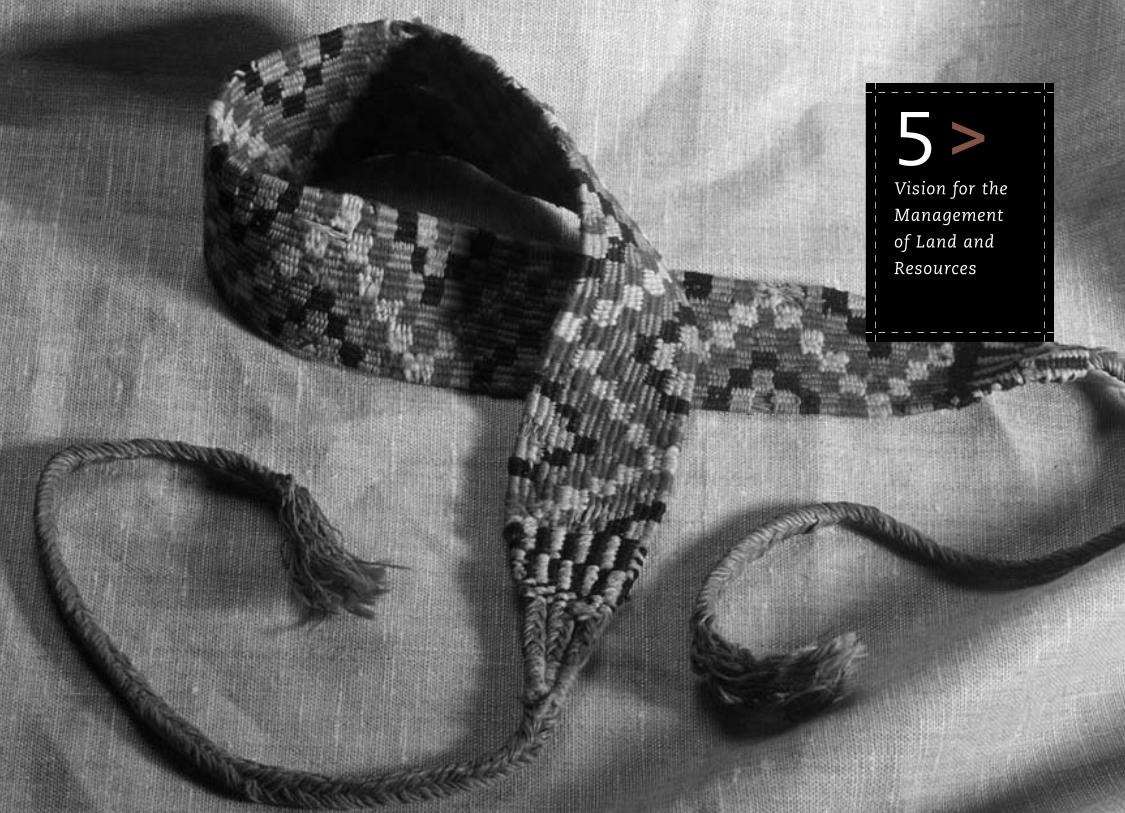
Previous page photo (page 21) Sh’umtun is a burden strap or tumpline generally used as a tying device. This particular burden strap was collected before 1950 in Duncan. Sh’umtun tied baskets or bundles of cedar to the waist, and the woven band is worn against the forehead. It was used when both hands were busy carrying out other tasks. Men also used these straps for packing deer meat home, and as gun straps. Traditionally, Coast Salish weaving methods include tight weaving using a xpey lhtsi’mun (cedar comb) to push stitches together so that it will not break. Photo by Gary Fiegehen, object Nbz794 courtesy of the Museum of Anthropology, UBC, Vancouver, Canada.
23
The use and value of all lands, food and medicine gathering is very important to me. Our culture feels to me as if it is
diminishing with time. The teachings have been lost and forgotten. Anything that would assist our people to practice and
preserve our heritage would be invaluable. In this way, teachings of our culture will be passed from generation to
generation for eons into the future. — Rebecca James
We can’t manage a resource, but we can manage our behaviour in how we relate to the land and the environment. For us to
be able to protect our interests in our traditional territory, it is critical to use our knowledge and expertise in managing our
behaviour. A strategic land use plan is an important tool for that. It will give us guidance about what we have to protect,
and gives us and other governments a clear idea of how we want to do it. — Kathleen Johnnie
All areas within the six nations should be important.
It should be protected and at the same time be
very sure that all people know of Lake Cowichan,
Lyackson, Halalt, Penelakut, Cowichan, and
Chemainus. They should know and respect each
and every one of the territories. Anything in our
territory isn’t without knowledge. We should
protect it and keep it in the natural state.
— cyril livingstone
6 >Implementation
of the Strategic
Land Plan
26
The goals, objectives, strategies, and proposed land use
designations contained in the following sections of this land
plan represent HTG policy statements with respect to how
land and intertidal resources should be conserved and
managed across the whole of the traditional territory to meet
the long term priorities of conservation, sustenance and
renewal of the Hul’qumi’num culture and land-based way
of life, and sustainable economic development.
The application of these policies is complex due to the wide
variety of landholders, licenses and Crown agencies that assert
varying degrees of property and management rights within the
territory. The successful implementation of this land plan will
require considerable cooperation between federal, provincial
and local governments, licensees and tenure holders, as well
as private landowners and operators.
Various mechanisms may be used to implement the direction
contained in this land plan, and exert Hul’qumi’num jurisdiction
and management authority over the whole traditional territory.
These include:
• planning and management on reserve lands owned by the
nations comprising the Hul’qumi’num Treaty Group, and on
settlement lands and “willing seller” lands acquired following
resolution of treaty;
• securing co-management agreements with other levels of
governments to give Hul’qumi’num decision making authority
over lands and resources, or access to resources, outside of
treaty settlement lands;
• acquiring specific resource tenures and licenses;
• developing partnerships with private landowners and firms
(i.e. joint ventures) to use and manage lands and resources,
or to derive economic benefits from such use;
• developing partnerships with non-profit organizations that
provide Hul’qumi’num people with some degree of control
over lands and resources, or facilitate the provision of
benefits from such use; and,
Implementation of the Strategic Land Plan6
They all need to be protected. All of the subsistence, cultural, and social sites and the environmental resources.
If they’re not protected, they’re most likely to be destroyed or abused in one form or another. — Martina Joe
Previous page photo (page 25) Skwuschus is a wood-working adze used to dig out the wood when building a canoe, house posts, beams, roof planks or other large wooden objects. This adze, made of hard maple, has the design of a bird figure on the haft. A flat iron blade is lashed to the handle with a heavy skin thong, with a piece of purple cloth between the thong and the blade. Photo by Gary Fiegehen, object courtesy of the Canadian Museum of Civilization, no. VII-G-686, old Coast Salish woodworking adze.
27
It is important that other governments — local governments, the provincial government and the federal government —
recognize and honour Hul’qumi’num peoples interests, attachments and connections to the land. It is important that they
integrate what we have done with the HTG Land Use Plan into the those land plans and directions that they have already
established and those that they put forward in the future. — Robert Morales
• asserting aboriginal rights and title to land and resources
through litigation or other means.
Each these mechanisms has the potential to assist the
Hul’qumi’num Treaty Group in fulfilling its mandate to
maintain a connection to 100% of the Hul’qumi’num territory.
Within the context of strategic land use planning, specific
application of some of these mechanisms is recommended
as a means to achieve the land and resource management
objectives of the Hul’qumi’num people.
It’s really important that we look at the overall
impacts or impact potential of the food and
resources that we use for the different things
like the bighouse. But I also think it’s important
for us to gain access or control over resources
that are not traditionally used. I do not
support any further restriction from using the
resources where conservation is not an issue.
— tim kulchyski
7 >Management
Direction for
Resource
Values
30
The management directions outlined in this section apply to the
whole of the Hul’qumi’num core traditional territory, identified as
the Hul’qumi’num Stewardship Area in Figure 3 (inside back cover).
Additional management direction for Hul’qumi’num Intensive
Traditional Use Areas (ITUs) is outlined in Section 8 (page 79).
7.1 Intertidal (Beach) Resources7.1.1 background
Intertidal resources are highly important to Hul’qumi’num.
The words beach and intertidal are used interchangeably here.
Intertidal means the area of the ocean shore between high tide
and low tide. The total intertidal area within the HTG Statement
of Intent area is 4,644 hectares.
This section does not cover marine resources beyond shoreline
areas. Resources that are normally harvested by fishing from
boats, such as salmon, herring, cod, flounder and halibut, are
vitally important, but they are beyond the scope of this plan.
Section 7.5 (page 46) of the plan on freshwater fish and fish
habitat addresses salmon in their freshwater habitat, but does
not address salmon fishing at sea.
Harvesting along the ocean shore is a central part of
Hul’qumi’num people’s heritage and the ocean has always
been an essential source of fresh food. Beach foods were
formerly plentiful and are still relied upon from February
through the summer months. Basket cockles, horse clams and
butter clams are staples in the diet and are gathered and
preserved in large quantities for food, ceremonial, social and
trade purposes. Beaches are actively managed to improve
growing conditions. The regular act of harvesting and turning
the beaches over helps prevent anoxic conditions that can
make shellfish inedible. Herring are harvested in eelgrass beds
and roe is collected on kelp and sometimes cedar boughs.
Trade or giving away of surplus food is important in
Hul’qumi’num culture. One purpose of trade is for a family
or group to access other resources through reciprocity. For
example, surplus food is often taken to relatives in other
villages to share, and the favour is returned with gifts of
foods locally available around those villages.8
Collecting shellfish for food is still very important to
Hul’qumi’num people. Preferred species include clams
oysters, scallops and mussels. Chiton, crabs (mainly dungeness),
sea cucumber, octopus, sea urchins (red and green) herring.
Other species such as ducks are also harvested along the
8 Suttles, Wayne. 1987. Affinal Ties, Subsistence and Prestige among Coast Salish. IN: Coast Salish Essays. Talon Books, Vancouver, B.C. pp. 16-25.
I think there’s big opportunity in shellfish aquaculture. We’re currently working on getting tenures for beaches. Depending on
what we get, there will be some employment opportunities for Hul’qumi’num people, which would include training. There are
always opportunities for joint ventures with companies. — Larry George
Management Direction for Resource Values7
Previous page photo (page 29) Te’ulh is a two-pointed spear used to spear ste’elhtun (salmon) spawning up the river. While this modern te’ulh has metal spear points and a rope, the traditional technology used is syukwum which is cedar bark instead of rope or string. Photo by Gary Fiegehen, object courtesy of Royal BC Museum 13340, Cowichan salmon harpoon.
31
i’m always concerned
about the docks that
they’re building
on the beaches. all
the oil and activities
are polluting our
shellfish. most of
the time you
can’t even clam.
— stephanie charlie
shoreline. Flounder were harvested along the shore at high
tide. Marine plants traditionally harvested include kelp,
rockweed and sea lettuce.
Intertidal resources are less abundant than in the past, despite
the naturally high productivity of the habitat. While the entire
coastline is still significant, constraints on access, depletion of
resources, and contamination now leads to harvesting on
fewer beaches. Some species, such as abalone, are no longer
available. Degradation of these resources from shoreline
development impacting habitat, over-harvesting and pollution
is a result of the high concentration of human population in
this area of the province. Sewage (municipal and septic),
industrial wastes from pulp mills and other harmful substances
such as fertilizers and pesticides are the main sources of
pollution. Bark debris from log dumping, storage and barging
also has negative impacts, smothering life on the sea floor in
bays and inlets. Logs also damage habitat as they ground in
shallow waters and log booms cause shading problems for
inshore life.9 (See Section 7.11, page 75, for more information
on water pollution.) Various food sources have been contami-
nated, from ducks to shellfish. Impacts range from making the
food harvested from beaches taste bad, to making it inedible
and a health risk. As a result, there are extensive closures on
intertidal shellfish harvest (which change from year to year).
Many Hul’qumi’num people are engaged in commercial shell-
fish harvesting (mainly clam digging). It is the main source of
jobs in some communities. Most commercially harvested clams
now have to be cleaned, or depurated, before they are safe to
market and eat. Depuration harvests are carried out on margin-
ally contaminated beaches. The key constraint on otherwise
promising economic potential is the poor condition of the
beaches. Furthermore, more areas are closed, for longer periods
than necessary, to offset ineffective or absent government
monitoring (with regular water quality sampling).
Another serious problem is diminishing access to intertidal
resources. The main factors blocking access to beaches are
existing foreshore leases, private tenures and excessive
harvesting by commercial and recreational fishers. Docks,
wharves and marinas have a harvest restriction of 150, 240
and 300 metre radius respectively around the structure,10
and have effectively closed off access in various parts of the
territory. Many beaches have been privatized through lease
arrangement with the Province for aquaculture. Access from
the land has decreased as waterfront private properties
occupy the entire shoreline (with the exception of parks
and Indian Reserves).
Other barriers to access are government restrictions. Licence
limitations were imposed in 1998, and at that time Fisheries and
Oceans Canada (DFO) provided approximately 70 Aboriginal
Communal licences for clam harvesting to Hul’qumi’num
member First Nations to maintain their involvement in the
fishery. Commercial harvesting of manila and littleneck clams
can be restricted by the age of harvester (18 or over), number of
licences available, cost of purchasing a license, area, timing of
openings (which are short), size limits and types of digs. While
DFO does most of the regulating, band offices also have a role.
Recreation and First Nations food, social and ceremonial
harvests are open year-round, except for time and area closures
due to fecal contamination or paralytic shellfish poisoning.
More Crown foreshore is to be made available to the shellfish
aquaculture industry as part of the Shellfish Development
Initiative, administered by Land and Water BC Inc. (LWBC).
9 Ayers, C.A. 26 June 2003, pers. comm.10 Ayers, C.A, T.Norgard, K. Fediuk, M. Parker, April, 2003. Hul’qumi’num Treaty Group State of Marine Resources Project, p.5
we need to start
cleaning up for the
next generation.
it’s going to take
that long to clean
up, especially down
cowichan bay.
— ben joseph
32
7.1.2 summary of community perspectives
• The beaches of the Hul’qumi’num territory have always been
very important for harvesting, and today they are a focus of
concern. The tradition of harvesting and eating shellfish is
particularly important to Hul’qumi’num people. Spiritual and
cultural use of intertidal resources is still very important to
Hul’qumi’num people, and clam diggers contribute clams
to the longhouse.
• Commercial harvesting of intertidal resources is important
for jobs and economic development. This includes clam digging
and shellfish aquaculture but excludes salmon aquaculture.
Hul’qumi’num people should have a high level of control
over aquaculture development.
• Given the high value of intertidal resources to Hul’qumi’num
people, degradation of these resources is especially distressing.
Shoreline development, log dumping or barging, overuse and
pollution are seen as serious threats to the environmental
quality of intertidal areas. There are concerns about the
supply of shellfish for future generations. Hul’qumi’num
people wish that they could harvest seafoods without
concern for their own safety.
• Access to beaches is vital in the view of many Hul’qumi’num
people, and loss or restriction of such access is a subject of much
concern. Hul’qumi’num Elders reflect on a time when they
could go to any beach and take what they needed. Now,
various forces have alienated beaches and intertidal resourc-
es from Hul’qumi’num people. A common viewpoint is that
all Hul’qumi’num people should be able to harvest from any
of the beaches in the Hul’qumi’num territory, while others
feel that the First Nation reserves with beach frontage have
the right to control the use of those beaches.
• Many Hul’qumi’num people would like to see more control over
and management of intertidal resources. A common opinion
is that the government places too many restraints on the
harvesting of intertidal resources. These extensive constraints
add to the difficulty in accessing the resource, thereby
contributing to the competition between communities for
harvesting areas. The desire for increased authority comes
from the need for the Hul’qumi’num people to get more
benefits from shellfish harvesting, but also from the belief that
they could do a better job of management and conservation.
• Hul’qumi’num people feel it is very important to protect
and restore intertidal species and habitats. Restoration of the
intertidal environment is a high priority, to meet the needs
of present and future generations. More controls on pollution
are needed, development pressures should be constrained,
fisheries have to be managed sustainably, and the beaches
have to be restored and protected.
• Increased controls or limitations on fisheries are supported
for conservation and to increase the availability of resources
for Hul’qumi’num uses. Hul’qumi’num people strongly
support increased controls or limitations on recreational
shellfish harvesting for the conservation of intertidal
resources. Many Hul’qumi’num people support increased
limitations on commercial shellfish harvesting, and some
would even like to see the commercial fishery closed.
i strongly support
[exclusive intertidal
use areas for
hul’qumi’num people].
it’s hard enough
to get by on our
beaches with
what’s available.
— chuck seymour
it’s management; we
need to address the
issue of declining
stocks and over
harvesting. we need
to turn that around
and also find ways to
stop the pollution.
— harvey alphonse
33
Most Hul’qumi’num people support controls or limitations on
shellfish harvesting when there is a genuine need for conserva-
tion. Many are opposed to such controls on the grounds that
the use of resources for food and cultural gatherings should
not be limited. Many people are in favour of excluding non-
Natives — at least from commercial harvesting — because
the Hul’qumi’num have a right to the resources in their own
territory and because there are not enough resources to meet
all the demands.
7.1.3 goals for management of intertidal (beach) resources
• Strengthen and restore the ties between intertidal resources
and the Hul’qumi’num diet, culture and way of life.
• Increase the availability of intertidal resources to
Hul’qumi’num communities. Ensure that needs for food
and ceremonial uses are met.
• Increase Hul’qumi’num member First Nation tenures
and management authority over intertidal resources and
re-establish Hul’qumi’num rights to the foreshore.
• Provide opportunities to participate in long-term, sustainable
shellfish aquaculture enterprises.
• Build capacity for commercial fisheries co-management.
The beach areas are really important to us as Indian people because we’re sea-going people and we live by the ocean.
My late husband used to call that [points to beach] his “refrigerator.” Everything was fresh. You got what you wished
for. His grandmother would tell him “I wish for cod fish” so he would get it. He would go to the island there, I guess they
call it Coffin Point. There used to be coffins there or something. What’s happening now is we’re getting pollution from
Ladysmith. Ladysmith is dumping sewer into the ocean. We were told not to get clams once that starts
drifting out here. — Marjorie Louie
34
11 Many of the objectives and strategies in this section are derived from: Ayers, C.A, T.Norgard, K. Fediuk, M. Parker, April, 2003. Hul’qumi’num Treaty Group State of Marine Resources Project; Ayers, C.A. 26 June 2003, pers. comm.; Ayers, C.A. 2003. Shellfish Aquaculture Economic Measures Project – Phase 2; DeJager, Tim, Brian Kingzett and Ruth Salmon, March 2003. Hul’qumi’num Treaty Group Shellfish Aquaculture Development
7.1.4 objectives and strategies for management of beach resources11
objective strategies
• Improve the consultation and referrals process with Hul’qumi’num people when wharfs
and docks are proposed and constructed. Seek ways to expand the capacity of Hul’qumi’num
member First Nations in responding to government referrals on marine and land development.
• Improve enforcement in the permitting of wharfs and docks. Check existing permits and
where permits are lacking use the referrals process before granting a permit.
• Ensure that the Regional Districts and other relevant regulatory and planning agencies
include beach access corridors when approving new developments.
• Prevent landowners from marking access routes as private or otherwise denying access —
enforce maintenance of public access corridors.
• Provide a map of foreshore access routes and rights-of-way.
• Explore the potential for restrictions of commercial dive harvesting in areas where the
harvested species can supply stock for near-shore and intertidal areas (e.g. for geoduck,
urchins, sea cucumber, and possibly scallops and octopus).
• Close zones outside the intertidal areas to the commercial crab fishery to promote
recruitment of crabs to the beach.
• Explore the potential for protocols guiding Hul’qumi’num people’s access to beaches in the
territories or fronting the reserves of other nations.
• Promote trading of resources between Hul’qumi’num member First Nations, in ways consistent
with traditions in which foods available in one area were traded for foods available in another
area (e.g., game or salmon for shellfish).
• Explore intra-nation partnerships for commercial harvesting and depuration.
Reduce alienation of
foreshore by private
wharfs and docks.
Increase access to
beaches through
measures on private
developments.
Encourage near-shore
and intertidal recruit-
ment of harvested
species.
Resolve inequities
between bands in access
to intertidal resources,
especially for food, social
and ceremonial use.
Access to Beach Resources
35
objective strategies
• Build a management model based on Hul’qumi’num values for marine parks and protected
areas to allow continued harvest.
• Ensure that sufficient openings for harvesting are provided to Hul’qumi’num people prior to
commercial openings.
• Decrease or remove DFO limits on allocations for harvesting.
• Either permit harvesting in areas with commercial shellfish tenures, or ensure that a
percentage of the harvest is available for Hul’qumi’num use.
• Maintain areas for Hul’qumi’num people to harvest as Hul’qumi’num commercial shellfish
aquaculture enterprises are initiated.
• Establish an effective catch monitoring system under the control of the Hul’qumi’num
member First Nations.
• Ensure that harvesting levels do not exceed conservation requirements for intertidal species.
• Explore options for selling of species harvested under our Aboriginal rights and licensed by
DFO that would be acceptable to Hul’qumi’num people.
• Ensure that such small scale sales are managed, due to the health risks of unregulated
harvest of shellfish; e.g., develop a fisheries cooperative or an arrangement with a local
depuration plant that would facilitate the processing and marketing of catch from
individual harvesters.
Maintain and expand
access to shellfish
resources.
Ensure that
Hul’qumi’num
harvesting of intertidal
resources is sustainable.
Resolve issues around
the sale of Aboriginal
harvested species
to ensure that
Hul’qumi’num people
who are non-harvesters
have access
to beach foods.
Food and Traditional Use
36
Tenures and Management Authorityobjective strategies
• Negotiate a management regime with Canada and BC for the exercise of Hul’qumi’num
authority on defined beach areas.
• Define specific geographic areas as Hul’qumi’num Management and Harvest Areas (HMHAs).
• Hul’qumi’num member First Nations, and HTG on their behalf, pursue with BC Memorandum
of Understandings for sites of interest.
• Hul’qumi’num member First Nations secure leases and shellfish aquaculture businesses
when opportunities arise; e.g., when shellfish areas come up for renewal.
• Increase the capacity for reviewing referrals on leases and on other tenures of
non-Hul’qumi’num people.
• Explore the potential for a Joint Fisheries Management Committee between Hul’qumi’num
member First Nations and other governments.
• Pilot test management by the Joint Fisheries Management Committee.
• Seek full responsibility for management of the fishery, contingent on the development of
management plans and regulations for monitoring and recording of catch to ensure
sustainability.
• Increase Hul’qumi’num peoples’ participation and involvement in DFO management plans,
including management of recreational harvesting.
• Pursue controlling interests in shellfish aquaculture projects.
• Ensure full community involvement in decision-making.
Secure exclusive
management of defined
intertidal (beach) areas
for Hul’qumi’num
member First Nations.
Secure leases for areas
that front reserve or are
very close to reserve, and
other areas that are
economical to harvest.
Establish co-management
of fisheries, species and/or
areas of interest to
increase Hul’qumi’num
management authority,
working towards full
management authority.
37
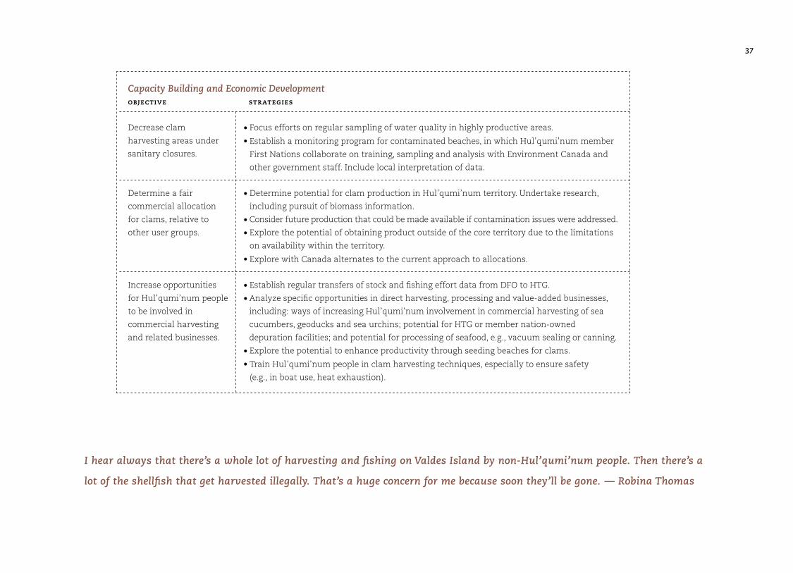
Capacity Building and Economic Developmentobjective strategies
• Focus efforts on regular sampling of water quality in highly productive areas.
• Establish a monitoring program for contaminated beaches, in which Hul’qumi’num member
First Nations collaborate on training, sampling and analysis with Environment Canada and
other government staff. Include local interpretation of data.
• Determine potential for clam production in Hul’qumi’num territory. Undertake research,
including pursuit of biomass information.
• Consider future production that could be made available if contamination issues were addressed.
• Explore the potential of obtaining product outside of the core territory due to the limitations
on availability within the territory.
• Explore with Canada alternates to the current approach to allocations.
• Establish regular transfers of stock and fishing effort data from DFO to HTG.
• Analyze specific opportunities in direct harvesting, processing and value-added businesses,
including: ways of increasing Hul’qumi’num involvement in commercial harvesting of sea
cucumbers, geoducks and sea urchins; potential for HTG or member nation-owned
depuration facilities; and potential for processing of seafood, e.g., vacuum sealing or canning.
• Explore the potential to enhance productivity through seeding beaches for clams.
• Train Hul’qumi’num people in clam harvesting techniques, especially to ensure safety
(e.g., in boat use, heat exhaustion).
Decrease clam
harvesting areas under
sanitary closures.
Determine a fair
commercial allocation
for clams, relative to
other user groups.
Increase opportunities
for Hul’qumi’num people
to be involved in
commercial harvesting
and related businesses.
I hear always that there’s a whole lot of harvesting and fishing on Valdes Island by non-Hul’qumi’num people. Then there’s a
lot of the shellfish that get harvested illegally. That’s a huge concern for me because soon they’ll be gone. — Robina Thomas
38
Protecting and Restoring Intertidal Resourcesobjective strategies
• Prohibit salmon aquaculture from nearshore waters in Hul’qumi’num territory.
• Expand water quality testing and monitoring programs to enforce permits for discharge of
industrial and municipal waste.
• Explore the potential to manage clam harvesting according to the traditional practice of
moving from beach to beach to dig clams so as to allow beaches to replenish.
• Develop and enforce more stringent regulations to reduce impacts from log booming grounds,
log dumping and barges. Ensure that tenures for log storage are moved away from shallow
waters. Promote shorter tenures so that areas can be changed based on results of monitoring.
• Improve the information base on stock abundance, e.g., through regular transfers of stock
and fishing effort data from DFO to HTG and member First Nations.
• Increase controls or limitations on recreational shellfish harvesting and commercial
harvesting through more stringent regulations.
• Reduce illegal catch through better enforcement of existing regulations, supported by
surveillance (monitoring or patrolling of beaches) by Hul’qumi’num people.
• Close certain areas to commercial harvesting as required for recovery of intertidal populations.
• Coordinate restoration efforts to more effectively garner funding for restoration and to
build capacity.
• Educate Hul’qumi’num people to reinforce traditional values that encourage Hul’qumi’num
people to take only what they need and not to waste resources, to enable them to participate
in fisheries management decision-making, and to help them recognize and work to reduce
negative impacts of harvesting on local species.
• Obtain funding to employ Hul’qumi’num people in cleaning up the beaches and in
enhancement projects.
• Explore the potential for enhancement activities such as re-seeding of clams and replenishment
or rehabilitation of species such as lhuq’us (sea lettuce).
Mitigate, reduce or
prevent uses of the
nearshore environment
that are harmful to
intertidal habitat and
species.
Reduce harvesting
pressures on intertidal
species.
Restore degraded
habitats and resources.
39
7.2 Agriculture7.2.1 background
Within the HTG core traditional territory, large tracts of prime
agricultural land are found in the lower part of the Cowichan
and Chemainus watersheds, and in the Yellow Point area.
Prime agricultural land is also found on Gabriola, Saltspring
and Saturna Islands, as well as along the lower Fraser River.
The remainder of areas on Vancouver Island and the Gulf Islands
are generally low to moderate capability for agriculture.12
7.2.2 summary of community perspectives on agriculture
Some Hul’qumi’num people do not see agriculture as an
important land use, although this activity was more important
in the past. Agricultural land in Hul’qumi’num territory is
productive, but there appears to be limited experience or
interest in farming among Hul’qumi’num people.
There is some support for the Hul’qumi’num First Nations to
pursue agricultural ventures especially grape vineyards, fruit
orchards, or berry farming. Hul’qumi’num people would like
to see the nations be more self sufficient in providing the food
needs of the community. Some people feel it would be important
for Hul’qumi’num youth to be trained in agriculture, and take
advantage of the opportunities in this area. Agriculture should
be low impact on the natural environment, and provide long-
term employment and food for the Hul’qumi’num communities.
Greenhouse agriculture was suggested. It was also suggested
that some areas could be set aside for harvesting q’uxmin, since
there are few places where it is naturally available now.
There is some concern that the pace of urban development
will result in the alienation of remaining arable land, and that
the nations should try and save the existing farm areas with
the hope that some Hul’qumi’num people will take an interest
in this activity in the future. Much of the best farming land on
reserve is also leased to non-members.
7.2.3 goals
• Promote a sustainable agricultural sector in support of
Hul’qumi’num Mustimuhw food needs and economic
development.
A lot of people don’t know the importance of agriculture. It’s healthier to grow your own food and it’s cheaper.
You get more vitamins from freshly grown fruit and vegetables. — Martina Joe
12 Kotaska, J. March 14, 2003. Hul’qumi’num Land Selection Study. Volume II: Land and Resource Assessment. POLIS Project on Ecological Governance, University of Victoria. pg. 41.
40
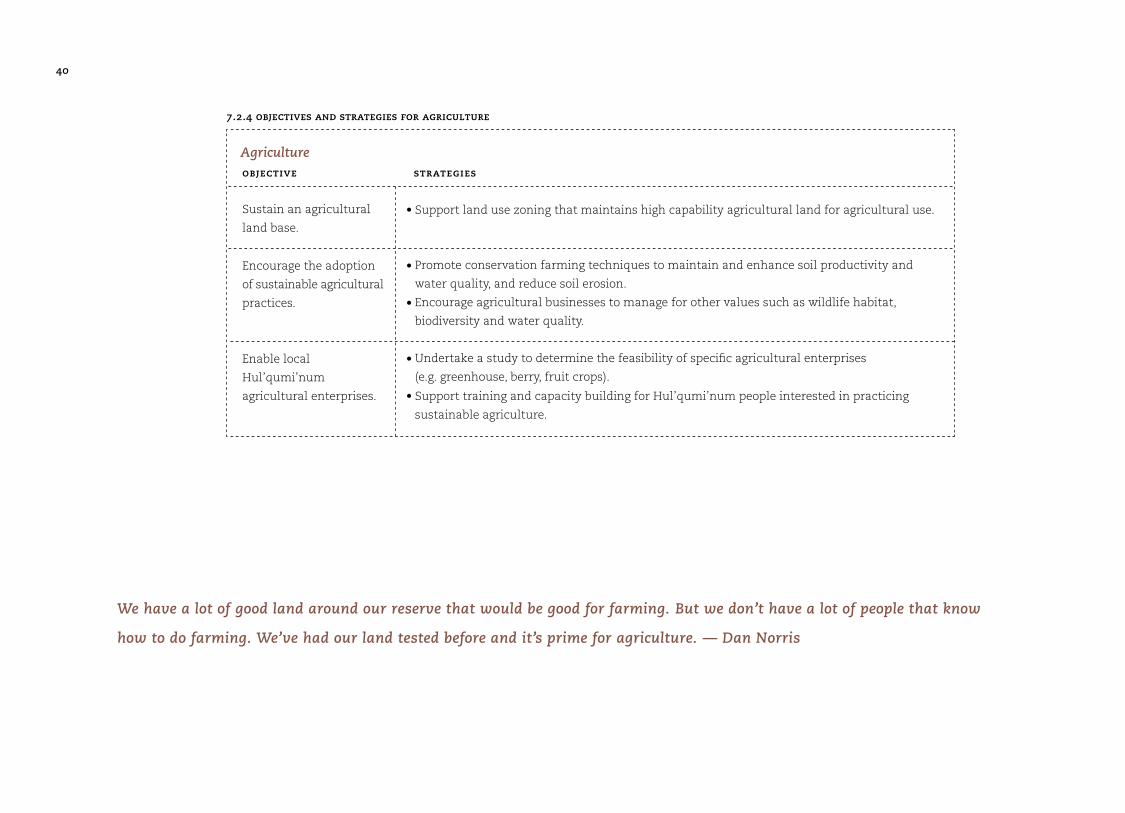
7.2.4 objectives and strategies for agriculture
objective strategies
• Support land use zoning that maintains high capability agricultural land for agricultural use.
• Promote conservation farming techniques to maintain and enhance soil productivity and
water quality, and reduce soil erosion.
• Encourage agricultural businesses to manage for other values such as wildlife habitat,
biodiversity and water quality.
• Undertake a study to determine the feasibility of specific agricultural enterprises
(e.g. greenhouse, berry, fruit crops).
• Support training and capacity building for Hul’qumi’num people interested in practicing
sustainable agriculture.
Sustain an agricultural
land base.
Encourage the adoption
of sustainable agricultural
practices.
Enable local
Hul’qumi’num
agricultural enterprises.
Agriculture
We have a lot of good land around our reserve that would be good for farming. But we don’t have a lot of people that know
how to do farming. We’ve had our land tested before and it’s prime for agriculture. — Dan Norris
41
7.3 Access Management7.3.1 summary of community perspectives on access
Hul’qumi’num people are heavily constrained in their access
to land and resources. Many areas that were important to the
Hul’qumi’num people in the past, for resource gathering or
cultural uses, are now owned by non-Native. In some cases,
Hul’qumi’num people have been denied access to traditional
use areas because they cannot get permission to cross private
property. There are also concerns that most of the territory is
readily accessible by road. As a result, there are few opportunities
for privacy and seclusion.
7.3.2 access management goals
• Sustain and enhance Hul’qumi’num access to traditional
use areas.
• Manage public access to protect the integrity of
Hul’qumi’num spiritual, cultural and traditional use areas.
Access Managementobjective strategies
• Develop access management plans for Hul’qumi’num Mustimuhw Intensive Traditional Use
Areas (HMITU) as appropriate (See Section 8, page 79).
• Prohibit new access development in HMITU until access management plans are in place.
• Encourage de-activation or gated access of forest access roads in HMITU, or other sites with
important cultural, spiritual or wildlife values.
• Secure agreement with forest companies for keys to gates on private forest lands.
• See Objectives and Strategies in Section 7.1.4 (page 34).
Manage resource
development access to
eliminate or minimize
impacts on traditional
use, cultural and
heritage, wildlife and
other values.
Protect and enhance
access to beach
resources.
7.3.3 objectives and strategies for access management
42
Within the HTG core traditional territory, there are 272 rare
plant or plant community occurrences, or record size trees.17
Rare plant occurrences occur throughout the territory, with
concentrations along the Fraser River, in the southern portions
of the Gulf Islands, and along the coastal portions of Vancouver
Island and north of Lake Cowichan.18
wildlife at risk
Within the HTG core traditional territory, there are 118 rare animal
occurrences, representing 27 animals species — including 12 bird
species, 3 mammals, 3 marine invertebrates, 6 butterflies and
skippers, 2 fish, and 1 reptile.19 Two of the marine invertebrates
are located in Finlayson Arm (Greenland cockle and halichondrid
sponge). Butterfly and skipper occurrences are throughout the Gulf
Islands and along the coast of Vancouver Island. The Cowichan
Lake lamprey occurs in Lake Cowichan and the white sturgeon is
found in the Fraser River. Sharp-tailed snakes are found on various
Gulf Islands. The bird occurrences are throughout the coastal
portions of the territory. All of the mammal occurrences are in the
north of Lake Cowichan, mostly representing Vancouver Island
marmots. The Vancouver Island marmot lives exclusively on
Vancouver Island, and almost all marmot colonies are within
the HTG traditional territory. Other species of concern include
Peregrine Falcon, Great Blue Heron, and Townsend’s big-eared bat.
Important habitats for migratory birds include Somenos Lake,
Quamichan Lake and the Fraser River delta.
harvested wildlife
Large land mammals, including deer, elk, moose, mountain
goat and bear, as well as sea mammals such as seals, sea lions
and porpoises, are important wildlife species harvested by
Hul’qumi’num people.20 Numerous birds, such as ducks and
geese, were also harvested. Hunting wildlife remains an
important part of many Hul’qumi’num people’s lives today.
13 SEI Project on file Hul’qumi’num Treaty Group14 SEI Project. Saving Riparian Ecosystems, on file Hul’qumi’num Treaty Group15 British Columbia, Ministry of Environment, Lands and Parks. 1999. Coastal Douglas-fir Ecosystems: Ecosystems at Risk in British Columbia. 16 British Columbia, Ministry of Environment, Lands and Parks. 1993. Garry Oak Ecosystems: Ecosystems at Risk in British Columbia.
7.4 Biodiversity and Wildlife Management 7.4.1 background
The Hul’qumi’num traditional territory is a unique ecological
region in Canada. The Mediterranean-type climate and long
growing season supports many rare species of plants, animals,
and plant communities. It is also one of two areas in British
Columbia where the greatest loss of natural systems has
occurred. Intense development pressures throughout this
region have resulted in the fragmentation, degradation, and
loss of these natural ecosystems. Less than 8% of eastern
Vancouver Island and the Gulf Islands support remaining
fragments of natural ecosystems.13 Only about 1.5% of riparian
ecosystems remain in a relatively natural state.14 The loss of
riparian ecosystems and older forests has greatly reduced the
number of fish and wildlife that these areas can support.
The Coastal Douglas-fir (CDF) biogeoclimatic zone covers all of
the coastal portions of the territory. Due to extensive develop-
ment pressures, only fragments — less than 0.05%, or 1100
hectares — of the Coastal Douglas-fir ecosystem remain as old-
growth.15 Of the six distinct Douglas-fir old-growth forest types
on the low coastal plain of southern BC, all are currently on the
province’s list of rare and endangered ecosystems. Nine upland
types are also listed as endangered. The Garry Oak ecosystem, a
forest ecosystem type found only on southern Vancouver Island
in BC, is also considered to be an ecosystem at risk.16
Inland and upland areas of the Hul’qumi’num Core traditional
territory are predominantly within the Coastal Western Hemlock
(CWH) biogeoclimatic zone. Forests of this zone, while common
to most coastal regions of BC, have been heavily logged with the
HTG traditional territory. As a result, there are few old forests
remaining, except in fragments (See Section 7.8.1, page 61).
how can you restore
old growth forests?
it would take at
least 100 years to
restore and i won’t
be alive. so i would
say protect old
growth, and restore
new growth. i don’t
think we have a lot
of old growth left.
— frank conibear
43
Roosevelt elk are a blue-listed species, meaning their populations
are vulnerable to extinction in British Columbia. There are several
herds of Roosevelt elk in the HTG traditional territory, including
herds in the Nanaimo River area and along the north shore of Lake
Cowichan. The population of the four herds in the Lake Cowichan
area is estimated at 200 animals in 2002.21 The Cowichan Lake
herds are located in the Meade, Cottonwood, McKay and Shaw
Creek watersheds. Unregulated hunting and predation are thought
to be keeping the herds north of Lake Cowichan at about half of
their potential population given the available habitat.
The Hul’qumi’num Treaty Group recently commissioned an
ecological assessment to determine the current distribution
and abundance of plant, mammal and bird species that are of
cultural importance to the Hul’qumi’num people and may be
limited in abundance. They study also contains estimates of
the harvesting area necessary to support the needs of
Hul’qumi’num people, both now and in the future, taking into
consideration the impacts of different land management
regimes on significant resources.22
7.4.2 summary of community perspectives on biodiversity
and wildlife management
• Many Hul’qumi’num people have concerns about how heavily
impacted the territory has been from various kinds of resource
extraction and urban development. Hul’qumi’num people
recognize many wildlife habitats have been seriously degraded
and need to be restored and protected. There has been a
dramatic loss in salmon habitat and extensive work needs to
be done to restore salmon streams.
• Logging has had a huge impact on the forests of the traditional
territory. Many Hul’qumi’num people expressed concern with
the extent of clearcutting and the damage that has been
done to rivers, streams, and wildlife habitat. Some would like
to see Hul’qumi’num people working in the forest, cleaning
up the streams and restoring the productivity of the land.
There also need to be more regulations on private forest land
to protect wildlife.
• Hul’qumi’num people are particularly concerned about salmon
and fish habitat, and threats to the elk, deer and bald eagle
habitat. They see some animals, such as bears and cougars,
coming into the community because so much of their natural
habitat has been lost. Their concerns also include reserve
land, where housing development threatens wildlife habitat.
Opportunities to hunt deer, elk and other animals have
been greatly reduced due to loss of habitat.
• Hul’qumi’num involvement in wildlife management is a high
priority. Most Hul’qumi’num people are concerned about
how little say they have had in the changes to the territory
and would like to see the Hul’qumi’num member First
Nations much more actively involved in wildlife management
for a whole range of species, both commercially harvested
species, traditionally hunted species, and other species that
are vulnerable or at risk. Habitat restoration is seen as
important, especially to bring back the native plants and
habitats of key wildlife species.
• Protection of old growth forest is a key issue for many
Hul’qumi’num people. Because so little old growth remains,
areas of mature forest need to be protected and allowed to
develop into old growth forests in the future. Sensitive ecosys-
tems need to be protected or restored. Some Hul’qumi’num
people would like to see as much as possible of the territory
retained in its natural state. Many Hul’qumi’num people would
like to see the beaches and foreshore protected, for traditional
harvesting and for their natural values. Few of these sites
remain for Hul’qumi’num people’s use.
17 British Columbia Conservation Data Centre. 2002. 18 Kotaska, J. March 14, 2003. Hul’qumi’num Land Selection Study. Volume II: Land and Resource Assessment. POLIS Project on Ecological Governance, University of Victoria. 99 pp. 19 Conservation Data Centre Rare Element Occurrence Report, 200320 Hodding, B. 1998. Report on the Ethnohistory of the Hul’qumi’num Treaty Group. p. 2621 Brunt, K. 2002. Vancouver Island Roosevelt Elk: Ecology and Management Overview. Ministry of Water, Land and Air Protection, Nanaimo, BC. 19 pp. 22 Murray, C., D. Polster, S. Leigh-Spencer, W. Campbell. August 27, 2004. Ecological Assessment of the Statement of Intent Area and Coast Salish World. Volume 1. Methodology and Results.
we have to protect
every habitat and
keep it from major
pollution.
— joe manson
i don’t know if
[old growth forests]
can be restored,
i think it would be
very important if
we can provide some
protection. we know
that there will be a
chain effect if they
are destroyed. chain
effect meaning loss
of animals, certain
types of plants.
they’ll either move
away or we will lose
them all together.
i don’t think we can
take that chance.
— larry george
44
• Maintain and restore the productivity and diversity of
native plants and animals.
• Ensure that Hul’qumi’num people have opportunities to
hunt, fish and trap to meet their domestic and cultural
needs, and in accordance with their customary laws and
institutions.
• Ensure that Hul’qumi’num people have meaningful authority
over the management of wildlife and wildlife habitat.
• Ensure that Hul’qumi’num people have capacity for effective
wildlife management.
• Ensure that Hul’qumi’num people benefit from jobs and
economic activity associated with wildlife management,
including wildlife viewing and protected areas management.
Management Authority objective strategies
• Establish a joint Wildlife Management Committee with the provincial and federal governments
to address wildlife management issues in Hul’qumi’num core traditional territory, especially
species and ecosystems at risk, and species and habitats of special management concern to
Hul’qumi’num people.
Increase Hul’qumi’num
Treaty Group authority
over the management of
wildlife and wildlife
habitat.
Ecosystems and Habitat Conservationobjective strategies
• Work with federal, provincial and local government agencies to designate and protect critical
ecosystems and habitats,
• Explore the feasibility of acquiring critical ecosystems and habitats on private land through
treaty settlement or in partnership with land trusts/conservation foundations.
• Establish Hul’qumi’num guidelines for the protection and/or restoration of species at risk
and critical habitats.
• Compile and maintain traditional ecological knowledge (TEK) information from Elders and
other Hul’qumi’num people on rare, sensitive or declining species.
Protect and/or restore
critical ecosystems and
habitats.
Protect, and where
necessary, restore rare,
sensitive or declining
wildlife or wildlife
species or populations.
7.4.4 objectives and strategies for management of wildlife and biodiversity
7.4.3 goals for the management of wildlife and biodiversity
45
Management of Harvested Wildlife objective strategies
• Manage harvest to achieve the following, in order of priority: meet conservation objectives;
provide Hul’qumi’num harvest opportunities to meet traditional food requirements; and,
provide opportunities for commercial and recreational hunting as appropriate.
• Develop and require Hul’qumi’num approval of wildlife harvest and habitat management
guidelines for species of special management concern to the Hul’qumi’num people, focusing
initially on elk and deer.
• Establish and implement a reporting system for all harvest activity for species of special
management concern to the Hul’qumi’num people.
• Establish methods to designate no-hunting, seasonal hunting closures and licensing procedures
for populations of concern.
• Establish a mechanism (e.g., Joint Wildlife Management Committee) to support monitoring
and management of harvested wildlife populations.
• Compile and maintain traditional ecological knowledge (TEK) information from Elders and
other Hul’qumi’num people on harvested species.
Ensure and promote
aboriginal rights to
wildlife harvest in all
harvest management
decisions.
Maintain or restore
healthy and widely
distributed populations
of harvested species.
Capacity Building and Economic Developmentobjective strategies
• Develop a HTG Wildlife Watch program, to engage Hul’qumi’num people in field-based
wildlife and wildlife habitat monitoring.
• Involve Elders in training programs for Hul’qumi’num people on appropriate conduct and
protocols for hunting and trapping, and the handling of fish, seafood and other products.
• Provide training opportunities to Hul’qumi’num youth in wildlife management and
traditional harvesting.
Build and sustain
Hul’qumi’num capacity
for wildlife management.
46
7.5 Fish and Aquatic Habitat7.5.1 background
Freshwater fishing is very important to Hul’qumi’num people.
The streams and lakes of the traditional territory support all
five species of salmon and numerous freshwater fish species.
Fish distribution is spread quite evenly over the territory, with
salmon less common in some headwater lakes.23 Freshwater
fish species include cutthroat, rainbow, steelhead and brown
trout, and smallmouth bass.24
7.5.2 summary of community perspectives on fish and
aquatic habitat
• Protection and restoration of streams and fish habitat.
Hul’qumi’num people feel it is very important to protect and
restore streams and fish habitat, and to do more salmon
habitat restoration in particular. Stream restoration activities
that people would like to see increased include cleaning out
debris, restoring side channels, and improving spawning
habitat. Other suggestions are to improve the food supply for
fish, and to re-establish streams in areas where they have
been lost to urban development. Restoration work is already
underway and in some areas streams have been regularly
cleaned of debris for some time. Some Hul’qumi’num people
feel restoration efforts have been successful, while others
are frustrated at what they see as a lack of progress.
Hul’qumi’num people have called for more training in
habitat restoration, better information to guide efforts, and
more control of restoration projects.
• Controls on fishing: There are widespread concerns about the
over-harvesting of in-river fish, which combined with habitat
loss, has led to a severe decline in populations. More controls
need to be in place to ensure conservation of fish stocks.
• Salmon hatcheries: Hul’qumi’num people have mixed opinions
about salmon hatcheries, with most feeling they are important to
very important (62%), but others are opposed to more hatcheries
(18%) or feel that more hatcheries is not important (10%). Support
is driven by the need to save salmon stocks, raise the numbers of
various fish including trout and salmon, and provide fish and jobs
for Hul’qumi’num people. Benefits to the Hul’qumi’num are a
condition of support for many people. Those opposed to more
salmon hatcheries feel that one hatchery run by First Nations in
the territory is enough and that the focus should instead be on
stream enhancement. The negative impacts of hatcheries on wild
salmon stocks need to be closely examined and facilities may
need to be improved. Another concern is that hatcheries should
not be raising brown trout, which are not native to the territory
and consume wild fish. Some Hul’qumi’num people are con-
cerned with the infection of wild stocks with diseases from
hatcheries, but these people might be thinking about net pen
salmon farms at sea rather than hatchery impacts.
Hul’qumi’num people are generally against salmon farming.
7.5.3 goals for management of fish and aquatic habitat
• Restore and maintain the diversity and abundance of
wild populations of all native fish species in perpetuity.
• Restore and maintain the structure, function, diversity
and natural productive capacity of aquatic habitats
throughout Hul’qumi’num territory.
• Sustain the cultural and sustenance benefits of
fisheries, fish, and other aquatic organisms for
Hul’qumi’num people.
23 Kotaska, J. March 14, 2003. Hul’qumi’num Land Selection Study. Volume II: Land and Resource Assessment. POLIS Project on Ecological Governance, University of Victoria. Map #16: Conservation – Fish and Wildlife. 24 Brown trout and smallmouth bass are introduced species.
i think we need to
continue to do
exactly what we’ve
been doing in stream
enhancement:
encourage the stock
to build by enhancing
the stream. what
i’ve heard from my
father-in-law, he
spoke of elders and
what they used to do,
which is manually
cleaning the streams.
he spoke of somenos
lake, certain people
looked after it. they
just did it, no pay.
their pay is return
of stock.
— harvey alphonse
47
Management Authorityobjective strategies
• Develop and require Hul’qumi’num member First Nations approval of a licensing and
management regime for commercial and sport fishing in the territory.
Ensure that the
Hul’qumi’num people
have meaningful
authority over the
management of fish and
aquatic habitat in the
traditional territory.
7.5.4 objectives and strategies for the management of freshwater fish and aquatic habitat
Fish Habitat Protection objective strategies
• Work cooperatively with Hul’qumi’num people, government fisheries agencies, other
First Nations, and stakeholders such as stewardship groups and commercial fishermen,
to identify regional priorities for fish and fish habitat management.
• Develop and implement watershed plans for priority fish-bearing watersheds that maintain
the structural and functional integrity of streams, stream channels, lakes, riparian areas,
and other aquatic habitat areas across the Hul’qumi’num territory in perpetuity.
• Require site level assessments prior to any development activity that has the potential to
impact fish or aquatic habitat.
• Prohibit development or disturbance in any area adjacent to or within fish habitats unless
impacts on fish or habitat values are eliminated, or substantially mitigated.
• Establish adequate protective reserves around all fish bearing streams and critical habitats.
Ensure long term
conservation of fish and
aquatic habitat across
the Hul’qumi’num
territory.
48
Habitat Enhancement and Hatcheries objective strategies
• Implement small-scale habitat enhancement measures to increase productivity of spawning
environments.
• Require responsible agencies to undertake a detailed assessment to determine the
cost-effectiveness and impacts of past hatchery activities on fish and aquatic habitat values
in the territory, and to assess potential risks associated with such activity.
Maintain or increase the
productivity of spawning
streams and fish habitat
areas through habitat
enhancement.
Fish Habitat Restoration objective strategies
• Identify and map spawning streams and other habitats that require restoration due to past
habitat degradation.
• Establish workplans to restore the productivity of degraded areas.
Restore the natural
productivity of spawning
streams and other aquatic
habitat areas where past
impacts have occurred.
Conservation of Biodiversity and Stock-by-Stock Management objective strategies
• Adopt an ecosystem-based management approach for all planning and management of
fish and aquatic habitat.
• Undertake a detailed stock assessment to determine current and historic population abundance
and distribution of fish species. Priority should be given to exploited species and those that
are vulnerable (blue-listed), or threatened or endangered (red-listed). Coordinate stock-specific
data collection initiatives with other project activities.
• Develop, refine and implement a risk-assessment management approach based on
conservation units.
• Develop management strategies for red or blue listed fish species and ensure these strategies
are addressed in landscape level or resource development plans
Ensure the long term
conservation of fish
biodiversity within the
territory.
49
Harvest Management and Allocation objective strategies
• Establish annual escapement goals for all exploited species based on target and limit
reference points for each conservation unit.
• Prohibit fishing of depleted or threatened stocks/conservation units.
• Develop a recovery plan for restoring depleted or threatened stocks/conservation units.
• Develop and implement catch monitoring regimes for commercial, sport and subsistence
fisheries adapted to a conservation unit management approach.
• Maintain priority access to fisheries for Hul’qumi’num use.
• Develop and implement a reporting system for Hul’qumi’num subsistence fishing.
• Pursue appropriate allocation of quota for Hul’qumi’num member First Nations from
commercially exploited fisheries.
• In consultation with the Elders, develop and implement an allocation framework to
ensure the equitable distribution of opportunity for commercial fishing among
Hul’qumi’num peoples.
Ensure that escapement
goals for all exploited spe-
cies are set conservatively
so as to maintain the health
and viability of all conserva-
tion units in perpetuity.
Ensure that subsistence
harvesting opportunities
are afforded to
Hul’qumi’num people
and distributed among
them equitably.
Ensure that commercial
harvesting opportunities
are afforded to the
Hul’qumi’num people
and distributed among
Hul’qumi’num people
equitably.
Sport Fishing objective strategies
• Develop and implement a Hul’qumi’num permitting system for all sport fishing guides
operating in the territory.
• Limit sport fishing to designated areas so that conflicts with Hul’qumi’num subsistence use,
commercial fishing, commercial recreation, or other users is minimized.
Allow sport fishing oppor-
tunities within a manage-
ment approach that
protects ecosystem values
and avoids conflicts with
subsistence or commercial
fisheries in the territory.
50
Water Quality, Quantity objective strategies
• Ensure adequate instream flows to maintain fish stocks.
• Establish an initial ranking of areas of concern within the territory for water quality.
• Undertake water quality sampling, water hydrology analysis and other biomonitoring projects
as needed based on known problems, or potential threats, to water quality/flow regimes.
• Develop and implement guidelines for upstream and upslope development activities to
prevent siltation, temperature, and hydrological problems in watersheds supporting fish.
These guidelines should require higher standards of precaution, greater accountability for
proponents for impacts, and more significant penalties for infractions. Monitor compliance
with and effectiveness of these guidelines.
• Require sediment control measures for all development activities that have the potential
to impact water quality.
• Develop and implement guidelines for boat use on all lakes in the territory, including waste
disposal measures.
• Prohibit the introduction of any deleterious substance into fish-bearing watercourses.
Maintain water quality,
quantity and natural
flow regimes or restore,
where necessary.
Traditional Fishing Sites objective strategies
• Identify and map traditional fishing camps and locations at the appropriate scale.
• Establish Hul’qumi’num-only fishing areas for commercial and subsistence use.
• Develop and implement guidelines for the management of traditional fishing sites.
• Prohibit development activities which threaten the integrity or continued use of
traditional fishing sites.
Identify traditional
fishing sites and main-
tain their social, cultural
and economic values in
perpetuity.
51
Capacity Building and Enforcement objective strategies
• Establish training programs for Hul’qumi’num youth to build capacity and capabilities for
fisheries management. Involve the Elders in all such training.
• Appoint qualified Hul’qumi’num fisheries technicians to undertake monitoring and enforcement
duties within the territory. Maintain active presence during periods of fishing activity.
Increase the capacity of
Hul’qumi’num people
to a level sufficient to
assume responsibility for
management of fish and
aquatic habitat, and
commercial, sport and
subsistence fisheries.
52
7.6 Cultural and Heritage Resources7.6.1 background
The Hul’qumi’num Treaty Group has been actively researching
and documenting Hul’qumi’num cultural, historical and
spiritual connections to the traditional territory over the last
five years. This research has involved the preparation of a
comprehensive Traditional Use Study, an archival literature
review, an internal genealogy study, a language revitalization
plan, and a program of archaeological field research for the
purposes of assisting treaty negotiations.
hul’qumi’num traditional use sites
Hul’qumi’num people have an inherent interest in the
protection of both the tangible, archaeological remains of the
past, and the intangible, historical lands where the Ancestors
and Spirits dwell.
Syuth historical lands
Oral history, family genealogies, and language embed
Hul’qumi’num people to their land. Although many of these
traditional use sites often have no physical evidence of past
aboriginal use, these places signify enormous value for the
cultural identity of Hul’qumi’num people. For a people whose
history is based on oral tradition, these heritage sites are living
cultural landscapes, where Hul’qumi’num persons learn about
and experience their relationship with the land. Examples of
such intangible heritage sites may include places where the
First Ancestors fell, places changed by Xeel’s the Transformer to
stone, and places identified in oral traditions and legend. There
are places of power that reside in the deep wilderness in the
vicinity of pools, waterfalls, streams, valleys and mountain
forests distant from human life that are sacred to persons who
practice the winter spirit dance religion. At these wilderness
spirit places there may be bathing pools, places where ceremonial
regalia are traditionally stored, and environments where
special resources are collected for medicinal, spiritual and
ceremonial use. There are also numerous traditional use
locations of cultural significance to Hul’qumi’num people
where people continue to engage in traditional economic
practices such as fishing, shellfishing, hunting and gathering.
The GIS mapping of traditional use locations for the HTG
Traditional Use Study (TUS) indicate that the coastal shore-
lines of the territory were the most intensively utilized, in
contrast to more inland, mountainous areas. Conspicuously,
the Cowichan Valley represents one the most highly utilized
areas based on TUS data. It should be noted, however, that the
density of traditional use sites may not correlate with cultural
significance. A single site, such as a Transformer Place or
bathing pool, can have a very high cultural significance.
Secondly, it must be explained that TUS information primarily
describes modern and historical land use patterns within the
last century. The high number of TUS sites recorded in the
Cowichan Valley may be due to historical resettlement of
Hul’qumi’num people on these large reserve lands in the
last century. Similarly, the lack of inland TUS sites may largely
be the result of recent land use constraints (colonization,
privatization of land), rather than a lack of pre-contact/
traditional use. Based on Elders testimony, the sample of
persons interviewed from different communities may also
be a factor.
lots of repatriation
needs to take place.
longhouse artifacts.
museums all over the
world, those need
to come home.
— chuck seymour
i think we have a
very important job
here and it could
be very tightly
controlled. too often
the white man has
come and desecrated
our gravesites and
middens. it shouldn’t
be allowed.
— ross modeste
53
archaeological sites
Over 1,000 archaeological sites have been recorded in
Hul’qumi’num Core Traditional Territory. Archaeological sites,
such as shell middens, burial caves, lithic scatters and rock art
sites, are tangible heritage sites that physically mark ancient
historical sites of Coast Salish villages, cemeteries, camps,
resource locations and places of spiritual use. These archaeo-
logical resources not only document physical evidence of past
settlement and use of Hul’qumi’num lands and resources
across the Territory, but have contemporary social importance
for Hul’qumi’num people to respect their Ancestors and
maintain their cultural identity.
In contrast to the TUS data, archaeological site location
patterns indicate that the southern Gulf Islands were the most
intensively utilized land and resources in pre-contact times.
This site distribution may partly reflect the intensity of past
settlement in this coastal area. However, it may also be a
sampling issue due to the lack of archaeological survey in
inland areas, notably the Cowichan and Chemainus River
Valleys. It is estimated that there are a similar number of
unrecorded archaeological sites throughout the territory.
7.6.2 summary of community perspectives on cultural and
heritage resources
Hul’qumi’num people express a great desire to regain their
cultural connection to their traditional lands. A majority of
persons interviewed further state there is an urgent need to
ensure Hul’qumi’num culture remains a living legacy for
future generations.
Specific perspectives include the following:
• Hul’qumi’num people strongly support measures to identify
and protect archaeological sites from destruction.
Hul’qumi’num people strongly support measures to identify
and protect Hul’qumi’num heritage sites. It is frequently
mentioned that ancient cemeteries and burial grounds, old
village locations, rock art sites and midden sites need urgent
protection. There is an awareness that many cemeteries and
burial grounds have been destroyed by vandalism and that
many other heritage sites and artifacts are rapidly being
removed from the land as a result of modern land develop-
ment. The protection of archaeological sites received 93%
support as an a very important issue.
• Hul’qumi’num people strongly support measures to protect
cultural lands. Hul’qumi’num people equally want to strongly
protect their intangible cultural relationships to the land,
such as Transformer Places, wilderness spirit areas, traditional
gathering areas and other natural places where Hul’qumi’num
people can seek solitude and spiritual renewal. The protec-
tion of bathing pools is identified as especially important to
Hul’qumi’num people. Too many wilderness areas used for
spiritual activities have been degraded by modern land use.
Many of the bathing pools have become xum’ xum’ (polluted).
The proposed ‘Noise Park’ at Hw’t’eshutsun was frequently
cited as an example of an important cultural landscape that
is threatened with inappropriate development and needs to
be protected. Problems of access to these traditional use
areas and loss of privacy are identified as significant commu-
nity land planning concerns. The protection of cultural
landscapes received 92% support by Hul’qumi’num people as
a very important issue.
the bath holes,
there’s one near
the north end of
shawnigan lake.
horrendous.
motor bikers go
down there and
make a mess. the
bath hole isn’t as
deep anymore. they
run bikes across
there and destroy
it. there’s a number
of others i haven’t
been back to, so i
don’t know their
condition.
— delmar johnnie
54
• Hul’qumi’num people support more control over heritage
research, conservation and cultural resource management.
Hul’qumi’num people generally support measures to assert
more Hul’qumi’num control over the research, conservation
and management of Hul’qumi’num heritage sites. There is a
concern that more care and conservation is needed to respect
these places. For instance, it is suggested that many cemeteries
and other archaeological sites along the shoreline are
naturally eroding from storms and tides and need better
protection. Documentation of these heritage sites will help
provide public education for Hul’qumi’num people to
understand the past and pass on to future generations
knowledge of how their Ancestors lived. There is a stated
interest in Hul’qumi’num people having sole jurisdiction
over their heritage sites, artifacts and ancient human
remains in the future. There must be museum facilities
constructed by Hul’qumi’num governments to house
cultural artifacts.
By building a role in heritage research and conservation, it
is understood that this measure will help assert the presence
of Hul’qumi’num people across the Traditional Territory.
Overall, 66% of respondents supported more involvement in
heritage research, conservation and management as a very
important issue.
• Educational Opportunities in Language, Culture and Heritage.
Providing educational opportunities for Hul’qumi’num
people to learn about their language and their cultural
heritage is a strong interest expressed by many people.
Hul’qumi’num people strongly support measures to protect
and enhance Hul’qumi’num language and traditional teachings.
Through language and teachings, Hul’qumi’num concepts
of land and resource stewardship can be communicated
and practiced. Many people consider the revitalization of
Hul’qumi’num customary laws to be central to improving
the future management of land and resources in the territory.
There is an interest for Hul’qumi’num people to be educated
about their origins, including both their archaeological heritage
and their oral history of the Ancestors and Transformer Places.
There is a strong interest in educational courses to teach
Hul’qumi’num people about traditional skills in order to return
to practicing traditional livelihoods. There is also an interest in
creating opportunities on the land for Hul’qumi’num people to
earn a living consistent with traditional ways.
7.6.3 goals for the management of heritage and
cultural values
• Preserve and protect traditional use areas, cultural
heritage sites, sacred sites, and other features and
values with heritage and cultural significance to
Hul’qumi’num people.
• Reaffirm and revitalize Hul’qumi’num traditional
uses of the land, cultural practices and learning.
• Ensure that Hul’qumi’num language and traditional
knowledge is understood and broadly used in land
and resource management.
they are our
ancestors. we
want to make sure
they’re properly
taken care of.
they provide
evidence to show
that we did use
and occupy this
land. it’s hugely
important.
— larry george
[archaeological
research and cultural
resource management
is] one of the most
important [activities].
any more information
we get in terms of
archaeological
evidence is of benefit
to ourselves, to our
grandchildren, and
to future generations.
— paul thomas
55
Jurisdictionobjective strategies
• Create Hul’qumi’num heritage laws and regulations to protect archaeological sites and
cultural landscapes on reserve lands and future treaty settlement lands.
• Establish a national political body within the Hul’qumi’num member First Nations such as a
Hul’qumi’num Heritage Council or Advisory Board that is given the authority to regulate
heritage laws.
• Establish a Hul’qumi’num permitting system, guidelines and protocols for any proposed
archaeological research and resource management concerning Hul’qumi’num heritage sites
in the territory.
• Require a Hul’qumi’num permit before any archaeological research or resource development
can occur on HTG-designated heritage sites.
• Require archaeological impact assessments (AIA) prior to development in areas of known
and unknown archaeological potential.
• Develop treaty measures and/or side agreements with BC to regulate archaeological sites
and historical lands off-reserve lands under the BC Heritage Conservation Act (1996) or
other legislation.
Ensure that the
Hul’qumi’num Treaty
Group member First
Nations have meaningful
authority over the
protection and
management of cultural
resources, including
archaeological sites,
historical lands, artifacts
and human remains
both on and off reserve
and future treaty
settlement land.
7.6.4 objectives and strategies for the management of heritage and cultural values
I think that’s really important for us and I say that because since I’ve been here, we’ve had three summers where we’ve
had archaeological teams out on Valdes. We’ve identified burial caves and archaeological sites. Cultural resource management,
I think in terms of history, I think it’s important that all relevant historical archaeological sites be identified for our children
so they too can identify their ancestral territory. — Barb Jimmy
56
Management of Heritage and Cultural Resources objective strategies
• Develop an Archaeological Overview Assessment (AOA) study of the HTG traditional territory.
• Identify and list archaeological sites and historical lands that have high cultural significance
to purchase as future treaty settlement lands.
• Identify and designate specific areas of the traditional territory where traditional use activities
and protection of heritage and cultural sites and values will take precedence over other uses
(See Section 8, page 79).
• Ground-truth identified heritage sites to ascertain their site location, condition and property status.
• Conduct an archaeological inventory of culturally-significant TUS areas that lack corresponding
recorded archaeological sites.
• Develop priorities for protection/restoration of identified sites, features or values.
• Develop and implement conservation plans for identified sites, features or
values based on priorities.
• Develop HTG policy to prohibit development activities that would have an unacceptable
impact on traditional uses and heritage/cultural values.
• Direct regional archaeological inventory research to ground truth recorded site locations
and document unrecorded archaeological sites.
• Construct a repository or museum facilities to professionally store and conserve repatriated
artifacts and archaeological materials.
• Repatriate Hul’qumi’num artifacts and ancient human remains.
• Update the HTG’s GIS database for TUS and Archaeological Sites as needed.
Protect culturally-
significant heritage lands
off-reserve.
Ensure the integrity and
long-term conservation
of archaeological sites
and historical lands.
Ensure that
Hul’qumi’num artifacts
and heritage objects are
protected for the benefit
of Hul’qumi’num people.
Ensure that archaeologi-
cal sites, historical lands
and other heritage sites
are properly identified and
recorded in an inventory
maintained by HTG.
57
Educationobjective strategies
• Establish a Hul’qumi’num Cultural Centre to provide educational services.
• Provide educational opportunities to Hul’qumi’num people to learn the
Hul’q’umi’num’ language.
• Cultural camps are encouraged to provide outdoor learning and cultural experiences in
traditional practices for Hul’qumi’num people, especially youth.
• Re-establish Hul’q’umi’num’ place names for key sites in the region. Ensure that
Hul’qumi’num place names are consistently adopted in all documentation.
• Provide public education to Hul’qumi’num people and the general public about importance of
heritage sites and the principles needed to respect and protect these special places.
Use plaques and other forms of public education about the cultural significance of specific
heritage sites (where confidentiality is not an issue).
• Provide information to all visitors on the history, culture and values of the Hul’qumi’num
people, such as books, websites and other media.
Increase awareness and
use of Hul’q’umi’num’
language, culture and
heritage values.
Archaeological research is extremely important to me because some of these archaeological digs are taking place out on
Galiano and Valdes. It secures the fact that some of our people existed and dwelled there. It will show the fishing and
clamming lifestyle of our people. — Nicole Norris
58
7.7 Recreation and Tourism7.7.1 background
An analysis of tourism capability shows that the majority of
Hul’qumi’num traditional territory has high capability to
support land and sea-based tourism.25 Areas with the highest
land-based tourism capability generally follow river corridors
in the Vancouver Island portion of the territory, including the
Cowichan, Chemainus, and Nanaimo Rivers. These areas have
the highest capability for sportfishing and resort development,
and one or both of hiking and mountain biking.
On the Gulf Islands, there is high capability for resort develop-
ment on most, if not all, of Galiano, Kuper, and Thetis Islands
and on portions of Gabriola, Valdes, Mayne, North Pender, and
Saltspring Islands. Very high wildlife viewing capability exists on
or adjacent to all of the Gulf Islands. There is very high capability
for hiking on Galiano and Saltspring, and for mountain biking
on Valdes, Galiano, Thetis, Kuper and Saltspring.
7.7.2 community perspectives on recreation and tourism
Many Hul’qumi’num people believe that nature-based and
cultural tourism are important activities that could generate
jobs and economic activity for Hul’qumi’num people and should
be pursued. Support is especially strong for nature-based or less
intensive tourism, such as campgrounds, trails and guided
hiking. There is mixed support for more intensive tourism
developments, such as destination resorts and golf courses.
Cultural tourism is seen as a way to educate Hul’qumi’num
youth, and others, about Hul’qumi’num culture, and increase
understanding and respect between non-Native and Native
peoples. Some Hul’qumi’num people are opposed to cultural
tourism development, however, or have significant concerns
that it could undermine the integrity of Hul’qumi’num culture
if it became commercialized. They feel that the culture of the
Hul’qumi’num people should not be on display or used for
commercial purposes. Of those who are opposed to tourism
development, some may give their qualified support if
Hul’qumi’num people were in charge and there was minimal
impact on traditional activities and use areas.
In short, tourism development must be led by Hul’qumi’num
people, with respect for Hul’qumi’num protocols and
cultural values. Tourism development must also be
environmentally sensitive, and not encroach on sacred
areas or sensitive sites.
Most Hul’qumi’num people would support increased recreation
opportunities for Hul’qumi’num people, to get more people
out on the land, and retain a connection to it. This is seen as
especially important for Hul’qumi’num youth. There is strong
opposition to a “noise park” or any kind of tourism or commercial
recreation development at or adjacent to Hul’qumi’num
cultural areas, such as Hw’t’eshutsun (Hill 60).
Specific perspectives on tourism and recreation development
include the following:
• Control over tourism development: Most Hul’qumi’num
people feel that the Hul’qumi’num member First Nations
should have full control over any culturally-based tourism
development in the territory. Joint ventures are seen as
appropriate ways to become involved in other (non-cultural)
tourism opportunities, and to develop capacity and job skills
among Hul’qumi’num people. Co-management of parks
and protected areas is seen as one means to ensure that
Hul’qumi’num people benefit from both recreational and
tourism opportunities in these areas.
[we need] a unified
plan for tourism
for first nations
activities / tourist
attractions that
supports each other.
there’s a number
of things we can
do to create
tourist related
small business
opportunities.
— robert morales
25 Kotaska, J. March 14, 2003. Hul’qumi’num Land Selection Study. Volume II: Land and Resource Assessment. POLIS Project on Ecological Governance, University of Victoria. pp. 43-44. Maps 12-13.
59
• Canoeing and kayaking tours: Most Hul’qumi’num people
would support canoeing and kayaking tours led by
Hul’qumi’num people. Tours would need to be led by
Hul’qumi’num people who are knowledgeable about, and
respectful of, the culture and protocols of the Hul’qumi’num
member First Nations. Such tours could be an important way
to promote Hul’qumi’num culture and educate visitors to the
territory. Developing culturally-oriented canoeing and
kayaking tours is seen as a significant opportunity, given the
rich archaeological evidence in the Gulf Islands, the high
quality scenery and the wide range of boating opportunities.
There is concern that if the Hul’qumi’num Nations do not
establish a presence in cultural and ecotourism, others will
fill the niche. It was suggested that traditional war canoes
could be built and be used for tours, as has been successfully
done by other coastal First Nations. Specific development
opportunities include day and multi-day guided kayaking and
canoeing trips in the Gulf Islands, based out of a lodge that
could also provide cultural education and nature viewing
tours. Canoe building courses could be taught. Some tradi-
tional lands need to be acquired through the treaty process
to develop ecotourism and cultural lodges in the Gulf Islands.
Canoeing and kayaking tours are also seen as a way to get
Hul’qumi’num youth outside, and to teach them the tradition
and culture of their nations. Outdoor recreational activities
are a way to reconnect youth with the history of their
families. Many Hul’qumi’num people lived on the water;
canoeing and water-based activities would reconnect them
with this history. A place for Elders to go that was away from
developed areas, in a natural setting, would help them
rest and heal.
• Guided Sport Fishing: There is mixed support for guided sport
fishing as a development opportunity by Hul’qumi’num
people. There is some opposition to this activity in principle.
It also competes with commercial and food fishing, and
creates further pressure on dwindling stocks. Some feel that
the territory does not have the sport fishing opportunities to
compete with more productive areas further north on
Vancouver Island or elsewhere on the coast. There is some
qualified support for guided sport fishing as a commercial
activity, however, if the fish stocks are healthy and there is a
catch and release policy in place. Guided sport fishing could
provide employment for some Hul’qumi’num people,
especially for displaced commercial fishermen. It could also
be activity based out of a tourism lodge.
• Off Road Recreation: Many Hul’qumi’num people are opposed
to off-road recreation activities. They feel that off-road
recreation often leads to environmental damage, intrudes on
culturally important areas, and does not provide meaningful
benefits for Hul’qumi’num people. There is some qualified
support for this activity if it is contained to an area with low
environmental impact and low cultural significance.
7.7.3 goals for the management of recreation and tourism
• Ensure that tourism and commercial recreation activities
respect Hul’qumi’num culture and do not adversely
impact Hul’qumi’num traditional use areas, sacred
sites, and historical lands.
• Encourage appropriate nature-based and cultural tourism
development that benefits Hul’qumi’num people.
• Ensure that the level of tourism and recreation activity
does not adversely impact the ecological and other
natural values of Hul’qumi’num territory.
i would support
tourism or
commercial
recreation as
long as it does
not exploit
our culture
or people.
— rebecca james
cultural tourism
seems to be taking
off in other
territories, this
is something we
can do to promote
our people.
— daniella
david-Harris
60
Management Authority objective strategies
• Enter into protocol agreements with commercial recreation and tourism operators in the
territory to ensure respect for Hul’qumi’num cultural integrity and resources. As part of the
above protocols, establish joint goals for Hul’qumi’num involvement in, employment from,
tourism developments.
• Consider establishing a voluntary visitor permitting system for commercial recreation or
tourism operations in the traditional territory, including appropriate royalties to enable
Hul’qumi’num capacity for effective management of cultural tourism resources.
Ensure that the
Hul’qumi’num people
have meaningful man-
agement authority over
recreation & tourism
development in the
traditional territory.
Assessment, Planning, Management of Recreation and Tourism objective strategies
• Provide information for all visitors to the territory on the history, culture, and values of
Hul’qumi’num people, and guidelines for environmentally and culturally sensitive recreation.
• Define culturally appropriate and inappropriate tourism activities and communicate these to
third parties.
• Identify and map site-specific areas where sensitive cultural or other values are incompatible
with commercial recreation and tourism, such as burial grounds and sacred sites.
Prohibit commercial recreation and tourism development in these areas as appropriate.
(See Section 8, page 79)
• Integrate tourism and recreational values into other resource planning and approval
processes within the territory. Ensure that landscape level plans address identified high
value recreation features.
• Consider developing a tourism carrying capacity framework for cultural and nature-based
tourism development. Restrict commercial recreation and tourism activities in areas where
the levels, type or seasonal intensity of use exceeds carrying capacity.
• Develop site level guidelines and practices for specific sites and features vulnerable to
impacts from recreational use.
Manage the expansion of
commercial activities to
avoid impacts on
environmental and
cultural values and sites.
7.7.4 objectives and strategies for the management of recreation and tourism
61
7.8 Timber Resources 7.8.1 background
Forests of the Hul’qumi’num Treaty Group Core traditional
territory are highly productive on generally low to medium
angle terrain and easily accessible from extensive road net-
works. Approximately 72% of the land area is within high (39%)
to very high (33%) forest capability classes. Medium (21%) and
low (5%) capability areas predominate north of Lake Cowichan
on steeper terrain, and in scattered locations. Slopes over 60%
account for only about 6% of the landbase. Community water-
sheds account for 33% of the land area.26 Much of the Crown
land corresponds with very high to high capability classes.
Hul’qumi’num forest landbase is some of the most developed
in British Columbia including large-scale clearcut harvesting
and even-aged silviculture. As a result, the majority of the
forests are young second or third growth, with only remnant
patches of old growth remaining. (See Table 3 below). Old
growth forests represent less than 8% of the remaining forest
cover on Hul’qumi’num land. Remnant old growth areas are
concentrated to the north of Lake Cowichan with patches
found south of Lake Cowichan, west of Shawnigan Lake and
on Saltspring and Pender Islands. Extensive areas have been
converted to non-forest uses, primarily urban development,
rural residential development and agriculture.
Table 3: Forest Cover
AGE PER CENT OF HUL’QUMI’NUM LAND BASE
Recently Logged (0-20 years) 21%
Young (21-140 years) 53%
Old Forest (Greater than 140 years) 8%
Note: Figures are from 1998, and likely understate the extent of Recently Logged Forest and overstate Old and Young Forest due to logging in the last 5 years.
crown forest lands
Crown lands represent approximately 14% of Hul’qumi’num
territory. Douglas-fir is the leading species on 86% of sites,
deciduous trees on 9%, and a small amount western red cedar
(1%). Almost all forests on Crown land are less than 100 years
old (95%). Table 4 (below) shows the age classes of Crown forest
land, assuming a merchantable age of 60 years.
Table 4: Age Class Distribution of Crown Forest on Hul’qumi’num landbase
AGE PER CENT OF CROWN FOREST ON HUL’QUMI’NUM LAND BASE
Immature (1–60) 43%
Harvestable (61–100 years) 52%
Mature Forest (Greater than 100 years) 5%
7.8.2 summary of community perspectives on forestry
Hul’qumi’num people have a long standing and intimate
relationship with their forests. They have traditionally relied
extensively on the resources of the forests to provide many
necessities, such as food, medicine, clothing, housing and
transportation. Forests have also provided the setting and
resources required for a wide range of traditional ceremonial
and spiritual activities that continue to play a central role in
Hul’qumi’num culture.
Hul’qumi’num people have witnessed a dramatic change in
their forests over the past 150 years. Extensive areas of the
territory that were once predominantly old-growth forests with
abundant fish, clean water, wildlife and other values have been
converted to young, managed forests with less old growth and
the loss of many species of wildlife. Most of the forest is now
26 See Kotaska, J. March 14, 2003. Hul’qumi’num Land Selection Study Volume II: Land and Resource Assessment. pp 29-33. These data do not include the Gulf Islands.
i believe that
we should have
commercial
forestry, but a
type of forestry
practice that is
value added, instead
of just clear cutting.
it seems to be our
traditional way
of harvesting.
— harvey alphonse
62
accessible by an extensive road network and substantial areas
are now private forest land managed by large forest companies.
Changes in forests conditions combined with forest ownership
and tenure arrangements have greatly altered the nature of
the forest and opportunities for Hul’qumi’num people to
harvest and use forest resources in the traditional ways.
Despite this, Hul’qumi’num people continue to use the forests
for a range of traditional harvesting activities, spiritual and
cultural uses, as well as contemporary uses.27 For example, a
survey of Cowichan people in 2001 found that 60% fish the
rivers, streams and lakes of the territory; over 25% hunt for
wild game; over 50% gather wood for use personal use or in
the longhouse; and 70% participate in spiritual activities in
the forest.28
There are mixed opinions on the importance and role of forestry
in HTG traditional territory into the future (see Appendix 1, page
97). Land plan interviewees were evenly split on whether they
support or are opposed to commercial forestry in the traditional
territory, with more opposition among college and young
students than adults. This is similar to the results of a more
detailed forest survey undertaken with 160 Cowichan Tribe’s
people in 2001. Over half of those interviewed (56%) said no
logging should occur and 44% supported logging, subject to it
being consistent with sustaining other forest values and uses.29
Because the territory is extensively logged, many people are very
concerned about the impact that clearcut logging has had on
wildlife and fish habitat, streams and water quality, and on
traditional harvesting areas, archaeological sites, and historical
lands. Some Hul’qumi’num people are more concerned with
protecting what remains of wildlife and fish habitat, old growth,
water quality, and historical lands than supporting additional
forest development.
Others believe that forestry must play an important role for
the Hul’qumi’num member First Nations in providing econom-
ic development opportunities and jobs. There is qualified
support for more Hul’qumi’num involvement in commercial
forestry, if it creates more jobs and benefits for Hul’qumi’num
people, and involves more environmentally sensitive and
culturally appropriate practices. Ninety-two (92%) of land plan
interviewees said it was important (32%) to very important
(60%) to derive Hul’qumi’num jobs in forestry.
Hul’qumi’num people do not want to become ‘part of the
problem’ when it comes to forestry. Hul’qumi’num forestry would
need to be based on ecological principles, involve the use of
alternative silvicultural systems — such as selection and variable
retention — and incorporate longer rotation forestry, with strict
measures to protect environmental and cultural resources,
especially water quality, wildlife and old growth. Involvement
in forestry is seen as one area where Hul’qumi’num people can
demonstrate their close ties to the land through a holistic,
ecological approach to forest management.
A summary of perspectives includes the following:
• Some Hul’qumi’num people would support involvement in
forestry, if there were clear benefits to Nations in terms of
revenue sharing, jobs, and economic activity, and the Nations
were more directly involved in management to ensure forestry
was sustainable. Some Hul’qumi’num people look to other
First Nations, such as the Nuu-Chah-Nulth, for models of
[forestry] has to be
done in a respectful
way, the way our
ancestors used to
take care of the
trees. it has to be
taken care of for
future generations.
— paul thomas
27 See for example, Fediuk, K. May 15, 2002. Hul’qumi’num Treaty Group Harvest Study 2001. 28 Hutton, C. August 2001. Community Values: Informing Cowichan Tribe’s Approach to Forestry. Report on Responses to Cowichan Tribe’s Community Forest Survey. Environment Department, Cowichan Tribes. p. 929 Ibid
it’s a must that we
have management
abilities in the forest.
so we can take part
in not only economic
benefits but to have
long term planning.
— arvid charlie
63
co-management with forest companies. Some people feel
that Hul’qumi’num member First Nations must be involved
in forestry to protect their interests and to provide benefits
for the community.
• Most people feel that the Hul’qumi’num member First Nations
should have either full control over forestry in the traditional
territory, or full involvement through co-management agreements
or joint ventures with forest companies. Most Hul’qumi’num
people would not be satisfied with just getting jobs or other
spin-off benefits from forestry. Forestry is an area that many
people feel the Nations have the experience and capability to
play a much larger role. There are experienced forest workers in
the communities who currently lack jobs and opportunities.
Many Hul’qumi’num people recognize, however, that joint
ventures would be necessary to build expertise and capacity to
undertake successful forestry ventures on a larger scale. Some
feel that there is sufficient expertise in the communities to
undertake smaller-scale forest enterprises without external
help, if there was access to timber.
• Some Hul’qumi’num people are concerned with the extent of
forest land held in private land holdings. Hul’qumi’num people
consistently assert that there should be compensation for
the alienation of this land and for the loss of highly valuable
timber and other values over the years. Hul’qumi’num people
have received very little benefit from the logging of these
lands, which had some of the most valuable timber and most
productive forest land in British Columbia.
• Opposition to conventional, industrial forestry. Many
Hul’qumi’num people are strongly opposed to clearcut
logging and the logging of forests adjacent to streams and
fish habitat and other important wildlife habitat. Many
people would like to see an end to clearcut logging, with a
focus on careful, selective logging that protects the environ-
ment and ensures the sustainability of the resource.30
• Protection of historical lands and cedar. Many Hul’qumi’num
people are strongly opposed to logging of culturally impor-
tant areas or landscapes. Old growth forests, especially cedar,
should be identified and protected, for cultural and other
traditional uses. Access to large timber for bighouse con-
struction or canoe building is also an issue. There is support
for forestry based on longer rotations, over hundreds of years,
in part to address the sustainable supply of large timber for
bighouses, canoes and other cultural purposes.
• Restoration and Second growth management. Many
Hul’qumi’num people are concerned that extensive areas of
the territory are now second growth and will require careful
management such as thinning and pruning to ensure that
there will be a good quality of timber for future generations.
There is also a lot of restoration of damaged habitats to be
undertaken. Management of these forests could create many
jobs for Hul’qumi’num people.
• Support for forestry is strongly dependent on creating jobs and
other benefits for Hul’qumi’num people. Many Hul’qumi’num
people have forestry job skills and there is a recognized need
to sustain a local forest sector that can create long term jobs
and benefits. The industry needs to be put on a stable footing,
however, and not be based on further liquidation of the
traditional territory’s old growth forests and important forest
habitats and historical lands. There needs to be training and
capacity building to ensure that Hul’qumi’num people,
especially youth, can access jobs at all levels of forestry, from
harvesting to technical planning, and management. On the
manufacturing side, there need to be programs to assist
Hul’qumi’num workers in running successful, value-added
wood processing businesses.
30 When shown pictures and provided with explanations of the pros and cons of three methods of harvesting (clear-cut, variable retention, and selection), the Cowichan Tribes forest survey found that 80% of 160 Cowichan people surveyed preferred selection logging, 16% preferred variable retention, and 4% clear-cutting.
forestry is an
industry with which
many of our people
are familiar. from
loggers to people
working in the mills,
it supports many
families. however,
it is an unstable
industry. as well,
i do not want to
see our territories
logged out.
— lea joe
64
7.8.3 goals for forest management
• Sustain the cultural, spiritual, and ecological integrity of
Hul’qumi’num forests in perpetuity.
• Ensure that Hul’qumi’num people have meaningful
management authority over forest development in
Hul’qumi’num traditional territory.
• Ensure that all forest development in Hul’qumi’num
traditional territory — both timber and non-timber —
contribute to Hul’qumi’num well-being, including economic
development, employment, and non-commercial benefits.
• Incorporate Hul’qumi’num indigenous knowledge into
forest planning and management.
• Ensure that Hul’qumi’num people have the capability and
capacity to effectively manage forest resources.
Management Authority objective strategies
• Enter into protocol agreements with the provincial government, forest licensees and private
forest landholders to address conservation of forest values of importance to Hul’qumi’num
people, and benefit sharing from resource use.
• Develop and implement a HTG member First Nations policy on forest management
certification to identify and endorse the certification systems that best reflect Hul’qumi’num
goals and objectives.
• Encourage operators within the traditional territory to pursue forest certification from
systems endorsed by the HTG member First Nations.
• Investigate the feasibility of establishing a Hul’qumi’num community forest, either on treaty
settlement lands, or through a community forest tenure.
Ensure that
Hul’qumi’num people
have meaningful
management authority
over forest development.
7.8.4 objectives and strategies for forest management
Note: This section draws, in part, on the comprehensive work
done by the Cowichan Tribes to develop a forest policy
informed by community input from Cowichan people.
Readers should also refer to the Cowichan Tribe’s Forest Policy
for direction on management of forest resources.
65
Assessment and Planningobjective strategies
• Determine the extent to which existing protected areas represent the ecological diversity of
Hul’qumi’num traditional territory.
• Establish additional forest reserves at the landscape-level to represent, and where necessary
restore, all native ecosystem types and seral stages across their natural range of variation
within a forest ecosystem reserve network. Incorporate reserves into Hul’qumi’num
Mustimuhw Intensive Traditional Use Areas. (See Section 8, page 79)
• Identify, map, and protect rare forest ecosystem types, and rare or endangered forest wildlife
species and habitats. Use the Sensitive Ecosystem Inventory (SEI) as a baseline.
• Protect all remaining old-growth areas within HTG traditional territory pending completion of an
ecosystem-based forest management plan and implementation of a protected forest reserve network.
• Adopt ecologically appropriate silvicultural systems, such as Variable Retention and
Selection systems. Prohibit clearcut harvesting.
• Limit new road developments in the traditional territory and where necessary, deactivate
roads to protect streams and restore natural conditions.
• Establish adequate riparian area buffers on all streams to ensure conservation of fish and
fish habitat. (See Section 7.5, page 46)
• Undertake an analysis to determine the sustainable rate of cut based on long-term, spatially
explicit modeling of timber supply under an EBM planning framework.
• Manage some forest lands on longer rotations to recruit mature and old growth forest
characteristics and to provide a high quality timber supply for Hul’qumi’num cultural
uses and enhanced value added manufacturing.
• As an interim step, pending determination of an ecologically sustainable rate of cut,
require licensees and the MOF to scale back to the approximate long-term sustainable
harvest level (LTHL) for their tenure areas as soon as possible.
Adopt an ecosystem-
based management
(EBM) approach to forest
management and
planning within
Hul’qumi’num
traditional territory.
66
• As needed to supplement the HTG TUS and other cultural data, design and conduct inventories
of forest cultural, spiritual and traditional use values within priority Hul’qumi’num
Mustimuhw Intensive Traditional Use Areas (See Section 8, page 79).
• Identify and map late seral and old growth cedar stands. Develop a strategy to protect the
future supply of cedar for specialized cultural uses, focusing initially on Crown forest land.
• Prior to approval of any forest development plan or operational plan, require an assessment
of Hul’qumi’num cultural and traditional use values within the planning area, and require
specific measures to either exclude site specific areas or features from development, or
modify forest practices to protect these values. Integrate this approval requirement into
protocol agreements with MOF, forest licensees, and private forest landowners.
• Require adequate buffers to protect the integrity of Hul’qumi’num cultural and
archaeological sites and features.
• Protect important historical lands and intensive traditional use areas through appropriate formal
designation of Hul’qumi’num Mustimuhw Intensive Traditional Use Areas (See Section 8, page 79).
Identify important
cultural and traditional
values and conduct
forest management in a
manner that does not
compromise these
values.
Capacity Building and Economic Development objective strategies
• Establish a revenue sharing agreement with the provincial government based on stumpage
collected, and apply the resources to build Hul’qumi’num capacity for forest planning and
monitoring.
• Undertake a feasibility study to establish a Hul’qumi’num area-based forest tenure, based
on ecosystem-based management principles. Establish a framework for consultation and
decision making to involve Hul’qumi’num people and in particular, Elders, in management
of the community forest.
• Provide training for Hul’qumi’num people in technical, management and professional roles
in forestry.
• Consider joint-venture partnerships with private interests to pursue local value-added
development opportunities, while retaining Hul’qumi’num control (i.e. 51% or more ownership
control) as appropriate.
• Make timber available for local Hul’qumi’num community needs, including firewood and
building materials, especially from on-reserve forest management.
Ensure that the
Hul’qumi’num member
First Nations receive an
equitable share of the
economic opportunities
and benefits from any
forest development in
the traditional territory.
Assessment and Planning (continued)
67
7.9 Non-Timber Forest Products7.9.1 background
The forested lands of the territory provide many things that
are necessary for Hul’qumi’num physical and spiritual well-
being. In addition to the important cultural role of wood from
trees and a setting for wildlife habitat, the forests also provide
a wide variety of berries, bark, plants and roots for food and
numerous medicines. They provide a spiritual home, a place
where traditional spiritual and ceremonial practices can take
place through practices acquired through traditions passed
down from generation to generation from the First Ancestors.
Forest products frequently utilized by Hul’qumi’num Mustimuhw
include alder, red cedar, yellow cedar, ocean spray, cascara,
crabapple, grand fir, hemlock, maple, Douglas-fir, cottonwood,
spruce and yew. Berries are harvested from black caps, red and
blue huckleberry, red and blue elderberry, trailing blackberry
and salal. Important medicinal plants include sti’ya’, lila’, and
tthu’kwa’, among others.
The contemporary term for these resources is non-timber
forest products (NTFPs). NTFPs are products of biological origin
other than wood derived from forests. NTFPs may provide
an opportunity to diversify the use of forests for economic
development purposes. NTFPs within Hul’qumi’num territory
could include floral greenery products (e.g. salal, sword fern,
(e.g. salmonberries, huckleberries) and Christmas trees
(e.g. Douglas-fir, grand fir, white pine)
No data are currently available to map areas of potential
NTFPs at a level of detail that would be useful for strategic
planning.31 Also, because NTFP harvesting is largely unregulated,
little information is currently available on the past or present
NTFP harvest, although the extent of NTFP harvesting in BC is
thought to be significant, especially for mushroom harvesting
and some botanicals (e.g. salal).
7.9.2 summary of community perspectives on NTFPs
Many Hul’qumi’num people feel that gathering plants for food
or other personal or cultural uses is very important. Some would
call it a matter of survival — those with adequate knowledge
can, if necessary, live off the plants found in the forest. Gathering
plants for ceremonial and spiritual uses is also a central part of
Hul’qumi’num culture; plants are used in the longhouse, in the
smokehouse, and in numerous ceremonies. Perspectives on
the use of plants include the following:
• It is important to Hul’qumi’num people that the traditional
knowledge about plants is passed on to future generations.
In the past, children were trained about the use of plants at a
young age. Various protocols determine who should hold certain
knowledge and how they should pass it on. The teachings
include the meaning of plants, their purposes, which are edible,
what they look like, where and when they grow, and appropriate
ways to prepare and use them. Some people are concerned that
this knowledge needs to be shared more than it has been lately
or it may be lost to the Hul’qumi’num culture. Education today
should include more attention to the cultural and spiritual
aspects of plant use and not just the practical side.
31 Kotaska, J. March 14, 2003. Hul’qumi’num Land Selection Study Volume II: Land and Resource Assessment. p. 12.
it’s hard to think of
selling something
our people used for
medicines. you know,
the roots, come from
a generation where
we didn’t sell
anything. everything
we got was given,
sharing. if it was me,
i’d just give it.
— sally norris
it sounds like ntfps
could be a really big
industry if it was
managed properly and
carefully planned.
— terry sampson
68
• The areas in which many foods can be gathered for medicinal use
are very limited and difficult to access. Certain plants that could
be collected close to settlements now have to be sought in the
mountains. The causes of loss of access to plants are numer-
ous. Logging and development have various negative impacts.
Certain medicines are associated with different age classes of
forests, so those that grew in old growth forests are now
scarce. Campers and hikers can also destroy plants. Chemical
spraying has a serious impact on plants, for example in hydro
corridors. Spraying contaminates plants, making them taste
bad, or worse, making them poisonous. Private property
prevents access to plants in many areas.
• To enable continued harvesting, the protection, restoration and
enhancement of medicinal or botanical plants is called for.
Putting cultural uses of plants on a higher priority than
logging is important in some areas. Research is required to
support conservation and restoration efforts. Monitoring
and surveillance would also help.
• Opinions are divided on the importance of gathering wild plants
to sell. Most feel it is important, but some are opposed, and
others have no opinion on this potential source of jobs. On
the topic of gathering of wild plants to sell as medicines,
Hul’qumi’num people’s views are split between support and
opposition. Younger people (students) are more supportive on
the whole. Hul’qumi’num people who do not support selling
plants give two main reasons. The first main reason is that
economic use could deplete the supply of plants — especially
the more scarce medicinal plants, decreasing their availability
for other, more important uses. The concern is that over-
harvesting could limit ongoing access to medicine which is
important for protection and to prevent reliance on purchased
drugs. Over-use of plants for economic purposes could even
make certain plants extinct, harming the environment as well
as taking them away from harvesting. The second reason that
many people oppose selling plants is that it is against spiritual
beliefs and traditions to sell medicinal plants for profit. The
tradition of sharing should be maintained. Some who currently
make medicines do not sell them because they should not ask
for payment. People who need plants should learn how to
gather them rather than seeking to buy them. Another concern
about harvesting plants for sale as food or medicine is the
health risk involved. Certain poisonous mushrooms could be
harvested accidentally. Medicinal use of plants is highly
specialized, and misuse can cause more harm than good.
• Those who support the economic use of plants focus on the good
potential it might have to provide jobs and income. While
people acknowledge that it takes hard work, they see it as
good employment in being outdoors, on the land. Also, it does
not require high levels of education or training — and a
benefit could be that those involved learn more about their
land. Non-Native people are making money gathering plants
to sell for floral arrangements, so the potential is real.
• Hul’qumi’num people would like to see more control of plant
harvesting within Hul’qumi’num territory. There should be
limits on harvesting, attention to replenishment, and more
benefits to Hul’qumi’num people. To be able to compete with
the established harvesters, some training of Hul’qumi’num
people who want this work might be necessary. More involve-
ment by the Hul’qumi’num could help to reassert their
presence in their traditional territory. The move towards
natural and herbal remedies suggests a good market for
medicinal plants. Sales of plants for this purpose could also
i think it’s important
that the people know
about their own
medicines and collect
it themselves.
— auggie sylvester
i don’t agree with
selling of plants.
it’s for spiritual,
emotional, and
physical hearing.
— willie seymour
69
bring recognition to First Nations culture. Perhaps the Elders
or particular bands could take out trademarks. Some feel that
if harvesting is happening in Hul’qumi’num territory anyway,
the Hul’qumi’num people should be getting the jobs.
• Hul’qumi’num people who support selling plants do place some
conditions on this type of economic development.
The knowledge associated with the medicinal plants especially
should stay with the people who hold it, and not be shared
with the non-Natives. Also, the industry would have to be
managed properly and carefully researched and planned to
be sustainable. Conservation would have to apply, with the
plants being replenished. Some feel that sales should only be
to Hul’qumi’num people. Control over the industry by the
Hul’qumi’num would be important. Limitations on the
potential of selling plants for economic development include:
a possible shortage of plants (e.g., salal is not as abundant as
it was and pine mushrooms have been depleted), lack of
knowledge about traditional medicines or an unwillingness
on the part of the holders of that knowledge to share it and
lack of information about the abundance of resources such
as mushrooms.
7.9.3 goals for the management of ntfps
• Sustain, and where necessary, restore traditional
gathering resources and opportunities for
Hul’qumi’num people.
• Protect the intellectual property rights of
Hul’qumi’num people in the management and
development of all non-timber forest products.
• Encourage the sharing of traditional knowledge
regarding the gathering and use of plants and berries
among Hul’qumi’num people.
• Provide culturally appropriate and ecologically
sustainable opportunities for Hul’qumi’num
commercial NTFP harvesting.
Management Authority objective strategies
• Prohibit bio-prospecting or any commercialization of indigenous medicinal plants within the
Hul’qumi’num territory until appropriate control mechanisms are in place to protect tradi-
tional use and intellectual property.
• Working with appropriate provincial agencies and others, develop mechanisms to prevent the
over-harvest of non-medicinal NTFPs within Hul’qumi’num traditional territory, particularly
salal harvesting.
Ensure that the
Hul’qumi’num people
have management
authority over traditional
gathering activities.
7.9.4 objectives and strategies for the management of ntfps
70
Assessment and Planning objective strategies
• As needed to supplement the HTG TUS, identify and map the location and current condition
of known traditional gathering areas.
• Protect intensive traditional gathering areas within landscape level forest reserves
(See Sections 7.8.4, page 65 and Section 8, page 79).
• Recognize the importance of traditional gathering areas in all landscape level or resource
development plans. Prohibit development activities that may degrade the quality of
traditional gathering areas or prevent access by Hul’qumi’num people.
• Establish priorities and strategies for the restoration of traditional gathering areas impacted
by past resource development activities. Undertake restoration of traditional gathering areas
according to the priorities identified.
• Work with MOF, forest licensees, landowners, and BC Hydro to eliminate herbicide and insecti-
cide spraying in silvicultural treatments and vegetation management of hydro right of ways.
Maintain opportunities
for traditional gathering
activities by the
Hul’qumi’num people.
Capacity Building and Economic Developmentobjective strategies
• Encourage teaching by the Elders to inform Hul’qumi’num people regarding appropriate
practices for the gathering and use of plants and berries.
• Undertake a study to determine the feasibility of commercial NTFP harvesting by
Hul’qumi’num people. In addition to addressing the commercial feasibility of NTFP
harvesting, the study should 1) identify appropriate mechanisms for determining ecologically
appropriate levels of harvest for high-potential NTFPs; 2) ensure conservation and
Hul’qumi’num sustenance and cultural needs are met as a first priority; and 3) protect
Hul’qumi’num intellectual property rights.
Ensure the continuity of
traditional knowledge and
appropriate practices for
gathering of plants and
berries.
Provide culturally
appropriate and
sustainable opportunities
for Hul’qumi’num
commercial NTFP
harvesting.
71
7.10 Mineral and Energy Resources7.10.1 background
Energy
There are a variety of energy and mineral resources within
the HTG core traditional territory. In addition to potential
for natural gas and coalbed methane, there is potential for
development of alternative “green” energy sources, such as
small hydro, wind and tidal current. Most of the HTG tradition-
al territory is within the provincial electrical grid, which makes
development of these alternate sources more feasible. Specific
energy resources and development opportunities include:32
• Micro-hydro: One site — at Fellow’s Creek in the southern
part of the territory — is considered by BC Hydro to have
potential for micro-hydro development at a cost of $0.05 to
$0.20 per kilowatt-hour assuming a 40 year life span. This is
a relatively high cost per unit energy.
• Wind: Ten to fifteen inland sites have medium to good
potential (6-8 metres/second) for wind turbine electrical
production. These are mostly north and northeast of Lake
Cowichan, with a few south of Cowichan River. No offshore
sites have been evaluated.
• Tidal current: There are no sites within the HTG core tradition-
al territory that meet the current minimum requirements for
tidal energy production, which is 2.4 metres/second.
• Natural gas: Over half of the HTG traditional territory
overlays the Georgia Basin sedimentary basin, with a signifi-
cant portion of the overlap being offshore. The Georgia Basin
sedimentary basin is estimated to contain 6.5 trillion cubic
feet of natural gas. There are four natural gas tenures in the
Georgia Basin, currently under a provincial development
moratorium.
• Coalbed methane: The Nanaimo coalbed is about 170 square
kilometres in size, covering the area north of Ladysmith
Harbour on Vancouver Island, Gabriola, Valdes, Mudge, Link,
De Courcey, Ruxton, and Pylades islands. Coalbed methane
reserves are estimated at 300 billion standard cubic feet in
the Nanaimo Coalfield.
Minerals
Some subsurface areas of the HTG traditional territory contain
high potential for metallic minerals, industrial minerals and
aggregates. Specific mineral resources and development
opportunities include:
• Metallic minerals: Most of the HTG traditional territory on
Vancouver Island has high potential for metallic minerals,
with low potential on the Gulf Islands and Fraser River
portions of the territory. The most economic occurrences are
for copper, gold and iron (5 or more occurrences).
• Industrial minerals: There are two areas of high potential for
industrial minerals — in the mountainous areas north of the
Chemainus River; and in the mountainous area south of the
Cowichan Valley — with smaller occurrences on the southern
portion of Saltspring, Portland and Moresby Islands. Mineral
occurrences of highest potential are limestone, rhodonite,
expanding shale and limestone.
• Aggregates: Aggregates are rocks generally mined for use in
roads and buildings. Aggregate potential is not mapped,
however developed pits occur throughout the territory.
32 Kotaska, J. March 14, 2001. Hul’qumi’num Treaty Group Land Selection Study. Volume II: Land and Resources Assessment. pp. 33-40.
at present, i don’t
see any responsible
practices or methods
in place for extract-
ing minerals, oil,
and gas for sure.
— tim kulchyski
i think it’s more
important that we
have the rights to
do [mineral and
energy development
before getting into
it]. right now these
are non-renewable
resources. having
control is more
important.
— shana robinson
72
7.10.2 summary of community perspectives
Most Hul’qumi’num people believe that deriving Hul’qumi’num
jobs or economic development from mineral and energy
resources is important (29%) to very important (31%). However,
a significant minority feel that mining (16%) and hydroelectric
development (20%) should not be encouraged. Concerns center
on impacts on the environment, especially fish habitat. Some
people are not confident that mineral and energy development
can be done in an environmentally sensitive way or feel that it
would lead to further alienation of land.
People who see opportunities emphasize the need for jobs and
resources for the use of the Hul’qumi’num. However, there is
widespread uncertainty as to the potential of various mineral
and energy resources such as oil and gas. Hul’qumi’num
people feel they should have full control over, or at least full
involvement in mineral and energy development if it does
go ahead. A high level of control is necessary to reflect
Hul’qumi’num rights to these resources, to ensure that
Hul’qumi’num people get the associated jobs, training and
other benefits, and to make certain that the development
occurs in an environmentally sound way. Specific perspectives
include the following:
• Oil, gas and coal methane: Hul’qumi’num people have mixed
opinions on oil and gas development, largely due to a lack of
information on the potential for these resources in the
traditional territory. Levels of confidence as to whether oil
and gas reserves are present — on-shore or offshore — vary.
Some emphasize that if there are such resources in
Hul’qumi’num territory, development for Hul’qumi’num
people’s benefit is appropriate. Some people are concerned
about the environmental impacts that could occur with oil
and gas development. Some people are aware that there is
potential for developing coal methane gas in Hul’qumi’num
territory. This potential is currently being explored. While the
development of this resource may or may not provide much
employment, Hul’qumi’num rights to it should be asserted.
• Aggregates (sand and gravel): There are several gravel pits in
Hul’qumi’num communities or nearby. Some Hul’qumi’num
people are involved in the business. Many feel that the
extensive gravel resources on reserve land should be made
use of — to sell for income, and as a resource for construction
of housing. More benefits should come to Hul’qumi’num
people in cases where others have developed the resource.
Another reason to extract gravel in some places is to reduce
flooding and to improve fish habitat
• Hydroelectric energy development: Hul’qumi’num peoples’
opinions on the importance of hydroelectric development are
polarized, with most feeling it is important (24%) to very
important (38%), but others are opposed (20%). Those who
do not support further hydroelectric development argue that
there are sufficient energy options without further disturbing
rivers and flooding land for hydro dams. Healthy rivers and
streams are too scarce to be used for hydro, especially consid-
ering the need to protect fish habitat. Some Hul’qumi’num
people feel that hydroelectric development has potential if it
is done with caution and advance research about its impacts.
Hydroelectric development would have to be in harmony with
the environment, maintaining river flows for fish, possibly
taking place on a small scale. Support for hydroelectric
development is based on the need for electricity, which will
increase in the future, and on the desire for greater self-
sufficiency in energy. If Hul’qumi’num people could generate
their own power, it could also help keep costs down. Some see
it as a good business opportunity, if energy beyond that needed
by the community could be sold. The need for training of
Hul’qumi’num young people so they can get employment in
this sector is recognized.
we need electricity
but we need to know
that it doesn’t
negatively impact
fishing and wildlife
and our environment.
— george harris
i support generating
hydro electric power,
not so much from
rivers but from other
sources. i think we
need to be more
innovative when
it comes to
generating power.
— harvey alphonse
73
• Alternative energy sources of electricity: Some Hul’qumi’num
people encourage the exploration of alternative sources of
energy. Potential sources include wind and solar power.
There is a need to be more innovative, looking beyond hydro,
oil, gas and coal.
7.10.3 goals for the management of energy and
mineral resources
• Ensure that mineral and energy related developments
attain the highest standards of environmental
management.
• Ensure that mineral and energy related developments
provide significant economic benefits to the
Hul’qumi’num communities.
Management Authority
• Establish protocol agreements with the provincial and federal government that would
trigger an independent environmental assessment and benefits assessment of any major
energy or mineral development in the traditional territory.
Ensure that the
Hul’qumi’num people have
meaningful management
authority over energy and
mineral development in
Hul’qumi’num traditional
territory.
objective strategies
7.10.4 objectives and strategies for the management of energy or mineral resources
74
Assessment, Planning, Management of Exploration and Development Activities
• As part of the above protocol agreement, ensure that Hul’qumi’num people has veto over
development approval where they conclude that the environmental impacts are unacceptable,
or insufficient benefits would accrue to the Hul’qumi’num communities.
• Ensure opportunity for Hul’qumi’num community participation in the review of proposed
mineral and energy developments.
• Prohibit energy or mineral-related exploration or development in Hul’qumi’num Mustimuhw Intensive
Traditional Use Areas (See Section 8, p. 79) unless acceptable by Hul’qumi’num member First Nations.
Ensure that potential
impacts from all
proposed energy or
mineral-related develop-
ments in Hul’qumi’num
territory are assessed
prior to development.
objective strategies
Compliance and Enforcement objective strategies
• Require continual monitoring of site operations and use of access routes for energy or
mineral-related projects to ensure compliance with guidelines (e.g., siltation of streams, fuel
storage, waste handling, measures to reduce disturbance to wildlife or other values,
control of access, etc).
• Require performance bonds for all exploration, development and reclamation activities to
a level sufficient to cover potential costs of mitigation from unintended impacts.
Monitor and report on
all exploration and
development activities in
Hul’qumi’num territory.
Capacity Building, Economic Development objective strategies
• For acceptable projects, enter into benefit sharing agreements with development proponents
to ensure that Hul’qumi’num member First Nations receive appropriate royalties, training,
and jobs from mineral and energy development activities occurring in the territory.
• Explore the feasibility of alternative energy sources to meet current and future energy
requirements of Hul’qumi’num communities.
Encourage local capacity
building for mineral and
energy related local
business and services.
75
7.11 Water, Air and Soil Resources 7.11.1 background
Groundwater is an important resource, used for a variety of
purposes including irrigation, industrial use, domestic water
supply, and freshwater aquaculture and hatchery operations.
There are 55 classified aquifers within the HTG core traditional
territory. Three are heavily developed — one in Duncan (Lower
Cowichan River A), one in West Duncan, and one on Panorama
Ridge in Chemainus. There are 27 that are moderately devel-
oped and 25 lightly developed. Vulnerability is evenly spread
between three classes — 20 are highly vulnerable according to
provincial rankings; 17 are moderate; and, 18 are low. Fifteen
of the highly vulnerable aquifers are used for drinking water.
Surface water is an important resource for industrial, agricul-
tural and domestic use, as well as power generation. Adequate
surface water is also crucial for fish and aquatic habitat. For all
areas within the HTG traditional territory, there is inadequate
summer flows to protect fish habitat, generally July through
September. As a result, there is only water available for year
round use and licensing if water storage is provided, allowing
the summer use to effectively come from stored winter peak
flows. Use of surface water is regulated by water licenses in
BC. Over 2000 licenses exist within HTG traditional territory,
the majority of which are for domestic use, followed by,
industrial use, irrigation and storage.
7.11.2 summary of community perspectives
Hul’qumi’num people strongly support having clean air,
adequate quantities of clean, fresh water, clean rivers and
lakes, and productive soil that is protected from erosion. Clean
rivers and lakes are especially important. There is a strong
desire to deal with pollution issues so as to maintain or restore
the integrity of the land, air, water and beaches. Industrial and
urban pollution are serious concerns — especially the air and
water pollution caused by the Crofton and Harmac pulp mills.
Air pollution in Hul’qumi’num territories is a serious concern.
Pulp mills are the main source, but there are other causes. Some
Hul’qumi’num people also are concerned with excess noise
from modern development. The Crofton and Harmac pulp mills
are the most frequent targets of concern. People have observed
health impacts on animals (e.g., birth defects in cattle) and in
humans (e.g., asthma).
Like air pollution, water pollution in Hul’qumi’num territories
is a serious concern. The poor quality of well water and other
sources of drinking water worries many people. The other
impact of high importance is the contamination of beaches.
While better information is needed on sources of water
pollution, the pulp mills and sewage appear to be the worst.
Other sources include a meat processing plant, farming
practices, waste disposal, urban development, marinas and
boats, and log storage and sorting.
Hul’qumi’num people describe the main sources of water
pollution as follows:
• Water pollution from pulp mill sources include landfill material
(dumping of waste) and waste water that carries chemicals
such as bleach into creeks (especially Bonsall Creek) and the
ocean. It contaminates the water for fish and shellfish, ruining
beaches for shellfish harvesting. Another concern is the use of
volumes of water by the mills, reducing water supply for other
needs such as wells and fish habitat. Concerns have been
expressed that the mills draw down the water levels in creeks
and groundwater. Increased water use by the Crofton mill will
make matters worse.
maintaining the
integrity of the land
and beaches is a high
priority. we need to
deal with issues
concerning pollution.
— robert morales
we need to protect
our rivers. we used
to have a lot of
eagles along our
rivers, but there’s
hardly any coming
back there now.
we need to protect
those because
they’re important
to our people.
— dan norris
76
• Halalt members have expressed deep concerns about the
major impact potential of urban development on the waters
of the Chemainus River Valley.
• Concerns about water pollution from sewage center on
sewage outflow from the town of Ladysmith, municipalities
and regional districts. Fears are that it will get worse as the
population grows. More septic and treatment systems are
needed to reduce the dumping of raw sewage into the water
and existing septic systems need to be better maintained.
• Various sources of solid waste or garbage are suspected of
polluting water supplies including landfill sites (dumps) and
other more local sources of waste.
• Sewage and garbage needs are related to growing urban
development in the Hul’qumi’num traditional territories.
Population growth has increased such pressures. Inappropriate
development (e.g., houses built along shorelines) makes
impacts worse. Even upland developments pollute water
through runoff caused by subdivision and road building.
Land uses permitted by municipalities do not respect First
Nations values, and Hul’qumi’num people are not consulted
on such development. People call on those who have caused
pollution through urban development to be responsible for it.
• Recreational boats and float homes are another source of
sewage and marinas also contribute to water pollution.
• Log dumping, storage/booming and sorting along the shores
are another target of concern about water pollution. Residues
such as tree bark and dioxins from treated lumber are among
the negative impacts on water and beaches.
7.11.3 goals for the management of air, water,
and soil resources
• Ensure a high standard of air quality
• Ensure a high standard of water quality and flow
availability
• Sustain, and where necessary, restore the
natural productivity of soils
Air Quality
• Work with provincial agencies and mill owners to reduce air and other emissions, particularly
from the Harmac and Crofton mills.
• Establish Hul’qumi’num air quality standards & require emissions to meet or exceed these standards.
Reduce airborne
pollutants.
objective strategies
7.11.4 objectives and strategies for the management of air, water and soil resources
there was a discussion
about storing lumber
in the water in
cowichan bay.
it was treated with
chemicals and when
it rained, it leaked
dioxins into the
water and killed the
fish. sewage outfalls
were created.
— robert morales
clean air is
important for
our health and
children.
— betty french
77
Water Quality, Quantity
• Prohibit log dumping or booming on traditional harvesting beaches.
• Require responsible parties to rehabilitate contaminated beaches from sewage, log dumping
or other sources. Focus on Cowichan river and beaches as an initial priority.
• Work with other levels of government to establish guidelines for waste disposal from recre-
ational boats. Monitor and enforce the guidelines in high priority areas (e.g. Cowichan Bay).
• Develop and distribute communication materials educating the public on the impacts of recre-
ational boating on water quality and aquatic resources with guidelines for safe waste disposal.
• Assess the condition of septic systems and upgrade as needed.
• Work with other levels of government to ensure adequate waste treatment facilities for all
existing and new residential and rural developments (e.g. Town of Ladysmith).
• Work with local governments to protect traditional bathing areas and the integrity of water
quality in these areas.
• Develop mechanisms to ensure accommodation of Hul’qumi’num title and rights to water.
Such mechanisms includes consultations on ground and surface water development
proposals, or co-management arrangements on water quality and flow.
• Work with other levels of government to establish minimum flow requirements for
fish-bearing streams and to meet community needs (i.e. as a priority use over industrial
demand, such as from Crofton Mill).
• Remove abandoned vehicles adjacent to watercourses on reserves.
• See also Section 7.5.4 (page 47).
Improve water quality,
flow regimes.
objective strategies
Soil objective strategies
• Identify sites damaged from past resource development activities & establish priorities for rehabilitation.
• Work with government and third parties to rehabilitate disturbed or contaminated soils.
Require development proponents to fund the cost of rehabilitation.
• Prohibit road building, logging or other developments on sensitive or unstable terrain.
Restore contaminated
sites.
78
7.12 Management of Provincial and Federal Protected AreasMany Hul’qumi’num people are concerned with the creation
of provincial and federal protected areas in Hul’qumi’num
territory without Hul’qumi’num input or consent. The
creation of terrestrial and marine parks limits, or potentially
limits, the ability of Hul’qumi’num people to use these areas
and harvest resources. Parks also attract visitors, which
threatens the solitude of these places, and can lead to
impacts on sacred sites and burial grounds. Visitors have also
conflicted with Hul’qumi’num people exercising harvest
rights in parks. There is some support for co-management of
protected areas with the provincial and federal governments.
Some areas will require more active management than
others, depending on the location and amount of use. The
Hul’qumi’num Elders could provide a lot of useful guidance
in the management of set aside areas. Local Hul’qumi’num
people should be involved in management as well as First
Nations technical staff. Some parks should be created and
managed solely by the Hul’qumi’num member First Nations.
Protected places are needed for hwulmuhw to practice traditional
ways in a safe place that’s not easily accessible and polluted
by other people.
A priority is to manage parks and protected areas for their
natural and cultural values, and for the protection of heritage
and cultural sites and traditional uses. Natural and cultural
resource conditions should be monitored by Hul’qumi’num
people and co-management regimes established for the
existing park and protected areas in the territory. If necessary,
restrictions on access should be imposed to protect resources
such as sacred aboriginal sites, while managment provisions
must be made to support continued Hul’qumi’num harvesting
within park boundaries.
parks are more of an
invitation right now
to let people come
out and probably do
whatever they want
without concern or
consideration for
sacred sites out
there. there will be
people looking for
sites out there in
these parks.
governments must
take action and
work with us to keep
these sacred places
protected.
— rick thomas
Management Authority
• Establish co-management agreements with the federal and provincial governments with
respect to the management of each federal and provincial protected areas within
Hul’qumi’num core traditional territory.
Ensure that the
Hul’qumi’num people
fully participate in
decision making processes
regarding the management
of federal and provincial
protected areas.
objective strategies
7.12.1 objectives and strategies for management of provincial and federal protected areas
8 >Hul’qumi’num
Mustimuhw
Intensive
Traditional
Use Areas
Hul’qumi’num people have been increasingly excluded from
accessing their traditional landscapes as a result of alienation
and degradation of their land and resources. Many formerly
important beach harvesting sites have been seriously degraded
by pollution and over harvesting. Many are no longer accessible
due to private land and waterfront development. Extensive
areas of old growth forest that were important hunting
grounds for deer and elk and other animals — as well as
gathering areas for cedar and many other food and medicinal
plants — are now privately managed timber lands with young
forests. Fish streams and habitat have been degraded by urban
and agricultural development, greatly reducing opportunities
to harvest salmon and other fish. Similarly, many important
spiritual sites, cultural sites and historical lands associated
with Hul’qumi’num oral traditions have been degraded and
treated with disrespect.
In order for Hul’qumi’num people to be able to continue to
retain a connection with their lands, greater efforts must be
directed at sustaining, and where necessary restoring opportu-
nities for traditional harvesting as well as cultural and social
activities on the land. Furthermore, historical lands need
protection to commemorate Hul’qumi’num Ancestors, honour
the Spirit World and maintain Hul’qumi’num ancestral
relationships with the land.
If Hul’qumi’num people are to maintain their spiritual and
cultural relationships to these natural places, effective land
protection measures and greater public recognition must
be gained to protect Hul’qumi’num cultural values and
preserve the environmental integrity of these areas. Some
areas need to be managed in a natural or semi-natural
condition, primarily for the purpose of providing on-going
Hul’qumi’num traditional resource harvesting opportunities
and protection of Hul’qumi’num cultural values. Other areas
may need site-specific protection and restoration efforts to
ensure specific resources — such as clam beds — are secured
for future generations.
The following section identifies and briefly describes 42
Hul’qumi’num Mustimuhw Intensive Traditional Use Areas
within Hul’qumi’num Treaty Group Core traditional territory.
Hul’qumi’num Mustimuhw Intensive Traditional Use Areas are
watershed areas with a long history of intensive resource
harvesting, traditional cultural use, and/or are associated with
Hul’qumi’num oral traditions (See Figure 3, inside back cover).
The identification of these important cultural landscapes
does not imply that other areas or sites in the territory are
of low importance to Hul’qumi’num people. Indeed this plan
designates other areas within Hul’qumi’num territory as
We need to be able to access all our traditional use areas in order to educate our children
about our traditional ways. — Doreen Thomas
80
Hul’qumi’num Mustimuhw Intensive Traditional Use Areas8
Previous page photo (page 79) Xe’luw is a carved spoon or ladle. Ladles have long been used in Coast Salish feasting, and are carved from horn or wood. This one is carved from cows horn. Photo by Gary Fiegehen, object A8109 courtesy of the Museum of Anthropology, UBC, Vancouver, Canada.
Hul’qumi’num Stewardship areas, and calls for careful manage-
ment of Hul’qumi’num values throughout the territory. There are
thousands of specific sites of importance, including over 1000
documented archaeological sites within the core traditional
territory (See Section 7.6.1, page 52) and hundreds of individual
“traditional use sites” where people have documented their
use and occupancy over the land. Hul’qumi’num laws of land
ownership and management have been guiding social relations
exercised (since time in memorial), throughout the territory.
The Hul’qumi’num Mustimuhw Intensive Traditional Use Areas
provide a system of dynamic zones which can direct strategic
planning decisions. They are intended to provide guidance for
engaging detailed consultations for more site-specific or
operational plans.
8.1 Types of Hul’qumi’num Mustimuhw Intensive Traditional Use AreasThis land plan identifies 3 types of Hul’qumi’num Mustimuhw
Intensive Traditional Use Areas based on the nature of the
Hul’qumi’num values within the landscape:
• ’A’lu’xut: resource harvesting places
• Xe’xe’: sacred or cultural use places
• Syuth: historical lands associated with Hul’qumi’num
oral traditions
Each of these landscapes is described briefly below.
8.1.1 ’a’lu’xut areas
’A’lu’xut traditional use areas are especially important areas
for hunting, gathering and harvesting of resources, such as
hunting areas for deer, elk, bear and so on; forest gathering
areas for consumptive and medicinal plants; and beaches for
gathering clams, oysters, cockles, seaweed and many other
beach foods. There are 39 ’A’lu’xut areas identified in this plan
(See Figure 3, inside back cover).
8.1.2 xe’xe’ areas
Xe’xe’ places are especially important areas for Hul’qumi’num
cultural uses and activities such as vision questing, spirit dancing
regalia, bathing, and other spiritual and cultural practices. The
protection and continued use of these areas is central to the
continuation of Hul’qumi’num culture and society. Bathing areas
are an example of xe’xe’ places. Hul’qumi’num people regularly
bathed for spiritual purposes in secluded streams, rivers, pools or
bodies of water. Ceremonial bathing is undertaken for the
purposes of physical, spiritual and emotional purification. These
practices are a vital component of the cultural activities of the
Hul’qumi’num nations, and play a central role in traditional
histories and teachings. There are 27 xe’xe’ landscapes identified
in this plan (See Figure 3, inside back cover).
8.1.3 syuth areas
Syuth areas are historical lands that represent deep historical, and
spiritual connections between Hul’qumi’num Mustimuhw and their
ancestral history, origins, and territory. In Hul’qumi’num life,
there exist powerful spiritual places on the land. These powerful,
sacred places entrench Hul’qumi’num people to their territory,
connecting geography with Hul’qumi’num oral traditions, history,
and family genealogy. These intangible heritage sites, or ‘cultural
landscapes’ can be understood by referring to Parks Canada’s
(2001)33 designation, as:
“A place valued by [Hul’qumi’num people] because of their long
and complex relationship with that land. It expresses their unity
with the natural and spiritual environment. It embodies their
traditional knowledge of spirits, places, land uses, and ecology.
Material remains of the association may be prominent, but will
often be minimal or absent”.
81
33 Recognition of Aboriginal Cultural Landscapes in Canada. Parks Canada: Ottawa 2001
82
Hul’qumi’num people revere historical lands as places to
commemorate their Ancestors, honour the Spirit World, and
maintain their ancestral cultural relationships with their
lands. The social and religious value of these historical lands
to Hul’qumi’num people has never been officially recognized
in Canada. These sacred site locations remain completely
unprotected from desecration.
Three main types of syuth landscapes are identified in this
plan: First Ancestor Sites; Transformer Places; and, Oral
Tradition Sites. These landscapes represent broad geographic
areas that are useful for purposes of land-use planning, rather
than a categorical list of each site-specific place.
first ancestor site
In Hul’qumi’num creation narratives, the First Ancestors of the
Hwulmuhw — the People of the Land — descended from the sky
to land on the mountains, fields and shores of the territory.
Family history and inherited family names directly connect
Hul’qumi’num people to these First Ancestors and the places
where they originated. First Ancestor Sites are honoured by
Hul’qumi’num people as ancient, sacred places commemorating
Hul’qumi’num people’s origins and rights on the land.
xeel’s transformer places
Hul’qumi’num oral narratives recite Xeel’s, the Transformer,
travels through the world where he left marks on the land to
remind the Hwulmuhw of his benevolence — sites where Xeel’s
transformed malicious persons, animals and supernatural
beings into mountains, boulders and other natural features.
Today, these Transformer Places are revered by Hul’qumi’num
people as sacred, powerful places marking the spiritual
creation of the World.
oral tradition sites
Oral traditions, place names and history shape how Hul’qumi’num
people perceive their place on the land. Oral traditions create living
landscapes where Hul’qumi’num people learn and experience their
historical relationships with their ancestral territory. Examples of
such intangible heritage sites may include places identified in
traditional narratives, the location of legendary events, or the
residence of supernatural beings.
There are 18 syuth landscapes identified in this plan
(See Figure 3, inside back cover).
8.2 Objectives for the Management of Hul’qumi’num Mustimuhw Intensive Traditional Use AreasIt is beyond the scope and purpose of this strategic land use plan
to document in detail the resource values, current conditions, and
specific management concerns of each of the following 42
Hul’qumi’num Mustimuhw Intensive Traditional Use Areas. Rather,
this land plan recommends that more detailed planning be
undertaken within each of these landscapes with appropriate third
parties to address each of the following objectives. The relative
emphasis between objectives will depend on the type of
Hul’qumi’num landscape, as follows:
’a’lu’xut areas
• Protect and where necessary, restore traditional harvesting
resources
• Protect, restore and enhance opportunities for Hul’qumi’num
Mustimuhw to pursue traditional resource harvesting
activities
• Foster public appreciation, understanding and respect for
Hul’qumi’num natural resources and harvesting activity
83
xe’xe’ areas
• Protect and where necessary, restore cultural resources,
including cultural materials and cultural sites34
• Protect, restore and enhance opportunities for Hul’qumi’num
Mustimuhw to pursue traditional cultural and spiritual
activities
• Foster public appreciation, understanding and respect for
Hul’qumi’num cultural and spiritual activities
syuth areas
• Protect and where necessary, restore spiritual and cultural
values of these historical lands
• Sustain and enhance opportunities for Hul’qumi’num people
to pursue spiritual and cultural activities
• Foster public appreciation, understanding and respect for
Hul’qumi’num cultural values and special relationships to
each landscape
The following 42 Hul’qumi’num Mustimuhw Intensive Tradi-
tional Use Areas are organized into 6 Hul’qumi’num planning
units — Cowichan Lake, Chemainus/Ladysmith, Cowichan River,
Gulf Islands/Mainland, Shawnigan/Koksilah, and Upper
Nanaimo River. These planning units represent sub-regional
planning areas within the HTG core traditional territory for the
purpose of organizing the special landscapes by geographic area.
The division of the territory into these planning units does not
have any cultural or other significance. A brief overview of the
current land status and natural resource values of each plan-
ning area is provided, followed by a summary of the traditional
resource harvesting activity, cultural use, and spiritual and oral
traditions associated with each Hul’qumi’num Mustimuhw
Intensive Traditional Use Area.35
Cowichan Lake Planning Unit“Cowichan Lake is where they used to go to get their trout. They used
to bring it down by the wagon load to use for just getting together for
potlatches and anything...They also used to dry herring and smoke it.
It lasts. They also used to sun dry the berries. They also picked all
their teas...up in the mountains.” — Sarah Modeste
The Cowichan Lake Planning Unit is 79,227 hectares in size,
and includes Cowichan Lake and surrounding watersheds.
Most of the Cowichan Lake Planning Unit is currently fee
simple private land, actively managed for timber production
by Island Timber, Timberwest and Hancock timber companies.
Pockets of Crown land are found along Cowichan Lake and in a
strip along the southern boundary of the planning unit within
the Alberni-Clayoquot Regional District. There is one Indian
Reserve in this planning unit, the Cowichan Lake Indian
Reserve, which is located on the eastern end of the lake.
This planning unit is extensively forested and is managed
primarily for timber production. The majority of forests are
recently logged (less than 140 years of age). Patches of older
forests (greater 140 years of age) are found at higher elevations,
particularly north of Cowichan Lake. Forest capability is gener-
ally high to very high at lower elevations along valley bottoms.
A forest road network accesses all the major drainages. Metallic
mineral potential is considered high and industrial mineral
potential is considered low for this planning unit. Some aggregate
mineral (sand and gravel) excavation has occurred around the
eastern end of the lake.
There are 5 Hul’qumi’num Mustimuhw Intensive Traditional
Use Areas within this planning unit.
34 Cultural materials includes for example, red ochre, medicinal and spiritual plants, deer, eagle, cedar, scallop shells, among others. Cultural sites includes supernatural being sites, spiritual, sacred and First Ancestor Places. 35 Descriptions of the planning areas are based on information compiled in Kotaska, J. March 14, 2003. Hul’qumi’num Land Selection Study. Volume II: Land and Resource Assessment. POLIS Project on Ecological
Governance, University of Victoria
84
8.3.1 snishutsum (mt holmes, cottonwood creek)
• Xe’xe’ (sacred, cultural use) area
• Syuth (oral tradition) area: Oral Tradition Site
The mountains on the northern shore of Cowichan Lake in the
vicinity of Youbou, known as Xwaaqw’um Smeent, or Mt. Holmes
and Mt. Franklyn, are recognized as a powerful stl’eluqum place.
The mountainous caves of Xwaaqw’um Smeent are related in
Hul’qumi’num oral tradition to be one of the dwelling places of
the Ts’inqwa’, the lightning serpent. The Cottonwood Creek
watershed is an important cultural area for spiritual bathing.
8.3.2 cowichan lake
• ’A’lu’xut (resource gathering) area
Cowichan Lake is a traditional use landscape for the Cowichan
people. Cowichan people have used the area around the present
day town of Youbou as a camping and hunting area. Several
species of waterfowl are taken in this area due to the variety of
fresh water habitats. On the shore of Cowichan Lake at Shaw
Creek, Cowichan hunters camp and prepare elk and deer meat
caught in the surrounding forests. Spring salmon and trout are
also caught and berries are gathered in the summer months.
3.3.3 robertson river
• Xe’xe’ (sacred, cultural use) area
Robertson River contains several important Hul’qumi’num
bathing areas and is used for vision questing and spiritual
cleansing.
8.3.4 shaw creek
• ’A’lu’xut (resource gathering) area
• Xe’xe’ (sacred, cultural use) area
The Shaw Creek area is an important hunting area for elk, deer
and bear. Spring salmon are also abundant. Camps have been
established along Shaw Creek to dry meat for packing ease.
Gathering berries is also common in the area. Part of the creek
is used by new dancers.
8.3.5 gordon river
• Xe’xe’ (sacred, cultural use) area
The Gordon River area has several bathing creeks and is
important for new dancers.
8.4 Chemainus — Ladysmith Planning Unit“Oyster Bay is where all my children were born, and it is where
they all grew up...All our ancestors fished there, all our great
grandfathers.” — Steve Sampson Sr.
“I was born at Shell Beach, and brought up in Chemainus Bay. I lived
at Deer Point; we went berry picking and fishing there and got berries,
clams and fish. I never went to the store. We just lived off the land.
We didn’t have a fridge.” — Theresa Rice
The Chemainus — Ladysmith Planning Unit is 72,481 hectares
in size and is bounded by the Chemainus River watershed to
the south and the Haslam creek watershed to the north. It
contains numerous smaller watersheds that drain east into
Stuart Channel, as well as the Oyster Bay and Kulleet Bay
areas. The planning unit is largely within the Cowichan Valley
Regional District, and includes the Municipality of Ladysmith
and North Cowichan. There are 7 reserves within the planning
unit — IR#13 (Chemainus), IR#12 (Oyster Bay), IR# 2 (Halalt),
and halibut. There are many deer on Mayne Island and
Hul’qumi’num people have used numerous protected bays in
the pass as campsites for fishing, hunting and food gathering.
In Hul’qumi’num oral tradition, it is recorded that when Xeel’s
stepped across to Vancouver Island from Washington State, he
left his footprint marked on the southern shore of Galiano Island
in the vicinity of Active Pass. Xeel’s footprint, or Shxixnetun, is
commemorated by Hul’qumi’num people as a landmark of the
Transformer’s mythic journey across the land.
8.6.12 tl’uqtuqsun (tumbo island, east point, saturna)
• ’A’lu’xut (resource gathering) area
• Xe’xe’ (cultural use) area
Tumbo Island and the East Point area of Saturna Island are
important resource harvesting and cultural use areas. Numerous
camps are located here, for families harvesting fish and
gathering clams and other beach foods.
95
8.6.13 ste’yus
• ’A’lu’xut (resource gathering) area
• Xe’xe’ (cultural use) area
Ste’yus on Pender Island is a resource gathering area and former
campsite as well as the oldest recorded Hul’qumi’num archaeo-
logical site in the core traditional territory. The place name
Ste’yus means ‘dry’ or ‘dried food’, referring to the early salmon
that are harvested and dried there.
8.6.14 tl’uqtinus (lulu island)
• ’A’lu’xut (resource gathering) area
The Hul’qumi’num people come to this area along the lower
Fraser River and Canoe Pass to fish sturgeon and salmon.
Berries of various kinds and reeds are also gathered; the latter
were used to make a variety of mattresses and canoe-kneeling
mats. Permanent villages of Island Hul’qumi’num people have
been recorded.
8.7 Shawnigan Koksilah Planning UnitThe Shawnigan — Koksilah Planning Unit is 48,157 hectares in
size and includes the watershed of the Koksilah River and
areas east to Saanich Inlet. The majority of the Koksilah River
is within private forest lands. Some blocks of Crown land
largely are found on the lower Koksilah River in the vicinity of
Koksilah River protected area.
There are three Hul’qumi’num Mustimuhw Intensive Tradi-
tional Use Areas within this planning unit, which are briefly
described below:
8.7.1 hwsalu’utsum (koksilah ridge)
• ’A’lu’xut (resource harvesting) area
• Xe’xe’ (sacred, cultural use) area
• Syuth (oral tradition) area: First Ancestor Site, Oral Tradition Site
Koksilah Ridge is a traditional hunting area for deer and elk.
Numerous medicinal plants are gathered on the forested ridges.
Spiritual bathing sites are located in Kelvin Creek and the area
is important for practicing one’s voice through echoing.
The mountain of Hwsalu’utsum, or Koksilah Ridge, frames the
southern slopes of the Cowichan River Valley. Hwsalu’utsum is
one of the locations identified where the First Ancestors
descended from the Sky. Hwsalu’utsum is also associated with
the narrative of the ‘Wooden Wife’, where the first female
married one of the First Ancestors to found the Hul’qumi’num
population on Vancouver Island. Deerholme Mountain figures
prominently in the Cowichan story of Syalutsa, the first Cowichan
ancestor who dropped from the sky near Koksilah Ridge.
8.7.2 shaanii’us (shawnigan lake)
• ’A’lu’xut (resource harvesting) area
• Xe’xe’ (sacred, cultural use) area
Shaanii’us, the Hul’qumi’num name for Shawnigan Lake, is
an area known for cedar harvesting and salal gathering for
medicinal purposes, as well as hunting and spiritual bathing.
8.7.3 leech river, lezzar lakes
• Xe’xe’ (sacred, cultural use) area
The Leech River and Lezzar lakes area is historically an
important summer retreat, especially for men wanting to
get ready or thuy’thut, to become bighouse speakers.
96
8.8 Upper Nanaimo River Planning Unit“Some of the Elders they talk about the lakes, one, two, three, four, that
we use to go all the way to the fourth lake.... The Hul’qumi’num people
traveled to Fourth Lake on the Nanaimo river to gather strawberries
and speenhw.” — Arvid Charlie
The Upper Nanaimo Planning Unit is 53,685 hectares in size
and includes the headwaters of Nanaimo River and Dunsmuir
Creek as well as Jump Lake, Fourth Lake, and the Nanaimo
Lakes. The area is almost entirely fee simple private land.
There is one protected area — the Haley Lake Ecological
Reserve — which was established to protect the endangered
Vancouver Island marmot.
The planning unit is predominantly forested with high to
very high capability forests at lower elevations. Compared with
other areas in Hul’qumi’num traditional territory, the upper
Nanaimo planning unit contains relatively significant remnants
old growth forests, mostly found at higher elevations and on
steeper ground in the headwaters of Nanaimo, Green and Jump
Creeks. The entire planning unit has a network of forest road
accessing all major drainages. The area has high metallic
mineral potential and moderate industrial mineral potential.
The headwaters of the Nanaimo river and the Jump Lake is a
community water supply area for the City of Nanaimo. Fourth
Lake and the Nanaimo Lakes offer high freshwater fishing
tourism opportunities.
There are two Hul’qumi’num Mustimuhw Intensive Traditional
Use Areas within this planning unit.
8.8.1 nanaimo lakes
• ’A’lu’xut (resource harvesting) area
• Xe’xe’ (sacred, cultural use) area
Elk are hunted and berries gathered near Nanaimo Lakes.
Beaver was abundant until Europeans arrived and hunted
them for their pelts. The Nanaimo Lakes area continues to
be used for hunting deer and spiritual bathing.
8.8.2 fourth lake
• ’A’lu’xut (resource harvesting) area
Fourth Lake, in the Upper Nanaimo River watershed, is a
hunting and food gathering destination for Hul’qumi’num
people. Strawberries and speenhw can be gathered there.
Trout are caught in the lake. Elk are also hunted in the
adjacent forests. Beaver were also formerly abundant in
this area.
97
Statistical Summary of Land Plan Interview ResultsThe following sections provide a summary of the closed ended questions included in the interviews undertaken as part of the preparation
of this document.
current concerns
Are there any development activities on the land or on the beaches that you are concerned about?
Don’t Know No Yes Total Responses
Key Informants 9% 12% 79% 66
College Students 42% 8% 50% 26
Young Students 33% 33% 33% 33
All Interviewees 17% 10% 65% 125
future concerns
Are there any new or proposed developments in your territory that concern you?
Don’t Know No Yes Total Responses
Key Informants 6% 24% 70% 67
How important is it that Hul’qumi’num people get more jobs from the use of land and intertidal (beach) resources of the traditional territory?
Interview Group Should Not Happen Not Important Neutral or Don’t Care Important Very Important Don’t Know Total Response
Key Informants 0% 0% 2% 8% 91% 0% 66
land-based jobs and economic activity
Here is a list of possible jobs in your territory based on the land or intertidal resources. Please choose the number that indicates how important you think each of
these jobs are. 5 means very important, and 1 means you don’t support that kind of development.
For jobs that you rate “Somewhat” or “Very Important”, you might want to tell me:
(i) how you would like to see these activities managed or developed.
(ii) where these activities are especially important and should be encouraged. Code on map with corresponding number.
Commercial Forestry
Interview Group Should Not Happen Not Important Neutral or Don’t Care Important Very Important Don’t know Total Responses
Key Informants 4% 1 % 4% 24% 66% 0% 70
College Students 0% 0% 4% 23% 73% 0% 26
Young Students 6% 0% 0% 55% 36% 3% 33
All Interviewees 4% 1% 3% 32% 60% 1% 129
Appendix I:
98
Farming / Agriculture
Interview Group Should Not Happen Not Important Neutral or Don’t Care Important Very Important Don’t know Total Responses
Key Informants 1% 6% 11% 29% 50% 3% 70
College Students 8% 0% 12% 31% 42% 8% 26
Young Students 9% 0% 30% 33% 15% 12% 33
All Interviewees 4% 3% 16% 30% 39% 6% 129
Gathering of Wild Plants to Sell for Florals
Interview Group Should Not Happen Not Important Neutral or Don’t Care Important Very Important Don’t know Total Responses
Key Informants 10% 7% 12% 25% 42% 3% 67
College Students 8% 0% 42% 27% 19% 4% 26
Young Students 13% 6% 32% 23% 13% 13% 31
All Interviewees 10% 5% 23% 25% 30% 6% 124
Gathering of Wild Plants to Sell as Medicines
Interview Group Should Not Happen Not Important Neutral or Don’t Care Important Very Important Don’t know Total Responses
Key Informants 47% 0% 4% 11% 36% 1% 70
College Students 12% 0% 8% 38% 31% 12% 26
Young Students 6% 3% 19% 26% 32% 13% 31
All Interviewees 30% 1% 8% 20% 34% 6% 127
Urban Development
Interview Group Should Not Happen Not Important Neutral or Don’t Care Important Very Important Don’t know Total Responses
Key Informants 11% 1% 7% 27% 53% 0% 70
College Students 4% 0% 16% 48% 32% 0% 25
Young Students 10% 3% 23% 35% 29% 0% 31
All Interviewees 9% 1% 13% 33% 43% 0% 126
Mining
Interview Group Should Not Happen Not Important Neutral or Don’t Care Important Very Important Don’t know Total Responses
Key Informants 14% 9% 12% 29% 35% 1% 69
College Students 8% 4% 8% 31% 35% 15% 26
Young Students 27% 3% 20% 27% 17% 7% 30
All Interviewees 16% 7% 13% 29% 31% 5% 125
99
Hydroelectric Development
Interview Group Should Not Happen Not Important Neutral or Don’t Care Important Very Important Don’t know Total Responses
Key Informants 29% 6% 6% 17% 36% 7% 70
College Students 4% 0% 16% 32% 40% 8% 25
Young Students 13% 0% 10% 33% 40% 3% 30
All Interviewees 20% 3% 9% 24% 38% 6% 125
Trapping
Interview Group Should Not Happen Not Important Neutral or Don’t Care Important Very Important Don’t know Total Responses
Key Informants 26% 22% 16% 9% 7% 9% 68
College Students 31% 15% 23% 19% 4% 8% 26
Young Students 28% 14% 28% 21% 3% 7% 29
All Interviewees 28% 19% 20% 14% 5% 8% 123
Wildlife Management
Interview Group Should Not Happen Not Important Neutral or Don’t Care Important Very Important Don’t know Total Responses
Key Informants 1% 0% 0% 7% 91% 0% 70
College Students 4% 0% 8% 28% 44% 16% 25
Young Students 6% 3% 19% 39% 29% 3% 31
All Interviewees 3% 1% 6% 19% 66% 4% 126
Nature-based or Cultural Tourism
Interview Group Should Not Happen Not Important Neutral or Don’t Care Important Very Important Don’t know Total Responses
Key Informants 10% 1% 4% 30% 54% 0% 70
College Students 8% 8% 8% 38% 38% 0% 26
Young Students 7% 17% 17% 40% 13% 7% 30
All Interviewees 9% 6% 8% 34% 41% 2% 126
Archaeological Research, Heritage Site Conservation and Cultural Resource Management
Interview Group Should Not Happen Not Important Neutral or Don’t Care Important Very Important Don’t know Total Responses
Key Informants 1% 0% 0% 11% 86% 1% 70
College Students 0% 0% 8% 16% 56% 20% 25
Young Students 0% 11% 25% 29% 25% 11% 28
All Interviewees 1% 3% 7% 16% 66% 7% 123
100
Guided Hunting
Interview Group Should Not Happen Not Important Neutral or Don’t Care Important Very Important Don’t know Total Responses
Key Informants 24% 9% 10% 26% 24% 7% 70
College Students 20% 0% 8% 36% 36% 0% 25
Young Students 13% 10% 10% 42% 19% 6% 31
All Interviewees 21% 7% 10% 32% 25% 5% 126
Off Road Recreation
Interview Group Should Not Happen Not Important Neutral or Don’t Care Important Very Important Don’t know Total Responses
Key Informants 51% 10% 9% 17% 10% 3% 70
College Students 12% 0% 38% 38% 8% 4% 26
Young Students 19% 0% 16% 25% 31% 9% 32
Total Interviewees 35% 5% 17% 23% 15% 5% 128
foreshore and fishing jobs and economic activity
Commercial Fishing
Interview Group Should Not Happen Not Important Neutral or Don’t Care Important Very Important Don’t know Total Responses
Key Informants 7% 1% 4% 39% 43% 4% 67
College Students 4% 4% 4% 50% 38% 0% 26
Young Students 13% 6% 19% 29% 23% 10% 31
All Interviewees 8% 3% 8% 39% 27% 5% 124
Commercial Harvesting of Intertidal Resources
Interview Group Should Not Happen Not Important Neutral or Don’t Care Important Very Important Don’t know Total Responses
Key Informants 9% 3% 3% 31% 51% 3% 68
College Students 0% 0% 19% 35% 46% 0% 26
Young Students 9% 3% 9% 33% 36% 9% 33
All Interviewees 7% 2% 8% 32% 46% 4% 127
Aquaculture
Interview Group Should Not Happen Not Important Neutral or Don’t Care Important Very Important Don’t know Total Responses
Key Informants 3% 0% 4% 16% 75% 1% 69
College Students 0% 0% 8% 31% 58% 4% 26
Young Students 0% 3% 26% 20% 43% 9% 35
All Interviewees 2% 1% 11% 20% 63% 4% 130
101
Guided Sport Fishing and Lodges
Interview Group Should Not Happen Not Important Neutral or Don’t Care Important Very Important Don’t know Total Responses
Key Informants 20% 9% 6% 31% 33% 1% 70
College Students 4% 4% 16% 40% 32% 4% 25
Young Students 13% 13% 10% 42% 13% 10% 31
All Interviewees 15% 9% 9% 35% 28% 4% 126
Canoeing and / or Kayaking Tours
Interview Group Should Not Happen Not Important Neutral or Don’t Care Important Very Important Don’t know Total Responses
Key Informants 3% 6% 3% 25% 61% 3% 69
College Students 4% 4% 4% 31% 54% 4% 26
Young Students 10% 3% 16% 32% 32% 6% 31
All Interviewees 5% 5% 6% 28% 52% 4% 126
Interview Group Should Not Happen Not Important Neutral or Don’t Care Important Very Important Don’t know Total Responses
Key Informants 1% 4% 9% 32% 49% 4% 70
College Students 0% 12% 23% 19% 42% 4% 26
Young Students 3% 6% 39% 19% 19% 13% 31
Total 1% 6% 19% 26% 40% 6% 127
subsistence, social and cultural uses
The following questions are about Hul’qumi’num traditional uses of land and natural resources of the traditional territory. As you may know, the HTG has collected a
substantial amount of information on traditional uses through a 5 year traditional use study involving hundreds of interviews, and 25% of Hul’qumi’num households.
The purpose of the following questions is to build on the traditional use study by asking you about how important specific traditional uses are for Hul’qumi’num
people, and how you would like to see these resources managed.
For each use listed below, I would like your opinion on its importance. Choose a number from 1–5, where 1 means you don’t support the use at all, to 5 meaning
that it is a very important use.
Although you are asked to choose a number first, we also welcome your comments or explanations for your choice.
For uses/values that you rate “Somewhat” to “Very Important”, you might want to tell me:
• what are the specific resources if relevant (e.g., kinds of seaweed, wildlife)
• how you would like to see these resources or values managed
102
Gather Forest Plants for Food or Medicine for Personal Use
Interview Group Should Not Happen Not Important Neutral or Don’t Care Important Very Important Don’t know Total Responses
Key Informants 0% 0% 1% 3% 96% 0% 70
Gather Forest Plants for Spiritual or Cultural Uses
Interview Group Should Not Happen Not Important Neutral or Don’t Care Important Very Important Don’t know Total Responses
Key Informants 0% 0% 1% 3% 96% 0% 70
Hunt Land Animals (For Food or Cultural Purposes)
Interview Group Should Not Happen Not Important Neutral or Don’t Care Important Very Important Don’t know Total Responses
Key Informants 4% 1% 1% 9% 84% 0% 70
Trapping for Personal Use
Interview Group Should Not Happen Not Important Neutral or Don’t Care Important Very Important Don’t know Total Responses
Key Informants 19% 10% 14% 13% 23% 21% 70
Gather Marine Plants for Food and / or Medicine
Interview Group Should Not Happen Not Important Neutral or Don’t Care Important Very Important Don’t know Total Responses
Key Informants 0% 0% 4% 6% 86% 1% 70
Gather Marine Resources for Spiritual and/or Cultural uses
Interview Group Should Not Happen Not Important Neutral or Don’t Care Important Very Important Don’t know Total Responses
Key Informants 0% 1% 3% 9% 86% 1% 69
Collect Shellfish for Food
Interview Group Should Not Happen Not Important Neutral or Don’t Care Important Very Important Don’t know Total Responses
Key Informants 1% 0% 1% 9% 84% 4% 69
Spiritual Use of Wilderness Areas
Interview Group Should Not Happen Not Important Neutral or Don’t Care Important Very Important Don’t know Total Responses
Key Informants 0% 0% 1% 7% 91% 0% 70
Fresh Water Fishing
Interview Group Should Not Happen Not Important Neutral or Don’t Care Important Very Important Don’t know Total Responses
Key Informants 0% 0% 6% 19% 66% 3% 68
103
Protect Archaeological Sites and Burial Grounds
Interview Group Should Not Happen Not Important Neutral or Don’t Care Important Very Important Don’t know Total Responses
Key Informants 0% 0% 0% 7% 93% 0% 69
Protect First Ancestor and Transformer Places
Interview Group Should Not Happen Not Important Neutral or Don’t Care Important Very Important Don’t know Total Responses
Key Informants 0% 0% 2% 6% 92% 0% 65
environmental resources and values
Below is a list of environmental values and resources. For each use, I would like your opinion on its importance. Choose a number from 1–5, where 1 means you think
it is NOT important at all, to 5 meaning that it is a very important. Note: College students were asked which of the environmental values listed below were most
important to them, rather than being asked to scale their response from 1–5 for each resource value. College student responses to closed-end (quantitative)
questions are summarized in the table below.
Which of the environmental values listed below are most important to you? Please choose two or three and explain why you feel they are especially important.
Resource or Value (In Rank Order) Responses (#)
Have clean rivers and lakes 19
Have clean air 10
Have unpolluted shorelines and oceans 9
Protect and restore old growth forests 9
Have adequate quantities of water for fish and humans 7
Protect and restore streams and fish habitat 6
Protect and restore wildlife and wildlife habitat 6
Protect and restore intertidal (beach) species and habitat 4
Protect scenery 1
Protect soil against erosion, pollution 0
Clean Rivers and Lakes
Interview Group Should Not Happen Not Important Neutral or Don’t Care Important Very Important Don’t know Total Responses
Key Informants 0% 0% 0% 0% 100% 0% 70
Young Students 0% 0% 3% 18% 79% 0% 34
Clean Air
Interview Group Should Not Happen Not Important Neutral or Don’t Care Important Very Important Don’t know Total Responses
Key Informants 0% 0% 0% 1% 99% 0% 70
Young Students 0% 0% 0% 12% 88% 0% 34
104
Unpolluted Shorelines and Oceans
Interview Group Should Not Happen Not Important Neutral or Don’t Care Important Very Important Don’t know Total Responses
Key Informants 0% 0% 0% 0% 100% 0% 70
Young Students 0% 0% 3% 15% 82% 0% 34
Adequate Quantities of Water
Interview Group Should Not Happen Not Important Neutral or Don’t Care Important Very Important Don’t know Total Responses
Key Informants 0% 0% 0% 1% 99% 0% 70
Young Students 3% 0% 0% 24% 71% 3% 34
Protect Soil
Interview Group Should Not Happen Not Important Neutral or Don’t Care Important Very Important Don’t know Total Responses
Key Informants 0% 0% 1% 4% 94% 0% 70
Young Students 0% 0% 9% 21% 59% 12% 34
Protect Scenery
Interview Group Should Not Happen Not Important Neutral or Don’t Care Important Very Important Don’t know Total Responses
Key Informants 0% 0% 4% 14% 81% 0% 70
Young Students 0% 0% 12% 32% 53% 3% 34
Protect and Restore Intertidal Species and Habitats
Interview Group Should Not Happen Not Important Neutral or Don’t Care Important Very Important Don’t know Total Responses
Key Informants 0% 0% 1% 3% 96% 0% 70
Young Students 0% 0% 3% 21% 69% 7% 29
Protect and Restore Streams and Fish Habitat
Interview Group Should Not Happen Not Important Neutral or Don’t Care Important Very Important Don’t know Total Responses
Key Informants 0% 0% 0% 0% 100% 0% 70
Young Students 0% 3% 0% 29% 65% 3% 34
Protect and Restore Wildlife and Wildlife Habitat
Interview Group Should Not Happen Not Important Neutral or Don’t Care Important Very Important Don’t know Total Responses
Key Informants 0% 0% 1% 1% 97% 0% 70
Young Students 3% 0% 9% 24% 65% 0% 34
105
Protect and Restore Old Growth Forests
Interview Group Should Not Happen Not Important Neutral or Don’t Care Important Very Important Don’t know Total Responses
Key Informants 0% 1% 0% 1% 96% 1% 69
Young Students 0% 0% 12% 21% 68% 0% 34
forestry
Do you support commercial forestry in the traditional territory?
Interview Group Don’t Know Yes No Total Responses
Key Informants 12% 49% 39% 69
College Students 28% 24% 48% 25
Young Students 53% 12% 35% 34
Total 15% 39% 38% 128
tourism and commercial recreation
Do you support tourism and commercial recreation in your territory?
Interview Group Don’t Know Yes No Total Responses
Key Informants 6% 79% 15% 67
College Students 12% 56% 32% 25
Young Students 34% 34% 31% 35
Total 7% 67% 185 127
intertidal resource management
Following is a list of possible ways of managing marine and intertidal resources to recover or protect them from over-harvesting. For each of the listed management
approaches, I would like to know how much you would support it. Choose a number from 1–5, where 1 means you strongly oppose the approach, to 5 meaning that
you strongly support the approach. For management approaches that you rate “Strongly oppose,” please explain. Note: College Students and Young Students were not
asked question K or its components.
Increased Controls or Limitations on FSC (food, social and ceremonial) Shellfish Harvesting
Interview Group Should Not Happen Not Important Neutral or Don’t Care Important Very Important Don’t know Total Responses
Key Informants 17% 11% 9% 16% 46% 1% 70
Increased Controls or Limitations on Recreational Shellfish Harvesting
Interview Group Should Not Happen Not Important Neutral or Don’t Care Important Very Important Don’t know Total Responses
Key Informants 4% 3% 1% 14% 74% 3% 69
106
Exclusive Use Areas for Hul’qumi’num People (e.g. clam beaches)
Interview Group Should Not Happen Not Important Neutral or Don’t Care Important Very Important Don’t know Total Responses
Key Informants 3% 9% 6% 20% 62% 0% 69
More Salmon Habitat Restoration
Interview Group Should Not Happen Not Important Neutral or Don’t Care Important Very Important Don’t know Total Responses
Key Informants 3% 0% 0% 6% 90% 1% 70
More Salmon Hatcheries
Interview Group Should Not Happen Not Important Neutral or Don’t Care Important Very Important Don’t know Total Responses
Key Informants 18% 10% 7% 15% 47% 3% 68
hul’qumi’num involvement in types of development
How important is it that the Hul’qumi’num people be involved in the following forms of economic development in the traditional territory? There are five choices,
which I will read to you for each form of development. Please choose one. Note: College Students and Young Students were not asked this question or its components.
Full control Full Some Involvement This form of (e.g. HTG involvement (e.g. involvement is optional development Form of economic ownership and co-management is adequate (economic spin-offs should not be development sole mgmt) or joint venture) (e.g. employment) are enough) supported at all. Don’t know
Urban development 50% 34% 10% 0% 3% 3%
Forestry 46% 40% 6% 3% 3% 3%
Mineral & energy development 42% 36% 3% 1% 9% 9%
Agriculture 64% 26% 1% 1% 3% 4%
Aquaculture 61% 30% 1% 0% 6% 1%
Guided fishing or Hunting 56% 18% 4% 1% 18% 3%
Tourism Commercial recreation 58% 30% 4% 1% 4% 1%
Protection and Restoration of Natural Areas
Do you support protecting or restoring some areas of the traditional territory to keep them in their natural state as “set aside areas” – i.e. for traditional uses, wildlife
conservation, or other compatible uses.
Interview Group Should Not Happen Not Important Neutral or Don’t Care Important Very Important Don’t know Total Responses
Key Informants 0% 0% 0% 10% 84% 6% 69
College Students 0% 0% 0% 19% 62% 19% 26
Young Students 6% 0% 9% 21% 53% 12% 34
All Interviewees 2% 0% 2% 15% 71% 10% 129
107
List of Interviewees
Appendix II:
Key Informants 1. Alphonse, Benedict 2. Alphonse, Harvey 3. Charlie, Arvid 4. August, Josephine 5. August, Michelle 6. Brown, Mark 7. George, Carmen 8. Charlie, Dennis 9. Charlie, Stephanie 10. Conibear, Frank 11. Crocker, Ellen 12. Crocker, John 13. Cross, Sharon 14. Daniels, Bob 15. George, Larry 16. Harris, Chad 17. Harris, Dean 18. Harris, George 19. Harris, Irene 20. Harris, Jerry 21. Harris, Ray 22. Jack, Wilbur 23. James, Rebecca 24. Jimmy, Barb 25. Joe, Abraham 26. Joe, Lea 27. Joe, Lester 28. Johnny, Delmar 29. Johnny, Leon 30. Joseph, Ben 31. Kauwell, Veronica 32. Kulchyski, Tim 33. Livingstone, Charlene 34. Livingstone, Cyril 35. Livingstone, Georgina
36. Bob, Lloyd 37. Louie, Antoinette 38. Louie, Marjorie 39. Louie, Matthew 40. Joe, Martina 41. Modeste, Ross 42. Modeste, Sarah 43. Morales, Robert 44. Moore, Janet 45. Norris, Dan 46. Norris, Frank 47. Norris, Joe 48. Norris, Nicole 49. Norris, Sally 50. Paige, Wayne 51. Peter, Stephanie 52. Peters, Pat 53. Peters, Tom 54. Robinson, Shana 55. Sam, Rhoda 56. Sam, Robert 57. Sampson, Terry 58. Seward, Joe 59. Seymour, Chuck 60. Seymour, Ed 61. Seymour, Harvey 62. Seymour, Peter 63. Seymour, Willie 64. Shaver, Lisa 65. Sullivan, Rhonda 66. Sylvester, Auggie 67. Thomas, Paul 68. Thomas, Rick 69. Thomas, Robina 70. Thorne, Dana 71. Wilson, Dora
College Students 1. Aleck, Ann 2. Aleck, Brenda 3. Aleck, Candace 4. Aleck, George 5. Charlie, James 6. Edwards, Karl 7. Edwards, Danny 8. Frenchy, Betty 9. Frenchy, Harriet 10. Frenchy, Henry 11. Frenchy, Jerome 12. Harris-David, Daniella 13. Isaksen, Richard 14. Jack, Gail 15. Johnny, Helen 16. Louie, Joseph Jr 17. Louie, Lawrence 18. Louie, Leona 19. Louis, Leah 20. Manson, Joe 21. Martin, Reggie-Ann 22. Modeste, Hubert Jr. 23. Rice, Gerald 24. Seymour, George 25. Seymour, Stan 26. Thomas, Dominic
Young Students 1. Aleck, Elmer 2. Allen, Jordan 3. Peter, Antoinette 4. Charlie, Cory 5. Charlie, Jamie 6. Charlie, Shawn 7. Crocker, Roger
8. Daniels, Margaret 9. Edwards, Rachel 10. Frenchy, Gilbert 11. Frenchy, Henry 12. George, Charles 13. George, Norma 14. Harris, Carrie 15. Harris, Howie 16. Harris, Kelly 17. James, August 18. Jimmy, Jerry 19. Joe, Daniel 20. Johnny, Prisilla 21. Jones, Sarah 22. Kinnaird, Lance 23. Louie, Tyrone 24. Martinez, Lorenzo 25. Norris, Abraham 26. Norris, Joseph 27. Paige, Aaron 28. Peall, Tara 29. Peter, George 30. Sam, Raymond 31. Sampson, Crystal 32. Seward, Myrna 33. Seymour, Douglas 34. Seymour, Holly 35. Seymour, Sandy 36. Seymour, Shawna 37. Silvey, Danny 38. Silvey, Paul 39. Tooshley, Stella 40. Wilson, Isabel
108
map 1 and overview: hul’q’umi’num’ snuhuwmuhw — selected place names within the core traditional territory
109
map 2: hul’q’umi’num’ snuhuwmuhw — selected place names
110
map 3: hul’q’umi’num’ snuhuwmuhw — selected place names
111
map 4: hul’q’umi’num’ snuhuwmuhw — selected place names
112
map 5: hul’q’umi’num’ snuhuwmuhw — selected place names within the core traditional territory
Front and back cover photo The sul’sul’tun (spindle whorl) is used in traditional Coast Salish weaving to spin and ply wool into yarn. This spindle whorl illustrates carvings of two ste’elhtun (salmon) below and above the sxwuxw’a’us (thunderbird) located in the middle, legendary figures from Hul’qumi’num oral tradition. Photo by Gary Fiegehen, object courtesy of Royal BC Museum 10352, Cowichan Spindle Whorl.
Hul’qumi’num Treaty Group RR#1 12611b Trans Canada Hwy. Ladysmith BC v9g 1m5
tel 250 245 4660 fax 250 245 4668 www.hulquminum.bc.ca