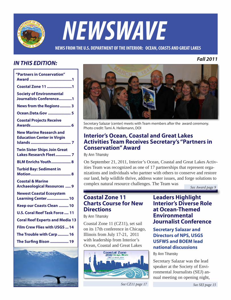
See Award page 9 See SEJ page 15 NEWS FROM THE U.S. DEPARTMENT OF THE INTERIOR: OCEAN, COASTS AND GREAT LAKES IN THIS EDITION: Fall 2011 Interior’s Ocean, Coastal and Great Lakes Activities Team Receives Secretary’s “Partners in Conservation” Award By Ann Tihansky On September 21, 2011, Interior’s Ocean, Coastal and Great Lakes Activ- ities Team was recognized as one of 17 partnerships that represent orga- nizations and individuals who partner with others to conserve and restore our land, help wildlife thrive, address water issues, and forge solutions to complex natural resource challenges. The Team was Leaders Highlight Interior’s Diverse Role at Ocean-Themed Environmental Journalist Conference Secretary Salazar and Directors of NPS, USGS USFWS and BOEM lead national discussions By Ann Tihansky Secretary Salazar was the lead speaker at the Society of Envi- ronmental Journalists (SEJ) an- nual meeting on opening night, Coastal Zone 11 Charts Course for New Directions By Ann Tihansky Coastal Zone 11 (CZ11), set sail on its 17th conference in Chicago, Illinois from July 17-21, 2011 with leadership from Interior’s Ocean, Coastal and Great Lakes See CZ11 page 17 “Partners in Conservation” Award .......................................1 Coastal Zone 11 .......................1 Society of Environmental Journalists Conference............1 News from the Regions .......... 3 Ocean.Data.Gov ..................... 5 Coastal Projects Receive Awards ..................................... 6 New Marine Research and Education Center in Virgin Islands ..................................... 7 Twin Sister Ships Join Great Lakes Research Fleet .............. 7 BLM Enrichs Youth .................. 8 Turbid Bay: Sediment in Motion ..................................... 8 Coastal & Marine Archaeological Resources ..... 9 Newest Coastal Ecosystem Learning Center .................... 10 Keep our Coasts Clean ......... 10 U.S. Coral Reef Task Force .... 11 Coral Reef Experts and Media 13 Film Crew Flies with USGS ... 14 The Trouble with Carp .......... 16 The Surfing Bison ................. 19 Secretary Salazar (center) meets with Team members after the award ceremony. Photo credit: Tami A. Heilemann, DOI NEWSWAVE
Transcript
See Award page 9
See SEJ page 15
NEWS FROM THE U.S. DEPARTMENT OF THE INTERIOR: OCEAN, COASTS AND GREAT LAKES
IN THIS EDITION:Fall 2011
Interior’s Ocean, Coastal and Great Lakes Activities Team Receives Secretary’s “Partners in Conservation” AwardBy Ann Tihansky
On September 21, 2011, Interior’s Ocean, Coastal and Great Lakes Activ-ities Team was recognized as one of 17 partnerships that represent orga-nizations and individuals who partner with others to conserve and restore our land, help wildlife thrive, address water issues, and forge solutions to complex natural resource challenges. The Team was
Leaders Highlight Interior’s Diverse Role at Ocean-Themed Environmental Journalist ConferenceSecretary Salazar and Directors of NPS, USGS USFWS and BOEM lead national discussionsBy Ann Tihansky
Secretary Salazar was the lead speaker at the Society of Envi-ronmental Journalists (SEJ) an-nual meeting on opening night,
Coastal Zone 11 Charts Course for New DirectionsBy Ann Tihansky
Coastal Zone 11 (CZ11), set sail on its 17th conference in Chicago, Illinois from July 17-21, 2011 with leadership from Interior’s Ocean, Coastal and Great Lakes
See CZ11 page 17
“Partners in Conservation” Award .......................................1
Coastal Zone 11 .......................1
Society of Environmental Journalists Conference ............1
New Marine Research and Education Center in Virgin Islands ..................................... 7
Twin Sister Ships Join Great Lakes Research Fleet .............. 7
BLM Enrichs Youth .................. 8
Turbid Bay: Sediment in Motion ..................................... 8
Coastal & Marine Archaeological Resources ..... 9
Newest Coastal Ecosystem Learning Center .................... 10
Keep our Coasts Clean ......... 10
U.S. Coral Reef Task Force .... 11
Coral Reef Experts and Media 13
Film Crew Flies with USGS ... 14
The Trouble with Carp .......... 16
The Surfing Bison ................. 19
Secretary Salazar (center) meets with Team members after the award ceremony. Photo credit: Tami A. Heilemann, DOI
NEWSWAVE
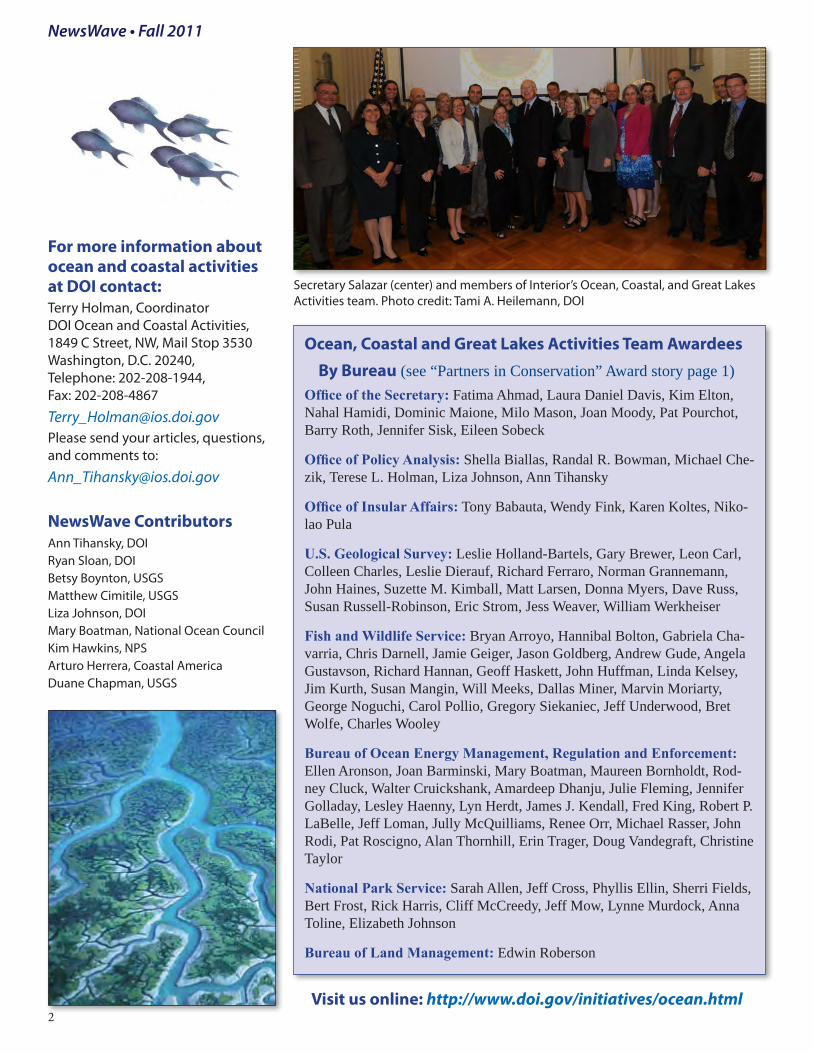
Ocean, Coastal and Great Lakes Activities Team Awardees By Bureau (see “Partners in Conservation” Award story page 1)Office of the Secretary: Fatima Ahmad, Laura Daniel Davis, Kim Elton, Nahal Hamidi, Dominic Maione, Milo Mason, Joan Moody, Pat Pourchot, Barry Roth, Jennifer Sisk, Eileen Sobeck
Office of Policy Analysis: Shella Biallas, Randal R. Bowman, Michael Che-zik, Terese L. Holman, Liza Johnson, Ann Tihansky
Office of Insular Affairs: Tony Babauta, Wendy Fink, Karen Koltes, Niko-lao Pula
U.S. Geological Survey: Leslie Holland-Bartels, Gary Brewer, Leon Carl, Colleen Charles, Leslie Dierauf, Richard Ferraro, Norman Grannemann, John Haines, Suzette M. Kimball, Matt Larsen, Donna Myers, Dave Russ, Susan Russell-Robinson, Eric Strom, Jess Weaver, William Werkheiser
Fish and Wildlife Service: Bryan Arroyo, Hannibal Bolton, Gabriela Cha-varria, Chris Darnell, Jamie Geiger, Jason Goldberg, Andrew Gude, Angela Gustavson, Richard Hannan, Geoff Haskett, John Huffman, Linda Kelsey, Jim Kurth, Susan Mangin, Will Meeks, Dallas Miner, Marvin Moriarty, George Noguchi, Carol Pollio, Gregory Siekaniec, Jeff Underwood, Bret Wolfe, Charles Wooley
Bureau of Ocean Energy Management, Regulation and Enforcement: Ellen Aronson, Joan Barminski, Mary Boatman, Maureen Bornholdt, Rod-ney Cluck, Walter Cruickshank, Amardeep Dhanju, Julie Fleming, Jennifer Golladay, Lesley Haenny, Lyn Herdt, James J. Kendall, Fred King, Robert P. LaBelle, Jeff Loman, Jully McQuilliams, Renee Orr, Michael Rasser, John Rodi, Pat Roscigno, Alan Thornhill, Erin Trager, Doug Vandegraft, Christine Taylor
National Park Service: Sarah Allen, Jeff Cross, Phyllis Ellin, Sherri Fields, Bert Frost, Rick Harris, Cliff McCreedy, Jeff Mow, Lynne Murdock, Anna Toline, Elizabeth Johnson
Bureau of Land Management: Edwin Roberson
NewsWave • Fall 2011
For more information about ocean and coastal activities at DOI contact: Terry Holman, Coordinator DOI Ocean and Coastal Activities, 1849 C Street, NW, Mail Stop 3530 Washington, D.C. 20240, Telephone: 202-208-1944, Fax: 202-208-4867
South Atlantic Alliance (SAA)http://www.southatlantical-liance.org/work.htm (North Carolina, South Caro-lina, Georgia, Florida)
The South Atlantic Alliance (SAA)held their first face-to-face meeting in Savannah, Georgia, on Septem-ber 7. They identified four priority areas: Healthy Ecosystems, Work-ing Waterfronts, Clean Coastal and Ocean Waters, and Disaster Resil-ient Communities. They identified seven tasks to move forward on sharing information and meeting these objectives throughout the region. The SAA Implementa-
tion Plan is available on-line here: http://www.southatlanticalliance.org/docs/2011_South_Atlantic_Al-liance_Meeting_Agenda.pdfSAA is creating a Regional Plan-ning Body (RPB) prototype to address the SAA’s administration and CMSP efforts. SAA members will likely become members of the RPB (many attended the National CMSP workshop) and have identi-fied 6 major steps toward creating the RPB, starting with identifying data and information needed by users of the regional data portal. Submitted by: Eric Strom, USGS, [email protected])
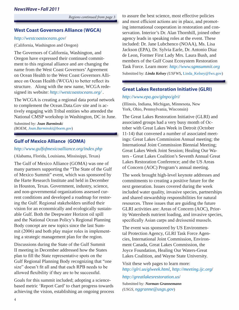
Rachel Jacobson, Department of the Interior’s Acting Assistant Secretary for Fish and Wildlife and Parks.
3
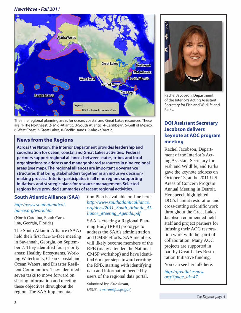
The nine regional planning areas for ocean, coastal and Great Lakes resources. These are: 1-The Northeast, 2- Mid-Atlantic, 3-South Atlantic, 4-Caribbean, 5-Gulf of Mexico, 6-West Coast, 7-Great Lakes, 8-Pacific Isands, 9-Alaska/Arctic.
News from the RegionsAcross the Nation, the Interior Department provides leadership and coordination for ocean, coastal and Great Lakes activities. Federal partners support regional alliances between states, tribes and local organizations to address and manage shared resources in nine regional areas (see map). The regional alliances are important governance structures that bring stakeholders together in an inclusive decision-making process. Interior participates in all nine regions supporting initiatives and strategic plans for resource management. Selected regions have provided summaries of recent regional activities.
DOI Assistant Secretary Jacobson delivers keynote at AOC program meetingRachel Jacobson, Depart-ment of the Interior’s Act-ing Assistant Secretary for Fish and Wildlife, and Parks gave the keynote address on October 13, at the 2011 U.S. Areas of Concern Program Annual Meeting in Detroit. Her speech highlighted DOI’s habitat restoration and cross-cutting scientific work throughout the Great Lakes. Jacobson commended field staff and project partners for infusing their AOC restora-tion work with the spirit of collaboration. Many AOC projects are supported in part by Great Lakes Resto-ration Initiative funding. You can see her talk here: http://greatlakesnow.org/?page_id=47.
West Coast Governors Alliance (WGCA)http://westcoastoceans.gov/(California, Washington and Oregon)
The Governors of California, Washington, and Oregon have expressed their continued commit-ment to this regional alliance and are changing the name from the West Coast Governors’ Agreement on Ocean Health to the West Coast Governors Alli-ance on Ocean Health (WCGA) to better reflect its structure. Along with the new name, WCGA rede-signed its website: http://westcoastoceans.org/ . The WCGA is creating a regional data portal network to complement the Ocean.Data.Gov site and is ac-tively engaging with Tribal entities who attended the National CMSP workshop in Washington, DC in June.Submitted by: Joan Barminski (BOEM, [email protected])
Gulf of Mexico Alliance (GOMA)http://www.gulfofmexicoalliance.org/index.php (Alabama, Florida, Louisiana, Mississippi, Texas)
The Gulf of Mexico Alliance (GOMA) was one of many partners supporting the “The State of the Gulf of Mexico Summit” event, which was sponsored by the Harte Research Institute and held in December in Houston, Texas. Government, industry, science, and non-governmental organizations assessed cur-rent conditions and developed a roadmap for restor-ing the Gulf. Regional stakeholders unified their vision for an economically and ecologically sustain-able Gulf. Both the Deepwater Horizon oil spill and the National Ocean Policy’s Regional Planning Body concept are new topics since the last Sum-mit (2006) and both play major roles in implement-ing a strategic management plan for the region. Discussions during the State of the Gulf Summit II meeting in December addressed how the States plan to fill the State representative spots on the Gulf Regional Planning Body recognizing that “one size” doesn’t fit all and that each RPB needs to be allowed flexibility if they are to be successful. Goals for this summit included; adopting a science-based metric ‘Report Card’ to chart progress towards achieving the vision, establishing an ongoing process
to assure the best science, most effective policies and most efficient actions are in place, and promot-ing international cooperation in restoration and con-servation. Interior’s Dr. Alan Thornhill, joined other agency leads in speaking roles at the event. These included: Dr. Jane Lubchenco (NOAA), Ms. Lisa Jackson (EPA), Dr. Sylvia Earle, Dr. Antonio Diaz de Leon, Former First Lady Mrs. Laura Bush, and members of the Gulf Coast Ecosystem Restoration Task Force. Learn more: http://www.sgmsummit.org Submitted by: Linda Kelsey (USFWS, [email protected])
Great Lakes Restoration Initiative (GLRI) http://www.epa.gov/glnpo/glri/(Illinois, Indiana, Michigan, Minnesota, New York, Ohio, Pennsylvania, Wisconsin)
The Great Lakes Restoration Initiative (GLRI) and associated groups had a very busy month of Oc-tober with Great Lakes Week in Detroit (October 11-14) that convened a number of associated meet-ings: Great Lakes Commission Annual meeting; the International Joint Commission Biennial Meeting; Great Lakes Week Joint Session; Healing Our Wa-ters - Great Lakes Coalition’s Seventh Annual Great Lakes Restoration Conference; and the US Areas of Concern (AOC) Program’s annual meeting. The week brought high-level keynote addresses and commitments to creating a positive future for the next generation. Issues covered during the week included water quality, invasive species, partnerships and shared stewardship responsibilities for natural resources. Three issues that are guiding the future GLRI activities are: Areas of Concern (AOC), Prior-ity Watersheds nutrient loading, and invasive species, specifically Asian carps and dreissenid mussels.The event was sponsored by US Environmen-tal Protection Agency, GLRI Task Force Agen-cies, International Joint Commission, Environ-ment Canada, Great Lakes Commission, the Joyce Foundation, Healing Our Waters-Great Lakes Coalition, and Wayne State University. Visit these web pages to learn more: http://glri.us/glweek.html, http://meeting.ijc.org/ http://greatlakesrestoration.us/Submitted by: Norman Grannemann (USGS, [email protected])
Ocean.Data.Gov Shares Federal Data in Centralized Location Prototype site seeks user feedbackBy Mary Boatman
On December 6, John Holdren, Assistant to the President for Sci-ence and Technology and Aneesh Chopra, the US Chief Technol-ogy Officer, together announced the launch of the data information tool, Ocean.data.gov, on the White House web page and blog. It is one of the first products created as a result of the National Ocean Policy and provides a central on-line location for discovering and accessing a wide variety of Federal ocean and coastal data. Ocean.Data.Gov supports regional gov-ernance with information needed for effective coastal planning as described during the National Coastal and Marine Spatial Plan-ning workshop in June 2011. For the first time, Feds are sharing ocean, coastal, and Great Lakes data from multiple agencies in one location. The site doesn’t house or maintain the data, but serves to identify where and what the data are, the data source and who main-tains it as well as the ability to ac-cess and download the data. Each agency keeps the original informa-tion and is responsible for keeping it up to date and ensuring it meets data quality standards. This sys-tem guarantees that all Federal data come directly from their sources and meet all required formats and standards. These Federal data are a valuable commodity and a neces-sary support tool for regional plan-ning efforts and the new regional planning bodies that are forming.
Interior has contributed data from USGS and USFWS as a start, with data from BOEM and NPS on its way. The site will be continually updated and modi-fied as requested by users and as new data are available. Interior staff played a major role in designing and building the concept and the site. The National Ocean Council sends a big thank you to Christine Taylor, Doug Vande-graft, Mike Rasser, John Haines, Fran Lightsom, Chris Lett, Rob Dollison, Chris Darnell, and Cliff McCreedy for all of their support. Creating this site has also brought
agencies together to explore bet-ter ways to share information and identify gaps and ensure format-ting compatibility. As an example, the Atlantic Seabird database is a powerful data tool that brought together various types of informa-tion and agency responsibilities for improved coordination and insight on how to best manage offshore wind energy develop-ment activities and migratory bird patterns. Tools like this will help federal agencies support regional planning efforts by providing data they need and identifying gaps to help prioritize next steps.
You can provide feedback! Users are encouraged to help tailor this prototype site to meet their needs. Now is the time to test it out and make suggestions.
Read the White House blog: http://www.whitehouse.gov/blog/2011/12/06/opening-our-oceans-datagovopening-our-oceans-datagov-1
http://www.data.gov/communities/oceanOcean.Data.Gov is a community of on-line Federal data resources within Data.gov. It supports coastal and marine spatial planning and complements other federal data resources:
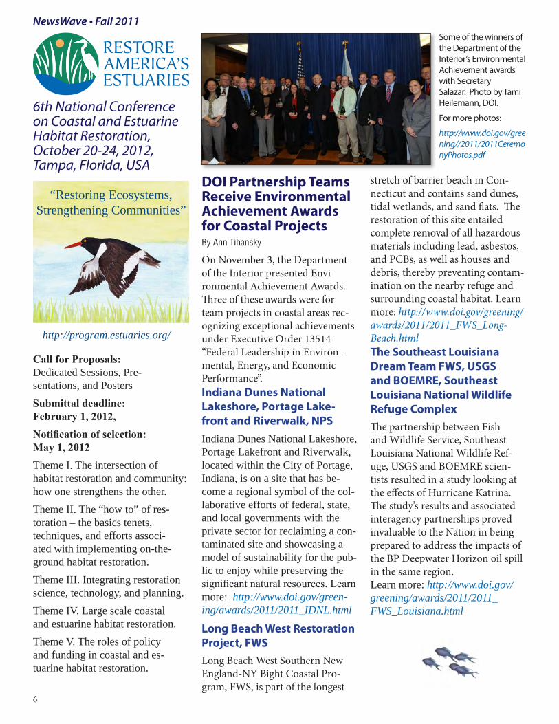
DOI Partnership Teams Receive Environmental Achievement Awards for Coastal Projects By Ann Tihansky
On November 3, the Department of the Interior presented Envi-ronmental Achievement Awards. Three of these awards were for team projects in coastal areas rec-ognizing exceptional achievements under Executive Order 13514 “Federal Leadership in Environ-mental, Energy, and Economic Performance”. Indiana Dunes National Lakeshore, Portage Lake-front and Riverwalk, NPSIndiana Dunes National Lakeshore, Portage Lakefront and Riverwalk, located within the City of Portage, Indiana, is on a site that has be-come a regional symbol of the col-laborative efforts of federal, state, and local governments with the private sector for reclaiming a con-taminated site and showcasing a model of sustainability for the pub-lic to enjoy while preserving the significant natural resources. Learn more: http://www.doi.gov/green-ing/awards/2011/2011_IDNL.html
Long Beach West Restoration Project, FWSLong Beach West Southern New England-NY Bight Coastal Pro-gram, FWS, is part of the longest
stretch of barrier beach in Con-necticut and contains sand dunes, tidal wetlands, and sand flats. The restoration of this site entailed complete removal of all hazardous materials including lead, asbestos, and PCBs, as well as houses and debris, thereby preventing contam-ination on the nearby refuge and surrounding coastal habitat. Learn more: http://www.doi.gov/greening/awards/2011/2011_FWS_Long-Beach.htmlThe Southeast Louisiana Dream Team FWS, USGS and BOEMRE, Southeast Louisiana National Wildlife Refuge Complex The partnership between Fish and Wildlife Service, Southeast Louisiana National Wildlife Ref-uge, USGS and BOEMRE scien-tists resulted in a study looking at the effects of Hurricane Katrina. The study’s results and associated interagency partnerships proved invaluable to the Nation in being prepared to address the impacts of the BP Deepwater Horizon oil spill in the same region. Learn more: http://www.doi.gov/greening/awards/2011/2011_FWS_Louisiana.html
6th National Conference on Coastal and Estuarine Habitat Restoration, October 20-24, 2012, Tampa, Florida, USA
Call for Proposals: Dedicated Sessions, Pre-sentations, and PostersSubmittal deadline: February 1, 2012, Notification of selection: May 1, 2012Theme I. The intersection of habitat restoration and community: how one strengthens the other.Theme II. The “how to” of res-toration – the basics tenets, techniques, and efforts associ-ated with implementing on-the-ground habitat restoration.Theme III. Integrating restoration science, technology, and planning.Theme IV. Large scale coastal and estuarine habitat restoration.Theme V. The roles of policy and funding in coastal and es-tuarine habitat restoration.
Some of the winners of the Department of the Interior’s Environmental Achievement awards with Secretary Salazar. Photo by Tami Heilemann, DOI.
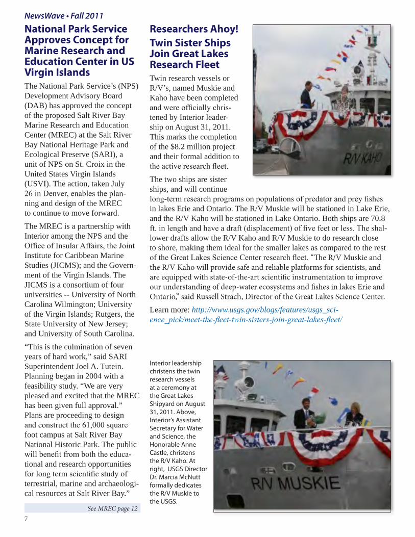
Researchers Ahoy! Twin Sister Ships Join Great Lakes Research FleetTwin research vessels or R/V’s, named Muskie and Kaho have been completed and were officially chris-tened by Interior leader-ship on August 31, 2011. This marks the completion of the $8.2 million project and their formal addition to the active research fleet. The two ships are sister ships, and will continue long-term research programs on populations of predator and prey fishes in lakes Erie and Ontario. The R/V Muskie will be stationed in Lake Erie, and the R/V Kaho will be stationed in Lake Ontario. Both ships are 70.8 ft. in length and have a draft (displacement) of five feet or less. The shal-lower drafts allow the R/V Kaho and R/V Muskie to do research close to shore, making them ideal for the smaller lakes as compared to the rest of the Great Lakes Science Center research fleet. “The R/V Muskie and the R/V Kaho will provide safe and reliable platforms for scientists, and are equipped with state-of-the-art scientific instrumentation to improve our understanding of deep-water ecosystems and fishes in lakes Erie and Ontario,” said Russell Strach, Director of the Great Lakes Science Center. Learn more: http://www.usgs.gov/blogs/features/usgs_sci-ence_pick/meet-the-fleet-twin-sisters-join-great-lakes-fleet/
Interior leadership christens the twin research vessels at a ceremony at the Great Lakes Shipyard on August 31, 2011. Above, Interior’s Assistant Secretary for Water and Science, the Honorable Anne Castle, christens the R/V Kaho. At right, USGS Director Dr. Marcia McNutt formally dedicates the R/V Muskie to the USGS.
National Park Service Approves Concept for Marine Research and Education Center in US Virgin Islands The National Park Service’s (NPS) Development Advisory Board (DAB) has approved the concept of the proposed Salt River Bay Marine Research and Education Center (MREC) at the Salt River Bay National Heritage Park and Ecological Preserve (SARI), a unit of NPS on St. Croix in the United States Virgin Islands (USVI). The action, taken July 26 in Denver, enables the plan-ning and design of the MREC to continue to move forward. The MREC is a partnership with Interior among the NPS and the Office of Insular Affairs, the Joint Institute for Caribbean Marine Studies (JICMS); and the Govern-ment of the Virgin Islands. The JICMS is a consortium of four universities -- University of North Carolina Wilmington; University of the Virgin Islands; Rutgers, the State University of New Jersey; and University of South Carolina. “This is the culmination of seven years of hard work,” said SARI Superintendent Joel A. Tutein. Planning began in 2004 with a feasibility study. “We are very pleased and excited that the MREC has been given full approval.” Plans are proceeding to design and construct the 61,000 square foot campus at Salt River Bay National Historic Park. The public will benefit from both the educa-tional and research opportunities for long term scientific study of terrestrial, marine and archaeologi-cal resources at Salt River Bay.”
BLM Programs Enrich Youth with Coastal ExperiencesExcerpted from: http://www.blm.gov/ca/st/en/info/newsbytes/2011/488xtra_ar-cata_youth.htmlBy Ryan SloanIn July 2011, the Bureau of Land Management’s (BLM) Arcata Field Office shared Northern Califor-nia’s unique coastal environments with more than 900 area elemen-tary school students. The annual Ocean Day restoration and aerial art project event took place at the Mike Thompson Wildlife Area, South Spit Cooperative Manage-ment Area, Humboldt Bay, CA. BLM partnered with the California Coastal Conservancy and Friends of the Dunes for the project in which students picked up trash and pulled invasive beach grass before forming an aerial art im-age with a conservation message. Prior to the beach day, Friends of the Dunes staff members visited all the schools talking to them about how their neighborhoods are connected to the beaches and oceans through storm drains. They addressed the importance
of recycling and litter reduction so that neighborhood trash does not end up on the coast. In addi-tion, the office hosted students in a Youth to Youth project where older students helped explain the unique environments of California Coastal National Monument’s tidal pools to younger ones. For many of the students, it was their first time experiencing a tide pool.
New video--
Turbid Bay: Sediment in Motion
http://gallery.usgs.gov/videos/369See how science is used to under-stand submarine sediment move-ment. Take a boat ride with USGS scientists as they demonstrate how they collect sediment transport data and how it is used for veri-fying the accuracy of sediment-transport models. These models are used to predict the impacts of long-term processes, such as marsh restoration and sea-level rise, on wetlands fringing San Francisco Bay. See related article: http://soundwaves.usgs.gov/2011/04/
More than 900 students arrived by bus (above) and as part of an annual tradition, assembled into a large scale formation with a conservation image that was captured with aerial photography. Photo credit: Gary Todoroff.
Students work in teams to remove invasive beach grasses and clean up trash at the Mike Thompson Wildlife Area in Humboldt County, California. Photo credit: Jeff Fontana, BLM
USGS researcher retrieves instruments from the Bay’s bottom.
recognized for its efforts in imple-menting the National Ocean Policy. Nearly 100 Interior staff members distributed across many Interior Bureaus make up this team. Be-cause the group of awardees was so large and located across the Na-tion, a small group led by Coordi-nator Terry Holman attended the ceremony to accept the award on behalf of the entire team. Secretary Salazar addressed the awardees and presented the awards. Other events including a reception at the Eisenhower Executive Office Building and a tour of the East Wing of the White House were held for the award recipients. The citation, included at right, high-lights the accomplishments of the team. Each team member received a certificate signed by the Secretary and a printed copy of the citation.
CITATIONPARTNERS IN CONSERVATION AWARD
DOI OCEAN, COASTAL AND GREAT LAKES ACTIVITIES TEAMIn recognition of the outstanding contributions of the DOI Ocean, Coastal and Great Lakes Activities Team in developing and imple-menting the National Ocean Policy. The Team has come together as a cohesive unit to leverage collective resources and to advance di-verse stewardship responsibilities representing a one-DOI approach for establishing the first ever National Ocean Policy, issued by the President in Executive Order 13547, July 19, 2010. The DOI Ocean, Coastal and Great Lakes Activities Team is a model for building a culture of collaboration within the Department. In 2010, DOI Senior Ocean Policy Team, the Ocean Technical Team, and the Regional Ocean Team came together to establish a clear set of DOI actions that advance the National Ocean Policy and the Framework for Effec-tive Coastal and Marine Spatial Planning established in Executive Order 13547. This collaborative endeavor, among others, solidified the Teams into a high-performance internal partnership that made significant contributions toward advancing the National Ocean Policy. For advancing the Department of the Interior’s collective steward-ship mission and being an exemplary model for collaboration in action, the DOI Ocean, Coastal and Great Lakes Activities Team is awarded the 2011 Secretary’s Partners in Conservation Award. Ken Salazar Secretary of the Interior
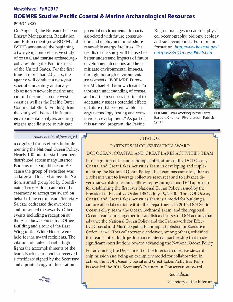
BOEMRE Studies Pacific Coastal & Marine Archaeological Resources By Ryan Sloan
On August 3, the Bureau of Ocean Energy Management, Regulation and Enforcement (now BOEM and BSEE) announced the beginning a two-year, comprehensive study of coastal and marine archaeologi-cal sites along the Pacific Coast of the United States. For the first time in more than 20 years, the agency will conduct a two-year scientific inventory and analy-sis of non-renewable marine and cultural resources on the west coast as well as the Pacific Outer Continental Shelf. Findings from the study will be used in future environmental analyses and may trigger specific steps to mitigate
potential environmental impacts associated with future construc-tion and deployment of offshore renewable energy facilities. The results of the study will be used to better understand impacts of future development decisions and help mitigate environmental impacts, through thorough environmental assessments. BOEMRE Direc-tor Michael R. Bromwich said, “a thorough understanding of coastal and marine resources is critical to adequately assess potential effects of future offshore renewable en-ergy technology testing and com-mercial development.” As part of this national program, the Pacific
Region manages research in physi-cal oceanography, biology, ecology and socioeconomics. For more in-formation: http://www.boemre.gov/ooc/press/2011/press0803b.htm
BOEMRE Diver working in the Santa Barbara Channel. Photo credit: Patrick Smith
Newest Coastal Ecosystem Learning Center Designated in Camden, New JerseyBy Arturo Herrera and Ann Tihansky
In a ceremony on November 15, the Adventure Aquarium and New Jersey Academy for Aquatic Sciences joined 23 other marine facilities in the network of Coastal America’s Coastal Ecosystem Learning Centers (CELC’s ) across the nation. Brett Hunter, Acting Supervisor of the New Jersey Field Office, US Fish and Wildlife Service, represented the Interior Depart-ment along with other officials recognizing Adventure Aquarium as one of the country’s top aquari-ums and a leading regional edu-cational institution. As a Coastal Ecosystem Learning Center, the Aquarium and the Academy for Aquatic Sciences gains access to the scientific resources of 16 Federal agencies such as ship time, technical expertise, exhibits, educational materials, and oppor-tunities to collaborate on research projects. The CELCs provide a communication avenue for govern-ment agencies to reach millions of visitors each year. This network plays a vital role in enhancing public understanding of the value of coastal resources and facilitates the ability for communities to address growing coastal issues. Adventure Aquarium houses 200,000 square feet of public space, more than two million gallons of water and 431 species. The Aquarium and the Academy serve over 800,000 visitors annu-ally and draw well over 300,000 participants to a wide variety of tours and field programs.
of these areas to their natural, pristine condition. CIAP projects like this serve as a reminder that a clean and healthy environment is an important legacy for us to leave to future generations.”Learn more: http://www.boemre.gov/ooc/press/2011/press0906a.htm
Trash Kicks the Bucket in California
National Seashores Participate and BenefitMore than 600,000 pounds of trash were removed from 800 sites along California’s coasts and inland waterways during Coastal Cleanup 2011. At the Point Reyes National Seashore, National Park Service Guide, Kim Hawkins served as the Coastal Cleanup’s Beach Captain. Kim coordinated 77 volunteers who picked up 512 pounds of trash just at Drake’s Beach. Items ranged from old bottles, debris that floated all the way from Japan, fishhooks, and big tractor tires. The Phelps group donated a graphic image to help raise awareness.
DOI Working with Partners to Keep our Coasts CleanBOEMRE provides grant money for coastal clean upAnchorage, Alaska--On Septem-ber 6, 2011, The Bureau of Ocean Energy Management, Regulation and Enforcement (BOEMRE) announced it awarded a $988,000 Coastal Impact Assistance Pro-gram (CIAP) grant to the Alaska Department of Natural Resources. The grant provides funding for the removal, from the state’s coast, of more than 400,000 pounds of commercial fishing gear and other marine debris that has ac-cumulated over time. The fund-ing will be spread over two years. “Alaska’s shores and coastal waters are among our most important and sensitive natural resources,” said BOEMRE Director Michael R. Bromwich. “We welcome the opportunity to work with the State of Alaska to restore some
On behalf of the Interior Department, Brett Hunter (USFWS) presented the Interior’s commitments during the ceremony program designating the newest CELC to a crowd of nearly 150 people.
The Phelps group donated a graphic fish image made of trash items to help raise awareness and visibility for the Clean-Up.
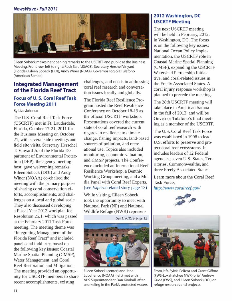
Integrated Management of the Florida Reef TractFocus of U. S. Coral Reef Task Force Meeting 2011 By Liza Johnson
The U.S. Coral Reef Task Force (USCRTF) met in Ft. Lauderdale, Florida, October 17-21, 2011 for the Business Meeting on October 21, with several side meetings and field site visits. Secretary Herschel T. Vinyard Jr. of the Florida De-partment of Environmental Protec-tion (DEP), the agency meeting host, gave welcoming remarks. Eileen Sobeck (DOI) and Andy Winer (NOAA) co-chaired the meeting with the primary purpose of sharing coral conservation ef-forts, accomplishments, and chal-lenges on a local and global scale. They also discussed developing a Fiscal Year 2012 workplan for Resolution 25.1, which was passed at the February 2011 Task Force meeting. The meeting theme was “Integrating Management of the Florida Reef Tract” and included panels and field trips based on the following key issues: Coastal Marine Spatial Planning (CMSP), Water Management, and Coral Reef Restoration and Mitigation. The meeting provided an opportu-nity for USCRTF members to share recent accomplishments, existing
challenges, and needs in addressing coral reef research and conversa-tion issues locally and globally. The Florida Reef Resilience Pro-gram hosted the Reef Resilience Conference on October 18-19 as the official USCRTF workshop. Presentations covered the current state of coral reef research with regards to resilience to climate change, fishing impacts, land-based sources of pollution, and recre-ational use. Topics also included monitoring, economic valuation, and CMSP projects. The Confer-ence included an International Reef Resilience Workshop, a Benthic Working Group meeting, and a Me-dia Panel with Coral Reef Experts. (see Experts related story page 13)While visiting, Eileen Sobeck took the opportunity to meet with National Park (NP) and National Wildlife Refuge (NWR) represen-
2012 Washington, DC USCRTF MeetingThe next USCRTF meeting will be held in February, 2012, in Washington, DC. The focus is on the following key issues: National Ocean Policy imple-mentation, the USCRTF role in Coastal Marine Spatial Planning (CMSP), expanding the USCRTF Watershed Partnership Initia-tive, and coral-related issues in the Freely Associated States. A coral injury response workshop is planned to precede the meeting.The 28th USCRTF meeting will take place in American Samoa in the fall of 2012, and will be Governor Tulafono’s final meet-ing as a member of the USCRTF. The U.S. Coral Reef Task Force was established in 1998 to lead U.S. efforts to preserve and pro-tect coral reef ecosystems. It includes leaders of 12 Federal agencies, seven U.S. States, Ter-ritories, Commonwealths, and three Freely Associated States.Learn more about the Coral Reef Task Force: http://www.coralreef.gov/
Eileen Sobeck makes her opening remarks to the USCRTF and public at the Business Meeting. Front row, left to right: Rock Salt (USACE), Secretary Hershel Vinyard (Florida), Eileen Sobeck (DOI), Andy Winer (NOAA), Governor Togiola Tulafono (American Samoa).
From left, Sylvia Pelizza and Grant Gifford (FWS-Loxahatchee NWR) brief Andrew Gude (FWS), and Eileen Sobeck (DOI) on refuge resources and projects.
Eileen Sobeck (center) and Jane Lubchenco (NOAA) (left) met with NPS Superintendent Dan Kimball after snorkeling in the Park’s protected waters.
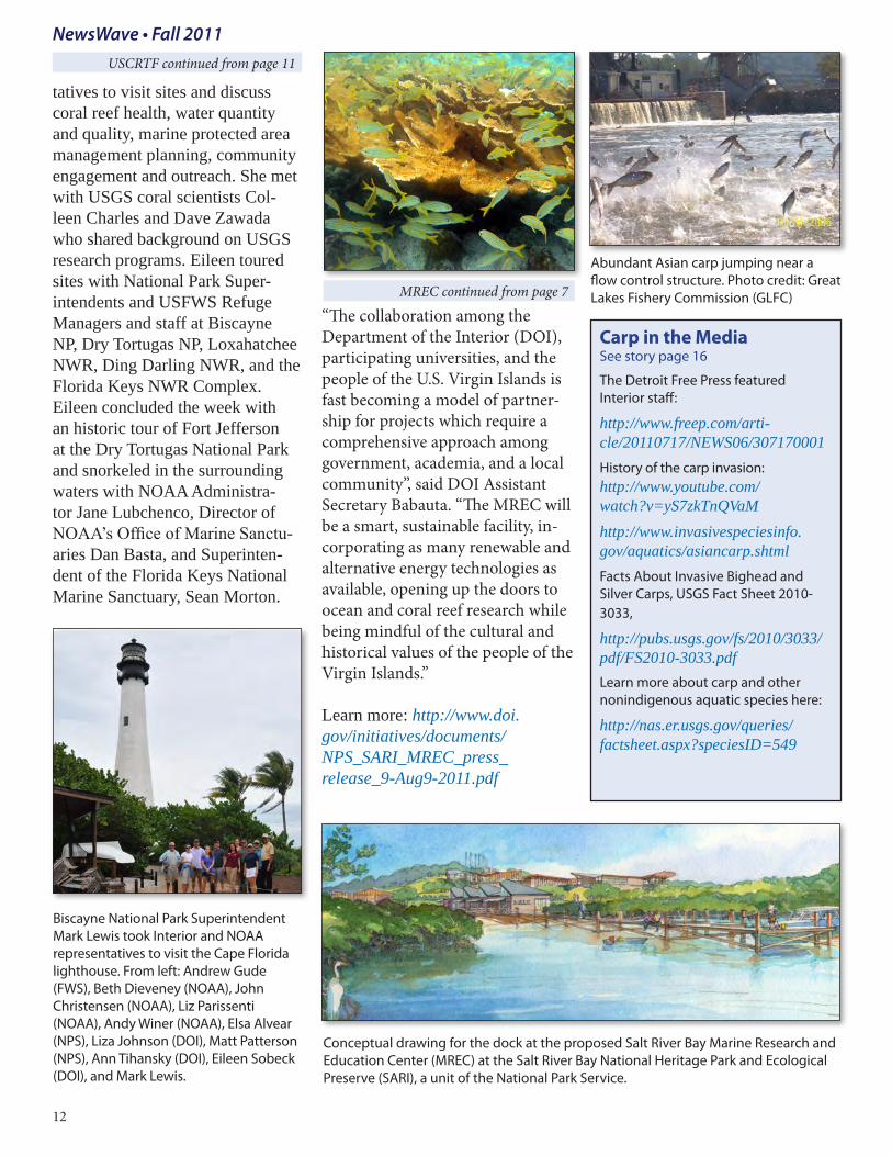
tatives to visit sites and discuss coral reef health, water quantity and quality, marine protected area management planning, community engagement and outreach. She met with USGS coral scientists Col-leen Charles and Dave Zawada who shared background on USGS research programs. Eileen toured sites with National Park Super-intendents and USFWS Refuge Managers and staff at Biscayne NP, Dry Tortugas NP, Loxahatchee NWR, Ding Darling NWR, and the Florida Keys NWR Complex. Eileen concluded the week with an historic tour of Fort Jefferson at the Dry Tortugas National Park and snorkeled in the surrounding waters with NOAA Administra-tor Jane Lubchenco, Director of NOAA’s Office of Marine Sanctu-aries Dan Basta, and Superinten-dent of the Florida Keys National Marine Sanctuary, Sean Morton.
“The collaboration among the Department of the Interior (DOI), participating universities, and the people of the U.S. Virgin Islands is fast becoming a model of partner-ship for projects which require a comprehensive approach among government, academia, and a local community”, said DOI Assistant Secretary Babauta. “The MREC will be a smart, sustainable facility, in-corporating as many renewable and alternative energy technologies as available, opening up the doors to ocean and coral reef research while being mindful of the cultural and historical values of the people of the Virgin Islands.” Learn more: http://www.doi.gov/initiatives/documents/NPS_SARI_MREC_press_release_9-Aug9-2011.pdf
USCRTF continued from page 11
Biscayne National Park Superintendent Mark Lewis took Interior and NOAA representatives to visit the Cape Florida lighthouse. From left: Andrew Gude (FWS), Beth Dieveney (NOAA), John Christensen (NOAA), Liz Parissenti (NOAA), Andy Winer (NOAA), Elsa Alvear (NPS), Liza Johnson (DOI), Matt Patterson (NPS), Ann Tihansky (DOI), Eileen Sobeck (DOI), and Mark Lewis.
Abundant Asian carp jumping near a flow control structure. Photo credit: Great Lakes Fishery Commission (GLFC)
Conceptual drawing for the dock at the proposed Salt River Bay Marine Research and Education Center (MREC) at the Salt River Bay National Heritage Park and Ecological Preserve (SARI), a unit of the National Park Service.
12
Carp in the Media See story page 16
The Detroit Free Press featured Interior staff:
http://www.freep.com/arti-cle/20110717/NEWS06/307170001History of the carp invasion: http://www.youtube.com/watch?v=yS7zkTnQVaMhttp://www.invasivespeciesinfo.gov/aquatics/asiancarp.shtmlFacts About Invasive Bighead and Silver Carps, USGS Fact Sheet 2010-3033,
http://pubs.usgs.gov/fs/2010/3033/pdf/FS2010-3033.pdf Learn more about carp and other nonindigenous aquatic species here:
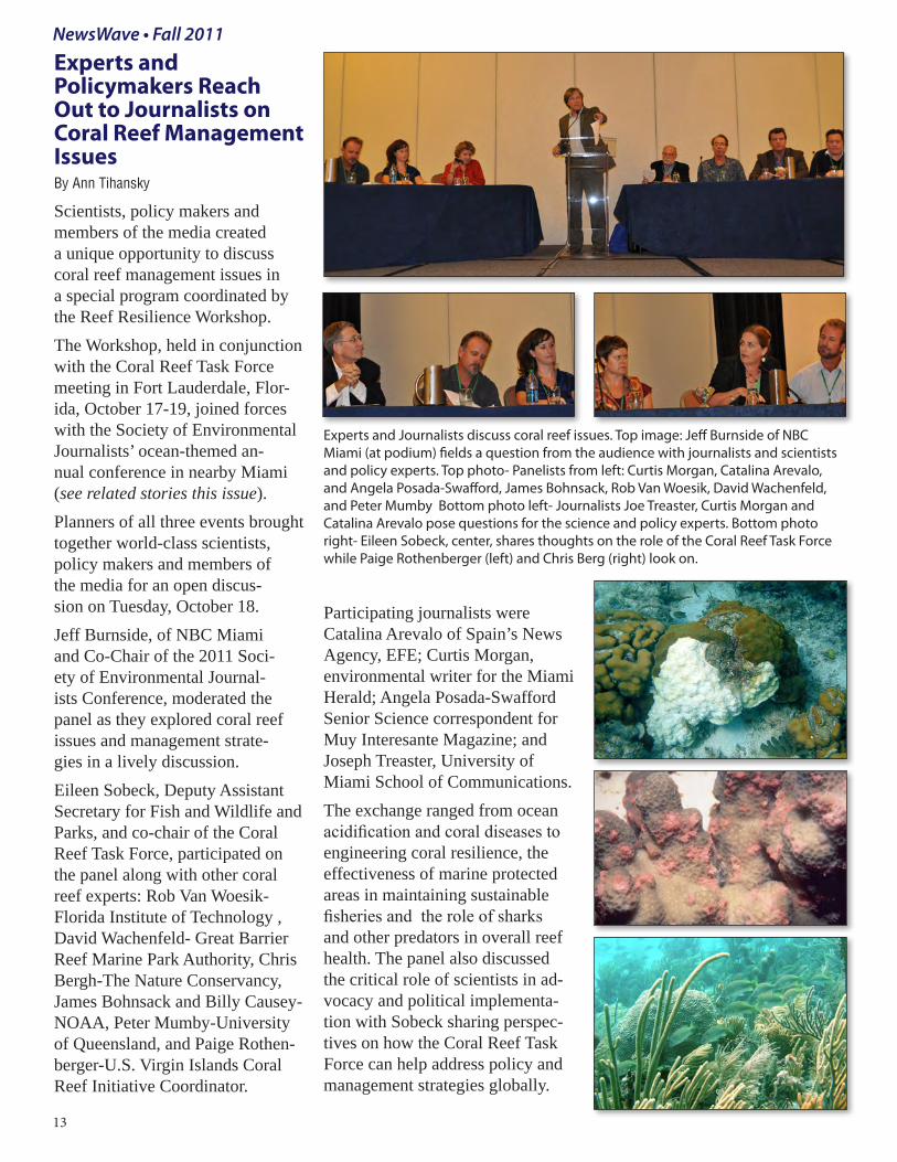
Experts and Policymakers Reach Out to Journalists on Coral Reef Management Issues By Ann Tihansky
Scientists, policy makers and members of the media created a unique opportunity to discuss coral reef management issues in a special program coordinated by the Reef Resilience Workshop. The Workshop, held in conjunction with the Coral Reef Task Force meeting in Fort Lauderdale, Flor-ida, October 17-19, joined forces with the Society of Environmental Journalists’ ocean-themed an-nual conference in nearby Miami (see related stories this issue). Planners of all three events brought together world-class scientists, policy makers and members of the media for an open discus-sion on Tuesday, October 18. Jeff Burnside, of NBC Miami and Co-Chair of the 2011 Soci-ety of Environmental Journal-ists Conference, moderated the panel as they explored coral reef issues and management strate-gies in a lively discussion. Eileen Sobeck, Deputy Assistant Secretary for Fish and Wildlife and Parks, and co-chair of the Coral Reef Task Force, participated on the panel along with other coral reef experts: Rob Van Woesik-Florida Institute of Technology , David Wachenfeld- Great Barrier Reef Marine Park Authority, Chris Bergh-The Nature Conservancy, James Bohnsack and Billy Causey-NOAA, Peter Mumby-University of Queensland, and Paige Rothen-berger-U.S. Virgin Islands Coral Reef Initiative Coordinator.
Participating journalists were Catalina Arevalo of Spain’s News Agency, EFE; Curtis Morgan, environmental writer for the Miami Herald; Angela Posada-Swafford Senior Science correspondent for Muy Interesante Magazine; and Joseph Treaster, University of Miami School of Communications. The exchange ranged from ocean acidification and coral diseases to engineering coral resilience, the effectiveness of marine protected areas in maintaining sustainable fisheries and the role of sharks and other predators in overall reef health. The panel also discussed the critical role of scientists in ad-vocacy and political implementa-tion with Sobeck sharing perspec-tives on how the Coral Reef Task Force can help address policy and management strategies globally.
Experts and Journalists discuss coral reef issues. Top image: Jeff Burnside of NBC Miami (at podium) fields a question from the audience with journalists and scientists and policy experts. Top photo- Panelists from left: Curtis Morgan, Catalina Arevalo, and Angela Posada-Swafford, James Bohnsack, Rob Van Woesik, David Wachenfeld, and Peter Mumby Bottom photo left- Journalists Joe Treaster, Curtis Morgan and Catalina Arevalo pose questions for the science and policy experts. Bottom photo right- Eileen Sobeck, center, shares thoughts on the role of the Coral Reef Task Force while Paige Rothenberger (left) and Chris Berg (right) look on.
13
NewsWave • Fall 2011
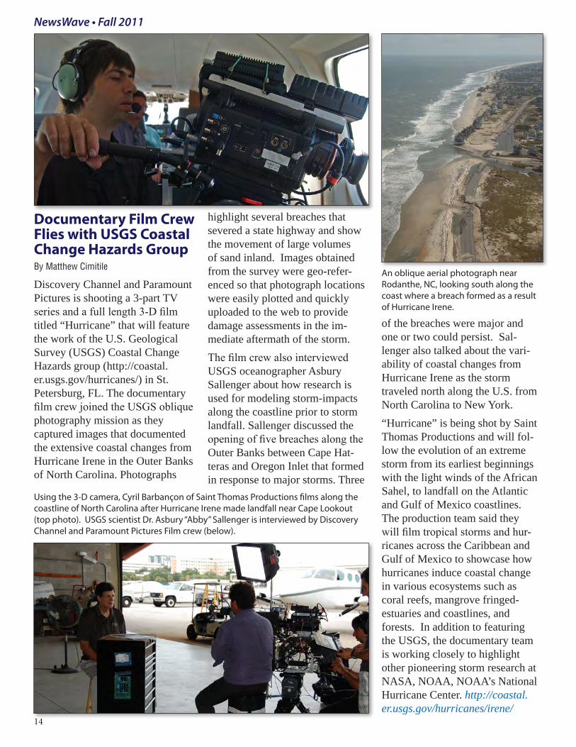
Documentary Film Crew Flies with USGS Coastal Change Hazards GroupBy Matthew Cimitile
Discovery Channel and Paramount Pictures is shooting a 3-part TV series and a full length 3-D film titled “Hurricane” that will feature the work of the U.S. Geological Survey (USGS) Coastal Change Hazards group (http://coastal.er.usgs.gov/hurricanes/) in St. Petersburg, FL. The documentary film crew joined the USGS oblique photography mission as they captured images that documented the extensive coastal changes from Hurricane Irene in the Outer Banks of North Carolina. Photographs
highlight several breaches that severed a state highway and show the movement of large volumes of sand inland. Images obtained from the survey were geo-refer-enced so that photograph locations were easily plotted and quickly uploaded to the web to provide damage assessments in the im-mediate aftermath of the storm.The film crew also interviewed USGS oceanographer Asbury Sallenger about how research is used for modeling storm-impacts along the coastline prior to storm landfall. Sallenger discussed the opening of five breaches along the Outer Banks between Cape Hat-teras and Oregon Inlet that formed in response to major storms. Three
of the breaches were major and one or two could persist. Sal-lenger also talked about the vari-ability of coastal changes from Hurricane Irene as the storm traveled north along the U.S. from North Carolina to New York. “Hurricane” is being shot by Saint Thomas Productions and will fol-low the evolution of an extreme storm from its earliest beginnings with the light winds of the African Sahel, to landfall on the Atlantic and Gulf of Mexico coastlines. The production team said they will film tropical storms and hur-ricanes across the Caribbean and Gulf of Mexico to showcase how hurricanes induce coastal change in various ecosystems such as coral reefs, mangrove fringed-estuaries and coastlines, and forests. In addition to featuring the USGS, the documentary team is working closely to highlight other pioneering storm research at NASA, NOAA, NOAA’s National Hurricane Center. http://coastal.er.usgs.gov/hurricanes/irene/
Using the 3-D camera, Cyril Barbançon of Saint Thomas Productions films along the coastline of North Carolina after Hurricane Irene made landfall near Cape Lookout (top photo). USGS scientist Dr. Asbury “Abby” Sallenger is interviewed by Discovery Channel and Paramount Pictures Film crew (below).
An oblique aerial photograph near Rodanthe, NC, looking south along the coast where a breach formed as a result of Hurricane Irene.
14
SEJ Continued from 1
See SEJ page 16
NewsWave • Fall 2011
October 19. The Secretary dis-cussed media coverage of the Deepwater Horizon oil spill, noting that the broad interest showed that “Americans aren’t just pas-sionate about conservation, they also demand knowledge and information about the natural world and how it’s changing. . . Deepwater Horizon proved that there is a huge appetite – and appreciation – for complicated information, scientific perspec-tives, and nuanced reporting.” The Columbia Journalism Review featured his speech, which you can read at: http://www.doi.gov/news/speeches/101911-Society-of-Environmental-Journalists.cfm You can listen to the audio of Sala-zar and the entire opening program at the SEJ website. http://www.sej.org/initiatives/sej-annual-confer-ences/AC2011-coverage#Salazar.Because the SEJ conference was lo-cated in South Florida, illustrative examples of resource management challenges are in Miami’s backyard. This close proximity gave Interior the chance to showcase diverse In-terior responsibilities and expertise as well as discuss the complex is-sues facing federal resource manag-ers and their partners. Salazar and Fish and Wildlife Service Director Dan Ashe met with reporters while visiting the Tamiami Trail Bridge Project in Miami-Dade County. Here they inspected the progress being made along a section of highway that is being elevated to re-establish the natural flow within a section of the Everglades. The Secretary discussed how vital this project is to restoring south Florida’s enor-mous wetland and coastal ecosys-tem. Shannon Estenoz, Interior’s
Director of Everglades Restoration Initiatives and Dan Kimball, Su-perintendent of Everglades Nation-al Park (ENP) were also present. Later that day, Salazar and Ashe installed four new commemorative planks at Pelican Island National Wildlife Refuge, marking the latest additions of four new refuges to the National Wildlife Refuge System. Interior showcased the unique wil-derness and wildlife management challenges facing South Florida’s world-famous park in another field trip: “Everglades National Park: Pythons, Gators and Billions for Restoration”. National Park Service Director, Jon Jarvis; Superintendent of Everglades and Dry Tortugas
National Parks Dan Kimball; Asso-ciate Regional Director for the NPS Southeast Region, Bill Reynolds and others, provided comments and expertise.The Director of the USGS, Marcia McNutt, opened the SEJ Friday morning program in a session called, “Communicating Science: Reporters Go Head to Head with Top Ocean Scientists”. Walter Cruickshank, Deputy Direc-tor of Interior’s Bureau of Ocean Energy Management (BOEM) participated in a panel exploring the future of America’s offshore drilling activities. Cruikshank
Secretary Salazar (above) uses a map of South Florida to show how and where the Tamiami Trail Bridge Project will help restore historic water flows to the Everglades. SEJ field trip participants enjoyed an expansive view of the Everglades from the new elevated roadway. (below) Photo credits: Niki Butcher
discussed how Interior’s restructur-ing of Mineral Management Ser-vice (MMS) into the new Bureau of Ocean Energy Management (BOEM), Bureau of Safety and En-vironmental Enforcement (BSEE) and the Office of Natural Resources Revenue (ONRR) is addressing issues of safety, improved man-agement, oversight and account-ability of activities on the Outer Continental Shelf and maintaining healthy coastal resources. He also discussed Interior’s priority for using science and technology to enhance America’s energy portfolio with renewables.
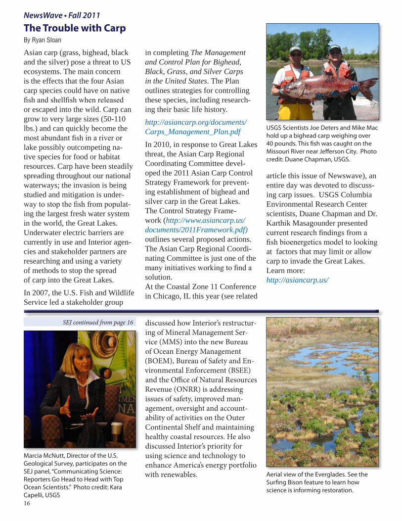
The Trouble with CarpBy Ryan Sloan
Asian carp (grass, bighead, black and the silver) pose a threat to US ecosystems. The main concern is the effects that the four Asian carp species could have on native fish and shellfish when released or escaped into the wild. Carp can grow to very large sizes (50-110 lbs.) and can quickly become the most abundant fish in a river or lake possibly outcompeting na-tive species for food or habitat resources. Carp have been steadily spreading throughout our national waterways; the invasion is being studied and mitigation is under-way to stop the fish from populat-ing the largest fresh water system in the world, the Great Lakes. Underwater electric barriers are currently in use and Interior agen-cies and stakeholder partners are researching and using a variety of methods to stop the spread of carp into the Great Lakes. In 2007, the U.S. Fish and Wildlife Service led a stakeholder group
in completing The Management and Control Plan for Bighead, Black, Grass, and Silver Carps in the United States. The Plan outlines strategies for controlling these species, including research-ing their basic life history. http://asiancarp.org/documents/Carps_Management_Plan.pdfIn 2010, in response to Great Lakes threat, the Asian Carp Regional Coordinating Committee devel-oped the 2011 Asian Carp Control Strategy Framework for prevent-ing establishment of bighead and silver carp in the Great Lakes. The Control Strategy Frame-work (http://www.asiancarp.us/documents/2011Framework.pdf) outlines several proposed actions. The Asian Carp Regional Coordi-nating Committee is just one of the many initiatives working to find a solution. At the Coastal Zone 11 Conference in Chicago, IL this year (see related
article this issue of Newswave), an entire day was devoted to discuss-ing carp issues. USGS Columbia Environmental Research Center scientists, Duane Chapman and Dr. Karthik Masagounder presented current research findings from a fish bioenergetics model to looking at factors that may limit or allow carp to invade the Great Lakes. Learn more: http://asiancarp.us/
Aerial view of the Everglades. See the Surfing Bison feature to learn how science is informing restoration.
Marcia McNutt, Director of the U.S. Geological Survey, participates on the SEJ panel, “Communicating Science: Reporters Go Head to Head with Top Ocean Scientists.” Photo credit: Kara Capelli, USGS16
USGS Scientists Joe Deters and Mike Mac hold up a bighead carp weighing over 40 pounds. This fish was caught on the Missouri River near Jefferson City. Photo credit: Duane Chapman, USGS.
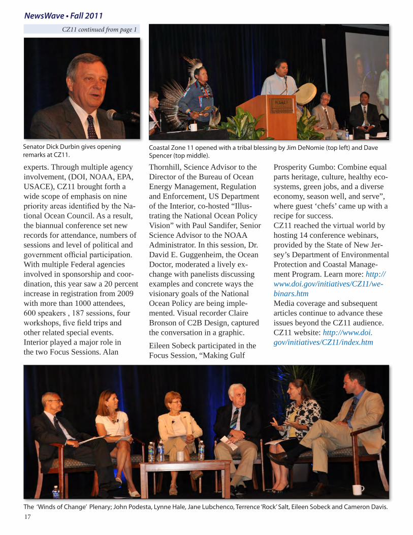
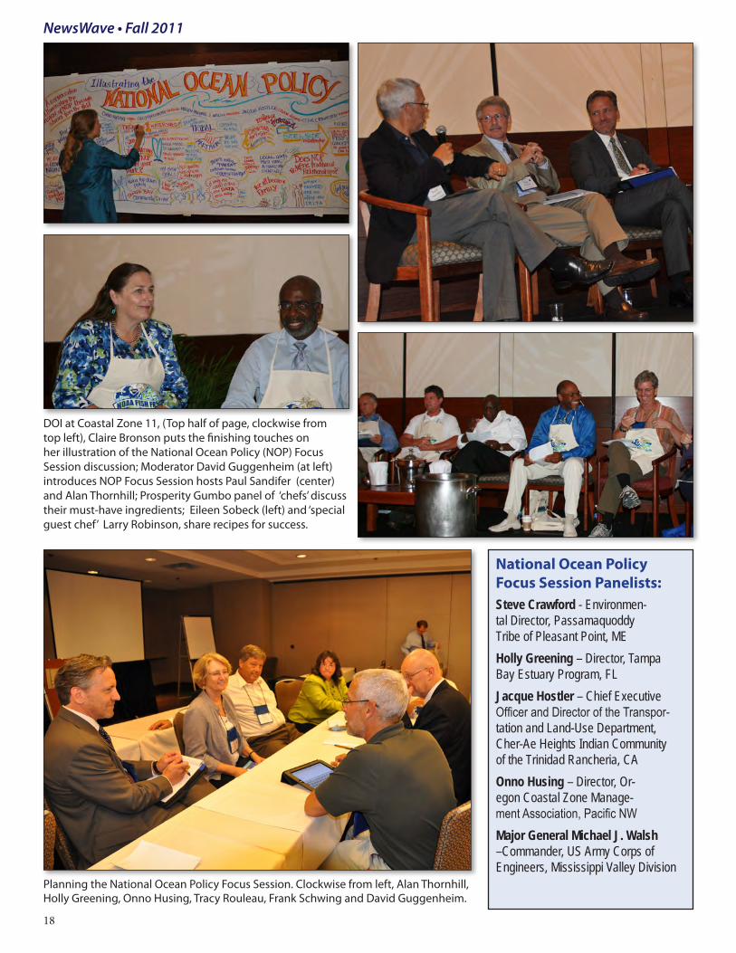
experts. Through multiple agency involvement, (DOI, NOAA, EPA, USACE), CZ11 brought forth a wide scope of emphasis on nine priority areas identified by the Na-tional Ocean Council. As a result, the biannual conference set new records for attendance, numbers of sessions and level of political and government official participation. With multiple Federal agencies involved in sponsorship and coor-dination, this year saw a 20 percent increase in registration from 2009 with more than 1000 attendees, 600 speakers , 187 sessions, four workshops, five field trips and other related special events. Interior played a major role in the two Focus Sessions. Alan
Thornhill, Science Advisor to the Director of the Bureau of Ocean Energy Management, Regulation and Enforcement, US Department of the Interior, co-hosted “Illus-trating the National Ocean Policy Vision” with Paul Sandifer, Senior Science Advisor to the NOAA Administrator. In this session, Dr. David E. Guggenheim, the Ocean Doctor, moderated a lively ex-change with panelists discussing examples and concrete ways the visionary goals of the National Ocean Policy are being imple-mented. Visual recorder Claire Bronson of C2B Design, captured the conversation in a graphic. Eileen Sobeck participated in the Focus Session, “Making Gulf
Prosperity Gumbo: Combine equal parts heritage, culture, healthy eco-systems, green jobs, and a diverse economy, season well, and serve”, where guest ‘chefs’ came up with a recipe for success. CZ11 reached the virtual world by hosting 14 conference webinars, provided by the State of New Jer-sey’s Department of Environmental Protection and Coastal Manage-ment Program. Learn more: http://www.doi.gov/initiatives/CZ11/we-binars.htm Media coverage and subsequent articles continue to advance these issues beyond the CZ11 audience. CZ11 website: http://www.doi.gov/initiatives/CZ11/index.htm
Coastal Zone 11 opened with a tribal blessing by Jim DeNomie (top left) and Dave Spencer (top middle).
The ‘Winds of Change’ Plenary; John Podesta, Lynne Hale, Jane Lubchenco, Terrence ‘Rock’ Salt, Eileen Sobeck and Cameron Davis.
Senator Dick Durbin gives opening remarks at CZ11.
National Ocean Policy Focus Session Panelists: Steve Crawford - Environmen-tal Director, Passamaquoddy Tribe of Pleasant Point, MEHolly Greening – Director, Tampa Bay Estuary Program, FLJacque Hostler – Chief Executive Officer and Director of the Transpor-tation and Land-Use Department, Cher-Ae Heights Indian Community of the Trinidad Rancheria, CA Onno Husing – Director, Or-egon Coastal Zone Manage-ment Association, Pacific NWMajor General Michael J. Walsh –Commander, US Army Corps of Engineers, Mississippi Valley Division
DOI at Coastal Zone 11, (Top half of page, clockwise from top left), Claire Bronson puts the finishing touches on her illustration of the National Ocean Policy (NOP) Focus Session discussion; Moderator David Guggenheim (at left) introduces NOP Focus Session hosts Paul Sandifer (center) and Alan Thornhill; Prosperity Gumbo panel of ‘chefs’ discuss their must-have ingredients; Eileen Sobeck (left) and ‘special guest chef’ Larry Robinson, share recipes for success.
Planning the National Ocean Policy Focus Session. Clockwise from left, Alan Thornhill, Holly Greening, Onno Husing, Tracy Rouleau, Frank Schwing and David Guggenheim.
18
The Surfing Bison Science in Support of Restoring the Everglades
By Matt Cimitile
See related article: http://soundwaves.usgs.gov/2011/11/research.html
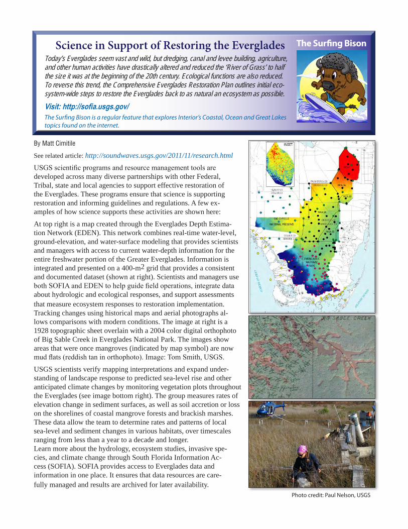
USGS scientific programs and resource management tools are developed across many diverse partnerships with other Federal, Tribal, state and local agencies to support effective restoration of the Everglades. These programs ensure that science is supporting restoration and informing guidelines and regulations. A few ex-amples of how science supports these activities are shown here:
At top right is a map created through the Everglades Depth Estima-tion Network (EDEN). This network combines real-time water-level, ground-elevation, and water-surface modeling that provides scientists and managers with access to current water-depth information for the entire freshwater portion of the Greater Everglades. Information is integrated and presented on a 400-m2 grid that provides a consistent and documented dataset (shown at right). Scientists and managers use both SOFIA and EDEN to help guide field operations, integrate data about hydrologic and ecological responses, and support assessments that measure ecosystem responses to restoration implementation. Tracking changes using historical maps and aerial photographs al-lows comparisons with modern conditions. The image at right is a 1928 topographic sheet overlain with a 2004 color digital orthophoto of Big Sable Creek in Everglades National Park. The images show areas that were once mangroves (indicated by map symbol) are now mud flats (reddish tan in orthophoto). Image: Tom Smith, USGS.
USGS scientists verify mapping interpretations and expand under-standing of landscape response to predicted sea-level rise and other anticipated climate changes by monitoring vegetation plots throughout the Everglades (see image bottom right). The group measures rates of elevation change in sediment surfaces, as well as soil accretion or loss on the shorelines of coastal mangrove forests and brackish marshes. These data allow the team to determine rates and patterns of local sea-level and sediment changes in various habitats, over timescales ranging from less than a year to a decade and longer. Learn more about the hydrology, ecosystem studies, invasive spe-cies, and climate change through South Florida Information Ac-cess (SOFIA). SOFIA provides access to Everglades data and information in one place. It ensures that data resources are care-fully managed and results are archived for later availability.
The Surfing Bison is a regular feature that explores Interior’s Coastal, Ocean and Great Lakes topics found on the internet.
Today’s Everglades seem vast and wild, but dredging, canal and levee building, agriculture, and other human activities have drastically altered and reduced the ‘River of Grass’ to half the size it was at the beginning of the 20th century. Ecological functions are also reduced. To reverse this trend, the Comprehensive Everglades Restoration Plan outlines initial eco-system-wide steps to restore the Everglades back to as natural an ecosystem as possible.Visit: http://sofia.usgs.gov/