36
International Boundary Study No. 91 – October 15, 1969 Benin (Dahomey) – Nigeria Boundary (Country Codes: BN-NI) The Geographer Office of the Geographer Bureau of Intelligence and Research

International Boundary Study
No. 91 – October 15, 1969
Benin (Dahomey) – Nigeria Boundary
(Country Codes: BN-NI)
The Geographer Office of the Geographer
Bureau of Intelligence and Research
The Geographer Office of Strategic and Functional Research
Bureau of Intelligence and Research
INTERNATIONAL BOUNDARY STUDY
No. 91
BENIN (DAHOMEY) – NIGERIA BOUNDARY
TABLE OF CONTENTS
Page I. Brief................................................................................. 2 II. Historical Background............................................... 2 III. Alignment ...................................................................... 6
APPENDIX I. Documents.................................................................... 13 II. Maps ............................................................................... 13 III. The Delimitation of the Frontier between the
British and French Possessions from the Gulf of Guinea to the Okapara River (Feb. 18, 1914) ........ 14

Page 2
BENIN (DAHOMEY) – NIGERIA BOUNDARY
I. BRIEF The Dahomey - Nigeria boundary is approximately 480 miles in length. It extends between the Gulf of Guinea (Bight of Benin) and the Republic of Niger tripoint at the median of the Niger river. Inland from the Gulf of Guinea, the boundary is demarcated by pillars to the Okpara and then follows the thalweg of the Okpara for about 100 miles. The remainder of the boundary consists primarily of straight-line segments, arcs of circles, and sectors parallel to roads.
II. HISTORICAL BACKGROUND In 1845 French possessions in western Africa were divided between Senegal with headquarters at Saint-Louis and Les Rivieres du Sud (Southern Rivers) with headquarters on the Ile de Goree (two miles east of the present city of Dakar). Les Rivieres du Sud comprised all French settlements south of Senegal to, and for a short time including, Gabon, under the admiral in Command of the Naval Station on the Ile de Goree. During 1851 Bouet-Willaumez of Les Rivieres du Sud concluded a treaty of friendship and commerce with King Gezo of Dahomey. On February 26, 1859, French settlements south of the Ile de Goree were placed under the Governor of Senegal. Porto Novo was established in 1863 as the first of a number of French protectorates in Dahomey. A decree of February 4, 1879 placed the French settlements along the Bight of Benin (Gulf of Guinea) under the administration of Gabon. Les Rivieres du Sud was made a colony in 1882 with a Lieutenant Governor responsible to the Governor of Senegal. In 1883 French protectorates were established, or in some cases re-established, for Grand-Popo, Petit-Popo (Anecho), Porto-Novo, and Porto-Seguro, and they were known as the Etablissements du Golfe de Guinee. As a result of the Berlin Conference of 1885, German claims on the Gulf of Guinea were recognized with the cession of Porto-Seguro and Anecho to Togo. On August 4, 1886, a French decree placed the remainder of the Etablissements du Golfe de Guinee under the Lieutenant Governor of Les Rivieres du Sud. The Lagos area of Nigeria was ceded to the United Kingdom by a local monarch in 1861, and was titled the Settlement of Lagos and Dependencies. In 1863 the Settlement of Lagos was made a member of the West African Settlements subject to the Governor of Sierra Leone. During 1874 the Settlement of Lagos and the Gold Coast Colony were detached from the West African Settlements and both were administered by the Governor of the Gold Coast. Twelve years later the Settlement of Lagos was detached from the Gold Coast Colony and made a separate colony. In June 1885 the United Kingdom proclaimed an Oil Rivers Protectorate between the Settlement of Lagos and Kamerun.1 During July 1886 the British chartered the Royal Niger Company which was given authority to administer territories in the interior of Nigeria held by treaties and concessions.
1 The Oil Rivers Protectorate was renamed the Niger Coast Protectorate on May 13, 1893.
Page 3
With the expansion inland of both Dahomey and Nigeria, the Anglo - French convention of August 10, 1889 delimited a boundary between the territories from the Gulf of Guinea northward to the parallel of 9° N.
Article IV. - Section 1. On the Slave Coast, the line of demarcation between the spheres of influence of the two powers shall be identical with the meridian which intersects the territory of Porto Novo at the Ajarra Creek [Adjarra], leaving Pokrah or Pokea to the English Colony of Lagos. It shall follow the above-mentioned meridian as far as the 9th degree of north latitude, where it shall stop.
In an attempt to clarify further the location of the meridian in Article IV of the Anglo - French Convention of August 10, 1889, Annex 2 of the same treaty affords the following information:
Section 1. "The meridian which intersects the territory of Porto Novo at the Ajarra Creek" shall be taken to mean:-- 1. (To the north of the Porto Novo Lagoon) the middle of the stream of the Ajarra or Ajera River to the point where the said river ceases to separate the Kingdom of Porto Novo from that of Pokrah, and from thence the meridian thereof as far as the 9th parallel of north latitude. 2. (To the south of Porto Novo Lagoon) the meridian of the middle of the Ajarra River, where it flows into the Porto Novo Lagoon. The frontier line has been based in this convention upon the sketch survey of the inland water communication in the Colony of Lagos, by Harbour-Master Speeding, 1886.
On December 17, 1891, Les Rivieres du Sud, which included the Etablissements du Golfe de Guinee was declared independent of Senegal. A decree of March 10, 1893 made the Etablissement du Golfe de Guinee a colony independent of the Les Rivieres du Sud. The new colony was titled Benin with a governor directly responsible to Paris. On March 10, 1894, a decree changed the name of the colony from Benin to Dahomey. On October 12, 1896, a joint report by British and French Commissioners delimited the boundary northward to the ninth parallel.
The boundary, starting from Point A [near Dopetu], ascends the River Iguidi (Igouidi) up to where it is found by the River Igirawun (Igouiraoun), leaving the town of Idiroko to the Colony of Lagos. From thence it ascends the River Igirawun to a point 200 metres beyond the intersection of the river by the road from Ilashe to Ifoyin.

Page 4
Ilashe remains in Lagos Colony. From thence the boundary follows a fictitious line traced 200 metres parallel with a roadway, and leaving the roadway on its left. This roadway (the first portion of which is the Ilashe -- Ifoyin road, starting from the river) runs north from Point B by the following farms:
Ikotun (Ikotoun), Idagbon (Ilagbo), Ilore (Ilore), Isagbano (Isagbano), Okeoko (Okeoko), Igbado (Bado), Madogan (Ogouissou).
All of which form part of the Colony of Dahomey; and by Ohumbe (Ohoumbe) and Ibeyun (Ibayan), which belong to Lagos Colony. From Point B up to the River Amidu (Amidou), the boundary-line runs to the right of the roadway. At this river it crosses to 200 metres to the left of the roadway, following it up to the point where such roadway is intersected by the River Itu (Itou) [Ibu]. From thence the boundary follows the course of this river until it meets the River Buru (Bourou). It then follows the River Buru up to a point 200 metres beyond the bridge which spans it on the road from Ilimon.
Isale (Issale) and Ilimon (Illemon) belong to the Colony of Dahomey. Isuku (Isouko) and Asa (Aso) to the Colony of Lagos.
From thence the boundary-line runs at a distance of 200 metres to the left of and parallel with the roadway, which, passing Ishada (Ichada), Mokofi (Ibokofi), Ibeyan (Ibiyan), and Tobolo (Tobolo) [Tabolo] all of which belong to Lagos Colony cuts the River Iguna (Gauna) [Igunu] exactly on the meridian. The boundary then follows the meridian up to a point 200 metres south of the road from Ketu to Idofa by Alagbe. From thence the boundary-line runs parallel with the road leading to Idofa via Alagbe at a distance of 200 metres on the right of the road as far as the River Yewa (Yeoua). The boundary-line then ascends the Yewa River up to a point 200 metres below the river's intersection with the road from Idanyin proceeding north; Idofa (Idofa) and Meko (Meko) belonging to Lagos Colony.
Page 5
Ilikimo (Likimon), Idanyin (Idanhim), Idjalu (Idjalou), and Iselu (Selou) belonging to the Colony of Dahomey. From thence the boundary-line runs parallel with, at a distance of 200 metres to the right of it, the above-mentioned road up to where the road crosses the Okpara River. Less than 100 metres from this crossing, on the right bank of the river, a cairn of stones in the shape of a pyramid was erected to distinguish the spot where lunar transit observations were taken. The boundary-line then follows the thalweg of the Okpara River up to the 9th parallel.
Article II of the Anglo - French Convention of June 14, 1898 accepted the delimitation of October 12, 1896, and it also extended a boundary between British and French territories northward to the Niger river.
II. The frontier between the British Colony of Lagos and the French Colony of Dahomey, which was delimited on the ground by the Anglo - French Boundary Commission of 1895, and which is described in the Report signed by the Commissioners of the two nations on the 12th October, 1896, shall henceforward be recognized as the frontier separating the British and French possessions from the sea to the 9th degree of north latitude. From the point of intersection of the River Ocpara with the 9th degree of north latitude, as determined by the said Commissioners, the frontier separating the British and French possessions shall proceed in a northerly direction, and follow a line passing west of the lands belonging to the following places, viz., Tabira, Okuta (Okouta), Boria, Tere, Gbani Ashigere (Yassikera), and Dekala. From the most westerly point of the lands belonging to Dekala the frontier shall be drawn in a northerly direction so as to coincide as far as possible with the line indicated on Map No. 1 annexed to the present Protocol, and shall strike the right bank of the Niger at a point situated 10 miles (16.093 metres) upstream from the centre of the town of Gere (Guiris) (the port of Ilo [Illo], measured as the crow flies.
A French decree included Dahomey in French West Africa on October 17, 1899. Also during the same year, the Royal Niger Company surrendered its charter, and the British Government assumed control of the company's territorial acquisitions in the south by annexing them to the Niger Coast Protectorate which was renamed the Protectorate of Southern Nigeria in January 1900. To the north the Royal Niger Company's holdings became the Protectorate of Northern Nigeria. In 1906 the Colony of Lagos was joined with the Protectorate of Southern Nigeria, and the new entity became known as the Colony and Protectorate of Southern Nigeria.

Page 6
An Anglo - French agreement of October 19, 1906 established the present Dahomey - Nigeria boundary, along with minor changes made by the demarcation protocol of July 20, 1912. An Anglo - French boundary commission completed the placement of pillars or beacons along the boundary from the Bight of Benin to the Okpara in 1912. As of January 1, 1914, the Colony and Protectorate of Southern Nigeria and the Protectorate of Northern Nigeria were amalgamated to form a single state called the Colony and Protectorate of Nigeria. In 1946 Dahomey, while remaining a part of French West Africa, was made an overseas territory and a member of the French Union. On December 4, 1958, the Republic of Dahomey became an autonomous member of the French Community. Dahomey was proclaimed independent on August 1, 1960 following an agreement with France. The Federation of Nigeria consisting of the Northern Region, Western Region, Eastern Region, Southern Cameroons, and the Federal Capital of Lagos, was organized on October 1, 1960, and it proclaimed a Federal Republic three years later. The designation of the Federal Republic of Nigeria was abolished on May 24, 1966, and the name was changed to the Republic of Nigeria.
III. ALIGNMENT The Anglo - French agreement of October 19, 1906 and amendments made by the demarcation protocol of July 20, 1912 (approved by an exchange of notes on February 18, 1914) determine the Dahomey - Nigeria boundary as follows2:
1. Starting on the coast of the Gulf of Guinea at the point at which it is intersected by the meridian passing through the middle of the mouth of the Ajara River where it flows into the Porto Novo lagoon, the frontier runs north along this meridian until it reaches the middle of the mouth of the River Ajara. 2. Thence it runs in the shortest straight line to the thalweg of the River Ajara. 3. Thence it ascends the thalweg of the River Ajara, its upper course being called the Iguidi (Igouidi), as far as the ravine [Itu] entering the river from the north immediately to the west of Idiroko, leaving the town of Idiroko to the Colony of Lagos. 4. Thence it follows the ravine [Itu] to its northern end.3
2 Details of the demarcation protocol of July 20, 1912 relative to the boundary between the Gulf of Guinea
and the Okpara are contained in the exchange of notes of February 18, 1914 included as Part III of the Appendix to this study.
3 The Amendments of Detail and special remarks included in the exchange of notes of February 18, 1914 indicate a change in the boundary as delimited by the Anglo - French Agreement of October 19, 1906 between the Itu ravine and the crossing of the Ilashe - Ikotum road and the Igirawun river. The new
Page 7
5. Thence it follows a line drawn to a point on the north side of the shortest road from Ilashe (Ilashe) to Ikpaboro on the right (west) bank of the River Igirawun (Iguiraoun). 6. Thence it runs 200 metres northward from the road, then westward parallel with the road at 200 metres distance until 200 metres east of the first road branching northward to Ikotun (Ikotoun), which road it then follows northward to Ikotun (Ikotoun) at a distance of 200 metres parallel to and eastward of it. 7. Thence it follows a road running through the following places, as far as the River Amidu (Amidou), keeping always on the same side of the road and at the same distance from it: Ikotun (Ikotoun), Idagbon (Ilagbo), Igbado (Bado), Modogan (Ogouissou), Agangan, continuing as far as the River Amidu (Amidou) along the road to Ibeyun (Ibayan). Ikotun (Ikotoun), Idagbon (Ilagbo), Ilore, Isagbano, Okoko, Igbado (Bado), and Modogan (Ogouissou) are in French territory.
8. On reaching the thalweg of the River Amidu (Amidou), the frontier follows it up-stream to a point 200 metres from and on the west side of the road. 9. From this point it runs parallel to the road which passes through Ibeyun (Ibayan) and Majano, keeping always on the same side of it, as far as its intersection by the River Ibu (Ibou) [Idi]. Ohumbe (Ohoumbe), Ibeyun (Ibayan), and Majano are in British territory. 10. Thence it follows the thalweg of the River Ibu (Ibou) downstream to its junction with the River Buru (Bourou), leaving Isale (Issale) in French, and Isuku (Isouko ) and Asa (Aso) in British territory. 11. Thence it follows the thalweg of the River Buru (Bourou), leaving Ilimon (Illemon) in French territory, to a point 200 metres beyond the bridge which spans that river on the road from Ilimon (Illemon). 12. From this point the frontier runs parallel to and at a distance of 200 metres from the road to a point at which, after passing Ishada (Ichada), Mokofi (Ibokofi), Ibeyan (Ibiyan) and Tabolo, all of which are in British territory, it custs the River Igunu (Gauna). 13. Thence it runs due north to a point 200 metres south of the road from Ketu (Ketou) to Idofa by Alagbe (Itagbe), the latter being in French territory. 14. Thence it runs eastward parallel to that road as far as the River Yewa (Yeoua).
alignment is provided by the demarcation contained in Part III of the Appendix between boundary pillars 13 and 20.
Page 8
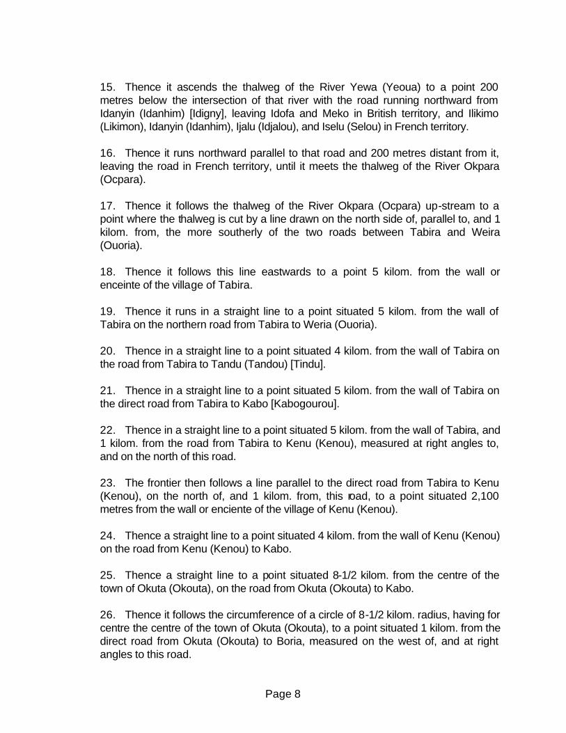
15. Thence it ascends the thalweg of the River Yewa (Yeoua) to a point 200 metres below the intersection of that river with the road running northward from Idanyin (Idanhim) [Idigny], leaving Idofa and Meko in British territory, and Ilikimo (Likimon), Idanyin (Idanhim), Ijalu (Idjalou), and Iselu (Selou) in French territory. 16. Thence it runs northward parallel to that road and 200 metres distant from it, leaving the road in French territory, until it meets the thalweg of the River Okpara (Ocpara). 17. Thence it follows the thalweg of the River Okpara (Ocpara) up-stream to a point where the thalweg is cut by a line drawn on the north side of, parallel to, and 1 kilom. from, the more southerly of the two roads between Tabira and Weira (Ouoria). 18. Thence it follows this line eastwards to a point 5 kilom. from the wall or enceinte of the village of Tabira. 19. Thence it runs in a straight line to a point situated 5 kilom. from the wall of Tabira on the northern road from Tabira to Weria (Ouoria). 20. Thence in a straight line to a point situated 4 kilom. from the wall of Tabira on the road from Tabira to Tandu (Tandou) [Tindu]. 21. Thence in a straight line to a point situated 5 kilom. from the wall of Tabira on the direct road from Tabira to Kabo [Kabogourou]. 22. Thence in a straight line to a point situated 5 kilom. from the wall of Tabira, and 1 kilom. from the road from Tabira to Kenu (Kenou), measured at right angles to, and on the north of this road. 23. The frontier then follows a line parallel to the direct road from Tabira to Kenu (Kenou), on the north of, and 1 kilom. from, this road, to a point situated 2,100 metres from the wall or enciente of the village of Kenu (Kenou). 24. Thence a straight line to a point situated 4 kilom. from the wall of Kenu (Kenou) on the road from Kenu (Kenou) to Kabo. 25. Thence a straight line to a point situated 8-1/2 kilom. from the centre of the town of Okuta (Okouta), on the road from Okuta (Okouta) to Kabo. 26. Thence it follows the circumference of a circle of 8-1/2 kilom. radius, having for centre the centre of the town of Okuta (Okouta), to a point situated 1 kilom. from the direct road from Okuta (Okouta) to Boria, measured on the west of, and at right angles to this road.
Page 9
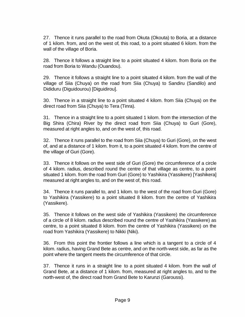
27. Thence it runs parallel to the road from Okuta (Okouta) to Boria, at a distance of 1 kilom. from, and on the west of, this road, to a point situated 6 kilom. from the wall of the village of Boria. 28. Thence it follows a straight line to a point situated 4 kilom. from Boria on the road from Boria to Wandu (Ouandou). 29. Thence it follows a straight line to a point situated 4 kilom. from the wall of the village of Siia (Chuya) on the road from Siia (Chuya) to Sandiru (Sandilo) and Dididuru (Diguidourou) [Diguidirou]. 30. Thence in a straight line to a point situated 4 kilom. from Siia (Chuya) on the direct road from Siia (Chuya) to Tera (Tinra). 31. Thence in a straight line to a point situated 1 kilom. from the intersection of the Big Shira (Chira) River by the direct road from Siia (Chuya) to Guri (Gore), measured at right angles to, and on the west of, this road. 32. Thence it runs parallel to the road from Siia (Chuya) to Guri (Gore), on the west of, and at a distance of 1 kilom. from it, to a point situated 4 kilom. from the centre of the village of Guri (Gore). 33. Thence it follows on the west side of Guri (Gore) the circumference of a circle of 4 kilom. radius, described round the centre of that village as centre, to a point situated 1 kilom. from the road from Guri (Gore) to Yashikira (Yassikere) [Yashikera] measured at right angles to, and on the west of, this road. 34. Thence it runs parallel to, and 1 kilom. to the west of the road from Guri (Gore) to Yashikira (Yassikere) to a point situated 8 kilom. from the centre of Yashikira (Yassikere). 35. Thence it follows on the west side of Yashikira (Yassikere) the circumference of a circle of 8 kilom. radius described round the centre of Yashikira (Yassikere) as centre, to a point situated 8 kilom. from the centre of Yashikira (Yassikere) on the road from Yashikira (Yassikere) to Nikki (Niki). 36. From this point the frontier follows a line which is a tangent to a circle of 4 kilom. radius, having Grand Bete as centre, and on the north-west side, as far as the point where the tangent meets the circumference of that circle. 37. Thence it runs in a straight line to a point situated 4 kilom. from the wall of Grand Bete, at a distance of 1 kilom. from, measured at right angles to, and to the north-west of, the direct road from Grand Bete to Karunzi (Garoussi).

Page 10
38. Thence it runs parallel to the road from Grand Bete to Karunzi (Garoussi) on the west of, and at a distance of 1 kilom. from this road, to a point situated 4 kilom. from the wall of the village of Karunzi (Garoussi). 39. Thence in a straight line to a point situated due west of Karunzi (Garoussi), 4 kilom. from the wall of that village. 40. Thence it runs direct to a point situated 4 kilom. from the wall of Karunzi (Garoussi), and 1 kilom. from the road from Karunzi (Garoussi) to Kenumbe (Kenombe), measured at right angles to and on the north-west of this road. 41. Thence it runs parallel to the direct road from Karunzi (Garoussi), to Kenumbe (Kenombe) on the west side of, and at a distance of 1 kilom. from that road to a point situated 4 kilom. from the centre of the village of Kenumbe (Kenombe). 42. Thence it follows on the west side of Kenumbe (Kenombe), the circumference of a circle of 4 kilom. radius, described round the centre of Kenumbe (Kenombe) as centre, to a point, situated 1 kilom. from and to the west of the road from Kenumbe (Kenombe) to Besi (Bessi) measured at right angles to this road. 43. Thence it runs parallel to the road from Kenumbe (Kenombe) to Besi (Bessi), on the west of and at a distance of 1 kilom. from this road to a point situated 8 kilom. from the centre of Besi (Bessi). 44. Thence it follows on the west side Besi (Bessi), the circumference of a circle of 8 kilom. radius described round the centre of Besi (Bessi) as centre to the intersection of this circumference with the road from Besi (Bessi) to Sakamanji (Sakamandji). 45. Thence it runs in a straight line to a point situated 12 kilom. from the wall or enceinte of Dakala on the road from Dekala to Lu (Lou) and Daganzi [Dagassi]. 46. Thence in a straight line to a point situated on the road from Dekala to Gauzhi (Gaodgi) at a distance of 3-1/2 kilom. from the centre of Gauzhi (Gaodgi). 47. Thence it follows on the east side Gauzhi (Gaodgi), the circumference of a circle, 3-1/2 kilom. radius, described round the centre of Gauzhi (Gaodgi) as center, to a point 1 kilom. from the road from Gauzhi (Gaodgi) to Basso, measured at right angles to, and to the south of, this road. 48. Thence it runs parallel to the road from Gauzhi (Gaodgi) to Basso, to the south-east of, and at a distance of 1 kilom. from this road, to a point situated 5 kilom. from Basso. 49. Thence it follows a tangent drawn from this point, on the south-west of Lusi

Page 11
(Lousi) to a circle of 3-1/2 kilom. radius, described round the centre of the village of Lusi (Lousi) as centre. It continues along this tangent to its intersection with a perpendicular to the road from Lusi (Lousi) to Babanna the perpendicular being drawn from the point half-way between Lusi (Lousi) and Babanna. 50. Thence it follows this perpendicular as far as the point half-way between Lusi (Lousi) and Babanna. 51. Thence it runs in a straight line to a point situated 5 kilom. from Lusi (Lousi), and 1 kilom. to the east of the road from Lusi (Lousi) to Naganzi (Nagandgi) [Neganzi]. 52. Thence it runs parallel to the road from Lusi (Lousi) to Naganzi (Nagandgi), to the east of, and at a distance of 1 kilom. from this road, cuts the road from Babanna to Naganzi (Nagandgi), and runs parallel to, and at a distance of 1 kilom. to the east of, this last road, to a point situated 4 kilom. from the centre of the village of Naganzi (Nagandgi), and 1 kilom. to the east of the road from Babanna to Naganzi (Nagandgi). 53. Thence it follows to the east of Naganzi (Nagandgi), the circumference of a circle of 4 kilom. radius, described round the centre of Naganzi (Nagandgi) as centre, as far as the point on the south-east of Naganzi (Nagandgi), at which this circle is touched by the longest common tangent to it and to another circle of the same radius described round the centre of the village of Kade (Koure) as centre. 54. Thence it follows this tangent until it touches the circumference of the circle described round Kude (Koure). 55. Thence it follows this circle to a point situated to the east of, and 1 kilom. from, the road from Kude (Koure) to Kankali (Kankari), the distance being measured at right angles to the road. 56. Thence it follows a line parallel to, on the east side of, and at a distance of 1 kilom. from, the road from Kude (Koure) to Kankali (Kankari), to a point situated 5 kilom. from the centre of Kankali (Kankari). 57. Thence it follows on the east side of Kankali (Kankari), the circumference of a circle of 5 kilom. radius, described round the centre of the village of Kankali (Kankari) as centre, until it meets, on the east side, the longest tangent common to the last-mentioned circle and to another circle of 4 kilom. radius described round Gusin - Sura (Gouri - Sare) [Goussin Sari] as centre. 58. Thence it follows this common tangent to its intersection with the longest tangent common to this last-mentioned circle, and to another of 5 kilom. radius, described round Daku (Dako) as centre.

Page 12
59. Thence it follows the last-mentioned tangent as far as its intersection with the circumference of the circle of 5 kilom. radius described round Daku (Dako). 60. Thence it follows the circumference of this circle, always on the east side of the road from Segbana to Samia, to a point situated 1 kilom. from, and on the east of, the road from Daku (Dako) to Samia. 61. Thence it follows a line parallel to, on the east of, and 1 kilom. from, the road from Daku (Dako) to Samia, to the intersection of the said parallel line with the thalweg of the River Wan (Oua) [Waratena, Shodu]. 62. Thence it follows the thalweg of the River Wan (Oua) up-stream to its intersection with a line passing through the following two points:-- (1.) A point situated 3 kilom. true west of the intersection of the River Wan (Oua) and the road from Daku (Dako) to Samia. (2.) A point situated on the road from Ilo to Lugu (Lougou) 37 kilom. from the enceinte or wall of Ilo, the distance being measured along the road. 63. Thence it follows this line to that above-mentioned point on the road fro Ilo to Lugu (Lougou). 64. Thence it runs in a straight line to a point 8 kilom. south, 23° west (true), of the cairn situated at the junction of the roads from Madekale (Madikale) to Tuandi and Madekale (Madikale) to Lolo, which cairn is about 3,000 metres from, and south of the River Niger. 65. Thence in a straight line to the cairn mentioned in paragraph 64, and thence in the same straight line produced until it terminates at its intersection with the median line of the River Niger.
Page 13
APPENDIX I. Documents 1. Arrangement between Great Britain and France, respecting the Delimitation of the
English and French Possessions on the West Coast of Africa. Signed at Paris, August 10, 1889. Edward Hertslet, The Map of Africa by Treaty, 3v. 3d. ed. (London: Harrison and Sons, 1909), Vol. 2, pp. 729 - 736.
2. Report of the British and French Commissioners for the Delimitation of the Boundary
between the Colonies of Lagos and Dahomey. Signed at Paris, October 12, 1896. British and Foreign State Papers (BFSP), Vol. 91, 1898 - 9, pp. 103 - 108.
3. Convention between Great Britain and France, for the Delimitation of their respective
Possessions to the West of the Niger, and of their respective Possessions and Spheres of Influence to the East of that River. Signed at Paris, June 14, 1898. BFSP, Vol. 91, 1898 - 9, pp. 38 - 57.
4. Agreement between Great Britain and France relative to the Frontier between the
British and French possessions from the Gulf of Guinea to the Niger (Southern Nigeria and Dahomey). Notes exchanged at Paris, October 19, 1906. BFSP, Vol. 99, 1905 - 6, pp. 217 - 229. Also United Kingdom Cd. 3303 (1907).
5. Agreement between the United Kingdom and France respecting the Delimitation of the
Frontier between the British and French Possessions from the Gulf of Guinea to the Okpara River. Treaty Series 1914, No. 5, Cd. 7278, with Map G.S.G.S. 2688 (also see Cd. 7214).
II. Maps 1. Dahomey: scale 1:100,000; published 1947 by Service Geographique de 1'A.O.F.
(French West Africa); sheets B-31-XV-II (Porto Novo) and B-31-XV-4 (Pobe). 2. Dahomey: scale 1:200,000 published 1947 - 67 by Institut Geographique National
(Paris and Dakar); sheets NB-31-XXI (Zagnanado), NC-31-III (Save), C-31-X (Nikki), C-31-XVI (Dunkassa), and NC-31-XXII (Gaya). (boundary pillars and associated numbers indicated on sheets)
3. Map of the Franco - British Frontier from the Gulf of Guinea to the R. Okpara: scale
1:250,000; published 1913 by United Kingdom War Office; G.S.G.S. No. 2688. 4. Nigeria: scale 1:500,000; published 1960 by Federal Surveys, Nigeria; sheets 9, 5,
and 1. (Boundary pillars and associated numbers indicated on sheets)

Page 14
III. The Delimitation of the Frontier between the British and French Possessions from the Gulf of Guinea to the Okpara River (February 18, 1914)
Table of Beacons No. Positions on Reckoned from the Remarks the Ground preceding Beacon Bearing Distance (Degrees) (Metres) Initial Middle of the frontier mouth of the point. River Ajara (Adjara). Width of the lagoon = 900 metres. Distance between the south bank of the lagoon and Beacon No. 1 = 174 metres. 1 On the first bank of 180 1,714 firm ground rising from the swamp. 2 On the direct path 180 409 (north side) from Poguidi to Fasimi. 3 In the palm on 180 359 plantation the line of beacons. 4 On the direct path 180 354 (north side) from Poguidi to Ashiri. 5 To the south of, and 180 383 about 100 metres from, the last houses west of Ashiri, near the point on the water which is in French territory and between the two oil-works in the English village of Ashiri. 6 On the path from 180 363

Page 15
Hovidokpo to Kwawme by Akpame (north side of road). 7 To the south of the 180 203 Akpame palm plantation on the line of beacons. 8 In the middle of a 180 729 tongue of wooded land jutting out of the swamp south of Akpame. 9 On the south bank 180 1,050 of the big swamp between Akrake and Kwawme and about 200 metres north of the Akrake - Kwawme road. 10 In the forest on 180 1,300 the north side of a farm road and on the line of beacons. 11 In a clearing on 180 464 the north side of a farm road and on the line of beacons. 12 Beacon on the sea-shore. 180 548 NOTE: -- Returning to the initial point: the centre of the mouth [approximately 2°42'30" E.] of the River Ajara (Adjara). From there the frontier ascends the thalweg of the River Ajara (Adjara), of which the upper course is called the Iguidi (Igouidi), to the mouth of the Itou Ravine, the thalweg of which it ascends until it leaves it at Beacon 13. This part of the frontier
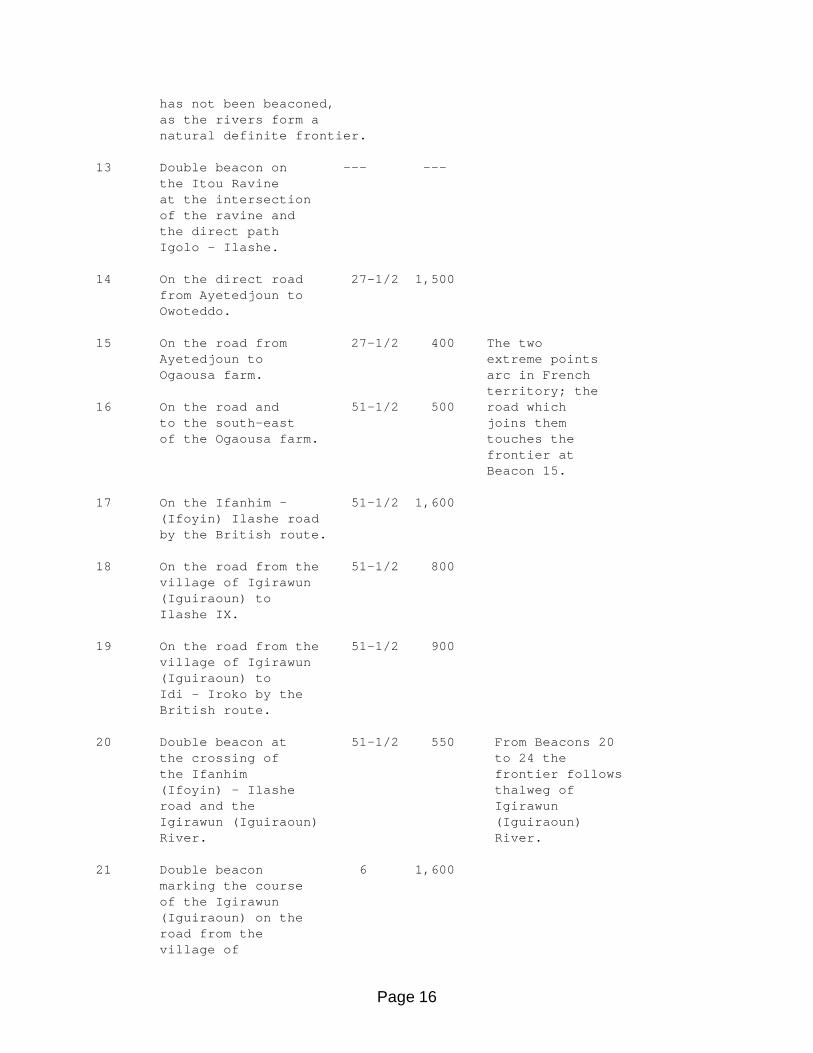
Page 16
has not been beaconed, as the rivers form a natural definite frontier. 13 Double beacon on --- --- the Itou Ravine at the intersection of the ravine and the direct path Igolo - Ilashe. 14 On the direct road 27-1/2 1,500 from Ayetedjoun to Owoteddo. 15 On the road from 27-1/2 400 The two Ayetedjoun to extreme points Ogaousa farm. arc in French territory; the 16 On the road and 51-1/2 500 road which to the south-east joins them of the Ogaousa farm. touches the frontier at Beacon 15. 17 On the Ifanhim - 51-1/2 1,600 (Ifoyin) Ilashe road by the British route. 18 On the road from the 51-1/2 800 village of Igirawun (Iguiraoun) to Ilashe IX. 19 On the road from the 51-1/2 900 village of Igirawun (Iguiraoun) to Idi - Iroko by the British route. 20 Double beacon at 51-1/2 550 From Beacons 20 the crossing of to 24 the the Ifanhim frontier follows (Ifoyin) - Ilashe thalweg of road and the Igirawun Igirawun (Iguiraoun) (Iguiraoun) River. River. 21 Double beacon 6 1,600 marking the course of the Igirawun (Iguiraoun) on the road from the village of

Page 17
Igirawun (Iguiraoun) to Adetawna. 22 Double beacon 347 1,300 marking the course of the Igirawun (Iguiraoun) on the road from the village of Igirawun (Iguiraoun) to Kawkaw. 23 Double beacon 2 500 marking the course of the Igirawun (Iguiraoun) at the watering- place of Baodjo village. 24 Double beacon near 40 300 the source of the Igirawun (Iguiraoun). 25 200 metres north- 28 350 east of the road from Aro to the source of the Igirawun (Iguiraoun) and on the path from Baodjo to Itawraw. 26 200 metres east 357 200 of the Baodjo - Atanatan road and on the direct path from Aro to Itawraw. 27 North-east of the 30 700 farms situated on the east of the Baodjo - Atanatan road,about 1,700 metres from Baodjo market. 28 200 metres east 9 1,300 of the Baodjo - Atanatan road on a farm path leaving the road 1,100 metres south of the

Page 18
Baodjo - Atanatan and Baodjo - Idagbon (Ilagbo) road- crossing. 29 200 metres east of the 0 400 Baodjo - Atanatan road on a farm path leaving the road 700 metres south of the Baodjo - Atanatan and Baodjo - Idagbon (Ilagbo)road-crossing. 30 On the Baodjo - 330 1,000 Atanatan road 200 metres north of the bifurcation of the paths Baodjo - Atanatan and Baodjo - Idagbon (Ilagbo). 31 200 metres north of 288 1,900 Idagbon (Ilagbo) on the path Idagbon (Ilagbo) - Oke Iwaw. 32 200 metres north of 271 600 the last houses of Idagbon (Ilagbo) on the Idagbo (Ilagbo) - Ajilinde path. 33 On the direct path 260 1,000 from Bedo to Ajilinde 200 metres north of the crossways Bedo - Ajilinde and Idagbon (Ilagbo) - Modogan (Ogouissou). 34 On the direct path 303 500 from Bedo to Ogunjawbi passing west of Ajilinde and 200 metres north of the crossways Bedo - Ogunjawbi and Idagbon (Ilagbo) - Modogan (Ogouissou). 35 200 metres north 313 2,250 of the the road Idagbon (Ilagbo) - Modogan (Ogouissou)
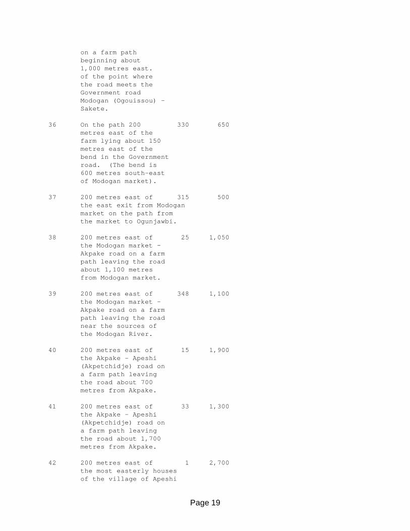
Page 19
on a farm path beginning about 1,000 metres east. of the point where the road meets the Government road Modogan (Ogouissou) - Sakete. 36 On the path 200 330 650 metres east of the farm lying about 150 metres east of the bend in the Government road. (The bend is 600 metres south-east of Modogan market). 37 200 metres east of 315 500 the east exit from Modogan market on the path from the market to Ogunjawbi. 38 200 metres east of 25 1,050 the Modogan market - Akpake road on a farm path leaving the road about 1,100 metres from Modogan market. 39 200 metres east of 348 1,100 the Modogan market - Akpake road on a farm path leaving the road near the sources of the Modogan River. 40 200 metres east of 15 1,900 the Akpake - Apeshi (Akpetchidje) road on a farm path leaving the road about 700 metres from Akpake. 41 200 metres east of 33 1,300 the Akpake - Apeshi (Akpetchidje) road on a farm path leaving the road about 1,700 metres from Akpake. 42 200 metres east of 1 2,700 the most easterly houses of the village of Apeshi

Page 20
(Akpetchidje). 43 On the Apeshi 18 1,200 (Akpetchidje) - Ikotan road 200 metres east the watering point of Apeshi (Akpetchidje) on the Gbon River. 44 200 metres east of the 348 2,400 place called Tamoro on the road from Apeshi (Akpetchidje) to Ohumbe (Ohoumbe). 45 200 metres east of the 19 900 place called Kobedio on the road from Apeshi (Akpetchidje)- Ohumbe (Ohoumbe). 46 200 metres east of the 0 1,800 Apeshi (Akpetchidje) - Ohumbe (Ohoumbe) road on a farm path leaving the road about 500 metres south of the River Amidu (Amidou). 47 Three beacons bearing the number 47-- (1.) On the River Amid 21 600 (Amidou) 200 metres below the crossing of the Apeshi (Akpetchidje) - Ohumbe (Ohoumbe) road. (2.) On the River 255 200 Amidu (Amidou) at the crossing of the Apeshi (Akpetchidje) - Ohumbe (Ohoumbe) road. (3.) On the River 255 200 Amidu (Amidou) 200 metres above the crossing of the Apeshi (Akpetchidje) - Ohumbe (Ohoumbe) road. 48 200 metres west of 21 700 the Apeshi (Akpetchidje) - Ohumbe (Ohoumbe) road on a farm path leaving

Page 21
the road about 250 metres south of Ohumbe (Ohumbe) market. 49 200 metres west of 335 500 the Ohumbe (Ohoumbe) - Ibeyun (Ibayan) road on the farm path which leaves Ohumbe (Ohoumbe) market. 50 200 metres west of 300 2,100 the Ohumbe (Ohoumbe) - Ibeyun (Ibayan) road on the path from Ohumbe (Ohoumbe) to Ouinka. 51 200 metres south-west 316 500 of the Ohumbe (Ohoumbe) - Ibeyun (Ibayan) road on the path from Ibeyun (Ibayan) to Ouinka. 52 200 metres west of 325 450 the Ohumbe (Ohoumbe) - Ibeyun (Ibayan) road on the path from the watering point of Ibeyun (Ibayan); the watering point is about 180 metres west of the beacon. 53 West of the Ibeyun 333 1,000 (Ibayan) - Mojana road and on the path from Ibeyun (Ibayan) to Okeita, about 300 metres north-west of the bifurcation of the two roads. 54 200 metres west of 10 900 the Ibeyun (Ibayan) - Mojana road and on a farm path which leaves the roads about 900 metres north of the bifurcation Ibeyun (Ibayan) - Mojana and Ibeyun (Ibayan) - Okeita roads.

Page 22
55 200 metres west of 30 700 the Ibeyun (Ibayan) - Mojana road and on a farm path which leaves the road about 1,800 metres north of the bifurcation of the Ibeyun (Ibayan) - Mojana and Ibeyun (Ibayan) - Okeita. 56 200 metres north-west 31 250 of the Ibeyun (Ibayan) - Mojana road and on a farm path which leaves the road about 1,800 metres north of the bifurcation of the roads Ibeyun (Ibayan) - Mojana and Ibeyun (Ibayan) - Okeita. 57 200 metres west of 18 1,000 the Ibeyun (Ibayan) - Isale (Issale) road and on the path Isale (Issale) - Okeita. 58 On the Mojana - Isale 10 2,300 This river (Issale) road and about is really 800 metres south of the called the River Ibu (Ibou). Idi. 59 About 200 metres south- 28 1,600 east of the last houses of Isale (Issale). 60 About 200 metres north- 9 600 east of the last houses of Isale (Issale). 61 On the River Ibu 305 300 NOTE.-- (Ibou) about 500 From Beacon metres north of the 61 to 67 last houses of Isale. the frontier (Issale). follows the thalweg of 62 Double beacon marking 53 3,300 the Rivers the River Ibu (Ibou), Ibu (Ibou) on the path from and Buru Ilimon (Illemon) to (Bourou). Isuku.
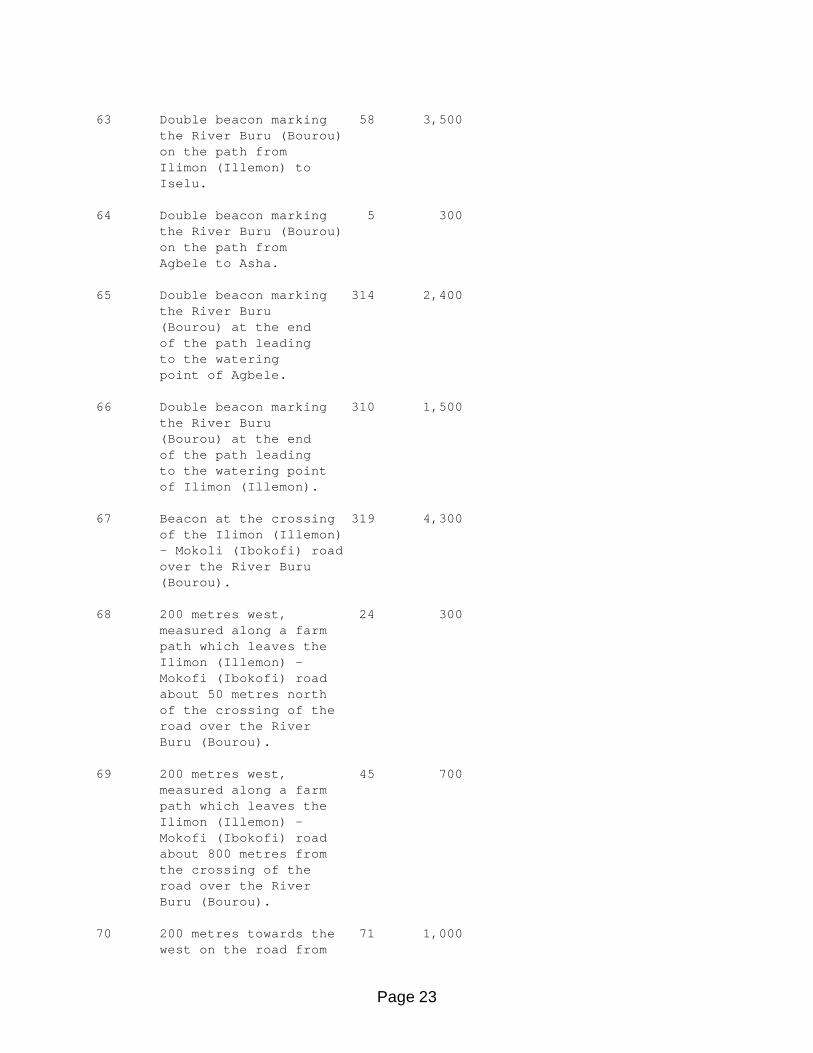
Page 23
63 Double beacon marking 58 3,500 the River Buru (Bourou) on the path from Ilimon (Illemon) to Iselu. 64 Double beacon marking 5 300 the River Buru (Bourou) on the path from Agbele to Asha. 65 Double beacon marking 314 2,400 the River Buru (Bourou) at the end of the path leading to the watering point of Agbele. 66 Double beacon marking 310 1,500 the River Buru (Bourou) at the end of the path leading to the watering point of Ilimon (Illemon). 67 Beacon at the crossing 319 4,300 of the Ilimon (Illemon) - Mokoli (Ibokofi) road over the River Buru (Bourou). 68 200 metres west, 24 300 measured along a farm path which leaves the Ilimon (Illemon) - Mokofi (Ibokofi) road about 50 metres north of the crossing of the road over the River Buru (Bourou). 69 200 metres west, 45 700 measured along a farm path which leaves the Ilimon (Illemon) - Mokofi (Ibokofi) road about 800 metres from the crossing of the road over the River Buru (Bourou). 70 200 metres towards the 71 1,000 west on the road from

Page 24
Mokofi (Ibokofi) to Iga market, measured from the bifurcation of the roads Mokofi (Ibokofi) - Iga market and Mokofi (Ibokofi) - Ilimon (Illemon). 71 200 metres west of the 71 900 Ilimon (Illemon) - Mokofi (Ibokofi) road, measured along the farm path leaving Ishada (Ichada) directly to the west. 72 200 metres west of the 40 200 Ilimon (Illemon) - Mokofi (Ibokofi) road, measured along the farm path leaving Ishada (Ichada) in a north- westerly direction. 73 200 metres west, 15 1,200 measured along a farm path leaving the Ilimon (Illemon) - Mokofi (Ibokofi) road about 1,200 metres north of the bifurcation of the roads Ilimon (Illemon) - Mokofi (Ibokofi) and Ilimon (Illemon) - Ishada (Ichada). 74 200 metres north-west, 32 850 measured along a farm path leaving the Ilimon (Illemon)- Mokofi (Ibokofi) road about 1,250 metres south of the River Ibale. 75 200 metres west, 49 900 measured along a farm path leaving the Ilimon (Illemon) - Mokofi (Ibokofi) road about 200 metres south of the River Ibale. 76 200 metres west of the 47 1,100

Page 25
Ilimon (Illemon) - Ibeyan (Ibiyan) road, measured along the farm path leaving Mokofi (Ibokofi). 77 200 metres north-west, 20 550 measured along a farm path leaving the Mokofi (Ibokofi) - Ibeyan (Ibiyan) road about 1,000 metres south of the River Fadawa. 78 200 metres west, 35 700 measured along a farm path leaving the Mokofi (Ibokofi) - Ibeyan (Ibiyan) road about 100 metres south of the River Fadawa. 79 In the bush 200 metres 14 1,850 west of the Mokofi (Ibokofi) - Ibeyan (Ibiyan) road and opposite a point situated about 1,700 metres north of the River Fadawa. 80 In the bush 200 metres 351 2,400 west of the Mokofi (Ibokofi) - Ibeyan (Ibiyan) road and opposite a point situated about 4,000 metres north of the River Fadawa. 81 In the bush 200 metres 350 450 west of the Mokofi (Ibokofi) - Ibeyan (Ibiyan) road and opposite a point situated about 4,500 metres north of the River Fadawa. 82 In the bush 200 metres 358 1,100 west of the Mokofi (Ibokofi) - Ibeyan (Ibiyan) road and

Page 26
opposite a point situated about 5,600 metres north of the River Fadawa. 83 200 metres south-west, 350 1,500 measured along a farm path which leaves the Mokofi (Ibokofi) - Ibeyan (Ibiyan) road about 2,400 metres south of Ibeyan (Ibiyan) cross-roads. 84 200 metres south-west, 352 800 measured along a farm path which leaves the Mokofi (Ibokofi) - Ibeyan (Ibiyan) road, about 1,600 metres south of Ibeyan (Ibiyan) cross-roads. 85 435 metres measured 359 1,700 west from Ibeyan (Ibiyan) cross-roads along the farm path. 86 200 metres south-west 301 1,600 of Tabolo (Tobolo) cross-roads on the farm path leading south-west. 87 200 metres west of 310 150 Tabolo (Tobolo) cross-roads on the farm path leading west. 88 200 metres west of 295 550 the Tabolo (Tobolo) - Ketou road, measured along a farm path which starts about 600 metres west of Tabolo (Tobolo) cross-roads. 89 200 metres west on 314 600 the Pankou road, measured from the bifurcation of the roads Tabolo (Tobolo) - Ketou and Tabolo
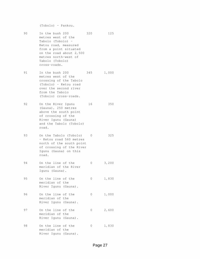
Page 27
(Tobolo) - Pankou. 90 In the bush 200 320 125 metres west of the Tabolo (Tobolo) - Ketou road, measured from a point situated on the road about 2,500 metres north-west of Tabolo (Tobolo) cross-roads. 91 In the bush 200 345 1,000 metres west of the crossing of the Tabolo (Tobolo) - Ketou road over the second river from the Tabolo (Tobolo) cross-roads. 92 On the River Igunu 16 350 (Gauna), 250 metres above the south point of crossing of the River Igunu (Gauna) and the Tabolo (Tobolo) road. 93 On the Tabolo (Tobolo) 0 325 - Ketou road 560 metres north of the south point of crossing of the River Igunu (Gauna) on this road. 94 On the line of the 0 3,200 meridian of the River Igunu (Gauna). 95 On the line of the 0 1,830 meridian of the River Igunu (Gauna). 96 On the line of the 0 1,000 meridian of the River Igunu (Gauna). 97 On the line of the 0 2,600 meridian of the River Igunu (Gauna). 98 On the line of the 0 1,830 meridian of the River Igunu (Gauna).

Page 28
99 On the line of the 0 1,100 meridian of the River Igunu (Gauna). 100 On the road 1,000 metres 0 1,480 south of Ilara (Ilou Ayra), measured along the path starting from the fetish temple in the village. 101 85 metres west of 0 940 the point of astronomical observation of Ilara (Ilou Ayra). 102 On the main path in 0 160 the north-western part in Ilara (Ilou Ayra). 102 bis To the north of Ilara 0 140 (Ilou Ayra) on the path from Kobedjo to Alagbe (Itagbe). 103 50 metres from Igbaka II, 0 170 on the path leading west. 104 200 metres west of a 0 875 point situated 200 metres south of the ruins of Alagbe (Itagbe). 105 200 metres south of 90 200 the ruins of Alagbe (Itagbe). 106 200 metres south-east 66 175 of the ruins of Alagbe (Itagbe), on the road from Ilikimo (Likimon) to Ilara (Ilou Ayra). 107 200 metres south of 37 300 the Ketou - Idofa (Idawfa) road and 200 metres east of the Ilikimo (Likimon) - Ilara (Ilou Ayra) road. 108 200 metres south of 77 1,100
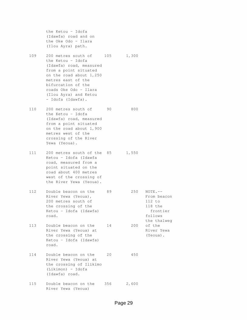
Page 29
the Ketou - Idofa (Idawfa) road and on the Oke Odo - Ilara (Ilou Ayra) path. 109 200 metres south of 105 1,300 the Ketou - Idofa (Idawfa) road, measured from a point situated on the road about 1,250 metres east of the bifurcation of the roads Oke Odo - Ilara (Ilou Ayra) and Ketou - Idofa (Idawfa). 110 200 metres south of 90 800 the Ketou - Idofa (Idawfa) road, measured from a point situated on the road about 1,900 metres west of the crossing of the River Yewa (Yeoua). 111 200 metres south of the 85 1,550 Ketou - Idofa (Idawfa road, measured from a point situated on the road about 400 metres west of the crossing of the River Yewa (Yeoua). 112 Double beacon on the 89 250 NOTE.-- River Yewa (Yeoua), From beacon 200 metres south of 112 to the crossing of the 118 the Ketou - Idofa (Idawfa) frontier road. follows the thalweg 113 Double beacon on the 14 200 of the River Yewa (Yeoua) at River Yewa the crossing of the (Yeoua). Ketou - Idofa (Idawfa) road. 114 Double beacon on the 20 450 River Yewa (Yeoua) at the crossing of Ilikimo (Likimon) - Idofa (Idawfa) road. 115 Double beacon on the 356 2,600 River Yewa (Yeoua)

Page 30
at the crossing of Iselu (Selou) - Meko road. 116 Double beacon on the 359 2,400 River Yewa (Yeoua) on the road coming south- east from Idiya. 117 Double beacon on the 323 7,300 River Yewa (Yeoua) about 2,400 metres as the crow flies, and below the crossing of the Idanyin (Idanhim) - Iwoye (Youoye) road. 118 Double beacon on the 304 2,200 River Yewa (Yeoua), 200 metres below the crossing of the Idanyim (Idanhim) - Iwoye (Youoye) road. 119 In the bush 200 29 600 metres east of the Idanyin (Idanhim) - Iwoye (Youoye) road opposite a point situated about 500 metres north of the crossing of the River Yewa (Yeoua). 120 On the Iwoye (Youoye) 23 500 - Meko road 200 metres south-east of the bifurcation of the Iwoye (Youoye) - Idanyin (Idanhim) and Iwoye (Youoye) - Meko roads. 121 200 metres north-east, 0 700 measured along a farm path which leaves the Iwoye (Youoye) - Jabata road about 250 metres north of the east entrance of the village. 122 In the bush 200 metres 340 1,400 north-east, measured from a point on the

Page 31
Iwoye (Youoye) - Jabata road about 600 metres south-east of the crossing of the River Ikomi. 123 In the bush 200 metres 310 800 north, measured along the path leaving the Iwoye (Youoye) - Jabata road 50 metres west of the crossing of the River Ikomi. 124 In the bush 200 metres 185 600 north-east of the Iwoye (Youoye) - Jabata road opposite a point situated about 800 metres west of the crossing of the River Ikomi. 125 In the bush 200 metres 355 2,000 east of the Iwoye (Youoye) - Jabata road opposite a point situated about 3,000 metres north of the crossing of the River Ikomi. 126 In the bush 200 metres 355 4,100 east of the Iwoye (Youoye) - Jabata road opposite a point situated about 3,700 metres south of the crossing of the River Adougbe. 127 In the bush 200 metres 357 3.700 east of the crossing of the Iwoye (Youoye) - Jabata road over the River Adougbe. 128 In the bush 200 metres 13 2,500 east of the Iwoye (Youoye) - Jabata road opposite a point situated about 2,300 metres north of the crossing of the
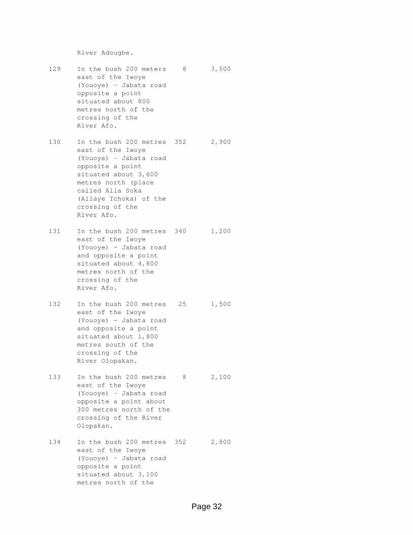
Page 32
River Adougbe. 129 In the bush 200 meters 8 3,500 east of the Iwoye (Youoye) - Jabata road opposite a point situated about 800 metres north of the crossing of the River Afo. 130 In the bush 200 metres 352 2,900 east of the Iwoye (Youoye) - Jabata road opposite a point situated about 3,600 metres north (place called Alla Soka (Allaye Tchoka) of the crossing of the River Afo. 131 In the bush 200 metres 340 1,200 east of the Iwoye (Youoye) - Jabata road and opposite a point situated about 4,800 metres north of the crossing of the River Afo. 132 In the bush 200 metres 25 1,500 east of the Iwoye (Youoye) - Jabata road and opposite a point situated about 1,800 metres south of the crossing of the River Olopakan. 133 In the bush 200 metres 8 2,100 east of the Iwoye (Youoye) - Jabata road opposite a point about 300 metres north of the crossing of the River Olopakan. 134 In the bush 200 metres 352 2,800 east of the Iwoye (Youoye) - Jabata road opposite a point situated about 3,100 metres north of the

Page 33
crossing of the River Olopakan. 135 In the bush 200 metres 10 1,400 north-east of the bend in the Iwoye (Youoye) - Jabata road opposite a point situated about 550 metres east of the crossing of the Onitie River. 136 In the bush 200 metres 283 900 north of the Iwoye (Youoye) - Jabata road opposite a point situated about 200 metres west of the crossing of the Onitie River. 137 In the bush 200 metres 283 1,150 north-east of the Iwoye (Youoye) - Jabata road opposite a point situated about 1,600 metres west of the crossing of the River Onitie. 138 In the bush 200 metres 348 3,700 east of the Iwoye (Youoye) - Jabata road opposite a point situated about 2,000 metres north of the crossing of the River Onikpako. 139 In the bush 200 metres 312 1,800 east of the crossing of the Iwoye (Youoye) - Jabata road over the River Okpe-Soukou. 140 In the bush 200 metres 337 2,400 north-east of the Iwoye (Youoye) - Jabata road opposite a point situated 2,250 metres north-west of the crossing of the road over the River Okpe-Soukou.
Page 34
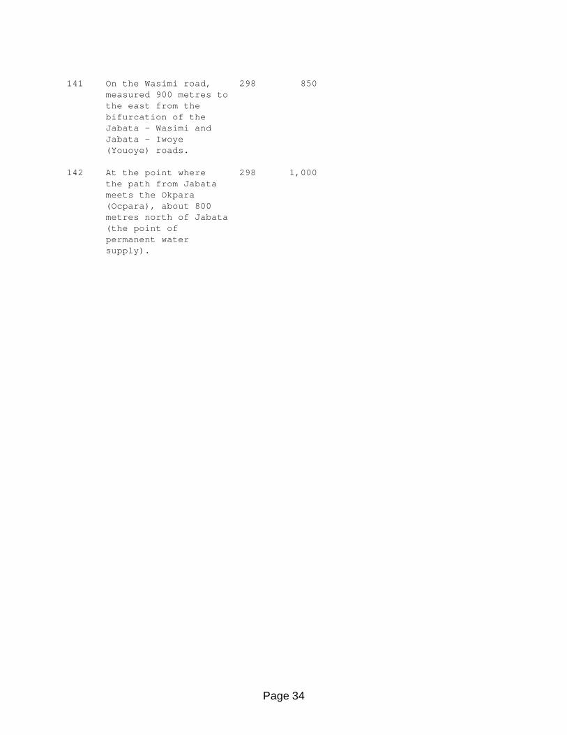
141 On the Wasimi road, 298 850 measured 900 metres to the east from the bifurcation of the Jabata - Wasimi and Jabata - Iwoye (Youoye) roads. 142 At the point where 298 1,000 the path from Jabata meets the Okpara (Ocpara), about 800 metres north of Jabata (the point of permanent water supply).

Page 35
This International Boundary Study is one of a series of specific boundary papers prepared by the Geographer, Office of Strategic and Functional Research, Bureau of Intelligence and Research, Department of State, in accordance with provisions of Bureau of the Budget Circular No. A-16. Government agencies may obtain additional information and copies of the study by calling the Geographer, Room 8744, Department of State, Washington, D.C. 20520 (Telephone 632-2022).


