Page 1
Mission Operations Working Group
1
International Earth Observing Constellation
Mission Operations Working GroupJune 2-5, 2015
Active Constellation Neighbor AnalysisMegan Johnson, Brian McCarthy & David A. Tracewell
EOS FDS, [email protected] , +1.301.416.5050
https://ntrs.nasa.gov/search.jsp?R=20150011484 2018-05-26T00:11:24+00:00Z
Page 2
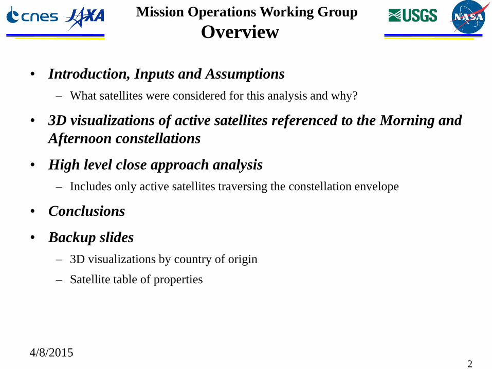
Mission Operations Working Group
Overview
• Introduction, Inputs and Assumptions
– What satellites were considered for this analysis and why?
• 3D visualizations of active satellites referenced to the Morning and
Afternoon constellations
• High level close approach analysis
– Includes only active satellites traversing the constellation envelope
• Conclusions
• Backup slides
– 3D visualizations by country of origin
– Satellite table of properties
4/8/20152
Page 3
Mission Operations Working Group
Goal
Increase constellation situational
awareness and safety by analyzing
nearby active satellites
4/8/20153
Page 4
Mission Operations Working Group
What Satellites Were Considered and Why
• Filtering objects near the constellation
– Used CARA MOWG Spring 2014 presentation of 705 km and 692 km neighbors
and results from “Aerospace Corporation Debris Risk Study” large object
analysis
– CARA analysis considered satellites within +/- 25 km of the constellation’s
nominal apogee and perigee
• How can you determine a satellite’s status?
– Use the internet to research the current status
• It is not always straightforward to determine whether a satellite is still active
• For this analysis, any satellite reported to be operational within the last two years was
considered active
– Propulsion/maneuverability was determined or inferred, if possible, but results
not used in analysis
• Why only active satellites
– These are missions where it may be possible to contact an operator to coordinate
during a close approach
4/8/20154
Page 5
Mission Operations Working Group
Inputs and Assumptions
• Based on the criteria shown on the previous slide, 54 foreign
satellite neighbors were identified
– 58 satellites were identified through research; however, four did not have TLEs
available needed to complete this analysis
• Accessed satellite files from www.space-track.org
– Used NORAD TLE files from Mar 24 2015
• Aqua & Terra states taken from definitive ephemeris
– Aqua and Terra were used as proxies for the Afternoon and Morning
Constellations, respectively.
• Orbit parameter data in the back-up slides is from space-trak.org
• This data is informational only; no visualizations or orbit property
data provided in this presentation should be used for conjunction
analysis
4/8/20155
Page 6
Mission Operations Working Group
0
200
400
600
800
1000
1200
1400
0 200 400 600 800 1000
Ap
oge
e (
km)
Perigee (km)
Apogee vs Perigee for Neighboring Satellites
Neighboring Satellites Apogee vs Perigee
Constellation Perigee
Constellation Apogee
Neighboring Satellite Overview
4/8/20156
Elliptical orbit
traversing constellation
The majority of
active
constellation
neighbors have
apogee and
perigee values
similar to the
morning and
afternoon
constellation.
Many fly in
similar sun-
synchronous
orbits.
Page 7
Mission Operations Working Group
Chinese Satellite Orbits
7
SJ-11-07
SJ-11-03
SJ-11-01
SJ-11-02
SJ-11-05
Chuangxin-3
PM Constellation
AM ConstellationSJ-11-06
BEIJING 1
SJ-11-08
4/8/2015
Page 8
Mission Operations Working Group
US Satellite Orbits
4/8/201588
DICE
Orbcomm fm 103
GEOEYE 1
CINEMA 3IKONOS 2
PM Constellation
AM Constellation
Orbcomm fm 104
IRIDIUM 14
E1P-2/HRBE
C/NOFS
Orbcomm fm 109
Page 9
Mission Operations Working Group
CLOSE APPROACH ANALYSIS
4/8/20159
Page 10
Mission Operations Working Group
Background
• 27 foreign satellites were identified as active and potentially maneuverable
– All 54 satellites identified are actively monitored by the CARA team
• Historical data for each of these satellites was collected for high level
assessment of close approaches to the morning and afternoon
constellations
• Aqua and Terra data were used as representative cases for the morning
and afternoon constellations, respectively
– Analysis of each satellite versus each constellation member not manageable
– conclusions drawn from Aqua/Terra are reasonable to infer for rest of constellation
members
• Three month period of historical data was used
– All available NORAD TLE’s were collected between Jan 01 2014 – Mar 30 2015
• Maneuvers of satellite could not be determined accurately due to TLE noise
– The set of TLE’s were used to create ephemerides for each satellite
4/8/201510
Page 11
Mission Operations Working Group
Analysis Methodology
• For each satellite:
– Calculate the mean SMA using the historical data
– Determine the +/- 3-sigma SMA (high/low SMA)
– Use the mean, high, and low values of the SMA and the 3 sigma max
eccentricity to categorize each satellite as completely inside, completely outside,
or traversing the constellation envelope
– Use constellation envelope equation as described in the 2014 Constellation
Operations Coordination Plan, details provided in back-up slides
– Synodic period of each secondary with Aqua and Terra were examined for
potentially traversing satellites
• High Level Results
– Satellites completely inside envelope = 0
– Satellites completely outside of envelope = 7
– Satellites traversing envelope = 20
4/8/201511
Page 12
Mission Operations Working Group
Results
• The table below is a list of the 20 traversing foreign satellites that are active and
their synodic period with Aqua and Terra.
4/8/201512
Foreign Sat ID Aqua Synodic Period Terra Synodic Period
36508 (CRYOSAT-2) 22 days 22 days
39030 (GOKTURK 2) 13 days 14 days
29479 (HINODE) 16 days 16 days
25777 (IRIDIUM 14) 50 days 40 days
35935 (ITUPSAT 1) 35 days 35 days
26268 (KOMPSAT 2) 20 days 20 days
38338 (KOMPSAT 3) 25 days 25 days
37789 (NIGERIASAT 2) 23 days 23 days
37790 (NIGERIASAT X) 150 days 100 days
38012 (PLEIADES 1) 80 days 75 days
39019 (PLEIADES 1B) 80 days 75 days
36037 (PROBA 2) 25 days 25 days
39634 (SENTINEL 1A) 25 days 25 days
36088 (SJ11-01) 35 days 35 days
37765 (SJ11-02) 35 days 35 days
37730 (SJ11-03) 35 days 40 days
39202 (SJ11-05) 45 days 45 days
39624 (SJ11-06) 50 days 50 days
38755 (SPOT 6) 50 days 70 days
35932 (SWISSCUBE) 40 days 40 days
Page 13
Mission Operations Working Group
Further Analysis
• Range and radial separation were examined and used to further
narrow the group of traversing satellites
• Some satellites may be traversing the constellation envelope, but are
located below or above Aqua/Terra during the closest approaches.
• Satellites located below Aqua/Terra are considered a lower risk:
– Posigrade maneuverability of Aqua/Terra allow for conjunction avoidance
– If satellites in these orbits are no longer maneuvering or are maintaining their
orbit, they will drop below or continue to stay below Aqua/Terra during the
closest approaches
• The following slides show one of the traversing satellites which
passes BELOW Aqua/Terra, and one which passes ABOVE or
NEAR Aqua/Terra
– This is one example of the analysis which was performed for all satellites
identified as traversing the constellation envelope
4/8/201513
Page 14
Mission Operations Working Group
Aqua Range/Radial Plots from HINODE
4/8/201514
Radial separation BELOW Aqua during close approaches
14
Page 15
Mission Operations Working Group
Aqua Range/Radial Plots from PROBA 2
4/8/201515
Radial separation NEAR or ABOVE Aqua during close approaches
Page 16
Mission Operations Working Group
Conclusions
• Based on this analysis:
– None of the 27 foreign satellites orbit inside of the constellation envelope
– 7 of the 27 foreign satellites orbit outside of the constellation envelope
– 20 of the 27 foreign satellites are traversing the constellation envelope
• Of the 20 traversing, 5 are nominally below Aqua and Terra during close approach
• Further analysis is necessary to ensure that these results are applicable to the rest of
the constellation members
• 15 traversing foreign satellites of interest based on analysis, which are
listed on the next slide
• This analysis is a 3 month snapshot of historical data. Due to unknown
frequency of station keeping maneuvers and the inherent inaccuracy of
TLE’s, these results may not hold true for earlier or later periods of time.
• CARA monitors all satellites and will provide assessments of future close
approaches. The data collected in this analysis should be used for high
level situational awareness only
4/8/201516
Page 17
Mission Operations Working Group
Final List of Traversing Foreign Satellites
4/8/201517
Foreign Sat ID Aqua Synodic Period Terra Synodic Period
36508 22 days 22 days
39030 13 days 14 days
25777 50 days 40 days
35935 35 days 35 days
26268 20 days 20 days
37790 150 days 100 days
38012 80 days 75 days
39019 80 days 75 days
36037 25 days 25 days
36088 (SJ11-01) 35 days 35 days
37765 (SJ11-02) 35 days 35 days
39202 (SJ11-05) 45 days 45 days
39624 (SJ11-06) 50 days 50 days
38755 50 days 70 days
35932 40 days 40 days
**CARA monitors all satellites (including those listed in the table above) and will
provide assessments of future close approaches. The data collected in this analysis should
be used for high level situational awareness only.
Page 18
Mission Operations Working Group
Contact Information
• Questions or comments?
– [email protected]
– FOC: (301)-614-5050
4/8/2015
Page 19
Mission Operations Working Group
BACK UP SLIDES
4/8/201519
Page 20
Mission Operations Working Group
ESA Satellite Orbits
20
PROBA 2
SENTINAL 1A
PM Constellation
AM Constellation
CRYOSAT 2
4/8/2015
Page 21
Mission Operations Working Group
French Satellite Orbits
21
PLEIDES 1B
PLEIADES 1
SPOT 6
PM Constellation
AM Constellation
SPOT 7
4/8/2015
Page 22
Mission Operations Working Group
German Satellite Orbits
22
RUBIN 4/SL-8
MOZ.5/SAFIR/RUBIN 5/SL-8
BEESAT
PM Constellation
AM Constellation
UWE-2
4/8/2015
Page 23
Mission Operations Working Group
Japanese Satellite Orbits
23
CUBESAT XI-V
HINODEGOSAT (IBUKI)
PM Constellation
AM Constellation
4/8/2015
Page 24
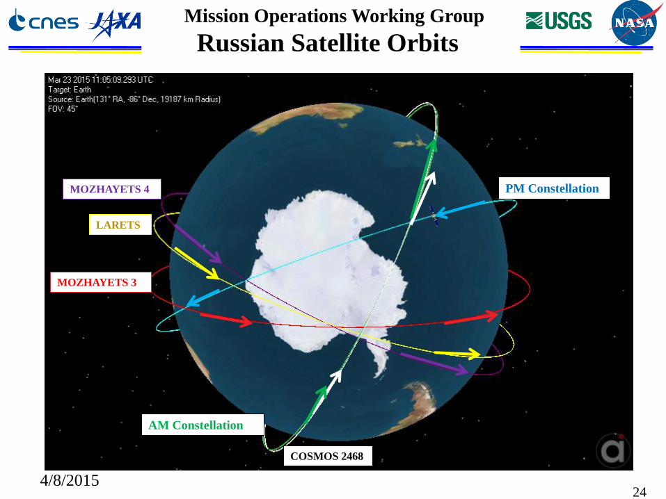
Mission Operations Working Group
Russian Satellite Orbits
24
MOZHAYETS 3
MOZHAYETS 4
COSMOS 2468
LARETS
PM Constellation
AM Constellation
4/8/2015
Page 25
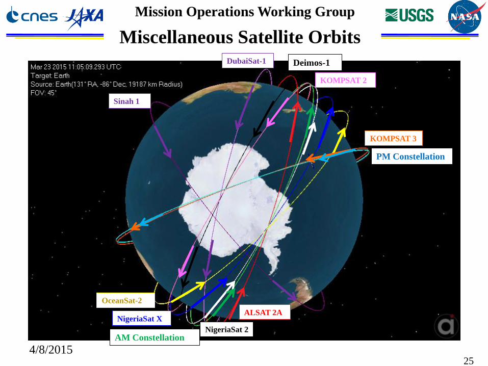
Mission Operations Working Group
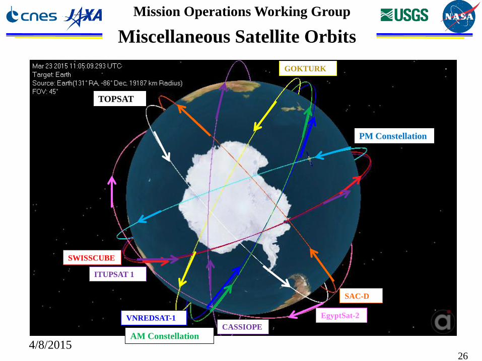
Miscellaneous Satellite Orbits
25
ALSAT 2A
Sinah 1
NigeriaSat X
NigeriaSat 2
OceanSat-2
DubaiSat-1
PM Constellation
AM Constellation
KOMPSAT 2
KOMPSAT 3
Deimos-1
4/8/2015
Page 26
Mission Operations Working Group
Miscellaneous Satellite Orbits
26
SWISSCUBE
ITUPSAT 1
VNREDSAT-1
GOKTURK
CASSIOPE
PM Constellation
AM Constellation
EgyptSat-2
SAC-D
TOPSAT
4/8/2015
Page 27
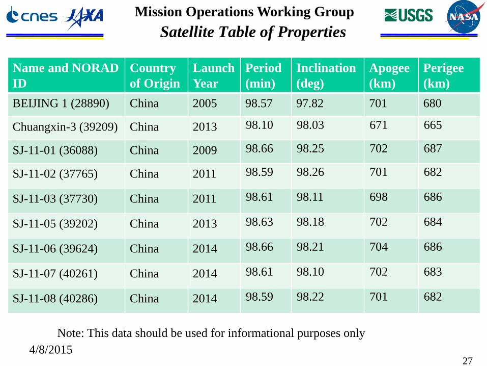
Mission Operations Working Group
Satellite Table of Properties
27
Name and NORAD
ID
Country
of Origin
Launch
Year
Period
(min)
Inclination
(deg)
Apogee
(km)
Perigee
(km)
BEIJING 1 (28890) China 2005 98.57 97.82 701 680
Chuangxin-3 (39209) China 2013 98.10 98.03 671 665
SJ-11-01 (36088) China 2009 98.66 98.25 702 687
SJ-11-02 (37765) China 2011 98.59 98.26 701 682
SJ-11-03 (37730) China 2011 98.61 98.11 698 686
SJ-11-05 (39202) China 2013 98.63 98.18 702 684
SJ-11-06 (39624) China 2014 98.66 98.21 704 686
SJ-11-07 (40261) China 2014 98.61 98.10 702 683
SJ-11-08 (40286) China 2014 98.59 98.22 701 682
Note: This data should be used for informational purposes only
4/8/2015
Page 28
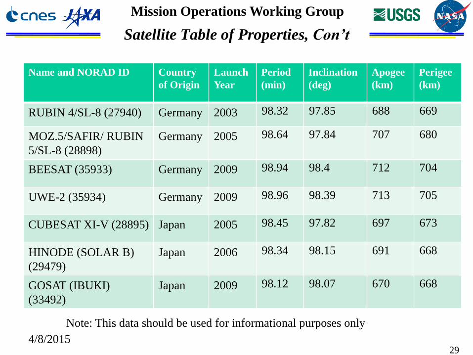
Mission Operations Working Group
Satellite Table of Properties, Con’t
28
Name and NORAD ID Country of
Origin
Launch
Year
Period
(min)
Inclination
(deg)
Apogee
(km)
Perigee
(km)
PROBA-2 (36037) ESA 2009 99.12 98.28 725 708
CRYOSAT 2 (36508) ESA 2010 99.16 92.03 723 714
SENTINEL 1A (39634) ESA 2014 98.68 98.18 697 695
PLEIADES 1 (38012) France 2011 98.73 98.2 699 697
PLEIADES 1B (39019) France 2012 98.73 98.17 699 697
SPOT 6 (38755) France 2012 98.73 98.16 699 697
SPOT 7 (40053) France 2014 98.73 98.17 699 697
Note: This data should be used for informational purposes only
4/8/2015
Page 29
Mission Operations Working Group
29
Name and NORAD ID Country
of Origin
Launch
Year
Period
(min)
Inclination
(deg)
Apogee
(km)
Perigee
(km)
RUBIN 4/SL-8 (27940) Germany 2003 98.32 97.85 688 669
MOZ.5/SAFIR/ RUBIN
5/SL-8 (28898)
Germany 2005 98.64 97.84 707 680
BEESAT (35933) Germany 2009 98.94 98.4 712 704
UWE-2 (35934) Germany 2009 98.96 98.39 713 705
CUBESAT XI-V (28895) Japan 2005 98.45 97.82 697 673
HINODE (SOLAR B)
(29479)
Japan 2006 98.34 98.15 691 668
GOSAT (IBUKI)
(33492)
Japan 2009 98.12 98.07 670 668
Satellite Table of Properties, Con’t
Note: This data should be used for informational purposes only
4/8/2015
Page 30
Mission Operations Working Group
30
Name and NORAD ID Country
of Origin
Launch
Year
Period
(min)
Inclination
(deg)
Apogee
(km)
Perigee
(km)
MOZHAYETS 3
(27560)
Russia 2002 98.83 98.09 732 673
MOZHAYETS 4
(27939)
Russia 2003 98.23 97.83 683 666
LARETS (27944) Russia 2003 98.42 97.86 691 675
COSMOS 2468 (39177) Russia 2013 99.21 98.23 732 710
IKONOS 2 (25919) USA 1999 96.9 98.09 615 606
IRIDIUM 14 (25777) USA 1999 100.4 86.4 779 776
C/NOFS (32765) USA 2008 93.19 13 509 352
GEOEYE 1 (33331) USA 2008 98.33 98.11 685 673
Satellite Table of Properties, Con’t
Note: This data should be used for informational purposes only4/8/2015
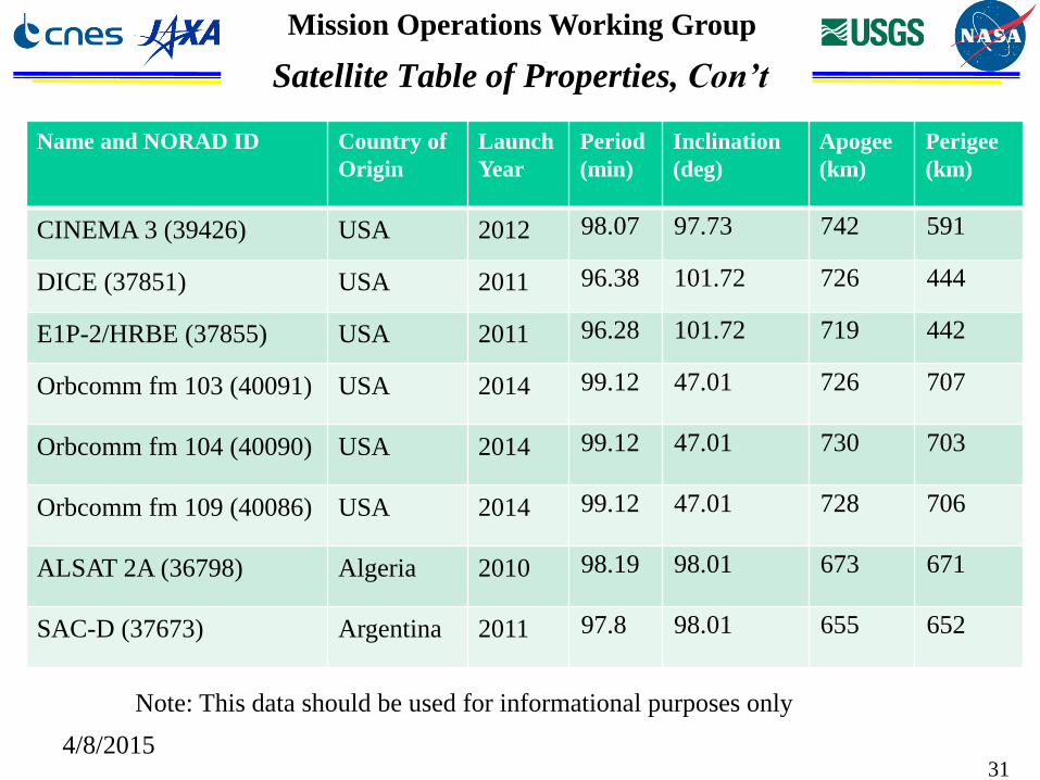
Page 31
Mission Operations Working Group
4/8/201531
Name and NORAD ID Country of
Origin
Launch
Year
Period
(min)
Inclination
(deg)
Apogee
(km)
Perigee
(km)
CINEMA 3 (39426) USA 2012 98.07 97.73 742 591
DICE (37851) USA 2011 96.38 101.72 726 444
E1P-2/HRBE (37855) USA 2011 96.28 101.72 719 442
Orbcomm fm 103 (40091) USA 2014 99.12 47.01 726 707
Orbcomm fm 104 (40090) USA 2014 99.12 47.01 730 703
Orbcomm fm 109 (40086) USA 2014 99.12 47.01 728 706
ALSAT 2A (36798) Algeria 2010 98.19 98.01 673 671
SAC-D (37673) Argentina 2011 97.8 98.01 655 652
Satellite Table of Properties, Con’t
Note: This data should be used for informational purposes only
Page 32
Mission Operations Working Group
32
Name and NORAD ID Country of
Origin
Launch
Year
Period
(min)
Inclination
(deg)
Apogee
(km)
Perigee
(km)
CASSIOPE (39265) Canada 2013 102.03 80.97 1387 322
DubaiSat-1 (35682) Dubai 2009 98.09 97.91 675 659
EgyptSat-2 (39678) Egypt 2014 99.05 51.62 714 713
SINAH 1 (28893) Iran 2005 98.56 97.82 700 679
OCEANSAT 2 (35931) India 2009 99.25 98.27 725 721
NIGERIASAT 2 (37789) Nigeria 2011 98.51 98.12 696 679
NIGERIASAT X
(37790)
Nigeria 2011 98.75 98.17 707 691
Satellite Table of Properties, Con’t
Note: This data should be used for informational purposes only
4/8/2015
Page 33
Mission Operations Working Group
4/8/201533
Name and NORAD ID Country of
Origin
Launch
Year
Period
(min)
Inclination
(deg)
Apogee
(km)
Perigee
(km)
KOMPSAT 2 (29268) S. Korea 2006 98.51 98.17 701 674
KOMPSAT 3 (38338) S. Korea 2012 98.5 98.12 695 679
SWISSCUBE (35932) Switzerland 2009 98.95 98.4 714 704
ITUPSAT 1 (35935) Turkey 2009 98.99 98.41 716 705
GOKTURK 2 (39030) Turkey 2012 98.27 98.08 686 666
TOPSAT (28891) UK 2005 98.57 97.82 702 678
Deimos-1 (35681) Spain/UK 2009 97.87 98.04 659 655
VNREDSAT 1 (39160) Vietnam 2013 98.44 98.15 685 683
Satellite Table of Properties, Con’t
Note: This data should be used for informational purposes only
Page 34
Mission Operations Working Group
Description of Constellation Envelope
• Completely inside of the constellation envelope:
|smaR – smaA| + |smaR * eR – smaA * eAMAX| < Margin + Frozen Orbit Tolerance
• Completely outside of the constellation envelope:
|smaR – smaA| - |smaR * eR – smaA * eAMAX| > Margin + Frozen Orbit Tolerance
• Traversing the constellation envelope meets neither of these
criteria
• See next slide for further details
4/8/201534
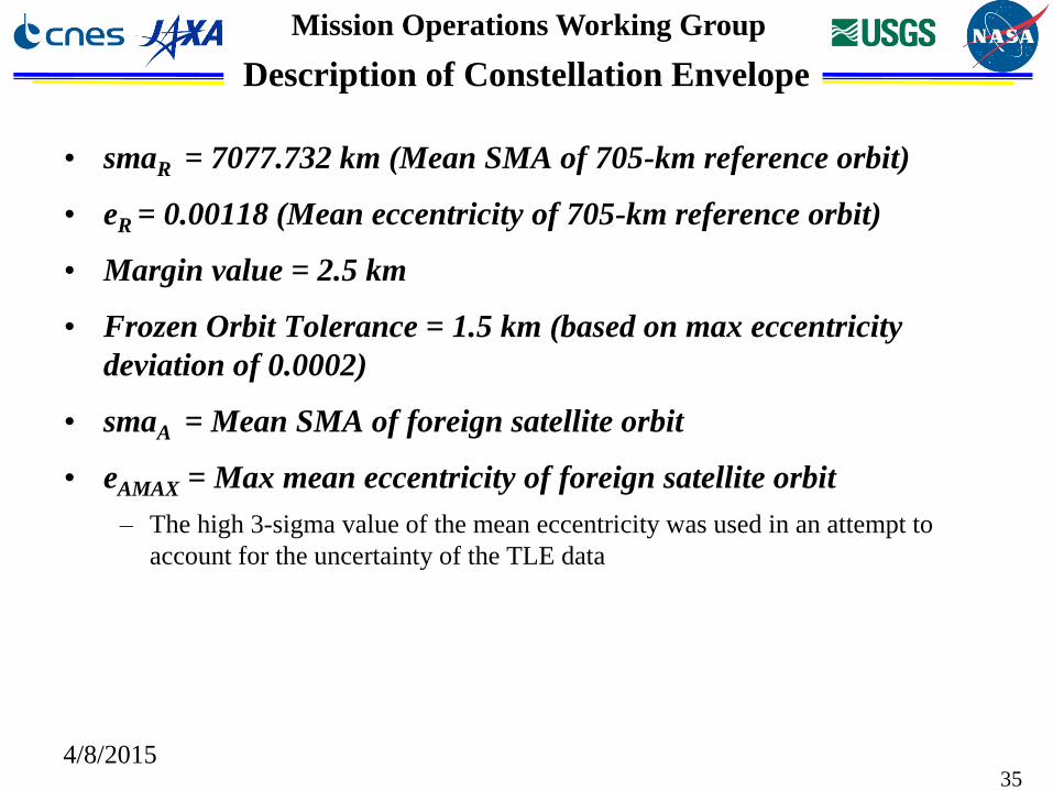
Page 35
Mission Operations Working Group
Description of Constellation Envelope
• smaR = 7077.732 km (Mean SMA of 705-km reference orbit)
• eR = 0.00118 (Mean eccentricity of 705-km reference orbit)
• Margin value = 2.5 km
• Frozen Orbit Tolerance = 1.5 km (based on max eccentricity
deviation of 0.0002)
• smaA = Mean SMA of foreign satellite orbit
• eAMAX = Max mean eccentricity of foreign satellite orbit
– The high 3-sigma value of the mean eccentricity was used in an attempt to
account for the uncertainty of the TLE data
4/8/201535
Page 36
Mission Operations Working Group
Terra Range/Radial Plots from HINODE (29479)
4/8/201536
Radial separation BELOW Terra during close approaches
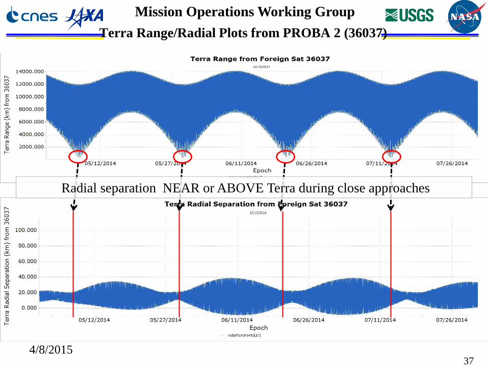
Page 37
Mission Operations Working Group
Terra Range/Radial Plots from PROBA 2 (36037)
4/8/201537
Radial separation NEAR or ABOVE Terra during close approaches