1912 1925 1938 1965 1998 2011 International Joint Commission Report to the Governments of the United States and Canada on Bi-national Water Management of the Lake of the Woods and Rainy River Watershed January 2012 ◗
Transcript
1912 1925 1938 1965 19982011
International Joint Commission
Report to the Governmentsof the United States and Canadaon Bi-national Water Management of the Lake of the Woods and Rainy River Watershed
January 2012
◗
Report to the Governments of the United States and Canada on Bi-national Water Management of the Lake of the Woods and Rainy River Watershed E95-2/14-2012E-PDF978-1-100-20063-7
1912 1925 1938 1965 19982011
International Joint Commission
Report to the Governmentsof the United States and Canadaon Bi-national Water Management of the Lake of the Woods and Rainy River Watershed
January 2012
◗
1912 1925 1938 1965 19982011
International Joint Commission
Report to the Governmentsof the United States and Canadaon Bi-national Water Management of the Lake of the Woods and Rainy River Watershed
January 2012
◗
◗ TABLE OF CONTENTS
Letter of Transmittal i
◗ Part I
Introduction 1
Current Mandates 5
Task Force Activities 5
IJC Public Hearings on Task Force Report 6
Summary of Public Comments 6
Recommendations 7
◗ Part II
International Lake of the Woods and Rainy River Watershed Board Form and Functions 13
Summary of Recommendations 21
◗ Maps and Figures
Map: Lake of the Woods and Rainy River Watershed 4
Figure 1: Board Composition – Current/Proposed 14
Figure 2: Lake of the Woods – Rainy River Watershed Board Governance Model 16
Figure 3: IJC/Board and Government Functions in Terms of Mandate 19
Figure 4: Recommendation/Mandate Timeline 20
Annex – Final Report on Bi-national Management of Lake of the Woods and Rainy River Watershed 23
Appendix – International St Croix Watershed Board Mandate 167
i
International Joint Commission Commission mixte internationale Canada and United States Canada et États-Unis
gro.cji.www 234 Laurier Avenue W., 22nd tS L 0002 6K6 P1K NO ,awattO ,roolF . NW, Suite 615, Washington, DC 20036
Ms. Lee Martinez Ms. Gitane De Silva Director, Office of Canadian Affairs Interim Director, Canada-U.S. Transboundary Division WHA/CAN Foreign Affairs and International Trade Canada United States Department of State U.S. Relations 2201 C St., NW, Room 3917 125 Sussex Dr. Washington, D.C. 20520 Ottawa, Canada K1A 0G2
Dear Ms. Martinez and Ms. De Silva,
Under Reference of June 17, 2010, the Governments of the United States and Canada requested the International Joint Commission examine and make recommendations regarding the bi-national management of the international waters of the Lake of the Woods and Rainy River system and the IJC’s potential role in this management. These recommendations were to also address potential structures and mechanisms for governance, as well as priority issues or activities to be addressed by or through such mechanism.
The Commission’s studies under this Reference were carried out with the assistance of the International Lake of the Woods and Rainy River Watershed Task Force. The Task Force Final Report was submitted to the Commission on July 15, 2011. The Commission encourages the governments to review the comprehensive Task Force Report which studies the bi-national management of the international waters of the Lake of the Woods and Rainy River system and the IJC’s potential role in this management.
Following public input on the Task Force report and Commission hearings on the reference recommendations the Commission has considered this matter. This constitutes the final report with recommendations of the Commission under the Lake of the Woods and Rainy River Watershed reference of June 17, 2010.
Dr. Charles A. Lawson Secretary, U.S. Section
Camille Mageau Secretary, Canadian Section
1
Part I ◗ Introduction
This report to the Governments of Canada and the United States is submitted pursuant to the Reference to this Commission embodied in identical letters dated June 17, 2010 and signed by the Director of U S Transboundary Affairs for Foreign Affairs and Trade Canada and the Director of the Office of Canadian Affairs of the U S Department of State, respectively The full text of the Reference is quoted below:
“The International Joint Commission (IJC) has a long and successful history of engagement in the Lake of the Woods and Rainy River system. Concern over fluctuating water levels on Lake of the Woods led governments to refer the matter to the IJC in 1912, resulting in the Lake of the Woods Convention and Protocol in 1925 and the establishment of the International Lake of the Woods Control Board. The IJC has been regulating water levels in the Rainy and Namakan lakes since 1938 and overseeing the water quality of the Rainy River since 1965.
In order to ensure the long-term ecological and economic vitality of Lake of the Woods and the Rainy River Basin, the governments of Canada and the United States are fostering transjurisdictional coordination and collaboration on science and management activities to enhance and restore water quality in the basin. A review of the bi-national management of the basin would complement these activities and will contribute to any future approach to addressing new and emerging water quality issues and water management needs.
In accordance with Article IX of the Boundary Waters Treaty and further to the reference letters from governments on November 19, 1998, concerning the International Watersheds Initiative, the governments of Canada and the United States request that the IJC examine, and make recommendations regarding, the bi-national management of the international waters of the Lake of the Woods and Rainy River system and the IJC’s potential role in this management. These recommendations should address potential structures and mechanisms for governance, as well as priority issues or activities to be addressed by or through such mechanisms.
The examination and recommendations should be in line with the IJC’s International Watersheds Initiative, the aim of which is to facilitate watershed-level solutions to transboundary environmental challenges by promoting communication, collaboration and coordination among the various stakeholders and interests using an integrated, ecosystem approach. The recommendations must, of course, respect existing treaties, orders and jurisdictional authorities already in place in this region.
The Commission is requested to produce a final report of its work in response to this reference within eighteen months from the date of this reference. The governments request the Commission to pursue its activities and examinations expeditiously, and to make periodic reports to the governments, as appropriate. Reporting should include IJC plans for engaging with the federal governments and relevant provinces, First Nations, tribes and states, as well as the wider body of stakeholders and the public.
2
The governments further request that the Commission undertakes this work as part of the International Watersheds Initiative with respect to funding any activities required, drawing upon the resources provided by the governments to the Commission for this program annually.
Based on the recommendations of the Commission and after consideration of input provided by the relevant provinces, tribes, and state, the governments may consider a follow-up reference to expand IJC’s role in addressing water quality issues in Lake of the Woods.”
On July 13, 2010, the International Joint Commission created the International Lake of the Woods and Rainy River Watershed Task Force (Task Force) to examine and report to the IJC on the matters expressed by the governments in the above reference On July 15, 2011, the Task Force issued its final report entitled “Bi-national Management of Lake of the Woods and Rainy River Watershed” (Task Force Report) to the IJC During the period of July 21, 2011 to August 31, 2011, the Commission held public hearings and received comments on the task force report The Task Force Report is submitted as an Annex to the Commission’s Reference Report.
The Task Force Report provided an excellent basis for considering governance mechanisms for the Lake of the Woods and Rainy River (LOWRR) watershed The Commission commends the Task Force for its high quality process and products The extent of agency support, collaboration and engagement that occurred during the one year period when the Task Force conducted its work, received extensive positive feedback during the Commission’s public comment period
The Commission finds and agrees with a key Task Force observation:
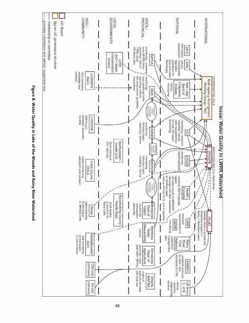
Many organizations at all levels are monitoring water quality, but there is no one entity that has the role of overall coordination and reporting for the entire watershed, and there is not presently an international governance mechanism in place to manage water quality throughout the watershed.
See Annex 1 (Task Force Report) “Observations” p. iii
To address this key observation the Commission recommends that the governments facilitate the development of a plan to help bi-nationally manage the quality of waters within the basin, and to assess the need for further reductions to point and non-point sources of pollution
To facilitate this effort the Commission recommends that governments expand the geographic scope of the IJC’s mandate to include reporting to governments on water quality in the boundary waters of the LOWRR watershed through an International Watersheds Initiative Board The Commission agrees with the Task Force recommendation that the IJC should combine the existing IJC Boards, the International Rainy River Water Pollution Board (IRRWPB) and the International Rainy Lake Board of Control (IRLBC) into a single International Watersheds Initiative Board Part II of this reference report describes the recommended form and functions of an International Lake of the Woods and Rainy River Watershed Board.
Under this expanded mandate, the Commission recommends that the two governments support the development of a LOWRR Water Quality Plan of Study (WQPOS) to identify what scientific work is needed to address the priority transboundary water issues identified within the report of the Task Force: nutrient enrichment and harmful algal blooms; aquatic invasive species; climate change indicators
3
and adaptation measure development; and sulphide and heavy metal ground and surface water contamination The Commission also recommends the two governments support the development of a Plan of Study for a water levels study on Lake of the Woods (WLPOS) A bi-national Lake of the Woods Water Levels study by the IJC under a reference from the U S and Canadian Governments would better inform regulation policy, enhance understanding of the impacts of post glacial isostatic adjustment on levels, and consider the anticipated effects of climate change on the adoption of a regulation approach
In this report the Commission addresses in detail: the new governance model for the proposed International Lake of the Woods and Rainy River Watershed Board, including the proposed form and functions of an IWI board; views on enhanced local participation in the new governance model; mechanisms for supporting cooperative studies and/or decisions to address priority issues; a summit to be convened by the IJC; and bi-national studies on transboundary water quality of Lake of the Woods and its water-level regulation
4
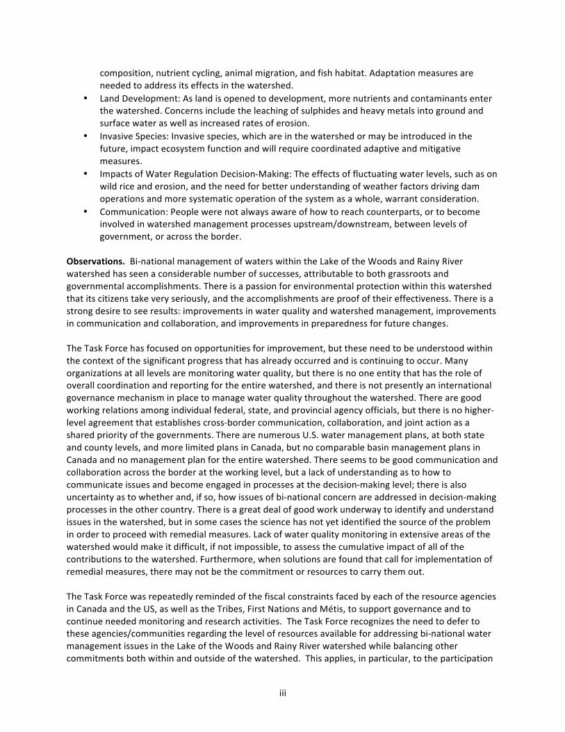
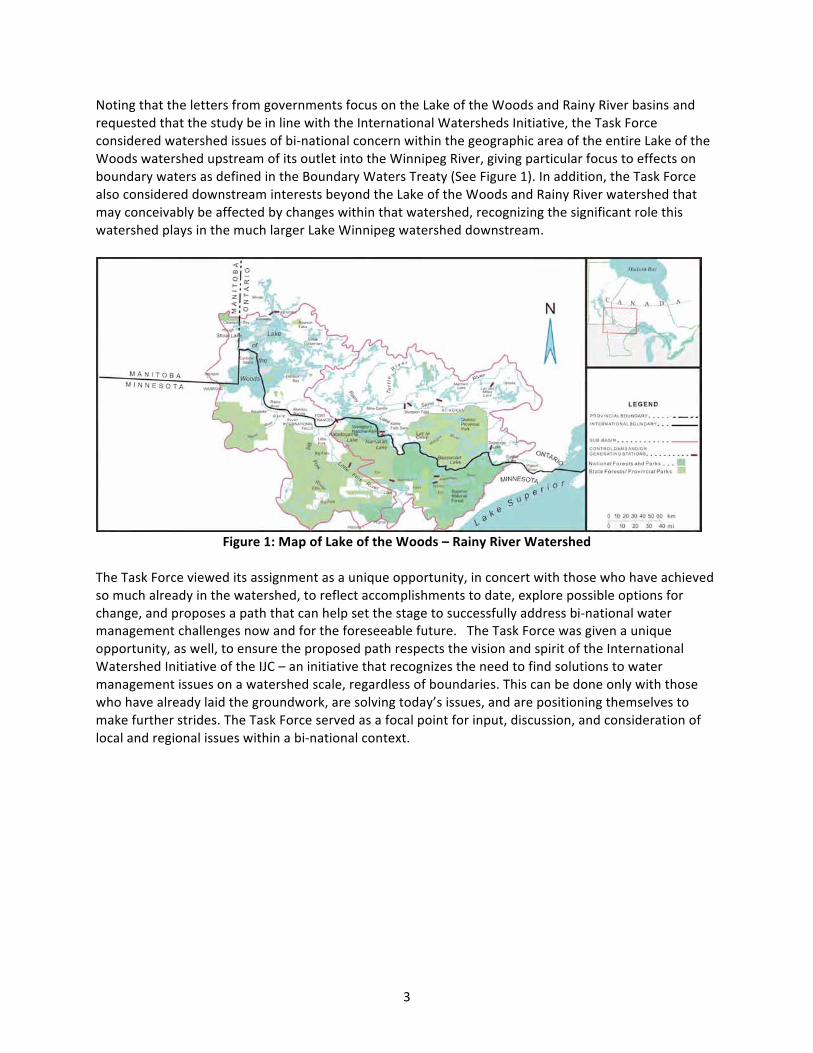
◗ Lake of the Woods and Rainy River Watershed:
The watershed is identified in the Task Force Report as located in:
“...Northwestern Ontario, Eastern Manitoba, and Northeastern Minnesota and is part of the larger Winnipeg River watershed that drains to Lake Winnipeg in Manitoba. The Watershed encompasses approximately 69,750 km2 (27,114 miles2) in Canada and the United States, of which approximately 41 percent is in Minnesota and approximately 59 percent is in Ontario and Manitoba (MPCA 2004 and DeSellas et al., 2009). The maximum distance from east to west in the Watershed is approximately 400 km (240 miles), and from north to south 260 km (156 miles).”
A more detailed explanation can be found on pages 8-9 of the Task Force report
Warroad
Baudette
Upsala
•Bigfork
ShoalLake
L a k e S u p e r i o r
Lac Seul
Lake of the Woods
Rainy Lake
EagleLake
Lower Red Lake
Upper Red Lake
Vermilion Lake
MinnitakiLake
Dinorwic Lake
Lac des Mille Lacs
MarmionLake
Lake Winnibigoshish
KakagiLake
White Otter Lake
DryberryLake
Lac la Croix
ClayLake
Atikwa Lake
Arrow Lake
ShebandowanLakes
BasswoodLake
Namakan Lake
Lower Manitou Lake
OtukamamoanLake
Northern Light Lake
PelicanLake
CrookedLake
Fall Lake
Upper Manitou Lake
SaganagaLake
Farm Lake
DogpawLake
Sand Point Lake
White Iron Lake
Ely
Kenora
Dryden
Bemidji
Hibbing
AtikokanTown ofRainy River
Grand Marais
Fort Frances
Sioux Lookout
InternationalFalls
Rain y River
Engli
sh R iver
Seine River
Tu rtle R
iver
Saint Louis
DogRiver
Winnipeg River
Wabigoon River
Red Lake River
Whitefish Ri r
Seine River
Wabigoo n R iver
Little Fork River
Big Fork River
Rapid
River
Kawishiwi River
Rat Root River
•
•
•
O n t a r i oO n t a r i o
M i n n e s o t aM i n n e s o t a
M a n i t o b aM a n i t o b a
0 25 5012.5 Mi.
0 30 60 9015 Km.
Canada
United States
Arrow River
ve
5
5
6
6
7
7
8
8
1
1
2
2
3
3
4
4
◗ SeamlessSub basin Drainages
Lake of the Woods09030009-US05PD-CANLower Rainy09030008-US05PC-CANRapid09030007-US05PCC-CANBig Fork09030006-US05PCB-CAN
Little Fork09030005-US05PCA-CANRainy Lake09030003-US05PB-CANVermilion09030002-US05PAB-CANRainy Headwaters09030001-US05PA-CAN
5
◗ Current Mandates
Water level and outflow requirements for the Lake of the Woods were agreed to by Canada and the United States in the 1925 Lake of the Woods Convention, which called for the creation of the Canadian and the International Lake of the Woods Control Boards The Canadian Lake of the Woods Control Board has responsibility for regulation of the lake under normal lake levels During high or low water events the rate of discharge of water from the lake is subject to the approval of the International Lake of the Woods Control Board The level at which the rate of total discharge of water becomes subject to the approval of the International Board may be raised with the approval of the IJC The Convention also provides for the resolution of disagreements by the IJC, and for approval of any diversion of these waters by government and the IJC
The 1938 Convention on the Emergency Regulation of the levels of Rainy Lake and other boundary waters between the U S and Canada authorized the IJC to determine when emergency high or low water conditions exist in the watershed and to adopt such measures of control as it sees fit The IJC issued Orders for regulating Rainy and Namakan Lakes beginning in 1949 These have been amended several times, most recently in 2000 The IJC appointed an International Rainy Lake Board of Control (IRLBC) to monitor the water level and outflow regulation of Namakan and Rainy Lakes Boise Inc in the United States and H2O Power LP in Canada operate dams at International Falls, Minnesota and Fort Frances, Ontario, and at the outlet of Namakan Lake, in accordance with operating rules specified by the IJC and domestic authorities
The IJC’s International Rainy River Pollution Control Board has continuing supervision over the waters of the Rainy River in relation to pollution on the basis of the Water Quality Objectives as approved by the Governments in 1965 The Board also identifies water quality problems caused by pollutants for which water
quality objectives have not been established through a process based on comparisons of monitoring data with alert levels selected by the Board as the most stringent water quality guidelines being used by local, state, provincial or federal agencies for such pollutants The recommendation to expand the geographic scope of the IJC’s mandate to establish and maintain continuing supervision over the water quality of the boundary waters of the LOWRR watershed would expand upon the mandate authorized by the governments in the 1960s
The historical context and frameworks of mandates in the watershed are discussed in greater depth in the Task Force Report on pages 17-22
◗ Task Force Activities
The mandate of the International Lake of the Woods and Rainy River Watershed Task Force was to review and make recommendations regarding the bi-national management of the Lake of the Woods and Rainy River Basin and the IJC’s potential role in this management by July 15, 2011 and identify priority basin issues The Task Force undertook significant outreach It established a self nominated Citizens Advisory Group; held fourteen public meetings; contacted federal, state, and provincial resource agencies; invited input from local governments; sought input from governmental and non-governmental organizations; met with U S Native American Tribes and Canadian First Nations, including holding a joint conference with Grand Council Treaty 3; and met with the Métis Nation of Ontario
6
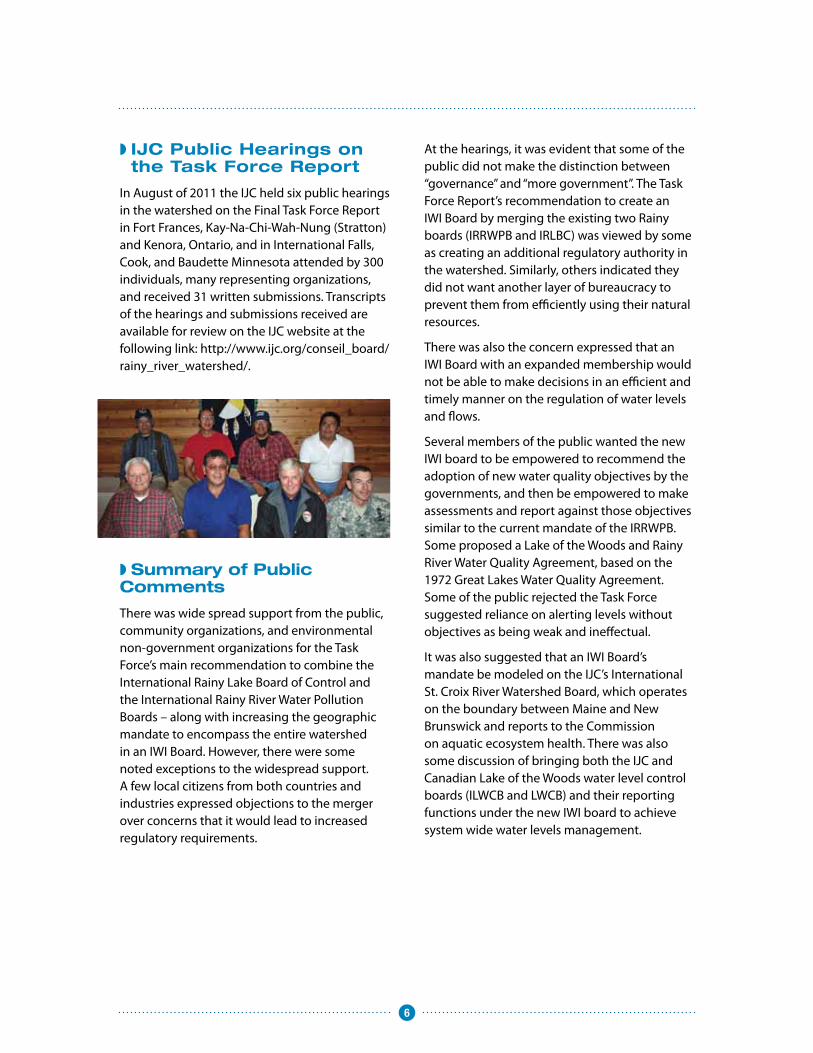
◗ IJC Public Hearings on the Task Force Report
In August of 2011 the IJC held six public hearings in the watershed on the Final Task Force Report in Fort Frances, Kay-Na-Chi-Wah-Nung (Stratton) and Kenora, Ontario, and in International Falls, Cook, and Baudette Minnesota attended by 300 individuals, many representing organizations, and received 31 written submissions Transcripts of the hearings and submissions received are available for review on the IJC website at the following link: http://www ijc org/conseil_board/rainy_river_watershed/
◗ Summary of Public Comments
There was wide spread support from the public, community organizations, and environmental non-government organizations for the Task Force’s main recommendation to combine the International Rainy Lake Board of Control and the International Rainy River Water Pollution Boards – along with increasing the geographic mandate to encompass the entire watershed in an IWI Board However, there were some noted exceptions to the widespread support A few local citizens from both countries and industries expressed objections to the merger over concerns that it would lead to increased regulatory requirements
At the hearings, it was evident that some of the public did not make the distinction between “governance” and “more government” The Task Force Report’s recommendation to create an IWI Board by merging the existing two Rainy boards (IRRWPB and IRLBC) was viewed by some as creating an additional regulatory authority in the watershed Similarly, others indicated they did not want another layer of bureaucracy to prevent them from efficiently using their natural resources
There was also the concern expressed that an IWI Board with an expanded membership would not be able to make decisions in an efficient and timely manner on the regulation of water levels and flows
Several members of the public wanted the new IWI board to be empowered to recommend the adoption of new water quality objectives by the governments, and then be empowered to make assessments and report against those objectives similar to the current mandate of the IRRWPB Some proposed a Lake of the Woods and Rainy River Water Quality Agreement, based on the 1972 Great Lakes Water Quality Agreement Some of the public rejected the Task Force suggested reliance on alerting levels without objectives as being weak and ineffectual
It was also suggested that an IWI Board’s mandate be modeled on the IJC’s International St Croix River Watershed Board, which operates on the boundary between Maine and New Brunswick and reports to the Commission on aquatic ecosystem health There was also some discussion of bringing both the IJC and Canadian Lake of the Woods water level control boards (ILWCB and LWCB) and their reporting functions under the new IWI board to achieve system wide water levels management
7
Common themes the Commission heard at its hearings and in the written submissions include:
a No unfunded mandate expansion If the mandate of the Board or Boards is expanded, then the human and financial resources needed to carry out the expanded mandate must be provided by the governments
b Local control, participation and collaboration on the new combined Board – for Tribes, First Nations, Métis and the public
c Simplify the existing governance structure to make it more efficient and effective, and it should build on current arrangements Many support the Task Force Report emphasizing facilitating bi-national collaboration of on-going efforts, such as the International
Multi-agency Work Group (IMA) However, there was also strong support for the IMA being part of the IWI Board structure, rather than a parallel and separate entity
d The differing treatment of Sturgeon In Ontario sturgeon is a recognized as a species at risk and cannot be fished in watershed The dam operators currently cooperate to minimize the effects of their operations on sturgeon during the spawning season, yet Minnesota allows the Sturgeon to be fished in limited numbers
Lead Commissioners and IJC staff met with the two dam operators to conduct further fact finding and better understand their concerns about a merged board or new IWI board in detail, before preparing this report
8
◗ Recommendations
1. An International Watershed Board with an Expanded Geographic Water Quality Mandate
The Task Force Report recommended the IJC combine its two existing boards into a single, integrated IWI Board After hearing from the public, the Commission finds that an expansion of mandate to include reporting water quality in the watershed is needed Simply merging the two boards, into one, without an expansion of mandate does not create an IWI Board that reflects the vision provided by the community, nor does it attain the principles of the IWI Local participation and assisting existing local entities to collaborate and communicate across the boundary for a common purpose of action – preventing and solving problems locally is integral to the IWI concept Two common and related themes that both the Task Force and the Commission heard were the need for more local participation in the Board’s activities and the need to expand the Board’s mandate It is anticipated that such an IWI Board would require additional ongoing support from governments in the range of approximately 2 7 Person Years of effort and $56K of additional funding per year
Recommendation 1: The Commission recommends that governments expand the geographic scope of the IJC’s water quality authority to the boundary waters of the Lake of the Woods and Rainy River watershed. The IJC proposes to combine the functions and responsibilities of the existing International Rainy River Water Pollution Board and the International Rainy Lake Board of Control in an International Lake of the Woods and Rainy River Watershed Board (ILWRRWB) that would include increased local membership and an expanded geographic mandate for water quality reporting. The proposed IWI Board’s form and function is described in Part II of this report, International Lake of the Woods and Rainy River Watershed Board -Form and Functions.
2. Development of a Water Quality Plan of Study for the Lake of the Woods Basin – Water Quality Alerts, and Objectives
The Task Force identified the following areas for watershed governance action: nutrient enrichment and harmful algal blooms; aquatic invasive species; climate change indicators and adaptation measure development; and sulphide and heavy metal ground and surface water contamination Further science would need to be conducted for an IWI Board to report to the Commission so that it, in turn, could report to governments on these issues As the Commission heard from the public, should the mandate of the new Board be expanded, the financial and human resources needed to undertake an expanded mandate to be provided by the governments
A Water Quality Plan of Study (WQPOS) would identify needed scientific research to understand the underlying causes of current concerns and establish what remedial actions might be most appropriate The intent would also be to assess the costs of any actions and the role of governments and the public in this regard Developing the WQPOS would include an analysis of what work is being done in these areas, its timing, as well as what work is needed The Commission sees an important link between the IWI Board and the IMA’s efforts and work plan The funding for preparing the WQPOS would come from the IJC’s IWI funding Once completed, it would be provided to the Governments for their consideration for funding recommended actions
Recommendation 2: The Commission recommends that the governments authorize the development of a Water Quality Plan of Study (WQPOS) for the Lake of the Woods Basin for those priority issues identified by the Task Force for watershed governance action.
9
3. Lake of the Woods Water Levels Study
As the Task Force Report noted, the Lake of the Woods has been regulated by the dams at Kenora since 1888 A binational study through a reference to the IJC was undertaken to better understand the effects and impacts of the regulation of water levels studied in the early 1900s leading to the establishment of the 1925 Lake of the Woods Convention and Protocol between Canada and the United States Article 3 of this Convention calls upon the Government of Canada to establish and maintain a Canadian Lake of the Wood Control Board, to regulate and control the outflow of waters from Lake of the Woods The Convention also calls for the two countries to create the International Lake of the Woods Control Board granting it authority to approve the rate of total discharge of water from lake of the Woods whenever its levels rise above elevation 1061 feet (323 47 m) sea-level datum or falls below 1056 feet (321 87 m) Since then, the Task Force has noted the development of other interests, the increasing effects of post-glacial isostatic adjustment, and climatic change suggesting the range of water levels in the Lake of the Woods Convention that governs water levels on Lake of the Woods may require revision to better reflect changing physical and social conditions and views Some members of the public expressed concerns that a water levels study would divert attention and funding from water quality efforts in Lake of the Woods The Canadian LWCB questioned the purpose, cost and desirability of this recommendation However, comments by some members of First Nations were supportive of a water-level study, mainly to assist in resolving their concerns of the impacts of regulation on wild rice production, health of the fisheries, and flooding of First Nations lands Treaty 3’s submission directly called for an examination of water levels, not just on Lake of the Woods, but Rainy Lake, Namakan Lake and Lac Seul as well
The Commission knows from its work in other basins that there is a strong connection between water quality, aquatic ecosystem health, and regulation of water levels A bi-national Lake of the Woods Water Levels study by the IJC under a reference from the U S and Canadian Governments would better inform regulation policy, enhance understanding of the impacts of post glacial isostatic adjustment on levels, and consider the anticipated effects of climate change on the adoption of a regulation approach
In terms of effectiveness and to avoid duplication, this study should start after the water quality study is underway, so that the findings from one study can inform the other Both studies should incorporate conventional science and traditional knowledge, as well as having input from Canadian First Nations, Métis, and Native Americans in the framing of the questions to be answered The water level study would have a suitable time frame to review the effects of Lake of the Woods water-level regulation on all affected interests, including riparian interests, shoreline erosion, water quality and fisheries, wild rice cultivation and navigation The extent of the study would include Shoal Lake, and it would also consider how the regulation of Lac Seul affects that of Lake of the Woods and downstream interest in the Winnipeg River system
Downstream effects of the regulation of Lake of the Woods are considered by the existing Lake of the Woods Boards, due to their known impacts As well, the study should also consider regulation issues outside of the Commission’s current jurisdiction on Rainy and Namakan Lakes, which is currently limited by the 1938 Rainy Lake Convention between Canada and the United States as when emergency conditions exist An example of the types of issues the levels study could address upstream is the Task Force Recommendation 5 4 that “The IJC make provision for a review of the impact of water
10
level regulation on wild rice as part of that [the IJC’s] 2015 rule curve review” Numerical hydro-climatic models and reservoir operation models would likely be applied to the watersheds in the process of answering the questions Should the governments agree with the development of a Water Levels Plan of Study (WLPOS), the Commission would undertake this through its IWI funds
The outcome of this study would help the Commission determine the linkages and possible efficiencies between the LWCB the ILWCB and the new IWI Board, and could lead to a recommendation for further amalgamations or structural changes in the future
Following the completion of the WQPOS, the POS for the Lake of the Woods water levels would be conducted (as per the time line in figure 4 in Part II) Both Plans of Study would be developed working collaboratively with the IMA and others in the basin conducting or planning on conducting research in these areas
To complement, collaborate and avoid duplicating efforts, the Commission would appoint a locally based Project Manager to lead the development of the two plans of study for water quality and the other priority issues identified by the Task Force, as well as water levels
Recomendation 3: The Commission recommends that the governments provide it with a reference to study the regulation of Lake of the Woods water levels and to provide governments with recommendations on any changes to the current regulatory approaches. Furthermore, the Commission recommends that a Lake of the Woods Water Levels Study include the aspects of its 2016 Rainy and Namakan Lakes Rule Curve Review, so the findings and results of both can be considered in establishing the water level regulation of the system.
4. A Summit on the Future of the Lake of the Woods – Rainy River Watershed
The Task Force Report recommended the IJC organize a Summit on the Future of the Lake of the Woods – Rainy River Watershed to bring together the general public, industries, businesses, US Native Americans, Canadian First Nations and Métis, US and Canadian scientists, resource managers, elected officials and other senior government officials with responsibilities for the watershed to talk about a common vision, having shared goals, objectives and implementation strategies A mid-2015 date for the Summit is recommended so that the IMA-WG, the new IWI Board and others can provide key findings and proposals for follow-up work needed (science as well as mitigation efforts) The Summit could serve as a mechanism to set in motion bi-national watershed management arrangements and subsequently coordinated actions that will last well into the future The public expressed a fair degree of support for the idea of a Summit, although there is skepticism of it being successful without high level political support from the governments The outcome of a Summit should include a common vision and objectives along with agreement on how to proceed in the future, perhaps through a reference from the U S and Canadian governments to the IJC, or a bi-national memorandum of understanding (in the nature of the Lake Champlain agreement) Each country may also consider actions such as the introduction of an Act (similar to the Lake Simcoe Protection Act in Ontario), or the inclusion of federal-provincial commitments as an addendum to the next Canada-Ontario Agreement, for example
Recommendation 4: The Commission recommends that the governments support and participate in a Summit on the Future of the Lake of the Woods – Rainy River Watershed.
Leadership support from the governments is critical for the success of the summit Should governments agree with this recommendation, the IJC would immediately establish a steering
11
committee, having representation from the new IWI Board, the IMA-WG and other appropriate partners to serve as a timely mechanism to complete the science and other needed actions to hold a successful summit as part of the WQPOS, as outlined above Invitations to participate in the steering committee will be extended to the leadership of agencies; political leaders; First Nations; Tribes and Métis as well as other community and stakeholder leadership One possible outcome of the Summit is the governments signing an aquatic ecosystem health agreement on the Lake of the Woods enhancing bi-national collaboration and reporting
5. Facilitating the Development of a Bi-national Watershed Management Plan
Some of the submissions to the Commission on the Task Force Report called for “a stewardship planning structure” or the “development of a watershed management plan” and others enumerated the elements of such a plan without calling it such The Commission notes that the Task Force report discusses the concept of a watershed management plan (page 36 of Annex 1 Task Force Report) and finds there are compelling arguments for its development
Recommendation 5: The Commission recommends that the governments support the development of a Bi-national Comprehensive Basin Water Management Plan to help bi-nationally manage waters within the basin and to improve further reductions to point and non-point sources of pollution and meet basin water needs. The IWI Board’s mandate would include the facilitation of the plan along with governmental agencies in both countries.
The Bi-national Comprehensive Basin Water Management Plan could be formalized by the two governments, or other levels of local, state and provincial governments, through an agreement mechanism that implements a bi-national long-term monitoring program It is desired that all interests, and Parties to the agreement work together to implement appropriate actions and strategies that improve water quality, water flows and lake levels in the watershed An agreement could be signed at the Summit recommended by the Task Force The binational comprehensive basin water management is discussed further in Part II, International Lake of the Woods and Rainy River Watershed - Form and Functions
12
6. Designation of Positions to Act Ex-Officio to the International Lake of the Woods Control Board
Currently appointments to the ILWCB rest with the governments, and there have been considerable delays in filling vacancies on the Board The Commission believes if the governments were to designate a position to act as ex-officio unless otherwise specified this would streamline the appointment process. For example, the U.S. Army Corps of Engineers District Engineer for the St. Paul, Minnesota District could be designated to act Ex-Officio in the position as U.S. Chair for the ILWCB.
Recommendation 6: The Commission recommends that the governments streamline and clarify the appointment process to the International Lake of the Woods Control Board and consider designating positions to act ex-officio unless otherwise specified.
7. Grand Council for Treaty 3 submission:
Grand Council for Treaty 3, in its submission to the IJC alleges, with considerable documentation, that:
“Thus, the 1917 report produced by the IJC, which laid the foundation for water level regulation on Lake of the Woods, was prepared with no understanding of the profound, negative impacts on the raised water levels on Anishinaabe reserves, fishing practices, wild rice harvesting and, more generally, way of life. The IJCs lack of knowledge was due to Canada’s disregard for Aboriginal concerns and its deliberate suppression of information.”
The Commission considers this to be a serious matter, and believes that, while Treaty 3 may have legal recourse through the courts or in negotiation with the Government of Canada,
it is beyond the Commission’s mandate to pronounce an opinion on the allegations
Recommendation 7: The Commission endorses the Task Force recommendation 4 1 (page 71 of Annex 1) that:
The Task Force recommends that the government partner with First Nations, Tribes and Métis people in watershed governance. The Canadian Government continues its efforts to resolve land and flooding claims by First Nations (as lack of resolution continues to be an impediment to integrated governance in the basin).
However, the Commission believes the levels study on Lake of Woods that it is recommending would be able to assess the ability to appropriately address some of the underlying concerns that Treaty 3 has enumerated, that being the effect of water regulation on “Anishinaabe reserves, fishing practices, wild rice harvesting” on the Lake of the Woods – Rainy River watershed
Furthermore by recommending the inclusion of a member nominated by Treaty 3 on a new IWI Board, the Commission believes that is also addressing the Grand Council’s other fundamental request that seeks “some form of decision-making authority on ... any amalgamated Watershed Board”. The Commission also notes that the current International Rainy Lake Board of Control has sought a nomination from Treaty 3 Grand Council to fill the current vacancy for a Canadian community member
Should the governments approve the creation of the IWI Board the Canadian Section of the IJC will consider the possibility of entering into an arrangement with First Nations and Métis to clearly delineate the roles and responsibilities of these board members
13
Part II ◗ The International Lake of the Woods and Rainy
River Watershed Board – Form and Functions
◗ Overarching Guiding Principles:
A Board Form – Balanced board size based on effectiveness and efficiency
B Board Function – the new IWI Board Directive would be similar to that of the IJC’s St Croix Watershed Board Directive (Appendix) whereby the board is directed to monitor and report on aquatic ecosystem health, including water quality and, through the Commission, report to governments on how well existing government actions are working for improving ecosystem health and where new government actions are needed
C New priority issues as part of the new mandate of tracking and reporting on aquatic ecosystem health in the Boundary Waters of the Lake of the Woods and Rainy River Basin include: water quality, alien
aquatic invasive species, climate change indicators and adaptation, and ground and surface water contamination
D Facilitate development of a Bi-national Comprehensive Basin Water Management Plan and report to governments on it through IJC
E Close collaboration with the International Multi-Agency Working Group (IMA-WG) on Lake of the Woods and other research groups conducting sound science on priority issues within the watershed In some cases there is common membership between the existing IJC Rainy Boards and the IMA-WG It is anticipated that specific board members would be designated by the Board to attend IMA-WG meetings and IMA-WG members would be invited to attend board meetings on topics of mutual interest
14
◗ Board Form – Balance board size with effectiveness and efficiency
Figure 1 illustrates and compares the membership of the current two IJC Rainy River Boards, with the proposed 18 member IWI Board
Membership to the Board would be by appointment by the IJC
The new IWI Watershed Board membership would include:
• All existing members of the two existing Rainy Boards combined (including the Canadian Section alternate to the International Rainy River Pollution Board and the two local members totalling nine) as well as an additional U S Federal and State representative
◗ Figure 1. Board Composition – Current/Proposed
❱ Current
Pollution Board (4 members and 1 alternate member)
Environment Canada (Water Quality)Ministry of Natural Resources MNR (Ontario)Ministry of the Environment OME Alternate (Ontario)
US Geological SurveyMinnesota Pollution Control Agency
US Geological Survey Minnesota Pollution Control AgencyUS Army Corps of EngineersUS Community Member-UpstreamUS Community Member - DownstreamUS Chair of Citizen’s Advisory GroupNative American TribeUS Federal Agency Minnesota State Agency
US Board AssociatesUS Engineering AdvisorUS Secretary
US Army Corps of EngineersUS Community Member
Control Board (4 members)
One Common Secretary for both Boards and one Canadian Engineering Advisor and One US Engineering Advisor
Environment Canada (Water Quantity)Canadian Community Member
❱ Proposed
IWI Board for LOW/RR (18 members)
Environment Canada (Water Quality)Ontario Ministry of Environment Environment Canada (Water Quantity)Ontario Ministry of Natural ResourcesCND Community Member – UpstreamCND community Member DownstreamCND Chair Citizen’s Advisory GroupFirst NationMétis
Canadian Board AssociatesCND Engineering AdvisorCND Secretary
15
• Maintain the existing role of the two engineering advisors
• One additional secretary (The two Boards currently have one secretary)
• Three aboriginal members – two located within Canada (a First Nations person and a Métis) with the other from the U S Tribes, all with a fixed three year term – who would be nominated by the recognized First Nations/Métis/Tribal leadership
• Two additional local members from each country (one upstream and one downstream from each country) for a total of six The existing control board already has one local community member from each country These members would be drawn from the Citizens Advisory Group (CAG)
• The board would be balanced between nine members from government and nine from the community
◗ Citizens Advisory Group (CAG)
The Board would have a Citizens Advisory Group (CAG) All six local Board members should have dual membership with the CAG, and the CAG Co-chair position would rotate on a three year basis, at the direction of the Board The Board would appoint members to the CAG and designate its Co-chairs The Board would designate the number of members to have on its CAG This is a similar approach as taken by the Task Force that worked well The six local members with dual membership on the CAG and the Board would be selected to reflect upstream, downstream and/or non-government organizations CAG members would be appointed to the new IWI Board with a fixed three year term The purpose of this group is to keep the Board aware of any water resource management issues that may arise in the basin and provide feedback and input to the Board products and processes, such as the Board’s work plan
16
◗ Industry Advisory Group (IAG)
The Board would also have an Industry Advisory Group (IAG) that would be appointed by the Board It could be comprised of representatives from the two paper companies, the hydroelectric power company, agriculture, forestry, fisheries, mining, recreation and tourism industries and others if interested To be considered for appointment, such groups or individuals would approach the Board requesting they be considered by the Board for appointment The purpose of this group would be to make the Board aware of industries’ perspective
The IAG and CAG would meet with the Board at the same time
Board Directive The Commission would establish a Board Directive to mandate the above items The Board Directive would reference the Citizen Advisory Group and the Industry Advisory Group
Figure 2 illustrates the proposed governance model for the basin, showing the relationship between the new IWI Board and other existing entities
IJC’s IWIBoard
◗ Figure 2. Lake ofthe Woods - Rainy River Watershed Board Governance Model
Citizen's Advisory Group (CAG)Members self-nominated, appointed
by IWI Board Board determinesnumber of members
3 CND / 3 US members includingChairs, on IWI Board
+ Canadian only Committee * Government of Canada member to be the same for all three
Industry Advisory Group (lAG)Members / Chairs not on IWI Board,
Members self -nominated,appointed by IWI Board
Possible Board Committees• Excess Nutrient & Algae Bloom• Alien Invasive Species• Climate Change impacts• Etc.
Multi-Agency Working Group on Lake of the Woods (IMA- WG) • Communication• Cross membership with IWI Board
MOU on Expanded Geographic Water Quality Mandate BetweenGovernments Involving: • Prov/Fed • State/Fed • Local
Water LevelsControl Committee of
IWI Board*(Former IRLBCmembership)
IJC’s InternationalLake of the Woods
Control Board*
+Lake of the WoodsControl Board*
17
◗ Board Function:
The existing mandates of the two existing Rainy Boards would be combined and its geographic scope broadened to include Boundary Waters in the Lake of the Woods and Rainy River Watershed It is proposed to the governments that the new mandate to the Boards would include reporting on aquatic ecosystem health over the broadened geographic scope The IWI Board would have the following functions:
1. Continue Current Water Level Regulation Mandate in Rainy and Namakan Lakes: Water regulation under an IWI Board would be delegated to a Rainy and Namakan Lake Water Levels Control Committee of the Board that would have exactly the same composition as the current International Rainy Lake Board of Control and authority to act independently, meaning there would be no change from the current manner in how water regulation is conducted The Board and dam operators would continue to follow the existing rule curves The Committee would meet face-to-face with the operators of the dam at International Falls to discuss water levels issues that have occurred over the previous year
2. Water Quality Alerting Levels: In the short-term, the IWI Board would be asked by the Commission to determine, establish and report on alerting levels for chemical constituents the Board deems as important The geographic extent of this alerting function would be waters within the watershed
3. Possible Water Quality Objectives: In the long-term, after a study is conducted in close collaboration with the IMA-WG and others, the board would present a report to the IJC recommending the establishment of water quality objectives (or not) and the levels, so the Commission can consider bringing those forward to the governments for their approval, provided the view of the Commission is that such objectives are needed The board would contribute to and
participate in the study The geographic extents of waters to which objectives may be set are within any basin waters in which the international boundary crosses (i e Boundary Waters in the Lake of the Woods and Rainy River Watershed) These waters include: Lake of the Woods, Rainy River, Rainy Lake and Namakan Lake, Sand Point, Little Vermilion, Lac La Croix, Crooked, Basswood, Sucker, Knife, Saganaga, Gunflint and North Lakes A similar approach was taken in the 1959 reference from governments asking IJC to explore water quality in Rainy River and Lake of the Woods with the final report issued in February of 1965 The new IWI Board could choose to establish any committees or work groups it believes is necessary to carry out the Commission’s directive For example, these committees could be organized along the lines of the priority issues identified by the Task Force, including: nutrient enrichment and harmful algal blooms; aquatic invasive species; climate change indicators and adaptation measures development; and sulphide and heavy metal ground and surface water contamination, as defined/stipulated/ described in the WQPOS, should funding be available
4. Bi-national Comprehensive Basin Water Management Plan for Lake of the Woods and Rainy River Watershed Facilitation – The Commission would request the governments’ mandate for the development of a plan to help bi-nationally manage transboundary waters within the basin and to improve further reductions to point and non-point sources of pollution It would be based on sound ecosystem and watershed principles and functions designed to sustain healthy and vibrant basin waters The Plan would be updated at least once every ten years One component of the management plan would be a long-term watershed monitoring program that helps define basin ecological health and helps determine how well mitigation and prevention actions are
18
working The long-term monitoring program would include addressing such aspects as alien aquatic invasive species, climate change indicators and adaptation measures impacting aquatic ecosystem health, including water quality, water pollution, fisheries, and other uses and needs The long-term monitoring program would be updated once every 5 years With public input including First Nations, Métis, Tribes, industry and municipalities, the Board, along with agencies from both countries would facilitate the setting of priorities for monitoring Another component of the Comprehensive Basin Water Management Plan is the State of the Lakes and Watershed Report conducted every five years and would incorporate data from the long-term monitoring program into an assessment of resources within the basin It would assess how well existing actions are working to improve water quality and maintain aquatic ecosystem health It would give the Commission the ability to identify shortfalls and make recommendations to governments actions to improve conditions With public input, the Board, along with agencies from both countries, would facilitate setting priorities for research needed to incorporate into the State of the Lakes and Watershed Report A workshop could be hosted by the Board every five years working in close collaboration with agencies from both countries to discuss with stakeholders
the latest finding of the State of the Basin Report and revisions to the long-term monitoring plan Each alternating workshop would also discuss revisions to the Bi-national Comprehensive Basin Water Management Plan
5. Contribute to Water Levels Plan of Study – The Board would contribute to the Water Levels Plan of Study (WLPOS) to define and cost out a Water Levels Study for Lake of the Woods, as per the Commission’s recommendation for such a study A WLPOS would be developed once the governments approve of this approach
6. Facilitate Communication of Aquatic Ecosystem Health Throughout the Watershed – Facilitate communication regarding aquatic ecosystem health by, for example, developing and implementing IJC recommended Bi-national Comprehensive Basin Water Management Plan, including the long-term watershed monitoring program and State of the Lakes and Watershed Report The IJC would use these components to report to governments every five years and inform the public on the findings from the monitoring program and various studies
7. Contribute to the Preparation of the Watershed Summit - As described in the recommendations in this report, participate in the steering committee or activities in preparation for the Summit, as appropriate
19
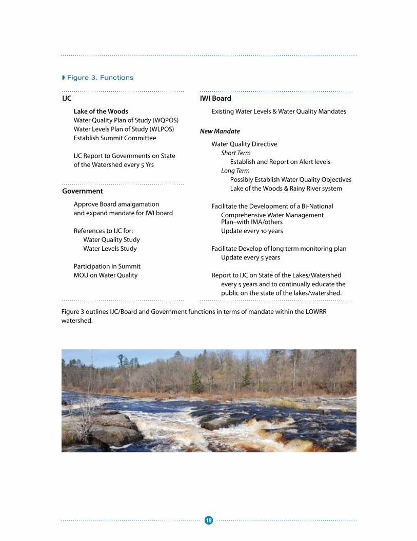
Figure 3 outlines IJC/Board and Government functions in terms of mandate within the LOWRR watershed
◗ Figure 3. Functions
IJC
Lake of the Woods Water Quality Plan of Study (WQPOS)Water Levels Plan of Study (WLPOS)Establish Summit Committee
IJC Report to Governments on State of the Watershed every 5 Yrs
IWI Board
Existing Water Levels & Water Quality Mandates
New Mandate
Water Quality Directive Short Term Establish and Report on Alert levels Long Term Possibly Establish Water Quality Objectives Lake of the Woods & Rainy River system
Facilitate the Development of a Bi-National Comprehensive Water Management Plan–with IMA/others Update every 10 years
Facilitate Develop of long term monitoring plan Update every 5 years
Report to IJC on State of the Lakes/Watershed every 5 years and to continually educate the public on the state of the lakes/watershed.
Government
Approve Board amalgamation and expand mandate for IWI board
References to IJC for: Water Quality Study Water Levels Study
Participation in Summit MOU on Water Quality
20
◗ Board Meetings, Reporting and Logistics
Similar to other IJC boards that are very active in the IWI having an aquatic ecosystem health driven mandate (Souris, Red, St Croix), the new IWI board would likely meet two or three times a year The new IWI board would decide how frequently they need to meet to conduct their work based on an expanded mandate Currently, the boards usually meet three times a year – April, August, and October Their April and October meetings take place in association with and prior to their meetings with IJC Commissioners each year For example, the new IWI board may choose to meet in March of each year when the Lake of the Woods Water Quality Forum is held
At a minimum, the IWI board would meet annually with First Nations, Métis, Native Americans and other water users groups and stakeholders to seek advice and hear concerns on the Bi-national Comprehensive Basin Water Management Plan and other issues of concern
The locations of such meetings should be moved around the basin, generally alternating being held in Canada and the United States The board could choose to meet the pubic more frequently than on an annual basis, if they choose
The IWI board would likely meet with the Commission twice a year, once in April and once in October This is the current practice with the Rainy Boards The Boards create two reports each year associated with these meetings The spring report focuses primarily on Rainy Lake and Namakan Lake regulation and the fall report focuses on water quality and environmental issues The new IWI board would likely continue to report twice per year, and would report on both water quality and water quantity issues
Figure 4 provides an approximate timeline map for the Board and IJC activities, based on the assumption that governments provide an affirmative response to the Commission’s recommendations in 2012 The time line shifts from single years to five year time spans to illustrate the cyclic functions of the board
◗ Figure 4. Recommendation/Mandate Timeline
LoW WQ POS
LoW WQ Study
LoW Levels POS
LoW Levels Study
LoW SUMMIT
Possible MOU-LOW WQ
RL Rule Curve Rev
Facilitate Basin Mgmt Plan Dev.
Dev. WQ Alerts
WQ Objectives
IWI Board Status Report to IJC
IJC Status Report to Governments
12 13 14 15 16 17 20 25 30
21
◗ Summary of Recommendations
1: The Commission recommends that governments expand the geographic scope of the IJC’s water quality authority to the boundary waters of the Lake of the Woods and Rainy River watershed. The IJC proposes to combine the functions and responsibilities of the existing International Rainy River Water Pollution Board and the International Rainy Lake Board of Control in an International Lake of the Woods and Rainy River Watershed Board (ILWRRWB) that would include increased local membership and an expanded geographic mandate for water quality reporting. The proposed IWI Board’s form and function is described in Part II of this report, International Lake of the Woods and Rainy River Watershed Board -Form and Functions.
2: The Commission recommends that the governments authorize the development of a Water Quality Plan of Study (WQPOS) for the Lake of the Woods Basin for those priority issues identified by the Task Force for watershed governance action.
3: The Commission recommends that the governments provide it with a reference to study the regulation of Lake of the Woods water levels and to provide governments with recommendations on any changes to the current regulatory approaches. Furthermore, the Commission recommends that a Lake of the Woods Water Levels Study include the aspects of its 2016 Rainy and Namakan Lakes Rule Curve Review, so the findings and results of both can be considered in establishing the water level regulation of the system.
4: The Commission recommends that the governments support and participate in a Summit on the Future of the Lake of the Woods – Rainy River Watershed.
5: The Commission recommends that the governments support the development of a Bi-national Comprehensive Basin Water Management Plan to help bi-nationally manage waters within the basin and to improve further reductions to point and non-point sources of pollution and meet basin water needs. The IWI Board’s mandate would include the facilitation of the plan along with governmental agencies in both countries.
6: The Commission recommends that the governments streamline and clarify the appointment process to the International Lake of the Woods Control Board and consider designating positions to act ex-officio unless otherwise specified.
7: The Commission recommends that the governments partner with First Nations, Tribes, and Métis people in watershed governance and that the Canadian Government continue its efforts to resolve land and flooding claims by First Nations (as lack of resolution continues to be an impediment to integrated governance in the basin).
22
Signed on this nineteenth day of January, 2012 as the Report to the Governments of the United States and Canada on Bi-national Water Management of the Lake of the Woods and Rainy River Watershed
Hon. Joseph ComuzziChair, Canadian Section
Pierre TépanierCommissioner
Lyall KnottCommissioner
Hon. Lana PollockChair, United States Section
Dereth GlanceCommissioner
Rich MoyCommissioner
23
Final Report to the InternationalJoint Commission on Bi-nationalManagement of Lake of the Woodsand Rainy River Watershed
International Lake of the Woodsand Rainy River WatershedTask Force
July 15, 2011
◗
A N N E X
25
◗ Errata
In this report, operators of the dam at International Falls and Kettle Falls are referred to alternately as “the paper companies” or Abitibi-Bowater During the development of this report, Abitibi-Bowater divested operation of the dams to H20 Power H20 Power operates the dams for hydroelectric production and does not engage in paper production Abitibi-Bowater now operates under the name Resolute Forestry Products
i
Table of Contents Executive Summary ...................................................................................................................................... ii
Task Force Approach ................................................................................................................................... 4
The Watershed ............................................................................................................................................ 8
Historical Context and Frameworks ........................................................................................................... 17
Issues in the Watershed ............................................................................................................................ 38
Appendix A: Letters of Government to the IJC ........................................................................................ A-‐1
Appendix B: Directive to the International Lake of the Woods and Rainy River Watershed Task Force . B-‐1
Appendix C: International Lake of the Woods and Rainy River Watershed Task Force ........................... C-‐1
Appendix D: Task Force Outreach ............................................................................................................ D-‐1
Appendix E: International Lake of the Woods and Rainy River Watershed Task Force’s Citizen Advisory Group ........................................................................................................................................................ E-‐1
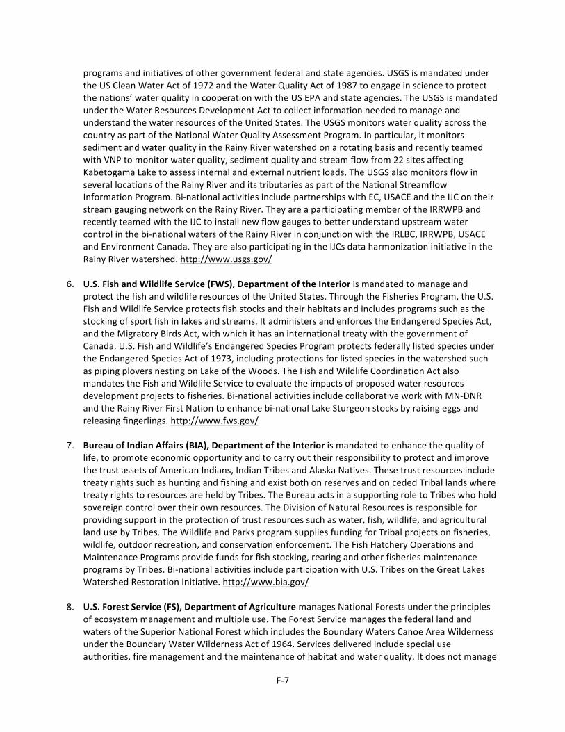
Appendix F: Organizational Roles and Responsibilities ........................................................................... F-‐1
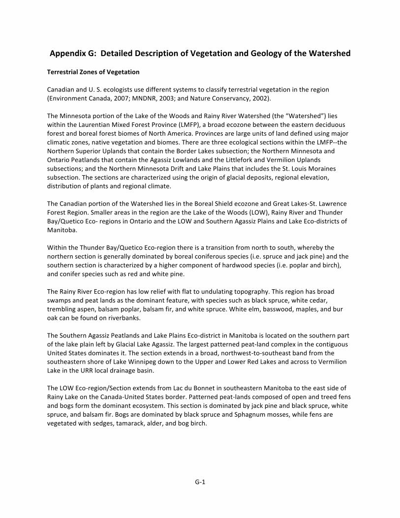
Appendix G: Detailed Description of Vegetation and Geology of the Watershed ................................... G-‐1
Appendix H: Population Table .................................................................................................................. H-‐1
Appendix I: Directive to the International Rainy River Water Pollution Board ......................................... I-‐1
Appendix J: Text of Multi-‐Agency Working Arrangement ......................................................................... J-‐1
Appendix L: List of Acronyms ..................................................................................................................... L-‐1
ii
Executive Summary Background. There has been growing concern over the long-‐term ecological health of the Lake of the Woods and Rainy River watershed. Issues include harmful algal blooms and erosion on Lake of the Woods, climate change and invasive species impacts throughout the watershed, effects of water levels on traditional practices and shoreline properties, and further impacts of potential development. In response, significant activity has been initiated in the watershed by grassroots organizations, communities, agencies, and various partnerships. Over three quarters of a million people depend on this watershed for their drinking water, including the city of Winnipeg, Manitoba, which has a population of over 700,000 people. The watershed is seen as a significant tourist destination and the natural character of the landscape is of utmost importance to many of its inhabitants; the future of this watershed, economically and environmentally, and the quality of its ecosystem are intimately linked. Charge. To ensure the long-‐term ecological and economic vitality of the Lake of the Woods and Rainy River watershed, and noting existing trans-‐jurisdictional coordination and collaboration, the Governments of Canada and the United States asked the International Joint Commission (IJC) to review and make recommendations regarding the watershed’s bi-‐national water management and the IJC’s potential role in that management. Recommendations were to address potential structures and mechanisms for governance and the priority issues or activities to be addressed through such mechanisms; to align with the IJC’s International Watershed Initiative; and to respect existing treaties, orders, and jurisdictional authorities. The IJC assigned this charge to an International Lake of the Woods and Rainy River Watershed Task Force, asking it to report by July 15, 2011. Informed by the Task Force’s work, the IJC will make its own recommendations to the U.S. and Canadian Governments by December 2011 for their consideration and potential action. Approach. The Task Force undertook significant outreach, with particular focus on current and planned activities that affect or can affect the boundary waters in the watershed. It established a Citizens Advisory Group; held public meetings; contacted federal, state, and provincial resource agencies; invited input from communities, municipalities, and counties; contacted coordinative governmental and non-‐governmental organizations; reached out to U.S. Tribes and Canadian First Nations and held a joint conference with Grand Council Treaty 3; met with the Métis Nation of Ontario; and provided information through a variety of means. As a result of this outreach the Task Force heard from many of the citizens, aboriginal peoples, agencies, scientists, and organizations throughout the watershed. Its observations and recommendations are founded on this outreach. Issues. The Task Force catalogued more than 250 issues raised during discussions. It highlighted the following priority issues:
• Participation of First Nations, Métis, and U.S. Tribes: Aboriginal peoples need to be at the table making decisions. While Canada is addressing native flood and land claims, integrated watershed management amongst these aboriginal peoples and communities is lacking.
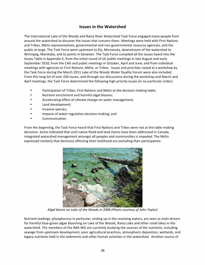
• Nutrient Enrichment and Harmful Algal Blooms: Nutrient loadings, particularly phosphorus, are potentially responsible for harmful algae blooms in Lake of the Woods and Rainy Lake; additionally, Big Traverse Bay has been identified as impaired due to phosphorus and chlorophyll levels in that section of Lake of the Woods.
• Effects of Climate Change: Climate change drives watershed changes that may impair water quality, including harmful algal blooms; lead to varying water levels and flows; and affect forest
ii
Executive Summary Background. There has been growing concern over the long-‐term ecological health of the Lake of the Woods and Rainy River watershed. Issues include harmful algal blooms and erosion on Lake of the Woods, climate change and invasive species impacts throughout the watershed, effects of water levels on traditional practices and shoreline properties, and further impacts of potential development. In response, significant activity has been initiated in the watershed by grassroots organizations, communities, agencies, and various partnerships. Over three quarters of a million people depend on this watershed for their drinking water, including the city of Winnipeg, Manitoba, which has a population of over 700,000 people. The watershed is seen as a significant tourist destination and the natural character of the landscape is of utmost importance to many of its inhabitants; the future of this watershed, economically and environmentally, and the quality of its ecosystem are intimately linked. Charge. To ensure the long-‐term ecological and economic vitality of the Lake of the Woods and Rainy River watershed, and noting existing trans-‐jurisdictional coordination and collaboration, the Governments of Canada and the United States asked the International Joint Commission (IJC) to review and make recommendations regarding the watershed’s bi-‐national water management and the IJC’s potential role in that management. Recommendations were to address potential structures and mechanisms for governance and the priority issues or activities to be addressed through such mechanisms; to align with the IJC’s International Watershed Initiative; and to respect existing treaties, orders, and jurisdictional authorities. The IJC assigned this charge to an International Lake of the Woods and Rainy River Watershed Task Force, asking it to report by July 15, 2011. Informed by the Task Force’s work, the IJC will make its own recommendations to the U.S. and Canadian Governments by December 2011 for their consideration and potential action. Approach. The Task Force undertook significant outreach, with particular focus on current and planned activities that affect or can affect the boundary waters in the watershed. It established a Citizens Advisory Group; held public meetings; contacted federal, state, and provincial resource agencies; invited input from communities, municipalities, and counties; contacted coordinative governmental and non-‐governmental organizations; reached out to U.S. Tribes and Canadian First Nations and held a joint conference with Grand Council Treaty 3; met with the Métis Nation of Ontario; and provided information through a variety of means. As a result of this outreach the Task Force heard from many of the citizens, aboriginal peoples, agencies, scientists, and organizations throughout the watershed. Its observations and recommendations are founded on this outreach. Issues. The Task Force catalogued more than 250 issues raised during discussions. It highlighted the following priority issues:
• Participation of First Nations, Métis, and U.S. Tribes: Aboriginal peoples need to be at the table making decisions. While Canada is addressing native flood and land claims, integrated watershed management amongst these aboriginal peoples and communities is lacking.
• Nutrient Enrichment and Harmful Algal Blooms: Nutrient loadings, particularly phosphorus, are potentially responsible for harmful algae blooms in Lake of the Woods and Rainy Lake; additionally, Big Traverse Bay has been identified as impaired due to phosphorus and chlorophyll levels in that section of Lake of the Woods.
• Effects of Climate Change: Climate change drives watershed changes that may impair water quality, including harmful algal blooms; lead to varying water levels and flows; and affect forest
iii
composition, nutrient cycling, animal migration, and fish habitat. Adaptation measures are needed to address its effects in the watershed.
• Land Development: As land is opened to development, more nutrients and contaminants enter the watershed. Concerns include the leaching of sulphides and heavy metals into ground and surface water as well as increased rates of erosion.
• Invasive Species: Invasive species, which are in the watershed or may be introduced in the future, impact ecosystem function and will require coordinated adaptive and mitigative measures.
• Impacts of Water Regulation Decision-‐Making: The effects of fluctuating water levels, such as on wild rice and erosion, and the need for better understanding of weather factors driving dam operations and more systematic operation of the system as a whole, warrant consideration.
• Communication: People were not always aware of how to reach counterparts, or to become involved in watershed management processes upstream/downstream, between levels of government, or across the border.
Observations. Bi-‐national management of waters within the Lake of the Woods and Rainy River watershed has seen a considerable number of successes, attributable to both grassroots and governmental accomplishments. There is a passion for environmental protection within this watershed that its citizens take very seriously, and the accomplishments are proof of their effectiveness. There is a strong desire to see results: improvements in water quality and watershed management, improvements in communication and collaboration, and improvements in preparedness for future changes. The Task Force has focused on opportunities for improvement, but these need to be understood within the context of the significant progress that has already occurred and is continuing to occur. Many organizations at all levels are monitoring water quality, but there is no one entity that has the role of overall coordination and reporting for the entire watershed, and there is not presently an international governance mechanism in place to manage water quality throughout the watershed. There are good working relations among individual federal, state, and provincial agency officials, but there is no higher-‐level agreement that establishes cross-‐border communication, collaboration, and joint action as a shared priority of the governments. There are numerous U.S. water management plans, at both state and county levels, and more limited plans in Canada, but no comparable basin management plans in Canada and no management plan for the entire watershed. There seems to be good communication and collaboration across the border at the working level, but a lack of understanding as to how to communicate issues and become engaged in processes at the decision-‐making level; there is also uncertainty as to whether and, if so, how issues of bi-‐national concern are addressed in decision-‐making processes in the other country. There is a great deal of good work underway to identify and understand issues in the watershed, but in some cases the science has not yet identified the source of the problem in order to proceed with remedial measures. Lack of water quality monitoring in extensive areas of the watershed would make it difficult, if not impossible, to assess the cumulative impact of all of the contributions to the watershed. Furthermore, when solutions are found that call for implementation of remedial measures, there may not be the commitment or resources to carry them out. The Task Force was repeatedly reminded of the fiscal constraints faced by each of the resource agencies in Canada and the US, as well as the Tribes, First Nations and Métis, to support governance and to continue needed monitoring and research activities. The Task Force recognizes the need to defer to these agencies/communities regarding the level of resources available for addressing bi-‐national water management issues in the Lake of the Woods and Rainy River watershed while balancing other commitments both within and outside of the watershed. This applies, in particular, to the participation
iv
of agency staff on IJC Boards, which is often performed in a voluntary manner in addition to the incumbent’s regular duties: “current board members are already overworked”. The final recommendations of the Task Force are sensitive to these fiscal realities and recognize that implementation may need to be phased in over time.
Recommendations. The Task Force developed recommendations in five themes that it feels would improve bi-‐national governance to address the priority issues, consistent with its charge and in consideration of appropriate roles of the public, governments, and bi-‐national organizations. The strongest recommendation is for a summit, convened by the IJC to encourage the development of a watershed vision, common goals and objectives. Other recommendations include a single IJC International Watershed Board that would combine the mandate of the two existing boards and expand its water quality mandate to Lake of the Woods, increased support for the existing International Multi-‐agency Arrangement working group (IMA-‐WG) currently coordinating water quality science efforts in the watershed, increased local participation in watershed management governance and a review of the regulation of Lake of the Woods. These five themes are briefly outlined below:
An International Watershed Board -‐ Combining the existing International Joint Commission Boards: the International Rainy River Water Pollution Board and the International Rainy Lake Board of Control, into one board and expanding its geographic mandate to encompass the entire watershed would be fully in the spirit of the International Watershed Initiative and would expand on the bi-‐national reporting of monitoring issues in the watershed and facilitate information exchange. In addition to reporting on water quality objectives and alert levels in the boundary waters of the watershed, the new International Watershed Board could track and report on indicators of climate change, the presence and extent of the intrusion of and mitigation measures for aquatic invasive species and diseases, and indicators of nutrient levels and harmful algae blooms and mitigation strategies to address them. The Board would enhance cross-‐border communication between agencies responsible for monitoring, preventing and educating on these priority issues and communicate the results of tracking/reporting efforts to key stakeholders and members of the community. The Task Force recommends that the IJC expand the membership of the Board and provide additional staff and financial resources. Supporting cooperative studies and/or decisions to address priority issues -‐ The current creative, cooperative arrangement of key federal, state, and provincial agencies involved with water resource issues in the watershed along with the Red Lake Band and the Lake of the Woods Water Sustainability Foundation are working well together to address critical issues; however, agencies’ ability to deliver on their commitments in the Arrangement are hampered by staff and resource limitations. The Task Force recommends that governments support member agencies of and provide needed resources to, the IMA-‐WG, including establishing more stable leadership. Enhanced local participation in governance -‐The Task Force sees possibilities for enhanced participation through partnership with Métis, First Nations and U.S. Tribes in watershed management, including appointments to IJC boards. To enhance local participation in watershed governance, the Task Force recommends citizens’ advisory support to the IW Board, and, through an advisory committee, to the LWCB. A summit convened by the IJC -‐ Bringing policy makers, to the table with scientists would encourage a cooperative process for assuring the long term health of the watershed. The Task
v
Force strongly recommends: A special summit for interchange among elected leaders, scientists and senior resource managers in the watershed to facilitate the development of a bi-‐nationally accepted common vision, with shared goals, objectives and implementation strategy could occur by 2013. A bi-‐national review of Lake of the Woods water-‐level regulation – Review the regulation of Lake of the Woods, including Shoal Lake, under a reference from the U.S. and Canadian Governments to the IJC to better inform regulation and its effects for the next 100 years, including anticipated effects of climate change. The Lake of the Woods Convention has served the two countries well over the last 85 years; however, factors such as new climate and economic conditions, environmental considerations, and isostatic rebound exist. The study should incorporate conventional science and traditional knowledge. The nature of such a review will need to be scoped taking into account the issues the Task Force identified from its consultations, key stakeholders, and a feasible timeline and funding stream.
The Task Force also recommends that the U.S. and Canadian Governments issue an anticipated timetable soon after receiving the report from the IJC for considering its recommendations, and that the IJC review governments’ progress in addressing all its recommendations three years after submitting its report. The Summary and Recommendations Section describes these recommendations and others in further detail. The Task Force recognizes that one of the key elements for the preservation of this watershed's ecosystem lies in much stronger political engagement from all levels of elected officials bi-‐nationally including First Nations, Tribes and Métis. Political will is a key determinant and absolutely required to ensure that much needed human and financial resources are available to those who can implement change and bring about real improvements to the watershed's ecosystem. It is hoped that these recommendations will set the governance mechanisms in place that will facilitate the coordination of existing and developing watershed management plans and the formation of a common vision, with shared goals, objectives, and implementation.
1
Introduction There has been growing interest in water quality and quantity issues within the Lake of the Woods and Rainy River watershed, with concern by First Nations, Tribes and Métis, agencies, citizens, and community groups for the long-‐term ecological health of the watershed. Issues such as blue-‐green algae blooms (at times toxic) in Lake of the Woods and excessive erosion along its south shore; introduction and impact of aquatic invasive species throughout the watershed; impacts of climate change; impacts of fluctuating water levels on traditional practices, shorefront properties, and sturgeon spawning and migration; effects of mining, hydropower and shoreline development projects on water quality; and the ecological impacts of application of the 2000 rule curve have raised concerns over water management in the watershed. 1. Local Efforts Significant activity has been initiated in the watershed to respond to a number of these issues. The Lake of the Woods Water Quality Forum, held annually since 2004, allows researchers in the watershed to present findings of their work and identify emerging issues. The Lake of the Woods Water Sustainability Foundation was established in 2004 to heighten the awareness of water quality issues and to secure funding for research projects aimed at providing much-‐needed data. Local groups and governments – including the City of Kenora, the Koochiching County Board of Commissioners, the Lake of the Woods Water Sustainability Foundation, and the Lake of the Woods County Soil and Water Conservation District, to name a few – signed resolutions of support to have the International Joint Commission (IJC) become involved in Lake of the Woods water quality issues.1 In 2009, a Lake of the Woods Multi-‐Agency Working Arrangement was signed by nine entities (including seven agencies in Canada and the United States, one non-‐governmental organization, and one U.S. Tribe) to enhance and restore water quality in the watershed. Resource agencies and organizations in the watershed have committed to ongoing and new research projects aimed at identifying sources of nutrients to Lake of the Woods and to the Rainy River and sharing that information. The IJC’s two Rainy Boards2, working closely with dam operators and provincial and state agency representatives, established a voluntary hydro peaking agreement to limit fluctuations in water flows driven by variations in demand for electricity from hydropower facilities at Fort Frances-‐International Falls in order to minimize adverse environmental impacts. The Rainy River First Nation has implemented an impressive Watershed Program targeted at stewardship and its successful fish hatchery has seen a resurgence of sturgeon in the Rainy River. These are but a few examples of locally-‐led activities responding to issues of water quality and quantity in the watershed.
2. Request from United States and Canadian Governments In order to ensure the long-‐term ecological and economic vitality of Lake of the Woods and the Rainy River watershed, and noting their work to foster trans-‐jurisdictional coordination and collaboration on science and management, the Governments of Canada and the United States determined that a review of the bi-‐national management of this watershed would complement these ongoing activities and contribute to any future approach to addressing new and emerging water quality issues and water management needs. On June 17, 2010, the Governments of Canada and the United States issued letters
1 Sample resolutions are included in appendices to the Work Plan of the International Lake of the Woods and Rainy River Watershed Task Force, available at http://www.ijc.org/conseil_board/rainy_river_watershed/workplan. 2 International Rainy River Water Pollution Board and International Rainy LakeBoard of Control
2
(see Appendix A) to the IJC requesting that it review and make recommendations regarding the bi-‐national water management of the Lake of the Woods and Rainy River Watershed and the IJC's potential role in this management. The recommendations were to address potential structures and mechanisms for governance, as well as priority issues or activities to be addressed by or through such mechanisms, with adherence to the following principles:
• The review and subsequent recommendations should be in line with the IJC’s International Watersheds Initiative, which recognizes the strength in watershed-‐level solutions to trans-‐boundary environmental challenges and encourages collaboration, communication and coordination amongst local stakeholders, and
• The recommendations must respect existing treaties, orders, and jurisdictional authorities already in place in this region.
3. International Joint Commission’s Creation of a Task Force The IJC appointed an International Lake of the Woods and Rainy River Watershed Task Force (Task Force) and assigned it the above mandate in a July 13, 2010 directive (see Appendix B). The IJC directed members of the Task Force (see Appendix C) to act in their personal and professional capacity, not as representatives of their countries, agencies, organizations, or other affiliations.
The IJC instructed the Task Force to coordinate its investigations and engage federal governments and relevant provinces, First Nations, Tribes, and states, as well as the wider body of stakeholders and the public, and to consult with the IRLBC and IRRWPB. On July 13, 2010, the IJC authorized the Task Force to begin its work immediately and instructed it to submit its final report no later than July 15, 2011. The IJC came to the watershed August 31-‐September 2, 2010 to launch the effort. It received briefings, made site visits, and held public meetings in International Falls (Minnesota), Kenora (Ontario), and Warroad (Minnesota), which the Task Force attended.
4. Task Force Purpose and Scope Within the broad context of the charge from the IJC, the Task Force collected information on activities that affect water quantity and water quality in boundary waters, as well as activities on one side of the border that could potentially have a significant effect on water-‐related uses or resources on the other side. In looking at existing and potential structures and mechanisms for bi-‐national governance, the Task Force viewed the concept of governance quite broadly. Both the institutions and processes for decision-‐making were considered. For example, several treaties and Orders are already in place in the watershed. Bi-‐national studies have been carried out by the IJC at the request of the two governments. Bi-‐national oversight of water quality in the Rainy River continues. Formal and informal memoranda of understanding and other arrangements exist between federal, state, and provincial agencies and one Tribe regarding water resource related issues. In addition, domestic decision-‐making bodies in each country often invite the participation of affected interests from the other country. Many of these arrangements have evolved over time to address changing needs. All of these approaches contribute to bi-‐national governance to some degree and provide opportunities to reflect and incorporate the shared interests in these waters. However, it has become apparent to the Task Force that significant gaps exist in the governance structure and greater synergy could be attained if these gaps were to be addressed.
3
Noting that the letters from governments focus on the Lake of the Woods and Rainy River basins and requested that the study be in line with the International Watersheds Initiative, the Task Force considered watershed issues of bi-‐national concern within the geographic area of the entire Lake of the Woods watershed upstream of its outlet into the Winnipeg River, giving particular focus to effects on boundary waters as defined in the Boundary Waters Treaty (See Figure 1). In addition, the Task Force also considered downstream interests beyond the Lake of the Woods and Rainy River watershed that may conceivably be affected by changes within that watershed, recognizing the significant role this watershed plays in the much larger Lake Winnipeg watershed downstream.
Figure 1: Map of Lake of the Woods – Rainy River Watershed
The Task Force viewed its assignment as a unique opportunity, in concert with those who have achieved so much already in the watershed, to reflect accomplishments to date, explore possible options for change, and proposes a path that can help set the stage to successfully address bi-‐national water management challenges now and for the foreseeable future. The Task Force was given a unique opportunity, as well, to ensure the proposed path respects the vision and spirit of the International Watershed Initiative of the IJC – an initiative that recognizes the need to find solutions to water management issues on a watershed scale, regardless of boundaries. This can be done only with those who have already laid the groundwork, are solving today’s issues, and are positioning themselves to make further strides. The Task Force served as a focal point for input, discussion, and consideration of local and regional issues within a bi-‐national context.
4
Task Force Approach The Task Force developed a work plan3 and adjusted it to address public comment prior to its being approved by the IJC on December 10, 2010.On February 24, 2010, the Task Force issued an interim report presenting progress to date and preliminary findings and obtained public comments. The Task Force’s final report, issued in draft form on May 12, 2011 for public review, builds on and supersedes the interim report. The Task Force characterized its main tasks as reviewing the ways that Canada and the United States work together to manage water quality, water quantity, and related issues in the watershed; identifying gaps in the current approach; identifying key existing or emerging issues that require attention; and recommending any new or adjusted governance mechanisms that would help address the identified future needs. It determined very early that, to do its work well, it would need to undertake significant outreach with particular focus on current and planned activities that affect or can affect the boundary waters in the watershed. The Task Force reviewed existing relevant reports and relied on information and consultations with experts (see Appendix D) to provide the context in which it considered bi-‐national management and did not collect scientific data or perform technical analyses. 1. Outreach and Interaction 1.1 Citizens Advisory Group The Task Force broadly invited expressions of interest for a Citizens Advisory Group (CAG), an informal group that served as a sounding board for the Task Force, reviewed Task Force draft reports, and made recommendations on possible bi-‐national management structures and priority issues or activities. The Task Force accepted 44 members to the CAG, split approximately 50% U.S. and 50% Canadian, and left open the opportunity for additional members to be added over time (see Appendix E for membership). CAG members participated in an introductory telephone call and then attended one or more of four meetings held in the watershed October 25-‐28, 2010, to provide feedback on the Task Force’s draft work plan and to allow for more detailed discussion and dialogue than might be possible during public meetings. CAG members developed guidelines, identified issues and additional relevant organizations, and offered observations regarding governance. The Task Force established a limited-‐access website for CAG use, posted background documents, initiated options for CAG online discussion chains on particular subjects, and provided a draft list of issues and a range of possible governance options. The Task Force reviewed the interim report with the CAG via telephone on February 22, 2011 and met with available members at meetings held in the watershed April 5-‐7, 2011 for detailed discussions. Similarly, the Task Force reviewed the draft final report with the CAG via telephone on May 11, 2011 and met with members at meetings in the basin June 13-‐16, 2011. 1.2 Public-‐at-‐Large The Task Force established a website (http://www.ijc.org/conseil_board/rainy_river_watershed/) for general information, including information about the Task Force and its mandate, contact information, background documents, Task Force documents such as the approved work plan and interim report, and notifications such as public meeting announcements or calls to join the CAG.
3 Work plan is available at http://www.ijc.org/conseil_board/rainy_river_watershed/workplan
5
The Task Force held an initial series of public meetings October 25-‐28, 2010, in Ely (Minnesota), International Falls (Minnesota), Kenora (Ontario), and Winnipeg (Manitoba) to receive comments on its draft work plan and information regarding issues of concern. It held a second series of public meetings April 5-‐7, 2011, in Warroad (Minnesota), Orr (Minnesota), and Sioux Narrows (Ontario). A final set of public meetings to review the draft final report were held June 13-‐16, 2011 in Atikokan (Ontario), Fort Frances (Ontario), Baudette (Minnesota) and Kenora (Ontario). Meetings were advertised in advance in local media, further downstream in Winnipeg (Free Press and Grass Roots News), and via an extensive contact list with over 300 entries developed by the Task Force.
Task Force members and participants from the June 13, 2011, public meeting in Atikokan, Ontario.
The Task Force also participated in several events hosted by others at which it could present information, answer questions, and discuss issues. These included the March 9-‐10, 2011 Lake of the Woods Water Quality Forum in International Falls (Minnesota), the May 2, 2011 Lake of the Woods District Property Owners’ Association Annual General Meeting and Cottage Show in Winnipeg (Manitoba), and the May 5, 2011 Northwestern Ontario Tourism Association spring meeting. Special notices and articles were written about the Task Force work for the Lake of the Woods District Property Owners’ Association Area News magazine, the Métis Nation of Ontario newsletter and local newspapers in Cook (Minnesota), Fort Frances (Ontario), and Kenora (Ontario). 1.3 Organizations and Arrangements The Task Force spoke with entities, formal and informal, that operate bi-‐nationally within the watershed: the Lake of the Woods Control Board, the International Lake of the Woods Control Board, the International Rainy Lake Board of Control, the International Rainy River Water Pollution Board, the Ontario-‐Minnesota Fisheries Management Committee, and the Lake of the Woods Multi-‐Agency Working Arrangement (both management/working group level and technical advisory group level.) It also arranged discussions with representatives involved in bi-‐national arrangements in other watersheds, including the Red River and Lake Champlain watersheds; five examples of bi-‐national governance approaches in other geographic areas (listed as Sidebars and referenced in the Table of Contents) are included in this report to illustrate how governance is being handled elsewhere and for consideration of their application to the Lake of the Woods and Rainy River watershed.
6
1.4 First Nations, Tribes, and Métis The Task Force sent introductory letters to two Tribes in the U.S. and the many First Nations in Ontario and Manitoba located in or near the watershed asking how they might prefer to interact with the Task Force and providing information about the Task Force and questions the Task Force wished to ask (see Appendix D). Task Force members made follow-‐up calls and sent follow-‐up emails as needed. The Task Force met with Iskatewizaagegan No. 39 (Shoal Lake 39) Independent First Nation as well as Ochiichagwe’Babigo’Ining (The Dalles) First Nation at their request. The Task Force contacted local Tribal governance organizations. It made presentations at the Treaty 3 National and Chiefs General Assembly in October, 2010; made presentations to the Kenora Chiefs Advisory in November, 2010; met with Network for Native Futures; and discussed appropriate approaches with the Fort Frances Chiefs Secretariat and the Anishinaabeg of Kabapikotawangag Resource Council. Grand Council Treaty 3 and the Task Force jointly organized a March 3-‐4, 2010 special conference with approximately 35 participants to ensure that views and concerns of First Nation communities in the watershed were heard. The event included attendance by chiefs, elders, Task Force members, IJC staff, and resource specialists. Since the Métis are a distinct Canadian Aboriginal people with a unique history, culture, language and territory that include the waterways of Ontario, the Task Force met with representatives of the Métis Nation of Ontario on April 4, 2011. The 16 participants reviewed Métis history; legal, cultural, and governmental distinctions between Métis and First Nations and European settlers; and Métis concerns regarding water management, its effects, and its governance within the watershed. The Task Force forwarded concerns beyond its purview from Tribes, First Nations, and Métis to the IJC. 1.5 Resource Agencies The Task Force contacted 26 agencies at federal, state, and provincial levels of government (see Appendix D). It arranged for individual discussions with most of these agencies to gain a better understanding of current and future initiatives, issues of concern, and perspectives regarding bi-‐national governance. It followed up with key resource agencies as it developed its recommendations. 1.6 Communities, Municipalities, and Counties At the suggestion of two former mayors, the Task Force issued introductory letters with a questionnaire to 46 communities, municipalities, and counties (see Appendix D). The questionnaire asked for information and views as well as desired level of involvement with the Task Force, ranging from none to a desire for follow up. Task Force members issued follow-‐up emails as needed. 2. Organizational Roles and Responsibilities In the Lake of the Woods and Rainy River watershed, there are a wide range of organizations that play a role in or have an impact on water management. Because of the trans-‐boundary nature of this watershed, there are multiple layers of government agencies and organizations, some with over-‐lapping jurisdictions and some with no jurisdictional overlap that play similar roles on opposite sides of the border. Understanding the roles and responsibilities of these organizations, and how they interact in the basin is complicated. As it consulted with various parties, the Task Force compiled a list of the various organizations and their roles; Appendix F lists government agencies and organizations with a role or
7
impact on water management in the basin. The Task Force considered a wide range of organizational roles and activities; organizations were included as long as their roles were deemed to have a significant impact on water management. These roles included responsibilities for or involvement in the regulation of sewage discharges, environmental assessments, municipal planning and development, water quality objectives, flooding, and best practices for resource extraction or agriculture, to name a few. The roles of each organization are outlined, and, if possible, specific activities in the watershed are identified, with an emphasis on those of a bi-‐national nature. Organizations are ordered by scale, starting from the grassroots level, and on through the municipal, state/provincial, national, and international level. The local level heads the list, in recognition that much of the impetus for this review, as well as for many of the environmental success stories in the basin, was from grassroots organizations in the watershed. This is also consistent with the International Watershed Initiative philosophy of local people solving local problems. Non-‐Governmental Organizations (NGO), for instance, provide a venue for concerned citizens to promote environmental stewardship, conduct environmental education and outreach, and participate in environmental monitoring programs. In the chapter on Observations, the Task Force provides examples of how these organizations interact at various scales for selected issues, for example, for water level regulation in Lake of the Woods. Because the original mandate from the U.S. and Canadian Governments specifically requests consideration of the IJC’s potential role in this water management, additional explanation is provided here (in addition to Appendix F). The IJC is a bi-‐national organization created by the Boundary Waters Treaty of 1909. Its Commissioners are appointed by the United States and Canada, typically three by each country, and act together impartially (rather than representing the view of the respective governments) in reviewing problems and deciding on issues. The IJC assists governments in managing waters along the boundary, and its responsibilities stem from the Treaty and specific requests by the two governments. The IJC has been granted decision-‐making authority regarding how flow is released through some dams, or how water is apportioned between the countries in some rivers; it also can conduct studies or provide advice when requested by the two governments, and can raise issues to the two governments' attention as needed. The IJC does not usually undertake general activities more typically carried out by government agencies, such as collecting data or regulating development. 3. Subsequent to Task Force Efforts After the Task Force completes its work by July 15, 2011, it anticipates the IJC will hold public meetings and prepare its report to the governments of Canada and the United States by December 31, 2011.The governments may then initiate any needed studies and will carry out their own consultations within their respective countries on future bi-‐national action in the watershed.
8
The Watershed "Watershed" is the term used to describe the geographic area of land that drains water (a drainage basin) to a shared destination. A watershed, therefore, is "an area of land that drains water, sediment, and dissolved materials to a common outlet" (FISWRG, 1998). Every waterway lies within a watershed, and smaller watersheds join together to become larger watersheds. Watershed boundaries always follow the highest ridgeline (drainage divide) around the stream channels and meet at the bottom or lowest point of the land where water flows out of the watershed. A watershed may be small and represent a single tributary within a larger system, or be quite large and cover thousands of square miles or hectares. Watersheds have been defined and named using standardized protocols. Naming conventions are defined at a regional scale, and then are broken down into smaller watershed units for management purposes (Poppenga and Worstell 2008). The concept of a watershed is very important because it pertains to everyone. No matter where people live, they live in a watershed and what we do on the land affects water quality for all communities living downstream. Features of a watershed not only include the physical characteristics (streams, lakes, valleys, fields, forests, wildlife, etc.), but also the socio-‐economic features of the landscape such as roads, towns, pits, farms and industry. What is common to both the physical and the socio-‐economic features is the water. Water has been called the universal solvent, affected by all that it comes in contact with – the land it traverses and the soils through which it travels (taken from Federation of Ontario Cottagers’ Associations, 2009). That is why the socio-‐economic land uses are as important as the physical features to the quality and quantity of the water in a watershed. The Lake of the Woods and Rainy River watershed (here after the “Watershed”) is in Northwestern Ontario, Eastern Manitoba, and Northeastern Minnesota and is part of the larger Winnipeg River watershed that drains to Lake Winnipeg in Manitoba. The Watershed encompasses approximately 69,750 km2 (27,114 miles2) in Canada and the United States, of which approximately 41 percent is in Minnesota and approximately 59 percent is in Ontario and Manitoba (MPCA 2004 and DeSellas et al., 2009). The maximum distance from east to west in the Watershed is approximately 400 km (240 miles), and from north to south 260 km (156 miles). The Watershed is comprised of four smaller local drainage basins− Upper Rainy River (URR, 18,813 km2 or 7,264 miles2), Central Rainy River (CRR, 19,314 km2 or 7,457 miles2), Lower Rainy River (LRR, 16,760 km2 or 6,471 miles2), and Lake of the Woods (LOW, 14,864 km2 or 5739 miles2) (Gartner Lee Limited, 2007) (See Figure 1). The URR local drainage basin is almost all in Ontario. The CRR local drainage basin of Minnesota and Ontario flows into the Namakan reservoir before entering the Rainy Lake reservoir. The URR and CRR local drainage basins then drain into the Rainy River (RR) at Fort Frances and International Falls. The tributaries that flow directly into the RR west of the RR headwaters comprise the LRR local drainage basin, receiving water from Minnesota and Ontario. Waters that flow to LOW but not via the RR are within the LOW local drainage basin of Manitoba, Ontario and Roseau and Lake of the Woods Counties of Minnesota. The Minnesota portion of the Watershed is bounded on the east by the Lake Superior watershed, the south by the Upper Mississippi watershed, the west by the Red River watershed, and the north by the English River watershed. The U.S. portion of the Watershed is made up of nine smaller local drainage basins: Rainy River Headwaters, Vermilion River, Rainy River/Rainy Lake, Rainy River/Manitou, Little Fork
9
River, Big Fork River, Rapid River, Rainy River/Baudette, and Lake of the Woods, all within the four larger local drainage basins of the Lake of the Woods and Rainy River Watershed. The Minnesota headwaters are located in Cook, Lake, Koochiching, Itasca, and St. Louis Counties. The eastern portion includes an extensive area known as the Boundary Waters Canoe Area Wilderness (BWCAW) within the Superior National Forest. A new state park is being developed on Lake Vermilion near the Vermilion Iron Range. The southern headwaters portion includes part of the Mesabi Iron Range and numerous lakes and streams situated in glacial till and moraines. Relatively large lakes characterize the central portion of the local drainage basin located in Koochiching and St. Louis counties. This area includes Voyageurs National Park, with Crane, Kabetogama, Namakan, Rainy, and Sand Point Lakes. The Lake of the Woods portion of the local drainage basin, located in Roseau and Lake of the Woods Counties, is characterized by extensive wetlands located on the old Glacial Lake Agassiz lakebed and Lake of the Woods (MPCA, 2004). The Canadian portion of the Watershed lies within the Kenora, Fort Frances, and Thunder Bay Management Districts of the Ontario Ministry of Natural Resources. The far eastern portion includes the Lac de Milles Lacs area and the upper section of the Seine River local drainage basins north and east of Quetico Provincial Park, a large provincial park within the upper Watershed. The Turtle River Provincial Park is the sole river park in the study area. The highest density of streams, lakes, and ponds are found in this portion of the Watershed, a characteristic of its poorly drained Cambrian shield topography. The Canadian portion consists of 42 smaller local drainage basins within the four larger local drainage basins of the Watershed (DeSellas et al., 2009). Searle (1977) wrote, “The region known as Quetico-‐Superior is a matchless section of primeval North America. Encompassing the Boundary Waters Canoe Area of the Superior National Forest, Voyageurs National Park, and Grand Portage National Monument in Minnesota, and Quetico Provincial Park in Ontario, the Quetico-‐Superior is the only region of its kind in the United States and Canada. The forests comprised of boreal spruces and firs, mixed with northern hardwoods and pines, fringe thousands of cold, clear interconnected lakes and free-‐flowing streams. Together they comprise an international wilderness superbly designed by nature for canoeing.” The origin of both Quetico Park and the Superior National Forest in 1909 was prompted by flooding concerns and the need to set aside areas to protect against decimating the forest and to preserve fish and wildlife populations. As a result, about half of the Quetico Park and the BWCAW is virgin forest that has never been cut (Heinselman, 1996). The area is a land set apart that represents the beautiful, remote, and primeval northern wilderness that once stretched from coastal Labrador and Maine to the prairies of Minnesota and Manitoba. Many lakes of these wilderness areas share the International Boundary of Canada and the United States. Much of the Quetico-‐Superior area contains primitive, road-‐less areas with canoe portages and few trails only. Float planes, motorized boats and snowmobiles are restricted in the Quetico and BWCAW and some parts of Voyageurs National Park. The Quetico-‐Superior makes up a significant portion of the Watershed that is managed differently than the multiple-‐use areas in the Watershed and represents a strong, long-‐lasting, cross-‐border partnership. Lake of the Woods, the largest lake in the Watershed, covers an area of 3,850 km2 (1,486 miles2) spanning maximum distances of 105 km (65 miles) from north to south and 90 km (56 miles) from east to west. The northern portion of the lake is in the Cambrian shield while the southern shores of the lake
10
are located on the prairie topography of the old Glacial Lake Agassiz lakebed. It contains approximately 14,500 islands, which make it extremely hydro logically complex (DeSellas et al., 2009). Water exits from the eastern Kenora powerhouse dam and western Norman dam separated by Tunnel Island at Kenora into the Winnipeg River on the far north end of Lake of the Woods. Outflows and levels have been regulated there since the mid-‐1890s. 1. Geology 1.1 Bedrock Geology The Watershed lies mainly within the Superior Structural Province of the Precambrian Shield (see Appendix G for more geological details.) The bedrock in this Province was formed 2.5 to 2.9 billion years ago. Almost a billion years later, crustal rifting down the middle of Lake Superior watershed (LSW) to the east of the Watershed caused major lava eruptions that flowed west away from the LSW over the more ancient bedrock formed earlier and intruded magma laden with precious metals into the older continental crust and cooled deep within the crust. There has been much precious mineral and iron deposition during bedrock formation in the Watershed. 1.2 Surficial Geology Virtually all the surficial geology in the Watershed is glacial in origin. About two million years ago four great ice sheets advanced and retreated across the Watershed, melting to create new stream systems, glacial lakes, and other depositional features. Glacial Lake Agassiz was extant for about 5,000 years and at its maximum extent covered over 500,000 km2 (193,050 miles2); it covered many of the present large lakes in the Watershed (Zoltai, 1961; Teller, 1983). As the ice and melt-‐waters were removed from the landscape, the depressed crust began to slowly rise. The uplift, known as isostatic rebound, is still occurring in the Watershed and causing water depths to increase in areas like the south shore of Lake of the Woods, where there are significant shoreline erosion issues. Glacial Lake Agassiz deposited laminated sediments of clay and silt in the lowlands adjacent to Rainy River, Lake of the Woods, and Rainy Lake. In other areas, clay and silt deposits occur only as small pockets. Large peat bogs occur in the Agassiz lacustrine plain with beaches of sand and gravel occurring along the northern boundary of the clay plain. The most widespread soil substrate in the Watershed is a shallow discontinuous ground moraine composed of sand mixed with gravel, stones, and boulders less than a meter deep. The ground moraine is derived from meta-‐sediments and greenstone belts, and is moderately acidic and relatively rich in available nutrients. At the area south of the Namakan River, and along the eastern edge of the unit adjacent to Quetico Park, the ground moraine is derived from granite and the soils tend to be acidic and low in nutrients. Soil depths are shallow to extremely shallow. Only small portions of the Watershed have suitable soils for farming. 2. Climate The Watershed climate is marked by warm, moist summers and cold winters. The mean annual temperature is approximately 1 to 2°C (34 to 36°F). Mean summer and winter temperatures in the region are 17.8°C (64.0°F) and -‐15.0°C (5.0°F). Snowfall averages have ranged from 40 inches in the west to 70 inches in the east portions of the watershed. Snow is typically on the ground from November through April, with the warmest month being July. Warmer than average temperatures have occurred consistently since 1988, especially in winter. The length of the frost-‐free season has increased by 13
11
days, on average, over the last 88 years. The length of the ice-‐free season is increasing on LOW, with ice-‐out occurring around 15 days earlier than the beginning of the monitoring period (0.3 days/year from 1964-‐2007) (DeSellas et al., 2009.) A similar pattern has occurred in other regional lakes in Voyageurs National Park (VNP), northern Wisconsin, and the Experimental Lakes Area in Northwestern Ontario. DeSellas et al. (2009) reported that the region receives an average of 742 mm (29 in) (1919-‐2004) of precipitation per year, most of which falls between May and September. About 70% of the moisture falls as rain, July being the wettest month. The average total precipitation in summer is 287 mm (11 in) and in winter 115 mm (4.5 in). Trends in increasing temperature and precipitation, and declines in winter precipitation, occurred throughout the Canadian Shield and Laurentian Great Lakes regions in previous decades (Magnuson et al., 1997). Frelich (2010) expects that the Watershed will likely experience a magnitude of climate change much larger than the global mean than for other interior boreal forests. That is because this forest is close to the prairie-‐forest border. Thus, very large changes in natural environments can be expected, with some predicting increases in summer temperatures to be 5-‐7°C (10-‐15°F) by the end of the 21st Century. 3. Hydrology The common statistics of the hydrology of the Watershed is shown in Figure 2, which indicates that the flows in the Rainy River are 290 m3/s (10,241 cfs) on average compared to 460 m3/s (16,245 cfs) for the Winnipeg River just below the Lake of the Woods outlet at Kenora and compared to 260 m3/s (9,182 cfs) for the English River at the outlet of Lac Seul. Also shown is the range of flows from extreme high to extreme lows. The range of flows corresponds to a large range in elevations for the rivers, while the large area of the lakes shown in the schematics, leads to a lesser range in elevations on the lakes. The average annual yield is 206 mm (8.1 inches).
12
Figure 2: Winnipeg River Drainage Basin Schematic
Figure 3 shows the lakes and rivers which are the boundary waters in the Watershed, and their relative elevations to Lake Winnipeg. Other lakes and rivers that are in the Watershed are not classed as “boundary waters”.
12
Figure 2: Winnipeg River Drainage Basin Schematic
Figure 3 shows the lakes and rivers which are the boundary waters in the Watershed, and their relative elevations to Lake Winnipeg. Other lakes and rivers that are in the Watershed are not classed as “boundary waters”.
13
Figure 3: Winnipeg River Drainage Basin Level Profile 4. Population Human population centers are sparsely distributed in the watershed and are concentrated in a few cities, towns, townships, Counties, on First Nation and Tribal lands, and in seasonal residences around the shorelines of major lakes (many of which are outside of municipal jurisdictions on the Canadian side). Overall populations are decreasing, as the table in Appendix H shows, although the populations of First Nations, Métis and Tribes are growing. Although the population in the Watershed proper is sparse, it burgeons during the summer tourist season, and since the City of Winnipeg, Manitoba, draws all its drinking water from Shoal Lake (a bay of Lake of the Woods), over three-‐quarters of a million people rely on the waters of the Watershed as a source of drinking water. Population density ranges from approximately 0.15 to 1.79 people per square kilometer for specific counties and districts in the area (DeSellas et. al, 2009). Approximately two dozen Aboriginal and Native American communities are located within or near the watershed (see Figure 4.)
14
A. Red Lake Band of Chippewa Indians B. Boise Fort Band 1. Shoal Lake #40 2. Iskatewizaagegan #39 3. WauzhuskOnigum First Nation 4. Obaskaandagaang First Nation 5. Northwest Angle #33 First Nation 6. Northwest Angle #37 First Nation
7. Wabeseemoong First Nation 8. Ochiichagwe’Babigo’Ining First Nation 9. Naotkamegwanning First Nation 10. Ojibways of Onigaming First Nation 11. MishosiimiiniizibingFirst Nation 12. Anishinaabeg of Naongashiing First Nation
13. Rainy River First Nation 14. Nigigoonsiminikaaning First Nation 15. Seine River First Nation 16. Couchiching First Nation 17. Mitaanjigaming First Nation 18. Lac La Croix First Nation 19. Lac Des Milles Lacs First Nation 20. Niacatchewenin First Nation
21. Buffalo Point First Nation 22. Eagle Lake First Nation 23. Lac Seul First Nation 24. Saugeen First Nation 25. Wabauskang First Nation 26. Wabigoon Lake First Nation 27. Grassy Narrows First Nation 28. Sagkeeng First Nation (not shown)
Figure 4: First Nations and Tribal Communities in and near the Lake of the Woods and Rainy River
Watershed
15
The watershed encompasses or adjoins four Métis Council areas, which are shown in Figure 5.
Figure 5: Métis Nation of Ontario Councils in and around the Lake of the Woods and Rainy River watershed
5. Land Use and the Economy Land use characteristics (resolution 1 km2 or .386 mile2) within the Watershed are discussed in DeSellas et al. (2009, USGS, NRCAN, and AAFC 2000 data). The characteristics and their occurrences for the entire Watershed include vegetation (81.1%, 55,656 km2 or 21,489 miles2), water bodies (14.2%, 9,841 km2 or 3,800 miles2, and cropland and shrubland/woodland (5.5% 3,827 km2 or 1,478 miles2), with burnt or sparse vegetation, wetlands, urban and built-‐up areas and consolidated rock and sparse vegetation contributing <0.1% of the total. The LOW local drainage basin contains the largest areas of open water and wetlands. On the U.S. side, a significant proportion of the land base is within national, state and county forest. On the Canadian side of the border, approximately 75% of the Watershed is Crown (provincial government) land, while the remainder is private (see Figure 6). Crown lands are non-‐private land in Canada that is owned by the province, who may lease timber, mining, and exploration rights. The Watershed is predominantly tree covered. Sawmill and pulp and paper production facilities have traditionally driven much of the economy, but with the recent downturn, communities are looking increasingly towards tourism, services and the fishery to support their economy. Land use still does include timber harvesting throughout all four local drainage basins in the watershed. Forest fires are not uncommon in the area, which include naturally occurring and prescriptive burns.
16
Figure 6: Crown, Park or Federal Lands within the Canadian Portion of the Watershed
(Courtesy of Ontario Ministry of the Environment) Because of the geology, major mining activities have occurred in the past (Steep Rock Iron Mine, Vermilion Iron Range, Mesabi Iron Range) and some others presently occur. Future mining activities in the east and west portions of the Watershed are proposed for mining iron, gold, and other precious metals. Gathering wild rice, hunting, fishing, trapping, water-‐based tourism, ecotourism and other summer and winter outdoor recreational activities are important multiple/wilderness land uses throughout the Watershed. They generate an important portion of the Watershed economy. Impairments to natural resources in the basin that impact on these uses, such as declines in fisheries and wild rice, excess erosion or reduced water quality from harmful algal blooms, can thus have a negative economic impact on the region through reductions in tourism and, in some cases, property values. The extensive interconnected waterway systems in the heart of the continent have been designated as provincial and national parks and wilderness areas, and these areas contribute not only to the characteristic natural beauty of this watershed, but also the potential for research and tourism opportunities. Agriculture and croplands occur mostly in the LOW and LRR local drainage basins. Crops grown include: hay, flax, oats, wheat, alfalfa, canola, and grass seeds.
17
Historical Context and Frameworks Long before Europeans settled in and around the Lake of the Woods and Rainy River watershed, First Nation and Tribal communities occupied the area. They fished the waters of Rainy River and the Lake of the Woods and pursued a number of harvesting activities, including timber harvesting, berry, food and medicinal plant harvesting, and wild rice harvesting. They also engaged in hunting and trapping activities. They relied on the land, waters and rich natural resources for survival and prosperity. Since at least as far back as the fixing of the international boundary between the Dominion of Canada and the new United States of America, there has been a series of governance mechanisms and arrangements covering the Lake of the Woods and Rainy River watershed that either directly or indirectly affect water quality or water quantity, or water-‐related resources of bi-‐national concern. Following is a short description of the major governance mechanisms and arrangements that have been put in place. 1. Treaties, Conventions, and Bi-‐National Practice 1.1 First Nations, Tribes, and Métis In the Nineteenth Century, in both the U.S. and Canada, treaties were made with First Nations and Tribes to end long periods of conflict and provide a framework for future relations. In Canada, Treaty #3 in 1873 between Great Britain on behalf of the Dominion of Canada and the many Ojibway First Nations in and around the Lake of the Woods watershed began to define the future relationship of these peoples in the watershed, including the responsibilities of the government of Canada toward the First Nations. This relationship is particularly important given the First Nations’ proximity to and dependence on the water related resources of the watershed for their economic and spiritual well-‐being. The formal relationship between the government of Canada and the Métis evolved from Treaty #3. First Nations, Métis, and the Canadian government continue to discuss how to address their remaining concerns, and their relationship continues to evolve. In the United States, 1850s and 1860s treaties with the Bois Forte and Red Lake bands were only the starting point for developing a new relationship between the Tribes and the U.S. federal government. In 1908, the U.S. Supreme Court, in Winters v. U.S., supported the principle that ambiguities in treaties with Tribes should be resolved from the standpoint of the Tribes and that this principle should certainly be applied to determine between two inferences, one of which would support the purpose of the agreement and the other would impair or defeat it. Building on this and other principles, the relationship between the U.S. government and the Red Lake and Bois Forte bands has continued to evolve. 1.2 The Boundary Waters Treaty of 1909 In 1909, the governments of the U.S. and Great Britain, on behalf of the Dominion of Canada, entered into the Boundary Waters Treaty, which established the basic principles for managing many water related issues along the International Boundary and established the International Joint Commission (IJC) as a permanent international organization to assist the governments in several ways. The most relevant provisions of the treaty for the Lake of the Woods and Rainy River watershed follow.
18
The treaty provides for freedom of navigation of all navigable boundary waters, subject to the laws and regulations of either country within its own territory, provided there is no discrimination against inhabitants or boats of the other country. Each country has exclusive jurisdiction and control over the use and diversion of water in rivers that would flow across the boundary or into boundary waters; but anyone downstream in the other country injured by a use or diversion will be given the same legal rights as if the injury occurred where the use or diversion took place. With a couple of exceptions for domestic and sanitary uses and governmental works, the uses, diversions or obstructions of boundary waters affecting water levels or flows on the other side of the boundary require international approval, either by special agreement between Canada and the United States or by the IJC. Dams in waters flowing from boundary waters or in trans-‐boundary rivers downstream of the boundary that raise water levels in the other country require international approval, either by special agreement between Canada and the United States or by the IJC. Boundary waters and waters flowing across the boundary shall not be polluted on either side to the injury of health or property on the other. The Governments may refer questions or issues to the IJC for investigation and recommendations, as they have done several times for issues in the Lake of the Woods and Rainy River Watershed. The IJC can develop its own rules of procedure but must provide all interested parties an opportunity to be heard. The treaty provides for decisions by a majority of Commissioners, but IJC practice is to make decisions by consensus. 1.3 1909 -‐ Superior National Forest and Quetico Provincial Park Established The Superior National Forest in the United States and the Quetico Provincial Park in Canada were both established in 1909, creating the largest international area set aside for wilderness recreational purposes in the world. While the two areas are separate entities, a close working relationship has developed over many years between management of the two. There are formal arrangements to deal with fire emergencies and fire suppression and informal arrangements to facilitate cooperation on numerous issues. Management of the two areas communicates regularly and cooperates on a wide range of wilderness related issues in the watershed. 1.4 1925 Lake of the Woods Convention and Protocol Beginning in 1887, prior to the time when international approval was required, dams were built in the outlets of Lake of the Woods to improve navigation and later to generate power. The effect of these dams was to raise the level of Lake of the Woods by about 3.5 ft. (1.07 m) above natural conditions. There were numerous complaints of high water from south shore settlers in Minnesota. At the same time, other interests in both the U.S and Canada preferred the higher levels during navigation season. Low water conditions in 1910 and 1911 coupled with attempts by certain U.S. interests to divert some water from the Lake of the Woods watershed into Lake Superior, via Birch Lake, raised questions about future water supplies. In response, on June 27, 1912, the governments of the U.S. and Canada, pursuant to Article IX of the Boundary Waters Treaty, asked the IJC to consider the most advantageous use of the waters of the Lake of the Woods watershed and to make recommendations on lake regulation.
19
The IJC undertook extensive studies and submitted its final report to the governments in 1917, and on February 24, 1925, the governments signed the Lake of the Woods Convention and Protocol. It constitutes the bi-‐national arrangement for regulating Lake of the Woods outflows and, consequently, water levels. While the convention deals with the entire watershed, it only includes provisions required to address the urgent issues of the day. To address unsettled future requirements, the governments included with the convention the text of a new request pursuant to Article IX of the Boundary Waters Treaty for the IJC to carry out additional studies and recommend other measures for the governments to consider. The convention says that the level of Lake of the Woods should ordinarily be held between 1056 ft. (321.87 m) and 1061.25 ft. (323.47 m) sea-‐level datum and that regulation should ensure the highest continuous discharge from the lake. Even during extreme high supply periods, the lake should not exceed elevation 1062.5 ft. These provisions constitute the only specific regulation goals in the convention. The convention called for a Canadian Lake of the Woods Control Board to regulate the outflow from the lake. It also established a two-‐member International Lake of the Woods Control Board to be appointed by the two federal governments to approve regulation decisions when the level of the lake is above 1061 ft. or below 1056 ft. sea-‐level datum. There is no provision in the convention for a formal review of regulation by governments to evaluate how interests in both countries have been affected over time. To deal with possible flood damages resulting from elevated water levels, the convention called for a flowage easement up to elevation 1064 ft. sea-‐level datum around the lake in the U.S. It also provided that each country would be responsible for any past or future damages to its own inhabitants. Finally, the convention provided that there should be no diversion of any water from the watershed to another watershed except by authority of the U.S. or Canada within their respective territories and with the approval of the International Joint Commission.
20
Norman Dam at the outlet of Lake of the Woods into the Winnipeg River
1.5 1914 Shoal Lake Diversion In September 1914, while the IJC was investigating Lake of the Woods water issues, the IJC approved the request of the Greater Winnipeg Water District for permission to divert water from Shoal Lake for domestic and sanitary purposes. There was no upper limit specified for the amount of the diversion, but it was anticipated that in time it could range from 85,000,000 to 100,000,000 gallons per day. This diversion is still in operation, and the IJC retains jurisdiction over it. 1.6 1938 Rainy Lake Convention While the Lake of the Woods Convention was being considered, private groups were developing general proposals for additional water storage in the watershed in Rainy and Namakan Lakes and in other lakes further upstream. As noted above, the governments referred this issue to the IJC for investigation and recommendations at the time the Lake of the Woods Convention was signed. Specifically, they asked the IJC to look at the most advantageous use of Rainy Lake and the boundary waters flowing into and out of Rainy Lake (in which some dams affecting boundary waters already had been or were being constructed) and whether it was practicable, taking into account all affected interests, to raise the upper limit of Rainy and Namakan Lakes. During the course of the investigation, it became clear that interest in developing additional water storage capacity and water level regulation had waned, and there were no active proposals for specific projects. There was, however, concern in both countries about extreme high water levels on Rainy and Namakan Lakes. The IJC concluded that any future proposals could be formally considered if and when they were submitted for approval, but it did recommend that it be given authority to make regulatory
21
decisions in certain circumstances. The governments agreed and entered into the 1938 Rainy Lake Convention. It authorized the IJC to determine when emergency conditions exist in the Rainy Lake watershed, due to high or low water, and to take regulatory action regarding the existing dams at Kettle Falls and International Falls as well as any future dams or works in boundary waters of the watershed. The IJC has exercised this authority by issuing formal Orders to the owners of the dams setting forth the range of levels that must be met to ensure that emergency conditions not occur, as well as other requirements, such as minimum outflows at International Falls/Fort Frances to protect fishery resources downstream. Regulation is overseen by the International Rainy Lake Board of Control. Originally composed of one federal official from each country, it now includes one local member from each country. The first Order was issued in 1949. It has been formally reviewed and substantially revised three times, most recently in 2000. An additional review is currently being developed. Data-‐gathering activities are under way; with a target completion date of 2015.The formal review will begin at that time. The Board of Control works closely with the International Rainy River Water Pollution Board, including holding joint public meetings, taking joint watershed inspection trips and submitting joint reports to the IJC. 1.7 1959 Rainy River and Lake of the Woods Pollution In 1959, the governments of Canada and the U.S. asked the IJC to study whether pollution in Rainy River and Lake of the Woods from municipal and industrial sources was causing injury to health or property in the two countries, and, if so, what should be done about it. Major studies were carried out by an IJC study board which included federal, state, and provincial officials. In 1965, based on the board’s report and public hearings, the IJC reported that Lake of the Woods water quality was satisfactory but that Rainy River was seriously polluted. The IJC recommended specific water quality objectives for Rainy River as well as programs and remedial measures by the municipalities and the paper companies to achieve them. The IJC also recommended that it be authorized to monitor and encourage implementation of the remedial actions and to review the water quality objectives and recommend amendments, as appropriate. The governments agreed with the IJC’s recommendations, and the IJC appointed the International Rainy River Water Pollution Board, composed of federal, state, and provincial members. The board, at times with direct involvement by the IJC, strongly encouraged timely completion of remedial actions by the appropriate governments and private parties in each country. The major remedial activities were completed by the 1980s, and the board continues to monitor water quality conditions in Rainy River and report to the IJC on major Rainy River Watershed developments. The Board’s Directive is available in Appendix I. As noted above, it works closely with the International Rainy Lake Board of Control by holding joint public meetings, taking joint watershed inspection trips, and submitting joint reports to the IJC. 1.8 1976 -‐ IJC Alerting Responsibility From time to time, the IJC has alerted the governments to issues of concern along the border. In 1976, governments acknowledged this practice and wrote that the IJC would be remiss in its duties if it were not to draw to the attention of governments such matters that came to its attention in the course of its normal activities. As one example, the proposed Namakan River power development was brought to the attention of governments in 2009 under this authority.
22
1.9 1998 International Watershed Initiative In 1998, the governments asked the IJC to explore the development of international watershed boards to facilitate watershed-‐level solutions to transboundary environmental challenges by promoting communication, collaboration and coordination among the various stakeholders and interests using an integrated, ecosystem approach. Consistent with this request, the two Rainy boards have worked collaboratively with the paper companies and resource agencies to address peaking operations in the Rainy River for the protection of fish spawning and to remain aware of ongoing research initiatives and issues within the watershed. 1.10 2009 Lake of the Woods Multi-‐Agency Working Arrangement This arrangement, which was established on May 22, 2009 by voluntary agreement of the U.S. Environmental Protection Agency (EPA), Environment Canada (EC), Minnesota Department of Natural Resources (MDNR), Minnesota Pollution Control Agency (MPCA), Ontario Ministry of the Environment (MOE), Ontario Ministry of Natural Resources (OMNR), Manitoba Water Stewardship (MWS), Lake of the Woods Water Sustainability Foundation (LOWWSF), and the Red Lake Band of Chippewa Indians, seeks to foster trans-‐jurisdictional coordination on science and/or management activities, according to each agency’s mission, to enhance and restore water quality in the watershed. The objectives of this Arrangement are to promote sharing of information and expertise on transboundary environmental impacts; define joint projects and actions to mitigate or prevent transboundary pollution, where applicable; jointly implement measures to prevent transboundary environmental impacts, where appropriate; share information in the event of any incident that may have the potential to cause adverse transboundary environmental impacts; share information on proposed major undertakings in the watershed; share scientific expertise; and promote cooperation and dialogue among members. Resource agencies and organizations in the watershed have committed to ongoing and new research projects focusing on nutrient loadings to the Winnipeg River, Lake Winnipeg, and Lake of the Woods; factors influencing algal blooms on Lake of the Woods; shoreline erosion issues on the south basin of Lake of the Woods; development of a Lake of the Woods Water Sustainability Plan; and sharing that information. The Arrangement has no termination date. Implementation of the Arrangement is overseen by the International Multi-‐Agency Working Group (IMA-‐WG), which is supported by a Technical Advisory Committee (TAC). See Appendix J for the text of the Arrangement.
23
Sidebar: International Red River Board and International Red River
Basin Commission
Another example of bi-‐national governance occurs in the Red River Basin (Red River of the North) in Minnesota, North Dakota, South Dakota, and Manitoba. There, the IJC boards overseeing pollution and water quantity in the Souris and Red River basins were transformed in 2001 to form a 12 member watershed board for the Souris River basin and an 18 member international watershed board for the Red River basin. Within the larger International Red River Board (IRRB), a subcommittee focuses on aquatic ecosystems and another on hydrology concerns. The subcommittees prepare their work plans for approval by the board as a whole. A second grass-‐roots, not for profit organization, works in concert with the IJC board. The Red River Basin Commission (RRBC) has a U.S. member and a Canadian member on the IJC’s International Red River Board. This group often works on contracts let by the IJC board. Also, the RRBC’s frequent public meetings which rotate throughout the basin and its annual conference provides the opportunity for IJC board members to have frequent contact with the public concerns and emerging issues voiced by the members of the RRBC. The RRBC has a 41 member Board of Directors comprised of First Nations, Tribes, provincial, state, county, and municipal officials. There are no federal representatives on the RBBC board. Rather federal agencies are considered ex-‐officio members and are invited to the RRBC’s September meeting. The RRBC’s mission is to have a living document, the Integrated Natural Resources Framework Plan, adopted as guidance throughout the basin with commitments to ensure its implementation. The plan covers water quality objectives, best management practices, soil conservation, ecology, recreation and drought, but recent public concerns have been largely involved with flooding and flood mitigation. Land use is mentioned implicitly in the plan. The RRBC has neither authority nor funding but its strength is in its strong ability to educate and foster communication across the basin and across levels of government. The proposed Nutrient Management Strategy for the basin illustrates the synergy between the RRBC and the IRRB. Because the federal and state representative on the IRRB recognize the need for a strategy, and the IRRB’s ability to fund the science, through the IJC and led by the Aquatic Ecosystem subcommittee, the targets which will be developed as part of the strategy will be adopted by the county, state, and municipal governments of the RRBC who have the ability to promote best practices to meet the targets. The RRBC currently acts in an outreach role to foster adoption practices at the local level and push for funding at the state, provincial, and federal levels.
24
Sidebar: The Great Lakes-St. Lawrence River Basin Sustainable Water Resources Agreement
The Great Lakes-‐St. Lawrence River Basin Sustainable Water Resources Agreement was signed by the governors of the eight Great Lakes States and the premiers of Ontario and Quebec in December 2005. This agreement, which builds on the 1986 Great Lakes Charter, grew out of concerns about maintaining adequate water supplies in the basin over the future to assure long term sustainable development. Concerns included proposals for the diversion of water out of the basin, likely increases in consumptive uses and the possible implications of climate change. While the agreement is not legally binding, each party agrees to seek the adoption and implementation of any measures that may be required to carry out the commitments contained in the agreement. It specifically provides that nothing in the agreement is intended to affect the existing aboriginal or treaty rights of aboriginal peoples in Ontario and Québec or the treaty or other rights held by any Tribe in the United States, and acknowledges the commitment of these peoples to preserve and protect the waters of the basin. It states that the Boundary Waters Treaty of 1909 and other applicable international agreements are unaffected by the agreement. It also recognizes that effective management is dependent upon all Parties acting in a continuing spirit of comity and mutual cooperation. The Agreement contains many important objectives, including: to act together to protect, conserve, and restore the waters of the Great Lakes— St. Lawrence River basin; to facilitate collaborative approaches to water management across the basin to protect, conserve, restore, improve, and efficiently and effectively manage the waters and water dependent natural resources of the basin; to retain state and provincial authority within the basin under appropriate arrangements for intergovernmental cooperation and consultation; to facilitate the exchange of data, strengthen the scientific information upon which decisions are made, and engage in consultation on the potential effects of withdrawals and losses on the waters and water dependent natural resources of the basin; to prevent significant adverse impacts of withdrawals and losses on the basin ecosystem and its watersheds; and, to promote an adaptive management approach to the conservation and management of basin water resources, which recognizes, considers, and provides adjustments for the uncertainties in, and evolution of, scientific knowledge concerning the basin’s waters and water-‐dependent natural resources. Under the Agreement, the states and provinces agree to adopt measures to prohibit new diversions of water except under certain limited circumstances. Provisions are also included to manage the withdrawal and consumptive use of water and report annually on major water uses. A regional body is established, composed of representatives of each party, to, among other things, maintain databases and conduct a review of proposals to divert water from the basin. Specific provision is made to fully and meaningfully include First Nations and Tribes throughout such reviews.
25
Sidebar: Declaration of Intent and the Niagara River Toxics
Management Plan
The problems of toxic chemical pollution in the Niagara River have been well documented, in particular through a multi-‐agency study that culminated in the Niagara River Toxics Committee (NRTC) report of October 1984. In response to the recommendations in this report, in 1987, the EPA Regional Administrator, EC Minister, the New York State Department of Environmental Conservation (NYSDEC) Commissioner and the MOE Minister – the “Four Parties” – signed a Declaration of Intent (DOI).The objective of the DOI was to establish a management strategy so that the Parties moved in a directed and coordinated manner toward the objective of achieving significant reductions of toxic chemical pollutants in the Niagara River in accordance with timetables and specific activities. The DOI was thus consistent with the goal of virtual elimination of toxic discharges, as agreed upon in 1978 by the US and Canada under the Great Lakes Water Quality Agreement. The Parties committed themselves to using the authority provided by their domestic laws and regulations to achieve this goal. In October 1986, the Parties released the first edition of the Four-‐Party Work Plan which established timetables and a set of specific activities to be undertaken. The DOI, in conjunction with the Work Plan, together formed The U.S. – Canada Niagara River Toxics Management Plan (NRTMP).The NRTMP committed the Parties to reduce toxic chemical pollutant inputs from point and non-‐point sources to the Niagara River, in a manner consistent with federal, state, and provincial laws. It also committed them to establishing a common basis for identifying, assessing and quantifying toxic chemical loadings into the Niagara River, including the development of a joint upstream/downstream monitoring program. The initial milestone was to achieve a 50% reduction in loadings of key toxic chemicals, later identified as the “Priority 18”, from point and non-‐point sources in Ontario and New York by 1996.There was a commitment to update the Work Plan, and report on progress as well as the state of new and emerging hazardous waste landfill remediation technologies at public meetings on an annual basis. A governance structure was established to oversee implementation of the NRTMP: (1) The Niagara River Coordination Committee (NRCC) was comprised of accountable senior-‐management level representatives from the Four Parties. (2) It was supported by the Niagara River Secretariat (NRS), comprised of senior agency program staff. (3) Point Source and Non-‐Point Source Committees, comprised of experts from the Four Parties, were established to oversee and provide updates on loadings to the river. (4) A River Monitoring Committee (RMC) was established to design and implement an upstream/downstream Niagara River monitoring program and to report on in-‐river concentrations and loadings of toxic pollutants. There is no termination date written into the DOI, however, there is a milestone of at least a 50% reduction in the “Priority 18” chemicals of concern from point and non-‐point sources in Ontario and New York by 1996. Even though the Four Parties achieved considerable success in meeting that target, in 1996 the Four Parties reaffirmed their commitment to the NRTMP and to developing a post-‐1996 strategy for continued reduction of toxic pollutants by signing a Letter of Support. Now, in 2011, work continues on reducing toxic chemical pollutants in the Niagara River. The NRCC, NRS, and RMC are still in place; the Niagara River upstream/ downstream monitoring program continues; the work plan is updated and reporting is conducted on a 3 year cycle. Public meetings are held every 3 years.
26
Sidebar: Lake Superior Bi-national Program/Lakewide Management Plan
Canada and the United States developed a bi-‐national program to restore and protect the Lake Superior Basin (LSBP) in 1991. The LSBP, comprised of a Zero Discharge Demonstration Program and a broader ecosystem program, has focused on the entire Lake Superior basin (that is, the lands and waters within its watershed boundary) and address all components of the ecosystem (air, land, water, wildlife and humans.) Participants include government and Tribal agencies and interested groups from Michigan, Minnesota, Ontario, and Wisconsin, along with both federal governments. The Lakewide Management Plan (LaMP) is the main planning document developed through the LSBP. The LaMP addresses commitments made by Canada and the United States under the Great Lakes Water Quality Agreement to restore and protect beneficial uses and to maintain the chemical, physical and biological integrity of the basin ecosystem. All activities identified in the LaMP work plan are funded and implemented by the responsible agencies. The Bi-‐national Program adds value to existing programs and activities by linking initiatives and coordinating efforts towards a common vision. The LSBP has developed ecosystem objectives for key elements of the Lake Superior ecosystem, including aquatic communities, terrestrial wildlife, habitat, human health, and sustainability; as well as indicators with quantitative targets to measure and report on the health of the ecosystem. Bi-‐national targets for chemical contaminants have also been established and are called “yardsticks”; they were derived by reviewing all applicable agency guidelines and selecting the most sensitive. Indicators have also been identified for reporting on progress in reducing chemical contaminants. A governance structure has been established to oversee implementation of the LaMP:
• The Task Force, which is comprised of senior government representatives to make policy decisions. The Task Force reports to the Bi-‐national Executive Committee which oversees implementation of the Great Lakes Water Quality Agreement.
• The Bi-‐national Forum, which is a multi-‐sectoral group of 24 volunteers both citizens and interest group representatives that provide analysis and advice.
• The Superior Working Group (SWG), which is comprised of Tribal and governmental agency technical experts who develop and implement LaMP projects and report on findings and progress.
Additionally, the SWG has five committees based on the Ecosystem Objective themes (Chemicals, Habitat, Aquatic Communities, Wildlife Communities, and Developing Sustainability). In addition, there is a Communications/Public Involvement Committee, which has linkages to all of the theme-‐based committees. These committees are comprised of staff from the federal, provincial, state, and Tribal organizations within the Lake Superior basin. The Lake Superior Bi-‐national Program continues today, as well as Lakewide Management Planning processes (and committees) for each of the other Great Lakes. The Bi-‐national Forum continues to be active, as does the SWG and its Committees, and the Task Force. The SWG organized a “Making a Great Lake Superior” Conference in 2007 and currently releases LaMP updates on a 3-‐year cycle.
27
Sidebar: The Lake Champlain Basin Program The Lake Champlain Basin Program (http://www.lcbp.org/) is an ongoing, non-‐binding, collaborative effort by the state, provincial, and U.S. federal governments in the Lake Champlain watershed to restore and enhance the ecological health of the watershed. In 1988 the Governors of Vermont and New York and the Premier of Québec initiated a creative approach to cooperative watershed management by signing the Memorandum of Understanding on Environmental Cooperation on the Management of Lake Champlain. This agreement created a mechanism for the exchange of scientific information, encouraged cooperative planning for environmental protection, established the Lake Champlain Steering Committee with diverse representation from the three jurisdictions, established citizens’ advisory committees, and provided for renewal of the agreement every four years. In 1990 the Lake Champlain Special Designation Act was passed in the U.S. It, along with important amendments in 2002, has provided strong ongoing financial and institutional support to the work started by the states and province. Specifically, the law established the Lake Champlain Basin Program and charged it with developing a watershed management plan and establishing the technical and education and outreach advisory committees. It also authorized funds to support the implementation of the program. Since 1988, there have been several renewals of the Memorandum of Understanding between Québec, Vermont, and New York as well as separate Memoranda of Understanding between two of the Parties on specific issues. Of particular note is a 2002 Missisquoi Bay Phosphorus Agreement between Vermont and Québec which determined a division of responsibility between Vermont and Québec for phosphorus load reduction in that bay. Also, the 2010 revision to the larger Memorandum of Understanding commits the Parties, where practicable, to provide prior notification and opportunity for consultation to each other on any pending major action which could affect the environmental quality of Lake Champlain. The Steering Committee and the advisory committees are supported by a core group of professional staff. This staff manages funds received from U.S. federal sources, facilitates coordination and collaboration among committee members, carries out specific program activities, and manages contracts and grants to other entities that are implementing parts of the programs. The management plan for the Lake Champlain watershed is called Opportunities for Action. The recently completed, current version is available on the Basin Program’s website. It is comprehensive and detailed and reflects the current thinking of the Program partners. Key issues include: reducing phosphorus inputs to Lake Champlain; reducing contaminants that pose a threat to human health and the Lake Champlain ecosystem; preventing the introduction, limiting the spread, and controlling the impact of non-‐native aquatic invasive species; identifying potential changes in climate and developing appropriate adaptation strategies; and promoting healthy and diverse economic activity and sustainable development principles within the Lake Champlain Basin while improving water quality and conserving the natural and cultural heritage resources on which the regional economy is based. All Lake Champlain Basin Program meetings are open to the public.
28
Accomplishments Bi-‐national management of waters within the Lake of the Woods and Rainy River watershed has seen a considerable number of successes over the years, which can be attributed to the IJC, to various levels of government, to industry, and – significantly – to grassroots organizations throughout the watershed. From water quality monitoring to stewardship promotion and public education, there is a passion for environmental protection within this watershed that its citizens take very seriously and the accomplishments gained are proof of the effectiveness of this level of effort. In the short time of the Task Force’s tenure, it has gained a heightened awareness of many of these accomplishments, all of which have a goal of protecting the resources and positively influencing that protection through cumulative improvements. Successes range from the large-‐scale, effective cleanup of the Rainy River to the more subtle enhancements of communication between Boards and communities and increased recognition of the need for local input to solve local issues. While by no means comprehensive, this section provides an overview of many accomplishments achieved throughout the watershed. 1. Improvements in Water Quality At one time, the Rainy River was extremely polluted with the human waste, bark, lime, and sulphite solutions from the two pulp and paper mills at Fort Frances and International Falls and municipal treatment facility discharges entering the river untreated. The 1950s found the river in its worst shape. In the early 1960s, at the request of the U.S. and Canadian governments, the IJC conducted a comprehensive study of the river and recommended water quality objectives, remedial measures to be completed in each country, and ongoing monitoring of the situation in the future by the IJC. With the installation of sewage treatment, bark handling facilities, sulphide mill shut-‐downs, and the initiation of the IJC’s IRRWPB, the river gradually showed improvements by the end of the 1960’s and significant improvements were seen by the 1980’s. For example, biological oxygen demand (BOD) levels in the Rainy River in 1968 were 74 metric tonnes/day; by 1976, they had dropped to 50 metric tonnes/day; by 1982 they had gone down to 13 metric tonnes/day and by 2009, had decreased to 3.6 metric tonnes/day. The water quality objectives recommended by the IJC in its study mentioned above set limitations for waste water (pulp, paper, and sewage) for parameters such as E coli, suspended solids, dissolved oxygen, and nutrients (though vague). Once the IRRWPB was established, pressure from both the IJC and the IRRWPB further enhanced the cleanup of the river over time. In order to maintain acceptable phosphorus (and other nutrients and contaminants) levels in the river, for which objectives had not been established as part of the IJC study, the IRRWPB instigated “alert” levels for the river in 1992. The alert levels represented levels stated as guidelines or objectives of regulatory agencies with jurisdiction on the river; the alert levels chosen were the most stringent of those used by the agencies. To this day, provincial/state agencies and industries on both sides of the border monitor effluent from sewage treatment plants, the mills and other facilities to ensure they are complying with environmental regulations. Results are reported back to the IJC in an effort to keep abreast of how facilities on both sides of the border are adhering to water quality objectives and these alert levels for the river. The IRRWPB posts the results via their biannual reports on their website for public access.
29
1.1 Water Quality Monitoring Efforts 1.1.1 Aquatic Synthesis for Voyageurs National Park (VNP) An Aquatic Synthesis for VNP was published in 2003, which summarized the results of research completed and further assessments needed in the aquatic environments of the boundary waters in and around the park. There is an aggressive water quality-‐monitoring program in boundary waters associated with Voyageurs National Park. 1.1.2 State of the Basin Report and Subsequent Studies/Monitoring Efforts on Lake of the Woods In 2009, the first ever “State of the Basin Report for the Lake of the Woods and Rainy River Basin” was published and provided an overview of environmental conditions in the watershed, the existence of data and the gaps in information that exist in order to understand water quality issues in the watershed. This report was a collaborative effort between the LOWWSF, MOE, MPCA, and EC and triggered a number of significant research projects as a result, including the Lake of the Woods Nutrient Budget Study which was an attempt to quantify nutrient loads entering and leaving the lake – something that had never been done before for this lake. One of the significant data gaps identified in the State of the Basin Report, and a requirement for a comprehensive nutrient budget to be accomplished, was monitoring data from Canadian tributaries to Lake of the Woods and the Rainy River. In 2009, the MOE commenced a targeted sampling program to measure nutrient concentrations in 9 tributaries and at the outflow to the Winnipeg River. In 2008, Environment Canada came on board with a comprehensive science initiative on the lake and in the Rainy River that has focused on monitoring atmospheric deposition of nutrients to the lake (at 3 locations in the watershed), measuring in-‐lake and river concentrations of nutrients, major ions and mercury; assessing the health of the benthic community, determining algal composition in the Lake of the Woods, studying currents, thermal structure and sediment loadings and developing a hydrodynamic model for the lake. EC also undertook to develop a digital bathymetry map of Lake of the Woods, information that was needed in order to support modeling efforts on the lake. MPCA’s tributary and lake monitoring program has been ongoing and reached full force in 2010 when sampling for their TMDL study started in response to algae and phosphorus levels in Lake of the Woods being above state standards. Minnesota has ensured that this TMDL study has incorporated the Canadian agencies’ data in calculations that will reflect loads from both sides of the border.
1.1.3 Red Lake Band of Chippewa Indians’ Commitment to Improving Water Quality The Red Lake Band of Chippewa Indians signed the international Multi Agency Arrangement (discussed in Section 4.3) to protect water quality in Lake of the Woods. As a result of that affiliation, the Red Lake Band initiated a water sampling program to fill a gap in data on the west side of Lake of the Woods.
1.1.4 Citizen-‐Based Monitoring There are numerous citizen-‐based monitoring projects throughout the watershed in which members of the public take samples on a regular basis and submit them for analysis. In this way, a substantial database can be developed for lakes otherwise not monitored. Examples include the MOE’s Lake Partner Program (33 samplers on Lake of the Woods alone) and the Cook County Coalition of Lake Association’s sampling program, which currently involves 12 samplers in this watershed (personal communication, B. Clark, 2011). The Rainy Lake Conservancy partnered with the Nature Conservancy of Canada and the Ontario Ministry of Natural Resources to conduct a comprehensive biological survey on the Canadian side of Rainy Lake; it also partnered with Voyageurs National Park on several research efforts including sturgeon research on the Namakan River and Reservoir, cormorant research, and loon
30
nesting. There are likely many more similar examples like these throughout the watershed and, collectively, they offer some of the only historical water quality databases for this watershed. 1.1.5 Local Agency Contributions Many agencies and organizations are contributing to the understanding of water quality and ecosystem health issues within the watershed. As part of the Lake of the Woods Water Quality Forums in 2008 and 2009, information on who was monitoring where and how in the watershed was collected. The information revealed that at least one dozen agencies/organizations were conducting some kind of water quality sampling in the watershed, with many more entities researching the fishery, benthos, precipitation trends, and paleolimnology and conducting modeling exercises on Lake of the Woods or the Rainy River. 2. Enhanced Communication and Local Involvement 2.1 IJC Presence in Watershed After the Rainy River cleanup, during the 1970’s and early 1980’s the IJC and the IRRWPB had a reduced presence in the watershed. Resource, business, and other groups individually sought out the IRLBC to find a path to the solutions each group wanted in water level management locally. At this point, the IJC and the IRLBC began to foster the joining of disparate interest groups to come together to reach a compromise for the good of the watershed and its interest groups. Beginning in the late 1980's, the IRLBC made several tours throughout the Rainy River Watershed and encouraged concerned groups to come together to speak with one voice as a collective. In essence, these meetings fostered a greater understanding of a watershed concept. It was also the birth of the international watershed initiative in the watershed according to those with corporate memory. In addition, in response to comments from the public in the late 1980’s, the Board had decided that it should attempt to inspect a portion of the watershed each year prior to the public meeting. The purpose would be to gain more first-‐hand knowledge of current conditions and public concerns. This concept was implemented in 1988. Enhanced coordination led to the development of a bi-‐national steering committee (established in 1991) to promote rule curve changes on the Rainy Lake and Namakan Reservoirs that would favor more natural flows such as in Lac La Croix, an unregulated border lake. It stimulated much discussion among proponents and opponents about the proposed changes. The "Rainy Lake / Namakan Chain International Water Level Steering Committee" held many meetings across the watershed with First Nations and other groups to develop a proposal for rule curve changes for Rainy Lake and the Namakan Chain of Lakes. Its work was brought to the attention of the IJC, which commissioned additional studies, established new rule curves in 2000, and specified that further review would occur by 2015. A 2009 Plan of Study was prepared to identify gaps in research to develop a final document for a 2015 IJC review of the 2000 rule curve changes on the Rainy and Namakan Reservoirs. Recommended studies are currently being funded by the IJC through its International Watershed Initiative. The IRRWPB and IRLBC have secured a Plan of Study project manager and are working with resource agencies and others to hire researchers to complete the studies. 2.2 Lake of the Woods Control Board In the early 1980's, following public consultation, the Lake of the Woods Control Board (LWCB) implemented new policies to include the participation of First Nations and other local interests in the
31
management of the waters regulated under its mandate. First Nations, specific interest groups, and resource advisors were invited to participate in all regulation meetings of the Board. Similarly, in early 1998, the LWCB launched a comprehensive website to provide the public and others with current watershed conditions, as well as technical and historical information related to the water management of the Winnipeg River watershed. This website has been instrumental in increasing public awareness of and participation in, the water level and flow management of Lake of the Woods and the Winnipeg River downstream. Compared to decades in the past, the LWCB and the IJC and its boards (IRRWPB and IRLBC) have fostered a significant dialogue and presence in the watershed today and have significantly increased local outreach and involvement. Commissioners now come to the watershed annually and are readily available to the public at meetings and on field trips. Resource agencies in both countries are invited annually to a forum with the Commissioners and Boards in an environment where they can freely discuss watershed management issues. The IRLBC was expanded in 2004 to add two local representatives from within the watershed. Board engineering advisors continue to work closely with paper company dam operators. 2.3 Rainy River First Nation Watershed Program The Rainy River First Nations Watershed program was established in 1998 and aims to increase public awareness to promote involvement in the protection, conservation, and revitalization of the Rainy River watershed; monitor and inventory potential impacts to the Rainy River watershed; and rehabilitate areas of concern. Within a watershed approach to environmental protection, the program achieves its goals by working cooperatively with community members, elders, local businesses, private landowners, and municipal, provincial, and federal agencies. Activities within the program include educational workshops, river cleanup events, stewardship activities with school age children, science camps, collaboration with Health Canada to conduct bacteriological surveys along the Rainy River (from the dam at Fort Frances/International Falls to its mouth near Rainy River/Baudette, both in Canada and the United States), hosting of Man-‐O-‐Min watershed conferences in the past, stream assessments and lake sturgeon research, bald eagle aerial surveys,prairie-‐oak savannah inventories, developing a fisheries resource stewardship framework, conducting land use/stream assessments, and producing a community environmental plan. 3. Proactive Protection and Restoration Measures 3.1 Legislative Changes As air and water pollution became increasingly serious in Canada and the United States in the 1950s and 1960s, comprehensive environmental laws and regulations were promulgated and new federal, state, and provincial institutions were established that have helped address many issues in the Lake of the Woods and Rainy River watershed. The establishment of agencies such as the Minnesota Pollution Control Agency in 1967, the U.S. Environmental Protection Agency and Environment Canada in 1970, and the passing of legislation such as the Canadian Environmental Protection Act in 1971, the U.S. Clean Water Act of 1972, and the Ontario Water Resources Act in 1972, represent major milestones in improving water quality in the watershed. Taken together, these provisions cover most municipal and industrial point sources. Non-‐point sources, including the atmospheric deposition of phosphorus, runoff into tributaries and legacy pollutants, such as nutrient loadings in lake and river sediments, have not been as fully addressed.
32
Significant new efforts are also currently being made in both countries. Minnesota is in the midst of a TMDL study for Lake of the Woods in response to the portion of this water body in the United States being declared “impaired” for phosphorus and algae. Canada and Ontario are partnering on research initiatives and communicating with Minnesota to support the study. Ontario’s Lake of the Woods Watershed Stewardship Strategy focuses on science, compliance, outreach/communication, partnership-‐building, and international cooperation to ensure that approaches used in Ontario to promote best management practices and research initiatives are aligned with Manitoba and Minnesota’s goals and ensure protection of water quality in Ontario. In fall of 2008, Minnesotans passed The Clean Water, Land and Legacy Act, an amendment to the state’s constitution that created a three-‐eighths of a percent sales tax to fund, among other things, the protection and preservation of Minnesota’s freshwater. The amendment has the potential to raise more than $275 million a year, of which roughly one third—about $85 million a year—will go toward protecting and preserving Minnesota’s surface and ground water. In spring 2009, the Minnesota legislature took the first step in investing that money, appropriating $750,000 to the University of Minnesota’s Water Resources Center to create a comprehensive, 25-‐year framework for the sustainable management of Minnesota’s water resources. The framework is intended to serve as a roadmap—with clear signposts on how and when to spend the money and on what initiatives—based on scientific research, expert opinion, and input from citizens around the state. The plan, titled “Minnesota Water Sustainability Framework,” was presented to the legislature on January 5, 2011. Also, another significant result of the Minnesota constitutional amendment is the employment of a major watershed approach to restore and protect water quality throughout the state. Under this approach, each of the nine watersheds in the Rainy Basin (including Lake of the Woods) is being worked on over the next 10 years. Once complete, the 10-‐year cycle will be repeated in order to track trends and progress toward restoration and protection and adapt or modify strategies as necessary in subsequent cycles4. The MPCA, MDNR, and Minnesota Board of Water and Soil Resources are the main state agencies responsible for leading this work. The work is very comprehensive in each watershed and involves intensive watershed monitoring & assessment (chemical, physical, biological, flow), watershed modeling, watershed planning and TMDL development, watershed Implementation (restoration and protection), data management, measuring, evaluating and reporting, and civic engagement, outreach, and education. In addition to the significant staff resources, the state agencies will spend a total of $3.3 million to $5.3 million in the Rainy Basin over the next 10 years with additional resources provided in subsequent cycles to reassess, adapt strategies, and implement. In February 2008, Environment Canada launched a $17.7 million (over a four-‐year period) Lake Winnipeg Basin Initiative (LWBI), which includes support for monitoring and research activities in Lake of the Woods. The LWBI was developed partly in response to Manitoba's request for federal support in meeting research, information and monitoring needs, and to facilitate governance and cooperation throughout this vast, trans-‐boundary watershed. Work is now underway on the three components of
4 Little Fork River Watershed (Cycle 1 2008, Cycle 2 2018); Big Fork River Watershed (Cycle 1 2010, Cycle 2 2020); Lake of the Woods Watershed (Cycle 1 2012, Cycle 2 2022); Rainy River Headwaters Watershed (Cycle 1 2014, Cycle 2 2024); Vermilion Watershed (Cycle 1 2015, Cycle 2 2025), Rainy River / Rainy Lake Watershed (Cycle 1 2016, Cycle 2 2026); and Rainy River Manitou Watershed, Rapid River Watershed, and Rainy River / Baudette Watershed (Cycle 1 2017, Cycle 2 2027).
33
the LWBI: science (research/information/monitoring); Lake Winnipeg Basin Stewardship Fund; and governance. 3.2 Manitou Fish Hatchery Ltd. The Manitou Fish Hatchery Ltd. began its sturgeon aquaculture activities as both a symbolic and practical gesture to acknowledge this ancestral debt and to nurture the river by offering some of the sturgeon progeny to the river. At the urging of the elders in 1995, the Rainy River First Nations imposed a moratorium on commercial sturgeon harvests from the Rainy River, and initiated the sturgeon aquaculture activities by constructing a hatchery and sending community members for technical aquaculture training. The corporate goal of Manitou Fish Hatchery Ltd. is to develop and operate a sustainable business that meets the increasing demand for sturgeon fingerlings and quality sturgeon meat products, while maintaining the nurturing approach to the river as defined in the mission statement (taken from Fisheries and Marine Institute, Memorial University website: www.mi.mun.ca).
3.3 Voyageurs National Park Clean Water Joint Powers Board A group of concerned citizens started a discussion on how to best address the watershed issues impacting Voyageurs National Park. As a result, The Namakan Basin Joint Powers Board was set up at the St. Louis County level in 2009 to carry out a comprehensive planning project that prioritizes the area’s wastewater treatment concerns. The Voyageur's National Park Clean Water Joint Powers Board was set up in 2010 between St. Louis County and Koochiching County to govern the application for, solicitation of, and administration of funds received for the purpose of planning, grant writing, engineering, conservation, and environmental studies, and the development, management, and construction of wastewater treatment for property within the project area, which includes the Namakan Basin plus Rainy Lake. A planning report was prepared and presented at a series of public hearings in June 2010. 3.4 Preservation of Lands and Resources As part of the 2007 Provincial Parks and Conservation Reserves Act in Ontario, ecological integrity was given first priority when planning and managing provincial parks and conservation reserves and balancing the varied interests. As part of this Act, the Lands for Life program was born. On Lake of the Woods alone, over 39,000 hectares were protected as Conservation Reserves; on Rainy Lake, through efforts of the Rainy Lake Conservancy and others, approximately 5,900 hectares of islands were also protected from major industrial uses such as mining and forestry. Management plans for Quetico Provincial Park, Voyageurs National Park, the Boundary Waters Canoe Wilderness Area, and the Superior National Forest have common management agreements for resource protection. In an effort to prevent severe burns that would adversely impact water quality and unique resources, Quetico Park and Superior National Forest worked bi-‐nationally to reduce fire fuel loads after the massive blow down of July 1999. The Superior National Forest Plan, developed in 2004, is based on the principles of ecosystem management and multiple use with an emphasis on ecological, social and economic sustainability over the long-‐term. It endorses cooperative management between Tribal, federal, state, local governments and land-‐owners and provides specific opportunities for traditional American Indian land uses and resources. In response to pressures on the fisheries resource in the watershed, a number of proactive resource management activities have taken place. These include the buy-‐out of commercial fisheries on border lakes (other than those with tribal rights), reduction of limits on game fish, establishment of slot limits, and closure of major known spawning bays in spring to protect fish from overharvesting.
34
3.5 Pulp and Paper Industry The pulp and paper company at Fort Frances is hooking up to the town water supply for a high pressure backup source for its emergency fire water intake. This will allow greater flexibility in the operation of the dams, since currently, gate operations when Rainy Lake is below the IJC’s “all-‐gates-‐open” level can lead to dewatering of the mill’s fire water intake. In years past, when the pulp mill was operating in Kenora, the Ontario Ministry of the Environment recommended that the flow through the Kenora powerhouse normally be no lower than 100 m³/s. During drought periods, if reduced flows were needed, the flow could be reduced (if the OMNR and the Fisheries and Oceans Canada (DFO) concurred) to no lower than 50 m³/s, except during critical fish spawning or egg incubation periods. In addition, with Kenora powerhouse outflows below 100 m³/s, a dissolved oxygen monitoring program came into effect. Now that the mill is closed, a minimum release of only 10 cubic meters per second is considered sufficient to dilute the effluent from the City of Kenora's waste water treatment plant. 4. Bi-‐national Cooperation There has been an increasing number of examples of international cooperation (some outside of the IJC structure) to solve shared problems in the watershed. 4.1 Lake of the Woods Water Quality Forum This annual event, now in its eighth consecutive year, is held at the Rainy River Community College in International Falls, Minnesota. It is the premier event for researchers and resource managers to congregate to discuss research plans, hear research progress, and collaborate across the Canada/U.S. border on items such as joint quality assurance / quality control, sharing resources and data, and focusing on common goals. Over the years, topics for discussion have included algae and nutrients, paleolimnology, international cooperation, and hydrological monitoring. Hosted by the LOWWSF, the partner organizers for this forum hail from MPCA, MOE, Environment Canada, St. Cloud State University, VNP and Rainy River Community College. 4.2 Hydropower Peaking Arrangement The Rainy boards, working closely with dam operators and provincial, state, and federal agency representatives, successfully concluded an agreement to limit fluctuations in water flows driven by variations in demand for electricity—“peaking”—from hydropower facilities at Fort Frances-‐International Falls, in order to minimize adverse environmental impacts. In 2006, the boards convened an informal working group to design and establish an informal process to balance hydropower needs with fish spawning needs during the spring spawning period on a two-‐year trial basis. The working group agreed on an annual 2-‐1/2 month spring spawning window during which no hydropower peaking would take place for 2007 and 2008; this voluntary arrangement continues to today. The general start and end dates for this window were April 15th to June 30th, but the dates are revisited annually to reflect the actual timing of the walleye and sturgeon spawning and incubation. The boards have initiated studies, with IWI funding, to more accurately identify the spawning window.
35
4.3 Multi-‐Agency Arrangement Recognizing the need for a collaborative effort on the part of resource agencies in the watershed to research and begin to manage water quality concerns on Lake of the Woods, an International Multi-‐Agency Arrangement (2009) was established among agencies, a non-‐governmental organization, and a Tribe. The group is entering its second full year of operation and has developed a five-‐year plan for research and goal-‐setting related to concerns around erosion and blue-‐green algae on Lake of the Woods. While informal in structure, this group has developed a quality assurance / quality control program for sample analysis, begun discussion on collaborative data management, partnered on filling data gaps regarding much-‐needed water quality sampling, established a Communications Plan and begun paleolimnological and modeling research in support of nutrient budget work for Lake of the Woods. 4.4 Bi-‐national harmonization of Geographic Information System (GIS) data GIS-‐based hydrographic datasets developed in the U.S. and Canada commonly terminate at the international border, and are often inconsistent with each other in terms of scale, classification and standards. These inconsistencies make it difficult to model hydrology on a watershed basis in trans-‐boundary waters, such as Lake of the Woods and the Rainy River. As part of the IJC’s International Watershed Initiative, a Transboundary Hydrographic Data Harmonization Task Force is coordinating the harmonization of both hydrographic and drainage area data sets in the Lake of the Woods and Rainy River watershed. It has completed the first phase of this effort, which involved harmonizing Canada’s National Hydro Network (NHN) with the U.S. National Hydrographic Dataset (NHD) within 100 m of the border. Next steps are to harmonize GIS datasets on a more detailed, local scale. The Data Harmonization Task Force held an initial meeting with GIS experts from local agencies at the 2010 Lake of the Woods Water Quality Forum and are planning a subsequent meeting in the near future. 4.5 Joint Research Sturgeon research on the Rainy River and Rainy Lake/ Namakan Reservoirs was directed by the bi-‐national Minnesota and Ontario Fisheries Committee. Results informed the voluntary hydropower peaking arrangement (discussed above) on Rainy River by paper companies to protect fish during spawning, and have increased understanding regarding how sturgeon are using border waters and the Namakan River. There has also been extensive bi-‐national sharing of watershed research and monitoring data concerning eagles, colonial water birds, cormorants, loons, beaver, wolves, moose, lynx, fisheries, zooplankton, exotic species, lake bottom sediment, aquatic vegetation, benthic organisms, environmental contaminants, psychology, climate change, and paleoecology. 5. Initiation of Watershed-‐based Initiatives 5.1 IJC’s International Watersheds Initiative (IWI) A growing interest in managing water-‐based issues on a watershed basis has gained momentum within the watershed, from both the IJC perspective and other agencies. The IJC’s IWI concept promotes an integrated ecosystem approach to issues that is focused on facilitating local people in their efforts to solve local issues. The initiative facilitates the development of watershed-‐specific responses to emerging challenges such as population growth and urbanization, climate change, and introductions of exotic species. Through the initiative, the IJC has funded significant hydrological research on the lower and upper Rainy River that will be shared with resource agencies in both countries. Additional projects
36
include temperature and flow gauge installation and management that will inform hydropower peaking discussions and water flow management. 5.2 Local Watershed Planning The Rainy River Basin Planning Process and Report (2004), conducted by the MPCA under the Clean Water Act, was completed with goals and objectives for water management in the Rainy River Basin. Significant planning and public outreach were done as a part of this project, and research has proceeded in the past few years that emanated from this study. Minnesota takes a watershed approach to monitor and assess water quality throughout the state and is now doing so on a 10-‐year cycle in order to restore waters that do not meet water quality standards and to protect those that do meet standards. Watershed planning has also been ongoing at the local level, most significantly in Minnesota. Each county with area within the watershed has developed local water management plans, supported by the efforts of their soil and water conservation districts, which address priority water-‐related issues across the county and make recommendations for the implementation of protection strategies. Issues of focus include land use management, erosion/sedimentation, sewage treatment, water quality, and education. On the Canadian side of the border in this watershed, there is no current watershed management planning mechanism. However, relevant water-‐related plans include the Shoal Lake Management Plan, the Seine River Water Management Plan, the Steep Rock Mine Reclamation plan, Environment Canada’s Lake Winnipeg Basin Initiative, which incorporates the Lake of the Woods watershed and MOE’s Lake of the Woods Watershed Stewardship Strategy. 6. Grassroots Interest 6.1 Local Voices Pushing for Action Grassroots non-‐governmental organizations such as the LOWWSF, Lake of the Woods District Property Owners’ Association, Rainy Lake Conservancy, Quetico Foundation, Heart of the Continent, Rainy River Soil and Crop Improvement Association and others, became involved in lobbying governments and the IJC and its Boards, raising research dollars, promoting stewardship education, and attending public meetings concerning watershed issues. For
Watershed Planning Making decisions such as land use activity, water quality protection or water level regulation are best made within the context of “watershed planning”, which employs an ecosystem approach to understanding environmental interrelationships and to managing change within the watershed itself. This requires a perspective that boundaries are not tied to political jurisdictions, but rather to the natural, biophysical boundaries within which the interaction of human activity and the natural environment can be considered. A “watershed management plan” recommends how water resources are to be protected and improved as land uses change within the watershed. It is based on field research that includes information on the form and function of natural systems within the watershed; it investigates and explains the relationships between the organisms, including humans that use and impact the water. The plan should be developed cooperatively by government agencies, First Nations, Métis, Tribes, and the stakeholders who manage the water for the benefit of the land/water interactions, aquatic life, and aquatic resources with the watershed. The plan is proactive in that it provides a framework for dealing with issues early on before they become more costly to correct; it brings together all interests in the basin to understand how they influence one another and the information in the plan can provide valuable background for policies and provisions included in planning documents. When ecosystem considerations are integrated into the planning process, it is more likely that land use decisions will not jeopardize ecosystem and human health (Federation of Ontario Cottagers’ Associations, 2009).
37
example, since 2004 the LOWWSF has been heightening the awareness of water quality concerns on Lake of the Woods at all levels of government within Canada and the U.S. and garnered written support for their cause and for the involvement of the IJC in this watershed from U.S. Counties, local non-‐governmental organizations, the Premier of Ontario, Manitoba Water Stewardship, and others throughout the watershed. Koochiching, Lake of the Woods, and Roseau Counties worked cooperatively with the Lake of the Woods Sustainability Foundation to support bi-‐national efforts to protect Lake of the Woods water quality. Heart of the Continent is planning an International Community Congress in October of 2011 to bring together community members, mayors and county commissioners from the Heart of the Continent Region on both sides of the international border to discuss issue facing communities regarding the balance between economic developments and preserving the natural integrity of the region. The Lake of the Woods District Property Owners’ Association, with over 4,000 members throughout the watershed, has a significant environmental education and outreach component of their mandate and is a strong voice in the watershed for good stewardship and water quality preservation. It is apparent that there are many grassroots organizations in the watershed that have taken on the responsibility of education around stewardship, promoting good environmental practices and initiating programs for citizens that cover a wide variety of issues. This level of on-‐the-‐ground awareness and communication, together with the interest and commitment to research by local scientists and to informed decision-‐making by resource managers and others, has driven many of the positive results we see today.
38
Issues in the Watershed The International Lake of the Woods and Rainy River Watershed Task Force engaged many people from around the watershed to discover the issues that concern them. Meetings were held with First Nations and Tribes, Métis representatives, governmental and non-‐governmental resource agencies, and the public at large. The Task Force went upstream to Ely, Minnesota, downstream of the watershed to Winnipeg, Manitoba, and to points in between. The Task Force compiled all the issues heard into the Issues Table in Appendix K, from the initial round of IJC public meetings in late August and early September 2010; from the CAG and public meetings in October, April and June; and from individual meetings with agencies or First Nations, Métis, or Tribes. Issues and priorities raised at a workshop by the Task Force during the March 2011 Lake of the Woods Water Quality Forum were also included. From this long list of over 250 issues, and through our discussions during the workshop and March and April meetings, the Task Force determined the following high priority issues (in no particular order):
• Participation of Tribes, First Nations and Métis at the decision-‐making table; • Nutrient enrichment and harmful algal blooms; • Accelerating effect of climate change on water management; • Land development; • Invasive species; • Impacts of water regulation decision-‐making; and • Communication.
From the beginning, the Task Force heard that First Nations and Tribes were not at the table making decisions. Some indicated that until native flood and land claims have been addressed in Canada, integrated watershed management amongst all peoples and communities is impeded. The Métis expressed similarly that decisions affecting their livelihood are excluding their participation.
Algal bloom on Lake of the Woods in 2008 (Photo courtesy of John Taylor)
Nutrient loadings, phosphorous in particular, ending up in the receiving waters, are seen as main drivers for harmful blue-‐green algae blooming on Lake of the Woods, Rainy Lake and other small lakes in the watershed. The members of the IMA-‐WG are currently studying the sources of the nutrients, including sewage from upstream development, poor agricultural practices, atmospheric deposition, wetlands, and legacy nutrients held in the sediments and other human activities in the watershed. Another source of
39
the nutrients may prove to be from eroded sediments. Despite the known technologies, some as simple as riparian buffer zones that reduce the loadings of nutrients into receiving water bodies, this issue pervades throughout the watershed. Another main driver is climate change, which is enabling the algae to bloom sooner and longer with the warmer and longer ice-‐free season. Climate change is also forcing other changes in the watershed which may impair water quality and lead to varying water levels and flows. The watershed is extremely sensitive to climate change, particularly as noted in the increasing length of the ice-‐free season, increased volatility of inflows and other weather factors such as more extreme winds, precipitation, and varying seasonal precipitation and temperature patterns. Climate change is affecting forest composition, animal migration, and fish habitat. We humans must learn new adaptation measures to address the new climate and its effect on the environment. As well, the land use is ever-‐changing as the land is opened to development: more cottages, more year-‐round residences, more industries, and more contaminants entering the watershed. Mining presents the concerns of leaching sulphides and heavy metals into ground and surface water, impacting fish, wildlife, humans, and wild rice. Shoreline and upstream development, in particular, is affecting erosion rates. There is, however, extensive erosion in natural areas un-‐impacted by development pressures as well. For example, natural areas along the southern shore of Lake of the Woods at Morris Point, Pine and Curry Islands, Zippel Bay State Park and Garden Island Recreational Area (all public lands with no development pressures) are experiencing a considerable amount of erosion.
Outlet of Rainy River into Lake of the Woods; the area is eroding
Invasive species and diseases are another impact on the ecosystem function which are here in the watershed or may occur at some time in the future. Rusty crayfish and spiny water flea invading Lake of the Woods and changing the ecosystem; ash borer on the land decimating riparian buffer zones which protect water quality and reduce erosion; cattails, European buckthorn, purple loosestrife, spotted knapweed, Viral Hemorrhagic Septicemia (VHS), and zebra mussels are current or potential threats to the watershed which will impact ecosystem function. Watershed managers have to plan coordinated adaptive and mitigative measures against threats from all of these.
40
Highway billboard in Ontario between Fort Frances and Atikokan
The decision-‐making process around water regulation was often voiced as an issue, as well as the impacts that fluctuating water levels have on such things as wild rice cultivation, erosion, and piping plover nests. The need for better understanding of the weather factors driving the operation of the dams and a more systematic operation of the whole watershed system were seen as major issues. Lastly, communication between levels of government, the public upstream to downstream in the watershed, and across the international border was an issue as people were not always aware of how to reach counterparts elsewhere or become involved in watershed management processes. The Task Force formed its recommendations in an attempt to address these priority issues, while all other issues remain recorded in this report’s Appendix K for future reference. The remainder of this section briefly describes the issues raised by category. For the complete list of issues the Task Force heard during its year in the basin, the reader is directed to the Issues Table in Appendix K. Most of the issues listed in Appendix K are verbatim, without assessment of validity, priority, or relevance; they are presented in the following categories:
1. Wind effects 2. Watershed development 3. Water quality 4. Water quantity 5. Education and Outreach 6. Communication 7. Affairs of First Nations, Métis, and Tribes 8. Governance
Some readers may feel an issue raised in upland areas of the watershed may not be an issue of bi-‐national concern, as only the waters of Namakan and Rainy lakes, the Rainy River, Lake of the Woods, and other water bodies through which the international boundary passes are boundary waters. However, an issue which affects the quality or quantity of the surface water runoff or groundwater in the watershed, which eventually flows downstream to significantly affect a boundary water, could potentially be considered an issue of bi-‐national concern.
41
1. Wind Effects Weather records indicate that winds are becoming more extreme in the watershed, rendering recreation more dangerous and felling trees. Also, wind induced wave erosion on lake shores increases with the higher winds. The erosion caused by seiche effects on Lake of the Woods, already considerable, will only increase for the worse with more extreme winds. 2. Watershed Development Inhabitants and agencies in the watershed raised concerns about residential and industrial developments impacting erosion rates, water quality and quantity locally and downstream. Concern was raised that development should be sustainable. The cumulative impact of growth was a concern as no overarching mechanism exists to assess the impacts of development on the watershed in its entirety. Land uses generating non-‐point and point sources of pollution are not currently mapped within the entire watershed. The Task Force heard that the diversion of water from Shoal Lake, a bay of Lake of the Woods, for Winnipeg‘s drinking water conflicts with development in the watershed. Furthermore, the environmental assessment process for development projects varies on each side of the international border. While a number of parks, protected forests, and wilderness reserves exist in the upper watershed, a 20-‐mile long break interrupts the wildlife corridors and protected areas along the Namakan River. The Task Force heard another issue related to the storage of nuclear waste in the underground rock of the Ontario portion of the watershed. Issues with watershed development included impacts from residential growth, road, and hydropower development; timber and agriculture industries; and mining (including the extracting and processing industries) and impingement on wetlands. The concerns were raised not only around Lake of the Woods but also upstream in the headwater portions of the watershed. Each concern is discussed below. 2.1 Residential Growth The particular concern with increased residential growth, and the conversion of cottages to permanent residences, is the capacity of existing sewage treatment facilities to handle increased loadings and changes to the shoreline landscape. Septic fields may then have insufficient capacity; piping to proper facilities and the upgrading of facilities requires adequate funding. Increased industrial growth would increase populations, increasing the demands on existing sewage treatment facilities. Also included in this issue category would be inadequate set-‐backs for shoreline erosion protection, water quality and aesthetics, and concerns for adequate drinking water supplies. As well, increased residential growth leads to the loss of accessibility to waterfronts, a crucial concern for the Métis who access the shoreline for their traditional harvests. A large concern was expressed about the lack of development control for the large portion of the watershed in unorganized territory in Ontario. 2.2 Road and Hydropower Development An issue was raised about the twinning of the highway north of Lake of the Woods and possible impacts that could have on water quality. Also raised was that upgrades to the road bridge linking Baudette, Minnesota to Rainy River, Ontario are proposed, which may have effects on water quality, flows, and levels during construction. Thirdly, road development to service any mining activity in northeastern Minnesota will entail numerous stream crossings. Another issue was the development of hydropower on the Namakan River, in particular, and elsewhere in general. The sturgeon stock that could have their migration inhibited by the construction of run-‐of-‐river hydroelectric power on the Namakan River do not observe international boundaries; tracking studies have shown they swim downstream into Namakan
42
Lake and its tributaries on both sides of the border. The Task Force also heard that studies have shown that hydro-‐power development increases the loading of methyl-‐mercury in downstream water bodies. 2.3 Timber and Agricultural Industries These industries, which impact large tracts of land, may affect both water quality and water quantity, compared to pre-‐harvest conditions, when not harvested sustainably. Leaching of soils and agricultural nutrient runoff may directly impact water quality downstream. These land uses change the timing and magnitudes of peak runoff for water quantity. The Task Force was told that timber cutting has a significant impact on wildlife corridors and impacts river morphology, erosion and sediment loads. 2.4 Mining Mining issues range from the abandoned Steep Rock mine in Ontario to potential mining of sulfite-‐bearing ores in upstream Minnesota. The Steep Rock mine, developed during the Second World War, is slowly but surely filling, presenting the potential to overflow and introduce toxic waters downstream into the Seine River and Namakan Lake in the future. New extraction and processing activities may not only affect surface water quality and quantities, but may also contaminate groundwater, should proper controls be ignored. The increased employment activity with new mining may lead to the growth issues discussed in sub-‐section 2.1. 2.5 Impingement of Wetlands An issue was raised with development draining wetlands and reducing the acreage of this land feature essential to the health of the watershed, both around Lake of the Woods and in the tributary river watersheds and the upstream lakes. Wetlands assist in the purification of water, serve as fish nurseries for many species, and provide habitat for many wildfowl, fur-‐bearing animals, and other creatures. Of particular concern was the trenching of ditches south of the Rainy River to allow for more land to be tilled in agriculture. 3. Water Quality Inhabitants of the watershed also raised concerns about water quality. Many voiced the issue that poor water quality impacts the economy of the watershed, which is heavily reliant on tourism, fishing, and the outdoor experience. Some requested a timely solution to the recent poor water quality on Lake of the Woods. More specific issues revolved around current water quality problems, regulations for water quality, and water quality monitoring. These are discussed below. 3.1 Current Water Quality Problems Water quality issues involve the erosion and sediment problems both along the south shore of Lake of the Woods and also along the Rainy River, nutrient loading problems including toxic blue-‐green algae on Lake of the Woods, and concerns over wildlife, especially invasive species, as well as fish and exotic parasites. Climate change may be influencing the growth of algae, a major cause for concern on Lake of the Woods. Air-‐borne pollutants, such as mercury, both long-‐range and local, contribute to water pollution in the watershed. Issues were raised with water treatment plants, the extent of their service, and inflow and infiltration problems. Nutrient sources, particularly of phosphorus, were major issues. 3.2 Water Quality Regulation Many voiced the concern of insufficient water quality regulations in the watershed, insufficient enforcement of what regulations exist, and a lack of collaboration between regulatory agencies allowing for gaps and inconsistencies between each country and between portions of the watershed. A desire for
43
obligatory water quality objectives for Lake of the Woods approved by the U.S. and Canadian governments was noted, in addition to a request for alert levels similar to those for the Rainy River. Many government agencies, First Nations, and others raised the need for land use guidelines or regulations that would stipulate best practices that would improve the water quality from non-‐point sources. 3.3 Water Quality Monitoring The issues raised regarding water quality monitoring ranged from a specific, current issue—that no monitoring of cumulative non-‐point source pollutants into water bodies is occurring within the watershed, to a more general, long-‐term issue—that coordination and the sufficiency of monitoring is inadequate. The Task Force heard that no responsible body currently exists to whom the water quality monitoring results are reported and that would coordinate monitoring efforts. 4. Water Quantity Inhabitants of the watershed raised concerns about water quantity, such as regulation, monitoring, and flooding, all of which are discussed briefly below. 4.1 Regulation The concerns with the regulation of the water levels in Lake of the Woods and Rainy and Namakan lakes are related to sudden water level fluctuations on the lakes as well as in upstream and downstream rivers, the effects of fluctuations on ecology, especially sturgeon spawning and wild rice culture, and the process of regulation. The Task Force heard that people are unable to influence the levels on Lake of the Woods, are unable to handle climate change, particularly the increased variability in weather of the past decade, and are unable to regulate the watershed as a whole. A desire for a more systematic approach using numerical models of the entire watershed, which would contribute to more knowledge and insight into the effects on water levels of regulation, was voiced. The Task Force also heard of concerns with the age and life-‐cycle management of the structures in the watershed, including when/if/how the structures would be removed. 4.2 Monitoring The concerns with water quantity monitoring in the watershed related to the need for more gauges throughout the watershed: stream flow, snowpack, water level, temperature, and precipitation. Funding for gauging is precarious and uncertain in the long-‐run. Also an issue is the use of multiple vertical datums (the National Geodetic Vertical Datum of 1929 and the North American Vertical Datum of 1988), causing confusion. The datum for the defined lake level operating range is different than that currently used for land surveys. In addition, isostatic rebound is very slowly changing the depths measured on Lake of the Woods at the south end of the lake, relative to the north end. 4.3 Flooding The concerns with flooding relate to a lack of compensation for First Nations, outstanding in Canada for nearly a century, to the effects on the wild rice crop and on endangered species such as the nests of the piping plover, and to the lack of hazard land descriptions or zones along the Rainy River and Rainy and Namakan Lake shorelines. The delineation of flood hazard zones could prescribe the construction within lands subject to flooding and reduce damages considerably. The Task Force heard that excessive flows due to destabilized tributary rivers increase erosion of vulnerable shores and create subsequent sedimentation downstream.
44
5. Education and Outreach Inhabitants of the watershed voiced many concerns calling for a better understanding through education and outreach. The need for the outreach ranged from education on the physical processes to support for socio-‐economic processes, such as capacity building. Support for the social dimension of watershed management is also important, especially for reaching people in smaller isolated communities. People at the IJC’s public meetings called for education on the effects of weather on water levels, how property rights are protected under the 1938 Rainy Lake Convention, and how the transition between control of lake levels by the LWCB to the ILWCB occurs. A member of the CAG brought up the need for more media attention for the Taskforce and by extension, to the existing Boards and their operations. An example would be more media attention on the LWCB’s education and outreach on development on flood hazard lands. Some government agencies expressed concern about a lack of knowledge of the governmental processes on either side of the border in each country. 6. Communication Official communication, coordination and collaboration were also raised as issues, such as the insufficient communication between the upstream populace/agencies with the downstream populace/agencies/institutions of the IJC. The Task Force heard of the difficulties that individual agencies had interacting with their counterparts across the border, or even within the same country. The current state of affairs was termed a “tangled web” which made communications difficult from one agency to another. 7. Affairs of First Nations, Métis, and Tribes The First Nations, Métis, and Tribes in the watershed voiced many concerns, starting with the presumption of the Canadian government that it could ask the International Joint Commission to look into water management in the watershed without consulting the First Nations and Métis first. The communities stated many times that water management wasn’t a bi-‐national issue but needed to occur multi-‐nationally, with the Métis, First Nations, and Tribes participating with the United States and Canadian governments as partners. Affected First Nation communities in Canada stated they have yet to be compensated for flooded lands bordering Lake of the Woods. First Nations, Métis and Tribes in the watershed have a different tradition for managing the land and water resources; their law emphasizes sharing resources and concerns were raised that others’ laws should recognize the traditional aboriginal law. The Kenora Chiefs Advisory noted, amongst other peoples, that they want to be at the table as “rights holders” not “stake holders”; these rights include land claims, hunting and fisheries resource allocation. The Shoal Lake Band #39 is considering establishing a Shoal Lake Water Control Board and would like to ensure communication with other Boards in the watershed. 8. Governance Mechanisms Many inhabitants of the watershed expressed issues with the historic and current governance mechanisms, and aspirations for future governance mechanisms, briefly described below. 8.1 Historic Shoal Lake Band #39 expressed concern that although the IJC gave permission for the City of Winnipeg to withdraw water for municipal purposes, it didn’t include industrial uses. Band #39 also stated that when the aqueduct intake was built on land was expropriated from the First Nations, the withdrawal of
45
drinking water led to an increased flow of poorer quality water from Lake of the Woods into Shoal Lake. Shoal Lake Band #40 mentioned that there was a watershed agreement between Manitoba, Ontario, the federal government and the band, but it was dysfunctional. The First Nations have a litany of concerns ranging from outstanding flood and land claims to the disregard of local, provincial and federal governments of their Treaty rights. 8.2 Current The concerns with current governance mechanisms ranged from the “patchwork” of authorities of the existing Boards and arrangements, both geographically and with respect to mandates, to an exclusion of First Nation communities, to difficulties in information and communication exchange between federal, state, and provincial agencies. A number of agencies mentioned that Homeland Security and Canadian Customs officials make frequent impromptu trans-‐border travel difficult. A lack of leadership and funding commitments in water management was noted, as was a lack of a priority list with concomitant funding and resources. Another issue was the differing goals and socio-‐economic-‐political values between the two countries. Also, noting the different legal systems in the two countries, several individuals voiced uncertainty and difficulty navigating the regulatory process on the other side of the border. A regulatory gap exists in Canada for the vast extent of unorganized lands. Finally, a concern was raised about the availability of the IJC’s International Watershed Initiative program to help build local capacity. 8.3 Future Aspirations The concerns expressed for the future include identifying priorities, resource capacity, and local participation. First Nations, Tribes and Métis wish to be at the table on equal footing with the Canadian and American nations. A notion to enhance the connection between existing boards rather than creating a new mega-‐board was expressed within the CAG and the Rainy Boards. The Task Force heard the warning that any new mechanisms be fully committed with resources and funding to accomplish the assigned tasks. Finally, a need for an overarching mechanism that provides international coordination where necessary, but not to replace more local efforts, was expressed within the CAG. The Task Force heard in its April basin meetings a clear call for a defined and accepted vision, goals and objectives for the entire Lake of the Woods and Rainy River watershed. As this brief discussion shows, the people in the watershed have many and varied issues with water management.
46
Observations The Task Force has had the benefit of considerable discussions with bi-‐national entities, First Nations, Métis, Tribes, government agencies, NGOs, the CAG, and interested public throughout its term to inform its identification of issues in the watershed and review of bi-‐national governance mechanisms. It was also able to gather input during its workshop at the 2011 Lake of the Woods Water Quality Forum, a special conference with Treaty 3, and a meeting with the Métis Nation of Ontario. In formulating its recommendations, the Task Force reflected on other examples of bi-‐national governance mechanisms that deal with water management issues outside this watershed (as described in sidebars at the end of the chapter on Historical Context and Frameworks). Finally, it considered the extensive feedback received from all stakeholders on its Interim and Draft Final reports. As a result of this engagement and discussion, the Task Force made several observations in terms of what currently appears to be working, where there is room for improvement, and what may be missing. In the section that follows, the Task Force offers recommendations for structures and activities that it feels are appropriate to address these observations. 1. Observations Based on a Review of Cross-‐scale Linkages In an effort to examine and share information regarding how issues are currently being addressed in the watershed at various scales, the Task Force undertook to create some charts showing the cross-‐linkages among stakeholders at different scales (NGO/Community, Local Governments, State/Provincial, National, International) with existing governance structures for:
• Water level regulation on Lake of the Woods; • Water quality in the Lake of the Woods / Rainy River watershed; and • Environmental assessment for hydropower development projects in Ontario and mining projects
in Minnesota. These charts served not only as educational tools for identifying roles, existing collaboration, and existing and potential opportunities for input, but were also useful at highlighting some gaps. A brief description of each chart, along with some observations, is provided below: 1.1 Water Level Regulation on Lake of the Woods As shown in Figure 5, the LWCB plays a major role in the regulation of Lake of the Woods outflows. It is a Canadian board whose mandate is to provide integrated water quantity management of the Winnipeg River, which includes both the English River/Lake Seul basin and the Lake of the Woods/upper boundary waters basin. The Canada -‐ United States Lake of the Woods Convention requires that this be carried out “for the benefit of all users and interests”, including Canadian, U.S., and Aboriginal interests. All decisions of this Board are published on its website for review by the public. Specifically, the LWCB has full discretionary power to regulate the outflows when the levels of the lake are between elevations 1061 and 1056 feet sea-‐level datum. Whenever the levels are higher or lower than that range of elevations, the decisions of the LWCB are subject to review and must be approved by the ILWCB, which is composed of one member each from the U.S. and Canada. As shown by the solid lines, the LWCB has members appointed by the national and provincial governments. The dashed line indicates that the LWCB receives information and advice from the owners and operators of the Kenora and Norman dams (and vice-‐versa).
47
Figure 7: Water Level Regulation on Lake of the W
oods
48
Figure 8: Water Q
uality in Lake of the Woods and Rainy River W
atershed
49
Figure 9a: EA for Hydropow
er Developm
ent Projects in Ontario subject to the Class Environm
ental Assessment for W
aterpower Projects
50
Figure 9b: Environmental Assessm
ent for Mining Project in M
innesota
50
Figure 9b: Environmental Assessm
ent for Mining Project in M
innesota
51
Although the Board receives input via its website, by telephone and during regulation meetings in the basin, numerous stakeholders (as indicated in Figure 5 by an asterisk) at the NGO/Community level, as well as one Local Government (City of Winnipeg), have identified formal “Water Level and Flow Preferences” to the LWCB for their consideration in regulating water levels. (Note that Figure 5 just shows formal contributions, not occasional, informal input.) The Task Force observed that the LWCB has done a remarkable job in their outreach and engagement; however, it was noted that there is an absence of “Water Level and Flow Preferences” submissions from U.S. stakeholders even though the LWCB has asked for input in the past. In discussions with the Task Force, a few U.S. Government agencies articulated interest in specifying their preferences for water levels to the LWCB; however, other U.S. agencies were unaware of opportunities for making their preferences known to the LWCB. The Task Force has communicated this to the LWCB and, in response, this summer it sent out invitations to a broader range of interested stakeholders (in Canada and the United States) to participate in the decision-‐making process of the LWCB. The Task Force similarly observed that there is an absence of “Water Level and Flow Preferences” submissions from the First Nations and Métis and feels that input from the First Nations and Métis, at a technical level, would be extremely beneficial in regulation of the Winnipeg River drainage basin. The Task Force learned that the LWCB has made attempts to engage First Nations in its regulation of the Winnipeg River drainage basin. In 2006, the LWCB wrote to the governments of Canada, Ontario and Manitoba to advise them of difficulties in engaging First Nations due to unresolved land claims between the First Nations and the governments. Whereas the LWCB views lake level and river flow regulation and land claims as separate issues involving separate parties, First Nations indicated to the LWCB, at that time, that they were not interested in interacting with the LWCB on regulation until flooding rights and related land claims have been addressed. Due to the activities of this Task Force in the past year, the LWCB reports that progress has been made in engaging the First Nations. The Task Force heard concern in the watershed that there was no local member on the LWCB; that decisions affecting the residents in the Lake of the Woods drainage basin were being made by people living outside the watershed. It also heard concern that no U.S. decision-‐maker was at the table despite decisions affecting the United States. The Task Force is recommending that a local Canadian member be added to the Board as a “decision-‐maker”. The role of the LWCB is to act impartially to determine the best balance of the water resources under its mandate, and there is concern about adding a local member that may have a geographic or special interest. Since Lake of the Woods is only one of the geographic areas in the large watershed within the LWCB mandate, there is also concern that appointing a member from one part of the basin may present the Board’s decisions as favoring that part of the basin. These concerns will need to be considered in selecting and appointing a local member. 1.2 Water Quality in Lake of the Woods and Rainy River Watershed Figure 6 illustrates the many organizations, at all levels, which are monitoring water quality in the watershed. While government resource agencies have a mandate and responsibility to conduct water quality monitoring (and not the IJC boards), the IRRWPB relies on the agencies’ monitoring results in order to report to the IJC. Many communities and citizens’ groups are conducting monitoring on a voluntary basis; however, as suggested by the missing linkages in Figure 6, the resultant information does not seem to be integrated into government agency or IJC Board water quality reporting. Some Tribes (e.g., Red Lake Band of Chippewa Indians) and First Nations (e.g., Rainy River, AKRC) are engaged in water quality monitoring, and the Rainy Boards are collaborating with the Seine River First Nations to link river temperature measurements to sturgeon spawning. Further development of Tribal, First Nation and Métis capacity in community-‐based watershed monitoring is recognized by the Task Force as an opportunity to expand monitoring throughout the watershed. There is evidence of some collaboration among multiple agencies (such as the IMA-‐WG) as well as interagency (such as between MOE and OMNR for providing fish consumption guidance); however, there is no one entity that has the role of
52
overall coordination and reporting for the entire watershed. The IMA-‐WG includes many (but not all) of the entities who conduct water quality monitoring and promotes collaboration and sharing of information and scientific expertise. Its focus at present is on water quality issues in Lake of the Woods, although the stated purpose of the Multi-‐Agency Arrangement is to enhance/restore water quality in the Lake of the Woods Watershed. The Task Force observed that the IMA-‐WG lacks stable leadership (there is no formal secretarial support for the Work Group and the role of Chair rotates among members). It also notes that, while there are good working relations among individual federal, state and provincial agency officials, there is no higher-‐level agreement that establishes cross-‐border communication, collaboration, and joint action as a shared priority of the governments.
1.3 Environmental Assessment: (1) for Ontario Hydropower Development Projects Hydropower development projects that are less than 200 megawatts (MW) and amendments to existing facilities of less than a 25% increase in resultant nameplate capacity in Ontario undergo a provincial Class Environmental Assessment (EA). These projects are also subject to a federal environmental assessment under the Canadian Environmental Assessment Act. The federal responsible authority conducts the federal EA and makes an EA decision on whether or not the project is likely to cause significant adverse environmental effects. The provincial Class EA for Waterpower Projects sets out a streamlined self-‐assessment process in order to fulfill the requirements of the Ontario Environmental Assessment Act. This Class EA is designed to ensure that proponents of waterpower projects consistently take into account the potential effects that their proposals will have on the environment using an approved process that is specific to waterpower projects. It sets out a planning process to be followed for specific project types identified under the Class EA. The process that is followed through this Class EA enables the proponent to identify potential effects to the environment and public, agency and Aboriginal concerns, along with the preferred means of addressing them. The proponent is also responsible for securing all necessary permits (from federal, provincial and local governments as necessary) and consulting with affected First Nations and Métis communities. As shown in Figure 7A, the Canadian Environmental Assessment Agency (CEAA) acts as the Federal Environmental Assessment Coordinator (FEAC) and coordinates the participation of the federal authorities with other governments. Responsible authorities (RA) are responsible for conducting the federal environmental assessment before they can either proceed with a project as the proponent or enable a proposed project to proceed by: (1) providing financial assistance; (2) transferring federal land or any interest in federal land; or (3) issuing an authorization identified in the Canadian Environmental Assessment Act’s Law List Regulations. Additionally, each RA must first consult with affected First Nation and Métis communities. Proponents who wish to coordinate federal and provincial EA requirements work with the federal authorities and provincial ministries to assist in the development of a single body of documentation that satisfies both federal and provincial requirements. There are opportunities for all interested stakeholders to provide feedback throughout the assessment (as outlined in Figure 7a); however, the Task Force heard expressions of frustration from many individuals in the watershed who did not understand the process and were unaware of how they could provide feedback to influence development decisions. (For additional information on the provincial and federal EA processes, please refer to the available guidance documents listed in the bibliography at the end of this report).
53
1.4 Environmental Assessment: (2) for Minnesota Mining Projects The Minnesota Environmental Review Program assigns the Responsible Government Unit (RGU), which is MDNR for metallic mineral mining and processing projects, to conduct the review using a standardized process (refer to Figure 7b). The RGU does not approve the project, but helps the agencies with permitting authority make informed decisions. The Environmental Impact Statement (EIS) and the Environmental Assessment Worksheet (EAW) are the two basic documents used in the review. The EAW is a standardized list of questions to screen projects before deciding if an EIS is required (and is subject to a 30-‐day public review period). The EIS is a thorough study of the project’s environmental impacts and a comparative analysis of its economic and sociological effects and is the basis for determining whether the project is acceptable and what mitigation measures are needed. Public comment is also available after release of the draft and final EIS. The U.S. Army Corps of Engineers (USACE) acts as federal lead and co-‐leads the review with the state RGU and is responsible for coordinating federal input and consulting with affected Tribes. 2. Observations based on Existing Governance Mechanisms and Capacity in the Watershed 2.1 State/Provincial Governance Mechanisms There are several governmental structures and legislative initiatives in Minnesota that address water management issues in the watershed. For example, all lands are under fairly well organized government oversight as part of counties, cities, Tribal lands, parks, forests, etc., and all are included in a new state-‐wide, comprehensive watershed planning process. MPCA, with partners, is monitoring, evaluating, and delivering on remediation and outreach strategies for all watersheds in the state, on a rotating schedule. As part of this, in 2008, Big Traverse Bay of LOW (U.S. portion) was placed on the Impaired Waters List due to exceedances of state objectives for nutrients. Once a water body has been placed on this list, the U.S Clean Water Act requires that the state institute a Total Maximum Daily Load (TMDL) study that identifies pollutant sources and reductions (loading targets) needed to restore the water body to its beneficial use. For LOW, the MPCA started the TMDL process in 2010 and it is a five-‐year project. Local planning initiatives can feed into that process and eventually develop management scenarios to help attain those legislated loading targets. Relevant to this TMDL, of course, is that inflows and phosphorus loads to LOW come from both U.S. and Canadian streams and rivers so, ideally, a comprehensive TMDL study would require a coordinated trans-‐boundary effort between the two countries. In response to this, Canada and Ontario have engaged in data collection over the past few years to support both the TMDL study and the bigger lake-‐wide issues facing LOW; this engagement has been fostered and coordinated through the IMA-‐WG. While Ontario does not have similar legislation for watershed management per se, it does support the concept of watershed management in its decision making.
MOE’s legislative authority to manage water comes primarily from the Ontario Water Resources Act and the Environmental Protection Act which allows them to regulate the volumes of water taken from any water body and the quality of any effluent discharged. In the case of mines, for example, proponents are generally asked to conduct two to three years of pre-‐construction water quality monitoring in the receiving water body (upstream and downstream) to determine baseline conditions and are committed to a long-‐term effects monitoring program (e.g. sediment, benthos, fish, water) outlined in their Certificate of Approval issued by MOE; in addition, the federal government monitors mining impacts through their Environmental Effects Monitoring program and the provincial Mining Act requires a closure plan with provisions for long-‐term assessments. Regarding nutrient levels, Ontario does have a Provincial Water Quality Objective for phosphorus for lakes on the Precambrian Shield which allows for a 50% increase in phosphorus concentration from a modeled baseline of water quality in the absence of human influence. In this way, the modeled objective is specific to each lake on the Shield, but it is truly
54
just an objective that is recommended to be achieved. No similar program to Minnesota’s TMDL for monitoring, mitigating and managing to achieve a water quality objective exists in current Ontario legislation. Water management plans exist in areas for flow and water level management and there are attempts to consider cumulative effects of industrial/municipal discharges.
In Ontario, while there are several municipalities and numerous First Nation reserves, the majority of the land in the watershed is unorganized or unincorporated territory. The majority of land within the unincorporated area is Crown Land, interspersed with small expanses of recreational and private properties. Crown land use is guided by policy and legislation of the MNR. MNR manages land use on Crown land (work permits, land use permits, leases, licenses of occupation), land dispositions, permitting, sale of shoreline reserves, etc. It is also responsible for forest, wildlife and fisheries management on Crown lands and has made considerable strides protecting land in the watershed through the establishment and regulation of Crown Conservation Reserves and provincial parks (Ontario’s Living Legacy). One mechanism utilized by MNR to control the impacts of development on lake trout habitat and water quality is in effect at the north end of LOW -‐ the Clearwater Bay Restricted Area Order (RAO) was put in place in 1991 to ensure that additional development on private lands will not negatively impact water quality and lake trout habitat. No building or structure can be erected and no improvements made to private lands within the RAO except under the authority of a work permit issued by MNR. The RAO approach has not been employed elsewhere in the watershed.
In the unincorporated areas, private land planning applications (consents, subdivisions, condominiums, etc.) are reviewed by Ministry of Municipal Affairs and Housing (MMAH). MMAH coordinates the approval with input from other government agencies via the Provincial Policy Statement (PPS) – this policy document allows the MMAH to serve as a linkage between other agencies and developers submitting the applications by providing guidance each agency recommends. In this watershed, when an application for development comes in, it is assessed according to the principles in the PPS and is circulated to MOE, MNR and the LWCB for additional comment as well. Watershed protection is encouraged by MMAH as an element of Official Plans written by municipalities. Several of the programs and initiatives that are, in some way, focused on water quality and its management elsewhere in the province, are not part of the northwestern Ontario fabric, for a variety of reasons. For example, source water protection planning, watershed planning through the establishment of a Conservation Authority, the Provincial Water Quality Monitoring Network for long-‐term sampling of lakes and rivers (which has been greatly reduced since 1995), and integrated watershed management are all effective tools for managing watersheds, but few are available or active in northwestern Ontario, partly due to the remoteness of the area and the general lack of intensive development. As a result, there are few processes for planning, oversight or assessment of the cumulative impact of human activity in the watershed as a whole, although MOE’s Lake of the Woods Watershed Stewardship Strategy has made some advances in this regard.
In an effort to bolster capacity for coordinated watershed management in this part of Ontario, and to encourage bi-‐national cooperation, the Task Force is recommending a summit of elected officials with responsibilities for this watershed. It will be important for the leaders in this watershed to hear about the science initiatives and findings, the threats to the watershed, the level of commitment to date in working across the border and the resourcing challenges and, then, make solid decisions around the best approach to facilitate cross-‐border watershed cooperation for the long-‐term. Potential outcomes might include a bi-‐national memorandum of understanding; an addendum to the Canada-‐Ontario Agreement Respecting the Great Lakes Basin Ecosystem for Lake of the Woods; and/or consideration of legislation similar to the Lake Simcoe Protection Act that provides a mechanism to develop a provincial watershed program for Lake Simcoe.
55
2.2 Systemic Approach Among the ideas that have been heard is the suggestion that, since the Task Force’s work is focusing on the watershed, consideration should be given to managing the levels of Lake of the Woods, Rainy River, Rainy Lake and Namakan Lake as a system. The Task Force has reviewed this matter. The regulation of Lake of the Woods has a large impact downstream on the Winnipeg River all the way to Lake Winnipeg, especially in conjunction with the regulation of Lac Seul on the English River, which is why the LWCB regulates both systems. The LWCB sets regulation strategies three times a year based on current and expected water conditions considering American, Canadian, First Nations, Tribal and Métis interests among a wide range of economic and environmental interests. Regulation of Lake of the Woods has very little effect on Rainy River upstream of the lower rapids, but effective regulation of that lake requires detailed information regarding conditions in the watershed upstream of the mouth of Rainy River. Much of this information is provided by the U. S. National Weather Service, Environment Canada’s Meteorological Service, federal gauging stations and the dam operators. In contrast, under the 1938 Rainy Lake Convention, the IJC regulates the outflows from Rainy and Namakan Lakes with the use of Rule Curves to avoid emergency high or low water levels on those lakes. Such regulation inevitably affects conditions downstream. While the convention does not address that situation directly, the IJC does require minimum outflows out of those lakes to, among other things, assure adequate dissolved oxygen levels for the fishery. The IJC’s two Rainy boards are also facilitating discussions to address the possible effects of peaking operation at International Falls/Fort Frances. To date, no one has proposed a set of goals or objectives that could be achieved through more systemic regulation within the watershed either upstream or downstream. In the absence of such a proposal, it is not possible to assess the impact of a different regulation approach on the many individuals, communities, First Nations, Tribes, and interests in the watershed. In the next section, the Task Force recommends a review of the regulation of Lake of the Woods outflows to assess the effects that regulation has had since water levels were raised in 1887, similar to the reviews of the regulation of Rainy and Namakan lakes. Such a review would, of necessity, encourage the establishment of better numeric models to understand the implication of reservoir releases for given or predicted hydrologic conditions throughout the watershed. The Task Force heard the same suggestion re adopting a more systemic approach to managing resources: considering effects upstream and downstream, the nesting of one watershed within another (such as the nesting of the Lake of the Woods and Rainy River watershed within the larger Winnipeg River watershed.), links between groundwater and surface water, and acknowledging that natural processes often ignore political boundaries. Consider the challenges of managing a national park unit that is located in close proximity to boundary waters; achieving nutrient reductions in a lake that is shared by two provinces, one state, many First Nations and one Tribe; or attempting to restore and protect lake sturgeon populations that move throughout the watershed. Environmental issues (whether it's air quality, invasive species such as ash borer, or diseases that affect the fish) don't recognize borders and need a bi-‐national, multi-‐agency coordinated approach to address them. Differences in governmental policies and approaches to mitigating problems make it difficult for resource managers to make effective decisions. The coordinated activities of the IMA-‐WG, as well as some of the Task Force's recommendations are tracking and reporting on the extent and intrusion of and mitigation measures to aquatic invasive species are attempts to establish a more systemic approach for managing resources. As knowledge, coordination, and awareness grows, opportunities to achieve advantages through further systemic approaches will become more apparent.
56
2.3 IRRWPB/IRLBC Plan of Study In order to be well positioned to conduct the Commission’s anticipated 2015 review of its order for Rainy and Namakan Lakes, the IJC’s 2000 Rule Curve Assessment Workgroup prepared a Plan of Study to identify and recommend studies that would address monitoring information gaps. Subsequent to the release of the Workgroup’s 2009 report, the IJC committed to support the identified studies, primarily with IWI funds. The recommended studies focused on a range of “best bet” indicators such as changes in benthic invertebrate communities; fish spawning success; impacts on habitat for fish, marsh nesting birds and herptiles; and mussel diversity and abundance. The Workgroup, themselves, noted an absence of studies related to cultural and economic indicators for assessing the impact of the 2000 Rule Curve. During their civic engagement, the Task Force heard from Tribes, First Nations and Métis communities that even small changes in the water levels have a significant impact on wild rice production. This is an opportune time for the Rainy Boards to engage the Tribes, First Nations and Métis in an examination of wild rice production estimates to see if they have been impacted by the 2000 rule curves. Accordingly, the Task Force is recommending that such an examination be carried out as part of the review of the 2000 Rule Curves now scheduled for 2015. 2.4 Limitations in Governance and Science Capacity The Task Force was repeatedly reminded of the fiscal constraints faced by each of the resource agencies in Canada and the US, as well as the Tribes, First Nations and Métis, to support governance and to continue needed monitoring and research activities. For example, during the last decade, an Erosion Control Workgroup was formed on the Minnesota side of Lake of the Woods, comprised of local, state and federal entities to explore the shoreline erosion issues on the lake; it was disbanded after continually having no funds available to seek more information on this issue. Additionally, the Red Lake Band of Chippewa Indians, who through their Department of Natural Resources have been monitoring tributaries to the Northwest Angle portion of Lake of the Woods, have identified that this monitoring will only continue if adequate funding is provided. Similarly, the Task Force has also heard that commitments to the Arrangement are hindered by agency resource and staffing constraints. The Task Force recognizes that it will need to defer to these agencies/communities regarding the level of resources available for addressing bi-‐national water management issues in the Lake of the Woods and Rainy River watershed while balancing other commitments both within and outside of the watershed. This applies, in particular, to the participation of agency staff on IJC Boards, which is often performed in a voluntary manner in addition to the incumbent’s regular duties. Agency comments received in response to the Task Force’s Draft Final Report included feedback that “Current board activities already stress the board members and staff workloads…the current board members are already overworked”. As explained in the next section of this report, the Task Force recommendations include enhanced Tribal, First Nation and Métis participation in governance across the watershed. The Task Force, however, was reminded that neither the Métis Community Councils nor their Regional Protocol Committees; nor First Nation or Tribal Councils receive funding from governments to implement consultation programs or traditional land use/traditional ecological knowledge studies, and that accommodation may be required for meaningful consultation to take place, as well as for participation on Boards.
The Task Force’s final recommendations must be sensitive to these fiscal realities and recognize that their implementation may need to be phased in over time.
57
3. Observations Based on Special Events and Civic Engagement The Task Force gleaned considerable information through the jointly-‐planned special conference with Treaty 3; its workshop at the 2011 Lake of the Woods Water Quality Forum; and its meeting with the Métis Nation of Ontario; as well as through its discussions with bi-‐national entities and various government agencies operating in the watershed, also the CAG and general public. 3.1 The IJC/Treaty 3 Special Conference on Watershed Management During March 3-‐4, 2011, the Task Force participated in a jointly-‐planned conference with Treaty 3 to provide an opportunity for First Nations to hear more about the Task Force’s mandate, and to afford the First Nations an opportunity to discuss issues of concern in the watershed and ideas for improved water management. Throughout the Task Force’s discussions with the First Nations in Ontario, there were several key messages that were delivered loud and clear regarding their concerns around water management in this watershed. First, it was stated many times over that, until the treaty rights of the First Nation people are respected and they have a seat at the decision table alongside the government of Canada and the government of the United States, the process for obtaining feedback required by the Task Force will not happen in a truly meaningful or productive manner. The message received from several First Nation Chiefs and the Treaty 3 Grand Chief was that the writing of the Reference should have involved the First Nations, and they are not to be grouped alongside other “stakeholders” that the Task Force is talking to, as they consider themselves “rights-‐holders” instead. Several individuals made it clear that their participation in this conference did not constitute consultation. While the Task Force is not “government”, the stalemate between First Nation communities and the government of Canada has been an impediment to the Task Force’s ability to fully fulfill its mandate – while the Task Force has certainly heard their many issues and concerns with regard to the state of water in the basin, constructive discussions around future management scenarios and ways to work together were stalled as a result. The First Nation view is that the process has been “flawed from the start” – they are not to be asked for input after the fact; they should have been involved in drafting the Reference itself from the start. While rectifying this is outside the scope of the abilities of the Task Force itself, the Task Force feels strongly that their view must be stated in this report, as this breakdown in relationship is impacting many – not just First Nations, not just the Task Force, but everyone and every decision within the watershed that could potentially involve First Nation people. A second key message delivered to the Task Force is that the respect and connection that First Nation people have with Mother Earth is not a relationship that others have respected over the years: the changes that have been made in this watershed (water level regulation by dams and diversions, contamination, development, etc.) have been cumulative over time and they feel the impacts are now showing up in the health of fish, animals, and humans. The respect of the First Nation people for the environment is based on the belief that humans are intimately connected to the land and its resources – the two cannot be separated nor can one disrespect the other. The resources are gifts from the Creator and demand respect. As stated in a written submission presented to the Task Force by Iskatewizaagegen Independent First Nation, “As the Anishinaabe who have been given the privilege of living in this incredible territory by our Creator, we have sought to live in accordance with the laws and requirements of this land. It is not in our beliefs that we were given dominion over these lands, water and other life that shares this place with us. We are the caretakers, the ones who have been given the responsibility to ensure that humans live in accordance with these laws and requirements.” The Task Force has listed hundreds of issues of concern voiced throughout the watershed, but the issues voiced by First Nation
58
peoples are directly affecting their culture, their livelihood, their traditions, their beliefs, and the lands and resources that are part of their reserves and traditional territory. The sentiment of the First Nation peoples is that “the resources, the water, the land…does not belong to us…we belong to it” (Chief Cobiness, reiterating words of an Elder). It isn’t just the issue that treaty rights have not been respected, although that would be enough, but that disrespect to Mother Earth has occurred over the years and, according to their beliefs, this simply is not our choice as people to make. From the deterioration of water quality by industry to the flooding of sacred burial grounds – these are not events to be taken lightly and it was reiterated over and over that these impacts have not been adequately addressed. It was explained to us that Treaty 3 laws include sacred responsibility to the land and that the land gives the people their identity, their culture and their livelihood. Their view is that resource extraction over the years has only benefited the extractors, not the First Nation people who were occupying this area before the development occurred.
A number of quotes taken from this conference with Treaty 3 help to clarify this fundamental issue:
“We are not going anywhere -‐ we’ve been here since time immemorial. We are still going to be here after resources have been extracted; we are connected to this land; we have a responsibility to this land” Grand Chief Kelly, Grand Council Treaty 3
“The water is dying...there is no sparkle in it anymore...long ago when the ice was leaving, we put tobacco in the water and watched it dance. The water is heavy with pollution, it no longer dances as it used to”. Elder Willie Yerxa
“We have to start to move forward, we are caught in neutral just talking, then we come back and talk again. Meanwhile, the water and land are getting worse.” Elder Willie Yerxa
“We at Treaty #3 are entitled to direct participation in the decision-‐making process based both on our inherent right to self-‐government and the Crown's consultation obligation to consult and accommodate. Beginning from this premise, the Task Force should be exploring when, where and how our Treaty #3 First Nations can be included in the governance of the watershed.” Chief Erwin Redsky, Shoal Lake #40
A third key message that the Task Force heard is recognition that we all need and want the same thing – clean water; the process for ensuring this is obtained is what needs to be revisited collectively. According to First Nation members, the future does hold promise and we need to work together in order to make positive progress:
“We have the same issues. We want and share common vision, common goals in achieving the ultimate water management and quality for Lake of the Woods and all of the watershed. We really do, I don’t care who you are, Anishinaabe, citizens of the various towns, we have the same goals and we just need to do that together.” Chief Cobiness, Ochiichagwe’Babigo’Ining Ojibway Nation.
The Task Force feels strongly that these messages are important to the integrity of this report.
3.2 2011 Lake of the Woods Water Quality Forum The Task Force held a workshop in concert with the March 8-‐10, 2011, Lake of the Woods Water Quality Forum in International Falls, MN. Approximately 62 participants, largely resource agency experts, attended the workshop to identify priority issues in the watershed and how to best address them bi-‐nationally. Each group was facilitated and its discussions recorded. Groups rejoined in a plenary session to compile and discuss results. Of the priority issues that were identified, five of the groups listed the impacts of climate change on water quality and quantity as one of the major issues in the watershed;
59
the other two most frequently-‐sited major issues were land use (mining, forestry, shoreline development, agriculture) and nutrient loading (defining the problem). The participants identified numerous management approaches for dealing with these issues, including:
• Establishment of best management practices; • Community outreach and education; • Joint plan for preparedness, with both countries participating; • Cooperative, bi-‐national effort to establish a watershed district approach; • Working in context of a broader, long-‐term vision with local entities implementing; • Establishing an institute to deal with climate change; • Having the IJC act as a catalyst to develop a management plan, initially for Lake of the Woods,
then following up with a mechanism for lake-‐wide or basin management; • Setting common goals and principles to which all local jurisdictions would aspire; • Adaptive management to deal with nitrification.
It will be important that climate change indicators (many of which could likely be garnered from traditional knowledge) be tracked in the watershed so that adaptation measures can be developed and promoted.
3.3 Métis Nation of Ontario During a meeting with the Métis Nation of Ontario on April 4, 2011, in Fort Frances, Ontario, and the Task Force learned the history of the Métis, as well as their governance structure. The Métis Nation also emphasized the Government of Canada’s duty to consult the Métis. They shared their priority issues in the watershed, which included development (particularly in unincorporated areas where there is limited oversight of septic systems, for example), waterfront accessibility, water diversion, in-‐use pesticides application, mining tailings and enforcement of environmental regulation. As with other Aboriginal communities, the Métis were unhappy about their lack of participation on IJC Boards and other governing bodies. 3.4 Civic Engagement Process Through their discussions with bi-‐national entities, the CAG and public meetings throughout the watershed, the Task Force observed that stakeholders were not always aware of issues being faced elsewhere in the watershed, nor what impact activities in their portion of the watershed might have on downstream interests. They heard a diversity of opinions expressed in terms of development in the watershed: some expressed a desire to have the Rainy River designated a Heritage River in an effort to protect the basin and prohibit development, while others came to the public meetings specifically to declare their support for mining and forestry development – both for their own personal source of income, as well as for sustenance of the local economy. The Task Force noted that there are: several significant U.S. county water management plans, as well as Canadian water management plans in locations where there is hydropower; watershed plans, including one developed by Canada, Manitoba, Ontario and the Shoal Lake Nations; and individual river plans in existence. For example, in 2004 the MPCA completed the Rainy River Basin Plan under the authority of the U.S. Clean Water Act, which covers most of the U.S. portion of the Lake of the Woods and Rainy River Watershed. There is also a new program in Minnesota to develop watershed plans for the 81 watersheds in the state on a 10-‐year rotating basis. There is no comparable basin management plan in the Canadian portion of the watershed and no management plan for the entire watershed.
60
Finally, at the working level, there seemed to be good communication and collaboration across the border; however, there appeared to be a lack of understanding as to how to communicate issues and become engaged in processes at the decision-‐making level (e.g., approvals for the proposed hydroelectric development project on the Namakan River).There is also uncertainty whether and, if so, how issues of bi-‐national concern are addressed in decision-‐making processes in the other country. The Lake of the Woods Water Quality Forum, held annually at the Rainy River Community College and hosted by the LOWWSF, was observed by the Task Force to be an excellent venue for sharing information; promoting collaboration among scientists throughout the watershed, on both sides of the border; and gathering feedback from the scientific community, as well as other interested stakeholders in the watershed (as, despite its title, its focus is not restricted to Lake of the Woods). The Task Force felt that this event could be a springboard to even greater communication and sharing of issues in the watershed, as well as an opportunity to gather further input and advice for water management in the watershed (such as the utility of establishing bi-‐national water quality objectives as a water management tool for Lake of the Woods).
Through the Task Force’s civic engagement process, it was recommended that bi-‐nationally-‐agreed upon water quality objectives be established for Lake of the Woods and the other boundary water lakes (since bi-‐national objectives already exist for the Rainy River) in order to gauge the health of the watershed, and to identify the need for remedial measures and/or regulatory action. Within the context of the Boundary Waters Treaty, the term “water quality objectives” has traditionally had a particular meaning. Article IV of the Boundary Waters Treaty provides that boundary waters and waters flowing across the boundary shall not be polluted on either side to the injury of health or property on the other. Not all pollution is prohibited. The facts of each case must be examined to determine whether injury has occurred. At times, the governments agree that pollution to the injury of health or property has occurred and that a reduction in the amount of pollution was required to eliminate that injury. In some cases, e.g., the Rainy River and the Great Lakes, the governments have used water quality objectives as a tool to help measure success in achieving that goal (although the governments are now moving away from the use of bi-‐national water quality objectives in the Great Lakes). In essence, the objectives, once adopted by governments, are a measure of whether or not the provisions of the treaty are being satisfied. They are “best efforts” targets rather than legally enforceable requirements. Over time, in light of new scientific or other information, these objectives may be amended, or new objectives adopted. The Task Force noted that the bi-‐national water quality objectives for Rainy River have not been revised or added to since the mid 1960s. It may be useful to develop water quality objectives for Lake of the Woods after considering the results of the science currently being conducted by MPCA and Canadian agencies – the science may show that preservation of water quality is best achieved by targeting particular nutrients, such as phosphorus, or may indicate that other factors such as longer and warmer summers play a lead role in algae growth – or there may be a determination that other mechanisms may better serve the need to improve water quality and shoreline objectives. “Alert Levels” are more commonly-‐used indicators of water quality for waters of bi-‐national concern. For example, the approach of using alert levels as benchmarks or targets for managing shared waters has been adopted by the Lakewide Management Plan Working Groups of the Great Lakes, as well as for the Niagara River Toxics Management Plan. The Commission has authorized the International Rainy River Water Pollution Board, at its discretion, to identify water quality problems caused by pollutants for which bi-‐national water quality objectives have not been established, and identify and report on alert levels for those pollutants. As used currently by the IRRWPB, alert levels are the most stringent water
61
quality guidelines among those being used by local, state, provincial or federal agencies. Such guidelines may or may not be legally enforceable domestically, but are not enforceable bi-‐nationally. In the case of this watershed, alert levels for strategically-‐chosen points in boundary waters within the entire watershed may be a good starting point for which to monitor emerging issues. These alert levels could be adjusted by the Board over time in response to new scientific information and changing circumstances without the difficulties entailed in formally amending government-‐to-‐government agreement, allowing them to flexible and responsive to watershed concerns. Alert levels do not preclude adoption of more formal objectives, as illustrated by the current use of both in the Rainy River. 4.0 Additional Observations In examining governance mechanisms in the watershed, the Task Force observed that current arrangements are fragmented and overly complicated; at the same time, there is not presently an international governance mechanism in place to manage water quality throughout the watershed. In regulating water levels and flows, the Task Force noted that, although there is no formal commitment to do so, the IJC and the U.S. and Canadian government strive to ensure linkages by appointing the same Canadian federal member to both the IRLBC and the LWCB/ILWCB, by appointing the same U.S. federal member to both the IRLBC and the ILWCB, and by allowing the LWCB Secretariat to support the IRLBC. In general, the Task Force observed a shortage of local involvement in overseeing water management in the watershed, as well as Tribal/First Nation/Métis participation on governance entities. That being said, the Task Force recognizes the difficulty in selecting a single participant that could, for example, represent the many (more than 20) First Nation communities in the watershed. However, it’s imperative that this be resolved and addressed, as the lack of Tribal/First Nation/Métis participation continues to be an impediment to integrated governance in the watershed.
Although perhaps outside the scope of governance, per se, the Task Force learned that there is a great deal of good work underway to identify and understand issues in the watershed, but it observed in some cases that the science has not yet identified the source/cause of the problem in order to proceed with remedial measures (e.g., source of nutrient loading to Lake of the Woods; cause of nuisance/harmful algal blooms). The Task Force noted a lack of water quality monitoring in extensive areas of the watershed which would make it difficult, if not impossible, to assess the cumulative impact of all of the contributions to the watershed. It further observed that, when solutions are found that call for implementation of remedial measures, most importantly, there may not be the commitment or resources to carry them out. Finally, there needs to be bi-‐national discussions towards establishing a long-‐term watershed vision that would identify desired ecosystem objectives and a path forward to achieve that vision.
62
Summary and Recommendations 1. Preamble The management of the waters of the Lake of the Woods and Rainy River watershed is at a critical point in history – there is broad agreement that water quality is threatened, that ecosystem health is deteriorating, that communication is not encompassing, and that current governance mechanisms are fragmented. The Task Force has been given the unique opportunity to step back, reassess, evaluate and recommend on how best to improve on that situation – and it noted many successes within this watershed on which to build. The Task Force is honored to have this opportunity at this critical point in time to offer solid recommendations it feels will help water management in this basin be inclusive, stable, ongoing and, most importantly, best for the watershed itself. Driving these recommendations are, firstly, the observations the Task Force has made in the preceding chapter regarding issues and existing governance in the watershed and, secondly, the U.S. and Canadian Governments’ direction to work within the spirit of the IJC’s International Watershed Initiative (IWI) while respecting existing treaties, orders and jurisdictional authorities already in place in this region. In a watershed so large and remote, so economically and culturally diverse, and so critically important to both its inhabitants and the two countries, the development of governance mechanisms is extremely challenging. Such mechanisms must be able to fill gaps and streamline water management so that duplication is avoided. They must build upon existing successes and call on the appropriate levels of governance to deal with issues at the proper scale. They must promote local involvement in decision making, but at the same time have high-‐level commitment to ensure sustainability of the efforts and the chance for long-‐term successes. They must promote bi-‐national cooperation, for water knows no borders. The Task Force applauds improved collaboration within the watershed during the past decade through such efforts as the International Multi-‐Agency Arrangement, the annual Lake of the Woods Water Quality Forum, and the Voyageurs National Park Clean Water Joint Powers Board. These efforts demonstrate willingness among governmental and non-‐governmental partners, public and private, upstream and downstream; to make progress working together that surpasses what would have been possible working separately. The Task Force believes the time is ripe to build on this spirit of cooperation and goodwill through the International Watershed Initiative (IWI), which is evolving with the support of the governments of Canada and the United States. The IWI was conceived by the International Joint Commission to aid in the development of watershed-‐specific responses to emerging challenges, including intensified development, global climate change, changing uses of water, pollution from air and land, and introductions of exotic species, all of which are threatening the health of the Lake of the Woods and Rainy River watershed. The underlying premise of the IWI is that local people, given appropriate assistance, are those best positioned to resolve many local transboundary problems. In 1998, the two governments asked the Commission to "further define the general framework under which watershed boards would operate, including, but not limited to mandate, scope of activities, and operating principles, recognizing that boards would be modified to meet the special circumstances of each watershed." This allows for a creative, watershed-‐specific model of governance to emerge for the Lake of the Woods and Rainy River watershed within the context of this initiative. As stated on the IJC website (www.ijc.org), “the Commission believes that more can be done to strengthen local participation, foster a more strategic approach, share information and lessons
63
learned, and pick up the pace of implementation.” The Task Force sees this watershed as a prime candidate to carry forward the proactive, forward-‐thinking and cooperative nature of the Commission’s IWI. In its consideration of possible bi-‐national governance mechanisms, the Task Force reflected on formal agreements and boards/committees, but also informal working arrangements, coordinated bi-‐national studies, and opportunities to communicate, participate and provide feedback on proposals that might have transboundary impact. All of these “mechanisms”, combined, can be effective by promoting governance at various scales as appropriate. The Task Force also considered appropriate roles of the general public, First Nations, Métis, Tribes, non-‐governmental organizations, government resource agencies, governments and the IJC, in assigning responsibilities. Government resource agencies are responsible for conducting science and collecting data; synthesizing the resultant information to identify problems and needed remedial measures; and defining enforceable objectives. Governments at federal, provincial, state, and local levels are responsible for enacting and enforcing laws, by-‐laws and ordinances. The IJC can complement but not replace these governmental functions. The IJC has decision-‐making responsibilities were assigned by the U.S. and Canadian governments (such as for water level regulation); provides a framework for connecting bi-‐nationally (including with the public); has oversight and reporting capabilities; and can carry out some assessments and evaluations. Under the International Watershed Initiative (IWI), the IJC and its boards can provide catalytic funding for selected projects that support local activities, such as developing harmonized trans-‐ boundary watershed maps and geographic information system data, modeling river and reservoir hydraulics, and expanding outreach to the public. The Task Force believes that the needs of this watershed can best be served by establishing a framework for agreement on a common vision and goals that are watershed-‐wide and providing mechanisms to allow local initiatives to flourish within that common vision. In that spirit and while building on the many successes and creative approaches already under way, the Task Force is recommending a range of new and revised activities and governance mechanisms that will help all those concerned with the watershed to work together collaboratively to assure its long-‐term ecological and economic vitality. The Task Force does not want to lose sight of the fact that these decisions do not come easily in a time of severe fiscal constraints. However, the future health of this watershed hinges on the commitment to address issues and possible management scenarios cooperatively, across the border and within jurisdictions. 2. Key Themes The Task Force identified in the Observations section that current governance mechanisms “are fragmented and overly complicated”; at the same time, there is not presently an international governance mechanism in place to manage water quality throughout the watershed.” Similarly, it noted that “no one entity that has the role of overall coordination and reporting for the entire watershed,” and that “there is no higher-‐level agreement that establishes cross-‐border communication, collaboration, and joint action as a shared priority of the governments”. Some of the complexity stems from historical governmental agreements, such as the 1925 Lake of the Woods Convention and the 1938 Rainy Lake Convention. The Task Force is not suggesting wholesale replacement of existing arrangements or an overarching governance structure, believing that building on current arrangements can be more fruitful. It does, however, see the need for a way to foster a shared watershed vision and mechanisms for action. It is recommending some simplification of current arrangements coupled with a
64
watershed-‐wide water quality focus for one organization and strengthened linkages with other organizations. The Task Force developed the following key themes for their overall set of recommendations:
• Establishment of a single, integrated IJC International Watershed Board, evolving from a merger of the existing International Rainy Lake Board of Control and the International Rainy River Water Pollution Board, that would take a watershed-‐wide view in promoting bi-‐national cooperation;
• Supporting cooperative studies and/or decisions to address the priority issues within this watershed, with a focus on local problem-‐solving;
• Enhanced First Nation/Métis/Tribal and local participation in governance across the watershed; • A summit convened by the IJC that would bring policy makers to the table with scientists to
encourage the development of a watershed vision, goals and objectives, as well as a cooperative process for assuring the long term health of the watershed; and
• A review of Lake of the Woods water-‐level regulation. We elaborate on each of these in turn and then ascribe the specific recommendations that would, we trust, ensure their fruition. 2.1 Establishment of a single, integrated IJC International Watershed Board Noting current overly complicated governance mechanisms and building on existing arrangements, the Task Force suggests establishing a single, integrated International Watershed Board reporting to the IJC. Specifically, the Task Force recommends merging two existing IJC Boards: the International Rainy Lake Board of Control (which has responsibility for overseeing water level management on Rainy and Namakan Lakes) and the International Rainy River Water Pollution Board (which has responsibility for reporting on water quality in the Rainy River), expanding the merged board’s water quality mandate to the boundary waters of the Lake of the Woods and Rainy River watershed, and establishing the merged board as an International Watershed Board reporting to the International Joint Commission. The U.S. and Canadian governments would need to provide the International Joint Commission the authority to expand its responsibilities geographically in the watershed, which the Commission could
65
then assign through an expanded mandate to its merged board. With such an expanded mandate, the Board could take a watershed-‐wide focus to monitor and report on conditions within the watershed that could potentially affect aquatic ecosystem health in the bi-‐national boundary waters themselves (Lake of the Woods; Rainy River; Rainy, Namakan, Sand Point, Little Vermilion, Lac La Croix, Crooked, Basswood, Sucker, Knife, Saganaga, Gunflint, and North lakes; and other water bodies through which the international boundary passes.) The Task Force feels that the new International Watershed Board can provide a communication and reporting role and a forum for encouraging the governments to engage in joint action as a shared priority to promote effective water management in this basin. While not in a position to tell government agencies what to do, the IJC and its new board, as a bi-‐national entity, is ideally suited to provide a framework for discussion of priority issues among agencies, to be a supporter of collaborative studies and mitigative actions that will address the priority issues of concern in this basin (including those identified at this time by the Task Force), and to help foster the climate for the joint development of a vision and goals for this watershed. The idea of combining the boards was considered by the IJC ten years ago. After meeting with the public and hearing concerns, the IJC decided not to combine its boards at that time, but instructed them to work closely together while retaining their separate authorities. The Task Force observed that the two boards have functioned well working together and has heard few concerns regarding board merger. It notes the advantages of simplifying current governance arrangements; better integrating water quality and water quality considerations, and providing one organization with a watershed-‐wide focus to which the public can turn. With appropriate provision to assure rapid response to emergency situations regarding water levels, the Task Force believes that a merger of the current boards and assignment of an expanded geographic scope is in the public interest at this time. A single IJC board for the whole watershed would promote communication, collaboration and coordination among the various stakeholders and interests. It would provide the forum for local people to provide local solutions to watershed-‐wide concerns. The main tasks of the single Board would be to report to the IJC on water quality objectives and alert levels for the boundary waters in the watershed (existing and as may be developed; see Observations section for further elaboration), identify issues throughout the watershed that have potential transboundary impacts, and continue its water-‐level regulation responsibilities for Rainy and Namakan Lakes. The Board could establish committees as deemed necessary to carry out its work and could develop work plans for the priority efforts it might undertake (some of which may be able to be funded by the IJC) in complementing and supporting other watershed efforts. For example, the Board could establish bi-‐national committees to assist in identifying the appropriate indicators, such as for climate change or aquatic invasive species, and gathering information to report on them. Establishment of such committees would have the additional benefit of promoting cross-‐border communication and collaboration between agencies involved in addressing aquatic invasive species (e.g., Ontario Federation of Anglers and Hunters, MNR, Minnesota Dept. of Agriculture and Minnesota Dept. of Natural Resources), as they currently have no formal mechanism to work collaboratively, or facilitate discussions around the filling of data gaps to understand the extent of intrusion and effective mitigation measures, sharing of monitoring information, and collaboration on prevention strategies and messaging. The Task Force views an international watershed board as a particularly useful mechanism in this watershed. It will provide an ongoing bi-‐national forum for raising any issue of potential transboundary concern and facilitating cross border communication. It will provide leadership in promoting collaboration across the border and initiating discussion around the long-‐term protection of this bi-‐national resource. By expanding its reporting responsibilities and by
66
establishing and working closely with the IMA-‐WG and others to address the priority issues in the watershed (such as those identified in this report), it can provide important support for a proposed leaders’ summit to consider the development of a long-‐term watershed vision, goals and objectives (discussed below). It will, however, substantially increase the workload of the new board and, for this reason, the Task Force is strongly recommending that the new International Watershed board be expanded in size and be given additional staffing and resource support to ensure this work can be done. 2.2 Supporting cooperative studies and/or decisions to address priority issues Consensus on the causes and required actions to deal with nuisance/harmful algal blooms and shoreline erosion issues in Lake of the Woods among leaders in both countries is one of the fundamental issues to assuring the long term health of the watershed – and it is one on which work has already been initiated. As noted earlier in this report, the IMA-‐WG is a creative, cooperative arrangement of the key federal, state, and provincial agencies involved with water resource issues in the watershed along with the Red Lake Band and the Lake of the Woods Water Sustainability Foundation. It includes the organizations that contributed to the preparation of the 2009 State of the Basin Report. The group, supported by a Technical Advisory Committee (TAC), is working well together to address some of these critical issues. Taking advantage of the ongoing TMDL program in Minnesota and science contributions from participating agencies on both sides of the border, the group’s work will help provide a good picture of the amount and sources of phosphorus loadings to the Lake of the Woods. Completion of this work will provide a scientific foundation for the summit of policy makers discussed below. Governments are rightly invested in conducting the studies framed by the IMA-‐WG, the cooperative vehicle established to coordinate those studies. To date, the IMA-‐WG has been operating within current budgets and priorities of its member organizations with considerable success. Current budgets, however, have limited progress on many projects essential to the completion of the IMA-‐WG’s work plan in a timely manner (e.g. erosion issues on south shore, historic nutrient budget work, best management practices review). Accordingly, the Task Force recommends that the federal, state and provincial governments provide additional funding to the member agencies of the IMA-‐WG sufficient for the group to complete its work. In addition, the Task Force is convinced that the operation of the group will be more effective, and the group will be better able to communicate with other agencies, communities, and groups, by establishing more stable leadership for carrying out its planned work. Since governments have invested in the success of the group’s efforts, the Task Force is also recommending that the governments invest in the leadership required to achieve those efforts in a timely manner. Given the recommendation that the new Board will track and report on aquatic ecosystem health (including nutrients) of the watershed, the nutrient loading work that this group is doing will be a crucial piece of research that will greatly inform the Board and provide further direction. The current nutrient work being done by the IMA-‐WG and TAC will also be integral to any future joint management planning that develops. In addition to work planned and underway through the IMA-‐WG, the Task Force expects that the new International Watershed board will work with appropriate organizations and agencies in the watershed to help address priority issues of bi-‐national concern. This work would supplement others’ efforts, such as ongoing work by the IMA-‐WG for Lake of the Woods and the Rainy River, but would focus on the issues in the entire watershed that could affect water quality or ecosystem health for the extent of the watershed’s boundary waters. The development of work plans by the Board, discussed earlier, for consideration and possible funding by the IJC for discrete appropriate efforts, could contribute key aspects to the overall picture. The Task Force notes that the two IJC Boards currently develop such work plans now, within the scope of their current mandates.
67
The Task Force heard real concerns for ongoing capacity to complete the research already planned through the IMA-‐WG, a lack of consensus as whether this group may be willing to take on new tasks, and pleas for a “Plan B” should there not be the capacity to deliver. The Task Force believes its recommendations for strengthening IMA-‐WG leadership, coupled with the commitment of the various government agencies, will take advantage of the good work already begun, sustain planned efforts, and yield results sooner rather than later. The Task Force has coupled that anticipated progress with supplemental activities by the International Watershed Board with its watershed-‐based scope and monitoring/reporting role of key issues in the basin. The Task Force also heard concerns about impacts of potential development within the watershed. A basic monitoring framework can provide information for key parameters regarding conditions now and in the future. The Task Force is suggesting that the current framework be examined from a watershed context and that a joint core monitoring program be designed to address this issue. It also is suggesting the tracking and reporting of key indicators. As additional science is completed and analyzed, filling some gaps and perhaps raising new questions, the Task Force believes it would be useful to reflect this information in an updated State of the Basin report. The current State of the Basin report (2009) was a cooperative effort by the Lake of the Woods Water Sustainability Foundation, the Ontario Ministry of the Environment, Environment Canada, and the Minnesota Pollution Control Agency. A similar cooperative effort funded by various organizations allowing for additional personnel to focus on the effort (such as hiring a project manager), seems reasonable for an update. The Task Force envisions that such updates would occur periodically, with the timing driven by the availability of new science or new issues. Ideally, the next update would have as its geographic scope the entire Lake of the Woods and Rainy River watershed. The work of the IMA-‐WG and the spirit of its Arrangement forms the nucleus of a longer-‐term watershed vision, and the IJC is in a position to help promote the expansion and development of that vision as the new International Watershed Board evolves and agencies find these mechanisms for working together useful and effective. Following the current science initiatives that are ongoing in the basin, there will be the need to develop strategies for addressing water quality over the long term and, while Minnesota will be establishing remedial actions under the TMDL, bi-‐national coordination on activities to reduce nutrient loading, joint communication efforts, evaluation of monitoring and remediation strategies will be key components of a long term vision and strategy for the basin. The Task Force feels that, as local leaders develop this long term vision and strategy, the IJC can assist through its watershed initiative, planning a summit (discussed below), and encouraging key agencies and groups to participate in bringing that vision to fruition. 2.3 Enhanced local participation in governance The Task Force sees possibilities for enhanced participation: through participation from Tribes, First Nations, and/or Métis; through citizens’ advisory support to the International Watershed Board; and through an advisory committee to the Lake of the Woods Control Board (LWCB). The Task Force believes that the current size of the two IJC boards to be merged will be insufficient to provide the necessary time and resources that this new International Watershed Board will require. This watershed is massive and, while the mandate for water quality is being recommended for the boundary waters per se, the new board needs to be aware of and bring to the attention of the Commission issues within the entire watershed. In addition to membership changes driven by increased scope, critical to the success of the new Board is the inclusion of members from Tribes, First Nations, and Métis communities. As
68
with other Board members, they would not be representing their community, but instead would bring their knowledge, perspectives and experience to bear in communicating issues and making decisions/recommendations. The Task Force recognizes the importance of incorporating traditional knowledge and perspectives in understanding environmental systems and the changes to them over time. These communities have been in the watershed for many generations and have experience and perspectives that are essential to monitoring and understanding the individual and cumulative effects of aquatic invasive species, climate change and future development. The Task Force has noted the concerns of some First Nations communities about engaging with the LWCB when land and flooding claims are outstanding, and is therefore recommending to the Canadian Government that it continue its efforts to resolve outstanding flood and land claims, and that the federal governments partner with First Nations, Tribes and Métis in watershed governance. We have supported this concept in a number of our specific recommendations. In addition to the existing information exchange role of the two current IJC boards (including annual meetings with the public, resource agencies, and paper companies, as well as sessions with invited speakers on emerging topics of concern), the Task Force envisions a citizen advisory group which will bring issues to the International Watershed Board, provide comments on the Board’s work-‐plans and reports, assist in disseminating information, and provide outreach to the communities across the watershed. The Board could structure the group in ways that help achieve this two-‐way flow of information while minimizing the administrative support required. The LWCB has an impressive record of outreach; however, we encourage that Board to continue to contact communities on both sides of the border and to consider establishing a formal advisory committee to enhance the exchange of information locally. The advisory committee could inform the LWCB of local concerns, traditional environmental knowledge, and explain regulation decisions to local communities. Again, the board could consider how an advisory committee might effectively function while minimizing the administrative support required. The Task Force is also suggesting increased local decision-‐making on the LWCB through a member from the watershed as a means of pushing towards greater inclusivity. Careful consideration would need to be given to bias in selecting such a local member. The Task Force is not recommending U.S. voting membership on the LWCB, as some called for, noting the constraints of the Lake of the Woods Convention and considering the recommended review of the impacts of Lake of the Woods water-‐level regulation. (There is a U.S. member on the ILWCB, which regulates water levels during high and low water-‐level conditions.)
The benefits of enhanced local participation will be realized almost immediately as outreach efforts are expanded and valuable new insights and venues for communication and collaboration are provided. Over the next few years, local participation will contribute significant information and perspective for collaborative efforts to deal with watershed concerns in both countries, including the proposed summit described below. 2.4 A Summit on the Future of the Lake of the Woods -‐ Rainy River Watershed The Task Force believes that a consensus among senior government officials with responsibilities for watershed communities and interests on a common vision with shared goals for the future of the watershed is needed to provide the focus and foundation for cooperative action to address the urgent needs of the watershed. Accordingly, we strongly recommend that these leaders hold a summit to take stock of where we are on critical issues in the watershed and chart a course for working together in the future.
69
The international boundary passes through the Lake of the Woods and Rainy River watershed. While water, pollutants, fish, invasive species and countless other aspects of the ecosystem do not respect this boundary, the authority of our governments do stop there and cross-‐border agreements or other arrangements are required to deal with issues of shared concern. The two federal governments, through the Boundary Waters Treaty and other conventions, have dealt with specific issues requiring formal joint action. Most water quality and other resource planning decisions, however, are made at the state, provincial, First Nation/Tribal, and local/municipal levels of government. They have the primary responsibility for environmental protection and resource management which, in many cases, requires coordination and joint action with authorities on the other side of the border. While state and provincial governments do not have authority to enter into binding bi-‐national agreements, some mechanism for working together is important. As the number of cross border environmental and resource issues increases, the need for finding an appropriate mechanism or venue for cooperation becomes more urgent. As noted above, the agencies of the IMA-‐WG are trying to carry out work to provide a more comprehensive picture of the amount and sources of phosphorus loadings to Lake of the Woods. The new International Watershed Board will have an awareness of water level and water quality conditions in the boundary waters, as well as transboundary issues (including AIS and the impacts of climate change and development) throughout the watershed. Hence, these two groups will provide key findings and proposals for follow-‐up work needed (science as well as mitigation efforts) for this summit. The International Watershed Board (or the two IJC boards if a merger has not occurred) will be reporting on additional developments throughout the watershed, and there will be Board membership from First Nations, Tribal, and/or Métis communities to provide broader perspectives on priority issues. The Task Force believes that now is the opportune time to start planning a summit where the elected officials and other senior government officials with responsibilities for the watershed come together to talk about a common vision, with shared goals, objectives and implementation strategies. The Task Force is recommending that the summit be convened by the IJC as a priority activity of the International Watersheds Initiative. We expect that the governor of Minnesota and the premiers of Ontario and Manitoba, as the officials with widest range of responsibility for watershed issues, will participate, along with federal, state, provincial, First Nations, Tribal and Métis elected officials. The Task Force believes that this summit will be a pivotal event in the history of the watershed, bringing together the key decision makers with responsibility for watershed communities and interests to set in motion watershed management arrangements that will last well into the future. We expect that the outcome will include a common vision and objectives along with agreement on how to proceed in the future, perhaps through a bi-‐national memorandum of understanding (in the nature of the Lake Champlain agreement), introduction of new legislation (e.g., an Act similar to the Lake Simcoe Protection Act), inclusion of federal-‐provincial commitments as an addendum to the next Canada-‐Ontario Agreement, or a commitment to developing a bi-‐national watershed management plan, to name but a few examples of possible outcomes. The Task Force recommends that the Commission agree that it will convene such a summit by 2013, when the essential work regarding nuisance/harmful algal blooms in Lake of the Woods is scheduled to be completed. If the Commission agrees with this recommendation, planning can proceed almost immediately with the establishment of an appropriate planning committee, which could include members from governments, First Nations, Tribes, Métis and resource agencies.
70
2.5 A Review of Lake of the Woods Regulation The water levels of Lake of the Woods have been regulated by the dams at Kenora since 1888, and the IJC studied the effects on water levels in the early 1900s leading to the establishment of the Lake of the Wood Control Board. Since then, other interests have risen in importance on the lake: south shore riparian landowners, the recognition of the economic and cultural value of the wild rice cultivation, and environmental concerns. As well, a further hundred years of isostatic rebound, due to the rising of the earth’s crust after the melting of the heavy glaciers which had pressed it down, has caused the northern outlet of the lake to rise with respect to the southern inlets of the Rainy and Warroad rivers. The range of water levels in the Convention may require revision to reflect modern realities. A bi-‐national review by the IJC under a reference from the U.S. and Canadian Governments would better inform regulation and its effects for the next 100 years, including anticipated effects of climate change. The review should incorporate conventional science and traditional knowledge, as well as having participation from Tribes, First Nations, and/or Métis communities in the framing of the questions that would be studied. The study would have a suitable time frame to review the effects of Lake of the Woods water-‐level regulation on all affected interests, including riparian interests upstream and downstream of the dams, shoreline erosion, water quality, fish spawning, wild rice cultivation and navigation. The extent of the study would include the effect of Lake of the Woods water-‐level regulation on Shoal Lake, and would consider how the regulation of Lac Seul affects that of Lake of the Woods. Numeric hydro-‐climatic models and reservoir operation models would likely be applied to the watersheds in the process of answering the questions. One ultimate goal of the study would be to review whether the range of water levels in the Convention is still appropriate, taking into account isostatic rebound, new economic considerations and environmental concerns. Another result could be best practices for mitigating shoreline erosion on the south shore of Lake of the Woods. 3 Recommendations
The Task Force framed the above recommendation themes into three sets of recommendations directed to various bodies:
• To the governments; • To the IJC; • To the Lake of the Woods and International Lake of the Woods Control Boards.
The order of the recommendations is not intended to imply priority; rather, the recommendations are envisioned as being complementary. The Task Force recognizes that there are resource implications associated with its recommendations for actions, oversight, and coordination –where either none currently exist (such as bi-‐national reporting on water quality in Lake of the Woods) or where existing efforts could be strengthened (such as emphasizing outreach by the Lake of the Woods Control Board after encountering agencies that were still unaware of how to participate). The Task Force believes that some of its recommendations can be accomplished with minimal additional resources. That said, it also recognizes that existing resources are already stretched, as much in terms of personnel as in terms of available funding. Additional work can only be accomplished with either additional resources or a shifting of priorities. While the Task Force has emphasized cooperation among the many players at all levels within the watershed, the resource implications of its recommendations fall most squarely on governments – either in the form of federal, provincial and state resource agencies, or in the form of the U.S. and Canadian federal funding that enables the work of the International Joint Commission. The Task Force hopes that those to whom
71
these recommendations are addressed will find them valuable and give them sufficient priority to make available the resources needed to carry them out. With respect to resources, the recommended review of Lake of the Woods regulation deserves special mention. The Task Force believes it would be remiss not to recommend this action; after a century of operations, a review is warranted. The nature of such a review will need to be scoped taking into account the issues the Task Force identified from its discussions, key stakeholders, and feasible timeline and funding stream. The Task Force recognizes that one of the key elements for the preservation of this watershed's ecosystem lies in much stronger political engagement from all levels of elected officials bi-‐nationally including First Nations, Tribes and Métis. Political will is a key determinant and absolutely required to ensure that much needed human and financial resources are available to those who can implement change and bring about real improvements to the watershed's ecosystem.
4. Recommendations to Governments 4.1 Governmental Relations with First Nations, Tribes, and Métis
The Task Force understands that while some see water management and land claims as separate issues involving separate parties, many First Nations see them as one issue and are concerned about interacting with governmental entities on water management until flooding rights and related land claims have been addressed. Métis have echoed similar concerns and both groups sent key messages to the Task Force that they need to be involved in decision-‐making that affects them. That notwithstanding, the Task Force also has heard receptivity to working cooperatively on improving water quality as a shared concern. The Task Force recommends that the governments partner with First Nations, Tribes, and Métis people in watershed governance. The Task Force also recommends that the Canadian Government continue its efforts to resolve land and flooding claims by First Nations (as lack of resolution continues to be an impediment to integrated governance in the basin).
4.2 Support for the Agencies of the International Multi-‐Agency Working Group (IMA-‐WG)
The Task Force was impressed by the goals and objectives of the Lake of the Woods Multi-‐Agency Arrangement and the efforts that the associated governance mechanism, the International Multi-‐Agency Working Group (IMA-‐WG), is undertaking to achieve those goals. It is worth noting that the Multi-‐Agency Arrangement has already committed the signatories to fulfilling most of the following recommendations; the Task Force’s recommendations are meant to strengthen the leadership and capacity of that group to fulfill the mission it has assigned itself. Noting that the IMA-‐WG is an arrangement rather than a formal institution, the Task Force is directing its recommendations to governments, whose member agencies constitute a majority of the organizations participating in the arrangement.
4.2.1 The Task Force recommends that governments support member agencies of and
provide needed resources to, the IMA-‐WG in their continued collaboration on science and reporting, sharing information and expertise, defining joint projects and coordinated actions to mitigate/prevent trans-‐boundary pollution while pushing more towards a watershed focus, as already outlined in the Arrangement. Work on its current nutrient work is particularly urgent. Political will, and political action by elected officials, is needed to ensure that funding is available for this important work to occur.
72
4.2.2 The Task Force recommends that governments assist with strengthened leadership,
stability, and effectiveness for the IMA-‐WG to carry out its planned work by making resources available to provide for co-‐Executive Directors (co-‐Secretaries) and Co-‐Chairs.
4.2.3 The Task Force recommends that governments consider cost-‐sharing key projects
coordinated through the IMA-‐WG, which might even leverage additional external funding (such as through the IJC’s IWI).
4.2.4 The Task Force recommends that governments, in conjunction with the International
Watershed Board’s inventory of water quality monitoring programs and considering local efforts, design a joint core monitoring program that could provide basic information to inform key questions facing the watershed regarding priority issues such as nutrients, climate change, aquatic invasive species, and future development. The Task Force suggests that the IMA-‐WG is a useful coordination mechanism for this bi-‐national effort. With general support for the resulting scope, agencies could then seek funding to help put the framework into effect.
4.3 Expansion of IJC’s Water Quality Authority
In the 1960s, the U.S. and Canadian Governments provided the International Joint Commission with the authority to establish and maintain continuing supervision over water quality in the Rainy River. Other IWI boards have addressed parameters of water quality and aquatic ecosystem health in addressing similar mandates; the Task Force envisions that, with concurrence of governments, the International Watershed Board would also do so in this watershed as well. The Task Force recommends that the U.S. and Canadian governments expand the geographic scope of this authority to the boundary waters of the Lake of the Woods and Rainy River watershed.
4.4 Lake of the Woods Convention and Protocol
4.4.1 The Task Force considers that the Lake of the Woods Convention has served the two countries well over the last 85 years; however, factors such as new climate and economic conditions, environmental considerations, and isostatic rebound exist. Therefore, the Task Force recommends a bi-‐national review of Lake of the Woods water-‐level regulation, including in Shoal Lake, by the IJC under a reference from the U.S. and Canadian Governments to better inform regulation and its effects for the next 100 years, including anticipated effects of climate change. The review would have a suitable time frame to study the effects of Lake of the Woods water-‐level regulation on all affected interests, including in Shoal Lake, and to consider how the regulation of Lac Seul affects Lake of the Woods. The study should incorporate both conventional science and traditional knowledge. As well the review would consider whether the range of water levels in the Convention is still appropriate, taking into account isostatic rebound and any other relevant considerations.
4.4.2 The Task Force notes the advantage of having common federal membership between
the LWCB, the ILWCB and the IRLBC and suggests this continue. The Task Force recommends that the LWCB include voting members from within the Lake of the
73
Woods drainage basin5. Under some circumstances this might require changes to legislation but it would not require changes to the Convention. Also the Task Force recommends that both governments streamline and clarify the appointment processes to the LWCB/ ILWCB and consider designating positions to act ex-‐officio unless otherwise specified.
4.4.3 The Task Force recommends that the LWCB/ILWCBs formalize their existing
interchange with, and support to, other watershed organizations, such as the IRLBC, notably the engineering advice and support provided by the LWCB Secretariat. Recognizing the important component of the engineering advice and the support and education in the watershed provided by the LWCB, the Task Force recommends that the governments of Canada, Ontario and Manitoba ensure that the budget of the LWCB is adequate to support these bi-‐national governance activities.
4.5 Timetable
As a measure of a modicum of accountability, the Task Force recommends the governments issue an anticipated timetable soon after receiving the report from the IJC for considering its recommendations.
5. Recommendations to the International Joint Commission (IJC) 5.1 First Nation, Tribal and Métis membership on IJC Boards
The Task Force recommends that the IJC immediately appoint one or more members from the local First Nations, Tribal and Métis communities to one of the existing IJC Boards (IRLBC, IRRWPB), creating positions if necessary should none be available. As an ultimate goal, there may be at least one First Nation, Tribal and/or Métis person from each country appointed to the board to participate in their personal and professional capacity, as is the IJC’s norm.
5.2 A Single, Integrated International Watershed Board
5.2.1 The Task Force recommends that, in keeping with the International Watersheds
Initiative, the IJC combine the existing IJC boards (IRLBC, IRRWPB) into a single International Watersheds Initiative Board, expanding its mandate to aquatic ecosystem health, with the concurrence of governments, in all boundary waters in the Lake of the Woods and Rainy River watershed, with alerting responsibilities for the entire watershed.
5.2.2 Given an expanded geographic scope and consequent responsibilities of the new Board, the Task Force recommends that the IJC expand the membership of the Board and provide additional resources through support staff and needed resources.
5.2.3 The Task Force recommends that the responsibilities of the new International Watershed Board include the following:
5 That portion of the watershed draining directly to Lake of the Woods, rather than through other major portions of the watershed such as the Rainy River.
74
5.2.3.1 Continue with water level regulation mandate for Rainy and Namakan lakes under the 1938 Rainy Lake Convention, ensuring timely avoidance of emergencies.
5.2.3.2 Report on Canada-‐U.S. approved water quality objectives; establish and report
on alert levels for pollutants of concern as the Board deems necessary; review and update alert levels in the Rainy River with attention to pollutants that are of current concern in boundary waters throughout the watershed. The IRRWP is currently reporting on both water quality objectives and alert levels in the Rainy River. Under an expanded mandate extending its water quality responsibilities to boundary waters of the Lake of the Woods and Rainy River watershed, the International Watershed Board would establish and report on alert levels for select points in boundary waters in the Lake of the Woods and Rainy River watershed. If it is deemed appropriate, following completion of science and discussion, that there is need for water quality objectives for Lake of the Woods or other lakes along the boundary in the watershed, the Board would report on those as well.
5.2.3.3 Track and report on priority issues, such as identified by this Task Force,
including: • Indicators of climate change, • The presence and extent of the intrusion of and mitigation measures for
aquatic invasive species and diseases, and • Indicators of nutrient levels and harmful algae blooms and mitigation
strategies to address them. Enhance cross-‐border communication between agencies responsible for monitoring, preventing and educating on these priority issues. Communicate the results of tracking/reporting efforts to key stakeholders and members of the community.
. 5.2.3.4 Create an inventory and review resource agencies’ current water quality
monitoring programs to determine whether information will be available to assess future impacts to boundary waters in the basin. For example, review lists of current parameters being measured through agencies’ monitoring programs to determine if information being collected would aid in the assessment of whether or not future/planned development projects in the watershed (e.g., gold mining or major shoreline developments) have had an impact on the water quality of the boundary waters.
5.2.3.5 Alert the IJC regarding issues throughout the watershed of potential trans-‐
boundary impact.
5.2.3.6 Liaise with the LWCB and continue cross-‐memberships.
5.2.3.7 Facilitate communication throughout the watershed.
75
5.2.3.7.1 Consider establishing a Citizens Advisory Group to form a grass-‐roots network of stakeholders within the watershed. The Citizens Advisory Group could act as the “eyes and ears” of the Board to advise on overall watershed emerging issues during the combined Boards’ regularly-‐scheduled meetings in the basin (but separate from the public meeting); assist in bringing information from citizen-‐based monitoring throughout the watershed to the Board; communicate issues amongst themselves, and extend the two-‐way flow of information with the combined board and the IMA-‐WG. In the longer-‐term, this Citizens Advisory Group may become a stand-‐alone organization linked to the various organizations within the watershed.
5.2.3.7.2 Consider increasing outreach through use of website, electronic
networks and notification by list-‐serve and social media.
5.2.3.7.3 Continue the annual meetings in the watershed with the resource agencies and paper companies; and expand the number and location of public meeting, tours and information exchanges with First Nations, Tribal, and Métis communities. Expanded location will be necessitated by the larger geographic area of responsibility; taking advantage of opportunities to piggy-‐back onto other meetings may help expand outreach while limiting the administrative burden.
5.2.3.7.4 Invite guest speakers to the annual resource agency meeting in the
watershed who would provide a briefing and engage in discussion with the Board on emerging issues in the watershed, (for example, invite agencies with responsibility for approving projects to attend resource agency meetings to provide an overview/update on Environmental Assessment and Review process and opportunities for public input). The purpose would be for: • Early awareness • Early information exchange across the border; • Providing Board members with updated information to improve
its interaction with the public at the board’s public meetings; • Potential alerting to the IJC and governments.
5.2.3.7.5 Provide a written report annually (instead of semi-‐annually), but
provide feedback as required to the IJC. 5.3 A Summit on the Future of the Lake of the Woods -‐ Rainy River Watershed
In order to develop a common mission, goals and vision for management of this international watershed, once information on nutrient loadings and sources and other science data have become available, the Task Force strongly recommends the IJC convene a special summit for interchange among elected leaders, scientists and senior resource managers in the watershed. This conference would facilitate the development of a bi-‐nationally accepted common vision, with shared goals, objectives and implementation strategy. Timely completion of current
76
studies in 2012, coupled with subsequent assessment to begin to assess the implications of those studies, suggests that the summit could occur by 2013.
5.4 2015 Rule Curve Review.
The 2000 rule curves for Rainy and Namakan lakes are scheduled for review in 2015. The review will focus on impacts both upstream and downstream of the dams. The Task Force recommends that the IJC make provision for a review of the impact of water level regulation on wild rice as part of that 2015 rule curve review. The Task Force envisions that First Nations, Métis, and/or Tribal communities would be involved in scoping and possibly carrying out this review.
5.5 Review of Governments’ Progress
The Task Force recommends that the IJC review governments’ progress in addressing all its recommendations three years after submitting its report.
6. Recommendations to Lake of the Woods Control Board / International Lake of the Woods Control
Board The Task Force is impressed by the existing consultation conducted by the LWCB, including their informative website, public meetings in the watershed, toll-‐free telephone service and active outreach and would recommend that the LWCB continue to emphasize consultation and outreach because the Task Force encountered agencies/organizations that were unaware of how to participate. 6.1 Water-‐Level Regulation of Lake of the Woods
The Task Force recommends that the LWCB (and the ILWCB, when appropriate) continue with water level regulation mandate for Lake of the Woods and responsibilities under the 1925 Lake of the Woods Convention.
6.2 Outreach
The Task Force recommends that the LWCB’s outreach should:
6.2.1 Include all relevant interests, agencies and organizations (including FN, Tribes, Métis, U.S. agencies and interests) to make them aware of opportunities to participate and inform them as to how their input will be used.
6.2.2 Provide more convenient opportunities for interests to be informed and involved; e.g.,
hold a workshop at the annual Water Quality Forum and increase the number of meetings of the LWCB.
6.2.3 Consider establishing an Advisory Committee that would provide a more formal
avenue for the LWCB to access needed information and advice, including traditional knowledge.
6.3 Enhanced Coordination
The Task Force recommends that the ILWCB annually provide a courtesy copy of its report to Governments to the IJC for informational purposes.
77
It is hoped that these three sets of recommendations will set the governance mechanisms in place that will facilitate the coordination of existing and developing watershed management plans and the formation of a common vision, with shared goals, objectives, and implementation.
78
Bibliography Canadian Environmental Assessment Agency. 2003. Canadian Environmental Assessment Act: An Overview. Canadian Environmental Assessment Agency and the Ontario Ministry of Environment. 2004. Canada-‐Ontario Agreement on Environmental Assessment Cooperation. Canadian Environmental Assessment Agency and the Ontario Ministry of Environment. 2007. Federal/Provincial Environmental Assessment Coordination in Ontario. A Guide for Proponents and the Public. Clark, Biz. 2010. Personal communication with Ms. Clark regarding membership of Cook County Coalition of Lakes Association. Community Information Database (www.cid-‐bdc.ca). 2011. Based on data from Statistics Canada. DeSellas, Anna M., A. M. Paterson, B. J. Clark, N. G. Baratono and T. J. Sellers. 2009. State of the Basin Report for the Lake of the Woods and Rainy River Basin. Prepared in cooperation with: Lake of the Woods Water Sustainability Foundation, Ontario Ministry of Environment, Environment Canada and Minnesota Pollution Control Agency. Environment Canada. 2007. Narrative Descriptions of Terrestrial Ecozones and Ecoregions of Canada. Federal Interagency Stream Restoration Working Group (FISWRG). 1998. "Stream Corridor Restoration: Principles, Processes, and Practices." GPO Item No. 0120-‐A; SuDocs No.A 57.6/2:EN3/PT.653. Federal Interagency Stream Restoration Working Group (FISWRG). 1998. "Stream Corridor Restoration: Principles, Processes, and Practices." GPO Item No. 0120-‐A; SuDocs No. A 57.6/2:EN3/PT.653. Federation of Ontario Cottagers’ Associations. 2009. Take the Plunge – A Guide to Stewardship of Ontario’s Waters. 136 pp. Fisheries and Marine Institute, Memorial University website: www.mi.mun.ca. Fisheries and Oceans Canada and Ontario Waterpower Association. 2010. Federal Requirements for Waterpower Development Environmental Assessment Processes in Ontario. Practitioner’s Guide. Frelich, LE. 2010. Climate change in the boreal forest. Director, The University of Minnesota Center for Hardwood Ecology. tribalclimate.org/LeeFrelichClimateChangeintheBorealForest.pdf Gartner Lee Limited. 2007. Lake of the Woods Baseline Nutrient Compilation and Guidance Document (Draft for Discussion). Reference GLL 70-‐068 – 70-‐069. Heinselman M.L. 1996. The Boundary Waters Wilderness Ecosystem. University of Minnesota Press, Minneapolis. 346 p.
79
International Joint Commission. 1914. Order of Approval for the Use of the Waters of Shoal Lake. Available at http://bwt.ijc.org/docket_table/attachments/Docket%207/Docket%207%20Order%20of%20Approval%201914-‐01-‐14.pdf International Joint Commission. 1934. Final Report of the International Joint Commission on the Rainy Lake Reference. International Joint Commission. February 1965. Pollution of Rainy River and Lake of the Woods – Final Report. International Joint Commission. October 21, 1992. Directive to the International Rainy River Water Pollution Board. Available at: http://www.ijc.org/conseil_board/rainy_river/en/rainy_mandate_mandat.htm International Joint Commission. December 2000. Transboundary Watersheds: First Report to the Governments of Canada and the United States Under the Reference of November 19, 1998 With Respect to International Watershed Boards. International Joint Commission. June 2005. A Discussion Paper on the International Watersheds Initiative: Second Report to the Governments of Canada and the United States. International Joint Commission. January 2001. In the Matter of Emergency Regulation of the Level of Rainy Lake and of Other Boundary Waters in the Rainy Lake Watershed; Order Prescribing Method of Regulating the Levels of Boundary Waters. Available at http://www.ijc.org/rel/boards/rainylake/Order_e.pdf International Red River Board. http://www.ijc.org/conseil_board/red_river/en/irrb_home_accueil.htm International Rainy Lake Board of Control and International Lake of the Woods Control Board. November 1984. Briefing Paper on International Rainy Lake Board of Control, International Lake of the Woods Control Board. Intersol. 2002. International Joint Commission Joint Board Workshop Report; March 5-‐6, 2002, Chicago, Illinois. Kallemeyn LW, Holmberg KL, Perry JA, and Odde, B. 2003. Aquatic Synthesis for Voyageurs National Park: U.S. Geological Survey, Information and Technology Report 2003-‐0001, 95p. Lake of the Woods Water Sustainability Foundation. March 2011. Phosphorus Budget Studies in the Lake of the Woods Watershed. Lake of the Woods Water Sustainability Foundation, Ontario Ministry of the Environment, Minnesota Pollution Control Agency, Environment Canada, Manitoba Water Stewardship, Red Lake Band of Chippewa Indians, U.S. Environmental Protection Agency, Minnesota Department of Natural Resources, Ontario Ministry of Natural Resources. 22 May 2009. Protecting and Restoring Lake of the Woods: a Multi-‐Agency Approach; Multi-‐Agency Working Arrangement.
80
Langbein WB and Iseri KT. 2008. Science in Your Watershed: General Introduction and Hydrologic Definitions. water.usgs.gov/wsc/glossary.html. Magnuson, J.J., Webster K.E., Assel, R.A., et al. 1997. Potential effects of climate changes on aquatic systems: Laurentian Great Lakes and Precambrian Shield Region. Hydrological Processes 11: 825-‐871. Ministry of Natural Resources, Fort Frances District, Northwest Region. 2007. 2007-‐2017 Forest Management Plan For The Crossroute Forest. Abitibi-‐Consolidated Company of Canada for the 10-‐year period from April 1, 2007 to March 31, 2017. Minnesota Department of Natural Resources. 2003. Field Guide to the Native Plant Communities of Minnesota: the Laurentian Mixed Forest Province. Ecological Land Classification Program, Minnesota County Biological Survey, and Natural Heritage and Nongame Research Program. MDNR St. Paul, MN. Minnesota Pollution Control Agency. 2001. Rainy River Basin information document, St. Paul, Minnesota. 279 pp. Minnesota Pollution Control Agency. 2004. The Rainy River Basin Plan. 318 p. National Park Service, U.S. Fish and Wildlife Service and Bureau of Land Management of the U.S. Department of the Interior and the U.S. Forest Service and Office of Ecosystem Services and Markets of the U.S. Department of Agriculture of the United States of America; and the Secretariat of the Environment and Natural Resources through the National Commission for Natural Protected Areas of the United Mexican States; and the Parks Canada Agency of the Government of Canada. 7 November 2009. Memorandum of Understanding on Cooperation for Wilderness Conservation. Oblak, J.A. 2009. Water and Health in Lake of the Woods and Rainy River Basins. Prepared for Health Professionals Task Force, International Joint Commission. 59pp. Poppenga, S.K., and Worstell, B.B., 2008, Elevation-‐derived watershed basins and characteristics for major rivers of the conterminous United States: U.S. Geological Survey Scientific Investigations Report 2008–5153, 27 p. Red River Basin Commission: http://www.redriverbasincommission.org. Roen, M.A. 1980. Northern Ontario Engineering Geology Terrain Studies 37, 38, 53, 54. Searle, R. Newell. 1977. Saving the Quetico-‐Superior: A Land Set Apart. Minnesota Historical Society. St. Paul, Minnesota. 275 pp. Shoal Lake Management Plan. Website: www.gov.mb.ca/waterstewardship/water_quality/qualty/shoal_lk_report_index.html Smith, B.W. 1966. Management Plan for the Rainy Lake Management Unit of the Fort Frances District for the Period of April 1, 1966 to March 31, 1986. Ontario Ministry of Natural Resources, Fort Frances District.143 pp.
81
State of Minnesota, Department of Transportation. 2009-‐2010. The Official Minnesota State Highway Map. State of Minnesota Demographic Data website. 2011. www.demography.state.mn.us/resource.html?Id=31945 Teller, J.T. and Clayton, L. 1983. Glacial Lake Agassiz. Toronto, University of Toronto Press, Geological Association of Canada Special Paper 26, 451 p. Tester, J.R. 1995. Minnesota’s Natural Heritage: An Ecological Perspective. University of Minnesota Press, Minneapolis. 334 p. The Nature Conservancy of Canada and The Nature Conservancy. November 2002. The Superior Mixed Forest Ecoregion: A Conservation Plan. 126 p. The Nature Conservancy and Nature Serve. Classification of Standard Ecological Units. http://www.natureserve.org/explorer/classeco.htm United States and Great Britain (on behalf of the Dominion of Canada.) 1909. Treaty Between the United States and Great Britain Relating to Boundary Waters, and Questions Arising Between the United States and Canada (“Boundary Waters Treaty”.) Text available at http://www.ijc.org/rel/agree/water.html#text United States and Great Britain (on behalf of the Dominion of Canada.) 1925. Convention and Protocol Between His Britannic Majesty in Respect of the Dominion of Canada and the United States for Regulating the Level of the Lake of the Woods, and of Identical Letters of Reference Submitting to the International Joint Commission certain Questions as the Regulation of the Levels of Rainy Lake and other Upper Waters (“Lake of the Woods Convention and Protocol”.) Unofficial copy available at http://bwt.ijc.org/docket_table/attachments/Docket%203/Docket%203%20Convention%20and%20Protocol.pdf United States and Canada. 1938. Convention Between Canada and the United States of America Providing for Emergency Regulation of the Level of Rainy Lake and of the Level of Other Boundary Waters in the Rainy Lake Watershed. Unofficial copy available at http://www.ijc.org/rel/boards/rainylake/RainyLakeConvention1938_e.pdf U.S. Forest Service, United States Department of Agriculture. 2003. The Superior National Forest Map. United Nations Environmental Programme.2010.Intergovernmental Science-‐Policy Platform for Biodiversity and ecosystem Services – What You Need to Know. Division of Environmental Policy Implementation. Voyageurs National Park Clean Water Joint Powers Board. Fact Sheet. Zoltai, S.C. 1961. Glacial History of Part of Northwestern Ontario: Proceedings of the Geological Association of Canada, v. 13, p. 61-‐83.
82
Zoltai, S. C. 1965. Kenora-‐Rainy River surfical geology, Map S165: Toronto, Ontario Department of Lands and Forests.
A-‐1
Appendix A: Letters of Government to the IJC
A-‐2
A-‐2
A-‐3
A-‐4
A-‐4
B-‐1
Appendix B: Directive to the International Lake of the Woods and Rainy River Watershed Task Force
The purpose of this directive is to establish and direct the International Lake of the Woods and
Rainy River Watershed Task Force to examine and report to the International Joint Commission on matters expressed by the governments of Canada and the United States in letters to the International Joint Commission dated June 17, 2010 (copies attached). As stated in these letters, the Governments requested that the IJC review and make recommendations regarding the bi-‐national management of the Lake of the Woods and Rainy River Basin and the IJC's potential role in this management. This is the mandate of the International Lake of the Woods and Rainy River Watershed Task Force.
The Commission will appoint Members of the Task Force, Co-‐Chairs to lead the Task Force’s efforts, and Co-‐Secretaries. The Co-‐Chairs will be responsible for organizing and executing the work of the Task Force, and for coordinating with, and reporting to, the Commission. The Task Force will be bi-‐national, comprising an equal number of members from each country. Under the general supervision of the Co-‐Chair(s), the Secretaries shall carry out such duties as are assigned by the Co-‐Chairs or the Task Team as a whole. Members and Secretaries of the Task Force will act in their personal and professional capacities and not as representatives of their countries, agencies, organizations, or other affiliations. The Commission will provide guidance to the Task Force and will pursue technical assistance from the two Governments, as identified by the Task Force. Members of the Task Force and any committees or work groups created by it will be responsible for their own expenses unless otherwise arranged with the Commission.
In addressing the matters raised by the Governments in their June 17 letters, the Task Force will coordinate its investigations and engage federal governments and relevant provinces, First Nations, Tribes and states, as well as the wider body of stakeholders and the public. The Commission stresses the importance of public outreach and consultation. The Task Force shall coordinate all such activities with the Commission. The Task Force shall consult with the International Rainy Lake Board of Control and International Rainy River Pollution Board to seek their views so that each Board and Task Force may be aware of any activities of the other that might be useful to it in carrying out its responsibilities.
The Task Force shall keep the Commission fully informed of its progress and direction through regular communications with, and by reporting to, the Commission Secretaries or their designees.
The Task Force will evaluate and analyze available information, and it will inform the Commission of any additional informational requirements necessary to address the matters raised by the Governments. The Task Force will strive to reach decisions by consensus and will immediately notify the Commission of any irreconcilable differences. Any lack of clarity or precision in instructions or directions received from the Commission shall be promptly referred to the Commission for clarification.
The Commission authorizes the Task Force to begin its work immediately. The Task Force will submit a work plan with an associated schedule of activities and budget for the Commission’s approval
B-‐2
as soon as practicable. The work plan shall include a proposal that will describe how public consultation will be undertaken. The consultation plan shall discuss how the Task Force will collaborate with federal governments, provinces, First Nations, Tribes and states, as well as the wider body of stakeholders and the public. The Task Force will submit its final report no later than July 15, 2011. The final report should contain the Task Force’s findings, conclusions and recommendations regarding the matters raised by the governments.
Documents, letters, memoranda, and communications of every kind in the official records of the Commission are privileged and become available for public information only after their release by the Commission. The Commission considers all documents in the official records of Task Force or any of its committees or work groups to be similarly privileged. Accordingly, all such documents shall be so identified and maintained as separate files.
Signed this 13th day of July, 2010.
Charles A. Lawson Murray Clamen Secretary Secretary United States Section Canadian Section
C-‐1
Appendix C: International Lake of the Woods and Rainy River Watershed Task Force
The International Joint Commission appointed the following to the Task Force in their personal and professional capacity:
Melanie Neilson (Canadian Co-‐Chair) James Chandler (U.S. Co-‐Chair) Gail Faveri (Canadian Member) Lee Grim (U.S. Member) Kelli Saunders (Canadian Secretary) Lisa Bourget (U.S. Secretary)
The Task Force was greatly assisted in every aspect of its work throughout the course of its efforts by Tana McDaniel (Canada.) The Task Force also benefitted from logistical support provided by Nicole Lamarche, Wendy Adams, and the team at PSA.
D-‐1
Appendix D: Task Force Outreach
The Task Force has been assisted greatly in its work by those who have provided information and views, as documented in this appendix. The Task Force contacted the following local governments to ask for their views and to determine how each might prefer to communicate with the Task Force. The Task Force also contacted the Rainy River District Municipal Association. Communities / Municipalities in Canada: Alberton Atikokan Chapple Dawson Emo Fort Frances Kenora Lake of the Woods LaVallee Morley Rainy River Sioux Narrows / Nestor Falls Winnipeg U.S. Counties: Cook County Itasca County Koochiching County Lake County Lake of the Woods County Roseau County St. Louis County
Communities / Municipalities in the U.S.: Alvwood Babbitt Baudette Beatty Cook Ely Embarrass Breitung Eagles Nest Field Grattan Greenwood Hibbing International Falls Leiding Linden Grove Kinghurst Morcom Orr Pike Portage Sandy Tower Vermillion Lake Waasa Warroad Willow Valley Township6 Winton Wuori
6 Task Force was contacted by the Chairman of the Township Board
D-‐2
The Task Force contacted the following agencies. The Task Force met with agency representatives either in person or by telephone. (Inquiries to the U.S. Farm Service Agency, U.S. Federal Emergency Management Agency, and Health Canada did not result in a meeting or call.) State/Provincial: Manitoba Water Stewardship Minnesota Department of Natural Resources Minnesota Department of Transportation Minnesota Pollution Control Agency Ontario Ministry of Aboriginal Affairs Ontario Ministry of Environment Ontario Ministry of Municipal Affairs and Housing Ontario Ministry of Natural Resources Ontario Ministry of Northern Development, Mines and Forestry Ontario Ministry of Agriculture, Food and Rural Affairs Ontario Parks Federal: Aboriginal Affairs & Northern Development Canada Agriculture and Agri-‐Food Canada Environment Canada Fisheries and Oceans Canada U.S. Army Corps of Engineers U.S. Bureau of Indian Affairs U.S. Environmental Protection Agency U.S. Fish and Wildlife Service U.S. Forest Service U.S. Geological Survey U.S. National Park Service U.S. National Resources Conservation Service U.S. National Weather Service
D-‐3
The Task Force issued a letter to each First Nation (in Canada) and Tribe or Band (in the U.S.) to ask to ask for their views and to inquire how each might prefer to communicate with the Task Force. Follow up phone calls to all communities were conducted in December, 2010 and Task Force members met with several of the Chiefs in their communities. The Task Force has also been in contact with Grand Council Treaty 3 (via telephone and in person at a two-‐day special conference March 3 and 4, 2011), Fort Frances Chiefs Secretariat, Anishinaabeg of Kabapikotawangag Resource Council (AKRC), Network for Native Futures, the Kenora Chiefs Advisory, and the Bimose Tribal Council. Anishinaabeg of Naongashiing (Big Island) First Nation Bois Fort Tribe Buffalo Point First Nation Couchiching First Nation Eagle Lake First Nation Iskatewizaagegan (Shoal Lake) #39 Independent First Nation Lac Des Milles Lacs First Nation Lac La Croix First Nation Lac Seul First Nation Mishosiimiiniizibing (Big Grassy) First Nation Mitaanjigaming (Stanjikoming) First Nation Naicatchewenin First Nation Naotkamegwanning (Whitefish) First Nation Nigigoonsiminikaaning First Nation Northwest Angle #33 First Nation Northwest Angle #37 First Nation Obashkaandagaang First Nation Ochiichagwe’Babigo’Ining (Dalles) First Nation Ojibways of Onigaming First Nation Rainy River First Nation Red Lake Band of Chippewa Indians Saugeen First Nation Sagkeeng First Nation Seine River First Nation Shoal Lake #40 First Nation Wabauskang First Nation Wabaseemoong (White Dog) First Nation Wabigoon Lake First Nation Wauzhusk Onigum First Nation The Task Force met in person with representatives from the Métis Nation of Ontario and its relevant Councils on April 4, 2011. Métis Nation of Ontario Atikokan and Surrounding Area Interim Métis Council Kenora Métis Council Northwest Métis Nation of Ontario Council Sunset County Métis Council
D-‐4
The Task Force met with the following organizations either in person or by telephone. International Joint Commission International Rainy Lake Board of Control International Rainy River Water Pollution Board Lake of the Woods Control Board Lake of the Woods Multi-‐Agency Arrangement Work Group Ontario-‐Minnesota Fisheries Committee
E-‐1
Appendix E: International Lake of the Woods and Rainy River Watershed Task Force’s Citizen Advisory Group
NAME ORGANIZATION
Les Ainspac Iskatewizaagegan #39 First Nation Bob Anderson Boise Paper Paul Anderson Rainy Lake Conservancy Carla Arneson Citizen, Researcher Barry Baltessen Lake of the Woods District Property Owners’ Association Rick Battles Warroad Watershed Cecil Burns Citizen Jerry Caple Cook County Coalition of Lake Associations (Gunflint Lake
rep.) John Carlson Border Lakes Association Rick Carson Citizen
Cameron Clark (or Arthur Saunders) The Quetico Foundation Barbara Clark Cook County Coalition of Lakes Associations Len Compton City of Kenora
Iain Davidson-‐Hunt Citizen Graham Gork Citizen Craig Halla Forest Capital Partners Eric Hansen Ontario Power Generation Kiley Hanson Citizen Mike Hirst Lake of the Woods Soil and Water Conservation District
E. James Hook Citizen Bruce Johnson Citizen Larry Lamb Ontario Soil and Crop Improvement Association Kurt Lysne Voyageur National Park Association Jay Mackie JR Mackie & Associates
Tim "Chopper" McBride City of International Falls Jack McKenzie Citizen Susan McLeod Lake of the Woods District Property Owners’ Association Mike Myers Consultant, Iskatewizaagegan #39 First Nation Craig Pagel Iron Mining Association of Minnesota Robin Reilly Quetico Provincial Park
Joan Richardson Citizen Rob Scott Crane Lake, Voyageurs National Park Clean Water Joint
Powers Board Todd Sellers Lake of the Woods Water Sustainability Foundation Tim Shanks City of Winnipeg Colleen Sklar It’s Lake Friendly! Roger Skraba City of Ely Jeff Struth Lake of the woods District Property Owners’ Association
Bob Tammen Citizen Pat Tammen Citizen
Claudia Westlund Northwestern Health Unit
E-‐2
Jason Westmacott Manitoba Hydro Dyke Williams Heart of the Continent Partnership, citizen Tom Worth Rainy Lake Sportfishing Club James Yount Citizen
F-‐1
Appendix F: Organizational Roles and Responsibilities Non-‐Government Organizations (NGOs) NGOs are not-‐for-‐profit groups which operate independently of governments, although they may work cooperatively with them. NGOs act as a vehicle for citizens to become directly involved and have a strong impact on environmental protection and conservation, through direct action, lobbying, outreach and education. They can exist at many scales. The Nature Conservancy and Ducks Unlimited, for instance, are international in scale and yet are involved in local conservation projects in the watershed on both sides of the border. The Lake of the Woods Water Sustainability Foundation and Heart of the Continent are bi-‐national NGOs, specific to this watershed, which specialize in such activities as fostering collaboration and enhanced communication amongst NGOs and governmental agencies on environmental issues or raising awareness of water quality issues and the need for research and solutions. Others such as the Rainy Lake Conservancy and the Voyageurs National Park Association are more local in their focus. In this watershed, NGOs have been instrumental in grass roots efforts to promote stewardship and education, lobby governments, collect and disseminate information. They have worked with local agencies and other NGOs on cooperative projects in the watershed, such as water quality on Lake of the Woods (see accomplishments section). Some NGOs are focused on environmental stewardship through best practices such as the Rainy River Soil and Crop Improvement Association and the Lake of the Woods District Property Owners’ Association. NGOs in this watershed have been instrumental in building public support for efforts to improve water quality in the watershed, particularly on Lake of the Woods and have helped to shape public policy on this issue. Other NGOs in the watershed not yet mentioned include the Rainy Lake Conservancy, the Quetico Foundation, the Cook County Coalition of Lakes Association and Voyageurs National Park Association, and there are likely more.
Local Governments 1. Counties (U.S.): U.S County zoning offices issue permits, as described in local zoning ordinances.
Local ordinances generally address building standards, floodplain regulations, shore land regulations, and other development issues. These plans and ordinances allow the counties to enforce management practices such as controlling erosion, managing storm water and preventing sewage effluent from entering the water. Counties work in conjunction with adjoining counties and state agencies to create river plans and ordinances which apply to the Rainy, Rapid, Big Fork, Little Fork and Rat Root River. This lead to the creation of River Management Boards for the Big Fork and Rainy/Rapid Rivers. The counties work with SWCDs, MDNR, and NRCS to create local water management plans for each county.
2. Cities and towns (U.S.): Responsible for waste water treatment and disposal and water treatment
infrastructure within their boundaries in conjunction with local Sanitary Sewer Districts. They are also responsible for land use and zoning regulations within their geographic mandate. These include regulations for the protection of wetlands as based on the Minnesota Wetland Conservation Act. The City of International Falls is a participant of the Namakan Basin Sanitary Sewer Initiative (see accomplishments section) involved in sewering properties on lakes in the Namakan watershed to protect water quality.
F-‐2
3. Cities/Townships (Canada): Municipal government units responsible for regulating land use through
local zoning ordinances and for waste water treatment and disposal and water treatment infrastructure. Cities and townships formulate a plan for development within their geographic mandate. Un-‐incorporated areas fall outside of this mandate. These plans have land use policies which impact shoreline development, drainage, docks, preservation of vegetation, land division, flood hazard land, and development on sensitive areas, open spaces, and natural areas. The City of Kenora has an Official Plan for development that incorporates environmental protection and the maintenance of water quality as does the Township of Sioux Narrows-‐Nestor Falls. Although the city of Winnipeg is outside of the watershed, it receives all of its water from Shoal lake and was involved in the development of the Shoal Lake watershed Management Plan and the Shoal Lake Tripartite Agreement. Cities and townships such as Kenora and Winnipeg communicate with the Lake of the Woods Control Board three times a year at its regulation meetings.
4. Soil and Water Conservation Districts (SWCD): In the United States, Soil and Water Conservation
Districts are local units of government which direct natural resource management programs at the local level in conjunction with landowners and other units of government to carry out programs for conservation use and development of soil, water and related resources. They may issue permits for activities such as filling and draining wetlands, which are covered under the Wetland Conservation Act and shoreline stabilization projects. Specific projects in the watershed include the Big Fork River Target Watershed Assessment by the Lake of the Woods and Koochiching SWCDs; collecting water chemistry and other parameters at Big Fork, Bear, and Sturgeon River; monitoring of water quality for phosphorus and chlorophyll for 6 Cook County lakes in partnership with the Cook County Lakes Association and the Citizen Lake Monitoring Program; and collaborating with MPCA on water quality monitoring of Lake of the Woods, Baudette, Manitou, Rapid and Big Fork Rivers as part of Intensive Watershed Monitoring Program. http://www.maswcd.org/
5. Northwestern Health Unit (NWHU) serves the Kenora and Rainy River districts in Ontario, Canada.
Their mandate is to promote health and quality of life in the communities within this district. They are mandated under Ontario Public Health Standards and Ontario’s Small Drinking Water System legislation to protect the health of the public from waterborne illness or injury related to drinking water and recreational use in the Lake of the Woods and Rainy River districts. Within this district they implement the Part 8 Private Sewage System Program to ensure that sewage is properly treated. They issue permits and perform inspections for sewage systems as directed under the Building Code Act. They have responsibility for sewage permitting for all private residences within this district as well as commercial operations with a maximum daily flow rate of 10,000 liters per day or less. http://www.nwhu.on.ca/
State/Provincial Agencies 1. Minnesota Pollution Control Agency (MPCA) is mandated under the US Clean Water Act to protect
the chemical, physical and biological integrity of Minnesota surface waters. MPCA administers requirements for storm water and waste water discharges under the Clean Water Act, issuing permits for municipal, construction and industrial storm water facilities through the Storm Water Program. They manage and monitor waste water discharges through the NPDES in conjunction with the US EPA. MPCA sets guidelines and monitors for microbial contamination of beaches for Minnesota’s Beach monitoring program. In cooperation with MDNR and the Minnesota Department
F-‐3
of Health, the MPCA monitors contaminant body burdens in sport fish and issues fish consumption advisories. As part of their Intensive Watershed Approach Program they assess water and biota for impairments on the Rainy, Little Fork, and Big Fork Rivers. Through their Major Watershed Load Monitoring Program they monitor long term trends in water quality in the Rainy, Little Fork, Big Fork, Vermillion and Rapid Rivers. Bi-‐national activities include participation on the IRRWPB and the International Multi-‐agency Working Group and Technical Advisory Committee where they work cooperatively with other US and Canadian agencies to implement a nutrient loading study for Lake of the Woods. They also created the 2004 Rainy Basin Plan. http://www.pca.state.mn.us/
2. Minnesota Department of Natural Resources (MDNR) works with citizens to conserve and manage
the state’s natural resources, provides outdoor recreation opportunities, and provides for the commercial use of natural resources in a sustainable way. They are responsible for floodplain and shoreline management through the DNR Waters Floodplain Management Program and the DNR Waters Shoreland Management and are the permitting agency for shoreline development, fish removal, dams, aquatic plant control and public waters work. They manage and operate Minnesota’s State Parks such as Lake Vermilion State Park. They manage and protect state fish and wildlife resources including within the boundaries of Superior National Forest, including restoration projects to improve habitat and water quality. They are involved in the monitoring and control of aquatic invasive species in the Lake of the Woods water shed. They monitor fisheries in state waters including those of Lake of the Woods, Rainy and Namakan Lakes and are involved in bi-‐national monitoring of Lake Sturgeon and walleye stocks with OMNR in the Rainy Watershed. Other bi-‐national activities include membership on the Ontario-‐Minnesota Fisheries Management Committee and the Peaking Working Group as well as the International Multi-‐Agency Working Group and Technical Advisory Committee. They are also participating in a number of studies, in cooperation with OMNR and VNP to assess the impacts of the IJC 2000 Rule Curves for Rainy and Namakan Lakes on fish habitat and typically attend the annual IRLBC/IRRWPB resource agency meeting in August. http://www.dnr.state.mn.us/index.html
3. Minnesota Department of Health (MNDOH), Environmental Health Division, Hazardous Sites and
Substances Assessment and Consultation Unit is charged with preventing or reducing exposures to spills, hazardous sites and toxic substances. It is also responsible for setting state wide safe drinking water guidelines and issue permits for well construction. It issues state wide Safe Eating Guidelines for Fish and collaborates with fish consumption guidelines in cooperation with MDNR and MPCA. http://www.health.state.mn.us/divs/eh/
4. Minnesota Department of Agriculture (MDA) is the state agency responsible for all aspects of
pesticide and fertilizer environmental and regulatory functions. Under Minnesota’s Clean Water Legacy Act they also fund projects to improve water quality. Their Agricultural Best Management Practices Program for fertilizer and pesticide use is protective of surface waters. The state has also passed and enforces the Phosphorus Lawn Fertilizer Law of 2007 which restricts the use of lawn fertilizers containing phosphorus to reduce nutrification of surface waters. http://www.mda.state.mn.us/
5. Minnesota Department of Transportation (MNDOT) is responsible for providing and maintaining
the highest quality, dependable transportation system for the state of Minnesota. As such they are responsible for maintaining transportation structures in the watershed and mitigating their impacts on water quality and hydrology. They are currently reviewing a proposal to rehabilitate or replace a bridge over the Rainy River at Baudette. This is being done cooperatively with the Ontario
F-‐4
Department of Transportation in consultation with the Lake of the Woods Control Board to ensure that there are no adverse effects to water flow. http://www.dot.state.mn.us/
6. Manitoba Water Stewardship (MWS) is the agency responsible for protecting the social, economic
and environmental value of water and fish resources in the province of Manitoba and ensuring that people are safe from fish and water related health threats under the Manitoba Environment Act. They are responsible for managing water quality including the development of provincial water quality standards and objectives. They also have a mandate to maintain the health of Manitoba’s fisheries. Their health and safety mandate includes safe drinking water protection (Drinking Water Safety Act), beach monitoring and fish consumption guidelines, as well as flood protection, and management of water shortages and other water related hazards. MWS is a partner in the development of the Watershed Management Plan for Shoal Lake and they conduct monitoring in the Manitoba portion of Lake of the Woods and its tributaries in collaboration with other members of the IMA-‐WG. They are part of the Lake Winnipeg Stewardship Board whose mandate to mitigate nutrient loading in Lake Winnipeg, downstream of the Lake of the Woods watershed. They also participate on the International Red River Board. http://www.gov.mb.ca/waterstewardship/index.html
7. Ontario Ministry of the Environment (MOE) is a regulatory agency tasked with protecting, restoring
and enhancing the natural environment to provide Ontarians with safe and clean air and water through the Environmental Protection Act and the Ontario Water Resource Act. Their mandate includes the inspection of sites that may pollute air, land or water, water quality sampling, issuing permits to take water and Certificates of Approval. As part of the Lake of the Woods initiative, the Kenora area office has been inspecting septic systems at resorts on Lake of the Woods to determine compliance levels and information on nutrient inputs into the lake from this source. They work cooperatively with the Ontario Ministry of Natural Resources (OMNR) to sample contaminant body burdens in Ontario sport fish and publish site specific fish consumption guidelines. Their Lake of the Woods Watershed Stewardship Strategy enables them to look at water quality and its management locally, but on a watershed basis with partners in Manitoba and Minnesota. Activities include monitoring water quality in Ontario tributaries entering Lake of the Woods and the Rainy River, as part of the MOE Tributary Monitoring Program. This has been an important component in generating nutrient loadings for Lake of the Woods in cooperation with MPCA and university partners and as part of their involvement in the International Multi-‐Agency Working Arrangement, making this an international effort in scope. MOE staff also participate currently on the IRRWPB. http://www.ene.gov.on.ca/environment
8. Ontario Ministry of Natural Resources (OMNR) promotes healthy, sustainable ecosystems and works to conserve biodiversity. They conduct scientific research and apply the findings to develop effective manage natural resources in a sustainable fashion through the Fish and Wildlife Conservation Act, the Lakes and Rivers Improvement Act, the Ontario Fishery Regulations under the Fisheries Act, the Aggregate Resources Act, the Ontario Parks Act, and the Forest Fire Prevention Act. They manage Ontario’s Crown Land through the Public Lands Act, and the Crown Forest Sustainability Act, which makes up a significant portion of land in Central and North Western Ontario and their jurisdiction includes all inland waters in the Fort Frances District in addition to Rainy River, Rainy Lake and Namakan Reservoir. As such they provide advice on regulation of flows and levels for the Namakan Reservoir, Rainy Lake, Seine River and Rainy River. They are the owners and operators of water control structures on the Manitou River, Footprint River and Big Canoe River. They participate with OMOE in sport fish contaminant monitoring and reporting programs. They also
F-‐5
operate Ontario Parks such as Quetico Provincial Park, Turtle River – White Otter Waterway Park, and Goose Island Provincial Parks, numerous nature reserves, natural environment and conservation reserves such as the Rainy Lake Islands. They are responsible for fisheries management including allocation, population assessment and inventory, objective setting and planning, disease surveillance, contaminant monitoring, commercial food and bait fish management. Bi-‐national activities include participation on the IRRWPB and the Ontario-‐Minnesota Fisheries Committee as well as the International Multi-‐Agency Working Group and Technical Advisory Committee and they are engaged with the Heart of the Continent Partnership. http://www.mnr.gov.on.ca/
9. Ontario Ministry of Municipal Affairs and Housing (OMMAH) is responsible for planning and zoning
particularly in the unincorporated areas of the province of Ontario. Through Section 3 of the Planning Act, the Provincial Policy Statement (PPS) sets the policy foundation for regulating the development of and use of land in Ontario. Section 2.2 of the PPS contains policies to protect, improve, or restore the quality and quantity of water. Planning applications which must be approved by a number of agencies such as OMOE, local municipalities and the Lake of the Woods Control Board, are coordinated by the OMMAH. They are currently updating the PPS and are consulting with other provincial agencies and stakeholders to ensure the PPS is up to date with other interests. http://www.mah.gov.on.ca/
10. Ontario Ministry of Agriculture, Food and Rural Affairs (OMAFRA) priorities are to support a strong
rural economy, promote healthy agriculture and food sectors through the wise use of rural Ontario’s land and water resources while enhancing the protection of the natural environment. In cooperation with AAFC, they promote the adoption of agricultural Best Management Practices, to reduce impacts to water quality from agriculture. In conjunction with the Ontario Ministry of the Environment they are also responsible for overseeing nutrient management planning and compliance in the storage and application of nutrient rich materials such as sewage sludge and manure under the Nutrient Management Act. http://www.omafra.gov.on.ca
11. Ontario Ministry of Transportation (MTO) priorities are to provide a transportation structure to
move people and goods that is safe, efficient, and sustainable. They are responsible for maintaining provincial transportation structures in the water shed. They work with appropriate state and federal agencies on both sides of the border on transportation structures which cross trans-‐boundary waters; these include bridges which serve as border crossings. Currently they are working with MNDOT on a bridge which crosses the Rainy River at Baudette. http://www.mto.gov.on.ca/english/
12. Ontario Ministry of Northern Development, Mines and Forestry (NDM&F) supports Ontario’s
mining and forestry sectors, encourages economic development and delivers programs and services to Northern Ontario in a healthy and sustainable manner. This includes funding and support to businesses and industrial ventures in Northern Ontario as well as to municipalities and non-‐profit organizations. The Ontario Geological Survey collects and supplies geological data for Ontario. The Forestry Division works with the forestry industry to encourage a healthy forestry products sector in Ontario. The Mines and Minerals Division supports responsible mineral resource extraction through the administration of the Mining Act. Mineral development projects must comply with multiple regulations, through a number of agencies, but this process may be streamlined by NDM&F through their One Window Coordination Process. Several mineral extraction projects are currently in the exploration stage in the Lake of the Woods and Rainy River watershed. http://www.mndmf.gov.on.ca/default_e.asp
F-‐6
Federal Agencies 1. U.S. Department of State, (DOS) is responsible for implementing U.S. foreign policy on behalf of the
government of the United States, and in general for fostering and maintaining international relations with other countries. As such they act as a facilitator for other government departments in regards to international activities and may act as a liaison between U.S. government departments and their equivalents in countries such as Canada. They are a primary point of contact between the International Joint Commission and the U.S. government. http://www.state.gov/
2. U.S. Environmental Protection Agency (EPA) is mandated under the U.S. Clean Water Act of 1972 to protect the chemical, physical and biological integrity of surface waters nationally. The EPA manages the National Pollution Discharge Elimination System to set discharge standards and issue permits to facilities which discharge effluent into surface waters such as sewage treatment facilities and pulp and paper effluent, which it does in partnership with state agencies. Other activities include monitoring surface water quality, setting regulatory guidelines for industrial and municipal discharges under the EPA’s 1987 Water Quality Act, setting water quality and bacterial criteria for beach monitoring. The EPA is also mandated by the Safe Drinking Water Act of 1974 to set health based standards for substances in drinking waters and to protect sources of drinking water. Bi-‐national activities include participation in the Lake of the Woods Multi-‐Agency Working Arrangement. http://www.epa.gov
3. U.S. Army Corps of Engineers (USACE) is responsible for investigating, developing and maintaining
water and related environmental resources in the United States. It provides public engineering services to the United States including flooding control, prediction and disaster response. The St. Paul District USACE is actively involved in a number of bi-‐national projects on the hydrology of the Rainy River and Rainy and Namakan Lakes watershed in conjunction with the IRLBC, Environment Canada, and USGS. It is an active member of the IRLBC and as part of this organization has been heavily involved in successive Rule Curve reviews for Rainy and Namakan Lakes including the current Plan of Study to evaluate the 2000 Rule Curves. http://www.usace.army.mil/Pages/default.aspx
4. U.S. National Park Service (NPS), Department of the Interior was created in 1916 to conserve the
natural beauty, history and wildlife of the United States park lands for future generations with a philosophy of multiple use. There are 392 park lands in the National Parks system including 58 National Parks of which Voyageurs National Park is one. Voyageurs National Park staff is involved in a number of studies to monitor the impacts of water level regulations on the park’s ecosystem. Recent studies include impacts of climate change on park ecosystems, water quality monitoring and a nutrient loading study of Kabetogama Lake in conjunction with the USGS. Bi-‐national activities include taking on a project management role, in cooperation with the IRLBC and IRRWPB and resource agencies on both sides of the border, to fill gaps identified in the Plan of Study to evaluate the IJC 2000 Rule Curves for Rainy and Namakan Lakes. Voyageurs National Park is a member of the Heart of the Continent Partnership and works closely with the Minnesota Department of Natural Resources and Quetico Provincial Park (Ontario Parks) on such activities as fire management. http://www.nps.gov/index.htm
5. U.S. Geological Survey (USGS), Department of the Interior is a federal science organization that conducts monitoring and research on environmental and ecosystem health, natural hazards, natural resources and the impacts of climate change and land-‐use change. Much of this is in support of
F-‐7
programs and initiatives of other government federal and state agencies. USGS is mandated under the US Clean Water Act of 1972 and the Water Quality Act of 1987 to engage in science to protect the nations’ water quality in cooperation with the US EPA and state agencies. The USGS is mandated under the Water Resources Development Act to collect information needed to manage and understand the water resources of the United States. The USGS monitors water quality across the country as part of the National Water Quality Assessment Program. In particular, it monitors sediment and water quality in the Rainy River watershed on a rotating basis and recently teamed with VNP to monitor water quality, sediment quality and stream flow from 22 sites affecting Kabetogama Lake to assess internal and external nutrient loads. The USGS also monitors flow in several locations of the Rainy River and its tributaries as part of the National Streamflow Information Program. Bi-‐national activities include partnerships with EC, USACE and the IJC on their stream gauging network on the Rainy River. They are a participating member of the IRRWPB and recently teamed with the IJC to install new flow gauges to better understand upstream water control in the bi-‐national waters of the Rainy River in conjunction with the IRLBC, IRRWPB, USACE and Environment Canada. They are also participating in the IJCs data harmonization initiative in the Rainy River watershed. http://www.usgs.gov/
6. U.S. Fish and Wildlife Service (FWS), Department of the Interior is mandated to manage and
protect the fish and wildlife resources of the United States. Through the Fisheries Program, the U.S. Fish and Wildlife Service protects fish stocks and their habitats and includes programs such as the stocking of sport fish in lakes and streams. It administers and enforces the Endangered Species Act, and the Migratory Birds Act, with which it has an international treaty with the government of Canada. U.S. Fish and Wildlife’s Endangered Species Program protects federally listed species under the Endangered Species Act of 1973, including protections for listed species in the watershed such as piping plovers nesting on Lake of the Woods. The Fish and Wildlife Coordination Act also mandates the Fish and Wildlife Service to evaluate the impacts of proposed water resources development projects to fisheries. Bi-‐national activities include collaborative work with MN-‐DNR and the Rainy River First Nation to enhance bi-‐national Lake Sturgeon stocks by raising eggs and releasing fingerlings. http://www.fws.gov/
7. Bureau of Indian Affairs (BIA), Department of the Interior is mandated to enhance the quality of
life, to promote economic opportunity and to carry out their responsibility to protect and improve the trust assets of American Indians, Indian Tribes and Alaska Natives. These trust resources include treaty rights such as hunting and fishing and exist both on reserves and on ceded Tribal lands where treaty rights to resources are held by Tribes. The Bureau acts in a supporting role to Tribes who hold sovereign control over their own resources. The Division of Natural Resources is responsible for providing support in the protection of trust resources such as water, fish, wildlife, and agricultural land use by Tribes. The Wildlife and Parks program supplies funding for Tribal projects on fisheries, wildlife, outdoor recreation, and conservation enforcement. The Fish Hatchery Operations and Maintenance Programs provide funds for fish stocking, rearing and other fisheries maintenance programs by Tribes. Bi-‐national activities include participation with U.S. Tribes on the Great Lakes Watershed Restoration Initiative. http://www.bia.gov/
8. U.S. Forest Service (FS), Department of Agriculture manages National Forests under the principles
of ecosystem management and multiple use. The Forest Service manages the federal land and waters of the Superior National Forest which includes the Boundary Waters Canoe Area Wilderness under the Boundary Water Wilderness Act of 1964. Services delivered include special use authorities, fire management and the maintenance of habitat and water quality. It does not manage
F-‐8
hunting and fishing within the National Forest, as this is done by MDNR. Bi-‐national activities include collaboration with Voyageurs National Park and Quetico Provincial Park on cooperative fire suppression activities on both sides of the border. It is also a member of the Heart of the Continent Partnership. http://www.fs.fed.us/
9. Natural Resources Conservation Service (NRCS), Department of Agriculture encourages
conservation stewardship on private lands through the 2008 Farm Bill Act. The NRCS’s Highly Erodible Land Conservation and Wetland Conservation Compliance Program promotes water quality by tying Farm Benefit funds to farming Best Management Practices that reduce soil erosion and are protective of surface water quality. Currently NRCS is working to improve water quality through erosion control on private lands in the Lake of the Woods and Rainy River district through conservation practices such as conservation buffers, access control with fencing, residue management, nutrient management, prescribed grazing, reforestation, animal waste management systems and stream bank protection. NRCS and partner agencies are conducting a study of the Bostic and Zippel Bay watersheds to determine sources of sediment loads to Lake of the Woods. The study will include recommendations for land treatment practices to reduce sediment loads. http://www.nrcs.usda.gov/
10. U.S. Farm Service Agency (FSA), Department of Agriculture serves farmers, ranches, and
agricultural partners through the delivery of effective, efficient agricultural programs. They support and provide assistance to farming communities through their farm commodity programs, farm credit, disaster assistance programs and farm loan programs. The Conservation Reserve Program is a voluntary program to encourage landowners to adopt conservation practices which reduce water run-‐off and sedimentation in conjunction with NRCS. They also encourage the retirement of environmentally sensitive agricultural land. The Farmable Wetlands Program encourages the voluntary restoration of farmable wetlands. Their Source Water Protection Program is designed to prevent source water pollution from agricultural sources through the development of Rural Source water protection plans. http://www.fsa.usda.gov/
11. U.S. National Weather Service (NWS) National Oceanic and Atmospheric Administration provides
weather, hydrologic, and climate forecasts and warnings for the United States, for the protection of life and property, and for the enhancement of the national economy. They are responsible for forecasting water levels, particularly flood conditions. The NWS is a request based organization, and responds to requests from communities for water level forecasting services. In our watershed, the NWS would respond to a request from a local community for a river forecast through the local NWS office in Duluth, MN. Although they are not currently forecasting on the Rainy River, they have done forecasting of water levels on the Souris and Red Rivers. They work closely with Canadian flood forecasters on bi-‐national waters and provide expertise to the province of Manitoba. They also work closely with Manitoba Water Stewardship. http://www.weather.gov/
12. U.S. Federal Emergency Management Agency (FEMA), Department of Homeland Security is
mandated to support citizens and emergency first responders to build, sustain, and improve the capability to prepare for, protect against, respond to, recover from, and mitigate all hazards. Through the Disaster Relief and Emergency Assistance Act and the Homeland Security Act, FEMA assists and coordinates the federal response to disasters in the U.S. which exceed the capacity of local and state agencies and a state of disaster is declared. They also provide advice on building codes and flood plain management to mitigate the impacts of flooding and other natural disasters and manage the National Flood Insurance Program. They assist local and state agencies on
F-‐9
emergency preparedness, provide disaster relief and help support the nation’s fire service. http://www.fema.gov/
13. Aboriginal Affairs and Northern Development Canada (AANDC) is responsible, along with Band
councils and Health Canada to ensure the provision of safe drinking water and waste water services to the First Nations and the Métis Nation through the Indian Act. They provide funding towards drinking water and waste water infrastructure and training through the First Nations Water and Waste Water Action Plan. They are also the agency involved in the settlement of First Nations land claims in the watershed. http://www.ainc-‐inac.gc.ca/index-‐eng.asp
14. Department of Foreign Affairs and International Trade Canada (DFAIT) manages Canada’s diplomatic and consular relations with other countries, and to encourage international trade. Under the Department of Foreign Affairs and International Trades Act they are responsible for developing and advancing foreign policy objectives on behalf of the Canadian government to enhance economic opportunity and security. They may also act as a liaison between other Canadian government departments and those in the U.S. They are the main formal point of contact between the Canadian government and the IJC and are involved in appointing Canadian commissioners to the IJC and drafting references to the IJC on behalf of the government of Canada. DFAIT and the Department of State work closely together, in conjunction with the IJC, on matters affecting international boundary waters. http://www.international.gc.ca
15. Environment Canada (EC) has a responsibility to protect the integrity of domestic waters in
cooperation with provinces and territories under the Canada Water Act, the Environmental Protection Act and the Department of the Environment Act. They are also involved in environmental impact assessments of development projects which impact waters or ecosystems in federal waters through the Environmental Assessment Division. Environment Canada has a mandate to monitor water quality and conduct science to support decision making in trans-‐boundary waters such as Rainy River and Lake of the Woods. Through their National Hydrometric Program the Water Survey Division is responsible for the collection, interpretation, and dissemination of water quantity data in Canada. Environment Canada measures water quantity and flow in the Rainy River and Rainy Lake Watersheds and creates predictive models of water availability and flooding in collaboration with US partner agencies such as the USGS and US Army Corps of Engineers. Environment Canada is conducting research on Lake of the Woods in collaboration with the International Multi-‐Agency Working Arrangement, as part of ECs Lake of the Woods Science Initiative to better understand nutrient dynamics in Lake of the Woods and the influence of this on harmful algal blooms. EC is also in the process of establishing the baseline status of the benthic community of the lake as key indicators. EC is a participant of the IRLBC, the ILWCB, the IRRWPB, the LWCB and ILWCB, and the International Multi-‐Agency Working Group and Technical Advisory Committee. http://www.ec.gc.ca/
16. The Canadian Environmental Assessment Agency (CEAA) is responsible for coordinating the federal
environmental assessment (EA) process for development projects subject to the Canadian Environmental Assessment Act as part of Canada’s sustainable development strategy. They serve as the coordinator for consultation with Aboriginal groups during the federal environmental assessment process for these projects. They also provide support to facilitate public participation in the environmental assessment process. Currently there is a proposal for gold mining in the Atikokan area undergoing the federal environmental assessment process. http://www.ceaa-‐acee.gc.ca
F-‐10
17. The Department of Fisheries and Oceans (DFO) delivers programs and services to support the sustainable use and development of safe and accessible waterways, healthy and productive aquatic ecosystems and sustainable fisheries in Canada. Under the Fisheries Act the department is mandated to protect fisheries and fish habitat and is therefore involved in the evaluation of the potential impacts of proposed developments to fisheries and fish habitat. They are a member of the Lake Sturgeon Recovery Team, a species at risk in the Lake of the Woods and Rainy River watershed. Bi-‐national activities include membership on the Peaking Working Group, which includes representatives from the power companies who operate the dams at Fort Frances/International Falls as well as MDNR. This group has developed and maintained a voluntary agreement to suspend peaking for hydro generation during the spring spawning periods of lake sturgeon and walleye in the bi-‐national waters of Rainy River. The Canadian Coast Guard is a division of DFO. They are responsible for navigational aids on Canadian waterways such as the Canadian portion of Lake of the Woods. http://www.dfo-‐mpo.gc.ca/
18. Health Canada (HC) is the federal department responsible for helping Canadians maintain and improve their health. Health Canada has historically monitored the Rainy River First Nation sewage lagoon as this community does not have a Waste Water Treatment Plant. However, Health Canada does not routinely monitor environmental discharges from First Nation sewage lagoons or treatment facilities. Primary responsibility for operational monitoring lies with First Nations. Health Canada provides sewage testing results to the International Rainy River Water Pollution Board upon annual requests. Health Canada does not have the legislative authority to issue or enforce permits for sewage facilities or any other type of facility on-‐reserve. http://www.hc-‐sc.gc.ca/
19. Agriculture and Agri-‐Foods Canada (AAFC) provides information, research and technology to
achieve an environmentally sustainable agricultural sector. They deal generally with terrestrial agricultural ecosystems. They set voluntary Agricultural Best Management Practices to mitigate potential negative impacts of agriculture to surface and ground water quality. Implementation of BMPs is largely done through the provincial agricultural agencies. Bi-‐national activities include Agriculture Canada’s involvement in the Lake Winnipeg Initiative on practices to reduce nutrient inputs into the Red River and participation on the International Red River Board. http://www.agr.gc.ca/
Aboriginal Peoples 1. Tribes (in the United States) have sovereignty over their own trust resources and lands and receive
support from the U.S. Department of Interior Bureau of Indian Affairs. Programs for fisheries monitoring and stocking, wildlife research and management planning are conducted by the Tribes and are supported by the Bureau of Indian Affairs and may occur at the level of a local Tribe or at the agency level. The Red Lake Band of Chippewa Indians holds more than 67% of the lands located in the Northwest Angle of Lake of the Woods. The Red Lake Department of Natural Resources currently has an active water quality monitoring program to monitor water quality in the Northwest Angle and the tributaries which enter this. This data will be incorporated into the Minnesota Pollution Control Agency’s (MPCA) Total Maximum Daily Load Study for Lake of the Woods. Bi-‐national activities include membership in the Multi-‐Agency Working Arrangement.
2. First Nations (FN) (in Canada) Responsibility for environmental protection and management of natural resources is transitioning to First Nations with a supporting role from Aboriginal Affairs and
F-‐11
Northern Development Canada (AANDC) in the form of funding. One example is the Rainy River First Nations Watershed Program which has a goal to restore the ecosystem of the watershed both on the territory and on traditional lands on both sides of the border. Bi-‐national programs include stream monitoring with the MPCA and research on Lake Sturgeon stocks on the Rainy River with the University of Guelph and Minnesota Department of Natural Resources (MDNR). Watershed restoration has included cattle exclusion fencing on 25 km of the Rainy River. Shoal Lake #39 and #40 participated in the Shoal Lake Watershed Management Plan along with the provinces of Manitoba and Ontario and the federal government.
a. Grand Council of Treaty #3 is the historical government of the Anishinaabe Nation in
Treaty #3 and is the political government for the 28 First Nations in the treaty area. The Chief and Grand Council of Treaty #3 has a mandate to protect, preserve and enhance Treaty and Aboriginal rights. They liaise with non-‐aboriginal governments on Treaty rights and obligations, negotiate delivery agreements, evaluate government programs and policies, and provide education on Anishinaabe ideals, principles and priorities. http://www.gct3.net/
b. Kenora Chiefs Advisory Council Ogimaawabiitong (KCA) is an alliance of seven
independent, participating First Nations within the Western Region which provides programs and services to First Nations in the field of health, education, and social services in a holistic, traditional way, including the creation of Community Public Health plans. http://www.kenorachiefs.ca/
3. Métis Nation (in Canada) The Métis Nation of Ontario (MNO) represents the collective aspirations,
rights and interests of the Métis people and communities in Ontario. The MNO does not receive any core funding from either the Federal Canadian Government or the Province of Ontario. Local communities are represented by community councils of which there are four in and around the Lake of the Woods and Rainy River watershed: the Kenora Métis Council, the Northwest Métis Nation of Ontario Council, the Sunset County Métis Council and the Atikokan and Area Métis Council. The Métis have harvesting rights to natural resources, including activities such as hunting and fishing, within their traditional territory under a self governed management regime that includes the responsibility to preserve and protect those resources for future generations. The MNO has developed Traditional Territory based consultation protocols for any projects or actions which would impact their rights. The Consultation Protocol Committee consists of the community council presidents from the region, the regional councilor and the regional Captain of the Hunt. These individuals are democratically elected (Captain of the Hunt is appointed), report back to MNO citizens and are ultimately accountable to the regional rights bearing Métis community through MNO’s governance structure. http://www.metisnation.org/
Domestic Organizations 1. Lake of the Woods Control Board (LWCB), established in 1919 after studies of the watershed by the
International Joint Commission (IJC), is responsible for the regulation of levels in Lake of the Woods and Lac Seul and flows in the Winnipeg and English Rivers downstream of these lakes to their junction. In addition, when the level of Lac Seul exceeds certain specified levels, the Board controls the diversion of water from Lake St. Joseph (Albany system) into Lac Seul. The 1925 Canada-‐United
F-‐12
States Convention and Protocol for Regulating the Lake of the Woods assigned the responsibility for regulating the outflow from Lake of the Woods to this board of control. Its members come from Manitoba, Ontario and Canada. For more information, see http://www.lwcb.ca/ .
International Organizations 1. International Joint Commission (IJC) is a bi-‐national organization established by the Boundary
Waters Treaty of 1909 between the governments of the United States and Canada. The IJC assists the governments in finding solutions in the boundary waters between the two countries, which respect the Boundary Waters Treaty. The IJC has six commissioners, three from each country. The IJC appoints Boards to assist it in carrying out its responsibilities. The International Rainy Lake Board of Control and the International Rainy River Water Pollution Board are two such IJC Boards in this watershed. The IJC has played a significant role in this watershed in the past, (see historical background section), and continues to do so. The International Lake of the Woods and Rainy River Watershed Task Force was appointed by the IJC to review bi-‐national governance in the watershed. In addition, the IJC has funded a number of local projects through its International Watersheds Initiative program. http://www.ijc.org/en/home/main_accueil.htm
2. International Lake of the Woods Control Board (ILWCB), established by a 1925 Canada-‐United
States of America Treaty (Convention and Protocol for Regulating the Level of the Lake of the Woods), approves the outflow from Lake of the Woods, whenever the level of the lake rises above or falls below certain elevations specified in the treaty. Its two members, one each, from the U.S. and Canada, work closely with the Lake of the Woods Control Board as the lake water levels approach those limits. For more information, see http://www.ijc.org/conseil_board/wood_lake/en/wood_home_accueil.htm
3. International Rainy Lake Board of Control (IRLBC), created in 1947 by the IJC, monitors and may, at
times, direct the regulation (water levels and outflows) of Namakan and Rainy lakes. Regulation is carried out jointly by the power companies in the United States and Canada in accordance with operating rules specified by the IJC. The board’s members come from the U.S. and Canada, two each. Projects in the watershed include the coordination of studies on the impacts of the current IJC 2000 rule curves and collaboration with the IJC trans-‐boundary hydrographic data harmonization initiative. http://www.ijc.org/conseil_board/rainy_lake/rl_home_accueil.php?language=english .
4. International Rainy River Water Pollution Board (IRRWPB), created in 1966 by the IJC, maintains
continuing supervision over the waters of the Rainy River in relation to pollution, advising the IJC on the status of water quality in the River, any exceedances of jurisdictional water quality objectives, and other emerging issues. The Board has established Alert Levels for water quality on the Rainy River and reports on exceedances to the IJC. Its members come from the U.S. and Canada, two each. The IRRWPB and the IRLBC worked with the hydropower generating stations on the Rainy River and local fisheries biologists to create a voluntary peaking agreement which restricts hydropower peaking during the spawning period of bi-‐national stocks of walleye and lake sturgeon to reduce the impacts to these fisheries. For more information, see http://www.ijc.org/conseil_board/rainy_river/en/rainy_home_accueil.htm .
F-‐13
5. Ontario – Minnesota Fisheries Committee has existed in various forms since 1983 and operates under Revised Terms of Reference approved in 2000, is established to review and assess fisheries management on boundary waters of the two jurisdictions and make recommendations to the respective governments that will manage and conserve the fisheries resources of the boundary waters. The Committee recognizes the sovereignty of each jurisdiction over their fisheries resources, while working towards cooperative management. The Committee has two members from the Minnesota Department of Natural Resources and two members from the Ontario Ministry of Natural Resources. It relies on technical/scientific advice, assessment and research information provided by local fisheries managers from both agencies, as well as staff from Voyageurs National Park. Sub-‐committees are established where necessary to address specific fisheries management issues (e.g., Lake Sturgeon Management, Rule Curve Monitoring, and Rainy River Peaking.)
6. International Multi-‐Agency Working Group (IMA-‐WG) is an arrangement established in 2009 by
voluntary agreement of nine organizations from both Canada and the U.S., including the Lake of the Woods Sustainability Foundation, Minnesota Department of Natural Resources, the Minnesota Pollution Control Agency, the Ontario Ministry of the Environment, Environment Canada, the Ontario Ministry of Natural Resources, Manitoba Water Stewardship, Red Lake Band of Chippewa Indians, and the United States Environmental Protection Agency. The IMA-‐WG seeks to foster trans-‐jurisdictional coordination on science and management activities to enhance and restore water quality in the watershed. Resource agencies and organizations in the watershed have committed to ongoing and new research projects aimed at identifying sources of nutrients to Lake of the Woods and to the Rainy River and sharing that information. The Technical Advisory Committee (TAC) advises the work group and develops and implements joint work plans for research and monitoring activities. http://www.lowwsf.com/progress-‐we-‐are-‐making/multi-‐agency-‐arrangement.html
G-‐1
Appendix G: Detailed Description of Vegetation and Geology of the Watershed Terrestrial Zones of Vegetation Canadian and U. S. ecologists use different systems to classify terrestrial vegetation in the region (Environment Canada, 2007; MNDNR, 2003; and Nature Conservancy, 2002). The Minnesota portion of the Lake of the Woods and Rainy River Watershed (the “Watershed”) lies within the Laurentian Mixed Forest Province (LMFP), a broad ecozone between the eastern deciduous forest and boreal forest biomes of North America. Provinces are large units of land defined using major climatic zones, native vegetation and biomes. There are three ecological sections within the LMFP-‐-‐the Northern Superior Uplands that contain the Border Lakes subsection; the Northern Minnesota and Ontario Peatlands that contain the Agassiz Lowlands and the Littlefork and Vermilion Uplands subsections; and the Northern Minnesota Drift and Lake Plains that includes the St. Louis Moraines subsection. The sections are characterized using the origin of glacial deposits, regional elevation, distribution of plants and regional climate. The Canadian portion of the Watershed lies in the Boreal Shield ecozone and Great Lakes-‐St. Lawrence Forest Region. Smaller areas in the region are the Lake of the Woods (LOW), Rainy River and Thunder Bay/Quetico Eco-‐ regions in Ontario and the LOW and Southern Agassiz Plains and Lake Eco-‐districts of Manitoba. Within the Thunder Bay/Quetico Eco-‐region there is a transition from north to south, whereby the northern section is generally dominated by boreal coniferous species (i.e. spruce and jack pine) and the southern section is characterized by a higher component of hardwood species (i.e. poplar and birch), and conifer species such as red and white pine. The Rainy River Eco-‐region has low relief with flat to undulating topography. This region has broad swamps and peat lands as the dominant feature, with species such as black spruce, white cedar, trembling aspen, balsam poplar, balsam fir, and white spruce. White elm, basswood, maples, and bur oak can be found on riverbanks. The Southern Agassiz Peatlands and Lake Plains Eco-‐district in Manitoba is located on the southern part of the lake plain left by Glacial Lake Agassiz. The largest patterned peat-‐land complex in the contiguous United States dominates it. The section extends in a broad, northwest-‐to-‐southeast band from the southeastern shore of Lake Winnipeg down to the Upper and Lower Red Lakes and across to Vermilion Lake in the URR local drainage basin. The LOW Eco-‐region/Section extends from Lac du Bonnet in southeastern Manitoba to the east side of Rainy Lake on the Canada-‐United States border. Patterned peat-‐lands composed of open and treed fens and bogs form the dominant ecosystem. This section is dominated by jack pine and black spruce, white spruce, and balsam fir. Bogs are dominated by black spruce and Sphagnum mosses, while fens are vegetated with sedges, tamarack, alder, and bog birch.
G-‐2
Geology Bedrock Geology The Watershed lies mainly within the Superior Structural Province of the Precambrian Shield. The bedrock in this Province was formed 2.5 to 2.9 billion years ago, in the Archean Era when the birth of the North American continent was occurring. During this time there were intense periods of volcanism, island arc formation, mountain building, faulting, earthquake activity, folding, and metamorphism of crustal materials followed by over two billion years of erosion. That combined erosion and subsequent glacial activity reduced possibly 3,045-‐meter (10,000-‐foot) mountains to a relatively flat landscape of 506 to 354 meters (1,660 to 1160 feet) in the Watershed today. The Superior sub-‐province is further subdivided into the Quetico Sub-‐province and the Wabigoon Sub-‐ province. The Seine River approximates the boundary between these two Sub-‐provinces. The Wabigoon Sub-‐province is characterized by Greenstone belts of volcanic and sedimentary rocks, intruded by rock of granitic composition. The sedimentary rock was derived from the erosion of volcanic and other rock, and is usually found in narrow bands parallel to the length of the volcanics. Greenstone belts are found along the Rainy River, the eastern portion of Rainy Lake and the Seine River, the Manitou Lakes, the Tower/Ely area, and the Pipestone Lake area. Masses of elliptical granitic rock occur in the Morson/Nestor Falls Area and Lake of the Woods and the northern Rainy Lake Area. The Quetico Sub-‐province of the Precambrian Shield dominates much of the former Flanders area, including Namakan, south of the Seine River. Sedimentary rocks that were eroded from the Wabigoon Sub-‐province and subsequently metamorphosed characterize this area. A massive Vermilion granitic batholith intruded into the crust along the southeastern region of the Watershed. The underlying bedrock controls the topography. The bedrock in the BWCAW and Quetico is exposed at the surface from Ely eastward to Saganaga and Sea Gull Lakes and in the granitic hills from Basswood Lake through Lac LaCroix to VNP and south to Vermilion and Burntside Lakes (Heinselman 1996). Other rocks of the Knife Lake Group in the BWCAW and Quetico are steeply tilted and fractured. Lakes there occupy the rock basins between ridges and are long, narrow, deep, and trend northeast. About 2.0 billion years ago materials of the Mesabi Iron range and Gunflint formation were deposited in oceans on the eastern edge of the Watershed. Almost a billion years later, crustal rifting down the middle of Lake Superior watershed to the east of the Watershed caused major lava eruptions that flowed west away from the LSW over the more ancient bedrock formed earlier and intruded magma laden with precious metals into the older continental crust and cooled deep within the crust. There has been much precious mineral and iron deposition during bedrock formation in the Watershed. Surficial Geology Virtually all of the surficial geology in the Watershed is glacial in origin. About two million years ago four great ice sheets advanced and retreated across the Watershed, the last occurring during the Wisconsin ice age that spanned from 50,000 to 10,000 years ago. The weight of the ice sheets caused the continental crust to sink beneath their weight. The erosion of the landscape and deposition of the eroded materials created an irregular covering over the Watershed. The melt water created new stream
G-‐3
systems, glacial lakes, and other depositional features. Glacial Lake Agassiz was extant for about 5,000 years and at its maximum extent covered over 500,000 km2. Lake Agassiz waters covered many of the present large lakes in the Watershed (Zoltai, 1961, Teller 1983). As the ice and melt-‐waters were removed from the landscape the depressed crust began to slowly rise. The uplift, known as isostatic rebound, is still occurring in the Watershed and causing water depths to increase in areas like the south shore of Lake of the Woods where there are significant shoreline erosion issues. Glacial Lake Agassiz deposited laminated sediments of clay and silt in the lowlands adjacent to Rainy River, Lake of the Woods, and Rainy Lake. In other areas, clay and silt deposits occur only as small pockets. Large peat bogs occur in the Agassiz lacustrine plain with beaches of sand and gravel occurring along the northern boundary of the clay plain. The last ice movement had the greatest impact on the northern part of the Watershed where tills consist primarily of coarse stony granitic materials and huge glacial erratic boulders. Sandy till is the main constituent of ground moraine, but local pockets of sand and gravel are not uncommon (Roen, 1980). A narrow, discontinuous terminal moraine extends from Sabaskong Bay of Lake of the Woods to Northwest Bay of Rainy Lake (Zoltai, 1961). This moraine sometimes rises over 100 feet above the surrounding country (Zoltai, 1961). A Steep Rock Moraine extends from Steep Rock Lake in a southeasterly direction (Zoltai, 1965). The Vermilion Moraine of the Rainy Lake Ice Lobe rises high above the landscape along Highway 53 near Orr, Minnesota. Once the glacial age waned, youthful soils began to reform on the exposed landscape. Till which is rock fragments in an unsorted matrix of sand and finer clay particles covered the entire Watershed. The till was modified by freezing and thawing, chemical weathering, and by the accumulation of organic material from animals and plants displaced by the ice sheets that gradually returned. The soils of the Rainy River lacustrine plain are mostly silts and clays. The accumulation of organic material is characteristic of the wet sites. The lacustrine plain is characterized by weakly broken terrain, interrupted by the occasional beach ridge of glacial Lake Agassiz. Deep soils are generally restricted to the lacustrine plain. Rolling rock ridges are covered by very shallow deposits of stony, silty sands. In areas of granite, the ridges are either bare, or covered by a very shallow mantle of silty-‐sand till. Areas underlain by volcanic rock tend to have more nutrients and bare rock is less common (Smith, 1966). The most widespread soil substrate in the Watershed is a shallow discontinuous ground moraine composed of sand mixed with gravel, stones, and boulders less than a meter deep. The ground moraine is derived from meta-‐sediments and greenstone belts, and is moderately acidic and relatively rich in available nutrients. At the area south of the Namakan River, and along the eastern edge of the unit adjacent to Quetico Park, the ground moraine is derived from granite and the soils tend to be acidic and low in nutrients. Soil depths are shallow to extremely shallow. Only small portions of the watershed have suitable soils for farming.
H-‐1
Appendix H: Population Table This table provides recent census data for larger Canadian communities and for U.S. counties within the watershed. Summer populations burgeon with the influx of seasonal visitors and cottagers.
Table: Recent Census Data for larger Canadian Communities and U.S. Counties
Select ON Locations 1996 2001 2006 Change 1996-‐2001
St. Louis 198,213 200,528 200,226 2,315 1.2% -‐302 -‐0.2%
Total 288,760 295,961 294,311 7,201 2.5% 5,551 1.9%
I-‐1
Appendix I: Directive to the International Rainy River Water Pollution Board
1. By letters dated December 13, 1965, the Governments of Canada and the United States approved the recommendations contained in the Commission's report to the Governments, dated February 24, 1965, and authorized the Commission to establish and maintain continuing supervision over water quality in the Rainy River.
2. The Commission established the "International Rainy River Water Pollution Board" on January 18, 1966, to assist it in complying with the Reference from the two Governments by reporting on progress to address pollution in the Rainy River on the basis of the Water Quality Objectives as approved by the Governments in 1965. In addition, the Board is requested to report on any other water quality problems that may come to its attention.
3. The Board's duties shall be:
a. on behalf of the Commission, to maintain continuing supervision over the waters of the Rainy River in relation to pollution;
b. to carry out such inspections, evaluations and assessments from time to time as the Board considers necessary or desirable to ascertain the extent to which the Water Quality Objectives for the Rainy River are being met;
c. to identify other water quality problems, caused by pollutants for which Water Quality Objectives have not been established, through a process based on comparisons of monitoring data with alert levels selected by the Board as the most stringent water quality guidelines being used by local, state, provincial or federal agencies for such pollutants;
d. to notify the Commission of (i) instances where the Water Quality Objectives are not being met and of actions being taken by those responsible for sources of pollution and by the regulatory agencies to meet these Water Quality Objectives, and of (ii) other issues based on alert levels as noted above in (c);
e. to review the quality of the waters of the Rainy River from time to time and recommend such amendments and additions to the Water Quality Objectives as might be appropriate.
4. The Board shall consist of a United States Section and a Canadian Section, each having two
members. The Commission shall appoint one member of each section to be the Chair of that Section.
5. At the request of any member, the Commission may appoint an alternate member to act in the place and stead of such member wherever the said member, for any reason, is not available to act as a member of the Board. Unless otherwise provided for by the Commission, an alternate member may act as Chair of a section with the unanimous consent of the Board.
6. The Chairs of the two sections shall be joint Chairs of the Board and shall be responsible for maintaining proper liaison between the Board and the Commission and between their respective sections of the Board and corresponding sections of the Commission.
7. The Chairs shall ensure that the Members of their respective sections of the Board are informed of all instructions, inquiries and authorizations received from the Commission and also of activities undertaken by or on behalf of the Board, progress made and any developments affecting such progress.
8. The Chairs, after consulting the members of their respective sections of the Board, may appoint a Secretary of that section. Under general supervision of the Chair, the Secretary shall carry out such duties as are assigned by the section.
9. The Board may establish such committees and working groups as may be required to discharge its responsibilities effectively and may enlist the co-operation of other federal, provincial or state
I-‐2
departments or agencies in the United States and Canada. The Commission shall be kept informed of the duties and composition of any such committees. Unless other arrangements are made, members will make their own arrangements for reimbursement of necessary expenditures for travel.
10. The Board shall submit annual written reports to the Commission two weeks in advance of the Commission's Fall semi-annual meeting and at other times as the Commission may request or the Board may desire. Longer detailed reports shall be prepared every other year with a short update to be submitted to the Commission on alternate years. Such reports shall normally be available only to the Commission, members of the Board and its committees until released by the Commission.
11. In addition, the Chairs shall keep the Commission currently informed of the Board's plans and progress and of any developments, actual or anticipated, which are likely to impede, delay or otherwise affect the carrying out of the Board's responsibilities. This will enable the Commission to take such action as may be appropriate to the circumstances without the delay that otherwise would occur while the members familiarize themselves with the background of the problem.
12. If, in the opinion of the Board or any member, there is a lack of clarity or precision in any instruction, directive or authorization received from the Commission which needs to be removed, the matter shall be referred promptly to the Commission for appropriate action.
13. In accordance with the Commission's Policy Statement "Special Meetings of Boards and the Public" dated September 5, 1990 and the Commission's revised Public Information Policy and Procedures document dated February 12, 1992,
i. The Board is asked to convene, at least once a year, a public meeting to report on its work and to receive the views of the public. The Board is also requested to inform the Commission in advance of plans for such meetings or other means of involving the public in Board deliberations and to report to the Commission on these meetings in its annual reports or in other reports as the situation warrants.
ii. The Board is asked to provide, in a timely manner, the text of media releases and other public information materials to the Secretaries of the Commission for review by the Commission's Public Information Co-Chairs, prior to their release.
iii. The Board is requested not to use agency or departmental letterhead for written communications of the Board. Letterhead used should clearly identify the body originating such communications.
The Commission may amend existing instructions or issue new instructions to the Board at any time.
James G. Chandler Philip Slyfield Acting Secretary Secretary United States Section Canadian Section
October 21, 1992
J-‐1
Appendix J: Text of Multi-‐Agency Working Arrangement
PROTECTING AND RESTORING LAKE OF THE WOODS: A MULTI-AGENCY APPROACH
Background:
Lake of the Woods (LOW) is an international water body located on the U.S. and Canadian border bounded by Minnesota, the Red Lake Reservation, Manitoba and Ontario. The lake covers 950,400 acres (384,613 hectares) with approximately 3% of the total lake surface in Manitoba, 31% in Minnesota and the remaining 66% in Ontario. The watershed – LOW and Rainy River Basins – is approximately 27,200 square miles (70,448 square Kilometers) with 11,152 square miles (41%) in the United States and 16,048 square miles (59%) in Canada. Rainy River is the largest tributary to LOW contributing over 70% of the inflow to LOW.
LOW is being impacted by enrichment of nutrients. Over-enrichment and climate change are thought to be key factors causing extensive blooms of algae, which are at times toxic. This impairs water quality and the lake’s value for recreation, drinking water, and fish habitat. The southern portion of the basin is also experiencing severe erosion. Recently (spring, 2008), Minnesota listed the southern portion of the lake as “impaired” for phosphorus and algae. Heightened awareness of the potential impacts of these issues has triggered stakeholder interest in finding a collective solution.
To effectively begin to address international water quality issues on LOW, a multi-agency Working Arrangement has been proposed and accepted. It will provide a framework within which partners and stakeholders can actively engage in coordinated activities to help protect and restore water quality in LOW. The continuation of this Arrangement, should a subsequent formal international management framework be established, will be at the discretion of the individual partner agencies listed in the Arrangement below.
J-‐2
MULTI-AGENCY WORKING ARRANGEMENT
Dated the 22 day of May, 2009
This Working Arrangement will be among, but not limited to, the following organizations: Environment Canada, Lake of the Woods Water Sustainability Foundation, Minnesota Department of Natural Resources, Minnesota Pollution Control Agency, Ontario Ministry of the Environment, Ontario Ministry of Natural Resources, Manitoba Water Stewardship, Red Lake Band of Chippewa Indians and United States Environmental Protection Agency (the Group).
1. Purpose of the Arrangement
The purpose of this arrangement is to foster trans-jurisdictional coordination and collaboration on science and/or management activities to enhance/restore water quality in the LOW Watershed (LOW and Rainy River Basins), according to each agency’s respective mission. The focus will be on:
• Factors influencing algae blooms on LOW • Nutrient loading to the Winnipeg River, Lake Winnipeg and LOW • Shoreline erosion issues in the south basin of LOW • Science and support for the development of a LOW Water Sustainability Plan
2. Objectives
To establish information exchange and joint cooperative mechanisms in areas related to transboundary environmental impacts between Ontario, Manitoba, Canada, Minnesota, the Red Lake Band of Chippewa Indians and the United States by:
• Promoting sharing of information and expertise on transboundary environmental impacts; • Where applicable, defining joint projects and actions to mitigate or prevent transboundary
pollution; • Where appropriate, jointly implementing measures to prevent transboundary environmental
impacts; • Sharing information in the event of any incident of natural or accidental origin that may have the
potential to cause adverse transboundary environmental impacts; • Sharing scientific expertise about the natural environment, biodiversity and other relevant
information and data of the watershed with a view toward encouraging the sustainable development of environmental resources;
• Sharing information on major undertakings proposed in the LOW Watershed; and • Implementing consultation and coordination mechanisms to promote cooperation and dialogue
provided for in this Working Arrangement among members of the Group.
3. Implementation – Management
Each signatory to the Arrangement intends to designate a person as liaison coordinator for the implementation of the terms of this Working Arrangement. Collectively, the coordinators will become the Working Group responsible for implementation of the Arrangement. The Year One Workplan is described in Appendix A.
It is anticipated that the Working Group will meet quarterly, in person or via teleconference, starting within 30 days of the signing of this Arrangement. One of these meetings will be held during the annual Lake of the Woods International Water Quality Forum.
J-‐3
4. Costs
Each member of the Group will be responsible for its own internal costs that are incurred in the administration of this Working Arrangement. This Arrangement does not obligate the expenditure of funds by any signatory.
5. Amendments
The Group may, by consensus, make amendments to this Arrangement, which will require the revised Arrangement to be re-signed by each signatory.
The Work Plan (Appendix A) will commence on the date of signing of this Arrangement and will be reviewed and amended annually upon consensus of all liaisons to this Arrangement.
To ensure efficiency in dealing with common transboundary environmental issues, the Group may, by consensus, change the Workplan (Appendix A) at any time by an exchange of letters.
Additional members may be added to this Group by Consensus.
All participants in this Arrangement will endeavour to engage with First Nation communities within the watershed.
This Arrangement may, by consensus, be dissolved should the Group feel it has served its purpose.
Any signatory may withdraw from this Arrangement upon provision of written notice to each other signatory.
6. Non-binding Arrangement
The Signatories agree that this Arrangement does not constitute a binding legal agreement. This Arrangement does not create any right or benefit, substantive or procedural, enforceable by law or equity, rather, it expresses the intent of the signatories to work together, subject to the availability of appropriated funds and budget priorities, in a cooperative manner to avoid duplication of effort and for the common goal of protecting and restoring water quality in LOW.
J-‐4
MULTI-AGENCY WORKING ARRANGEMENT: APPENDIX A
YEAR ONE WORKPLAN
In Year One of the Workplan, members of the Working Group are expected to work towards:
• Coordinating and collaborating on sampling/monitoring and/or watershed planning activities throughout LOW and its tributaries;
• Sharing data from LOW and its tributaries; • Exploring opportunities to geo-reference, map and share information; • Investigate options to secure needed analytical support for LOW water samples and participate in
inter-laboratory QA/QC studies to determine data comparability; • Develop a plan and an annual program to address the objectives set forth and oversee its
implementation, with specific focus in the first year to:_ o Review and consider data gaps identified in the final State of the Basin Report (released
March 2009, LOW Water Sustainability Foundation, MOE, MPCA) when developing a coordinated sampling/analyses program for LOW and its tributaries for field seasons of 2009 and 2010.
• Expand internal and external communication/outreach activities to better promote enhanced stewardship and stakeholder education/participation through:
o Lake of the Woods Water Sustainability Foundation and MOE LOW Coordinator o Presentations at and participation in the Annual International LOW Water Quality Forum
• Seek to share information through the establishment of a common information portal to benefit all partners, decision makers and stakeholders.
K-‐1
Appendix K: Issues Table The issues in this table are those the Task Force heard during their year in the basin; most are verbatim, without assessment of validity, priority or relevance. Character Description 1. Watershed Development • Cumulative effects of increased development in the watershed on
LOW water quality and drinking water sources upstream • Increased growth (seasonal tourism and full time residents) will result in a greater demand on energy consumption and landfill capacity, boat traffic will increase, pollution will amplify, recreational fishing will increase and there will be an exhaustion of resources that the Métis generally harvest directly impacting the Métis way of life.
• Solid and hazardous waste management standards and practices • Comprehensive land use and pollutant point source mapping for entire watershed
• Stormwater management • Subdivision of large tracts into much smaller land holdings increases the difficulty of conducting sound land management practices to prevent septic failures and shoreline erosion
• Uncontrolled land use in Canadian areas outside of natural parks, municipal and county regulated areas, etc. No control over anglers, recreational visitors, etc.
• Waterfront accessibility • Ecological Sensitive Areas and the Development of a Natural Heritage System
• Land use changes (especially forest to cropland) • Resource development impacts (hydropower, mining, forestry, agriculture)
• Insufficient enforcement of regulations for industrial growth contaminating water
• Development of private lands around LOW with very shallow soils • Increased surface water temperatures from vegetation removal, expanded impervious surfaces and exposed compacted areas from urban development, hydrology changes that destroy or re-‐route natural flow via culverts, etc.
• Undesirable erosion and water contamination from uncontrolled shoreline property development without sufficient vegetated buffer riparian zones
• Sediment loading (both point and non-‐point) from development along lakes and streams, road construction, forestry operations, and agricultural activities
• Enforcement of existing land use laws and use of BMP in development and forest management activities
K-‐2
• Groundwater issues • Effects of mining on aquifers and sulfide mines near Ely on surface and ground waters
• Impacts of proposed gold mining in Pinewood River basin and Harmion Lake on water quality and quantity and other mines on US side
• Extreme mining will impact the watershed (i.e., Red Lake gold mine & NWMO DGR sites)
• Mining impacts on traditional FN lands • Steep Rock abandoned mine and possible effects • Cumulative impacts of hydropower development • Effect of possible Seine River hydropower development • Possible effects of Namakan River hydropower project on bi-‐national water management (water quality, water levels, fisheries)
• Private power companies control water releases on eastern power plants
• Shoal Lake FN are asking for a commitment (see submission); concern re supply of freshwater for municipalities and potential need to draw from northern lakes
• Rebuilding Baudette/Rainy River road bridge • Water management and erosion control at road, bridge and construction sites
• Bypass surveys -‐ Effect of moving Hwy 17N closer to LOW (effect on LOW water quality)
• Watershed protection for sources of drinking water conflicting with development desires
• Protection of boreal forest for combating climate change • The reduction, through development and lack of management, of marshes and fens and other wetlands which serve to conserve and cleanse water
• Pulp and paper fines go to governments not d/s communities • Timber harvest – Cutting has a significant impact on wildlife corridors, impacts water quality and morphology – for example, Little Fork has not yet stabilized; direct inflow to Rainy River with big sediment load
• 20 mile gap along Namakan River between National Forest with wilderness canoe area and VNP
• Storage of nuclear waste underground • Growth includes an increase in Pesticide and fertilizer use • Proximity of agricultural uses to the lake • Contamination and nutrients from feedlot runoff
2. Water Quality 2.1 Current Problems • Timeliness of solutions to water quality issues
• Algal blooms and underlying water quality are significant concerns. Higher nutrient loading may be associated with this accelerated erosion. (Need to quantify in terms of volume and importance.)
• At low flows, water quality in the Winnipeg River related to DO
K-‐3
deficiency, a legacy oxygen demand from bottom sediments from Kenora's pulp and paper industry as well as dilution of municipal waste effluent
• Impact of beaver dams that washout and cause road or railway washout leading to chemical contamination of waterways
• Contamination from legacy mines • Economic impacts of poor water quality • Pollution trapped in bays of lakes • Impacts of cyanobacterial toxins or e.coli concentrations on water quality and its use for food production or cattle watering
• Impact of Climate Change -‐ increased local climate variability • Climate change – trying to coordinate the best way to respond to climate change with partners, the Landscape Conservation Cooperatives have been a good mechanism for this
• Sensitivity of watershed to climate change; particularly variations in precipitation, increased winds
2.1.1 Physical • Acidification • Air quality -‐ deposition of contaminants • Local air pollution affecting water quality • Erosion at southern end of LOW, relationship to water management practices, if any
• Link between erosion and water quality, if any • Impacts of tile drainage on soil erosion • Rainy River streambank erosion • Increased shoreline erosion on the southern shore of Lake of the Woods -‐ including Pine Island, Garden Island, Curry Island and Buffalo Point.
• Large boats causing erosion, other problems with wakes • Velocity of Warroad River flows affecting bank erosion, water quality and fisheries management
• Entire shoreline of Shoal Lake is eroding – movement of water east and west due to conflicting uses
• 2002 major flood event eroded ditches, drainages, and shoreline depositing sediment in watercourses, impeding both drainage and waterway navigation. Continual dredging for access to channels leading to LOW.
• Increasing frequency of larger water level fluctuations on Rainy Lake which in turn increase lakeshore erosion.
• Excess sedimentation in Bostic Bay, Zippel Bay and Little Fork River and in the Rainy River leading to boating issues.
• Brown bog water from upper reaches of basin • Opening up of Ash Rapids to allow logging from Shoal Lake into Kenora – pollution entering Shoal from LOW as a result
• Hydro facilities at east end of Shoal Lake being used as a holding space – shoreline eroded
• Hydro-‐wires in water
K-‐4
• Water purification plants now required for drinking water • Impacts from mining effluent (sulphides, mercury and phosphorus) • Sulfate levels affecting wild rice roots • Chemical spills upstream of water intake line • Toxic Chemicals – mercury, PCBs, landfills, hazardous waste generators
• Mercury levels throughout the watershed • Elevated mercury levels in Kabetogama system • Mercury sources, including natural sources, coal-‐powered fly ash, aerial transport, legacy lake sediments from historic pulp and paper processing and mobilization by fire
• Impacts of fluctuating water levels on mercury and methyl-‐mercury in water
• Potential increase in methyl mercury with Namakan power project • Pesticides • Threat to d/s water quality when Steep Rock Mine near Atikokan overflows
• Climate change affecting the quality of the water, release of more phosphorous
2.1.2 Biological • Economic impact of algae in the water to property owners • Weed infestation in tributaries and bays • Increasing frequency, duration, and extent of algal blooms on LOW, particularly blue-‐green algae
• toxic algae concentrations in LOW higher than WHO action trigger limits
• Algal blooms increasing even in undeveloped upstream boundary water lakes
• White mat/foam on shorelines • Impacts to wild rice such as algal blooms • Microbial induced corrosion • Nutrient loadings to LOW • Eutrofication and the movement of nutrients in LOW, Kabetogama and Namakan Lakes and how nutrients influence the population dynamics of phytoplankton.
• Finding an appropriate mixing model for Lake of the Woods, a southern basin that is well mixed and appropriate for a bathtub model vs. northern basins with complex water flow and thermal stratification
• Impact of total phosphorus levels and how much from visitors and how much from residents
• Historic buildup of phosphorus in the system's sediments and its current impact
• Nutrient contributions into the Rainy River on the north side, some from agricultural sources, and how to be pro-‐active in addressing them; Consider paying farmers to avoid commercial fertilizer
• A clear determination of a nutrient budget for the lake is needed, as well as actions that could be taken for the long-‐term health of the
K-‐5
lake. • Nowhere to empty holding tanks on south end of LOW • Pollution resulting from inadequate wastewater management, including failing septic systems, inflow and infiltration problems, storm overflows, industrial effluent, and recreational wastes
• e. coli contamination • Pollution to surface and ground water from contaminated runoff • Legacy pollutants • Endocrine disruption (part of sewage discussion; USGS leading research all over, including effects on ecology, people’s drinking water)
• Emerging contaminants in Kabetogama and Namakan Lakes – USGS has been monitoring distribution of endocrine disrupting compounds in water and sediments
2.1.3 Fauna • Invasive species and diseases (ash borer, VHS, zebra mussels, spiny water flea, rusty crayfish, purple loosestrife, European buckthorn, spotted knapweed, cattails etc.)
• Quality of the fisheries in light of phosphorous loadings • Tourism down due to overfishing • Impacts of climate change on flora and fauna populations • Animals have declined or are sick • Endangered Species-‐ US FWS-‐ provide section 7 (Endangered Species Act) consultations for other federal agencies in regards to activities which could impact on endangered species-‐ this process is very effective
• Identification and characterization of spawning sites for the protection of Bi-‐national populations of Lake Sturgeons
• Migration of tree species evident due to climate change • Parasites in fish found in 1990s never seen before • Mapping of Critical spawning areas in Rainy River • Impacts of water fluctuations on loons, beavers and suckers • Contaminants in water harmful to fish in Winnipeg River • Kenora and Norman dams grinding fish • Exploitation of fisheries resource and equitable sharing
2.2 Regulation • District Land Use Guidelines from 1980's are ineffective • Review of Seine River Water Management Plan (expires 2014) • Disconnect between permit writers in the basin and the lack of collaboration, leading to no connection between permit levels allowed for various facilities and total loadings in the basin
• Low penalties for chemical spills • Process for regulatory agencies to change limits (e.g. for mining) and then to enforce them?
• Revenues from fishing licenses go to MB and not to FN • Lack of regulations enforcing cleaning boat hulls before entering new water bodies
• Require prohibition of lawn care and agricultural chemicals contingent
K-‐6
to boundary waters. • Prevention of agricultural wastes, chemical runoff and leaching from entering watershed
• Lack of US EPA regulatory authority over non-‐point sources of pollution
• Water quality impacts of agriculture and other land uses require best practices or regulations to control runoff contaminants
• Ontario Ministry of Agriculture, Food and Rural Affairs has no legislative teeth regarding water management in the watershed, but needs to contact MOE or DFO to enforce their legislation.
• Each country has different water quality regulations • Regulatory control of sewer lines and mains • Only single dwellings have setback requirements
2.3 Water Quality Monitoring
• Sufficiency and extent of long-‐term monitoring to be broader than water quality on LOW, should include cumulative non-‐point source pollutants
• Coordination and report of LOW water quality monitoring • Ongoing monitoring is difficult – measuring effectiveness of efforts/remediation is required, but often missing
• Insufficient monitoring in Winnipeg River • Data gaps
3. Water Quantity 3.1 Regulation • Sale of water to US southwest
• Climate change, including anticipated increased difficulty controlling water levels given increased variability
• Fluctuations in annual precipitation make it difficult to control lake and river levels but for the most part the 2000 Rule Curve has helped alleviate some of the problems on Rainy River, Lake and Namakan Lake
• Modeling of hydrology, water levels and flows between the lakes and rivers of the entire watershed to allow for systematic management of the dams
• Lack of hydrologic data for modeling in basin • Need for better understanding of factors affecting water levels • State and future of over 100 year old dams bordering VNP • High water levels on Lake of the Woods – 2.5 to 3 feet higher than pre-‐settlement level
• Recent management of the dams at Kenora may be a major contributing factor to increased shoreline erosion and loss of endangered species habitat on Lake of the Woods.
• Lake sturgeon under the Ontario Endangered Species Act and under the Canadian Species at Risk legislation (SARA) may have a future impact on regulation of Lake of the Woods and Lac Seul.
• Effect on Shoal Lake water quality of (a) reversing flow so LOW would flow into Shoal Lake, and (b) raising water level of LOW in 1914 and beyond
• LOW outflows higher than 575 cm result in loss of power generation
K-‐7
• Impact of LOW water management on English River watershed • MDNR unaware of means to influence LOW water levels • LWCB doesn't have a local Board member • Remoteness of LWCB operation (perception of not being able to manage from 1500 miles away, lack of trust)
• Unexpected water level changes • Ecosystems responding to unnatural water levels, stressing biological components and the reduction of spawning habitat, especially that of sturgeon.
• Peaking during fish spawning periods 3.2 Monitoring • Improved monitoring with more gauging stations throughout the
watershed to allow better modeling and forecasting based on a watershed approach under one lead bi-‐national board
• Limited snow monitoring as perhaps the biggest gap in their water availability predictions, although melt time and spring rains also have significant impacts
• Adequacy of flow and temperature gauges in basin (need mechanism for permanency of gauge at Wheeler’s Point)
• Gauging on LOW is all on the north end (only 1 near Warroad, no gage near SW corner of LOW)
• Need more monitoring for upper Rainy River • Uncertainty over long-‐term funding for stream gauging networks for the creation of a consistent, long term data set, which is necessary in order to elucidate temporal trends.
• Homeland Security border crossing limitations makes servicing stream gauges in international waters difficult
• Use of multiple vertical datum generates confusion (1929, 1988), differing land and lake datums
• Isostatic rebound is very slowly changing lake depths relative to same level at the south end of the lake, relative to the north end.
3.3 Flooding • EC has identified water availability, flooding and drought, as one of the two top priorities in water management across Canada
• Impacts of Norman Dam • Drowning of muskrat winter homes by increased water levels • Flood control • Excess flows due to destabilizing regime • Loss of wild rice, loss of spawn, loss of economic infrastructure without compensation since 1912
• Flooding of Garden Islands -‐ Garden Islands used to produce food for consumption and sale to Hudson Bay – flooding occurred and islands can no longer produce
• Flooding reduces foraging areas for wildlife. • Flooding reduces and potentially extinguishes the opportunity for Métis to harvest traditional plants along the impacted area
• Nature or lack of consultation with natives, consideration of native rights in 1914 with respect to effects of changes water management
K-‐8
of LOW on Shoal Lake • Higher LOW water levels created islands out of peninsulas affecting land claims
• Illegal flooding of reserve lands – Canada compensated Red Lake Tribe, but our Tribe was not compensated (Debra Wetzel)
• Storing water without providing compensation for inundated property on Rainy and Namakan lakes
• Endangered species (e.g., piping plovers); strategies to address in the future
• Impacts of seiches on LOW shorelines • Lack of hazard land descriptions proscribing development in floodplains for Rainy River, Rainy and Namakan Lakes based on water levels -‐ valuable information for the public and shoreline property owners
4. Education/Outreach • Natural resources and water resources education on cause and effects of human actions to maintaining or improving the quality of water and water related environments.
• Education re effects of weather on water levels • Flooding impacts on erosion • Understanding how property rights were protected in the 1938 Rainy Lake Convention
• Impacts of water levels on wild rice crops (non-‐dependable supply in Ontario vs. Saskatchewan)
• Transition from Canadian LWCB to Int’l Board (awareness of reporting chains at higher levels of government, whether Int’l Board has any latitude for decision-‐making)
• Effects of 12-‐15 foot rise and fall of Rainy River • LWCB impacts on Winnipeg River • Extent of watershed: Net Lake is included in watershed (Bois Forte) • Providing support to help the Lac La Croix be successful in moving forward and to help other smaller communities work together along the border. The social dimension (such as economic depression) is important.
• Target with different outreach materials for different groups (i.e., Tourism/seasonal cottagers, Industry, Districts, and Métis/First Nations)
• Need to make friends with what media you have in the area, have them attend your meetings
• Hydropower concerned with water quantity issues, reduced flexibility in operating procedures. Water quality connections on Lake Winnipeg; where this process would impact operations.
5. Communication • Continuing communication among agencies delivering on water quality objectives
• Overarching priority and getting involvement of state and Tribes • MDOT collaborating well with ON MOT for bridge permit process on both sides of border
• Linkages between IJC Boards in watershed and other IJC Boards (SAB,
K-‐9
IAQAB) • IMA-‐WG call leads change every quarter, annual leadership would provide more continuity
• Better communication u/s of d/s IJC role • Work with agencies across border on projects that have potential impacts on the other country – suggest Section 7 as a potential model for this sort of mechanism
• Enhance communications and promote improved coordination with dam operators, IJC, and FERC by attending meetings.
• Need channel through which to raise issues on Namakan Dam (better communication horizontally and vertically) – e.g. Park management can only talk to ON through State Dept.
• Need to recommend approved channels to allow federal agencies in Canada to talk to Minnesota; federal government in U.S. to talk to state government
• Tangled web of flow of official communication • No purposeful interaction with other agencies/mechanisms other than the great networking provided by Water Quality Forum
• Coordination of agencies is needed, definition of roles, who talks to whom
• No avenue for Quetico Park to present case against installation of communications tower across border in MN
• Better communication of Agricultural Best Management Practices between lower levels of USDA and AAFC, not only at higher levels
• Communication protocols between Boards, federal and provincial governments require modifications to become effective
6. First Nations/Tribes • Level of involvement of First Nation and Métis communities on boards, task forces, etc.
• FN want seat on IJC – re-‐open Boundary Waters Treaty • Métis need to be at the table and have a vote where decisions are being made
• Kenora Chiefs need to be at decision table as rights holders not stakeholders
• Current bi-‐national mechanisms are often ineffective or lacking in addressing aboriginal community engagement (First Nations and Métis) including duty to consult, and government to government relationship established in Ontario.
• Kenora Chiefs Advisory have a concern regarding providing input into our process when there are outstanding flooding claims negotiations – they don’t want to do/say something that will impact the outcome
• Lack of staff and financial resources for technical departments • Water plays a much bigger role in the Métis way of life than just a medium for harvesting. Listening to the sound of the river alone is part of the Métis way of life. Generation upon Generation, the Métis family has found spiritual healing with the waters of the Lake of the Woods and Rainy River watershed
• Loss of traditional way of life: living off the land and water -‐ trapping,
K-‐10
harvesting, and fishing • Shoal Lake Tripartite Agreement: City of Winnipeg, Province of Manitoba, Shoal Lake Band 40 entered tripartite agreement to manage watershed development so as not to affect water quality
• FN law predates “white” laws; FN law emphasizes sharing resources, can’t make decisions on water without considering reality of traditional law
• Aboriginal peoples have a spiritual connection to land, water and resources such as wild rice.
• Need to identify social impacts • Need to recognize the roles and responsibilities of First Nations and Tribes with respect to the watershed, respect those roles and responsibilities, and recognize that the thinking is different.
• Shoal Lake considering setting up a regulatory authority, as this is an inherent right (Section 35); would like a causeway for access to Shoal Lake 39 traditional lands in the bay
• Sale of ACH dams ignores FN land and flood compensation claims • Thinking of establishing Shoal Lake Water Control Board – signing a protocol to ensure communication with other Boards in the watershed
• Land claims and assertion of aboriginal (First Nation and Métis) rights for resource harvesting. Future issues with fisheries resource allocation for both commercial and recreational purposes in the watershed.
• Should require compensation for both First Nations and Métis when water quality deteriorates
7. Governance Mechanisms 7.1 Historical • IJC gave approval for Winnipeg to take water for drinking, not
industrial use; federal gov’t expropriated land at the intake, which they say increases inflow of water in from LOW;
• Shoal Lake 40 Chief – there was a watershed agreement, but it never panned out
7.2 Current • Level of involvement of First Nation communities on boards, task forces, etc.
• “Patchwork” of authorities of IJC and control Boards (geographically and with respect to mandates) sometimes at odds
• Availability of the IJC’s IWI program to help build local capacity • Dams for wild rice cultivation prohibited, however power dams are allowed
• Lack of bi-‐national management tools in the form of planning tools, wetland conservation, etc. hampers efforts in this area of Lake of the Woods
• Competing interests impacted by water management decisions, without any clear mechanism for quantifying all the impacts related to water management decisions (i.e., economic, social, and environmental)
• Lack of Conservation Area in Ontario side of watershed
K-‐11
• Property owners in the unorganized area asking City of Kenora for information on building permit requirements etc., and to be responsible for all issues associated with protection of waters, wetlands, etc.
• Environmental Assessment process differences across border • Ontario policy which allows a construction project affecting a species, i. e., lake sturgeon in one area, to be offset in another area. However, offsetting elsewhere doesn’t replace species affected in boundary waters
• Role of ON gov’t and native issues for Namakan dam • Identification of lack of resources as an impediment to progress • Watershed is missing priority list with funding and resource commitments
• Lack of leadership and funding commitments • More resources and funding to the LWCB to assist in the watershed management. a better quantitative understanding of the social, environmental, and economic impacts of LOTW operating strategies
• Differing goals and socio-‐economic-‐political values between the two countries
• Role of Homeland Security out of Grand Forks ND, how they work with Canada; they are exempt from all laws along the border
• Border crossing delays and hassles makes servicing stream gauges in international waters very difficult
7.3 Future • “Bi-‐national” not good enough – include 3rd nation • Although FN feel they are at mercy of power companies, industries come and go, and FN are here to stay.
• Greater support by both federal governments (Canada and US) to both the LWCB and to the ILWCB for quicker Board appointments.
• Timing of IJC bi-‐national study to meet MN required TDML schedule • A conservation authority would be helpful for flooding issues • Answer to governance has to be locally controlled • How to preserve independence of IJC Boards if partnering with local groups
• Winnipeg should be under IJC jurisdiction • International Court of the Hague or similar structure • Have Local Units of Government directly represented in the mechanisms and part of the decision making process
• After all of the resources have been extracted, when there are no longer any economic opportunities and everyone has left, the Métis will still be there just as they have always been. The development of a long term plan that spans generations is critical to guarantee that Métis families will be able to continue their way of life
• Additionally, some sort of planning controls in the unorganized areas which are also not under ministerial order.
• Need an overarching mechanism that provides bi-‐national coordination where necessary (not to replace more local efforts.) Work is best done by those who live there
K-‐12
• Sufficient priorities, commitments and resources to deliver on watershed management goals and plan
• Increased resource requirements (people and $) of managing on a watershed basis (if “patchwork” were to be expanded)
• Additional funding resources to conduct technical studies are also needed.
• Can we enhance the connection between existing boards rather than create a new mega-‐board
L-‐1
Appendix L: List of Acronyms AAFC Agriculture and Agri-‐Foods Canada AANDC Aboriginal Affairs and Northern Development Canada AKRC Anishinaabeg of Kabapikotawangag Resource Council BIA U.S. Bureau of Indian Affairs, Department of the Interior BMP Best Management Practices BOD biological oxygen demand BWCAW Boundary Waters Canoe Area Wilderness CAG Citizens Advisory Group CEAA Canadian Environmental Assessment Agency CRR Central Rainy River DFAIT Department of Foreign Affairs and International Trade Canada DFO Fisheries and Oceans Canada DND Canadian Department of National Defense DNR Department of Natural Resources DOI Declaration of Intent DOS U.S. Department of State EA Environmental Assessment EAW Environmental Assessment Worksheet EC Environment Canada EIS Environmental Impact Statement EPA U.S. Environmental Protection Agency FEAC Federal Environmental Assessment Coordinator FEMA U.S. Federal Emergency Management Agency, Department of Homeland Security FERC Federal Energy Regulatory Commission FISWRG Federal Interagency Stream Restoration Working Group FN First Nations FS U.S. Forest Service, Department of Agriculture FSA U.S. Farm Service Agency, Department of Agriculture FWS U.S. Fish and Wildlife Service, Department of the Interior GIS Geographic Information System GPO U.S. Government Printing Office HC Health Canada IAQAB International Air Quality Advisory Board IJC International Joint Commission ILWCB International Lake of the Woods Control Board IMA-‐WG International Multi-‐Agency Working Group IRLBC International Rainy Lake Board of Control IRRB International Red River Board IRRWPB International Rainy River Water Pollution Board IWI International Watersheds Initiative KCA Kenora Chiefs Advisory Council Ogimaawabiitong LaMP Lakewide Management Plan LMFP Laurentian Mixed Forest Province LOW Lake of the Woods LOWWSF Lake of the Woods Water Sustainability Foundation
L-‐2
LRR Lower Rainy River LSBP Lake Superior Bi-‐national Program LSW Lake Superior Watershed LWBI Lake Winnipeg Basin Initiative LWCB Lake of the Woods Control Board M of Culture Ministry of Culture MDA Minnesota Department of Agriculture MNDOH Minnesota Department of Health MDNR Minnesota Department of Natural Resources MN Minnesota MNDOT Minnesota Department of Transportation MOE Ontario Ministry of the Environment MPCA Minnesota Pollution Control Agency MTO Ontario Ministry of Transportation MWS Manitoba Water Stewardship NAVD North American Vertical Datum NDM&F Ontario Ministry of Northern Development, Mines, and Forestry NGO Non-‐Government Organization NHD National Hydro Dataset NHN National Hydro Network NPDES National Pollutant Discharge Elimination System NPS U.S. National Park Service, Department of the Interior NRCAN Natural Resources Canada NRCC Niagara River Coordination Committee NRCS Natural Resources Conservation Service, Department of Agriculture NRS Niagara River Secretariat NRTC Niagara River Toxics Committee NRTMP Niagara River Toxics Management Plan NWHU Northwestern Health Unit NWS U.S. National Weather Service, National Oceanic and Atmospheric Administration NYSDEC New York State Department of Environmental Conservation OMAFRA Ontario Ministry of Agriculture, Food and Rural Affairs OMMAH Ontario Ministry of Municipal Affairs and Housing OMNR Ontario Ministry of Natural Resources ON Ontario PPS Provincial Policy Statement RA Responsible Authority RGU Responsible Government Unit RMC River Monitoring Committee RR Rainy River RRBC Red River Basin Commission SAB Science Advisory Board SARA Species at Risk Act SWCD Soil and Water Conservation District SWG Superior Working Group TAC Technical Advisory Committee TC Transport Canada TMDL Total Maximum Daily Load
L-‐3
URR Upper Rainy River USACE U.S. Army Corps of Engineers USDA U.S. Department of Agriculture USGS U.S. Geological Survey, Department of the Interior VHS Viral Hemorrhagic Septicemia VNP Voyageurs National Park