I:\COMSAR\13\14.doc For reasons of economy, this document is printed in a limited number. Delegates are kindly asked to bring their copies to meetings and not to request additional copies. INTERNATIONAL MARITIME ORGANIZATION IMO E SUB-COMMITTEE ON RADIOCOMMUNICATIONS AND SEARCH AND RESCUE 13th session Agenda item 14 COMSAR 13/14 6 February 2009 Original: ENGLISH REPORT TO THE MARITIME SAFETY COMMITTEE Table of contents Section Page No. 1 GENERAL 3 2 DECISIONS OF OTHER IMO BODIES 5 3 GLOBAL MARITIME DISTRESS AND SAFETY SYSTEM (GMDSS) 6 4 ITU MARITIME RADIOCOMMUNICATION MATTERS 11 5 SATELLITE SERVICES (Inmarsat and Cospas-Sarsat) 25 6 MATTERS CONCERNING SEARCH AND RESCUE, INCLUDING THOSE RELATED TO THE 1979 SAR CONFERENCE AND IMPLEMENTATION OF THE GMDSS 26 7 DEVELOPMENTS IN MARITIME RADIOCOMMUNICATION SYSTEMS AND TECHNOLOGY 36 8 REVISION OF THE IAMSAR MANUAL 40 9 DEVELOPMENT OF PROCEDURES FOR UPDATING SHIPBORNE NAVIGATION AND COMMUNICATION EQUIPMENT 40 10 MEASURES TO PROTECT THE SAFETY OF PERSONS RESCUED AT SEA 41 11 WORK PROGRAMME AND AGENDA FOR COMSAR 14 44 12 ELECTION OF CHAIRMAN AND VICE-CHAIRMAN FOR 2010 45 13 ANY OTHER BUSINESS 46 14 ACTION REQUESTED OF THE COMMITTEE 48
Transcript
I:\COMSAR\13\14.doc
For reasons of economy, this document is printed in a limited number. Delegates are kindly asked to bring their copies to meetings and not to request additional copies.
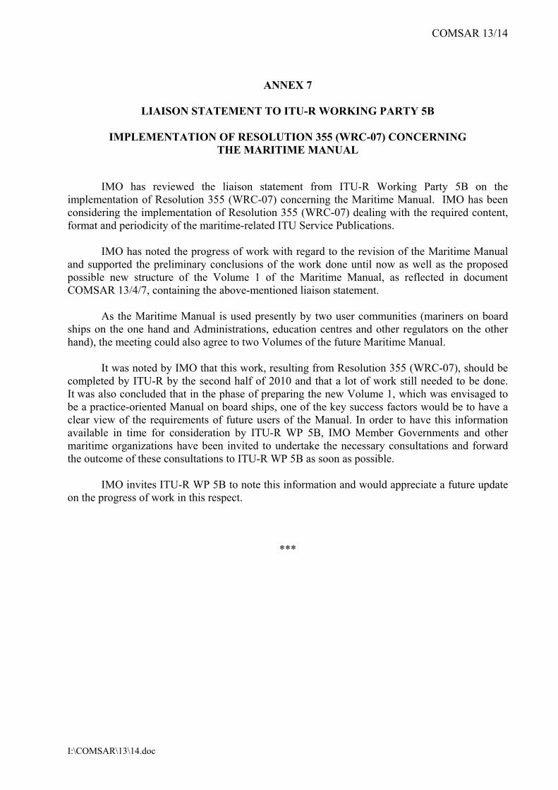
INTERNATIONAL MARITIME ORGANIZATION
IMO
E
SUB-COMMITTEE ON RADIOCOMMUNICATIONS AND SEARCH AND RESCUE 13th session Agenda item 14
COMSAR 13/14 6 February 2009 Original: ENGLISH
REPORT TO THE MARITIME SAFETY COMMITTEE
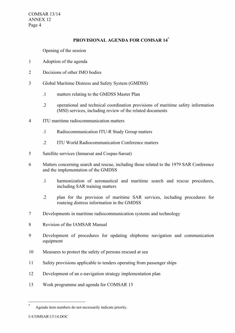
Table of contents Section Page No. 1 GENERAL 3 2 DECISIONS OF OTHER IMO BODIES 5 3 GLOBAL MARITIME DISTRESS AND SAFETY SYSTEM (GMDSS) 6 4 ITU MARITIME RADIOCOMMUNICATION MATTERS 11 5 SATELLITE SERVICES (Inmarsat and Cospas-Sarsat) 25 6 MATTERS CONCERNING SEARCH AND RESCUE, INCLUDING THOSE RELATED TO THE 1979 SAR CONFERENCE AND IMPLEMENTATION OF THE GMDSS 26 7 DEVELOPMENTS IN MARITIME RADIOCOMMUNICATION SYSTEMS AND TECHNOLOGY 36 8 REVISION OF THE IAMSAR MANUAL 40 9 DEVELOPMENT OF PROCEDURES FOR UPDATING SHIPBORNE NAVIGATION AND COMMUNICATION EQUIPMENT 40 10 MEASURES TO PROTECT THE SAFETY OF PERSONS RESCUED AT SEA 41 11 WORK PROGRAMME AND AGENDA FOR COMSAR 14 44 12 ELECTION OF CHAIRMAN AND VICE-CHAIRMAN FOR 2010 45 13 ANY OTHER BUSINESS 46 14 ACTION REQUESTED OF THE COMMITTEE 48
COMSAR 13/14 - 2 -
I:\COMSAR\13\14.doc
LIST OF ANNEXES ANNEX 1 DRAFT MSC CIRCULAR − REVISED JOINT IMO/IHO/WMO MANUAL ON
MARITIME SAFETY INFORMATION (MSI) ANNEX 2 COMSAR CIRCULAR − GUIDANCE ON DISTRESS ALERTS ANNEX 3 LIAISON STATEMENT TO ITU-R WP 5B AND CIRM – PROPOSED NEW
“DSC CLASS H” OF DSC PORTABLE RADIO INTENDED PRIMARILY FOR DISTRESS ALERTING AND COMMUNICATION
ANNEX 4 LIAISON STATEMENT TO ITU-R WP 5B, IALA, IEC TC 80 AND CIRM −
AUTOMATIC IDENTIFICATION SYSTEM (AIS) SEARCH AND RESCUE TRANSMITTER (AIS-SART)
ANNEX 5 LIAISON STATEMENT TO ITU-R WORKING PARTY 5B – REGULATORY
STATUS OF AIS FREQUENCIES FOR THE ITU WORLD RADIOCOMMUNICATION CONFERENCE 2011 (WRC-11)
ANNEX 6 PRELIMINARY DRAFT IMO POSITION ON WRC-11 AGENDA ITEMS
CONCERNING MATTERS RELATING TO MARITIME SERVICES ANNEX 7 LIAISON STATEMENT TO ITU-R WORKING PARTY 5B –
IMPLEMENTATION OF RESOLUTION 355 (WRC-07) CONCERNING THE MARITIME MANUAL
ANNEX 8 TERMS OF REFERENCE FOR THE JOINT IMO/ITU EXPERTS GROUP ON
MARITIME RADIOCOMMUNICATION MATTERS ANNEX 9 TERMS OF REFERENCE AND PROVISIONAL AGENDA FOR THE
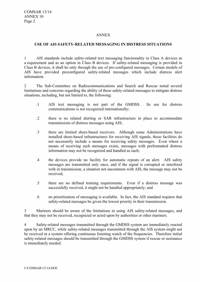
SIXTEENTH SESSION OF THE ICAO/IMO JOINT WORKING GROUP ANNEX 10 COMSAR CIRCULAR – AIS SAFETY-RELATED MESSAGING ANNEX 11 DRAFT MSC CIRCULAR − ADOPTION OF AMENDMENTS TO THE
INTERNATIONAL AERONAUTICAL AND MARITIME SEARCH AND RESCUE (IAMSAR) MANUAL
ANNEX 12 PROPOSED REVISED WORK PROGRAMME AND PROVISIONAL
AGENDA FOR COMSAR 14 ANNEX 13 STATUS OF THE PLANNED OUTPUTS OF THE SUB-COMMITTEE
RELATING TO THE HIGH-LEVEL ACTION PLAN OF THE ORGANIZATION AND PRIORITIES FOR THE 2008-2009 BIENNIUM
- 3 - COMSAR 13/14
I:\COMSAR\13\14.doc
1 GENERAL 1.1 The Sub-Committee on Radiocommunications and Search and Rescue held its thirteenth session from 19 to 23 January 2009 under the Chairmanship of Mr. C. Salgado (Chile). 1.2 The session was attended by delegations from the following countries:
ALGERIA ANGOLA ARGENTINA AUSTRALIA BAHAMAS BELGIUM BRAZIL BULGARIA CANADA CHILE CHINA COLOMBIA CÔTE D’IVOIRE CROATIA CYPRUS DEMOCRATIC PEOPLE’S REPUBLIC OF KOREA DENMARK DOMINICAN REPUBLIC ECUADOR EGYPT ESTONIA FINLAND FRANCE GERMANY GHANA GREECE INDONESIA IRAN (ISLAMIC REPUBLIC OF) IRELAND ISRAEL ITALY JAPAN KENYA LATVIA
LIBERIA MALAYSIA MALTA MARSHALL ISLANDS MEXICO MOROCCO NETHERLANDS NEW ZEALAND NIGERIA NORWAY PANAMA PAPUA NEW GUINEA PERU PHILIPPINES POLAND PORTUGAL REPUBLIC OF KOREA ROMANIA RUSSIAN FEDERATION SAUDI ARABIA SINGAPORE SOUTH AFRICA SPAIN SWEDEN TUNISIA TURKEY TUVALU UKRAINE UNITED KINGDOM UNITED STATES URUGUAY VANUATU VENEZUELA (BOLIVARIAN REPUBLIC OF)
and by the following Associate Member of IMO: HONG KONG, China 1.3 The following United Nations specialized agencies were also represented:
INTERNATIONAL TELECOMMUNICATION UNION (ITU)
COMSAR 13/14 - 4 -
I:\COMSAR\13\14.doc
WORLD METEOROLOGICAL ORGANIZATION (WMO) 1.4 The session was also attended by observers from the following intergovernmental organizations:
INTERNATIONAL HYDROGRAPHIC ORGANIZATION (IHO) EUROPEAN COMMISSION (EC) MARITIME ORGANIZATION FOR WEST AND CENTRAL AFRICA (MOWCA) LEAGUE OF ARAB STATES INTERNATIONAL COSPAS-SARSAT PROGRAMME AGREEMENT (COSPAS-SARSAT) INTERNATIONAL MOBILE SATELLITE ORGANIZATION (IMSO) EUROPEAN CONFERENCE OF POSTAL AND TELECOMMUNICATIONS ADMINISTRATIONS (CEPT)
and by observers from the following non-governmental organizations in consultative status:
INTERNATIONAL CHAMBER OF SHIPPING (ICS) INTERNATIONAL ELECTROTECHNICAL COMMISSION (IEC) INTERNATIONAL TRANSPORT WORKERS’ FEDERATION (ITF) INTERNATIONAL ASSOCIATION OF MARINE AIDS TO NAVIGATION AND LIGHTHOUSE AUTHORITIES (IALA) INTERNATIONAL RADIO-MARITIME COMMITTEE (CIRM) INTERNATIONAL ASSOCIATION OF CLASSIFICATION SOCIETIES (IACS) OIL COMPANIES INTERNATIONAL MARINE FORUM (OCIMF) INTERNATIONAL MARITIME PILOTS’ ASSOCIATION (IMPA) INTERNATIONAL FEDERATION OF SHIPMASTERS’ ASSOCIATIONS (IFSMA) INTERNATIONAL MARITIME RESCUE FEDERATION (IMRF) CRUISE LINES INTERNATIONAL ASSOCIATION (CLIA) INTERNATIONAL SHIP MANAGERS’ ASSOCIATION (INTERMANAGER) INTERNATIONAL SAILING FEDERATION (ISAF)
Secretary-General’s opening address 1.5 The Secretary-General welcomed participants and delivered his opening address. The full text of the opening address is reproduced in document COMSAR 13/INF.8. Chairman’s remarks 1.6 In responding, the Chairman thanked the Secretary-General for his words of guidance and encouragement and assured the Secretary-General that his advice and requests would be given every consideration in the deliberations of the Sub-Committee and its working groups. 1.7 The Indonesian delegation, on behalf of the Government of the Republic of Indonesia, conveyed the sincere appreciation of their Government for the expressions of condolences and support, which the Chairman, the Secretary-General and various delegations had extended in relation to the tragic accident of M.V. Teratai Prima. The delegation of Indonesia informed the Sub-Committee that authorities in Indonesia had conducted search and rescue operations around the clock to look for survivors and minimize the loss of life and were taking all necessary measures to improve the safety standards of its ferries. As an archipelagic country, sea transport was an essential means of transport for the people of Indonesia. With the assistance of IMO,
- 5 - COMSAR 13/14
I:\COMSAR\13\14.doc
Indonesia had conducted seminars and workshops in its efforts to solve problems related to ferry operation and to enhance safety. As a Member of IMO, Indonesia had always given very serious attention to efforts to enhance maritime safety and the protection of environment, particularly in the region. Adoption of the agenda and related matters 1.8 The Sub-Committee adopted the agenda (COMSAR 13/1), and agreed, in general, that the work of the Sub-Committee should be guided by the annotations to the provisional agenda and timetable (COMSAR 13/1/1), as amended. The agenda of the session with the list of documents submitted under each agenda item for consideration, is set out in document COMSAR 13/INF.9. 2 DECISIONS OF OTHER IMO BODIES 2.1 The Sub-Committee noted the decisions and comments pertaining to its work made by MSC 84, NAV 54 and MSC 85, as reported in documents COMSAR 13/2 and COMSAR 13/2/1 and took them into account in its deliberations under the relevant agenda items. 2.2 The Sub-Committee also noted the relevant decisions of FAL 35, which took place in the previous week and had been reported orally by the Secretariat under agenda item 10. Review of the Guidelines on the organization and method of work of the MSC and the MEPC and their subsidiary bodies 2.3 The Sub-Committee recalled that MSC 83, when considering the Guidelines on the organization and method of work of the MSC and the MEPC and their subsidiary bodies, had agreed that the Guidelines should be strictly adhered to, but, having recognized that, at the same time, flexibility was needed in certain circumstances, agreed that:
.1 intersessional working groups and technical groups should not be held at the same time as Committee or sub-committee meetings; and
.2 splinter groups of a working group, if established, should meet outside normal
working hours. 2.4 The Sub-Committee also recalled that MSC 83 had agreed to extend the deadline for submission of bulky information documents from 13 weeks to 9 weeks if they were submitted in electronic format and to amend the Committees’ Guidelines accordingly. 2.5 The Sub-Committee noted that MSC 84 had noted that MEPC 57 had concurred with the decisions of MSC 83 and had approved the corresponding draft amendments (MSC 84/21, annex) and had requested the Secretariat to prepare and circulate the revised Committees’ Guidelines by means of MSC-MEPC.1/Circ.2, which incorporated the approved amendments and superseded the existing Guidelines. 2.6 The Sub-Committee further noted that the agenda management procedure specified in paragraphs 3.13 to 3.25 of the Committee’s revised guidelines should be strictly adhered to and that this would reduce the need for various groups at a meeting as well as intersessional meetings, so that the agendas of all the Sub-Committees were manageable.
COMSAR 13/14 - 6 -
I:\COMSAR\13\14.doc
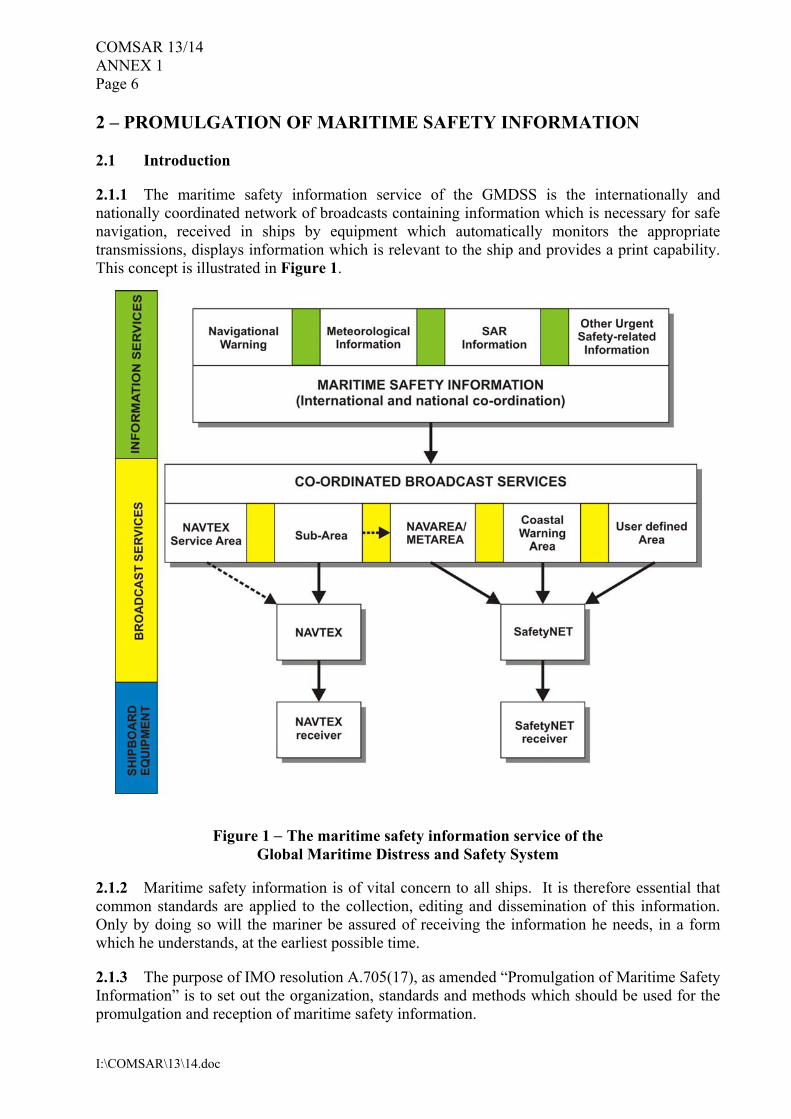
3 GLOBAL MARITIME DISTRESS AND SAFETY SYSTEM (GMDSS) MATTERS RELATING TO THE GMDSS MASTER PLAN 3.1 The Sub-Committee noted document COMSAR 13/3 (Secretariat) advising that, in accordance with its instructions and using information provided by Member Governments after April 2008, the Secretariat had issued GMDSS/Circ.10 on 22 July 2008 to amend GMDSS/Circ.9 (GMDSS Master Plan). Member Governments providing information after COMSAR 12, which was included in GMDSS/Circ.10, were: France, Norway and South Africa. 3.2 The Sub-Committee also noted that, since issuing GMDSS/Circ.10, up to the time of issuing document COMSAR 13/3, the Secretariat had received updated information from Australia, Greece, Singapore and South Africa. 3.3 The Sub-Committee further noted that, since issuing this document COMSAR 13/3, the Secretariat had received updates from Angola and Poland. The Secretariat was planning to issue GMDSS/Circ.11 in March 2009, after completion of the thirteenth session of the Sub-Committee. 3.4 Noting the above information, the Sub-Committee once again requested Member Governments to check their national data in GMDSS/Circ.10 and document COMSAR 13/3 for accuracy, and provide the Secretariat with any necessary amendments, as soon as possible, and to respond to MSC/Circ.684, if they had not already done so. OPERATIONAL AND TECHNICAL COORDINATION PROVISIONS OF MARITIME SAFETY INFORMATION (MSI) SERVICES, INCLUDING REVIEW OF THE RELATED DOCUMENTS 3.5 The Sub-Committee noted that MSC 85 had approved: .1 the amendments to resolution A.705(17) on the Promulgation of Maritime Safety
Information, for dissemination by means of MSC.1/Circ.1287; and .2 the amendments to resolution A.706(17), as amended on the IMO/IHO
World-Wide Navigational Warning Service, for dissemination by means of MSC.1/Circ.1288,
and decided that the adopted amendments should enter into force on 1 January 2010. Activities undertaken by the Commission on the Promulgation of Radio Navigational Warnings (CPRNW) and the NAVTEX Coordinating Panel 3.6 In considering document COMSAR 13/3/3 (IHO), the Sub-Committee noted with appreciation the outcome of the tenth session of the IHO Commission on the Promulgation of Radio Navigational Warnings (CPRNW) which was held from 25 to 29 August 2008. 3.7 The Sub-Committee noted the information provided by the delegation of the Islamic Republic of Iran on its intention of, and readiness for, being appointed as coordinator for the proposed Sub-area III for the Caspian Sea. The delegation stated that it had considered the matter very closely with all the national parties involved and had nominated themselves for coordinating this proposed Sub-area. To this end, the delegation of the Islamic Republic of Iran
- 7 - COMSAR 13/14
I:\COMSAR\13\14.doc
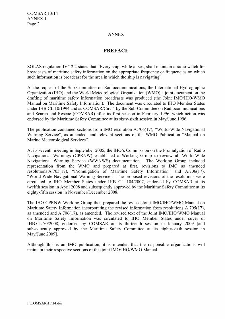
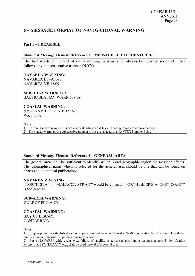
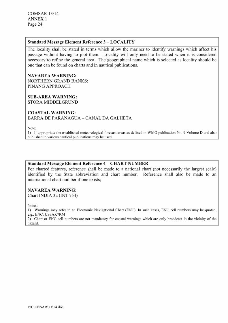
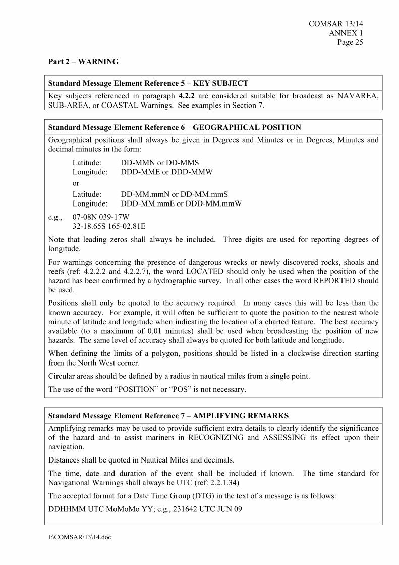
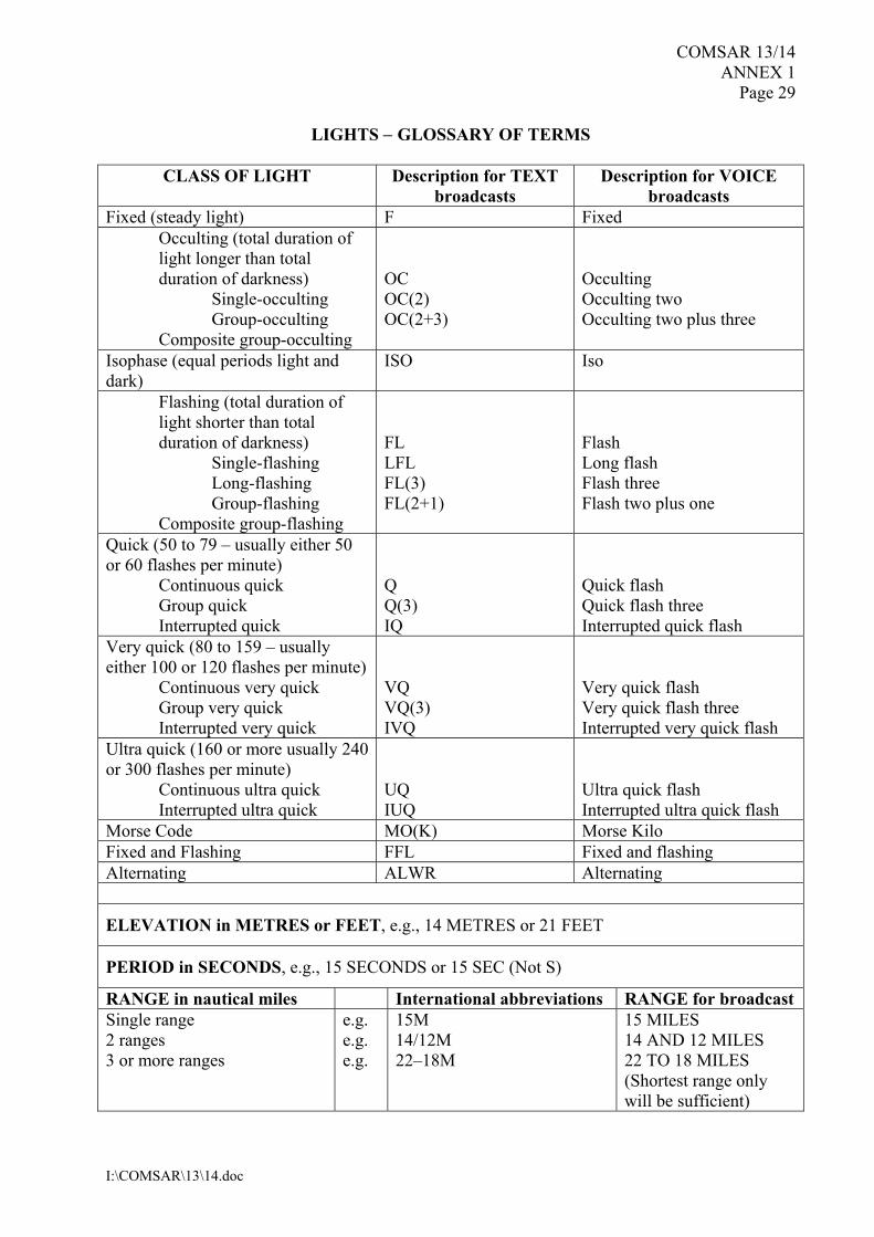
had submitted to CPRNW 10, officially through Spain as NAVAREA III Coordinator, the specific details of their capabilities, resources and infrastructures in the mentioned area. 3.8 The Sub-Committee also noted that the Chairman of the International NAVTEX Coordinating Panel, Cdr. Steve Godsiff, had retired last September and that the members of the Panel had unanimously endorsed Cdr. Tim Sewell as its new chairman. The Sub-Committee congratulated Mr. Sewell on his appointment and wished him all the best with this new assignment. The Sub-Committee invited the new Chairman of the NAVTEX Coordinating Panel to convey to Cdr. Steve Godsiff the sincere thanks and appreciation of the Sub-Committee for all the work done over the last ten years. 3.9 The Sub-Committee further noted the report of the Chairman, International NAVTEX Coordinating Panel (COMSAR 13/3/5), summarizing the current issues being addressed by the Panel and its activities since COMSAR 12. Review of the Joint IMO-IHO-WMO Manual on Maritime Safety Information 3.10 The Sub-Committee briefly considered documents COMSAR 13/3/1 and COMSAR 13/3/1/Corr.1 (IHO and WMO), containing a revised edition of the Joint IMO/IHO/WMO Manual on Maritime Safety Information. 3.11 The delegation of Chile, supported by several other delegations, proposed to have Section 7 of the draft manual also translated into the Spanish language. The Sub-Committee noted that it was of importance to present the information provided in section 7 in the French and Spanish languages, to cover those cases where there was a lack of knowledge of the English language, as well as for training purposes. It was further noted that section 7 provided extensive guidance and examples on the structure and text to be used in navigational warnings. IHO and WMO had suggested that section 7 should not be translated into other languages, as this would defeat the intention of ensuring greater uniformity by providing an extensive set of examples in the language in which the broadcast should be made (COMSAR 13/3/1, paragraph 4). The Sub-Committee also noted the view of France that section 7 of the draft manual needed to be translated in the French language as well. Finally, the view of the Russian Federation was noted, that section 7 should be translated in all official languages. 3.12 The Sub-Committee agreed that there was a need to translate the text of section 7 into Spanish and French, as the Organization’s working languages, for inclusion in the publications in these languages. The Sub-Committee further agreed that the message examples in the English language should also be included in a separate annex to the publications in Spanish and French. The Sub-Committee decided to refer documents COMSAR 13/3/1 and COMSAR 13/3/1/Corr.1 to the Technical Working Group for further consideration. Promulgation of Arctic MSI services 3.13 The Sub-Committee recalled that COMSAR 12 had re-established the Joint IMO/IHO/WMO Correspondence Group on Arctic MSI services with the following terms of reference: taking into account the proposed amended resolutions A.705(17) and A.706(17),
including the relevant decisions of COMSAR 10, COMSAR 11 and COMSAR 12, the Joint IMO/IHO/WMO Correspondence Group on Arctic MSI Services should consider and provide comments and recommendations relating to:
COMSAR 13/14 - 8 -
I:\COMSAR\13\14.doc
.1 the broadcast of MSI messages by each Arctic NAVAREA Coordinator/
METAREA Issuing Service as well as the international coordination and monitoring of such messages;
.2 the review of Inmarsat’s proposal with a view to identifying the preferred solution
for updating the Inmarsat System Definition Manual (SDM) as well as to establish a timeline for updating the existing SafetyNET terminals to allow receipt of MSI within the new NAVAREAs including the current coverage gaps elsewhere in the world;
.3 the determination of an implementation timeline for full Arctic MSI services; and .4 the determination of the training, assistance, and support necessary to achieve full
operational capability of Arctic MSI services as requested by the relevant Administrations and Data Providers,
and submit its report to COMSAR 13. 3.14 The Sub-Committee briefly considered document COMSAR 13/3/4 (Joint IMO/IHO/WMO Correspondence Group) containing the report on the work of the Correspondence Group on Arctic MSI Services, addressing the expansion of the World-Wide Navigational Warning Service (WWNWS) into the Arctic waters and decided to refer the detailed consideration of document COMSAR 13/3/4 to the Technical Working Group. List of NAVAREA Coordinators 3.15 Having briefly considered document COMSAR 13/3/2 (IHO), concerning a draft COMSAR circular containing a revised list of NAVAREA Coordinators, the Sub-Committee decided to refer this document to the Technical Working Group. ESTABLISHING THE TECHNICAL WORKING GROUP 3.16 The Sub-Committee instructed the Technical Working Group to consider documents COMSAR 13/3/1, COMSAR 13/3/1/Corr.1, COMSAR 13/3/2 and COMSAR 13/3/4, taking into account decisions of, and comments and proposals made in, Plenary and, in particular, to consider: .1 the proposed revised edition of the Joint IMO/IHO/WMO Manual on Maritime
Safety Information, given in documents COMSAR 13/3/1 and COMSAR 13/3/1/Cor.1 and prepare an associated draft MSC circular for approval by the Committee, at its eighty-sixth session;
.2 the updated list of NAVAREA Coordinators given in document COMSAR 13/3/2
and finalize a draft COMSAR circular on the list of NAVAREA Coordinators; and
.3 the recommendations given in paragraph 9 of document COMSAR 13/3/4 of the
Correspondence Group on Arctic MSI Services, and provide relevant comments and recommendations,
and report back to Plenary.
- 9 - COMSAR 13/14
I:\COMSAR\13\14.doc
Report of the Technical Working Group 3.17 Having received and considered the relevant part of the report of the Technical Working Group (COMSAR 13/WP.3, section 3), the Sub-Committee approved it in general, and took action as indicated hereunder. Proposed revised edition of the Joint IMO/IHO/WMO Manual on Maritime Safety Information 3.18 The Sub-Committee agreed that the Preface to the Joint Manual should include the following additional text: “Resolution A.706(17), as amended, on the World-Wide Navigational Warning Service (MSC.1/Circ.1288) at section 5.3.1 requires that “All NAVAREA, Sub-Area and coastal warnings shall be broadcast only in English in the International NAVTEX and SafetyNET services”. Where this Manual had been produced in languages other than English, then the message examples given in section 7 should also be provided in the English language in an additional annex”. 3.19 The Sub-Committee approved the proposed revised edition of the Joint IMO/IHO/WMO Manual on Maritime Safety Information, and the additional proposed amendments, set out in annex 1, and instructed the Secretariat to prepare a draft MSC circular on the Revised Joint IMO/IHO/WMO Manual on Maritime Safety Information (MSI), for consideration and approval by the Committee, at its eighty-sixth session. List of NAVAREA Coordinators 3.20 The Sub-Committee considered the updated list of NAVAREA Coordinators provided by IHO (COMSAR 13/3/2) and approved COMSAR.1/Circ.44 on the list of NAVAREA Coordinators with appropriate amendments. The Sub-Committee instructed the Secretariat to circulate it, and invited the Committee to endorse this action. Report of the Joint IMO/IHO/WMO Correspondence Group on Arctic Maritime Safety Information (MSI) Services 3.21 The Sub-Committee considered the report of the Joint IMO/IHO/WMO Correspondence Group on Arctic MSI Services (CG) and:
.1 noted the active participation, through national delegations, by members of the CG and the continued coordination with IHO CPRNW throughout the work of the CG;
.2 endorsed the recommendation of the CG that outside the limits of Inmarsat and
NAVTEX coverage, HF NBDP was the most feasible means for MSI dissemination;
.3 endorsed the recommendation of the CG that HF dissemination plans identified
for the NAVAREAs should also be utilized for the dissemination of METAREA information;
COMSAR 13/14 - 10 -
I:\COMSAR\13\14.doc
.4 endorsed the recommendation of the CG for dissemination of messages
by HF means, that when messages were also needed to be sent by SafetyNET, in order to avoid any misunderstanding these should carry a statement in the form that the “HF message xxx refers”;
.5 endorsed the recommendation of the CG that the use of “rectangular addressing”
for providing Arctic MSI services via Inmarsat-C was the preferred solution until the modification and inclusion of all Arctic NAVAREA/METAREA boundary limits could be incorporated into the System Definition Manual (SDM);
.6 endorsed the recommendation of the CG that there should be an overlap zone,
where possible, up to 300 NM between the Arctic NAVAREAs/METAREAs in order to ensure that ships received relevant information prior to their arrival in that NAVAREA/METAREA;
.7 endorsed the recommendation of the CG for live testing of the Arctic
NAVAREA/METAREA operations to be in 2009 and 2010 time frame, with a milestone goal of “Full Operational Status” being declared at COMSAR 15 in 2011; and
.8 noted the active participation in providing assistance for training and technical
support to the new Arctic NAVAREA Coordinators and the METAREA Issuing Services by the IHO CPRNW and the WMO respectively.
3.22 The Sub-Committee considered that it would be necessary to continue with the work of the Joint IMO/IHO/WMO Correspondence Group on Arctic MSI Services and re-established the Correspondence Group with the following terms of reference under the coordination of IHO*:
.1 monitor the testing of Arctic NAVAREAS/METAREAS including status, infrastructure, monitoring of messages and relationships with information providers (i.e. International Ice Patrol, METAREA Issuing Authorities, Search and Rescue authorities, National administrations and other NAVAREA Coordinators);
.2 facilitate the coordination of transmissions on the NAVTEX frequencies
of 518 kHz, 490 kHz and 4209.5 kHz through the International NAVTEX Coordinating Panel;
.3 facilitate the coordination of transmissions of SafetyNET messages through the
International SafetyNET Panel, including identification of prospective Service Providers;
* Coordinator:
Mr. Peter M. Doherty Chairman, IHO Promulgation of Radio Navigational Warnings Sub-Committee Attn: PVM, Mail Stop D-44 4600 Sangamore Road Bethesda, MD 20816-5003 United States Office: (301) 227-7646 Fax: (301) 227-3731 E-mail: [email protected]
- 11 - COMSAR 13/14
I:\COMSAR\13\14.doc
.4 determine NAVAREA/METAREA overlap zone limits in the use of rectangular
area addressing for SafetyNET; .5 develop Arctic NAVAREA/METAREA/NAVTEX coverage diagram including
service areas and times of transmission; .6 monitor Inmarsat’s progress on updating the System Definition Manual; and .7 monitor the status of training, assistance and support to achieve operational
capability of Arctic MSI services, and submit its report to COMSAR 14. REPORT OF THE 18TH SESSION OF THE BALTIC/BARENTS SEA REGIONAL CO-OPERATION ON MATTERS RELATING TO THE COMSAR SUB-COMMITTEE (BBRC/COMSAR-18) 3.23 The Sub-Committee noted the information provided by Norway (COMSAR 13/INF.6) containing the report on the outcome of the 18th session of the Baltic/Barents Sea Regional Co-operation on matters relating to the COMSAR Sub-Committee (BBRC/COMSAR-18). 4 ITU MARITIME RADIOCOMMUNICATION MATTERS RADIOCOMMUNICATION ITU-R STUDY GROUP 8 MATTERS 4.1 The Sub-Committee recalled that COMSAR 12 had: .1 approved a liaison statement to ITU-RWP 5B with regard to Recommendation
ITU-R M.493-12 in respect of DSC functionality. It reflected COMSAR 12’s consideration that, in line with the current guidance in MSC/Circ.803, the specification for Class D equipment should not include an excessive degree of functionality that would be inappropriate for the intended use on non-SOLAS vessels;
.2 approved a liaison statement to ITU-RWP 5B on AIS safety-related broadcast
messages used for distress purposes, requesting that distress messages should not be preconfigured;
.3 approved a liaison statement to ITU-RWP 5B on an identifier for AIS Search and
Rescue Transmitter (AIS-SART); and .4 agreed to the re-establishment of the Joint IMO/ITU Experts Group to discuss
common areas of interest and prepare the IMO position paper for submission to WRC-11.
4.2 The Sub-Committee noted that: .1 the meeting of the Joint IMO/ITU Experts Group was held at IMO Headquarters
from 10 to 12 June 2008;
COMSAR 13/14 - 12 -
I:\COMSAR\13\14.doc
.2 NAV 54 had approved a liaison statement to ITU-R WP 5B on satellite detection of AIS, informing WP 5B that further discussion in IMO was needed before any guidance on this issue could be given; and
.3 ITU-R WP 5B held its last meeting from 29 October to 7 November 2008. Outcome of the fourth meeting of the Joint IMO/ITU Experts Group on Maritime Radiocommunication Matters, 10 to 12 June 2008 4.3 In considering document COMSAR 13/4 (Secretariat), on the outcome of the fourth meeting of the Joint IMO/ITU Experts Group on Maritime radiocommunication matters, the Sub-Committee noted the information provided with regard to: .1 the satellite detection of AIS messages (see also paragraphs 4.12 to 4.15); .2 the implementation of Resolution 355 (WRC-07) concerning the Maritime
Manual (see also paragraphs 4.34 and 4.81 to 4.83); .3 the proposed new “DSC Class H” of DSC (see also paragraphs 4.16 to 4.27); and .4 the analysis of the outcome (including the resolutions) of WRC-07. 4.4 The Sub-Committee endorsed the action taken by the Experts Group in providing information to the relevant ITU-R Working Parties on non-controversial issues which needed to be brought quickly to the attention of ITU. 4.5 The Sub-Committee decided to refer to its ITU Working Group: .1 the consideration of the information with regard to the issues of relevance to the
maritime services on the agenda of WRC-11; and .2 the further development of the Preliminary draft IMO position on WRC-11
agenda items concerning matters relating to maritime services. Terms of Reference for the Technical Working Group 4.6 The Sub-Committee instructed the Technical Working Group, taking into account decisions of, and comments and proposals made in, Plenary, to consider paragraph 6 and annex 3 of document COMSAR 13/4 and finalize the proposed amendments to the draft revised “flow diagram on simplified operating guidance on initial distress calls”, and consider the proposed change of the title to “Guidance on distress alerts”, and submit its report for consideration at Plenary. Report of the Working Group 4.7 In considering the relevant part of the Technical Working Group’s report (COMSAR 13/WP.3, paragraphs 4.5 to 4.8), the Sub-Committee took action as indicated in the ensuing paragraphs.
- 13 - COMSAR 13/14
I:\COMSAR\13\14.doc
4.8 The Sub-Committee agreed to the general format of the diagram and to use the title “Guidance on distress alerts”. The following revisions were considered useful:
.1 remove text immediately under the title (DISTRESS button and voice calling on
radios/satellite installations); .2 remove first down arrow under the red button; .3 add the legend “use HANDSET for voice calling” next to the handset symbol; .4 align the sequence of OWN ID information with the spoken sequence and use
horizontal arrows to the “MAYDAY MAYDAY MAYDAY” yellow box for clarity in place of the OWN ID box;
.5 change “become” to “becomes” in legend below “PRESS RED BUTTON”; and .6 change “usefull” to “useful” in “MAYDAY” yellow box.
4.9 The Sub-Committee approved the proposed amendments and instructed the Secretariat to prepare a COMSAR circular on “Guidance on distress alerts” and circulate it as COMSAR.1/Circ.45, as set out in annex 2. The Sub-Committee invited the Committee to endorse this action. Outcome of the meeting of ITU-R Working Party 5B, 29 October to 7 November 2008 4.10 In considering document COMSAR 13/4/5 (Secretariat), on the outcome of the last meeting of ITU-R WP 5B, the Sub-Committee noted the information provided with regard to: .1 AIS Search and Rescue Transmitter (AIS-SART) (see also paragraphs 4.30
to 4.33); .2 the proposed new “DSC Class H” of DSC (see also paragraphs 4.16 to 4.27); .3 AIS Safety-related Broadcast messages used for Distress purposes; .4 a Preliminary Draft Revision of Recommendation ITU-R M.1842 on
Characteristics of VHF radio system and equipment for the exchange of data and electronic mail in the maritime mobile service appendix 18 channels;
.5 the implementation of Resolution 355 (WRC-07) concerning the Maritime
Manual (see also paragraphs 4.34 and 4.81 to 4.83); .6 ITU-R Recommendations; and .7 the valuable work done by the Joint IMO/ITU Experts Group. 4.11 The Sub-Committee decided to refer the information regarding the WRC-11 agenda items, as given in paragraphs 13 to 20 of document COMSAR 13/4/5, to its ITU Working Group for detailed consideration.
COMSAR 13/14 - 14 -
I:\COMSAR\13\14.doc
Satellite detection of AIS 4.12 Having noted the information provided in document COMSAR 13/4/5, the Sub-Committee also noted document COMSAR 13/INF.5 (Secretariat), containing a liaison statement from ITU-R WP 5B to IMO and IALA concerning Improved satellite detection of AIS. 4.13 The Sub-Committee further noted that MSC 85 had considered the issue of satellite detection of AIS (COMSAR 13/2/1, annex, paragraphs 4.26 to 4.34). Views were expressed at MSC 85 that: .1 the concept was still at the development stage; .2 it should be investigated whether the issue could be included in the e-navigation
strategy; .3 there was a need to study the matter of the commercial use of the data received by
satellites; .4 it was an option for the enhancement of maritime safety and security; .5 AIS was not conceived for satellite detection and the technology was still in
its infancy; .6 the possible future of AIS detection by satellite was not a replacement, but when
determined to be feasible, a supplement to LRIT; and .7 the matter should be dealt with by the Committee itself and that it was premature
at this stage to specify modifications to the shipborne AIS Class A equipment. Finally, the Committee decided to postpone discussion of the issue to its next session and invited interested delegations to submit relevant proposals for consideration under the agenda item “Any other business” to MSC 86. 4.14 The Sub-Committee also noted that the issue of satellite detection of AIS was, in principle, a matter for consideration by the NAV Sub-Committee. Several delegations were of the view that, in relation to the development of the Preliminary draft IMO position on WRC-11 agenda items concerning matters relating to maritime services, the issue needed to be discussed by this Sub-Committee as well. The Sub-Committee noted the view expressed by the delegation of France that there was a need to discuss the possible need for additional channels for satellite detection of AIS and which conditions should apply. The delegation stressed that this was particularly important in view of the limited time available to contribute to studies in ITU-R, as requested in Resolution 357 (WRC-07). 4.15 However, the majority of delegations were of the view that there was a need for a policy decision from the Maritime Safety Committee first, before the matter could be further discussed by the Sub-Committee. Therefore, the Sub-Committee decided to postpone any further discussions on this issue, awaiting the outcome of MSC 86.
- 15 - COMSAR 13/14
I:\COMSAR\13\14.doc
Proposed new “DSC Class H” of DSC 4.16 Having briefly considered documents COMSAR 13/4/1 (Secretariat) containing a liaison statement from ITU-R WP 5B to IMO and CIRM on a proposed new “DSC Class H” of DSC, COMSAR 13/4/4 (United States) encouraging the Sub-Committee to reply affirmatively to ITU’s liaison statement, COMSAR 13/4/9 (Canada) commenting on document COMSAR 13/4 and, in particular on a proposed new “DSC Class H” of DSC and COMSAR 13/4/10 (United Kingdom) commenting on document COMSAR 13/4/4, the Sub-Committee referred the matter to the Technical Working Group for detailed consideration. It was further decided to invite the SAR Working Group to provide the Technical Working Group with relevant advice from the SAR point of view. Terms of Reference for the SAR Working Group 4.17 The Sub-Committee instructed the SAR Working Group, taking into account decisions of, and comments and proposals made in, Plenary, to consider the issue of a “Proposed new “DSC Class H”” of DSC portable radio, using documents COMSAR 13/4/1, COMSAR 13/4/4, COMSAR 13/4/9 and COMSAR 13/4/10 as a reference and provide the Technical Working Group with relevant advice from the SAR point of view. Report of the SAR Working Group 4.18 In considering the relevant part of the SAR Working Group’s report (COMSAR 13/WP.2, paragraphs 3.1 to 3.4), the Sub-Committee noted the advice provided to the Technical Working Group. Terms of Reference for the Technical Working Group 4.19 The Sub-Committee instructed the Technical Working Group, taking into account decisions of, and comments and proposals made in, Plenary, to consider documents COMSAR 13/4/1, COMSAR 13/4/4, COMSAR 13/4/9 and COMSAR 13/4/10 on a “Proposed new “DSC Class H”” and prepare a liaison statement to ITU and CIRM, taking into account the advice provided by the SAR Working Group on this issue, and submit its report for consideration at Plenary. Report of the Technical Working Group 4.20 In considering the relevant part of the Technical Working Group’s report (COMSAR 13/WP.3, paragraphs 4.9 to 4.20), the Sub-Committee took action as indicated in the ensuing paragraphs. 4.21 The Sub-Committee noted that the Group had considered documents COMSAR 13/4/1, COMSAR 13/4/4, COMSAR 13/4/9 and COMSAR 13/4/10, taking into consideration the advice provided by the SAR Working Group, on the proposal for a new DSC handheld radio (termed Class H) and was of the opinion that there was a clear need for a handheld VHF radio with an appropriate range of DSC facilities for use on non-regulated vessels, usually operating within visibility range of the coast. The intention was to provide a simple cost-effective VHF handheld radio that would be able to:
COMSAR 13/14 - 16 -
I:\COMSAR\13\14.doc
.1 initiate a distress alert via DSC and a distress call via radiotelephony; .2 provide the unit’s location by means of a built-in GNSS receiver; and .3 support voice communications with rescue services in an emergency.
The inclusion of accurate location information obtained from GNSS with distress calls was vital to provide a rapid response to vessels in distress. The DSC alerting capability would also provide a more reliable communication path than voice distress calls on VHF Channel 16. 4.22 These handheld radios would not duplicate the functions provided by VHF/DSC communications equipment required under GMDSS compulsory carriage requirements but would be compatible with GMDSS procedures. They would not be suitable for replacing a fixed VHF/DSC installation but might be considered as a possible future replacement for the VHF portable two-way radiotelephone set specified for use on survival craft. The term “Class H” could, however, be misleading because the type of equipment envisaged was not intended to be an integral part of the GMDSS, rather it uses functionalities provided within the GMDSS. 4.23 The Sub-Committee noted that the Group had noted the concerns raised in Plenary, the SAR Working Group and also referenced in documents COMSAR 13/4/1 and COMSAR 13/4/9, about operational limitations, false alerts and operator competence. 4.24 The Sub-Committee also had concerns about how to avoid confusion when trying to identify the source of distress alerts from handheld radios. These were likely to move around with personnel to different vessels on a regular basis, rather than always being associated with a specific vessel. 4.25 On balance and taking account of the fact that VHF radios with basic DSC facilities, manufactured in accordance with RTCM standard SC101, were already in use, the Sub-Committee was of the opinion that it would be beneficial to provide industry and standards organizations with clear guidance on the performance capabilities needed to ensure that SAR Services were able to respond to distress alerts promptly and efficiently. 4.26 The Sub-Committee accepted the case for a handheld VHF radio with certain DSC facilities as described in paragraph 7 of document COMSAR 13/4/4 and was of the opinion that the most important characteristics of such a radio were:
.1 simple operational layout, minimizing accidental misuse; .2 GNSS position acquisition; .3 identification/registration of each individual unit to a named individual (as already
carried out for example by Australia and the United Kingdom); and .4 minimum number of options beyond the essential requirements.
4.27 The Sub-Committee approved a draft liaison statement to ITU-R WP 5B and CIRM, set out at annex 3, and instructed the Secretariat to convey it to ITU and CIRM, and invited the Committee to endorse this action.
- 17 - COMSAR 13/14
I:\COMSAR\13\14.doc
Excessive disturbance from DSC alarms 4.28 The Sub-Committee considered the information given in document COMSAR 13/4/9 (Canada) that increasing deployment of DSC capable VHF radios to replace VHF radiotelephones can lead to a situation where multiple DSC sets on a small vessel will sound an alarm upon receiving each DSC announcement of a safety message. 4.29 The Sub-Committee expressed sympathy with the reported predicament and invited Member Governments and international organizations to submit further information on this issue, together with means of solution, to future meetings of the Sub-Committee and other appropriate fora. AIS Search and Rescue Transmitters (AIS-SARTs) 4.30 The Sub-Committee briefly considered document COMSAR 13/4/6 (Secretariat), containing a liaison statement from ITU-R WP 5B on AIS Search and Rescue Transmitters (AIS-SARTs), and decided to refer the matter to the Technical Working Group, for detailed consideration. Terms of Reference for the Technical Working Group 4.31 The Sub-Committee instructed the Technical Working Group, taking into account decisions of, and comments and proposals made in, Plenary, to consider document COMSAR 13/4/6 on AIS Search and Rescue Transmitters (AIS-SARTs) and prepare a liaison statement to ITU, IALA, IEC TC80 and CIRM, and submit its report for consideration at Plenary. Report of the Technical Working Group 4.32 In considering the relevant part of the Technical Working Group’s report (COMSAR 13/WP.3, paragraphs 4.1 to 4.4), the Sub-Committee took action as indicated in the ensuing paragraphs. 4.33 The Sub-Committee approved a liaison statement to ITU-R WP 5B, IALA, IEC TC 80 and CIRM, as set out in annex 4 and instructed the Secretariat to convey it to ITU, IALA, IEC and CIRM, and invited the Committee to endorse this action. Implementation of Resolution 355 (WRC-07) concerning the Maritime Manual 4.34 The Sub-Committee briefly considered document COMSAR 13/4/7, containing a liaison statement from ITU-R WP 5B with regard to the Implementation of Resolution 355 (WRC-07) concerning the Maritime Manual, and decided to refer the matter to its ITU Working Group, for detailed consideration. ITU WORLD RADIOCOMMUNICATION CONFERENCE MATTERS 4.35 The Sub-Committee recalled that COMSAR 12 had approved a liaison statement to IHO and ISO on ship and port security requirements for ITU’s World Radiocommunication Conference 2011 (WRC-11), requesting specific background information on relevant procedural and standardization aspects.
COMSAR 13/14 - 18 -
I:\COMSAR\13\14.doc
4.36 The Sub-Committee noted document COMSAR 13/2/1, annex, paragraphs 4.18 to 4.25 (Secretariat), providing an overview of the information provided to MSC 85 concerning the issue of Spectrum requirements and potential frequency bands suitable to support communication on ship and port security and enhanced maritime safety systems, currently under discussion in the context of the development of the Preliminary draft IMO position on WRC-11 Agenda item 1.10. MSC 85 had noted that the information available was considered to be not comprehensive enough and that the matter needed to be first discussed further at COMSAR 13 before it could be considered by the Committee; and concluded by requesting interested delegations to submit proposals to COMSAR 13 on this issue and relaxed the deadline for submissions, on this matter only, to 19 December 2008. 4.37 The Sub-Committee briefly considered document COMSAR 13/4/2/Rev.1 (Secretariat), containing a revised liaison statement from IHO on Ship and port security requirements in relation to the preparation of the IMO position on WRC-11 Agenda item 1.10, and decided to refer the matter to its ITU Working Group, for detailed consideration. 4.38 The Sub-Committee also briefly considered document COMSAR 13/4/3 (Secretariat), containing a liaison statement from ISO on radio spectrum requirements for radio frequency identification devices (RFID) used on cargo containers to enhance ship and cargo identification, tracking and surveillance for ship and port security purposes, in relation to the preparation of the IMO position on WRC-11 Agenda item 1.10, and decided to refer the matter to its ITU Working Group, for detailed consideration. 4.39 Having briefly considered document COMSAR 13/4/8 (United States), providing an overview of the maritime issues related to WRC-11, Agenda item 1.10 and proposing a draft IMO liaison statement to ITU-R WP 5B concerning the status of the two existing AIS frequencies used for Safety of Navigation, inviting ITU to evaluate the appropriate designation of the two AIS frequencies within the ITU Radio Regulations, the Sub-Committee decided to refer the matter to its ITU Working Group, for detailed consideration. 4.40 The Sub-Committee also briefly considered documents COMSAR 13/4/11 (France), containing information with regard to maritime issues related to WRC-11, Agenda item 1.10 and COMSAR 13/4/12 (France), explaining how the agenda for a WRC is elaborated and also providing the timetable requirement associated with WRC-11. The Sub-Committee noted the view expressed by the delegation of the United Kingdom that, due to the limited time available, there was a need for interested Member Governments to participate in the next meeting of the Joint IMO/ITU Experts Group, to be held intersessionally. The Sub-Committee further decided to refer documents COMSAR 13/4/11 and COMSAR 13/4/12 to its ITU Working Group for detailed consideration. ESTABLISHING THE ITU WORKING GROUP 4.41 The Sub-Committee instructed the ITU Working Group to consider documents COMSAR 13/4, COMSAR 13/4/2/Rev.1, COMSAR 13/4/3, COMSAR 13/4/5, COMSAR 13/4/7, COMSAR 13/4/8, COMSAR 13/4/11 and COMSAR 13/4/12, taking into account decisions of, and comments and proposals made in, Plenary and, in particular, to consider: .1 document COMSAR 13/4 and provide comments and recommendations with
regard to the issues of relevance to the maritime services on the agenda of WRC-11;
- 19 - COMSAR 13/14
I:\COMSAR\13\14.doc
.2 documents COMSAR 13/4, COMSAR 13/4/2/Rev.1, COMSAR 13/4/3, COMSAR 13/4/5, COMSAR 13/4/8 and COMSAR 13/4/11 and further develop the Preliminary draft IMO position on WRC-11 agenda items concerning matters relating to maritime services, except the issue of satellite detection of AIS, which was subject to a decision by MSC 86;
.3 document COMSAR 13/4/7 with regard to the Implementation of Resolution 355
(WRC-07) concerning the Maritime Manual and provide comments and recommendations and prepare a liaison statement to ITU-R WP 5B; and
.4 the need for the continuation of the Joint IMO/ITU Experts Group, taking into
account document COMSAR 13/4/12 and, if so, prepare draft terms of reference for this group (in consultation with the ITU Secretariat it has been agreed that a meeting for the Experts Group be scheduled from 23 to 25 June 2009 at IMO Headquarters),
and prepare a report for consideration by Plenary. Report of the ITU Working Group 4.42 Having received and considered the report of the ITU Working Group (COMSAR 13/WP.4), the Sub-Committee approved it, in general, and took action as indicated in the ensuing paragraphs. World Radiocommunication Conference 2011 (WRC-11) General 4.43 The Sub-Committee noted the following comments and recommendations with regard to the issues of relevance to the maritime services on the agenda of WRC-11, on issues of relevance to IMO. WRC-11 Agenda item 1.2 4.44 The Sub-Committee noted that this agenda item and the associated Resolution 951 were directed towards providing for more flexibility in spectrum use by changing or adapting the international spectrum management framework. The Sub-Committee noted that the Group had agreed with the first Preliminary draft IMO position prepared by the Joint IMO/ITU Experts Group on maritime radiocommunication matters. WRC-11 Agenda item 1.3 4.45 The Sub-Committee noted that this agenda item was looking for spectrum requirements for command and control and for the purposes of sense and avoidance of unmanned aircraft systems (UAS). 4.46 The Sub-Committee appreciated the work done by ITU and supported this agenda item. However, the Sub-Committee was of the opinion that allocation of frequencies should not have any adverse impact on maritime distress and safety services. In addition, the Sub-Committee was of the view that Administrations which were contemplating the use of UAS for maritime purposes should inform IMO, as appropriate.
COMSAR 13/14 - 20 -
I:\COMSAR\13\14.doc
WRC-11 Agenda item 1.5 4.47 The Sub-Committee noted that the use of radio equipment by services ancillary to broadcasting (BAS), commonly described as electronic news gathering (ENG), operating terrestrially in appropriate fixed and mobile service bands was an element in the coverage of public events in all countries where the public interest was served by live news coverage of breaking events, especially during disasters or potential disasters affecting public safety. There was an increasing demand from the audiences for the quantity and quality of coverage of sound and television ENG and for this reason a lot of spectrum was under consideration in order to ensure worldwide harmonization, which could impact on maritime usage. The background information of the agenda item was amended accordingly. WRC-11 Agenda item 1.7 4.48 The Sub-Committee noted that the Group had agreed with the first Preliminary draft IMO position prepared by the Joint IMO/ITU Experts Group on maritime radiocommunication matters. WRC-11 Agenda item 1.9 4.49 The Sub-Committee recalled the decision of COMSAR 12 that the frequencies currently allocated for use by the GMDSS needed to be retained because IMO had no intention to change the requirements for NBDP and DSC at this moment in time and these requirements should be retained in Appendix 15. The Sub-Committee noted that the spectrum that would have to remain dedicated to NBDP and DSC, in order to support the functional requirements of distress communications and the promulgation of MSI, only amounted to a small fraction of the Appendix 17 bands, the major portion of which would then become available for new digital technologies for the maritime mobile service. 4.50 The Sub-Committee noted that WP 5B had prepared a Working document towards Preliminary Draft Revision of Recommendation ITU-R M.1798 on Characteristics of HF radio equipment for the exchange of digital data and electronic mail in the maritime mobile service. WP 5B had further worked on the proposed text towards the draft CPM Report for WRC-11 on this agenda item. 4.51 The Sub-Committee noted that the Group had agreed with the first Preliminary draft IMO position prepared by the Joint IMO/ITU Experts Group on maritime radiocommunication matters. WRC-11 Agenda item 1.10 Matters related to AIS 4.52 The Sub-Committee concurred that the ITU Radio Regulations only recognized the AIS-SART operation as having a safety function on the two AIS frequencies. For the other usage the AIS frequencies were shared with the land mobile and aeronautical mobile services. Regulatory studies were needed in order to re-evaluate the status of those frequencies taking into account the AIS ship-to-ship collision avoidance function.
- 21 - COMSAR 13/14
I:\COMSAR\13\14.doc
4.53 The Sub-Committee approved a liaison statement to ITU WP 5B, as set out in annex 5, concerning the non-status of the two existing AIS frequencies used for Safety of Navigation, requesting ITU to evaluate the appropriate designation of the two AIS frequencies within the ITU Radio Regulations. The Secretariat was instructed to convey it to ITU and the Committee was invited to endorse this action. In addition, the preliminary IMO position on Agenda item 1.10 was amended accordingly. 4.54 The Sub-Committee agreed that issues of AIS frequencies status needed to be considered by the Sub-Committee on Safety of Navigation and invited the Committee to instruct the NAV Sub-Committee to consider issues related to the status of the current AIS frequencies and advise COMSAR 14 accordingly. Matters related to security communications and the broadcast of security information to and from ships 4.55 The Sub-Committee noted that Article 33 of the Radio Regulations (RR) described the operational procedures for maritime urgency and safety communications, including the transmission of maritime safety information. Security communications and transmissions of maritime security information were not explicitly treated in the RR but these types of transmissions would likely fall under Article 33. Since it could be argued that security related to the movements and needs of ships and since certain security information might be classified as urgent, most transmissions might already meet the requirements of Article 33 and might be made over GMDSS systems. Clarifications to Article 33 might be necessary. 4.56 The Sub-Committee also noted in this respect that the Group had amended the preliminary IMO position on Agenda item 1.10 accordingly. Spectrum requirements for identification and security of cargo containers entering and leaving international ports and ships 4.57 The Sub-Committee noted that with the large and increasing numbers of cargo containers entering and leaving international ports, there was a growing need to identify and maintain the security of these containers from port of origin to port of destination. This required technology using radio spectrum consistently available and protected in any port accepting cargo containers in any country. ISO TC104 was developing standards for RFID devices used on cargo containers for this purpose, but other spectrum-dependent technology, such as mesh networks, was also being developed, which might help meet this need. ISO (COMSAR 13/4/3) believed that one of the reasons that freight container tracking had been slow to adopt RFID technologies was the lack of a common frequency band that could be used economically on a worldwide basis. The allocation of spectrum in ports necessary for the identification and security of cargo containers might improve the effectiveness and international interoperability of such systems, without causing interference to other uses of that spectrum outside of ports. Additional studies might be required to assess the current and future RFID technology for cargo container systems. 4.58 The Sub-Committee also noted the views of the delegation of China, that more information and data were still needed to demonstrate the necessity and compelling need for the allocation of additional spectrum. 4.59 In view of the above, the Sub-Committee agreed to seek guidance from the Sub-Committee on Dangerous Goods, Solid Cargoes and Containers on the issue of tracking and identification of cargo containers and invited the Committee to instruct the DSC Sub-Committee
COMSAR 13/14 - 22 -
I:\COMSAR\13\14.doc
to consider the issue of tracking and identification of cargo containers and advise COMSAR 14 accordingly. Member Governments were also invited to submit relevant proposals on the issue to the proposed next meeting of the Joint IMO/ITU Experts Group in June 2009 and COMSAR 14. Modernization of shipboard and port safety and security communication systems including e-navigation 4.60 The Sub-Committee recalled that both the COMSAR and the NAV Sub-Committees were reviewing technology which might require amendments to the Radio Regulations and possibly new allocations of spectrum. For example, COMSAR 12 was in favour of leaving options for the development of VHF radios systems and technology open for further discussions including, but not limited to, retention of VHF voice communications, possibly using 12.5 kHz channel spacing; narrow band digital voice and data communication using 6.25 kHz channel spacing; and broadband data communications using two or more 25 kHz adjacent channels, using digital data technologies in infrastructure mode or in direct mode. The 100 and 1200 baud data limitations of 518 kHz NAVTEX and Inmarsat-C SafetyNET, respectively, had long been a complaint by certain users and providers of maritime safety information, and were likely inadequate for the evolving need for graphical navigation as well as increasing needs for meteorological, search and rescue and security information, particularly information intended for presentation on integrated shipboard navigational display systems. 4.61 With regard to modernization of the VHF shipborne equipment, the Sub-Committee noted that the Group was of the view that the key elements outlined in the report of COMSAR 12 (COMSAR 12/15, paragraph 4.26) were of interest and needed to be further studied and developed in the future. 4.62 The Sub-Committee also noted in this respect that the Group had amended the preliminary IMO position on Agenda item 1.10 accordingly. 4.63 The Sub-Committee endorsed the view of IHO (COMSAR 13/4/2/Rev.1) that there might be a requirement for additional spectrum to be allocated for broadcasting of more than changes to port security levels in major ports and coastal waters. The Sub-Committee agreed that the band 495-505 kHz could be of interest to IMO for this purpose. 4.64 With respect to e-navigation, the Sub-Committee agreed to request the NAV Sub-Committee to consider this issue of future spectrum requirement and invited the Committee to instruct the NAV Sub-Committee to consider future spectrum requirement with respect to e-navigation and advise COMSAR 14 accordingly. WRC-11 Agenda item 1.14 4.65 The Sub-Committee noted that not only the distress frequencies, its guard bands and the frequencies in use for AIS needed to be protected, but that all VHF frequencies in use by the maritime services needed protection against the use of the VHF band by the radiolocation service. A lot of interference had been caused by radars operating in the VHF band and WP 5B had been invited to study the technical characteristics in order to protect the maritime services. 4.66 The Sub-Committee also noted that the Group had agreed with the first Preliminary draft IMO position prepared by the Joint IMO/ITU Experts Group on maritime radiocommunication matters.
- 23 - COMSAR 13/14
I:\COMSAR\13\14.doc
WRC-11 Agenda item 1.15 4.67 The Sub-Committee noted that a liaison statement had been sent to Working Parties 5A, 7D, 6A, 5C and 7B, stating that WP 5B intended to conduct sharing analyses between radiolocation service applications (between 3 and 50 MHz to support HF oceanographic radar operations of sea states and wave conditions) and incumbent services in the bands identified to be suitable for the operation of high-frequency oceanographic radar systems and that it would take into account the characteristics of incumbent services and would keep the other Working Parties informed of the results. 4.68 The Sub-Committee also noted that the Group had agreed with the first Preliminary draft IMO position prepared by the Joint IMO/ITU Experts Group on maritime radiocommunication matters. WRC-11 Agenda item 1.17 4.69 The Sub-Committee noted that the Group had agreed with the first Preliminary draft IMO position prepared by the Joint IMO/ITU Experts Group on maritime radiocommunication matters. WRC-11 Agenda item 1.18 4.70 The Sub-Committee noted that the Group had agreed with the first Preliminary draft IMO position prepared by the Joint IMO/ITU Experts Group on maritime radiocommunication matters. WRC-11 Agenda items 1.19 and 1.22 4.71 The Sub-Committee noted that Agenda items 1.19 and 1.22 were very closely related. 4.72 The Sub-Committee also noted that WP 5B had sent a liaison statement to WP 1A regarding information on short-range devices required for WRC-11, Agenda item 1.22, which referred to the conclusion of a study conducted in ITU-R TG 1/8 (SM.2057) that, without constraints, those short-range devices had the potential to cause harmful interference to the maritime mobile service including the Global Maritime Distress and Safety System (GMDSS), aeronautical mobile services and radio determination services. 4.73 The Sub-Committee further noted the draft IMO position regarding Agenda item 1.19 and also noted that the Group could not agree on a draft IMO position for Agenda item 1.22. WRC-11 Agenda item 1.23 4.74 The Sub-Committee recalled that, at COMSAR 12, it had considered the proposal by IFSMA to preserve the heritage of the important frequency 500 kHz, and that it was considered that this frequency could be better used in future. The Sub-Committee had also considered it necessary to be very careful not to lose access to this very important frequency band, currently controlled in the maritime environment.
COMSAR 13/14 - 24 -
I:\COMSAR\13\14.doc
4.75 The Sub-Committee noted that WP 5B had sent a liaison statement to WP 5A on studies related to WRC-11 Agenda item 1.23 stating that, prior to identification of preferred frequency bands for secondary amateur allocations in the 415-526.5 kHz bands, the maritime service must first consider existing and future requirements for ship and port safety spectrum in existing maritime spectrum to solve Agenda item 1.10. It was also noted that the band was also under study for the provision of future systems for enhancing of safety of navigation at sea (e-navigation applications). WRC-11 Agenda items 2 and 4 4.76 The Sub-Committee agreed that with respect to the initial list of Resolutions and Recommendations of relevance developed by the Joint IMO/ITU Experts Group (COMSAR 13/4, annex 5 (annexes 1 and 2)) there was no need to amend these annexes. WRC-11 Agenda item 8.2 4.77 The Sub-Committee noted that Agenda item 8.2 was the development of the preliminary agenda for the next WRC in 2015. If IMO identified the need for new WRC agenda item(s), the Organization would have to ensure that clearly-defined proposals for the inclusion of agenda item(s) for WRC-15 were finalized in time for COMSAR 15 in 2011. Member Governments needed to be informed in time to include these proposals in their submissions to WRC-11. 4.78 The Sub-Committee further noted that there was a need to inform, directly after COMSAR 14 (March 2010), ITU-R Working Party 5B on the status of the IMO position regarding WRC-11. This would enable WP 5B to include relevant text into the draft CPM report, to be finalized by WP 5B in May 2010. Therefore, the Sub-Committee agreed to invite the Committee to authorize the Secretariat to forward the draft IMO position, directly after COMSAR 14 and prior to approval by MSC 87, to ITU-R Working Party 5B in order to inform ITU in time on the status of the IMO position regarding WRC-11. 4.79 The detailed preliminary draft IMO position relating to WRC-11, Agenda items 1.2, 1.3, 1.5, 1.7, 1.9, 1.10, 1.15, 1.17, 1.18, 1.19, 1.22, 1.23, 2, 4 and 8.2 are set out in annex 6. 4.80 The Sub-Committee encouraged Member Governments to submit relevant proposals to the proposed next meeting of the Joint IMO/ITU Experts Group meeting in June 2009. Taking into account that COMSAR 14 needed to finalize the draft IMO position, the Sub-Committee considered the next meeting of the Joint IMO/ITU Experts Group to be of utmost importance for the further development of the draft IMO position. Implementation of Resolution 355 (WRC-07) concerning the Maritime Manual 4.81 The Sub-Committee noted that ITU-R WP 5B had been considering the implementation of Resolution 355 (WRC-07) dealing with the required content, format and periodicity of the maritime-related ITU Service Publications. In this context, the Sub-Committee also noted that the Maritime Manual was subject to further study and in line with the advice of the fourth meeting of the Joint IMO/ITU Experts Group; ITU-R WP 5B had reached agreement on the possible new structure of the Maritime Manual, which would result in two volumes. It was envisaged that volume 1 would be used in future as a practice-oriented Manual on board ships. The proposed volume 2 would be an edited version of the current Maritime Manual. It was
- 25 - COMSAR 13/14
I:\COMSAR\13\14.doc
envisaged that this volume would be used by Administrations, education centres, (M)RCCs, SAR organizations, coast guards, etc. 4.82 The Sub-Committee invited Member Governments and other maritime organizations to undertake the necessary consultations and forward the outcome of these consultations to ITU-R WP 5B as soon as possible for the preparation of the Maritime Manual. 4.83 The Sub-Committee agreed to the proposed new structure of the new Maritime Manual and approved a liaison statement to ITU-R Working Party 5B on the matter, as set out in annex 7, and instructed the Secretariat to convey it to ITU and invited the Committee to endorse this action. Joint IMO/ITU Experts Group 4.84 The Sub-Committee endorsed the need for the re-establishment of a Joint IMO/ITU Experts Group. This would be necessary in order to discuss common areas of interest and prepare the IMO position document for submission to WRC-11. Accordingly, the Sub-Committee approved the terms of reference as set out in annex 8, and the holding of an intersessional meeting from 23 to 25 June 2009 at IMO Headquarters. The Sub-Committee invited the Committee to endorse this action. 5 SATELLITE SERVICES (Inmarsat and Cospas-Sarsat) 5.1 The Sub-Committee noted that MSC 85 had noted the information contained in COMSAR.1/Circ.42 on the List of Coast Earth Station Operation Coordinators in the Inmarsat system to be a routine update of information provided by IMSO and accordingly authorized the Secretariat to revise and publish the COMSAR circular on the List of Coast Earth Station (CES) Operation Coordinators in the Inmarsat system on an annual basis, without bringing it first to the attention of the Sub-Committee for approval. 5.2 The Sub-Committee further noted that the Secretariat, in consultation with IMSO, was in the process of revising COMSAR.1/Circ.42 on the List of Coast Earth Station (CES) Operation Coordinators in the Inmarsat system and it was anticipated that the revised COMSAR circular would be issued in February 2009. INMARSAT SERVICES 5.3 The Sub-Committee noted with appreciation the information contained in document COMSAR 13/5/2 (IMSO), providing an analysis and assessment of the performance by Inmarsat Global Ltd. of the company’s obligations for the provision of maritime services within the GMDSS, as overseen by IMSO, generally covering the period from 1 January to 31 October 2008. IMSO had assessed that, during this period, Inmarsat had continued to provide a sufficient quality of service to meet its obligations under the GMDSS. The delegation of the United States expressed high appreciation for the information provided by IMSO. List of Rescue Coordination Centres (RCCs) associated with Inmarsat Land Earth Stations (LESs) 5.4 The Sub-Committee noted document COMSAR 13/5, advising that the Secretariat, in consultation with Inmarsat, had revised COMSAR/Circ.19 on the List of Rescue Coordination Centres (RCCs) associated with Inmarsat Land Earth Stations (LESs). The Sub-Committee
COMSAR 13/14 - 26 -
I:\COMSAR\13\14.doc
approved the revised text, taking into account the updated information provided by Japan. Having noted the request from the delegation of the United Kingdom, inviting Member Governments to submit any changes needed to the annex to document COMSAR 13/5 to Inmarsat, the Sub-Committee instructed the Secretariat to circulate the revised circular by means of a new COMSAR circular, revoking COMSAR/Circ.19, taking into account any updates submitted to Inmarsat. In order to allow Member Governments time to submit the updated information, it was decided to circulate the revised COMSAR circular in April 2009. 5.5 Taking into account the fact that it was a routine update of information provided by Inmarsat and that there was no compelling need to bring the changes to this factual information to the Sub-Committee for approval, the Sub-Committee considered it appropriate to authorize the Secretariat, in future, to revise and publish this COMSAR circular on the List of Rescue Coordination Centres (RCCs) associated with Inmarsat Land Earth Stations (LESs) on an annual basis, without bringing it first to the attention of the Sub-Committee for approval. The Committee was requested to endorse this authorization. COSPAS-SARSAT SERVICES 5.6 The Sub-Committee noted, with appreciation, the information contained in document COMSAR 13/5/1 (Cospas-Sarsat), providing a status report on the Cospas-Sarsat System, including System operations, space and ground segments, and beacons, the International 406 MHz Beacon Registration Database (IBRD), false alerts and interference. 5.7 The Sub-Committee further noted document COMSAR 13/INF.7 (Cospas-Sarsat), providing information regarding document C/S G.007 “Handbook on Distress Alert Messages for RCCs, SPOCs and IMO Ship Security Competent Authorities”. The Sub-Committee thanked Cospas-Sarsat for providing the valuable Handbook and agreed to include it in the list of documents and publications which should be held by a Maritime Rescue Coordination Centre (MRCC), and instructed the Secretariat accordingly. The Secretariat was also instructed to prepare further updates of this circular, as deemed necessary, and to circulate the updated document as SAR.7/Circ.9. The Committee was invited to endorse this action. 6 MATTERS CONCERNING SEARCH AND RESCUE, INCLUDING THOSE
RELATED TO THE 1979 SAR CONFERENCE AND IMPLEMENTATION OF THE GMDSS
HARMONIZATION OF AERONAUTICAL AND MARITIME SEARCH AND RESCUE PROCEDURES, INCLUDING SAR TRAINING MATTERS 6.1 The Sub-Committee noted that, as requested by COMSAR 12, MSC 84 had extended the target completion date for the work programme agenda item “Harmonization of aeronautical and maritime search and rescue procedures, including SAR training matters” to 2009. 15th meeting of the ICAO/IMO Joint Working Group on the Harmonization of Aeronautical and Maritime SAR 6.2 The Sub-Committee noted that, as agreed by COMSAR 12 and already approved by MSC 83, the 15th meeting of the International Civil Aviation Organization/International Maritime Organization (ICAO/IMO) Joint Working Group (JWG) on the Harmonization of Aeronautical and Maritime Search and Rescue was held in Canberra, Australia, from 29 September to 3 October 2008.
- 27 - COMSAR 13/14
I:\COMSAR\13\14.doc
6.3 In considering document COMSAR 13/6 (Secretariat), containing the report of the fifteenth session of the ICAO/IMO Joint Working Group on Harmonization of Aeronautical and Maritime Search and Rescue, the Sub-Committee noted the information provided, and in particular with regard to: .1 recommendation 15/2, that MSC 85 had:
.1 noted that there was a need for a major update and restructuring and that there was no need to start developing a complete new manual; and
.2 endorsed the establishment of the Editorial Group, including its Terms of
Reference, to correspond intersessionally between meetings of the ICAO/IMO Joint Working Group on SAR, comprising three aviation and three maritime SAR experts;
.2 recommendation 15/11, that when reviewing the functional requirements for the
GMDSS, due consideration should be given to aeronautical SAR communications functional requirements and, to assist in this regard, an ICAO aeronautical expert should be invited to participate in the deliberations; and
.3 the next meeting of the Joint Working Group and the preliminary dates
were 28 September to 2 October 2009. 6.4 The Sub-Committee decided to refer document COMSAR 13/6 to the SAR Working Group for detailed consideration of the remaining issues (recommendations 15/1, 15/5, 15/7, 15/8, 15/9, 15/10, 15/12 and 15/13). Report on the World Maritime University (WMU) Project on Search and Rescue Research related to Passenger Ships 6.5 The Sub-Committee recalled that COMSAR 12 had: .1 considered the report on the intermediate phase of the World Maritime University
Project on Search and Rescue Research related to Passenger Ships, including a report on the first workshop on SAR research and similar activities hosted by WMU in December 2007 in Malmö, Sweden;
.2 supported the view of some participants of the WMU workshop, which expressed
the need to consider additional advisory information services on SAR best practices and had requested to add them to the WMU SAR information platform. It was clearly pointed out by the Sub-Committee that the focus on SAR research related to passenger ships should not be abandoned; and
.3 considered the development of a database system of the actual SAR operations in
which SOLAS ships were involved and was of the opinion that there was no need to develop a new database, bearing in mind that WMU already had developed a SAR information platform (www.sar-info.net). Therefore, the Sub-Committee requested Member Governments to provide relevant information to WMU.
COMSAR 13/14 - 28 -
I:\COMSAR\13\14.doc
6.6 The Sub-Committee briefly considered document COMSAR 13/6/3 (Secretariat), containing the report on the progress made during Phase 2 of the WMU Project on Search and Rescue Research related to Passenger Ships. The Sub-Committee noted the view expressed by the delegation of the United Kingdom, endorsing the work done in Phase 2 and supporting to continue with Phase 3 of the project. The Sub-Committee further noted the information provided by the delegation of the Bahamas, expressing their particular interest for mass rescue operations in the polar areas and decided to refer the document to the SAR Working Group for detailed consideration. Search planning software 6.7 The Sub-Committee noted document COMSAR 13/INF.4 (United States), providing an update on implementation of new maritime search planning software within the United States SAR system and availability of this software for use by other SAR services. PLAN FOR THE PROVISION OF MARITIME SAR SERVICES, INCLUDING PROCEDURES FOR ROUTEING DISTRESS INFORMATION IN THE GMDSS Global SAR Plan 6.8 The Sub-Committee noted the information provided in document COMSAR 13/6/1 (Secretariat) advising that, as instructed by the Sub-Committee and based on information provided by Member Governments, the Secretariat had issued SAR.8/Circ.1/Corr.6 (Global SAR Plan) after COMSAR 12, in June 2008, which included information provided by Iceland and Mauritania. 6.9 The Sub-Committee noted further that since the issuance of SAR.8/Circ.1/Corr.6, the Secretariat had received information from the Democratic People’s Republic of Korea, Mexico, the Russian Federation and Turkey. 6.10 The Sub-Committee noted also that, since issuing document COMSAR 13/6/1, the Secretariat had received further updates from Denmark (Faroe Islands), India and Mauritania. The Secretariat was planning to issue SAR.8/Circ.1/Corr.7 in March/April 2009 after completion of the present session of the Sub-Committee. 6.11 The Sub-Committee once again reiterated its invitation to Member Governments to respond to COMSAR/Circ.27 as soon as possible if they had not already done so. Availability of SAR services worldwide 6.12 The Sub-Committee noted the information provided in document COMSAR 13/6/2 (Secretariat) containing a progress report on the establishment of MRCCs and MRSCs in all African coastal States bordering the Atlantic and Indian Oceans. 6.13 The Sub-Committee also noted the information, provided by the delegation of Malta, that an invitation was sent to all five countries in the West African sub-region (Guinea, Sierra Leone, Liberia, Côte d’Ivoire and Ghana) for four weeks’ SAR training, to be provided for two persons per country. The training would be provided with technical and financial support from the United States.
- 29 - COMSAR 13/14
I:\COMSAR\13\14.doc
6.14 The Sub-Committee further noted the information provided by the delegation of Côte d’Ivoire, concerning the progress made with regard to the establishment of a national Rescue Coordination Centre in their country. 6.15 The Sub-Committee also noted the information provided by the delegation of Liberia, concerning the establishment of the Regional MRCC in Monrovia. The project was progressing as planned, as well in terms of equipping the centre as with regard to the initial training of the personnel. The Sub-Committee also noted that the Secretary-General was invited to commission the centre on 23 April 2009, together with the President of Liberia. 6.16 The Sub-Committee further noted the information provided by the delegation of Morocco, on the progress being made to establish a regional MRCC in Morocco. Since the first regional meeting on the development of a regional SAR agreement among the countries concerned (Cape Verde, Gambia, Guinea-Bissau, Mauritania, Morocco and Senegal) and its associated infrastructure, held in Rabat in September 2007, needs assessment missions had been carried out by IMO to all the countries of the region to identify their capacity-building requirements. With these developments in mind, the Government of Morocco had now approved budgetary resources to initiate the construction, equipment and manning of the Regional MRCC, which was to be located in Rabat. 6.17 The Sub-Committee also noted the information provided by the delegation of Angola, on the progress made in their country as to the acceptance of Florence resolution No.1. 6.18 Finally, the Chairman thanked the delegations for the updated information provided. He stated that the Sub-Committee would wish to record its appreciation to the Governments concerned for the efforts being made to establish SAR facilities in all Africa-coastal States bordering the Atlantic and Indian Oceans, in order that a vital service to the safety of life at sea can be rendered effectively and in a coordinated manner throughout the region. 6.19 The Sub-Committee recalled that the 2000 Florence Conference on Maritime SAR and GMDSS had also adopted resolution No.2 on the establishment of an International SAR Fund. The Sub-Committee was informed by the Secretariat that the SAR Fund was still far from reaching the estimated budget to support the installation of equipment and the training for the personnel of all the centres involved. 6.20 The Sub-Committee consequently once again invited Member Governments and the Industry to make contributions financially or in-kind towards the equipping and training of their personnel in the already established and proposed Regional Maritime Rescue Coordination centres which are dedicated to a purely humanitarian cause. Amver 6.21 The Sub-Committee noted the information provided in document COMSAR 13/INF.2 (United States), giving a brief update on Amver developments since COMSAR 12. 5th Black Sea Conference on Maritime Search and Rescue (SAR) and the Global Maritime Distress and Safety System (GMDSS) 6.22 The Sub-Committee noted the information provided in document COMSAR 13/INF.3 (Turkey), providing information on the harmonization of aeronautical and maritime search and rescue procedures, including SAR training matters carried out in the Black Sea area and briefly
COMSAR 13/14 - 30 -
I:\COMSAR\13\14.doc
summarizing the outcome of the 5th Black Sea Conference on Maritime Search and Rescue (SAR) and the Global Maritime Distress and Safety System (GMDSS) which was held in Ankara, Turkey, from 13 to 14 October 2008. Third International SAR Workshop, Tokyo, 18 to 20 November 2008 6.23 The Sub-Committee noted the information provided by the delegation of Japan, on its effort of having the third International SAR Workshop in Tokyo, from 18 to 20 November 2008. The workshop was hosted by the Japan Coast Guard and the Ocean Policy Research Foundation and the delegation of Japan expressed a comment of appreciation to the participants for the said event. The Sub-Committee welcomed Japan’s effort in this respect. Exercise held in the Persian Gulf and Gulf of Oman by the Islamic Republic of Iran 6.24 The Sub-Committee noted the information provided by the Islamic Republic of Iran, which held a national exercise on 14 and 15 January 2009, on Search and Rescue, Combating oil pollution and suppression of unlawful act against ships, particularly, armed robbery and piracy. The exercise was held in a wide range of area, both in the Persian Gulf and the Gulf of Oman. It was further noted that the head of Marine Emergency Mutual Aid Centre (MEMAC) and representatives from Kuwait, Oman, the United Arab Emirates, Bahrain and Qatar participated in this exercise as observers and that a detailed report would be sent in the context of a document to the fifty-ninth session of the Marine Environmental Protection Committee. Finally it was noted that the Islamic Republic of Iran committed itself, as before, to implement all related instruments properly and precisely. Non-telex Distress Alert Delivery to Maritime Rescue Coordination Centres (MRCCs) 6.25 The Sub-Committee briefly considered document COMSAR 13/6/4 (United Kingdom), proposing that in order to maintain the integrity of the GMDSS it was imperative that, with the global cessation of the telex system, consideration should be given to finding an alternative method of delivering distress alerts to Maritime Rescue Coordination Centres (MRCCs). The annex of the document provided some potential solutions for situations where telex was no longer available and the United Kingdom considered that these potential solutions could form a suitable basis for further discussion. The Sub-Committee decided to refer the document to the SAR Working Group for detailed consideration. Distribution of Distress Alerts 6.26 The Sub-Committee considered document COMSAR 13/6/5 (United States), on the need to improve distribution of distress alerts within the GMDSS to better support SAR services. The Sub-Committee noted the view of Norway, that distribution of distress alerts was only one element of the total SAR System. Norway agreed that there was a need to consider the distribution of distress alerts, but they were of the opinion that only the delivery of an alert was not enough to guarantee the initiation of a search and rescue operation. The Sub-Committee further decided to refer the document to the SAR Working Group for detailed consideration. ESTABLISHING THE SAR WORKING GROUP 6.27 The Sub-Committee instructed the SAR Working Group to consider documents COMSAR 13/6, COMSAR 13/6/3, COMSAR 13/6/4 and COMSAR 13/6/5, taking into account decisions of, and comments and proposals made in, Plenary and, in particular, to:
- 31 - COMSAR 13/14
I:\COMSAR\13\14.doc
.1 consider documents COMSAR 13/6 containing the report of the fifteenth session
of ICAO/IMO Joint Working Group on the Harmonization of Aeronautical and Maritime Search and Rescue, particularly recommendations 15/1, 15/5, 15/7, 15/8, 15/9, 15/10, 15/12 and 15/13, and provide comments and recommendations, as appropriate;
.2 consider document COMSAR 13/6/3 and comment on the activities of Phase 2 of
the WMU Project on Search and Rescue Research related to Passenger Ships, and provide recommendations for the further development of the project;
.3 consider document COMSAR 13/6/4 on non-telex distress alert delivery to
maritime rescue coordination centres (MRCCs), and provide comments and recommendations;
.4 consider document COMSAR 13/6/5 on the distribution of distress alerts and
provide comments and recommendations; .5 provide proper justification, if there was a need for extension of the target
completion date of the work programme item “Harmonization of aeronautical and maritime search and rescue procedures, including SAR training matters” to 2010; and
.6 provide proper justification for holding a next session of the ICAO/IMO Joint
Working Group, prepare the draft provisional agenda and also review its terms of reference, taking into account appendix I of document COMSAR 13/6,
and report back to Plenary. Report of the SAR Working Group 6.28 Having received and considered the report of the SAR Working Group (COMSAR 13/WP.2, paragraphs 4.1 to 4.30), the Sub-Committee approved it, in general, and took action as indicated in the ensuing paragraphs. Recommendations of the fifteenth session of ICAO/IMO Joint Working Group on the Harmonization of Aeronautical and Maritime Search and Rescue (JWG 15) Availability and amendment of the IAMSAR Manual 6.29 The Sub-Committee noted that the group had considered recommendation 1 of JWG 15, inviting ICAO and IMO to consider updating the “general principles and structured amendment process for the IAMSAR Manual” with regard to the availability of amendments to the IAMSAR Manual. The Sub-Committee noted the decision of MSC 85 that amendments to the IAMSAR Manual would be circulated by MSC circulars and that the text of such circulars would be available on IMO’s documents website (MSC 85/26, paragraph 13.14). The Sub-Committee was of the view that this decision was in line with paragraph 3 of the “general principles” section in document COMSAR 12/15, annex 6, since the IMO documents website was password protected. The Sub-Committee was further of the view that it was also in line with paragraph 10 of the “structured amendment process” section, suggesting free download for urgent amendments between editions, since IMO documents could be downloaded freely from the IMO documents
COMSAR 13/14 - 32 -
I:\COMSAR\13\14.doc
website. It was therefore considered that there was no need to update document COMSAR 12/15, annex 6. 6.30 The Sub-Committee further noted the information provided to JWG 15 by the representative of the IMO Secretariat, that IMO intended to publish a new version of all three volumes of the Manual every two years and that the intention was that COMSAR would meet early in the year to have the opportunity to report to MSC in May. After MSC in May, the amendments to the IAMSAR Manual would be ready either to be published (once every two years), or to be made available as a MSC circular for the duration of one year. The Sub-Committee also noted that there was no necessity for users to buy all three volumes of the document every two years, because the updates of the document would be available as MSC circulars separately as well (COMSAR 13/6, paragraph 3.4.15). LRIT information 6.31 In considering recommendation 5 of JWG 15, the Sub-Committee noted that there was a need to open the possibility for SAR services to obtain LRIT information on specific ships. The Sub-Committee also noted that MSC 85 had reviewed MSC.1/Circ.1258 on Guidance to search and rescue services in relation to requesting and receiving LRIT information and prepared and approved MSC.1/Circ.1297, revoking MSC.1/Circ.1258. 6.32 The Sub-Committee considered that it was important for SAR services to be able to obtain the last position of a specific ship, which for instance was overdue, consequently leading to a declared “uncertainty phase” and respective actions of the responsible RCC. The Sub-Committee also acknowledged that a request for a specific ship might greatly minimize the burden on the system, since there was no need to receive the information of all ships in a certain area when only searching for a specific ship. In this context, the Sub-Committee also considered that, in a lot of cases, it was impossible to obtain timely information from shipowners ashore, in circumstances that ships could not be contacted by any available communication means. Therefore, the LRIT system could provide valuable information which could not be obtained by other means. 6.33 The Sub-Committee noted the view expressed by the delegations of Panama, the Bahamas and the Marshall Islands that they did not support recommendation 5, bearing in mind that the LRIT system was designed to keep LRIT information available on a 24/7 basis, in order to assist SAR operations and, therefore, it was not necessary to make any changes in the LRIT system as the position of a specific ship could be obtained by contacting the flag States. 6.34 The Sub-Committee further noted the view expressed by the delegation of the United Kingdom, supported by others, that, from an operational point of view, LRIT information was another tool that MRCCs could use. The use of the LRIT system could be greatly improved when information on specific ships could be obtained. In this context, the Sub-Committee considered it of importance to recommend to the Committee to instruct the Ad Hoc LRIT working group to prepare a proposal for the appropriate changes for the technical specifications, if necessary, for inclusion of such a reasonable request from those declared SAR Services which have notified information to the Organization, laid down in SAR.8/Circ.1 and Corrigenda (The Global SAR Plan).
- 33 - COMSAR 13/14
I:\COMSAR\13\14.doc
Unmanned Aircraft Systems (UASs) 6.35 The Sub-Committee considered recommendation 7.1 of JWG 15 and was of the opinion that Member Governments should monitor the development of Unmanned Aircraft Systems (UASs) closely and keep the matter under review in ICAO and IMO. 6.36 The Sub-Committee further considered the recommendation 7.2 of the JWG 15, and was of the opinion that Member Governments should be encouraged to bring the possible use of UASs for SAR to the attention of responsible authorities in their countries. 121.5 MHz homing capability on 406 MHz Cospas-Sarsat distress beacons 6.37 The Sub-Committee considered recommendation 8 of JWG 15, concerning the advice that ICAO and IMO should recommend that all 406 MHz beacons should be equipped with a 121.5 MHz homing frequency. The Sub-Committee agreed with this recommendation and also noted that the 121.5 MHz homing capability on 406 MHz Cospas-Sarsat distress beacons (EPIRBs, ELTs and PLBs) was not an international requirement of ICAO, IMO or Cospas-Sarsat and that many national carriage requirements had been formulated after taking into account the need to harmonize standards with such as agencies as IEC. 6.38 In this context, the Sub-Committee considered it of importance that the requirements for 121.5 MHz homing capability on 406 MHz Cospas-Sarsat beacons were maintained. It was further considered that the use needed to be encouraged for the near future, since many States now had the 121.5 MHz homing capability and it was considered effective when close to the distress position. The Sub-Committee further recognized that the full transition to carriage of 406 MHz direction finders on board dedicated craft was expected to take a long time due to the relatively higher cost of 406 MHz homing capability. Non-responding Rescue Coordination Centres (RCCs) and SAR Points of Contact (SPOCs) 6.39 The Sub-Committee noted recommendation 9.1 of JWG 15 and shared the view of the JWG that IMO should advise Cospas-Sarsat to make the report on MCC/SPOC communication tests available to IMO. 6.40 In considering recommendation 9.2 of JWG 15, the Sub-Committee agreed to recommend that IMO should advise Cospas-Sarsat that in the case of maritime emergencies, any MCC not able to deliver the alert to the responsible SPOC should forward the alert to a RCC in the same country as the MCC. 6.41 The Sub-Committee noted recommendation 9.3 of JWG 15, that ICAO should advise Cospas-Sarsat that in the case of aeronautical emergencies, any MCC not able to deliver the alert to the responsible SPOC should consider, for example, contacting the control tower of an international airport in the country concerned. 6.42 The Sub-Committee further noted recommendation 9.4 of JWG 15 and shared the view of the JWG that, based on improved SAR services resulting from the ICAO and IMO audit schemes, Member Governments should be encouraged to participate in the IMO voluntary audit scheme.
COMSAR 13/14 - 34 -
I:\COMSAR\13\14.doc
Design for a future Global SAR network for the distribution of distress alerts 6.43 The Sub-Committee considered recommendation 10 of JWG 15, concerning the need to begin without delay a design for a future Global SAR network for the distribution of distress alerts from Inmarsat, Cospas-Sarsat and other (new) providers of distress communications. The group was of the opinion that the current system was working well and considered that the recommendation was very ambitious and agreed to delete the following words “without delay” of the recommendation. Developing technologies in commercially available alerting devices 6.44 The Sub-Committee also considered recommendation 12 of JWG 15, and shared the view of the JWG that ICAO and IMO address the issue of developing technologies in commercially available alerting devices and the impact on the effectiveness and integrity of States’ SAR Services as a matter of priority. The group did not agree on any comments or recommendations. Performance criteria regarding the accuracy of distress beacon location data 6.45 In considering recommendation 13 of JWG 15 concerning recent Cospas-Sarsat developments, the Sub-Committee agreed that ICAO, IMO and Cospas-Sarsat should consider the possible evolution of performance criteria regarding the accuracy of distress beacon location data, in the context of new technologies that would become available in the Cospas-Sarsat strategic planning period over the coming 20 years. Activities of Phase II of the WMU Project on SAR research related to passenger ships 6.46 The Sub-Committee considered the report on the progress made during Phase II of the WMU project on SAR research related to passenger ships (COMSAR 13/6/3). The report dealt mainly with the workshop on SAR research organized at WMU in May 2008. The workshop was used to gather information on current SAR research activities in the different Member Governments and to find out if there was a general interest to expand the scope of the WMU SAR Information Platform into a global SAR knowledge base. 6.47 The Sub-Committee welcomed the progress made during the Phase II of WMU project and was of the opinion that issues specifically related to passenger ships in remote areas were of great interest as, for example, lessons learned from exercises or incidents, allowing the sharing of best practice as widely as possible. 6.48 In this context, the Sub-Committee noted the information provided by the delegation of France that their Administration was prepared to provide reports in the French language to WMU. The delegation of the Bahamas and the observer from CLIA expressed their willingness to work with WMU on this project, especially with respect to sharing lessons learnt and best practice. Probable further steps should be considered after the receipt of the final report of Phase II (August 2009). Non-telex Distress Alert Delivery to Maritime Rescue Coordination Centres (MRCCs) 6.49 The Sub-Committee considered the information provided in document COMSAR 13/6/4 and noted the view of the United Kingdom that, in order to maintain the integrity of the GMDSS,
- 35 - COMSAR 13/14
I:\COMSAR\13\14.doc
it was imperative that, with the global cessation of the telex system, consideration should be given to finding an alternative method of delivering distress alerts to Maritime Rescue Coordination Centres (MRCCs). In this context, several delegations supported the United Kingdom’s proposal, presented in the annex of the document, providing some potential solutions for situations where telex was no longer available. The Sub-Committee noted the information provided by the delegation of Australia that they used a similar system based on the X.25 Protocol. Distribution of distress alerts 6.50 The Sub-Committee considered the information provided in document COMSAR 13/6/5 (United States) concerning the need to improve distribution of distress alerts within GMDSS to give better support to SAR services. 6.51 The Sub-Committee noted the view expressed by the delegation of Norway that there was a need to improve the worldwide SAR service and that the distribution of distress alerts within the GMDSS was just one element of that. However, concern was raised that modifications to improve the distribution of distress alerts may result in less performance. Therefore, it was suggested to be cautious so that improvements actually were improvements and not modifications that may result in less overall performance. It was pointed out that today there was no guarantee that the process time would be reduced through direct routeing of distress messages to a responsible RCC in an SRR, if that RCC was not responding or did not have the assets, competence or equipment to respond adequately. The result could be a delay of the search and rescue operation, resulting in loss of life. 6.52 The Sub-Committee noted that MSC 83 had approved MSC.1/Circ.1248 on minimizing delays in SAR response to distress alerts, containing elements that have to be in place before distributing alerts automatically to those areas. The Sub-Committee further considered the action items described in document COMSAR 13/6/5 and agreed to items 3.2, 3.4 and 3.5. Action item 3.3 was considered by the Sub-Committee as being premature and was therefore deleted and with regard to item 3.4 it was noted that IMO does not appear to have a clear general requirement that distress alerts delivered to the SAR system should include position information. The Sub-Committee considered the position information to be of utmost importance for proper distress alert distribution and SAR response and therefore invited Member Governments to submit proposals for the development of a clearer general requirement to COMSAR 14. Harmonization of aeronautical and maritime search and rescue procedures, including SAR training matters 6.53 The Sub-Committee agreed that there was a need for extension of the work programme item “Harmonization of aeronautical and maritime search and rescue procedures, including SAR training matters” to 2010 and that justification was given by the work the JWG was tasked with at this session and, in particular, the update and review of the IAMSAR Manual. Accordingly, the Sub-Committee invited the Committee to extend the target completion date for this item to 2010, when discussing its work programme under agenda item 11. Joint ICAO/IMO Working Group 6.54 The Sub-Committee agreed on the continuation of the Joint ICAO/IMO Working Group for the next session planned to be held in the northern part of Wales on the military base on the Isle of Anglesey from 28 September to 2 October 2009 and that justification was given by the
COMSAR 13/14 - 36 -
I:\COMSAR\13\14.doc
work the JWG was tasked with at this session and, in particular, the report of the IAMSAR Manual Editorial Group in accordance with its terms of reference. The Sub-Committee invited the Committee to approve the revised terms of reference and provisional agenda for JWG 16, as given in annex 9. 7 DEVELOPMENTS IN MARITIME RADIOCOMMUNICATION SYSTEMS AND
TECHNOLOGY AIS safety-related messaging 7.1 The Sub-Committee recalled that COMSAR 12 had:
.1 noted that some manufacturers had included distress alerts in the predefined AIS broadcast messages of Class B equipment;
.2 agreed that, as such, it could not be considered to be a part of the GMDSS at the
present time, however, the role of the text message facility could be employed within e-navigation and could find a role in SAR;
.3 concluded that it was crucial to assess the compatibility with the GMDSS and that
a possible inclusion of AIS in GMDSS should therefore be a proposal for future work, if considered appropriate, to add AIS distress alerting as a component to the GMDSS and as a part of the wide-ranging review of the GMDSS;
.4 approved a liaison statement to ITU-R WP 5B on AIS safety-related broadcast
messages used for distress purposes, requesting that distress messages should not be preconfigured; and
.5 agreed that there would be a need to issue a circular to mariners describing the
limitations of using predefined distress text messages in distress situations and invited Member Governments and international organizations to submit proposals to COMSAR 13.
7.2 Having briefly considered documents COMSAR 13/7 (United States) proposing, in accordance with the request by COMSAR 12, a draft COMSAR circular on the use of AIS safety-related messaging in distress situations, and COMSAR 13/7/3 (Norway) commenting on document COMSAR 13/7, the Sub-Committee referred the matter to the Technical Working Group for detailed consideration. It was further decided to invite the SAR Working Group to provide the Technical Working Group with relevant advice from the SAR point of view. Terms of Reference for the SAR Working Group 7.3 The Sub-Committee instructed the SAR Working Group, taking into account decisions of, and comments and proposals made in, Plenary, to consider comments, recommendations as well as draft COMSAR circulars, as appropriate, prepared by the Technical Working Group on AIS safety-related messaging, taking into account documents COMSAR 13/7 and COMSAR 13/7/3 and provide the Technical Working Group with relevant advice from the SAR point of view.
- 37 - COMSAR 13/14
I:\COMSAR\13\14.doc
Report of the SAR Working Group 7.4 In considering the relevant part of the SAR Working Group’s report (COMSAR 13/WP.2, paragraphs 5.1 to 5.3), the Sub-Committee noted the advice provided to the Technical Working Group. Terms of Reference for the Technical Working Group 7.5 The Sub-Committee instructed the Technical Working Group, taking into account decisions of, and comments and proposals made in, Plenary, to consider document COMSAR 13/7, taking into account document COMSAR 13/7/3 on AIS safety-related messaging, and prepare comments, recommendations as well as draft COMSAR circulars, as appropriate, taking into account the advice provided by the SAR Working Group on this issue. Report of the Technical Working Group 7.6 In considering the relevant part of the Technical Working Group’s report (COMSAR 13/WP.3, paragraphs 5.10 to 5.13), the Sub-Committee took action as indicated in the ensuing paragraphs. 7.7 The Sub-Committee recalled that, at its last session, it had considered AIS safety-related broadcast messages and their ability to be used for distress purposes, and was of the view that AIS devices should be modified to preclude pre-configured distress-related messages. The Sub-Committee also agreed that there would be a need to issue a circular to mariners describing the limitations of using pre-defined distress text messages in distress situations. 7.8 The Sub-Committee, after considering the merits of producing a single circular to this effect, approved COMSAR.1/Circ.46, as set out at annex 10, instructed the Secretariat to circulate it and invited the Committee to endorse this action. 7.9 However, the Sub-Committee was also of the view that the transmission of distress information using AIS might have the potential to improve safety of life and property and did not preclude further development of AIS’s distress communications potential. AIS-EPIRB 7.10 Having briefly considered document COMSAR 13/7/1 (United States), introducing the concept of an AIS transmitter being permitted as an option to the 121.5 MHz homing beacon now required on 406 MHz EPIRBs, the Sub-Committee decided to refer the matter to the SAR Working Group, for detailed consideration. It was further decided to invite the Technical Working Group to provide the SAR Working Group with relevant advice from the technical point of view. Terms of Reference for the Technical Working Group 7.11 The Sub-Committee instructed the Technical Working Group, taking into account decisions of, and comments and proposals made in, Plenary, to consider document COMSAR 13/7/1 (United States) on AIS-EPIRB and provide the SAR Working Group with relevant advice from the technical point of view.
COMSAR 13/14 - 38 -
I:\COMSAR\13\14.doc
Report of the Technical Working Group 7.12 In considering the relevant part of the Technical Working Group’s report (COMSAR 13/WP.3, paragraphs 5.1 to 5.9), the Sub-Committee noted the following advice provided to the SAR Working Group. 7.13 The Sub-Committee noted that the Technical Working Group had considered document COMSAR 13/7/1 on AIS-EPIRB in order to provide relevant advice to the SAR Working Group from the technical point of view. 7.14 There were some general concerns that new technologies should not be adopted in a piecemeal fashion – that was, without considering their role in the wider perspective of the GMDSS and all other options for its modernization. 7.15 The Group had also noted that the effective acquisition range of the 121.5 MHz transmission by SAR aircraft was markedly lower than the radar SART response, the 406 MHz signal or an AIS signal. The Group had noted, however, that the 121.5 MHz homing function was intended for short range homing. 7.16 Various views were expressed on the advisability of removing the 121.5 MHz homing function entirely. Where a large population of AIS units was in operation it might not be possible to resolve the position of the unit requiring assistance immediately. However, reception of AIS-EPIRBs and AIS-SARTs should not be affected as severely by congestion as standard AIS units. Nevertheless, the Group noted that other means should be available to cover the case when no position can be resolved through AIS transmissions. The delegation of the United States had informed the Group that it was continuing to monitor AIS data integrity. 7.17 The Group had concerns about removing the requirement for the 121.5 MHz homing function entirely, as SAR facilities vary around the world and a 121.5 MHz direction finding facility was a simple technical solution already fitted to SAR units. 7.18 On the question of using the 406 MHz signal for homing, the Group noted the excellent performance of this mode of operation but felt that the additional equipment complexity and cost needed for SAR units could not be recommended as a worldwide solution at the present time. 7.19 The Group had concluded that, on balance, the best solution would be to permit the option of adding an AIS processor to the standard EPIRB. The EPIRB performance standard would need to be amended accordingly. Concerning the question of identification for the AIS component of an AIS-EPIRB, the Group had noted that it would be necessary to use the same MMSI numbering protocol as recommended for the AIS-SART in order to ensure that the location of the unit was displayed on navigational displays. 7.20 The Sub-Committee noted that there had been some reservations about the description “AIS-EPIRB” and the Technical Working Group recommended that a more accurate description would be an “EPIRB-AIS”. Terms of Reference for the SAR Working Group 7.21 The Sub-Committee instructed the SAR Working Group, taking into account decisions of, and comments and proposals made in, Plenary, to consider document COMSAR 13/7/1
- 39 - COMSAR 13/14
I:\COMSAR\13\14.doc
(United States) on AIS-EPIRB and prepare comments and proposals, taking into account the advice provided by the Technical Working Group on this issue. Report of the SAR Working Group 7.22 In considering the relevant part of the SAR Working Group’s report (COMSAR 13/WP.2, paragraphs 5.4 to 5.6), the Sub-Committee took action as indicated in the ensuing paragraphs. 7.23 The Sub-Committee noted that the SAR Working Group had considered document COMSAR 13/7/1 on AIS-EPIRB, taking into account the advice provided by the Technical Working Group on this issue. 7.24 The Sub-Committee noted the views expressed by the delegation of Panama, supported by others, that although the AIS-EPIRB presented several advantages, as described by the United States in document COMSAR 13/7/1 and considered by the Technical Working Group, at this moment one should proceed with caution and not rush into amending the current performance standards for EPIRBs. AIS was not part of the GMDSS at present and therefore this issue should be considered within the wider GMDSS future concept. A possible way forward could be to carry out an assessment of the inclusion of an AIS processor to the EPIRB, taking into consideration the negative effects that this might have on the reliability, durability and cost of the equipment. 7.25 The Sub-Committee endorsed the views of the SAR Working Group that an AIS-EPIRB might be an option; however, it emphasized the continuing importance of the 121.5 MHz frequency for final homing. Whilst an AIS-EPIRB might have useful application in some parts of the world and should be further developed as an option, the global need for 121.5 MHz homers, especially in regions with limited dedicated SAR facilities, would remain for the foreseeable future. GMDSS Modernization 7.26 The Sub-Committee considered document COMSAR 13/7/2 (United States), presenting the view that a systematic process was needed for the continuous review of the GMDSS to ensure it remained modern and fully responsive to changes in requirements and evolutions of technology. While recognizing that there was a need to consider a possible modernization of the GMDSS, which, if it went ahead, was likely to lead to a future overall review of SOLAS chapter IV, the Sub-Committee decided that, in accordance with the Committees’ guidelines, inclusion of a new work programme item was needed before such a discussion could be started. In that respect, the Sub-Committee noted that the delegation of the United Kingdom intended to submit a proposal for a new work programme item to MSC 86, recognizing that the deadline for submission of documents containing proposals for new work programme items was 24 February 2009. XML Format for Ship Reporting Systems 7.27 The Sub-Committee recalled that COMSAR 12 had invited Member Governments and international organizations to submit details of existing standardized XML message formats and relevant proposals for consideration at COMSAR 13.
COMSAR 13/14 - 40 -
I:\COMSAR\13\14.doc
7.28 Since no substantial documents had been submitted on this issue, the Sub-Committee decided to defer further consideration of this item to its next session. Consequently, the Sub-Committee agreed to invite the Committee to extend the target completion date for this item to 2010, when discussing its work programme under agenda item 11. 8 REVISION OF THE IAMSAR MANUAL 8.1 The Sub-Committee noted that, in accordance with the procedures prescribed in the Annex to resolution A.894(21), and being advised that ICAO had already approved the proposed draft amendments to the IAMSAR Manual, MSC 85 had adopted them for dissemination by means of MSC.1/Circ.1289, and decided that the adopted amendments should become applicable on 1 June 2009. Terms of reference for the SAR Working Group 8.2 The Sub-Committee briefly discussed the proposed amendments to the IAMSAR Manual in the report of the 15th Meeting of the ICAO/IMO Joint Working Group on the Harmonization of Aeronautical and Maritime SAR (COMSAR 13/6, sections 3, 4 and 7 and appendices F, G and H) and instructed the SAR Working Group to consider them in detail and prepare: .1 draft proposed amendments to the IAMSAR Manual recommending a date of their
application; .2 a draft MSC circular on Adoption of amendments to the IAMSAR Manual; and .3 relevant comments and proposals, for consideration at Plenary. 8.3 The Sub-Committee further noted that ICAO had advised IMO in October 2008 of ICAO’s concurrence to the inclusion of the proposed amendments mentioned in paragraph 8.2 in the IAMSAR Manual. Report of the SAR Working Group 8.4 In considering the relevant part of the SAR Working Group’s report (COMSAR 13/WP.2, paragraph 6.1 and annex 2), the Sub-Committee endorsed the draft MSC circular on Adoption of amendments to the IAMSAR Manual, set out in annex 11, for submission to MSC 86 for approval and to become applicable on [1 June 2010]. 9 DEVELOPMENT OF PROCEDURES FOR UPDATING SHIPBORNE
NAVIGATION AND COMMUNICATION EQUIPMENT 9.1 The Sub-Committee recalled that MSC 83 had agreed to include, in the work programme of the Sub-Committee, a high priority item on “Development of procedures for updating shipborne navigation and communication equipment”, with two sessions needed to complete the item, and that it had assigned the NAV Sub-Committee as a coordinator. 9.2 The Sub-Committee also recalled that COMSAR 12 had noted the background information provided by the United Kingdom and Australia (COMSAR 12/INF.10), regarding the high priority item on the work programmes of the NAV and COMSAR Sub-Committees on this issue.
- 41 - COMSAR 13/14
I:\COMSAR\13\14.doc
9.3 The Sub-Committee noted that the NAV Sub-Committee would consider the issue for the first time at its fifty-fifth session in July this year. 9.4 Since no substantial documents had been submitted on this issue, the Sub-Committee decided to defer further consideration of this item to its next session when the outcome of NAV 55 would also be available for the benefit of COMSAR 14. 9.5 The Sub-Committee also invited Members to submit comments and suitable proposals for consideration at COMSAR 14. 10 MEASURES TO PROTECT THE SAFETY OF PERSONS RESCUED AT SEA 10.1 The Sub-Committee recalled that the Assembly, at its twenty-second session in 2001, had adopted resolution A.920(22) on the Review of safety measures and procedures for the treatment of persons rescued at sea. 10.2 The Sub-Committee further recalled that COMSAR 7, in February 2003, after initial consideration by COMSAR 6, had agreed to submit proposed draft amendments to the SOLAS and SAR Conventions to MSC 77 for consideration and approval with a view to adoption at MSC 78. 10.3 The Sub-Committee also recalled that COMSAR 8, in February 2004, after initial consideration by COMSAR 6 and COMSAR 7, had approved a draft MSC resolution on Guidance on the treatment of persons rescued at sea. 10.4 The Sub-Committee further recalled that MSC 78, in May 2004, had adopted: .1 resolution MSC.153(78), containing amendments to SOLAS regulations V/2,
V/33 and V/34; .2 resolution MSC.155(78), containing amendments to the annex of the
SAR Convention, paragraphs 2.1, 3.1 and 4.8; and .3 resolution MSC.167(78), containing Guidelines on the treatment of persons
rescued at sea. 10.5 The Sub-Committee noted that MSC 83, on the basis of a submission from Spain, and MSC 84, on the basis of a submission from Italy and Spain, had considered the issue of “Measures to protect the safety of persons rescued at sea” and that MSC 84 had decided to include the matter in the work programmes and provisional agendas of the COMSAR and FSI Sub-Committees, with a target completion date of 2010. 10.6 The Sub-Committee further noted that MSC 84 had also decided to request the COMSAR Sub-Committee to consider the new item first and thereafter, in co-operation with the FSI Sub-Committee, progress it in time for completion within the agreed time frame, taking into account the work being carried out by the FAL Committee, as appropriate. 10.7 The Sub-Committee also noted document COMSAR 13/10 (Secretariat), and the information provided orally by the Secretariat on the outcome of the thirty-fifth session of the Facilitation Committee which had met the previous week. The Sub-Committee noted that the
COMSAR 13/14 - 42 -
I:\COMSAR\13\14.doc
FAL Committee had agreed that its involvement with issues in relation to persons rescued at sea should be limited to those matters which fall either within the area of its competency or the scope of the FAL Convention which could be broadly summarized as issues relating to the arrival and disembarkation of such persons. The Sub-Committee further noted that, after extensive debate, FAL 35 had approved a FAL circular on Principles relating to administrative procedures for disembarking persons rescued at sea. 10.8 The delegation of Spain stated that they, together with Italy, had intended to submit an information document to this session because a binding decision had been taken by MSC 84 to have the matter of persons rescued at sea discussed by COMSAR 13 and FSI 17. Unfortunately, the period between the conclusion of MSC 84 and the date for submission of documents to COMSAR 13 had not left enough time for them to submit documents, and they thus had decided to make the information available to the Sub-Committee mainly describing the efforts that both countries were making to rescue persons at sea and providing statistics for 2008. By virtue of their geographical locations, Spain and Italy had carried out a large number of rescue operations, both in the relevant SAR region and in other countries’ regions, using specialized SAR units and merchant and fishing vessels. The number of persons rescued at sea spoke for itself. In 2008, up to November, Spain rescued 10,375 persons. While the number of those rescued had fallen since 2006, most probably because of the bilateral agreements that Spain had concluded with West African countries, this level was unsustainable. Spain and Italy would submit working documents to FSI 17, but they continued to feel that this was not a matter for the COMSAR Sub-Committee, as there were no problems of communication involved and Spain and Italy were conducting SAR operations without problems, both having sufficient resources and qualified personnel. Both delegations considered this to be a highly sensitive and important matter, since human lives were at stake. Spain and Italy both knew how many people they had rescued but, sadly, they did not know how many people had died. People who had been rescued at sea and disembarked at Los Cristianos, on Tenerife, had told the Spanish Authorities that they saw merchant ships pass close by without paying them any attention. 10.9 The delegation of Italy also referred to the information document Italy and Spain had intended to introduce, aiming at underlining the dimension of this topic and how much it was alive and in continuous problematic evolution, affecting the littoral States involved in this issue. The paper contained an update of statistical data regarding the number of persons rescued at sea during 2008, which just for Italy was amounting to over 36,000 persons and at a worrying rate of more than 500/day during the first spell of 2009. These high figures highlighted the need of finding due, clearer and resolutive measures in order to improve the situation. In their opinion, the circular approved by the FAL Committee had addressed all the main aspects of the principles relating to procedures for disembarking those persons to a place of safety, fully balancing the need of protection of human lives at sea with the need of minimizing disruptions to those who assist persons in distress and fulfil their SOLAS and SAR obligations. In particular, the provisions, as adopted in paragraph 2.3 of the FAL circular, requested that all the parties involved (and not only the Governments responsible for the SAR area where the persons are rescued) to co-operate in order to ensure that disembarkation is carried out swiftly, taking into account the master’s preferred arrangements for disembarkation and the immediate basic needs of the survivors. At the same time the primary responsibility for such co-operation was acted upon by the same Government responsible for the SAR area, with the important principle that it
- 43 - COMSAR 13/14
I:\COMSAR\13\14.doc
should accept the disembarkation of the persons into a place of safety under its control, if the disembarkation could not possibly be arranged swiftly elsewhere. On these grounds, taking into account that the provisions, as contained in the FAL circular, could serve as “interim guidelines” to Member Governments until potential amendments to the above-mentioned conventions would be considered and eventually adopted, the delegations of Italy and Spain intended to submit new proposals in this respect to the next session of the FSI Sub-Committee. 10.10 The delegation of Malta stated that this very important matter was being faced in different parts of the world, resulting in a large number of search and rescue operations as well as human tragedies. The delegation drew attention to the incident involving the Marshall Islands flagged tanker Overseas Primar, laden with oil, which had rescued 162 migrants from a 10-metre boat at approximately 59 miles south of Malta in severe weather conditions. The Maltese RCC coordinated the rescue operations and the rescued persons were eventually disembarked in Malta. The delegation of Malta informed the meeting that it was also facing similar problems, as expressed by Italy and Spain. Malta’s search and rescue facilities were heavily taxed and its human resources ashore were at a breaking point. Considering the size of the country and its population, this had become a national issue of crisis proportion. The influx of asylum seekers in Malta during 2008 alone represented 63% of its birth rate and 110% of its population growth. Malta stressed that it would never shy away from its responsibilities to coordinate SAR response within its Search and Rescue Region. To this effect, Malta was continuously investing heavily in training to enable its SAR personnel to execute this role, even in very tough circumstances involving simultaneous multiple mass rescue operations, many times far offshore. In 2008, this resulted in no less than 2,775 rescued persons being disembarked in Malta. The Maltese delegation, supported by some delegations, expressed the opinion that the work carried out to date concerning this issue was not sufficient for the SAR Working Group to initiate work on the matter. Moreover, Malta strongly believed that this was a very delicate issue on which four years ago, in order for a delicate compromise to be agreed in respect of the 2004 SOLAS and SAR amendments, a lengthy debate had taken place. Furthermore, Malta maintained that this was a multi-disciplinary matter that needed to be undertaken with an inter-agency approach. 10.11 The Marshall Islands delegation, referring to the previous statements, confirmed the details provided by the delegation of Malta regarding the rescue of 162 persons at sea by the Marshall Islands loaded tank ship Overseas Primar and that very bad weather had hindered efforts to land the rescued persons ashore. The Marshall Islands delegation expressed appreciation for the co-operation of the Maltese Authorities in making arrangements to land the rescued persons onshore as quickly and safely as possible. 10.12 The delegation of Italy proposed the distribution of the information, which Spain and Italy had provided orally and had intended to submit as an information paper to this session, as a meeting document at this stage and to forward it to the SAR Working Group for detailed consideration. The delegation of Malta, referring to the Committees’ guidelines on the organization and method of work, could not agree to the distribution of a document which had not been submitted in accordance with these guidelines for discussion by the SAR Working Group.
COMSAR 13/14 - 44 -
I:\COMSAR\13\14.doc
10.13 Following debate, the Sub-Committee agreed that it was premature to refer the issue to the SAR Working Group due to the lack of substantive submissions and to: .1 take note of the outcome of FAL 35; .2 report the outcome of discussions to FSI 17 and MSC 86 for consideration; and .3 invite interested parties to submit proposals for consideration by FSI 17, MSC 86
and COMSAR 14, as appropriate, in order to further facilitate the debate on this issue.
11 WORK PROGRAMME AND AGENDA FOR COMSAR 14 11.1 The Sub-Committee recalled that MSC 78 had agreed that a decision to include a new item in a sub-committee’s work programme did not mean that the Committee agreed with the technical aspects of the proposal; and that detailed consideration of the technical aspects of the proposal and the development of appropriate requirements and recommendations should be left to the sub-committee concerned. 11.2 The Sub-Committee noted that MSC 84 had agreed to include, in the COMSAR Sub-Committee’s work programme, a high priority item on “Safety provisions applicable to tenders operating from passenger ships”, with three sessions needed to complete the item, assigning the DE Sub-Committee as a coordinator. The DE Sub-Committee was expected to deal with this matter at its fifty-third meeting in February 2010, before COMSAR 14. 11.3 The Sub-Committee further noted that NAV 54, with regard to the development of an e-navigation strategy, had reviewed the draft strategy implementation framework and agreed that, subject to the Committee’s approval of the e-navigation strategy, it would be necessary to have a corresponding item on the NAV Sub-Committee’s work programme to implement it. Furthermore, the NAV Sub-Committee also agreed that there was a need for a coordinated approach leading to the development of an e-navigation strategy implementation plan by the COMSAR, NAV and STW Sub-Committees and that the NAV Sub-Committee should be the coordinator. 11.4 The Sub-Committee also noted that MSC 85 had:
.1 approved the draft strategy for the development and implementation of e-navigation;
.2 subsequently, also approved the draft framework for the implementation process for the e-navigation strategy along with a time frame for implementation of the proposed e-navigation strategy and requested other international organizations to participate in the implementation of e-navigation;
.3 endorsed the Sub-Committee’s decision that the Chairmen along with
the Secretaries of the COMSAR, NAV and STW Sub-Committees should jointly develop a coordinated approach to implement the proposed e-navigation strategy; and
.4 agreed to include in the work programmes of the COMSAR, NAV and
STW Sub-Committees, a high priority item on “Development of an e-navigation strategy implementation plan”, with four sessions needed to complete the item, assigning the NAV Sub-Committee as a coordinator.
- 45 - COMSAR 13/14
I:\COMSAR\13\14.doc
11.5 Finally, the Sub-Committee noted that, together with the Chairmen and Secretaries of the NAV and STW Sub-Committees, the Chairman and Secretary were involved in the development of a coordinated approach to implement the proposed e-navigation strategy and that the joint plan of work, containing a specific proposal outlining the approach, would be presented to MSC 86 for review and approval. 11.6 Taking into account the progress made during the session and the provisions of the agenda management procedure contained in paragraphs 3.11 to 3.25 of the Guidelines on the organization and method of work (MSC-MEPC.1/Circ.2), the Sub-Committee reviewed its work programme and agenda for its next session (COMSAR 13/WP.1) and prepared revisions thereof for COMSAR 14. While doing so, the Sub-Committee agreed to invite the Committee to extend the target completion dates of the following work programme items: .1 item 6.1 – Harmonization of aeronautical and maritime search and
rescue procedures, including SAR training matters, to 2010; and
.2 item H.1 – Developments in maritime radiocommunication systems
and technology, to 2010. 11.7 The Committee was also invited to approve the proposed revised work programme of the Sub-Committee and provisional agenda for COMSAR 14, as set out in annex 12. High-level Action Plan of the Organization and priorities for the 2008-2009 biennium 11.8 The Sub-Committee noted the information on the status of the planned outputs of the Sub-Committee’s work programme and provisional agenda for COMSAR 14 related to the High-level Action Plan of the Organization and priorities for the 2008-2009 biennium, as set out in annex 13, for submission to MSC 86 for consideration and action as appropriate. Arrangements for the next session 11.9 The Sub-Committee anticipated that working groups on the following subjects might be established at COMSAR 14: .1 Search and Rescue (SAR); .2 Technical (GMDSS, ITU and operational matters and performance standards); and .3 e-navigation. 11.10 The Sub-Committee noted that the fourteenth session of the Sub-Committee had been tentatively scheduled to be held from [8 to 12 March 2010] at IMO Headquarters. 12 ELECTION OF CHAIRMAN AND VICE-CHAIRMAN FOR 2010 12.1 In accordance with rule 16 of the Rules of Procedure of the Maritime Safety Committee, the Sub-Committee unanimously re-elected Mr. C. Salgado (Chile) as Chairman and, in absentia, Mr. A. Olopoenia (Nigeria) as Vice-Chairman for 2010.
COMSAR 13/14 - 46 -
I:\COMSAR\13\14.doc
13 ANY OTHER BUSINESS Report on the Tenth Combined Antarctic Naval Patrol 13.1 The Sub-Committee noted the information provided by Argentina and Chile (COMSAR 13/13), as presented by Chile, on the activities of the tenth combined Antarctic naval patrol, undertaken by Argentina and Chile with the aim of enhancing maritime safety and environmental protection on the Antarctic continent. 13.2 The delegation of Argentina informed the Sub-Committee that it carried out annual SAR exercises with the Navy of the Republic of Chile in the Beagle Channel and also simulation exercises regarding radiocommunications and SAR with Uruguay and South Africa. It was particularly in the Antarctic Treaty area, in which Argentina had SAR responsibility, where significant improvements in emergency response could be achieved through co-operation. The Sub-Committee further noted the holding of a workshop in Viña del Mar, Chile, in August 2008, which was coordinated by the Navy of the Republic of Chile and which was attended by countries with different SAR responsibilities in Antarctica. 13.3 The Sub-Committee agreed with the view of the United States, that the workshop held in Chile was an excellent example of co-operation in this respect. Codes, recommendations, guidelines of non-mandatory instruments 13.4 The Sub-Committee recalled that COMSAR 12 had: .1 considered document COMSAR 12/14/1 (Secretariat), containing at annex the list
of codes, recommendations, guidelines and other non-mandatory instruments under the purview of the COMSAR Sub-Committee, which the Sub-Committee had been requested to review by MSC 83;
.2 in view of the length of the list attached to document COMSAR 12/14/1,
containing 126 non-mandatory instruments, agreed to approve the list attached to document COMSAR 12/14/1 as being the list of relevant documents;
.3 agreed that there was not sufficient time to review carefully the complete list of
non-mandatory instruments under the purview of the COMSAR Sub-Committee during that session and that there was a need for experts to take a detailed look at these documents and to examine the need to revise or delete some of the documents; and
.4 decided to establish a correspondence group to review the list intersessionally. 13.5 The Sub-Committee briefly considered document COMSAR 13/13/1 (United Kingdom), containing the recommendations and comments of the correspondence group with regard to the existing COMSAR-related codes, recommendations and guidelines of non-mandatory instruments. The Sub-Committee decided to refer the document to the Technical Working Group, for detailed consideration of the recommendations and comments of the correspondence group related to Radiocommunications issues and to the SAR Working Group, for detailed consideration of the recommendations and comments of the correspondence group related to Search and Rescue issues.
- 47 - COMSAR 13/14
I:\COMSAR\13\14.doc
Terms of reference for the Technical Working Group 13.6 The Sub-Committee instructed the Technical Working Group, taking into account decisions of, and comments and proposals made in, Plenary, to consider document COMSAR 13/13/1 (items 1 to 42, 44 to 62, 64, 65, 67 to 70, 72 to 80, 82 to 85, 87, 88, 92 to 94, 97 to 99, 106, 111 to 116, 118, 119, 121 and 123 to 126) and prepare comments and recommendations. Report of the Technical Working Group 13.7 In considering the relevant part of the Technical Working Group’s report (COMSAR 13/WP.3, paragraphs 6.1 to 6.3), the Sub-Committee took action as indicated in the ensuing paragraphs. 13.8 The Sub-Committee approved amendments to the annex of document COMSAR 13/13/1 and instructed the Secretariat to identify instances where codes, recommendations, guidelines and other non-mandatory instruments were incorporated directly into other publications. Terms of reference for the SAR Working Group 13.9 The Sub-Committee instructed the SAR Working Group, taking into account decisions of, and comments and proposals made in, Plenary, to consider document COMSAR 13/13/1 (items 43, 63, 66, 71, 81, 86, 89 to 91, 95, 96, 100 to 105, 107 to 110, 117, 120 and 122) and prepare comments and recommendations. Report of the SAR Working Group 13.10 In considering the relevant part of the SAR Working Group’s report (COMSAR 13/WP.2, paragraphs 7.2 to 7.4), the Sub-Committee took action as indicated in the ensuing paragraphs. 13.11 The Sub-Committee agreed with the majority of suggested actions and comments and was of the opinion that COMSAR/Circ.27 (item 63) had to be modified as a new data format for the present SAR.8 circular. MSC/Circ.960 (item 91) remained valid, bearing in mind that this information was used by TMAS ashore, but not the maritime industry. 13.12 The Sub-Committee instructed the Secretariat to take action, as appropriate, with respect to the changes proposed. 13.13 The Sub-Committee agreed that the work carried out by the correspondence group was very helpful. The Sub-Committee also concurred that the COMSAR-related codes, recommendations, guidelines and other non-mandatory instruments should be reviewed in the future on a regular basis, at least every five years. Expressions of appreciation 13.14 The Sub-Committee expressed appreciation to the following delegates and observers, who had recently relinquished their duties, retired or were transferred to other duties or were about to do so, for their invaluable contribution to its work and wished them a long and happy retirement or, as the case might be, every success in their new duties:
COMSAR 13/14 - 48 -
I:\COMSAR\13\14.doc
- Capitán Ronald Quipildor Tito (Bolivia) (on return home); - Captain José Caetano de Oliveira Filho (Brazil) (on return home); - Mr. Yun Min Jong and Mr. Kwang Nam Ri (Democratic People’s Republic of Korea)
(on return home); - Captain Hugo Ricaurte Caravias (Ecuador) (on return home); - Mrs. Inger-Lise Walter (Norway) (on retirement); - Mr. Håkan Lindley (Sweden) (on retirement); - Mr. Dave Jardine-Smith (United Kingdom) (on retirement); and - Mr. Steve Godsiff (United Kingdom) (on retirement).
14 ACTION REQUESTED OF THE COMMITTEE 14.1 The Maritime Safety Committee, at its eighty-sixth session, is invited to: .1 approve the draft MSC circular on the Revised Joint IMO/IHO/WMO Manual on
Maritime Safety Information (MSI) (paragraph 3.19 and annex 1); .2 endorse the action of the Sub-Committee to instruct the Secretariat to circulate the
COMSAR circular on the list of NAVAREA Coordinators (paragraph 3.20); .3 endorse the action of the Sub-Committee to instruct the Secretariat to prepare and
circulate a COMSAR circular on “Guidance on distress alerts” (paragraph 4.9 and annex 2);
.4 endorse the action of the Sub-Committee to instruct the Secretariat to convey a
liaison statement to ITU and CIRM on Proposed new “DSC Class H” of DSC portable radio intended primarily for distress alerting and communication (paragraph 4.27 and annex 3);
.5 endorse the action of the Sub-Committee to instruct the Secretariat to convey a
liaison statement to ITU, IALA, IEC and CIRM on Automatic Identification System (AIS) Search and Rescue Transmitter (AIS-SART) (paragraph 4.33 and annex 4);
.6 endorse the action of the Sub-Committee to instruct the Secretariat to convey a
liaison statement to ITU on the Regulatory status of AIS frequencies for the ITU World Radiocommunication Conference 2011 (WRC-11) (paragraph 4.53 and annex 5);
.7 instruct the NAV Sub-Committee to consider issues related to the status of the
current AIS frequencies and advise COMSAR 14 accordingly (paragraph 4.54); .8 instruct the DSC Sub-Committee to consider the issue of tracking and
identification of cargo containers and advise COMSAR 14 accordingly (paragraph 4.59);
.9 instruct the NAV Sub-Committee to consider future spectrum requirement with
respect to e-navigation and advise COMSAR 14 accordingly (paragraph 4.64);
- 49 - COMSAR 13/14
I:\COMSAR\13\14.doc
.10 authorize the Secretariat to forward the draft IMO position, directly after COMSAR 14 and prior to approval by MSC 87, to ITU-R Working Party 5B in order to inform ITU in time on the status of the IMO position regarding WRC-11 (paragraph 4.78);
.11 note the issues of relevance to the maritime services on the agenda of WRC-11
and the detailed preliminary draft IMO position relating to WRC-11, Agenda items 1.2, 1.3, 1.5, 1.7, 1.9, 1.10, 1.15, 1.17, 1.18, 1.19, 1.22, 1.23, 2, 4 and 8.2 (paragraphs 4.43 to 4.80 and annex 6);
.12 endorse the action of the Sub-Committee to instruct the Secretariat to convey a
liaison statement to ITU on the Implementation of Resolution 355 (WRC-07) concerning the Maritime Manual (paragraph 4.83 and annex 7);
.13 endorse the decision of the Sub-Committee on the re-establishment of the
Joint IMO/ITU Experts Group, including its terms of reference, to be held from 23 to 25 June 2009 at IMO Headquarters (paragraph 4.84 and annex 8);
.14 endorse the action of the Sub-Committee to instruct the Secretariat to circulate the
revised COMSAR circular on the List of Rescue Coordination Centres (RCCs) associated with Inmarsat Land Earth Stations (LESs) (paragraph 5.4);
.15 authorize the Secretariat to revise and publish the COMSAR circular on the List
of Rescue Coordination Centres (RCCs) associated with Inmarsat Land Earth Stations (LESs) on an annual basis, without bringing it first to the attention of the Sub-Committee for approval (paragraph 5.5);
.16 endorse the action of the Sub-Committee to instruct the Secretariat to update and
circulate the List of documents and publications which should be held by a Maritime Rescue Coordination Centre (MRCC) (paragraph 5.7);
.17 instruct the Ad Hoc LRIT working group to prepare a proposal for appropriate
changes of the technical specifications, if necessary, in order to open the possibility for SAR Services to obtain information on specific ships (paragraph 6.34);
.18 approve the terms of reference and provisional agenda for, and the convening of
the 16th session of the ICAO/IMO JWG on Harmonization of Aeronautical and Maritime SAR (paragraph 6.54 and annex 9);
.19 endorse the action of the Sub-Committee to instruct the Secretariat to circulate a
COMSAR circular on AIS safety-related messaging (paragraphs 7.8 and annex 10);
.20 note the information with regard to the issue of AIS-EPIRB in relation to the
proposal for a new work programme item in document MSC 86/23/1 by the United States (paragraphs 7.10 to 7.25);
COMSAR 13/14 - 50 -
I:\COMSAR\13\14.doc
.21 approve the draft MSC circular on Adoption of amendments to the International
Aeronautical and Maritime Search and Rescue (IAMSAR) Manual, taking into account ICAO’s concurrence to the inclusion of the proposed amendments into the IAMSAR Manual (paragraphs 8.3 and 8.4, and annex 11);
.22 note the outcome of discussions with regard to the issue of Measures to protect the
safety of persons rescued at sea (section 10); and .23 approve the report in general. 15.2 In reviewing the work programme of the Sub-Committee, the Committee is invited to consider the revised work programme suggested by the Sub-Committee (annex 12) in general and, in particular, to extend the target completion date of the following work programme items, namely: .1 “Harmonization of aeronautical and maritime search and rescue procedures,
including SAR training matters” (paragraph 6.53); and .2 “Development in maritime radiocommunication systems and technology”
(paragraph 7.28). 15.3 The Committee is also invited to approve the proposed agenda for the Sub-Committee’s fourteenth session (annex 12), which has been developed using the agenda management procedure and to endorse the report on the status of the Sub-Committee’s planned outputs in the High-level Action Plan for the current biennium (paragraph 11.8 and annex 13).
***
COMSAR 13/14
I:\COMSAR\13\14.doc
ANNEX 1
DRAFT MSC CIRCULAR
REVISED JOINT IMO/IHO/WMO MANUAL ON
MARITIME SAFETY INFORMATION (MSI) 1 The Maritime Safety Committee (MSC), at its [eighty sixth session (27 May to 5 June 2009)], noted and approved the revised Joint IMO/IHO/WMO Manual on Maritime Safety Information (MSI), as prepared by WMO and IHO and agreed by the Sub-Committee on Radiocommunications and Search and Rescue (COMSAR) at its thirteenth session (19 to 23 January 2009). 2 MSC 86 noted that section 7 provides extensive guidance and examples on the structure and text to be used in navigational warnings and that, to ensure greater uniformity, this section would be provided in the English language in an additional annex in the circulars and publications in the Spanish and French languages. 3 The Committee was of the opinion that the widest possible use of the manual should be encouraged and invited Member Governments to bring the annexed Joint IMO/IHO/WMO Manual to the attention of mariners and those involved in the promulgation of navigational warnings and meteorological forecasts and warnings. 4 This circular supersedes COMSAR/Circ.4. 5 The Committee decided that the amendments will come into force on [1 January 2011].
COMSAR 13/14 ANNEX 1 Page 2
I:\COMSAR\13\14.doc
ANNEX
PREFACE SOLAS regulation IV/12.2 states that “Every ship, while at sea, shall maintain a radio watch for broadcasts of maritime safety information on the appropriate frequency or frequencies on which such information is broadcast for the area in which the ship is navigating”. At the request of the Sub-Committee on Radiocommunications, the International Hydrographic Organization (IHO) and the World Meteorological Organization (WMO) a joint document on the drafting of maritime safety information broadcasts was produced (the Joint IMO/IHO/WMO Manual on Maritime Safety Information). The document was circulated to IHO Member States under IHB CL 10/1994 and as COMSAR/Circ.4 by the Sub-Committee on Radiocommunications and Search and Rescue (COMSAR) after its first session in February 1996, which action was endorsed by the Maritime Safety Committee at its sixty-sixth session in May/June 1996. The publication contained sections from IMO resolution A.706(17), “World-Wide Navigational Warning Service”, as amended, and relevant sections of the WMO Publication “Manual on Marine Meteorological Services”. At its seventh meeting in September 2005, the IHO’s Commission on the Promulgation of Radio Navigational Warnings (CPRNW) established a Working Group to review all World-Wide Navigational Warning Service (WWNWS) documentation. The Working Group included representation from the WMO and prepared at first, revisions to IMO as amended resolutions A.705(17), “Promulgation of Maritime Safety Information” and A.706(17), “World-Wide Navigational Warning Service”. The proposed revisions of the resolutions were circulated to IHO Member States under IHB CL 104/2007, endorsed by COMSAR at its twelfth session in April 2008 and subsequently approved by the Maritime Safety Committee at its eighty-fifth session in November/December 2008. The IHO CPRNW Working Group then prepared the revised Joint IMO/IHO/WMO Manual on Maritime Safety Information incorporating the revised information from resolutions A.705(17), as amended and A.706(17), as amended. The revised text of the Joint IMO/IHO/WMO Manual on Maritime Safety Information was circulated to IHO Member States under cover of IHB CL 70/2008, endorsed by COMSAR at its thirteenth session in January 2009 [and subsequently approved by the Maritime Safety Committee at its eighty-sixth session in May/June 2009]. Although this is an IMO publication, it is intended that the responsible organizations will maintain their respective sections of this joint IMO/IHO/WMO Manual.
COMSAR 13/14 ANNEX 1
Page 3
I:\COMSAR\13\14.doc
CONTENTS
SECTION PAGE 1. GENERAL INFORMATION ..................................................................................................
5
2. PROMULGATION OF MARITIME SAFETY INFORMATION .......................................... 2.1 Introduction 2.2 Definitions 2.2.2 Delimitation of NAVAREAS 2.3 Broadcast methods 2.4 Scheduling 2.5 Shipboard equipment 2.6 Provision of information 2.7 Coordination procedures
6 6 7
10 11 11 12 12 13
3. COORDINATOR RESOURCES AND RESPONSIBILITIES ...............................................
4. NAVIGATIONAL WARNINGS FOR THE WWNWS ..........................................................
4.1 General 4.2 NAVAREA warnings 4.3 Sub-Area warnings 4.4 Coastal warnings 4.5 Local warnings
18 18 19 20 20 20
5. THE STRUCTURE OF NAVIGATIONAL WARNINGS ......................................................
5.1 Numbering 5.2 Language 5.3 “No warnings” message 5.4 Standard elements of messages 5.5 Message elements table
21 21 21 21 21 22
6. MESSAGE FORMAT OF NAVIGATIONAL WARNING .............................................
Part 1 – PREAMBLE Standard Message Element Reference 1 – MESSAGE SERIES IDENTIFIER Standard Message Element Reference 2 – GENERAL AREA Standard Message Element Reference 3 – LOCALITY Standard Message Element Reference 4 – CHART NUMBER
Part 2 – WARNING Standard Message Element Reference 5 – KEY SUBJECT Standard Message Element Reference 6 – GEOGRAPHICAL POSITION Standard Message Element Reference 7 – AMPLIFYING REMARKS
Part 3 – POSTSCRIPT Standard Message Element Reference 8 – CANCELLATION DETAILS
23 23 23 23 24 24 25 25 25 25 26 26
COMSAR 13/14 ANNEX 1 Page 4
I:\COMSAR\13\14.doc
7. GUIDANCE AND EXAMPLES FOR NAVIGATIONAL WARNINGS BY TYPE OF HAZARD .......................................................................................................................................
1. Casualties to lights, fog signals, buoys and other aids to navigation affecting main shipping lanes;
2. The presence of dangerous wrecks in or near main shipping lanes and, if relevant, their marking;
3. Establishment of major new aids to navigation or significant changes to existing ones when such establishment or change, might be misleading to shipping;
4. The presence of large unwieldy tows in congested waters; 5. Drifting hazards (including derelict vessels, ice, mines, containers, other large
items, etc.); 6. Areas where search and rescue (SAR) and anti-pollution operations are being
carried out (for avoidance of such areas); 7. The presence of newly discovered rocks, shoals, reefs and wrecks likely to
constitute a danger to shipping, and, if relevant, their marking; 8. Unexpected alteration or suspension of established routes; 9. Cable or pipe-laying activities, the towing of large submerged objects for research
or exploration purposes, the employment of manned or unmanned submersibles, or other underwater operations constituting potential dangers in or near shipping lanes;
10. The establishment of research or scientific instruments in or near shipping lanes; 11. The establishment of offshore structures in or near shipping lanes; 12. Significant malfunctioning of radio-navigation services and shore-based maritime
safety information radio or satellite services; 13. Information concerning special operations which might affect the safety of shipping,
sometimes over wide areas, e.g., naval exercises, missile firings, space missions, nuclear tests, ordnance dumping zones, etc. It is important that where the degree of hazard is known, this information is included in the relevant warning. Whenever possible such warnings should be originated not less than five days in advance of the scheduled event and reference may be made to relevant national publications in the warning;
14. Acts of piracy and armed robbery against ships; 15. Tsunamis and other natural phenomena, such as abnormal changes to sea level; 16. World Health Organization (WHO) health advisory information; 17. Security-related requirements
8. METEOROLOGICAL WARNINGS AND FORECASTS ................................................. 8.1 Provision of warnings and weather and sea bulletins (GMDSS application) 8.2 Procedures 8.3 Warnings 8.4 Synopses 8.5 Forecasts 8.6 Common abbreviations for International NAVTEX Service 8.7 Delimitation of METAREAS
65 65 65 67 68 69 70 71
9. SEARCH AND RESCUE NOTIFICATION ........................................................................... 72
10. PROCEDURE FOR AMENDING THE JOINT IMO/IHO/WMO MANUAL ON MSI ........ 72
COMSAR 13/14 ANNEX 1
Page 5
I:\COMSAR\13\14.doc
1 – GENERAL INFORMATION This manual provides a practical guide for anyone who is concerned with drafting navigational warnings or with the issuance of meteorological forecasts and warnings under the Global Maritime Distress and Safety System (GMDSS). Maritime Safety Information (MSI) is promulgated in accordance with the requirements of IMO resolution A.705(17), as amended. Navigational warnings are issued under the auspices of the IMO/International Hydrographic Organization (IHO) World-Wide Navigational Warning Service (WWNWS) in accordance with the requirements of IMO resolution A.706(17), as amended. Meteorological forecasts and warnings are issued under the patronage of the World Meteorological Organization (WMO). In order to achieve the necessary impact on the mariner it is essential to present timely and relevant information in a consistent format that is clear, unambiguous and brief. Within this manual, it is particularly intended to provide the best form of words for use in all types of navigational warnings and meteorological forecasts and warnings that are required to be broadcast in the English language1. Note has been taken of the IMO Standard Marine Communication Phrases (resolution A.918(22)), where appropriate. This manual cannot provide specimen texts for every type of event which may occur. However, the principles illustrated herein may be applied in general to drafting messages for every kind of navigational warning and covering all types of hazards and for the issuance of meteorological forecasts and warnings. Resolution A.706(17), as amended on the World-Wide Navigational Warning Service (MSC.1/Circ.1288) at section 5.3.1 requires that “All NAVAREA, Sub-Area and coastal warnings shall be broadcast only in English in the International NAVTEX and SafetyNET services”. Where this manual has been produced in languages other than English then the message examples given in section 7 are also provided in the English language in an additional annex.
1 See WMO Publication Manual on Marine Meteorological Services (WMO No 558).
COMSAR 13/14 ANNEX 1 Page 6
I:\COMSAR\13\14.doc
2 – PROMULGATION OF MARITIME SAFETY INFORMATION 2.1 Introduction
2.1.1 The maritime safety information service of the GMDSS is the internationally and nationally coordinated network of broadcasts containing information which is necessary for safe navigation, received in ships by equipment which automatically monitors the appropriate transmissions, displays information which is relevant to the ship and provides a print capability. This concept is illustrated in Figure 1.
Figure 1 − The maritime safety information service of the
Global Maritime Distress and Safety System 2.1.2 Maritime safety information is of vital concern to all ships. It is therefore essential that common standards are applied to the collection, editing and dissemination of this information. Only by doing so will the mariner be assured of receiving the information he needs, in a form which he understands, at the earliest possible time.
2.1.3 The purpose of IMO resolution A.705(17), as amended “Promulgation of Maritime Safety Information” is to set out the organization, standards and methods which should be used for the promulgation and reception of maritime safety information.
COMSAR 13/14 ANNEX 1
Page 7
I:\COMSAR\13\14.doc
2.2 Definitions 2.2.1 For the purposes of this manual, the following definitions apply:
.1 Coast Earth Station (CES) means a fixed terrestrial radio facility acting as a gateway between terrestrial networks and the Inmarsat satellites in the maritime mobile-satellite service. This may also be referred to as a Land Earth Station (LES).
.2 Coastal warning means a navigational warning promulgated as part of a numbered series by a National coordinator. Broadcast shall be made by the International NAVTEX service to defined NAVTEX service areas and/or by the International SafetyNET service to coastal warning areas. (In addition, Administrations may issue coastal warnings by other means).
.3 Coastal warning area means a unique and precisely defined sea area within a NAVAREA/METAREA or Sub-Area established by a coastal State for the purpose of coordinating the broadcast of coastal maritime safety information through the SafetyNET service.
.4 HF NBDP means High Frequency narrow-band direct-printing, using radio telegraphy as defined in Recommendation ITU-R M.688.
.5 In-force bulletin means a list of serial numbers of those NAVAREA, Sub-Area or coastal warnings in force issued and broadcast by the NAVAREA coordinator, Sub-Area coordinator or National coordinator during at least the previous six weeks.
.6 International NAVTEX service means the coordinated broadcast and automatic reception on 518 kHz of maritime safety information by means of narrow-band direct-printing telegraphy using the English language2.
.7 International SafetyNET service means the coordinated broadcasting and automated reception of maritime safety information via the Inmarsat Enhanced Group Call (EGC) system, using the English language, in accordance with the provisions of the International Convention for the Safety of Life at Sea, 1974, as amended.
.8 Local warning means a navigational warning which covers inshore waters, often within the limits of jurisdiction of a harbour or port authority.
.9 Main Shipping Lanes means those routes used by international shipping.
.10 Maritime safety information (MSI)3 means navigational and meteorological warnings, meteorological forecasts and other urgent safety-related messages broadcast to ships.
2 As set out in the IMO NAVTEX Manual. 3 As defined in regulation IV/2 of the 1974 SOLAS Convention, as amended.
COMSAR 13/14 ANNEX 1 Page 8
I:\COMSAR\13\14.doc
.11 Maritime safety information service means the internationally and nationally coordinated network of broadcasts containing information which is necessary for safe navigation.
.12 METAREA means a geographical sea area4 established for the purpose of coordinating the broadcast of marine meteorological information. The term METAREA followed by a roman numeral may be used to identify a particular sea area. The delimitation of such areas is not related to and shall not prejudice the delimitation of any boundaries between States.
.13 Meteorological information means the marine meteorological warning and forecast information in accordance with the provisions of the International Convention for the Safety of Life at Sea, 1974, as amended.
.14 National coordinator means the national authority charged with collating and issuing coastal warnings within a national area of responsibility.
.15 National NAVTEX service means the broadcast and automatic reception of maritime safety information by means of narrow-band direct-printing telegraphy using frequencies other than 518 kHz and languages as decided by the Administration concerned.
.16 National SafetyNET service means the broadcasting and automated reception of maritime safety information via the Inmarsat EGC system, using languages as decided by the Administration concerned.
.17 NAVAREA means a geographical sea area4 established for the purpose of coordinating the broadcast of navigational warnings. The term NAVAREA followed by a roman numeral may be used to identify a particular sea area. The delimitation of such areas is not related to and shall not prejudice the delimitation of any boundaries between States.
.18 NAVAREA coordinator means the authority charged with coordinating, collating and issuing NAVAREA warnings for a designated NAVAREA.
.19 NAVAREA warning means a navigational warning or in-force bulletin promulgated as part of a numbered series by a NAVAREA coordinator.
.20 Navigational warning means a message containing urgent information relevant to safe navigation broadcast to ships in accordance with the provisions of the International Convention for the Safety of Life at Sea, 1974, as amended.
.21 NAVTEX means the system for the broadcast and automatic reception of maritime safety information by means of narrow-band direct-printing telegraphy.
.22 NAVTEX service area means a unique and precisely defined sea area for which maritime safety information is provided from a particular NAVTEX transmitter.
4 Which may include inland seas, lakes and waterways navigable by sea-going ships.
COMSAR 13/14 ANNEX 1
Page 9
I:\COMSAR\13\14.doc
.23 NAVTEX coordinator means the authority charged with operating and managing one or more NAVTEX stations broadcasting maritime safety information as part of the International NAVTEX service.
.24 Other urgent safety-related information means maritime safety information broadcast to ships that is not defined as a navigational warning, meteorological information or SAR information. This may include, but is not limited to, significant malfunctions or changes to maritime communications systems, and new or amended mandatory ship reporting systems or maritime regulations affecting ships at sea.
.25 SafetyNET means the international service for the broadcasting and automatic reception of maritime safety information through the Inmarsat EGC system. SafetyNET receiving capability is part of the mandatory equipment which is required to be carried by certain ships in accordance with the provisions of the International Convention for the Safety of Life at Sea, 1974, as amended.
.26 SAR information means distress alert relays and other urgent search and rescue information broadcast to ships.
.27 Sea Area A1 means an area within the radiotelephone coverage of at least one VHF coast station in which continuous DSC5 alerting is available, as may be defined by a Contracting Government.
.28 Sea Area A2 means an area, excluding sea area A1, within the radiotelephone coverage of at least one MF coast station in which continuous DSC alerting is available, as may be defined by a Contracting Government.
.29 Sea Area A3 means an area, excluding sea areas A1 and A2, within the coverage of an Inmarsat geostationary satellite in which continuous alerting is available.
.30 Sea Area A4 means an area outside sea areas A1, A2 and A3.
.31 Sub-Area means a sub-division of a NAVAREA/METAREA in which a number of countries have established a coordinated system for the promulgation of maritime safety information. The delimitation of such areas is not related to and shall not prejudice the delimitation of any boundaries between States.
.32 Sub-Area coordinator means the authority charged with coordinating, collating and issuing Sub-Area warnings for a designated Sub-Area.
.33 Sub-Area warning means a navigational warning promulgated as part of a numbered series by a Sub-Area coordinator. Broadcast shall be made by the International NAVTEX service to defined NAVTEX service areas or by the International SafetyNET service (through the appropriate NAVAREA coordinator.)
.34 User defined area means a temporary geographic area, either circular or rectangular, to which maritime safety information is addressed.
5 Digital selective calling (DSC) means a technique using digital codes which enables a radio station to establish
contact with and transfer information to another station or group of stations and complying with the relevant recommendations of the International Radio Consultative Committee ((CCIR) – “Radiocommunications Bureau of the International Telecommunication Union (ITU)” from 1 March 1993).
COMSAR 13/14 ANNEX 1 Page 10
I:\COMSAR\13\14.doc
.35 UTC means Coordinated Universal Time which is equivalent to GMT (or ZULU) as the international time standard.
.36 World-Wide Navigational Warning Service (WWNWS)6 means the internationally and nationally coordinated service for the promulgation of navigational warnings.
.37 In the operating procedures coordination means that the allocation of the time for data broadcast is centralized, the format and criteria of data transmissions are compliant as described in the Joint IMO/IHO/WMO Manual on Maritime Safety Information and that all services are managed as set out in IMO resolutions A.705(17), as amended and A.(706)17, as amended.
2.2.2 Delimitation of NAVAREAS
Figure 2 – NAVAREAS for coordinating and promulgating radio navigational warnings under the World-Wide Navigational Warning Service
The delimitation of such areas is not related to and shall not prejudice the delimitation of any
boundaries between States.
6 As set out in resolution A.706(17), as amended.
COMSAR 13/14 ANNEX 1
Page 11
I:\COMSAR\13\14.doc
2.3 Broadcast methods 2.3.1 Two principal methods are used for broadcasting maritime safety information in accordance with the provisions of the International Convention for the Safety of Life at Sea, 1974, as amended, in the areas covered by these methods, as follows:
.1 NAVTEX: broadcasts to coastal waters; and
.2 SafetyNET: broadcasts which cover all the waters of the globe except for Sea Area A4, as defined by IMO resolution A.801(19), Annex 3, as amended.
2.3.2 Information should be provided for unique and precisely defined sea areas, each being served only by the most appropriate of the above methods. Although there will be some duplication to allow a vessel to change from one method to another, the majority of messages will be broadcast either on NAVTEX or SafetyNET.
2.3.3 NAVTEX broadcasts shall be made in accordance with the standards and procedures set out in the NAVTEX Manual.
2.3.4 SafetyNET broadcasts shall be made in accordance with the standards and procedures set out in the International SafetyNET Manual.
2.3.5 HF NBDP may be used to promulgate maritime safety information in areas outside Inmarsat or NAVTEX coverage (SOLAS regulation IV/7.1.5).
2.3.6 In addition, Administrations may also provide maritime safety information by other means.
2.3.7 In the event of failure of normal transmission facilities, an alternative means of transmission should be utilized. A NAVAREA Warning and a coastal Warning, if possible, should be issued detailing the failure, its duration and, if known, the alternative route for the dissemination of MSI. 2.4 Scheduling
2.4.1 Automated methods (NAVTEX /SafetyNET)
2.4.1.1 Navigational warnings shall be broadcast as soon as possible or as dictated by the nature and timing of the event. Normally, the initial broadcast should be made as follows:
.1 for NAVTEX, at the next scheduled broadcast, unless circumstances indicate the use of procedures for VITAL or IMPORTANT warnings; and
.2 for SafetyNET, within 30 minutes of receipt of original information, or at the next scheduled broadcast.
2.4.1.2 Navigational warnings shall be repeated in scheduled broadcasts in accordance with the guidelines promulgated in the NAVTEX Manual and International SafetyNET Manual as appropriate.
COMSAR 13/14 ANNEX 1 Page 12
I:\COMSAR\13\14.doc
2.4.1.3 At least two scheduled daily broadcast times are necessary to provide adequate promulgation of NAVAREA warnings. When NAVAREAs extend across more than six time zones, more than two broadcasts should be considered to ensure that warnings can be received. When using SafetyNET in lieu of NAVTEX for coastal warnings, Administrations may need to consider an increase in the number of scheduled daily broadcasts compared with the requirement for NAVAREA warnings.
2.4.2 Schedule changes
2.4.2.1 Broadcast times for NAVTEX are defined by the B1 character of the station, allocated by the coordinating Panel on NAVTEX Services of the Sub-Committee on Radiocommunications and Search and Rescue.
2.4.2.2 Times of scheduled broadcasts under the International SafetyNET service are coordinated through the International SafetyNET coordinating Panel. 2.5 Shipboard equipment
2.5.1 Ships are required to be capable of receiving maritime safety information broadcasts for the area in which they operate in accordance with the provisions of the International Convention for the Safety of Life at Sea, 1974, as amended.
2.5.2 The NAVTEX receiver should operate in accordance with the technical specifications set out in Recommendation ITU-R M.540-2, as amended, and should meet the performance standards adopted by the IMO resolution MSC.148(77), as amended.
2.5.3 The SafetyNET receiver should conform to the Maritime Design and Installation Guidelines (DIGs) published by Inmarsat, and should meet the performance standards adopted by the IMO resolution A.664(16).
2.5.4 In Sea Area A4, outside of the coverage of NAVTEX, where MSI is received using HF NBDP, the HF NBDP receiver should operate in accordance with the technical specifications set out in Recommendation ITU-R M.688, as amended, and should meet the performance standards adopted by the IMO resolution A.700(17), as amended. 2.6 Provision of information
2.6.1 Navigational warnings shall be provided in accordance with the standards, organization and procedures of the WWNWS under the functional guidelines of the IHO through its Commission on Promulgation of Radio Navigational Warnings. Details of NAVAREA coordinators are maintained on the IHO Web site www.iho.org>committees> and are also published by an IMO COMSAR circular.
2.6.2 Meteorological information shall be provided in accordance with the WMO technical regulations and recommendations, monitored and reviewed by the Expert Team on Maritime Safety Services of the Joint WMO/IOC7 Commission for Oceanography and Marine Meteorology (JCOMM).
7 IOC is the Intergovernmental Oceanographic Commission of UNESCO.
COMSAR 13/14 ANNEX 1
Page 13
I:\COMSAR\13\14.doc
2.6.3 SAR information shall be provided by the various authorities responsible for coordinating maritime search and rescue operations in accordance with the standards and procedures established by the IMO.
2.6.4 Other urgent safety-related information shall be provided by the relevant national or international authority responsible for managing the system or scheme.
2.6.5 Relevant national or international authorities shall take into account the need for contingency planning. 2.7 Coordination procedures
2.7.1 In order to make the best use of automated reception facilities and to ensure that the mariner receives at least the minimum information necessary for safe navigation, careful coordination is required.
2.7.2 In general, this requirement for coordination will be met by the standard operational procedures of IMO, IHO, WMO, International Telecommunication Union (ITU) and International Mobile Satellite Organization (IMSO). Cases of difficulty should be referred, in the first instance, to the most appropriate parent body.
2.7.3 Administrations broadcasting maritime safety information should provide details of services to the IMO, which will maintain and publish this as part of the GMDSS Master Plan.
2.7.4 The coordination of changes to operational NAVTEX services and of the establishment of new stations is undertaken by the Coordinating Panel on NAVTEX Services of the Sub-Committee on Radiocommunications and Search and Rescue on behalf of the Maritime Safety Committee.
2.7.5 The coordination of changes to operational SafetyNET services and of the authorization and registration of information providers is undertaken by the International SafetyNET Coordinating Panel of the Sub-Committee on Radiocommunications and Search and Rescue on behalf of the Maritime Safety Committee.
2.7.6 Administrations should design their broadcasts to suit specific service areas8. The designation of service areas is an important part of the coordination process since it is intended that a ship should be able to obtain all the information relevant to a given area from a single source. The Maritime Safety Committee approves NAVAREAs/METAREAs and service areas for the International NAVTEX and SafetyNET service as advised by IHO and WMO.
8 Coordination of HF NBDP broadcasts in the Arctic should be undertaken by relevant MSI Service Providers.
COMSAR 13/14 ANNEX 1 Page 14
I:\COMSAR\13\14.doc
3 – COORDINATOR RESOURCES AND RESPONSIBILITIES 3.1 NAVAREA coordinator resources
3.1.1 The NAVAREA coordinator must have:
.1 the expertise and information sources of a well established national hydrographic service;
.2 effective communications, e.g., telephone, e-mail, facsimile, internet, telex, etc., with Sub-Area and National coordinators in the NAVAREA, with other NAVAREA coordinators, and with other data providers; and
.3 access to broadcast systems for transmission to the navigable waters of the NAVAREA. As a minimum, this shall include those described in paragraph 2.3.1. Reception should normally be possible at least 300 nautical miles beyond the limit of the NAVAREA (24 hours sailing by a fast ship).
3.2 NAVAREA coordinator responsibilities
3.2.1 The NAVAREA coordinator must:
.1 endeavour to be informed of all events that could significantly affect the safety of navigation within the NAVAREA;
.2 assess all information immediately upon receipt in the light of expert knowledge for relevance to navigation in the NAVAREA;
.3 select information for broadcast in accordance with the guidance given in paragraph 4.2;
.4 draft NAVAREA warnings in accordance with the Joint IMO/IHO/WMO Manual on Maritime Safety Information;
.5 direct and control the broadcast of NAVAREA warnings, in accordance with the provisions of the International Convention for the Safety of Life at Sea, 1974, as amended;
.6 forward NAVAREA warnings and relevant associated information which may require wider promulgation directly to adjacent NAVAREA coordinators and/or others as appropriate, using the quickest possible means;
.7 ensure that NAVAREA warnings which may remain in force for more than six weeks are made available immediately to NAVAREA coordinators, other authorities and mariners in general, as appropriate;
.8 ensure that information concerning all navigational warning subject areas listed in paragraph 4.2.2 that may not require a NAVAREA warning within their own NAVAREA is forwarded immediately to the appropriate National and NAVAREA coordinators affected by the event;
COMSAR 13/14 ANNEX 1
Page 15
I:\COMSAR\13\14.doc
.9 broadcast in-force bulletins not less than once per week at a regularly scheduled time;
.10 promulgate the cancellation of NAVAREA warnings which are no longer valid;
.11 act as the central point of contact on matters relating to navigational warnings within the NAVAREA;
.12 promote and oversee the use of established international standards and practices with respect to the promulgation of navigational warnings throughout the NAVAREA;
.13 when notified by the authority designated to act on reports of piracy and armed robbery against ships, arrange for the broadcast of a suitable NAVAREA warning. Additionally, keep the national or regional piracy control centre informed of long-term broadcast action(s);
.14 when notified by the appropriate authorities, arrange for the broadcast of suitable NAVAREA warnings to promulgate World Health Organization (WHO) health advisory information; and tsunami-related information;
.15 monitor the broadcasts which they originate to ensure that the messages have been correctly broadcast;
.16 maintain records of source data relating to NAVAREA warnings in accordance with the requirement of the National Administration of the NAVAREA coordinator;
.17 coordinate preliminary discussions between neighbouring Member States, seeking to establish or amend NAVTEX services and with other adjacent Administrations, prior to formal application;
.18 contribute to the development of international standards and practices through attendance and participation in the IHO Commission on the Promulgation of Radio Navigational Warnings (CPRNW) meetings, and also participate in relevant IMO, IHO and WMO fora as appropriate, e.g., Sub-Committee on Radiocommunications and Search and (COMSAR), Expert Team on Maritime Safety Services (ETMSS) and other regional conferences, etc., as required; and
.19 take into account the need for contingency planning.
3.3 Sub-Area coordinator resources
3.3.1 The Sub-Area coordinator must have, or have access to:
.1 the expertise and information sources of a well established national hydrographic service;
.2 effective communications, e.g., telephone, e-mail, facsimile, internet, telex, etc., with National coordinators in the Sub-Area, with the NAVAREA coordinator, and with other data providers; and
.3 access to broadcast systems for transmission to the entire Sub-Area.
COMSAR 13/14 ANNEX 1 Page 16
I:\COMSAR\13\14.doc
3.4 Sub-Area coordinator responsibilities
3.4.1 The Sub-Area coordinator must:
.1 endeavour to be informed of all events that could significantly affect the safety of navigation within the Sub-Area;
.2 assess all information immediately upon receipt in the light of expert knowledge for relevance to navigation in the Sub-Area;
.3 select information for broadcast in accordance with the guidance given in paragraph 4.2;
.4 draft Sub-Area warnings in accordance with the Joint IMO/IHO/WMO Manual on Maritime Safety Information;
.5 direct and control the broadcast of Sub-Area warnings, in accordance with the provisions of the International Convention for the Safety of Life at Sea, 1974, as amended;
.6 forward Sub-Area warnings and relevant associated information which may require wider promulgation directly to their own NAVAREA coordinator using the quickest possible means;
.7 broadcast in-force bulletins not less than once per week at a regularly scheduled time;
.8 promulgate the cancellation of Sub-Area warnings which are no longer valid;
.9 act as the central point of contact on matters relating to navigational warnings within the Sub-Area;
.10 promote the use of established international standards and practices in the promulgation of navigational warnings within the Sub-Area;
.11 monitor the broadcasts which they originate to ensure that the messages have been correctly broadcast;
.12 maintain records of source data relating to Sub-Area warnings in accordance with the requirement of the National Administration of the Sub-Area coordinator;
.13 contribute to the development of international standards and practices through attendance and participation in the IHO CPRNW meetings, and also participate in relevant IMO, IHO and WMO fora as appropriate, e.g., COMSAR, ETMSS, and other regional conferences, etc., as required; and
.14 take into account the need for contingency planning.
COMSAR 13/14 ANNEX 1
Page 17
I:\COMSAR\13\14.doc
3.5 National coordinator resources
3.5.1 The National coordinator must have:
.1 established sources of information relevant to the safety of navigation within national waters;
.2 effective communications, e.g., telephone, e-mail, facsimile, internet, telex, etc., with the NAVAREA/Sub-Area coordinator and adjacent National coordinators; and
.3 access to broadcast systems for transmission to their area of national responsibility. 3.6 National coordinator responsibilities
3.6.1 The National coordinator must:
.1 endeavour to be informed of all events that could significantly affect the safety of navigation within their area of national responsibility;
.2 assess all information immediately upon receipt in the light of expert knowledge for relevance to navigation in their area of national responsibility;
.3 select information for broadcast in accordance with the guidance given in paragraph 4.2;
.4 draft coastal warnings in accordance with the Joint IMO/IHO/WMO Manual on Maritime Safety Information;
.5 direct and control the broadcast of coastal warnings, in accordance with the provisions of the International Convention for the Safety of Life at Sea, 1974, as amended;
.6 forward coastal warnings and relevant associated information which may require wider promulgation directly to their NAVAREA coordinator and/or adjacent National coordinators as appropriate, using the quickest possible means;
.7 broadcast in-force bulletins not less than once per week at a regularly scheduled time;
.8 promulgate the cancellation of coastal warnings which are no longer valid;
.9 act as the central point of contact on matters relating to navigational warnings within their area of national responsibility;
.10 promote the use of established international standards and practices in the promulgation of navigational warnings within their area of national responsibility;
.11 monitor the broadcasts which they originate to ensure that the messages have been correctly broadcast;
.12 maintain records of source data relating to coastal warnings in accordance with the requirement of the National Administration of the National coordinator; and
.13 take into account the need for contingency planning.
COMSAR 13/14 ANNEX 1 Page 18
I:\COMSAR\13\14.doc
4 – NAVIGATIONAL WARNINGS FOR THE WORLD-WIDE NAVIGATIONAL WARNING SERVICE
4.1 General 4.1.1 Navigational warnings are issued in response to SOLAS regulation V/4 and carry information which may have a direct bearing on the safety of life at sea. It is the fundamental nature of navigational warnings that they will often be based on incomplete or unconfirmed information and mariners will need to take this into account when deciding what reliance to place on the information contained therein.
4.1.2 In order to achieve the necessary impact on the mariner it is essential to present timely and relevant information in a consistent format that is CLEAR, UNAMBIGUOUS and BRIEF. This is ensured by using structured messages in standard formats, as shown in sections 6 and 7 of this manual.
4.1.3 The resources employed by administrations and the mariner are extremely limited. Thus only information which is vital to the safe conduct of vessels should be transmitted. Notices to Mariners and other means exist for passing less urgent information to ships after they have reached port. Information of a purely administrative nature should never be broadcasted on the regular international navigational warning schedules.
4.1.4 There are four types of navigational warnings: NAVAREA warnings, Sub-Area warnings, coastal warnings and local warnings. The WWNWS guidance and coordination are involved with only three of them:
.1 NAVAREA warnings,
.2 Sub-Area warnings, and
.3 Coastal warnings.
4.1.5 Navigational warnings shall remain in force until cancelled by the originating coordinator. Navigational warnings should be broadcast for as long as the information is valid; however, if they are readily available to mariners by other official means, for example in Notices to Mariners, then after a period of six weeks they may no longer be broadcast.
4.1.6 The minimum information in a navigational warning which a mariner requires is “hazard” and “position”. It is usual, however, to include sufficient extra detail to allow some freedom of action in the vicinity of the hazard. This means that the message should give enough extra data for the mariner to be able to recognize the hazard and assess its effect upon his navigation.
4.1.7 If known, the duration of the event causing a navigational warning should be given in the text.
4.1.8 Some of the subjects for navigational warnings listed in paragraph 4.2.2 (e.g., drifting ice, tsunami warnings, negative tidal surges) may also be suitable for promulgation as METAREA forecasts or warnings. In this event, appropriate coordination between the relevant NAVAREA coordinator and METAREA Issuing Service must occur.
COMSAR 13/14 ANNEX 1
Page 19
I:\COMSAR\13\14.doc
4.2 NAVAREA warnings
4.2.1. NAVAREA warnings are concerned with the information detailed below which ocean-going mariners require for their safe navigation. This includes, in particular, new navigational hazards and failures of important aids to navigation as well as information which may require changes to planned navigational routes. 4.2.2 The following subjects are considered suitable for broadcast as NAVAREA warnings. This list is not exhaustive and should be regarded only as a guideline. Furthermore, it pre-supposes that sufficiently precise information about the item has not previously been disseminated in a Notice to Mariners:
.1 casualties to lights, fog signals, buoys and other aids to navigation affecting main shipping lanes;
.2 the presence of dangerous wrecks in or near main shipping lanes and, if relevant, their marking;
.3 establishment of major new aids to navigation or significant changes to existing ones when such establishment or change, might be misleading to shipping;
.4 the presence of large unwieldy tows in congested waters;
.5 drifting hazards (including derelict vessels, ice, mines, containers, other large items, etc.);
.6 areas where search and rescue (SAR) and anti-pollution operations are being carried out (for avoidance of such areas);
.7 the presence of newly discovered rocks, shoals, reefs and wrecks likely to constitute a danger to shipping, and, if relevant, their marking;
.8 unexpected alteration or suspension of established routes;
.9 cable or pipe-laying activities, the towing of large submerged objects for research or exploration purposes, the employment of manned or unmanned submersibles, or other underwater operations constituting potential dangers in or near shipping lanes;
.10 the establishment of research or scientific instruments in or near shipping lanes;
.11 the establishment of offshore structures in or near shipping lanes;
.12 significant malfunctioning of radio-navigation services and shore-based maritime safety information radio or satellite services;
.13 information concerning special operations which might affect the safety of shipping, sometimes over wide areas, e.g., naval exercises, missile firings, space missions, nuclear tests, ordnance dumping zones, etc. It is important that where the degree of hazard is known, this information is included in the relevant warning. Whenever possible such warnings should be originated not less than five days in advance of the scheduled event and reference may be made to relevant national publications in the warning;
COMSAR 13/14 ANNEX 1 Page 20
I:\COMSAR\13\14.doc
.14 acts of piracy and armed robbery against ships;
.15 tsunamis and other natural phenomena, such as abnormal changes to sea level;
.16 World Health Organization (WHO) health advisory information; and
4.3.1 Sub-Area warnings broadcast information which is necessary for safe navigation within a Sub-Area. They will normally include all subjects listed in 4.2.2 above, but will usually affect only the Sub-Area. 4.4 Coastal warnings
4.4.1 Coastal warnings broadcast information which is necessary for safe navigation within areas seaward of the fairway buoy or pilot station, and should not be restricted to main shipping lanes. Where the area is served by NAVTEX, it should provide navigational warnings for the entire NAVTEX service area. Where the area is not served by NAVTEX, it is necessary to include all warnings relevant to the coastal waters up to 250 miles from the coast in the International SafetyNET service broadcast.
4.4.2 Coastal warnings should include at least the subjects in 4.2.2. 4.5 Local warnings
4.5.1 Local warnings broadcast information which cover inshore waters, often within the limits of jurisdiction of a harbour or port authority. They are broadcast by means other than NAVTEX or SafetyNET, and supplement coastal warnings by giving detailed information within inshore waters.
9 In accordance with the requirements of the International Ship and Port Facility Security Code only.
COMSAR 13/14 ANNEX 1
Page 21
I:\COMSAR\13\14.doc
5 – THE STRUCTURE OF NAVIGATIONAL WARNINGS 5.1 Numbering
5.1.1 Navigational warnings in each series shall be consecutively numbered throughout the calendar year, commencing with 1/YY at 0000 UTC on 01 January.
5.1.2 Navigational warnings shall be transmitted in reverse numerical order on scheduled broadcasts. 5.2 Language
5.2.1 All NAVAREA, Sub-Area and coastal warnings shall be broadcast only in English in the International NAVTEX and SafetyNET services in accordance with IMO resolution A.706(17), as amended.
5.2.2 In addition to the required broadcasts in English, NAVAREA, Sub-Area and coastal warnings may be broadcast in a national language using national NAVTEX and SafetyNET services and/or other means.
5.2.3 Local warnings may be issued in the national language and/or in English. 5.3 “No warnings” message
5.3.1 When there are no navigational warnings to be disseminated at a scheduled broadcast time, a brief message shall be transmitted to identify the broadcast and advise the mariner that there is no navigational warning message traffic on hand. 5.4 Standard elements of messages
5.4.1 The minimum information which a mariner requires to avoid danger is:
HAZARD + POSITION
It is usual, however, to include amplifying remarks in order to provide sufficient extra details to clearly identify the significance of the hazard and to assist mariners in recognizing and assessing its effect upon their navigation. The time, date and duration of the event shall be included if known.
5.4.2 A message can have up to three parts: Preamble, Warning, and Postscript. Sections 6 and 7 of the Manual give guidance on the correct way of phrasing each part of the warning to achieve maximum impact with minimum broadcast time.
5.4.3 The text of a navigational warning shall contain specific message elements, identified and ordered by the reference numbers shown in Figure 3 and expanded in Section 6. The format and structure of a message should ensure that each message element begins on a new line.
5.4.4 The first words of the text of every warning message shall always be the message series identifier, followed by the consecutive number; this may be preceded on a separate line by the time of origin of the message.
COMSAR 13/14 ANNEX 1 Page 22
I:\COMSAR\13\14.doc
5.5 Message Elements Table
MESSAGE ELEMENTS TABLE Part Reference No.10 Message Elements
1 Message series identifier 2 General area 3 Locality Preamble
4 Chart number 5 Key subject 6 Geographical position Warning 7 Amplifying remarks
Postscript 8 Cancellations details Figure 3 – Message Elements Table showing standard elements for each part of a message
10 Reference number is NOT to be included as part of the message text.
COMSAR 13/14 ANNEX 1
Page 23
I:\COMSAR\13\14.doc
6 – MESSAGE FORMAT OF NAVIGATIONAL WARNING Part 1 − PREAMBLE Standard Message Element Reference 1 – MESSAGE SERIES IDENTIFIER The first words of the text of every warning message shall always be message series identifier followed by the consecutive number (N/YY) NAVAREA WARNING: NAVAREA III 496/09; NAVAREA VII 42/09 SUB-AREA WARNING: BALTIC SEA NAV WARN 009/09 COASTAL WARNING: AVURNAV TOULON 1015/09; WZ 345/09 Notes: 1) The consecutive number re-starts each calendar year at 1/YY (Leading zeros are not mandatory) 2) For coastal warnings the consecutive number is not the same as the NAVTEX Number B3B4. Standard Message Element Reference 2 – GENERAL AREA The general area shall be sufficient to identify which broad geographic region the message affects. The geographical name which is selected for the general area should be one that can be found on charts and in nautical publications. NAVAREA WARNING: “NORTH SEA” or “MALACCA STRAIT” would be correct; “NORTH AMERICA, EAST COAST” is too general. SUB-AREA WARNING: GULF OF FINLAND COASTAL WARNING: BAY OF BISCAY; CANTABRICO Notes: 1) If appropriate the established meteorological forecast areas as defined in WMO publication No. 9 Volume D and also published in various nautical publications may be used. 2) For a NAVAREA-wide event, e.g., failure of satellite or terrestrial positioning systems, a navaid identification acronym “GPS”, “LORAN”, etc., shall by used instead of a general area.
COMSAR 13/14 ANNEX 1 Page 24
I:\COMSAR\13\14.doc
Standard Message Element Reference 3 – LOCALITY The locality shall be stated in terms which allow the mariner to identify warnings which affect his passage without having to plot them. Locality will only need to be stated when it is considered necessary to refine the general area. The geographical name which is selected as locality should be one that can be found on charts and in nautical publications. NAVAREA WARNING: NORTHERN GRAND BANKS; PINANG APPROACH SUB-AREA WARNING: STORA MIDDELGRUND COASTAL WARNING: BARRA DE PARANAGUA – CANAL DA GALHETA Note: 1) If appropriate the established meteorological forecast areas as defined in WMO publication No. 9 Volume D and also published in various nautical publications may be used. Standard Message Element Reference 4 – CHART NUMBER For charted features, reference shall be made to a national chart (not necessarily the largest scale) identified by the State abbreviation and chart number. Reference shall also be made to an international chart number if one exists; NAVAREA WARNING: Chart INDIA 32 (INT 754) Notes: 1) Warnings may refer to an Electronic Navigational Chart (ENC). In such cases, ENC cell numbers may be quoted, e.g., ENC: US3AK7RM 2) Chart or ENC cell numbers are not mandatory for coastal warnings which are only broadcast in the vicinity of the hazard.
COMSAR 13/14 ANNEX 1
Page 25
I:\COMSAR\13\14.doc
Part 2 − WARNING Standard Message Element Reference 5 – KEY SUBJECT Key subjects referenced in paragraph 4.2.2 are considered suitable for broadcast as NAVAREA, SUB-AREA, or COASTAL Warnings. See examples in Section 7. Standard Message Element Reference 6 – GEOGRAPHICAL POSITION Geographical positions shall always be given in Degrees and Minutes or in Degrees, Minutes and decimal minutes in the form:
Latitude: DD-MMN or DD-MMS Longitude: DDD-MME or DDD-MMW or Latitude: DD-MM.mmN or DD-MM.mmS Longitude: DDD-MM.mmE or DDD-MM.mmW
e.g., 07-08N 039-17W 32-18.65S 165-02.81E
Note that leading zeros shall always be included. Three digits are used for reporting degrees of longitude.
For warnings concerning the presence of dangerous wrecks or newly discovered rocks, shoals and reefs (ref: 4.2.2.2 and 4.2.2.7), the word LOCATED should only be used when the position of the hazard has been confirmed by a hydrographic survey. In all other cases the word REPORTED should be used.
Positions shall only be quoted to the accuracy required. In many cases this will be less than the known accuracy. For example, it will often be sufficient to quote the position to the nearest whole minute of latitude and longitude when indicating the location of a charted feature. The best accuracy available (to a maximum of 0.01 minutes) shall be used when broadcasting the position of new hazards. The same level of accuracy shall always be quoted for both latitude and longitude.
When defining the limits of a polygon, positions should be listed in a clockwise direction starting from the North West corner.
Circular areas should be defined by a radius in nautical miles from a single point.
The use of the word “POSITION” or “POS” is not necessary.
Standard Message Element Reference 7 – AMPLIFYING REMARKS Amplifying remarks may be used to provide sufficient extra details to clearly identify the significance of the hazard and to assist mariners in RECOGNIZING and ASSESSING its effect upon their navigation.
Distances shall be quoted in Nautical Miles and decimals.
The time, date and duration of the event shall be included if known. The time standard for Navigational Warnings shall always be UTC (ref: 2.2.1.34)
The accepted format for a Date Time Group (DTG) in the text of a message is as follows:
DDHHMM UTC MoMoMo YY; e.g., 231642 UTC JUN 09
COMSAR 13/14 ANNEX 1 Page 26
I:\COMSAR\13\14.doc
Part 3 − POSTCRIPT Standard Message Element Reference 8 – CANCELLATION DETAILS Cancellation details shall be provided in a message that includes a definitive timeframe; the cancellation time shall be one hour after the event completes or one day later if the time is not accurately known. A reason for the cancellation should only be included if it is of benefit to the mariner, and can be stated concisely. Cancellations messages may be “stand alone” and only concern the cancellation of a previous message, as in examples A and B below. When cancellation details relating to the subject of the message are included, it is recommended that paragraph numbers are used in order to clearly distinguish between the subject of the message and the cancellation details, as in example C below. The word “MESSAGE” can be abbreviated to MSG.
Examples Comments A. CANCEL NAVAREA IV 123/09 AND THIS MSG. B. CANCEL ESTONIAN NAV WARN 87/08. ESTONIAN NOTICES TO MARINERS 520/09 REFERS. C. 1. MESSAGE TEXT – EVENT OF KNOWN DURATION. 2. CANCEL THIS MSG DDHHMM UTC MoMoMo YY.
Choose a time for self-cancelling messages (example C) one hour after the event completes or one day later if time is not accurately known.
COMSAR 13/14 ANNEX 1
Page 27
I:\COMSAR\13\14.doc
7 – GUIDANCE AND EXAMPLES FOR NAVIGATIONAL WARNINGS BY TYPE OF HAZARD
(AS LISTED IN 4.2.2) NOTE: All NAVAREA, Sub-Area and coastal warnings shall be broadcast only in English in the International NAVTEX and SafetyNET services in accordance with IMO resolution A.706(17), as amended. 1. Casualties to lights, fog signals, buoys and other aids to navigation affecting main
shipping lanes The text of a navigational warning in this category shall contain message elements 1, 2, 3, 4, 5, 6, 7 identified and ordered, as in Message Elements Table Figure 3
LIGHTHOUSES, BEACONS, LIGHT VESSELS Standard Remarks Comments
UNLIT Use UNLIT in place of: Out, Extinguished, Not Burning, Not Working.
LIGHT UNRELIABLE
Use LIGHT UNRELIABLE in place of: Weak, Dim, Low Power, Fixed, Flashing Incorrectly, Out of Character, Incorrect colour of light, Sector limits unreliable See Note iv.
DAMAGED Use only for major damage, e.g., loss of significant functionality. See Note vi.
DESTROYED Do not use “Temporarily destroyed”. RACON INOPERATIVE CHANGED TO FLASH THREE 20 SECONDS 14 METRES 16 MILES
PERMANENT change of character. See Notes v and viii.
TEMPORARILY CHANGED TO QUICK YELLOW 12 MILES
TEMPORARY change. Do not use for listed reserve light. See Note ix
MOVED 0.3 MILES NORTH TO 63-14.8N 022-15.6E
Do not quote former geographical position. Indicate former position by approximate direction and distance. See Note x.
RE-ESTABLISHED For previously charted or listed as DESTROYED or TEMPORARILY REMOVED. See Note xi.
PERMANENTLY DISCONTINUED Use for removed TEMPORARILY REMOVED Use when an aid is temporarily removed (i.e. for
maintenance purposes.) Notes: i) Use CHARTED names, not LISTED names. ii) LIGHT LIST number is not required. iii) POSITION normally quoted to nearest whole minute for existing lights. iv) Due to the fundamental nature of navigational warnings that they will often be based on incomplete or
unconfirmed information, the use of “REPORTED” is unnecessary for casualties to lights. If the report is unconfirmed, use LIGHT UNRELIABLE.
v) Always quote FULL LIGHT CHARACTERISTIC to avoid confusion over what has been changed. vi) Damage to DAYMARKS is not usually worthy a navigational warning. vii) Do not initiate a navigational warning to request reports on an unwatched light. viii) Use light descriptions as given in the LIGHTS − GLOSSARY OF TERMS Table. ix) Temporary use of a listed reserve light is to be expected. A warning would only be required due to a change of
character, i.e. reduction of Range.
COMSAR 13/14 ANNEX 1 Page 28
I:\COMSAR\13\14.doc
x) Distances shall be quoted in nautical miles and decimals. xi) RE-ESTABLISHED is only appropriate for lights which have previously been CHARTED or LISTED as
DESTROYED or TEMPORARILY REMOVED. Navigational Warnings concerning such lights are cancelled when the light is re-established. A new Navigational Warning is only required if the character or position has changed.
xii) Chart INT 1 Abbreviations for light characters are only suitable for NAVTEX or SafetyNET transmissions. Voice broadcasts shall be drafted using the terms for lights in the LIGHTS - GLOSSARY OF TERMS Table.
COMSAR 13/14 ANNEX 1
Page 29
I:\COMSAR\13\14.doc
LIGHTS − GLOSSARY OF TERMS
CLASS OF LIGHT Description for TEXT broadcasts
Description for VOICE broadcasts
Fixed (steady light) F Fixed Occulting (total duration of light longer than total duration of darkness) Single-occulting Group-occulting
Composite group-occulting
OC OC(2) OC(2+3)
Occulting Occulting two Occulting two plus three
Isophase (equal periods light and dark)
ISO Iso
Flashing (total duration of light shorter than total duration of darkness) Single-flashing Long-flashing Group-flashing
Composite group-flashing
FL LFL FL(3) FL(2+1)
Flash Long flash Flash three Flash two plus one
Quick (50 to 79 – usually either 50 or 60 flashes per minute) Continuous quick Group quick Interrupted quick
Q Q(3) IQ
Quick flash Quick flash three Interrupted quick flash
Very quick (80 to 159 – usually either 100 or 120 flashes per minute) Continuous very quick Group very quick Interrupted very quick
VQ VQ(3) IVQ
Very quick flash Very quick flash three Interrupted very quick flash
Ultra quick (160 or more usually 240 or 300 flashes per minute) Continuous ultra quick Interrupted ultra quick
UQ IUQ
Ultra quick flash Interrupted ultra quick flash
Morse Code MO(K) Morse Kilo Fixed and Flashing FFL Fixed and flashing Alternating ALWR Alternating
ELEVATION in METRES or FEET, e.g., 14 METRES or 21 FEET
PERIOD in SECONDS, e.g., 15 SECONDS or 15 SEC (Not S)
RANGE in nautical miles International abbreviations RANGE for broadcast Single range 2 ranges 3 or more ranges
e.g. e.g. e.g.
15M 14/12M 22–18M
15 MILES 14 AND 12 MILES 22 TO 18 MILES (Shortest range only will be sufficient)
COMSAR 13/14 ANNEX 1 Page 30
I:\COMSAR\13\14.doc
BUOYS, LANBYS, SUPERBUOYS
Standard Remarks Comments
UNLIT Use UNLIT in place of: Out, Extinguished, Not Burning, Not Working. See Note iv.
LIGHT UNRELIABLE Use LIGHT UNRELIABLE in place of: Weak, Dim, Low power, Fixed, Out of Character, Irregular, Reduced power.
DAMAGED No action for Topmark or Radar Reflectors. Use only for major damage, e.g., loss of significant functionality.
OFF STATION Not in charted position, but still in the vicinity of original location. The actual position may be informed, if known.
MISSING Completely absent from position. TEMPORARILY CHANGED MOVED Only use for established minor changes of position PERMANENTLY DISCONTINUED Use for removed TEMPORARILY REMOVED Use when an aid is temporarily removed (i.e. for
maintenance purposes). RE-ESTABLISHED Use for previously charted or listed as
DESTROYED or TEMPORARILY REMOVED. See Note viii.
Notes: i) POSITION normally quoted to nearest whole minute for existing buoys, lanbys, superbuoys. ii) Use light descriptions as given in the LIGHTS − GLOSSARY OF TERMS Table. iii) Do NOT describe the type of buoy, e.g., North Cardinal buoy, Port Hand buoy, unless the buoy is unnamed. iv) UNLIT may be used to amplify “DAMAGED” as in “DAMAGED AND UNLIT”. v) “LANBY” (Large Automated Navigational Buoy) or “SUPERBUOY” may be used in lieu of “BUOY” where
appropriate. vi) Chart INT 1 Abbreviations for light characters are only suitable for NAVTEX or SafetyNET transmissions.
Voice broadcasts shall be drafted using the terms for lights in the LIGHTS − GLOSSARY OF TERMS Table vii) The term “REPORTED” may be used for unconfirmed reports regarding buoys. viii) RE-ESTABLISHED is only appropriate for buoys which have previously been CHARTED or LISTED as
DESTROYED or TEMPORARILY REMOVED. Navigational Warnings concerning such buoys are cancelled when the buoy is re-established. A new Navigational Warning is only required if the characteristics or position has changed.
COMSAR 13/14 ANNEX 1
Page 31
I:\COMSAR\13\14.doc
BUOYAGE − GLOSSARY OF TERMS
IALA BUOYAGE Comments PORT HAND BUOY STARBOARD HAND BUOY NORTH CARDINAL BUOY EAST CARDINAL BUOY SOUTH CARDINAL BUOY WEST CARDINAL BUOY ISOLATED DANGER BUOY SAFE WATER BUOY SPECIAL BUOY EMERGENCY WRECK MARKING BUOY
Full description of light and colour not required for IALA standard buoys. “Lightbuoy” may be used to indicate that the buoy is lit.
OTHER BUOYS COLOURS RED BLACK WHITE GREEN YELLOW BLUE
SHAPE/TYPE CAN CONICAL (not OGIVAL or NUN) PILLAR SPAR SPHERICAL WRECK CABLE (not TELEGRAPH) MOORING DANGER ZONE ODAS SPM DART
COMSAR 13/14 ANNEX 1 Page 32
I:\COMSAR\13\14.doc
EXAMPLES OF WARNINGS IN SECTION 4.2.2.1
Message Element Example 3 1. Message series identifier 2. General area 3. Locality 4. Chart number 5. Key subject 6. Geographical position 7. Amplifying remarks 8. Cancellations details
NAVAREA I 23/09 SOUTHERN NORTH SEA. VICTOR GAS FIELD. CHART ____ (INT ____). PLATFORM 49/22-JD 53-19.6N 002-21.8E FOG SIGNAL INOPERATIVE.
Message Element Example 4 1. Message series identifier 2. General area 3. Locality 4. Chart number 5. Key subject 6. Geographical position 7. Amplifying remarks 8. Cancellations details
NAVAREA VII 345/09 MOZAMBIQUE CHANNEL. PORT OF MAPUTO. CHART ____ (INT ____). BAIXO RIBEIRO LIGHT 25-54.6S 032-48.1E UNLIT.
Message Element Example 1 1. Message series identifier 2. General area 3. Locality 4. Chart number 5. Key subject 6. Geographical position 7. Amplifying remarks 8. Cancellations details
NAVAREA XIII 145/09 SEA OF OKHOTSK. WESTERN PART. CHART ____ (INT ____). ISOLATED DANGER BUOY 54-49.9N 142-04.1E MISSING.
Message Element Example 2 1. Message series identifier 2. General area 3. Locality 4. Chart number 5. Key subject 6. Geographical position 7. Amplifying remarks 8. Cancellations details
NAVAREA X 346/09 AUSTRALIA NORTH EAST COAST. ARCHER POINT. CHART ____ (INT ____). LIGHT 15-35.6S 145-19.7E UNRELIABLE.
Message Element Example 5 1. Message series identifier 2. General area 3. Locality 4. Chart number 5. Key subject 6. Geographical position 7. Amplifying remarks 8. Cancellations details
NAVAREA IX 12/09 RED SEA, EGYPT. GULF OF AQABA, STRAIT OF TIRAN. CHART ____ (INT ____). WEST CARDINAL BUOY 27-59.4N 034-29.1E RACON INOPERATIVE.
COMSAR 13/14 ANNEX 1
Page 33
I:\COMSAR\13\14.doc
2. The presence of dangerous wrecks in or near main shipping lanes and, if relevant, their marking
The text of a navigational warning in this category shall contain message elements 1, 2, 3, 4, 5, 6, identified and ordered, as in Message Elements Table Figure 3
Standard Remarks Comments DANGEROUS WRECK REPORTED Reported position unconfirmed. See Note i. DANGEROUS WRECK LOCATED Position confirmed, usually by survey. Notes: i) Position Approximate (PA) is not appropriate since all ‘‘reported’’ hazards will be of this nature by definition. ii) Remarks may be amplified e.g.: “. . . MARKED BY SOUTH CARDINAL BUOY 0.2 MILES
SOUTHWARD’’ or “GUARD VESSEL VALIENT STATIONED CLOSE SOUTH EXHIBITING RACON MO(D)”
iii) The appropriate action to be taken on receipt of wreck information will depend on its location as well as its depth (and therefore relative danger to navigation). Generally, any wreck with a least depth of 30 metres or less will need a navigation warning.
iv) Only quote position and depth to an accuracy of which you can be confident. For example, a wreck which has been fully surveyed may have its position quoted to two decimal places and depth to 0.1m. On the other hand, in cases of reports of a vessel which has been abandoned (in a known position) and has then sunk some hours later, the position and depth of water may be vague.
v) The inclusion of the name of the wreck is not necessary; however, details of the type of vessel may be included in the amplifying remarks if it is considered relevant, i.e. Super Tanker or Fishing Vessel with nets, etc.
EXAMPLES OF WARNINGS IN SECTION 4.2.2.2
Message Element Example 1 1. Message series identifier 2. General area 3. Locality 4. Chart number 5. Key subject 6. Geographical position 7. Amplifying remarks 8. Cancellations details
NAVAREA III 45/09 TUNISIA, EAST COAST. RADE DE SFAX. CHART ____ (INT ____). WRECK REPORTED IN VICINITY 34-41.5N 010-54.0E.
Message Element Example 2 1. Message series identifier 2. General area 3. Locality 4. Chart number 5. Key subject 6. Geographical position 7. Amplifying remarks 8. Cancellations details
NAVAREA I 110/09 SOUTHERN NORTH SEA. SWARTE BANK. CHART ____ (INT ____). WRECK LOCATED 53-26.02N 002-08.40E MARKED BY NORTH, SOUTH, EAST AND TWO WEST CARDINAL LIGHTBUOYS, THE MOST WESTERLY ONE FITTED WITH RACON MO(D).
COMSAR 13/14 ANNEX 1 Page 34
I:\COMSAR\13\14.doc
Message Element Example 3 1. Message series identifier 2. General area 3. Locality 4. Chart number 5. Key subject 6. Geographical position 7. Amplifying remarks 8. Cancellations details
NAVAREA XVI 95/09 PERU. PAITA. CHART ____ (INT ____). WRECK LOCATED 05-04.8N 081-06.7W. EMERGENCY WRECK MARKING BUOY ESTABLISHED 0.25 MILES SOUTH, ALTERNATING OCCULTING BLUE AND YELLOW THREE SECONDS.
Message Element Example 4 1. Message series identifier 2. General area 3. Locality 4. Chart number 5. Key subject 6. Geographical position 7. Amplifying remarks 8. Cancellations details
NAVAREA V 56/09 BRAZIL, SOUTH COAST. APPROACHES TO BAIA DE GUANABARA. CHART ____ (INT ____). TUG ANGLIAN MONARCH STANDING BY WRECK 23-01.8S 043-08.3W. TUG IS EXHIBITING FLASHING BLUE LIGHT.
Message Element Example 5 1. Message series identifier 2. General area 3. Locality 4. Chart number 5. Key subject 6. Geographical position 7. Amplifying remarks 8. Cancellations details
NAVAREA VI 16/09 ARGENTINA, EAST COAST. VALDES PENINSULA. CHART ____ (INT ___). WRECK OF FISHING VESSEL REPORTED 42-05.75S 063-22.00W.
COMSAR 13/14 ANNEX 1
Page 35
I:\COMSAR\13\14.doc
3. Establishment of major new aids to navigation or significant changes to existing ones when such establishment or change, might be misleading to shipping
The text of a navigational warning in this category shall contain message elements 1, 2, 3, 4, 5, 6, identified and ordered, as in Message Elements Table Figure 3
Standard Remarks Comments ESTABLISHED The use of the word ESTABLISHED conveys that
the position and operation of the new or changed aid has been accurately confirmed by the appropriate competent authority.
RE-ESTABLISHED For previously charted or listed as DESTROYED or TEMPORARILY REMOVED. See Note ix.
Notes: i) Use CHARTED names, not LISTED names. ii) LIGHT LIST number is not required. iii) POSITION normally quoted to nearest whole minute for existing lights. iv) For new lights or changed positions, quote accurate CHARTED position; in degrees, minutes and decimal
minutes (maximum 2 decimal places). v) Always quote FULL LIGHT CHARACTERISTIC to avoid confusion over what has been changed. vi) Damage to DAYMARKS is not usually worthy a navigational warning. vii) Use light descriptions as given in the LIGHTS − GLOSSARY OF TERMS Table. viii) Distances shall be quoted in nautical miles and decimals. ix) RE-ESTABLISHED is only appropriate for aids which have previously been CHARTED or LISTED as
DESTROYED or TEMPORARILY REMOVED. Navigational Warnings concerning such aids are cancelled when the aid is re-established. A new Navigational Warning is only required if the characteristics or position has changed.
x) For new buoys, lanbys, superbuoys or changed positions, quote accurate CHARTED position; in degrees, minutes and decimal minutes (maximum 2 decimal places).
xi) Chart INT 1 Abbreviations for light characters are only suitable for NAVTEX or SafetyNET transmissions. Voice broadcasts shall be drafted using the terms for lights in the LIGHTS − GLOSSARY OF TERMS Table.
EXAMPLES OF WARNINGS IN SECTION 4.2.2.3
Message Element Example 1 1. Message series identifier 2. General area 3. Locality 4. Chart number 5. Key subject 6. Geographical position 7. Amplifying remarks 8. Cancellations details
NAVAREA IV 210/09 JAMAICA, SOUTHWARDS. PEDRO BANK. CHART 26050 SOUTHWEST ROCK LIGHT, FL (3) 10 SECONDS 7 METRES 5M ESTABLISHED 16-47.55N 078-11.48W.
COMSAR 13/14 ANNEX 1 Page 36
I:\COMSAR\13\14.doc
Message Element Example 2 1. Message series identifier 2. General area 3. Locality 4. Chart number 5. Key subject 6. Geographical position 7. Amplifying remarks 8. Cancellations details
NAVAREA V 23/09 BRAZIL, SOUTH COAST. ILHA RASA SOUTHEASTWARD. CHART ____ (INT ____). 1. EIGHT UNLIT LARGE SPHERICAL ORANGE BUOYS ESTABLISHED
WITHIN 1MILE RADIUS OF 24-17.8S 042-39.8W. EXPLORATION IN PROGRESS WITHIN THIS AREA 15 APR TO 15 MAY 09.
2. CANCEL THIS MSG 160300 UTC MAY 09.
Message Element Example 3 1. Message series identifier 2. General area 3. Locality 4. Chart number 5. Key subject 6. Geographical position 7. Amplifying remarks 8. Cancellations details
NAVAREA X 15/09 AUSTRALIA - NORTH WEST COAST. PORT HEDLAND, NORTHWARDS. CHART ____ (INT ____). E2 SOUTH CARDINAL LIGHTBUOY ESTABLISHED 20-03.08S 118-32.82E.
Message Element Example 4 1. Message series identifier 2. General area 3. Locality 4. Chart number 5. Key subject 6. Geographical position 7. Amplifying remarks 8. Cancellations details
NAVAREA I 245/09 ENGLAND - WEST COAST. LIVERPOOL APPROACH. CHART ____ (INT ____). LIGHTBUOYS ESTABLISHED MARKING BURBO WINDFARM CONSTRUCTION AREA. A. WEST CARDINAL 53-30.21N 003-13.56W. B. WEST CARDINAL 53-29.70N 003-13.79W. C. SOUTH CARDINAL 53-28.22N 003-11.10W.
COMSAR 13/14 ANNEX 1
Page 37
I:\COMSAR\13\14.doc
4. The presence of large unwieldy tows in congested waters The text of a navigational warning in this category shall contain message elements 1, 2, 3, 5, 6, 7, identified and ordered, as in Message Elements Table Figure 3
Standard Remarks Comments LENGTH OF TOW Notes: i) Regular communications should be undertaken with the operators of the tow to ensure that the message is
cancelled promptly as soon as the operation has been completed. Particular care should be taken when considering including a cancellation time or date for this category of message due to the many factors which could effect the completion of the operation.
ii) The name or type of the towing vessel and/or towed object should be included when known. iii) Amplifying remarks regarding length and speed of tow need only be included if relevant or significant. iv) Amplifying remarks regarding the necessity for “WIDE BERTH” should only be included if specifically
requested by the operator as it will always be the case that the towing vessel and towed object will have restricted manoeuvrability.
EXAMPLES OF WARNINGS IN SECTION 4.2.2.4
Message Element Example 1 1. Message series identifier 2. General area 3. Locality 4. Chart number 5. Key subject 6. Geographical position 7. Amplifying remarks 8. Cancellations details
NAVAREA VII 58/09 SOUTH ATLANTIC OCEAN. TUG RIG DELIVERER WILL TOW VESSEL AGATE ISLAND FROM RECIFE, BRASIL TO CAPE TOWN, COMMENCING 09 JUN 09, ETA CAPE TOWN ON 09 JUL 09. LENGTH OF TOW 550 METRES WIDE BERTH REQUESTED.
Message Element Example 2 1. Message series identifier 2. General area 3. Locality 4. Chart number 5. Key subject 6. Geographical position 7. Amplifying remarks 8. Cancellations details
NAVAREA XI 76/09 KYUSHU - WEST COAST TO EASTERN CHINA SEA. TUG TOWING DRILLING RIG KURYU NR 3. DEPARTS NAGASAKI KO ETD 010100 UTC JUL 09 TO EASTERN CHINA SEA, 29-37.5N 125-49.8E, VIA 31-45N 128-51E. SPEED 5 KNOTS. ETA 060300 UTC JUL 09. LENGTH OF TOW 1000 METRES.
Message Element Example 3 1. Message series identifier 2. General area 3. Locality 4. Chart number 5. Key subject 6. Geographical position 7. Amplifying remarks
8. Cancellations details
NAVAREA XIII 34/09 SEA OF JAPAN. PROLIV LAPERUZA AND SAKHALIN NORTH EAST COAST. TUG TOWING DRILLING RIG PA-B 04,18 JUN 09 FROM 34-58.1N 128-48.3E TO 52-55.9N 143-29.9E, VIA 45-43.0N 141-58.0E, 45-45.0N 142-30.0E, 45-49.0N 143-19.0E, 45-55.0N 143-40.0E, 52-52.0N 143-39.5E, LENGTH OF TOW 1000 METRES SPEED 4.2 KNOTS. ONE MILE BERTH REQUESTED.
COMSAR 13/14 ANNEX 1 Page 38
I:\COMSAR\13\14.doc
Message Element Example 4 1. Message series identifier 2. General area 3. Locality 4. Chart number 5. Key subject 6. Geographical position 7. Amplifying remarks 8. Cancellations details
NAVAREA III 65/09 BLACK SEA. ROMANIA. GSP KING TOWING PLATFORM JUPITER 060030 UTC AUG 09 FROM 44-31.9N 029-28.0E TO 44-35.9N 029-21.5E.
Message Element Example 5 1. Message series identifier 2. General area 3. Locality 4. Chart number 5. Key subject 6. Geographical position 7. Amplifying remarks 8. Cancellations details
NAVAREA I 145/09 SCOTLAND - EAST COAST. NOSS HEAD SOUTH-EASTWARDS TO KITTIWAKE OIL FIELD TOW OF SEMI-SUBMERGED PIPELINE BUNDLE IN PROGRESS IN VICINITY OF LINE JOINING: 58-30N 003-08W, 58-28N 001-51W, 58-16N 000-48W, 58-05N 000-28W, 57-43N 000-11W AND 57-32N 000-10E.
COMSAR 13/14 ANNEX 1
Page 39
I:\COMSAR\13\14.doc
5. Drifting hazards (including derelict vessels, ice, mines, containers, other large items, etc.)
The text of a navigational warning in this category shall contain message elements 1, 2, 3, 5, 6, 7, 8, identified and ordered, as in Message Elements Table Figure 3
Standard Remarks Comments REPORTED ADRIFT ADRIFT IN VICINITY
The time of the latest position report shall ALWAYS be included.
Notes: i) It is recommended that messages concerning drifting hazards should self cancel within 72 hours. ii) Drifting objects (with the exception of mines) of less than 6 metres in length are not normally considered to be
hazards to navigation and therefore should not be promulgated.
EXAMPLES OF WARNINGS IN SECTION 4.2.2.5
Message Element Example 1 1. Message series identifier 2. General area 3. Locality 4. Chart number 5. Key subject 6. Geographical position 7. Amplifying remarks 8. Cancellations details
NAVAREA VIII 35/09 INDIA WEST COAST. OFF MURUD JANJIRA. 1. LARGE RECTANGULAR PARTIALLY SUBMERGED METALLIC OBJECT
ADRIFT IN VICINITY 18-16.15N 072–24.05E AT 150830 UTC JUN 09.
2. CANCEL THIS MSG 180830 UTC JUN 09.
Message Element Example 2 1. Message series identifier 2. General area 3. Locality 4. Chart number 5. Key subject 6. Geographical position 7. Amplifying remarks 8. Cancellations details
NAVAREA II 78/09 PAZENN. 1. SIX CONTAINERS ADRIFT IN VICINITY 47-37N 006-26W AT 262200 UTC JUL 09. 2. CANCEL THIS MSG 292200 UTC JUL 09.
Message Element Example 3 1. Message series identifier 2. General area 3. Locality 4. Chart number 5. Key subject 6. Geographical position 7. Amplifying remarks 8. Cancellations details
51-25.5N 006-21.9W AT 132210 UTC NOV 09. 2. CANCEL THIS MSG 162210 UTC NOV 09.
COMSAR 13/14 ANNEX 1 Page 40
I:\COMSAR\13\14.doc
Message Element Example 4 1. Message series identifier 2. General area 3. Locality 4. Chart number 5. Key subject 6. Geographical position 7. Amplifying remarks 8. Cancellations details
NAVAREA IV 75/09 MEXICO. PLAYA DEL CARMEN APPROACH. 1. DRIFTING MINE REPORTED 20-37.3N 087-03.1W AT 060850
UTC AUG 09. 2. CANCEL THIS MSG 090850 UTC AUG 09.
Message Element Example 5 1. Message series identifier 2. General area 3. Locality 4. Chart number 5. Key subject 6. Geographical position 7. Amplifying remarks 8. Cancellations details
NAVAREA VI 99/09 SOUTH ATLANTIC. WEST SCOTIA RIDGE, RHINE BANK 1. ICEBERGS REPORTED AT 250130 UTC JUL: A. 55-27.9S 053-35.6W. B. 55-26.2S 053-18.3W. 2. CANCEL THIS MSG 280130 UTC JUL 09.
Message Element Example 6 1. Message series identifier 2. General area 3. Locality 4. Chart number 5. Key subject 6. Geographical position 7. Amplifying remarks 8. Cancellations details
NAVAREA IV 55/09 WEST INDIES. MARTINIQUE, SOUTH. 1. LARGE TRUNK, ELEVEN METRES IN LENGTH, REPORTED IN VICINITY 14-14N 060–52W AT 272115 UTC AUG 09. 2. CANCEL THIS MSG 302115 UTC AUG 09.
COMSAR 13/14 ANNEX 1
Page 41
I:\COMSAR\13\14.doc
6. Areas where search and rescue (SAR) and anti-pollution operations are being carried out (for avoidance of such areas)
The text of a navigational warning in this category shall contain message elements 1, 2, 3, 5, 6, 7, identified and ordered, as in Message Elements Table Figure 3
Standard Remarks Comments SAR OPERATION ANTIPOLLUTION OPERATIONS
EXAMPLES OF WARNINGS IN SECTION 4.2.2.6
Message Element Example 1 1. Message series identifier 2. General area 3. Locality 4. Chart number 5. Key subject 6. Geographical position 7. Amplifying remarks 8. Cancellations details
NAVAREA XIV 67/09 NEW ZEALAND. COOK STRAIT. SAR OPERATION IN PROGRESS CENTRED ON 40-24.5S 173-57.6E. ALL VESSELS NOT UNDER INSTRUCTION OF THE SAR MISSION CONTROLLER RCCNZ ARE REQUESTED TO KEEP A WIDE BERTH.
Message Element Example 2 1. Message series identifier 2. General area 3. Locality 4. Chart number 5. Key subject 6. Geographical position 7. Amplifying remarks 8. Cancellations details
NAVAREA I 25/09 ENGLAND SOUTH COAST. LYME BAY, BEER HEAD WESTWARDS. ANTIPOLLUTION OPERATIONS IN PROGRESS 50-40.0N 003-10.0W. A TEMPORARY EXCLUSION ZONE RADIUS TWO MILES HAS BEEN ESTABLISHED CENTRED ON THIS POSITION. VESSELS ARE PROHIBITED FROM ENTERING OR REMAINING WITHIN THIS ZONE.
Message Element Example 3 1. Message series identifier 2. General area 3. Locality 4. Chart number 5. Key subject 6. Geographical position 7. Amplifying remarks 8. Cancellations details
NAVAREA IV 6/09 GULF OF MEXICO. MISSISSIPPI RIVER. THE CAPTAIN OF THE PORT, NEW ORLEANS 23-00N 90-00W HAS ESTABLISHED A SAFETY ZONE FROM SOUTHWEST PASS BUOY, INCLUDING BAPTISTE COLLETTE, TIGER PASS AND SOUTH PASS TO MM 98, LOWER MISSISSIPPI RIVER, ABOVE HEAD OF PASSES, EXTENDING THE ENTIRE WIDTH OF THE RIVER. THIS SAFETY ZONE IS NEEDED TO PROTECT PERSONS AND VESSELS FROM THE HAZARDS ASSOCIATED WITH AN OIL SPILL FROM A COLLISION INVOLVING A TANK SHIP AND RED FLAG BARGE. ALL VESSELS ARE PROHIBITED FROM ENTERING THIS SAFETY ZONE UNLESS THEY HAVE BEEN GRANTED PERMISSION BY THE CAPTAIN OF THE PORT, NEW ORLEANS. ALL INBOUND VESSELS BOUND FOR BERTHS IN THE AFFECTED ZONE ARE REQUIRED TO STAY OUTSIDE SOUTHWEST PASS. CONTACT CAPTAIN OF PORT FOR UPDATED INFORMATION.
COMSAR 13/14 ANNEX 1 Page 42
I:\COMSAR\13\14.doc
7. The presence of newly discovered rocks, shoals, reefs and wrecks likely to constitute a danger to shipping, and, if relevant, their marking
The text of a navigational warning in this category shall contain message elements 1, 2, 3, 4, 5, 6, identified and ordered, as in Message Elements Table Figure 3
Standard Remarks Comments LOCATED
REPORTED
The word LOCATED should only be used when the position of the hazard has been confirmed by a hydrographic survey. In all other cases the word REPORTED should be used.
LESS WATER REPORTED SIGNIFICANTLY LESS WATER THAN CHARTED REPORTED
Notes: i) Due consideration should be taken over the inclusion of a specific depth over a newly discovered submerged
hazard to navigation. The terms “LESS WATER REPORTED” or “SIGNIFICANTLY LESS WATER THAN CHARTED REPORTED” may be used prior to a report of survey of the area.
EXAMPLES OF WARNINGS IN SECTION 4.2.2.7
Message Element Example 1 1. Message series identifier 2. General area 3. Locality 4. Chart number 5. Key subject 6. Geographical position 7. Amplifying remarks 8. Cancellations details
NAVAREA XII 222/09 COSTA RICA. SOUTHWEST COAST. CHART ____ (INT ____). SHOALS LOCATED: A. 28 METRES 08-17.1N 083-53.1W. B. 13.5 METRES 08-19.2N 083-54.2W. C. 27 METRES 08-21.8N 083-56.1W.
Message Element Example 2 1. Message series identifier 2. General area 3. Locality 4. Chart number 5. Key subject 6. Geographical position 7. Amplifying remarks 8. Cancellations details
NAVAREA IV 231/09 NORTH PACIFIC OCEAN. JASPER SEAMOUNT. CHART ____ (INT ____). DISCOLOURED WATER WITH SUBMARINE VOLCANIC ACTIVITY REPORTED VICINITY 30-27N 122-40W AT 190110 UTC FEB 09.
Message Element Example 3 1. Message series identifier 2. General area 3. Locality 4. Chart number 5. Key subject 6. Geographical position 7. Amplifying remarks 8. Cancellations details
NAVAREA VII 48/09 ANGOLA. PORT OF LUANDA. CHART ____ (INT ____). WRECK LOCATED 08-16.50S 013–16.07E. LEAST DEPTH EIGHT METRES.
COMSAR 13/14 ANNEX 1
Page 43
I:\COMSAR\13\14.doc
Message Element Example 4 1. Message series identifier 2. General area 3. Locality 4. Chart number 5. Key subject 6. Geographical position 7. Amplifying remarks 8. Cancellations details
NAVAREA I 432/09 ORKNEY ISLANDS. WESTRAY FIRTH. CHART ____ (INT ____). SHOAL DEPTH 10.9 METRES LOCATED 59-12.979N 002-54.962W.
Message Element Example 5 1. Message series identifier 2. General area 3. Locality 4. Chart number 5. Key subject 6. Geographical position 7. Amplifying remarks 8. Cancellations details
NAVAREA XVI 98/09 PERU. BAHIA DEL CALLAO. CHART ____ (INT ____). SIGNIFICANTLY LESS WATER THAN CHARTED REPORTED 11-59.89S 077-17.50W.
COMSAR 13/14 ANNEX 1 Page 44
I:\COMSAR\13\14.doc
8. Unexpected alteration or suspension of established routes The text of a navigational warning in this category shall contain message elements 1, 2, 3, 5, 6, 7, identified and ordered, as in Message Elements Table Figure 3
EXAMPLES OF WARNINGS IN SECTION 4.2.2.8
Message Element Example 1 1. Message series identifier 2. General area 3. Locality 4. Chart number 5. Key subject 6. Geographical position 7. Amplifying remarks 8. Cancellations details
NAVAREA I 67/09 ENGLAND - EAST COAST. THAMES ESTUARY NORTHERN APPROACHES. WITH EFFECT FROM 010001 UTC JUL 09 EXTENSIVE CHANGES TO ROUTEING AND BUOYAGE WILL BE IMPLEMENTED TO SEAWARD OF AND IN THE SUNK AREA 51-50N 001-46E. FOR FULL DETAILS REFER TO ADMIRALTY NOTICE TO MARINERS 534(P)/09 AND RELEVANT NEW EDITIONS OF ADMIRALTY CHARTS PUBLISHED IN MAY AND JUNE 09. THE CURRENT SUNK VTS IS CANCELLED AT 010001 UTC JULY UNTIL FURTHER NOTICE. VESSELS REQUIRING A PILOT SHOULD CONTACT SUNK PILOTAGE SERVICE VHF CHANNEL 9.
Message Element Example 2 1. Message series identifier 2. General area 3. Locality 4. Chart number 5. Key subject 6. Geographical position 7. Amplifying remarks 8. Cancellations details
NAVAREA X 234/09 AUSTRALIA NORTH COAST. TORRES STRAIT. CHART ____ (INT ____). COMPULSORY TORRES STRAIT PILOTAGE 10-32S 143-01E. MASTERS OF VESSELS 70 METRES IN LENGTH OVERALL OR GREATER, AND ALL LOADED OIL, CHEMICAL TANKERS OR LIQUEFIED GAS CARRIERS ARE ADVISED THAT AUSTRALIAN LAW HAS BEEN AMENDED TO REQUIRE A LICENSED PILOT TO BE ENGAGED WHEN NAVIGATING THE TORRES STRAIT. ALL VESSELS WILL BE AUTOMATICALLY CHECKED FOR COMPLIANCE AND THE FAILURE TO EMBARK A LICENSED PILOT MAY RESULT IN PROSECUTION. MASTERS OF VESSELS SHOULD ENSURE CONTACT IS MADE IN A TIMELY MANNER WITH A PILOTAGE PROVIDER TO GUARANTEE A LICENSED PILOT IS BOOKED. THE FOLLOWING ARE THE CONTACT DETAILS OF THE TWO COMPANIES THAT CAN PROVIDE LICENSED PILOTS: AUSTRALIAN REEF PILOTS PTY LTD. [email protected]. TORRES PILOTS PTY LTD - [email protected].
Message Element Example 3 1. Message series identifier 2. General area 3. Locality 4. Chart number 5. Key subject 6. Geographical position 7. Amplifying remarks 8. Cancellations details
NAVAREA XI 07/09 MALAYSIA SOUTH COAST. SINGAPORE. WEST JURONG CHANNEL WILL BE CLOSED FROM 0100 TO 0600 UTC DAILY 02 THRU 20 JAN WHILE REPLACING ALL CHANNEL BUOYS. MASTERS OF VESSELS SHOULD CONTACT SINGAPORE PORT OPERATIONS AT LEAST 48 HOURS IN ADVANCE PRIOR TO ENTERING OR LEAVING THE WEST JURONG CHANNEL TO ENSURE PILOTS ARE ENGAGED IN A TIMELY MANNER. CONTACT INFORMATION IS AS FOLLOWS. PHONE: 65-62265539, FAX: 65-62279971.
COMSAR 13/14 ANNEX 1
Page 45
I:\COMSAR\13\14.doc
Message Element Example 4 1. Message series identifier 2. General area 3. Locality 4. Chart number 5. Key subject 6. Geographical position 7. Amplifying remarks 8. Cancellations details
NAVAREA V 206/09 BRAZIL - SOUTH COAST. 1. NAVAL CONTROL EXERCISE 091900 UTC TO 130300 UTC NOV 09 IN AREA BOUNDED BY: 31-33.00S 051-14.50W, 32-17.50S 050-07.00W, 33-51.00S 051-33.50W, 33-07.00S 052-38.00W. A. MERCHANT VESSELS SHOULD CROSS MARITIME AREA USING THE FOLLOWING LANES: i) LANE COASTAL-1: (DIRECTION NE-SW) 32-00.00S 050-50.00W AND 33-20.00S 052-03.00W. ii) LANE COASTAL-2: (NC2-PORT RIO GRANDE) 32-38.00S 051-25.00W AND 32-15.00S 051-58.00W. B. WIDTH OF LANE IS SIX NAUTICAL MILES, THREE NAUTICAL MILES ON EACH SIDE OF THE TRACKLINE JOINING: i) NC1: 32-00.00S 050-50.00W. ii) NC2: 32-38.00S 051-25.00W. iii) NC3: 33-20.00S 052-03.00W. C. ACCESS AND DEPART RIO GRANDE PORT FROM: 32-15.00S 051-58.00W. D. ACCORDING TO ENTERING POSITION, MERCHANT VESSELS IN THE AREA SHOULD CALL LANE CONTROLLER VESSELS BY VHF CHANNELS 16 AND 10, USING THE FOLLOWING: i) NC1 CONTROLLER OF MERCHANT VESSELS ENTERING AND LEAVING BY NORTHEAST OF AREA. ii) NC2 CONTROLLER OF MERCHANT VESSELS REQUESTING AND LEAVING FROM POINT OF ACCESS AND DEPART OF RIO GRANDE PORT. iii) NC3 CONTROLLER OF MERCHANT VESSELS ENTERING AND LEAVING BY SOUTHWEST OF AREA. CAUTION ADVISED. 2. CANCEL THIS MSG 130400 UTC NOV 09.
Message Element Example 5 1. Message series identifier 2. General area 3. Locality 4. Chart number 5. Key subject 6. Geographical position 7. Amplifying remarks 8. Cancellations details
NAVAREA IV 351/09 NORTH ATLANTIC. NORTH CAROLINA. 1. THE PORTS FOR NORTH CAROLINA HAVE BEEN CLOSED UNTIL
FURTHER NOTICE IN PREPARATION FOR THE ANTICIPATED IMPACT OF HURRICANE HANNA. ALL INLAND WATERS, COASTAL INLETS AND TERRITORIAL SEAS WITHIN THE CAPTAIN OF THE PORT ZONE, FROM LITTLE RIVER INLET TO THE NORTH CAROLINA – VIRGINIA BOUNDARY HAS BEEN ESTABLISHED. NO VESSEL MAY ENTER, DEPART OR TRANSIT WITHIN THIS SAFETY ZONE WITHOUT THE PERMISSION OF THE CAPTAIN OF THE PORT.
2. ALL CARGO AND BUNKER HANDLING OPERATIONS MUST CEASE. 3. CONTACT CAPTAIN OF PORT FOR UPDATED INFORMATION.
COMSAR 13/14 ANNEX 1 Page 46
I:\COMSAR\13\14.doc
9. Cable or pipe-laying activities, the towing of large submerged objects for research or exploration purposes, the employment of manned or unmanned submersibles, or other underwater operations constituting potential dangers in or near shipping lanes
The text of a navigational warning in this category shall contain message elements 1, 2, 3, 5, 6, 7, identified and ordered, as in Message Elements Table Figure 3
Standard Remarks Comments CABLE LAYING OPERATIONS IN PROGRESS
SEISMIC SURVEY IN PROGRESS UNDERWATER OPERATIONS Do not use “SUBMARINE OPERATIONS” SCIENTIFIC OPERATIONS IN PROGRESS
Notes: i) Regular communications should be undertaken with the operators to ensure that the message is cancelled
promptly as soon as the operation has been completed. Particular care should be taken when considering including a cancellation time or date for this category of message due to the many factors which could effect the completion of the operation.
ii) Use “REQUESTED” when wide berth is for the benefit of the ship which is performing the operation iii) Use “ADVISED” when the operations create a significant hazard
EXAMPLES OF WARNINGS IN SECTION 4.2.2.9
Message Element Example 1 1. Message series identifier 2. General area 3. Locality 4. Chart number 5. Key subject 6. Geographical position 7. Amplifying remarks 8. Cancellations details
NAVAREA VII 256/09 ATLANTIC OCEAN. ANGOLA. M/V GECO EMERALD IS CONDUCTING SEISMIC SURVEY OPERATIONS AND TOWING SIX STREAMERS AT 8000 METRE LENGTH WITH ENDS MARKED WITH YELLOW BUOYS AND BLUE FLASHING LIGHTS IN AREA BOUNDED BY 10-55S, 11-21S, 013-20E AND 012-40E. WIDE BERTH REQUESTED, MINIMUM SIX MILE ASTERN AND THREE MILES ABEAM. SURVEY VESSEL STANDING BY ON VHF CH 67 AND 16. GUARD VESSEL ST JOHNS IN ATTENDANCE.
Message Element Example 2 1. Message series identifier 2. General area 3. Locality 4. Chart number 5. Key subject 6. Geographical position 7. Amplifying remarks 8. Cancellations details
NAVAREA IX 15/09 RED SEA. GULF OF SUEZ. VESSEL TIME BARGE IS WORKING ON HILAL PLATFORM MOORED WITH EIGHT ANCHORS AND BUOYS IN FOLLOWING POSITIONS: A. 27-49.98N 033-43.82E. B. 27-50.21N 033-43.67E. C. 27-50.29N 033-43.36E. D. 27-50.41N 033-43.45E. E. 27-50.06N 033-44.41E. F. 27-50.18N 033-44.03E. G. 27-50.50N 033-43.74E. H. 27-50.50N 033-43.61E. WIDE BERTH REQUESTED.
COMSAR 13/14 ANNEX 1
Page 47
I:\COMSAR\13\14.doc
Message Element Example 3 1. Message series identifier 2. General area 3. Locality 4. Chart number 5. Key subject 6. Geographical position 7. Amplifying remarks 8. Cancellations details
NAVAREA XIII 55/09 TATARSKIY PROLIV. PROLIV LAPERUZA. 1. CABLE LAYING OPERATIONS IN PROGRESS BY VESSEL SUBARU
TOWING 2000 METRE CABLE UNTIL 30 JUN 09 ALONG LINE JOINING 45–56.8N 140–00.7E, 46–36.5N 140–53.6E, 46–36.6N 141–29.0E, 46–38.9N 141–47.3E, 46–36.5N 141–49.8E. WIDE BERTH REQUESTED.
2. CANCEL THIS MSG 020001 UTC JUL 09. Message Element Example 4 1. Message series identifier 2. General area 3. Locality 4. Chart number 5. Key subject 6. Geographical position 7. Amplifying remarks 8. Cancellations details
NAVAREA VIII 361/09 INDIAN OCEAN. SONGO AND MAFIA ISLANDS. SEISMIC SURVEY IN PROGRESS BY M/V GEO MARINER IN AREA BOUNDED BY: A. 07-32S 039-18E. B. 07-37S 040-17E. C. 06-22S 039-50E. D. 06-35S 039-09E. VESSEL TOWING FOUR MILE SEISMIC CABLE WITH YELLOW TAIL BUOY AND FLASHING LIGHT AT THE END OF THE CABLE. SIX MILE BERTH REQUESTED.
Message Element Example 5 1. Message series identifier 2. General area 3. Locality 4. Chart number 5. Key subject 6. Geographical position 7. Amplifying remarks 8. Cancellations details
NAVAREA IV 20/09 NORTH ATLANTIC OCEAN. TRINIDAD, EASTWARDS. 1. PIPELAYING OPERATIONS IN PROGRESS UNTIL 31 JUL 09 BY
M/V SOLITAIRE AND M/V HIGHLAND NAVIGATOR ALONG TRACK BETWEEN 10-02.28N 060-15.08W AND 10-06.08N 060-17.81W. WIDE BERTH REQUESTED.
2. CANCEL THIS MESSAGE 010001 UTC AUG 09.
COMSAR 13/14 ANNEX 1 Page 48
I:\COMSAR\13\14.doc
10. The establishment of research or scientific instruments in or near shipping lanes The text of a navigational warning in this category shall contain message elements 1, 2, 3, 4, 5, 6, identified and ordered, as in Message Elements Table Figure 3
EXAMPLES OF WARNINGS IN SECTION 4.2.2.10
Message Element Example 1 1. Message series identifier 2. General area 3. Locality 4. Chart number 5. Key subject 6. Geographical position 7. Amplifying remarks 8. Cancellations details
NAVAREA X 77/09 AUSTRALIA WEST COAST. EXMOUTH PLATEAU. CHART ____ (INT ____). SUBSEA MOORING BUOY ESTABLISHED 21-26S 114-04E. BUOY MARKED WITH MOORING LINE AND SMALL FLOAT. WIDE BERTH REQUESTED.
Message Element Example 2 1. Message series identifier 2. General area 3. Locality 4. Chart number 5. Key subject 6. Geographical position 7. Amplifying remarks 8. Cancellations details
NAVAREA VII 321/09 MADAGASCAR. PORT OF MAJUNGA. CHART ____ (INT ____). TWO TIDE GAUGES AND A CURRENT METER MOORED IN AREA BOUNDED BY: 15-32.70S, 15-33.03S, 046-11.77E AND 046-11.53E.
Message Element Example 3 1. Message series identifier 2. General area 3. Locality 4. Chart number 5. Key subject 6. Geographical position 7. Amplifying remarks 8. Cancellations details
NAVAREA IV 333/09 NORTH ATLANTIC OCEAN. GRAND BANKS OF NEWFOUNDLAND. CHART ____ (INT ____). DART BUOY ESTABLISHED 44-04.58N 055-12.80W.
Message Element Example 4 1. Message series identifier 2. General area 3. Locality 4. Chart number 5. Key subject 6. Geographical position 7. Amplifying remarks 8. Cancellations details
NAVAREA III 55/09 IONIAN SEA. CENTRAL. CHART ____ (INT ____). ODAS BUOY ESTABLISHED 38-25.59N 18-20.65E.
COMSAR 13/14 ANNEX 1
Page 49
I:\COMSAR\13\14.doc
Message Element Example 5 1. Message series identifier 2. General area 3. Locality 4. Chart number 5. Key subject 6. Geographical position 7. Amplifying remarks 8. Cancellations details
NAVAREA XI 66/09 NORTH PACIFIC OCEAN. CAROLINE ISLANDS AND NGULU ATOL SOUTH-WESTWARDS. CHART ____ (INT ____). ODAS BUOY ESTABLISHED IN VICINITY 07-39.0N 136-41.9E.
COMSAR 13/14 ANNEX 1 Page 50
I:\COMSAR\13\14.doc
11. The establishment of offshore structures in or near shipping lanes The text of a navigational warning in this category shall contain message elements 1, 2, 3, 5, 6, identified and ordered, as in Message Elements Table Figure 3 Note: i) It is not necessary to number or alphabetizes the list of structures.
EXAMPLES OF WARNINGS IN SECTION 4.2.2.11
Message Element Example 1 1. Message series identifier 2. General area 3. Locality 4. Chart number 5. Key subject 6. Geographical position 7. Amplifying remarks 8. Cancellations details
NAVAREA IX 5/09 RED SEA. GULF OF SUEZ, TOR BANK. CHART ____ (INT ____). MOBILE RIG ESTABLISHED IN 28-12.8N 033-24.1E.
Message Element Example 2 1. Message series identifier 2. General area 3. Locality 4. Chart number 5. Key subject 6. Geographical position 7. Amplifying remarks 8. Cancellations details
NAVAREA VII 117/09 SOUTH ATLANTIC OCEAN. ANGOLA, CONGO, IVORY COAST AND NAMIBIA. RIG LIST: 05-08.58S 011-55.15E PRIDE CAPINDA. 05-33.08S 011-27.08E PRIDE VENEZUELA. 06-03.81S 011-05.86E GSF RIG 140. 06-19.02S 011-03.23E KIZOMBA A. 06-20.15S 011-18.01E PRIDE SOUTH PACIFIC. 06-20.92S 011-09.22E KIZOMBA B. 07-40.05S 011-45.08E PRIDE AFRICA. 07-43.00S 011-43.00E PRIDE ANGOLA. 35-08.86S 022-31.81E PRIDE SOUTH SEAS. 35-13.99S 021-29.89E ORCA. FOUR MILE EXCLUSION ZONE ABOUT RIGS DUE TO PRESENCE OF UNLIT ANCHOR MARKING BUOYS.
Message Element Example 3 1. Message series identifier 2. General area 3. Locality 4. Chart number 5. Key subject 6. Geographical position 7. Amplifying remarks 8. Cancellations details
NAVAREA VIII 244/09 INDIA. WEST COAST. 1. PRESENT POSITION OF OIL RIGS AND DRILL SHIPS: 20-43.00N 072-19.06E ABAN V. 20-18.23N 070-00.03E BADRINATH. 19-54.20N 071-18.95E FRONTIER ICE. 19-29.72N 071-22.89E NOBLE ED HOLT. 19-11.99N 072-11.00E RON TAPPMEYER. 19-40.14N 072-00.33E SAGER RATNA. 19-25.23N 071-16.98E TRIDENT–12. 19-18.23N 072-02.75E ENSCO-50. 19-32.70N 071-13.98E SUNDOWNER–7. WIDE BERTH REQUESTED. 2. CANCEL NAVAREA VIII 236/09.
COMSAR 13/14 ANNEX 1
Page 51
I:\COMSAR\13\14.doc
Message Element Example 4 1. Message series identifier 2. General area 3. Locality 4. Chart number 5. Key subject 6. Geographical position 7. Amplifying remarks 8. Cancellations details
NAVAREA I 220/09 SOUTHERN NORTH SEA. 51N TO 55N. 1. RIGLIST. CORRECT AT 040600 UTC AUG 09. 52-54.1N 004-08.5E NOBLE LYNDA BOSSLER. 53-27.7N 002-17.1E ENSCO 100. NEW 53-39.3N 004-16.9E ENSCO 72. 53-48.3N 002-50.3E NOBLE JULIE ROBERTSON. 53-57.0N 002-13.5E NOBLE AL WHITE. NEW 54-16.6N 002-12.6E GSF LABRADOR. 54-19.0N 002-37.2E NOBLE GEORGE SAUVAGEAU. NOTES: A. RIGS ARE PROTECTED BY A 500 METRE SAFETY ZONE. B. ACP - ADJACENT TO CHARTED PLATFORM. 2. CANCEL NAVAREA I 225/09.
Message Element Example 5 1. Message series identifier 2. General area 3. Locality 4. Chart number 5. Key subject 6. Geographical position 7. Amplifying remarks 8. Cancellations details
NAVAREA VI 116/09 URUGUAY. MONTEVIDEO. CHART ____ (INT ____). PLATFORM AJAX ESTABLISHED 35-00N 056-20W.
COMSAR 13/14 ANNEX 1 Page 52
I:\COMSAR\13\14.doc
12. Significant malfunctioning of radio-navigation services and shore-based maritime safety information radio or satellite services
The text of a navigational warning in this category shall contain message elements 1, 5, identified and ordered, as in Message Elements Table Figure 3
Standard Remarks Comments OFF AIR UNSTABLE REDUCED POWER INOPERATIVE UNUSABLE DISCONTINUED
Do not use “Until Further Notice” since the fact that the event is complete will always be apparent from the cancellation message. Back-up facility should be included if one is available.
Notes: i) Messages concerning long-range electronic navigational aids will not normally need the message elements;
General area, Locality or Chart number. ii) If a definitive time is quoted for the outage, the message cancels 1 hour after event completes. EXAMPLES OF WARNINGS IN SECTION 4.2.2.12
Message Element Example 1 1. Message series identifier 2. General area 3. Locality 4. Chart number 5. Key subject 6. Geographical position 7. Amplifying remarks 8. Cancellations details
NAVAREA I 55/09 GPS SATELLITE SYSTEM. 1. PRN 25 UNUSABLE 231900 UTC TO 241000 UTC APR 09. 2. CANCEL THIS MESSAGE 241100 UTC APR 09.
Message Element Example 2 1. Message series identifier 2. General area 3. Locality 4. Chart number 5. Key subject 6. Geographical position 7. Amplifying remarks 8. Cancellations details
NAVAREA X 81/09 AIS. SOME AIS TRANSPONDERS COMBINED WITH OLDER GPS RECEIVERS HAVE STOPPED WORKING WHILE GPS SATELLITE PRN 32 IS IN VIEW. HOWEVER, IN SOME INSTANCES VESSELS MAY CONTINUE TO RECEIVE AIS INFORMATION FROM OTHER AIS EQUIPPED VESSELS. ALL VESSELS ARE ADVISED TO CHECK THE PROPER OPERATION OF THEIR AIS AND GPS EQUIPMENT.
Message Element Example 3 1. Message series identifier 2. General area 3. Locality 4. Chart number 5. Key subject 6. Geographical position 7. Amplifying remarks 8. Cancellations details
NAVAREA XIII 66/09 NORTH PACIFIC. LORAN-C. RUSSIAN-AMERICAN CHAIN, RATE 5980, UNUSABLE.
COMSAR 13/14 ANNEX 1
Page 53
I:\COMSAR\13\14.doc
Message Element Example 4 1. Message series identifier 2. General area 3. Locality 4. Chart number 5. Key subject 6. Geographical position 7. Amplifying remarks 8. Cancellations details
NAVAREA I 93/09 SHETLAND ISLANDS. GMDSS. MRCC SHETLAND. VHF RT AND DSC SERVICES FROM SAXA VORD SITE, 60-50N 000-50W, OFF AIR.
Message Element Example 5 1. Message series identifier 2. General area 3. Locality 4. Chart number 5. Key subject 6. Geographical position 7. Amplifying remarks 8. Cancellations details
NAVAREA IV 43/09 NORTH ATLANTIC OCEAN. INMARSAT-B TERMINAL AT JRCC HALIFAX INOPERATIVE. DISTRESS MESSAGES CAN BE SENT TO JRCC HALIFAX VIA INMARSAT-C. INMARSAT-B MESSAGES CAN BE DIRECTED TO MCTS HALIFAX 01922510.
COMSAR 13/14 ANNEX 1 Page 54
I:\COMSAR\13\14.doc
13. Information concerning special operations which might affect the safety of shipping, sometimes over wide areas, e.g., naval exercises, missile firings, space missions, nuclear tests, ordnance dumping zones, etc. It is important that where the degree of hazard is known, this information is included in the relevant warning. Whenever possible such warnings should be originated not less than five days in advance of the scheduled event and reference may be made to relevant national publications in the warning
The text of a navigational warning in this category shall contain message elements 1, 2, 3, 5, 6, 7, 8, identified and ordered, as in Message Elements Table Figure 3 Note: i) Warnings may include reference to relevant national publications and contact information.
EXAMPLES OF WARNINGS IN SECTION 4.2.2.13
Message Element Example 1 1. Message series identifier 2. General area 3. Locality 4. Chart number 5. Key subject 6. Geographical position 7. Amplifying remarks 8. Cancellations details
NAVAREA III 199/09 BLACK SEA. UKRAINE. 1. GUNNERY EXERCISES 0800 TO 1600 UTC DAILY 16 TO 18 JAN IN AREA BOUNDED BY: A. 44-43.8N 032-52.2E. B. 44-34.8N 032-37.4E. C. 44-39.0N 032-11.5E. D. 44-48.4N 032-08.2E. E. 45-00.2N 032-14.2E. F. 44-52.2N 032-41.6E. 2. CANCEL THIS MESSAGE 181700 UTC JAN 09.
Message Element Example 2 1. Message series identifier 2. General area 3. Locality 4. Chart number 5. Key subject 6. Geographical position 7. Amplifying remarks 8. Cancellations details
NAVAREA VIII 62/09 INDIA WEST COAST. MORMUGAO. 1. FIRING PRACTICE BY NAVAL AIRCRAFT 0230 TO 1230 UTC DAILY FROM 01 TO 07 AUG AND 14 AUG TO 21 AUG 09 IN AREA BOUNDED BY 15-13N, 15-11N, 073-57E AND 073-52E. 2. CANCEL THIS MESSAGE 211330 UTC AUG 09.
Message Element Example 3 1. Message series identifier 2. General area 3. Locality 4. Chart number 5. Key subject 6. Geographical position 7. Amplifying remarks 8. Cancellations details
NAVAREA XIV 233/09 SOUTH PACIFIC OCEAN 1. HAZARDOUS OPERATIONS SPACE DEBRIS. 090600 TO 090845 UTC MAR IN AREA BOUNDED BY: A. 19-30S 120-00W B. 26-30S 120-00W C. 30-00S 123-30W D. 30-00S 132-00W 2. CANCEL THIS MSG 090945 UTC MAR 09.
COMSAR 13/14 ANNEX 1
Page 55
I:\COMSAR\13\14.doc
Message Element Example 4 1. Message series identifier 2. General area 3. Locality 4. Chart number 5. Key subject 6. Geographical position 7. Amplifying remarks 8. Cancellations details
NAVAREA XI 198/09 JAPAN, HONSHU. NOJIMA SAKI, SOUTHEASTWARD. 1. HAZARDOUS OPERATIONS ROCKET, FLARE FIRING AND BOMBING FROM 041500 TO 071500 UTC AUG, ALTERNATE FROM 071500 TO 081500 UTC AUG. AREA BOUNDED BY: A. 34-35.2N 140-16.8E. B. 34-08.2N 141-01.8E. C. 33-44.2N 140-22.8E. D. 34-31.2N 140-07.8E. 2. CANCEL THIS MSG 071600 UTC AUG 09.
Message Element Example 5 1. Message series identifier 2. General area 3. Locality 4. Chart number 5. Key subject 6. Geographical position 7. Amplifying remarks 8. Cancellations details
NAVAREA VII 74/09 INDIAN OCEAN. ILES KERGUELEN NORTH-EASTWARDS. 1. ROCKET LAUNCHING SCHEDULED 0330 TO 0530 UTC 28 APR TO 03 MAY 09. FOLLOWING RANGE CLEARANCE AREA ESTABLISHED: A. 44–20S 074–45E. B. 44–20S 077–30E. C. 49–10S 074–45E. D. 49–10S 077–30E. VESSELS TO REMAIN CLEAR OF THIS AREA. 2. CANCEL THIS MESSAGE 030630 UTC MAY 09.
COMSAR 13/14 ANNEX 1 Page 56
I:\COMSAR\13\14.doc
14. Acts of piracy and armed robbery against ships The text of a navigational warning in this category shall contain message elements 1, 2, 3, 5, 6, identified and ordered, as in Message Elements Table Figure 3
Standard Remarks Comments ACT OF PIRACY ARMED ROBBERY Note: i) Add amplifying information if available for example, “Regional Piracy Centre, KUALA LUMPUR, TEL, FAX, E-MAIL”:
EXAMPLES OF WARNINGS IN SECTION 4.2.2.4
Message Element Example 1 1. Message series identifier 2. General area 3. Locality 4. Chart number 5. Key subject 6. Geographical position 7. Amplifying remarks 8. Cancellations details
NAVAREA IX 99/09 GULF OF ADEN. M/V ALWAYS SAIL REPORTS ACT OF PIRACY/ARMED ROBBERY IN VICINITY 11-50N 048-60E AT 120600 UTC AUG 09. TWO ZODIACS CARRYING 3–4 MEN EACH APPROACHING FROM ASTERN AT 20 KNOTS AT FIRST LIGHT. ATTEMPTED TO BOARD PORT SIDE AFT.
Message Element Example 2 1. Message series identifier 2. General area 3. Locality 4. Chart number 5. Key subject 6. Geographical position 7. Amplifying remarks 8. Cancellations details
NAVAREA XI 60/09 MALACCA STRAIT. PIRACY ATTACKS/ARMED ROBBERY CONCENTRATED IN MALACCA STRAIT BETWEEN A. 03-50N 099-25E. B. 03-49N 100-19E. C. 03-05N 100-57E. D. 03-17N 099-50E. REPORTED ATTACKS ALWAYS OCCUR AT NIGHT. VESSELS ADVISED TO MAINTAIN ANTI-PIRACY WATCHES. ALL SUSPICIOUS OR UNEXPLAINED CRAFT MOVEMENTS OR PIRACY ATTACKS SHOULD BE REPORTED IMMEDIATELY TO THE NEAREST RCC, NATIONAL OR REGIONAL PIRACY CENTRE OR THE NEAREST POINT ON THE COAST WITH WHICH THEY CAN COMMUNICATE.
Message Element Example 3 1. Message series identifier 2. General area 3. Locality 4. Chart number 5. Key subject 6. Geographical position 7. Amplifying remarks 8. Cancellations details
NAVAREA XV 231/09 CHILE. ISLA SAN AMBROSIO AND ISLA SAN FELIX. 1. FOUR SPEEDBOATS CARRYING 20 PIRATES, ALL ARMED WITH
AUTOMATIC WEAPONS, ATTACKED A FISHING BOAT KILLING FOUR PASSENGERS AND INJURING EIGHT OTHERS. THE WOUNDED PASSENGERS WERE SENT TO SHORE FOR MEDICAL TREATMENT.
2. CANCEL THIS MSG 140001 UTC JUN 09.
COMSAR 13/14 ANNEX 1
Page 57
I:\COMSAR\13\14.doc
Message Element Example 4 1. Message series identifier 2. General area 3. Locality 4. Chart number 5. Key subject 6. Geographical position 7. Amplifying remarks 8. Cancellations details
NAVAREA II 254/09 NIGERIA. BONNY RIVER. TUGBOAT HERKULES, HIJACKED 25 JUL. VESSEL WAS HEADED TO AKPO OIL FIELD WHEN GUNMEN IN TWO SPEEDBOATS SEIZED THE VESSEL AND ITS 12 MAN CREW. THE GUNMEN LATER RELEASED THE VESSEL AND SEVEN CREW MEMBERS. CREW MEMBERS WERE ROBBED OF THEIR POSSESSIONS. VESSELS ARE REQUESTED TO MAINTAIN A VIGILANT WATCH.
Message Element Example 5 1. Message series identifier 2. General area 3. Locality 4. Chart number 5. Key subject 6. Geographical position 7. Amplifying remarks 8. Cancellations details
NAVAREA V 17/09 BRAZIL. SALVADOR. DUTY WATCHMAN ON BOARD A REFRIGERATED CARGO SHIP SPOTTED TWO ROBBERS HIDING BEHIND A 40 FOOT CONTAINER. THEY HAD STOLEN SHIPS STORES FROM THE PAINT LOCKER AND LOWERED THEM INTO A WAITING BOAT. WHEN THEY REALIZED THEY WERE SPOTTED THEY JUMPED INTO THE WATER AND ESCAPED IN A WAITING BOAT.
COMSAR 13/14 ANNEX 1 Page 58
I:\COMSAR\13\14.doc
15. Tsunamis and other natural phenomena, such as abnormal changes to sea level The text of a navigational warning in this category shall contain message elements 1, 2, 5, identified and ordered, as in Message Elements Table Figure 3
EXAMPLES OF WARNINGS IN SECTION 4.2.2.15
Message Element Example 1 1. Message series identifier 2. General area 3. Locality 4. Chart number 5. Key subject 6. Geographical position 7. Amplifying remarks 8. Cancellations details
NAVAREA XI 95/09 HOKKAIDO, EAST COAST AND OKHOTSK COAST. TSUNAMI WARNING AT 130436 UTC JAN 09. DANGEROUS DRIFTING OBJECTS, CHANGE OF DEPTH AND DAMAGE OF HARBOUR FACILITIES OR NAVIGATIONAL AIDS MAY OCCUR.
Message Element Example 2 1. Message series identifier 2. General area 3. Locality 4. Chart number 5. Key subject 6. Geographical position 7. Amplifying remarks 8. Cancellations details
NAVAREA XII 55/09 PACIFIC COASTAL AREAS. TSUNAMI WARNING. AN EARTHQUAKE OCCURRED AT 152341 UTC AUG 09. PRELIMINARY MAG 7.9. PRELIMINARY LOCATION VICINITY OF PERU COAST 13-5S 076-7W. A TSUNAMI WARNING IS IN EFFECT FOR PERU, CHILE, ECUADOR AND COLOMBIA. A TSUNAMI WATCH IS IN EFFECT FOR PANAMA, COSTA RICA, NICARAGUA, GUATEMALA, EL SALVADOR, MEXICO AND HONDURAS. A TSUNAMI ADVISORY IS ISSUED FOR THE STATE OF HAWAII EFFECTIVE AT 160020 UTC AUG. A TSUNAMI HAS BEEN GENERATED WHICH COULD CAUSE DAMAGE TO COASTS AND ISLANDS IN THE PACIFIC AREA. TSUNAMI WAVE HEIGHTS CANNOT BE PREDICTED AND MAY BE A SERIES OF WAVES WHICH COULD BE DANGEROUS FOR SEVERAL HOURS AFTER THE INITIAL WAVE ARRIVAL.
Message Element Example 3 1. Message series identifier 2. General area 3. Locality 4. Chart number 5. Key subject 6. Geographical position 7. Amplifying remarks 8. Cancellations details
SUBAREA I 233/09 SOUTHERN BALTIC, THE BELTS, THE SOUND. THE WATER LEVEL IS EXPECTED TO DROP 80 CM BELOW MSL AFTERNOON 20 AUG 09. RISING TO ABOUT MSL MORNING 21 AUG 09.
COMSAR 13/14 ANNEX 1
Page 59
I:\COMSAR\13\14.doc
Message Element Example 4 1. Message series identifier 2. General area 3. Locality 4. Chart number 5. Key subject 6. Geographical position 7. Amplifying remarks 8. Cancellations details
NAVAREA XVI 05/09 PERU. AN EARTHQUAKE HAS OCCURRED AT 211128 UTC JAN WITH A PRELIMINARY MAGITUDE OF 7.6 VICINITY 07-23N 086-49W. A TSUNAMI HAS BEEN GENERATED.
Message Element Example 5 1. Message series identifier 2. General area 3. Locality 4. Chart number 5. Key subject 6. Geographical position 7. Amplifying remarks 8. Cancellations details
NAVAREA XIV 319/09 NEW ZEALAND, NORTH ISLAND, SOUTH ISLAND, EAST COAST. DUE TO TSUNAMI AFTERMATH ALL AIDS TO NAVIGATION IN NORTH AND SOUTH ISLANDS ARE UNRELIABLE.
COMSAR 13/14 ANNEX 1 Page 60
I:\COMSAR\13\14.doc
16. World Health Organization (WHO) health advisory information The text of a navigational warning in this category shall contain message elements 1, 2, 3, 5, identified and ordered, as in Message Elements Table Figure 3
EXAMPLES OF WARNINGS IN SECTION 4.2.2.16
Message Element Example 1 1. Message series identifier 2. General area 3. Locality 4. Chart number 5. Key subject 6. Geographical position 7. Amplifying remarks 8. Cancellations details
NAVAREA IV 250/09 FLORIDA. SOUTH COAST. THE WORLD HEALTH ORGANIZATION HAS ADVISED THAT AN OUTBREAK OF BIRD FLU HAS OCCURRED IN THE VICINITY OF MIAMI. VESSELS THAT VISITED THIS PORT SINCE 20 JAN 09 AND THOSE PLANNING TO VISIT SHOULD CONSULT WWW.WHO.INT FOR MORE INFORMATION.
COMSAR 13/14 ANNEX 1
Page 61
I:\COMSAR\13\14.doc
17. Security-related requirements The text of a navigational warning in this category shall contain message elements 1, 2, 5, identified and ordered, as in Message Elements Table Figure 3 Note: i) In accordance with the requirements of the International Ship and Port Facility Security Code only.
EXAMPLES OF WARNINGS IN SECTION 4.2.2.17
Message Element Example 1 1. Message series identifier 2. General area 3. Locality 4. Chart number 5. Key subject 6. Geographical position 7. Amplifying remarks 8. Cancellations details
NAVAREA II 88/09 FRANCE NORTH COAST. BAIE DE SEINE AND LE HAVRE HARBOUR. SECURITY ANNOUNCEMENT. REF: ISPS CODE - SECURITY LEVELS IN FRENCH TERRITORIAL WATERS IN THE BAIE DE SEINE AND IN LE HAVRE HARBOUR UPGRADED TO SECURITY LEVEL 3. ALL VESSELS ARE PROHIBITED TO ENTER BAIE DE SEINE AND LE HAVRE HARBOUR.
Message Element Example 2 1. Message series identifier 2. General area 3. Locality 4. Chart number 5. Key subject 6. Geographical position 7. Amplifying remarks 8. Cancellations details
NAVAREA XI 111/09 JAPAN. THE GOVERNMENT OF JAPAN ANNOUNCES PUBLICLY THAT IT SETS MARITIME SECURITY LEVEL 1 IN ACCORDANCE WITH THE PROVISION OF ARTICLE 3 OF SOLAS XI-2. FOR DETAILS, CALL SOLAS CONVENTION IMPLEMENTATION OFFICE, PHONE: 81-3-5253-8071.
Message Element Example 3 1. Message series identifier 2. General area 3. Locality 4. Chart number 5. Key subject 6. Geographical position 7. Amplifying remarks 8. Cancellations details
SUBAREA I 49/09 SWEDEN. HEIGHTENED ISPS SECURITY LEVEL. THE SWEDISH GOVERNMENT HAS DECIDED THAT ALL SHIPS IN SWEDISH PORTS OR IN SWEDISH TERRITORIAL WATERS ABOUT TO ENTER A SWEDISH PORT, SHALL APPLY SECURITY LEVEL 2.
Message Element Example 4 1. Message series identifier 2. General area 3. Locality 4. Chart number 5. Key subject 6. Geographical position 7. Amplifying remarks 8. Cancellations details
NAVAREA VI 285/09 ARGENTINA. THE ARGENTINIAN GOVERNMENT HAS SET MARITIME SECURITY LEVEL 3 FOR ALL PORTS. ALL VESSELS ENTERING ARGENTINA WATERS OR PORTS ARE REQUIRED TO MAINTAIN AN ARMED SECURITY WATCH.
COMSAR 13/14 ANNEX 1 Page 62
I:\COMSAR\13\14.doc
BULLETINS Message Element Example 1 1. Message series identifier 2. General area 3. Locality 4. Chart number 5. Key subject 6. Geographical position 7. Amplifying remarks 8. Cancellations details
NAVAREA I 120/09 NAVAREA I MESSAGES IN FORCE AT 091000 UTC MAY 09: 2005 SERIES: 402. 2008 SERIES: 019 035 050 247 251 279 293 329. 2009 SERIES: 075 078 089 090 096 099 101 102 108 117 118 119 120 121 124 125. NOTES: 1. TEXTS OF NAVAREA ONE MESSAGES ARE PRINTED IN WEEKLY
EDITIONS OF NOTICES TO MARINERS. 2. NAVAREA ONE MESSAGES LESS THAN 42 DAYS OLD(075/09
ONWARD) ARE CURRENTLY INCLUDED ON RELEVANT SAFETYNET AND/OR NAVTEX BROADCASTS.
3. CANCEL NAVAREA I 115/09. Message Element Example 2 1. Message series identifier 2. General area 3. Locality 4. Chart number 5. Key subject 6. Geographical position 7. Amplifying remarks 8. Cancellations details
NAVAREA VII 141/09 1. NAVAREA VII MESSAGES IN FORCE = 055, 060, 070, 072,
2. MESSAGES RE-ISSUED AS NOTICES TO MARINERS = NIL. 3. MESSAGES ISSUED THIS WEEK = 140, 141 OF 2009. 4. MESSAGES CANCELLED THIS WEEK = 141 OF 2009. 5. CANCEL THIS MESSAGE.
Message Element Example 3 1. Message series identifier 2. General area 3. Locality 4. Chart number 5. Key subject 6. Geographical position 7. Amplifying remarks 8. Cancellations details
NAVAREA II 265/09 NAVAREA II IN FORCE AT 02 SEP 09. 2008 :017 - 112 - 239 - 241 - 254 - 258 - 259 – 260 - 263 - 264 – 265. 1. ONLY THOSE LESS THAN 42 DAYS OLD ARE DAILY BROADCASTED
ON SAFETYNET AT 1630 UTC. 2. NAVAREA II WARNINGS ARE PRINTED IN WEEKLY EDITIONS OF
NOTICES TO MARINERS (SECTION 1.2).
COMSAR 13/14 ANNEX 1
Page 63
I:\COMSAR\13\14.doc
MISCELLANEOUS Message Element Example 1 1. Message series identifier 2. General area 3. Locality 4. Chart number 5. Key subject 6. Geographical position 7. Amplifying remarks 8. Cancellations details
NAVAREA VII 126/09 CANCEL NAVAREA VII 100/09 BAIXO RIBEIRO LIGHT, NORMAL CONDITIONS RESTORED.
Message Element Example 2 1. Message series identifier 2. General area 3. Locality 4. Chart number 5. Key subject 6. Geographical position 7. Amplifying remarks 8. Cancellations details
NAVAREA IV 74/09 RADIO SERVICES. 1. U.S. COAST GUARD WILL TERMINATE HF RADIOTELEX (SITOR)
SERVICES FOR COLLECTION OF AMVER SHIP POSITION REPORTS AND OF METEOROLOGICAL OBSERVATION FROM: A. COMMUNICATIONS AREA MASTER STATION ATLANTIC (CAMSLANT NMN) AND COMMUNICATIONS STATION KODIAK (NOJ) EFFECTIVE 312359 UTC MAR 09. B. COMMUNICATIONS AREA MASTER STATION PACIFIC (CAMSPAC NMC/NMO) AND COMMUNICATIONS STATION GUAM (NRV) WILL CONTINUE AT LEAST UNTIL 302359 UTC SEP 09. AMVER AND NOAA METEOROLOGICAL REPORTS WILL CONTINUE TO BE RECEIVED AT NO CHARGE THRU SHIPCOM HF RADIOTELEX (NBDP) SERVICE VIA STATIONS KLB NEAR SEATTLE AND WLO NEAR MOBILE, ALABAMA, AND NOAA'S SEAS (SHIPBOARD EVIRONMENTAL (DATA) ACQUISITION SYSTEM) PROGRAM THROUGH INMARSAT-C. AMVER REPORTS MAY ALSO BE SENT AT NO CHARGE THRU GLOBE WIRELESS.BROADCAST OF MARITIME SAFETY INFORMATION BY HF SITOR (HF NAVTEX) WILL NOT BE AFFECTED BY THIS ACTION
2. CANCEL THIS MSG 010001 UTC OCT 09. Message Element Example 3 1. Message series identifier 2. General area 3. Locality 4. Chart number 5. Key subject 6. Geographical position 7. Amplifying remarks 8. Cancellations details
NAVAREA XI 30/09 JAPAN, KYUSHU - EAST COAST. HYUGA NADA AND APPROACHES. CHART ____ (INT ____). 1. SEARCH AND RESCUE EXERCISES BY AIRCRAFT. 2300 TO 1200 UTC DAILY 30 JUN, 01, 02, 06 TO 09, 13 TO 16, 21 TO 23 AND 27 TO 30 JUL 09 IN AREAS BOUNDED BY: A. 32-26.20N 131-46.85E, 32-33.20N 132-09.85E, 32-11.20N 132-13.85E, 31-57.21N 132-00.85E, 31-59.21N 131-35.85E. B. 31-23.21N 132-07.85E, 32-09.21N 132-53.85E, 32-35.83N 134-00.00E, 31-52.91N 134-00.00E, 30-48.21N 132-22.85E, 31-04.21N 132-07.85E. 2. CANCEL THIS MSG 301300 UTC JUL 09.
COMSAR 13/14 ANNEX 1 Page 64
I:\COMSAR\13\14.doc
Message Element Example 4 1. Message series identifier 2. General area 3. Locality 4. Chart number 5. Key subject 6. Geographical position 7. Amplifying remarks 8. Cancellations details
NAVAREA XV 55/09 DUE TO TIME CHANGE CARRIED OUT 300001 UTC MAR 09 CHILEAN STANDARD TIME HAS CHANGED TO TIME ZONE (UTC+4). VESSELS SHOULD COMPLY WITH REGULATIONS OF NATIONAL MARITIME AUTHORITY IN THE FOLLOWING WEB SITE: WWW.SHOA.MIL.CL (SERVICIOS/RADIOAVISOS/RADIOWARNINGS/PROVISIONS OF THE NATIONAL MARITIME AUTHORITY). ALL VESSELS ARE REQUESTED TO SEND IN CLEAR TEXT, WIND, SEA AND ATMOSPHERIC PRESSURE REPORTS, TO CHILREP.
ENC CONCERNS Message Element Example 1. Message series identifier 2. General area 3. Locality 4. Chart number 5. Key subject 6. Geographical position 7. Amplifying remarks 8. Cancellations details
NAVAREA IV 89/09 GULF OF MEXICO. NEW ORLEANS TO JACKSONVILLE. DUE TO A PRODUCTION PROBLEM THAT HAS CAUSED DISPLACED FEATURES, IT HAS BEEN DETERMINED THAT ELECTRONIC NAUTICAL CHART US2GC12M (NEW ORLEANS TO JACKSONVILLE) IS NOT TO BE USED FOR NAVIGATION OR SITUATIONAL AWARENESS. A REVIEW IS IN PROCESS TO ADDRESS THIS SITUATION.
AVOIDANCE OF CERTAIN FISHERIES AREAS Message Element Example 1. Message series identifier 2. General area 3. Locality 4. Chart number 5. Key subject 6. Geographical position 7. Amplifying remarks 8. Cancellations details
NAVAREA III 445/09 LIGURIAN SEA. 1. FISHING OPERATIONS 031000 UTC THRU 152000 UTC AUG BY F/V TRAWLER IN AREA BOUND BY: A. 43-20N 009-27E. B. 42-46N 008-40E. C. 43-37N 008-40E. D. 43-38N 007-53E. E. 44-20N 008-53E. F. 43-53N 009-27E. WIDE BERTH REQUESTED. 2. CANCEL THIS MSG 152100 AUG 09.
WEB SITE OUT OF SERVICE Message Element Example 4 1. Message series identifier 2. General area 3. Locality 4. Chart number 5. Key subject 6. Geographical position 7. Amplifying remarks 8. Cancellations details
NAVAREA VIII 43/09 NAVAREA VIII WEBSITE. 1. NAVAREA VIII WEBSITE UNUSABLE 122300 UTC TO 132300 UTC NOV. FOR URGENT SERVICE, CONTACT NAVAREA VIII, PHONE: 91 135 274 7365, FAX: 91 135 274 8373, E-MAIL: [email protected]. 2. CANCEL THIS MSG 140001 UTC NOV 09.
COMSAR 13/14 ANNEX 1
Page 65
I:\COMSAR\13\14.doc
8 – METEOROLOGICAL WARNINGS AND FORECASTS 8.1 Provision of warnings and weather and sea bulletins (GMDSS application)
8.1.1 The Global Maritime Distress and Safety System (GMDSS) application which is compatible with and required by the radiocommunication provisions of the 1988 SOLAS amendments via the NAVTEX, International SafetyNET and HF MSI services.
Principles
8.1.2 The principles for the preparation and issue of warnings and weather and sea bulletins are as follows:
.1 For the purpose of the preparation and issue of meteorological warnings and the regular preparation and issue of weather and sea bulletins, the oceans and seas are divided into areas for which national Meteorological Services assume responsibility.
.2 The areas of responsibility together provide complete coverage of oceans and seas by meteorological information contained in warnings and weather and sea bulletins.
.3 The issue of meteorological warnings and routine weather and sea bulletins for areas not covered by NAVTEX shall be broadcast by the International SafetyNET Service for the reception of maritime safety information (MSI) in compliance with SOLAS chapter IV “Radiocommunications”, as amended.
Note: In addition, national Meteorological Services may have to prepare and/or issue warnings and routine forecasts for transmission by an HF-direct printing telegraphy maritime safety information service for areas where such a service is provided for ships engaged exclusively on voyages in such areas.
.4 The preparation and issue of warnings and weather and sea bulletins for areas of responsibility are coordinated in accordance with the procedures mentioned in the Manual on Marine Meteorological Services (WMO No. 558) and the Guide to Marine Meteorological Services (WMO No. 471), and summarized in the following section.
.5 The efficiency and effectiveness of the provision of warnings and of weather and sea bulletins are monitored by obtaining opinions and reports from marine users.
.6 Maritime Safety Information broadcasts are monitored by the originating Issuing Service to ensure the accuracy and integrity of the broadcast.
8.2 Procedures Definitions
8.2.1 A Preparation Service is a national Meteorological Service which has accepted responsibility for the preparation of forecasts and warnings for parts of, or an entire, designated Maritime Safety Information (MSI) area in the WMO system for the dissemination of meteorological forecasts and warnings to shipping under the GMDSS and for their transfer to the relevant Issuing Service for broadcast.
COMSAR 13/14 ANNEX 1 Page 66
I:\COMSAR\13\14.doc
8.2.2 An Issuing Service is a national Meteorological Service which has accepted responsibility for ensuring that meteorological forecasts and warnings for shipping are disseminated through the Inmarsat and SafetyNET service to the designated area for which the Service has accepted responsibility under the broadcast requirements of the GMDSS. The Issuing Service is responsible for composing a complete broadcast bulletin on the basis of information input from the relevant Preparation Services, and for inserting the appropriate EGC header, as specified in annex 4(b) of the International SafetyNET Manual. The Issuing Service is also responsible for monitoring the broadcasts of information to its designated area of responsibility.
Preparation and issue of weather and sea bulletins
8.2.3 Weather and sea bulletins shall include, in the order given hereafter:
.1 Part I: Storm warnings;
.2 Part II: Synopsis of major features of the surface weather chart and, to the possible extent, significant characteristics of corresponding sea-surface conditions; and
.3 Part III: Forecasts.
8.2.4 Weather and sea bulletins may, in addition, include the following parts:
.1 Part IV: Analysis and/or prognosis in IAC FLEET code form;
.2 Part V: Selection of reports from sea stations; and
.3 Part VI: Selection of reports from land stations.
Notes: (1) The reports included in part VI should be for a fixed selection of stations in a fixed order.
(2) Parts IV, V and VI may be issued at a separate scheduled time.
8.2.5 For area(s) for which an Issuing Service has assumed responsibility, the Service should select the appropriate CES to service that area. In particular, the following procedures should be adopted:
.1 For scheduled broadcasts: These should be issued for broadcast over at least a single nominated satellite, in accordance with a pre-arranged schedule, coordinated by WMO.
.2 For unscheduled broadcasts: These should be issued for broadcast under the SafetyNET Service through all Inmarsat ocean region satellites covering the Issuing Service’s area of responsibility.
8.2.6 Weather and sea bulletins shall be prepared and issued at least twice daily.
8.2.7 The issue of the weather and sea bulletins shall be at a scheduled time and be in the following sequence: part I to be followed immediately by part II and then part III. A schedule of transmission start times for these bulletins has been compiled for all MSI areas and the CESs which serve the areas and takes into consideration, inter alia, the existing WMO synoptic times for observations, data analysis and forecast production. Additionally, as these broadcast schedules for the International SafetyNET Service have to be coordinated, under the aegis of
COMSAR 13/14 ANNEX 1
Page 67
I:\COMSAR\13\14.doc
WMO, with other organizations such as IHO, Issuing Services should not independently change or request WMO to arrange frequent alterations to these coordinated and published schedules.
8.2.8 Issuing Services must ensure that the correct EGC message addressing formats are adhered to for all warning and forecast messages intended for broadcast by a CES.
8.2.9 Warnings shall be given in plain language. Synopses and forecasts should be given in plain language, however some abbreviations may be used, especially when the size of the bulletin needs to be reduced for dissemination by a low bandwidth system, such as the NAVTEX Service (ref: 8.2.13).
8.2.10 Warnings, synopses and forecasts intended for the International SafetyNET and the International NAVTEX Services shall be broadcast in English.
Note: Additionally, if a national Meteorological Service wishes to issue warnings and forecasts to meet national obligations under SOLAS, broadcasts may be made in other languages. These broadcasts will be part of national SafetyNET or NAVTEX Services.
8.2.11 In order to ensure the integrity of the warnings and forecasts being received by mariners, it is essential that Issuing Services monitor the broadcasts which they originate. Monitoring is especially important in a highly automated system which is dependent on careful adherence to procedure and format. This may be accomplished by the installation of an EGC receive-capability at the Issuing Service’s facility.
Note: Each Issuing Service may use the EGC receiver to check the following:
(1) That the message has been broadcast;
(2) That the message is received correctly;
(3) That cancellation messages are properly executed; and
(4) Any unexplained delay in the message being broadcast. 8.2.12 The language of the synopsis should be as free as possible from technical phraseology.
8.2.13 The terminology in weather and sea bulletins should be in accordance with the “Multilingual list of terms used in weather and sea bulletins”, which is available in Appendix I.2 to the Manual on Marine Meteorological Services (WMO No. 558) and in Annex 2.B to the Guide to Marine Meteorological Services (WMO No. 471). Specific guidelines for the NAVTEX Service, including a list of common abbreviations for weather and sea messages, are available in Appendix II.2 to the Manual on Marine Meteorological Services (WMO No. 558). The list of common abbreviations is also given in 8.6 hereto. 8.3 Warnings 8.3.1 Warnings shall be given for gales (Beaufort force 8 or 9) and storms (Beaufort force 10 or over), and for tropical cyclones (hurricanes in the North Atlantic and eastern North Pacific, typhoons in the Western Pacific, cyclones in the Indian Ocean and cyclones of similar nature in other regions).
8.3.2 The issue of warnings for near gales (Beaufort force 7) is optional.
COMSAR 13/14 ANNEX 1 Page 68
I:\COMSAR\13\14.doc
8.3.3 Warnings for gales, storms and tropical cyclones should have the following content and order of items:
.1 type of warning;
.2 date and time of reference in UTC,
.3 type of disturbance (e.g., low, hurricane, etc.) with a statement of central pressure in hectopascals;
.4 location of disturbance in terms of latitude and longitude or with reference to well-known landmarks;
.5 direction and speed of movement of disturbance;
.6 extent of affected area;
.7 wind speed or force and direction in the affected areas;
.8 sea and swell conditions in the affected area; and
.9 other appropriate information such as future positions of disturbance.
Sub-items .1, .2, .4, .6, and .7 listed above shall always be included in the warnings. 8.3.4 When warnings are included for more than one pressure disturbance or system, the systems shall be described in a descending order of threat.
8.3.5 Warnings shall be as brief as possible and, at the same time, clear and complete.
8.3.6 The time of the last location of each tropical cyclone or extra-tropical storm shall be indicated in the warning.
8.3.7 A warning shall be issued immediately the need becomes apparent and broadcasted immediately on receipt, followed by a repeat after six minutes, when issued as an unscheduled broadcast.
8.3.8 When no warnings for gales, storms or tropical cyclones are to be issued, that fact shall be positively stated in part I of each weather and sea bulletin.
8.3.9 Warnings shall be updated whenever necessary and then issued immediately.
8.3.10 Warnings shall remain in force until amended or cancelled.
8.3.11 Warnings issued as part I of a scheduled bulletin do not need to be repeated after 6 minutes.
8.3.12 Warnings for other severe conditions such as poor visibility, severe sea states (such as high swell, risk of abnormal waves, etc.), ice accretion, etc., shall also be issued, as necessary. 8.4 Synopses
8.4.1 The synopses given in part II of weather and sea bulletins shall have the following content and order of items:
.1 date and time of reference in UTC;
COMSAR 13/14 ANNEX 1
Page 69
I:\COMSAR\13\14.doc
.2 synopsis of major features of the surface weather chart; and
.3 direction and speed of movement of significant pressure systems and tropical disturbances.
8.4.2 If possible, significant characteristics of corresponding wave conditions (sea and swell) should be included in the synopsis as well as characteristics of other sea-surface conditions (drifting ice, currents, etc.) if feasible and significant.
8.4.3 Significant low-pressure systems and tropical disturbances which affect or are expected to affect the area within or near to the valid period of the forecast should be described; the central pressure and/or intensity, location movement and changes of intensity should be given for each system; significant fronts, high-pressure centres, troughs and ridges should be included whenever this helps to clarify the weather situation.
8.4.4 Direction and speed of movement of significant pressure systems and tropical disturbances should be indicated in compass points and metres per second or knots respectively.
8.4.5 Units used for speed of movement of systems shall be indicated.
8.5 Forecasts
8.5.1 The forecasts given in part III of weather and sea bulletins shall have the following content and order of items:
.1 the valid period of forecast;
.2 name or designation of forecast area(s) within the main MSI area; and
.3 a description of:
(i) wind speed or force and direction;
(ii) sea state (significant wave height/total sea);
(iii) visibility when forecast is less than five nautical miles; and
(iv) ice accretion, where applicable.
8.5.2 The forecasts should include expected significant changes during the forecast period, significant meteors such as freezing precipitation, snowfall or rainfall, and an outlook for a period beyond 24 hours. In addition, phenomena such as breaking seas, cross seas, and abnormal waves should also be included, where possible.
8.5.3 The valid period should be indicated either in terms of number of hours from the time of issue of the forecast or in terms of dates and time in UTC of the beginning and the end of the period.
8.5.4 The following descriptive terms should be used for visibility:
(i) very poor (less than 0.5 nautical miles)
(ii) poor (0.5 to 2 nautical miles)
(iii) moderate (2 to 5 nautical miles)
(iv) good (greater than 5 nautical miles)
COMSAR 13/14 ANNEX 1 Page 70
I:\COMSAR\13\14.doc
8.6 Common abbreviations for International NAVTEX Service
Terminology in full NAVTEX Abbreviation Terminology in full NAVTEX
Abbreviation North or Northerly N Slowly SLWY Northeast or Northeasterly NE Quickly QCKY East or Easterly E Rapidly RPDY Southeast or Southeasterly SE Knots KT South or Southerly S Km/h KMH Southwest or Southwesterly SW Nautical miles NM West or Westerly W Metres M Northwest or Northwesterly NW HectoPascal HPA Decreasing DECR Meteo… MET Increasing INCR Forecast FCST Variable VRB Further outlooks TEND Becoming BECMG Visibility VIS Locally LOC Slight SLGT or SLT Moderate MOD Quadrant QUAD Occasionally OCNL Possible POSS Scattered SCT Probability/Probable PROB Temporarily/Temporary TEMPO Significant SIG Isolated ISOL No change NC Frequent/Frequency FRQ No significant change NOSIG Showers SHWRS or SH Following FLW Cold Front C-FRONT or CFNT Next NXT Warm Front W-FRONT or WFNT Heavy HVY Occlusion Front O-FRONT or OFNT Severe SEV or SVR Weakening WKN Strong STRG Building BLDN From FM Filling FLN Expected EXP Deepening DPN Latitude/Longitude LAT/LONG Intensifying/Intensify INTSF Filling FLN Improving/Improve IMPR Deepening DPN Stationary STNR Intensifying/Intensify INTSF Quasi-Stationary QSTNR Improving/Improve IMPR Moving/Move MOV or MVG Stationary STNR Veering VEER Quasi-Stationary QSTNR Backing BACK Moving/Move MOV or MVG
COMSAR 13/14 ANNEX 1
Page 71
I:\COMSAR\13\14.doc
8.7 Delimitation of METAREAS
Figure 4 – METAREAs for coordinating and promulgating meteorological warnings and forecasts within the GMDSS
The delimitation of such areas is not related to and shall not prejudice the delimitation of any boundaries between States.
COMSAR 13/14 ANNEX 1 Page 72
I:\COMSAR\13\14.doc
9 – SEARCH AND RESCUE NOTIFICATION 9.1 Communications related to search and rescue operations such as distress alerts, coordination of operations, local communications and positioning signals are never MSI, even when (for some shore-to-ship alerts) they use the International SafetyNET or NAVTEX services which are also used for MSI. This guide, therefore, does not apply to them. 9.2 Search and Rescue operations may, however, involve the broadcasting of MSI in the navigational warning category, described in 4.2.2.6. 10 – PROCEDURE FOR AMENDING THE JOINT IMO/IHO/WMO
MANUAL ON MSI 10.1 Proposals for amendment or enhancement of the maritime safety information service should be submitted for evaluation to the Maritime Safety Committee through the Sub-Committee on Radiocommunications and Search and Rescue.
10.2 The agreement of the IHO, WMO, IMSO and ITU, as appropriate, and the active participation of other bodies should be sought, according to the nature of the proposed amendments.
10.3 The active participation of IHO, WMO, IMSO and ITU is considered necessary for the coordination of broadcasts of all maritime safety information.
10.4 Amendments adopted by Maritime Safety Committee will be notified to all concerned. At least 12 months notice will be given before implementation and they will come into force on 1 January of the following year.
***
COMSAR 13/14
I:\COMSAR\13\14.doc
ANNEX 2
COMSAR CIRCULAR
GUIDANCE ON DISTRESS ALERTS
1 The Sub-Committee on Radiocommunications and Search and Rescue (COMSAR), at its thirteenth session (19 to 23 January 2009), finalized the annexed Guidance on distress alerts, describing the operating procedure for a distress alert. 2 Member Governments are invited to bring the annexed guidance to the attention of their shipowners, seafarers and all others concerned.
COMSAR 13/14 ANNEX 2 Page 2
I:\COMSAR\13\14.doc
ANNEX
***
COMSAR 13/14
I:\COMSAR\13\14.doc
ANNEX 3
LIAISON STATEMENT TO ITU-R WP 5B AND CIRM
PROPOSED NEW “DSC CLASS H” OF DSC PORTABLE RADIO INTENDED PRIMARILY FOR DISTRESS ALERTING AND COMMUNICATION
1 IMO would like to thank ITU-R for the opportunity to comment on the proposed new DSC Class H device. 2 The Sub-Committee on Radiocommunications and Search and Rescue (COMSAR), at its thirteenth session (19 to 23 January 2009), discussed the proposal and concluded that a handheld DSC device compatible with the GMDSS could be of benefit on vessels not required to be equipped with radios compliant with the GMDSS. The simplified radio would increase the probability of successful communication with Search and Rescue forces in an emergency, and would provide an accurate location when equipped with a Global Navigation Satellite System (GNSS) processor. The Sub-Committee considered that the establishment of a new Class H might not be necessary. The objective is to allow for a handheld VHF radio with DSC facilities. 3 The Sub-Committee considered that such handheld DSC radios with a GNSS processor should have the following features and capabilities:
.1 simple display and operator interface;
.2 standard operating mode which could be Dual Watch on Channels 16 and 70, with the option of setting a Working Channel as well (Tri-Watch);
.3 send a DSC distress alert with undesignated nature of distress using a “Distress”
button under a flip-up cover; .4 automatically handle the integration of location via GNSS into the DSC message;
.5 send a distress message even if location is not available; however, it will warn the
user of this and keep trying to acquire location and send an updated distress message automatically;
.6 safeguards to ensure erroneous and out-of-date locations are not transmitted;
.7 send a test call;
.8 send a routine call to individual stations;
.9 send a group call to stations having common interest; and
routine calls and group calls. 4 The Sub-Committee noted that since these handheld DSC radios could be moved from vessel to vessel, further consideration should be given to the issuance of MMSIs to indicate that it is a handheld device.
***
COMSAR 13/14
I:\COMSAR\13\14.doc
ANNEX 4
LIAISON STATEMENT TO ITU-R WP 5B, IALA, IEC TC 80 AND CIRM
AUTOMATIC IDENTIFICATION SYSTEM (AIS)
SEARCH AND RESCUE TRANSMITTER (AIS-SART) 1 IMO would like to thank ITU-R Working Party 5B for the liaison statement (Document 5B/TEMP/50(Rev.1)) concerning the proposed text message within message 14 to identify the modes of the AIS SART active and test, as well as the navigational status to be used by this device when activated. 2 The Sub-Committee on Radiocommunications and Search and Rescue (COMSAR), at its thirteenth session (19 to 23 January 2009), noted, in relation to the proposed text message within message 14, that ITU-R WP 5B finds both suggestions acceptable. The Sub-Committee has decided to stay with its initial position that the messages should be as simple as possible; therefore the following wording should be used for the Broadcast Safety-Related Message 14:
.1 For the active SART, use the text “SART ACTIVE”.
.2 For the test mode, use the text “SART TEST”. 3 The COMSAR Sub-Committee also considered the ITU-R WP 5B suggestion relating to the navigational status in messages 1, 2 and 3. The Sub Committee believes that the reserved number 14 should be activated for the use by AIS-SART. The message used should define the navigational status as “AIS-SART” when the device is activated. The Sub-Committee further agreed that when the device is under test the navigational status should be set to 15 “NOT DEFINED”. 4 Action required:
.1 ITU-R is invited to consider the decisions taken by the Sub-Committee when the next version ITU-R M.1371 is prepared.
.2 IALA is invited to consider the decisions taken by the Sub-Committee by
upgrading the IALA technical clarifications to ITU-R M.1371.
.3 IEC TC 80 is invited to consider the decisions taken by the Sub-Committee for the relevant test standards using such technology.
.4 CIRM is invited to inform their members about the decisions taken by the
Sub-Committee.
***
COMSAR 13/14
I:\COMSAR\13\14.doc
ANNEX 5
LIAISON STATEMENT TO ITU-R WORKING PARTY 5B
REGULATORY STATUS OF AIS FREQUENCIES FOR THE ITU WORLD RADIOCOMMUNICATION CONFERENCE 2011 (WRC-11)
IMO is presently developing its position regarding WRC-11, in particular, Agenda item 1.10 and its effect on the Automatic Identification System (AIS). IMO resolution MSC.74(69) requires that AIS improve the safety of navigation by assisting in the efficient navigation of ships, protection of the environment, and operation of Vessel Traffic Services (VTS), by satisfying the following functional requirements:
.1 in a ship-to-ship mode for collision avoidance; .2 as a means for littoral States to obtain information about a ship and its cargo; and
.3 as a VTS tool, i.e. ship-to-shore (traffic management). Although these functional requirements clearly specify safety functions, the ITU Radio Regulations only recognize the AIS-SART operation as having a safety function on the two AIS frequencies (see ITU Radio Regulations Appendix 15 (Rev. WRC-07). IMO kindly invites ITU to study the appropriate Radio Regulation designation of the AIS frequencies (AIS1 and AIS2), considering the AIS ship-to-ship collision avoidance function, AIS use in Vessel Traffic Services (VTS), and AIS general use as a navigational technology.
***
COMSAR 13/14
I:\COMSAR\13\14.doc
ANNEX 6
PRELIMINARY DRAFT IMO POSITION ON WRC-11 AGENDA ITEMS CONCERNING MATTERS RELATING TO MARITIME SERVICES
Agenda item 1.2 1.2 taking into account the ITU-R studies carried out in accordance with Resolution 951 (Rev.WRC-07), to take appropriate action with a view to enhancing the international regulatory framework; Background TBD Actions to be taken: To inform the responsible group WP 1B (and also WP 5B and WP 4CB) that the maritime
frequencies are severely limited and generally used for safety purposes. Preliminary IMO position Ensure that measures taken at WRC-11 under Agenda item 1.2 do not have an impact on
the protection of spectrum currently in use for the maritime services. Agenda item 1.3 1.3 to consider spectrum requirements and possible regulatory actions, including allocations, in order to support the safe operation of unmanned aircraft systems (UAS), based on the results of ITU-R studies, in accordance with Resolution 421 (WRC-07); Background This agenda item is looking for spectrum requirements for command and control and for
purposes of sense and avoid of UAS. It is expected that these types of systems could also be employed for SAR in future.
Actions to be taken: - Administrations which were contemplating the use of UAS for maritime purposes
should inform IMO, as appropriate.
COMSAR 13/14 ANNEX 6 Page 2
I:\COMSAR\13\14.DOC
Preliminary IMO position To oppose any allocation that would affect the interests of the maritime services. Agenda item 1.5 1.5 to consider worldwide/regional harmonization of spectrum for electronic news gathering (ENG), taking into account the results of ITU-R studies, in accordance with Resolution 954 (WRC-07); Background
Use of radio equipment by services ancillary to broadcasting (BAS), commonly described as electronic news gathering (ENG), operating terrestrially in appropriate fixed and mobile service bands is an element in the coverage of public events in all countries where the public interest is served by live news coverage of breaking events, especially disasters or potential disasters affecting public safety.
There is increasing demand from the audiences for the quantity and quality of coverage of sound and television ENG and the similar applications of outside broadcasting (OB) and electronic field production (EFP). Under this agenda item a great number of bands are under consideration.
Actions to be taken: - none identified Preliminary IMO position To ensure that any worldwide allocation would not affect the interests of the maritime
services. Agenda item 1.7 1.7 to consider the results of ITU-R studies in accordance with Resolution 222 (Rev.WRC-07) in order to ensure long-term spectrum availability and access to spectrum necessary to meet requirements for the aeronautical mobile-satellite (R) service, and to take appropriate action on this subject, while retaining unchanged the generic allocation to the mobile-satellite service in the bands 1 525-1 559 MHz and 1 626.5-1 660.5 MHz; Background TBD
COMSAR 13/14 ANNEX 6
Page 3
I:\COMSAR\13\14.DOC
Actions to be taken: - To follow discussions in WP 4C and WP 5B; Preliminary IMO position In meeting the long-term requirements of the AMS(R)S within the existing allocations, no
constraints should be placed on maritime systems operating in the band (Table 15-2 of Appendix 15 identifies the bands 1 530-1 544 MHz (space-to-Earth) and 1 626.5-1 645.5 MHz (Earth-to-space) for distress and safety purposes in the maritime mobile-satellite service as well as for routine non-safety purposes).
Agenda item 1.9 1.9 to revise frequencies and channelling arrangements of Appendix 17 to the Radio Regulations, in accordance with Resolution 351 (Rev.WRC-07), in order to implement new digital technologies for the maritime mobile service; Background
Appendix 17 outlines the frequencies and channelling arrangements in the high-frequency bands for the maritime mobile service (MMS). During WRC-03, changes were made to Appendix 17 to allow for the use of digital technology on a no-protection, non-interference basis in certain bands (footnote “p”).
There is a requirement within the maritime mobile service for improving the utility of the present spectrum in the high-frequency bands for the maritime mobile service by allowing new digital technologies to use certain parts of RR Appendix 17 to provide additional flexibility and efficiency.
Resolution 351 (revised WRC-07) invites WRC-11 to consider necessary changes and calls for studies to identify any necessary modifications to the frequency table contained within Appendix 17; to identify any necessary transition arrangements for the introduction of new digital technologies and any consequential changes to Appendix 17 and to recommend how digital technologies can be introduced whilst ensuring compliance with distress and safety requirements.
Actions to be taken: - To inform ITU-R with regard to the anticipated future use of HF frequencies for
GMDSS and non-GMDSS in order to revise the current CPM text, as given in document IMO/ITU EG 4/5/1.
Preliminary IMO position 1 The frequencies currently allocated for use by the GMDSS need to be retained
because IMO has no intention to change the requirements for NBDP and DSC at this moment in time and these requirements should be retained in Appendix 15.
COMSAR 13/14 ANNEX 6 Page 4
I:\COMSAR\13\14.DOC
2 It has to be noted that the spectrum that would have to remain dedicated to NBDP and DSC, in order to support the functional requirements of distress communications and the promulgation of MSI, only amounted to a small fraction of the Appendix 17 bands, the major portion of which would then become available for new digital technologies for the maritime mobile service.
3 The frequency bands allocated for Morse could be used for technologies within
the maritime community giving in the same time the possibility for the Administrations who wish to continue to use them to do so without claiming protection.
4 IMO recognizes that the channel bandwidths within Appendix 17 are only
adequate for narrow band systems. Therefore IMO supports the idea of the creation of wide band channels within Appendix 17 for new technologies.
5 The frequencies for MSI within Appendix 15 have to be kept untouched. Agenda item 1.10 1.10 to examine the frequency allocation requirements with regard to operation of safety systems for ships and ports and associated regulatory provisions, in accordance with Resolution 357 (WRC-07); Background
There is a global requirement for application of radiocommunications to enhance ships and ports security. Among the concerns are: management and identification of cargo; coordination of sensors and monitors; rapid detection of dangerous, unauthorized, or compromised shipments; and, enhanced interaction with both local and national public protection resources.
Frequencies, procedures and techniques used by the GMDSS will not be affected by any further developments of Agenda item 1.10.
Actions to be taken: - A total picture of other safety and security messages was needed to determine the
need for other systems and possibly an additional need for spectrum; - whether specific equipment and frequencies in harbours were needed, while
digital broadcast services were already available; - clearly describe the difference between safety and security; - additional spectrum requirements should be clearly proven; and - request MSC to validate the need for technology to help identify and maintain the
security of cargo containers from port of origination to port of destination.
COMSAR 13/14 ANNEX 6
Page 5
I:\COMSAR\13\14.DOC
Preliminary IMO position 1 Agenda item 1.10 should not affect the frequencies used by the GMDSS. 2 IMO invites the ITU to eliminate confusion between the terms “safety” and
“security” inside of Agenda item 1.10. In the context of IMO the term safety has to be interpreted as safe movement and integrity of ships and security provides protection from threats.
3 IMO supports studies in order to identify the possible future requirements for the
enhancement of security for the transportation of goods. 4 IMO supports the prospective studies currently undertaken to establish the
requirement for the broadcasting of the port security levels in the band 495 kHz-505 kHz.
5 IMO supports the regulatory studies to re-evaluate the status of the
AIS frequencies taking into account the AIS ship-to-ship collision avoidance function.
6 IMO supports the regulatory studies for article 33 of the Radio Regulations in
order to determine whether clarifying amendments are necessary to accommodate security communications and the broadcast of security information to and from ships.
7 IMO supports the prospective studies in order to identify the future requirements
for the modernization of VHF shipborne equipment. 8 Regarding additional allocations to the maritime mobile – satellite service in the
band 156-162.025 MHz, IMO has not yet taken a final position. Agenda item 1.14 1.14 to consider requirements for new applications in the radiolocation service and review allocations or regulatory provisions for implementation of the radiolocation service in the range 30-300 MHz, in accordance with Resolution 611 (WRC-07); Background Development of new applications in the radiolocation service closely related to
significant growth of the number of space objects including artificial debris. These applications are planned for use of aerospace surveillance and tracking the launch and manoeuvring of spacecrafts. They are based on design of effective and economical radars that can be implemented in the VHF range.
Currently the only primary allocation is in Region 2 in the frequency band 138-144 MHz.
This Agenda item was adopted at WRC-07 in order to address existing lack of spectrum available for radiolocation service in VHF band required for large-scale air and space surveillance operations in accordance with Resolution 611 (WRC-07).
COMSAR 13/14 ANNEX 6 Page 6
I:\COMSAR\13\14.DOC
VHF radio waves propagate well through the ionosphere, thus enabling various space object detection applications including remote space sensing and asteroid detection, as well as for defining the position of natural and artificial Earth satellites, from terrestrial-based radiolocation systems.
Current requirements for radiolocation systems for space-object detection from terrestrial
locations in portion of the band 30-300 MHz are based on up to 2 MHz bandwidth systems, however allocation with a wider frequency range may provide flexibility and facilitate sharing with existing services.
During the 2003-2007 study period the studies on protection criteria, technical
characteristics of the radiolocation systems, operating in VHF frequency range were conducted in accordance with Question ITU-R 237/8. The studies resulted in preparation of Recommendation ITU-R M.1802 “Characteristics and protection criteria for radars operating in the band 30-300 MHz”. In this Recommendation the typical characteristics of radars, operating in the VHF band and the examples of compatibility with the existing services are presented.
Actions to be taken: - To invite WP 5B to study the technical characteristics in order to protect the
maritime services. Preliminary IMO position That any allocation made as a result of this agenda item does not affect the operation of
existing and planned maritime systems that operate in or adjacent to the frequency band 30-300 MHz
Agenda item 1.15 1.15 to consider possible allocations in the range 3-50 MHz to the radiolocation service for oceanographic radar applications, taking into account the results of ITU-R studies, in accordance with Resolution 612 (WRC-07); Background WRC-11 Agenda item 1.15 calls for the consideration of the creation of radiolocation
allocations in the 3 to 50 MHz range. These allocations will be used for the operation of oceanographic radars that monitor the sea surface for wave heights, currents and tracking of large objects. These radars will have an operational range which will not be greater than [220 km] [400 km]. Oceanographic radars have been operating in the 3 to 50 MHz range for more than 30 years on an experimental, non-interference basis. Increased reliance on the data from these systems for maritime safety, oceanographic, climatological, meteorological and disaster response operations have driven the need to improve the regulatory status of the spectrum which is used by oceanographic radars while taking into account the protection of existing allocated services. WRC-11 Agenda item 1.15 was established with the understanding that spectrum would be allocated on a shared basis. Reallocation of spectrum from an existing allocated radio service to the radiolocation services is not the intent.
COMSAR 13/14 ANNEX 6
Page 7
I:\COMSAR\13\14.DOC
Actions to be taken: - none identified Preliminary IMO position That any allocation made as a result of this agenda item does not affect the operation of
existing and planned maritime systems that operate in or adjacent to the frequency band 3-50 MHz.
Agenda item 1.17 1.17 to consider results of sharing studies between the mobile service and other services in the band 790-862 MHz in Regions 1 and 3, in accordance with Resolution 749 (WRC-07), to ensure the adequate protection of services to which this frequency band is allocated, and take appropriate action; Background The band could have application for new maritime purposes. Actions to be taken: - none identified Preliminary IMO position TBD Agenda item 1.18 1.18 to consider extending the existing primary and secondary radiodetermination-satellite service (space-to-Earth) allocations in the band 2 483.5-2 500 MHz in order to make a global primary allocation, and to determine the necessary regulatory provisions based upon the results of ITU-R studies, in accordance with Resolution 613 (WRC-07); Background This band is intended to facilitate navigation signals for existing RDSS systems in this
band to be used globally and to support potential signals from new RDSS systems, which because of this band’s proximity to mobile service allocations above 2.5 GHz, may offer attractive synergies with terrestrial mobile systems due to improved antenna efficiencies and use of shared hardware not possible with other RNSS bands.
COMSAR 13/14 ANNEX 6 Page 8
I:\COMSAR\13\14.DOC
Actions to be taken: - none identified Preliminary IMO position The primary global allocation for the radiodetermination-satellite service (space-to-Earth)
is supported because the system may have application for the precise positioning of ships. Agenda item 1.19 1.19 to consider regulatory measures and their relevance, in order to enable the introduction of software-defined radio and cognitive radio systems, based on the results of ITU-R studies, in accordance with Resolution 956 (WRC-07); Background Software defined radios (SDR) and cognitive radio systems (CRS) are technologies,
which may offer better spectrum efficiency and flexible spectrum access. Radiocommunication systems using applications of SDR are already being fielded. Cognitive radio systems, whereby features of cognition based on artificial intelligence are used, are being researched and applications are still under trial.
Fundamental to the understanding of this topic is the development of acceptable
definitions of SDR and CRS, since several exist, and this will be addressed in various studies within ITU.
Actions to be taken: - To monitor studies into the need for regulatory measures relating to the
application of cognitive radio system technologies and software-defined radio to the maritime mobile service.
Preliminary IMO position IMO in principle supports the efforts of the ITU to obtain spectrum efficiency, and
recognizes the potential wide application. IMO seeks to ensure that any implementation plan for software defined radio or cognitive radio systems will not adversely affect the interests of the maritime services.
COMSAR 13/14 ANNEX 6
Page 9
I:\COMSAR\13\14.DOC
Agenda item 1.22 1.22 to examine the effect of emissions from short-range devices on radiocommunication services, in accordance with Resolution 953 (WRC-07); Background TBD Actions to be taken: - none identified Preliminary IMO position TBD Agenda item 1.23 1.23 to consider an allocation of about 15 kHz in parts of the band 415-526.5 kHz to the amateur service on a secondary basis, taking into account the need to protect existing services; Background
WRC-07 adopted Agenda item 1.23 for WRC-11, to consider an allocation of about 15 kHz in parts of the band 415-526.5 kHz to the amateur service on a secondary basis, taking into account the need to protect existing services. This part of the spectrum is interesting to radio amateurs because of its unique propagation properties.
Actions to be taken: - none identified Preliminary IMO position The allocations for the NAVTEX Service at 490 kHz and 518 kHz will remain important
for maritime purposes and should not be changed. With respect to the band 495 kHz – 505 kHz, under Agenda item 1.10, IMO supports the
prospective studies currently being undertaken to establish the requirement for the broadcasting of more than changes to port security levels in major ports and coastal waters.
COMSAR 13/14 ANNEX 6 Page 10
I:\COMSAR\13\14.DOC
Agenda item 2 2 to examine the revised ITU-R Recommendations incorporated by reference in the Radio Regulations communicated by the Radiocommunication Assembly, in accordance with Resolution 28 (Rev.WRC-03), and to decide whether or not to update the corresponding references in the Radio Regulations, in accordance with principles contained in Annex 1 to Resolution 27 (Rev.WRC-07); Background TBD Actions to be taken: - none identified Preliminary IMO position 1 IMO has studied the Recommendations of relevance and commented on each as
given at annex 1. 2 Incorporation by reference is of importance to IMO because of the close
relationship between many of the ITU-R Recommendations related to GMDSS equipment and its operation, to IMO performance standards.
3 IMO requests early indication of any changes proposed by ITU to the mechanism
of incorporation by reference and to the list of incorporated Recommendations. Agenda item 4 4 in accordance with Resolution 95 (Rev.WRC-07), to review the resolutions and recommendations of previous conferences with a view to their possible revision, replacement or abrogation; Background TBD Actions to be taken: - none identified Preliminary IMO position IMO has studied the Resolutions and Recommendations of relevance and commented on
each as given at annex 2.
COMSAR 13/14 ANNEX 6
Page 11
I:\COMSAR\13\14.DOC
Agenda item 8.2 8.2 to recommend to the Council items for inclusion in the agenda for the next WRC, and to give its views on the preliminary agenda for the subsequent conference and on possible agenda items for future conferences, taking into account Resolution 806 (WRC-07); Background TBD Actions to be taken: - none identified Preliminary IMO position TBD
COMSAR 13/14 ANNEX 6 Page 12
I:\COMSAR\13\14.DOC
ANNEX 1
RECOMMENDATION ITU-R M.476-5
Direct-printing telegraph equipment in the maritime mobile service∗
No longer needed by IMO. Probably no longer needed by the maritime community.
RECOMMENDATION ITU-R M.489-2
Technical characteristics of VHF radiotelephone equipment operating in the maritime mobile service in channels spaced by 25 kHz
(1974-1978-1995)
Needed by IMO to support the carriage requirements of SOLAS IV and needed by the maritime community in general. Will likely be needed into the foreseeable future.
RECOMMENDATION ITU-R M.492-6
Operational procedures for the use of direct-printing telegraph equipment in the maritime mobile service
Currently needed by IMO to support the NBDP carriage requirement in SOLAS IV although the system is little used.
∗ This Recommendation is retained in order to provide information concerning existing equipment, but will
probably be deleted at a later date. New equipment should conform to Recommendation ITU-R M.625 which provides for the exchange of identification signals, for the use of 9-digit maritime mobile service identification signals and for compatibility with existing equipment built in accordance with this Recommendation.
Note by the Secretariat: The references made to the Radio Regulations (RR) in this Recommendation refer to the RR as revised by the World Radiocommunication Conference 1995. These elements of the RR will come into force on 1 June 1998. Where applicable, the equivalent references in the current RR are also provided in square brackets.
COMSAR 13/14 ANNEX 6
Page 13
I:\COMSAR\13\14.DOC
RECOMMENDATION ITU-R M.541-9
Operational procedures for the use of digital selective-calling equipment
in the maritime mobile service
(Question ITU-R 9/8)
(1978-1982-1986-1990-1992-1994-1995-1996-1997) Needed by IMO, Likely to be needed into the foreseeable future.
RECOMMENDATION ITU-R M.625-3
Direct-printing telegraph equipment employing automatic identification in the maritime mobile service**
(Question ITU-R 5/8)
(1986-1990-1992-1995)
Currently needed by IMO to support the NBDP carriage requirement in SOLAS IV although the system is little used.
RECOMMENDATION ITU-R M.690-1
Technical characteristics of emergency position-indicating radio beacons (EPIRBs) operating on the carrier frequencies of 121.5 MHz and 243 MHz
(Question ITU-R 31/8)
(1990-1995)
Required by IMO to define the homing signal characteristics for the satellite EPIRB required by SOLAS IV. Likely to be used by the maritime community for some time to come for EPIRBs and man overboard devices. COSPAS-SARSAT will provide a service which detects 121.5 MHz signals by satellite until 2009.
** Newly developed equipment should conform to the present Recommendation which provides for compatibility
with existing equipment built in accordance with Recommendation ITU-R M.476.
COMSAR 13/14 ANNEX 6 Page 14
I:\COMSAR\13\14.DOC
RECOMMENDATION ITU-R M.1171
Radiotelephony procedures in the maritime mobile service
(1995)
Required by IMO and the maritime community as long as coast stations offer a public correspondence service. The number of such coast stations is however declining.
RECOMMENDATION ITU-R M.1172
Miscellaneous abbreviations and signals to be used for radiocommunications in the maritime mobile service
(1995)
No longer required by IMO which uses the Standard Marine Communication Phrases but required by the maritime community.
RECOMMENDATION ITU-R M.1173
Technical characteristics of single-sideband transmitters used in the maritime mobile service for radiotelephony in the bands between 1 606.5 kHz (1 605 kHz Region 2)
and 4 000 kHz and between 4 000 kHz and 27 500 kHz
(1995) Required by IMO and the maritime community and likely to be required into the foreseeable future.
RECOMMENDATION ITU-R M.1174-2
Technical characteristics of equipment used for onboard vessel communications in the bands between 450 and 470 MHz
(1995-1998)
Required by the maritime community and useful to IMO.
COMSAR 13/14 ANNEX 6
Page 15
I:\COMSAR\13\14.DOC
RECOMMENDATION ITU-R M.1638
Characteristics of and protection criteria for sharing studies for radiolocation, aeronautical radionavigation and meteorological radars operating in the frequency bands between 5 250
and 5 850 MHz
(2003)
Not required by IMO but may be required by the maritime community where radars in this band are used.
COMSAR 13/14 ANNEX 6 Page 16
I:\COMSAR\13\14.DOC
ANNEX 2
RESOLUTION 13 (Rev.WRC-97)
Formation of call signs and allocation of new international series Retain.
RESOLUTION 18 (Rev.WRC-07)
Relating to the procedure for identifying and announcing the position of ships and aircraft of States not parties to an armed conflict
Retain.
RESOLUTION 205 (Rev.MOB-87)
Protection of the band 406-406.1 MHz allocated to the mobile-satellite service
Retain.
RESOLUTION 207 (Rev.WRC-03)
Measures to address unauthorized use of and interference to frequencies in the bands allocated to the maritime mobile service and
to the aeronautical mobile (R) service Retain.
RESOLUTION 222 (Rev.WRC-07)
Use of the bands 1 525-1 559 MHz and 1 626.5-1 660.5 MHz by the mobile-satellite service
Subject of agenda item 1.7.
RESOLUTION 331 (Rev.WRC-07)
Transition to the Global Maritime Distress and Safety System (GMDSS) Retain noting the action on IMO to advise the ITU-R of changes.
RESOLUTION 339 (Rev.WRC-07)
Coordination of NAVTEX services Retain.
COMSAR 13/14 ANNEX 6
Page 17
I:\COMSAR\13\14.DOC
RESOLUTION 342 (Rev.WRC-2000)
New technologies to provide improved efficiency in the use of the band 156-174 MHz by stations in the maritime mobile service
Retain.
RESOLUTION 343 (WRC-97)
Maritime certification for personnel of ship stations and ship earth stations for which a radio installation is not compulsory
Retain to ensure common operations between Convention and non-Convention ships.
RESOLUTION 344 (Rev.WRC-03)
Management of the maritime mobile service identity numbering resource
Retain and review in 2015 as there is now no evidence of lack of capacity of MMSIs.
RESOLUTION 345 (WRC-97)
Operation of Global Maritime Distress and Safety System equipment on and assignment of maritime mobile service
identities to non-compulsory fitted vessels
Revise. Resolves 1 has been carried out through Res. 340. Resolves 2 has been carried out through Res. 340, Res. 344 and Agenda item 1.16. In Resolves 2 and 3 Res. 344 removed ITU-T role.
RESOLUTION 349 (WRC-97)
Operational procedures for cancelling false distress alerts in the Global Maritime Distress and Safety System
Retain.
COMSAR 13/14 ANNEX 6 Page 18
I:\COMSAR\13\14.DOC
RESOLUTION 351 (Rev.WRC-07)
Review of the frequency and channel arrangements in the MF and HF bands allocated to the maritime mobile service with a view to
improving efficiency by considering the use of new digital technology by the maritime mobile service
Subject of agenda item 1.9.
RESOLUTION 352 (WRC-03)
Use of the carrier frequencies 12 290 kHz and 16 420 kHz for safety-related calling to and from rescue coordination centres
Retain.
RESOLUTION 354 (WRC-07)
Distress and safety radiotelephony procedures for 2 182 kHz ADD
RESOLUTION 355 (WRC-07)
Content, formats and periodicity of the maritime-related service publications ADD
RESOLUTION 356 (WRC-07)
ITU maritime service information registration ADD
RESOLUTION 357 (WRC-07)
Consideration of regulatory provisions and spectrum allocations for use by enhanced maritime safety systems for ships and ports
ADD
COMSAR 13/14 ANNEX 6
Page 19
I:\COMSAR\13\14.DOC
RESOLUTION 611 (WRC-07)
Use of portion of the VHF band by the radiolocation service ADD
RESOLUTION 612 (WRC-07)
Use of the radiolocation service between 3 and 50 MHz to support high-frequency oceanographic radar operations
ADD
RECOMMENDATION 7 (Rev.WRC-97)
Adoption of standard forms for ship station and ship earth station licences and aircraft station and aircraft earth station licences
Retain.
RECOMMENDATION 37 (WRC-03)
Operational procedures for earth stations on board vessels (ESVs) use
Retain.
RECOMMENDATION 316 (Rev.MOB-87)
Use of ship earth stations within harbours and other waters under national jurisdiction
Retain.
***
COMSAR 13/14
I:\COMSAR\13\14.doc
ANNEX 7
LIAISON STATEMENT TO ITU-R WORKING PARTY 5B
IMPLEMENTATION OF RESOLUTION 355 (WRC-07) CONCERNING THE MARITIME MANUAL
IMO has reviewed the liaison statement from ITU-R Working Party 5B on the implementation of Resolution 355 (WRC-07) concerning the Maritime Manual. IMO has been considering the implementation of Resolution 355 (WRC-07) dealing with the required content, format and periodicity of the maritime-related ITU Service Publications.
IMO has noted the progress of work with regard to the revision of the Maritime Manual and supported the preliminary conclusions of the work done until now as well as the proposed possible new structure of the Volume 1 of the Maritime Manual, as reflected in document COMSAR 13/4/7, containing the above-mentioned liaison statement.
As the Maritime Manual is used presently by two user communities (mariners on board ships on the one hand and Administrations, education centres and other regulators on the other hand), the meeting could also agree to two Volumes of the future Maritime Manual.
It was noted by IMO that this work, resulting from Resolution 355 (WRC-07), should be completed by ITU-R by the second half of 2010 and that a lot of work still needed to be done. It was also concluded that in the phase of preparing the new Volume 1, which was envisaged to be a practice-oriented Manual on board ships, one of the key success factors would be to have a clear view of the requirements of future users of the Manual. In order to have this information available in time for consideration by ITU-R WP 5B, IMO Member Governments and other maritime organizations have been invited to undertake the necessary consultations and forward the outcome of these consultations to ITU-R WP 5B as soon as possible.
IMO invites ITU-R WP 5B to note this information and would appreciate a future update on the progress of work in this respect.
***
COMSAR 13/14
I:\COMSAR\13\14.doc
ANNEX 8
TERMS OF REFERENCE FOR THE JOINT IMO/ITU EXPERTS GROUP ON MARITIME RADIOCOMMUNICATION MATTERS
Purpose To develop the future requirements for maritime radiocommunications taking into account the operational needs as defined by the IMO and the regulatory needs as defined by the ITU. Structure An experts group will be established from people active in IMO and ITU with a representative range of viewpoints. Contact points: IMO Secretariat – Mr. H. van der Graaf ITU Secretariat – Mr. K. Bogens The Secretariats will liaise with each other and interested Administrations to determine the optimum composition of the group, regarding representation of various interests, geographic distribution and efficiency of working. IMO is prepared to provide the group leader. Terms of reference 1 To further develop the Preliminary draft IMO position on WRC-11 agenda items
concerning matters relating to maritime services, using the relevant annex of document COMSAR 13/14 as a starting point, with particular emphasis on:
.1 the revision of frequencies and channelling arrangements of Appendix 17; .2 frequency requirements with regard to operation of safety and security
systems for ships and ports; .3 the implementation issues of relevant WRC-07 Resolutions; and
.4 future WRC agenda item(s) addressing maritime issues. 2 To prepare a briefing for ITU-R WP 4C, ITU-R WP 5B and other ITU-R Working
Parties, as deemed necessary, on issues of special interest to the maritime service. 3 To comment on the work undertaken by Working Party 5B regarding the
implementation of Resolution 355 (WRC-07) concerning the Maritime Manual.
COMSAR 13/14 ANNEX 8 Page 2
I:\COMSAR\13\14.DOC
Suggested method of working To meet at IMO Headquarters, London, from 23 to 25 June 2009 to: .1 consider the outcome of WP 4C, WP 5B and COMSAR 13; .2 prepare a briefing for ITU-R WP 4C (31 August to 9 September 2009), ITU-R
WP 5B (23 November to 4 December 2009) and other ITU-R Working Parties, as deemed necessary; and
.3 further develop the Preliminary draft IMO position on WRC-11 agenda items
concerning matters relating to maritime services, for finalization at COMSAR 14. Work by correspondence and meet again, if necessary.
***
COMSAR 13/14
I:\COMSAR\13\14.doc
ANNEX 9
TERMS OF REFERENCE AND PROVISIONAL AGENDA FOR THE SIXTEENTH
SESSION OF THE ICAO/IMO JOINT WORKING GROUP
TERMS OF REFERENCE 1 This Joint Working Group (JWG) is established to develop recommendations and information to support the IMO Sub-Committee on Radiocommunications and Search and Rescue and/or ICAO, as appropriate, on any matters pertinent to harmonization of international maritime and aeronautical SAR. 2 The JWG will meet as necessary, subject to approval of the IMO Maritime Safety Committee and ICAO, with meetings supported by IMO and ICAO on an alternating basis. 3 Invitations to participate in the JWG will be submitted to respective Member and contracting States by both IMO and ICAO respectively. 4 Language services will not be provided during JWG meetings. 5 JWG meetings will generally take place annually about midway between meetings of the IMO Sub-Committee on Radiocommunications and Search and Rescue. 6 The JWG will provide an active interface between IMO and ICAO for harmonization of maritime and aeronautical SAR plans and procedures in accordance with the 1985 MoU between IMO and ICAO, and with Resolution 1 of the 1979 International Conference on Maritime Search and Rescue. 7 The JWG will review and develop proposals relating to harmonization in various matters including:
(a) provisions of conventions, plans, manuals and other documents affecting SAR;
(b) SAR operational principles, procedures and techniques;
(c) SAR system administration, organization and implementation methods;
(d) RCC/RSC equipment and facility designations and standards;
(e) SAR communications; and
(f) SAR personnel staffing and training. 8 Need for JWG continuation will be reviewed by IMO and ICAO on an ongoing basis; the JWG will be discontinued when either organization concludes the work is no longer cost-effective, and formally informs the other of its decision to discontinue.
COMSAR 13/14 ANNEX 9 Page 2
I:\COMSAR\13\14.DOC
PROVISIONAL AGENDA JWG 16
1 Adoption of the agenda 2 Decisions of ICAO and IMO bodies related to the Joint Working Group work, for
instance: - briefing on the outcome of COMSAR 13 and MSC 85 and 86; and - briefing on outcome of ICAO activities. 3 Provisions of conventions, plans, manuals and other documents affecting SAR, for
instance: - status of the Maritime SAR Convention and Annex 12 to the Convention on
International Civil Aviation; - alignment of the IMO Area SAR Plans, GMDSS Master Plan and ICAO Regional
Air Navigation Plans; - progress report on work by the ANC and advancing provisions pertained to
carriage of airborne equipment for civil aviation search and rescue alerting systems; and
- amendments to the IAMSAR Manual, including making more usable by training – institutions.
4 SAR operational principles, procedures and techniques, for instance: - development of operational guidelines for safe and effective rescue operations,
taking account of previous experiences adding on UASs?; - mass rescue operations, taking account of experiences from major disasters; - medical assistance in SAR services; - effects of measures to enhance maritime and aeronautical security on
SAR services, including the implementation of the Long-range Identification and Tracking (LRIT) system; and
- development of procedural strategies for the practical provision of SAR services. 5 SAR system administration, organization and implementation methods, for instance: - regional SAR databases, i.e. SDP, facilities; - development of guidelines for subregional SAR organization; - quality assurance, improvement, needs assessment, risk management (including
subregional organizations), safety management and resource allocation; - implementation and operation of the “International SAR Fund”; and - evaluating the effect of various technical co-operation projects in co-operation
with relevant governments, organizations and agencies with a view to assess their impact on implementing and maintaining SAR services.
COMSAR 13/14 ANNEX 9
Page 3
I:\COMSAR\13\14.DOC
6 RCC/RSC equipment and facility designations and standards, for instance: - establishment of RCCs and in particular JRCCs; and - status of AIS and related systems in aeronautical and maritime SAR. 7 SAR communications, for instance: - status of the GMDSS; - status of aeronautical communications systems for distress and SAR; - status of the Cospas-Sarsat system; - future trends in SAR communications; and - non-GMDSS Communications systems which may be used for distress alerting. 8 SAR personnel staffing and training, for instance: - development of RCC Staff Certificates; and - development of joint SAR courses based on the IAMSAR Manual. 9 Any other business 10 Draft terms of reference and provisional agenda for JWG/17 11 Reports to ICAO and the COMSAR Sub-Committee
***
COMSAR 13/14
I:\COMSAR\13\14.doc
ANNEX 10
COMSAR CIRCULAR
AIS SAFETY-RELATED MESSAGING
1 The Sub-Committee on Radiocommunications and Search and Rescue (COMSAR), at its thirteenth session (19 to 23 January 2009) considered AIS safety-related broadcast messages and its ability to be used for distress purposes and agreed to issue the present circular describing the limitations of using predefined distress text messages in distress situations. 2 Member Governments are invited to bring the present annex to the attention of mariners and, if practicable, AIS manufacturers and/or users, for information.
COMSAR 13/14 ANNEX 10 Page 2
I:\COMSAR\13\14.DOC
ANNEX
USE OF AIS SAFETY-RELATED MESSAGING IN DISTRESS SITUATIONS
1 AIS standards include safety-related text messaging functionality in Class A devices as a requirement and as an option in Class B devices. If safety-related messaging is provided in Class B devices, it shall be only through the use of pre-configured messages. Certain models of AIS have provided preconfigured safety-related messages which include distress alert information. 2 The Sub-Committee on Radiocommunications and Search and Rescue noted several limitations and concerns regarding the ability of these safety-related messages to mitigate distress situations, including, but not limited to, the following:
.1 AIS text messaging is not part of the GMDSS. Its use for distress communications is not recognized internationally;
.2 there is no related alerting or SAR infrastructure in place to accommodate
transmissions of distress messages using AIS; .3 there are limited shore-based receivers. Although some Administrations have
installed shore-based infrastructures for receiving AIS signals, those facilities do not necessarily include a means for receiving safety messages. Even where a means of receiving such messages exists, messages with preformatted distress information may not be recognized and handled as such;
.4 the devices provide no facility for automatic repeats of an alert. AIS safety
messages are transmitted only once, and if the signal is corrupted or interfered with in transmission, a situation not uncommon with AIS, the message may not be received;
.5 there are no defined training requirements. Even if a distress message was
successfully received, it might not be handled appropriately; and .6 no prioritization of messaging is available. In fact, the AIS standard requires that
safety-related messages be given the lowest priority in their transmission. 3 Mariners should be aware of the limitations in using AIS safety-related messages, and that they may not be received, recognized or acted upon by authorities or other mariners. 4 Safety-related messages transmitted through the GMDSS system are immediately reacted upon by an MRCC, while safety-related messages transmitted through the AIS system might not be received in a system offering continuous listening watch of the frequencies. Therefore initial safety-related messages should be transmitted through the GMDSS system if rescue or assistance is immediately needed.
COMSAR 13/14 ANNEX 10
Page 3
I:\COMSAR\13\14.DOC
5 The Sub-Committee on Radiocommunications and Search and Rescue is of the view that AIS devices should be designed such that they cannot broadcast a pre-configured safety-related message (distress or otherwise), and it is recommended that AIS manufacturers and/or users should delete any pre-configured AIS safety-related messages that could be used to indicate distress.
***
COMSAR 13/14
I:\COMSAR\13\14.doc
ANNEX 11
DRAFT MSC CIRCULAR
ADOPTION OF AMENDMENTS TO THE INTERNATIONAL AERONAUTICAL AND MARITIME SEARCH AND RESCUE (IAMSAR) MANUAL
1 The Maritime Safety Committee (MSC), at its [eighty sixth session (27 May to 5 June 2009)], having been informed that the International Civil Aviation Organization (ICAO) had approved the amendments to the IAMSAR Manual prepared by the Joint ICAO/IMO Working Group on Harmonization of Aeronautical and Maritime Search and Rescue, and that they had been endorsed by the Sub-Committee on Radiocommunications and Search and Rescue (COMSAR) at its thirteenth session (19 to 23 January 2009), approved the annexed amendments in accordance with the procedure laid down in resolution A.894(21). 2 The Committee decided that the amendments should become applicable on [1 June 2010].
COMSAR 13/14 ANNEX 11 Page 2
I:\COMSAR\13\14.DOC
ANNEX
PROPOSED AMENDMENTS TO THE IAMSAR MANUAL – VOLUME II
Appendix B – Message Formats - Replace all examples given on pages B-3 to B-8 with the following examples; - Delete existing page B-10 (Inmarsat-E format); and - Renumber the pages.
SAMPLE 406 MHz INITIAL ENCODED POSITION ALERT (STANDARD LOCATION – EPIRB: SERIAL NUMBER)
1. DISTRESS COSPAS-SARSAT INITIAL ALERT 2. MSG NO: 00306 AUMCC REF: 12345 3. DETECTED AT: 17 APR 07 1627 UTC BY GOES 11 4. DETECTION FREQUENCY: 406.0250 MHz 5. COUNTRY OF BEACON REGISTRATION: 316/ CANADA 6. USER CLASS: STANDARD LOCATION - EPIRB
SERIAL NO: 05918 7. EMERGENCY CODE: NIL 8. POSITIONS:
RESOLVED - NIL DOPPLER A - NIL DOPPLER B - NIL ENCODED - 05 00 00 S 178 00 00 E TIME OF UPDATE UNKNOWN
9. ENCODED POSITION PROVIDED BY: EXTERNAL DEVICE 10. NEXT PASS TIMES:
RESOLVED - NIL DOPPLER A - NIL DOPPLER B - NIL ENCODED - NIL
11. HEX ID: 278C362E3CFFBFF HOMING SIGNAL: 121.5 MHZ 12. ACTIVATION TYPE: NIL 13. BEACON NUMBER ON AIRCRAFT OR VESSEL: NIL 14. OTHER ENCODED INFORMATION:
CSTA CERTIFICATE NO: 0108 BEACON MODEL - ACR, RLB-33 ENCODED POSITION UNCERTAINTY: PLUS-MINUS 30 MINUTES OF LATITUDE AND LONGITUDE
COMSAR 13/14 ANNEX 11
Page 3
I:\COMSAR\13\14.DOC
15. OPERATIONAL INFORMATION:
LUT ID: NZGEO1 WELLINGTON GEOLUT, NEW ZEALAND (GOES 11) BEACON REGISTRATION AT [CMCC]
1. DISTRESS COSPAS-SARSAT INITIAL ALERT 2. MSG NO: 01087 AUMCC REF: ADCE402FA80028D 3. DETECTED AT: 20 MAY 07 1613 UTC BY SARSAT S08 4. DETECTION FREQUENCY: 406.0266 MHz 5. COUNTRY OF BEACON REGISTRATION: 366/ USA 6. USER CLASS: SERIAL USER – EPIRB (NON-FLOAT FREE)
SERIAL NO: 0003050 7. EMERGENCY CODE: NIL 8. POSITIONS:
RESOLVED - NIL DOPPLER A - 36 38 S 168 58 E PROB 50 PERCENT DOPPLER B - 36 39 S 169 01 E PROB 50 PERCENT ENCODED - NIL
9. ENCODED POSITION PROVIDED BY: NIL 10. NEXT PASS TIMES:
RESOLVED - NIL DOPPLER A - 21 MAY 07 0812 UTC DOPPLER B - 21 MAY 07 0812 UTC ENCODED - NIL
11. HEX ID: ADCE402FA80028D HOMING SIGNAL: 121.5 MHZ 12. ACTIVATION TYPE: MANUAL 13. BEACON NUMBER ON AIRCRAFT OR VESSEL: NIL 14. OTHER ENCODED INFORMATION:
CSTA CERTIFICATE NO: 0163 BEACON MODEL - MCMURDO LTD: G5 OR E5 SMARTFIND
15. OPERATIONAL INFORMATION:
RELIABILITY OF DOPPLER POSITION DATA - SUSPECT LUT ID: AULUTW ALBANY, AUSTRALIA
16. REMARKS: NIL END OF MESSAGE
COMSAR 13/14 ANNEX 11 Page 8
I:\COMSAR\13\14.DOC
SAMPLE 406 MHz RESOLVED ALERT
(ELT USER – AIRCRAFT REGISTRATION) 1. DISTRESS COSPAS-SARSAT POSITION RESOLVED ALERT 2. MSG NO: 00932 AUMCC REF: 9D064BED62EAFE1 3. DETECTED AT: 10 MAY 07 0654 UTC BY SARSAT S11 4. DETECTION FREQUENCY: 406.0246 MHz 5. COUNTRY OF BEACON REGISTRATION: 232/ G. BRITAIN 6. USER CLASS: ELT USER
RESOLVED - 25 13 N 055 22 E DOPPLER A - 25 17 N 055 23 E DOPPLER B - NIL ENCODED - NIL
9. ENCODED POSITION PROVIDED BY: NIL 10. NEXT PASS TIMES:
RESOLVED - NIL DOPPLER A - NIL DOPPLER B - NIL ENCODED - NIL
11. HEX ID: 9D064BED62EAFE1 HOMING SIGNAL: 121.5 MHZ 12. ACTIVATION TYPE: MANUAL 13. BEACON NUMBER ON AIRCRAFT OR VESSEL: NIL 14. OTHER ENCODED INFORMATION: NIL 15. OPERATIONAL INFORMATION: NIL 16. REMARKS: NIL END OF MESSAGE
COMSAR 13/14 ANNEX 11
Page 9
I:\COMSAR\13\14.DOC
PROPOSED AMENDMENTS TO THE IAMSAR MANUAL – VOLUME III 1 Abbreviations and Acronyms - Insert in Abbreviations and Acronyms C coverage factor W sweep width 2 Glossary - Insert in Glossary Coverage factor (C) The ratio of the search effort (Z) to the area searched (A). C = Z/A.
For parallel track sweep searches, it may be computed as the ratio of sweep width (W) to track spacing (S). C = W/S. Sweep width (W) A measure of the effectiveness with which a particular sensor can detect a particular object under specific environmental conditions.
3 Section 3 Page 3-16: Second item from the top;
– total water current may be estimated by using the computed computing set and drift of vessels at or near when approaching the scene
Page 3-18: Replace the title “Track Spacing” to read as follows: Track Spacing Sweep Width, Track Spacing, and Coverage Page 3-18: Delete the first two bullets: • Most search patterns consist of parallel tracks or sweeps covering a rectangular area. The
distance between adjacent tracks is called the track spacing. • Recommended uncorrected track spacings for merchant vessels are provided in the table
following this discussion. Correction factors based on weather conditions and search object are provided in the table after the track spacing table. Multiplying the uncorrected track spacing (SU) by the appropriate weather correction factor (fW) produces the recommended track spacing (S):
S = SU × fW
COMSAR 13/14 ANNEX 11 Page 10
I:\COMSAR\13\14.DOC
Page 3-18: Add the following four bullets: • Sweep Width (W) is an index or measure of the ease or difficulty of detecting a given search
object with a given sensor under a given set of environmental conditions. Tables of “uncorrected” sweep width values based on search object and meteorological visibility for calm weather, and correction factors based on search object and weather conditions (fW) are provided following this discussion. Multiplying the uncorrected sweep width value (WU) by the appropriate weather correction factor produces the corrected sweep width (WC):
WC = WU × fw • Most search patterns consist of straight, parallel, equally spaced tracks covering a rectangular
area. The distance between adjacent tracks is called the Track Spacing (S). • Coverage (C) is the ratio of the corrected sweep width (WC) to the track spacing (S):
C = WC / S • The recommended coverage (C) for most situations is 1.0, which means the recommended
track spacing (S) in most situations is the same as the corrected sweep width (WC): Recommended S = WC
Page 3-18: The present third bullet becomes the fifth bullet with no changes to the text, as follows: • Changes in weather, number of assisting craft, etc., may occur, making it prudent to alter the
track spacing (S). Page 3-18: Amend the last bullet as follows: • The SMC, or OSC if an OSC is designated by the SMC, must ensure that all All searching
ships and aircraft should maintain safe distances separations from one another and accurately follow their assigned search patterns.
Page 3-18: Amend title of table to read as follows:
Uncorrected sweep widths (WU) for merchant vessels (km (NM))
Replace the present table with a copy of Table N-4 from Volume II as shown below.
COMSAR 13/14 ANNEX 11
Page 11
I:\COMSAR\13\14.DOC
Page 3-19: Delete the first two bullets as follows:
• The track spacings shown in the table above are recommended for use with all the search patterns shown in this Volume except for the sector search pattern.
• The table takes into account the type of search object and the meteorological visibility. Amend the remaining bullet to read: • In addition to the weather correction factors (fW), O other factors may also be considered,
including sea conditions such as time of day, position of the sun, effectiveness of observers, etc.
Amend the titles of the next two tables to add “(WU)” for clarity:
Uncorrected sweep widths (WU) for helicopters (km (NM)) Uncorrected sweep widths (WU) for fixed-wing aircraft (km (NM))
Page 3-20: Section on Searching Speed (V): Amend the first two bullets as follows: • To carry out perform a parallel sweep track search with several vessels moving together in a
coordinated manner, all facilities vessels should proceed at the same speed, as directed by the OSC.
• When performing a coordinated search with several vessels moving together, the search speed This should normally be the maximum speed of the slowest ship vessel present under the prevailing conditions.
Page 3-21 Section on Search Patterns: Add the following note between Search Patterns and Expanding Square Search (SS): It may be advisable for vessels, especially when searching for a person in the water with either an Expanding Square Search (SS) or a Sector Search (VS), to use dead reckoning (DR) navigation rather than more accurate navigational methods. DR navigation will minimize pattern distortion relative to the search object since it will automatically account for the currents affecting the search object’s drift during the search. For both vessels and aircraft, if a smoke float or other highly visible, expendable object is available, it should be deployed at datum and the pattern should be performed relative to it. Precise search pattern navigation using high-precision methods such as global satellite navigation systems will produce good patterns relative to the ocean bottom, but not relative to the drifting search object. This could allow the search object to drift out of the search area before the search facility arrives in that vicinity.
COMSAR 13/14 ANNEX 11 Page 12
I:\COMSAR\13\14.DOC
Page 3-25 Table of Sweep widths for visual land search (km (NM)): Add to the title: Uncorrected and (WU) as shown below.
Uncorrected sweep widths (WU) for visual land search (km (NM))
Page 3-25: Add a copy of Table N-10 (correction factors) from Volume II (as shown below).
Correction factors – vegetation and high terrain
Search Object 15-60% vegetation or hilly
60-85% vegetation or mountainous Over 85% vegetation
Person 0.5 0.3 0.1 Vehicle 0.7 0.4 0.1 Aircraft less than 5,700 kg 0.7 0.4 0.1
Aircraft over 5,700 kg 0.8 0.4 0.1 Page 3-26
Amend the title: Parallel track Sweep Search (PS):
COMSAR 13/14 ANNEX 11
Page 13
I:\COMSAR\13\14.DOC
Page 3-27: Delete “Sweep” in the title of the figure: “Parallel track sweep search (PS)” Amend the word “sweep” to “search” in the four sub-bullets under the heading: • Multiple vessels may be used as shown on page 3-28:
□ Parallel track sweep search: for use by two ships. □ Parallel track sweep search: for use by three ships. □ Parallel track sweep search: for use by four ships. □ Parallel track sweep search: for use by five or more ships.
Page 3-31: Fourth bullet from the top of the page change as follows: • In restricted visibility, or if sufficient search facilities are not available, it will probably be
better to have the first facility break off the expanding square search and be available for initiation of a parallel track sweep search.
In the section on Restricted Visibility, change the first bullet as follows: • A parallel track sweep search in restricted visibility poses problems because of the following
considerations: Page 3-32: Amend the last word of the first sub-bullet at the top of the page:
□ reduction in track spacing would require a reduction in the interval between SAR facilities and, thus, the carrying out of more tracks sweeps.
Page 3-33 Section on Visual Ground Search: Amend the third bullet from the top as follows: • Land search facility patterns are normally parallel tracks sweeps or contour searches using a
line-abreast formation. Sixth bullet should be amended to read: • The parallel track sweep search: Amend the fourth sub-bullet under “The parallel track search” to read:
□ boundary control of each successive pass sweep through an area is assigned to the pivoting flanker.
COMSAR 13/14 ANNEX 11 Page 14
I:\COMSAR\13\14.DOC
Amend the second sub-bullet under “The contour search:” to read:
□ pattern is a modified parallel track sweep Page 3-34: Amend second sub-bullet from the top of the page to read:
□ general procedures for a parallel track sweep search are followed. Under the last bullet that begins, “Failure to locate…,” amend the third sub-bullet to read as follows:
□ failure to sight the search object during the search although it was in the search area. This is most likely to occur if the search object is a small craft, a survival craft, survivors in the water, a light aircraft forced down in rough or densely vegetated terrain, or survivors in rough or densely vegetated terrain. In the case of aircraft forced down in a forested area, the best indicator may be broken treetops.
Page 3-37: In the second bullet that begins, “Unless a time…,” replace the word “execute” with “perform.” • Unless a time is specified in the text, individual ships should proceed as necessary to perform
execute the purpose of the message on receipt.
COMSAR 13/14 ANNEX 11
Page 15
I:\COMSAR\13\14.DOC
PROPOSED AMENDMENTS TO THE IAMSAR MANUAL – VOLUME III
1 Section 2 - Page 2-36 Insert a footnote after the heading: � Recovery of survivors by assisting vessels1 Text to be shown at the bottom of the page: 1 Additional information to be found in the pocket guide to Recovery Techniques –
IMO 2007 edition.
***
COMSAR 13/14
I:\COMSAR\13\14.doc
ANNEX 12
PROPOSED REVISED WORK PROGRAMME AND PROVISIONAL AGENDA FOR COMSAR 14
SUB-COMMITTEE ON RADIOCOMMUNICATIONS AND SEARCH AND RESCUE (COMSAR) Target
completion date/number of sessions needed for completion
Reference
1 Global Maritime Distress and Safety System (GMDSS)
Continuous COMSAR 12/15 paragraphs 3.1 to 3.7 and 3.23 to 3.30 COMSAR 13/14 paragraphs 3.5 to 3.23
3 Radiocommunication ITU-R Study Group matters Strategic direction: 1.1 High-level action: 1.1.2 Planned output: 1.1.2.2
Continuous COMSAR 12/15 paragraphs 4.1 to 4.10 and 4.22 to 4.27 COMSAR 13/14 paragraphs 4.1 to 4.34
4 ITU World Radiocommunication Conference matters Strategic direction: 1.1 High-level action: 1.1.2 Planned output: 1.1.2.2
Continuous COMSAR 12/15, paragraphs 4.11 to 4.19 and 4.28 to 4.35 COMSAR 13/14 paragraphs 4.35 to 4.84
________________ Notes:
1 “H” means a high priority item and “L” means a low priority item. However, within the high and low priority groups, items have not been listed in any order of priority.
2 Items printed in bold letters have been selected for the provisional agenda for COMSAR 14.
COMSAR 13/14 ANNEX 12 Page 2
I:\COMSAR\13\14.DOC
Sub-Committee on Radiocommunications and Search and Rescue (COMSAR) (continued) Target
completion date/number of sessions needed for completion
6 Matters concerning search and rescue, including those related to the 1979 SAR Conference and the implementation of the GMDSS
.1 harmonization of aeronautical and maritime search and rescue procedures, including SAR training matters Strategic direction: 2 High-level action: 2.3.1 Planned output: 2.3.1.5
2009 2010
COMSAR 12/15, paragraphs 6.1 to 6.15, 6.65 to 6.75 and 6.91 to 6.92 COMSAR 13/14, paragraphs 6.1 to 6.7
.2 plan for the provision of maritime SAR services, including procedures for routeing distress information in the GMDSS Strategic direction: 2 High-level action: 2.3.1 Planned output: 2.3.1.1/2.3.1.2
Continuous COMSAR 12/15, paragraphs 6.16 to 6.59 and 6.76 to 6.90 COMSAR 13/14, paragraphs 6.8 to 6.54
.3 revision of the IAMSAR Manual Strategic direction: 1.3 High-level action: 1.3.5 Planned output: 1.3.5.2
H.2 Development of procedures for updating shipborne navigation and communication equipment (coordinated by NAV) Strategic direction: 5.2 High-level action - Planned output: -
H.5 Development of an e-navigation strategy implementation plan (coordinated by NAV) Strategic direction: 5.2 High-level action: 5.2.4 Planned output: -
4 sessions 2012
MSC 85/26, paragraph 23.22
COMSAR 13/14 ANNEX 12 Page 4
I:\COMSAR\13\14.DOC
PROVISIONAL AGENDA FOR COMSAR 14*
Opening of the session 1 Adoption of the agenda 2 Decisions of other IMO bodies 3 Global Maritime Distress and Safety System (GMDSS)
.1 matters relating to the GMDSS Master Plan
.2 operational and technical coordination provisions of maritime safety information (MSI) services, including review of the related documents
4 ITU maritime radiocommunication matters
.1 Radiocommunication ITU-R Study Group matters
.2 ITU World Radiocommunication Conference matters 5 Satellite services (Inmarsat and Cospas-Sarsat) 6 Matters concerning search and rescue, including those related to the 1979 SAR Conference
and the implementation of the GMDSS
.1 harmonization of aeronautical and maritime search and rescue procedures, including SAR training matters
.2 plan for the provision of maritime SAR services, including procedures for
routeing distress information in the GMDSS 7 Developments in maritime radiocommunication systems and technology 8 Revision of the IAMSAR Manual 9 Development of procedures for updating shipborne navigation and communication
equipment 10 Measures to protect the safety of persons rescued at sea 11 Safety provisions applicable to tenders operating from passenger ships 12 Development of an e-navigation strategy implementation plan 13 Work programme and agenda for COMSAR 15
* Agenda item numbers do not necessarily indicate priority.
COMSAR 13/14 ANNEX 12
Page 5
I:\COMSAR\13\14.DOC
14 Election of Chairman and Vice-Chairman for 2011 15 Any other business 16 Report to the Maritime Safety Committee
***
COMSAR 13/14
I:\COMSAR\13\14.doc
ANNEX 13
STATUS OF THE PLANNED OUTPUTS OF THE SUB-COMMITTEE RELATING TO THE HIGH-LEVEL ACTION PLAN OF THE ORGANIZATION AND PRIORITIES FOR THE 2008-2009 BIENNIUM
1.1 Further develop its role in maritime affairs vis-à-vis other intergovernmental organizations, so as to be able to deal effectively and comprehensively with complex cross-agency issues
1.1.2 Cooperate with the United Nations and other international bodies on matters of mutual interest
1.1.2.2 Liaison statements issued to or from (MSC): - ICAO: GNSS and SAR issues
Status: ongoing - IEC: radiocommunications and safety of navigation
Status: ongoing - ITU: radiocommunications
Status: ongoing
1 IMO is the primary international forum for technical matters of all kinds affecting international shipping and legal matters related thereto. An inclusive and comprehensive approach to such matters will be a hallmark of IMO. In order to maintain that primacy, it will: 1.3 Actively seek to reap synergies
and avoid duplication of efforts made by other UN agencies in shipping matters
1.3.5 Harmonize IMO instruments with other relevant international instruments, as necessary
1.3.5.2 Amendments to the ICAO/IMO IAMSAR Manual (MSC) Status: ongoing
2.1.1 Monitor and improve conventions, etc., and provide interpretation thereof if requested by Member States
2.1.1.5 Promotion of the implementation of mandatory and non-mandatory instruments (MSC) Status: ongoing
2.3.1.1 Technical guidance for the establishment of regional MRCCs and MRSCs in Africa supported by the ISAR Fund (MSC) Status: ongoing
2.3.1.2 Further development of the Global SAR Plan for the provision of maritime SAR services (MSC) Status: ongoing
2.3.1.3 Guidelines on medical assistance in SAR services (MSC) Status: completed
2 IMO will foster global compliance with its instruments governing international shipping and will promote their uniform implementation by Member States
2.3.1 Encourage the worldwide provision of maritime search and rescue services
2.3.1.5 Completed WMU project on SAR related to passenger ships (MSC) Status: ongoing