+ All Categories
Home > Documents > Interpretive trail guide for the Mount Baden-Powell trail ...

Interpretive trail guide for the Mount Baden-Powell trail ...

Date post: 13-Mar-2022
Category:
Upload: others
View: 1 times
Download: 0 times
Share this document with a friend
107
California State University, San Bernardino California State University, San Bernardino CSUSB ScholarWorks CSUSB ScholarWorks Theses Digitization Project John M. Pfau Library 2008 Interpretive trail guide for the Mount Baden-Powell trail hike to Interpretive trail guide for the Mount Baden-Powell trail hike to Lamel Spring Lamel Spring Amy Kathleen McConnell Follow this and additional works at: https://scholarworks.lib.csusb.edu/etd-project Part of the Outdoor Education Commons Recommended Citation Recommended Citation McConnell, Amy Kathleen, "Interpretive trail guide for the Mount Baden-Powell trail hike to Lamel Spring" (2008). Theses Digitization Project. 3567. https://scholarworks.lib.csusb.edu/etd-project/3567 This Thesis is brought to you for free and open access by the John M. Pfau Library at CSUSB ScholarWorks. It has been accepted for inclusion in Theses Digitization Project by an authorized administrator of CSUSB ScholarWorks. For more information, please contact [email protected].
Transcript

California State University, San Bernardino California State University, San Bernardino

CSUSB ScholarWorks CSUSB ScholarWorks

Theses Digitization Project John M. Pfau Library

2008

Interpretive trail guide for the Mount Baden-Powell trail hike to Interpretive trail guide for the Mount Baden-Powell trail hike to

Lamel Spring Lamel Spring

Amy Kathleen McConnell

Follow this and additional works at: https://scholarworks.lib.csusb.edu/etd-project

Part of the Outdoor Education Commons

Recommended Citation Recommended Citation McConnell, Amy Kathleen, "Interpretive trail guide for the Mount Baden-Powell trail hike to Lamel Spring" (2008). Theses Digitization Project. 3567. https://scholarworks.lib.csusb.edu/etd-project/3567

This Thesis is brought to you for free and open access by the John M. Pfau Library at CSUSB ScholarWorks. It has been accepted for inclusion in Theses Digitization Project by an authorized administrator of CSUSB ScholarWorks. For more information, please contact [email protected].

INTERPRETIVE TRAIL GUIDE FOR THE

MOUNT BADEN-POWELL TRAIL HIKE TO LAMEL SPRING

A Project

Presented to the

Faculty of

California State University,

San Bernardino

In Partial Fulfillment

of the Requirements for the Degree

Master of Arts

in

Education:

Environmental Education

by

Amy Kathleen McConnell

December 2008

INTERPRETIVE TRAIL GUIDE FOR THE

MOUNT BADEN-POWELL TRAIL HIKE TO LAMEL SPRING

A Project

Presented to the

Faculty of

California State University,

San Bernardino

by

Amy Kathleen McConnell

December 2008

Approved by:

Dr. Joseph Jesunathadas, Second Reader

11-35-QBDate

© 2008 Amy Kathleen McConnell

ABSTRACT

This project aimed to effectively use interpretation

as a form of non-formal environmental education. In order

to do that, an interpretive trail guide was developed for

the trail up Mt. Baden-Powell to Lamel Spring, a popular

hiking trail in the San Gabriel Mountains of southern

California. The theme-based trail guide emphasizes

knowledge, awareness, and appreciation of the environment

and natural history of the Mt. Baden-Powell area. It

encourages people to take care of the area while enjoying

it. In order to create an effective interpretive trail

guide, the development of this project is based on a

review of the literature and research into the history,

geology, plants, and animals of the area. After

completion of the trail guide a survey was conducted of

hikers who used the trail guide to assess changes in

knowledge, awareness, and appreciation of this

environment. The results of the survey show that

interpretation can in fact play an important role in

environmental education.

iii

ACKNOWLEDGMENTS

Thank you to Dr. Darleen Stoner for her support and

instruction in the Environmental Education program. I am

grateful to Omar Safie for his insightful instruction and

positive feedback on many papers and on this project. I

have been inspired throughout the program by my fellow

students who willingly shared their knowledge, ideas, and

enthusiasm for education and for the environment. I am

grateful to instructor Jolene Redvale who shared her

passion for environmental education. Thank you also to

Dr. Herbert Brunkhorst who took over and saw this project

to its completion.

This project would never have been completed without

the support and help of my patient husband and friends.

iv

DEDICATION

To Ben and his friends who are growing up with a love

and excitement for the natural world around us.

TABLE OF CONTENTS

ABSTRACT............................................... iii

ACKNOWLEDGMENTS ....................................... iv

LIST OF FIGURES....................................... viii

CHAPTER ONE: INTRODUCTION............................ 1

CHAPTER TWO: REVIEW OF THE LITERATURE

Introduction..................................... 5

What Is Environmental Interpretation? .......... 5

Goals of Interpretation......................... 9

What Is Environmental Education? ............... 10

The Cross-Section of Environmental Educationand Environmental Interpretation............... 12

Differences in Structure................... 12

Differences in Development Goals.......... 13

Using Interpretation as a Component ofEnvironmental Education......................... 14

Learning Theory and Interpretation............. 16

Learning in Environmental Education...... 16

Learning in Informal Settings............. 17

Learning Affecting Behavior and AttitudeChange...................................... 18

Qualities of Effective Interpretation.......... 20

Know the Audience.......................... 20

What Information Will Be Interpreted? .... 22

Attracting and Holding the Visitor'sAttention................................... 23

Summary........................................... 2 5

v

CHAPTER THREE: METHODOLOGY

Introduction..................................... 27

Phase One: Preliminary Research............... 27

Location and Access........................ 28

Visitor Demographics ....................... 28

Description of Local Trails............... 29

Choosing the Mount Baden-Powell Trail for Interpretation......................... 30

Analysis of Existing Interpretation in the Area.................................... 32

Phase Two: Development of the Trail Guide.... 38

Determining the Format for Interpretation.............................. 3 8

Developing a Theme......................... 40

Designing the Stops Along the Trail ...... 41

Designing the Plant Guide ................. 43

Including Animals on the Trail Guide ..... 45

Feedback and Field Testing................ 45

Production and Printing.................... 46

Phase Three: Survey of Hikers................. 47

Creating the Survey........................ 4 7

Administering the Survey................... 4 8

Survey Data Analysis Procedure............ 49

Summary........................................... 50

CHAPTER FOUR: RESULTS AND DISCUSSION

Introduction..................................... 51

vi

Findings for the Knowledge Goal................. 51

Findings for the Awareness Goal................. 55

Findings for the Appreciation Goal.............. 59

Comparison of Hiker Experience With Increases in Knowledge, Awareness and Appreciation...... 63

Discussion of the Findings...................... 64

Comments from Hikers About Using the Trail Guide................................. 64

Comments From Hikers Concerning Knowledge, Awareness and AppreciationGoals....................................... 65

Conclusion....................................... 66

CHAPTER FIVE: CONCLUSIONS AND RECOMMENDATIONS

Conclusions...................................... 68

Recommendations .................................. 70

Recommendations for the Trail Guide........ 70

Recommendations for the Forest Service .... 70

Recommendations for Further Research ........ 71

Summary........................................... 72

APPENDIX A: TRAIL GUIDE............................... 74

APPENDIX B: SURVEYS................................... 85

REFERENCES................................... ......... 9 0

vii

LIST OF FIGURES

Figure 1. Analysis of responses to knowledge questions between hikers with the trail guide and hikers without the trail guide....................................... 53

Figure 2. Analysis of responses to knowledge questions comparing pre-hike and post­hike surveys of hikers who used the trail guide................................ 55

Figure 3. Analysis of responses to awareness questions between hikers with the trail guide and hikers without the trail guide............ 57

Figure 4. Analysis of responses to awareness questions comparing pre-hike and post­hike surveys of hikers who used the trail guide................................ 58

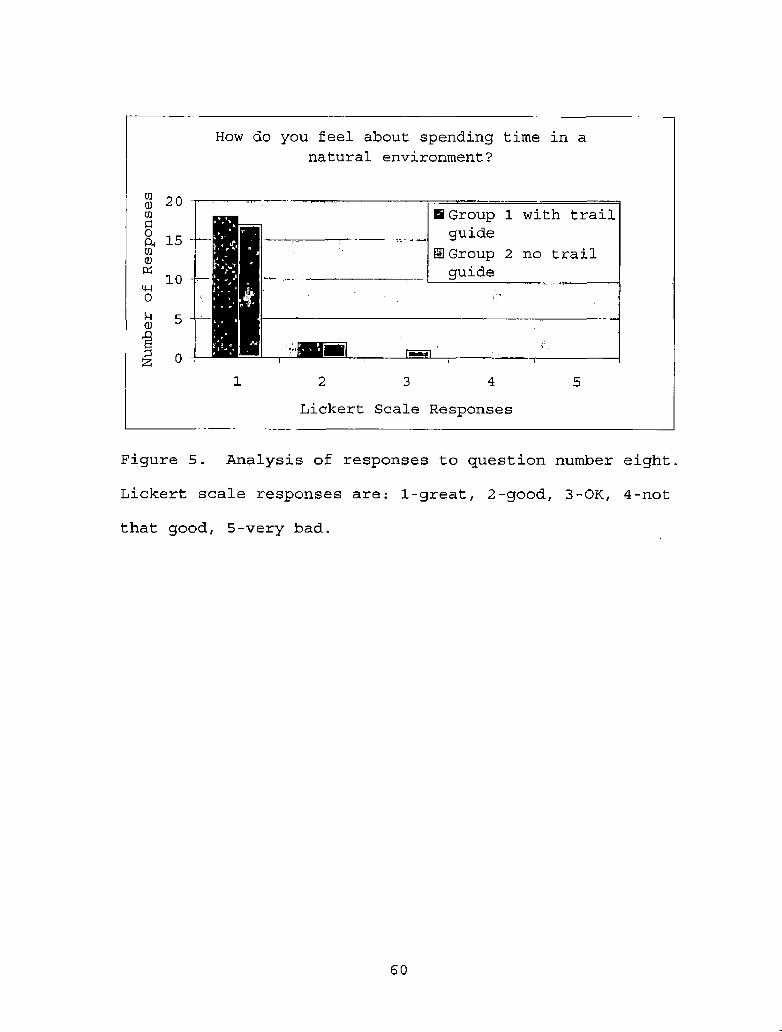
Figure 5. Analysis of responses to question number eight. Lickert scale responses are: 1- great, 2-good, 3-OK, 4-not that good, 5- very bad.................................... 6 0

Figure 6. Analysis of responses to question number nine. Lickert scale responses are: 1- great, 2-good, 3-OK, 4-not that good, 5- very bad.................................... 61

Figure 7. Analysis of responses to question number ten. Lickert scale responses are: 1- great, 2-good, 3-OK, 4-not that good, 5- very bad.................................... 62

viii

CHAPTER ONE

INTRODUCTION

The four-mile-long Mt. Baden-Powell trail in the San

Gabriel Mountains of Southern California is a popular hike

visited by many people each year (USDA Forest Service,

2006). Visitors include people of all ages and abilities:

novice hikers, seasoned hikers, backpackers, families with

children from infants to teens, trail runners, Boy Scout

groups, even nuns dressed in traditional attire.

The trail begins at about 6,500 feet elevation and

climbs steadily to the 9,399 foot summit, a gain of 2,800

feet in elevation (USDA Forest Service, 2006) . Many

hikers attempt the eight-mile roundtrip to the summit

(USDA Forest Service, 2006). Some visitors climb the

mountain as a day hike, while others backpack in for the

weekend. Many visitors are not attempting the summit at

all but only going part-way up the trail. Regardless of

how far visitors are planning to go up the trail, many of

them are not accustomed to the elevation and experience

some shortness of breath as they climb up the steep trail

(USDA Forest Service, 2006). This results in hikers

making frequent rest stops along the trail.

1

Having hiked the Mt. Baden-Powell trail many times

myself, and having spent many rest stops contemplating the

natural environment along the way, led me to believe that

this trail could present not only an opportunity for its

many visitors to enjoy a challenging hike but also an

opportunity for them to gain knowledge and awareness about

the area they are visiting.

Currently, there is no interpretive information

available at the Mt. Baden-Powell trailhead or along the

trail. For those visitors who do research before or after

a hike some information about the trees, the history of

the area, and the trail is available through the Forest

Service (USDA Forest Service, 2006). Also, a trail plant

list is available on the internet (Chester & Strong,

2003). However, to assist the site's many visitors in

developing awareness, appreciation, and understanding of

the area, there is a need for on-site environmental

interpretation.

Environmental interpretation is a pleasurable and

relevant way to communicate an organized theme-based

message to an audience (Ham, 1992). According to Sharpe

(1982), one of the major objectives of environmental

interpretation is "to assist the visitor in developing a

keener awareness, appreciation, and understanding of the

2

area he or she is visiting. Interpretation should help to

make the visit a rich and enjoyable experience" (p.4).

The interpretation must relate to the experience of the

visitor (Tilden, 1957). Its goal is provocation and

presentation of whole concepts (Regnier, Gross, Zimmerman,

1992; Tilden, 1957) . Interpretation is one aspect of

environmental education which takes place in a non-formal

setting (Knapp, 2005) . While non-formal education has not

proven to change peoples' beliefs (Storksdieck, Ellenbogen

& Heinlich, 2005), it can promote ecological knowledge

(Knapp & Volk, 1997).

In order to facilitate interpretation of the Mount

Baden-Powell trail, this project develops an interpretive

trail guide which includes information to be read at rest

stops along the trail up Mt. Baden-Powell. The theme­

based trail guide emphasizes knowledge, awareness, and

appreciation of the environment and natural history of the

Mt. Baden-Powell area. It encourages people to take care

of the area while enjoying it. A survey is conducted of

hikers who have used the trail guide and hikers who have

not used to the trail guide to assess differences and

changes in knowledge, awareness, and appreciation of this

environment. In order to create an effective interpretive

3

trail guide, the development of this project is based on a

review of the literature.

4

CHAPTER TWO

REVIEW OF THE LITERATURE

Introduction

This literature review will examine the definition

and goals of environmental interpretation. It will also

define environmental education and look at the

relationship between environmental education and

interpretation, including using interpretation as a

component of environmental education. Developing an

effective interpretive program or display must take into

account the educational theory supporting environmental

interpretation and the qualities which make interpretation

effective. Research in these areas is also included. The

information and research reviewed here will be used to

develop an effective interpretive trail guide for the Mt.

Baden-Powell trail.

What Is EnvironmentalInterpretation?

Environmental interpretation is a way of

communicating the technical language of natural science

into words and ideas which can be easily understood (Ham,

1992). It is a way of communicating ideas in a manner that

is entertaining and interesting (Ham, 1992). "The goal is

5

to communicate a message—a message that answers the

question 'so what7 with regard to the factual information

we've chosen to present" (Ham, 1992, p-4). Interpretation

is informal education which aids visitors in learning

environmental information (Knapp & Barrie, 1998) .

Environmental interpretation has largely been

supported and guided by Tilden's Six Principles of

Interpretation (Ham, 1992; Knapp & Volk, 1997) originally

stated in Interpreting Our Heritage (Tilden, 1957) .

Regnier, Gross & Zimmerman (1992) have restated Tilden's

principles to say "interpretation should relate the

subject to the audience, it should reveal information, not

just impart facts, it should aim for provocation and for

presentation of whole concepts, and it should be age-

appropriate" (p.4). Awareness is achieved through

firsthand experience where meanings and relationships are

revealed (Tilden, 1957), which is a critical component of

nature study (Knapp & Barrie, 1998).

Environmental interpretation has historically been

used as an important way to help site visitors understand

basic ecological and cultural information (Ballantyne,

1994; Knapp & Barrie, 1998), but interpretation is viewed

as more than that. Aldridge (1972, as cited in

Ballantyne, 1994) adds to the definition of environmental

6

interpretation by stating that it increases environmental

awareness and stirs a desire for conservation. Ballantyne

(1994) states the interpreter's aim is to "make an object

or event meaningful to the visitor by communicating its

significance and sense of place or time in a way which

relates to the visitor's own experience and personal

world" (p.112). In other words, engaging visitors through

storytelling about the natural and cultural environment

they are visiting leads to changes in knowledge, skills,

attitudes, and behaviors (Ballantyne, 1994).

The field of interpretation has several important

philosophical and objective statements (Knapp & Volk,

1997). In addition to Tilden's Principles of

Interpretation (1957), Grant Sharpe (1982) has identified

three major objectives for interpreting the environment.

Sharpe's objectives are reflected in the objectives of the

National Forest Service interpretive services program as

well (Knapp & Volk, 1997). The National Forest Service

(1990) objectives are to:

1. Provide customer service through orientation,

information, and interpretation so that forest

visitors will have a more enjoyable experience while

developing a better appreciation and understanding

of the area they are visiting.

7

2. Help solve management problems associated with

visitor use of the National Forest System and its

resources.

3. Enhance public understanding of Forest Service

programs and activities.

Tilden viewed his work on the principles guiding

interpretation as a work in progress (Beck & Cable, 2002).

In their recent book Interpretation for the 21st

century: Fifteen guiding principles for interpreting

nature and culture (2002), Larry Beck and Ted Cable have

expanded on Tilden's six original principles. Their

additional principles include: bringing the past alive by

addressing the history of a place, knowing when enough is

enough, interpreting beauty, supporting an optimal

experience, and creating passion. Beck and Cable

encourage others in the interpretive field to further

expand on their ideas.

While the main goal of interpretation is essentially

to communicate a message, these guiding principles and

objectives have led to developmental goals of

interpretation. These formal goals help in developing and

evaluating effective interpretation.

8

Goals of Interpretation

In 1994, the Program Development Goals for

Environmental Interpretation were developed (Knapp, 1994).

This comprehensive set of objectives was synthesized from

over 100 goals, principles, and objectives on

interpretation. These research-based goals are organized

into three categories that may lead to increased

environmental behavior: entry level goals, ownership

goals, and empowerment goals (Knapp & Barrie, 1998).

According to D. Knapp and E. Barrie (1998) :

The most powerful use of these goals is to offer

interpretive experiences that represent all three

variable levels in a sequential hierarchical order.

Although this may not assure attitude or behavior

change in the visitor, it does offer opportunities to

stimulate change, (p.25)

While research has not shown environmental

interpretation to be effective at changing skills,

attitudes, and behaviors (Knapp & Barrie, 1998), many

interpreters consider that part of their goal (Ham &

Krumpe, 1996; Knapp, 1994). Some interpreters view their

goal as interpreting controversial events and issues

(Knapp & Barrie, 1998; National Park Service, 1992). In

fact the ultimate goal of many interpreters may be to

9

produce "an environmentally responsible individual" (Knapp

& Barrie 1998).

To better understand how environmental interpretation

can be effective, it is important to look at where

interpretation fits into the broader field of

environmental education (Knapp, 2005) .

What Is EnvironmentalEducation?

Environmental education is a process which aims to

develop three main goals (Stapp, 1969; Tbilisi, 1977) :

students will gain knowledge about the environment and its

problems, they will become aware of ways to solve these

problems, and they will become motivated to work toward a

solution to these problems (Stapp, 1969).

Environmental education has a clear set of

established development goals, objectives, and guiding

principles which were set forth in the Tbilisi Declaration

in 1977 (Knapp, 2005; Tbilisi, 1977). The categories of

environmental education objectives as stated in the

Tbilisi Declaration (Tbilisi, 1977) are:

Awareness: to help social groups and individuals

acquire an awareness and sensitivity to the

total environment and its allied problems.

10

Knowledge: to help social groups and individuals gain

a variety of experience in, and acquire a basic

understanding of, the environment and its

associated problems.

Attitudes: to help social groups and individuals

acquire a set of values and feelings of concern

for the environment and the motivation' for

actively participating in environmental

improvement and protection.

Skills: to help social groups and individuals acquire

the skills for identifying and solving

environmental problems.

Participation: to provide social groups and

individuals with an opportunity to be actively

involved at all levels in working toward

resolution of environmental problems, (p.15)

These goals have been used for curriculum development

(Culen, 2005), and research has clearly shown that the

ultimate goal, citizenship behavior, can be developed

using environmental education (Hungerford & Volk, 1990).

11

The Cross-Section of Environmental Education and Environmental

Interpretation

Environmental education and environmental

interpretation share a similar mission (Knapp, 2005) .

Both fields strive to develop an environmental ethic

(Ballantyne, 1994; Knapp, 2005). However, while connected,

the two fields each have their own unique characteristics

(Knapp, 2005). These differing characteristics are

important considerations in the development,

implementation, and evaluation of interpretive programs

(Ballantyne, 1994). Environmental education and

environmental interpretation differ in their structure and

developmental goals (Knapp, 2005).

Differences in Structure

Environmental education tends to be structured toward

school-based audiences (Ham & Krumpe, 1996) . This formal

type of education usually requires students to participate

in a sequential curriculum (Knapp, 2005). Typically,

students must pay attention in order to pass tests and get

good grades (Ham & Krumpe, 1996). However, in

environmental education, students are "encouraged to

discover, investigate, and formulate principles and

concepts for themselves" (Ballantyne, 1994, p. 113). The

curriculum is taught over an extended period of time

12

allowing students much more involvement with the

curriculum (Knapp, 2 005) .

Environmental interpretation, on the other hand,

usually occurs in an informal or non-formal recreational

setting (Knapp, 2005) . The audience is voluntary and non­

captive (Ham & Krumpe, 1996; Knapp, 2005). The

participants freely choose to pay attention or not with no

threat of punishment or loss of reward. They choose how

long they will pay attention, and also to what extent they

will be involved (Ham & Krumpe, 1996). At most,

interpretive experiences may last from two hours to a half

a day (Knapp, 2 0 05) . Many exhibits may be viewed for only

a few seconds (Ballantyne, 1994). In short, this free-

choice environmental education allows visitors to choose

to participate or not, and also to choose what they will

take away from their experience (Storksdieck, Ellenbogen,

& Heimlich, 2005) .

Differences in Development Goals

Environmental education has a clear set of

established development goals (Knapp, 2005; Tbilisi,

1977). Research has clearly shown that the highest level

goal, participation or action, can be effectively

developed using environmental education (Hungerford &

Volk, 1990) .

13

Environmental interpretation also has established

goals (Knapp & Volk, 1997), objectives (Sharpe, 1982), and

principles (Beck & Cable, 2002; Tilden, 1957) . Although

this has not led to a road map that helps to develop

higher level goals, such as attitude and behavior changes,

as it has in environmental education (Knapp, 2005) .

Research has shown that interpretive programs can have an

impact on site-specific behaviors (Knapp & Barrie, 1998).

However, research showing achievement of the higher

level goals (attitude and behavior changes) has been weak

or mixed in non-formal settings (Knapp & Barrie, 1998;

Storksdieck, Ellenbogen, & Heimlich, 2005; Young & Witter,

1994). While interpretation may not achieve the highest

level goals of environmental education, clearly it is an

important aspect of the field (Knapp, 2005) .

Using Interpretation as a Component of Environmental Education

While site-based interpretation is not the same as

teaching or instruction in a formal setting (Ham & Krumpe,

1996), teachers are increasingly using informal

interpretive experiences as an important part of their

efforts to build environmental literacy (Ballantyne,

1994). This has many benefits: learning takes place

through first-hand experiences rather than in the

14

classroom, students have the opportunity to apply skills

in investigation and observation, and they undertake real

problem solving and decision making in relation to

environmental issues (Ballantyne, 1994). Research and

conventional wisdom have shown that first-hand experience

leads to better learning (Ballantyne, 1994) .

Interpretive displays are often primarily designed

for a non-captive, recreational audience and may not meet

the needs of students and teachers (Ballantyne, 1994). It

may be valuable for interpreters to consider

modifications. They may think about evaluating and

altering displays in order to be of more use to and

attract more formal education audiences (Ballantyne,

1994) .

Whether an interpretive program is designed for use

with formal or non-formal audiences, it can play an

important role in building environmental literacy

(Ballantyne, 1994). In order to accomplish this, the

fundamental principles of learning theory must be

addressed (Knapp & Volk, 1997).

15

Learning Theory and Interpretation

To achieve the desired goals and to help evaluate

effectiveness, interpretive programs must be based on

established learning theory (Knapp & Volk, 1997) . Several

learning theories are addressed in the current research

and applied to the goals of interpretation. These

perspectives on learning include theories of learning in

environmental education, learning in informal settings

such as museums, nature centers, and interpretive

programs, and theories which support behavior and attitude

change (Brody, 2005; Ham & Krumpe, 1996; Knapp & Barrie,

1998) .

Learning in Environmental Education

In his theory of learning in nature, Michael Brody

(2005) attempts to explain how people learn in natural

settings. Based on empirical research, he finds that

people do not all learn spontaneously from nature and that

"much of what we would like learners to learn is not

obvious or commonsense" (Brody, 2005, p. 604). He states

that environmental education, like other learning, is

centered on the notion that meaningful learning takes

place in specific 'real-world7 situations in which

knowledge is personally constructed based on learners'

16

previously held conceptions (Brody, 2005). Personal,

social, and physical contexts all play a role in the

learning (Brody, 2005) . Prior conceptions help to form an

association with new knowledge to increase understanding

and lead to a "change in the meaning of experience for the

learner" (Brody, 2005, p. 605).

Learning in Informal Settings

The important role of prior knowledge in learning is

also one of the major themes in learning in informal

settings such as museums, nature centers, and interpretive

experiences (Brody, 2005) . Prior knowledge fosters

understanding in a situation where people have the

opportunity to investigate, discover new information, and

link it to their everyday lives (Brody, 2005) . Social and

physical contexts are also important. The social aspect

is important because knowledge develops as a result of

communication which provides opportunities for learners to

link new ideas to past experiences and develop a shared

understanding of an experience (Brody, 2005). In a

physical context, learning seems to be linked to the

environment in which it occurs but can be generalized to

new situations (Brody, 2005).

17

Learning Affecting Behavior and Attitude Change

The main theories used to connect behavior and

attitude change with learning through interpretation are

Fishbein's Theories of Reasoned Action and Planned

Behavior (Ham & Krumpe, 1996; Knapp & Barrie, 1998).

Fishbein's theories have been used to provide a structure

for a learning model which looks at interpretation as a

form of persuasive communication (Knapp & Barrie, 1998).

Fishbein's theory (1986, as cited in Ham & Krumpe,

1996) suggests that behavior is guided by intention.

Intention results from: 1) personal attitudes which are

formed by beliefs and perceived outcomes of behavior, 2)

subjective norms which are formed by the beliefs a person

has about what significant others will think, and 3)

beliefs that a person has the necessary knowledge,

ability, skill, and resources to control the behavior (Ham

& Krumpe, 1996) . These three areas, in turn, are

influenced by primary beliefs a person holds about

behavior, social norms, and control. In order to change

behavior, first primary beliefs affecting current behavior

must be changed which can lead to changes in attitudes,

subjective norms, and behavioral control. These factors,

in turn, may change a person's intentions which may (if

18

there are not intervening factors) change the behavior

(Ham & Krumpe, 1996) .

According to the model based on Fishbein's theory, in

order for an interpretive program to affect behavior it is

first necessary to address the attitudinal, subjective

norm, and behavioral beliefs which the target audience

holds in relation to the desired behavior (Ham & Krumpe,

1996). These beliefs need to be identified and addressed

through theme-based communication in order to be changed

(Ham & Krumpe, 1996). "By nature, communication that

develops a theme advocates a belief" (Ham & Krumpe, 1996,

p. 18). This model seems to be theoretically sound and is

frequently cited, although there is not yet substantial

research supporting it (Knapp & Barrie, 1998) .

In summary, looking at the theories which support

learning in interpretation helps guide its development.

Different theories support different levels of goals. The

highest goal levels, those of attitude and behavior

change, may be achieved by working to change visitors'

beliefs through the use of communication based on a theme

(Ham & Krumpe, 1996) . Basing interpretation on a theme is

one of the most important qualities in making

interpretation effective (Ham, 1992; Ham & Krumpe, 1996).

In order to be effective and achieve its goals,

19

environmental interpretation must have qualities which

make it meaningful and understandable (Ham & Krumpe,

1996).

Qualities of Effective Interpretation

Three important questions must be answered in

designing an effective interpretative program or display:

1. Who will be the target audience (Ballantyne, 1994;

Ham & Krumpe, 1996; Rideout & Legg, 2000),

2 . What should be interpreted when you may only have the

attention of the visitor for a short time (Ham, 1992;

Knapp & Barrie, 1998) and,

3. How can you attract the visitor's attention and hold

it long enough to get your message across (Ham,

1992) .

Know the Audience

Since most interpretive displays and programs will be

aimed at a wide and varied audience, it is important to

consider several aspects of the intended audience in order

to make the information accessible to all. These aspects

include: age (Ballantyne, 1994), ethnicity (Rideout &

Legg, 2000), and beliefs (Ham & Krumpe, 1996).

Ballantyne (1994) states that "adults and children do

not perceive the world in the same way and interpretive

20

learning experiences aimed at adults may not achieve the

intended effect with young students" (p. 115). Tilden

(1957) also suggested that children learn in a

fundamentally different way and require a different

approach in interpretation. It is important to know if a

site's visitors will be primarily adults, families, or

both.

In their research on minorities and interpretive

programs, Rideout and Legg (2000) found that a culturally

diverse population may have different needs and desires

from interpretive programming. Interpreters need to

understand that potential cultural boundaries, both

perceived and real, exist which prevent programs from

being equally accessible to different cultural and ethnic

groups (Rideout & Legg, 2000) . They should ask

themselves, "Do existing programs and personnel foster

intercultural boundary maintenance, or do they encourage

diversity?" (Rideout & Legg, 2000, p. 55). An effective

program or display will encourage diversity.

Another important consideration in knowing the target

audience is to understand beliefs which they may hold.

Ham and Krumpe (1996) state that for interpretation to

influence visitors' behavior it is important to identify

the salient beliefs which are influencing their behavior

21

in a particular situation. In order to influence those

beliefs, it is most important to develop the interpretive

program around a theme (Ham & Krumpe, 1996). Ham & Krumpe

(1996) state that, "A well-articulated theme expresses a

belief about a thing, whether it be a behavior, event,

person, or obj ect. By nature, communication that develops

a theme advocates a belief" (p. 18).

In other words, to influence the visitor's behavior

it is necessary to understand their belief and help them

to understand the interpreter's belief. This can be

accomplished by presenting information through a theme.

What Information Will Be Interpreted?

It is most important to have a unified theme when

deciding what information will be communicated in an

interpretive display or program (Ham, 1992; Ham & Krumpe,

1996; Trapp, Gross, & Zimmerman, 1991). Ham (1992)

defines the theme as "the main point or message the

communicator is trying to convey about the topic" (p. 21).

In choosing the theme, the interpreter should be able to

say, "After people have completed this trail I'd like them

to know that... (or appreciate that..., or think that...)" (Ham,

1992, p. 331). The theme should reveal the importance of

the site and what it means (Trapp, Gross, & Zimmerman,

22

1991). It is the main message the interpreter is trying

to convey (Ham, 1992).

In order to make the entire display or program

unified, each piece of information included in the display

or program should fit within the chosen theme (Trapp,

Gross, & Zimmerman, 1991). All of the information should

be organized to fit together like the parts of a story,

with a beginning, middle, and end (Ham, 1992; Tilden,

1957) .

Attracting and Holding the Visitor's Attention

In addition to having a theme, an effective

interpretive program or display must attract and hold the

visitor's attention (Ham, 1992). In order to do that,

effective interpretation must be:

• meaningful and personal (Ham, 1992),

• pleasurable (Ham, 1992),

• closely associated with the experience of the visitor

at the site (Ham, 1992; Trapp, Gross, & Zimmerman,

1991),

• related to concrete objects and experiences (Trapp,

Gross, & Zimmerman, 1991),

• short and concise (Trapp, Gross, & Zimmerman, 1991),

23

• able to help the visitor experience the site (Trapp,

Gross, & Zimmerman, 1991).

Interpretation should add to, and not detract from, the

site and the visitor's experience there (Trapp, Gross, &

Zimmerman, 1991).

In order to hold the audience's attention,

interpretation must also be both interesting and

understandable (Young & Whitter, 1994) . In their research

on interpretive brochures, Young and Whitter (1994) found

the characteristics of story line, mystery, vividness, and

motivating information were all important in developing

interesting, effective brochures. The sense of a story

being followed, along with the anticipation of what is

coming next in the story, holds the attention of the

audience (Ham, 1992; Young & Whitter, 1994) .

To make the information understandable, Young and

Whitter (1994) found that it was important to use what

they called 'chunking'. Ham (1992) describes this same

idea as helping "people learn big ideas (like themes) by

combining smaller ideas (like main points and subordinate

information)" (p. 27). Ham (1992) recommends that the

main ideas within the theme should be kept to five or

fewer and should be organized so that "the audience can

easily distinguish between those main ideas and the

24

subordinate information" (p. 21). Organizing the

information so that it is interesting and understandable

helps to keep the attention of the non-captive audience.

An effective interpretive program is developed

through careful planning and design. Consideration must be

given to who the interpretation will be directed at, what

will be interpreted given that there is a limited amount

of time, and how it will capture and hold the attention of

a non-captive audience.

Summary

In summary, the key goal of environmental

interpretation is to offer interpretive experiences which

represent the variable levels of environmental education:

awareness, knowledge, attitudes, skills, and

participation. This is the best way to offer opportunities

which may stimulate change in visitors (Knapp & Barrie,

1998). An interpretive program whether formal or non-

formal can play an important role in building

environmental literacy (Ballantyne, 1994) and may help

produce an environmentally responsible individual (Knapp &

Barrie, 1998) .

To be effective, interpretation must be based on a

unified theme and attract and hold the visitor's

25

attention. It should add to, and not detract from, the

site and the visitor's experience there (Trapp, Gross, &

Zimmerman, 1991). Effective interpretation must be

pleasurable, meaningful and personal (Ham, 1992), related

to the visitor's concrete experiences (Ham, 1992; Trapp,

Gross, & Zimmerman, 1991), and short and concise (Trapp,

Gross, & Zimmerman, 1991). Organizing the information so

that it is interesting and understandable helps to keep

the attention of the non-captive audience. All of the

information should tell the story of the place (Ham, 1992;

Tilden, 1957) .

The information reviewed here will be used next to

develop an effective interpretive trail guide for the Mt.

Baden-Powell trail.

26

CHAPTER THREE

METHODOLOGY

Introduction

The goal of this project is to effectively tell the

story of the Mount Baden-Powell area through

interpretation which should increase visitors' knowledge,

awareness, and appreciation of the area. There were three

main phases of development for this project: the

preliminary research, the development of the trail guide,

and a survey of hikers to determine the effectiveness of

the trail guide.

Phase One: PreliminaryResearch

The first phase of developing the project included

reviewing the current literature in the field of

interpretation and its intersection with environmental

education as discussed in Chapter Two, Review of the

Literature. In addition, this phase included examining

the location, accessibility, and visitor demographics for

the area, investigating the suitability of the site and

local trails, and an evaluation of existing interpretive

trails and other opportunities in the area.

27

Location and Access

Mount Baden-Powell is located about eight miles west

of the small town of Wrightwood, California, population

4,200 (US Census Bureau). It is within easy driving

distance of the Los Angeles metropolitan area via State

Highway 2. Parking is available at the Vincent Gap

trailhead parking lot. The area has year-round visitor

access except when there is an especially heavy snowfall.

The trails in the area, and especially the Mount Baden-

Powell trail itself, have limited access during winter

months because of ice and snow.

Visitor Demographics

The Mount Baden-Powell area has many visitors. It

has easy access and close proximity to the Los Angeles-

Riverside-Orange County metropolitan area with an area

population of approximately 16.5 million people (US Census

Bureau). Exact visitor statistics are not available for

the area or the trails. Frequent observations over the

past ten years reveal great variation in age, hiking

experience, and objectives of visitors to this area.

Visitors observed include people of all ages and

abilities: novice hikers, seasoned hikers, backpackers,

families with children, Boy Scout groups, high school and

college cross country running teams, and even nuns dressed

28

in traditional attire. In recent years there has been a

marked increase in observations of people running the

trail to the top of Mount Baden-Powell and back. For many

visitors it is their first time in the area, but others

have returned dozens of times or more.

Description of Local Trails

There are several trails in the immediate area of

Mount Baden-Powell. They all begin at or near the Vincent

Gap parking lot. The Mount Baden-Powell trail itself

heads west from Vincent Gap. It is four miles to the

summit of the 9,399' mountain. Most of this trail is part

of the Pacific Crest Trail which runs from Mexico to

Canada. The Pacific Crest Trail can also be followed to

the east from Vincent Gap toward Grassy Hollow Visitor

Center (about five miles by trail). Access to the trail

heading east is across the road from the main parking area

and is not obvious.

The Mine Gulch trail leads from Vincent Gap around

the east flank of Mount Baden-Powell. It is a relatively

level dirt road with some rocky stretches. Two steep

gully sections have been washed out and are now steep,

rocky, and narrow trail sections. This trail is also four

miles long, ending at the Bighorn Mine. The Mine Gulch

trail is clearly indicated by a sign at the trailhead, and

29

it has many hikers. About 200 yards down the Mine Gulch

road another trail descends to the East Fork of the San

Gabriel River.

The Manzanita trail descends from Vincent Gap

approximately 5.5 miles to Big Rock creek. The access to

this trail is unsigned and is located across the road from

the main parking area.

Choosing the Mount Baden-Powell Trail for Interpretation

The trail up Mount Baden-Powell was chosen from among

the other area trails for interpretation for a variety of

reasons. A majority of the people who come to Vincent Gap

hike either the Mount Baden-Powell trail or the Mine Gulch

trail. The starting points of both of these trails are

clearly marked, whereas the starting points of the other

trails are less obvious. The effects of a high number of

visitors can be observed on both of these trails and in

the parking lot: trash, graffiti, vandalism of signs and

restrooms, and erosion caused by hikers and runners

cutting switchbacks on the trail are problems which have

been personally observed. Interpretation could ideally be

designed to help improve visitor impact.

The trail up Mount Baden-Powell also has pre-existing

landmarks which made it more usable for the type of self­

30

guided trail guide proposed. The Mine Gulch trail, while

more level and wider, does not have clear landmarks along

the way, which does not make it a prime site for this

proj ect.

There are some drawbacks to designing an interpretive

guide for the trail up Mount Baden-Powel1. The main

drawback is that the trail, although not steep, is

generally uphill. This may be less appealing to some

novice hikers or those with small children. The fact that

the trail is uphill was incorporated into the trail guide.

The stops give hikers a reason to take brief rests on the

way up. Another drawback is that many hikers are intent

on reaching the summit or running the trail, and

therefore, less likely to be interested in learning along

the way.

The trail is also a linear, out and back, trail.

This is slightly less desirable than a loop trail for

interpretation (Ham, 1992). The trail is also longer than

the typical interpretive trail. According to Ham (1992),

an interpretive trail is best if less than one mile long,

a distance most effective for maintaining a person's

interest in an interpretive activity. For this reason a

stopping point at Lamel Spring, at 1.6 miles from the

trailhead, was chosen for the end of the interpreted

31

section of this trail. Lamel Spring provides an

interesting destination for hikers who do not want to hike

the whole trail. But, being a linear trail which is

downhill on the way back makes it easy for people to

return at whatever point they are ready.

Analysis of Existing Interpretation in the Area

An early step in researching this project was to

assess what interpretive materials are already available

in the area, how well they work, their condition, and

their accessibility. Interpretive opportunities exist at

the Grassy Hollow Visitor Center, on various other nature

trails, and at one signed point along the highway.

The primary local source of interpretive materials is

the Grassy Hollow Visitor Center, located about two miles

east of the Mount Baden-Powell trailhead on Highway 2.

The visitor center is open only on weekends throughout the

year and is staffed by members of Volunteers of the

Angeles Forest. Displays on local animals, plants,

geology, and forest management are available inside the

center during their open hours. Some Saturday programs

are provided on a variety of subjects during the summer

months both at the visitor center and other local

locations.

32

A loop hike on the Pacific Crest Trail starting very-

near Grassy Hollow Visitor Center provides an ideal

location for an interpretive trail. This was, in fact,

the first choice for this project. However, a trail is

currently under development there by one of the volunteers

and should be available soon.

The following trails are developed nature trails all

within about 10 miles of Vincent Gap. The information

here is a result of hiking the trails, interviews with

local Forest Service employees and volunteers, and the

existing trail guides.

1. Big Pines Self-guided Nature Trail

a. Type of trail: signed posts

b. Theme: Plants, animals and native people exist

together.

c. Length: 0.5 mile

d. Located behind Big Pines Ranger station.

e. Conditions: Trail is in good condition, but with

limited access due to ongoing construction at the

trail entrance for the past several years. It is

possible to access the trail by walking around to

the back of the Forest Service building, but no

signs show how to get to the trail or that it

exists. All interpretive signs on the trail are

33

currently in place and in readable condition.

However, due to recent fires some of the plants

listed on the signs are no longer there. This

trail was designed in the 1970's by Doug Milburn

of the Forest Service. During an interview he

stated he would like to see the trail changed and

updated to focus more on the recent human history

of the area, including use by the LA County Parks

in the 1930's.

2. Table Mountain Self-guided Nature Trail

a. Type of trail: Brochure and 12 numbered posts

b. Theme: "Many forms of life make up a forest where

plants and animals live together. Their survival

depends upon interaction with each other". Not

all points follow the theme.

c. Length: 0.5 mile

d. Condition: The trail is in fair condition. All

of the numbered posts are in place. There is one

confusing turn where it is easy to lose the nature

trail entirely. There is a metal trail guide box

at the beginning of the trail for brochures, but

it rarely is stocked. Brochures were located at

Big Pines Ranger Station.

34

e. The brochure is provided by the Friends of the

Angeles National Forest. It is not clear if the

trail was designed by volunteers or by the Forest

Service. The latest update was 7/2003.

3. Lightning Ridge Self-guided Nature Trail

a. Type of trail: Brochure and 14 numbered posts

b. Theme: "Highlights examples of the harsh and often

violent forces of nature. But nature has its

delicate side as well and it needs our

assistance".

c. Length: 0.6 mile loop

d. Condition: The trail is in good condition.

Most or all of the numbered posts were in place on

various hikes. Volunteers from Grassy Hollow

Visitor Center lead interpretive hikes on this

trail several times during the summer. There is a

metal trail guide box at the beginning of this

trail for brochures, but it is usually empty. No

brochures could be found at Grassy Hollow. The

only brochures located were at Big Pines Ranger

Station.

4. Jackson Flats Self-guided Geology Trail

a. Type of trail: Placards on posts

35

b. Theme: Examples of many geologic features and

activity can be found in this area.

c. Length: 0.75 mile loop

d. Condition: Although a bit overgrown, this trail

is in good condition. All signs are in place and

readable. However, this trail is located at

Jackson Flats Group Campground which is behind a

locked gate. Unless camping at Jackson Flats

there is a one mile hike to get to this trail.

5. Jackson Flats Self-guided Forest Management Trail

a. Type of trail: Placards on posts

b. Theme: Unclear. The existing signs all related

to management of the forest by people.

c. Length: 0.5 mile loop

d. Condition: While the actual trail is in good

condition, only a few interpretive signs remain

and few of those are readable. This trail is also

located at Jackson Flats Group Campground

accessible only to campers or with a one mile hike

in.

6. Blue Ridge Trail Self-guided Nature Trail

a. Type of trail: Brochure and 15 numbered posts

b. Theme: "Many kinds of plants, shrubs, and trees

make up a forest".

36

c. The purpose of the trail as stated in the brochure

is to "learn more about the environment of your

National Forest". Most of the paragraphs have to

do with different plants; not all points follow

the theme.

d. Length: 2 miles

e. Conditions: The nature trail here is essentially

non-existent, although the trail itself is

frequently used by hikers and mountain bicyclists.

The numbered posts were removed after a snow

player was injured by colliding with one. The

brochure is not available. Like the Mount Baden-

Powell trail, this is a linear trail which is

mostly uphill.

f. Designed in 1977 by the Forest Service.

There is also an interpretive road sign located at

Inspiration Point, across the road from the Lightning

Ridge trail and about four miles before the Mount Baden-

Powell trailhead. Mount Baden-Powell is an impressive

sight from this viewpoint. This engraved metal sign

points out the names of the visible peaks and drainages

with elevations, and gives some information about the

history of Mount Baden-Powell.

37

Gathering this background information developed a

strong base of knowledge on which to develop the actual

trail guide.

Phase Two: Development of theTrail Guide

The second phase of the project was the development

of the trail guide itself. In order to ensure the

effectiveness of the trail guide, it was based on current

information from the field of interpretation. The trail

guide was developed over the course of several months, but

is based on ten years of experience hiking in the area as

well as research into the local history, geology, animals,

and plants. Development of the trail guide incorporated

feedback from other hikers and field testing.

Determining the Format for Interpretation

Several options were considered in deciding on the

format in which to present the interpretive material.

Initially, a large wooden sign at the Vincent Gap parking

lot was investigated for presenting a stationary

interpretive exhibit. This 4' x 8' sign is occasionally

used for Forest Service posters or flyers. However,

because of the possibility of vandalism, this idea was not

practical (Sharp, 1982) .

38

A series of informational placards placed along the

trail was considered next. However, any permanent signs

require Forest Service approval. Based on a discussion

with Doug Milburn of the Forest Service and the experience

of the Pasadena Audubon Society (Garret, 2008) getting

this approval can be frustrating and lengthy. For this

reason, numbered markers along the trail with an

accompanying brochure trail guide did not seem practical

either, as it would require Forest Service approval before

installing the markers.

The format finally chosen is a take-along trail guide

brochure which relies only on existing landmarks for the

stopping points along the way. This type of format has

several advantages and drawbacks (Ham, 1992, p.312).

Advantages are that it is relatively inexpensive to

produce, seems to be easy to use, and is effective.

Drawbacks are that it may cost more to reproduce in the

long run and that it relies on one person who reads the

information while others listen passively. Eventually it

is hoped to have the trail guide brochure available for

purchase at Grassy Hollow Visitor Center, to help cover

the cost of printing. With a general idea of the format,

the next step was to decide on the story to tell.

39

Developing a Theme

Effective interpretation is based on a theme and

tells the story of a place (Ham, 1992; Beck & Cable,

2002). Much thought, hiking, reading, and consultation

with other hikers went into the development of the theme

for this trail guide.

The story of Mount Baden-Powell is in part its

history and in part what is there today. The history and

human history of the mountain are well told by John

Robinson in two of his books The San Gabriels and Trails

of the Angeles 100 Hikes in the San Gabriels. The plants

and geology of the area are described briefly by Robinson

and more in depth by Tom Chester in his online book and

website, Field Guide to the San Gabriel Mountains, and

Hikes in the Gabriel Mountains. Using information from

these sources, other locally available interpretive

materials, as well as ideas from fellow hikers, the theme

for the interpretive trail in this project was developed

and refined.

The theme of the trail guide gradually evolved into

the idea that knowing something about a place ties us to

that place. Being tied to a place by our knowledge and

experience helps us to grow and to appreciate and value

that place. This was further refined and incorporated

40

into the introduction paragraph of the trail guide which

reads:

By learning and understanding a little about the

plants, animals, rocks and history of this mountain,

we also become a part of the mountain. Knowing

something about a place ties us to that place. From

the moment you set foot here, you too are part of

this environment, part of the Baden-Powell natural

and human history (see Appendix A).

Designing the Stops Along the Trail

The next step was to decide on the key points which

support the theme and would be included on the trail guide

at the stops along the trail. Ham states that each stop

should: 1) focus the audience's attention on the feature,

2) explain the significance of the feature, and 3) connect

the explanation to the theme (Ham, 1992, pg.325). Because

of the design of this trail guide, the audience must

actually be looking for the feature ahead of time, so they

are already focused on the feature.

Once the theme was developed and refined the

significance of each feature was also very

straightforward. Each landmark is a feature which makes

up part of the story of Mount Baden-Powell. Explicitly

connecting the explanation to the theme was possible for

41

most of the sites, although limited space for writing was

a major factor in determining what exact information to

include. This did, however, make it easy to keep writing

short and concise which is also important (Ham, 1992; Beck

& Cable, 2002) .

There is disagreement about how many stops an

interpretive trail should have (Ham, 1992). Fortunately,

for this purpose of this project, the decisions for the

number and location of stops were very straightforward.

Stops had to be where there were easily identifiable,

permanent landmarks.

Nine landmarks were chosen as stops. Seven of these

are very clear: the trailhead, a split rail fence

section, two Boy Scout/Pacific Crest Trail markers, a

bench, a large boulder with a flat face right alongside

the trail, and Lamel Spring. All but one of these

landmarks is also located at the end of a switchback. Two

of the landmarks are not as obvious as the others. Number

six, a dead tree with lichen, could be one of several

trees along the trail although this particular tree is

more prominent and is located at the end of a switchback.

Number seven, an example of erosion and trail cuts, is one

of several examples which can be seen along the trail.

In order to help hikers find the landmark stops along

42

the trail and know what information went with each stop,

the trail guide was designed in a map format. This made

the trail easier to follow and interpret, but it also

imposed strict limits on how much writing could be

included about each stop.

Designing the Plant Guide

In addition to the stops, incorporating a way to

identify native plants was also important. Awareness of

the native plants is a key part of the theme. Plants were

identified and cross-checked using several guidebooks, to

local flora (Havert & Gray, 1996; San Bernardino Mountains

Land Trust, 1999), as well as Tom Chester's Plant Guide to

Mount Baden-Powell and Lamel Spring (Chester & Strong,

2002-2003) .

Initially, several prominent plants were listed which

could be found at each of the stops along the trail.

However, that seemed to make the stops too time consuming

and took away from the idea of a gradual change in species

as the elevation of the trail changes.

Eventually, the idea developed to note the names of

plants on the map in general places where they can be

found, since almost all of the species can be found in

more than one place along the trail. A description with

photographs of each species is on the back of the trail

43

guide. Each species is marked with a small icon which

shows a distinguishing feature of that plant (i.e. flower

color, berries, or cones/acorns depending on the type of

plant). This helps with plant identification and with

locating the plant description on the back of the trail

guide.

The plant descriptions on the back of the trail guide

include the plant name, botanical name, a brief

description which includes, in most cases, a short idea to

tie the plant to the theme, and a photograph showing the

prominent feature of the plant for identification. The

number of plants included was limited by space as

photographs must be large enough to actually see and help

identify the plant. The photographs were taken throughout

the summer months to show plants in bloom in most cases.

Twenty different plants were included in the final

trail guide. Most of these plants are found in the first

1.6 miles of the trail, up to and at Lamel Spring. This

area has the greatest diversity of plant species.

However, the Lodgepole Pine and Limber Pine were also

included on the trail guide because of their significance

in demonstrating the change in species with the increase

in elevation. These are the dominant species as the trail

nears the summit. The extraordinary Limber Pines in this

44

area are estimated to be 1,500 to 2,000 years old

(Robinson, 1984) . While a great attempt was made to

include the most eye-catching plants, several interesting

species had to be left off because of the limited space.

Including Animals on the Trail Guide

Native animals are also a key part of the theme to

the trail guide, but they proved much more difficult to

incorporate. There are not sites along the trail where

animals, birds, or even obvious animal signs can be

consistently found with the exception of hummingbirds near

certain flowers. Also with the limited space on the trail

guide there was not enough room for photographs or

descriptions of animals. Stop number five does discuss

the Nelson Bighorn sheep which live in the area.

In order to help visitors learn more about the local

animals and birds a text box was included on the back of

the trail guide indicating that more information and

examples of local animals and birds are available at

Grassy Hollow Visitor Center.

Feedback and Field Testing

As the trail guide neared completion, draft samples

were presented to eight different hikers for feedback.

These hikers had varying levels of hiking experience, from

novice to expert, and varying knowledge of the Mount

45

Baden-Powell area, from first-time visitors to hikers who

have visited the area over 50 times. Each person offered

unique observations and asked questions which brought up

important considerations. This feedback was instrumental

in clarifying the trail guide and adding important

features.

After many revisions, the field guide was field

tested by two hikers with an intermediate level of hiking

experience and limited knowledge of the Mount Baden-Powell

area. They also offered a few minor suggestions which

were incorporated in the final trail guide.

Production and Printing

The trail guide was produced using Microsoft Office

Publisher. The actual trail map is based on the United

States Geological Survey (USGS) topographical map, Crystal

Lake quadrangle, but was drawn freehand and revised

multiple times in the field. The final version was then

scanned into Publisher. The inset topographical map is

part of the Crystal Lake quadrangle downloaded from the

USGS website. All photographs were taken using an Olympus

4.0 mega pixel camera with AF 3x zoom lens. Icons for the

various plants are from Microsoft Office. The font used

for the text of the introduction, stop descriptions, and

plant descriptions is 9 point or 10 point Times New Roman.

46

Plant names on the map are in 12 point Rage Italic. The

title font is 14 point Pooh. The final version of the map

was printed in color with a laser printer on laser card

stock. Once printed, the finished trail guide was ready

for hikers to determine if it was effective.

Phase Three: Survey ofHikers

The third phase of the project was to design a survey

and use it with hikers to determine if the finished trail

guide is effective in accomplishing the goals of

increasing knowledge, awareness, and appreciation of an

area.

Creating the Survey

The survey was created to assess visitor knowledge,

awareness and appreciation, as well as provide some

demographic information. Questions 1 through 5 are

multiple choice and true/false questions designed to

assess visitors' knowledge. Answers to these five

questions are contained in the trail guide and should be

easily found while hiking with the guide. Questions 6, 7,

11, and 14 relate to visitors' awareness of the area and

environment and are not directly answered by the trail

guide. These questions are all of either a true/false or

yes/no format. Questions 8 through 10 relate to the

47

visitor's appreciation of the area and their hiking

experience. These questions are answered with a Lickert

scale. Questions 12, 13, and 15 ask demographic

information using both a free response and yes/no format.

The survey protocol was approved by the Institutional

Review Board (IRB) of California State University, San

Bernardino. The survey was not field tested before use.

After several surveys were complete, it became apparent

that some changes had to be made in the questions to

better clarify the responses, and the survey had to be

resubmitted to the IRB for approval.

Administering the Survey

Two groups of hikers were surveyed: 1) hikers who

hiked the entire trail or a part of it with the trail

guide and 2) hikers who hiked the trail without the trail

guide. The survey collection period was from September 1,

2008 through October 8, 2008.

A total of 40 hikers were surveyed. Twenty hikers

were surveyed who had hiked the trail with the trail guide

(group one). Twenty hikers were surveyed who hiked in the

area but did not use the trail guide (group two). Both

groups received the same post-hike survey. Of the 20

hikers in group one, 13 were also given a pre-hike survey

which is the same as the post-hike survey but with the

48

exclusion of question numbers 10 and 13 which relate

specifically to the hike experience.

The initial idea was to recruit hikers for group one

at the trailhead and have them complete a survey when they

returned from hiking with the trail guide. However, this

did not prove effective because of time constraints. As

an alternative, trail guides were made available to a

local Wrightwood-area hiking group, some hikers who were

encountered on the trail during the creation of the trail

guide and were interested in hiking with it, and a local

Pilates exercise instructor who offered to make the trail

guides available to her students. Therefore, hikers in

group one were mostly local Wrightwood-area residents who

volunteered to do the hike.

Hikers in group two were contacted at the trailhead .

when they were finishing a hike in the Mount Baden-Powell

area. Since there did not need to be any contact with

these hikers before they hiked, time was not an issue.

Although information was not collected on where these

hikers were from, a few of them identified themselves as

local residents also.

Survey Data Analysis Procedure

Results of the surveys were put into an Excel

spreadsheet for analysis. Results were compared between

49

group one and group two. Changes in knowledge, awareness,

and appreciation were also analyzed for group one by

comparing their pre- and post-hike surveys.

Summary

These three phases describe the development of the

project from idea to final product. Knowing if the trail

guide actually accomplished the stated goals requires an

in-depth analysis of the results of the survey.

50

CHAPTER FOUR

RESULTS AND DISCUSSION

Introduction

Current literature in the field of interpretation

indicates that theme-based interpretive displays can be

effective in changing visitors' knowledge, awareness, and

appreciation of an area (Ham, 1992; Knapp & Volk, 1997).

The surveys were analyzed quantitatively to determine if

change was effected by use of the trail guide. Results

showed that knowledge was in fact increased through use of

the trail guide, while awareness and appreciation of the

area were much less affected. Qualitative analysis was

also done based on comments from and discussions with

hikers who used the trail guide. These findings helped to

clarify the quantitative findings.

Findings for the KnowledgeGoal

The questions which focused on knowledge were numbers

one through five on the survey. These questions ask about

human history, plants, formation of the mountain, and big

horn sheep. Answers to these five questions are all found

on the trail guide. To determine if there was a change in

51

visitor knowledge, the survey results were analyzed in two

ways .

First, the two groups were compared with each other:

those who hiked with the trail guide and those who had

hiked in the area without a trail guide. Results show

clearly that the group who had used the trail guide did

have a higher level of knowledge after hiking than the

group who had hiked without the trail guide.

Question number one asks about the historical uses of

the area. While nearly all of the hikers who used the

trail guide answered correctly, so did more than half of

the group who did not use the trail guide. This

information may be more generally known and also the

correct response was "all of these" which may have led to

more accurate guessing. Question number four had nearly

all correct responses from both groups. This is a fairly

general question about which factors contribute to the

formation of the mountain and although the information is

on the trail guide the question is probably too general to

indicate a change in knowledge. Question number five is a

true/false question asking if there are Bighorn Sheep in

the area. With a 50% chance of getting the answer correct

the results could be as much the result from guessing as

actual knowledge. The results for questions two and three

52

show the largest range in responses between the two groups

of hikers. Both of these multiple choice questions are

about specific less-common plants. These questions most

accurately show that knowledge did increase because of use

of the trail guide. The survey results are shown below in

Figure 1.

Knowledge Questions

® Group 1 with trail guide

□ Group 2 no trail guide

Figure 1. Analysis of responses to knowledge questions

between hikers with the trail guide and hikers without the

trail guide.

Second, the results were compared between the pre­

hike and post-hike surveys for the group who hiked with

53

the trail guide. The results of this analysis, shown in

Figure 2 below, also show that there was an increase in

individual hiker's knowledge after hiking with the trail

guide. Again, questions two and three show the most

increase between the pre- and post-hike. Questions one,

four, and five were answered correctly by nearly all

hikers on the pre-hike survey. Question four was probably

too general overall to indicate any change in knowledge.

Questions one and five may have had a high number of

correct responses initially because most of the hikers in

this group reside in the local area and overall have had a

greater number of hikes in the area. These hikers

probably have more exposure to uses of the area and the

existence of the Bighorn Sheep.

54

Pre / Post Surveys: Knowledge Questions

Figure 2. Analysis of responses to knowledge questions

comparing pre-hike and post-hike surveys of hikers who

used the trail guide.

Based on these findings it can be assumed that the

trail guide was effective at increasing visitors'

knowledge of this area.

Findings for the AwarenessGoal

There are four questions on the survey which relate

to visitor awareness of the area. These questions ask

about staying on the established trail, if personal

actions at home and at the trail affect the area, and if

the visitor is aware of resources available at Grassy

55

Hollow Visitor Center. The results of the questions

relating to awareness were analyzed in a similar way to

the knowledge questions.

First, the two groups were compared with each other:

those who hiked with the trail guide and those who had

hiked in the area without a trail guide. Although there

are some differences, results do not show any clear

distinction between the two groups' levels of awareness of

the area. The one question which did show a difference in

awareness was the question about the availability of

information at Grassy Hollow Visitor Center. Visitors who

hiked with the trail guide were more likely to know about

the information available at the visitor center. However,

since many of the hikers in group one are from the local

area it could be assumed that they held this knowledge

already. The survey results are shown here in Figure 3.

56

Awareness Questions

Question Number

SGroup 1 with trail guide

□ Group 2 no trail guide

Figure 3. Analysis of responses to awareness questions

between hikers with the trail guide and hikers without the

trail guide.

•Second, the results were again compared between the

pre-hike and post-hike surveys for the group who hiked

with the trail guide. The results of this analysis, shown

in Figure 4 below, also do not show a large increase in

individual hiker's awareness of the area after hiking with

the trail guide. It should be noted however, that these

hikers already had a strong awareness of the area before

hiking as shown by the number of positive responses on the

pre-hike survey.

57

Pre/Post Survey - Awareness Questions

Question Number

Figure 4. Analysis of responses to awareness questions

comparing pre-hike and post-hike surveys of hikers who

used the trail guide.

Overall only a small increase in awareness was

noticed for hikers who used the trail guide. This was in

the areas of whether personal actions at home and at the

trail affect the area, and if the visitor is aware of

resources available at Grassy Hollow Visitor Center.

58

Findings for the AppreciationGoal

The questions which try to elicit an indication of

appreciation of the area are all Lickert scale questions.

The three questions ask about the hiker's feelings

regarding the natural environment, the hike, and learning

from an interpretive guide. The scale of responses used

is: great, good, OK, not that good, and very bad. Almost

all of the responses were positive for both groups. The

only clear differences were for the third question

regarding learning from an interpretive trail guide. The

group who had hiked with the trail guide responded much

more positively than did the other group. The responses

to each question are shown below in the three graphs of

Figure 5, Figure 6, and Figure 7.

59

How do you feel about spending time in a natural environment ?

g o -i—1

1 ' 1

2i"—3

=j—----------4 5

Lickert Scale Responses

Figure 5. Analysis of responses to question number eight.

Lickert scale responses are: 1-great, 2-good, 3-OK, 4-not

that good, 5-very bad.

60

How do you feel about your hike today?

Lickert Scale Responses

Figure 6. Analysis of responses to question number nine.

Lickert scale responses are: 1-great, 2-good, 3-OK, 4-not

that good, 5-very bad.

61

How do you feel about learning from an interpretive trail guide?

tQ O Q d o £4 CQ O Pi

O

20

15

10

S Group 1 with trail guide

[*l Group 2 no trail guide

4 512 3Lickert Scale Responses

Figure 7. Analysis of responses to question number ten.

Lickert scale responses are: 1-great, 2-good, 3-OK, 4-not

that good, 5-very bad.

Only one appreciation question is on the pre-hike

survey. The questions asking about the hiker's feelings

toward the hike and learning from an interpretive trail

guide were not included on the pre-hike survey since they

relate to the actual hiking experience. All 13 of the

hikers who completed a pre-hike survey responded with

"great" to the question, "How do you feel about spending

time in a natural environment?" Their responses were also

all "great" on the post-hike survey.

62

Comparison of Hiker Experience With Increases in Knowledge, Awareness and Appreciation

Before administering the survey it was thought that

the results may be influenced by the number of experiences

a hiker has had in the area, so this information was asked

for on the survey. Overall, the group that hiked with the

trail guide had many previous experiences in the area.

Two hikers indicated that this was their first time hiking

in the area. Two others indicated that they had hiked

here less than five times. Nine hikers noted hiking in

the area between five and ten times. Seven hikers said

that they had hiked in the area at least 20 or more times,

and up to 50 times.

The group who hiked without the survey was less

experienced with the area. Nine hikers indicated that

this was their first time hiking in the area. Five others

reported having hiked here five or less times. One hiker

had hiked between five and ten times, and five indicated

that they had hiked in the area at least 20 or more times,

and also up to 50 times.

Experience in the area may or may not have increased

a hiker's knowledge of specific history, animals, and

plants given the results from the graphs above. However,

less experience in the area probably did affect the

63

answers to awareness questions. Appreciation was also

probably less affected by the experience level of the

hikers.

Discussion of the Findings

The quantifiable results of the survey show that this

interpretive trail guide can be effective at changing

hikers' knowledge of the area. Changes in awareness and

appreciation are less obvious. However, the quantifiable

survey responses were not the only ones received. Several

surveys from the group who hiked with the trail guide had

additional comments written on them or attached. Many

hikers also discussed their hiking experience when they

returned their surveys. These qualitative responses were

also taken into account in interpreting the findings.

Comments from Hikers About Using the Trail Guide

Most of the hikers who used the trail guide had

positive comments about it. They felt it was easy to use,

the pictures were clear and aided in identifying plants,

and they felt it added to their hiking experience.

Several hikers reported using the trail guide like a

"treasure hunt" as they looked for the plants and trail

stops along the way. Several also stated that the stops

provided a great way to take a short break from hiking

64

without having to admit they wanted to rest or catch their

breath. One group who hiked to the summit reported that

they enjoyed the lower section of the trail with the trail

guide much more than the upper part, and they wished the

trail guide went all the way to the summit. Several of

the hikers who reached the top were curious about plants

growing near the summit which were not included on the

trail guide.

Not all of the hikers liked hiking with the trail

guide. Three surveys contained additional comments

indicating that they read the guide only briefly during

the hike or after the hike was finished. Two of these

same hikers also felt that it was too difficult or

disruptive to stop and read while hiking this particular

trail.

Comments From Hikers Concerning Knowledge,Awareness and Appreciation Goals

Several interesting details regarding the goals of

increasing knowledge, awareness, and appreciation came out

of the hiker comments and discussions. Although the

graphs above show an increase in knowledge, the data may

not adequately indicate overall increases in knowledge.

One hiker stated that although he knew the answers to all

of the knowledge and awareness questions on the pre-hike

65

and post-hike surveys he had learned about four other

plants that are listed on the trail guide which were new

to him. Coincidently, this hiker said he had worked for

several years as a naturalist at the Los Angeles County

Outdoor School nearby in Wrightwood. Other hikers also

mentioned learning "lots of new things".

Appreciation may not have been adequately assessed

through the survey questions. In a discussion with one

hiker concerning her appreciation of the area, she felt

that knowing more of the native plants helped her to

appreciate her hike and her surroundings more, but there

was no way of indicating this through the survey

questions. Several surveys contained comments about the

beautiful day and how much the hikers enjoyed hiking. In

discussions, several groups of hikers indicated that the

group experience itself was a key element in their

appreciation of the hike. One hiker also noted that

"friendship" was one of the main reasons people would come

to the area.

Conclusion

The data clearly shows that the trail guide did

increase visitors' knowledge of the area. Awareness was

also increased somewhat by the trail guide. While the

66

data does not indicate a clear increase in appreciation,

it is possible that this is due more to shortcomings in

the survey itself. The appreciation level as assessed by

the survey was already high for almost all of the hikers.

Therefore, there was less room to indicate change.

Different questions may have shown an increase in

appreciation. Also, appreciation may be a more difficult

quality to assess through a survey.

67

CHAPTER FIVE

CONCLUSIONS AND RECOMMENDATIONS

Conclusions

Through the development of the Mt. Baden-Powell trail

guide visitors now have a new opportunity to gain

knowledge, awareness of, and appreciation for the area by

participating in non-formal environmental education.

After researching and developing the Mount Baden-Powell

trail guide and testing it for effectiveness the following

conclusions have been drawn.

The research phase of this project may have had an

impact on the availability of other interpretive

materials. Over the last several years trail guides have

not been available for any of the other local nature

trails. After seeking out the guides and bringing it to

the attention of both the volunteers and Forest Service

employees, there have now been trail guides in the

trailside boxes for two of these trails.

The trail guide developed through this proj ect offers

visitors information about the trees, plants, animals,

human and geologic history of the area, and about the

trail itself. It was demonstrated through the survey of

hikers that this trail guide can successfully increase

68

hikers' knowledge of the area. Through discussions with

hikers it also seemed to increase visitor awareness and

appreciation, although these changes were not

quantifiable.

The trail guide was also successful in including

ideas from the field of interpretation and environmental

education as developed in the literature review. Research

done by D. Knapp and T. Volk found that interpretation, as

a form of non-formal environmental education, can promote

ecological knowledge (Knapp & Volk, 1997) . The results of

the hiker survey for this project were in line with Knapp

and Volk's findings.

Freeman Tilden proposed that interpretation must

relate to the experience of the visitor (Tilden, 1957).

The trail guide uses language to help to relate concepts

more personally to the visitor. Examples include: "Look

carefully and you may see some!" and "If it is a warm day,

try leaning against the flat face of this boulder for a

cool break." Hiker comments such as, "I learned so much.

It really opened up my eyes to how much is there," and "We

did lean on that boulder. It was so cool!" indicate that

hikers were personally involved in their learning.

According to Grant Sharp (1982) interpretation should

help to make the visit a rich and enjoyable experience.

69

Based on hiker comments and discussions the trail guide is

a successful component for adding meaning and enjoyment to

this hike.

Recommendations

The overall response to the trail guide was positive,

but there are some recommendations for the future for the

trail guide, the trail itself, and for further research.

Recommendations for the Trail Guide

Currently the trail guide is only available to those

hikers who participated in the survey and a few other

interested individuals. Ideally, in the near future the

trail guide will be available at Grassy Hollow Visitor

Center. In order to have the color photographs be clear

the trail guide is printed on laser cardstock. This is

much more costly per trail guide so a small price could be

charged to cover the cost of printing. The trail guides

could also be sold at a slightly higher price which could

then be used as a donation to the visitor center. This

would allow people to use this new resource and also

increase donations for the visitor center.

Recommendations for the Forest Service

During the process of completing this project it was

repeatedly noticed that there is a need for trail

70

maintenance on the Mount Baden-Powell trail and other

local area trails. The trail sign which points out the

trail leading to Lamel Spring has been missing for several

years (reportedly eaten by termites). Only the sign post

remains, lying near the trail. Trail signs are also down

and missing on the Mine Gulch trail. Some of the

switchbacks on the Mount Baden-Powell trail have been cut

so often that, when hiking downhill, it is difficult to

tell which path to take. The sign urging hikers to not

cut the switchbacks has also been missing for some time.

These signs need to be replaced and trail cuts blocked off

in order to help preserve these trails. Although trail

maintenance in this area may be done by the Boy Scouts or

Volunteers of the Angeles Forest, the responsibility lies

with the Forest Service.

Recommendations for Further Research

The completion of this project also indicates a need

for further research in several areas. One area for

additional study is to provide a more in depth analysis of

the value of the trail guide in changing visitors'

appreciation of the area. The questions used in the

survey part of this project did not adequately determine

if there was in fact any change or not in visitor

appreciation after using the trail guide, however

71

discussions with hikers did indicate that some change had

taken place. Additional surveys or other methods of

research focused specifically on the appreciation aspect,

could give more information about this.

Another area for future research would be to

determine if use of this trail guide or other interpretive

materials impacts visitor behavior. For example: Does

implementing an interpretive trail guide or other program

change the amount of trash found, the cutting of

switchbacks, or amount of graffiti in the area? The

research in this area has not been conclusive.

Ballantyne's research (1994) showed that engaging visitors

through storytelling about the natural and cultural

environment leads to changes in knowledge, skills,

attitudes, and behaviors (Ballantyne, 1994) . However,

Knapp & Barrie's results found that environmental

interpretation has not been effective at changing skills,

attitudes, and behaviors (Knapp & Barrie, 1998).

Summary

The various components of this project including the

literature review, researching and developing the trail

guide, and conducting the survey have all shown that

interpretation can in fact play an important role in

72

environmental education. The development of the Mount

Baden-Powell trail guide has allowed more opportunity for

visitors to enjoy and learn about themselves and the world

around them by becoming a small part of the Mount Baden-

Powell story.

73

APPENDIX A

TRAIL GUIDE

74

Welcome to Mt Boden-Powell Hike to Lome! spring

Me Baden-Powell (9J99’) is the second highest peak in the San Gabriel Mountains. From lite irailltead at Vincent Gap (6,450') the four mite trail climbs 2.800' to live sununit. Latncl Spring is located about half

way up the trail This trail guide describes so me of the plants and fea­tures you will sec on iltc trail as Taras Lttmel Spring. Wltellteryou hike all the way to tlic summit ora portionof the trail the bike olfcra spec­tacular views, a good workout and an opportunity io team about ob­

serve, and know this mountain environment.The native planls and animals of Mt Baden-Powell are tied to the con­ditions which exist on die mountain w here llicy live. By learning and

understanding a lirtle about the plants, animals, rocks, and history of this mountain, we also become a pari of the mountain. Knowing something

about a place tics us io that place.

From the moment you set Toot licrc, you too are part of this environment, pan of the Baden-Powell natural and human history". Walk sofUy, use y our senses, and lake a break now and then as you hike Io learn about life here.

About the hikeI 'incent Gap to Lamel Spring: 1.6 miles each w<pt

Approx. 1.5 hours up. 1 hour to return.Vincent Gap Io the summit: 4 miles each u'rrrt

Approx 3.5 hours up. 2.5 hours to return.(Of course, your time may vary)

Season: June-October, hlld-day can be hot.

desefifftlorvy

1. Vincent Gan TRAILHEAD (6.450’)This area is named for Miner Vincent (Charles Tom Vin­

cent) o big game hunter and prospector, fomnkrofthe Big Hom Gold Mine, who lived in this area from Use

1870’»to 1926.

2. Split rail fenceTlic beginning of the trail lies in the fault zone of a subsidiary of the San Andrens Fault which

helped create these mountains. The bright red sedimentary soil near the parking lot contrasts with the bluish gray granitic soil seen a little farther up.

2-C */five ffek

j

3. Pacific Crest Trail Mort of the trail up Mt. Baden- Powell is part of the Pacific Crest Trail This 2.638 mile long trail goes lirom Mexico la Canada. About 300 Inkers attempt to hike the entire trail each year, taking 5-6 months. Vin­cent Gap is 375 miles from Mexico and 2,263 miles from Canada.

4. PCT/Rov Scout (RSA) trail marker (7.150'} j Previously. known as North Baldy, in 1931 Mt Baden-

Powell was renamed otter Lord Boden- Powell, the founder of the Boy Scouts. The trail itself was built by the Civilian Con­servation Crew a few years later, one cf many depression-era

N wnrtaprojecU

IV E

S

7. Erosion tfavMnyy.In this area, hikers have “cut the switchhacks" creating new shortcuts Thiscanseseroston, damaging thettriil.

Erosion hy watrr and wind liave helped create this inc ult­imo. Ahead there ore views of Big Rock Creek canyon

which drams to the Mojave Basin.

5. PencilFrom here you see Blue Ridge Pine

Mountain is on the right, and Mount Sen Antonio and Old Baldy exe tor right Below you is the East Fork of Uie Sen Gabriel River. The San Gabriel River eventually drains to the Pacific Ocean

near Long Beach turd Sea! Beach.This orca is put of Sheep Mountain

Wilderness. Established in 1984, this wilderness era protects the habitat of the Nelson Bighorn Sheep. It's also home 1o deer, coyotes, bears, mountain lions, and the endangered mountain yellow-legged frog, In 2007, on estimated 3f>0 bighorn sheep were living in this wilderness tuna.Look carefully and you may sec samel

& Unulder ___[fit is a warm day, try leaning against die flat face o this boulder for a cool break. Al the next switchback

the side trail leads to Lamel Spring.(Currently the sign pod lays across the trai I to tire

.sjiririg i

PCT/BSA trai marker

10. Reyond the surimi If you continue up the main trail a short distance,

the terrain levels out Here are several flutter areas with roam for a rest or lunch stop

The summit is another 2.4 miles front hem.

©2008 AMoCcnncn

6. Pead free (White Fir) with Lichen The forest changes with the elevation. The lows' area of the trail is mostly White Fir

mixed with Oaks, JdBcj Pine, and Incense Cedar. As you go up Sugar Pine becomes more prevalent. Atter passing Lamel Spring, While Fir and Sugar Pine are the main

trees, with some Lodgepole Pine. Climbing higher, the forest becomrs less dense and the tall, straight Lodgepole Fines predominate Above 9.000 feet

Lodgepole and Limber Pines are tire trees found. Bush Chinquapin is the main shrub found along the trail. Near the summit, the gnarled Limber Pine

trees arc estimated to be over 1,500 years old.

p. lamel Snrbte (7.760') Look for changes in the variety and type of plants,

birds, and insects in tliis area. The natural spring flows " out from under a small grate to the left of a small boul­

der. The water keeps the surrounding area moist Return to the main trail the way you came.

75

Penstcmon (pcnstcmon roslriflorus) Bright red tubular Howers: blooms July -August; upright flower stems 12 — 18” high; common on dry slopes; look and listen for hummingbirds near Ihis plant; stems turn bright red in fall.

(Erysimum capitatum) Orange-yellow four-pctalcd flowers; usu­ally in dusters at lhe end of a stalk, but may be single; How ers early spring io sum­mer: I’-3' high

Western Wallflower

California Fuschia (Epilobiumcnnum) Bright rod tubular Howers; may be 8” - 15” but often low growing among rocks and rocky slopes; blooms summer to late fall; leaves appear slighliy haiiy 'A" wide; flow­ers arc similar to pcnsicmon, but leaves and growth habit arc different; very attractive to hummingbirds.

•S)Sulphcr Buckwheat

(Eriogonum uinbcllatum) Briglit yellow flower clusters on up­right stems; blooms mid-summer through fall; 8-12" liigh x 1* - 2' wide; plants mat forming.

Scarlet Monkey lion er (MimuJus cardi­nal is) Found in moist areas; red-orange flow­ers summer to fall: 10-36” high; another hummingbird favorite.

Wild Rose (Rosa woodsii)Usually found in moist, shady areas; I"- 2" pink, fivc-pctalcd flow ers in late spring and summer, 2’ -6’ high slirub; fragrant flowers are followed by rcd "rose hips" fruit in fall.

Malted Buckwheal (Eriogonum nudum) Small compact cream to pink flowers at the end of leafless stems: 12"-36" high; blooms mid io laic sunuticr.

Rubber Rabbit Brush (Chtysoiliamnus) Yellow flowers Lite summer—fall; 2 -3' higli; flexible green branches; a type of rub­bercan be made from this plain.

Bigelow’s Snccczcwccd(Ilelenium bigelowii)

Found in moist areas; yeUow flowers bloom from late spring-fall; 2' -4' talk in the sunflower family.

Mountain Whitethorn (also called Deer Brush) (Ccanotlms cordulatus) Gray-green leaves; sirarp, I” long ilioms; 2’fp'-r \J I “gJUVJl JEaVU^ bJkiJp, 1 IUU£ UUJIllh,- 4’ slirub; deer like io nib We lhe ends ofthe branches.

Blue Elderberry(Sambucus Meccano)

rial-topped flower clusters creamy white; small blue berries in clusters; blooms early summer, usually a buslry slirub here, with bright green leaves; edible berries.

Canyon Live Oak(Quercus chtysolcpis)

Evergreen leaves I—3" long; may have spiny leclh along edges; golden fuzz un­der leaves; acoms 1" or la tiger with yel­lowish liairs on cup.

Currant and Gooseberry (Ribes) Leaves of both plants are very similar, (lowers w hile to pink bells, droop down in clusters: berries may be rcd or blue w ith w hitish bloom depending on species; gooseberry stems and fruits arc covered with prickly spines

s™ Incense Cedar (Caloccdrus docuncns) Shiny green scales; aromatic fragrance; thick, often slireddingbark; Native Americans used strips of bark as vv alls for shelters.

Bush Chinquapin (Cluysolcpis scrupcrvirens) A low growing shrub to 3’ high in lhe oak family; the dominant slirub found tu upper elevations licrc.

Jeffrey Pine (Pinus jefTreyi)Needles in clusters of 3,5”-8”long; also known as Western Yellow Pine; bark lias a strong. Sweet smell like vanilla or butterscotch.

five; largest pine, up to 21)0' high Native Americans ate die pine nuts (seeds) and chewed iliesnp. which is sweeter than that of otltcr pines.

Sugar Pine (Pinus lambert Lana)Long 12"-18" cones liang down from lhe lips of lhe branches; needles 2"-3" in bundles of

White Fir (Abies concolor) %

brandies; may be up io 200' liigh.

in two rows, not in bundles: curvingupward; cones arc small, witli lightly overlapping scales which sit upright on

Needles grow straight up from the twig

Lodgepole Pine (Pinus contorts)Needles 2 in a bunch, 1-3” long; small, roun- 'sb cones to 2”; usually found above 8,000'; may be 20- 80' high..

Limber Pine (Pinus flexilis)May be straight, but often gnarled and con­torted by wind and heavy snows; needles in bundles of 5; cones 3 -6"; branches very flexible; "Wally Waldron” tree estimated lobe 2,000 years old.

Please visit Grassy Hollow Visitor Center to see ex­amples of many of the animals and birds which are

native in this area.

76

-J <1

Welcome to Mt. Baden-Powell Hike to Lamel Spring

Mt. Baden-Powell (9,399’) is the second highest peak in the San Gabriel Mountains. From the trailhead at Vincent Gap (6,450’) the four mile trail climbs 2,800’ to the summit. Lamel Spring is located about half way up the traiL This trail guide describes some of the plants and fea­

tures you will see on the trail as far as Lamel Spring. Whether you hike all the way to the summit or a portion of the trail, the hike offers spec­tacular views, a good workout, and an opportunity to learn about, ob­

serve, and know this mountain environment.The native plants and animak of Mt. Baden-Powell are tied to the con­ditions which exist on die mountain where they live. By learning and

understanding a little about the plants, animals^ rocks, and history of this mountain, we also become a part of the mountain. Knowing something

about a place ties us to that place.

From the moment you set foot here, you too are part of this environment, part of the Baden-Powell natural and human history. Walk softly, use your senses, and take a break now and then as you hike to learn, about life here.

About the hikeVincent Gap toLamelSpring: 1.6miles each way.

Approx. 1.5 hours up, 1 hour to return. Vincent Gap to the summit: 4 miles each ivay.

Approx 3.5 hours up, 2.5 hours to return. (Of course, your time may vary)

Season: June-October. Mid-day can be hot.

. L-' ’

-J co

■ 4 w

:r?.

-

l fiM/l399 ‘^MtlBaden’Po'rteir’ “T j h"| F7T>iiA»:

- /1 / ■ V

1. Vincent Gap TRAILHEAD (6,450’)This area is named for Miner Vincent (Charles Tom. Vin­

cent) a big game hunter and prospector, founder of the Big Hom Gold Mine, who lived in this area from the

1870’s to 1926.

2. Split rail fenceThe beginning of the trail lies in the fault zone of a subsidiary of the San Andreas Fault which

helped create these mountains. The bright red sedimentary soil near the parking lot contrasts withthe bluish gray granitic soil seen a little farther up.

*S» wZfli as. , .,

7lakc<l

Xi

. v - *\ \3

3. Pacific.Crest Trail Most of the trail up Mt Baden- Powell is part of the Pacific Crest TraiL This 2,638 mile long trail goes from Mexico toCanada. About 300 hikers attempt to hike the entire trail each year, taking 5-6 months Vin­cent Gap is 375 miles from Mexico and 2,263 miles from Canada.

5

E-J tD

'UJktfc '/it.

4. PCT/Bov Scout (BSA) trail marker (7J 503 4^Previously known as North Baldy, in 1931 Mt. Baden-

Powell was renamed after Lord Baden-Poweli, the founder of the Boy Scouts. The trail itself was built by the Civilian Con­servation Crew a few years later, one of many depression-era

works projects.

7. ErosionIn tliis area, hikers liave “cut the switchbacks” creating new shortcuts. This causes erosion, damaging the trail.

Erosion by water and wind have helped create this moun­tain. Ahead there are views of Big Rock Creek canyon

which drains to the Mojave Basin.

5. BenchFrom here you see Blue Ridge. Pine

Mountain is on the right, and Mount San Antonio and Old Baldy are far right.

Below you is the East Fork of the San Gabriel River. The San Gabriel River eventually drains to the Pacific Ocean

near Long Beach and Seal Beach.This area is part of Sheep Mountain

Wilderness. Established in 1984, this wilderness area protects the habitat of the Nelson Bighorn Sheep. It’s also home to deer, coyotes, bears, mountain lions, and the endangered mountain yellow-legged frog. In 2007, an estimated 300 bighorn sheep were living in tills wilderness area. Look carefully and you may see some!

00 o

6. Dead tree (White Fir) with Lichen

8. BoulderIf it is a warm day, try leaning against the flat free o this boulder for a cool break. At the next switchback

the side trail leads to Lamel Spring.(Currently the sign post lays across the trail to the

spring.)

PCT/BSA trai marker

10. Beyond the springIf you continue up the main trail a short distance,

the terrain levels out There are several flatter areas with room for a rest or hutch stop.

The sn-mmit is another 2.4 miles from here.

The forest changes with the elevation. The lower area of the trail is mostly White Fir mixed with OaksJ Jeffrey Pine, and Incense Cedar. As you go up, Sugar Pine becomes more prevalent After passing Lamel Spring, White Fir and Sugar Pine are the main

trees, with some Lodgepole Pine. Climbing higher, the forest becomes less dense and the tall, straight Lodgepole Pines predominate Above 9,000 feet

Lodgepole and Limber Pines are the trees found. Bush Chinquapin is the mam shrub found along the trait Near the summit the gnarled Limber Pine

trees are estimated to be over 1,500 years old.

p. Lamel Spring (7,760’) Look for changes in the variety and type of plants,

birds, and insects in this area. The natural spring flows out from under a small grate to the left of a small boul­

der. The water keeps the surrounding area moist. Return to the main trail the way you came.

©2008 A McConnell

00

Penstemon (penstemon rostriflorus) Bright red tubular flowers; blooms July — August; upright flower stems 12 — 18" high; common on dry slopes; look and listen for hummingbirds near this plant; stems turn bright red in fell

California Fuschia (Epilobium canum) Bright red tubular flowers; may be 8”—15", but often low growing among rocks and rocky slopes; blooms summer to late fall; leaves appear slightly hairy V” wide; flow­ers are similar to penstemon, but leaves and growth habit are different; veiy attractive to hummingbirds

Western Wallflower(Erysimum capitatum)

Orange-yellow four-petaled flowers; usu­ally in clusters at the end of a stalk, but may be single; flowers early spring to sum­mer; 1 ’ — 3 ’ high.

Sulpher Buckwheat (Eriogonum umbellatum)

Bright yellow flower clusters on up­right stems; blooms mid-summer through fall; 8-12” high x 1’ - 2’ wide; plants mat forming.

00to

Scarlet Monkey flower (Mimulus cardi- nalis) Found in moist areas; red-orange flow­ers summer to fall; 10 — 36” high; another hummingbird favorite.

Wild Rose (Rosa woodsii)Usually found in moist, shady areas; 1"- 2” pink, five-petaled flowers in late spring and summer; 2’ — 6’ high shrub; fragrant flowers are followed by red “rose hips” fruit in fall.

Bigelow’s Sneeezeweed (Helemum bigelowii)

Found in moist areas; yellow flowers bloom from late spring — fall; 2’ - 4’ tall; in thesunflower family.

Naked Buckwheat(Eriogonum nudum) Small compact cream to pink flowers at the end ofleafless stems; 12”-36” high; blooms mid to late summer.

Rubber Rabbit Brush (Chrysothamnus) Yellow flowers late summer—fall; 2 —3’ high; flexible green branches; a type of rub­ber can be made from this plant.

Mountain Whitethorn (also called Deer Brush) (Ceanothus cordulatus) Gray-green leaves; sharp, 1” long thorns; 2’ —4’ shrub; deer like to nibble the ends of the branches.

00 w

Bine Elderberry(Sambucus Mexcana)

Flat-topped flower clusters creamy white; small blue berries in clusters; blooms early summer, usually a bushy shrub here, with bright green leaves; edible berries.

Canyon Live Oak(Quercus chrysolepis)

Evergreen leaves 1—3” long; may have spiny teeth along edges; golden fuzz un­der leaves; acorns I” or longer with yel­lowish hairs on cup.

Currant and Gooseberry (Kibes) Leaves of both plants are very similar flowers white to pink bells, droop down in clusters; berries may be red or blue with whitish bloom depending on species; gooseberry stems and fruits are covered with prickly spines.

Bush Chinquapin (Chrysolepis sempervirens) A low growing shrub to 3’ high; in the oak family; the dominant shrub found at upper elevations here.

tU

Incense Cedar (Calocedrus decurrens) Shiny green scales; aromatic fragrance; thick, often shredding bark; Native Americans used strips of bark as walls for shelters.

Jeffrey Pine (Pinus jeffreyi)Needles in clusters of 3, 5”-8”long; also known as Western Yellow Pine; bark has a strong, sweet smell like vanilla or butterscotch.

Sugar Pine (Pinus lambertiana)Leng 12”-18” cones hang down from the tips of the branches; needles 2”-3” in bundles of five; largest pine, up to 200’ high; Native Americans ate the pine nuts (seeds) and chewed the sap, which is sweeter than that of other pines.

co

White Fir (Abies concolor)Needles grow straight up from the twig in two rows, not in bundles; curving upward; cones are small, with tightly overlapping scales which sit upright on branches; may be up to 200’ high.

Lodgepole Pine (Pinus contorta)Needles 2 in a bunch, 1-3” long; small, roun- ish cones to 2”; usually found above 8,000’; may be 20- 80’ high..

Limber Pine (Pinus flexilis)May be straight, but often gnarled ana con­torted by wind and heavy snows; needles in bundles of 5; cones 3 -6”; branches very flexible; “Wally Waldron” tree estimated to be 2,000 years old.

Please visit Grassy Hollow Visitor Center to see ex­

amples of many of the animals and bir ds which are

native in this area.

APPENDIX B

SURVEYS

85

Pre-hike surveyMt. Baden-Powell

Hike to Lamel Spring1. Historically people have come to this area for___________________ ?

a. hunting b. mining c. recreation d. all of these

2. Which of these plants is most likely to be found in an area with more moisture?

a. Scarlet Monkeyflower b. Live Oak c. Sulphur Buckwheat d. Rabbit Brush

3. Which of these trees can be found at the top of Mt. Baden-Powell?

a. Jeffrey Pine b. Sugar Pine c. Limber Pine d. Incense Cedar

4. Which of these factors have helped shape this mountain and life on it?

a., erosion b. earthquake faults c. weather d. elevation e. all of these

5. Bighorn Sheep live in this area.

6. When I use a trail it is best to stay on the established trail.

7. My own actions can help protect the Mt. Baden-Powell area.

True False

True False

True False

8. How do you feel about spending time in a natural environment? _________

a. great b. good c. OK d. not that good e. very bad

9. How do you feel about learning from an interpretive trail guide? _________

a. great b. good c. OK d. not that good e. very bad

10. Do you feel actions people take at home, like recycling or cutting back on car trips,

are connected to the mountain environment? Yes No

11. About how many times have you visited the Vincent Gap/Mt. Baden-Powell area?

86

12. Do you know if the Grassy Hollow Visitor Center has information on animals and

birds native to this area? Yes they do I don’t know

13. Your age____________ Male / Female

No they don’t

87

Mt. Baden-PowellHike to Lamel Spring

See how much you learned on the trail today!1. Historically people have come to this area for____________________ ?

a. hunting b. mining c. recreation d. all of these

2. Which of these plants is most likely to be found in an area with more moisture?

a. Scarlet Monkeyflower b. Live Oak c. Sulphur Buckwheat d. Rabbit Brush

3. Which of these trees can be found at the top of Mt. Baden-Powell?

a. Jeffrey Pine b. Sugar Pine c. Limber Pine d. Incense Cedar

4. Which of these factors have helped shape this mountain and life on it?

a. erosion b. earthquake faults c. weather d. elevation e. all of these

5. Bighorn Sheep live in this area. True False

6. When I use a trail it is best to stay on the established trail. True False

7. My own actions can help protect the Mt. Baden-Powell area. True False

8. How do you feel about spending time in a natural environment? _________

a. great b. good c. OK d. not that good e. very bad

9. How do you feel about your hike today? _________

a. great b. good c. OK d. not that good e. very bad

10. How do you feel about learning from an interpretive trail guide? _________

a. great b. good c. OK d. not that good e. very bad

11. Do you feel actions people take at home, like recycling or cutting back on car trips,

are connected to this environment? Yes No

12. Including today, about how many times have you visited the Vincent Gap/Mt.

Baden-Powell area?______________

13. Did you read the interpretive trail guide while hiking the Mt. Baden-Powell trail

today? Yes No

88

14. Do you know if the Grassy Hollow Visitor Center has more information on

animals and birds native to this area?

Yes, they do I don’t know No, they don’t

15. Your age____________ Male / Female

89

REFERENCES

Ballantyne, R. (1994). A checklist for the critical

evaluation of informal environmental learning

experiences. Environmental Education and Information

13(2} , 111-124 .

Beck, L., & Cable, T. (2002). Interpretation for the 21st

century: Fifteen guiding principles for interpreting

nature and culture. Champaign, Il: Sagamore.

Brody, M. (2005). Learning in nature. Environmental

Education Research, 11(5), 603-621.

Chadhodar, Y., & McLoughlin, L. (1999). Interpretation at

wetland sites in the Sydney region. Journal of

Interpretation Research 4(1), 39-57.

Chester, T.(2002-2003). Field Guide to the San Gabriel

Mountains. Retrieved July 24, 2008 from

http://tchester.org/sgm/index.html

Chester, T. (2002-2003) . Hikes in the, San Gabriel

Mountains. Retrieved July 24, 2008 from

http://tchester.org/sgm/index.html

Chester, T., & Strong, J. (2002-2003). Plant guide to Mt.

Baden-Powell and Lamel Spring trail. Retrieved

February 4, 2008 from

90

http://tchester.org/sgm/plants/guides

/baden_powell_trail.html

Cullen, G. (2005) . The status of environmental education

with respect to the goal of responsible citizenship

behavior. In H.R. Hungerford, W.J. Bluhm, T.L. Volk,

& J.M. Ramsey, (Eds.), Essential Readings in

Environmental Education (pp. 37-45) . Champaign, IL:

Stipes.

Garrett, L. (2008). How to install signs at the Cobb

Estate. The Wrentit, 56(2), 2-3.

Ham, S. (1992) . Environmental interpretation. Golden, CO:

Fulcrum.

Ham, S., & Krumpe, E. (1996). Identifying audiences and

messages for nonformal environmental education—A

theoretical framework for interpreters. Journal of

Interpretation Research, 1(1), 11-23.

Havert, B., & Gray, G1 (1996). Nature guide to the

mountains of southern California by car and on foot.

Idyllwild, CA: Earth Trails Publications.

Hungerford, H. & Volk, T. (1990). Changing learner

behavior through environmental education. Journal of

Environmental Education, 21(3), 8-22.

Knapp, D. (1994). Validating a framework of goals for

program development in environmental interpretation.

91

Unpublished doctoral dissertation, Southern Illinois

University, Carbondale.

Knapp, D. (2005). Environmental education and

environmental interpretation: The relationships. In

H.R. Hungerford, W.J. Bluhm, T.L. Volk, & J.M.

Ramsey, (Eds.), Essential Readings in Environmental

Education (pp. 349-354). Champaign, IL: Stipes.

Knapp, D., & Barrie, E. (1998) . Ecology versus issue

interpretation: The analysis of two different

messages. Journal of Interpretation Research, 3(1),

21-38 .

Knapp, D., & Volk, T. (1997). The identification of

empirically derived goals for program development in

environmental interpretation. Journal of

Environmental Education, 28(3), 24-34.

National Forest Service. (1990). Objectives and policies

of the interpretive services program (Publication No.

FSM 2390.2). Washington, DC: Author.

National Park Service. (1992). National Parks for the 21st

century: The Vail agenda. Washington, DC: National

Park Service.

Regnier, K., Gross, M., & Zimmerman, R. (1992). The

interpreter's guidebook: Techniques for programs and

92

presentation. Stevens Point, WI: University of

Wisconsin-Stevens Point.

Rideout, S., & Legg, M. (2000). Factors limiting minority

participation in interpretive programming: A case

study. Journal of Interpretation Research, 5(1), 53-

58 .

Robinson, John W. (1991). The San Gabriels. Arcadia, CA:

Big Santa Anita Historical Society.

Robinson, John W. (1984) . Trails of the Angeles 100 hikes

in the San Gabriels. Berkeley, CA: Wilderness Press.

San Bernardino Mountains Land Trust (1999). Wildflowers of

the San Bernardino Mountains. Lake Arrowhead, CA:

Irvine Press.

Sharpe, G. (1982) . Interpreting the environment. New York:

Wiley.

Stapp, W.B., et al. (1969). The concept of environmental

education. The Journal of Environmental Education

1(1), 30-31.

Storksdieck, M., Ellenbogen, K., & Heimlich, J. (2005).

Changing minds? Reassessing outcomes in free-choice

environmental education. Environmental Education

Research, 11(3), 353-369.

93

Tbilisi Intergovernmental Conference on Environmental

Education. (1977). The Tbilisi Declaration. In H.R.

Hungerford, W.J. Bluhm, T.L. Volk, & J.M. Ramsey,

(Eds.), Essential Readings in Environmental Education

(pp. 13-16). Champaign, IL: Stipes.

Tilden, F. (1957). Interpreting our heritage. Chapel Hill:

University of North Carolina Press.

Trapp, S., Gross, M. , & Zimmerman, R. (1991). Signs,

trails, and wayside exhibits: Connecting people and

places. Stevens Point, WI: UW-SP Foundation Press.

US Census Bureau (1997). Retrieved October 26, 2008 from

http://factfinder.census.gov/home/saff/main.html?_lan

g=en

USDA Forest Service-Angeles National Forest. (2006, June

08). Angeles National Forest recreational activities

Vincent Gap to Mount Baden-Powell. Retrieved February

4, 2008 from

http://www.fs.fed.us/r5/angeles/recreation

/hike-vincent2badenpowell.shtml

Young, C., & Witter, J. (1994). Developing effective

brochures for increasing knowledge of environmental

problems: The case of the gypsy moth. Journal of

Environmental Education, 25(3), 27-34.

94


Recommended