33
Introduction to the Wisconsin Land Information Program and the Wisconsin Land Information Association WLIA Annual Conference March 1, 2000 Lake Geneva, Wisconsin
| Date post: | 25-Dec-2015 |
| Category: |
Documents |
| Upload: | imogen-preston |
| View: | 214 times |
| Download: | 0 times |

Introduction
to the
Wisconsin Land Information Program
and the Wisconsin Land Information Association
WLIA Annual Conference
March 1, 2000Lake Geneva, Wisconsin
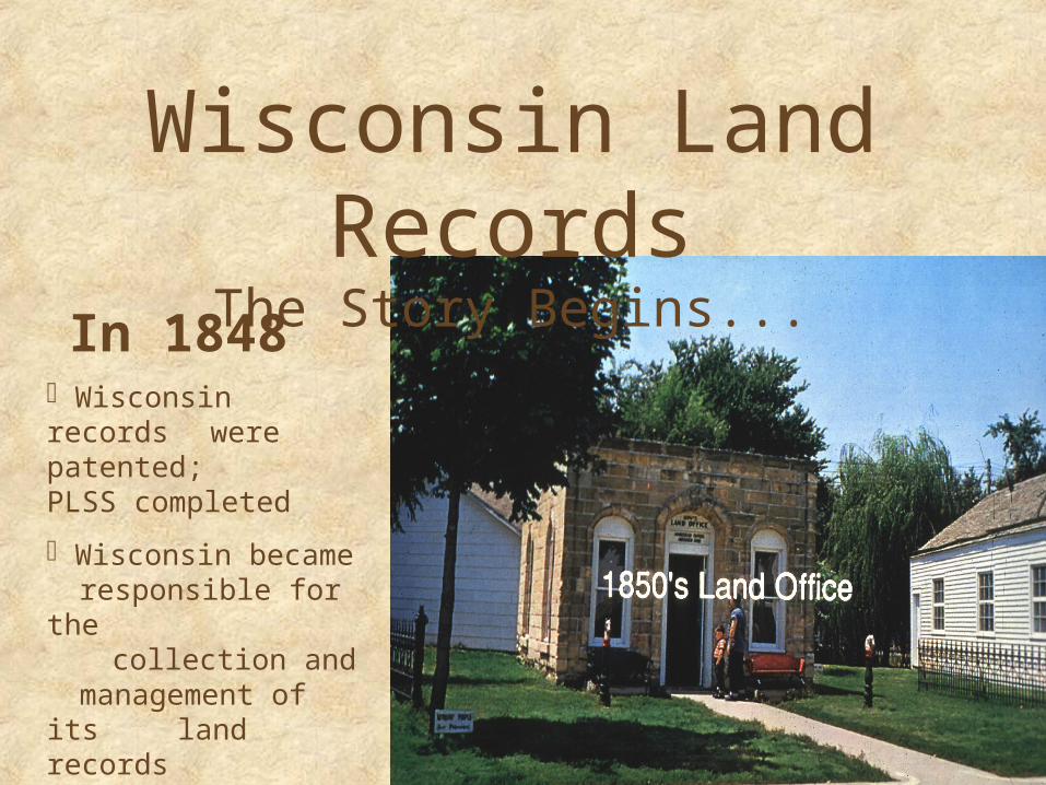
Wisconsin Land Records
The Story Begins...In 1848 Wisconsin records were patented;
PLSS completed
Wisconsin became responsible for the
collection andmanagement of its
land records

The emergence of the issue…The 1976 DOA-funded Larsen Study found the Annual Cost to Collect & Manage Wisconsin’s Land Records to be $78.6 million, with the greatest share of the activity and expenses occurring at the local government level
State 15%
$41m
Federal 19%Utilities 14%
$11.6m
$10.7m
$15.3m
Local 52%(City, Village, Town,
County)

The Larsen Study also identified seven significant problems related to land records:
Lack of accessibility Not available comprehensively Cannot be duplicated Cannot be aggregated Cannot be combined Proprietary interests limit full public access Institutional reluctance to share

In 1985, as a result of the Larsen Study,
the Governor appointed the Land Records Committee to:
Examine and address the immediate needs of state and local agencies regarding land records collection and management
Develop recommendations on how Wisconsin should approach the long-term issues of land records modernization
The Wisconsin
Land Records Committee
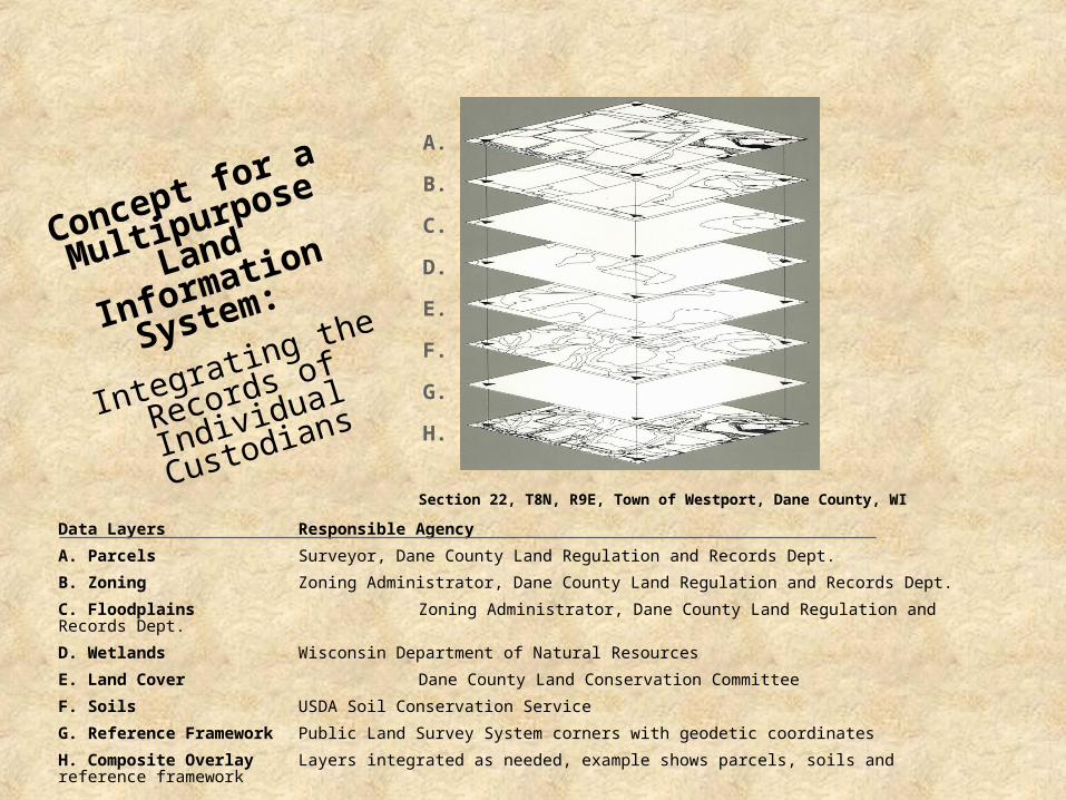
Concept for a
Multipurpose
Land Information
System:
Integrating the
Records of Individual
Custodians
Section 22, T8N, R9E, Town of Westport, Dane County, WI
Data Layers Responsible Agency
A. Parcels Surveyor, Dane County Land Regulation and Records Dept.
B. Zoning Zoning Administrator, Dane County Land Regulation and Records Dept.
C. Floodplains Zoning Administrator, Dane County Land Regulation and Records Dept.
D. Wetlands Wisconsin Department of Natural Resources
E. Land Cover Dane County Land Conservation Committee
F. Soils USDA Soil Conservation Service
G. Reference Framework Public Land Survey System corners with geodetic coordinates
H. Composite Overlay Layers integrated as needed, example shows parcels, soils and reference framework
A.
B.
C.
D.
E.
F.
G.
H.

A Vision for
Wisconsin Land Records
Emerges
• Statewide Coordination and Guidance• Funding for Local Land
Records Modernization• Development of a
Coordinated System of Independent Land Information Systems
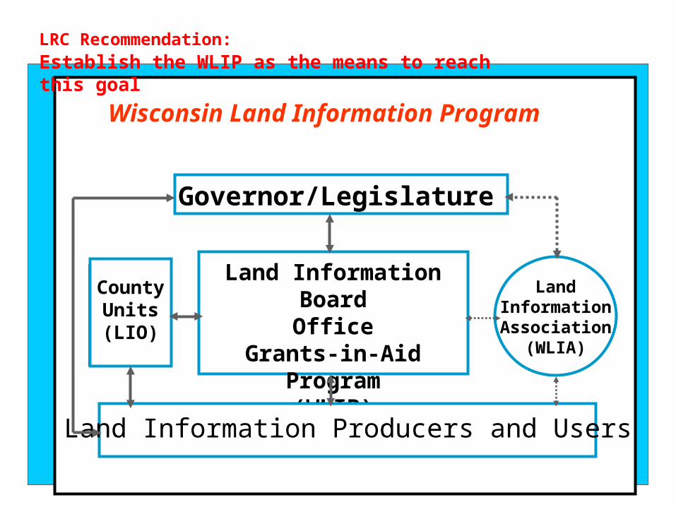
Wisconsin Land Information Program
Land Information BoardOffice
Grants-in-Aid Program(WLIB)
Land Information Producers and Users
Governor/Legislature
CountyUnits(LIO)
LandInformationAssociation
(WLIA)
LRC Recommendation: Establish the WLIP as the means to reach this goal

WLIA Wisconsin Land Information
Association
A key component of the WLIP was the formation of an
independent autonomous organization of land records professionals to promote and
advocate for the WLIP
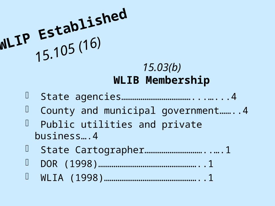
15.03(b)WLIB Membership
State agencies………………………………...…...4 County and municipal government……..4 Public utilities and private business….4 State Cartographer…………………………..….1 DOR (1998)……………………………………………..1 WLIA (1998)…………………………………………..1
WLIP Established
15.105 (16)

16.967WLIB Duties
Provide technical assistance to state and local agencies
Direct and supervise the WLIP and serve as the state clearinghouse for access to land information
Maintain an inventory of land information
Prepare guidelines to coordinate modernization
Review grant applications
Review state agency land integration plans
Report on possible additional revenue sources
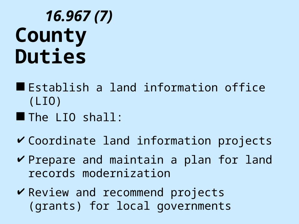
16.967 (7)County Duties Establish a land information office (LIO) The LIO shall:
Coordinate land information projects
Prepare and maintain a plan for land records modernization
Review and recommend projects (grants) for local governments

16.967 (7)
Aid to Counties (Use of Fees & Grants)
Property and ownership records, including boundary information
A parcel ID and tax assessments
Soil surveys
Wetlands
Modern geographic reference system
Zoning restrictions
(1) Implement a land information system that, at a minimum, contains:

WLIP Foundational Elements (original)
Geographic reference frameworks: Geodetic reference systemsPLSS corner remonumentation and
coordinatesGeographic data (basemaps, orthophotos,
etc.)
Parcels Wetlands mapping Soils Mapping Zoning mapping Institutional arrangements Communications, education, training Public access
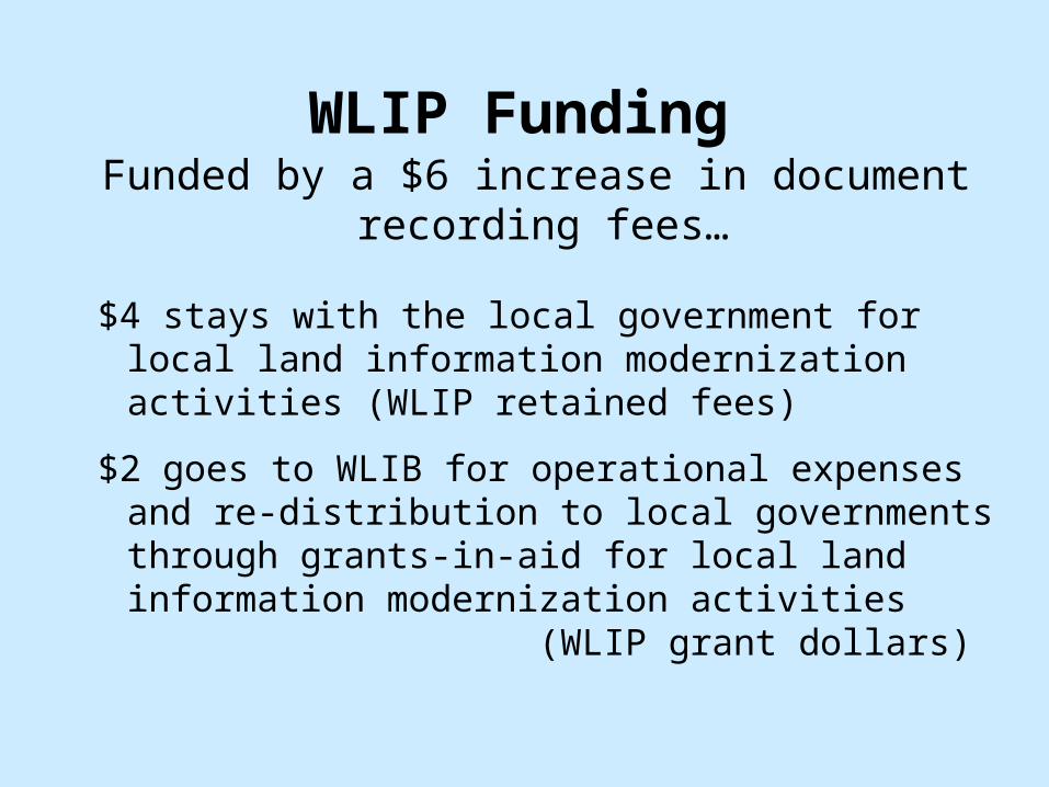
Funded by a $6 increase in document recording fees…
$4 stays with the local government for local land information modernization activities (WLIP retained fees)
$2 goes to WLIB for operational expenses and re-distribution to local governments through grants-in-aid for local land information modernization activities (WLIP grant dollars)
WLIP Funding

Expenditures: 1989-1998
• Retained Fees ($4)…………………………...$34,914,692• Grants and Board Expenses ($2)…..$18,395,528 (about 7%) $53,310,220
$10.36 per capita (5,142,999 people)$ 1.49 per acre (35.7 million acres)$17.00 per parcel (3,136,719 parcels)
Summary of WLIP Expenditures

WLIP Funding by County 1991-1998

WLIP Economic Contribution
Using the inflation rate calculated from the annual Consumer Price Index, and no new additional tasks, local government spending from 1991 through 1998 was an estimated $857 million for land records collection, use and management
Since 1991, the WLIP has generated $53 million (or about 6% of the above $857 million) to help modernize local land record systems in Wisconsin

WLIP Economic Impact & Benefits
For every WLIP dollar, another dollar has been matched from another source in some
form
A variety of local governments participate in the grant process ranging from cities and villages to regional planning commissions, tribal governments and others
At least 10 new companies and 75 new jobs have been established
“Lost” taxable parcels are discovered in Waukesha county
Time needed to choose new landfill site in Portage County reduced by 90%

Reduced Title Insurance Costs in Dane County
Benefits Summary Money: $300 savings per transaction saves Dane
County landowners $6 million annually.
Space: Digital record-keeping results in expanded public-access office area,while total office space was cut by 25%. Document-storage space alone was reduced by over 90%.
Staff: Modernization means that 17 full-time staff are performing duties that would require 27 full-time positions to manage record-keeping the old way.

Improved Floodplain Mapping in Winnebago
County
Benefits Summary Money: Annual insurance savings of $300-$500
for approximately 1,100 households. There is also a reduced burden on emergency and
disaster- relief funds.
Home values: Home values have increased by more than $1 million for affected homes.
Staff: Two-foot contour maps have led to more accurately determined flood-prone areas and
flood insurance rate maps (FIRMs) (the old FIRMs relied on 10-foot contours).

A diverse land records community emerged
The Wisconsin Land Information Program (WLIP) helped initiate modernization in Wisconsin
Mega amounts of human energy were unleashed
All 72 counties prepared modernization plans
Cross-county and cross-governmental consortiums were created
Wisconsin became the national envy of the land information community
WLIP Social Impact

In 1987, theWisconsin Land
Information Association (WLIA)
was formed to advocate for the establishment
and funding of the WLIP

WLI-? Relationship of WLIB, WLIP, &
WLIA...
Wisconsin Land Information ProgramThe Program is that collection of people, organizations, and activities involved in modernizing and managing Wisconsin’s
land information and land information systems, including:
WLIB, WLIA, government agencies at all levels, academia, private firms and businesses, and professional and non-profit
organizations
Wisconsin Land Information Board
Program Governance
Wisconsin Land Information Association
Program Advocacy and Professional (Technical and
Policy) Support

Wisconsin Land Information Association
Nearly 600 members representing the wide variety of professions active in Wisconsin land records modernizationPlanners Zoning AdministratorsLand Conservationists AssessorsForesters PhotogrammetristsEngineers CartographersSurveyors Systems AnalystsTitle Examiners ConsultantsRegisters of Deeds EducatorsReal Property Listers Students

Wisconsin Land Information Association….advocacy, leadership, and
support of Wisconsin land records modernization...
• Policy and Program Advocacy•To actively promote modern land information and systems development.•To provide a unified professional voice on land information issues.•To represent the voice of the Wisconsin land information community.•To participate in WLIP strategic planning and program management.•To review and respond to legislative actions.
• Liaison and Networking•To promote interaction among WLIA members, other professional associations, and public and private sector groups.
• Technical Expertise and Research•To investigate and resolve land information issues.•To develop standards and guidelines that support the WLIP.•To provide a forum for examining new ideas and methods.•To provide resources for research and evaluation of land information development, implementation, and maintenance.
• Education and Public Relations•To develop, and help others develop, a variety of educational programs and materials related to land information and land information systems.•To promote public understanding of WLIA, its members and its activities through a variety of media.

WLIA Gatherings…provide opportunities to exchange ideas, learn new skills, participate in discussions, and expand professional networks...• Annual Conference (over 500 attendees)
• Pre-conference workshops• Technical sessions and presentations• Technology and applications demonstrations• Vendor exhibits• Poster session• Public Night (free and open to general public)• WLIP Town Forum• WLIA Business Meeting
• Quarterly Meetings (typically 50-80 attendees) • Public Night featuring local activities• Educational program on WLIP technical and policy issues• WLIA Business Meeting
• Ongoing Activities• Program advocacy and professional support• Communication about Wisconsin land information activities• Task Forces investigating technical issues• Development of WLIP standards and guidelines

WLIA Membership 1998575 members
Regional Planning 2%(13)
County 41%(215)
Municipality 7.3% (city 32, village 4, town 0)
University 8.5% (faculty 17, student 28 )
State 14.7% (77)
Business GIS Provider 17.5% (92)
Business GIS User 4.4% (23)
Federal Govt. 2%(12)
Tribal 2%(10)

Better
Land Records
NOW!
WLIA Policy Objectives
To actively promote modern land information development;
To provide a unified professional voice on land information issues;
To provide advice on land information issues to public and private decision makers;
To promote positive legislative actions regarding land information issues;
To promote land information activities that benefit the citizens of Wisconsin.

Add WLIA Guiding Principles Poster
Here
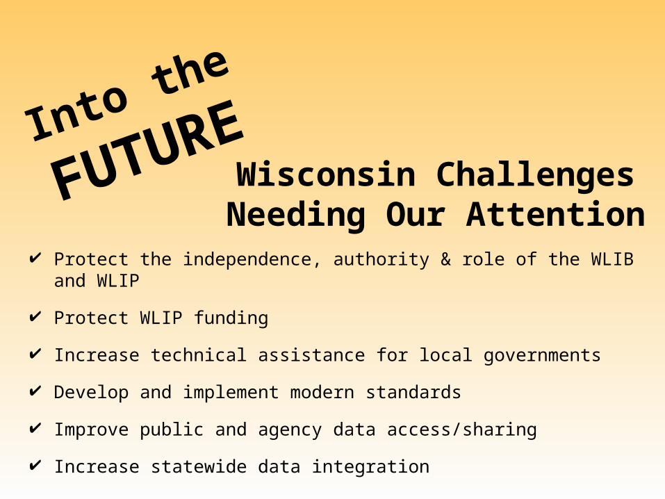
Wisconsin Challenges Needing Our Attention
Protect the independence, authority & role of the WLIB and WLIP
Protect WLIP funding
Increase technical assistance for local governments
Develop and implement modern standards
Improve public and agency data access/sharing
Increase statewide data integration
Into the
FUTURE

Increased National Opportunities
Into the
FUTURE
Federal Emergency Management Agency (FEMA) proposes new national/local floodplain mapping program
National Resources Conservation Service (NRCS) proposes new desktop GIS program for all rural U.S. counties
Federal Geographic Data Committee (FGDC) proposes new federal/local partnerships to help build the National Spatial Data Infrastructure (NSDI)

The WLIP is YOUR Program!
Be active and involved…
WLIA 1-800-344-0421www.wlia.org
WLIB 608-267-2707www.badger.state.wi.us/agencies/wlib


