Introduction to the Maya Biosphere Reserve, Petén, Guatemala, Central America Consejo Nacional de Áreas Protegidas Wildlife Conservation Society With the collaboration of: With the support of:
Transcript
Introduction to the Maya Biosphere Reserve, Petén, Guatemala, Central America
Consejo Nacional de Áreas Protegidas
Wildlife Conservation Society
With the collaboration of:
With the support of:
General conditions and context
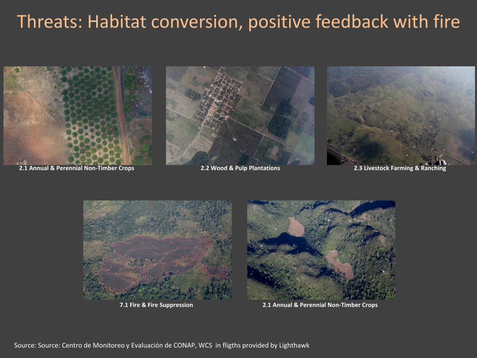
Threats
Monitoring tools
Contents
General conditions and context: Location
Source: Centro de Monitoreo y Evaluación de CONAP, Wildlife Conservation Society
General conditions and context: Timeline1955
Tikal National Park is created by the Guatemalan Government
1959
FYDEP (Empresa Nacional de Fomento y Desarrollo Económico de Petén) is created, the colonization of Petén is promoted as one of the pivotal measures of the institution
1979UNESCO declares Tikal National Park a World Heritage Site
1989The Protected Areas Law Congressional Decree is declared, CONAP is created
1990The Maya Biosphere Reserve is declared by Congressional Decree
1994The first community forest concession is granted to San Miguel
1997-2002Forest concessions are granted to 11 communities and 2 private industries
1998, 2003 and 2005
Coinciding with El Niño events and an extended droughs, large forest fires affect the MBR
2009The largest deforestation area in ten years (close to 25K hectares) is reported for the MBR
2014The lowest deforestation area in ten years (close to 11K hectares) is reported for the MBR, the reserve retains close to 70% of natural habitats
2015
25th anniversary of the creation of the MBR, ongoing efforts to advance a REDD project in the Multiple Use Zone and Sierra del LacandónNational Park
Temple II, newly uncovered mask south of stairway on pyramid stage, April 1958
Credit: William R. Coe, University of Pennsylvania Museum
General conditions and context: Timeline1955
Tikal National Park is created by the Guatemalan Government
1959
FYDEP (Empresa Nacional de Fomento y Desarrollo Económico de Petén) is created, the colonization of Petén is promoted as one of the pivotal measures of the institution
1979UNESCO declares Tikal National Park a World Heritage Site
1989The Protected Areas Law Congressional Decree is declared, CONAP is created
1990The Maya Biosphere Reserve is declared by Congressional Decree
1994The first community forest concession is granted to San Miguel
1997-2002Forest concessions are granted to 11 communities and 2 private industries
1998, 2003 and 2005
Coinciding with El Niño events and an extended droughs, large forest fires affect the MBR
2009The largest deforestation area in ten years (close to 25K hectares) is reported for the MBR
2014The lowest deforestation area in ten years (close to 11K hectares) is reported for the MBR, the reserve retains close to 70% of natural habitats
2015
25th anniversary of the creation of the MBR, ongoing efforts to advance a REDD project in the Multiple Use Zone and Sierra del LacandónNational Park
Temple I, Tikal National ParkCredit: Victor Hugo Ramos, CONAP, WCS
General conditions and context: Timeline1955
Tikal National Park is created by the Guatemalan Government
1959
FYDEP (Empresa Nacional de Fomento y Desarrollo Económico de Petén) is created, the colonization of Petén is promoted as one of the pivotal measures of the institution
1979UNESCO declares Tikal National Park a World Heritage Site
1989The Protected Areas Law Congressional Decree is declared, CONAP is created
1990The Maya Biosphere Reserve is declared by Congressional Decree
1994The first community forest concession is granted to San Miguel
1997-2002Forest concessions are granted to 11 communities and 2 private industries
1998, 2003 and 2005
Coinciding with El Niño events and an extended droughs, large forest fires affect the MBR
2009The largest deforestation area in ten years (close to 25K hectares) is reported for the MBR
2014The lowest deforestation area in ten years (close to 11K hectares) is reported for the MBR, the reserve retains close to 70% of natural habitats
2015
25th anniversary of the creation of the MBR, ongoing efforts to advance a REDD project in the Multiple Use Zone and Sierra del LacandónNational Park
México – Guatemala border circa 1990LANDSAT images from 1991 and 1987, USGS and NASA
General conditions and context: Timeline1955
Tikal National Park is created by the Guatemalan Government
1959
FYDEP (Empresa Nacional de Fomento y Desarrollo Económico de Petén) is created, the colonization of Petén is promoted as one of the pivotal measures of the institution
1979UNESCO declares Tikal National Park a World Heritage Site
1989The Protected Areas Law Congressional Decree is declared, CONAP is created
1990The Maya Biosphere Reserve is declared by Congressional Decree
1994The first community forest concession is granted to San Miguel
1997-2002Forest concessions are granted to 11 communities and 2 private industries
1998, 2003 and 2005
Coinciding with El Niño events and an extended droughs, large forest fires affect the MBR
2009The largest deforestation area in ten years (close to 25K hectares) is reported for the MBR
2014The lowest deforestation area in ten years (close to 11K hectares) is reported for the MBR, the reserve retains close to 70% of natural habitats
2015
25th anniversary of the creation of the MBR, ongoing efforts to advance a REDD project in the Multiple Use Zone and Sierra del LacandónNational Park
Classification of Xate palmsCredit: CONAP
Certified wood from Río Chanchich community concessionCredit: CONAP
General conditions and context: Timeline1955
Tikal National Park is created by the Guatemalan Government
1959
FYDEP (Empresa Nacional de Fomento y Desarrollo Económico de Petén) is created, the colonization of Petén is promoted as one of the pivotal measures of the institution
1979UNESCO declares Tikal National Park a World Heritage Site
1989The Protected Areas Law Congressional Decree is declared, CONAP is created
1990The Maya Biosphere Reserve is declared by Congressional Decree
1994The first community forest concession is granted to San Miguel
1997-2002Forest concessions are granted to 11 communities and 2 private industries
1998, 2003 and 2005
Coinciding with El Niño events and an extended droughs, large forest fires affect the MBR
2009The largest deforestation area in ten years (close to 25K hectares) is reported for the MBR
2014The lowest deforestation area in ten years (close to 11K hectares) is reported for the MBR, the reserve retains close to 70% of natural habitats
2015
25th anniversary of the creation of the MBR, ongoing efforts to advance a REDD project in the Multiple Use Zone and Sierra del LacandónNational Park
MODIS Acqua, March 18, 2003Active fires in Northwestern Guatemala, large amounts of smoke that will
eventually travel trough the Gulf of México to FloridaCredit: Jacques Descloitres, MODIS Rapid Response Team, NASA/GSFC
General conditions and context: Timeline1955
Tikal National Park is created by the Guatemalan Government
1959
FYDEP (Empresa Nacional de Fomento y Desarrollo Económico de Petén) is created, the colonization of Petén is promoted as one of the pivotal measures of the institution
1979UNESCO declares Tikal National Park a World Heritage Site
1989The Protected Areas Law Congressional Decree is declared, CONAP is created
1990The Maya Biosphere Reserve is declared by Congressional Decree
1994The first community forest concession is granted to San Miguel
1997-2002Forest concessions are granted to 11 communities and 2 private industries
1998, 2003 and 2005
Coinciding with El Niño events and an extended droughs, large forest fires affect the MBR
2009The largest deforestation area in ten years (close to 25K hectares) is reported for the MBR
2014The lowest deforestation area in ten years (close to 11K hectares) is reported for the MBR, the reserve retains close to 70% of natural habitats
2015
25th anniversary of the creation of the MBR, ongoing efforts to advance a REDD project in the Multiple Use Zone and Sierra del LacandónNational Park
The above clearing burning on May, 2009Credit: CONAP-WCS in an flight provided by Lighthawk
A 900 hectares clearing in a March, 2009 Landsat imageUSGS and NASA
General conditions and context: Timeline1955
Tikal National Park is created by the Guatemalan Government
1959
FYDEP (Empresa Nacional de Fomento y Desarrollo Económico de Petén) is created, the colonization of Petén is promoted as one of the pivotal measures of the institution
1979UNESCO declares Tikal National Park a World Heritage Site
1989The Protected Areas Law Congressional Decree is declared, CONAP is created
1990The Maya Biosphere Reserve is declared by Congressional Decree
1994The first community forest concession is granted to San Miguel
1997-2002Forest concessions are granted to 11 communities and 2 private industries
1998, 2003 and 2005
Coinciding with El Niño events and an extended droughs, large forest fires affect the MBR
2009The largest deforestation area in ten years (close to 25K hectares) is reported for the MBR
2014The lowest deforestation area in ten years (close to 11K hectares) is reported for the MBR, the reserve retains close to 70% of natural habitats
2015
25th anniversary of the creation of the MBR, ongoing efforts to advance a REDD project in the Multiple Use Zone and Sierra del LacandónNational Park
Re-growth in the above general area on May, 2014Credit: CONAP-WCS in an flight provided by Lighthawk
The 900 hectares clearing of 2009 in re-growth after evicting the land grabbers, September, 2014 Landsat image
USGS and NASA
General conditions and context: Timeline1955
Tikal National Park is created by the Guatemalan Government
1959
FYDEP (Empresa Nacional de Fomento y Desarrollo Económico de Petén) is created, the colonization of Petén is promoted as one of the pivotal measures of the institution
1979UNESCO declares Tikal National Park a World Heritage Site
1989The Protected Areas Law Congressional Decree is declared, CONAP is created
1990The Maya Biosphere Reserve is declared by Congressional Decree
1994The first community forest concession is granted to San Miguel
1997-2002Forest concessions are granted to 11 communities and 2 private industries
1998, 2003 and 2005
Coinciding with El Niño events and an extended droughs, large forest fires affect the MBR
2009The largest deforestation area in ten years (close to 25K hectares) is reported for the MBR
2014The lowest deforestation area in ten years (close to 11K hectares) is reported for the MBR, the reserve retains close to 70% of natural habitats
2015
25th anniversary of the creation of the MBR, ongoing efforts to advance a REDD project in the Multiple Use Zone and Sierra del LacandónNational Park
Soy502 digital newspaper article on the MBR 25th anniversaryhttp://www.soy502.com/articulo/retos-desafios-25-anos-reserva-
biosfera-maya
General conditions and context: Zonification
Source: Centro de Monitoreo y Evaluación de CONAP, Wildlife Conservation Society
General conditions and context: Values
2800 species34% of vascular plants in Guatemala
513 species 71% of birds in Guatemala
62 species 43% of amphibians in Guatemala
122 species 64% of mammals in Guatemala
95 species 39% of reptiles in Guatemala
Source: Centro de Monitoreo y Evaluación de CONAP, Wildlife Conservation Society
General conditions and context: Values
Source: Centro de Monitoreo y Evaluación de CONAP, Wildlife Conservation Society
General conditions and context: Values
Tikal Mirador Naachtun El Perú
Yaxhá
Nakum La Corona Río Azul
Uaxactun Piedras NegrasSource: Centro de Monitoreo y Evaluación de CONAP, Wildlife Conservation Society
General conditions and context: Values
Source: Centro de Monitoreo y Evaluación de CONAP, WCS in a flight provided by Lighthawk
General conditions and context: Values
Source: ONU, AGEXPORT
General conditions and context: Physical conditions
Source: Source: Centro de Monitoreo y Evaluación de CONAP, WCS with data from Shuttle Radar Topographic Mission, NASA-DLR
General conditions and context: Physical conditions
Source: Source: Centro de Monitoreo y Evaluación de CONAP, WCS with data from Worldclim
General conditions and context: Physical conditions
Source: Source: Centro de Monitoreo y Evaluación de CONAP, WCS with data from Worldclim
General conditions and context: Habitats and land use
Source: Source: Centro de Monitoreo y Evaluación de CONAP, WCS in fligths provided by Lighthawk
General conditions and context: Habitats and land use
Source: Source: Centro de Monitoreo y Evaluación de CONAP, WCS in fligths provided by Lighthawk
General conditions and context: Habitats and land use
Source: Centro de Monitoreo y Evaluación de CONAP, Wildlife Conservation Society
5000
10000
15000
20000
25000
30000
35000
20
00
-20
01
20
01
-20
02
20
02
-20
03
20
03
-20
04
20
04
-20
05
20
05
-20
06
20
06
-20
07
20
07
-20
08
20
08
-20
09
20
09
-20
10
20
10
-20
11
20
11
-20
12
20
12
-20
13
20
13
-20
14
An
nu
al r
ate
(h
ect
are
s)
Period
Annual rate
General conditions and context: Habitats and land use
Source: Centro de Monitoreo y Evaluación de CONAP, Wildlife Conservation Society
General conditions and context: Human population
Source: Centro de Monitoreo y Evaluación de CONAP, Wildlife Conservation Society
General conditions and context: Accessibility
Source: Centro de Monitoreo y Evaluación de CONAP, Wildlife Conservation Society