134
INUVIALUIT SETTLEMENT REGION GRANULAR RESOURCES MANAGEMENT PLAN

INUVIALUIT SETTLEMENT REGION
GRANULAR RESOURCES
MANAGEMENT PLAN

ISR Granular Resources Management Plan
2
CONTENTS
SECTION 1: INTRODUCTION
Page
RATIONALE. . . . . . . . . . . . . . . . . . . . . . . . . . . . . . . . . . . . . . . . . . . . . . . . . . . . . . . . . . . . . . . . . . . . .4
CONTRIBUTORS. . . . . . . . . . . . . . . . . . . . . . . . . . . . . . . . . . . . . . . . . . . . . . . . . . . . . . . . . . . . . . . . . .5
OBJECTIVES. . . . . . . . . . . . . . . . . . . . . . . . . . . . . . . . . . . . . . . . . . . . . . . . . . . . . . . . . . . . . . . . . . . . .6
AREA. . . . . . . . . . . . . . . . . . . . . . . . . . . . . . . . . . . . . . . . . . . . . . . . . . . . . . . . . . . . . . . . . . . . . . . . . . .7
REGULATIONS. . . . . . . . . . . . . . . . . . . . . . . . . . . . . . . . . . . . . . . . . . . . . . . . . . . . . . . . . . . . . . . . . . . 10
LIMITATIONS. . . . . . . . . . . . . . . . . . . . . . . . . . . . . . . . . . . . . . . . . . . . . . . . . . . . . . . . . . . . . . . . . . . .24
ENVIRONMENTAL MANAGEMENT. . . . . . . . . . . . . . . . . . . . . . . . . . . . . . . . . . . . . . . . . . . . . . . . . . 25
SECTION 2: SUPPLY AND DEMAND
SUPPLY. . . . . . . . . . . . . . . . . . . . . . . . . . . . . . . . . . . . . . . . . . . . . . . . . . . . . . . . . . . . . . . . . . . . . . . . .27
DEMAND. . . . . . . . . . . . . . . . . . . . . . . . . . . . . . . . . . . . . . . . . . . . . . . . . . . . . . . . . . . . . . . . . . . . . . . 30
HISTORICAL DEMAND FORECASTS. . . . . . . . . . . . . . . . . . . . . . . . . . . . . . . . . . . . . . . . . . . . 30
DEMAND FORECAST METHODOLOGY. . . . . . . . . . . . . . . . . . . . . . . . . . . . . . . . . . . . . . . . . .34
PRIORITIZATION OF GRAVEL SOURCES. . . . . . . . . . . . . . . . . . . . . . . . . . . . . . . . . . . . . . . . .35
2009 FORECAST. . . . . . . . . . . . . . . . . . . . . . . . . . . . . . . . . . . . . . . . . . . . . . . . . . . . . . . . . . . .37
AKLAVIK. . . . . . . . . . . . . . . . . . . . . . . . . . . . . . . . . . . . . . . . . . . . . . . . . . . . . . . . . . . 37
INUVIK. . . . . . . . . . . . . . . . . . . . . . . . . . . . . . . . . . . . . . . . . . . . . . . . . . . . . . . . . . . . .39
PAULATUK. . . . . . . . . . . . . . . . . . . . . . . . . . . . . . . . . . . . . . . . . . . . . . . . . . . . . . . . . .43
SACHS HARBOUR. . . . . . . . . . . . . . . . . . . . . . . . . . . . . . . . . . . . . . . . . . . . . . . . . . . . 46
TUKTOYAKTUK. . . . . . . . . . . . . . . . . . . . . . . . . . . . . . . . . . . . . . . . . . . . . . . . . . . . . . 49
2009 DEMAND FORECAST SUMMARY. . . . . . . . . . . . . . . . . . . . . . . . . . . . . . . . . . . . . . . . . 58
COMMUNITY CONCERNS. . . . . . . . . . . . . . . . . . . . . . . . . . . . . . . . . . . . . . . . . . . . . . . . . . . . . . . . . .60
REFERENCES. . . . . . . . . . . . . . . . . . . . . . . . . . . . . . . . . . . . . . . . . . . . . . . . . . . . . . . . . . . . . . . . . . . . 63
APPENDIX A- MEMORANDUM OF UNDERSTANDING. . . . . . . . . . . . . . . . . . . . . . . . . . . . . . . . . . .65
APPENDIX B- GRANULAR RESOURCE SUPPLY MAPS . . . . . . . . . . . . . . . . . . . . . . . . . . . . . . . . . . .69

ISR Granular Resources Management Plan
3
APPENDIX C- COMMUNITY CONSULTATION NOTES . . . . . . . . . . . . . . . . . . . . . . . . . . . . . . . . . . .75
ISR Granular Resources Management Plan
4
SECTION 1: INTRODUCTION
RATIONALE
The Inuvialuit Settlement Region (ISR) gravel management plan is a joint initiative by the ISR’s
largest landowners – the Inuvialuit and the Government of Canada. Both of these respective
parties recognize that effective use of finite gravel resources in one of the most geographically
remote places in Canada is crucial in meeting local community socio-economic objectives as
well as ensuring the sustainable management of all natural resources. It is the intention of the
Government of Canada and the Inuvialuit to establish a cooperative approach to managing this
valuable resource. To accomplish this will result in more consistent approaches to planning,
extraction and reclamation of sites where activity currently exists, or may take place in the
future. Reduction of legal liability and enhancement of the efficiencies of the material usage
will also occur.
This plan will create an integrated approach to management of granular resources through an
agreed upon process regardless of tenure. The resource will be managed in the most effective
manner through the prioritization process identified in the Inuvialuit Final Agreement on
Inuvialuit owned lands. It will also be achieved through the application of current best
management practices coupled with environmental terms and conditions applied through
associated authorizations deemed necessary throughout the Settlement Region.
It is also realized that while demand forecasts can help determine future projects, situations
can change and that new economic opportunities may present challenges to established
management criteria. Regional developments and changes to the gravel management plan will
need to be explored as and when events unfold. It is also realized that the current royalty rates
for gravel resources on Crown lands is less than that of resources on Inuvialuit Private lands,
and as such these economic differences will impact proponent desired site selection. The
challenge will be the differentiation between ideal gravel source prioritization versus the
economic practicalities of the project in question.
The Inuvialuit Land Administration (ILA) and Indian and Northern Affairs Canada (INAC) will
continue to consult on these issues to ensure that the management plan effectively meets
current objectives while providing the flexibility to adapt to meet changing conditions in the
future. The goal of the plan is to promote sustainable approaches to gravel utilization and site
restoration that may inspire other organizations across the north to work with the Government
of Canada and other partners in the development of similar natural resource management
plans for their geographical areas.
ISR Granular Resources Management Plan
5
CONTRIBUTORS
The ISR Granular Resources Management Plan is a document that has been contributed to by
many employees of Indian and Northern Affairs Canada (INAC) and the Inuvialuit Land
Administration (ILA). Other contributors to the development of the management plan include
the Inuvialuit Land Administration Commission (ILAC), the ISR Community Corporations and
Hamlets, the Government of the Northwest Territories, and the citizens of the Inuvialuit
Settlement Region.

ISR Granular Resources Management Plan
6
OBJECTIVES
In 2002 a Memorandum of Understanding (MOU) was signed, in which the Inuvialuit Regional
Corporation (IRC) and Indian and Northern Affairs Canada - Northwest Territories Region (INAC)
agreed to co-manage Crown and privately owned Inuvialuit Settlement Region (ISR) granular
resources (see Appendix A). The following management plan provides an approach for the
management of all potential granular resources on both public (Crown) and private (Inuvialuit-
owned) lands, but does not compromise the authority of either organization to administer
lands under their jurisdiction. A co-ordinated and systematic approach to granular resource
management will be developed through the compilation and utilization of existing information,
sharing of research and project data, and a commitment to joint planning, action and resource
allocation. This joint management approach is supported in the Inuvialuit Final Agreement
(IFA).

ISR Granular Resources Management Plan
7
AREA
The Inuvialuit Settlement Region is located in Canada’s Western Arctic and spans from the
Alaska-Yukon border to Victoria Island on the Beaufort Sea (see Figure 1). With an area of
450,000 square kilometres, the ISR includes the Mackenzie Delta, Victoria Island and Banks
Island. There are six communities that are part of the ISR: Aklavik (population 594), Inuvik
(3,484), Paulatuk (294), Sachs Harbour (122), Tuktoyaktuk (870) and Ulukhaktok (formerly
known as Holman) (398) (Statistics Canada, 2006).
Within the ISR there are four land owners: the Inuvialuit (Inuvialuit Private lands), the
Government of the Northwest Territories (Commissioner’s lands), the Gwich’in (Gwich’in
Private lands), and the Federal Government of Canada (Crown lands). Inuvialuit Private lands
comprise approximately twenty percent of the lands within the ISR. The Inuvialuit Land
Administration has jurisdiction over Inuvialuit Private lands that fall under the categories of
“7(1)(a)” and “7(1)(b)” lands as defined in the Inuvialuit Final Agreement. 7(1)(a) lands refer to
lands to which the Inuvialuit hold both surface and subsurface rights, while 7(1)(b) lands refer
to lands to which the Inuvialuit hold only surface rights. Surface rights were granted for
granular resources only, while subsurface rights include rights to granular resources, as well as
oil, gas, other hydrocarbons, coal, sulphur and minerals. The distribution of 7(1)(a) and 7(1)(b)
lands can be seen in Figure 1. 7(1)(a) lands consist of approximately 13,000 square kilometres
of land, which lie in 1,800 square kilometre blocks belonging to each of the six ISR communities,
as well as a block (approximately 2,000 square kilometres) at Cape Bathurst. 7(1)(b) lands
consist of 78,000 square kilometres which lie further afield from the communities.
Nearly eighty percent of the land within the ISR belongs to the Federal Government. Surface
and subsurface rights on Crown lands within the ISR are administered by the Minister of the
Department of Indian and Northern Affairs Canada. INAC also administers the subsurface rights
on 7(1)(b) Inuvialuit Private lands and subsurface rights for resources on Commissioner’s Lands.
Commissioner’s land is land which has been transferred from the Government of Canada to the
Commissioner of the Northwest Territories for the purposes of future Community
development. This land is also referred to as Block Land Transfer (or BLT) lands and accounts
for two percent of the land within the Northwest Territories. Commissioner’s lands within the
ISR are administered by the Lands Administration section of the Government of the Northwest
Territories’ Department of Municipal and Community Affairs (MACA). MACA administers the
Commissioner’s land by selling, leasing, or otherwise disposing of land within the BLT existing
outside Municipal boundaries in the Northwest Territories. Thus, MACA is responsible for the
management of gravel on these lands which is used mainly by the GNWT Departments of
Transportation and Public Works and Services.
There are multiple methods of access to the six ISR communities and the areas surrounding
them. Inuvik is accessible from the south almost year-round by the Dempster Highway (with

ISR Granular Resources Management Plan
8
the exception of spring break-up and fall freeze-up). During the winter (approximately
December-April) Aklavik and Tuktoyaktuk are accessible by an ice road which is constructed on
the Mackenzie River. All communities have airstrips and are accessible by air. All communities
are also accessible by barge during ice-free seasons. Granular sources outside of a community’s
municipal infrastructure can also be accessed through the construction of a seasonal winter
road or ice road, or an all-weather road.

ISR Granular Resources Management Plan
9
Figure 1- The Inuvialuit Settlement Region Source: Inuvialuit Land Administration

ISR Granular Resources Management Plan
10
REGULATIONS
This section includes relevant legislation and regulations regarding granular resource
management in the Inuvialuit Settlement Region for both Indian and Northern Affairs Canada
and the Inuvialuit Land Administration. Pertinent legislation includes, but is not limited to -
provisions of the Inuvialuit Final Agreement, ILA Rules & Procedures, the Territorial Lands Act,
the Territorial Land Use Regulations, the Territorial Quarry Regulations, and the NWT Waters
Act.
The legislation, regulations, and rules and procedures included in this section are subject to
change, and the gravel management plan will be updated accordingly. In the foreseeable
future, the Inuvialuit Land Administration will be implementing a new land management system
entitled “Inuvialuit Land Management System” which may make significant changes to gravel
permitting and royalties. Indian and Northern Affairs Canada is currently reviewing and
considering changes to the existing Territorial Quarrying Regulations.
Documents Applicable to Inuvialuit Private Lands
The Inuvialuit Final Agreement
The Western Arctic (Inuvialuit) Claims Settlement Act approved, gave effect to and declared
valid the Inuvialuit Final Agreement in 1984. The Inuvialuit Final Agreement is the agreement
which delineates the Inuvialuit Settlement Region, establishes ownership of lands, and creates
the Inuvialuit Regional Corporation and its subsidiaries including the Inuvialuit Land
Corporation, which is managed by the Inuvialuit Land Administration. The following are the
sections of the Inuvialuit Final Agreement that dictate the management of granular resources in
the ISR:
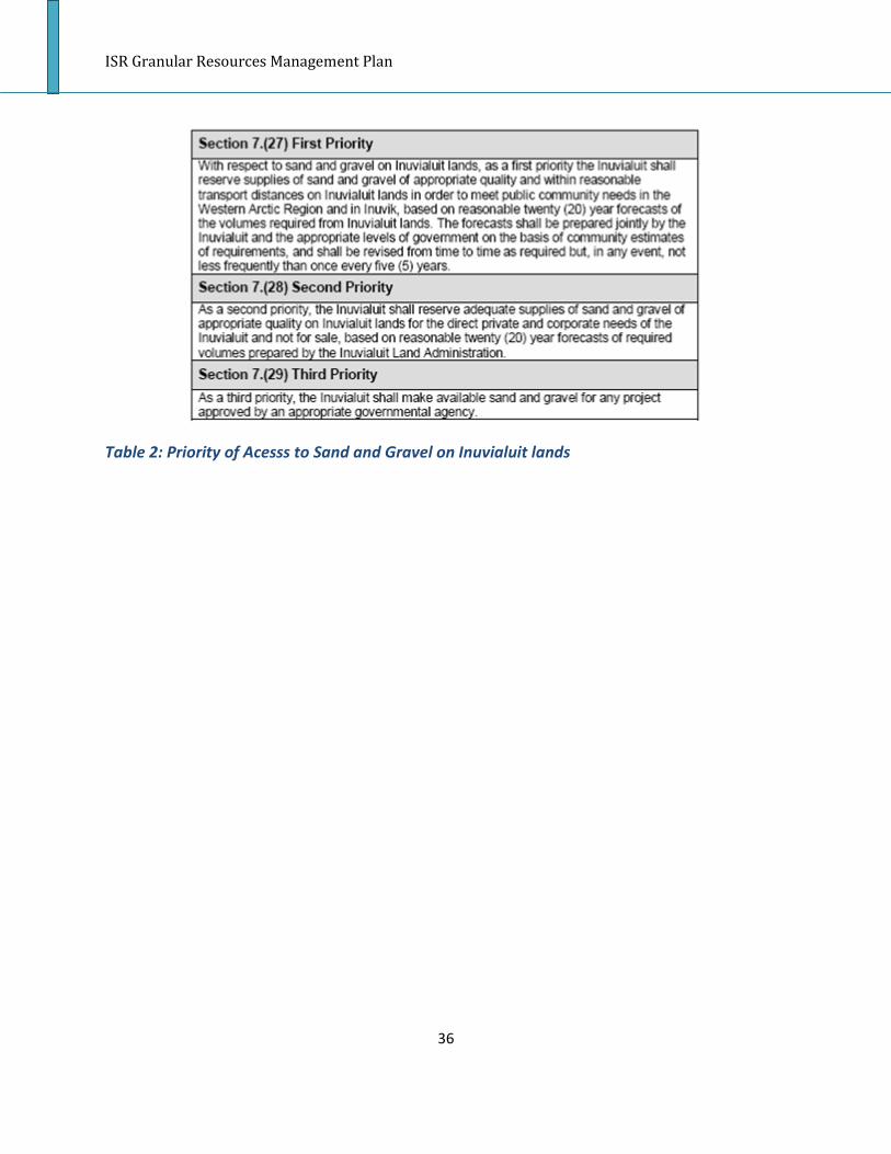
7(27) With respect to sand and gravel on Inuvialuit lands, as a first priority the Inuvialuit shall
reserve supplies of sand and gravel of appropriate quality and within reasonable transport
distances on Inuvialuit lands in order to meet public community needs in the Western Arctic
Region and in Inuvik, based on reasonable twenty (20) year forecasts of the volumes required
from Inuvialuit lands. The forecasts shall be prepared jointly by the Inuvialuit and the
appropriate levels of government on the basis of community estimates of requirements, and
shall be revised from time to time as required but, in any event, not less frequently than once
every five (5) years.
7(28) As a second priority, the Inuvialuit shall reserve adequate supplies of sand and gravel of
appropriate quality on Inuvialuit lands for the direct private and corporate needs of the

ISR Granular Resources Management Plan
11
Inuvialuit and not for sale, based on reasonable twenty (20) year forecasts of required volumes
prepared by the Inuvialuit Land Administration.
7(29) As a third priority, the Inuvialuit shall make available sand and gravel for any project
approved by an appropriate governmental agency.
7(30) The Inuvialuit and the appropriate level of government may jointly identify certain zones
within the Western Arctic Region including, for greater certainty, Inuvialuit lands, where sand
and gravel may not be removed, or may not be removed during certain periods of the year, for
environmental reasons or because of other conflicting uses of such land.
7(31) For greater certainty, the sand and gravel deposits within Inuvialuit lands, known
collectively as the Ya Ya Lakes eskers, shall be dedicated to sand and gravel development,
subject to normal pit development, restoration measures and laws of general application.
7(32) The right to remove sand and gravel from Inuvialuit lands requires a licence or concession
obtained from the Inuvialuit Land Administration. A licence or concession may stipulate the
required payment of a royalty to the Inuvialuit Land Administration, not exceeding $0.75 per
cubic yard multiplied by b/a, where “a” means the Gross National Product of Canada in current
dollars for the year 1982 and “b” means the Gross National Product of Canada in current dollars
for the year previous to the year in which the royalties are being charged.
7(33) For the purposes of subsection (32):
(a) a licence is a non-exclusive right to remove a certain volume of sand and gravel for a specific
purpose during a period not exceeding one (1) year from a specific sand and gravel pit; and As
amended January 15, 1987 (b) a concession is the exclusive right to explore, develop and
produce sand and gravel from an area for a period specified in the concession.
7(34) A licence or concession may stipulate payments to cover reasonable administrative costs
and, where they are applicable and justified, reasonable land reclamation costs in relation to
the sand and gravel deposit for which the licence or concession has been granted.
7(35) In granting a licence, the Inuvialuit Land Administration shall, to the extent of its legal
capability, ensure that sand and gravel is made available to interested parties at reasonable
prices.
7(36) Before issuing a licence, the Inuvialuit Land Administration shall require the applicant to
establish that the proposed project has been approved by the appropriate level of government
and that a contract has been awarded.

ISR Granular Resources Management Plan
12
7(37) Notwithstanding subsection (36), the Inuvialuit Land Administration shall, subject to
reasonable rules of pit management, issue a licence to any person for personal use in amounts
not exceeding 50 cubic yards annually.
7(38) Any concession granted by the Inuvialuit Land Administration to the Inuvialuit
Development Corporation shall contain the specific provision that the Inuvialuit Development
Corporation shall make sand and gravel available at reasonable prices to interested parties
bearing in mind the priorities set out in subsections (27) to (29). Reasonable prices shall not
exceed levels that would result in a rate of return in excess of 20%, after tax, on the capital
employed by the holder in his sand and gravel business.
7(39) The rate of return referred to in subsection (38) shall be determined in accordance with
generally acceptable accounting principles on the basis of actual data for past years and
reasonable forecasts for future years with the aim of averaging the rate of return over the life
of the concession. For the purpose of determining reasonable prices, the concession holder
shall not take into account any general annual overhead and management costs in excess of
15% of total costs.
7(40) Any concession referred to in subsection (38) shall establish that the Inuvialuit
Development Corporation maintains for inspection by the Inuvialuit Land Administration and
the appropriate government officials the necessary financial records related to the royalty
payments, profits and rate of return of the operations.
7(41) Where the Minister is of the opinion that the Inuvialuit Development Corporation, under
a concession, is providing sand and gravel in an unreliable or inefficient manner or at excessive
prices, he may notify the Inuvialuit Land Administration in writing whereupon it shall terminate
the concession and offer it on a competitive bid basis. Neither Canada, the concession holder
nor any third party shall have any right, claim or recourse against the Inuvialuit arising from
alleged damage or loss resulting from such termination.
7(42) The provisions of this Agreement respecting sand and gravel, except subsection (41), are
subject to the arbitration process set out in section 18.
The Inuvialuit Land Administration Rules and Procedures
The Inuvialuit Land Administration has adopted its own rules and procedures for how gravel use
shall be permitted and the fees and royalties associated with resource extraction. The relevant
sections of the ILA Rules and Procedures are included below:

ISR Granular Resources Management Plan
13
Application for a Quarry License
7(21) Every application for a Quarry License, must be accompanied by the Royalties for the
volume of Surface Materials, proposed to be removed, or the first 1,000 cubic metres (1308
cubic yards), whichever is less.
Royalties shall be refunded, where the Administrator does not issue the Right applied or shall
be partially refunded where the Right is issued for a volume smaller than the one applied for.
Preliminary Plan
7(22) Every application shall be accompanied by a preliminary plan showing the intended Land
Use or Land Occupancy and an estimate of their area in hectares or square kilometres.
Area applied for in Application for a Quarry, Coal or Mineral Concession Must be Staked
Furthermore, any Application for a Quarry, Coal or Mineral Concession cannot be made unless
the area has been staked in accordance with subsection 19(18) hereof, prior to the date of
application.
7(23) The preliminary plan with an Application shall identify the approximate location, with
coordinates, of all:
a) Existing lines, trails, Rights of Way and cleared areas proposed to be used in the
operations;
b) New lines, trails, Rights of Way and cleared areas proposed to be used in the operations;
c) Buildings, campsites, air landing strips, air navigations aids, fuel and supply storage sites,
waste disposal sites, excavations and other works and places proposed to be
constructed or used during the operations; and
d) Bridges, dams, ditches, railroads, highways and roads, transmission lines, pipelines,
survey lines and monuments, air landing strips, streams and other features, structures
or works that, in the opinion of the applicant, may be affected by the operations.

ISR Granular Resources Management Plan
14
Documents Applicable to Crown Lands
Territorial Quarrying Regulations
The Territorial Quarrying Regulations apply to granular resource development on Crown land
within the Inuvialuit Settlement Region, and as such are used by Indian and Northern Affairs
Canada to guide their quarry permitting process. These regulations are currently being
reviewed which may bring substantial changes to this document upon completion. It should
also be noted that although there are provisions to stake and lease granular resources, the
NWT Region has taken the policy position to not proceed on the application of either activity in
consideration of the general, local scarcity of the resource.
APPLICATION
3. These Regulations apply only to territorial lands under the control, management and
administration of the Minister.
STAKING
4. (1) A person who desires to obtain a lease of territorial lands for the purpose of taking
limestone, granite, slate, marble, gypsum, marl, gravel, loam, sand, clay, volcanic ash or stone
therefrom, shall stake such lands in the manner prescribed in this section.
(2) In the case of loam, the area shall not exceed 20 acres, and in the case of any other
material mentioned in subsection (1), the area shall not exceed 160 acres; and the length of any
area shall not exceed twice the breadth.
(3) The area staked shall be rectangular in form except where a boundary of a previously
staked tract is adopted as common to both areas.
(4) The land shall be marked by the applicant with posts firmly fixed in the ground, one at each
corner; in areas where there is no timber, rock cairns may be used in lieu of posts.
(5) Each post shall be at least four inches square and when firmly planted shall be not less than
four feet above the ground.
(6) Each post shall bear markings showing the number of the post, the name of the applicant,
the date of staking and the kind of material which it is desired to remove.
(7) When rock cairns are used, they shall be well constructed, be not less than two feet high
and two feet in diameter at the base, a metal container shall be built into the cairn, and a
notice bearing the number of the cairn, the name of the applicant, the date of staking and the
kind of material which it is desired to remove shall be placed therein.

ISR Granular Resources Management Plan
15
(8) In a timbered area the lines between the posts shall be clearly marked, and in treeless
areas mounds of earth or rock not less than two feet high and two feet in diameter at the base
may be used to mark the lines between the cairns.
(9) The applicant shall post a written or printed notice on a post or in a cairn setting out his
intention to apply for a lease within the time prescribed by these Regulations.
(10) If two or more persons apply for the same area, the person who first staked the area in
accordance with these Regulations shall be entitled to priority in respect of the issuance of a
lease.
LEASES
5. Territorial lands containing limestone, granite, slate, marble, gypsum, loam, marl, gravel,
sand, clay, volcanic ash or stone may be leased by the Minister for the sole purpose of
quarrying out or removing therefrom any such substances or materials.
6. (1) An application for a lease shall be filed with the territorial land agent of the land district in
which the land is situated within 30 days from the date upon which it was staked.
(2) Every lease application shall be accompanied by the application fee set out in Schedule I
and the rental for the first year of the lease at the rate set out in Schedule II.
(3) Every application for a lease shall be in duplicate and shall contain
(a) a description by metes and bounds of the land applied for;
(b) the name of the materials that the applicant desires to remove from the area;
(c) a sketch showing clearly the position of the parcel in relation to a survey monument,
prominent topographical feature or other known point and showing in its margin, copies of the
markings on the posts or cairns; and
(d) an affidavit by the applicant setting forth
(i) that he has complied with all the provisions of these Regulations, and
(ii) that the land contains material of the kind applied for in merchantable quantities.
SOR/96-112, s. 1.
7. The term of a lease shall not exceed 10 years.
8. A lessee shall, within such time from the date of the lease as the Minister may fix, commence
the removal of the material or materials in merchantable quantities from the area under lease
and shall continue the removal of materials to an extent and in a manner satisfactory to the
Minister.
RENEWAL OF LEASE
9. Where, in the opinion of the Minister, the lessee has complied with the terms of his lease
and these Regulations, the Minister may renew the lease for a further term not exceeding 10
years.

ISR Granular Resources Management Plan
16
SAND, GRAVEL AND STONE FOR RESIDENTS
10. Any person resident in the Northwest Territories may take, without a permit or payment of
any fees or dues, not more than 50 cubic yards of sand, gravel or stone from territorial lands in
any calendar year for his own use but not for barter or sale, but no sand, gravel or stone shall
be taken from any territorial lands if any interest in the surface rights of such lands has been
licensed, leased or otherwise disposed of by the Crown.
SOR/2003-116, s. 18.
LOAM FOR USE OF RESIDENTS
11. (1) A territorial land agent may issue to any person resident in the Northwest Territories,
without the payment of any fee or royalty, a permit authorizing him to take not more than 15
cubic yards of loam from territorial lands in any calendar year for his own use, but not for
barter or sale.
(2) No person shall take loam from any territorial lands unless he is the holder of a permit.
SOR/2003-116, s. 19.
PERMITS
12. (1) A territorial land agent, on receipt of the permit application fee set out in Schedule I and
the applicable royalties payable under section 14, may issue a permit to the applicant
authorizing the applicant to take the quantity of material specified in the permit from the lands
described in the permit.
(2) A territorial land agent may issue a permit, without the payment of any fees or dues, to
take such quantities of the materials named in the permit from the land described in the
permit, to any of the following:
(a) a department of the Government of Canada;
(b) the Commissioner of the Northwest Territories;
(c) [Repealed, SOR/2003-116, s. 20]
(d) any municipal district in the Northwest Territories; and
(e) any educational, religious or charitable institution or hospital in the Northwest Territories.
(3) Permits shall expire when the quantity of material or substance mentioned in the permit
has been quarried or removed, or on the expiry of one year from the date of issue of the
permit, whichever is the earlier.
(4) A permit shall not be assigned.
(5) If a permittee has not complied with these Regulations or the conditions of his permit, the
Minister may cancel the permit.

ISR Granular Resources Management Plan
17
SOR/96-112, s. 2; SOR/2003-116, s. 20.
RESERVATIONS
13. (1) Where the area under a lease or permit issued pursuant to these Regulations is subject
to an oil and gas permit or lease, or a recorded mineral claim, the lease or permit shall not
authorize entry upon such area without first obtaining the permission of the Minister.
(2) The Minister may grant such permission subject to such conditions for the protection of
the holder of the terminable grant as may be considered necessary.
FEES AND ROYALTIES
14. Except as provided in these Regulations, material taken by a lessee or permittee from lands
described in a permit or lease is subject to the payment of royalties at the rates set out in
Schedule II.
SOR/96-112, s. 3.
15. The fee set out in column II of an item of Schedule I is payable for the service set out in
column I of that item.
Territorial Land Use Regulations
While a prospective proponent may be granted the rights to the resource (ie: a specified
volume of granular material), he/she may remain in need of a Land Use Permit should quarrying
the material require the use of equipment which triggers such an authorization. Triggers
important to keep in mind are as follows:
No person shall, without a Class A Permit, carry on any work or undertaking on territorial lands that
involves
(a) the use, in any 30-day period, of more than 150 kg of explosives;
(b) the use, except on a public road or trail maintained wholly or in part by federal funds, of any vehicle
that exceeds 10 t net vehicle weight;
(c) the use of any power driven machinery for earth drilling purposes whose operating weight, excluding
the weight of drill rods or stems, bits, pumps and other ancillary equipment, exceeds 2.5 t;
(d) the establishment of any campsite that is to be used for more than 400 man-days;
(e) the establishment of any petroleum fuel storage facility exceeding 80 000 l capacity or the use of a
single container for the storage of petroleum fuel that has a capacity exceeding 4 000 l;

ISR Granular Resources Management Plan
18
(f) the use of any self-propelled power driven machine for moving earth or clearing land of vegetation;
(g) the use of any stationary power driven machine for hydraulic prospecting, moving earth or clearing
land, other than a power saw; or
(h) the levelling, grading, clearing, cutting or snowploughing of any line, trail or right-of-way exceeding
1.5 m in width and exceeding 4 ha in area.
9. No person shall, without a Class B Permit, carry on any work or undertaking on territorial lands that
involves
(a) the use, in any 30-day period, of more than 50 kg but less than 150 kg of explosives;
(b) the use, except on a public road or trail maintained wholly or in part by federal funds, of any vehicle
that is more than 5 t but less than 10 t net vehicle weight, or the use of any vehicle of any weight that
exerts pressure on the ground in excess of 35 k pa;
(c) the use of any power driven machinery for earth drilling purposes whose operating weight, excluding
the weight of drill rods or stems and bits, pumps and other ancillary equipment, is more than 500 kg but
less than 2.5 t;
(d) the establishment of any campsite that is to be used by more than two people for more than 100 but
less than 400 man-days;
(e) the establishment of any petroleum fuel storage facility that has a capacity of more than 4 000 l but
less than 80 000 l or the use of a single container for the storage of petroleum fuel that has a capacity of
more than 2 000 l but less than 4 000 l; or
(f) the levelling, grading, clearing, cutting or snowploughing of any line, trail or right-of-way exceeding
1.5 m in width but not exceeding 4 ha in area.
NWT Waters Act
In addition to the land authorizations, should any activities related to the quarrying of materials
fall within the triggers of a water licence, there may be a requirement for a licence issued by
the NWT Water Board as well. Generally this in not a necessity, however, to be aware the
triggers are as follows:
8. (1) Except as authorized pursuant to the Dominion Water Power Act, and subject to
subsection (2), no person shall use, or permit the use of, waters in a water management area
except
(a) in accordance with the conditions of a licence; or

ISR Granular Resources Management Plan
19
(b) as authorized by regulations made under paragraph 33(1)(m).
9. (1) Except in accordance with the conditions of a licence or as authorized by regulations
made under paragraph 33(1)(n), no person shall, subject to subsection (2), deposit or permit
the deposit of waste
(a) in any waters in a water management area; or
(b) in any other place under conditions in which the waste, or any other waste that results from
the deposit of that waste, may enter any waters in a water management area.
ISR Granular Resources Management Plan
20
Documents Applicable to Commissioner’s Land
Commissioner’s Land Act
3.(1) Subject to this Act, the Commissioner may authorize the sale, lease or other disposition of
Commissioner’s land, including:
(b) a permit authorizing the removal of granular materials from a quarry on Commissioner’s
land.
(1.1) For greater certainty, the Commissioner may, under subsection (1), authorize a lease or an
administration agreement that provides for the establishment, operation and restoration of a
quarry on Commissioner’s land and for the issuance of a permit referred to in paragraph
3(1)(b).
12. The Commissioner, on the recommendation of the Minister, may make regulations
(b.1) respecting the establishment, operation and restoration of a quarry on Commissioner’s
land;
(b.2) respecting the removal and use of granular materials from Commissioner’s land generally;
Commissioner’s Land Regulations
Quarrying Leases
22. (1) A person who desires to obtain a lease of Commissioner's land for the purpose of
quarrying and taking limestone, granite, slate, marble, gypsum, marl, gravel, loam, sand, clay,
volcanic ash or stone from the Commissioner's land shall make application as provided by
section 10 and shall stake lands in the manner prescribed in this section.
(2) In the case of loam the area of a quarrying lease shall not exceed 8 ha, and in the case of
any other material mentioned in subsection (1) the area shall not exceed 65 ha, and the length
of any area shall not exceed twice the breadth.
(3) Land staked for a quarrying lease shall be rectangular in form except where a boundary of a
previously staked tract is adopted as common to both areas.
(4) The Deputy Minister shall not issue a quarrying lease to an applicant unless, in the Deputy
Minister's opinion, the materials to be quarried are to be used or marketed immediately, the
land contains such materials in economic quantities, and use of the land applied for quarrying
purposes is not significantly detrimental to the surrounding area. R-085-92,s.3.
23. (1) The term of a quarrying lease shall not exceed 10 years.

ISR Granular Resources Management Plan
21
(2) A quarrying lease must provide that the lessee shall pay a royalty in the amount set out in
Schedule A. R-085-92,s.9.
24. A lessee shall pay an annual rental fee for a quarrying lease in the amount set out in
Schedule A. R-012-2002,s.3.
25. A lessee shall, within such time from the date of the quarrying lease as the Deputy Minister
may fix, commence the removal in merchantable quantities of the material or materials from
the area under the quarrying lease and shall continue the removal to an extent and in a manner
satisfactory to the Deputy Minister. R-085-92,s.3.
26. Where in the opinion of the Deputy Minister the lessee has complied with the terms of his
or her quarrying lease and the regulations, the Deputy Minister may grant another lease for a
term not exceeding 10 years subject to such terms and conditions as he or she deems fit. R-
085-92,s.3.
Quarrying Permits
31. (1) The Deputy Minister or a municipal corporation or any other person that has entered
into a quarry administration agreement may, on the application of any person and on the
payment of the fee for a quarrying permit, the royalty and the fees for quarry restoration, road
maintenance and quarry administration set out in Schedule A and, where applicable, any fee
charged under subsection (1.1), issue a quarrying permit in Form 8 of Schedule B authorizing
such person to take, subject to any conditions specified in the permit, such granular materials in
such quantities as are specified in the permit from the land described in the permit.
(1.1) The Deputy Minister or a municipal corporation or any other person that has entered into
a quarry administration agreement shall, in addition to the fees set out in Schedule A, charge a
quarry development fee determined under subsection (1.2) to an applicant for a quarrying
permit where one or more of the following activities has been carried out at a quarry in order
to facilitate the sale or supply of granular materials under the authority of the permit:
(a) drilling;
(b) blasting;
(c) crushing;
(d) stockpiling;
(e) loading;
(f) hauling;
(g) any other development activity.
(1.2) The Deputy Minister or a municipal corporation or any other person that has entered into
a quarry administration agreement shall, in accordance with subsection (1.3) and before March
31 each year, determine the quarry development fee that may be charged during the period

ISR Granular Resources Management Plan
22
beginning on April 1 in that year and ending on March 31 in the following year for each cubic
meter of granular materials to be developed for sale or supply at a quarry during that period.
(1.3) The quarry development fee that may be charged in a period referred to in subsection
(1.2) must be equal to
A
B
where
(a) A is the total estimated cost of developing the granular materials estimated to be
required for sale or supply during the period; and
(b) B is the total estimated number of cubic meters of granular materials estimated to
be required for sale or supply during the period.
(1.4) Before the commencement of the period in respect of which a quarry development fee is
determined under subsection (1.3), the Deputy Minister or a municipal corporation or any
other person that has entered into a quarry administration agreement shall
(a) publish the amount of the quarry development fee for each cubic meter of granular
materials, in a newspaper or any other publication circulating in the region or place
where the quarry is located; or
(b) post the amount of the quarry development fee that will be charged for each cubic
meter of granular materials, in various conspicuous locations within the region or
place where the quarry is located and at the site of the quarry.
(2) On application and without the payment of any fees or royalties, the Deputy Minister or a
municipal corporation or any other person that has entered into a quarry administration
agreement may issue a quarrying permit authorizing any of the following applicants to take
such materials in such quantities as are specified in the permit from the land described in the
permit:
(a) the Government of Canada;
(b) the Government of the Northwest Territories;
(c) a municipal corporation;
(d) an educational, religious or charitable institution or hospital.
(3) A quarrying permit expires when the quantity of material specified in the permit has been
quarried or removed or on the day specified in the permit, whichever occurs first.
(4) The day specified in the permit must not be more than 12 months after the date of issue of
the permit.

ISR Granular Resources Management Plan
23
(5) A quarrying permit is not assignable and any assignment of it is of no effect. R-085-92,s.12;
R-053-97,s.2.
31.1. Repealed, R-053-97,s.3.
31.2. (1) Where a permittee is required by a quarry permit to restore a quarry, the fee for
quarry restoration paid under subsection 31(1) shall be refunded to the permittee if the
permittee restores the quarry and the quarry is restored to a condition acceptable to the
Deputy Minister on the expiration of the quarry permit.
(2) Where a permittee is required by a quarry permit to maintain an access road to a quarry,
the fee for road maintenance paid under subsection 31(1) shall be refunded to the permittee if
the permittee has maintained the road and it is in a condition acceptable to the Deputy
Minister on the expiration of the quarry permit. R-085-92,s.12.
32. Any person may take, without a quarrying permit or payment of any fees or dues, not more
than 40 m³ of sand, gravel or stone from Commissioner's land in any year for his or her own use
but not for barter or sale.
33. (1) The Deputy Minister or a municipal corporation or any other person that has entered
into a quarry administration agreement may issue to any person resident in the Territories,
without the payment of any fee or royalty, a quarrying permit authorizing him or her to take
not more than 12 m³ of loam from Commissioner's land in any year for his or her own use, but
not for barter or sale.
(2) No person shall take loam from any Commissioner's land unless he or she is the holder of a
quarrying permit. R-053-97,s.4.
Quarry Administration Agreements
33.1. (1) The Deputy Minister may enter into a quarry administration agreement with a
municipal corporation or any other person providing for the establishment, operation and
restoration of a quarry on Commissioner’s land.
(2) A municipal corporation or any other person that has entered into a quarry
administration agreement under subsection (1), may, if authorized to do so by the agreement,
(a) issue quarrying permits in accordance with section 31;
(b) collect any royalty or fee set out in Schedule A to these regulations;
(c) where appropriate, determine, charge and collect a quarry development fee in
accordance with subsections 31(1.1) to (1.3); and
(d) retain any fee, but not any royalty, collected under paragraph (b) or (c). R-053-
97,s.5.

ISR Granular Resources Management Plan
24
LIMITATIONS OF THE GRANULAR RESOURCES MANAGEMENT PLAN
As with all projections and forecasts, a certain amount of uncertainty and a number of
assumptions have been incorporated into this management plan. Most significantly, the plan is
based on a limited number of historical analyses, most of which were undertaken in the 1970s
and 1980s and have for the most part focused on the Mackenzie Delta region. Therefore this
contemporary management plan is based on dated information which may not accurately
reflect quality and quantity of materials remaining in the identified gravel sources, and does not
include other possible sources yet to be identified. The existing data often discusses probable
and prospective resources, since few existing reports contain sufficient data to identify proven
quantities of granular materials.
Demand forecasts play a key role in this management plan in the speculative allocation of
resources from identified sources. The demand for granular resources may change in respect
to public requirements as well as for major private sector developments, and significant
variations from the 20 year forecast may result. For example, there are a number of pending
projects in the Inuvialuit Settlement Region which may, or may not come to fruition in the
forecasted period. Both the Mackenzie Gas Project as well as the potential Tuktoyaktuk-Inuvik
highway present major challenges for demand prediction, as these projects would not only use
tremendous quantities of granular resources, but likely spur population growth and further
increase community granular resource requirements.
With respect to the reservation of granular resources on Inuvialuit Private Land, based on the
requirements of the Inuvialuit Final Agreement, it should be recognized that geology,
development costs, existing infrastructure and geotechnical limitations will all affect a user’s
decision in the selection of an aggregate source. Future inventory and evaluation of granular
resources will improve our strategic approach to resource development.
Finally there is an existing and substantial price differential with respect to gravel fees and
royalty rates on Inuvialuit lands and on Government of Canada Crown lands. As a result it may
be difficult to assign specific gravel sources on Inuvialuit Private Land for community or private
sector development if adjacent federal sources are available at a much lower cost. This issue
will be further reviewed by ILA and the Federal Government to determine whether rates can be
harmonized to ensure that management plan objectives coincide with the economic realities of
development activities in the far north.
ISR Granular Resources Management Plan
25
ENVIRONMENTAL MANAGEMENT
The ISR gravel management plan will be a framework from which both Regulators and
proponents can draw from to apply current day best management practices related to the
planning, extraction and reclamation of granular resources. It lends itself to progressive land
stewardship objectives pertaining to pit development. The ISR Granular Resource Management
Plan, along with the site specific quarry management plan and the project specific development
plans will work in concert with the necessary land use authorizations to ensure adequate
mitigation of the potential impacts resulting from the quarrying and its associated development
activities occurs
In addition to terms and conditions on Inuvialuit Private Land, the ILA also utilizes
Environmental Monitors throughout the gravel extraction and road construction to ensure that
the proponent adheres to the terms and conditions of the licence. While INAC has no
legislative ability to compel operators to hire Environmental Monitors for projects occurring on
Crown land, it fully supports the program and recognizes the many benefits of having a local
representative who can provide objective observations related to the development activities.
Both ILA and INAC undertake inspections before, during, and after the development activity to
ensure the proponent is operating in accordance with the permit conditions and environmental
accountability. Both security deposits and signed legal agreements may be required which bind
the proponent legally to restore the site after the completion of the development activity.
Finally, the ILA utilizes gravel checkers to ensure that the quantity of gravel extracted from the
pit equates to what was indicated in the proponent’s original land application. This ensures that
ILA can accurately determine the amount of gravel extracted from the pit, and update the
quantity of gravel remaining in the source at the completion of extraction activities. The use of
gravel checkers also ensures that the proponent is invoiced according to the true value of
extracted materials taken.
In support of the regulatory approach to gravel management, the management plan also
proposes a generic pit management plan (see Section 4), and pit operation plan (see Section 5)
that will be developed for active or future sites. Preparation by the proponent of this site plan
will ensure that development activities are reflective of the existing Granular Resource
Management Plan and the Pit Management Plan, as appropriate. The INAC publication ISR Pits
& Quarries Guidelines has been adapted to reflect some of the unique characteristics related to
quarry operations in the Inuvialuit Settlement Region (see Section 3), and is designed to provide
information related to best management practices for granular resource extraction activity in

ISR Granular Resources Management Plan
26
the ISR. This guideline document will assist proponents and operators with the regulatory
approval process as well as the actual gravel extraction process.

ISR Granular Resources Management Plan
27
SECTION 2: SUPPLY AND DEMAND
SUPPLY
Granular resources, like all resources, are often described as being either a proven resource, meaning
there is certainty that the resource exists, a probable resource, meaning it is likely that the resource
exists, or a prospective resource, meaning it is possible the resource exists. Although there have been
many regional inventories of granular resources in the Inuvialuit Settlement Region, there is still
uncertainty about the quantity and quality of resources in the area. This is due to the fact that
inventories have been largely focussed on the Mackenzie Delta, leaving the eastern ISR communities
with few geotechnical studies. Furthermore, within the regional inventories, the method of calculating
the amounts and types of gravel may be tenuous at best (using air photo interpretation only, for
example), resulting in inaccuracies in the granular resource estimates presented in the report. Despite
this, work has been done by the Inuvialuit Land Administration to compile information from any
geotechnical studies and resource inventories that have been done in the region to come up with a
general idea of the quantity and quality of resources available in the region. Based on this compilation
of information, it is estimated that the total volume of granular resources in the ISR is 4.9 billion cubic
meters, consisting of 65.8 million cubic meters of proven reserves, 517.5 million cubic meters of
probable reserves and 4.3 billion cubic meters of prospective reserves. Maps showing the locations of
the granular resource sites mentioned throughout this section can be found in Appendix D.
The quality of a granular resource is also commonly classified on a scale of 1 to 5. Throughout the ISE
Granular Resources management plan, Department of Indian Affairs and Northern Development
(DIAND) classification system is used to describe the quality of granular material. Class 1 is considered
to be excellent quality material, class 2 is good quality material, class 3 is fair quality material, class 4 is
poor quality material and class 5 is solid rock material which must be crushed and worked to produce a
desired gravel size.
ISR Granular Resources Management Plan
28
Table 1- DIAND Classification of Granular Resources (EBA Engineering Consultants, December,
1986)
Of the 6.5 million cubic meters of proven granular resources in the ISR, 0.6 million is class 1, 31.4 million
is class 2, 31.6 million is class 3 and 2.2 million is class 4. Within the regional granular resource
inventories and geotechnical reports, there is no mention of proven class 5 granular resources within
the ISR.
Of the 517.5 million cubic meters of probable granular resources in the ISR, 5.9 million is class 1, 81.6
million is class 2, 350.0 million is class 3, 55.2 million is class 4 and 24.7 million is class 5.
Finally, of the 4.3 billion cubic meters of prospective granular resources, 9.9 million is class 1, 203.3
million is class 2, 1.4 billion is class 3, 211.1 million is class 4 and 2.4 billion is class 5.
A chart displaying the quantity and quality of the proven, probable and prospective granular resources
in the ISR can be seen in Figure 2 below.

ISR Granular Resources Management Plan
29
Figure 2- Estimated Granular Resource Supply in the ISR

ISR Granular Resources Management Plan
30
DEMAND
In March 2007, Alpha Corporation prepared a report for the Department of Indian Affairs and
Northern Development to summarize the previous demand forecasts that have been
completed for the Inuvialuit Settlement Area. Below is an excerpt from Alpha Corporation’s
report, which serves as a summary of the demand forecasts that have been completed for the
region since the signing of the Inuvialuit Final Agreement in 1984.
Historical Demand Forecasts
1987 Forecast
The 1987 forecast consisted of six reports completed by EBA Engineering Consultants Ltd., one
for each Inuvialuit Settlement Region Community.
The first regional inventory and demand forecast for the ISR was completed in 1987 by EBA
Engineering Consultants Ltd. and covered the 20 year period of 1987 to 2006. The scope of
these reports (EBA Engineering Consultants Ltd., 1987) included:
• Development of granular resource supply models for each of the six communities by
examination of all existing reports describing granular material deposits.
• Development of a granular resource demand model for each community through
consultation with private and public sector users.
• Development of a recommended resource development scenario for each community
to ensure reserves are established according to the priorities outlined in the IFA.
• Preparation of appropriate development recommendations for those sources with the
best development prospects.
• Development of a geotechnical data base consisting of historic borehole information
from the study area.
In order to obtain granular demand information a questionnaire was sent to all levels of
government and contractors that were potential users of granular material in the ISR. The
questionnaire was used to determine volumes and grades of material required, as well as the
most probable source of the material. The 20 year projection was presented in four blocks
covering five years each. Following the distribution of the questionnaire EBA representatives
made site visits to assess local conditions. Follow up phone calls were made to answer
questions and obtain more detailed information. All collected data
was entered into a database to facilitate the forecasting. A considerable component of these
reports was the evaluation of granular supply and recommendations for development for
specific deposits in an attempt to match existing supply with the projected demand for each
community.

ISR Granular Resources Management Plan
31
Demand of granular material was classified using the classification system developed by DIAND
in 1983 whereby material is graded into one of five classifications based on the quality. The
GNWT classification system was cross referenced to the DIAND system to provide for
consistency. Furthermore, demand was categorized into the three broad areas of planned
capital projects, speculative capital projects and maintenance requirements and presented as
either “Public” or “Other”. The total demand for all the ISR was forecast to be 17,400,000 m3
of which 92% was for speculative projects, 5% for planned capital projects and 3% for general
maintenance requirements.
1991 Forecast
In 1991 Hardy BBT Limited completed a granular resource demand summary of the Mackenzie
Delta which updated some of the 1987 EBA forecast figures for the period of 1990 to 2009. This
scope of this report (Hardy BBT, 1991) included only the communities of Aklavik, Inuvik and
Tuktoyaktuk and included the revision of only granular demand, not supply. Prior to obtaining
new granular demand information the previous EBA forecast figures were discussed during
workshops held in the three communities in 1988. Any community concerns with the demand
figures were noted at that time, but in general the figures were found to be acceptable. This
forecast was generated using the 1987 EBA demand forecast and incorporating only new or
changed projects to extend the time period to 2009.
Updated demand information was requested via a letter sent in March of 1990, with a second
mailing and follow up phone calls four months later. The EBA demand figures from the previous
forecast were included with the letter for reference in order to make adjustments. A very low
response rate of 38% was achieved, primarily from the Oil and Gas sector and the Federal
Government. Therefore this demand forecast relied primarily on the previous EBA figures as
they were presented in the forecast. The original raw survey data was not made available for
this forecast.
Adjustments were made to the 1987 community demand tables by shifting the onshore oil and
gas production demand from Tuktoyaktuk to Inuvik. It was felt that Inuvik was closer to where
the proposed gas pipeline development would occur. This pipeline proposal was not considered
at the time of the 1987 forecast.
The initial 1987 forecast was presented in five year periods. This forecast does not follow that
format and no attempt was made to reconcile the time periods with the previous forecast, or to
be consistent with the time periods that were used. This forecast used the same classification
and categorization of material as the 1987 report.
Overall demand for the 20 year period was forecasted to be approximately 26,000,000 m3 for
the three communities of Aklavik, Inuvik and Tuktoyaktuk. This is a considerable increase from
the 1987 forecast.

ISR Granular Resources Management Plan
32
1995 Forecast
In 1995 North of 60 Engineering Ltd. completed the third demand forecast for the period of
1995 to 2015 (North of 60 Engineering Ltd., 1995). The scope of this forecast was to:
• collect, review and consolidate information from previous forecasts as a starting point
for creating the new short and long term forecasts,
• assist the Inuvialuit Land Administration to implement the “Granular Resource Demand
Forecast Model” to capture historical usage and
• to develop both short term (5 year) and long term (20 year) granular demand forecasts
for the Inuvialuit Settlement Region.
In 1994 North of 60 Engineering developed a “Granular Resource Demand Forecast Model”,
which was a database designed to record depletion of granular resource sources within the ISR.
ILA used this model to record all depletion information from permits issued during the period of
1985 to 1994. This provided historical usage information that was compared to forecasted
demand. Actual volume of granular material used over the 10 year period was 480,000 m3,
although this does not capture any depletion of granular sources not under ILA jurisdiction. This
was considerably lower than both of the previous demand forecasts had anticipated.
The discrepancy is due to the demand for speculative projects, such as the Tuktoyaktuk
highway and Oil and Gas development that did not come to fruition. The demand for these
speculative projects also included the related expectation of an increase in community growth
and infrastructure. Therefore, demand at the community level was also forecast to be
substantially higher than the actual usage.
The comparisons of the previous forecasts determined that the majority of demand is in the
communities of Inuvik and Tuktoyaktuk comprising 96 -98% of the demands forecast in 1987
and 1991. Historical usage clearly demonstrates a significant decline coinciding with the
reduction in oil and gas exploration activity in the region. The data shows a clear link between
the exploration and development activity and the demand for granular material.
The demand information from previous forecasts was reviewed as a starting point for this
report then compared to the historical usage data to determine the accuracy of the previous
forecasts. Updated information was sourced from the Hamlets, the GNWT 1995/96 Capital
Plan, ILA, DIAND, GNWT and other concurrent studies. Finally, the historical data, the previous
forecast data and new information gathered was used to develop the new short and long term
forecasts. The five year periods used in previous forecasts were averaged to provide data for
each year for comparison purposes.

ISR Granular Resources Management Plan
33
The previous forecast categories and classifications were used to develop new short term
demands. Public demand was based primarily on the GNWT capital plan with capital
expenditures being converted into equivalent granular requirements. Private demand was
based on long term oil and gas exploration and development. Various oil and gas development
scenarios were presented along with associated volumes and classes of required material. The
total demand forecast for the 20 year period of 1995 to 2015 was approximately 4,000,000 m3
for all the communities. This projection was dependant for the most part on the level and
timing of activity in the Oil and Gas exploration sector in the region. This forecast did not
attempt to match demand with supply availability.
2001 Forecast
The most recent demand forecast was completed in 2001 by North of 60 Engineering Ltd.
covering the period of 2000 to 2020 (North of 60 Engineering Ltd., 2001). The scope of this
forecast was to:
• collect, review and consolidate information from previous forecasts and incorporate
recent information not included in the existing model
• modify and update the “Granular Resource Demand Forecast Model” to improve
performance, flexibility and compatibility with current DIAND systems, and
• to review historical usage and develop both short term (5 year) and long term (20 year)
granular demand forecasts for the Inuvialuit Settlement Region.
The “Granular Resources Demand Forecast Model” was updated and migrated from Microsoft
Excel to Microsoft Access to make it more user friendly. The previous five year granular usage
data was captured and entered into the database. Comparisons of actual usage were made
with the previous forecasts to provide a foundation for the new forecast.
This forecast continued the use of the same categories and classifications as in all previous
forecasts. The data was presented on a yearly basis. The short term demand was determined
with the use of the GNWT 1999 Capital Plan, community input, GNWT, DND and Federal
Government departments. The gas exploration sector provided information for the short and
long term demands. The long term demand focused on gas exploration and development and
provided various in depth granular demands based on
a number of scenarios including the proposed gas pipeline and an oil pipeline.
Actual granular resource usage since the last forecast five years earlier was determined to have
been 274,174 m3, with approximately 15% consumed by the Inuvik Gas Project. This was
considerably higher than projected for this period. The total 20 year demand forecast in this
report was for 5,372,000 m3, an increase of 30% due to the resurgence in gas exploration in the
region.
ISR Granular Resources Management Plan
34
The continuation of gas exploration, development and associated activities was predicted to
consume 4,600,000 m3 of granular material over the 20 year forecast period. Of this 66% was
allocated towards onshore gas development. As in the previous forecast there was no attempt
made to allocate or reserve any particular granular borrows as sources for supply. Historical
usage information was obtained only from ILA and for granular material coming from Inuvialuit
lands only.
Demand Forecast Methodology
The IFA stipulates that regular periodic granular demand forecasting be performed and that
granular resources be reserved based on the forecasted demands. There is also a necessity to
prioritize different areas, as not all gravel reserves will be equally cost effective to use.
It should be noted that, in order to be effective, any granular resource demand forecast for the
ISR must consider all potential demands on both public (Crown) and private (Inuvialuit-owned)
lands. If this exercise was undertaken by either party, in isolation, there would be no way to
consider the potential impact on the resources that might be supplied by other parties.
Therefore, it is essential that the forecasting exercise be undertaken jointly by the ILA and
DIAND.
The 2009-2029 granular resource forecast for the ISR was compiled by the Inuvialuit Land
Administration, drawing upon various sources of information. These sources included the 2007
Territorial Granular Resources Forecast, and its October 2008 and May 2009 updates, as well as
community consultation with the Hamlet and Community Corporation of each community, and
projections for private projects (such as the Mackenzie Gas Project).
A detailed forecast was produced for the five years between 2009 and 2014, and a more
general forecast was completed for the remaining fifteen years beyond 2014. The demand
forecast was formatted to reflect the three prioritizations of gravel reservation under the
Inuvialuit Final Agreement, as well as an “other” category.
The first priority section of the forecast includes information about gravel demand related to
community maintenance and development, including operation and maintenance, road
resurfacing and protection, Community Capital Plan Projects, housing construction and
maintenance, runway expansion and maintenance, etc. The gravel users accounted for in the
“Community Use” category include the Hamlet, NWT Housing Corporation, and the
Government of the Northwest Territories. Demand information for this section was derived
from the three versions of the Territorial Granular Resources Forecast. For each of the
potential uses of gravel, the most recent information available was used for the forecast. In
instances where demand was not forecasted in the TGRF, demand was projected by calculating
the average amount of gravel demanded during years that were forecasted for in the TGRF.

ISR Granular Resources Management Plan
35
Within the demand forecast tables, values that were taken directly from the 2007 Territorial
Granular Resources Forecast are recorded without any further demarcation. Values within the
tables followed by a “ ~ ” indicate gravel demand that was forecasted by the more recent May
2009 version of the TGRF. Finally, values that are followed by a “ * ” are those that have been
projected as an average of previous years’ forecasted demand from the TGRF.
A ten percent contingency volume was added to the 20 year forecast for Priority 1 (Community
Use) demands, due to the fact that many volumes within the forecast were projected based on
one or two years worth of data, and could in fact be underestimates of the actual volumes of
gravel required.
Forecasting demand for individual private use in the Inuvialuit Settlement Region was carried
out using statistics from the Government of the Northwest Territories Bureau of Statistics NWT
Community Profiles (2007) and from the Inuvialuit Regional Corporation. The NWT Community
Profiles contain population projections for the years 2012, 2017 and 2022. The percent
population change between these five year intervals, and was used to project the population
numbers for the remaining years between 2009 and 2029. In order to calculate the number of
Inuvialuit beneficiaries each year between 2009 and 2029, the number of enrolled beneficiaries
(enrolled beneficiaries are aged 18 and over) for each Community Corporation for 2009 was
projected based upon the population growth rates as outlined previously. The number of non-
Inuvialuit residents over the age of 18 was calculated by subtracting the number of enrolled
Inuvialuit beneficiaries from the total number of residents over the age of 18 in the community.
The personal gravel allotment allowance from Inuvialuit Private land and Crown land is 50 cubic
yards (38.2277m3). Thus the yearly demand for personal gravel allotment was calculated by
multiplying the number of eligible applicants by 38.2277 cubic metres.
Prioritization of Gravel Sources
In addition to the above form of forecasting demand the IFA has stipulated priorities of access
to granular resources within the ISR on private lands. First priority is given to public community
needs, second priority for private and corporate needs of the Inuvialuit, and third priority for
any project approved by an appropriate government agency. To clarify, “any project approved”
would include privately (non-Inuvialuit) owned and funded projects as long as approved by an
“appropriate governmental agency”. Table 1 details these priorities with excerpts from the IFA.
ISR Granular Resources Management Plan
36
Table 2: Priority of Acesss to Sand and Gravel on Inuvialuit lands

ISR Granular Resources Management Plan
37
2009 Community Demand Forecasts
Aklavik
Table 3- Aklavik 20 Year Demand Forecast
Aklavik
Priority 1- Future
Community Use 2009/2010 2010/2011 2011/2012 2012/2013 2013/2014
2014-
2029
Capital/O&M
O&M 4000 4000* 4000* 4000* 4000* 60000*
Road Erosion
Protection 500 500* 500* 500* 500* 7500*
Capital Plan/Projects 9500~ 2000~ 2500~ 4667* 4667* 70005*
NWTHC
Housing Corporation 400~ 0~ 400~ 267* 267* 4005*
O&M Private Housing 300 300* 300* 300* 300* 4500*
GNWT
General 500~ 300~ 0~ 267* 267* 4005*
DOT Runway
Maintenance - - - - - TBD~
Totals 15,200 7,100 7,700 10,001 10,001 150,015
20 Year Total 200,017
10% Contingency 220,019
Priority 2-
Inuvialuit Private Use
Beneficiary Personal
Allotment (IPL) 9557 9480 9404 9328 9328 135670
20 Year Total 182,767
Priority 3- Projects
Approved by
Government Agencies
- - - - - -
Other
Non Beneficiary
Allotment (Crown) 7072 7034 6957 6919 6881 100,577
*Indicates values which have been projected based on the 2007
Territorial Granular Resources Forecast 20 Year Total 135,441

ISR Granular Resources Management Plan
38
~Indicates forecasted values from the May 2009 Update of the
Territorial Granular Resources Forecast 20 Year Total Demand 538,226
Aklavik Gravel Demand Summary
The total amount of gravel demand for Aklavik between 2009 and 2029 is estimated to be
538,226m3. It is estimated that 200,017m3 of granular material will be required by the
community of Aklavik for community use, a total that increases to 220,019m3, if a ten percent
contingency is added. There are annual requirements for granular resources for the purposes
of operation and maintenance of community infrastructure, as well as road erosion protection.
The amount of gravel required for Community Capital Plan projects varies by year, but these
projects are likely to require the most gravel of any of the community uses. Other gravel uses
for Aklavik that fall under community use (or Priority 1 demand under the IFA) include NWT
Housing Corporation construction and maintenance, private housing operation and
maintenance, and other departments of the GNWT general gravel requirements.
Over the next 20 years, the estimated maximum demand for Inuvialuit private use (Priority 2
demand under the IFA) is 182,767m3. The total enrolled Inuvialuit beneficiary population of
Aklavik in 2009 is 569, and is projected to decrease to 487 by 2028. Due to an overall
population decline trend in Aklavik, the yearly beneficiary personal demand is forecasted to
decrease over the next 20 years. Non-beneficiary personal allotment of gravel from Crown
sources in the vicinity of Aklavik is forecasted to be 135,441m3 between 2009 and 2029. In
2009, the total non-Inuvialuit population over the age of 18 is 53, a number that is projected to
decrease to 46 by 2029. It must be noted that the aforementioned values for personal gravel
allotment are calculated such that every person eligible takes their personal gravel allotment
each year.
There are no forecasted Priority 3 other government approved projects that will require
granular resources for the 2009-2029 forecast period.
Aklavik Gravel Supply and Source Reservation on Inuvialuit Private Land
Currently the Hamlet of Aklavik is using Source 467, which is located on Gwich’in Private Land,
to meet its demand for granular resources. Although this source will doubtlessly continue to be
used by the Hamlet in the future, as it is the cheapest, closest source of materials, the IFA
requires that the Inuvialuit Land Administration designate resources on Inuvialuit Private Land
for Inuvialuit use.
The Hamlet of Aklavik is in the unique position of having no Inuvialuit Private Land within 12km
of the community boundary. As a result of this situation, the nearest identified potential gravel
source on Inuvialuit Private Land is over 40km away. This source, identified as 464SE, is
classified entirely as material class 5, meaning significant crushing and possibly blasting would
ISR Granular Resources Management Plan
39
need to be undertaken to convert the deposit into class 1, 2, or 3 materials. The total volume
of granular resources in 464SE has been estimated to be 625,000m3 and is classified as entirely
probable class 5 (Kiggiak-EBA Consulting Inc., 2002). The next two closest deposits on Inuvialuit
Private Land, Sources 463 and 464, are also considered to be class 5 deposits. As a result of this
situation it is clear that there is no known easily accessible, low-cost source of granular
resources on Inuvialuit Private Land for Aklavik residents. Despite this situation the Inuvialuit
Land Administration must still designate sources 464SE and 464 as future sources of Aklavik
gravel due to their relative attractiveness as sources and their proximity to the Peel Channel of
the Mackenzie River, which would allow for Aklavik access via a potential future ice road. In the
meantime, ILA will continue to investigate other potential sources of granular materials on
Inuvialuit Private Lands in the vicinity of Aklavik. If, in the future, a more appropriate source is
identified then the gravel management plan will be revised accordingly.
For the purpose of meeting the requirements of section 7.(27) of the IFA, a volume of
220,019m3 of source 464SE granular materials is hereby designated as reserved for Aklavik
public community needs (Priority 1). This volume must not be depleted by either private
Inuvialuit use or for any other government approved projects.
For the purpose of meeting the requirements of 7.(28) of the IFA, an additional volume of
182,767m3 of source 464SE granular materials is hereby designated as reserved for direct
Inuvialuit private and corporate needs (Priority 2). This volume must not be used for any
government approved projects.

ISR Granular Resources Management Plan
40
Inuvik
Table 4- Inuvik 20 Year Demand Forecast
Inuvik
Priority 1- Future
Community Use 2009/2010 2010/2011 2011/2012 2012/2013 2013/2014
2014-
2029
Capital/O&M
Roads 5000 5000* 5000* 5000* 5000* 75000*
O&M 45000 45000* 45000* 45000* 45000* 675000*
Community
Plan/Projects 9450~ 7250~ 8100~ 8267** 8267** 124005**
NWTHC
Housing Corporation 450~ 875~ 1000~ 775** 775** 11625**
O&M Private Housing 3500 3500 3500 3500 3500 52500
GNWT
General 11,150~ 7175~ 3675~ 7333** 7333** 109995**
DOT Maintenance
Garage - - - - - 1100
DOT Apron Expansion - - - - - 3500
O&M 19mm (Highway
& Airport) 2000 2000 2000 2000 2000 30000
EC&E Schools 2000 - - - - -
Aurora College Gym - - 900 - - -
H&SS Group Home - - - - - 1000
IT&I Park Development - - 5000! - - -
Justice Courthouse
Expansion - - - - - 1200
PWS Garage - - - - - 1000
Totals 78,550 70,800 74,175 71,875 71,875 1,085,925
! Park Development to occur between 2011-2017 20 Year Total 1,453,200
10% Contingency 1,598,520
Priority 2- Future
Inuvialuit Private Use 2009/2010 2010/2011 2011/2012 2012/2013 2013/2014
2014-
2029
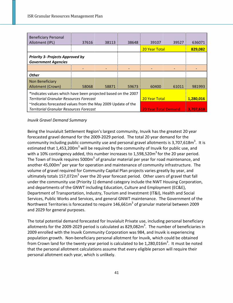
ISR Granular Resources Management Plan
41
Beneficiary Personal
Allotment (IPL) 37616 38113 38648 39107 39527 636071
20 Year Total 829,082
Priority 3- Projects Approved by
Government Agencies
- - - - - -
Other
Non Beneficiary
Allotment (Crown) 58068 58871 59673 60400 61011 981993
*Indicates values which have been projected based on the 2007
Territorial Granular Resources Forecast 20 Year Total 1,280,016
~Indicates forecasted values from the May 2009 Update of the
Territorial Granular Resources Forecast 20 Year Total Demand 3,707,618
Inuvik Gravel Demand Summary
Being the Inuvialuit Settlement Region’s largest community, Inuvik has the greatest 20 year
forecasted gravel demand for the 2009-2029 period. The total 20 year demand for the
community including public community use and personal gravel allotments is 3,707,618m3. It is
estimated that 1,453,200m3 will be required by the community of Inuvik for public use, and
with a 10% contingency added, this number increases to 1,598,520m3 for the 20 year period.
The Town of Inuvik requires 5000m3 of granular material per year for road maintenance, and
another 45,000m3 per year for operation and maintenance of community infrastructure. The
volume of gravel required for Community Capital Plan projects varies greatly by year, and
ultimately totals 157,072m3 over the 20 year forecast period. Other users of gravel that fall
under the community use (Priority 1) demand category include the NWT Housing Corporation,
and departments of the GNWT including Education, Culture and Employment (EC&E),
Department of Transportation, Industry, Tourism and Investment (IT&I), Health and Social
Services, Public Works and Services, and general GNWT maintenance. The Government of the
Northwest Territories is forecasted to require 146,661m3 of granular material between 2009
and 2029 for general purposes.
The total potential demand forecasted for Inuvialuit Private use, including personal beneficiary
allotments for the 2009-2029 period is calculated as 829,082m3. The number of beneficiaries in
2009 enrolled with the Inuvik Community Corporation was 984, and Inuvik is experiencing
population growth. Non-beneficiary personal allotment for Inuvik, which could be obtained
from Crown land for the twenty year period is calculated to be 1,280,016m3. It must be noted
that the personal allotment calculations assume that every eligible person will require their
personal allotment each year, which is unlikely.

ISR Granular Resources Management Plan
42
Inuvik Gravel Supply and Source Reservation on Inuvialuit Private Land
The town of Inuvik is actively quarrying three sources of granular materials within the town’s
boundaries in order to meet the demands of the community; Navy Road Pit, Old Baldy Pit (I400)
and Airport Pit (I402). The quantity of granular materials or the lifespan of all three deposits is
unknown as the community does not track their rates of extraction.
The nearest source of granular materials on Inuvialuit Private Land to Inuvik is source I401A,
which is located approximately 4km northeast of the community. According to the available
data on source 1401A it has 20,000m3 of proven class 4 granular materials, 250,000m3 of
probable class 4 granular materials and 750,000m3 of prospective class 4 granular materials
(Hardy BBT, Ltd., 1991). Due to the poor quality of granular materials (class 4) this source has
been described in several consultant reports as unsuitable for development.
More suitable sources for granular materials have been identified 45km to the north of Inuvik,
in deposits 323A and 324A. Both of these deposits are classified as class 2 quality and contain
millions of cubic meters of probable and prospective materials. Specifically, source 323A
contains 10,000m3 of proven, 1,000,000m3 of probable and 45,000,000m3 of prospective Class
2 granular resources, and source 424A contains 120,000m3 of proven, 12,000,000m3 of
probable and 35,000,000m3 of prospective Class 2 materials (Hardy BBT, Ltd., 1991).
In addition to the aforementioned sources is another source, I407, which is moderately more
distant but containing granular materials of equally high quality and quantity. Source I407 is
also an attractive source, as significant geotechnical work has already been completed at the
site resulting in reliable data. According to a 1990 geotechnical investigation by Hardy BBT Ltd.,
source I407 is mainly composed of material classes 2 to 3 and divided between 655,500m3 in
proven reserves, 3,556,000m3 of probable reserves and 9,055,000m3 of prospective reserves
(Hardy BBT, Ltd., 1990).
Since Inuvik has three equally as attractive sources of granular materials on IPL, I407, 323A and
324A, the Inuvialuit Land Administration cannot at this time predict or prescribe which source
will be developed next. However under the IFA, ILA is required to reserve an appropriate
volume of quality granular materials from a reasonably accessible site for all ISR communities.
Therefore, whichever of the three aforementioned sources is developed next, it shall be the
source containing the reserved materials as required by the IFA.

ISR Granular Resources Management Plan
43
Paulatuk
Table 5- Paulatuk 20 Year Demand Forecast
Paulatuk
Priority 1- Future
Community
Use 2009/2010 2010/2011 2011/2012 2012/2013 2013/2014
2014-
2029
Capital/O&M
O&M 3000 3000 3000 3000 3000 45000
Capital
Plan/Projects 6000~ 1100~ 5500~ 4500** 4500** 67500**
NWTHC
Housing
Corporation 400~ 400~ ND~ 267** 267** 4005**
O&M Private
Housing 600 600 600 600 600 9000
GNWT
General ND~ ND~ 4200~ 1400** 1400** 21000**
DOT Runway
Improvements - - - - TBD -
O&M 16mm 100 100 100 100 100 1500
EC&E School - - - - - 1000
Totals 10,100 5,200 13,400 9,867 9,867 149,005
20 Year Total 197,439
10% Contingency 217,183
Priority 2- Future
Inuvialuit
Private Use 2009/2010 2010/2011 2011/2012 2012/2013 2013/2014
2014-
2029
Personal
Allotment 7340 7378 7416 7416 7493 115218
20 Year Total 144,848
Priority 3- Projects Approved
by Government Agencies
- - - - - -
Other
Non
Beneficiary
Allotment 1185 1185 1185 1185 1223 18540
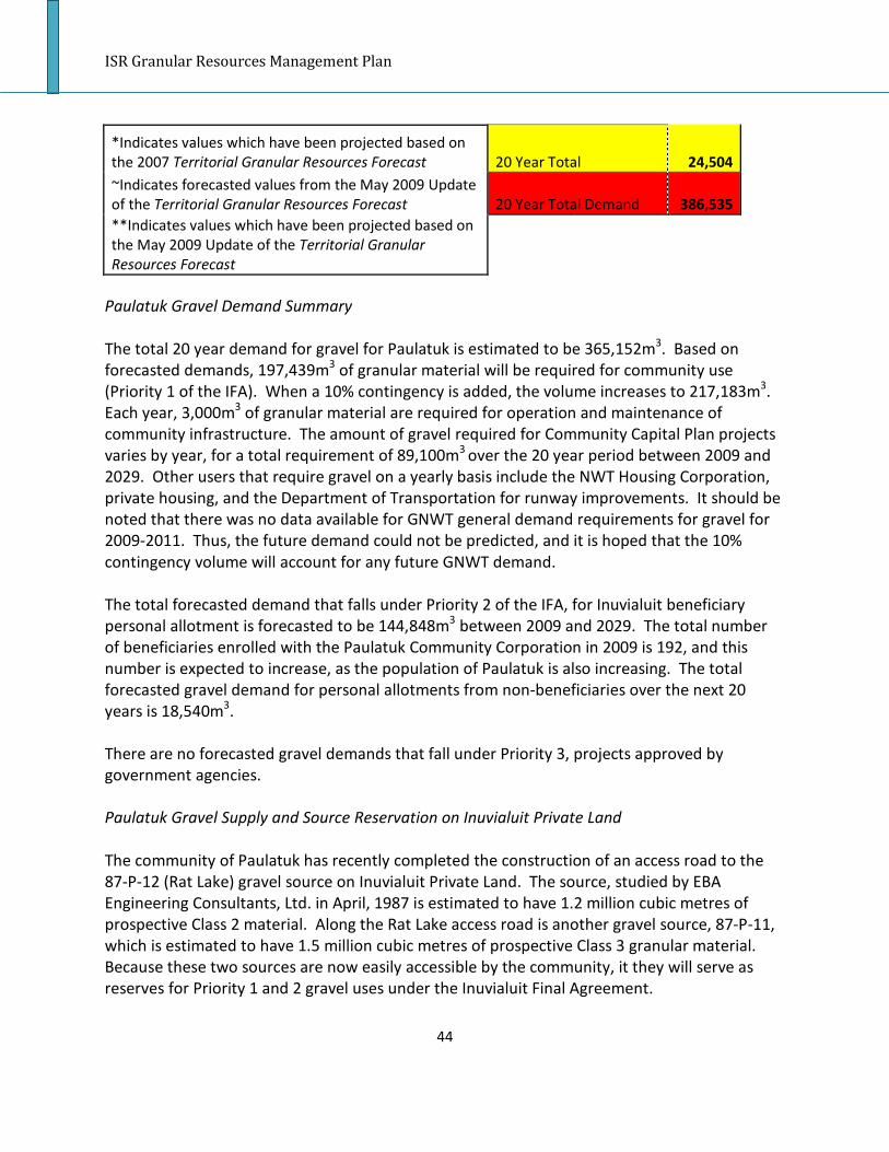
ISR Granular Resources Management Plan
44
*Indicates values which have been projected based on
the 2007 Territorial Granular Resources Forecast 20 Year Total 24,504
~Indicates forecasted values from the May 2009 Update
of the Territorial Granular Resources Forecast 20 Year Total Demand 386,535
**Indicates values which have been projected based on
the May 2009 Update of the Territorial Granular
Resources Forecast
Paulatuk Gravel Demand Summary
The total 20 year demand for gravel for Paulatuk is estimated to be 365,152m3. Based on
forecasted demands, 197,439m3 of granular material will be required for community use
(Priority 1 of the IFA). When a 10% contingency is added, the volume increases to 217,183m3.
Each year, 3,000m3 of granular material are required for operation and maintenance of
community infrastructure. The amount of gravel required for Community Capital Plan projects
varies by year, for a total requirement of 89,100m3 over the 20 year period between 2009 and
2029. Other users that require gravel on a yearly basis include the NWT Housing Corporation,
private housing, and the Department of Transportation for runway improvements. It should be
noted that there was no data available for GNWT general demand requirements for gravel for
2009-2011. Thus, the future demand could not be predicted, and it is hoped that the 10%
contingency volume will account for any future GNWT demand.
The total forecasted demand that falls under Priority 2 of the IFA, for Inuvialuit beneficiary
personal allotment is forecasted to be 144,848m3 between 2009 and 2029. The total number
of beneficiaries enrolled with the Paulatuk Community Corporation in 2009 is 192, and this
number is expected to increase, as the population of Paulatuk is also increasing. The total
forecasted gravel demand for personal allotments from non-beneficiaries over the next 20
years is 18,540m3.
There are no forecasted gravel demands that fall under Priority 3, projects approved by
government agencies.
Paulatuk Gravel Supply and Source Reservation on Inuvialuit Private Land
The community of Paulatuk has recently completed the construction of an access road to the
87-P-12 (Rat Lake) gravel source on Inuvialuit Private Land. The source, studied by EBA
Engineering Consultants, Ltd. in April, 1987 is estimated to have 1.2 million cubic metres of
prospective Class 2 material. Along the Rat Lake access road is another gravel source, 87-P-11,
which is estimated to have 1.5 million cubic metres of prospective Class 3 granular material.
Because these two sources are now easily accessible by the community, it they will serve as
reserves for Priority 1 and 2 gravel uses under the Inuvialuit Final Agreement.

ISR Granular Resources Management Plan
45
The Inuvialuit Land Administration will reserve 217,183m3 of granular material for community
use (Priority 1) between 2009 and 2029 from Source 87-P-12. Another 144,848m3 will be
reserved for Inuvialuit beneficiary personal allotments (Priority 2) during the same 20 year time
period. Any further gravel demands in Paulatuk that fall under Priority 3 will likely be approved
for extraction from the 87-P-12 gravel source, due to the large volume of materials available,
and the relative low demand for gravel in the community.

ISR Granular Resources Management Plan
46
Sachs Harbour
Table 6- Sachs Harbour 20 Year Demand Forecast
Sachs
Harbour
Priority 1- Future
Community Use 2009/2010 2010/2011 2011/2012 2012/2013 2013/2014 2014-2029
Capital/O&M
O&M 2500 2500 2500 2500 2500 37500
Capital Projects 1100~ ND~ 1150~ 750** 750** 11250**
NWTHC
Housing
Corporation ND~ ND~ ND~ 150 150 2250
O&M Private
Housing 100 100 100 100 100 1500
GNWT
General 600~ 1100~ 2000~ 1233** 1233** 18495**
GNWT
Unspecified 500 - - - - -
DOT Runway
Improvements - - - - - TBD
O&M 16mm 40 40 40 40 40 600
EC&E School - - - - - 1000
H&SS Health
Centre - - - - 1100
Totals 4,840 3,740 5,790 4,773 4,773 73,695
20 Year Total 97,611
10% Contingency 107,372
Priority 2- Future
Inuvialuit Private
Use 2009/2010 2010/2011 2011/2012 2012/2013 2013/2014 2014-2029
Personal
Allotment 2523 2523 2523 2485 2485 40521
20 Year Total 53,060
Priority 3- Projects Approved
by Government Agencies
- - - - - -
Other

ISR Granular Resources Management Plan
47
Non Beneficiary
Allotment 726 726 726 726 726 11965
*Indicates values which have been projected based on the
2007 Territorial Granular Resources Forecast 20 Year Total 15,597
~Indicates forecasted values from the May 2009 Update of
the Territorial Granular Resources Forecast 20 Year Total Demand 176,029
Sachs Harbour Gravel Demand Summary
The community of Sachs Harbour has a twenty year forecasted gravel demand of 176,029m3. It
is forecasted that 97,611m3, or 107,372m3 including a 10% contingency, of granular resources
will be required for community use between 2009 and 2029. Each year, 2,500m3 of gravel is
required for operation and maintenance of infrastructure within Sachs Harbour. It is estimated
that 15,000m3 of gravel will be required for Community Capital Plan projects over the twenty
year period. The Territorial Granular Resources Forecast (2007) predicts that in 150m3 of gravel
will be required by the NWT Housing Corporation in 2012 and 2013, however, makes no
forecasts for 2009-2011. Based upon the forecasted demand for 2009-2014, it is estimated that
an additional 2,250m3 of gravel will be required by the NWT Housing Corporation between
2015 and 2029. The TGRF also estimates that 100m3 of gravel will be required on a yearly basis
for operation and maintenance of private housing. Gravel will also be required for general
purposes by the Government of the Northwest Territories, and for runway operation and
maintenance.
Priority 2 demands for gravel for enrolled Inuvialuit beneficiaries are forecasted to be 53,060m3
over the twenty year forecast period. There were 63 Inuvialuit beneficiaries enrolled with the
Sachs Harbour Community Corporation in 2009, and the population of Sachs Harbour is
projected to stay relatively even over the twenty year period. No Priority 3 demands for gravel
have been identified for Sachs Harbour for the twenty year forecast period.
The non-beneficiary demand for granular resources for Sachs Harbour is forecasted to be
minimal, with only 19 non- Inuvialuit community members over the age of 18. The maximum
demand for individual non-beneficiary use over the twenty year period is forecasted to be
15,597m3 of granular material.
Sachs Harbour Gravel Supply and Source Reservation on Inuvialuit Private Land
The Hamlet of Sachs Harbour is currently using sources 87-SH-4 and 87-SH-5 for its
community’s gravel requirements. An older source, 87-SH-1, was recently depleted and is no
longer in use. Both deposits, 87-SH-4 and 87-SH-5, are partially on Commissioner’s Land and
partially on Inuvialuit Private Land. The portion of the deposit that is currently being quarried
by the Hamlet is located on Commissioner’s Land but in the future the portion of the quarry on
IPL may also be required. According to EBA Engineering Consultants’ 1987 report on Sachs

ISR Granular Resources Management Plan
48
Harbour granular materials, Source 87-SH-4 was depleted and the portion of Source 87-SH-5 on
Commissioner’s Land was nearly depleted. The report does not state whether the portion of
Source 87-SH-5 that is located on IPL had been quarried. During a recent community
consultation the Hamlet indicated that the portion on IPL is not currently being used by the
Hamlet. Since both sources of granular resources currently used by the Hamlet are nearly
depleted, and future sources of materials will need to come from IPL, a plan for the
development of gravel resources on IPL in the vicinity of Sachs Harbour must be developed.
This plan will include a volume of gravel that is reserved as per the IFA.
A review of the granular material resources in the vicinity of Sachs Harbour reveals that several
sources of materials are either already depleted (87-SH-1, 87-SH-4), or unusable due to
environmental conditions (87-SH-9, 87-SH-10, 87-SH-11). Other nearby sources of granular
materials (87-SH-2, 87-SH-3, 87-SH-6) contain low volumes of materials and would not satisfy
the community’s needs for long. Rather than develop several small deposits (87-SH-2, 87-SH-3,
87-SH-6), which will be costly and cause widespread environmental damage, the Hamlet should
develop one larger deposit thereby concentrating the environmental damage and reducing the
cost of site development and ultimate remediation. The most attractive future source of
granular materials for Sachs Harbour is 87-SH-8. This source is located 4km east of the hamlet,
contains 200,000m3 of prospective class 3 materials, and has not been identified as being in an
environmentally sensitive area (EBA Engineering Consultants, Ltd., 1987).
For the purpose of meeting the requirements of section 7.(27) of the IFA, a volume of
107,372m3 of source 87-SH-8 granular materials is hereby designated as reserved for Sachs
Harbour public community needs (priority 1). This volume must not be used by either private
Inuvialuit use or for any other government approved project unless adequate quantities above
the reserved amount are proven.
For the purpose of meeting the requirements of 7.(28) of the IFA, an additional volume of
53,060m3 of source 87-SH-8 granular materials is hereby designated as reserved for direct
Inuvialuit private and corporate needs (priority 2). This volume must not be used for any
government approved projects unless adequate quantities above the reserved amount are
proven.

ISR Granular Resources Management Plan
49
Tuktoyaktuk
Table 7- Tuktoyaktuk 20 Year Demand Forecast
Tuktoyaktuk
Priority 1- Future
Community Use 2009/2010 2010/2011 2011/2012 2012/2013 2013/2014
2014-
2029
Capital/O&M
O&M 10000 10000 10000 10000 10000 150000
Capital Plan/Projects 5600~ 6500~ 8000~ 6700** 6700** 100500**
NWTHC
Housing Corporation 1600~ 2000~ ND~ 1200** 1200** 18000**
O&M Private
Housing 600 600 600 600 600 9000
GNWT
General 100500~ 107000~ 101600~ - - -
DOT Runway
Improvements - - TBD - - -
DOT Maintenance
Garage - - - - - 1000
O&M 16mm 100 100 100 100 100 1500
IT& I Interpretive
Centre - - - - - 800
EC&E School - - - - - 1000
Totals 118,400 126,200 120,300 15,700 15,700 238,300
20 Year Total 634,600
10% Contingency 698,060
Priority 2- Future
Inuvialuit Private
Use 2009/2010 2010/2011 2011/2012 2012/2013 2013/2014
2014-
2029
Personal Allotment 21752 21637 21522 21408 21255 298,902
20 Year Total 363,316
Priority 3- Projects Approved by
Government Agencies
- - - - - -
Other
Non Beneficiary
Allotment 2026 2026 2026 1988 1988 27,944
*Indicates values which have been projected based on the
2007 Territorial Granular Resources Forecast 20 Year Total 35,972

ISR Granular Resources Management Plan
50
~Indicates forecasted values from the May 2009 Update of
the Territorial Granular Resources Forecast 20 Year Total Demand 1,097,348
**Indicates values which have been projected based on the
May 2009 Update of the Territorial Granular Resources
Forecast
Tuktoyaktuk Gravel Demand Summary
Between 2009 and 2029, it is estimated that Tuktoyaktuk will require 1,097,348 cubic metres of
granular resources. Over the twenty year period, Tuktoyaktuk is forecasted to require
634,600m3 of gravel for community use (Priority 1 under the IFA), or 698,060m3 with the
addition of a ten percent contingency volume. According to the Territorial Granular Resources
Forecast (2007), the community will require 10,000m3 of granular material per year for
operation and maintenance of community infrastructure. Furthermore, for Community Capital
Plan projects, the Hamlet of Tuktoyaktuk will require a total of 134,000m3 of granular material
over the twenty year period.
The NWT Housing Corporation in Tuktoyaktuk requires on average, 1200m3 of gravel per year,
while the operation and maintenance of private dwellings has a yearly demand of 600m3.
There are other demands for gravel by the Government of the Northwest Territories, including
a large project for a road to gravel Source 177. This project will require 309,100m3 of granular
material between 2009 and 2012, according to the May 2009 update of the Territorial Granular
Resources Forecast. Because the forecasted gravel demand that falls under general GNWT
demand was inflated due to the road to Source 177 project, it was not possible to forecast the
average yearly demand for the remaining 17 years between 2012 and 2029. Therefore, the
forecasted gravel demand for Tuktoyaktuk may be under estimated, however this would likely
be covered by the ten percent contingency volume that is calculated for each community.
In 2009, there were 569 enrolled Inuvialuit beneficiaries with the Tuktoyaktuk Community
Corporation. The population of Tuktoyaktuk is forecasted to decline, thus the amount of gravel
required for beneficiary personal allotments is expected to decrease as well over time. The
forecasted demand for gravel by beneficiaries for 2009 is 21,752m3, and 406,475m3 over the
next twenty years. It must be noted that the forecast for beneficiary demand is likely over
estimated, because it is calculated as though each beneficiary will use their personal allotment
each year, which is not likely. Non beneficiary demand is calculated to be 27,944 for the period
of 2009-2029.
At the time of the forecast there were no priority 3 projects known for Tuktoyaktuk.

ISR Granular Resources Management Plan
51
Tuktoyaktuk Gravel Supply and Source Reservation on Inuvialuit Private Land
In 2009-2010 the Hamlet of Tuktoyaktuk and Government of the Northwest Territories
Department of Transportation are constructing a road to gravel Source 177 using materials
quarried from Source 177. A 1991 report by Hardy BBT Limited estimates that there are
approximately 19 million cubic metres of prospective granular material, which are classified as
“good,” or Class 2 (Hardy BBT, Ltd., 1991b). During the last twenty years quarrying has taken
place at Source 177 intermittently. The total volume of known granular resources extracted
from Source 177 prior to 2009 totals 40,091m3. According to the quarry licence application for
the project, the construction of the road to Source 177 is expected to use a further 450,000m3
of granular materials resulting in a remaining volume of approximately 18.5 million cubic
metres in the gravel source. This remaining volume, if in fact present, is sufficient to cover the
remaining needs of Tuktoyaktuk for granular resources during the 20 year forecast period, and
for many years beyond the forecast period. Furthermore, if there is 19 million cubic metres of
granular material in the source, there will be enough gravel to designate to priority two and
three demands for gravel resources as well. A secondary source has been designated for
Tuktoyaktuk in the event that the source does not contain as much gravel as was estimated in
the 1991 Hardy BBT Limited report, or if the gravel source becomes depleted. Furthermore,
Tuktoyaktuk is in a region of higher potential for development, so there could be high demands
for gravel.
The next best source of granular materials for Tuktoyaktuk, based on accessibility, quantity of
granular materials present, quality of granular materials present and environmental impacts, is
Source 159. This gravel source is located 4km east of Tuktoyaktuk and has a probable volume
of 3,500,000m3 of granular materials respectively (Hardy BBT, Ltd., 1991b). ILA has no record of
Source 159 ever having been used in the past meaning a quarry would need to be developed
prior to use. Source 159 is composed of class 1 and class 3 materials and has been rated as a
good prospect for granular resources by EBA Engineering Consultants in a report prepared for
Indian and Northern Affairs Canada (EBA Engineering Consultants, Ltd., 1987).
In the event that Source 159 is deemed to be insufficient in volume, or unusable then another
source would need to be utilized. Other prospective sources near Tuktoyaktuk include 157,
160A, 160B, 160D, 161C, 161E and 161F. These sources have all been rated as favourable and
are all located within a few kilometres of Tuktoyaktuk. Sources 160A, 160B and 160D have the
additional benefit of having been already developed in the past meaning the environmental
disturbance and cost associated with developing these quarries is reduced.
For the purpose of meeting the requirements of Section 7.(27) of the IFA, a volume of
698,060m3 of Source 177 granular materials is hereby designated as reserved for Tuktoyaktuk
public community needs (priority 1). This volume must not be depleted by either private
Inuvialuit use or for any other government approved project.

ISR Granular Resources Management Plan
52
For the purpose of meeting the requirements of 7.(28) of the IFA, an additional volume of
363,316m3 of Source 177 granular materials is hereby designated as reserved for direct
Inuvialuit private and corporate needs (priority 2). This volume must not be used for any
government approved projects.

ISR Granular Resources Management Plan
53
Ulukhaktok
Table 8- Ulukhaktok 20 Year Demand Forecast
Ulukhaktok
Future
2009/2010 2010/2011 2011/2012 2012/2013 2013/2014
2014-
2029
Capital/O&M
O&M 3500 3500 3500 3500 3500 52500
Capital
Plan/Projects 1000~ 4875~ 4700~ 3525** 3525** 52875**
NWTHC
Housing
Corporation 400~ 400~ ND~ 267** 267** 4005**
O&M Private
Housing 100 100* 100* 100* 100* 1500*
GNWT
General 500~ ND~ ND~ 167** 167** 2505**
GNWT
Unspecified 400 - - - - -
DOT Runway
Improvements - - - - - TBD
O&M 16mm 30 30 30 30 30 450
ENR Office
Building - 500 - - - -
EC&E School - - - - - 1000
Totals 5,930 9,405 8,330 7,589 7,589 114,835
*Indicates values which have been projected based on the
2007 Territorial Granular Resources Forecast
20 Year Total 153,678
10% Contingency 169,046
Priority 2- Future
Inuvialuit Private
Use 2009/2010 2010/2011 2011/2012 2012/2013 2013/2014
2014-
2029
Personal
Allotment 8410 8448 8487 8525 8525 128522
20 Year Total 170,916
Priority 3- Projects Approved
by Government Agencies
- - - - - -

ISR Granular Resources Management Plan
54
Other
Non Beneficiary
Allotment 1988 1988 2026 2026 2026 30467
*Indicates values which have been projected based on the
2007 Territorial Granular Resources Forecast 20 Year Total 40,521
~Indicates forecasted values from the May 2009 Update of
the Territorial Granular Resources Forecast 20 Year Total Demand 380,483
**Indicates values which have been projected based on
the May 2009 Update of the Territorial Granular Resources
Forecast
Ulukhaktok Gravel Demand Summary
According to numbers provided in the various versions of the Territorial Granular Resources
Forecast and population projections, the community of Ulukhaktok is forecasted to require
380,483m3 of granular resources between 2009 and 2029. It is estimated that 153,678m3 of
gravel will be required for community demands (priority 1 under the IFA). This number
increases to 169,046m3 if a ten percent contingency volume is added. The Hamlet requires
3500m3 of gravel each year for operation and maintenance of community infrastructure.
Furthermore, Community Capital Plan projects are forecasted to require 70,500m3 of granular
material over the twenty year period. The NWT Housing Corporation requires granular material
on a yearly basis, and is forecasted to require 5339m3 between 2009 and 2029. Furthermore,
100 cubic metres of gravel is required per year for private housing operation and maintenance
requirements. Forecast data from the Territorial Granular Resources Forecast (May 2009
update) is only available for 2009 for Government of the Northwest Territories demands, while
data for 2010 and 2011 is unavailable. Thus, an average was taken of the three years,
estimating that 167m3 of gravel would be used by GNWT on a yearly basis. Thirty cubic metres
of 16mm material is required by the Department of Transportation for runway operation and
maintenance each year.
In 2009, there were 220 Inuvialuit beneficiaries enrolled with the Ulukhaktok Community
Corporation. The population of Ulukhaktok is increasing, and as such, the number of people
eligible for personal gravel allotments will also increase over the 20 year forecast period. It is
estimated that 170,916m3 could be required to meet Inuvialuit beneficiary demand for personal
allotments between 2009 and 2029. It must be noted that the forecasted number assumes that
each beneficiary would claim a personal allotment every year, which is not likely.
There were no known Priority 3, other government approved projects for Ulukhaktok at the
time of the forecast. There are however, approximately 52 non-Inuvialuit community members
over the age of 18 in the community of Ulukhaktok who may desire to obtain a personal

ISR Granular Resources Management Plan
55
allotment of gravel. Over the 20 year period, approximately 40,521m3 of granular material
could be required by non-Inuvialuit residents of Ulukhaktok.
Ulukhaktok Gravel Supply and Source Reservation on Inuvialuit Private Land
The Hamlet of Ulukhaktok is currently using source 87-H-7, located directly north of the
community on Commissioner’s Land acquired as part of a municipal land transfer, for its source
of granular materials. Source 87-H-7 was originally estimated to contain 75,000m3 of probable
class 2 materials and 75,000m3 of prospective class 2 materials. The remaining volume of
materials in source 87-H-7 is currently unknown however based on reports from the
community it is likely the remaining volume in the quarry is substantial. Due to the fact that
Source 87-H-7 is located on Commissioner’s Land, and the fact that the Inuvialuit Land
Administration is required to reserve granular material in gravel sources on Inuvialuit Private
Land, two sources on IPL will be reserved for community and Inuvialuit private use. Source 87-
H-4 will be reserved as a gravel source for community use if 87-H-7 becomes depleted, or
unavailable to the community of Ulukhaktok. This source is located 5.5km northwest of
Ulukhaktok, and contains 150,000m3 of prospective class 2 granular material. Source 87-H-10
will serve as an alternate source, and is located 5km southeast of the Hamlet. The source has
75,000m3 of prospective class 3 granular material. All of the materials in both of these sources
would need to be reserved for community and Inuvialuit private use in order to meet the
criteria set forth in the IFA.
From these two gravel source options, a total of 169,046m3 must be reserved for Priority 1
needs (community use). Another 170,916m3 must be reserved for Priority 2 (Inuvialuit private
use). There are no anticipated Priority 3 gravel demands for other approved government
projects.
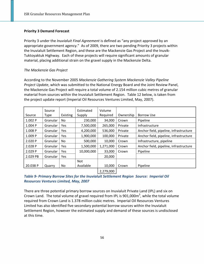
ISR Granular Resources Management Plan
56
Priority 3 Demand Forecast
Priority 3 under the Inuvialuit Final Agreement is defined as “any project approved by an
appropriate government agency.” As of 2009, there are two pending Priority 3 projects within
the Inuvialuit Settlement Region, and these are the Mackenzie Gas Project and the Inuvik-
Tuktoyaktuk Highway. Each of these projects will require significant amounts of granular
material, placing additional strain on the gravel supply in the Mackenzie Delta.
The Mackenzie Gas Project
According to the November 2005 Mackenzie Gathering System Mackenzie Valley Pipeline
Project Update, which was submitted to the National Energy Board and the Joint Review Panel,
the Mackenzie Gas Project will require a total volume of 2.154 million cubic metres of granular
material from sources within the Inuvialuit Settlement Region. Table 12 below, is taken from
the project update report (Imperial Oil Resources Ventures Limited, May, 2007).
Source
Source
Type Existing
Estimated
Supply
Volume
Required Ownership Borrow Use
1.002 P Granular No 230,000 34,000 Crown Pipeline
1.004 P Granular Yes 7,500,000 265,000 Private Infrastructure
1.008 P Granular Yes 4,200,000 536,000 Private Anchor field, pipeline, infrastructure
1.009 P Granular Yes 1,900,000 100,000 Private Anchor field, pipeline, infrastructure
2.020 P Granular No 500,000 10,000 Crown Infrastructure, pipeline
2.028 P Granular Yes 1,500,000 1,271,000 Crown Anchor field, pipeline, infrastructure
2.029 P Granular Yes 10,000,000 33,000 Crown Pipeline
2.029 PB Granular Yes 20,000
20.038 P Quarry No
Not
Available 10,000 Crown Pipeline
2,279,000
Table 9- Primary Borrow Sites for the Inuvialuit Settlement Region Source: Imperial Oil
Resources Ventures Limited, May, 2007
There are three potential primary borrow sources on Inuvialuit Private Land (IPL) and six on
Crown Land. The total volume of gravel required from IPL is 901,000m3, while the total volume
required from Crown Land is 1.378 million cubic metres. Imperial Oil Resources Ventures
Limited has also identified five secondary potential borrow sources within the Inuvialuit
Settlement Region, however the estimated supply and demand of these sources is undisclosed
at this time.

ISR Granular Resources Management Plan
57
Inuvik-Tuktoyaktuk Highway
A feasibility study for a potential Inuvik-Tuktoyaktuk highway is currently underway, and if it is
decided that construction of the highway will begin, there will be significant demand for
granular resources along the highway corridor. The most recent estimate of how much
granular material will be required for the highway is found within an EBA Engineering
Consultants, Ltd. (1987) report, which states that 3.30 million cubic metres will be required.
2009 Demand Survey Revisions
The quantity and location of the reserved materials within the 2009 Demand Survey will be
revised, from time to time, to reflect changes in granular resource supply and demand. As per
the IFA, the location and quantity of these reserved materials shall be reviewed at minimum
once every five years.

ISR Granular Resources Management Plan
58
2009 Community Demand Forecast Summary
The estimated twenty year demand for gravel in the Inuvialuit Settlement Region for Priorities
1, 2, and 3 (non-beneficiary personal allotments only) under the Inuvialuit Final Agreement is
forecasted to be 6,286,239 cubic metres. A comparison of the demand by community is
presented in Table 9, below.
Table 10- 20-Year Priority 1 and 2 Demand for ISR Communities
An additional 5,454,000 cubic metres of gravel may be required within the region for Priority 3
demands. There are two major potential projects that fall under Priority 3, the Mackenzie Gas Project
and the Inuvik-Tuktoyaktuk Highway. Neither has been approved, however, they have the potential to
stress the supply of resources in the region, specifically in the Mackenzie Delta. These demands cannot
be associated to one community, as they will impact several of the communities (namely Tuktoyaktuk,
Inuvik and Aklavik) nearby the projects. A breakdown of demand by IFA prioritization is depicted in the
table below.

ISR Granular Resources Management Plan
59
Table 11- 20-Year ISR Granular Resource Demand by IFA Priority
ISR Granular Resources Management Plan
60
Community Concerns
During the creation of the ISR Granular Resources Management Plan, the Inuvialuit Land
Administration undertook a series of community consultations with six primary objectives:
a) To introduce the upcoming granular resources management plan that is being co-
operatively worked on by ILA and INAC.
b) To show and discuss the granular resource maps and gravel database, and how they can
be used by the community to determine to whom to apply for a quarry permit, and the
characteristics and quantity of gravel within the gravel sources.
c) To inform the Community Corporation of gravel tenure and to reinforce the necessary
application process for obtaining granular resources.
d) To determine upcoming demand for gravel within the community from public and
private entities.
e) To determine whether gravel is being taken by any entities without a permit.
f) To determine whether there are any concerns within the community about the gravel
supply.
ILA attended Community Corporation and Hamlet meetings in each community, with the
exception of Inuvik. The following is a summary of community concerns that were voiced
during community consultation sessions, and that should be taken into consideration by ILA
and INAC when managing gravel in the ISR.
The results of the Inuvialuit Land Administration’s community consultation sessions are
available in Appendix B of Section 2 of this document.
Aklavik
The community of Aklavik is highly concerned about the fact that there are only several
identified sources of gravel on Inuvialuit Private land. Currently, the community of Aklavik
obtains its gravel from Source 467, which lies on Gwich’in Private Land. As such, there is no
source on IPL within the vicinity of Aklavik from which enrolled Inuvialuit residents can obtain
their yearly personal allotment of gravel. The Community Corporation directors pointed out
that a gravel reconnaissance mission had been conducted in the past, but no further gravel
sources were identified by the Inuvialuit Land Administration. The directors identified ten

ISR Granular Resources Management Plan
61
potential sources of gravel within the Aklavik 7(1)(a), and the Inuvialuit Land Administration
conducted a gravel sampling program at each of the sites in June 2009. Specific notes from the
community consultation meetings with the Aklavik Community Corporation and Hamlet of
Aklavik can be found within Appendix E.
Paulatuk
The community of Paulatuk has relatively good access to granular resources, and has recently
completed an access road to what is referred to as the “Rat Lake” gravel source, or the lower
part of 87-P-23. Generally, the community feels that there is low demand for granular material,
due to a small population. However, there are concerns throughout the community about
gravel royalties under the ILA fee structure, which are seen to be prohibitive to ensuring
community wellbeing.
Sachs Harbour
During community consultations, the residents of Sachs Harbour communicated the fact that
Sachs Harbour is a small community located in an area with lots of granular material. The
gravel sources on Commissioner’s land which are used by the Hamlet are said to be becoming
depleted, and this may cause the community to require gravel from a source on Inuvialuit
Private land. Generally, the community requires gravel for community infrastructure, including
resurfacing roads, new buildings, and also a cleanup on the beach near the RCMP station.
There are no major concerns regarding granular resource supply in Sachs Harbour.
Tuktoyaktuk
In the past, the community of Tuktoyaktuk has had to travel great distances to obtain granular
material for public use, including infrastructure development as well as protection from
shoreline erosion. Several different sites within the Tuktoyaktuk vicinity have been utilized,
depending on the type of material that is required. However, the completion of the road to
gravel Source 177, south of Tuktoyaktuk, in winter 2010 is expected to alleviate some of the
concerns about the scarcity of granular material for the community.
Ulukhaktok
The community of Ulukhaktok does not have high demand for granular resources, and tends to
utilize one gravel source when it does require gravel. At this time, there are no major concerns
regarding gravel supply or quality within the community. The primary concern about gravel

ISR Granular Resources Management Plan
62
within the community is to ensure that enough gravel is reserved for community use before it is
barged out for third priority uses (i.e. site remediations).

ISR Granular Resources Management Plan
63
References
Department of Public Works and Services, Department of Municipal and Community Affairs,
Department of Transportation and NWT Housing Corporation. (July 2007) Territorial Granular
Resource Forecast Report: The Territorial Granular Strategy. [Online] Available:
http://www.pws.gov.nt.ca/pdf/publications/GranularForecast.pdf
Department of Public Works and Services, Department of Municipal and Community Affairs,
Department of Transportation and NWT Housing Corporation. (October 2008) Territorial
Granular Strategy: Territorial Granular Resource Forecast Update October 2008. [Online]
Available:
http://www.pws.gov.nt.ca/pdf/grd/ch1/Territorial%20Granular%20Resoruce%20Forecast%20T
ables%20Updated%20October%202008.pdf
Department of Public Works and Services, Department of Municipal and Community Affairs,
Department of Transportation and NWT Housing Corporation. (May 2009) Territorial Granular
Strategy: Territorial Granular Resource Forecast May 2009 Update. [Online] Available:
http://www.pws.gov.nt.ca/pdf/publications/TGRF%20May%202009%20Update.pdf
EBA Engineering Consultants Ltd. (December 1986) Granular Resource Evaluation- Richards
Island, NWT. Report Submitted to Indian and Northern Affairs Canada, Ottawa.
EBA Engineering Consultants Ltd. (1987) Inuvialuit Settlement Region Sand and Gravel
Inventory and Recommendations for Development—Aklavik, NWT. Report to Indian and
Northern Affairs Canada.
EBA Engineering Consultants Ltd. (1987) Inuvialuit Settlement Region Sand and Gravel
Inventory and Recommendations for Development—Holman, NWT. Report to Indian and
Northern Affairs Canada.
EBA Engineering Consultants Ltd. (1987) Inuvialuit Settlement Region Sand and Gravel
Inventory and Recommendations for Development—Inuvik, NWT. Report to Indian and
Northern Affairs Canada.
EBA Engineering Consultants Ltd. (1987) Inuvialuit Settlement Region Sand and Gravel
Inventory and Recommendations for Development—Paulatuk, NWT. Report to Indian and
Northern Affairs Canada.
EBA Engineering Consultants Ltd. (1987) Inuvialuit Settlement Region Sand and Gravel
Inventory and Recommendations for Development—Sachs Harbour, NWT. Report to Indian and
Northern Affairs Canada.

ISR Granular Resources Management Plan
64
EBA Engineering Consultants Ltd. (1987) Inuvialuit Settlement Region Sand and Gravel
Inventory and Recommendations for Development—Tuktoyaktuk, NWT. Report to Indian and
Northern Affairs Canada.
Hardy BBT Ltd. (1990) Geotechnical Investigation of Potential Sand and Gravel Reserves:
Inuvialuit Settlement Region Deposit I407 (Caribou Hills) Inuvik, NWT. Report to Indian and
Northern Affairs Canada.
Hardy BBT Ltd. (1991) Preliminary Granular Resources Demand Mackenzie Delta Region.
Report to Indian and Northern Affairs Canada.
Hardy BBT, Ltd. (1991b) Report on Evaluation of Granular Resource Potential, Mackenzie Delta
Region. Report to Indian and Northern Affairs Canada.
Imperial Oil Resources Ventures Limited. (November 2005) Mackenzie Gathering System
Mackenzie Valley Pipeline Supplemental Information: Project Update. Submitted to the
National Energy Board and the Joint Review Panel.
Kiggiak-EBA Consulting, Inc. (2002) Evaluation of Six Granular Borrow Prospects in the
Mackenzie Delta Area Phase 1: Assessment of Investigation Program Requirements. Report to
the Inuvialuit Land Administration. [Online] Available:
http://pubs.aina.ucalgary.ca/gran/54885.pdf
North of 60 Engineering Ltd. (1995) A Granular Resource Demand Forecast for the Inuvialuit
Settlement Region. Report to Indian and Northern Affairs Canada.
North of 60 Engineering Ltd. (2001) A Granular Resource Demand Forecast for the Inuvialuit
Settlement Region. Report to Indian and Northern Affairs Canada and the Inuvialuit Land
Administration.

ISR Granular Resources Management Plan
65
APPENDIX A
Memorandum of Understanding
between
Inuvialuit Regional Corporation (IRC)
and the
Department of Indian Affairs and Northern Development (DIAND)
Regarding
Granular Resource Management Planning
in the Inuvialuit Settlement Region
INTRODUCTION
Historically, management of granular resources in the Inuvialuit Settlement Region (ISR) was
the responsibility of the Department of Indian Affairs and Northern Development. As a result of
the Inuvialuit Final Agreement (IFA) in 1984 the Inuvialuit now own a significant portion of the
granular resources in the ISR. Management of the resource is now divided between two Land
Managers - the Inuvialuit Land Administration (ILA) in the case of the Inuvialuit owned lands
and DIAND in the case of Crown lands.
The upswing in hydrocarbon exploration within the region during the past three years has
resulted in a significant increase in the demand for granular resources to support drilling and
camp facilities. On January 7, 2002 the Mackenzie Delta Producers Group and the Aboriginal
Pipeline Group announced that they were proceeding to undertake the project definition stage
of a Mackenzie Valley Pipeline. The public consultation, technical study and environmental
fieldwork elements of this phase are already underway. Strongly supported by market demand
and political leadership, there is every reason to believe that this project will move towards
reality within the next few years. This will result in a major escalation in the demand for
granular resources as producers construct production platforms, gathering lines and other
support facilities.

ISR Granular Resources Management Plan
66
It is critical that this demand be provided for in a manner that conforms to the requirements
and priorities outlined in the Inuvialuit Final Agreement (IFA) and meets sound management
practices and standards for the extraction of non-renewable resources.
The attached document Preliminary Planning Framework Granular Resource Management
Planning For The ISR (Schedule A) presents a background and preliminary planning framework
specific to granular resource management planning for the Inuvialuit Settlement Region (ISR).
PURPOSE
The purpose of this Memorandum of Understanding (MOU) is to develop a coordinated,
systematic approach to granular resources management within the Inuvialuit Settlement
Region through the gathering and utilization of all existing information, the sharing of research
and project data, the avoidance of duplication of effort and a commitment to joint planning,
action and resource allocation. This joint management approach is supported in the IFA.
In entering this agreement the parties make the commitment to participate in a joint planning
process resulting in the development and implementation of a Granular Resource Management
Plan for the Inuvialuit Regional Settlement.
It should be noted that, in order to be effective, any granular resource plan for the ISR must
consider all potential resources on both public (Crown) and private (Inuvialuit-owned) lands. If
this exercise was undertaken by either party in isolation it would be of limited value in that it
would not consider the potential impact of the resulting plan on resources that might be
supplied by other parties. It is therefore essential that the planning exercise be undertaken
jointly by the ILA and DIAND, and also, for areas near the southern boundary of the ISR, in
collaboration with the Gwich’in Tribal Council.
WORK PLAN OBJECTIVES
The objectives will be established so as to reflect the specific views of both the Inuvialuit and
DIAND, as owners of granular resources, to adhere, as appropriate to either IFA or DIAND
regulations, and may include resource conservation principles, equity, flexibility, optimum use
of resources, and public involvement in the planning process.
The objectives guiding this planning exercise are as follows:
ISR Granular Resources Management Plan
67
• Conservation of aggregate for the most appropriate use to which it is suited is a priority
in order to minimize “high grading” and limit the continuing requirements to locate new
sources of high quality material.
• Planning should to be based on specific area and regional needs giving highest priority
to areas where shortages of granular material exist and to areas where a significant
increased in future demand is anticipated.
• Logical and orderly development of individual sources (from preliminary exploration
through extraction to site restoration) is essential, so that the extraction of different
classes of material from any particular source is maximized.
• Supply-demand conflicts within management areas and competition for sources and
aggregate classes should be minimized.
• Utilization of the concrete aggregate resources that are available in the region should be
optimized.
• Restoration and rehabilitation of depleted sources should take place on a continuing
basis as resource development proceeds.
• Adequate reserves of suitable material for specific community uses should be assured
giving public use priority over private use.
PROVISIONS
It is mutually agreed and understood that:
• Periodic meetings between IRC and DIAND will be held to assess, plan and problem
solve during the development and implementation of the Granular Resource
Management Plan.
• Consistent with available resources, IRC and DIAND will develop integrated services to
the extent possible, in bringing together resources of program, staff, and/or funding
respectively.
• IRC and DIAND will determine costs and payment responsibilities, by consensus.
• Opportunities for cost sharing with industry will be considered and pursued.
• The work plan and initial cost estimates are outlined in the Preliminary Planning
Framework: Granular Resource Management Planning for the ISR dated March 4, 2002
as attached in Schedule A of this MOU.
• The effective date of the Interim Granular Resource Management Plan for the ISR
(attached in Schedule B) is the immediate on signing this MOU by both DIAND and IRC.
• Time is of the essence in the preparation of the Granular Resource Management Plan.

ISR Granular Resources Management Plan
68
TRANSFER OF INFORMATION
The parties agree to the principles of common reporting, technology and shared information.
Exchanges of information will generally include any supporting documentation gathered during
this collaboration, or other sources of information.
AGREEMENT
The provisions of this Memorandum of Understanding may be reviewed and jointly modified as
appropriate when it is determined by IRC and DIAND that such review and modification is in the
interest of their respective responsibilities.
The parties hereto have entered into this Memorandum of Understanding as evidenced by their
signatures below. The Memorandum of Understanding is effective upon the date signed.
INUVIALUIT REGIONAL CORPORATION
______________________________________ Date______________
Nellie J. Cournoyea
Chair and Chief Executive Officer
DEPARTMENT OF INDIAN AFFAIRS
AND NORTHERN DEVELOPMENT
______________________________________ Date______________
Bob Overvold
Regional Director-General

ISR Granular Resources Management Plan
69
Appendix B
Granular Resource Supply Maps

ISR Granular Resources Management Plan
70

ISR Granular Resources Management Plan
71

ISR Granular Resources Management Plan
72

ISR Granular Resources Management Plan
73
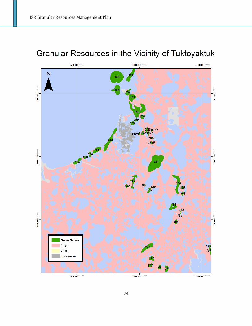
ISR Granular Resources Management Plan
74

ISR Granular Resources Management Plan
75
APPENDIX C
Community Consultation Meeting Notes
Aklavik Community Corporation:
• The Aklavik Community Corporation meeting date was changed to the night before, and
ILA was not notified in time, thus the meeting was missed. We travelled to Aklavik the
following day to meet with Carol Arey, who then called in other community members
with interests in the gravel industry.
• Alex Illasiak flew up to some sources with ILA in the past, and found some really good
gravel, northwest of Aklavik
• Would like to know more information about Source 469, it is right on the potential route
to Source 467, and is near the site where Aklavik would like to move its dump
• Gravel currently comes from Source 467 (Gwich’in), a winter road is put in every few
years to do a haul and stockpile in town
• Billy Storr and Dennis Arey remember that there are areas where gravel is visible on the
surface near stream known locally as Stink Creek
• Billy thinks the Geological Survey of Canada has maps with borehole data that might be
useful for the areas around Aklavik
• Carol would like ILA to locate maps that were made during Calvin Pokiak’s time at ILA,
which identify some potential sources, and to do further reconnaissance on these
sources. She thinks there should be about 3 maps of gravel sources northwest of
Aklavik.
• There have been obstacles to developing Source 464 in the past—DFO thinks there are
fish in the creek nearby, and will not allow development near a creek that has “life”
• Billy suggested that ILA look into ground penetrating radar (GPR) costs and methodology
for locating/assessing gravel in the Aklavik area. Department of Transportation has one.
• Some of the meeting attendees pointed out that although the gravel database says that
the gravel in source 469 is Class 5, that might be an over generalization. They pointed
out that in many pits, there is good and bad gravel, and perhaps there is good gravel to
be found within that source.
• There used to be a crusher that rotated between the communities, and this would be
useful for some of the rock that is NW of Aklavik
• Foster Arey wanted to know if there would be any way ILA could check out Source 464
this spring on snowmobiles, and perhaps we could do a cost-share on this initiative
• There is lots of gravel around NW of Aklavik, it can easily be seen from a skidoo when
travelling along the river
• The town is in need of gravel right away, for new developments (garage, Housing Corp.
building lot, power corporation lot). Lots of fill is needed
• When a stockpile is built, usually 2500 cubic metres is for housing, 1500 for the Hamlet,
and 3000 for the power corporation
• The community would be willing to travel longer distances for gravel if it was available
on Inuvialuit Private Lands, rather than taking gravel from the Gwich’in pit (467) in the
Gwich’in Settlement Area

ISR Granular Resources Management Plan
76
• Other suggested places where gravel might be found: Deep Creek, Beaver House, and
Willow Creek
• There are also some creeks that have dried up and have not had water run through
them in several years that could be utilized as gravel sources
• Aklavik feels that it needs to start pressuring IRC for better access to gravel sources
• Contact Dave McLeod (867-978-2792) for any details necessary if ILA is looking at setting
up some ground reconnaissance in the spring (ie// costs of renting snowmobile, etc)
• The meeting attendees pointed out on the map areas where they have noticed gravel
on the surface, as well as a cutoff line that would be the furthest distance that would be
feasible for Aklavik to haul gravel from
Hamlet of Aklavik
• Currently there is a feasibility study for the access road to Source 467, which is on Gwich’in
Private Lands
• Members of the Gwich’in Tribal Council, Hamlet and Community Corporation will be
contributing information to the feasibility study
• The Council mentioned that they would like more details on Source 469, which is also on crown
land, including how much gravel is there and what the quality is. Council members suggested
that this might be an alternate source of gravel to Source 467. However, the database indicates
that the gravel in this source is Class 5.
• The SAO, Evelyn Storr asked how the ILA will be working with the GNWT to facilitate easier
access to granular resources.
• A council member had questions about gravel royalty fees, and how ILA tracks the amount of
gravel leaving the pits. He also had questions about who is responsible for the cost of the
EM/Gravel Checker, and where they would come from.
Paulatuk Community Corporation Notes:
• The Community Corporation members present confirmed what was said at the Hamlet meeting,
that the Rat Lake source, and the two sources along the Rat Lake road are the sources that have
been used by the community in the past.
• The Community Corporation thinks that it will be expensive to build the housing pads and other
infrastructure with the cost of gravel royalties from Inuvialuit Private Land.
• The Community Corporation would like ILA to send out a reminder about how the community
can apply for gravel from IPL, so that compliance can be encouraged in the future.
• Overall, there are no concerns in the community about access to gravel sources of good quality
and quantity.
• The Community Corporation requested a map of the gravel sources, and appreciated the ILA
Gravel Supply Database that corresponds with the map.
• Paulatuk Community Corporation was appreciative of seeing ILA staff in Paulatuk to talk about
land use issues, and looks forward to the final presentation of the ISR Draft Gravel Management
Plan.

ISR Granular Resources Management Plan
77
Hamlet of Paulatuk Notes:
• The Hamlet of Paulatuk is currently using the Rat Lake gravel source, which is the lower part of
87-P-23 on the ILA maps.
• The Hamlet has constructed an 11km gravel road from town to the gravel source on Inuvialuit
Private Land, using gravel from along the road route, and gravel from the actual Rat Lake source.
• The Hamlet foreman believes that the source will have a long lifetime, of at least 20 years for
the community.
• The Rat Lake source is recontoured after each time gravel is extracted, and will be thoroughly
recontoured after each season.
• The community hopes to haul and stockpile gravel each summer now that the road construction
is completed.
• The same Rat Lake gravel source was also used to build the new airstrip in Paulatuk.
• There are two stockpile locations along the road that were used for reaching the final source.
These need to be levelled off.
• This year, gravel is needed for the pad of a duplex, as well as a youth centre.
• In the 1980s, gravel sampling was conducted on the hills by DOT for the road to Rat Lake.
• Overall, the community of Paulatuk does not have high demand for gravel.
• The Hamlet meeting attendees feel that the cost of gravel is too high, and that it should be
lower if the gravel contributes to community wellbeing.
• The Hamlet indicated that high gravel costs combined with non-compliance they have heard
about in other communities has encouraged them to avoid ILA’s application process.
• Source 87-P-22 has been used in the past for getting sand for the community’s beach volleyball
court.
• The Hamlet members were hesitant to give information about historical use of gravel, because
they didn’t want to be invoiced for sand and gravel taken in the past.
Sachs Harbour Community Corporation Notes:
• The Community Corporation members looked over the ILA gravel supply maps and
database. They noted that source 87-SH-5 should be noted as 1/8 km out of town and
on Commissioner’s land
• 87-SH-4 was noted to be located 1km W of the community, not south of the community
as the database says
• Community Corporation suggested that 87-SH-1 was used for the airport, and has
basically nothing left in it
• There are gravel sources that lie on Commissioner’s land that are listed as being on
Inuvialuit Private land
• The major gravel-consuming project for this year will be the resurfacing of all the roads
within the hamlet
• It was noted that there is plenty of gravel surrounding the community, and that access
to granular resources won’t likely be a problem for many years

ISR Granular Resources Management Plan
78
• If the community expands, it will need to be expanded further north on the hill,
therefore more gravel could be required for new homes and access to these homes.
• Some homes are being relocated due to shoreline erosion, and these homes will likely
need new gravel pads as well
• There is some gravel on the beach near the RCMP that is contaminated with diesel, and
it is currently being aired out. More gravel could be required to cover up the
contaminated site once it is cleaned up
• Community Corp members noted that it would cost $360 for a loader and dump truck if
someone wanted to acquire their personal allotment of gravel for the year
Hamlet of Sachs Harbour Notes:
• Council members suggested that the Hamlet Foreman (Richard Carpenter) would be the best
source of information regarding gravel in the community.
• The hamlet needs gravel for a new parking garage, firehall and to resurface the roads within the
next several years.
• Gravel may also be needed for reclamation of several contaminated areas around town.
• The short road to the water pumping site might need to be rebuilt in the next year.
• Ahmad Alkhalaf in Inuvik who works for the Department of Public Works & Services is a project
manager and knows a bit more information about how much gravel precisely would be needed
for some of these projects.
• The community feels that there is enough gravel to meet their needs in at least the short term.
Sachs Harbour is built on and surrounded by gravel, and the community thinks most of the
gravel is of good quality to sustain infrastructure development.
• Sachs Harbour feels that the security deposit for using gravel from Inuvialuit Private land is too
steep, and although it will be returned, it is too unaffordable for the Hamlet to put out that
money.
• In the past, Sachs Harbour has thought about using gravel from IPL, but in the end decided
against it due to the security deposit. As such, they have been using gravel from
Commissioner’s land within the Hamlet boundaries exclusively.
• Adella inquired about whether there was some sort of deal the community could make to
exchange some land for a gravel source (the answer given was no, as we do not want IPL broken
up into piecemeal).
• Within the town boundaries, the gravel supply is getting low and soon the community might
need to utilize a gravel source on Inuvialuit Private land.
• Development projects within the near future include: new firehall, parking garage, resurfacing
roads. Roads are resurfaced almost every year in Sachs Harbour.
• People within the community sometimes want gravel for personal use, but personal allotments
are not allowed from gravel sources within the Hamlet boundaries. As such, residents could buy
gravel from the Hamlet. However, it is generally too expensive for people to do so, and Hamlet
gravel equipment is often too busy in the summer months.
ISR Granular Resources Management Plan
79
• The community would like to upgrade the road to Mary Sachs, and would like to know if they
could get free gravel because it would be for the benefit of the entire community, and on
Inuvialuit Private land.
Tuktoyaktuk Community Corporation Notes:
• The community of Tuk has used several gravel sources in the past, including Tootsie Bay, Ya Ya
Lakes and Water Creek
• At Water Creek, the past gravel users never recontoured the land, and ponding is occurring.
There is still gravel left at this source.
• The meeting attendees feel that Tuk’s concerns about gravel availability will be alleviated if
Source 177 is used to meet community needs
• Gravel may be required within the next five years for several potential projects including
experimental wind turbines, a hotel building, and a new 9-plex. Gravel will also be required for
regular road upgrades
• There are concerns within the community about the royalty rate that E. Gruben’s Transport will
be charged for stockpiling gravel for community member’s use
• TCC would like to know what gravel sources near Parson’s Lake have been reserved for the
Mackenzie Gas Project
Hamlet of Tuktoyaktuk Notes:
• Source 161 is heavily utilized, as well as Ya Ya Lakes, and Source 168.
• The last gravel haul for the community was from Sandy Hills (Source 1407?).
• A haul occurred from Ya Ya Lakes approximately 4 years ago for gravel for the airstrip and roads.
• Gravel was acquired for the dump about 10 years ago.
• Rip rap for shoreline erosion was brought from Inuvik on the Ice Road (10 years ago), at a cost of
$100,000
• Hamlet has been taking some gravel from the DEW line for use on roads, after permission was
obtained from DND.
• There is some crushed rock at the airport.
• Hamlet is in desperate need of clay material for the dump, however, there is no nearby source
that hasn’t already been exhausted.
• There are plans to move the solid waste site, sewage lagoon and cemetery to locations along
the road to Source 177. There will be large gravel requirements if this occurs.
• Currently, the roads are in good shape and there is not huge demand for gravel for their
maintenance.
• There is a lot of demand from the public for driveways that are sinking, and for underneath
houses. It is too cost prohibitive for home owners to get gravel required for their lots, the
transportation is too expensive.
• Some houses are being built without a layer of gravel underneath, and in the summer the
ground becomes muddy because there is no insulating layer. Some houses haven’t been built
because it would be too expensive to get the gravel.
• The access road to Source 177 may help with this problem.

ISR Granular Resources Management Plan
80
• The Hamlet in the past has tried to figure out what private home owners require gravel, and has
suggested that a group goes together to pay for a truck load of gravel, but there has been little
interest because people know that they won’t be able to afford it.
• Debbie Raddi gave ILA a copy of the October 2008 update to the Territorial Granular Resource
Forecast .
• Jim Stevens noted that the Hamlet is in charge of infrastructure development now due to the
New Deal, and as such, the Territorial Granular Resource Forecast may not be accurate- the
Hamlet can only construct as much as they are able to, and therefore the forecast numbers may
be high.
• Source 155 is now closed as it has been depleted, and the Hamlet now takes gravel from
wherever ILA tells them.
• Tuktoyaktuk needs access to a good source of clay as well as rock.
• There is a strong opinion that the Parson`s Lake airstrip will use too much gravel that should be
reserved for Inuvialuit and community use.
• Residents are hesitant to have gravel allotted to Conoco before knowing whether there will be
enough for the community to sustain itself.
• Concerns that the airstrip proposed for Parson`s requires way too much gravel.
• It was noted that it would be ideal to do an overall assessment of the quantity and quality of
gravel in the area before Conoco is allowed gravel for the airstrip.
• The council was pleased to have gravel maps made available as well as the database, and were
surprised at the locations of some gravel sources.
• Quite a bit of interest in more details for feasibility of utilizing Source 158 (dredge only
accessibility).
Ulukhaktok Community Corporation Notes:
• 87-H-7 is the most commonly used gravel source for Ulukhaktok
• There was another gravel source used a few years ago that is unidentified in the ILA gravel
database. It is located slightly southeast of 87-H-7, and the UCC marked its location on the
gravel map ILA provided.
• There are not many worries about quality or quantity of granular resources available to the
community.
• There is concern regarding gravel being barged out of the community for non-community uses
(i.e. Johnson’s Point cleanup).
• Until last year Ulukhaktok did not realize that 87-H-7 is on Inuvialuit Private land, and the
situation that occurred last fall highlights the necessity of ILA informing the communities about
gravel ownership, and the process for applying for quarry permits.
• A new community hall will be built in 2010 to replace the old community hall- this project
should definitely require granular resources.
• A new duplex is also planned which will also require gravel.
• The community is thinking of closing the current garbage dump and opening a new dump at a
different location. If this were to occur, gravel would be required for closing the old dump, as
well as building the new dump and access to the new dump.

ISR Granular Resources Management Plan
81
• The community would like to see the gravel management plan prioritize gravel such that gravel
won’t be leaving the community before community demand is known, and community use is put
before private use.
Hamlet of Ulukhaktok Notes:
• The Hamlet council members confirmed that Source 87-H-7 is the only gravel source utilized by
the Community of Ulukhaktok at this time.
• The council members said that there are no concerns in the community about gravel supply at
this time. They feel that there is adequate supply, and that the community has very small
demand for gravel.
• The community would like clarification about where the IPL/Hamlet boundary is within source
87-H-7.
• Ulukhaktok is without a hamlet foreman at this time, and as such there was not much
information to be obtained about forecasted gravel use for Ulukhaktok.

ISR Granular Resources Management Plan
1
SECTION 3:
INUVIALUIT SETTLEMENT REGION PITS AND QUARRIES GUIDELINES

ISR Granular Resources Management Plan
2
PREFACE This document is an amended version of the INAC’s pits and quarries guidelines, which is part of the land-use guidelines series. This set of guidelines serves as a supporting document to the Inuvialuit Settlement Region Granular Resources Management Plan which is a joint initiative by Indian and Northern Affairs Canada (INAC) and the Inuvialuit Land Administration (ILA). The ISR Pits and Quarries Guidelines gives prospective users of granular resources information about the methods that should be used for obtaining gravel within the ISR, as well as about the permitting processes for Crown and Inuvialuit Private Land. These guidelines apply only to Inuvialuit Private land and Crown land within the Inuvialuit Settlement Region in the Northwest Territories. Resources on Commissioner’s land require direction from the appropriate agency. The contact information for these agencies is found in Appendix A. For further information concerning the subject matter contained in these guidelines please contact: Inuvialuit Land Administration P.O. Box 290 273 Inuvialuit Lane Tuktoyaktuk, NT X0E 1C0 Tel.: (867) 977-7100 Fax: (867) 977-7101 Email: [email protected] Indian and Northern Affairs Canada North Mackenzie District Office P.O. Box 2100 Inuvik, NT X0E 0T0 Tel.: (867) 777-8900 Fax: (867)777-2090

ISR Granular Resources Management Plan
3
CONTENTS SECTION 1: ACKNOWLEDGEMENTS. . . . . . . . . . . . . . . . . . . . . . . . . . . . . . . . . . . . . . . . . . . . . . . . . .5 SECTION 2: INTRODUCTION . . . . . . . . . . . . . . . . . . . . . . . . . . . . . . . . . . . . . . . . . . . . . . . . . . . . . . . 6 SECTION 3: NORTHERN GRANULAR RESOURCES 3.1 Definitions. . . . . . . . . . . . . . . . . . . . . . . . . . . . . . . . . . . . . . . . . . . . . . . . . . . . . . . . . . . . . . . . . . . .7 3.2 Granular Deposits. . . . . . . . . . . . . . . . . . . . . . . . . . . . . . . . . . . . . . . . . . . . . . . . . . . . . . . . . . . . . .7 3.3 Quarry Permit and Lease Requirements. . . . . . . . . . . . . . . . . . . . . . . . . . . . . . . . . . . . . . . . . . . .8 3.5 Fees. . . . . . . . . . . . . . . . . . . . . . . . . . . . . . . . . . . . . . . . . . . . . . . . . . . . . . . . . . . . . . . . . . . . . . . . . 9 SECTION 4: PLANNING AND DESIGN 4.1 Site Conditions . . . . . . . . . . . . . . . . . . . . . . . . . . . . . . . . . . . . . . . . . . . . . . . . . . . . . . . . . . . . . . 12 4.1.1 Permafrost . . . . . . . . . . . . . . . . . . . . . . . . . . . . . . . . . . . . . . . . . . . . . . . . . . . . . . . . . . . . . . . .13 4.2 Exploration. . . . . . . . . . . . . . . . . . . . . . . . . . . . . . . . . . . . . . . . . . . . . . . . . . . . . . . . . . . . . . . . . . 13 4.2.1 Pits and Quarries. . . . . . . . . . . . . . . . . . . . . . . . . . . . . . . . . . . . . . . . . . . . . . . . . . . . . . . . . . . .13 4.2.2 Armour Stone Quarries. . . . . . . . . . . . . . . . . . . . . . . . . . . . . . . . . . . . . . . . . . . . . . . . . . . . . . .13 4.3 Pit/Quarry Management Plan. . . . . . . . . . . . . . . . . . . . . . . . . . . . . . . . . . . . . . . . . . . . . . . . . . .13 4.4 Water Management. . . . . . . . . . . . . . . . . . . . . . . . . . . . . . . . . . . . . . . . . . . . . . . . . . . . . . . . . . 14 4.5 Fish and Wildlife . . . . . . . . . . . . . . . . . . . . . . . . . . . . . . . . . . . . . . . . . . . . . . . . . . . . . . . . . . . . . 15 4.6 Development Timing. . . . . . . . . . . . . . . . . . . . . . . . . . . . . . . . . . . . . . . . . . . . . . . . . . . . . . . . . . 15 SECTION 5: SITE DESIGN 5.1 Site Layout................................................................................................................17 5.1.1 Quarries ................................................................................................................17 5.2 Buffer Strips..............................................................................................................17 5.3 Visual Impacts .........................................................................................................17 5.4 Noise and Dust ........................................................................................................18 SECTION 6: SITE PREPARATION .....................................................................................19 6.1 Clearing ...................................................................................................................19 6.2 Organic Topsoil Layer ..............................................................................................19 6.3 Overburden...............................................................................................................19 SECTION 7: OPERATIONS................................................................................................20 7.1 Resource Extraction ................................................................................................20 7.2 Resource Processing ..............................................................................................20 7.3 Monitoring ................................................................................................................20 7.4 Maintenance ............................................................................................................21 7.5 Site security .............................................................................................................21 7.6 Intermittent Operations.............................................................................................21

ISR Granular Resources Management Plan
4
SECTION 8: SPILLS ......................................................................................................22 8.1 Spill Contingency Plan............................................................................................22 8.2 Spill Prevention.......................................................................................................22 8.3 Spill Response..........................................................................................................22 SECTION 9: RECLAMATION...........................................................................................23 9.1 Clean-up...................................................................................................................23 9.2 Landscape Reconstruction.......................................................................................23 9.3 Drainage and Erosion Control..................................................................................24 9.4 Revegetation ...........................................................................................................24 9.5 End-Pit Lake.............................................................................................................24 9.6 Monitoring.................................................................................................................25 REFERENCES....................................................................................................................26 GLOSSARY.......................................................................................................................28 LIST OF TABLES Table 3-1 Definitions for Pits and Quarries .....................................................................7 Table 4-1 Quarry and pit planning information...............................................................11 Table 4-2 Pit and quarry environmental concerns and mitigation techniques ...............14

ISR Granular Resources Management Plan
5
SECTION 1: ACKNOWLEDGEMENTS In the 1980s, Indian and Northern Affairs Canada published a series of six land-use guidelines in a handbook format, intended to help operators of small to medium-scale projects carry out activities in northern Canada in an environmentally sensitive manner. These handbooks, commonly called “The Blue Books,” have been widely distributed and quoted. Their success is a tribute to the efforts of the original authors and contributors, and to the departmental steering committee that guided their preparation. This new series of northern land-use guidelines is, in part, an update of the earlier series. This work was directed by a steering committee made up of Northern Affairs Program staff in Ottawa and Northern Regional Office staff. Further edits were made by the Granular Resources Management Plan Working group within the Inuvialuit Settlement Region to create this document, which is specific to the ISR.

ISR Granular Resources Management Plan
6
SECTION 2: INTRODUCTION The purpose of this volume is to provide guidance to pit and quarry operators when operating on Crown land or Inuvialuit Private land in the Inuvialuit Settlement Region. If you are not operating on Crown land or Inuvialuit Private land, it is your responsibility to contact the appropriate landowner for any land-use guidelines that may be in place. Resources on Commissioner’s land require direction from the appropriate agency. The contact information for these agencies is found in Appendix A. Granular resources are a strategic and valuable resource, and it is important that they are used in a sustainable way. This volume presents specific land-use techniques for quarrying within the Inuvialuit Settlement Region, and best practices that can be used by operators to minimize land disturbances and environmental impacts.

ISR Granular Resources Management Plan
7
SECTION 3: NORTHERN GRANULAR RESOURCES Granular resources is a term that describes a wide range of materials from silts to sands, gravel and cobbles that are vital for the construction of a wide range of northern developments such as roads, pipelines, mines, and community infrastructure. Access to granular materials is often a challenge in the north because development activities are commonly located in remote areas with limited infrastructure. The availability of granular resources is often an important factor in determining how and if a proposed development can proceed. In order to minimize their environmental effects, and prevent any wastage of granular resources, proper land-use techniques and extraction methods should be used. The information presented in this volume reflects current industry best practices that apply to both pits and quarries. The guidelines are general in nature and should be supplemented, on a site specific basis, by engineering and other expertise. 3.1 Definitions Pits and quarries are used to extract granular resources, as defined in Table 3-1. Granular materials are often used for construction, but some materials have other uses, such as carving. Type Definition
Quarry Extraction of rock materials by digging, cutting or blasting.
Quarries usually yield large stone that may then be crushed. Commonly quarried materials include limestone and granite.
Sand or Gravel Pit Extraction of unconsolidated earth materials, such as sand or gravel by digging a pit.
Borrow Pit Excavation of low-quality fill, such as silt, clay and topsoil.
Material is usually removed for use at a nearby site.
Table 3-1 Definitions for Pits and Quarries 3.2 Granular Deposits Different types of granular resources have specific uses. The proponent must evaluate the source material to ensure it has the characteristics required for the intended use. Each material and deposit has unique characteristics which will require a slightly different approach to development. Site investigations and testing should be conducted on the source material to verify:

ISR Granular Resources Management Plan
8
• type, extent and geology of the granular deposit • grade and quality of the deposit • structural and chemical properties of rock • extent of ground-ice in the material
If results from these investigations show that the granular material is suitable for its intended use, then the proposed development is ready to proceed through the four phases of land-use activity:
Phase 1 - Planning and Design Phase 2 - Site Development Phase 3 - Operations Phase 4 - Reclamation
3.3 Quarry Permit and Lease Requirements In the Inuvialuit Settlement Region, pit or quarry developments require a quarry permit, under the Territorial Quarrying Regulations on Crown land, or a quarry licence under the Inuvialuit Inuvialuit Final Agreement on Inuvialuit Private land. If activities include the use of equipment that exceeds the thresholds of the applicable land-use regulations, a land-use permit will be required. Quarry and land use permits will include terms and conditions specifying how operations must be conducted. Applications for quarry permits/licences are assessed by INAC or ILA to determine:
• whether an existing pit can meet the demands or whether there is a requirement for the development of an undisturbed site • if the proposed application is an appropriate use of the resource • if potential reserves of the granular material are adequately identified • if the development plan will maximize resource recovery • if the proposed extraction and use of granular resources is consistent with the prioritization of materials outlined in the Inuvialuit Final Agreement (on Inuvialuit Private land only)
Aboriginal rights must be respected when planning and conducting land-use activities, including pits and quarries. Proponents should contact the local Community Corporation and Hunters and Trappers Committee to discuss their proposed development. INAC and ILA strongly encourage community engagement as part of the permitting process. Proponents should contact the applicable land-use regulator, depending on ownership of the land on which the granular resources lie, for more information on their requirements. Once permits are issued, INAC and ILA are responsible for ensuring compliance of their terms and conditions in the Inuvialuit Settlement Region. INAC resource management officers conduct regular inspections of quarry operations on Crown land, and the ILA requires the presence of an environmental monitor and

ISR Granular Resources Management Plan
9
gravel checker at all times during quarry operations, and periodic inspections by the ILA Inspector. Under Section 10 of the Territorial Quarrying Regulations, residents of the Northwest Territories are allowed to take up to 38.23 cubic metres (50 cubic yards) of sand, gravel or stone from Crown land per calendar year for their own personal use without having to obtain a quarry permit or pay any fees. A land use permit may be required, depending on the type of equipment required to extract and haul the resources. The personal allotment cannot be obtained from areas where any interest in the surface rights of lands has been licensed, leased or otherwise disposed of by the Crown. On Inuvialuit Private land, enrolled Inuvialuit beneficiaries are entitled to a personal gravel allotment of 38.23 cubic metres (50 cubic yards) per year. Any person wishing to obtain their personal gravel allotment must notify ILA prior to extraction, and a quarry license will be issued, if the proposed source is appropriate for the extraction of personal allotments. Other permits may be required depending on the nature of work being conducted. Quarry operations that require blasting may require regulatory approval from the Workers’ Safety and Compensation Commission. Removing granular resources from riverbeds, lakeshores or ocean shorelines may require a water license from the Northwest Territories Water Board, and approval from the Department of Fisheries and Oceans. Approvals for extraction from water bodies and shorelines are not normally granted unless there are no alternatives, and include more stringent conditions to minimize environmental impacts. Fees for quarried material on Crown land vary depending on the type, and are set out in Schedule 2 of the Territorial Quarry Regulations. Royalty fees, based on an estimate of material required, must be submitted with a Quarry Permit application, and fees will be returned if the amount of material used is less than estimated. The amount of quarry returns must be reported monthly, and a final plan is required at the end of operations. In the case of a quarry lease, fees are required as per the schedule in the lease. On Inuvialuit Private land (for uses other than personal allotment), at the time of application, the proponent will be required to pay a quarry license application fee, land use permit application fee, and land use permit fee. During quarry development and operation, ILA will require an environmental monitor to be on site at all times, as well as a gravel checker when resources are being extracted and hauled. Periodic inspections will also be required by the ILA Inspector. The proponent is responsible for paying the costs associated with site monitoring (environmental monitors, gravel checkers and inspectors). The proponent will also pay gravel royalty fees for the volume of gravel extracted, as per the Inuvialuit Final Agreement and ILA Fee Schedule. Surveying of the pit may also be required to verify gravel extraction quantities, at the cost of the proponent.

ISR Granular Resources Management Plan
10
SECTION 4: PLANNING AND DESIGN Proper planning is crucial in conducting an efficient and environmentally responsible pit or quarry development. The planning process and collection of detailed site information should commence in the early stages of the proposed development to gain an understanding of the site, and submit to the regulatory authorities. Pit management plans may be available for the most commonly used granular resource sites within the Inuvialuit Settlement Region from the respective land owner. These plans contain all relevant information for proponents wishing to develop and extract resources from the gravel source. Furthermore, the Inuvialuit Settlement Region Granular Resources Management Plan contains a generic pit development plan which sets out guidelines for what a proponent’s pit development plan should look like if one doesn’t already exist. The following general suggestions should be considered:
• Contact regulatory authorities early to understand regulatory requirements and timeframes necessary to obtain the required permits. • Initiate contact and discuss plans with local Community Corporations and Hunters and Trappers Committees well in advance of submitting permit applications. • Estimate the quantity of material required and the duration of the operation. • Review aerial photographs or satellite imagery to identify access routes to the site and locations to investigate site conditions. • Conduct a field reconnaissance of the site (Section 4.1) to verify aerial photograph or satellite imagery interpretations, obtain surface and shallow-depth granular samples using test pits and boreholes, and conduct geophysical surveys. • Finalize pit or quarry design before submitting permit applications.
There are a variety of information sources outlined in Table 4-1 that can be accessed when planning and designing a pit or quarry operation.

ISR Granular Resources Management Plan
11
Table 4-1 Quarry and Pit Planning Information
Information Category
Examples of Required Information Information Sources (Crown) Information Sources (Inuvialuit)
Legal Quarry Permit INAC Resource Management Officer and District Offices Inuvialuit Land Administration Office
Fees and Royalties Territorial Quarrying Regulations Inuvialuit Final Agreement
Quarry Lease
Territorial Lands Act Territorial Land Use Regulations Inuvialuit Land Administration Rules and Procedures
Land Use Permit Environmental Impact Screening Committee
Blasting Environmental Impact Review Board
Northwest Territories Waterboard
Department of Fisheries and Oceans Canada
Workers Safety and Compensation Commission
Geological Type of deposit INAC Granular Resources Inventory ILA Granular Resources Inventory
Extent of deposit INAC Resource Management Officer and District Offices Inuvialuit Land Administration Office
Grade of deposit NWT Geoscience Centre
Geological Survey of Canada
Site Investigation
Local operators in project area
Community Corporations and Hunters and Trappers Committees
Municipal and Community Affairs (MACA)/Hamlets
Engineering Slope design INAC Source-Specific Pit Management Plan ILA Source-Specific Pit Management Plan
Blasting INAC Resource Management Officer ILA Environmental Specialist
Engineers and Consultants
Workers Safety and Compensation Commission
Blasting Equipment Suppliers
Operations Staking INAC Resource Management Officer ILA Environmental Specialist
Pit wall safety and operations
Territorial Quarrying Regulations Territorial Lands Act Territorial Land Use Regulations ILA Rules and Procedures and Pit Management Plan
Workers Safety and Compensation Commission
Access roads Equipment Suppliers
Equipment
Environmental Fish and wildlife habitat INAC Resource Management Officer ILA Environmental Specialist
INAC Water Resource Division
Vegetation Environmental Impact Screening Committee
Soil conservation Environmental Impact Review Board
Topography and drainage Northwest Territories Water Board
Department of Fisheries and Oceans Canada
Permafrost Aerial photographs and maps

ISR Granular Resources Management Plan
12
Water Community Corporations and Hunters and Trappers Committees
Territorial Environmental Departments Archaeological/Cultural Location of
archaeological sites
Territorial Land Use Regulations Inuvialuit Cultural Resources Centre
Community Corporations and Hunters and Trappers Committees
Prince of Wales Northern Heritage Centre
Reclamation Reclamation standards INAC Resource Management Officer ILA Environmental Specialist
INAC Source-Specific Pit Development Plan ILA Source-Specific Pit Development Plan
Territorial Lands Act Territorial Land Use Regulations ILA Rules and Procedures
Territorial Environmental Departments
Environmental Impact Screening Committee
Environmental Impact Review Board
Northwest Territories Water Board
Department of Fisheries and Oceans Canada
4.1 Site Conditions Pit or quarry development should include an assessment of site conditions since these will often dictate how a development can be conducted most efficiently and with minimal environmental impacts. Factors that should be considered when assessing site conditions include:
• Topography and drainage • Extent and depth of permafrost and ground-ice • Soils, particularly organic layer composition and depth, and depth of overburden • Proximity of water bodies • Groundwater conditions (e.g. evidence of seepage or springs) • Surface vegetation and the conservation status of the present plant species • Sensitive landforms (Eg. pingos, sand dunes, wildlife areas, buffer zones near water bodies) • Wildlife or fish habitat • Type of access required • Extent of reclamation required (Eg. minimum overburden) • Existence of cultural/archaeological sites
Site selection for a quarry can be more complex than for a pit because blasting and processing equipment increase the impacts and potential risks to other land-users. Dust control, noise controls, warning signs and site security are mitigation measures that should be considered when planning site development. 4.1.1 Permafrost

ISR Granular Resources Management Plan
13
The Inuvialuit Settlement Region is located in an area of continuous permafrost. Ice-rich permafrost is prone to subsidence and slumping when thawed and is more problematic for pit and quarry operations than permafrost with low ice content or areas without permafrost. Field investigations should determine the extent, depth and ice content of permafrost at a proposed pit or quarry site before proceeding with development. This will ensure that measures can be implemented to mitigate permafrost degradation, or an alternate location could be developed to avoid problems associated with permafrost disturbance. Measures to mitigate degradation in areas of ice-rich permafrost include conducting work during the winter, and replacing the organic layer prior to spring thaw to provide an insulating layer between the permafrost and warm air temperatures. In the summer, ice-rich material should be stockpiled in windrows and allowed to melt and drain before use. More information is available in the INAC Blue Books. 4.2 Exploration 4.2.1 Pits and Quarries Advanced exploration of the granular deposit will be necessary to further understand the geological properties and size of the granular deposit. Soil and rock types and their structure can be analyzed at a laboratory to determine if the granular material is suitable for the required use. Type and thickness of vegetation, overburden and interburden must be assessed to determine the preparatory work required to access the deposit, and to ensure the deposit has adequate volume to meet user needs. If advanced exploration activities such as drilling, test pits, or trial quarries, include the use of equipment that exceeds the thresholds of the applicable land-use regulations (Crown land) or ILA Rules and Procedures (Inuvialuit Private land), a land-use permit will be required. 4.2.2 Armour Stone Quarries Quarries for large diameter armour stone require a more detailed field assessment to confirm that suitable material exists and that its extraction is feasible. The following factors should be considered:
• Stable, weather-resistant rock is required • Deep quarries are likely to be good sources of armour stone, but the presence of groundwater will limit quarry depth • If the deposit is within sedimentary rock, thick beds are required to yield large stone • Secondary structures (Eg. jointing, faulting, and shearing) affect the feasibility of extracting large stone, and a drilling program may be required to delineate the deposit • Pit layout will depend on the dominant structure • A trial quarry to assess the feasibility of full-scale development may be necessary • Transport of armour stone requires large, heavy equipment, which will affect access requirements, and may require that transportation be carried out during the winter

ISR Granular Resources Management Plan
14
4.3 Pit/Quarry Development Plan Following site exploration, a pit or quarry development plan should be created to outline the entire project life cycle, including site layout, preparation, operations, environmental concerns, and reclamation. The size and duration of the operation will determine the scope and level of detail required in the plan. In pits or quarries with multiple users, an overall management plan may be developed by the owner. This plan will indicate where and how the proposed development can operate, and the proponent will be required to provide a development plan that shows how they will operate within the site constraints. Generic pit management and development plans for granular sources within the ISR are available within the ISR Granular Resources Management Plan. There are a number environmental concerns related to the development of a pit or quarry. A description and proposed mitigation for each applicable concern should be addressed in the management plan. Table 4.2 provides an overview of potential environmental concerns and related mitigation options that may be encountered in the site layout or operations phase of development. These will be described in greater detail in the following sections. Table 4-2 Pit and quarry environmental concerns and mitigation techniques
Development Phase Actitivities Potential Environmental Effects Mitigations Techniques Site layout and preparation Timber clearing Soil erosion Retain vegetation to maintain slope stability
Vegetation removal Habitat loss Maintain natural drainage patterns
Soil and overburden removal Maintain vegetation buffer zones to protect water bodies
Construct ditches to direct runoff away from the site
Locate the development in a well drained area
Salvage and properly store organics, topsoil, and overburden for use in reclamation
Operations and monitoring Blasting Soil erosion and sediment deposition Limit sediment movement using silt fences or straw bales
Stockpilling Use rip-rap to reinforce drainage channel corners and water discharge points
Crushing Revegetate where required to stabilize slopes
Access road maintenance Water quality impacts Limit sediment movement or use settling ponds before discharging
Use proper fuel containment and handling techniques, and have spill kits accessible
Use proper explosive handling techniques to minimize wastage
Water ponding and permafrost impacts Minimize source of in-pit water by diverting surface water away from the development area
Place ice-rich material to thaw in a location where melt water will not re-enter pit
Limit pit or quarry depth
Dust generation Spray water and use dust skirts on conveyors to minimize dust

ISR Granular Resources Management Plan
15
4.4 Water The control of water into and out of a proposed pit or quarry site should be planned prior to development to enhance the efficiency of operations, limit effects on water quality, and prevent permafrost degradation. Water from within a pit or quarry should not be discharged to surface waters without an appropriate water license. Any use of water or deposit of waste into water above thresholds within the Northwest Territories Waters Regulations requires a water license that will specify discharge limits. Proponents should avoid conducting operations below the water table. The accumulation of groundwater will impede operations, must be pumped to the surface and may require treatment. Ponded water that rests in low-lying areas of pits or quarries can also lead to permafrost degradation. Drainage ditches or channels should be installed to prevent ponding. Measures should be taken to prevent the migration of silt into water bodies. Settling ponds or impoundments may be constructed to control surface runoff where required. Construction methods and materials that prevent exfiltration and seepage to the surrounding environment should be used. Erosion control supplies (Eg. geotextile fabrics, straw blankets) should be kept on-hand to respond to scouring or slope destabilization caused by water erosion. 4.5 Fish and Wildlife Project development and operations should aim to minimize wildlife disturbance and the loss of habitat. Caribou are a migratory species of particular concern in the north. Pit and quarry walls may attract certain bird species that prefer this type of habitat for nesting. Nesting birds should not be disturbed and the destruction of nests or bird mortalities should be immediately reported to a territorial wildlife officer and the local Hunters and Trappers Committee. Measures to minimize wildlife disturbance include:
• Reducing or stopping project operations during sensitive breeding times • Ensuring working equipment is well maintained to minimize excessive noise • Using proper waste disposal techniques to minimize wildlife attractants
o using covered containers for garbage and waste storage o keeping the site clean at all times o regularly removing waste from the site
• Using water management and erosion control techniques to prevent the deposition of sediment into fish-bearing water bodies (Table 5-2).
The Species at Risk Act protects wildlife species that may become endangered or threatened. Proponents should be aware of their special status and should minimize disturbance or contact with these species during operations. Species of special concern are listed under Schedule 1 of the Species at Risk Act, and more information is available from Environment Canada at www.ec.gc.ca. 4.6 Development Timing

ISR Granular Resources Management Plan
16
Development timing is an important consideration in the north as many operations utilize the winter frozen-ground season to minimize land disturbance, and to maximize transportation efficiency. Proponents should consider scheduling specific components of their pit or quarry development at the most advantageous time of the year. Development stages and suggestions for their timing in the Inuvialuit Settlement Region are listed below:
• Exploration: o Access may favour winter, but field programs may favour summer
• Access and Transportation o Will require winter roads, unless all-season road construction is planned
• Operations and Processing o Generally favour summer; however, in areas of ice-rich permafrost, work should be scheduled during the winter o Operations may need to stop during spring break-up o Washing is a summer operation o Critical life stages for birds, mammals and fish may limit operations during some seasons

ISR Granular Resources Management Plan
17
SECTION 5: SITE DESIGN
Careful consideration of site design prior to development will result in an efficient operation with minimal environmental disturbance. Site design should consider all potential uses for the site, allowing for enough room to conduct all phases of development, as well as considering the eventual reclamation of the site. Design may also be affected by land-use permit conditions. This section outlines specific factors that should be considered during the planning phase of the development. 5.1 Site Layout The site layout should be designed with the following considerations:
• Adequate room for all activities, including stockpiling of resources and overburden • A refuelling station with appropriate containment, if required (Section 8.2) • Dust or noise, particularly if other land-uses are nearby
5.1.1 Quarries Territorial mine safety legislation (Mine Safety Act) will dictate how a quarry must be developed and this will affect the layout of the quarry operation. Quarry-specific site layout considerations include:
• Orienting pit walls to take advantage of natural structure in bedrock • Orienting walls to direct blasting and operating noises away from sensitive areas • Using safety benches at regular intervals • Using signage and/or fences to delineate potential safety issues • Planning for a considerable volume of waste
5.2 Buffer Strips Buffer strips are areas of land that are left untouched to provide a natural barrier between the development and an adjacent area. Buffers can be used to protect important ecosystem components such as wildlife habitat or water bodies, or they can be used to provide a visual barrier between the development and an area of human use. Buffer strips of existing vegetation at least 100 metres wide should be left around water bodies, and if trees are present, should be designed to resist damage from prevailing winds. Direct sunshine in winter or spring can cause unsafe glare-ice conditions on access road surfaces. If possible, buffer strips should be designed to block road surfaces from direct sun exposure. 5.3 Visual Impacts Minimization of visual impacts to areas of human use should be considered when designing a pit or quarry site. Land-use permits may have specific conditions regarding the appearance of a

ISR Granular Resources Management Plan
18
development. The visual impacts of a pit or quarry can be reduced by using the following methods:
• Locating the development on the downhill side of a road • Leaving a buffer strip at least 30 metres wide in place between the road and the pit • Constructing a berm between the road and the development • Ensuring that access roads have a ‘dog-leg’ to eliminate the line of sight
5.4 Noise and Dust Dust and noise from pit or quarry operations can be a nuisance in areas where other land-uses, such as recreational areas, are nearby. Excessive dust can be an occupational hazard for those working on-site. Wildlife can also be deterred by noise. The following considerations can minimize noise and dust issues:
• Erecting a berm to block noise • Restricting operations during certain times • Orienting quarry faces to direct noise away from other land-uses • Considering prevailing winds when designing the site layout • Applying dust suppression controls such as road watering, and using a dust skirt or minimizing the drop height when releasing material from a conveyor

ISR Granular Resources Management Plan
19
SECTION 6: SITE PREPARATION
Preparation of a pit or quarry site should proceed in an orderly sequence to ensure that materials overlying the granular resource are segregated and properly stored for future use in reclamation. The following section outlines measures that should be utilized in the preparation of a pit or quarry site, if a pit management plan is not already in place. 6.1 Clearing Prior to clearing, the pit and quarry site boundaries should be flagged to delineate the project area and restrict the project footprint. Since the clearing of vegetation has both a visual and environmental impact, it is good practice to avoid clearing a larger area than is necessary for the development. A site survey should be conducted to confirm the planned site layout. Global Positioning System (GPS) units can be used to survey and delineate specific project components. The timing of clearing should be chosen carefully. In areas of ice-rich permafrost, vegetation clearing in the summer can expose the soil to direct sunlight, and lead to ground-ice melting and subsidence. Clearing activities should also be avoided during sensitive nesting periods for birds. Trees larger than 12 centimetres in diameter should be saved as merchantable timber. Land-use permits may indicate conditions for saving and stacking merchantable timber. Brush should be stockpiled for future use in site reclamation as specified in the land-use permit, or as directed by an INAC resource management officer. 6.2 Organic Topsoil Layer As a result of site exploration, the proponent should have a good understanding of the local soils, including the depth of surface organic topsoil. This layer should be stripped and stockpiled separately from deeper mineral soil so as to minimize mixing. Topsoil will be replaced on the surface during reclamation, to function as a natural native seed bank and promote successful revegetation. Topsoil and organics can dry out quickly and can easily blow away or erode if not covered during storage. Tarpaulins can be used to protect stockpiles from wind and water erosion. Topsoil stockpiles should be stored at a secure location that will not interfere with pit operations, will not be affected by surface runoff, and will allow drainage of melt water from ground-ice. 6.3 Overburden Overburden is rock or soil of low economic value that is located above the desired granular deposit, and below the topsoil layer. It must also be removed and stockpiled for reclamation prior to accessing the granular resource. Overburden should be removed in a manner that does not reduce the stability of adjacent ground. Stockpiles should be gradually sloped and rounded to minimize erosion from wind and water. As with topsoil, overburden stockpiles should be stored at a location that will not interfere with pit operations, will not be affected by surface runoff, and will allow drainage of melt water from ground-ice. Structures to collect and treat runoff from overburden stockpiles may be required if the water has a high silt content.

ISR Granular Resources Management Plan
20
SECTION 7: OPERATIONS
Operations must be conducted in accordance with approved management plans associated with the land-use permit. These plans include a Pit/Quarry Management Plan (Section 4.3) and a Spill Response Plan (Section 8.1). Major changes in operations may require amendments to existing permits or additional permits. 7.1 Resource Extraction The method used to excavate the granular material will depend on the nature of the material, the equipment available, and in permafrost terrain, the extent and nature of the permafrost. Pits and quarries should not be excavated below the water table to avoid safety concerns, additional water handling, and permafrost degradation (Section 4.4). If excavated material contains ground-ice, it should be stored at a location within the pit where it can thaw and drain. Small stockpiles will allow frozen material to thaw and drain in one summer season, as a large surface area will be exposed to heating. Melt water from thawing stockpiles may have high silt content, and require control and treatment before being discharged to surface water. Interburden is waste material that may be encountered within the granular resource and should be stockpiled in a depleted section of the pit. It can be handled in the same way as overburden (Section 6.3). 7.2 Resource Processing Processing of granular material often requires an area of intensive heavy equipment activity, and can include crushers, screens, wash plants, generators and conveyors. Each processing step requires an accessible area within the pit to carry out the operation, stockpile the processed material, and allow trucks easy access to haul material out of the pit. The crusher should be located on hard and stable ground to support intensive use by heavy equipment. Oversized materials, such as boulders that are rejected for resource use should be stored and used for future reclamation activities. For operations that require washing of granular materials, a water license may be required to use and dispose of wash water. Treatment of water from washing operations may also be required. Screening frozen material often leads to wastage caused by the presence of large frozen blocks. Wastage can be reduced by only screening dry, thawed material. Alternatively, frozen material should be crushed before being screened. 7.3 Monitoring Operations should be monitored to ensure that they are proceeding according to the Pit/Quarry Management Plan and remain in compliance with local regulations and the land-use permit. For gravel sources on Crown land, there will be periodic inspections from the INAC Resources Officer and on Inuvialuit Private land, an Environmental Monitor will be present at all times. Monitoring results should answer the following questions:
• Are site preparation measures achieving goals? • Are water management strategies effective?

ISR Granular Resources Management Plan
21
• Are pit walls safe? • Is the granular resource still suitable for end uses? • How much ground-ice is present in the material? • What is the behaviour and volume loss of the material as thawing occurs? • Are wildlife sightings and interactions being recorded?
Regular monitoring can be used to assess the performance of designed structures (Eg. a water containment dyke) and specific environmental mitigation measures (Eg. spraying water to reduce dust). Monitoring will also promote the early detection of a problem which should trigger the appropriate response or contingency plan, and notification of the INAC resource management officer or the ILA Inspector. 7.4 Maintenance The site and access roads should be regularly maintained to minimize erosion, sediment deposition, and dust emissions. Potholes, wash boarding, and frost heaving should be promptly repaired to minimize dust generation and equipment wear. Hydrocarbon spills from equipment are a major source of environmental damage and are completely preventable. Equipment should be properly maintained and in good working condition to minimize potential leaks from hydraulic hoses and other working components. Drip trays should be placed under equipment when it is not in use to prevent hydrocarbon staining. 7.5 Site security For safety and security purposes, uncontrolled access to the pit or quarry site should be limited. Contact an INAC resource management officer or ILA Inspector for more information on appropriate access control strategies. 7.6 Intermittent Operations If a pit or quarry is to be closed seasonally, the operation is considered to be inactive. The proponent should inform and obtain consent from regulatory authorities to discontinue operations. Regulatory authorities may request financial assurance from the proponent to complete the reclamation. The pit or quarry must be stabilized before the operation is shut down. Areas where extraction is complete must be reclaimed by backfilling and/or contouring. Proper drainage must be in place to prevent flooding of the pit or quarry. If site conditions do not allow for positive drainage, intermittent operations may be impractical, and this should be identified at the planning stage.

ISR Granular Resources Management Plan
22
SECTION 8: SPILLS
A spill contingency plan must be in place during all phases of pit and quarry development. Spills can involve chemicals, hydrocarbons, or process water. Unexpected spill events do occur and a plan will help operators to respond to them quickly and effectively. The spill contingency plan should be implemented immediately after a spill event. All spills must be reported immediately to the 24 hour spill line: 867-920-8130. On Inuvialuit Private land, all spills must also be reported to the ILA Environmental Monitor. 8.1 Spill Contingency Plan A spill contingency plan outlines a logical order of how operators should respond to a spill, resources available on-site for spill response, and agencies and individuals who need to be notified. All personnel working on the site should be aware of and understand the plan so that they can respond effectively to a spill. The Government of the Northwest Territories has guidelines for developing a spill contingency plan that proponents should review, as a spill contingency plan is required to be submitted with the land-use permit applications on Crown and Inuvialuit Private land. The guidelines are available at: www.enr.gov.nt.ca/eps/pdf/spill_contingency.pdf 8.2 Spill Prevention Hydrocarbon spills are a major source of contamination at northern pit and quarry operations. Proper fuel storage and handling can help to prevent these spills. A dedicated refuelling area should be constructed using impermeable ground or a liner to contain drips and spills. A well stocked spill response kit should be available in the refuelling area. All vehicles should be equipped with spill response kits and drip trays. Used oil and fuel should not be stored at the site and should be disposed of immediately at an approved hydrocarbon waste disposal facility. 8.3 Spill Response Spill response includes stopping, containing, and reporting the spill event. In permafrost areas, containment dikes should only be constructed of snow since excavating soil may expose underlying permafrost, causing thawing and subsidence. Photographs should be taken of the spill area and the extent of the spill should be delineated. During the winter, removal or compression of the snow may allow spreading liquid to be more clearly seen. At all times, ensure that there is no ignition source in the vicinity of spilled flammable products. Once the spill is contained and has been reported, a clean up strategy must be developed.
ISR Granular Resources Management Plan
23
SECTION 9: RECLAMATION
The final phase of pit and quarry development is reclamation. Reclamation objectives are influenced by site conditions and the future land-use, and must be satisfactory to regulatory authorities and key stakeholders. Proponents may suggest future uses for the site, but the landuse regulator will make the determination. A closure and reclamation plan is required by the land-use permit or land lease. In some cases, INAC or ILA may already have developed a pit reclamation plan that the proponent must follow. If a reclamation plan does not already exist, a plan should be developed with input from local stakeholders, regulatory authorities, and the INAC resource management officer or the ILA Environmental Specialist, and will require approval from the appropriate regulatory authority. Land-use permits may also contain specific conditions regarding reclamation. Once a closure and reclamation plan is approved, progressive reclamation may be conducted during operations at areas of the site that are no longer used. This will reduce the amount of reclamation required when operations are completed, and could reduce reclamation costs at the end of operations. When operations are complete, the site must be reclaimed as per the reclamation objectives outlined in the plan, and to the satisfaction of the land-use regulator. Monitoring will last for several years after reclamation has been completed to ensure that reclamation objectives are being met. If they are not, proponents will be required to return to a site for further work. Once the regulator or land owner is satisfied that the site is stable, they will issue a letter of final clearance indicating that the permit holder is no longer responsible for the pit or quarry site. 9.1 Clean-up Once operations are completed, all buildings, machinery, and fuel containers must be removed from the site. All garbage, blasting materials, and material stockpiles must also be removed. 9.2 Landscape Reconstruction Coarse material, overburden, and topsoil stockpiled in the pit or quarry during operations should be used for reclamation of the site upon project completion. Use of frozen materials for reconstruction activities is not recommended as ground-ice may melt and cause subsidence. Coarse material should be buried at the bottom of the pit or used for slope reconstruction. Overburden should then be used for site grading and contouring. It should not be left piled in, or adjacent to the pit. Contour the site to blend with the surrounding topography but also consider the end land-use for the site. If sufficient overburden is available, gentle slopes and rounded shapes are visually preferable to straight lines. Once site contouring is completed and the ground surface has stabilized, stored topsoil should be placed evenly on areas from which the soil was stripped. Topsoil should be spread over as much of the surface of the disturbed area, and as close to the original depth as possible. The ground surface should be roughened to provide micro-sites suitable for revegetation. If cliffs are left in place, cliff faces may require scaling to remove loose material that could pose a safety hazard. Access to the site should be restricted and warning signs installed for public safety.

ISR Granular Resources Management Plan
24
9.3 Drainage and Erosion Control Successful reclamation involves proper surface drainage. Contouring should not block or divert natural drainage patterns on the site as reclaimed areas are susceptible to erosion while vegetation and soil stability become re-established. Drainage ditches should have adequate grade and capacity to divert runoff from the reclaimed site without eroding adjacent material. Riprap or boulders may be required to armour drainage ditch corners and discharge areas to prevent erosion from flows. Construction and repairs of drainage ditches should be performed during dry weather to avoid adding sediment to the water. Roughening the exposed soil surface using horizontal grooves also improves drainage and minimizes ponding. 9.4 Revegetation Natural revegetation is preferred as it promotes the growth of native plants, and limits the introduction of invasive plant species that may be included in seed mixes. Salvaged topsoil often contains seeds from native plants and organic matter that aid in vegetation re-establishment. When slope soil erosion is a concern, seeding may be required. Native seed mixes should be used to avoid the establishment of invasive species. The main objectives of revegetation are to prevent soil erosion, and improve the appearance of the reclaimed site. Revegetation objectives should be discussed with the land-use regulators, and will be specified in the Closure and Reclamation Plan. The selected option should be based on the end land-use, compatibility with the surrounding landscape, as well as limiting factors such as climate, the surface material and its moisture-holding capacity. 9.5 End-Pit Lake Allowing surface water or groundwater to flood a pit and create a lake may be an acceptable reclamation goal. More careful planning may be required in areas of permafrost, since the presence of a large body of water in permafrost terrain will lead to warming and subsidence of the ground. In permafrost areas, information collected during the planning phase should be used to avoid ice-bearing permafrost during operations. Positive drainage should be used to divert water away from the pit area to prevent the formation of a lake. If permafrost is not a concern and an end-pit lake is planned, all economically viable gravel should be removed from the pit before flooding. Pit walls should be contoured to provide stability. Proponents planning an end-pit lake should discuss their plans with the Department of Fisheries and Oceans. The following questions should be considered if planning an end-pit lake:
• Is presence of a lake compatible with the surrounding landscape? • What will be the long-term health of the lake? • Will the lake thaw adjacent land? • Will the shore and slopes be stable? • Is rip-rap or armour stone required to protect the shoreline? • Will the water level in the lake rise over time? • Will the pit lake be connected to other water bodies? • Will shoreline or littoral habitat be enhanced for fish and wildlife?

ISR Granular Resources Management Plan
25
9.6 Monitoring Site monitoring will be required for several years to assess whether the reclamation objectives have been met. Monitoring requirements are usually specified in the land use permit. The following questions should be considered when monitoring reclamation:
• Has vegetation been re-established and has it reached predicted levels? • Are erosion control structures performing as designed? • Are water management techniques controlling water in and out of the pit and quarry?
Regulatory bodies and stakeholders may require additional monitoring as part of the licensing/permitting process.

ISR Granular Resources Management Plan
26
REFERENCES
Aggregate Producers Association of Ontario. 1999. Environmental Management Guide for Ontario Pits and Quarries, Version 2.0. Alberta Environmental Protection. 1996. Code of Practice for Concrete Producing Plants, Alberta Government. Alberta Environmental Protection, 2004. A Guide to the Code of Practice for Pits, Alberta Government. Alberta Environmental Protection. 2004. Code of Practice for Pits, Alberta Government, September 2004. Alberta Government. 1996. Environmental Protection and Enhancement Act. Buttleman, C.G., 1992. A Handbook for Reclaiming Sand and Gravel Pits in Minnesota, Minnesota Department of Natural Resources, Division of Minerals. Department of Ecology. 2005. Fact Sheet for Sand and Gravel General Permit. State of Washington. Department of Energy and Labour. 2002. Guide to Preparing an EA Registration Document for Pit and Quarry Developments in Nova Scotia. Government of Nova Scotia. Department of Natural Resources, Division of Mining, Land and Water. 2006. Material Site Reclamation Plan. State of Alaska. Environment and Natural Resources. 2002. A Guide to Spill Contingency Planning and Reporting Regulations. Government of the Northwest Territories, June 2002. Green, J.E. et al. 1992. A User Guide to Pit and Quarry Reclamation in Alberta. Prepared for: Alberta Land Conservation and Reclamation Council. Indian and Northern Affairs Canada. 2001. Understanding the Sand and Gravel Business. Accessed at: http://www.ainc-inac.gc.ca/pr/pub/bldg/snd/sgb_e.html. Ministry of Energy and Mines. 2001. Heath, Safety and Reclamation Code for Mines in British Columbia. Government of British Columbia, Mines Branch. Ministry of Energy and Mines. 2002. Aggregate Operators Best Management Practices Handbook. Government of British Columbia.

ISR Granular Resources Management Plan
27
Ministry of Natural Resources. 2001. Rehabilitating Aggregate Sites. Government of Ontario. Public Lands and Forest Division. 2004. Alberta Sustainable Resource Development. Alberta Government. Watershed Science Institute. 1999. Water Related Best Management Practices for the Landscape, Natural Resource Conservation Service. United States Department of Agriculture.

ISR Granular Resources Management Plan
28
GLOSSARY
Armour stone
Stones or broken rock of larger size than rip rap that are placed on an embankment as erosion control and protection.
Borehole A small diameter hole drilled from the soil surface to collect soil samples.
Buffer strip An area of land that is left untouched to provide a natural barrier between a development
and an adjacent area. Buffers can be used to protect important ecosystem components such as wildlife habitat or water bodies, or they can be used to provide a visual barrier between the development and an area of human use.
Dog leg A sharp change in the direction of a road that is designed to conceal it from view for
aesthetic purposes.
Dust skirt A sheet that surrounds the outlet of a crusher to contain and minimize dust emissions.
Exfiltration The removal of water from an area by percolation or absorption into the surrounding soil.
Used to remove sediment from water.
Granular resources Granular Resource Management Plan
Materials ranging from silts to sands, gravel and cobbles that can be used for a wide variety of construction purposes. An overarching plan intended to serve the purposes of providing long term guidance for managing granular resources within a defined geographical area (ie: the ISR). This plan is the responsibility of the resource/land owner and is intended to be a document which identifies the granular resources which exist and the responsible utilization of such resources.
Ground-ice A general term referring to all types of ice contained in freezing and frozen ground. Ground ice occurs in pores, cavities, voids or other openings in soil or rock and includes massive ice. It may occur as lenses, wedges, veins, sheets, seams, irregular masses, or as individual crystals or coatings on mineral or organic particles.
GPR Ground Penetrating Radar is a technique used to delineate subsurface features by passing electromagnetic energy into the ground and back to a receiving antenna.
Interburden Waste material encountered within the granular resource.
Littoral Major Projects Granular Resources Development
The shoreline area of streams, rivers and lakes.
A proponent's plan for selection, investigation, development, closure and reclamation of several or many pits and quarries associated with a major project, whether entirely on Crown lands or partially on Crown lands. The plan should indicate what factors the proponent has considered in site selection, or rejection of sites, and plans for additional investigation to confirm that the sites contain the quantity and quality of material needed

ISR Granular Resources Management Plan
29
Plan to meet the requirements of the project, and how the proponent would implement and modify this plan to accommodate changes that might occur during the course of the project. It is intended that this broad project-wide plan would be supplemented by specific Pit/Quarry Development Plans for individual sites. This plan should also demonstrate how it complies with any overarching regional Granular Resource Management Plan as well as any specific Pit/Quarry Management Plans, established by the Crown or other affected land owners within the vicinity of the major project.
Overburden Pit Operations Plan
Rock or soil of little or no value that is located above the desired granular deposit, and must be removed prior to quarrying. An operational plan designed by a contractor operating in the quarry site which identifies specific periods of operation (timing). It is intended that this plan defines methods of extraction, related activities and on site infrastructure. Other users of the same source need to be considered and approval by the Regulatory Authority(ies) is necessary prior to operations start up. It is short term, or seasonal in nature.
Pit/Quarry Management Plan Pit/Quarry Development Plan Permafrost
A plan designed to define the best management of a specific quarry related to resource extraction, expansion and reclamation of the work area. The development of this plan must adhere to the concepts and statements committed to in the Granular Resource Management Plan, and is the responsibility of the resource owner. The plan is to provide assurance that as development of the quarry occurs that the extraction of the material is appropriately managed and controlled - Particularly if the site is a multi user site. Key attributes are that the plan is site specific, spans the life of the deposit and as a result, long term in nature. A plan generally drafted by the developer or contractor intending to work a specific quarry site. It must adhere to the overarching Granular Resource Management Plan as well as the Pit/Quarry Management Plan. It is intended that this plan include specific methods of extraction and related activities (including reclamation) as well as address on site infrastructure. The Development plan fulfills the regulatory obligations by describing mitigation measures of pre-determined environmental conditions contained in the higher level Management Plans and upon submission must be approved by the Regulatory Authority(ies). This is a medium to short term plan designed to apply only for the life of a specific project. Ground that is frozen for at least two consecutive years. Continuous permafrost is defined as an area where at least 90% of the land area is underlain by permafrost, while in discontinuous permafrost, between 10 to 90% of the land is underlain by permafrost.
Progressive reclamation
Actions that can be taken during operations before permanent closure to take advantage of cost and operating efficiencies by using the resources available from ongoing operations. It enhances environmental protection and shortens the timeframe for achieving the reclamation objectives.
Riparian An area of land adjacent to a stream, river, lake or wetland that contains vegetation that,

ISR Granular Resources Management Plan
30
due to the presence of water, is distinctly different from the vegetation of adjacent upland areas.
Windrow Method of placing materials such that they are in long, continuous rows.
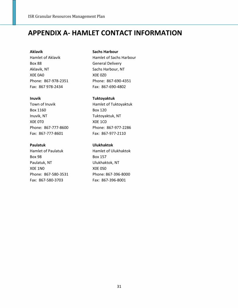
ISR Granular Resources Management Plan
31
APPENDIX A- HAMLET CONTACT INFORMATION
Aklavik Sachs Harbour Hamlet of Aklavik Hamlet of Sachs Harbour Box 88 General Delivery Aklavik, NT Sachs Harbour, NT X0E 0A0 X0E 0Z0 Phone: 867-978-2351 Phone: 867-690-4351 Fax: 867 978-2434 Fax: 867-690-4802 Inuvik Tuktoyaktuk Town of Inuvik Hamlet of Tuktoyaktuk Box 1160 Box 120 Inuvik, NT Tuktoyaktuk, NT X0E 0T0 X0E 1C0 Phone: 867-777-8600 Phone: 867-977-2286 Fax: 867-777-8601 Fax: 867-977-2110 Paulatuk Ulukhaktok Hamlet of Paulatuk Hamlet of Ulukhaktok Box 98 Box 157 Paulatuk, NT Ulukhaktok, NT X0E 1N0 X0E 0S0 Phone: 867-580-3531 Phone: 867-396-8000 Fax: 867-580-3703 Fax: 867-396-8001

ISR Granular Resources Management Plan
SECTION 4:
INUVIALUIT SETTLEMENT REGION GENERIC PIT MANAGEMENT PLAN

ISR Granular Resources Management Plan
2
CONTENTS
SECTION 1: INTRODUCTION 1.1 PURPOSE. . . . . . . . . . . . . . . . . . . . . . . . . . . . . . . . . . . . . . . . . . . . . . . . . . . . . . .4 1.2 PIT DESIGNATION. . . . . . . . . . . . . . . . . . . . . . . . . . . . . . . . . . . . . . . . . . . . . . . .4 SECTION 2: DEPOSIT DESCRIPTION 2.1 ANNOTATED LIST OF DEPOSIT GEOTECHNICAL REPORTS AND ASSOCIATED
DOCUMENTS. . . . . . . . . . . . . . . . . . . . . . . . . . . . . . . . . . . . . . . . . . . . . . . . . . . .5 2.2 TOPOGRAPHIC MAP. . . . . . . . . . . . . . . . . . . . . . . . . . . . . . . . . . . . . . . . . . . . . .5 2.3 SURFACE WATER AND HYDROGEOLOGY. . . . . . . . . . . . . . . . . . . . . . . . . . . . . .5 2.4 TEST HOLE LOCATIONS AND DESCRIPTIONS. . . . . . . . . . . . . . . . . . . . . . . . . . .5 2.5 SUMMARY OF TEST HOLE RESULTS. . . . . . . . . . . . . . . . . . . . . . . . . . . . . . . . . . 6 2.6 PROPERTIES OF GRANULAR MATERIALS. . . . . . . . . . . . . . . . . . . . . . . . . . . . . .6 2.7 DEPTH OF OVERBURDEN AND TOPSOIL. . . . . . . . . . . . . . . . . . . . . . . . . . . . . . 6 2.8 GROUND ICE CONTENT. . . . . . . . . . . . . . . . . . . . . . . . . . . . . . . . . . . . . . . . . . . .6 2.9 HIGHEST AND BEST USE OF MATERIALS. . . . . . . . . . . . . . . . . . . . . . . . . . . . . . 6 2.10 ARCHAEOLOGY. . . . . . . . . . . . . . . . . . . . . . . . . . . . . . . . . . . . . . . . . . . . . . . . . . 7 SECTION 3: SITE PREPARATION 3.1 ACCESS. . . . . . . . . . . . . . . . . . . . . . . . . . . . . . . . . . . . . . . . . . . . . . . . . . . . . . . . . 7 3.2 TIMBER REMOVAL. . . . . . . . . . . . . . . . . . . . . . . . . . . . . . . . . . . . . . . . . . . . . . . .7 3.3 VEGETATION RETENTION. . . . . . . . . . . . . . . . . . . . . . . . . . . . . . . . . . . . . . . . . . 7 3.4 CLEARING AND GRUBBING. . . . . . . . . . . . . . . . . . . . . . . . . . . . . . . . . . . . . . . . .7 3.5 SALVAGE AND STORAGE OF TOPSOIL AND STORAGE OR DISPOSAL OF
OVERBURDEN. . . . . . . . . . . . . . . . . . . . . . . . . . . . . . . . . . . . . . . . . . . . . . . . . . . 7 3.6 TOPOGRAPHIC SURVEY FOR FUTURE VOLUME CHECKS. . . . . . . . . . . . . . . . . 8 SECTION 4: PIT OPERATION 4.1 SEQUENCE OF DEVELOPMENT, QUARRYING AND RECLAMATION. . . . . . . . . 8 SECTION 5: PROCESSING
ISR Granular Resources Management Plan
3
5.1 PERMITS REQUIRED FOR PROCESSING. . . . . . . . . . . . . . . . . . . . . . . . . . . . . . . 8 SECTION 6: RECLAMATION 6.1 DESIRED FUTURE CONDITION OF THE SITE. . . . . . . . . . . . . . . . . . . . . . . . . . . .9 6.2 ENVIRONMENTAL PROTECTION. . . . . . . . . . . . . . . . . . . . . . . . . . . . . . . . . . . . .9 6.3 AESTHETICS. . . . . . . . . . . . . . . . . . . . . . . . . . . . . . . . . . . . . . . . . . . . . . . . . . . . . 9 6.4 WILDLIFE HABITAT ENHANCEMENT. . . . . . . . . . . . . . . . . . . . . . . . . . . . . . . . 10 6.5 WATER DIVERSION OR PROTECTION. . . . . . . . . . . . . . . . . . . . . . . . . . . . . . . .10 6.6 SLOPING/BENCHING. . . . . . . . . . . . . . . . . . . . . . . . . . . . . . . . . . . . . . . . . . . . .10 6.7 PERMAFROST STABILIZATION. . . . . . . . . . . . . . . . . . . . . . . . . . . . . . . . . . . . . 10 6.8 VEGETATION. . . . . . . . . . . . . . . . . . . . . . . . . . . . . . . . . . . . . . . . . . . . . . . . . . . 11
ISR Granular Resources Management Plan
4
SECTION 1: INTRODUCTION
1.1 PURPOSE As a result of the Inuvialuit Final Agreement, the Inuvialuit Land Administration and Indian and Northern Affairs Canada have developed a Granular Resources Management Plan for the Inuvialuit Settlement Region with the intent of setting in place responsible management criteria for granular resources. Part of this initiative is the development of pit management plans for active sources of granular resource extraction in the Inuvialuit Settlement Region. This pit management plan provides the direction required by the Inuvialuit Land Administration or Indian and Northern Affairs Canada to quarry/borrow source (insert source name here) in an efficient and environmentally acceptable manner and to leave the area in a safe and productive condition. The pit management plan describes the aspects of managing Source (insert source name here) from the start of operations to final reclamation. The plan is complementary to the terms and conditions contained in authorizations (licences or permits). 1.2 PIT DESIGNATION This section describes the designation of the site by ILA, and is only applicable for gravel sources on Inuvialuit Private Land. This would reflect the Inuvialuit Final Agreement’s requirement for gravel prioritization (community, Inuvialuit and private). The text below is an example of a pit designated for community use. Source (insert source name here) has been designated as a priority source for community use by the Inuvialuit Land Administration. It serves as a primary source of granular resources for the community of (insert community name here). Based upon current and future demand forecasts, the Inuvialuit Land Administration will determine whether quarrying for purposes other than community use will be permitted at this source.

ISR Granular Resources Management Plan
5
SECTION 2: DESCRIPTION OF THE DEPOSIT 2.1 Annotated List of Deposit Geotechnical Reports and Associated Documents This section will contain a list of all known documents containing appropriate information about the specific deposit. Information sources should be dated and properly referenced. 2.2 Topographic Map Topographic maps for all areas of Canada are available freely for downloading1
. Topographic maps of the gravel source can be obtained from some past geotechnical reports for many gravel sources within the Inuvialuit Settlement Region. As they become available, more detailed topographic survey will also be included. Satellite imagery, of a suitable resolution to provide similar detail, may be included in this section as a substitute for a topographic map.
2.3 Surface Water and Hydrogeology This information may be available from geotechnical reports or may require further field work. This information will allow quarry users to know what water bodies are present and the way water flows at the site. Furthermore, this section will include information about what water licenses, if any, must be obtained to conduct quarry activity at this site based on existing hydrogeology characteristics. Water source location data can also be Indian and Northern Affairs Canada and Environment Canada. 2.4 Test Hole Locations and Descriptions Test hole locations and descriptions of the gravel source can be obtained from geotechnical reports. Additional field work may be needed to adequately define the quantity and quality of materials, and potential hazards to development of the deposit. This section should include the coordinates of test holes, and descriptions of the areas where test holes were completed. Many geotechnical reports with test hole locations already exist for the Inuvialuit Settlement Region.
1 Index Maps of the National Topographic System of Canada ftp: ftp://ftp.nrcan.gc.ca/ess/topo/NTSIndex-SNRCIndex/
CanMatrix-Georeferenced, Digital Topographic Maps of Canada (zipped tiff) http: http://ftp2.cits.rncan.gc.ca/pub/canmatrix/ ftp: ftp://ftp2.cits.rncan.gc.ca/pub/canmatrix/
CanMatrix-Print Ready, Ditital Topographic Maps of Canada (tiff or PDF) http: http://ftp2.cits.rncanlgc.ca/pub/canmatrix2 ftp: ftp://ftp2.cits.rncan.gc.ca/pub/canmatrix2/

ISR Granular Resources Management Plan
6
2.5 Summary of Test Hole Results This section details the types, quantities and qualities of materials found within the pit based on test hole results. Much of this information is available for many ISR gravel sources from previous geotechnical work. 2.6 Properties of Granular Materials This section contains laboratory test results on samples obtained from surface sampling and test holes. It should include sample classifications, particle-size distributions (grain-size curves), moisture contents, and additional information depending on intended usage. Information is available in existing geotechnical reports for many ISR gravel sources, but additional samples and testing may be required. 2.7 Depth of Overburden and Topsoil This section discusses the depth of overburden and topsoil at the gravel source. This information should also be available from geotechnical reports, but additional field work may be needed to adequately delineate these materials. 2.8 Ground Ice Content This section details the type of ground ice that is present, and its extent within the gravel source. The type and amount of ground ice may have an impact on the seasons and locations of quarry operations or in the least provide for greater certainty of methods to be employed during the operations to ensure more efficient extraction activities. Areas of massive ground ice should generally be avoided. 2.9 Highest and Best Use of Materials This section is a description of the grades of material that can be found in the gravel source, and what their best uses are for the pit designation. Therefore, each class of gravel within a deposit will have a designated end use which will maximize the efficient and responsible use of the deposit. This can also help prevent high grading, which is the use of higher quality materials than are required for a specific purpose. For example, the pit management plan can say that Class 1 granular resources within the pit are reserved for asphalt or concrete aggregate for the community that the pit serves. Information about the classes of gravel available within a gravel source can be found in existing geotechnical reports. 2.10 Archaeology

ISR Granular Resources Management Plan
7
This section outlines the archaeological potential of the land on which the pit lies. An archaeological survey will be compulsory by law prior to pit development, and as such the results of this survey can be made known in the pit quarry/development plan. The regulator will include any archaeological information that is available, but this section will also emphasize that the proponent will be required to conduct their own survey.
SECTION 3: SITE PREPARATION 3.1 Access This section will detail how the gravel source will be accessed (i.e. ice road, winter road, barge, all weather road) and the seasonality of access. Furthermore, this section will detail how access to the gravel source will be controlled (i.e. fences, berms, posted signs, etc.). Information about how right of ways will be constructed to and at the site will be included to ensure best environmental practice. Access throughout the pit need also be included in this section. The INAC “Blue Book” for Access Roads and Trails should be consulted prior to the development of this section of the pit management plan. 3.2 Timber Removal This section discusses what timber can be removed from the site, and where the timber should be placed. 3.3 Vegetation Retention Vegetation retention will be detailed in this section. 3.4 Clearing and Grubbing Clearing and grubbing plans will be detailed in this section. The plans will include how best to minimize impacts to permafrost through these activities. 3.5 Salvage and Storage of Topsoil and Storage or Disposal of Overburden All soil should be stripped from the area to be cleared and saved for the reclamation phase. Topsoil should be stockpiled separately and not mixed with other materials. Further instructions about the exact location of the topsoil stockpile will be included in this section.

ISR Granular Resources Management Plan
8
During development of a pit, the removal and storage of overburden is a necessary activity for access to underlying granular resources. This section will contain a detailed plan for the removal and storage of overburden. Overburden that lies above the granular resource should be removed in a manner that does not reduce the stability of adjacent ground. It should be removed ahead of pit operations to ensure that safety during removal is not compromised by proximity to the pit wall, and that thawed material does not slump and flow over the pit wall. The overburden should be stored in a location that does not cover gravel resources or interfere with operations. The overburden stockpile should allow melt water from ground ice to flow away from the pit, and provide convenient access during site restoration. Environmental impacts should also be considered when determining a storage location. 3.6 Topographic Survey for Future Volume Checks This section will include the most recent topographic survey (as built) which will be used to estimate how much gravel has been extracted from the gravel source during the permitted quarrying activity. If it is the first time that the proponent will be operating in the pit, a survey may be required (per Inspector’s direction) to provide a base-line survey. Upon completion of removal of the permitted volume, a post activity survey would then be required to verify the volume removed from the area. This section of the pit management plan will require updating each time quarry activity is completed at the gravel site.
SECTION 4: PIT OPERATION 4.1 Sequence of Development, Extraction and Reclamation A sequence of extraction is necessary in order to ensure that all marketable material is removed from one area of the gravel source before moving on to other areas. This policy is in place to prevent high-grading of material, and to deter operators from taking gravel that is the easiest to acquire. This section of the document should include a map of the gravel source in which sections of the source are blocked off and labelled in terms of extraction sequence.
SECTION 5: PROCESSING 5.1 Permits Required for Processing

ISR Granular Resources Management Plan
9
This section of the pit management plan will detail any additional permits that are required for processing materials on site. Additional heavy equipment associated with crushing may require a different land use permit.
SECTION 6: RECLAMATION 6.1 Desired future condition of the site Having a closure plan prior to the development of a site helps operators and regulators to anticipate the scope of reclamation activities and post reclamation condition of the site. For most ISR sites, the ideal future condition of the site would be to return it to its natural state, or as close as possible. For multi-user pits, or for sites with a strong potential for multi-year operations, depleted areas should be restored, and active removal areas should be left in stable condition so as to minimize the risk of slope failure and granular material contamination. Desired site conditions after closure of the quarry should be listed here by the land owner. 6.2 Environmental Protection The process of site reclamation must be ongoing and not relegated to the end of operations at the pit. As a result, progressive reclamation must be employed as areas of the pit become depleted and no longer used. All unused materials should be returned to the pit, flattened and contoured at the time of final reclamation. Displaced and stored topsoil and overburden will also need to be returned and placed on top of any remaining quarry materials. Revegetation should be encouraged. This portion of the plan will detail not only progressive reclamation, but also final reclamation. Reducing environmental impacts should be the main focus of this section. 6.3 Aesthetics This section of the pit management plan will discuss how the quarry site should look once it is reclaimed. This will include details on whether the site should blend into the existing landscape, and how this should be carried out. 6.4 Wildlife Habitat Enhancement
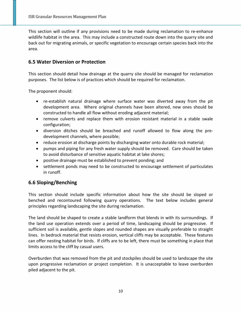
ISR Granular Resources Management Plan
10
This section will outline if any provisions need to be made during reclamation to re-enhance wildlife habitat in the area. This may include a constructed route down into the quarry site and back out for migrating animals, or specific vegetation to encourage certain species back into the area. 6.5 Water Diversion or Protection This section should detail how drainage at the quarry site should be managed for reclamation purposes. The list below is of practices which should be required for reclamation. The proponent should:
• re-establish natural drainage where surface water was diverted away from the pit development area. Where original channels have been altered, new ones should be constructed to handle all flow without eroding adjacent material;
• remove culverts and replace them with erosion resistant material in a stable swale configuration;
• diversion ditches should be breached and runoff allowed to flow along the pre-development channels, where possible;
• reduce erosion at discharge points by discharging water onto durable rock material; • pumps and piping for any fresh water supply should be removed. Care should be taken
to avoid disturbance of sensitive aquatic habitat at lake shores; • positive drainage must be established to prevent ponding; and • settlement ponds may need to be constructed to encourage settlement of particulates
in runoff.
6.6 Sloping/Benching This section should include specific information about how the site should be sloped or benched and recontoured following quarry operations. The text below includes general principles regarding landscaping the site during reclamation. The land should be shaped to create a stable landform that blends in with its surroundings. If the land use operation extends over a period of time, landscaping should be progressive. If sufficient soil is available, gentle slopes and rounded shapes are visually preferable to straight lines. In bedrock material that resists erosion, vertical cliffs may be acceptable. These features can offer nesting habitat for birds. If cliffs are to be left, there must be something in place that limits access to the cliff by casual users. Overburden that was removed from the pit and stockpiles should be used to landscape the site upon progressive reclamation or project completion. It is unacceptable to leave overburden piled adjacent to the pit.

ISR Granular Resources Management Plan
11
6.7 Permafrost Stabilization This section should detail how permafrost stabilization will be ensured during pit restoration. The remediation plan for doing so will depend on the specific site. Below are some general rules for permafrost stabilization in soils with different amounts of excess ice. The behaviour of permafrost when thawing depends on the amount of excess ice which is present. Excess ice is expressed as a percentage of the thickness of ice in the total thickness of a sample. Soils with less than 5% excess ice are generally not thaw unstable and can be simply revegetated after slopes are trimmed to a stable angle, such as 2H:1V or flatter. Soils with moderate excess ice, 5% to 20%, will release excess water and experience minor slumping or settling upon thawing. These soils should be stabilized by providing some insulation. This may consist of ice poor granular soil placed at least 30 cm thick over the affected area. Slopes should be trimmed to 3H:1V before placing the insulating layer. Soils with significant excess ice, greater than 20%, are prone to slumping and ongoing thawing. Where this occurs in fine grained soils such as silts or clays the excess water plus any precipitation will continually wash away the soil particles which prevent a build-up of a new insulating later. These fine-grained soils can be easily washed into streams or lakes and destroy aquatic habitat. Stabilization may involve use of geo-textiles and special construction methods. A geotechnical engineer should be consulted in these cases, especially where slopes are involved. In all permafrost stabilization, it should be anticipated that thawing and settlement will continue until a new permafrost regime is established. Allowance for settlement should be made. The design of reclamation measures should allow for this and incorporate features to prevent ponds from forming which could delay or prevent the establishing of stable conditions. In general, exploration trenches in frozen ground should be backfilled, or at a minimum, sufficient backfill should be placed to provide a new insulating layer over the permafrost. Any trees which are standing at the crest of cut slopes, such as in trenches, quarries or roads, should be cut down so that any settlement which results from thawing will be uniform and toppling trees do not expose more permafrost. Where pits have been excavated for granular materials, a depression in the topography may result. Natural flooding may create an end-pit lake that will cause permafrost to thaw and ongoing degradation of the land surface. Ideally, proper drainage should prevent the formation of an end-pit lake. If flooding in ice-rich ground is inevitable, however, the extent of damage to the surrounding area should be forecast and monitored. Stabilizing such an area could take a long time.

ISR Granular Resources Management Plan
12
6.8 Vegetation This section will outline if any revegetation is required, and if so, what improvements will be required to encourage revegetation. The publication “Guidelines for Reclamation/Revegetation in the Yukon” can serve as a guide for determining which native plants are in the area, the seed mixture required, and the fertilizer mix for the site. Information may also be available from the Aurora Research Institute in Inuvik, regarding the various vegetation types and sources of seed that may be available for local plant varieties in the Mackenzie Delta area. All sites should be scarified.

ISR Granular Resources Management Plan
1
SECTION 5:
GENERIC PIT/QUARRY DEVELOPMENT
PLAN

ISR Granular Resources Management Plan
2
CONTENTS
SECTION 1: INTRODUCTION. . . . . . . . . . . . . . . . . . . . . . . . . . . . . . . . . . . . . . . . . . . . 4 1.1 PURPOSE. . . . . . . . . . . . . . . . . . . . . . . . . . . . . . . . . . . . . . . . . . . . . . . . . . . . . . .4 SECTION 2: DEPOSIT DESCRIPTION. . . . . . . . . . . . . . . . . . . . . . . . . . . . . . . . . . . . . . . 5 2.1 TOPOGRAPHIC MAP. . . . . . . . . . . . . . . . . . . . . . . . . . . . . . . . . . . . . . . . . . . . . . 5 2.2 TEST HOLE LOCATIONS AND DESCRIPTIONS. . . . . . . . . . . . . . . . . . . . . . . . . . .5 2.3 SUMMARY OF TEST HOLE RESULTS. . . . . . . . . . . . . . . . . . . . . . . . . . . . . . . . . .5 SECTION 3: SITE PREPARATION. . . . . . . . . . . . . . . . . . . . . . . . . . . . . . . . . . . . . . . . . .5 3.1 ACCESS. . . . . . . . . . . . . . . . . . . . . . . . . . . . . . . . . . . . . . . . . . . . . . . . . . . . . . . . .5 3.2 TIMBER REMOVAL. . . . . . . . . . . . . . . . . . . . . . . . . . . . . . . . . . . . . . . . . . . . . . . .6 3.3 VEGETATION RETENTION. . . . . . . . . . . . . . . . . . . . . . . . . . . . . . . . . . . . . . . . . . 6 3.4 CLEARING AND GRUBBING. . . . . . . . . . . . . . . . . . . . . . . . . . . . . . . . . . . . . . . . .6 3.5 SALVAGE AND STORAGE OF TOPSOIL AND STORAGE OR DISPOSAL OF
OVERBURDEN. . . . . . . . . . . . . . . . . . . . . . . . . . . . . . . . . . . . . . . . . . . . . . . . . . . 6 3.6 BRUSH DISPOSAL. . . . . . . . . . . . . . . . . . . . . . . . . . . . . . . . . . . . . . . . . . . . . . . . .7 3.7 SCALES, BUILDINGS AND OTHER FACILITIES. . . . . . . . . . . . . . . . . . . . . . . . . . . 7 3.8 TOPOGRAPHIC SURVEY FOR FUTURE VOLUME CHECKS. . . . . . . . . . . . . . . . . 7 SECTION 4: PIT OPERATION. . . . . . . . . . . . . . . . . . . . . . . . . . . . . . . . . . . . . . . . . . . . .7 4.1 SEQUENCE OF DEVELOPMENT, MINING AND RECLAMATION. . . . . . . . . . . . .7 4.2 LIMITS ON THE TYPE OF EQUIPMENT. . . . . . . . . . . . . . . . . . . . . . . . . . . . . . . . 8 4.3 GRADES OF THE PIT FLOOR. . . . . . . . . . . . . . . . . . . . . . . . . . . . . . . . . . . . . . . . .8 4.4 EROSION PREVENTION. . . . . . . . . . . . . . . . . . . . . . . . . . . . . . . . . . . . . . . . . . . . 8 4.5 PERMAFROST DEGRADATION . . . . . . . . . . . . . . . . . . . . . . . . . . . . . . . . . . . . . . 8 4.6 LOCAL WATER MANAGEMENT. . . . . . . . . . . . . . . . . . . . . . . . . . . . . . . . . . . . . .8 4.7 GRADES OF SIDE SLOPES/BENCHES . . . . . . . . . . . . . . . . . . . . . . . . . . . . . . . . . 9 4.8 STORAGE AREA FOR COARSE OR FINE REJECTS. . . . . . . . . . . . . . . . . . . . . . . . 9 4.9 STORAGE AREA FOR FINISHED PRODUCTS. . . . . . . . . . . . . . . . . . . . . . . . . . . . 9 SECTION 5: PROCESSING

ISR Granular Resources Management Plan
3
5.1 PROCESSING LIMITS. . . . . . . . . . . . . . . . . . . . . . . . . . . . . . . . . . . . . . . . . . . . . .9 5.2 SCREENING SIZE LIMITS. . . . . . . . . . . . . . . . . . . . . . . . . . . . . . . . . . . . . . . . . . 10 5.3 CRUSHING SIZE LIMITS. . . . . . . . . . . . . . . . . . . . . . . . . . . . . . . . . . . . . . . . . . . 10

ISR Granular Resources Management Plan
4
SECTION 1: INTRODUCTION 1.1 PURPOSE As a result of the Inuvialuit Final Agreement, the Inuvialuit Land Administration and Indian and Northern Affairs Canada have developed a Granular Resources Management Plan for the Inuvialuit Settlement Region with the intent of setting in place responsible management criteria for granular resources. Part of this initiative is the development of pit/quarry development plans for active sources of granular resource extraction in the Inuvialuit Settlement Region. This pit/quarry development plan is submitted by the proponent/developer to describe how quarrying will occur within the parameters of the pit management plan. This development plan provides the direction required by the Inuvialuit Land Administration or Indian and Northern Affairs Canada to quarry Source (insert source name here) in an efficient and environmentally acceptable manner and to leave the area in a safe and productive condition. The pit/quarry development plan describes the aspects of managing Source (insert source name here) from the start of the project operation through completion of the project. The plan is complementary to the terms and conditions contained in authorizations (licences or permits).

ISR Granular Resources Management Plan
5
SECTION 2: DESCRIPTION OF THE DEPOSIT 2.1 TOPOGRAPHIC MAP Topographic maps for all areas of Canada are available freely for downloading1
. Topographic maps of the gravel source can be obtained from some past geotechnical reports for many gravel sources within the Inuvialuit Settlement Region. As they become available, more detailed topographic survey will also be included. Satellite imagery, of a suitable resolution to provide similar detail, may be included in this section as a substitute for a topographic map.
2.2 TEST HOLE LOCATIONS AND DESCRIPTION Test hole locations and descriptions of the gravel source can be obtained from geotechnical reports. Additional field work may be needed to adequately define the quantity and quality of materials, and potential hazards to development of the deposit. This section should include the coordinates of test holes, and descriptions of the areas where test holes were completed. Many geotechnical reports with test hole locations exist already for the Inuvialuit Settlement Region. 2.3 SUMMARY OF TEST HOLE RESULTS This section details the types, quantities and qualities of materials found within the pit based on test hole results. Much of this information is available for many ISR gravel sources from previous geotechnical work.
SECTION 3: SITE PREPARATION 3.1 ACCESS This section will detail how the gravel source will be accessed (i.e. ice road, winter road, barge, all weather road) and the seasonality of access. Furthermore, this section will detail how access to the gravel source will be controlled (i.e. fences, berms, posted signs, etc.). Information pertaining to proposed construction methods, including best construction and route selection
1 Index Maps of the National Topographic System of Canada ftp: ftp://ftp.nrcan.gc.ca/ess/topo/NTSIndex-SNRCIndex/
CanMatrix-Georeferenced, Digital Topographic Maps of Canada (zipped tiff) http: http://ftp2.cits.rncan.gc.ca/pub/canmatrix/ ftp: ftp://ftp2.cits.rncan.gc.ca/pub/canmatrix/
CanMatrix-Print Ready, Ditital Topographic Maps of Canada (tiff or PDF) http: http://ftp2.cits.rncanlgc.ca/pub/canmatrix2 ftp: ftp://ftp2.cits.rncan.gc.ca/pub/canmatrix2/

ISR Granular Resources Management Plan
6
practices, for the proposed access to and within the site will be described in this section. Access to multi-use areas should not be compromised. The INAC “Blue Book” for Access Roads and Trails should be consulted prior to the development of this section of the pit/quarry development plan. 3.2 TIMBER REMOVAL This section discusses what timber can be removed from the site, and where the timber should be placed. The proponent should consider consulting the local Environment and Natural Resources staff when removal of timber is contemplated. 3.3 VEGETATION RETENTION Vegetation retention will be detailed in this section. 3.4 CLEARING AND GRUBBING Clearing and grubbing plans will be detailed in this section. The plans will include how best to minimize impacts to permafrost through these activities. 3.5 SALVAGE AND STORAGE OF TOPSOIL AND STORAGE OR DISPOSAL OF OVERBURDEN All soil should be stripped from the area to be cleared and saved for the reclamation phase. Topsoil should be stockpiled separately and not mixed with other materials. Further description about the exact location of the topsoil stockpile should be provided by the proponent in this section. During development of a pit, the removal and storage of overburden is a necessary activity for access to underlying granular resources. This section will contain a detailed plan for the removal and storage of overburden.
Overburden that lies above the granular resource should be removed in a manner that does not reduce the stability of adjacent ground. It should be removed ahead of pit operations to ensure that safety during removal is not compromised by proximity to the pit wall, and that thawed material does not slump and flow over the pit wall.
The overburden should be stored in a location that does not cover gravel resources or interfere with operations. The overburden stockpile should allow meltwater from ground ice to flow away from the pit, and provide convenient access during site restoration. Environmental impacts should also be considered when determining a storage location.

ISR Granular Resources Management Plan
7
3.6 BRUSH DISPOSAL The disposal of brush accumulated during pit development will be discussed in this section. The discussion will focus on preferred methods including, but not limited to: • using brush for erosion control and insulation; • lopping and scattering cleared trees; and • windrowing brush. 3.7 SCALES, BUILDINGS OR OTHER FACILITIES This section will discuss the types of equipment used for size determination (screening), and equipment used for washing of granular materials and/or equipment, and where these facilities should be placed in order to reduce potential environmental damage. Information regarding detergents, degreasers or surfactants for equipment washing 3.8 TOPOGRAPHIC SURVEY FOR FUTURE VOLUME CHECKS This section will include the most recent topographic survey or as-built which will be used to estimate how much gravel has been or will be extracted from the gravel source during the permitted quarrying activity. If it is the first time that the proponent will be operating in the pit, a survey may be required (per Inspector’s direction) to provide a base-line survey. Upon completion of removal of the permitted volume, a post activity survey would then be required to verify the volume removed from the area. This section of the pit/quarry development plan will require updating each time quarry activity is completed at the gravel site.
SECTION 4: PIT OPERATION 4.1 SEQUENCE OF DEVELOPMENT, EXTRACTION AND RECLAMATION A sequence of extraction is necessary in order to ensure that all marketable material is removed from one area of the gravel source before moving on to other areas. This policy is in place to prevent high-grading of material, and to deter operators from taking gravel that is the easiest to acquire. This section of the document should include a map of the gravel source in which sections of the source are blocked off and labelled in terms of extraction sequence. 4.2 LIMITS ON THE TYPE OF EQUIPMENT

ISR Granular Resources Management Plan
8
Quarries of different sizes and configurations require different equipment. The information in this section will be similar to that which was included in the Land Use Permit application. This section will further detail what equipment will be used to conduct various activities at the site. The list of equipment will be based on environmental as well as logistical considerations. 4.3 GRADES OF THE PIT FLOOR In order to encourage positive drainage as well as stable pit walls and permafrost preservation, a quarry will need to be graded appropriately. This section will detail the planned grades within the pit and should include diagrams. 4.4 EROSION PREVENTION This section should detail the various techniques that must be used at the site to prevent ground erosion, while ensuring remaining resources are not contaminated with fines and organics. Requirements for recontouring the pit after each operation will also be outlined here. 4.5 Permafrost Degradation This section will contain information about how quarry operations should be carried out in order to avoid permafrost degradation. Permafrost degradation will reduce the availability of granular resources and increase the cost of pit development. 4.6 Local Water Management This section should detail how water should be managed at the quarry site. Best practice for quarry sites is to minimize water inflow and control runoff. Some considerations of this section should include: -Diversion of surface water away from the development area, and the construction of channels and berms to do so -Reduction of erosion at discharge points by discharging water onto rock material -Minimization of water in the pit by directing it out by gravity or pumping This section should also make mention of any other permits that would be required at this source from the NWT Water Board for water discharge. 4.7 Grades of the Side Slopes/Benches

ISR Granular Resources Management Plan
9
In order to maintain pit stability, and reduce the likelihood of slumping and sliding, a gravel pit should be contoured at an appropriate grade. A general benchmark grade is 1:2. This section should outline which grades will be in place at what parts of the pit, and identify what the minimum grade for pit walls. 4.8 Storage Area for Coarse or Fine Rejects During pit development, unusable materials are often encountered and as a result the plan is required to ensure orderly, and separate, storage of rejected materials. This section will define the exact locations of where rejects should be stored during quarry operations. 4.9 Storage Area for Finished Products (i.e. stockpile, and permits required)
A separate area to store usable materials will be required in most pits. This section of the plan will detail the location of stockpiles, the maximum volume of materials to be stored in the stockpiles, and any permits required by the regulatory agency for stockpiling.
SECTION 5: PROCESSING 5.1 PROCESSING LIMITS Processing includes stockpiling, crushing, screening and washing. Each step requires space to carry out the operation (i.e., access to and room at the working face) and to stockpile the processed material. Crushing and screening equipment and stockpiled material must be located in an easily accessible location within the pit, i.e., accessible from the cut face and to the access road for haulage. The crusher should be situated on hard, well-drained ground as the area around it will be heavily used. Prevailing winds should be considered for dust control. This section should set out where exactly the processing should take place during the various stages of pit development. This section could also discuss the rates of processing and the maximum volume of each material class to be removed or stockpiled. 5.2 SCREENING SIZE LIMITS

ISR Granular Resources Management Plan
10
Most quarries contain some materials which are either too large or too small for use. A complete quarry pit development plan will detail what the maximum and minimum grain/rock sizes are in the project and how to treat and store rejected materials from screening. This section should focus on detailing materials which are of appropriate size and those which are not, for use. 5.3 CRUSHING SIZE LIMITS Quarries often contain materials which are too large for use without crushing. Similarly, crushing devices have a limit on the size of materials which can be processed in the device. This section will detail what size materials are appropriate for the crushing operations expected on site.


