76
Inventory of peatlands in the Caribbean and first description of priority areas Peters, J. & Tegetmeyer, C. Proceedings of the Greifswald Mire Centre 05/ 2019
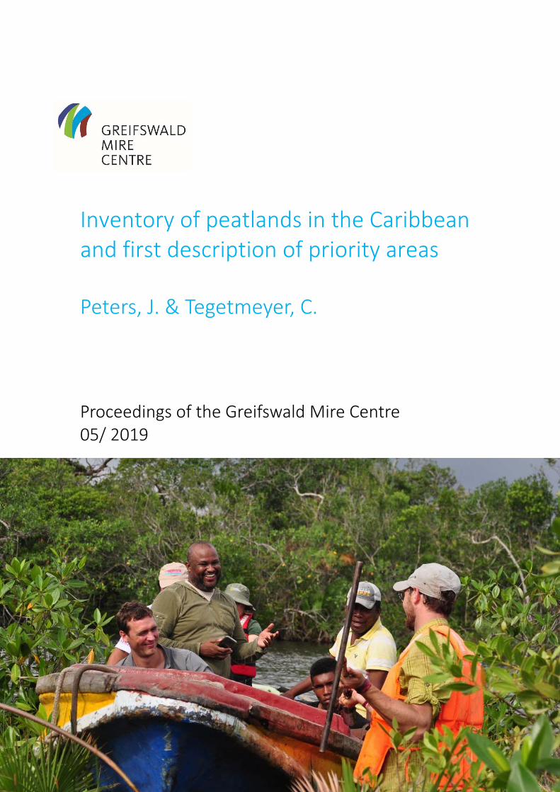
Inventory of peatlands in the Caribbean and first description of priority areas Peters, J. & Tegetmeyer, C.
Proceedings of the Greifswald Mire Centre 05/ 2019

cover picture: Hans Joosten
all other photographs: Jan Peters
maps: Cosima Tegetmeyer
Zitiervorschlag │ suggestion for citation:
Peters, J. & Tegetmeyer, C. (2019) Inventory of peatlands in the Caribbean and first description of priority areas. Proceedings of the Greifswald Mire Centre 05/2019 (self‐published, ISSN 2627‐910X), 76 S.
Für den Inhalt der Arbeiten sind die Verfasser verantwortlich. │ Authors are responsible for the content of their publications.
Impressum │ Imprint
Herausgeber │ publisher:
Greifswald Moor Centrum │ Greifswald Mire Centre
c/o Michael Succow Stiftung
Ellernholzstraße 1/3
17489 Greifswald
Germany
Tel: +49(0)3834 8354210
Mail: [email protected]
Internet: www.greifswaldmoor.de
Das Greifswald Moor Centrum ist eine Kooperation von Universität Greifswald, Michael Succow
Stiftung und DUENE e.V. │ The Greifswald Mire Centre is a cooperation between University of
Greifswald, Michael Succow Foundation and DUENE e.V.

This report was prepared in the frame of “Strategic Environmental Dialogues for Coastal
Peatlands in the Caribbean ‐ Underlining the importance of peatlands for biodiversity,
climate change mitigation, coastal protection, and human livelihoods”, a project
implemented by Michael Succow Stiftung, Partner in the Greifswald Mire Centre with
funding from the German Federal Ministry for the Environment, Nature Conservation and
Nuclear Safety (BMU), facilitated by the Gesellschaft für Internationale Zusammenarbeit
(GIZ).
The objectives of the project were 1) to map Caribbean peatlands using methods developed
by the Global Peatlands Database at the Greifswald Mire Centre; 2) to initiate expert round
table dialogues in key peatlands countries in the region (Costa Rica, Cuba, Honduras,
Nicaragua, Panama); 3) to prioritise sites; and 4) to assess potentials and priorities for
peatland conservation, restoration and alternative, wet use (paludiculture) of degraded
areas for following steps. In this report, we briefly summarise the results of the mapping and
dialogues before we present identified priority peatland sites in the assessed countries Costa
Rica, Cuba, Honduras, Nicaragua, Panama.

Contents:
1. Introduction……………………………………………………………………………………3
2. Methodology…………………………………………………………………………………..4
2.1. Identification and delineation of areas with high probability of peatland occurrence
with available data from cartography and other sources………………………………...4
2.2. Dialogue with environmental specialist and stakeholders in region to cross-check
probability maps and collate additional data………………………………………………5
2.3. Scoping mission to selected peatland sites to confirm peatland occurrence in the
field……………………………………………………………………………………………..5
2.4. Identify priority for conservation and restoration action……………………………..5
3. Probability maps………………………………………………………………………………7
4. Priority peatland areas……………………………………………………………………...14 4.1. Factsheets on priority peatland sites in Panama………………...……….………...16 4.2. Factsheets on priority peatland sites in Costa Rica……………………….………..22 4.3. Factsheets on priority peatland sites in Nicaragua…………………………………32 4.4. Factsheets on priority peatland sites in Honduras………………………….………38 4.5. Factsheets on priority peatland sites in Cuba……………………………………….42
5. Conclusions…………………………………………………………………………………..50
6. Acknowledgments……………………………………………………………………………50
7. References……………………………………………………………………………………51
8. Annexes……………………………………………………………………………………….52

2
1. Introduction
Coastal peatlands in the Caribbean provide important ecological functions beyond declining habitats for endangered biodiversity and sequestration and long-term storage of carbon. Intact coastal ecosystems including coastal peatlands fulfil important roles in the protection against extreme weather events (e.g. hurricanes, which have become more frequent and strong in times of climate change). Coral reefs break the biggest waves in front of the shore, mangroves stabilize the coastline’s soils with their roots, and coastal peatlands finally act like buffer zones between salt and inland freshwaters. Peatlands store freshwater like huge sponges, blocks salt water intrusion in the aquifers and provide permanent water supply throughout the year for local communities, bridging periods of water shortage in the dry seasons. Therefore, they are key ecosystems in climate change adaptation.
Figure 1: Natural Caribbean coastal ecosystems act as natural barriers in coastal protection
Draining coastal peatlands implies emission of CO2 to the atmosphere due to oxidation of peat layers and dissolving of underlying carbonates typical for Caribbean mires. This process is fast under tropic climate condition and imposes the risk of catastrophic fire events during droughts. Furthermore, decomposition of peat soils leads to subsidence, which implicates a risk of irreversible land loss as sea level is rising in contrast to dropping peatland surface. Last but not least, the beauty of mire landscapes is a significant asset for future development of eco-tourism in the region. However, little is known about the distribution, the ecosystem functioning and status of the peatlands in the Caribbean region (including Bahamas, Cuba, Dominican Republic, Haiti, Jamaica, Mexico (Yucatan), Panama, Puerto Rico). There are indications that some of them are in unfavourable conditions and under threat of degradation. To start a dialogue with stakeholders in the Caribbean countries on coastal peatlands within this project, a comprehensive overview of the distribution in the Caribbean countries is needed. Existing data from the Global Peatland Database, hosted at the Greifswald Mire Centre, has been be screened, existing gaps identified and filled as far as possible in consultation with regional partners by expert-guided literature and internet research for soil maps, scientific publications, official statistical datasets, expert interviews etc. Data newly available have been harmonized and included in the database. In this desk study, peatland probability maps for the region and selected countries (Cuba, Panama, Costa Rica, Honduras, Nicaragua, Mexico (Yucatan)) are presented indicating different levels of confidence of peatland locations. They are also necessary basis for further research e.g. on carbon stocks, biodiversity and conservation efforts in the countries and give primary information for the priority list of peatlands, which was drawn with acquired information of scoping missions and workshops.
3
2. Methodology
2.1. Identification and delineation of areas with high probability of peatland occurrence with available data from cartography and other sources
The method of the present desk study is derived from ‘identification and delineation of peatlands/organic soils with available data’ developed in the framework of the “High carbon stock (HSC) study of the sustainable palm oil manifesto” (Barthelmes et al., 2015). Peatlands are areas with a thick layer of peat (dead, locally produced plant material) at the surface. In the context of this study, we define peatlands as special form of organic soils according to IPCC (2014): Soil with (dependent on the clay content) at least 12-18% (by weight) of organic carbon. Only limited attention was paid on peatlands so far in the Caribbean region. To assess the extent and location of peatlands in the Caribbean region it is necessary to collate a vast variety of cartographic information and to extrapolate spatially restricted peatland/organic soil data to adjacent areas. In doing so, the search intensity and the number of appropriate key words determine the final amount of accessed meaningful data sets. Spatially explicit information indicating organic soil of various scales was collected under consideration of local terminology for e.g. organic soils and (peat forming) wetland vegetation. Because of the restricted direct peatland and organic soil information, a broad variability of indirect (proxy) data has been included which indicates potential peatland and organic soil occurrences. This contains data on e.g. specific (hydromorphic) soil conditions, landforms as e.g. depressions and valleys, wetland vegetation and habitat types, and land use restrictions through permanent high water levels or flooding. The internet search has been conducted using ‘Google’ engine. We used the following online archives for this study: ISRIC (World Soil Information; http://eusoils.jrc.ec.europa.eu/esdb_archive/eudasm/indexes/access.htm) JRC (Joint Research Centre; http://eusoils.jrc.ec.europa.eu/esdb_archive/eudasm/indexes/access.htm) FAO Corporated Document Repository (http://www.fao.org/documents/en/docrep.jsp) We used the following keywords while searching for data: histosoles, suelo organico, materia organica del suelo, mapa de suelos, manglares, vegetacion, vegetation, histosols, organic soil, mangroves
Datasets (GIS datasets as well as digital maps) of national, regional and global scale have been used. Digitalised printed maps produced decades ago were considered as well as recently produced raster or vector data, as they are mostly of very high precision. Results of geospatial data from the internet search with scales ranging from 1:50.000 to 1:5.000.000 were stored, if necessary georeferenced and imported into a Geodatabase (ESRI, 2013). All used data is listed in Annex 1. In a further step, all sources of information that indicate probable occurrence of peat or organic soil were digitalised and depicted as overlaying features in ArcGIS2 and compared to available satellite images (World Imagery1, BING Maps, Google Earth) with a peatland expert judgement from Greifswald Mire Centre. Areas of high probability of peatland occurrence were derived and demarcated by the evaluation of the collected spatial information and the comparison of (partly legacy) cartographic and (recent) satellite image data. The more proxy data for peat occurrence was overlapping in certain areas, the higher the probability was rated; indicated in darker red signature in the maps. We produced probability maps for the whole region as an overview and 1 Sources: Esri, DigitalGlobe, Earthstar Geographics, CNES/Airbus DS, GeoEye, USDA FSA, USGS, Aerogrid, IGN, IGP, and the
GIS User Community

4
on higher resolution for each of the target countries Panama, Costa Rica, Nicaragua, Honduras and Cuba. By adding additional socio-geographical data like the boundaries of protected areas (WDPA) the protection and potential threats on peatland areas can be derived.
2.2. Dialogue with environmental specialist and stakeholders in region to cross-check probability maps and collate additional data
During missions to the selected key countries, the dialogue on existing knowledge of peatlands was initiated among relevant academic and practicing experts. 4 specialist’s round tables on the distribution and importance of coastal peatlands for the Caribbean key countries for biodiversity, climate change mitigation, coastal protection, and human livelihoods have been conducted with scientists and practitioners in the fields of ecology and conservation biology, geography, agriculture, and land use economics (Tab. 1). Additionally, individual meeting with specialists in these key countries (incl. Honduras) have been conducted to acquire additional information. A detailed list and description of all meetings conducted you find in Annexes 2-5. Table 1: List of conducted round tables
Date Country Venue
5th Sep. 2017 Costa Rica Universidad Nacional de Costa Rica (UNA), Heredia
6th Sep. 2017 Panama Smithsonian Tropical Research Institute, Panama City
31st Oct. 2017 Nicaragua Puerto Cabezas
6th Nov. 2017 Cuba XI. Simposio Internacional “Humedales 2017”, Playa Girón
As major expert of the 1st project mission to Panama and Costa Rica (30th August – 6th September 2017), Prof. Michael Succow with his livelong experiences on peatlands ecology and conservation shared his knowledge and insights during these meetings. Prof. Hans Joosten of Greifswald University present and discuss needs and challenges of Caribbean peatlands with major experts and stakeholders from Latin America and the Caribbean during the 2nd project mission to Nicaragua, Honduras and Cuba (30th October – 9th September 2017). One round table venturing beyond academia took place at the International Wetland Symposium 2017 (XI Simposio Internacional “Humedales 2017”), hosted from 3rd to 6th November 2017 in the Ciénaga de Zapata Biosphere Reserve, Cuba, at the edge of the largest known peatland of the Caribbean. All round tables have been supported and facilitated by Rebeca Magaña, executive director of the Centro Regional Ramsar para la capacitación e investigación sobre humedales en el Hemisferio Occidental (CREHO).
2.3. Scoping mission to selected peatland sites to confirm peatland occurrence in the field
During field missions to the target countries (Panama, Costa Rica, Nicaragua, Honduras, Cuba) internationally renowned peatland experts of Greifswald Mire Centre visited some of the delineated areas in the probability map and conducted soil sampling with peat coring devices of max. 2.2 m length. They confirmed or falsified the occurrence of peat in some identified probable areas with this ground-truthing information. With the help of this acquired information more detailed maps of peatland occurrence of specific areas can be drawn in a further working step.
2.4. Identify priority for conservation and restoration action
We discussed the gathered information from literature (e.g. Bundschuh & Alvarado 2007) and probability maps with experts and stakeholders during the meetings to specify locations of peatlands and their status. Based on discussions, we prepared a preliminary list of priority peatlands in the Caribbean region. Either selected sites have high conservation values with need for management and research or they are under risk by anthropogenic threats (mainly land use change) with limited knowledge and protection. For each peatland site, we draw individual site maps based on available data and collated factsheets with site description, status and

5
possible threats. Information on peatland areas are rare so these descriptions are only a first step for future, more in-depth investigations of each individual site.

6
3. Probability maps
Figure 2: Peatland probability map for the Caribbean region; darker red indicates higher probability; scope countries green-coloured.

7
Figure 3: Peatland probability map for Panama; darker red indicates higher probability; protected areas in green colours

8
Figure 4: Peatland probability map for Costa Rica; darker red indicates higher probability; protected areas in green colours

9
Figure 5: Peatland probability map for Nicaragua; darker red indicates higher probability; protected areas in green colours

10
Figure 6: Peatland probability map for Honduras; darker red indicates higher probability; protected areas in green colours
11
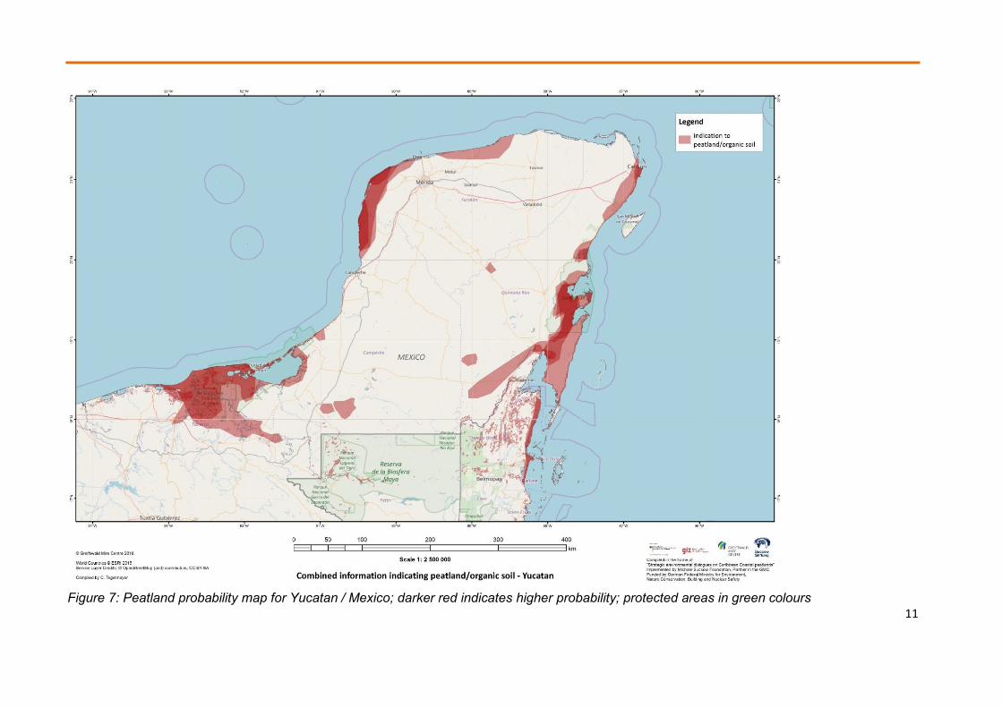
Figure 7: Peatland probability map for Yucatan / Mexico; darker red indicates higher probability; protected areas in green colours
12
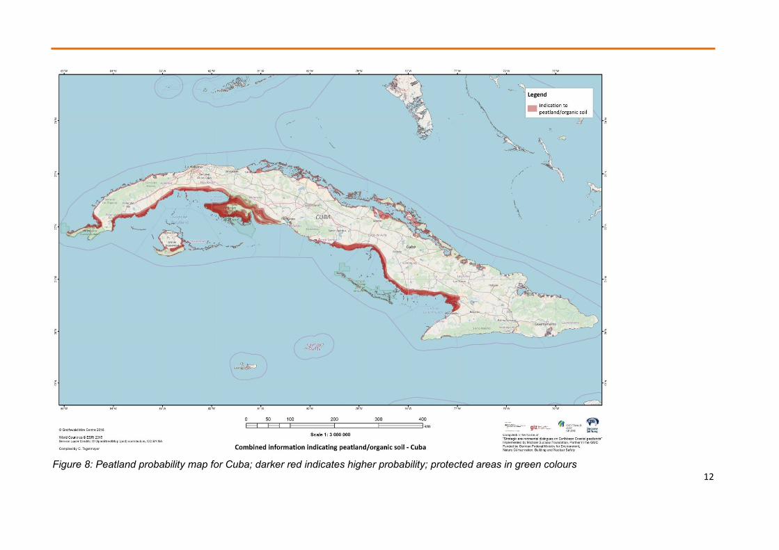
Figure 8: Peatland probability map for Cuba; darker red indicates higher probability; protected areas in green colours

13
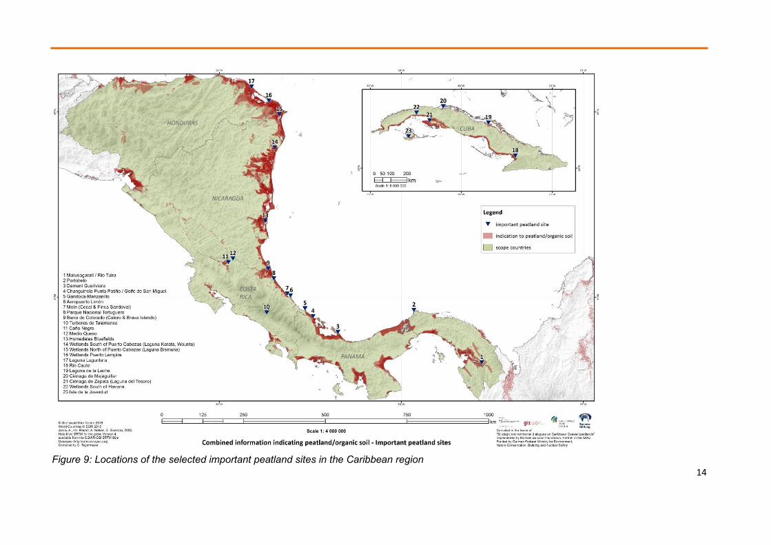
4. Priority peatland areas
In the following section, brief descriptions of preliminarily selected priority peatland areas are presented. The focus of selected sites lays on areas along the Caribbean Sea coast of the target countries, but experts also indicated other important peatland sites in their countries, which have been included in the list for the sake of higher completeness (Tab. 2). The factsheets encompass a site map indicating probable peatland area and borders of protected areas, description of the location, status, land use and other available information. For few sites, which the project team visited during scoping missions, more precise information on peat sampling and vegetation are given.
Table 2: List of priority potential peatland sites (confirmed peat occurrence marked red)
Nr. Country Site Coordinates
1 Panama Matusagaratí / Rio Tuira 8°14‘ N 77°79‘ W 2 Panama Portobelo 9°57‘ N 79°65‘ W 3 Panama Damani Guariviara 8°97‘ N 81°74‘ W 4 Panama Changuinola 9°40‘ N 82°42‘ W Panama Punta Patiño / Golfo de San Miguel 8°23‘ N 78°17‘ W 5 Costa Rica Gandoca-Manzanillo 9°61‘ N 82°65‘ W 6 Costa Rica Aeropuerto Limón 9°96‘ N 83°05‘ W 7 Costa Rica Moín (Cocal & Finca Sandoval) 10°02‘ N 83°14‘ W 8 Costa Rica Parque Nacional Tortuguero 10°43‘ N 83°51‘ W 9 Costa Rica Barra de Colorado (Calero & Brava Islands) 10°70‘ N 83°66‘ W
10 Costa Rica Turberas de Talamanca 9°50‘ N 83°70‘ W 11 Costa Rica Caño Negro 10°87‘ N 84°75‘ W 12 Costa Rica Medio Queso 10°97‘ N 84°63‘ W 13 Nicaragua Humedales Bluefields 11°99‘ N 83°74‘ W 14 Nicaragua Wetlands South of Puerto Cabezas (Laguna
Karata, Wounta) 13°97‘ N 83°48‘ W
15 Nicaragua Wetlands North of Puerto Cabezas (Laguna Bismuna)
14°84‘ N 83°35‘ W
16 Honduras Wetlands Puerto Lempira 15°22‘ N 83°64‘ W 17 Honduras Laguna Laguntara 15°59‘ N 84°12‘ W 18 Cuba Rio Cauto 20°49‘ N 77°03‘ W 19 Cuba Laguna de la Leche 22°19‘ N 78°50‘ W 20 Cuba Ciénaga de Majaguillar 23°02‘ N 80°98‘ W 21 Cuba Ciénaga de Zapata (Laguna del Tesoro) 22°32‘ N 81°74‘ W 22 Cuba Wetlands South of Havana 22°70‘ N 82°46‘ W 23 Cuba Isla de la Juventud 21°50‘ N 82°89‘ W
14
Figure 9: Locations of the selected important peatland sites in the Caribbean region

15
4.1. Factsheets on priority peatland sites in Panama
4.1.1. Laguna de Matusagaratí
Location: South-eastern province of Darién along the river Rio Tuira, east of its tributary Rio Iglesia (Nr. 1 in Fig. 9) The area is sparsely inhabited; the community of Nuevo Progreso in the district of Yaviza is located in north-eastern direction of the site.
Figure 10: Potential peatland site at Laguna de Matusagaratí
Geography: Lowland wetland in the Wet Forests of Chocó-Darién ecoregion (Olson et al. 2001) under wet tropical climate (average temperatures of 25°C; precipitation ~ 2,000 mm/a) and with a constant water supply from the River Tuira and its tributaries. Permanent wetlands of the Rio Iglesia and Rio Aruza have the potential to form peat layers in depressions under water saturation. Potential peatland size: ~ 11,000 ha.
Vegetation: Inundated, wet tropical forest and open wetland vegetation with Elocharis sp. (which known as proxy plant for potential peat occurrence).
Land use: Core areas of the wetland show only little human disturbance, whereas more accessible parts used for forestry, subsistence farming and grazing lands from local communities. Recently, concessions for palm oil plantations have been issued for the area and large drainage channels affect approximately 2,000 ha so far (Fig. 11). Their expansion for palm oil and rice paddies and deforestation for timber are the main threats for this area.
Conservation: Predominantly no or weak protection status; small parts are included in the Canglón forest reserve; planned to enlarge the hydrological reserve of Serranía Filo del Tallo with major parts of Matusagaratí.

16
Figure 11: Satellite image of drainage system in the potential peatland area of Matusagaratí
References: Flores De G., E., Gallardo, M., Núnez, E. (eds.) (2009): Inventario de los humedales continentals y costeros de la República de Panamá. CREHO, Panama, 255 pp. Olson, D.M., E. Dinerstein, E.D. Wikramanayake, N.D. Burgess, G.V.N. Powell, E.C. Underwood, J.A. D’amico, I. Itoua, H.E. Strand, J.C. Morrison, C.J. Loucks, T.F. Allnutt, T.H. Ricketts, Y. Kura, J.F. Lamoreux, W.W. Wettengel, P. Hedao, K.R. Kassem (2001): Terrestrial Ecoregions of the World: A New Map of Life on Earth. BioScience 51:933.
4.1.2. Portobelo
Location: At the Caribbean coast of the province of Colón at the estuary of the river Rio Cascaja, close to the town of Portobelo.
Geography: Coastal wetland. Due to wet tropical climate with average temperatures of 27°C and precipitation of around 4,000 mm/a and constant water supply by the River Cascaja and its tributaries, permanent wetlands are found with the potential for the development of peat layers in depressions under permanent water saturation. Potential peatland size in the floodplain of Rio Cascaja and tributaries: ~230 ha.
Vegetation: Partly inundated, wet tropical lowland forest, mangroves at the estuary of rivers.
Land use: Core parts in natural state with little interventions, more accessible parts of forest used for small-scale forestry and areas closer to habitations for subsistence farming and grazing lands. Tourism plays major role in the area, mostly at the coastline affecting beaches and mangroves. In recent years, development of tourist sector is increasing, so conservationists report risk of negative influence of tourism. Nevertheless, risk for the peatland sites, which are in the core of the wetland and hardly accessible, is relative low.
Conservation: Part of the Portobelo National park and therefore well protected by national legislation.

17
Figure 12: Potential peatland site at Portobelo
4.1.3. Damani-Guariviara
Location: North-west of Panama, province of Ño Kribo, indigenous reserve Ngöbe-Buglé. Part of the districts of Kankintú and Kusapín. The eastern parts are bordering to open Caribbean Sea, the western to Laguna de Chiriquí. Sparsely inhabited with only small villages within the area.
Geography: Coastal and inland features like beaches, marshes, salty and freshwater lagoons, rivers, wet tropical forest and mangroves, belonging to the Neotropical-Caribbean biogeographical region. Climate is wet tropical without dry season. Average temperature is 27°C with 3000 mm/a precipitation. Peat is mainly found in marshes, wet forest and possibly mangroves. Researchers from the Smithsonian Tropical Research Institute and of Nottingham University have confirmed peat layers at Cricamola and Damani sites at the shore of Laguna de Chiriquí (personal communication Jorge Hoyos Santillán, 2011). Potential peatland area: ~28,000 ha.
Vegetation: Dominated by mangroves, wet tropical lowland forest and open grasslands. Because of its various habitats, high biological value with ample diversity of flora and fauna.
Land use: Core parts of wetland are in natural state with little interventions; more accessible parts of forest are used for hunting, fishing and small-scale forestry and areas closer to habitations for subsistence farming and grazing lands of local, indigenous communities. Eco-tourism is carried out in more accessible parts. Major threats are deforestation for timber and
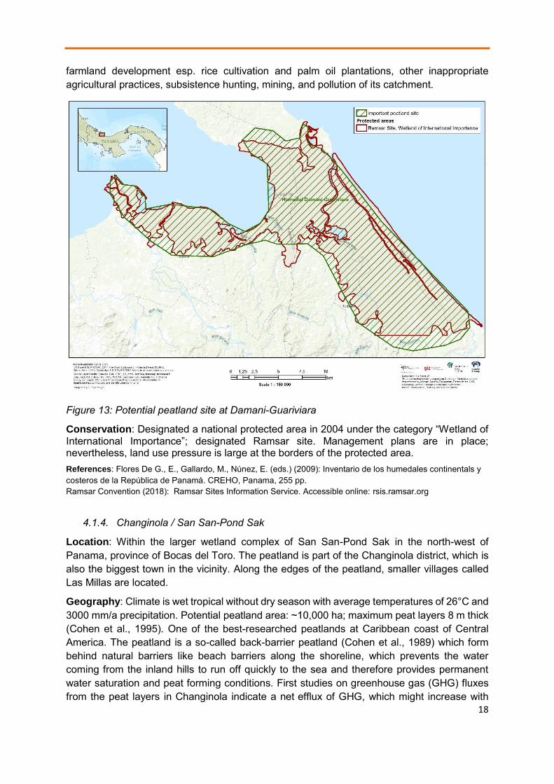
18
farmland development esp. rice cultivation and palm oil plantations, other inappropriate agricultural practices, subsistence hunting, mining, and pollution of its catchment.
Figure 13: Potential peatland site at Damani-Guariviara
Conservation: Designated a national protected area in 2004 under the category “Wetland of International Importance”; designated Ramsar site. Management plans are in place; nevertheless, land use pressure is large at the borders of the protected area. References: Flores De G., E., Gallardo, M., Núnez, E. (eds.) (2009): Inventario de los humedales continentals y costeros de la República de Panamá. CREHO, Panama, 255 pp. Ramsar Convention (2018): Ramsar Sites Information Service. Accessible online: rsis.ramsar.org
4.1.4. Changinola / San San-Pond Sak
Location: Within the larger wetland complex of San San-Pond Sak in the north-west of Panama, province of Bocas del Toro. The peatland is part of the Changinola district, which is also the biggest town in the vicinity. Along the edges of the peatland, smaller villages called Las Millas are located.
Geography: Climate is wet tropical without dry season with average temperatures of 26°C and 3000 mm/a precipitation. Potential peatland area: ~10,000 ha; maximum peat layers 8 m thick (Cohen et al., 1995). One of the best-researched peatlands at Caribbean coast of Central America. The peatland is a so-called back-barrier peatland (Cohen et al., 1989) which form behind natural barriers like beach barriers along the shoreline, which prevents the water coming from the inland hills to run off quickly to the sea and therefore provides permanent water saturation and peat forming conditions. First studies on greenhouse gas (GHG) fluxes from the peat layers in Changinola indicate a net efflux of GHG, which might increase with
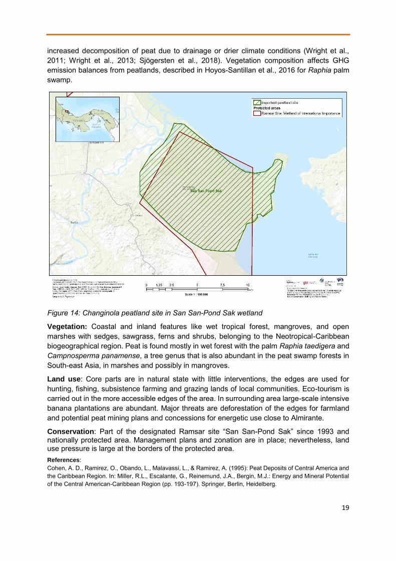
19
increased decomposition of peat due to drainage or drier climate conditions (Wright et al., 2011; Wright et al., 2013; Sjögersten et al., 2018). Vegetation composition affects GHG emission balances from peatlands, described in Hoyos-Santillan et al., 2016 for Raphia palm swamp.
Figure 14: Changinola peatland site in San San-Pond Sak wetland
Vegetation: Coastal and inland features like wet tropical forest, mangroves, and open marshes with sedges, sawgrass, ferns and shrubs, belonging to the Neotropical-Caribbean biogeographical region. Peat is found mostly in wet forest with the palm Raphia taedigera and Campnosperma panamense, a tree genus that is also abundant in the peat swamp forests in South-east Asia, in marshes and possibly in mangroves.
Land use: Core parts are in natural state with little interventions, the edges are used for hunting, fishing, subsistence farming and grazing lands of local communities. Eco-tourism is carried out in the more accessible edges of the area. In surrounding area large-scale intensive banana plantations are abundant. Major threats are deforestation of the edges for farmland and potential peat mining plans and concessions for energetic use close to Almirante.
Conservation: Part of the designated Ramsar site “San San-Pond Sak” since 1993 and nationally protected area. Management plans and zonation are in place; nevertheless, land use pressure is large at the borders of the protected area. References: Cohen, A. D., Ramirez, O., Obando, L., Malavassi, L., & Ramirez, A. (1995): Peat Deposits of Central America and the Caribbean Region. In: Miller, R.L., Escalante, G., Reinemund, J.A., Bergin, M.J.: Energy and Mineral Potential of the Central American-Caribbean Region (pp. 193-197). Springer, Berlin, Heidelberg.
20
Cohen, A. D., Raymond Jr, R., Ramirez, A., Morales, Z., & Ponce, F. (1989): The Changuinola peat deposit of northwestern Panama: a tropical, back-barrier, peat (coal)-forming environment. International Journal of Coal Geology, 12(1-4), 157-192. Flores De G., E., Gallardo, M., Núnez, E. (eds.) (2009): Inventario de los humedales continentals y costeros de la República de Panamá. CREHO, Panama, 2555 pp. Hoyos-Santillan, J., Craigon, J., Lomax, B. H., Lopez, O. R., Turner, B. L., & Sjögersten, S. (2016): Root oxygen loss from Raphia taedigera palms mediates greenhouse gas emissions in lowland neotropical peatlands. Plant and soil, 404(1-2), 47-60. Phillips S., Rouse G.E., Bustin R.M. (1997): Vegetation zones and diagnostic pollen profiles of a coastal peat swamp, Bocas del Toro, Panama. Paleogeography, Paleoclimatology and Palaeoecology, 128, 301–338. Ramsar Convention (2018): Ramsar Sites Information Service. Accessible online: rsis.ramsar.org Sjögersten, S., Aplin, P., Gauci, V., Peacock, M., Siegenthaler, A., & Turner, B. L. (2018): Temperature response of ex-situ greenhouse gas emissions from tropical peatlands: Interactions between forest type and peat moisture conditions. Geoderma, 324, 47-55. 533-010-9493-7. Sjögersten S., Cheesman A.W., Lopez O., Turner B.L. (2010): Biogeochemical processes along a nutrient gradient in a tropical ombrotrophic peatland. Biogeochemistry, doi: 10.1007/s10 Valdespino & Santamaría (1997): Evaluación ecológica rápida del Parque Nacional Marion Isla Bastimentos y áreas de influencia, Islas Solarte, Swan Cay, Mimitimbi (Isla Colón) y humedal San San-Pond Sak, provincial de Bocas del Toro. Tomo 1: Recursos terrestres. ANCON. Panama. Wright, E.L., Black, C., Turner, B. L., Sjögersten, S. (2013): Environmental controls of temporal and spatial variability in CO2 and CH4 fluxes in a neotropical peatland, Global Change Biol., 19, 3775–3789. Wright E.L., Black C.R., Cheesman A.W., Drages T., Larges D., Turner, B.L., Sjogersten S (2011): Contribution of subsurface peat to CO2 and CH4 fluxes in a neotropical peatland. Global Change Biology, 17, 2867–2881.

21
4.2. Factsheets on priority peatland sites in Costa Rica
4.2.1. Gandoca-Manzanillo
Location: Southeast of Costa Rica, close to Panama border, part of Limón province, district of Talamanca. Small villages are at the edge of the reserve, the closed town is Puerto Viejo.
Figure 15: Potential peatland site at Gandoca-Manzanillo
Geography: Coastal and inland features like beaches, marshes, salty and freshwater lagoons, rivers, wet tropical forest and mangroves, belonging to the Neotropical-Caribbean biogeographical region. Climate is wet tropical without dry season. Average temperature is around 27°C with 3000 mm/a precipitation. Peat is mainly found in marshes, wet forest and possibly mangroves. Potential total area in which patches of peat could be found: ~3,800 ha. During the 1st scoping mission, wood peat was confirmed in a wet forest close to the village Gandoca at the riverside of Rio Gandoca (Fig. 16).
Vegetation: Dominated by Raphia taedigera and Campnosperma panamensis forest. Open grassland patches with sedges and sawgrass exist to a smaller extend. Gandoca estuary at the border to Panama characterized by mangroves (Rhizophora mangle).

22
Figure 16: Peat core in Gandoca-Manzanillo
Land use: Core parts in natural state with little interventions, more accessible parts of forest are used for hunting, fishing and small-scale forestry. Small patches are used for subsistence farming and grazing lands of local communities. Eco-tourism is carried out in the more accessible parts of the area. Major threats are deforestation at the edges of the forest.
Conservation: Designated as a national forest refuge (Refugio Nacional de Vida Silvestre) and as Ramsar site “Gandoca-Manzanillo”. References: Ramsar Convention (2018): Ramsar Sites Information Service. Accessible online: rsis.ramsar.org
4.2.2. Aeropuerto Limón
Location: Called after his location Aeropuerto Limón, in the centre of Costa Rican Caribbean shoreline, south of the city of Puerto Limón, which is also the capital of Limón province and district. The villages of Cieneguita, Westfalia, Beverly and La Bomber are around the peatland.
Geography &: Inland the international airport of Limón which is built on the mineral beach-barrier which prevents water run-off from the site. The peatland can be classified as a back-barrier peatland. Climate is wet tropical, average temperature is around 25°C with 3400 mm/a precipitation. The potential total area: ~800 ha, peat layers are in average 1 m thick (Obando et al., 1995). During the 1st scoping mission, peat was confirmed in the Raphia swamps accessed from the road along the road opposite of the airport.
Vegetation: Dominated by Raphia taedigera. Other parts are deforested and partly drained for grazing lands.
Land use: Densely overgrown with Raphia taedigera and unused. Edges close to bordering villages are partly drained for agriculture including large-scale banana plantations and cattle grazing. Major threats are deforestation at the edges of the swamp for agricultural extensions (plantations, grazing land). Due to the vicinity to the city of Puerto Limón, to infrastructure like roads and airport and to agricultural plantations, the hydrological regime could be disturbed so that water availability and quality could negatively affect the peatland site.

23
Figure 17: Potential peatland site at Aeropuerto Limón
Figure 18: Raphia taedigera peatland at Aeropuerto Limón
Conservation: Not designated as a protected area. References: Obando, L.G., & Bolanos, K. (2007): Coal and peat resources. In: Bundschuh, J., & Alvarado, G. E. (Eds.): Central America, Geology, Resources and Hazards. Volume 2. CRC Press. Obando, L.G., Malavassi, L.R., & Estrada, R. (1995): Deposits of Peat in Costa Rica. In: Miller, R.L., Escalante, G., Reinemund, J.A., Bergin, M.J.: Energy and Mineral Potential of the Central American-Caribbean Region (pp. 199-207). Springer, Berlin, Heidelberg.

24
4.2.3. Moín
Location: In centre of Costa Rican Caribbean shoreline, north of the city of Puerto Limón, which is also the capital of the Limón province and district. The harbour and industrial complex of Moín and the villages of Cocal and Finca Sandoval are bordering the peatland.
Figure 19: Potential peatland site at Moín
Geography & Vegetation: The peatland can be classified as a back-barrier peatland, separated from the sea by a sandy beach-barrier. Potential total peatland: ~780 ha, peat layers are in average 1.6 m thick (Obando et al. 1995). Climate is wet tropical, average temperature is around 25°C with 3400 mm/a precipitation. Vegetation dominated by Raphia taedigera.
Land use: Mostly overgrown with Raphia taedigera and inaccessible. Edges close to the bordering villages are partly drained for agriculture and for cattle grazing. There is a risk of further deforestation at the edges of the swamp for agricultural extensions (plantations, grazing land). Close to the site, a big petroleum refinery, a power plant and Moín port are operational, in recent years the port developed into one of the major Costa Rican ports for exports of goods at the Caribbean coast. This is followed by large-scale infrastructure developments like a new highway to the inland in close vicinity to the peatland. Major threats are the disturbance of the hydrological regime so that water availability and quality could negatively affect the peatland site. In addition, an exploitation of peat was considered for energetic use but no further investigation carried out in recent years.
Conservation: Not designated as a protected area.

25
References: Obando, L.G., Malavassi, L.R., & Estrada, R. (1995): Deposits of Peat in Costa Rica. In: Miller, R.L., Escalante, G., Reinemund, J.A., Bergin, M.J.: Energy and Mineral Potential of the Central American-Caribbean Region (pp. 199-207). Springer, Berlin, Heidelberg. Obando, L.G., & Bolanos, K. (2007): Coal and peat resources. In: Bundschuh, J., & Alvarado, G. E. (Eds.): Central America, Geology, Resources and Hazards. Volume 2. CRC Press.
4.2.4. Tortuguero
Location: Stretched 25 km along northern Costa Rican Caribbean shoreline, within Limón province and Pococí district. Only smaller villages like Boca de Las Lagunas del Tortuguero are located close to the wetland.
Geography & Vegetation: Back-barrier peatland, separated from the sea by a sandy beach-barrier. Potential total peatland area: ~20,000 ha. First peat investigations in only two boreholes by Obando et al., 1995 indicated peat layers of 1.2 m thickness in average. Climate is wet tropical, average temperature is around 26°C with 6000 mm/a precipitation. Wet tropical forest is widespread in the area, in the wetter parts vegetation dominated by Raphia taedigera, along the lagoons and channels mangroves could be found.
Land use: Not used, at edges small-scale gathering of forest products and fishing allowed for local communities. Around the wetland, large areas are under cattle ranching and agricultural farming, which could negatively affect water availability and quality in peatlands of Tortuguero.
Conservation: Designated as national park in 1975; part of the “Humedal Caribe Noreste”, declared as a Wetland of International Importance (Ramsar site) since 1996.
Figure 20: Potential peatland site at Tortugero

26
References: Obando, L.G., Malavassi, L.R., & Estrada, R. (1995): Deposits of Peat in Costa Rica. In: Miller, R.L., Escalante, G., Reinemund, J.A., Bergin, M.J.: Energy and Mineral Potential of the Central American-Caribbean Region (pp. 199-207). Springer, Berlin, Heidelberg. Obando, L.G., & Bolanos, K. (2007): Coal and peat resources. In: Bundschuh, J., & Alvarado, G. E. (Eds.): Central America, Geology, Resources and Hazards. Volume 2. CRC Press. Ramsar Convention (2018): Ramsar Sites Information Service. Accessible online: rsis.ramsar.org
4.2.5. Barra del Colorado
Location: Stretched 50 km along the northern Costa Rican Caribbean shoreline starting from Tortuguero up to Nicaragua border. Within Limón province and Pococí district. Only smaller villages like Barra del Colorado are located close to the wetland.
Geography & Vegetation: Classified as a back-barrier peatland, separated from the sea by a sandy beach-barrier, San Juan and Colorado rivers are supplying the wetland with inland waters. Potential total peatland area: ~42,000 ha. Sampling of Obando et al., 1995 indicate peat layers of 1.2 m thickness in average like in Tortuguero site. Climate is wet tropical, average temperature is around 26°C with 6000 mm/a precipitation. Wet tropical forest with Campnosperma panamense widespread in the area, in wetter parts the vegetation dominated by Raphia taedigera, along lagoons and channels mangroves.
Figure 21: Potential peatland site at Barra del Colorado
Land use: One of most remote places in Costa Rica; therefore mostly without any human interventions. Just at edges small-scale forestry, hunting and fishing by local communities. Around wetland, large areas are under cattle ranching and agriculture, which possibly have a light negatively effect on the peatlands in Barra del Colorado.

27
Conservation: Designated as Barra del Colorado Wildlife Refuge in 1985, part of the “Humedal Caribe Noreste”, declared as Ramsar site since 1996. References: Obando, L.G., Malavassi, L.R., & Estrada, R. (1995): Deposits of Peat in Costa Rica. In: Miller, R.L., Escalante, G., Reinemund, J.A., Bergin, M.J.: Energy and Mineral Potential of the Central American-Caribbean Region (pp. 199-207). Springer, Berlin, Heidelberg. Obando, L.G., & Bolanos, K. (2007): Coal and peat resources. In: Bundschuh, J., & Alvarado, G. E. (Eds.): Central America, Geology, Resources and Hazards. Volume 2. CRC Press. Ramsar Convention (2018): Ramsar Sites Information Service. Accessible online: rsis.ramsar.org
In sensu strictu, the following inland and mountain peatland sites are not part of the assessment of Caribbean coastal peatlands, but as many experts during the meetings and most of the literature on peatlands mentioned them, we will also provide a brief overview of non-coastal peatlands in Costa Rica.
4.2.6. Turberas de Talamanca
Location: Distributed over the central Costa Rican mountain range of Talamanca within provinces of San José and Cartago.
Figure 22: Potential peatland site at Talamanca Mountains
Geography & Vegetation: In an altitude between 700-3,821 m in small, mostly elongated basins, which hold the water for the initial peat forming processes. Due to high precipitation (2,000-3,000 mm/a depending on exposition and altitude) and moisture, blanket bogs, so called “Paramos“ develop on the peat layers. Potential total peatland area: ~47,000 ha, but actual coverage by peat in this area will be much lower. Sampling of Obando et al., 1995

28
indicate nutrient poor peat layers of max. 1.3 m thickness. Paramo vegetation characterized by grasses, sedges, herbs, but also Sphagnum mosses, ferns, and shrubs.
Land use: Mostly in a natural state, some are used for sheep and goat grazing which can negatively affect the vegetation and soil structure trough compaction. Peatlands are of vital importance in terms of hydroelectric power production and supply of a large portion of the drinking water for the country's largest cities.
Conservation: Partly within the National Parks of Los Quetzales, Tapantí and Chirripó. In 2003, declared as Ramsar site “Turberas de Talamanca”. References: Obando, L.G., Malavassi, L.R., & Estrada, R. (1995): Deposits of Peat in Costa Rica. In: Miller, R.L., Escalante, G., Reinemund, J.A., Bergin, M. J.: Energy and Mineral Potential of the Central American-Caribbean Region (pp. 199-207). Springer, Berlin, Heidelberg. Obando, L.G., & Bolanos, K. (2007): Coal and peat resources. In: Bundschuh, J., & Alvarado, G. E. (Eds.): Central America, Geology, Resources and Hazards. Volume 2. CRC Press. Ramsar Convention (2018): Ramsar Sites Information Service. Accessible online: rsis.ramsar.org
4.2.7. Caño Negro
Location: North of Costa Rica, close to Nicaragua border. 20 km north of district capital Los Chiles in Alajuela province.
Figure 23: Potential peatland site at Caño Negro
Geography & Vegetation: Located in river and lake floodplain with permanent water saturation where peat has formed over centuries and filled up old meanders of Frío River or former bays of Lake Caño Negro. Potential peatland area: 5,700 ha. Tropical savannah climate

29
with average temperature of 27°C and precipitation of 1,700 mm/a. Covered with grasses, sedges and small shrubs, but no forest.
Land use: Mostly well protected and used only for eco-tourism, mainly bird watching. Edges are used for cattle grazing and other agriculture, which could negatively affect the water quality in the wetland, vegetation and soil structure trough compaction.
Conservation: In 1984, Caño Negro Wildlife Refuge declared as national protected area, as the Ramsar site “Caño Negro” in 1991, mostly because of its importance for breeding and migrating water birds. References: Ramsar Convention (2018): Ramsar Sites Information Service. Accessible online: rsis.ramsar.org
4.2.8 Medio Queso
Location: Transboundary area between Costa Rica in the south and Nicaragua in the north. Costa Rican part in district Los Chiles in Alajuela province. Part in Nicaragua situated in department of Río San Juan.
Figure 24: Potential peatland site at Medio Queso
Geography & Vegetation: Within depressions like old meander of floodplain of Rio Medio Queso, a tributary to the Rio San Juán and finally to the Nicaragua Lake, peat has formed. Potential peatland area: ~3,800 ha. Average peat depth is 1.6 m and total peat deposit reported as 1,024,264 Mt dry matter (Obando et al., 1995). Tropical savannah climate with average temperature of 27°C and precipitation of 1,700 mm/a. Covered with grasses, sedges and small shrubs. Raphia palm, which is predominant plant in described coastal areas, is absent.

30
Land use: Floodplain used for pastures and agriculture (protein plants like soy beans), for which small-scale drainage system was constructed by local farmers and frequent burning of fields takes place. Due to these practices, high oxidation and subsidence take place in the area. The use of peat for agriculture and horticulture as well as for energy was suggested in the 1980s (Obando et al., 1995; Cohan & Raymond, 1984), but nowadays there are no mining concessions. Small-scale eco-tourism is conducted in the area.
Conservation: Costa Rican part of the floodplain not protected; in Nicaragua, designated as a wildlife reserve and declared a Ramsar site “Los Guatuzos” in 1997. References: Cohen, A. D., & Raymond Jr, R. (1984): Final report of short-term mission for preliminary evaluation of the peat resources of Costa Rica: InterAmerican Development Bank (p. 31). Los Alamos National Laboratory Report LA-UR-84-3436. Obando, L.G., Malavassi, L.R., & Estrada, R. (1995): Deposits of Peat in Costa Rica. In: Miller, R.L., Escalante, G., Reinemund, J.A., Bergin, M.J.: Energy and Mineral Potential of the Central American-Caribbean Region (pp. 199-207). Springer, Berlin, Heidelberg. Obando, L.G., & Bolanos, K. (2007): Coal and peat resources. In: Bundschuh, J., & Alvarado, G. E. (Eds.): Central America, Geology, Resources and Hazards. Volume 2. CRC Press. Ramsar Convention (2018): Ramsar Sites Information Service. Accessible online: rsis.ramsar.org

31
4.3. Factsheets on priority peatland sites in Nicaragua
4.3.1. Bluefields
Location: Southern part of Nicaraguan Caribbean coast in the South Caribbean Autonomous Region. Situated at the estuary of the Rio Escondido to the Bahia de Bluefields and at shoreline of the Smokey Lane Lagoon north of the town of Bluefields.
Figure 25: Potential peatland site at Bluefields
Geography & Vegetation: Coastal and continental wetland types like beaches, mangroves, permanently flooded marshes with graminoid and palm species like Acoeloraphe wrightii and Raphia taedigera, and wet inundated forest dominated by Raphia and Pterocarpus officinalis. Peatlands can be found along the river Escondido and at the lagoon in form of back-barrier peatlands. Potential peatland area: ~11,000 ha. No sampling or other further investigations of peat layers in the area are available. Tropical rainforest climate with average temperature of 26°C and precipitation of 4,300 mm/a.
Land use: Area around Bluefield is an important area of indigenous communities of Creoles and Rama who use the area for subsistence fishing and hunting. Eco-tourism takes place in more accessible parts of the wetland. The wetland plays a vital role as buffer ecosystem for coastal protection as it serves as a barrier for floods caused by hurricanes to protect habitations from destruction. Due to climate change, the frequency and magnitude of hurricanes is increasing and sea level is rising, therefore the wetlands are under pressure of being salinated and ultimately flooded. Another risk is the advancing of agricultural extension in the upstream areas of the Rio Escondido with increased rates of deforestation. In effect, sedimentation is increased in the estuary of the river and water are contaminated with chemicals and nutrients.

32
Figure 26: Map of ecosystem types within the wetland of Bluefields (Castrillo, 2000)
Conservation: Designated as a “Reserva Natural Cerro Silva” and declared as Ramsar site “Sistema de Humedales de la Bahía de Bluefields” in 2001. Monitoring and scientific assessment is carried out by the local universities Universidad de las Regiones Autónomas de la Costa Caribe Nicaragüense (URACCAN) and Bluefields Indian and Caribbean University (BICU). References: Ramsar Convention (2018): Ramsar Sites Information Service. Accessible online: rsis.ramsar.org Castrillo, M. (2000): Plan de Manejo de los Humedales de Mahogany: primera propuestade zonificación. Revista Trimestral Humedales de la RAAS, Año 2. No. 3. PROCODEFOR.Bluefields, RAAS, Nicaragua.
4.3.2. Wetlands South of Puerto Cabezas (Laguna Karatá, Wouhnta)
Location: Northern part of the Nicaraguan Caribbean coast in the North Caribbean Autonomous Region. The peatlands spread in the backwater areas south of district capital

33
Puerto Cabezas, also known as Bilwi. Back-barrier peatlands are situated at the lagoon system of Laguna de Karatá and Laguna de Wouhnta and at the estuary of the Rio Wawa.
Figure 27: Potential peatland site at Laguna Karatá / Wouhnta
Geography & Vegetation: Coastal and continental wetland types like beaches, mangroves, permanently flooded marshes with mostly graminoid like Cladium jamaicense and Eleocharis and patches of the palm Acoeloraphe wrightii. Raphia taedigera is absent from these sites. Peatlands can be found along the river Wawa and at the lagoons in form of back-barrier peatlands. During the 2nd scoping mission, 11 corings have been conducted by project team and peat layers of more than 2,2 m thickness (max. coring depth) have been identified in different parts of the wetland (Fig. 28, Fig. 29). Peat was mostly undecomposted to slightly decomposed graminoid peat in upper layers and wood peat in deeper layers. A more detailed description of the findings of the scoping mission, you find in Annex 3. Potential peatland area: ~478,000 ha. Tropical monsoon climate with average temperature of 26°C and precipitation of 2,800 mm/a.
Land use: The area around Puerto Cabezas is an important area of indigenous communities of Miskitos who use the area for subsistence fishing and hunting. Eco-tourism takes place in more accessible parts of the wetland. A channel was cut through the peatland to connect Laguna Karatá and Laguna de Wouhnta. It is used by local people for transportation to avoid the inconvenient and dangerous passage over the open sea to get from Wouhnta to Puerto Cabezas. The channel has a possible drainage effect on the peatland along its bank and transports salty water from the lagoons into the sweet water environments. There are plans to extend the channel system which could increase negative impact, e.g. to dig a connection to Bluefields. The wetland plays a vital role as buffer ecosystem for coastal protection as it serves

34
as a barrier for floods caused by hurricanes to protect habitations from destruction. Due to climate change, the frequency and magnitude of hurricanes is increasing and sea level is rising, therefore the wetlands are under pressure of being salinated and ultimately flooded. Another risk is the advancing of agricultural extension in the upstream areas of the Rio Wawa with increased rates of deforestation. In effect, sedimentation is increased in the estuary of the river and lagoons and water are contaminated with chemicals and nutrients.
Figure 28: Site map Puerto Cabezas with coring points and peat occurrence during 2nd mission

35
Figure 29: a) Landscape impression of open grassland site dominated by Eleocharis with palm patches of Acoeloraphe wrightii; b) Peat core sample from Laguna Karatá.
Conservation: Designated as a “Reserva Biológica Cayos Miskitos y Franja Costera” and declared a Ramsar site “Cayos Miskitos y Franja Costera Immediata” in 2001. Monitoring and scientific assessment is carried out by the local universities Universidad de las Regiones Autónomas de la Costa Caribe Nicaragüense (URACCAN) and Bluefields Indian and Caribbean University (BICU). References: Ramsar Convention (2018): Ramsar Sites Information Service. Accessible online: rsis.ramsar.org
4.3.3. Wetlands North of Puerto Cabezas (Laguna Bismuna)
Location: Northern part of the Nicaraguan Caribbean coast in the North Caribbean Autonomous Region up to the border to Honduras. The peatlands spread in the lagoon and backwater areas north of district capital Puerto Cabezas, also known as Bilwi. Back-barrier peatlands are situated at the lagoon system of Laguna de Bismuna and tributary rivers.
Geography & Vegetation: Coastal and continental wetland types like beaches, mangroves, permanently flooded marshes with mostly graminoids like Cladium jamaicense and Eleocharis and patches of the palm Acoeloraphe wrightii. Peatlands can be found along the rivers and at the lagoons in form of back-barrier peatlands. Potential peatland area: 81,000 ha, but there is no sampling data available. Tropical monsoon climate with average temperature of 26°C and precipitation of 2,800 mm/a.
Land use: The area around Puerto Cabezas and village of Bismuna are important for indigenous communities of Miskitos who use the area for subsistence fishing and hunting. The wetland plays a vital role as buffer ecosystem for coastal protection as it serves as a barrier for floods caused by hurricanes to protect habitations from destruction. Due to climate change, the frequency and magnitude of hurricanes is increasing and sea level is rising, therefore the wetlands are under pressure of being salinated and ultimately flooded.
Conservation: Conservation: Designated as “Reserva Biológica Cayos Miskitos y Franja Costera” and declared a Ramsar site “Cayos Miskitos y Franja Costera Immediata” in 2001. Parts of wetland further inland are designated as “Reserva Natural Cabo Viejo Tela Sulamas”. References: Ramsar Convention (2018): Ramsar Sites Information Service. Accessible online: rsis.ramsar.org
a) b)

36
Figure 30: Potential peatland site at Laguna Bismuna

37
4.4. Factsheets on priority peatland sites in Honduras
4.4.1. Wetlands of Puerto Lempira
Location: Southern part of the Honduran Caribbean coast in Gracias a Dios province stretching towards the Rio Coco, the border to Nicaragua. The peatlands are situated at the shoreline of Laguna de Caratasca, Laguna Daiwras, Laguna Cojunta and Laguna de Liwa and along the little river Crique Lakamaya, a tributary of Rio Cruta, south of the city of Puerto Lempira. The village of Tuntuntara is located in the peatland area.
Figure 31: Potential peatland site at Puerto Lempira
Geography & Vegetation: Permanently and temporary flooded marshes with mostly graminoids like Cladium jamaicense and Eleocharis, patches of the palm Acoeloraphe wrightii and mangroves.
Figure 32: a) Landscape impression of peatland site with Eleocharis, Cladium, Acoeloraphe wrightii, and Rhizophora mangle; b) Peat core sample from Crique Lakamaya.
a) b)

38
Peatlands can be found along the rivers and at the lagoons in form of back-barrier peatlands. During the 2nd scoping mission in the project, experts from Greifswald Mire Centre confirmed peat occurrence in the area by 8 corings of which 6 showed considerable peat layers with peat depth of around 1.5 m thickness at most places (Fig. 32). Peat was classified as slightly to highly decomposed root peat with wood inclusions. Potential peatland area: ~100,000 ha. Tropical rainforest climate with average temperature of 27°C and precipitation of 3,300 mm/a.
Figure 33: Site map Puerto Lempira with coring points and peat occurrence during 2nd mission
39
Land use: The area around Puerto Lempira and village of Tuntuntara are important for indigenous communities of Miskitos who use the area for subsistence farming, fishing and hunting. The wetland plays a vital role as buffer ecosystem for coastal protection as it serves as a barrier for floods caused by hurricanes to protect habitations from destruction. Due to climate change, the frequency and magnitude of hurricanes is increasing and sea level is rising, therefore the wetlands are under pressure of being salinated and ultimately flooded.
Conservation: The wetlands towards the border with Nicaragua are protected in the “Parque Nacional de Kruta”, other sites are no designated conservation areas.
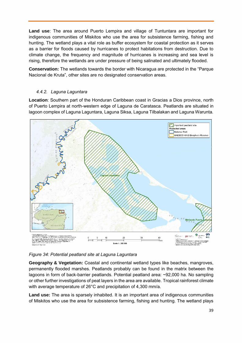
4.4.2. Laguna Laguntara
Location: Southern part of the Honduran Caribbean coast in Gracias a Dios province, north of Puerto Lempira at north-western edge of Laguna de Caratasca. Peatlands are situated in lagoon complex of Laguna Laguntara, Laguna Siksa, Laguna Tilbalakan and Laguna Warunta.
Figure 34: Potential peatland site at Laguna Laguntara
Geography & Vegetation: Coastal and continental wetland types like beaches, mangroves, permanently flooded marshes. Peatlands probably can be found in the matrix between the lagoons in form of back-barrier peatlands. Potential peatland area: ~92,000 ha. No sampling or other further investigations of peat layers in the area are available. Tropical rainforest climate with average temperature of 26°C and precipitation of 4,300 mm/a.
Land use: The area is sparsely inhabited. It is an important area of indigenous communities of Miskitos who use the area for subsistence farming, fishing and hunting. The wetland plays
40
a vital role as buffer ecosystem for coastal protection as it serves as a barrier for floods caused by hurricanes to protect habitations from destruction. Due to climate change, the frequency and magnitude of hurricanes is increasing and sea level is rising, therefore the wetlands are under pressure of being salinated and ultimately flooded.
Conservation: Designated as a “Reserva de Vida Silvestre Caratasca”.

41
4.5. Factsheets on priority peatland sites in Cuba
4.5.1. Rio Cauto
Location: East of Cuba in Granma province at the southern coast. Closest towns are Rio Cauto and Manzanillo. It is the biggest river delta in Cuba. Peatlands have been descripted mainly for the northern part of the delta called Ciénaga de Birama.
Figure 35: Potential peatland site at Delta of Rio Cauto
Geography & Vegetation: The delta has formed by sedimentation of fluvial material transported from Rio Cauto. Most of the delta is covered with these mineral sediments with mangrove and marshland, only the northern part Ciénaga de Birama is reported to have peat layers of 60 – 70 cm. Potential peatland area: 500 ha (Perejrest, 1964). No sampling or other recent investigations of peat layers in the area are available. Vegetation of peatlands is dominated by graminoid species (e.g. Eleocharis, Typha domingensis) with groups of the palm Sabal parviflora. The climate has average temperatures of 26°C and precipitation of 1,200 mm/a.
Land use: The area has been intensively used in the last decades. First, tropical wet forest was chopped down to create pastures and agricultural land within the delta. Later, the hydrological regime has been changed to improve navigability for ship on Rio Cauto and dams were built to create artificial water basins for irrigation of adjacent rice paddies (Schaller, 2014). Due to climate change and sea level rise there is a risk of losing land of the delta to the sea. The abstraction of fresh water from the wetland to irrigate agricultural land creates a risk of water scarcity and degradation of the peat body. Activities of shrimp farming create a risk of pollution and destruction of mangroves.

42
Conservation: Designated as protected area “Refugios de Fauna Delta del Cauto y Monte Cabaniguan” and declared as Ramsar site “Humedal Delta del Cauto” in 2002. References: Perejrest, S. (1964): Los pantanos de Cuba y su importancia para el aumento de la producción agrícola y fortalecimiento de la economía del país. Instituto Nacional de Recursos Hidráulicos. Ramsar Convention (2018): Ramsar Sites Information Service. Accessible online: rsis.ramsar.org Schaller, C. (2014): Naturraumkundliche Untersuchungen in Kubanischen Küstenmooren. Diplomarbeit. Universität Greifswald.
4.5.2. Laguna de la Leche
Location: Laguna de la Leche with the adjacent Ciénaga de Morón is located in the centre of Cuba in the Villa Clara province at the northern coast. Closest town is Móron.
Geography & Vegetation: Formed on calcareous bedrocks and is surrounded by mangrove vegetation. The Ciénaga de Morón has bigger, mostly inundated grasslands (e.g. Cladium jamaicense, Eleocharis rostellata, Typha domingensis (Peros et al. 2007). In addition, wet forest with Callophyllum antillanum, Annona glabra, Bucida sp., Copernicia sp., Sabal parviflora exists in the area. Investigations by Schaller, 2014 showed that in the vegetated depression peat layers of average 1.5 m thickness formed. Mostly highly decomposed peat strongly intermixed with calcareous sediments were found. Potential peatland area: 43,000 ha. Tropical savannah climate with average temperature of 25°C and precipitation of 1,300 mm/a.
Figure 36: Potential peatland site at Laguna de la Leche
Land use: Parts used for forestry and fisheries (Schaller, 2014). Tourism is intense in other parts. Agriculture has developed further inland; therefore, Canal de Chicola was dig to transport sugar cane to the sea, which is draining the area and allows salt-water intrusion into

43
Laguna de la Leche. Deforestation and agriculture in the catchment increased sedimentation into the lagoon and led to covering of peat soils and stopped their natural capacity to grow up with the rising water levels. Wastewater from Morón town is contaminating the wetland.
Conservation: Parts designated as protected areas (in total 6 protected areas) which form the core zones of the 2002 declared Ramsar site “Gran Humedal del Norte de Ciego de Ávila”. References: Peros, M. C., Reinhardt, E. G., Davis, A. M. (2007): A 6000-year record of ecological and hydrological changes from Laguna de la Leche, north coastal Cuba. Quaternary Research 67: 69- 82. Ramsar Convention (2018): Ramsar Sites Information Service. Accessible online: rsis.ramsar.org Schaller, C. (2014): Naturraumkundliche Untersuchungen in Kubanischen Küstenmooren. Diplomarbeit. Universität Greifswald.
4.5.3. Ciénaga de Majaguillar
Location: Western Cuba at the northern coast, Matanzas province. The town of Cárdenas is situated closely to the area in western direction.
Figure 37: Potential peatland site at Ciénaga de Majaguillar
Geography & Vegetation: Formed on calcareous bedrocks, surrounded by mangrove vegetation. Inner part characterized as inundated grasslands with shrubs dominated by Cladium jamaicense (Schaller, 2014). Corings by Schaller, 2014 confirmed peat layers of 1 m thickness in average at central parts. Mostly highly decomposed peat strongly intermixed with sediments. Potential peatland area: 20,000 ha (Perejrest, 1964). Tropical savannah climate with average temperature of 25°C and precipitation of 1,300 mm/a.
Land use: Eastern parts of Ciénaga de Majaguillar were planned to be converted into agricultural lands, channels and ditches dig into the area. Nowadays, agricultural activities

44
within the peatland have stopped but drainage system negatively affects the water regime and functioning of the peatland. In addition, roads were built to develop the area, which influence the water flow and peatlands functioning. Intense agricultural activities in the surrounding inland with irrigation systems also has negative effect. The area is recognized as an important area for climate change mitigation and adaptation to prevent flooding and salination of aquifers.
Conservation: Parts of the wetlands have been designated as ecological areas but in general, conservation status of the peatland is low. References: Perejrest, S. (1964): Los pantanos de Cuba y su importancia para el aumento de la producción agrícola y fortalecimiento de la economía del país. Instituto Nacional de Recursos Hidráulicos. Schaller, C. (2014): Naturraumkundliche Untersuchungen in Kubanischen Küstenmooren. Diplomarbeit. Universität Greifswald.
4.5.4. Ciénaga de Zapata
Location: On peninsular at the southern coast of Cuba, in Matanzas province. Jagüey Grande is the closest city; within Ciénaga de Zapata several smaller villages and touristic infrastructure can be found. One of the largest and best preserved wetlands in the Caribbean Islands, with the largest peatland in Cuba.
Figure 38: Potential peatland site at Ciénaga de Zapata
Geography: Formed on calcareous bedrocks and closely connected with karstic system of the region. Precipitation in the inland catchment area is drained through the complex karst holes and discharged at northern edge, which leads to a permanent water supply throughout the year (Rodriguez Yi, 1991). Additionally, several rivers discharge water into the wetland. The central part of the wetland is a tectonic depression where peat has possibly formed over an

45
historic lake. Until today fresh water lakes like Laguna del Tesero can be found. Run-off to the sea is blocked in the eastern part, which is the part with biggest peatland distribution, by a limestone ridge, which is itself pervaded by a karst system with limited discharge rate. Peat could be mainly found in the northern part of the wetland dominated by wet grasslands. Pajón et al., 2004 indicate a peat depth of up to 7 m for this part, Perejrest, 1964 even a peat depth of up to 10 m in the area around Laguna del Tesero. Schaller, 2014 describes a peat depth of 5 m with changing intermixed layers of calcareous and gleyic sediments. The peat is composed by roots of graminoids and is mostly highly decomposed and rich in nutrients. Potential peatland area: 345,300 ha (Schaller, 2014). Tropical savannah climate with average temperature of 25°C and precipitation of 1,600 mm/a.
Vegetation: Typical peatlands in Ciénaga de Zapata are permanently or temporally inundated grasslands dominated by Cladium jamaicense, Typha domingensis and Eleocharis instertincta with palms (Sabal parviflora) and small forest islands. In addition, wet forest with Annona glabra, Bucida buceras, Hibiscus elatus, Sabal parviflora exists. Salt water influenced areas closer to the shoreline or along channels with connection to the sea have extensive mangrove vegetation, which partly form peat deposits as well.
Figure 38: Impression of a Cladium jamaicense dominated grassland on peat in Ciénaga de Zapata with Typha domingensis and Sabal parviflora
Land use: 19 communities with a total population of approximately 10,000 persons live in the wetland. Main economic activities are forestry for timber and charcoal production, tourism and fishing. There were plans to drain parts of the peatland for sugar cane and rice agriculture already in pre-revolution times around 1900, but they have not been implemented due to high costs (Perejrest, 1964). In 1959, extensive drainage of the peatland was implemented. 400 km² area in the western part and 250 km² in the eastern part were planned to be converted into rice fields. Construction started with a 5.4 km2 pilot area for which a canal was built to redirect the outflow of the Río Hanábana into the sea. For technical and financial reasons finally only a smaller area was drained (Perejrest, 1964), which is still well visible on satellite imagery today. In this and other drained areas, peat mineralization is going on for decades with high GHG emissions. Invasive species like Casuarina equisetifolia and Melaleuca quinquinervia can easily spread along the channels, increase evapotranspiration and suppress native species. Additional problems are the salinization of soils by the capillary rise of salt water from formerly agricultural sites. Also due to agriculture in adjacent inland areas, nutrient inputs into the peatland increased and large-scale irrigation of e.g. citrus plantations reduced

46
fresh water discharge through the karst system. The still existing drainage system increased outflow of water and drying of peat, which leads to fire events during dry summer periods. Deforestation is prevalent, especially in the semi-deciduous forest at the edges of the peatlands for timber or grazing lands
Conservation: Declared as multi-use protected area by Cuban legislation and as UNESCO Biosphere Reserve in 2000. Its core is conserved as five strictly protected areas, including a national park. Declared as Ramsar site “Ciénaga de Zapata” in 2001. References: Pajón, J. M., Balado, E., Hernández, I., Córdova, A. (2004): Karst y Asentamientos Aborigenes en la Ciénaga de Zapata. Conferencia internacional Antropología, Centro de Antropología, Departamiento de Arqueolgía, La Habana, Cuba. Perejrest, S. (1964): Pantanos de Cuba y su importancia para el aumento de la producción agrícola. Instituto Nacional de Recursos Hidraulicos, Cuba. Ramsar Convention (2018): Ramsar Sites Information Service. Accessible online: rsis.ramsar.org Rodriguez Yi, J. (1991): Estudio Geográfico Especial Ciénaga de Zapata. Instituto Cubano de Geodesia y Cartografía, Cuba. Schaller, C. (2014): Naturraumkundliche Untersuchungen in Kubanischen Küstenmooren. Diplomarbeit. Universität Greifswald.
4.5.5. Wetlands South of Havana (Gran Humedal del Sur de La Habana)
Location: Narrow band for 110 km along southern coast of Cuba, south of country’s capital Havana in provinces of Mayabeque and Pinar del Río.
Figure 40: Potential peatland site at Wetlands South of Havana

47
Geography & Vegetation: Formed by marine sedimentation along the coast and following establishment of mangrove vegetation (Rhizophora mangle, Avicennia germinans) which formed growing organic peat soils over centuries and stabilised the coastline (Ortega Sastriques, 1980). Inland, fresh water conditions established, which harbour inundated grasslands with Cladium jamaicense, Typha domingensis and patches of Sabal parviflora. Peat deposits with thickness of 2.5 m can be found mainly in the eastern part of the wetland, composed mostly from highly decomposed peat strongly intermixed with calcareous sediments (Schaller, 2014). Potential peatland area: ~38,000 ha. Tropical savannah climate with average temperature of 25°C and precipitation of 1,300 mm/a.
Land use: Starting in the year 1942, peatland near Playa Guanímar was drained with channels to the sea for agricultural use but drainage failed. In 1962, plantations of bananas, peppers and corn started in drained areas close to Playa del Rosario and for forestry use close to Playa Cajío (Perejrest, 1964). The tree Casuarina equisetifolia was introduced as a neophyte and nowadays spreading along the channels in the peatland. In 1985, the construction of a dike along the south coast began on a length of about 100 km between Majina and Batabanó. The goal was to stop fresh water outflow to the sea, as it was needed for agriculture and drinking water supply for Havana and to prevent intrusion of salt water into aquifers. In effect, the mangrove belt suffer due to lacking of fresh water supply and are damaged or died-off in many places along the coast today, so that their protective function for the coast in storm events is reduced (Díaz-Briquets & Pérez Lopez 2000).
Conservation: No legal protection status. References: Díaz-Briquets, S., Pérez- López, J. (2000): Conquering Nature – The Environmental Legacy of Socialism in Cuba. University of Pittsburgh Press, USA. Ortega Sastriques, F. (1980): Contribución a la clasificación de los suelos de las ciénagas cubanas. Ciencias de la Agricultura 6: 63-86. Perejrest, S. (1964): Los pantanos de Cuba y su importancia para el aumento de la producción agrícola y fortalecimiento de la economía del país. Instituto Nacional de Recursos Hidráulicos. Ramsar Convention (2018): Ramsar Sites Information Service. Accessible online: rsis.ramsar.org Schaller, C. (2014): Naturraumkundliche Untersuchungen in Kubanischen Küstenmooren. Diplomarbeit. Universität Greifswald.
4.5.6. Isla de la Juventud / Ciénaga de Lanier
Location: On Canareos Archipelago, specifically on southern part of Isla de la Juventud. Runs from the bay of Siguanea to eastern mouth of the San Juán River.
Geography & Vegetation: Ciénaga de Lanier has developed in depressions formed by San Juán River and connected lagoon, which forms a natural geographical barrier that divides the northern part of the island from the karst plain in the south including nearby marine areas. Water discharges from the karst system of the northern part of the island so that continuous water supply to allow peat growth in ensured throughout the year. Water flows through the peatland and recharges karst system at the southern part of the island, partly to the sea. Several habitats exist in the area especially mangroves and swamp grasslands with Cladium jamaicense, Typha domingensis with patches of Sabal parviflora and shrubs. Potential peatland area: 4,000 ha. Tropical savannah climate with average temperature of 25°C and precipitation of 1,000 mm/a.

48
Figure 41: Potential peatland site at Ciénaga de Lanier
Land use: Mostly in natural state and no utilisation. In northern part of Ciénaga de Lanier, extraction of peat for agricultural soil improvement takes place. Agricultural development especially rice paddies need water for irrigation which could reduce discharge to peatland area and negatively affect the hydrological regime. Small-scale Tourism developed at edges.
Conservation: Partly designated as Refugios de Fauna and as an Ecological reserve. In 2002, the Ramsar site “Ciénaga de Lanier y Sur de la Isla de la Juventud” was declared. References: Ramsar Convention (2018): Ramsar Sites Information Service. Accessible online: rsis.ramsar.org
Schaller, C (2014): Naturraumkundliche Untersuchungen in Kubanischen Küstenmooren. Diplomarbeit. Universität Greifswald.

49
5. Conclusion
Given the large extend of coastal peatlands in the Caribbean region and their value for climate change mitigation and adaptation, local livelihoods and biodiversity, very little is known about their distribution, functioning and status. In this project, we could only focus on a limited set of countries (Panama, Costa Rica, Nicaragua, Honduras, Cuba) within the region with a first assessment of probable peatland distribution, dialogue with experts and decision makers and two scoping missions to selected peatland sites for ground-truthing. As a first step, we draw maps to show potential sites of future interest. Derived from these maps, we identified the list of priority sites for further investigations and actions, and we rose awareness among the target group. For the selected countries alone, approximately 1,500,000 ha of peatland have been estimated, the total extend in the whole region will be much bigger. Local stakeholders from practitioners, scientists to politicians showed big interest to learn more about the features and specialities of peatlands of their region. The list presented here shows that there are relatively well-protected areas in a near-natural state or used in a sustainable way, many of them in hardly accessible, remote areas along the Caribbean coast. On the other hand, there are sites under risk of direct human interventions like agriculture and development of infrastructure for transport and tourism, even more by indirect influence of degradation of lands in the catchment area of the peatlands further inland by deforestation and agricultural extension. Some of the areas might get under pressure by advancing agricultural belt e.g. concessions for palm oil plantations. Without further knowledge and understanding of the properties and functioning of their tropical peatlands as sensitive ecosystems important for the coastal zone in times of climate change, the countries of the region run the risk of taking the same pathway of peatland destruction as South-east Asian countries with devastating effects like fire, subsidence, salination, loss of land to flooding by the sea and high greenhouse gas emissions. In follow-up projects in research and conservation, more knowledge, awareness and capacity has to be gained to understand and value peatlands of the region as important coastal buffer zones, habitats and carbon sinks.
6. Acknowledgments
This report and the collection of information and data including two scoping missions with experts from Greifswald Mire Centre was made possible by the funding of the project “Strategic Environmental Dialogues on Caribbean Coastal Peatlands” by the German Federal Ministry of Environment and Nature Conservation (BMU), facilitated by the Gesellschaft für Internationale Zusammenarbeit” (GIZ). We thank the experts Prof. Dr. Michael Succow and Prof. Dr. Dr. h.c. Hans Joosten from Greifswald Mire Centre for their time and effort to travel to the region within the scoping missions and their valuable input. We thank Rebeca Magaña and her team from the Centro Regional para la capacitación e investigación sobre humedales para el Hemisferio Occidental (CREHO) for valuable information on wetlands of the region and the constant support for organising the trips and meeting. Special thanks go to the Manfred-Hermsen-Stiftung, represented by Johannes Burmeister, who supported our efforts in the region constantly and made this project possible. In this regard, we also thank all colleagues, which supported and dedicated their time to this study in various important ways. Specially, we want to name Alexandra Barthelmes, Laura Villegas Mejía (both Greifswald University), Dr. Lilliana Piedra Castro, Prof. Dr. Ludwig Ellenberg (both UNA Costa Rica), Hector Rodriguez Aburto (Nicaragua), and Dr. Elier Tabilo Valdivieso (Centro Neotropical de Entrenamiento en Humedales Chile).

50
7. References
Barthelmes, A., Ballhorn, U. & Couwenberg, J. (2015): Consulting Study 5: Practical guidance on locating and delineating peatlands and other organic soils in the tropics. The High Carbon Stock Science Study 2015, 120 p.
Bundschuh, J., & Alvarado, G. E. (Eds.). (2007): Central America, Two Volume Set: Geology, Resources and Hazards. CRC Press.
Castrillo, M. (2000): Plan de Manejo de los Humedales de Mahogany: primera propuestade zonificación. Revista Trimestral Humedales de la RAAS, Año 2. No. 3. PROCODEFOR.Bluefields, RAAS, Nicaragua.
Cohen, A. D., Ramirez, O., Obando, L., Malavassi, L., & Ramirez, A. (1995): Peat Deposits of Central America and the Caribbean Region. In: Miller, R.L., Escalante, G., Reinemund, J.A., Bergin, M.J.: Energy and Mineral Potential of the Central American-Caribbean Region (pp. 193-197). Springer, Berlin, Heidelberg.
Cohen, A. D., & Raymond Jr, R. (1984): Final report of short-term mission for preliminary evaluation of the peat resources of Costa Rica: InterAmerican Development Bank (p. 31). Los Alamos National Laboratory Report LA-UR-84-3436.
Cohen, A. D., Raymond Jr, R., Ramirez, A., Morales, Z., & Ponce, F. (1989): The Changuinola peat deposit of northwestern Panama: a tropical, back-barrier, peat (coal)-forming environment. International Journal of Coal Geology, 12(1-4), 157-192.
Díaz-Briquets, S., Pérez- López, J. (2000): Conquering Nature – The Environmental Legacy of Socialism in Cuba. University of Pittsburgh Press, USA.
Environmental Systems Research Institute (ESRI) (2013): ArcGIS Desktop 10.2. Flores De G., E., Gallardo, M., Núnez, E. (eds.) (2009): Inventario de los humedales
continentals y costeros de la República de Panamá. CREHO, Panama, 2555 pp. Hoyos-Santillan, J., Craigon, J., Lomax, B. H., Lopez, O. R., Turner, B. L., & Sjögersten, S.
(2016): Root oxygen loss from Raphia taedigera palms mediates greenhouse gas emissions in lowland neotropical peatlands. Plant and soil, 404(1-2), 47-60.
Intergovernmental Panel on Climate Change (IPCC) (2014): 2013 supplement to the 2006 IPCC guidelines for national greenhouse gas inventories: Wetlands. IPCC, Switzerland.
Obando, L.G., & Bolanos, K. (2007): Coal and peat resources. In: Bundschuh, J., & Alvarado, G. E. (Eds.): Central America, Geology, Resources and Hazards. Volume 2. CRC Press.
Obando, L.G., Malavassi, L.R., & Estrada, R. (1995): Deposits of Peat in Costa Rica. In: Miller, R.L., Escalante, G., Reinemund, J.A., Bergin, M.J.: Energy and Mineral Potential of the Central American-Caribbean Region (pp. 199-207). Springer, Berlin, Heidelberg.
Olson, D.M., E. Dinerstein, E.D. Wikramanayake, N.D. Burgess, G.V.N. Powell, E.C. Underwood, J.A. D’amico, I. Itoua, H.E. Strand, J.C. Morrison, C.J. Loucks, T.F. Allnutt, T.H. Ricketts, Y. Kura, J.F. Lamoreux, W.W. Wettengel, P. Hedao, K.R. Kassem (2001): Terrestrial Ecoregions of the World: A New Map of Life on Earth. BioScience 51:933.
Ortega Sastriques, F. (1980): Contribución a la clasificación de los suelos de las ciénagas cubanas. Ciencias de la Agricultura 6: 63-86.
Pajón, J. M., Balado, E., Hernández, I., Córdova, A. (2004): Karst y Asentamientos Aborigenes en la Ciénaga de Zapata. Conferencia internacional Antropología, Centro de Antropología, Departamiento de Arqueolgía, La Habana, Cuba.
Perejrest, S. (1964): Los pantanos de Cuba y su importancia para el aumento de la producción agrícola y fortalecimiento de la economía del país. Instituto Nacional de Recursos Hidráulicos.
Peros, M. C., Reinhardt, E. G., Davis, A. M. (2007): A 6000-year record of ecological and hydrological changes from Laguna de la Leche, north coastal Cuba. Quaternary Research 67: 69- 82.

51
Phillips S., Rouse G.E., Bustin R.M. (1997): Vegetation zones and diagnostic pollen profiles of a coastal peat swamp, Bocas del Toro, Panama. Paleogeography, Paleoclimatology and Palaeoecology, 128, 301–338.
Ramsar Convention (2018): Ramsar Sites Information Service. Accessible online: rsis.ramsar.org
Rodriguez Yi, J. (1991): Estudio Geográfico Especial Ciénaga de Zapata. Instituto Cubano de Geodesia y Cartografía, Cuba.
Schaller, C (2014): Naturraumkundliche Untersuchungen in Kubanischen Küstenmooren. Diplomarbeit. Universität Greifswald.
Sjögersten, S., Aplin, P., Gauci, V., Peacock, M., Siegenthaler, A., & Turner, B. L. (2018): Temperature response of ex-situ greenhouse gas emissions from tropical peatlands: Interactions between forest type and peat moisture conditions. Geoderma, 324, 47-55. 533-010-9493-7.
Sjögersten S., Cheesman A.W., Lopez O., Turner B.L. (2010): Biogeochemical processes along a nutrient gradient in a tropical ombrotrophic peatland. Biogeochemistry, doi: 10.1007/s10.
Valdespino & Santamaría (1997): Evaluación ecológica rápida del Parque Nacional Marion Isla Bastimentos y áreas de influencia, Islas Solarte, Swan Cay, Mimitimbi (Isla Colón) y humedal San San-Pond Sak, provincial de Bocas del Toro. Tomo 1: Recursos terrestres. ANCON. Panama.
Wright, E.L., Black, C., Turner, B. L., Sjögersten, S. (2013): Environmental controls of temporal and spatial variability in CO2 and CH4 fluxes in a neotropical peatland, Global Change Biol., 19, 3775–3789.
Wright E.L., Black C.R., Cheesman A.W., Drages T., Larges D., Turner, B.L., Sjogersten S (2011): Contribution of subsurface peat to CO2 and CH4 fluxes in a neotropical peatland. Global Change Biology, 17, 2867–2881.
8. Annexes
Annex 1: Maps of probable peatland areas at the Caribbean coast of Panama, Cosa Rica, Nicaragua, and Cuba showing specific used geospatial data
Annex 2: List of geospatial data used for the mapping of probable peatland areas at the Caribbean coast of Panama, Cosa Rica, Nicaragua, Honduras, Yucatan / Mexico, and Cuba
The project “Strategic Dialogues for Coastal Peatlands in the Caribbean - Underlining the importance of peatlands for biodiversity, climate change mitigation, coastal protection, and human livelihoods” is funded by the German Federal Ministry for the Environment, Nature Conservation and Nuclear Safety, facilitated by the Gesellschaft für Internationale Zusammenarbeit (GIZ). The project is implemented by Michael Succow Foundation, partner in the Greifswald Mire Centre.

52
Annex 1: Maps of probable peatland areas at the Caribbean coast of Panama, Cosa Rica, Nicaragua, and Cuba showing specific used geospatial data

53

54

55

56
Annex 2: List of geospatial data used for the mapping of probable peatland areas at the Caribbean coast of Panama, Cosa Rica, Nicaragua, Honduras, Yucatan / Mexico, and Cuba
nb R
eg
ion
Co
un
try
pe
atl
/org
so
il d
ata
de
sc
rip
tio
n p
ea
t/o
rg s
oil
da
ta
pro
xy
da
ta
de
sc
rip
tio
n p
roxy
da
ta
Feature name Feature description S
ca
le
ye
ar
Source Ref. URL
1
Cen
tral A
mer
ica
x Histosols
OrgSoil_MSAmerica
organic soil digitalised from map
1:5.
000.
000
1972
Soil map of the World FAO/UNESCO
FAO/UNESCO (1972) Soil map of the World Edition 1/1972 Sheet III Mexico and Central America. IVIS-Verlag/Geogr. Verlag G.R. Preuss Berlin West.
http://www.fao.org/fileadmin/user_upload/soils/docs/Soil_map_FAOUNESCO/new_maps/III_petit.jpg
57
2 C
entra
l Am
eric
a
x ecosystems
ecosisla_withprojection
Ecosystem classes
20
02
Map of Ecosystems of Central America
Vreugdenhil, D., J. Meerman, A. Meyrat, L. Diego Gómez, and D. J. Graham. 2002. Map of the Ecosystems of Central America: Final Report. World Bank, Washington, D.C.
http://www.birdlist.org/cam/themes/map_download_page.htm
3
Wor
ld
x Histosols
DSMW O : HISTOSOLS, Digital Soil map of the World FAO Version 3.6, completed January 2003
20
03
'Source: Land and Water Development Division, FAO, Rome'
FOOD AND AGRICULTURE ORGANIZATION OF THE UNITED NATIONS Version 3.6, completed January 2003 THE DIGITAL SOIL MAP OF THE WORLD

58
4 W
orld
x Histosol histosols_cifor_2016
20
16
Center for International Forestry Research (CIFOR)
Gumbricht T (2015) Hybrid mapping of pantropical wetlands from optical satellite images, hydrology and geomorphology. In: Remote Sensing of Wetlands: Applications and Advances. (eds Ralph W. Tiner, Megan W. Lang, Victor V. Klemas), pp 433-452. CRP Press. Taylor and Francis Group. Boca Raton, Florida
http://www.cifor.org/library/4014/mapping-global-tropical-wetlands-from-earth-observing-satellite-imagery/

59
5 W
orld
x mangroves
WCMC_010_MangrovesUSGS2011
Global Distribution of Mangroves USGS
20
11
UNEP-WCMC
Giri C, Ochieng E, Tieszen LL, Zhu Z, Singh A, Loveland T, Masek J, Duke N (2011). Status and distribution of mangrove forests of the world using earth observation satellite data (version 1.3, updated by UNEP-WCMC). Global Ecology and Biogeography 20: 154-159. doi: 10.1111/j.1466-8238.2010.00584.x . Data URL: http://data.unep-wcmc.org/datasets/4
http://data.unep-wcmc.org/datasets/4

60
6
Co
sta
Ric
a
x Raphia taedigera swamp
Raphia taedigera swamp digitalized from map
1:50
000
2014
Raphia taedigera swamp (Yolillal) distributions for Nicaragua, Yolillal distribution was estimated by georeferenciating cartographic maps at 1:50001
Juan José Serrano-Sandí, Fabian Bonilla-Murillo, Mahmood Sasa (2013)Distribution, surface and protected area of palm-swamps in Costa Rica and Nicaragua. Revista de Biología Tropical . Vol.61 Supplement 2
http://revistas.ucr.ac.cr/index.php/rbt/article/view/23177/23498
7
C
os
ta R
ica
x Hemic Tropofibrist, Lithic Troposaprist, Lithic Tropofolist
Histosols (Hemic Tropofibrist, Lithic Troposaprist, Lithic Tropofolist) digitalised from map
1:20
0.00
0 19
78
National Soil maps ESDAC
Perez, S.l, Ramirez, A.A.Y.(1978) Asociacion de sub-grupos de suelos de Costa Rica (mapa préliminar). Instituto Nacional de Seguros.
http://esdac.jrc.ec.europa.eu/resource-type/national-soil-maps-eudasm?field_data_continent_tid_selective=1269&field_data_country_country_selective=CR&field_data_cont_coverage_value=

61
8
Co
sta
Ric
a
x Fibric Histosol,Sapric Histosol
Histosols digitalised from Mapa de suelos de Costa Rica WRB
1:20
0.00
0 20
12
Slide Share
(en proceso) Mapa de suelos de Costa Rica WRB. Sistema World Reference Base. (Bad quality reference not readable)
https://es.slideshare.net/FAOoftheUN/estado-prioridades-y-necesidades-parta-el-manejo-sostenible-del-suelo-en-costa-rica-ing-tania-lpez-lee-viceministra-mag-y-presidenta-del-inta-costa-rica

62
9
Co
sta
Ric
a
x wetlands
CostaRica_source9 Wetlands digitalised from map. Map of land use (1992) with priority zone areas superimposed
20
07
BERT KOHLMANN, ÁNGEL SOLÍS, ORTWIN ELLE, XINIA SOTO, & RICARDO RUSSO1 (2007): Biodiversity, conservation, and hotspot atlas of Costa Rica: a dung beetle perspective (Coleoptera: Scarabaeidae: Scarabaeinae).Zootaxa 1457: 1-34pp. Fig. 14
https://www.researchgate.net/publication/236592513_Biodiversity_conservation_and_hotspot_atlas_of_Costa_Rica
10
C
os
ta R
ica
x Manglar, Humedal
CostaRica_source10
Mangroves and Wetlands digitalised from map
20
00
Centro Cientifico Tropical (2001) Uso del suelos al 2000,Costa Rica.Sistemas de Información Geografica, San José, Costa Rica Enero.
http://elprofedebiolo.blogspot.de/2012/02/material-clase-de-suelos.html

63
11
C
os
ta R
ica
x Histosoles
CostaRica_source11
Histosoles digitalised from map (only Atlantik coast)
1:20
0000
19
95
Ministerio de Agricultura y ganaderia
Ministerio de Agricultura y ganaderia (1995) Costa Rica Suelos.
http://www.madrimasd.org/blogs/universo/2007/09/09/73665
12
C
os
ta R
ica
x Histosoles
Ordenes_de_Suelos_2015
Histosols from Costa Rica digital soil map 2015
20
16
Centro de Investigaciones Agronomicas
Centro de Investigaciones Agronomicas 82016) Mapa digital de Suelos de Costa Rica.
http://www.cia.ucr.ac.cr/?page_id=139
13
C
ub
a
x turbas (peat)
x cienaga, aluvial tipico
turbas, cienaga,aluvial tipico digitalised from map
1:25
0.00
0 19
61
National Soil maps ESDAC
Hernández A., Pérez Jiménez M.J., Ascanio O. (1961) Mapa Genetico de Suelos.Academia de Ciencias de Cuba Instituto de Suelos. Instituto cubano de Geodesia y Cartografia.
http://esdac.jrc.ec.europa.eu/resource-type/national-soil-maps-eudasm?field_data_continent_tid_selective=1269&field_data_country_country_selective=CU&field_data_cont_coverage_value=
14
C
ub
a
x vegetation
v192_vege formation from attributes N1 (vegetación natural) and N2 (complejos de vegetación, comunidade
betw
een
1:50
0.00
0 an
d 1:
1.00
0.00
0 20
15
Mapa de vegetación/usos del suelo de Cuba
SECAD, Servicio de Cartografia Digital e IDE - Universidad de Extremadura (2015) Mapa de vegetación/u
http://secad.unex.es/conocimiento/index.php?/article/AA-00272/72/06-Vegetacin-Vegetation/03-Amrica-del-Norte-Central-e-islas-del-Caribe-North-America-Central-America-and-Caribbean-islands/192-Cuba/Mapa-de-vegetacin-usos-del-suelo-de-Cuba.html

64
s herbáceas) of shape v192_vege_cuba : Mapa de vegetación/usos del suelo de Cuba
sos del suelo de Cuba
15
C
ub
a
x mangroves
digitalised from map:Cuba:Extant Forests and Mangroves,formation: Mangroves
20
06
The Nature Conservancy
The Nature Conservancy (2006) Cuba:Extant Forests and Mangroves
http://www.bu.edu/scscb/programs/Program_resources/map-hr-forest-mangroves-cuba.jpg

65
16
H
on
du
ras
x x marsh and swamp, alluvium
Honduras_source16 proxy data 1 Cienaga y pantano (marsh and swamp), 2 materiales aluviales (alluvium) digitalised from map (only Atlantik coast side)
1:25
0.00
0 19
62
National Soil maps ESDAC
Rodgers, K.P. (1962) Mapa parcial de Honduras , Clasificacion de Tierras, Organizacion de los Estados Americanos.
http://esdac.jrc.ec.europa.eu/content/mapa-parcial-de-honduras-classification-de-tierras-organizacion-de-los-estados-americanos-0
17
H
on
du
ras
x pantanos y cienagas
Honduras_source17 digitalized from: Mapa des suelos, formation: pantanos y cienagas
20
07
AFE-COHDEFOR
AFE-COHDEFOR (2007) Mapa des suelos
http://calidadsuelos2010-estefania.blogspot.de/
18
H
on
du
ras
x pantano o cienaga
Honduras_source18 digitalised from Mapa de Capacidad de Uso de Suelos. formation: 1 pantano o cienaga
1:1.
000.
000
1999
Secretaria Comunal de Planificación
Secretaria Comunal de Planificación (1999) Honduras - Mapa de Capacidad de Uso de Suelos.
https://mapasfosdeh.files.wordpress.com/2011/09/07-mapa-de-capacidad-de-uso-de-suelos.jpg

66
19
H
on
du
ras
x manglar
Honduras_source19 digitalised from map: Mapa de Factibilidad y Potencial para el Cultivo Cacao en Honduras, formation: 1 manglares
20
15
Fundacion Hondurena de Investigacion Agricola
Fundacion Hondurena de Investigacion Agricola (2015) Mapa de Factibilidad y Potencial para el Cultivo Cacao en Honduras
http://cacaomovil.com/guia/2/contenido/seleccion-de-sitios-produccion/
20
H
on
du
ras
x high organic matter
Honduras_source20 digitatlised from map :Honduras: Bean area by major abiotic stresses, formation: 1high organic matter,2 impeded drainage,
1993
? Michigan State University/Bean Cowpea CRSP
Michigan State University/Bean Cowpea CRSP (1993?) Honduras: Bean area by major abiotic stresses
https://msu.edu/~bernsten/beanatlas/Country%20Pages--withGIS/Honduras/2.BeanGrowingEnvironment/HONDURAS_BEAN_ATLAS_major_stresses.RB-New.jpg
21
C
os
ta R
ica
x Pantanos hérbaceos
Pantanos hérbaceos digitalised from map Tipos de Vegetacion: Hoja Liberia - Area de Conservacion Guanacaste.
1999
Area de Conservacion Guanacaste
Waldy medina (1999)Tipos de Vegetacion: Hoja Liberia - Area de Conservacion Guanacaste.
http://investigadoresacg.org/blog/?page_id=98&lang=es

67
22
N
ica
rag
ua
x manglar, pantano con vegetation herbacea, tierras sujetas a innundacion, Yolillo
Nicaragua_source22
1 mangroves (Manglar) and 2 swamp vegetation (Pantano con vegetacion herbacea), 3 Flood plains (tierras sujetas a innundacion), 4 Palma (Yolillo) digitalised from map Uso del suelo (only Atlantic cost of Nicaragua)
1:25
0.00
0 19
83
National Soil maps ESDAC
Instituto Nicaraguense de estudios territoriales (1983) Uso del suelo.Realisacion de temas cartograficos a prartir de la interpretacion de imagenes Landsat. Ministerio de Planificacion.
http://esdac.jrc.ec.europa.eu/resource-type/national-soil-maps-eudasm?field_data_continent_tid_selective=1269&field_data_country_country_selective=NI&field_data_cont_coverage_value=
23
N
ica
rag
ua
x Raphia taedigera swamp
Nicaragua_source23
Raphia taedigera swamp digitalized from map
1:50
000
2013
Raphia taedigera swamp (Yolillal) distributions for Nicaragua, Yolillal distribution was estimated by georeferenciating cartographic maps at 1:50000
Juan José Serrano-Sandí, Fabian Bonilla-Murillo, Mahmood Sasa (2013)Distribution, surface and protected area of palm-swamps in Costa Rica and Nicaragua.
http://revistas.ucr.ac.cr/index.php/rbt/article/view/23177/23497

68
Revista de Biología Tropical . Vol.61 Supplement 1

69
24
N
ica
rag
ua
x Histosols
x Fluvisol
Nicaragua_source24
1:10
0000
0 20
10
Republica de Nicaragua Mapa de suelos WRB
https://es.slideshare.net/FAOoftheUN/estado-prioridades-y-necesidades-para-el-manejo-sostenible-del-suelo-en-nicaragua-luis-manuel-urbina-instituto-nicaragense-de-tecnologia-agropecuaria

70
25
N
ica
rag
ua
x vegetation, maglar
Nicaragua_source25
digitalised from : Mapa de Ecosistemas y formaciones Vegetales, vegetation form: ,VF1d Herbazal en depositos organicos de crecida (Herbazal in organic deposits of flood), VD1b Pantano de ciperaceas (swamp of Cyperaceae), IA5a Manglar limoso del Caribe con Pelliciera (muddy mangrove with pinch), VIB3b Vegetacion costera pantanosa (marshy costal vegetation)
1:25
0000
20
00
Ministerio del Ambiente y recursos naturales
Ministerio del Ambiente y recursos naturales (2000) Mapa de Ecosistemas y formaciones Vegetales. Primera edicion nicaragua (Agosto, 2000).

71
26
P
an
am
a
x swamps and seasonally flooded areas
Panama_source26 swamps and seasonally flooded areas digitalised from map
20
00
La guia 2000
http://geografia.laguia2000.com/climatologia/panama-clima-y-vegetacion
27
P
an
am
a
x vegetation
Panama_source27 digitalised from map: Mapa de vegetación de Panamá, vegetation form: Vegetacion de paramo (16), Pantanos de ciperáceas con abundante accumulación de material organico (17), Pantanos herbáceos salobres (18), Bosque de manglar (13), Bosque perennifoloi ombrofilo tropical pantanoso (9-11)
1:50
0.00
0 20
00
ANAM / CBMAP
ANAM / CBMAP (2000) Mapa de vegetación de Panamá
http://www.gifex.com/fullsize/2011-10-14-14630/Mapa-de-vegetacion-de-Panama-2000.html

72
30
M
ex
ico
(Y
uca
tan
) x Pantano
Mexico_source30 digitalised fom map: pantano
1:4
000
000
1960
JRC Secretaria de Recursos Hidraulicos Direccion de aprovechamientos Departmento de Agrologia (1960) Carta des Suelos de la Republica Mexicana. 1:4000000
http://esdac.jrc.ec.europa.eu/images/Eudasm/latinamerica/images/maps/download/mex2.jpg
31
M
ex
ico
(Y
uca
tan
) x vegetacion hidrofila
Mexico_source31 digitalised fom map: vegetacion hidrofila
Instituto National de Ecologia. (2007) Vegetacion y uso del suelo 2000 Republica mexicana
https://sferaproyectoambiental.org/2011/06/21/cartografia-tematica-de-mexico-mapa-de-vegetacion-y-usos-del-suelo/
32
M
ex
ico
(Y
uca
tan
) x Humedal
Mexico_source32 digitalised from map: Cobertura de suelo 2006, formation Humedal (only Yucatan)
20
05
Comisión Nacional para el Conocimiento y Uso de la Biodiversida
Colditz, R.R., López Saldaña, G., Maeda, P., Argumedo Espinoza, J., Meneses Tovar, C., Victoria Hernández, A., Ornelas de la Anda, J.-L., Zermeño Benítez, C., Cruz López, I., Ressl, R., 2012.
http://www.biodiversidad.gob.mx/pais/cobertura_suelo/br/nalcms/index.html#

73
Generation and analysis of the 2005 land cover map for Mexico using 250 m MODIS data. Remote Sensing of Environment, 123: 541-552.
33
M
ex
ico
(Y
uca
tan
) x Tular Mexico_source33 digitalised from map: formation_manglar, Tular (a type of sedge in the plant family Cyperaceae, in english apparently is Tule vegetation)
1:10
0000
0 19
81
JRC Direction general de geografia del territorio Nacional (1981) Carta de uso del suelo y vegetacion
http://esdac.jrc.ec.europa.eu/images/Eudasm/latinamerica/images/maps/download/mex_landuse2.jpg
34
M
ex
ico
(Y
uca
tan
) x Marismas, manglares, Tulares y popales
Mexico_source34 digitalised from map:Uso de la Tierra. formation: Marismas, manglares, Tulares y popales
1: 4
000
000
19
87
JRC Instituto de Geografia, UNAM (1987) Uso de la Tierra.1: 4 000 000.
http://esdac.jrc.ec.europa.eu/images/Eudasm/latinamerica/images/maps/download/mex_landuse2.jpg


