22
INVESTIGATING SAGE-GROUSE POPULATION TRENDS AMID INTENSE ENERGY DEVELOPMENT IN THE POWDER RIVER BASIN Nyssa Whitford Pennsylvania State University
| Date post: | 24-Dec-2015 |
| Category: |
Documents |
| Upload: | opal-burns |
| View: | 218 times |
| Download: | 3 times |

INVESTIGATING SAGE-GROUSE POPULATION TRENDS AMID INTENSE ENERGY DEVELOPMENT IN THE POWDER RIVER BASIN
Nyssa WhitfordPennsylvania State University

Outline
Introduction to Sage-Grouse and Overview of Management
Goals and Objectives Methods Anticipated Results Management
Implications Project Timeline Acknowledgements References

What is a Sage-Grouse?
Chicken Sized
Sagebrush Obligates
Mate, Nest, and Raise Young in Sagebrush Sea
Sagebrush Only Diet in Winter

Current and Historic Range
Iconic Western Bird
Occupy 56% of Historic Range
Populations in 11 States and 2 Provinces
70% of Wyoming is Occupied Sage-Grouse Habitat

Sage-Grouse Population Declines

Leks and Population Estimates
Lek is Mating or Breeding Ground
Populations Estimates Based on Male Lek Attendance
90% of Leks Monitored on Annual Basis

Sage-Grouse Core Areas
Steps Taken to Stem Population Decline
Core Areas Established in 2008
Three Core Area Updates Based on New Science and Data

Sage-Grouse Breeding Density
Breeding Density of 65%-85% of Grouse
Same Analysis Used for All Core Area Versions
Updated with New Lek Data and Counts

Sage-Grouse in Northeast Wyoming
Lower Density of Sagebrush
Historic Habitat Conversions
Lots of Energy Development
Special Concern for USFWS

Project Area in Powder River Basin
Relatively Dense Population of Grouse
Intense Oil and Gas Development
Why is this Population Persisting?
Goal and Objectives
Goal: To determine if this population of sage-grouse has sufficient open space around their leks to persist in the face of heavy development.
Objective 1: Measure the level of population persistence by analyzing sage-grouse lek densities in northeast Wyoming.
Objective 2: Examine the temporal aspect of oil and gas development on this population.
Objective 3: Measure the amount and pattern of undeveloped space within this area to determine the pattern’s importance to developed space.

Objective 1: Measuring the Level of Population Persistence
Peak Male Counts at Leks from 2005-2015
Rolling Three Year Analysis
Not Every Lek Visited Every Year
Kernel Density Analysis

Objective 1: Measuring the Level of Population Persistence
Targeted Density Analysis: 25%, 50%, 75%, and 100%
Population Polygons
Generalized Density Analysis: 65%, 70%, 75%, 80%, 85%
Population Polygons

Study Area Boundary Delineation
Compare Completed Density Analysis
Area based on 2013-2015 Density Analysis
Reflects Current Conditions
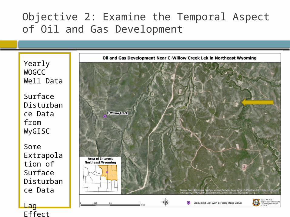
Objective 2: Examine the Temporal Aspect of Oil and Gas Development
Yearly WOGCC Well Data
Surface Disturbance Data from WyGISC
Some Extrapolation of Surface Disturbance Data
Lag Effect Evident?

Objective 3: Examine the amount of Undeveloped Space within Study Area
Calculate Open Space within 5.3 miles of Leks What is the Amount of Open Space needed? 2015 Lek and Disturbance Data

Anticipated Results
Validate previous research: leks closest to development decline the most. The birds on these leks have a refuge. Persistence a combination of development direction and drilling timeline?

Management Implications
State and Federal Agencies
Stakeholder Advisory Groups
Adaptive Management
Balance Multiple Use Mandates

Project Timeline
August Objective 1: Density Analysis
September Objective 2 : Development
Timeline October
Objective 3: Amount of
Undeveloped Space November
Finish Paper and Presentation December
Present at Conference GRADUATE!

Acknowledgements
Dr. Joseph Bishop Advisor
Tom Christiansen Sage-Grouse Program Coordinator, Wyoming Game and Fish
Department Nicholas Graf
DDCT Data Steward, Wyoming Geographic Information Science Center
Dr. Kevin Doherty Spatial Ecologist, U.S. Fish and Wildlife Service
Numerous WGFD Biologists Their time in the field makes my analysis possible.

ReferencesConnelly, J. W., K.P. Reese, and M.A. Schroeder. (2003). Monitoring of Greater Sage-Grouse
Habitats and Populations. College of Natural Resources Experiment Station. University of Idaho, Moscow Idaho. Retrieved from: https://wgfd.wyo.gov/web2011/Departments/Wildlife/pdfs/SG_MONITORINGHABITAT0000687.pdf
Christiansen, T.J. (2012). Chapter 12: Sage-grouse (Centrocercus urophasianus). In S.A. Tessmann (Ed.), Handbook of Biological Techniques: third edition (pp. 12-1 to 12-51). Cheyenne, WY: Wyoming Game and Fish Department.
Bureau of Lander Management. (2008). Record of Decision Final Supplemental Environmental Impact Statement for the Pinedale Anticline Oil and Gas Exploration and Development Project. Pinedale, WY: Pinedale Field Office. Retrieved from: http://www.blm.gov/wy/st/en/info/NEPA/documents/pfo/anticline/seis.html
Doherty, K.E. (2008). Sage-grouse and Energy Development: Integrating Science with Conservation Planning to Reduce Impacts (Doctoral dissertation). Paper 855. Retrieved from: http://scholarworks.umt.edu/cgi/viewcontent.cgi?article=1874&context=etd
Doherty, K. E., J. D. Tack, J. S. Evans, and D. E. Naugle. (2010a). Mapping breeding densities of greater sage-grouse: a tool for range-wide conservation planning. Completion Report for U.S.D.I. Bureau of Land Management.
Doherty, K.E., Naugle, D.E., and Evans, J.S. (2010b). A Currency for Offsetting Energy Development Impacts: Horse-Trading Sage-Grouse on the Open Market. PLoSONE 5(4): e10339.doi:10.1371/journal.pone.0010339
Doherty, K.E., N.E. Naugle, H.E. Copeland, A. Pocewicz, and J.M. Kiesecker. (2011). Energy Development and Conservation Tradeoffs: Systematic Planning for Greater Sage-Grouse in their Eastern Range. Pp. 505-516 in S.T. Knick and J.W. Connelly (editors). Greater Sage Grouse: ecology and conservation of a landscape species and its habitats. Studies in Avian Biology (vol. 38), University of California Press, Berkeley, CA.
Environmental Systems Research Institute. (2012). What is ModelBuilder? Retrieved from ArcGIS Help 10.1 Resource Center: http://resources.arcgis.com/en/help/main/10.1/index.html#//002w00000001000000
Environmental Systems Research Institute. (2015). Independent Report Highlights Esri as Leader in Global GIS Market. Retrieved from: http://www.esri.com/esri-news/releases/15-1qtr/independent-report-highlights-esri-as-leader-in-global-gis-market
Evans, J. S. (2015). spatialEco: Spatial Analysis and Modeling. Comprehensive R Archive Network. Retrieved from: http://cran.r-project.org/web/packages/spatialEco/index.html
Gregory, A.J. and Beck, J.L. (2014). Spatial Heterogeneity in Response of Male Greater Sage-Grouse Lek Attendance to Energy Development. PLoS ONE 9(6). Retrieved from: http://journals.plos.org/plosone/article?id=10.1371/journal.pone.0097132
Fedy, B. C. and K. E. Doherty. (2010). Population Cycles are Highly Correlated over Long Time Series
And Large Spatial Scales in Two Unrelated Species: Greater Sage-grouse and Cottontail Rabbits. Oecologia 165:915-924.
Freudenthal, D. D. (2009, March 9). Letter to Sage-grouse Implementation Team. Cheyenne, WY: Office of the Governor.
Harju, S.M., Dzialak, M.R., Taylor, R.C., Hyden-Wing, L.W., and Winstead, J.B. (2010). Thresholds and Time Lags in Effects of Energy Development on Greater Sage-
grouse Populations. Journal of Wildlife Management, 72(3), 437-448. Holloran, M.J., and S.H. Anderson. (2005). Spatial distribution of greater sage-grouse nests
in relatively contiguous sagebrush habitats. Condor 107:742-752.Holloran, M.J., Kaiser, R.C., and Hubert, W.A. (2010). Yearling Greater Sage-Grouse
Response to Energy Development in Wyoming. Journal of Wildlife Management, 74(1), 65-72.
National Wildlife Federation. (2010). Frequently Asked Questions about Greater Sage-grouse and the Endangered Species Act. Retrieved from: https://www.nwf.org/pdf/Wildlife/Sagegrouse_FAQ_nwf_2010.pdf
Sage-Grouse Implementation Team. (2010). Wyoming Sage-Grouse Core Area Revision Process 2010: Guidelines to Local Working Groups. Cheyenne, WY.
Sage-Grouse Implementation Team. (2015). Wyoming Sage-Grouse Implementation Team acts ahead of deadline and will take public input [Press release]. Cheyenne, WY.
Simpson, D.A. (2008). Official Letter to Governor Freudenthal. Cheyenne, WY: Bureau of Land Management.
State of Wyoming Executive Order. (2008). Greater Sage Grouse Core Area Protection (Executive Order 2008-2). Cheyenne, WY: U.S. Executive Department. Retrieved from: http://will.state.wy.us/sis/wydocs/execorders/WS-GOV-EO-2008-02.pdf
State of Wyoming Executive Order. (2010). Greater Sage Grouse Core Area Protection (Executive Order 2010-4). Cheyenne, WY: U.S. Executive Department. Retrieved from: http://will.state.wy.us/sis/wydocs/execorders/WS-GOV-EO-2010-04.pdf
State of Wyoming Executive Order. (2011). Greater Sage Grouse Core Area Protection (Executive Order 2011-5). Cheyenne, WY: U.S. Executive Department. Retrieved from: http://governor.wy.gov/Documents/Sage%20Grouse%20Executive%20Order.pdf
United Nations Economic Commission for Europe. (2009). Making Data Meaningful Part 2: A Guide to Presenting Statistics (UNECE Publication No. 2009/3). Geneva: Switzerland. United Nations. Retrieved from: http://www.unece.org/fileadmin/DAM/stats/documents/writing/MDM_Part2_English.pdf
United States Fish and Wildlife Service. (2010). Beginner’s Guide to Greater Sage-grouse. Notes from the Lek: Greater Sage-grouse Conservation Primer Series, Primer 1. Retrieved from: http://www.fws.gov/greatersagegrouse/factsheets/Primer1-SGBeginnersGuide.pdf
United States Fish and Wildlife Service. (2010). Sage-grouse Mapping and Priority Habitats. Notes from the Lek: Greater Sage-grouse Conservation Primer Series, Primer 3. Retrieved from: http://www.fws.gov/mountain-prairie/species/birds/sagegrouse/Primer3SGMapping&PriorityHabitats1.2%20(2).pdf
Walker, B. L. (2008). Greater Sage-grouse Response to Coal-bed Natural Gas Development and West
Nile Virus in the Powder River Basin, Montana and Wyoming (Doctoral dissertation). University
of Montana. Paper 499. Retrieved from: http://www.cas.umt.edu/facultydatabase/FILES_Faculty/1136/Walker2008Dissertation.pdf
Wyoming Game and Fish Department. (2007). 2004 Greater Sage-grouse Completion Report. P18. Wyoming Game and Fish Department. Cheyenne, WY.
Wyoming Game and Fish Department. (2014). Greater Sage-Grouse Job Completion Report. Wyoming Game and Fish Department. Cheyenne, WY. Retrieved from: https://wgfd.wyo.gov/web2011/Departments/Wildlife/pdfs/JCR_SAGEGROUSE_20130006611.pdf
Wyoming Game and Fish Department. (2015). Sage-grouse lek locations [Data file]. Retrieved from: https://wgfd.wyo.gov/web2011/wildlife-1000811.aspx
Wyoming Geographic Information Science Center. (2015). Wyoming Density and Disturbance Calculation Tool. Laramie, WY. Retrieved from: https://ddct.wygisc.org/
Wyoming Oil and Gas Conservation Commission. (2015). Well Header [Data file]. Retrieved from: http://wogcc.state.wy.us/urecordsMenu.cfm?Skip=%27Y%27&oops=ID75918


