IPY 2007 2008 Space Task Group of the IPY Sub-Committee on Observations AN ACQUISITION STRATEGY FOR SAR AND INSAR COORDINATED RESPONSE OF THE SPACE AGENCIES TO IPY SCIENCE OBJECTIVES Yves Crevier Canadian Space Agency STG 4 Geneva Feb. 3 – 4, 2009 RSAT 2 ScanSAR Wide A – 2008.05.11 Banks Island, Beaufort SeaRSAT-2 Scansar Wide
Transcript
IPY20072008
Space Task Group of the IPY Sub-Committee on Observations
AN ACQUISITION STRATEGY FOR SAR AND INSAR
COORDINATED RESPONSE OF THE SPACE AGENCIES TO IPY SCIENCE OBJECTIVES
Yves CrevierCanadian Space Agency
STG 4GenevaFeb. 3 – 4, 2009
RSAT 2 ScanSAR Wide A – 2008.05.11Banks Island, Beaufort SeaRSAT-2 Scansar Wide
IPY20072008 Contributors
• SAR Space Agencies– Agenzia Spaziale Italiana – Fabrizio Battazza– Canadian Space Agency – Yves Crevier, Robert Saint-Jean– DLR, Germand Aerospace Center – Manfred Gottwald, Dana
Floricioiu, et al.– European Space Agency – Henri Laur– JAXA – Masanobu Shimada– NASA – Craig Dobson
• STG members– Mark Drinkwater– Ken Jezek, Katy Farness
• Private sector and International organisations– MDA, ASF, KSAT, GIIPSY, WMO JC
IPY20072008 SAR Agency IPY Portfolios• http://bprc.osu.edu/rsl/GIIPSY/
IPY20072008
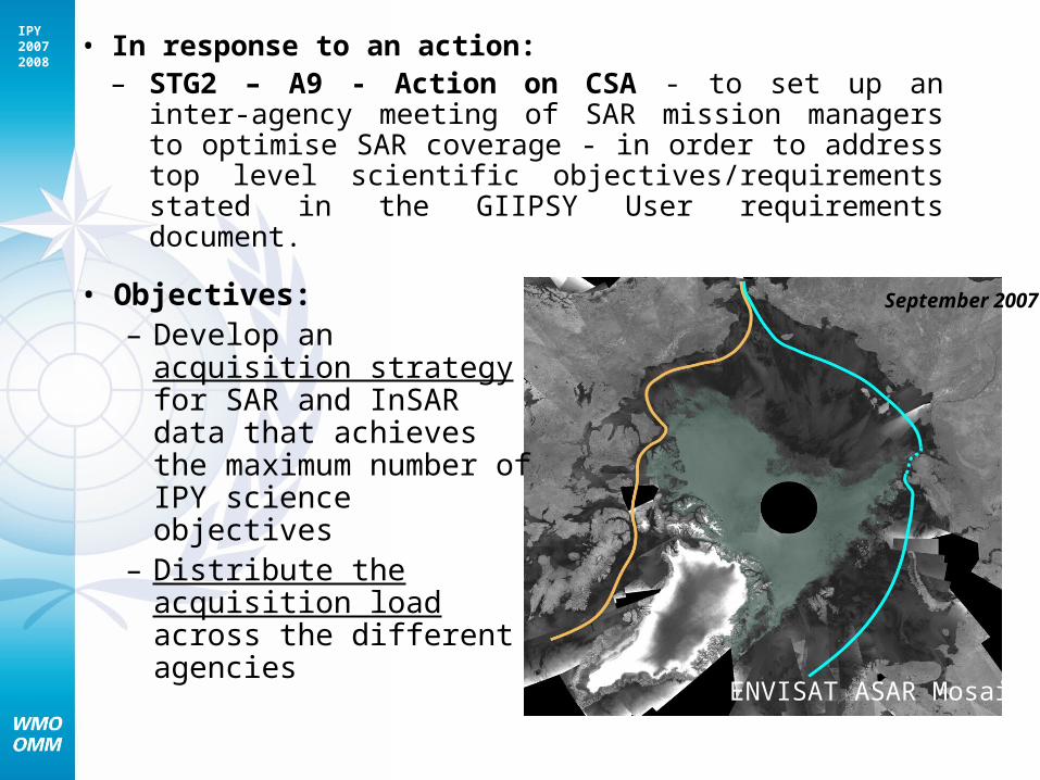
• In response to an action:– STG2 – A9 - Action on CSA - to set up an inter-
agency meeting of SAR mission managers to optimise SAR coverage - in order to address top level scientific objectives/requirements stated in the GIIPSY User requirements document.
September 2007• Objectives:– Develop an acquisition
strategy for SAR and InSAR data that achieves the maximum number of IPY science objectives
– Distribute the acquisition load across the different agencies
ENVISAT ASAR Mosaic
IPY20072008 Path Towards SAR Coordination
• Assessment of SAR system capacity vs IPY science objectives – meeting 1
• SAR acquisition plan consolidation exercise – meeting 2
• SAR processing strategy• Data dissemination - sustainability
IPY20072008 Assessment of SAR system
capacity vs IPY science objectives• Review existing GIIPSY science requirements (the
Global Inter-agency IPY Polar Snapshot Year (GIIPSY) Strategy Document)
• Review the Agencies strategic priorities in line with IPY science activities.
• Review current acquisition plans focused on IPY.• Review the satellite and ground segment operators
system capabilities and constraints related to the acquisition of data in support to IPY.
• Agree on priorities
IPY20072008 SAR Coordination Meeting
March 08
• 13 organisations were represented at this meeting– 6 Space Agencies– 3 Ground Segment Operators– 4 end-user and research organizations
• Presentation material available on the GIIPSY website
IPY20072008
Meeting Outcomes
• Agreement to focus the acquisition strategy on:– Solving important science problem (in line
with STG objectives)– Filling a gap in planned coverage for IPY
(build from existing agencies’ imaging activities)
– Involve interagency collaboration (no-single agency can do it all)
IPY20072008
Derived Contribution From SAR
– C-Band coverage (3-day snapshots) for the Arctic Ocean during the remainder of IPY (background missions, operation data acquisitions, etc.).
– Winter Pole to Coast InSAR coverage of the Antarctic in high-resolution mode (3-4 consecutive cycles in ascending and descending).
– Greenland and Major Canadian Icefields of InSAR acquisition over 3-4 consecutive cycles of high-resolution in winter.
– Supersites (where possible using what exists already): determine acquisition parameters (frequency, resolution, etc.) for multi-polarisation and polarimetry data collection.
IPY20072008
User Requirements Guidelines
IPY20072008 SAR acquisition plan consolidation
exercise
• Avoid Gaps and Overlaps – optimize resources• Consolidate the current SAR planning and imaging
activities occurring under the auspices of IPY/STG (i.e. thematic / instrument matrix, common planning tool, etc.)
• Distribute imaging load according to Agencies’ capacities and priorities, and develop acquisition plans
• Look at a short/med/long term planning approach to continue the acquisitions (if at all possible)
IPY20072008
- C-Band coverage (3-day snapshots) for the Arctic Ocean - Winter Pole to Coast InSAR coverage of the Antarctic - Greenland and Major Canadian Icefields - Supersites
JAXA ESA CSA ASI DLR
L-Band C-Band X-Band
Horizontal Collaboration
Space Task Group Coordination
IPY20072008
Sensors 3-day Arctic Basin snapshots Pole to coast InSAR Greenland - Ice fields SupersitesPALSAR Fixed image acquisition plan.
New L-band mosaic of sea ice. Systematic NRT direct in-mask downlink requests to ASF.
Fixed image acquisition plan. New L-band mosaic being prepared. South pole hole not covered. Repeat fine beam cycles - 76 degrees
Partial InSAR coverage in fine beam and pol mode. JAXA would entertain a proposal.
Robust proposal required for augmentation of the basic observation plan. Action GIIPSY.
ASAR Systematic wide swath coverage – C-Band complementary to RSAT. Acquisition limitation in Chukchi Sea and East Siberian Shelf. See Ken's presentation. Action ESA and CSA background mission managers - define optimal mission coverage.
Already intense InSAR acquisition plan for regions north of about 78 degrees S. Continue doing this through the IPY. Plans beyond IPY to be discussed.
Greenland: already intense acquisition plan. Reception hole central Greenland. Continue doing this through IPY period.
2nd Tandem campaign ERS and ASAR over large supersites (list to be provided by ESA).
Available for supersites – prefers systematic coverage??? Multi-pol capabilities not exploited (LARGE SITES)
RSAT 1 Requires the participation and agreement of ASF and KSAT. Canadian and Norwegian waters well covered under background and operational missions. Back-up in case of conflicts.
Not possible due to lack of receiving station. Presence of NASA and KSAT station in area. No rotation planned.
Not possible without the participation of foreign receiving stations – requires $$$ contribution. Historical coverage -- covered 2-times in InSAR – data are in ASF archive. 2007 coverage.
Available for supersite monitoring under the Canadian mask – should not be in conflict with the operational users and thus avoid the coastal areas.
RSAT 2 Planned background mission. 8 times 3-day snapshot over 24-day cycle. Action ESA and CSA background mission managers - define optimal mission coverage.
Current plan is to acquire entire continent left-looking`in cycle 12 (wide asc) starting Oct 14. Plan to acquire pole hole interferomtrically left looking cycle 16 starting Jan 18 and cycle 17 starting Feb 11. Use Standard mode for interferometry except for EH4 in areas that cannot be reached with Standard. MDA to check cycle 18.
Background mission planning. InSAR coverage. 3 cycles in Fine mode in descending orbits in Nov-Dec. Could end after Dec (to Feb).
Sites may require polarimetric capabilities of R2. Need input from PIs. See SOAR reference.
Terrasar X N-A Primary contribution to the ASAR pole hole gap will be the acquisitions planned in Transantarctic Mountains, Filchner Ice Streams & Coats Land.
Margins and coastal areas. InSAR coverage, minimum 2 cycles. Need a proposal to DLR.
Ideal sensor for this application. Supersites already identified in Antarctic. Proposal submitted for 2 regions. Possibility for interferometry at Greenland glaciers matching SPOT super-sites. See below for list. Proposal required for Greenland and Canadian super-sites.
Cosmo-Skymed
N-A TBD TBD Ideal sensor for this application.
Action Look at a coordinated acq plan between ESA and CSA. For R1 – how can receiving station contribute?
Consolidate acquisition planning to distribute imaging load and meet the requirement. Task C-Band missions.
Select the supersites; Based on science activities and other missions calval; identify PIs as poc for agencies. Distribute the supersites in-between missions. Identify agencies for supersite monitoring.
The mission is not appropriate for achieving this particular requirement.The mission is ideal for achieving this particular requirement.The mission is not optimum for achieving this particular requirement.
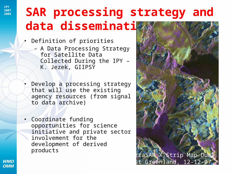
IPY20072008 SAR processing strategy and data
dissemination • Definition of priorities
– A Data Processing Strategy for Satellite Data Collected During the IPY – K. Jezek, GIIPSY
• Develop a processing strategy that will use the existing agency resources (from signal to data archive)
• Coordinate funding opportunities for science initiative and private sector involvement for the development of derived products
TerraSAR X Strip Map Dual PolEast Greenland, 12-12-07
IPY20072008
Dissemination
• Development of an outreach strategy to demonstrate the leverage of coordination under STG. – Joint technical paper– Presentation of compiled results in selected
forums– Compile links of data nodes and portfolio
description for space agencies– Promote our joint / integrated products– GIIPSY