40
Autumn Planning Conference 2016: Socio-economic mapping, Census 2016 and evidence based planning Friday 7 th October The Gibson Hotel
| Date post: | 13-Apr-2017 |
| Category: |
Data & Analytics |
| Upload: | justin-gleeson |
| View: | 142 times |
| Download: | 0 times |

Autumn Planning Conference 2016:
Socio-economic mapping, Census 2016
and evidence based planning
Friday 7th October
The Gibson Hotel

Socio-Economic Mapping, Evidence Based Planning & Census 2016
• Background to the All-Island Research Observatory (AIRO)
• AIRO Public Mapping Tools
• Census 2016
– Preliminary Results
– Schedule and Release of 2016 Results
• Local Economic and Community Plans (LECP)
– Development of an Evidence Baseline
– Monitoring Tools to measure implementation
• New AIRO Projects
– Environmental Sensitivity Mapping (ESM)
– Dublin Housing Intelligence (DHI)
– Training and Workshops
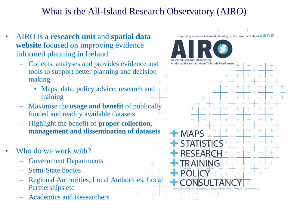
What is the All-Island Research Observatory (AIRO)
• AIRO is a research unit and spatial data website focused on improving evidence informed planning in Ireland
– Collects, analyses and provides evidence and tools to support better planning and decision making
• Maps, data, policy advice, research and training
– Maximise the usage and benefit of publically funded and readily available datasets
– Highlight the benefit of proper collection, management and dissemination of datasets
• Who do we work with?
– Government Departments
– Semi-State bodies
– Regional Authorities, Local Authorities, Local Partnerships etc
– Academics and Researchers

What is the All-Island Research Observatory (AIRO)

AIRO Public Mapping Tools

AIRO Public Mapping Tools

AIRO Public Mapping Tools

AIRO Public Mapping Tools

AIRO Public Mapping Tools

AIRO Public Mapping Tools

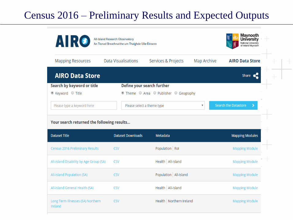
Census 2016 – Preliminary Results and Expected Outputs
• On 14th June 2016, the Central Statistics Office (CSO) released the Preliminary
Report for Census 2016.
– Summary count for each enumeration area (4,663)
• Released as a variety of geographical scales – National, Regional, County and
Electoral Division
• Data released for the following variables:
– Population 2016
– Male and Female
– Housing Stock
– Vacant Dwellings
– Vacant Holiday Homes
– Other Vacant Dwellings (Houses and Flats)
– Total Vacancy Rate
• Scheduled release of all census themes and variables starting April 2017

Census 2016 – Preliminary Results and Expected Outputs

Census 2016 – Preliminary Results and Expected Outputs
• +169k or 3.7% increase 2011 to
2016
• Highest growth rates:
– Fingal (+8.1%)
– Meath (+5.9%)
– Kildare (+5.6%)
– DLR (+5.3%)
– Galway City (+5.3)
• Decreases:
– Donegal (-1.5%)
– Mayo (-0.2%)
– Sligo (-0.1%)
• 61 EDs > +20%
• 147 EDs +10% to +20%
• 1,389 (40%) of EDs decreased
in population
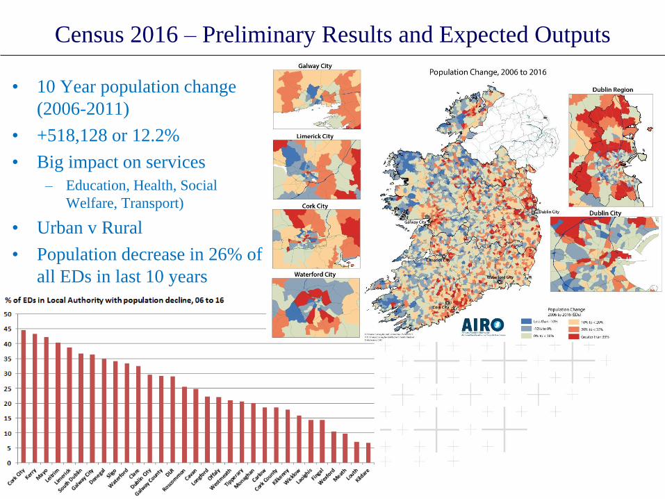
Census 2016 – Preliminary Results and Expected Outputs
• 10 Year population change
(2006-2011)
• +518,128 or 12.2%
• Big impact on services
– Education, Health, Social
Welfare, Transport)
• Urban v Rural
• Population decrease in 26% of
all EDs in last 10 years
Census 2016 – Preliminary Results and Expected Outputs
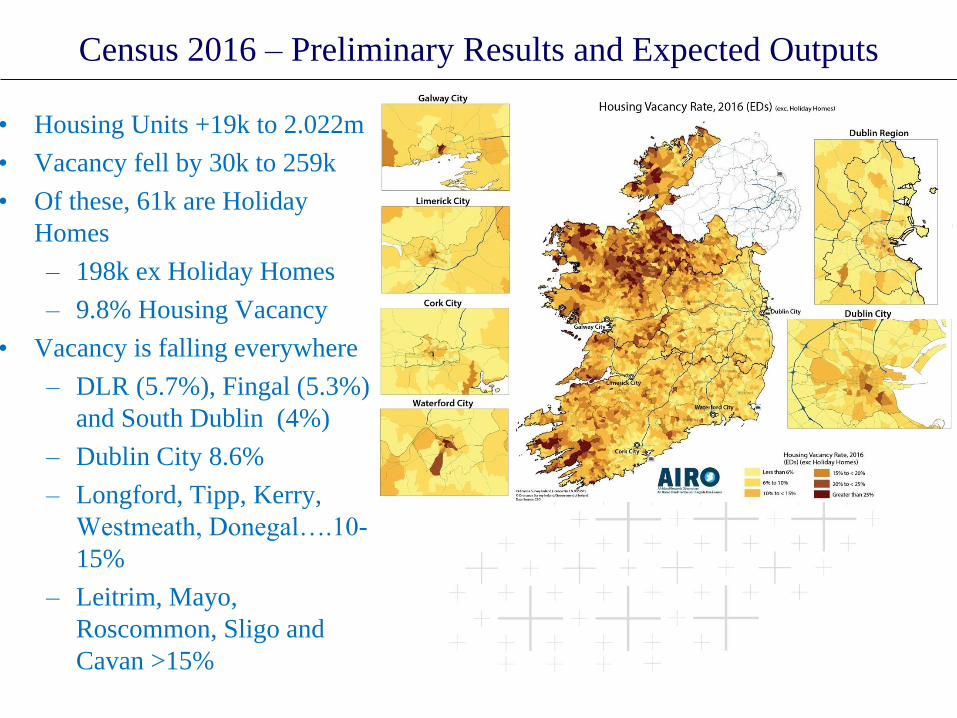
• Housing Units +19k to 2.022m
• Vacancy fell by 30k to 259k
• Of these, 61k are Holiday
Homes
– 198k ex Holiday Homes
– 9.8% Housing Vacancy
• Vacancy is falling everywhere
– DLR (5.7%), Fingal (5.3%)
and South Dublin (4%)
– Dublin City 8.6%
– Longford, Tipp, Kerry,
Westmeath, Donegal….10-
15%
– Leitrim, Mayo,
Roscommon, Sligo and
Cavan >15%

Census 2016 – Preliminary Results and Expected Outputs

Census 2016 – Preliminary Results and Expected Outputs
• DCC: 21,781 vacant units (20,844 exc holiday homes) – 8.6%
• On a base vacancy of 6% (14,544) this suggests an oversupply of 6,300
• City Centre > 10%, Mansion House B and Pembroke West B >20%

Census 2016 – Preliminary Results and Expected Outputs
• Blue = Decrease, Red = Increase
• Reasons for vacancy? Second homes, Investment stock left empty or awaiting
development, Bed-sits not yet converted, Property in the middle of transfer,
LA stock scheduled for refurbishment
Census 2016 – Preliminary Results and Expected Outputs

Census 2016 – Expected Outputs
• Dissemination Timetable due shortly – it will mirror 2012 releases with some
minor changes
• All tables will be Statbank only – no hard copies
– Table range has been expanded to include some requests from 2011 –
single year of age across more variables
• This is Ireland – Highlights
• Housing release will be next (mid-April)
– New analysis on vacancy!
– Type of Dwelling (detached, terraced etc)
– Analysis of whether they were vacant in 2011
– Reasons why vacant (for sale, person in nursing home, renovation etc)
• Full SAPS in July - Small Areas, EDs, Settlements and new
Municipalities/LEAs
– Adjustments to some SA boundaries – splitting due to new developments
• POWSCAR (July) but with some new restrictions
• Daytime Working Population in the Commuting Release
• AIRO and CSO MoU now in place to develop mapping tools to coinside with
data releases

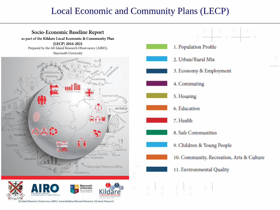
Local Economic and Community Plans (LECP)
• Engaged with a number of local authorities on the development of initial evidence
based report for LCDC/LECP
Local Economic and Community Plans (LECP)

Local Economic and Community Plans (LECP)
• Where possible data was gathered at all spatial
scales
– State
– Region: Eastern & Midlands
• Southern and Eastern (NUTS II),
• Greater Dublin Area,
• Mid East (NUTS III) and Dublin
– Neighbouring Local Authorities (8)
– Municipal Districts (5)
– Metropolitan/Hinterland
– Urban/Rural
– Kildare Settlement Hierarchy
• Primary Economic Growth Towns (7)
• Secondary Economic Growth Towns (2)
• District Employment Centres (1)
• Local Employment Centres - Small Towns (8)
• Local Employment Centres – Villages (11)

Local Economic and Community Plans (LECP)

Local Economic and Community Plans (LECP)

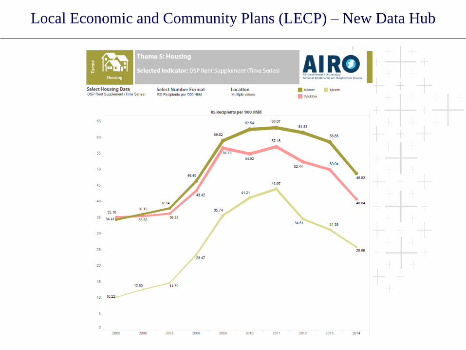
Local Economic and Community Plans (LECP) – New Data Hub
Backgroound LECP Intro ………………..Intro intro intro <foldable> Lorem ipsum dolor sit amet, consectetur adipiscing elit, sed do eiusmod tempor incididunt ut labore et dolore magna aliqua.
Ut enim ad minim veniam, quis nostrud exercitation ullamco laboris nisi ut aliquip ex ea commodo consequat. Duis

Local Economic and Community Plans (LECP) – New Data Hub

Local Economic and Community Plans (LECP) – New Data Hub
Local Economic and Community Plans (LECP) – New Data Hub

Evidence Informed Planning – Environmental Sensitivity Mapping
(ESM)

Evidence Informed Planning – Environmental Sensitivity Mapping
(ESM)

Evidence Informed Planning – Environmental Sensitivity Mapping
(ESM)

Evidence Informed Planning – Environmental Sensitivity Mapping
(ESM)

Evidence Informed Planning – Environmental Sensitivity Mapping
(ESM)

Evidence Informed Planning – Environmental Sensitivity Mapping
(ESM)

Evidence Informed Planning – Environmental Sensitivity Mapping
(ESM)
• Stakeholder consultation and testing
• 2 minutes for a Planner/Environmental Analyst to re-create in-house SEA Mapping
• Quick and accurate results - easy to understand and analyse output

Evidence Informed Planning – Dublin Housing Intelligence
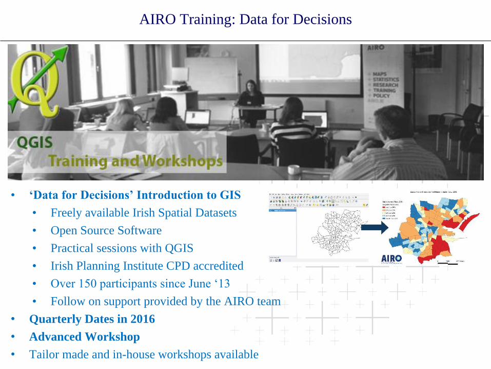
AIRO Training: Data for Decisions
• ‘Data for Decisions’ Introduction to GIS
• Freely available Irish Spatial Datasets
• Open Source Software
• Practical sessions with QGIS
• Irish Planning Institute CPD accredited
• Over 150 participants since June ‘13
• Follow on support provided by the AIRO team
• Quarterly Dates in 2016
• Advanced Workshop
• Tailor made and in-house workshops available
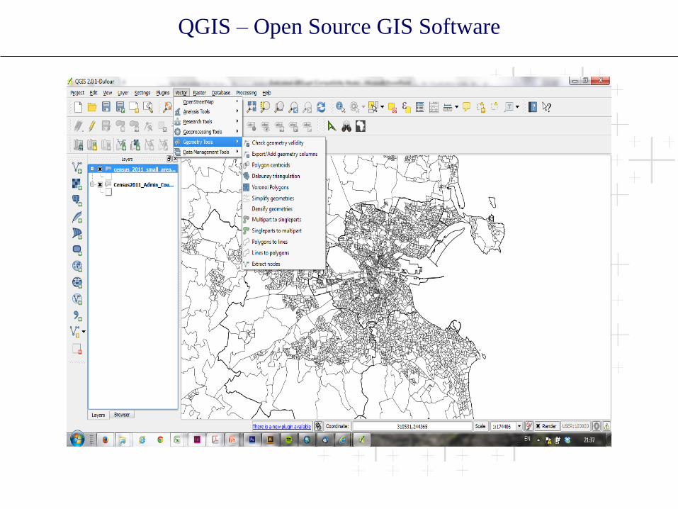
QGIS – Open Source GIS Software
Thanks
Questions?
w: www.airo.ie
twitter: airo_mu


