Disclosure to Promote the Right To Information Whereas the Parliament of India has set out to provide a practical regime of right to information for citizens to secure access to information under the control of public authorities, in order to promote transparency and accountability in the working of every public authority, and whereas the attached publication of the Bureau of Indian Standards is of particular interest to the public, particularly disadvantaged communities and those engaged in the pursuit of education and knowledge, the attached public safety standard is made available to promote the timely dissemination of this information in an accurate manner to the public. इंटरनेट मानक “!ान $ एक न’ भारत का +नम-ण” Satyanarayan Gangaram Pitroda “Invent a New India Using Knowledge” “प0रा1 को छोड न’ 5 तरफ” Jawaharlal Nehru “Step Out From the Old to the New” “जान1 का अ+धकार, जी1 का अ+धकार” Mazdoor Kisan Shakti Sangathan “The Right to Information, The Right to Live” “!ान एक ऐसा खजाना > जो कभी च0राया नहB जा सकता ह ै” Bhartṛhari—Nītiśatakam “Knowledge is such a treasure which cannot be stolen” IS 6748-1 (1973): Recommendations for watershed management relating to soil conservation, Part 1: Agronomic aspects [WRD 6: Water Resources Planning, Management and Evaluation]
Transcript
Disclosure to Promote the Right To Information
Whereas the Parliament of India has set out to provide a practical regime of right to information for citizens to secure access to information under the control of public authorities, in order to promote transparency and accountability in the working of every public authority, and whereas the attached publication of the Bureau of Indian Standards is of particular interest to the public, particularly disadvantaged communities and those engaged in the pursuit of education and knowledge, the attached public safety standard is made available to promote the timely dissemination of this information in an accurate manner to the public.
इंटरनेट मानक
“!ान $ एक न' भारत का +नम-ण”Satyanarayan Gangaram Pitroda
“Invent a New India Using Knowledge”
“प0रा1 को छोड न' 5 तरफ”Jawaharlal Nehru
“Step Out From the Old to the New”
“जान1 का अ+धकार, जी1 का अ+धकार”Mazdoor Kisan Shakti Sangathan
“The Right to Information, The Right to Live”
“!ान एक ऐसा खजाना > जो कभी च0राया नहB जा सकता है”Bhartṛhari—Nītiśatakam
“Knowledge is such a treasure which cannot be stolen”
“Invent a New India Using Knowledge”
है”ह”ह
IS 6748-1 (1973): Recommendations for watershed managementrelating to soil conservation, Part 1: Agronomic aspects[WRD 6: Water Resources Planning, Management andEvaluation]
IS : 6748 ( Part I ) - 1973
Indian Standard RECOMMENDATIONS FOR
WATERSHED MANAGEMENT RELATING TO SOIL CONSERVATION
PART I AGRONOMIC ASPECTS
Catchment Area and Reservoirs Sectional Committee, BDC 48
Chairman
SHRI S. K. BANERJEE
Members
SHRI M. M. ANAND
SHRI S. S. SAHI ( ~kWUZte ) SHRI K. K. CHAU~HRY
SHRI R. N. HOON (Alfemale) DIRECTOR
DR S. R. SEHCAL (Alternate) DIRECTOR ( HYDROLOGY )
DEPUTY DIRECTOR ( HYDRO- LOGY ) ( Allernnb )
DIRECTOR ( INTERSTATE & DESIGNS )
SHRI P. V.RAO ( AItcrmlc) SHRI D. DODDIAH SHRI R. L. GUPTA
SUPERINTENDING ENGINEER, DESIGNS ( Alternate )
SHKI B. M. HUKKU JOINT COMMISSIONER ( SOIL CONSER-
VATION )
SHRI N. V. KHURSALE SHRI R. D. GUPTE ( Alternate)
SHRI S. K. IMOORTHY
SHRI K. N. TANE~A ( Alternate ) SHRI B. N. MURTHY
Representing
Ministry of Irrigation & Power, New Delhi
Irrigation & Power Department, Government of Punjab
Bhakra Dams Organization, Nangal Township
Land Reclamation, Irrigation & Power Research Institute, Amritsar
Central Water & Power Commission, New Delhi
Public Works Department, Government of Andhra Pradesh
Central Board of Irrigation & Power, New Delhi Public Works Department, Government of Madhya
Pradesh
Geological Survey of India, Calcutta Soil Conservation Division (Ministry of Food,
Agriculture, Community Development & Cooperation )
Irrigation Department, Government of Maharashtra
National Projects Construction Corporation, New Delhi
Damodar Valley Corporation, Maithon Dam, Dhanbad
( Continued on page 2 )
@ Copyright 1973
BUREAU OF INDIAN STANDARDS
This publication is protected under the I&inn Copyri$ Act ,( XIV of 1957 ) and reproduction in whole or in part by any means except with wrltten permission of the publisher shall be deemed to be an infringement of copyright under the said Act.
IS I 6748 ( Part I ) - 1973
( Cantinuedfrom page 1)
Members
SHRI H. R. PRAMANIK
DR S. P. RAYCXAUDHURI
SECRETARY SxRl G. S. %ilVANNA
SXRI BIJAYANANDA TRIPATHY
SHRI D. AJITHA SIMXA, Director ( Civ Engg )
Representing
Irrigation & Waterways Department, Government of West Bengal
In personal capacity ( E. C. 9, Inder Puri, New Delhi 12)
Central Board of Irrigation & Power, New Delhi Public Works Department, Government of Mysore Irrigation & Power Department, Government of
Orissa Director General, BIS ( Ex-oBcio Member)
Secrefury
SXRI K. RACHAVENDRAN
Deputy Director ( Civ Engg ), BIS
2
IS:6748(Part I).1973
Indian Standard RECOMMENDATIONS FOR
WATERSHED MANAGEMENT RELATING TO SOIL CONSERVATION
PART i AGRONOMIC ASPECTS
0. FOREWORD
0.1 This Indian Standard ( Part I ) was adopted by the Indian Standards Institution on 2 April 1973, after the draft finalized by the Catchment Area and Reservoirs Sectional Committee had been approved by the Civil Engineering Division Council.
0.2 Sedimentation of reservoirs is a matter of vital concern for any project whether irrigation, hydro-electric power, flood control etc, since it adversely affects the life and functions of the reservoirs. For this, effective measures of soil conservation in the watershed are essential.
0.3 Soil conservation is an integrated approach of three disciplines namely, engineering, agronomy and forestry and involves -a co-ordinated effort of these disciplines for a comprehensive and composite programme of development and management of watersheds. of these three disciplines are given below:
Some of the broad aspects
a) Engineering - Bank protection and roadside control measures, abutment, spurs, check-dams, gully plugging, masonry or concrete water disposal system, etc.
b) Agrononly - Retirement of severely eroded land to permanent protection of vegetation, pasture development, vegetative water- ways, contour farming,~strip cropping, crop rotation, etc.
c) Forestry - Like forest conservancy - management and protection and forest plantation, etc.
0.4 A standard for the engineerin g aspects of watershed management ( IS : &j18-1972* ) has already been published. This standard deals with the agronomical aspects with regard to watershed management and the forestry aspects are proposed to be covered in Part II of this standard. _. .._.__ ____---
*Cod& practice for control of sediment in reservoirs.
3
L
IS : 6748 ( Part I ) - 1973
0.5 In the formulation of this standard due consideration has been given for relating this standard to the practices in the field in this country. This has been met by deriving assistance from the Soil Survey Manual, 1970 of the All India Soil and Land Use Survey Organization, IARI.
I. SCOPE
1.1 This standard ( Part I ) covers the recommendations on the agronomlcal aspects for soil conservation in the catchment area and the appropriate method(s) to be adopted.
2. IDENTIFICATION OF AREAS REQUIRING SOIL CONSERVA- TION MEASURES ON PRIORITY BASIS
2.1 For achieving maximum benefit of soil conservation and covering as much critical areas as feasible in minimum possible time, one should know the pockets of sediment contributing areas and the amount of sediment contributed by them and then have a comprehensive plan to tackle these areas in the order of priorities taking sub-watershed as a unit of management.
2.2 Quick erosion survey by soil survey parties or by collection of available sediment data and aerial photo interpretation should be carried out to determine the pattern of present land use and degree of erosion in order to fix priorities for soil conservation measures.
3. CLASSIFICATION OF LAND ON THE BASIS OF LAND USE
3.1 Land is classified into the following types:
a) Suitable for cultivation, and
b) Unsuitable for cultivation.
These are further subdivided and the details are given in Appendix A, based on IS : 5510-I 969 * with additions in Classes VI and VII.
4. AGRONOMIC PRACTICES
4.1 The agronomic practices in respect of soil conservation are. the following and they are described in detail in 4.1.1 to 4.1.11:
a) Retirement of severely eroded cultivated land for permanent protection by vegetation,
b) Planting severely erodible aseas with feed and cover plants for rehabilitation of wild life,
*Guide for soil surveys for -river valley projects.
4
c
C) 4 e) f 1 d h) 3 k) 4
IS : 6748 ( Part I ) - 1973
Pasture development and their protection,
Construction of small water storages,
Vegetated waterways,
Contour farming by bunding and terracing,
Strip-cropping,
Modified strip cropping,
Stubble mulch farming,
Seasonal cover crops, and
Crop rotation.
All these aspects are to be simultaneously taken note of for minimiz- ing the erosion and appropriate method(s) should be adopted.
4.1.1 Retirement of Severely Eroded Cultivated Landfor Permanent Protection by Vegetation-Gullies tend to form wherever runoff is concentrated in unprotected depression channel ways. Once started they increase in size, and unless checked, ultimately develop into deep, spreading chasms which ruin the land. The best method of treatment of severely eroded cultivated land is to provide permanent vegetal cover.
4.1.2 Planting Severely Erodible Areas with Feed and Cover Plants for Rehabilitation of Wild Lzfe - In severely erodible areas wild life plantings offer the best solution of the erosion problem. This is because the plant species adapted to wild life succeed under the ecological conditions imposed by such sites and also because the areas are too-small or too inconveniently located for the profitable production of economical plants even if they thrive under such conditions. The plantings may be trees, shrubs, vines, or grasses. The ideal condition to be realized is adequate food and cover at all times.
4.1.3 Pasture Development and Their Protection - One of the chief causes of soil deterioration on grazing land is the loss of plant cover due to over- grazing and poor management practices that expose the ground to wind and rain. Properly prepared and managed pastures produce several times more than ill-managed grazing ground. It has been found that an abundance of high quality forage is the very faundation of any type of livestock farming. Three aspects essential in pasture development are:
a) addition of lime and fertilizers according to soil test;
b) use of proper seed rates and mixtures; and
c) controlled grazing.
4.1.4 Construction of Small Water Storages - Small dams for use in farm and grazing lands are usually not expensive, yet they add considerably to
5
IS:674S(PartI)-1973
the value of dry land farm or grazing lands. Besides supplying water and some recreation facilities, they play a part in controlling floods. The size and cost of such dams are largely governed by the terrain.
4.1.5 Vegetated Waterways -These are waterways protected by vegetation to prevent conversion into gullies. Natural drainage depressions, seeded with adaptable grass-legume mixture, often may be utilized as satisfactory water channels and meadows at the same. time. The vegetated waterways should not be less than 6 m wide. Seeding should not only cover the channel but extend well back on the shoulders.
4.1.6 Contour Farming by Bunding and Terracing - Contour farming is preparing, planting or drilling and cultivating of crops along and parallel to level lines that have been laid out across the field slope. When farming contour strip-cropped fields, terraced fields, fields with diversions and contour orchards, cultivation should be parallel to guidelines.
4.1.6.1 Contour cultivation iseffectivein controlling erosion by surface flow. When carried out properly, it is one of the most effective mechani- cal control measures for cultivated crop land. It is effective in increasing crop yields, reducing runoff and scour-erosion losses. When contour farming is used alone, new guidelines should be established each time the crop is planted, unless erosion is made to maintain original lines by contour hedges, back furrows or other means.
4.1.6.2 Contour bunding consists of the construction of small bunds across the slope of the land along contours so that the long stretch of slope is cut into a series of small ones and each contour bund acts as a barrier to the flow of water. This practice is generally followed in gently sloping lands.
4.1.6.3 Terraces may be of bench type or graded channel type which are designed to intercept and divert runoff at non-erosive velocities. This practice is generally followed in hill slopes.
4.1.7 Stri#-Groj$ing - Strip-cropping is the practice of growing crops in a systematic arrangement ,of strips or bands which serve as vegetative + barrier to erosion. It includes the utilization of crop rotation, contour cultivation, proper tillage, cover crops and other related practices. The arrangement of crop in strips should be such that erosion- and semi-erosion- resistant crops are alternated with clean cultivated crops that are conducive to erosion.
4.1.7.1 In choosing any system of strip-cropping the following guiding principles should be kept in mind:
a) Strip-cropping should be made to fit into the farm management;
b) Strip should be laid out as nearly on the contour as possible; and
6
cl
4.1.8
Consideration should be given to the degree of erosion, the percentage of slope, the length of the rotation and the ratio of erosion resisting and erosion permitting crops.
Modi’ed StriP_CroPging - Field stripping is a modified form of contour strip cropping under which strips are laid parallel and across the general slope but not exactly on the contour, This system is best suited to land of uniform slopes and to gentle slopes with minor surface irregularities that make accurate strip-cropping impracticable. Field ‘stripping is very beneficial for checking wind and water erosion. If strips deviate from the contour fbr only short distance, not more than 30 m, little damage may result especially on soil of high erodibility. However, if the deviation should be more than 3 percent, and the distance.of such deviation greater than 30 m, field stripping should give way to contour stripping.
IS:674S(PartI)-1973
4.1.9 Stubble Mulch Farming - Leaving stubble in the surface in sufficient quantity is one of the surest ways to prevent wind erosion and conserve moisture and also add organic matter to the soil. Subtilled stubble mulch gives high yields.
4.1.10 Seasonal Cover Crops - Seasonal cover crops are very important in protecting fields from erosion. They also serve to absorb plant nutrients that otherwise would be lost by leaching and thus aid in their preservation for subsequent crop use. Green manure crops are included under cover crops. Other examples of cover crops are catch-crops of various kinds, which leave the soil exposed to erosion for a minimum period during the year and protect the soil when the regular cultivated crops are off the ground.
4.1.11 Crop Rotation - Crop rotation reduces runoff and soil loss, both of which~are important in maintaining yields. Crop rotation refers to the growing of different crops in a regular succession on the same land. For erosion control a rotation should embody the principle of alternating cultivated crops with erosion-resistant and organic matter building crop. Methods of increasing the erosion control value of a rotation are:
a) b) cl 4
increasing the number of years of hay and pasture,
improving the seed mixture to include legumes,
adequate fertilization, and
addition of cover crops to provide a contmuous cover on the field.
The capability of the land limits the kind of rotation to be recom- mended on any field.
7
IS :Q748 ( Part I ) - 1973
5. GENERAL TYPES OF CONSERVATION USES RECOMMENDED ON THE BASIS FICATION
PRACTICES AND OF LAND CLASSI-
5.1 The recommended type of conservation practice for various of land on the basis of cultivation is given briefly in Appendix B.
categories
APPENDIX A .
( Clause 3.1 )
CLASSIFICATION OF LAND ON THE BASIS OF CULTIVATION
A-l. LAND SUITABLE FOR CULTIVATION
A-1.0 Land is categorized under four different classes as given in A-l.1 to A-1.4.
A-l.1 Class I Land-This is very good land that may be cultivated safely with ordinary good farming methods. It is nearly level land ( slope less than one percent ) and has deep, productive, easily worked soils and is subject to only slight erosion. It is well drained and is suited for intensive cropping. The land is suited for a wide variety of crops. For continued good production, this land requires the use of fertilizers, green manure crops and crop rotation.
A-1 .‘J @lass II Land - This is good land that may be cultivated with easily available practices. Some of the limitations of this class of land are gentle slope, moderate susceptibility to erosion, moderate depth, moderate overflow and moderate wetness. Each of these limitations requires special methods for correction, such as contour bunding, strip cropping, contour tillage, crop rotstions that include grasses or legumes, drainage and the application of fertilizers and manures.
A-1.3 Class III Land - This class of land has restricted use for cultivation. The lancl is moderately good and may be used for cropping provided intensive management measures are taken. This kind of land is characterized by one or more of the following limitations:
a) Moderate steep slope,
b) High susceptibility to erosion,
cl Moderate overflow,
d) Slow sub-soil permeability,
4 Excessive wetness,
8
-
IS : 6748 ( Part 1) - 1973
f) Shallow depth,
g) Hard pan or clay pan,
h) Sand or gravelly with low moisture capacity, and
j) Low inherent fertility.
A-l.4 Class IV Land -This class of land has very restricted use for cultivation and needs special care in handling and management. The variety of crops that may be grown is limited. Its cropping use is restricted by slope, erosion, unfavourable soil characteristics and adverse .&mate.
A-2. LAND UNSUITABLE FOR CULTIVATION
A-2.0 The land is categorized under four different classes as given in A-2.1 to A-2.4.
A-2.1 Class V Land - This laud is not suited for cultivation, but is suited for pasture and grassland. Cultivation may not be feasible because of one or more factors, such as wetness, stoniness or some other limitations. Land is nearly level and not subject to more than slight wind or water erosion. It occurs in many swampy areas that may not be drained easily.
A-2.2 Class VI Land - This land is subject to moderate limitations under grazing or forestry use or orchards and plantation crops under suitable geographical and climatic conditions. It is too steep, subject to erosion, shallow, wet or dry but with careful management may be made suitable either for grazing or forestry. Gullies in such areas should be controlled by diversion of water, provision of contour furrows or ridges.
A-2.3 Class VII Land - This land is very steep, eroded, stony, rough, shallow, dry or swampy and is recommended particularly in humid regions onlv for forestry and wood land and not pasture, but the grazing has to be very limited.
A-2.4 Class deserts, deep barren land. tion uses.
VIII Land - This land includes such areas as marshes, gullies rocky escarpments and very steep, rough, stony, It is suited only for wild life, recreation or watershed ‘protec-
9
APPENDIX B
( Clause 5.1 )
GENERAL TYPES OF CONSERVATION PRACTICES AND USES RECOMMENDED ON THE BASIS OF LAND CLASSIFICATION
A. LAND SUITABLE FOR CULTIVATION
SUBCLASS ( DOMINANT KIND OF LAND )
SUITABLE FOR (ONLY THE MOST INTENSIVE SAFE USE IS
ME~VTIONED )
LANLJ CLASSIFICATION CLASS
1 \-my good culti- vable land
0’ II GP,“,“~ cultivable
III Moderately good cultivable land
Deep nearly level productive valley land
He-Good soil on gentle slopes subjrct to water erosion or wind erosion on sandy soils
IIw - Good soil, slightly wet or subject to overflow
11s - Soil with minor soil problems such as clay or sandy texture, modeqatc depth, or slight alkali
IIIe - Good soil on moderate slopes subject to water erosion, or sandy soil subject to wind erosion
Intensive cultivation to all climatically adapted crops
Cultivation with precaution
Cultivation with management of excess water and selection of crops adapted to wet conditions
Cultivation with selection of crops adapted to soil limita- tions
Cultivatibn with precautions against permanent land damage
SPECIAL NEEDS OR PRECAUTIONS
No special difficulty in farm- ing usual goed farm@ practices to maintain soil fertility and conserve water
Protection from erosion, use conservation methods
irrigation
Drainage improvement or flood protection
Treatments to offset soil limitations and to conserve irrigation water
Special attention to erosion control and conservation irrigation
t
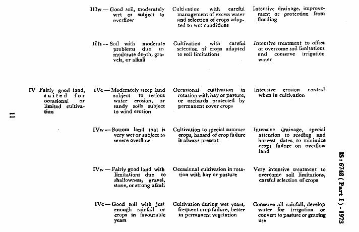
IV Fairly good land, suited for occasional limited cultivz tion
111~ - Good soil, moderately wet or subject to overflow
Ilh - Soil with moderate problems due to moderate depth, gra- vels, or alkali
IVe -Moderately steep land subject to serious water erosion, or sandy soils subject to wind erosion
IVw- Bottom land that is very wet or subject to severe overflow
IVW Fairly good land with limitations due to shallowness, gravel, atone, or strong alkali
WC-Good soil with just enough rainfall or crops in favourable years
Cultivation with careful management of excess water and selection of crops adap- ted to wet conditions
Cultivation with careful selection of crops adapted to soil limitations
Occasional cultivation in rotation with hay or pasture, or orchards protected by permanent cover crops
Cultivation to special summer orops, hazard of crop failure is always present
Occasional cultivation in rota- tion with hay or pasture
Cultivation during wet years, frequent crop failure, better in permanent vegetation
Intensive drainage, improve- ment or protection from flooding
Intensive treatment to offset or overcome soil limitations and conserve irrigation water
Intensive erosion control when in cultivation
Intensive drainage, special attention to seeding and harvest dates, to minimize crops failure on overflow land
Very intensive treatment to overcome soil limitations, careful selection of crops
Conserve all rainfall, develop water for irrigation or convert to pasture or grazing use
B. LAND UNSUITABLE FOR CULTIVATION
LAND CLASSIFICATION SUBCLASS ( DOMINANT KIND CLASS OF LAND )
V Very well suited fur grazing, not arable
VI Well suited for VIS - Steep land subject to grazing or fores- erosion if cover is try, not arable depleted
VII Fairly well suited for grazing or forestry, not arable
VW - Good productive mo- untain meadows that are wet and have short growing season
VIw - Ft;tnd, qccasionally saline salts,
permanently det or subject to overflow
VIs - Fza;zwgently sloping
gravelI;, stony,
or alkali land
VIc -Good or fairly good soil not enough moisture for cultivation
VIIe -Very steep land sub- ject to erosion if cover is depleted
SUITABLE FOR ( ONLY THE SPECIAL NEEDS OR MOST INTENSIVE SAFE USE IS PRECAU’~~ONS
MENTIONED )
Grazing and production of Proper season of use and rate wild hay of stocking; protect from
gullying
Grazing or forestry of both Manage grazing and logging to maintain sufficient residue and litter on the soil for soil and moisture conservation, fire protection
Grazing Manage grazing to prevent soil puddling, and to favour desire forage plants
Grazing or forestry or both Good range and forestry management fire protection
practices,
Grazing primarily, some fore- Good range and forestry stry, could be cultivated if water were available
management fire protection
practices,
Grazing or forestry or both Carefully manage grazmg and logging tq maintain enough plant litter for soil and moisture conservation, fire protection
L
w
VIIw - Flat, permanentlray; or overflow along stream, tidal marsh areas
VII5 -Very shallow, stony, or strbng alkali land
VIIc - Fairly good aoil, not enough moisture for cultivation
VIII Suited ohly for VIIie -Highly erodible- wild life, recrea- gullies, bad lands, tion and protec- and sand dunes tion of water supplies
VIIIw - Tidal land, strealh channels and swamps
VIIIr- Barren mountain topg, hst160r no sol1
Nm -T&se symbols denote subiclauees:
e - erosion and runoff
w-excess water s -root-zone limitations
c - climatic limitation
Limited grazing
Grazing or forestry or both
Grazing or forestry or both
Watershed and wild life
Wild life, recreation, and water spreading
Recreation and watershed
Range grazing to favour desirable plants
Good range and forestry management, fire protec- tion
Good range and forestry management, fire protec- tion


![Durham Research Onlinedro.dur.ac.uk/6748/1/6748.pdf · 2020-05-24 · several billion lifetimes of the universe‟ [4]. Models are also bound to be simplifications of real systems](https://static.documents.pub/doc/80x56/5ed95a62f59b0f56f45f54e5/durham-research-2020-05-24-several-billion-lifetimes-of-the-universea-4-models.jpg)


