Page 1
Adib et al. / Iranian Journal of Earth Sciences 9 (2017) / 168-183
168
Determination of a Conceptual Model for the Structural
Features and Pb–Zn Mineralization in the North of
Behabad Fault Zone, Central Iran
Ahamd Adib
*1, Shapour Mirzaei Ilani
2, Gholamreza Shoaei
3, Peyman Afzal
4
1. Department of Petroleum Engineering, South Tehran Branch, Islamic Azad University, Tehran, Iran
2. Zamin Kav Environmental & Geology Research Center, Tehran, Iran
3. Department of Geology, Tarbiat Modares University, Tehran, Iran
4. Department of Mining Engineering, South Tehran Branch, Islamic Azad University, Tehran, Iran
Received 17 November 2016; accepted 4 April 2017
Abstract
The Behabad region is located within a tectono–sedimentary zone in southeast Yazd province, Central Iran. The tectonic
activities have deformed and faulted the Mesozoic and Quaternary formations in this area. The faults in Kuhbanan and Behabad have
played a key role in the evolution of geological events, mineralization, and the formation of Behabad–Kuhbanan horst. These faults
have separated the Posht-e-Badam block from the Tabas block and the Behabad zone from the Abdoghi–Ravar tectonic zone,
respectively. Remote-sensing techniques and field observations show that the Pb–Zn veins share similar trends with the structures.
The compressional system induced by the activities of the Behabad-1 and 2 fault systems have caused the formation of thrusts, drag,
and sigmoidal folds, the North Behabad horst, and shear zones containing Pb–Zn mineralization. The Mississippi Valley-type (MVT)
deposits and strata band mineralization types are present in the study area. In terms of the temporal phase controller, it is consistent
with the tectonic-magmatic model of the Late Paleozoic–Triassic period; in terms of the spatial controller, mineralization is situated
in the tectonic–metallogeny province of Central Iran and the ore deposits that mainly follow the geometry of the thrust faults’
crushed zones. The thrust fault that drives the dolomite unit over the limestone is the main cause of the ore solutions migration.
According to the MVT mineralization and the correlation between structures and mineralization, the sulfide deposits can be
potentially found at the base of the Permo–Triassic units in the studied area. There are several active and non-active Zn–Pb mines
such as Abheydar, Rikalaghi, and Tapesorkh.
Keywords: Conceptual model; non-sulfide mineralization; Behabad fault; Kuhbanan fault.
1. Introduction The study area is located in the southeast of the Yazd
province and the northeast of the Behabad city in the
tectono-sedimentary zone of the Tabas block, Central
Iran (Fig 1). The Kuhbanan and Behabad-1 and 2 faults
have played a major role in the geological and
mineralization processes of this area, and have resulted
in the formation of various structural zones in this
region, such as the Kuhbanan and Behabad-1 faults, the
Posht-e-Badam block, the Tabas block, the Behabad
zone, and the Abdoghi–Ravar tectonic zone,
respectively (Kargaran Bafghi et al. 2012; Adib et al.
2017). Geological processes such as igneous and
metamorphic activities and ore deposits occur within the
plate boundaries (such as thrusts), which are often
identified by fault zones (Alavi 1991; Leach et al. 2001;
Robb 2005). These mineralizations are very similar to
the Mississippi Valley-type (MVT) in which
mineralizations like barite, lead, and zinc deposits occur
within the carbonate host rock. In the Behabad and
--------------------- *Corresponding author.
E-mail address (es): [email protected]
Mehdiabad regions (~70 Km SW of Behabad fault),
minerals are formed in the continental rifts and margins
(Evans 2000; Piri and Asghari 2012). Thus, it can be
stated that the mineral deposits in the Behabad region
are MVT with various geological units, such as shale,
sandstone, conglomerate, gypsum, limestone, and
dolomite.
In this research, the main tectonic characteristics of the
area are counted among the important controlling
factors in the mineralization processes. Hence, the
structural parameters in relation with mineralization are
described by a structural–mineralization conceptual
model. Deformations of the study area are consistent
with the recent activities of the faults (Mahdavi
1996;Walker and Jackson 2004), while the active
faulting is affected by a N–S dextral strike-slip shearing
between the Iranian plate and Western Afghanistan with
a movement rate of 15 mm y-1(Vernant et al. 2004a).
The recent activities of the major NW–SE regional
structures are mostly in form of a strike-slip fault, and
are consistent with the trend of folds and faults of the
study area.
Islamic Azad University
Mashhad Branch
Page 2
Adib et al. / Iranian Journal of Earth Sciences 9 (2017) / 168-183
169
Fig 1. Location of the studied area and the simplified geological map of Southwestern Central Iran, showing major Eocene and
Neogene to the recent faults (Kargaran Bafghi et al. 2012).
The density of lineaments depends on the extent of the
tectonic uplift and represents its active tectonic features
(Walker 2006). Migration of the solutions along the
rock joints results in the hydrothermal alteration of the
rocks. Metallic prospects can be discovered by tracing
this phenomenon (Kearey et al. 2009).
The leaching and enrichment processes depicted in
Gilbert and Park’s (Guilbert and Park 1997) schematic
diagram might be used to illustrate the location of Pb–
Zn mineralization in the supergene environments. Based
on this diagram, lead, anglesite, and cerussite are
formed above the water level table (Bateman 1950).
Smithsonite, hydrozincite, and hemimorphite are
formed near the surface, while smithsonite and gypsum
emerge below the water level. Iron oxide and lead
sulfate are relatively insoluble and remain at the surface.
Galena is soluble in a solution containing ferric sulfate,
whereas the stable lead carbonate is formed in the veins,
in which the other sulfides are altered or washed away.
Silver and zinc sulfides are soluble in the presence of
ferric sulfate fluids (Guilbert and Park 1997).Because of
the solubility of zinc sulfate, the zinc containing the
most oxidized bodies is scattered in the groundwater
and can be presented as smithsonite, hydrozincite, and
hemimorphite or in form of other carbonate minerals
and silicate above the surface. This process may occur
in semi-arid climates, such as that of Behabad, in
carbonate rocks. The main aim of this study is to
propose a conceptual model for the MVT Pb–Zn
Study area
Page 3
Adib et al. / Iranian Journal of Earth Sciences 9 (2017) / 168-183
170
mineralization in the Behabad faulting zone based on
geology, field observations, and known mines/deposits.
2. Geology and tectonic setting The Infra Cambrian to Quaternary rock units of Central
Iran are affected by orogenic phases, magmatism, and
metamorphism. The Central Iran micro-continent is
surrounded by the ophiolitic sutures of Sistan,Nain–
Baft, the Darouneh fault, and the ophiolites of
Kashmar–Sabzevar. The activities of the faults with the
strike-slip component are found in the Shotori, Tabas,
Kalmard, Posht-e-Badam, Bayazeh–Bardsir, and Yazd
blocks (Bateman 1950; Takin 1972; Berberian 1981;
Jackson and McKenzie 1984; Kargaran Bafghi et al,
2012). Based on the structural sub-stages, magmatism,
metamorphism, mineralization, stratigraphic sequences,
and the deformation of the basement, the study area is
located in the middle part of Central Iran in the Tabas
block (Fig 1).
The Permian outcrops in the study area consist of
siliceous clastic rocks impregnated with iron
compounds located on the Shotori formation by a
normal overlap (Nadimi 2007). In the eastern region of
Behabad, the Triassic carbonate rock sequences are
covered by Jurassic gypsum units. The rocks of the
Upper Triassic to the Lower Jurassic (Lias) are covered
by tectonic boundaries of the Shotori formation. The
sequence of a thin layer of limestone with mid-layers of
green shale covers the Hojedk formation (Mahdavi
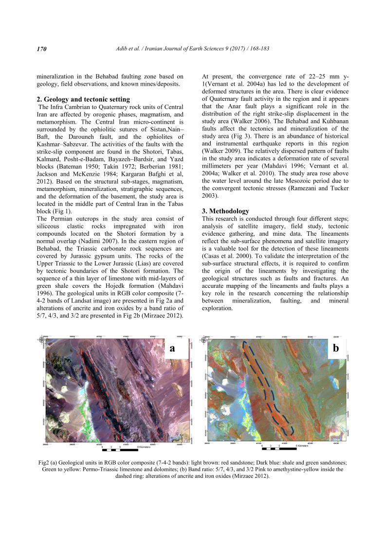
1996). The geological units in RGB color composite (7-
4-2 bands of Landsat image) are presented in Fig 2a and
alterations of ancrite and iron oxides by a band ratio of
5/7, 4/3, and 3/2 are presented in Fig 2b (Mirzaee 2012).
At present, the convergence rate of 22–25 mm y-
1(Vernant et al. 2004a) has led to the development of
deformed structures in the area. There is clear evidence
of Quaternary fault activity in the region and it appears
that the Anar fault plays a significant role in the
distribution of the right strike-slip displacement in the
study area (Walker 2006). The Behabad and Kuhbanan
faults affect the tectonics and mineralization of the
study area (Fig 3). There is an abundance of historical
and instrumental earthquake reports in this region
(Walker 2009). The relatively dispersed pattern of faults
in the study area indicates a deformation rate of several
millimeters per year (Mahdavi 1996; Vernant et al.
2004a; Walker et al. 2010). The study area rose above
the water level around the late Mesozoic period due to
the convergent tectonic stresses (Ramezani and Tucker
2003).
3. Methodology This research is conducted through four different steps;
analysis of satellite imagery, field study, tectonic
evidence gathering, and mine data. The lineaments
reflect the sub-surface phenomena and satellite imagery
is a valuable tool for the detection of these lineaments
(Casas et al. 2000). To validate the interpretation of the
sub-surface structural effects, it is required to confirm
the origin of the lineaments by investigating the
geological structures such as faults and fractures. An
accurate mapping of the lineaments and faults plays a
key role in the research concerning the relationship
between mineralization, faulting, and mineral
exploration.
Fig2 (a) Geological units in RGB color composite (7-4-2 bands): light brown: red sandstone; Dark blue: shale and green sandstones;
Green to yellow: Permo-Triassic limestone and dolomites; (b) Band ratio: 5/7, 4/3, and 3/2 Pink to amethystine-yellow inside the
dashed ring: alterations of ancrite and iron oxides (Mirzaee 2012).
a b
Page 4
Adib et al. / Iranian Journal of Earth Sciences 9 (2017) / 168-183
171
Fig 3. The fault system, geological units, and the location of the studied mines (The NE–SW faults are mainly tensional with the
strike-slip component).
Lineaments and zones of alteration are extracted from
the ETM multispectral images using PCI Geomatica
software (PCI 2012) by applying various filters like the
Envi Software. To confirm the fault lineaments and
provide information on the distribution of active
faulting, the extraction is validated through a series of
field surveys (e.g. Sarp and Toprak 2005). Then, to
identify the major and minor fault trends, their rose
diagrams are compared with mineralization and
alteration evidences in these zones. To construct a
conceptual model in this area, mineralization-
controlling indexes at the regional scale, the
stratigraphic evolution, structures, and regional
mineralization, as well as the spatial and temporal
controllers are investigated.
4. Result and discussion 4-1.Faulting and alteration
Most alterations are used as a guideline to find the
relationship with the other structural factors
(Shahabpour 2005). The study area mainly consists of
limestone, dolomitic limestone, shale, and sandstone
(Fig. 2A). The hydrothermal solutions cause the
alteration in the limestone (Fig.2B). The hydrothermal
solutions are directed by fractures toward the ground
surface. At the intersection between the faults and
fractures with the dolomites, mineralization is likely to
occur (Kearey et al. 2009). The studies indicated that
mineralization and alteration areas are mostly located in
the dolomites and the limestone near or along the thrust
faults. The northwest, north, and central parts of the
10 0 105 Kilometers
414000 421000 428000 428000 428000
3531000
3522000
3513000
3504000
3495000
pudan
Ab-heidar
Rikalaghy
Gicherkoh
Dehasgar
Goger
Behabad Fault 2
Behabad Fault 1
Kohbanan Fault
Fig.5
Page 5
Adib et al. / Iranian Journal of Earth Sciences 9 (2017) / 168-183
172
region have the largest diversity and number of
structural fractures (Fig.2 and Fig.4). Thus, these areas
might have the greatest mineralization potential.
The structures of the area are affected by the movement
of the Tabas block toward its adjacent blocks (Posht-e-
Badam, and Yazd). Transpressional deformation, drag
and sigmoidal folds, and the direction of thrusting in
oblique-slip tear faults are the obvious reasons for the
dextral component of the Behabad strike-slip faults
(Adib 1998). The Kuhbanan and Behabad dextral strike-
slip faults converge around the west of Ravar to Gojer
mine (Fig.3), where the tension system between these
faults results in the formation of the Behabad
depression. The compressional fault system between
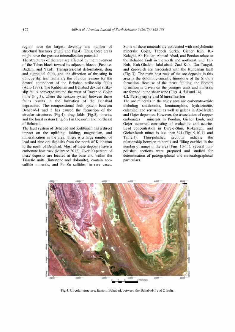
Behabad-1 and 2 has caused the formation of the
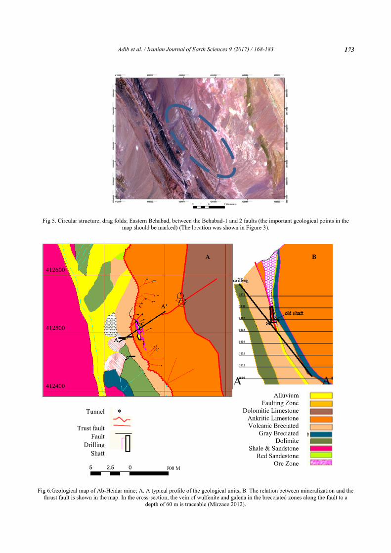
circular structures (Fig.4), drag folds (Fig.5), thrusts,
and the horst system (Fig.6,7) in the north and northeast
of Behabad.
The fault system of Behabad and Kuhbanan has a direct
impact on the uplifting, folding, magmatism, and
mineralization in the area. There is a large number of
lead and zinc ore deposits from the north of Kuhbanan
to the north of Behabad. Most of these deposits have a
carbonate host rock (Mirzaee 2012). Over 90 percent of
these deposits are located at the base and within the
Triassic units (limestone and dolomite), contain non-
sulfide minerals, and Pb–Zn sulfides, in rare cases.
Some of these minerals are associated with molybdenite
minerals. Gojer, Tappeh Sorkh, Gicher Kuh, Ri-
Kalaghi, Ab-Heidar, Ahmad-Abad, and Poodan relate to
the Behabad fault in the north and northeast, and Taj-
Kuh, Kuh-Ghaleh, Jalal-abad, Zard-Kuh, Dar-Tangol,
and Zar-kuieh are associated with the Kuhbanan fault
(Fig. 3). The main host rock of the ore deposits in this
area is the dolomitic–ancritic limestone of the Shotori
formation. Because of the thrust faulting, the Shotori
formation is driven on the younger units and minerals
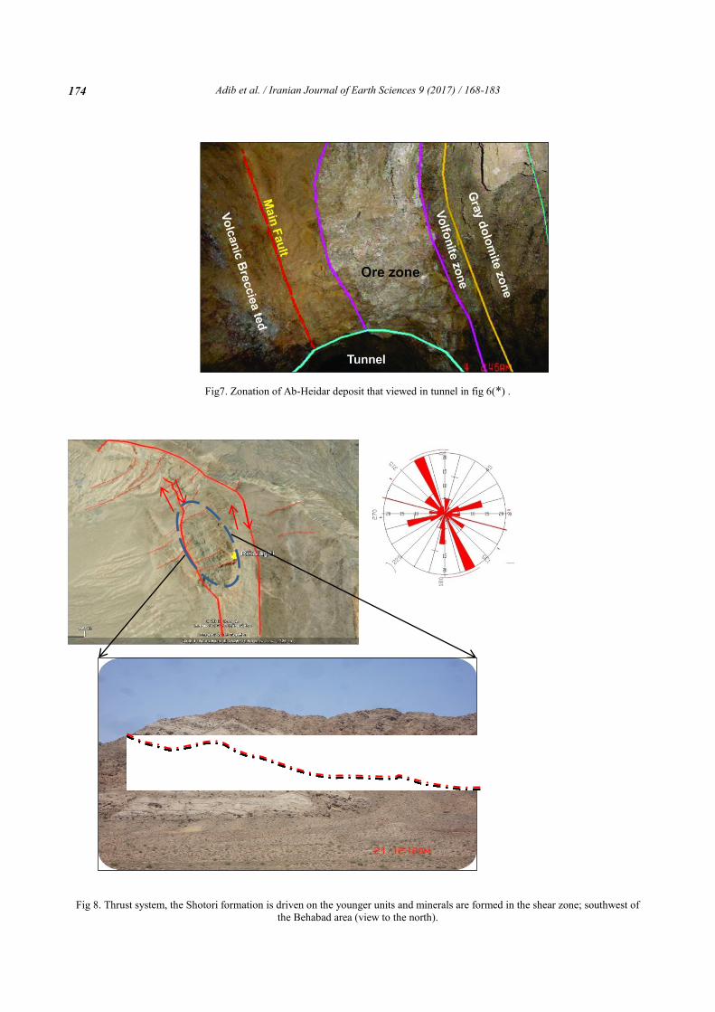
are formed in the shear zone (Figs. 4, 5,8 and 14).
4.2. Petrography and Mineralization
The ore minerals in the study area are carbonate-oxide
including smithsonite, hemimorphite, hydrozincite,
calamine, and serussite; as well as galena in Ab-Heidar
and Gojer deposites. However, the association of copper
carbonates minerals in Poodan, Gicher kouh, and
Gojer occurred consisting of malachite and azurite.
Lead concentration in Dare-e-Shur, Ri-kalaghi, and
Gicher-kouh mines is less than %1,(Figs 9,10,11 and
Table.1). Thin-polished sections indicate the
relationship between minerals and filling cavities in the
number of mines in the area (Figs. 10-11). Several thin-
polished sections were prepared and studied for
determination of petrographical and mineralographical
particulars.
Fig 4. Circular structure; Eastern Behabad, between the Behabad-1 and 2 faults.
Page 6
Adib et al. / Iranian Journal of Earth Sciences 9 (2017) / 168-183
173
Fig 5. Circular structure, drag folds; Eastern Behabad, between the Behabad-1 and 2 faults (the important geological points in the
map should be marked) (The location was shown in Figure 3).
Fig 6.Geological map of Ab-Heidar mine; A. A typical profile of the geological units; B. The relation between mineralization and the
thrust fault is shown in the map. In the cross-section, the vein of wulfenite and galena in the brecciated zones along the fault to a
depth of 60 m is traceable (Mirzaee 2012).
5 0 52.5 Kilometers
5 0 52.5 Kilometers
5 0 52.5 Kilometers
5 0 52.5 Kilometers
Alluvium
Faulting Zone
Dolomitic Limestone
Ankritic Limestone
Volcanic Breciated
Gray Breciated
Dolimite
Shale & Sandstone
Red Sandestone
Ore Zone
Tunnel
Trust fault
Fault
Drilling
Shaft
100 M
A B
*
*
Page 7
Adib et al. / Iranian Journal of Earth Sciences 9 (2017) / 168-183
174
Fig7. Zonation of Ab-Heidar deposit that viewed in tunnel in fig 6(*) .
Fig 8. Thrust system, the Shotori formation is driven on the younger units and minerals are formed in the shear zone; southwest of
the Behabad area (view to the north).
Page 8
Adib et al. / Iranian Journal of Earth Sciences 9 (2017) / 168-183
175
Fig 9. Abhydar Pb–Zn Mine; (a) The relationship between dolomite rocks (dol) and the conversion of minerals (gallons [gn] to
cerozitis [ce]) ; (b) Gallons (gn) to fill cavities and dolomites also seen between gallons (gn) and Cerussite(ce).
Fig 10. Gujer Mine; (a) Coarse crystalline dolomite epigenetic in micrite; (b) and (c) Hemimorphite with iron oxide minerals from
pyrite in the early sulfur ore; (d) Dolomitization along fractures in micritic background.
Table 1 presents the mineralogical composition and
abundance of Fe,Zn,Pb,Cu elements in some of these
mines. In the carbonate host rock, the concentration of
Zn is more than the lead. During the process of non-
sulfide minerals, sphalerite is formed as secondary
mineral, while galena is brecciated and changes in to the
cerussite (Cer) and anglesite. In Ab-Heidar and Gojer
mines, mineralization is observed in the form of veins
and lenses with variable length and thickness.
Mineralogical composition represents the primary
Mississippi Valley Type (MVT) mineralization/deposits
and secondary non sulfide supergene enriched by the
mines.
a b
Page 9
Adib et al. / Iranian Journal of Earth Sciences 9 (2017) / 168-183
176
Fig 11. Gicher Kuh Mine; (a) Calamine (Zn Co3) with chloroform texture; (b) Calamine with Calcite; (c) Fractures
filled with pyrite; d. Goethite and calamine in carbonate rocks.
Table1. Characteristics of the Pb-Zn min the study area
In these mines, a temperature of 200 to 250℃ was
likely the cause of sulfides dissolution from the
probable organic shale containing lead, zinc, and iron
sulfides, and mineralization in carbonate host rock what
is the evidences for this state. Colloform texture in the
secondary minerals implies presence of low to medium
temperature in this area (Leach et al. 2001 and 2010).
Permeation of mineral fluids is more obvious in the
Mine Name Gange Ore Mineral Length (m) Width(m) Cu% Pb% Zn% Fe%
Ab Heidar Dol+Cal+Iron Oxide+Gyp
Gal+Cer+Hem+Smit+Wolf
65 0.5-3 >1 3_5 16_19 2_3
Dahaneh Shur Dol+Cal+Iron
Oxide Hem+Smit 30 0.5-5 >1 >1 15_25 8_10
Luk-e-Siah Dol+Cal+Iron
Oxide Hem+Smit 15 0.2-5 >1 >1 15_23 8_10
Rig-e-Kalaghi Dol+Cal+Iron
Oxide Hem+Smit+Cer 90 0.2-10 >1 >1 29_31 8_10
Gijar Kuh Dol+Cal+Iron
Oxide Hem+Smit+Cer+
Hzin 250 0.1-8 >1 >1 20_35 2_3
Deh-e-Asghar Dol+Cal+Iron
Oxide Gal+Cer+Hem+S
mit 120 0.1-7 >1 >1 20_30 8_11
Tapeh Sorkh Dol+Cal+Iron
Oxide Hem+Smit+Cer+
Hzin 150 0.1-10 >1 >1 25_35 5_15
Gujar Dol+Cal+Iron
Oxide Hem+Smit+Cer+
Hzin 300 0.5-15 >1 >1 25_35 3_5
a
d c
b Calamin
Ca
Py Ca Go
Ca
Calamin
1000 µ
500 µ 1000 µ
1000 µ
Page 10
Adib et al. / Iranian Journal of Earth Sciences 9 (2017) / 168-183
177
deeper host rocks, where non sulfide Zn mineralization
like (calamine, smithsonite, hemimorphite, hydrozincite,
and olegiste) contain small percent of lead (Mirzaee
2012). Thus, these deposits provide very interesting
examples of non-sulfide lead-zinc mineralization. In the
Ab-Heidar mine (Figs.12 and 13), the mineral veins
containing galena are exposed in the east of the non-
sulfide main vein. The main oxide and carbonate
minerals in this area are hematite, goethite, cerussite,
smithsonite, and hemimorphite. There are sulfide
minerals in some deposits in Taj-Kuh, Ab-Heidar, and
Senjedu ores. In Gojer and Gicher-kuh ores, presence of
iron oxide, hydrozincite, cerussite, anglesite,
hemimorphite, malecite, and azurite non-sulfide ores are
detected. Nevertheless, sulfide mineralization is also
expected at depths below groundwater level.
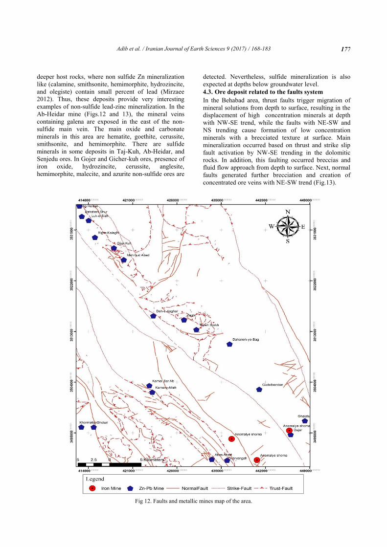
4.3. Ore deposit related to the faults system
In the Behabad area, thrust faults trigger migration of
mineral solutions from depth to surface, resulting in the
displacement of high concentration minerals at depth
with NW-SE trend, while the faults with NE-SW and
NS trending cause formation of low concentration
minerals with a brecciated texture at surface. Main
mineralization occurred based on thrust and strike slip
fault activation by NW-SE trending in the dolomitic
rocks. In addition, this faulting occurred breccias and
fluid flow approach from depth to surface. Next, normal
faults generated further brecciation and creation of
concentrated ore veins with NE-SW trend (Fig.13).
Fig 12. Faults and metallic mines map of the area.
Page 11
Adib et al. / Iranian Journal of Earth Sciences 9 (2017) / 168-183
178
Fig 13. Fault density map of the area.
Presence of hemimorphite, hydrozincite, and calamine
in brecciated dolomite indicates the effect of faulting in
mineralization process in the form of cavity filling in
the brecciated zones.
This process is associated with shallow faults and in
steep thrust belts in the vein and epigenetic forms.
Most of the high concentration mineralized veins
following the Behabad fault trend. Because of the re-
mobility of supergene hydrothermal fluids, Zinc
mineralization (i.e. calamine) are reformed and the high
concentration calamine veins are developed around the
karstic and dissolution areas. Extent of breccia is mainly
limited to the zones around the veins, implying genesis
of breccia with of tectonic activities.
In the eastern and western Behabad subsidence, the fault
system has controlled the trend of mineralization. In
Figure 12 faults map and their location relative to the
iron, lead and zinc mines in the Behabad-Kuhbanan
shown, distance between faults and Pb, Zn and Fe mines
are 200 and 1,200 meters. Most mineral evidences have
relationship with Behabad 1 and 2 thrust faults.
Furthermore, the rose diagram and fault densities’ map
were prepared which show the association of
mineralized faults (Figs 12,13 and 14).
The dominant veins are with 300-330 degrees azimuth,
which are very good agreement with the NW-SE faults.
Most of the faults have NW-SE trend in the area with
intense intersection of thrust and normal faults and ore
vines are formed in the NW and SE of the Behabad
area. The overlap between the faults map and
mineralized veins shows that the association of between
ore veins and fault zones. Most metallic mines are
situated in 200 to 1500 meters’ distances from the main
fault line within the zone of Behabad 1.
Page 12
Adib et al. / Iranian Journal of Earth Sciences 9 (2017) / 168-183
179
Fig 14. The rose diagram shows the main strike of faults (N–
NW and SE). The predominant strike-slip faults with a reverse
component are marked with a red color (NW–SE), the thrust
fault with a green color (NW–SE) and the normal faults are
shown striking NE–SW.
4.4 Structure–Mineralization Conceptual Model
Statistical analysis shows that most of the folds have
strikes extended from N65W to N35W (Fig.15).
Fig 15 (a). Regional pattern of the strike-slip shear zone in
Kuhbanan and Behabad compared with the rose diagram of
the area; R1 and R2 are riddle and conjugate faults, N and F
represent the normal and trust faults, respectively and F is the
axis of folding (Adib 1998); (b). The rose diagram of the
faults in the N–NW and SE.
Since the folds always have a strike that is
perpendicular to the axis of the principal compressive
stress, the direction of the tectonic force is N30E (Adib
1998). The rose diagrams of the joints in most deposits
reveal the effect of structure on ore accumulation. The
spatial distribution of non-sulfide mines such as Tarz,
Gojer, Tap-e-Sorkh, Gicher-kuh, Ri-kalaghi, Dar-e-
Shur, and Ab-Heidar in the east of the Behabad-1 fault
in the Abdoghi tectonic zone shows that the faults
control the mineralization processes. All evaluated
deposits and mineralization signs have the dolomitic
host rock and are controlled by the faults, particularly
the Behabad fault. The tectonic-mineralization
conceptual models are presented in Figs.16–18 based on
the field results and studies. The schematic model of the
thrust fault development, brecciation of dolomite,
influence of hydrothermal solutions (mainly lead and
zinc rich fluids), and vein formation are shown in Fig.17
(Steps 1 to 3).
Page 13
Adib et al. / Iranian Journal of Earth Sciences 9 (2017) / 168-183
180
Fig 16. The schematic cross section of the tectonic-mineralization conceptual model for the epigenetic non-sulfide Pb–Zn mineral
veins of the Permo–Triassic dolomites in Northern Behabad.
Fig 17. The schematic map of the tectonic-mineralization conceptual model for the Pb–Zn non-sulfide mineral veins of the Permo–
Triassic dolomites in Northern Behabad.
Page 14
Adib et al. / Iranian Journal of Earth Sciences 9 (2017) / 168-183
181
Fig 18. The schematic model indicating the steps involved in the formation of the normal fault with the strike-slip component,
brecciating of dolomites and veins, re-mobility of the zinc-containing hydrothermal solution. The mineralization process occurs in
the fault plane, joints and fractures and everywhere that the hydrothermal solution containing zinc and iron is distributed in different
parts of the brecciated rocks.
5. Conclusions There is a significant relation between the
mineralization and structural system in the north of
Behabad. This relation is provided by the number of
lead and zinc vein outcrops along the Behabad-1 fault.
In terms of the tectonic-mineralization formation
setting, the area presents an inter-continental and
continental margin region with carbonate host rocks
similar to the MVT lead and zinc deposits. Based on the
temporal control factors, the area is a part of the Late
Paleozoic–Triassic mineralization phase and, according
to the spatial control factors, it is a part of the Central
Iran and Bafq–Behabad tectonic–metallogeny
provinces. The Behabad fault system is the main
controller of the deformation of the northern Behabad
structural zone, where the mineral resources of the area
follow the fault geometry. Firstly, the Behabad-1 and
Behabad-2 faults were formed in the west and east of
the area, respectively. Secondly, the compression
system of the strike-slip movements between these two
faults has caused the thrusts, sigmoidal and drag folds,
and the bulge of the northern Behabad. In the final
stages, normal faulting with the strike-slip component is
the governing phenomenon in the northern part of the
region. The thrust fault, with the northwest-to-southeast
trend, is probably the main pathway for the movement
Page 15
Adib et al. / Iranian Journal of Earth Sciences 9 (2017) / 168-183
182
of the ore solution from the depth to the surface (faults
can provide a way or channel for ore fluid movements).
The performance of the faults has caused a displacement
of the veins, the formation of high-concentration
mineral patches at the bottom, and low-grade
mineralization with the brecciated texture in the surface.
The mineralization in this area is mostly controlled by
these faults and related structures. Additionally,
dolomites are brecciated due to the faulting processes
that host the ore minerals, including hemimorphite,
hydrozincite, and calamine associated with oligest.
According to the MVT mineralization in the structural–
mineralization conceptual model, sulfide deposits are
emplaced at the base of the Permo–Triassic dolomitic
units.
Acknowledgement The authors would like to thank the research deputy of
the Islamic Azad University, South Tehran branch for
supporting this research.
References Adib A (1998) Structural analysis and active tectonics of
east Yazd. Ph.D thesis on Structural geology, Islamic
Azad University, Science and Research branch, 370p.
(In Persian with English abstract)
Adib A, Afzal P, Mirzaei Ilani S, Aliyari F)2017)
Determination of the relationship between major fault
and zinc mineralization using fractal modeling in the
Behabad fault zone, central Iran. Journal of African
Earth Sciences 134: 308-319.
Alavi M (1991) Tectonic map of the Middle East,
1:5000000, Iranian Geological Survey and Mineral
Exploration Publications.
Bateman AM (1950) Economic Mineral Deposits, 2nd ed.
Wiley, New York 916.
Berberian M (1981) Active Faulting and Tectonics of Iran
in Zagros, Hindu Kush, and Himalaya: Geodynamic
Evolution, Geodynamic Series, edited by H. K. Gupta
and F. M. Delany 3:33 – 69.
Casas AM, Cortes AL, Maestro A, Soriano MA, Riaguas
A, Bernal J (2000) A Program for Lineament Length
and Density Analysis. Computers and Geosciences
26:1011-1022.
Chu D, Gordon RG (1998) Current Plate Motions a cross
the Red Sea, Geophysical Journal International 135:
313 – 328.
DeMets C, Gordon RG, Argus DF, Stein S (1994) Effect
Of Recent Revisions To The Geomagnetic Reversal
Time Scale On Estimates Of Current Plate Motions,
Geophysical Research Letter 21: 2191– 2194.
Evans AM (2000) Ore geology and industrial minerals An
Introduction, Black well Pub 3th Edition, Oxford, p 389.
Jackson J, McKenzie D (1984) Active Tectonics of the
Alpine-Himalayan Belt between Western Turkey and
Pakistan, Geophysical Journal of the Royal
Astronomical Society 77: 185-264.
Guilbert J, Park CF(1997) The Geology of Ore Deposits.
W.H. Freeman and Company Pub New York, p 985.
Kargaran Bafghi F, Franz Neubauer F, Genser J, Faghih A
and Kusky T (2012) Mesozoic to Eocene ductile
deformation of western Central Iran: From Cimmerian
collisional orogeny to Eocene exhumation,
Tectonophysics 564–565, 83–100.
Kearey Ph, Klepeis KA, Vine FJ (2009) Global Tectonics.
3th ed. Wiley-Black Well Pub P 482.
Leach DL, Bradley D, Lewchuk MT, Symons DT, Marsily
G, Brannon J (2001) Mississippi Valley type lead-zinc
deposits through geological time - implications from
recent age-dating research. Mineralium Deposita
36:711-740.
Leach DL, Bradley DC, Huston D, Pisarevsky SA, Taylor
RD, Gardoll SJ (2010) Sediment-Hosted Lead-Zinc
Deposits in Earth History, Economic Geology 105: 593–
625.
Mahdavi MA (1996) Geology Map of the Behabad,
1:100,000, Iranian Geological Survey and Mineral
Exploration Publications.
Mirzaee S (2012) The Study of Relation of Structural
Features with Mineralization of the Behabad Area. MSc
Thesis on Structural geology, Islamic Azad University,
North Tehran Branch, p 160 (in Persian with English
abstract)
Nadimi A (2007) Evolution of the Central Iranian
Basement, Gondwana Research 12:324-333.
PCI Geomatics Enterprises (2011) PCI Geomatica 2012
software.
Piri M, Asghari O (2012) Structural Analysis of Lead And
Zinc Ore Reserve Estimation of Mehdi Abad, Twenty-
Ninth Meeting of Earth Sciences, Iranian Geological
Survey and Mineral Exploration Publications.
Ramezani J, Tucker RD (2003) The Saghand Region,
Central Iran: U-Pb Geochronology, Petrogenesis and
Implications for Gondwana Tectonics. American
Journal of Science 303:622-665.
Robb L(2005) Introduction to Ore-Forming Processes.
Blackwell Pub p 373.
Sarp G, Toprak V (2005) Lineament Analysis from
Satellite Images, North-West of Ankara, p76.
Sella GF, Dixon TH, Mao A (2002) REVEL: A Model for
Recent Plate Velocities from Space Geodesy, Journal of
geophysical research 107: 2081-2091.
Shahabpour J (2005) Tectonic Evolution of The Orogenic
Belt in the Region Located Between Kerman and
Neyriz. Journal of Asian Earth Sciences 24:504-417.
Takin M (1972) Iranian Geology and Continental Drift in
the Middle East, Nature 235:147-150.
Vernant PH, Nilfroushan F, Hatzfeld D, Abbassi MR,
Vigny C, Masson F, Nanakali H, Martinod J, Ashtiani
A, Bayer R, Tavakoli F, Chery J(2004a) Contemporary
Crustal Deformation and Plate Kinematics in Middle
East Constrained by GPS Measurements in Iran and
Northern Oman. Geophysical Journal International
157:381–398.
Page 16
Adib et al. / Iranian Journal of Earth Sciences 9 (2017) / 168-183
183
Walker RT, Jackson J (2002) Offset and Evolution of the
Gowk Fault, S.E. Iran:A Major Intra-Continental Strike-
Slip System, Journal of Structural Geology 24:1677–
1698.
Walker R, Jackson J (2004) Active Tectonics and Late
Cenozoic Strain Distribution in Central and Eastern
Iran. Tectonics 23:157-170
Walker RT(2006) A Remote Sensing Study of Active
Folding and Faulting in Southern Kerman Province,
S.E. Iran, Journal of Structural Geology 28:654–668.
Walker RT, Gans P, Allen MB, Jackson J, Khatib M,
Marsh N, Zarrinkoub M (2009) Late Cenozoic
Volcanism and Rates of Active Faulting in Eastern Iran:
Geophysical Journal International 177:783–805.
Walker RT, Talebian M, Saiffori S, Sloan RA, Rasheedi A,
Mac Bean N, Ghassemi A (2010) Active Faulting,
Earthquakes, and Restraining Bend Development near
Kerman City in Southeastern Iran: Journal of Structural
Geology 32:1046–1060.


![Index [assets.cambridge.org]assets.cambridge.org/97811076/59728/index/9781107659728_index.pdf · Index More information ... Azad, Chandra Sekhar, 324 Azad, Maulana, 313 Azad, Maulana](https://static.documents.pub/doc/80x56/5b14f4647f8b9a54488d12ee/index-index-more-information-azad-chandra-sekhar-324-azad-maulana.jpg)


![Indigenous Enhanced Mineralization Pyrene, Benzo[a]pyrene ...Indigenous soil microorganism mineralization experiments. All of the mineralization experiments were performed by using](https://static.documents.pub/doc/80x56/5e7c41b0b7c4ef64181e5e16/indigenous-enhanced-mineralization-pyrene-benzoapyrene-indigenous-soil-microorganism.jpg)

