PLEASE SCROLL DOWN FOR ARTICLE This article was downloaded by: [CDL Journals Account]On: 20 April 2011 Access details: Access Details: [subscription number 922973516]Publisher RoutledgeInforma Ltd Registered in England and Wales Registered Number: 1072954 Registered office: Mortimer House, 37- 41 Mortimer Street, London W1T 3JH, UK The Journal of Island and Coastal Archaeology Publication details, including instructions for authors and subscription information: http://www. informaworld.co m/smpp/title~con tent=t716100767 Households and Hierarchy: Domestic Modes of Production in Leeward Kohala, Hawai'i Island Julie S. Field a ; Patrick V. Kirch b ; Kathy Kawelu c ; Thegn N. Ladefoged d a Department of Anthropology, The Ohio State University, Columbus, Ohio, USA b Department ofAnthropolog y, University of California, Berkeley, Berkeley, California, USA c Anthropology Department , University of Hawai'i, Hilo, Hawai'i, USA d Department of Anthropology, University ofAuckland, Auckland, New Zealand Online publication date: 09 April 2010 To cite this Article Field, Julie S. , Kirch, Patrick V. , Kawelu, Kathy and Ladefoged, Thegn N.(2010) 'Households and Hierarchy: Domestic Modes of Production in Leeward Kohala, Hawai'i Island', The Journal of Island and Coastal Archaeology, 5: 1, 52 — 85 To link to this Article: DOI: 10.1080/15564890903178663 URL: http://dx.doi.org/10.1080/15564890903178663 Full terms and conditions of use: http://www.informaworld.com/terms-and-conditions-of-access.pdf This article may be used for research, teaching and private study purposes. Any substantial or systematic reproduction, re-distribution, re-selling, loan or sub-licensing, systematic supply or distribution in any form to anyone is expressly forbidden. The publisher does not give any warranty express or implied or make any representation that the contents will be complete or accurate or up to date. The accuracy of any instructions, formulae and drug doses should be independently verified with primary sources. The publisher shall not be liable for any loss, actions, claims, proceedings, demand or costs or damages whatsoever or howsoever caused arising directly or indirectly in connection with or arising out of the use of this material.
This article was downloaded by: [CDL Journals Account]
On: 20 April 2011
Access details: Access Details: [subscription number 922973516]
Publisher Routledge
Informa Ltd Registered in England and Wales Registered Number: 1072954 Registered office: Mortimer House, 37-
41 Mortimer Street, London W1T 3JH, UK
The Journal of Island and Coastal ArchaeologyPublication details, including instructions for authors and subscription information:http://www.informaworld.com/smpp/title~content=t716100767
Households and Hierarchy: Domestic Modes of Production in Leeward
Kohala, Hawai'i Island Julie S. Fielda; Patrick V. Kirchb; Kathy Kaweluc; Thegn N. Ladefogedd
a Department of Anthropology, The Ohio State University, Columbus, Ohio, USA b Department of Anthropology, University of California, Berkeley, Berkeley, California, USA c AnthropologyDepartment, University of Hawai'i, Hilo, Hawai'i, USA d Department of Anthropology, University of
Auckland, Auckland, New Zealand
Online publication date: 09 April 2010
To cite this Article Field, Julie S. , Kirch, Patrick V. , Kawelu, Kathy and Ladefoged, Thegn N.(2010) 'Households andHierarchy: Domestic Modes of Production in Leeward Kohala, Hawai'i Island', The Journal of Island and CoastalArchaeology, 5: 1, 52 — 85
To link to this Article: DOI: 10.1080/15564890903178663
URL: http://dx.doi.org/10.1080/15564890903178663
Full terms and conditions of use: http://www.informaworld.com/terms-and-conditions-of-access.pdf
This article may be used for research, teaching and private study purposes. Any substantial orsystematic reproduction, re-distribution, re-selling, loan or sub-licensing, systematic supply ordistribution in any form to anyone is expressly forbidden.
The publisher does not give any warranty express or implied or make any representation that the contentswill be complete or accurate or up to date. The accuracy of any instructions, formulae and drug dosesshould be independently verified with primary sources. The publisher shall not be liable for any loss,actions, claims, proceedings, demand or costs or damages whatsoever or howsoever caused arising directly
or indirectly in connection with or arising out of the use of this material.
Households and Hierarchy:Domestic Modes of Production in LeewardKohala, Hawai‘i Island
Julie S. Field,1 Patrick V. Kirch,2 Kathy Kawelu,3 and
Thegn N. Ladefoged4
1 Department of Anthropology, The Ohio State University, Columbus, Ohio, USA 2 Department of Anthropology, University of California, Berkeley, Berkeley,
California, USA 3 Anthropology Department, University of Hawai‘i, Hilo, Hawai‘i, USA4 Department of Anthropology, University of Auckland, Auckland, New Zealand
ABSTRACT
This article describes archaeological evidence for the transformation of Hawaiian society from the fifteenth to nineteenth centuries AD. Using archaeological testing of households coupled withhigh-resolution surveydata, we trace changes in the domestic mode of production in late pre- contact Hawai‘i. These analyses yield insights into the transformationof Polynesia’s most highly stratified society. The traditional land units(ahupua‘a) of Makiloa and K alala, located on the arid, leeward coast of Kohala, Hawai‘i, are investigated with both survey and excavation,and detailed information pertaining to subsistence, household extent,and material culture are reviewed. Changes in the economy and configuration of households from the fifteenth to nineteenth centuries
AD are discussed, as are the appearance of elite residences in thelater periods. This microscale perspective on the evolution of Hawaiianeconomy and society provides a necessary complement to a macroscale perspective of human ecodynamics in the Hawaiian archipelago.
Keywords pre-contact, agriculture, human ecodynamics, Polynesia
Received 30 October 2008; accepted 13 July 2009. Address correspondence to Julie S. Field, Department of Anthropology, The Ohio State University, 4034Smith Labs, 174 W. 18th Avenue, Columbus, OH 43210, USA. E-mail: [email protected]
Since 2001 the Hawai‘i Biocomplexity Project, a multidisciplinary team includingarchaeologists, ecologists, soil scientists, de-mographers, and quantitative modelers hasinvestigated long-term human ecodynamicsin the Hawaiian archipelago (Kirch 2007a;Kirch et al. 2007). The human ecodynamicsapproach in archaeology rejects the assump-tion that the environment or ecosystemcan be detached from humans and their behavior, and argues instead that human-environmental relationships involve the co-evolution of socio-historical and naturalprocesses, resulting in what have beentermed socioecosystems (Barton et al. 2004;McGlade 1995). To that end, the first phaseof the project focused on large-scale spatialdynamicsintegratingnaturalbiogeochemicalgradients and intensive dryland agriculturalfield systems (Hartshorn et al. 2006; Kirch et al. 2004; Ladefoged and Graves 2008;
Vitousek et al. 2004). A second phase, ini-tiated in 2007, now focuses on the non-linear dynamics of population growth, agri-cultural intensification, and sociopoliticalchange.
This requires, in part, the generationof data at multiple scales: the macro scaleof islands, or districts ( moku ) within is-lands, and the micro scale of householdsand associated land units. In this paper wereport upon the micro scale, in particular the archaeological correlates of late pre-contact Hawaiian households. Our approach follows developing trends in anthropologi-
cal archaeology, in which households are widely recognized as fundamental socialunits within traditional societies (e.g., Ash-more and Wilk 1988; Cioleck-Torello 1989;Flannery, 1976; Reid and Whittlesley 1982;
WilkandRathje1982).Ourapproachseekstomodel the social and economic changes thatoccurred at the household level during thelate-prehistoric period. As outlined below,these changes often leave detectable archae-ological signatures, revealing the integration
of independent households into larger socialand economic units.
Hawaiian Households and the DomesticMode of Production
The term ‘household’ refers to a socialunit that can be variably defined by factors of economics and social relations (Levi-Strauss1979:47). Our use of the term ‘household’refers to small social groupings that areunified by bonds of kinship ( ‘ohana ) andothers who are not kin in the usual senseof consanguineal or affinal relations ( ‘ ohua ),but who were assigned roles as dependentsor helpers (Handy and Pukui 1958:5). Our use of the word ‘household’ also empha-
sizes the key role of houses or homesteads( kauhale ) as primary organizing structuresin the society. This distinction reflects the
widespread pattern of houses as units of kinship, following the “house society” model
which has been described in linguistic andethnographic studies of Austronesian andPolynesian societies from throughout thePacific (Fox 1993; Kahn and Kirch 2004;Kirch and Green 2001).
Our emphasis is also on the function of households as primary economic units. Inhis classic work on Stone Age Economics,
which drew heavily upon Hawaiian ethno-history, Sahlins (1972) pointed to the key role of households in what he termed thedomestic mode of production ( DMP ) inpre-industrial societies. The household is“charged with production, with the deploy-ment and use of labor-power, (and) with thedetermination of the economic objective”of society (1972:76–77). The key elementsof the DMP —labor, simple technology, andlimited production objectives—are system-atically interrelated. In small-scale societies,these forces combine to work against theproduction of a surplus greater than thatrequired by each household for its ownautonomous existence (Chayanov 1966). Incomplex chiefdoms, however, and more par-ticularly in the emergence of archaic states,the “anti-surplus” tendencies of the DMP areovercome to forge a larger and integratedpolitical economy. As Sahlins states: “Thepolitical economy cannot survive on thatrestrained use of resources which for the
domestic economy is a satisfactory exis-tence” (1972:135), and he points to the caseof Hawai‘i as one which took “the primitivecontradiction between the domestic andpublic economies to an ultimate crisis” be-tween a society organized on the principlesof kinship, and one dictated by the structuresof hierarchy and chiefly power (1972:141).
We hypothesize that as the base eco-nomic units of the society, pre-Europeancontact Hawaiian households would haveundergone a transformation from a largely domestic mode of production to integra-tion into a larger sociopolitical apparatus in
which one role was to produce surplus to
underwritethelargerpoliticaleconomy.Thistransformation would have occurred partly as a product of demographic growth, andpartly through a process of social transitionby which emerging elite were able to em-power themselves in relation to lower-statusindividuals. How this process occurred haslong been of interest to historians and socialscientists (Childe, 1951; Johnson and Earle1987), and has been the subject of numerousstudiesinHawai‘iandotherpartsofPolynesia
(Cordy 1981; Earle 1997; Kirch 1984, 2006;Ladefoged 1993, 1995; Service 1975). Our focus is therefore not on determining thecausal mechanisms for the evolution of socialcomplexity in ancient Hawai‘i, but to exam-ine the variables and complex relationshipsthat developed between people and their environment in the late prehistory of thearchipelago. A conceptual model of our human ecodynamics approach is graphically displayed in Figure 1. This outlines several
key variables that we seek to investigate andmodel. It is important to note that we distin-guish between classes of variables which canbe potentially studied archaeologically, fromthose which are modeled mathematically and quantitatively. In particular, elite andcommoner households are two importantcategories amenable to direct archaeologi-cal investigation. Data obtained from such features should provide evidence for key economic variables,such as the use of marine
resources, pig and dog husbandry, regionalexchange, and surplus extraction.
Because the household is the criticalnexus at which agricultural production, de-
mography, and social organization intersect, we have chosen to focus on the detailed ar-chaeological study of a sample of prehistoricfeatures on the leeward side of KohalaDistrict, Hawai‘i Island. In Hawai‘i, groupsof contiguous stone features such as enclo-sures and terraces are usually interpreted asthe archaeological correlates of households(Cordy and Kaschko 1980; Kirch and O’Day 2002; Kolb and Snead 1997; Weisler andKirch1985).Thepresenceofmarinemidden,lithic debitage, shell and bone tools, andsurface scatters of fire-cracked rock are alsokey indicators of archaeological features that
were used for residence. These features are
often thought to reflect the ethnographically attested kauhale habitation system, in which particular activities such as cooking, eating,and sleeping were carried out in separatestructures (Handy and Pukui 1958:7–14;Malo 1951:27–30). In the century prior to theoverthrow of the traditional Hawaiian ritualsystem in 1819, the activities of people of dif-ferent genders were also sometimes spatially segregated, with separate structures erectedfor particular activities of men and women,
such as cooking and eating. In this way a sin-gle household, which could have consistedof several generations of consanguineal andaffinal kin along with their ‘ ohua, wouldhave occupied a single kauhale complex.Following the introduction of Christianity the kauhale system was modified as theprohibitionsonseparategenderactivityareas
were abandoned, and Hawaiian householdsshifted to single-structure residences (Kirch 1985, 2006; Ladefoged 1991). However,
we argue that archaeological evidence fromHawai‘i suggests that important changes alsooccurred in the organization and structuringof Hawaiian households during the three tofour centuries prior to European contact (ca.
AD 1400–1778). These changes reflect theemergent social power of chiefs, and therequirements of surplus production placedon the commoner society.
By excavating a sample of archaeologicalfeatures that meet our criteria for use as resi-
dences, andplacingthesewithina chronolog-ical framework through 14C dating, we seek to obtain a data set which spans the criticaltime period over which the Hawaiian DMP
Figure 1. Conceptual model of the demographic, sociopolitical, and economic variables that we seekto investigate in Leeward Kohala. The variables outlined in grey were the focus of the 2007–2008 survey and excavations in Makiloa and K alala.
was transformed through the emergence of a regionally integrated political economy.Investigation of archaeological residentialfeatures—and through them the changingnature of Hawaiian households—has thepotential to provide a microscale perspec-tive on the evolution of Hawaiian economy and society. We regard this as a necessary complement to the macroscale perspectiveprovided by the study of landscape-levelagroecosystems, in particular the leewardKohala field system.
Kohala’s landscape is dominated by anintensive dryland agricultural field system
which extended over roughly 60 km2. Thissystem has been studied by several investi-gators, including our own project (see Lade-fogedandGraves2000,2008;Ladefogedetal.1996 for a summary of the early work includ-ing that of Rosendahl 1972, 1994). However,the nature of pre-contact households thatorganized and operated this field system,
includingtheirsizeandstructure,productionand consumption patterns, domestic tech-nology, and contribution to surplus haveremained elusive. This paper summarizesresults from the first of three field seasonsof archaeological investigation of householdfeatures in Kohala, in the adjacent traditionalland units ( ahupua‘a ) of Makiloa and K alala.
We selected these ahupua‘a because thecorresponding areas of the upland intensiveagricultural field system had already beensurveyed and dated (Ladefoged and Graves2008), and a preliminary seriation analysisof residential features in Makiloa and theadjacent ahupua‘a of Pahinahina and Kahua1 suggested limited interaction between theahupua‘a (Graves et al. 2002; O’Conner 1998). In 2007–2008 we investigated resi-dential features within the coastal zone of Makiloa and K alala, providing data to com-plement the prior inland studies. Here wereport on intensive survey and excavations
within the coastal region of Makiloa and thesouthern part of K alala, with an emphasis on14 residential complexes.
THE MAKILOA-KALALA STUDY AREA
Makiloa and K alala are two of 32 ahupua‘aincorporating portions of theleeward Kohalafield system (Figure 2). In the traditionalHawaiian system of land rights that wasdescribed in the early post-contact period, in-dividual ahupua‘a were awarded by the king( ali‘i nui ) to chiefs ( ali‘i ‘ai ahupua‘a ), whooften appointed land managers or stewards( konohiki ) to oversee these estates (Chinen1958; Sahlins 1992). Commoner households
within an ahupua‘a paid regular tribute( ho‘okupu ) in foodstuffs and other goods;such tribute passed upwards through thehierarchy of konohiki , ali‘i ‘ai ahupua‘a,and ali‘i nui . With a total area of 15.08km2, Kalala is roughly three times larger thanMakiloa (area 5.12 km2 ) and extends farther into the upland forest zone. Both ahupua‘aincorporated portions of the Kohala field
system, although both were south of themost productive central core (Ladefoged etal. 2008). At the time of the Great Maheleor division of lands in 1846–1852, Makiloaand K alala were not claimed by any of the high chiefs, but rather were designatedas “Government land.” This suggests thatthey were not among the most desirable or productive ahupua‘a, which tended to beclaimed by the ali‘i nui or ali‘i ‘ai ahupua‘a.
Makiloa and K alala span a wide range of
variation in rainfall andtemperature, from thecoast up across the volcanic flow slopes tothe crest of the Kohala Mountains (reaching amaximum elevation in K alala of 985 m). Thecoastal sector which was the focus of our 2007–2008 fieldwork is arid, with less than250 mm rainfall annually, mostly during the
winter months. Between 6 and 9 km inland, where the field system is located, rainfallis between 750 and 1,800 mm, sufficientto support crops of sweet potato ( Ipomoea
batatas ), and taro ( Colocasia esculenta ).On the coast, aridity combined with
high temperatures precludes horticulturalactivities (Vitousek et al. 2004). The main
attraction of the coastal zone was there-fore littoral and marine resources, includingshellfish, seaweeds, fish, and turtles. Dueto its relatively young geological age, theMakiloa-K alala shoreline is dominated by low lava cliffs; coral reef development is minimal.Two substantial bays, Pohakuloa and Kamilo,offered sheltered landing places for canoes,
with gravel and boulder beaches. Shellfish and seaweed could be gathered, and inshorefishes caught, from the low bluffs and rocky promontories along this shoreline. Potable
water was available from small seeps or springs that issue from the lava rocks at sealevel and would have been accessible at low
tide.The occupants of the coast presum-
ably obtained their subsistence staples fromthe inland field system, either by exchange
with upland households or by cultivatingupland plots themselves. The area of in-tensive field system falling within Makiloaand Kalala ahupua‘a is approximately 475ha. If we assume an average production
value of ∼5 mt/ha/yr (following Massal andBarrau 1973:25), and a short fallow regime
of cropping for any given plot every other year, then this area could in theory haveproduced as much as 1,187.5 mt/yr. Further assuming an average daily per capita con-sumption level of 2.5 kg of starch staple, onecan calculate an order-of-magnitude carryingcapacity for the two combined Makiloa-Kalala ahupua‘a of around 1,300 persons.Hawaiian and other Polynesian householdstypically averaged between 6 and 8 per-sons (Kirch 2007c:100–101); thus the two
ahupua‘a might have accommodated on theorder of between 162 and 213 householdsaccording to ideal production estimates.These estimates, however, do not take intoaccount such critical factors as stochastic
variation in yield due to periodic drought, theextraction of surplus for animal husbandry,or direct tribute exactation by non-farmingelites. Thus the number of households actu-ally supported within these two territories
wasalmostcertainlyfewer—indeed,perhaps
far fewer—than the range indicated by thiscrude maximal estimate of carrying capacity.
A future goal of our research project isto check such theoretical carrying capacity
Figure 2. Map of Kohala, Hawai‘i, showing the traditional land units (ahupua‘ a) of Makiloa (MKI)and K alala (KAL), and the extent of the Kohala field system. Base hillshade obtained from
Hawaii Statewide GIS Program (http://hawaii.gov/dbedt/gis/).
estimates with empirical archaeological dataon actual numbers of residential complexes,and to constrain these temporally with chronological data.
Based on a pattern of sequential sub-division of originally larger territories intosmaller units, Ladefoged and Graves (2006)analyzed the formation and temporal fission-ing of ahupua‘a in leeward Kohala. They identify six successive phases of subdivision,
with Makiloa first appearing in Level 2, asa segment taken out of an originally larger ahupua‘a of K alala(whichadjoinstoMakiloaon the north). At an even earlier stage (Level6), Makiloa and Kalala were both part of an original “proto-ahupua‘a” that included
a large tract from Kehena southwards toMakiloa. Thus, as an independent territorialunit,Makiloapresumablyemergedlate,inthesecond to the last phase of subdivision of land
units. Testing this sequence of territorial divi-sion is another objective of our investigation.
MAKILOA-KALALA COASTALSETTLEMENT PATTERNS
Our research commenced with an intensivesurvey of coastal Makiloa-Kalala, recordingall visible surface architecture located be-tween the shoreline and the modern high-
way (which varied between 540 and 340m inland). This comprises the main coastalzone of occupation, with a “barren zone”lying between the coast and the upland fieldsystem. The entire coastal sector of Makiloa
was surveyed, as well as the southern part of Kalala up to a prominent cinder cone namedPu‘u ‘Ula‘ula (“Red Hill”), an area of about
Table 1. Summary of features recorded in the 2007–2008 survey of Makiloa and K alala ahupua‘a classified according to morphology and function. The morphologies of thefeatures recorded in the survey are listed in the rows; the columns provideadditional detail for the functional habitation/non-habitation categories.
Morphology Non-
Habitation Primary
Residential Secondary Residential Total
Alignment or wall 11 5 16
Curved wall (any shape) 1 33 34
Enclosure 9 15 19 43
High-back terrace w/ enclosing
wall
4 4
Midden and/or lithic scatter 4 4 8
Modified outcrop 14 1 15
Mound 60 60
Not determined/not field checked 22 22
Platform(S) 13 1 1 15
Rockshelter or overhang shelter 1 2 3
Terrace(s) 19 8 27
Total 154 20 73 247
0.64 km2. The area was surveyed by close
walking of transects, using Trimble GeoXHGPS instruments to record archaeologicalfeatures.1 A standardized feature form wasfilled in for each feature, including a mea-sured sketch, dimensions, andother attributedata. Within the surveyed area, a total of 247individual features were identified (Table 1).Feature numbers were prefixed with MKI- or KAL- to designate their ahupua‘a, followedby a unique numeric identifier. Figure 3depicts the distribution and morphology of
archaeological features in the study area.
Morphological and FunctionalClassification of Components, Features,
and Complexes
Archaeological features in the survey area included a variety of stone architecturaltypes. In general, features were constructedof angular ‘al‘ a rocks (cobble and boulder
facing with interior rubble fill), to form free-standing walls or terrace retaining walls, with heights up to 1 m or occasionally more.
Among the most common morphological
featuretypesareenclosuresofvariousshapes
(“C”, “J”, “U”) and terraces. Some individ-ual features consist of spatially contiguousarchitectural elements, which we define as‘components’, and which were recorded us-ing an additional alphabetical letter. A singlefeature cancontainone ormore components,and these are termed “multi-componentfeatures”. For example, a multi-componentfeature could contain several spatially con-tiguous terraces with contiguous walls or enclosures (e.g., MKI-2A, -2B, -2C, etc.).
Of the 247 features recorded in the study area, 11 features were recorded as “multi-component”, although this should be consid-ered a minimum estimate of the number of multi-component features as not all compo-nents within features were recorded.
Functional designations were based inpart on the morphology of the architecture,and on the character of visible surface de-posits (e.g., the presence of marine shellmidden,paving, coral pebbles). We acknowl-
edge that these functional classifications may be subject to later reinterpretation, as thesurfacedepositsandsurfacearchitecturemay not reflect the range of activities recorded in
Figure 3. GIS-generated maps of the Makiloa and K alala coastline. Map A indicates the morphologyof the features as recorded during the GPS survey.Map B indicates the location of excavated
features mentioned in the text, and also the distribution of sites classified as primary or secondary residential features, or as heiau. Primary residences are indicated by their
alphanumeric code.
the subsurface deposits. Tentative functionaldesignations were assigned to the morpho-logical categories, and these are summarizedin Table 1. Ninety-three residential features
were recorded in the study area and these were divided into 20 “primary residentialfeatures” and 73 “secondary residential fea-tures”. Ourdesignation of‘residence’ is basedon the presence of either an enclosing wallor a raised stone terrace, pavements or platforms, and also the presence of associ-ated midden and surface artifacts. Primary residences were discerned from secondary
residences based upon their size (both insurface area and wall height), the amountand type of associated midden, and themorphology of the walls. For example, theprimary residential features that we refer to as a “high-backed terrace with enclosing
wall” are rectangular structures with interior floor spaces that range in size from 15 to22 m2. A free-standing stacked wall on theup-slope side (hence “high-backed”), offeredprotection from the frequently strong winds
which sweep down the mountain slope. Thedown-slope side is terraced. These structures
usually have substantial deposits of shell andbone midden within and extending beyondthe walls. In contrast, secondary residentialfeatures are smaller in size and include a
wide range of surface structures, such as‘curved walls’, ‘enclosures’ or ‘lithic scat-ter’. The presence of midden in association
with these features indicates their use asresidences.
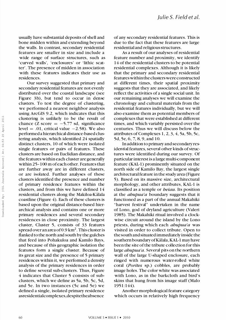
Our survey suggested that primary andsecondary residential features are not evenly distributed over the coastal landscape (seeFigure 3b), but tend to occur in denseclusters. To test the degree of clustering,
we performed a nearest neighbor analysis
using ArcGIS 9.2, which indicates that thisclustering is unlikely to be the result of chance (Z score = −5.77 sd, significancelevel = .01, critical value −2.58). We alsoperformed a hierarchical distance-based clus-tering analysis, which identified 24 spatially distinct clusters, 10 of which were isolatedsingle features or pairs of features. Theseclusters are based on Euclidian distance, andthe features within each cluster are generally
within 25–100 m of each other. Features that
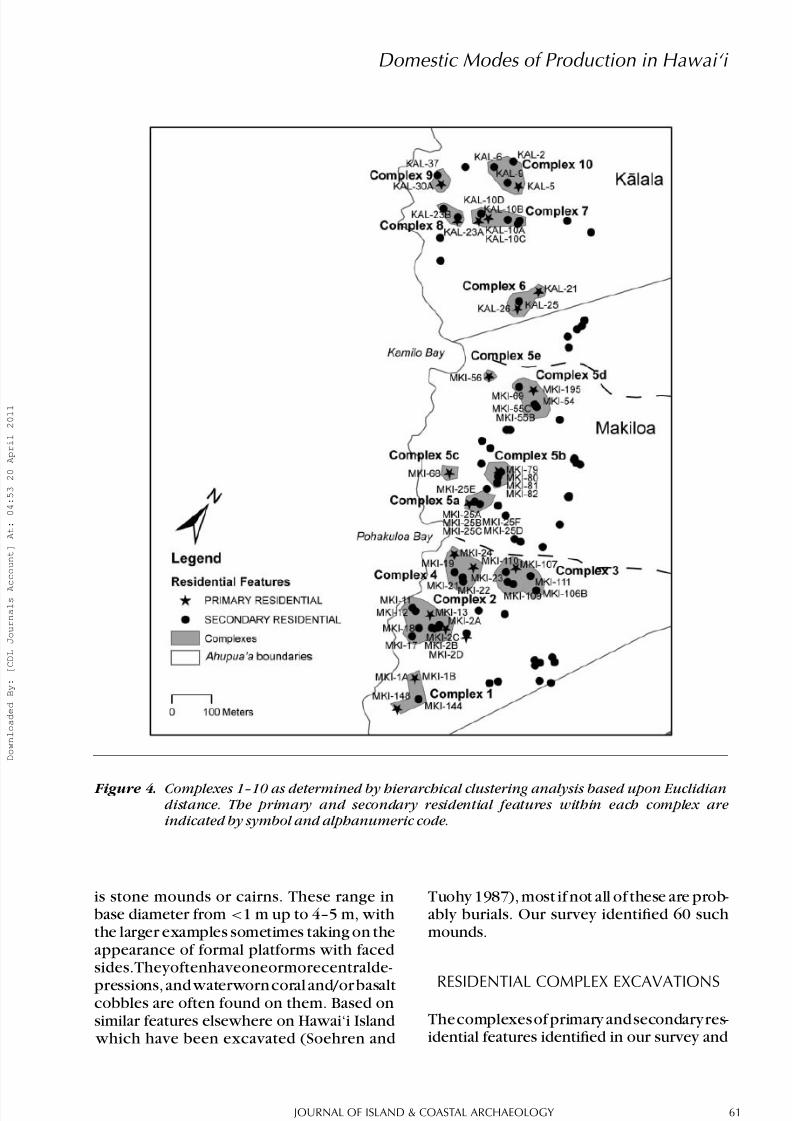
are further away are in different clusters,or are isolated. Further analyses of theseclusters identified the presence and number of primary residence features within theclusters, and from this we have defined 14residential clusters along the Makiloa-K alalacoastline (Figure 4). Each of these clusters isbased upon the original distance-based hier-archical analysis and contains one or moreprimary residences and several secondary residences in close proximity. The largest
cluster, Cluster 5, consists of 33 featuresspread over an area of 0.9 km2. This cluster isflanked to the north and south by the gulchesthat feed into Pohakuloa and Kamilo Bays,and because of this geographic isolation thefeatures form a single cluster. Because of its great size and the presence of 5 primary residences within it, we performed a density analysis of the primary residences in order to define several sub-clusters. Thus, Figure4 indicates that Cluster 5 consists of sub-
clusters, which we define as 5a, 5b, 5c, 5d,and 5e. In two instances (5c and 5e) wedefined a single, isolated primary residenceasresidentialcomplexes,despitetheabsence
of any secondary residential features. This isdue to the fact that these features are largeresidential and religious structures.
As a result of our analyses of residentialfeature number and proximity, we identify 14 of the residential clusters to be potentialresidential complexes. Although it is likely that the primary and secondary residentialfeatures withinthe clusters were constructedat different times, their spatial proximity suggests that they are associated, and likely reflect the activities of a single social unit. Inour remaining analyses we will examine thechronology and cultural materials from theresidential features individually, but we will
also examine them as potential members of complexes that were established at differenttimes, and which variably persisted over thecenturies. Thus we will discuss below theattributes of Complexes 1, 2, 3, 4, 5a, 5b, 5c,5d, 5e, 6, 7, 8, 9, and 10.
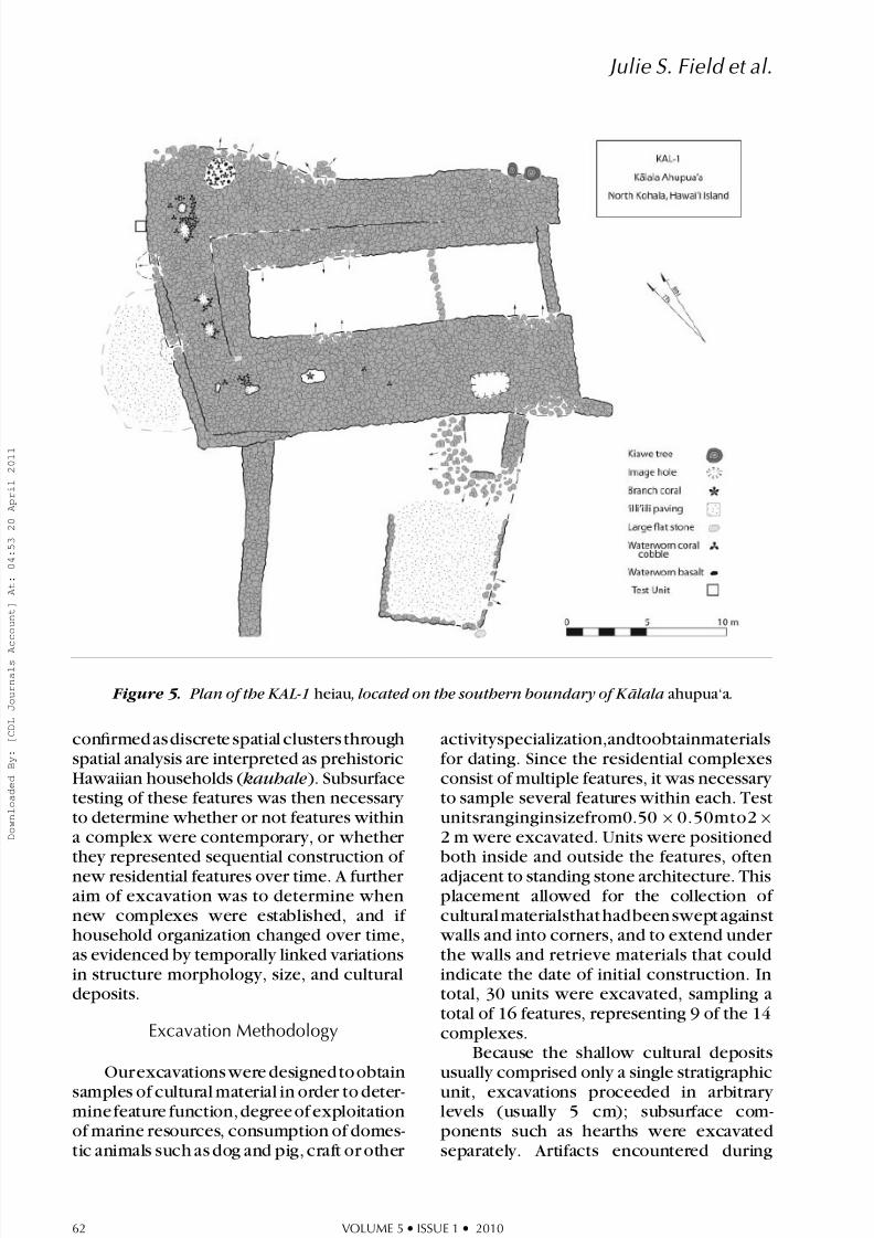
In addition to primary and secondary res-idential features, several other kinds of struc-tures were identified during our survey. Of particular interest is a large multi-componentfeature (KAL-1) prominently situated on the
north side of Kamilo Bay, the largest singlearchitectural feature in the study area (Figure5). Based on its massive size, architecturalmorphology, and other attributes, KAL-1 isclassified as a temple or heiau. Its positionat the ahupua‘a boundary suggests that itfunctioned as a part of the annual Makahiki“harvest festival” undertaken in the nameof Lono, god of dryland agriculture (Valeri1985). The Makahiki ritual involved a clock-
wise circuit around the island by the Lono
priests, during which each ahupua‘a was visited in order to collect tribute. Open tothe south and situated immediately inside thesouthern boundary of K alala,KAL-1 may havebeen the site of the tribute collection for thislarge ahupua‘a. Several pits on the northern
wall of the large U-shaped enclosure, each ringed with numerous water-rolled whitecoral ( Porites sp.) cobbles, are probably image holes. The color white was associated
with Lono, as in the barkcloth and bird’s
skins that hung from his image staff (Malo1951:144).
Another morphological feature category which occurs in relatively high frequency
Figure 4. Complexes 1–10 as determined by hierarchical clustering analysis based upon Euclidiandistance. The primary and secondary residential features within each complex areindicated by symbol and alphanumeric code.
is stone mounds or cairns. These range inbase diameter from <1 m up to 4–5 m, with the larger examples sometimes taking on theappearance of formal platforms with facedsides.Theyoftenhaveoneormorecentralde-
pressions, and waterworn coral and/or basaltcobbles are often found on them. Based onsimilar features elsewhere on Hawai‘i Island
which have been excavated (Soehren and
Tuohy 1987), most if not all of these are prob-ably burials. Our survey identified 60 such mounds.
RESIDENTIAL COMPLEX EXCAVATIONS
Thecomplexesof primary and secondaryres-idential features identified in our survey and
Figure 5. Plan of the KAL-1 heiau , located on the southern boundary of K alala ahupua‘a.
confirmed as discrete spatial clusters through spatial analysis are interpreted as prehistoricHawaiian households ( kauhale ). Subsurfacetesting of these features was then necessary to determine whether or not features withina complex were contemporary, or whether they represented sequential construction of new residential features over time. A further aim of excavation was to determine whennew complexes were established, and if household organization changed over time,as evidenced by temporally linked variationsin structure morphology, size, and culturaldeposits.
Excavation Methodology
Ourexcavations were designed to obtainsamples of cultural material in order to deter-mine feature function, degree of exploitationof marine resources, consumption of domes-tic animals such as dog and pig, craft or other
activityspecialization,andtoobtainmaterialsfor dating. Since the residential complexesconsist of multiple features, it was necessary to sample several features within each. Testunitsranginginsizefrom0.50 × 0.50mto2 ×
2 m were excavated. Units were positionedboth inside and outside the features, oftenadjacent to standing stone architecture. Thisplacement allowed for the collection of cultural materialsthat hadbeen swept against
walls and into corners, and to extend under the walls and retrieve materials that couldindicate the date of initial construction. Intotal, 30 units were excavated, sampling atotal of 16 features, representing 9 of the 14complexes.
Because the shallow cultural depositsusually comprised only a single stratigraphicunit, excavations proceeded in arbitrary levels (usually 5 cm); subsurface com-ponents such as hearths were excavatedseparately. Artifacts encountered during
excavationwerepoint-provenienced.Allsed-iment was sieved through 1/8 and 1/16inch mesh, with the exception of featuresMKI-1A and 1B, part of which was sieved
with 1/8 inch mesh only. Below we briefly describe salient architectural and subsurfaceaspects of the nine residential complexes
we excavated, treating them in geographicsequence from south to north. Followingthese summaries, the indications for spatio-temporal variation in household size arediscussed, along with a comparative analysisof cultural materials using normalized values.Chronological data based on 14C and U/Th dates are also discussed in detail.
Complex 1 (Features MKI -1A, -1B, -144,-148)
Complex 1 consists of two primary residences (MKI-148, MKI-1A, 1B) and onesecondary residence (MKI-144). MKI-144consisted of a round enclosure with ap-proximately 10 m2 of floor space. It wasconstructed of stacked cobble walls with rubble-filled interiors, and had no visiblesurface features or associated components.MKI-148 wasa large U-shaped enclosure (140m2 in interior floor area) with a paved floor and a raised stone paved platform in onecorner. Its large size and midden suggeststhat it was used as a residence, but part of the structure was later transformed into aprobable burial platform. This structure wasnot tested with subsurface excavation.
MKI-1A, 1B was the only feature in thiscomplex to be investigated archaeologically.Located on a slight rise about 55 m inland of the shoreline, this multi-component featureis composed of a small (10.39 m2 ) squareenclosure (Feature MKI-1A) attached to alarger U-shaped enclosure open to the west(Feature MKI-1B). Several pieces of branch coral ( Pocillopora meandrina ), an indicator of ritual use, were noted in the enclosure
walls. A single elongated waterworn basaltboulder is positioned on the southern wall;such waterworn stones often functioned assymbols of the fishing god K u‘ula (Malo1951:82–84). Surface midden around thestructureconsisted of marine shell, fishbone,and flaked stone. The branch coral and
upright waterworn stone, both typical ritualmarkers, suggest that MKI-1A in addition tobeing a primary residential feature, served aspecial function, possibly as a fishing shrine( ko‘a ).
Three units were excavated: TU 2 inMKI-1B produced no cultural materials or subsurface components encountering a nat-ural deposit of pebbles and gravel at 10cmbs. This suggests that the open enclosurehad a specialized function, possibly canoestorage. TU 3, outside the structure, revealeda thin deposit of lithics and midden overlyinga natural layer of gravel and pebbles. Incontrast, TU 1 in the southwest corner of
the enclosure exposed a 35 cm thick culturaldeposit incorporating a slab-lined hearth defined by two rock slabs. Between theseslabs and the enclosure wall a 10 cm thick deposit of ashy midden contained fragmentsof shell, sea urchin spines, charcoal, lithics,and fish bone, and artifacts such as seaurchin spine files, cut bone, and a bonetoggle. A layer of flat slabs formed the hearth foundation, and two midden/ash deposits
were found below this, extending to 42
cmbs. The hearth features did not extendunder the wall, and had been built after themain enclosure was constructed. Fragmentsof kukui nutshell were extracted from thisfeatureandsubmittedforradiocarbondating.
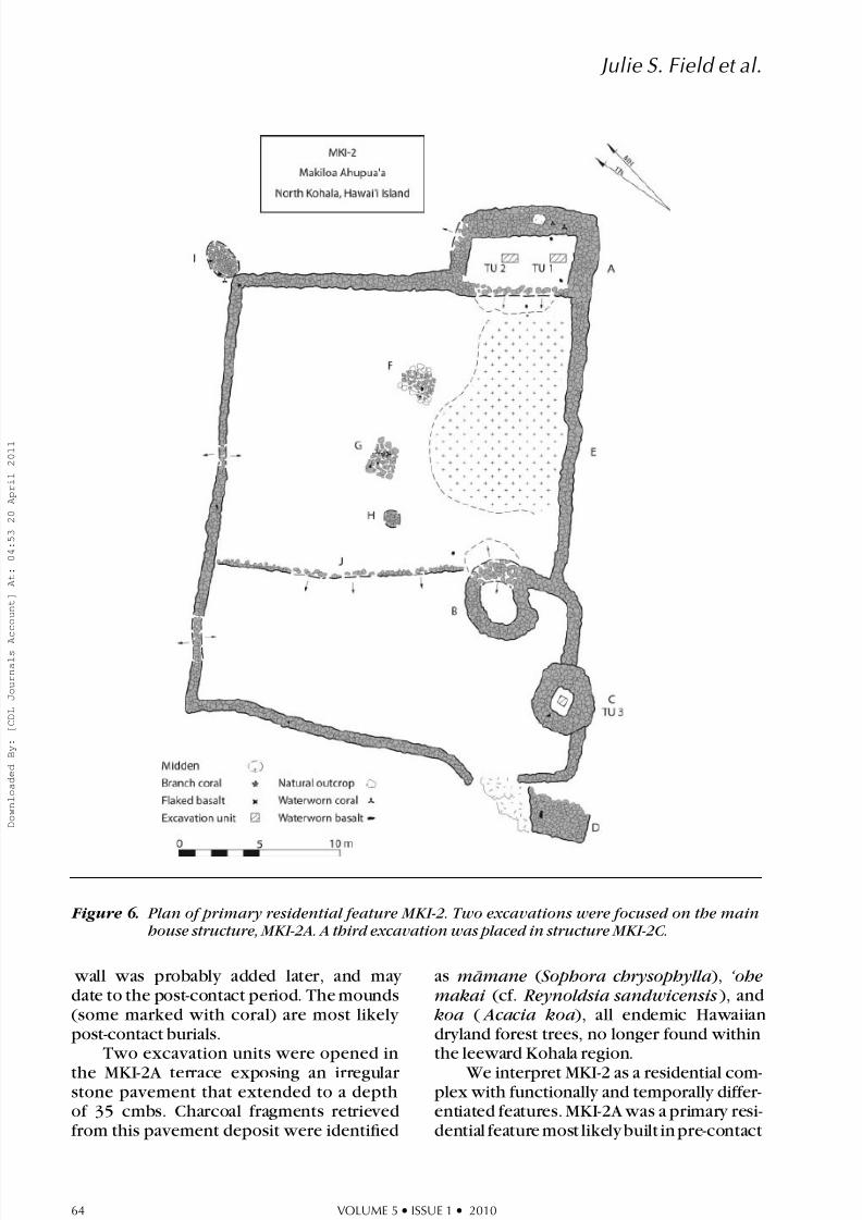
Complex 2 consists of 15 features ar-rayed over an area of 0.4 hectare. MKI-2, thefurthest inland, is a large multi-componentfeature with 10 components (Figure 6). A long rectangular terrace (22.75 m2 ) backed
with a high stacked wall on the upslope side(MKI-2A) was classified as a primary resi-dence;a dense concentration of shell middenand lithics extends downslope. Slightly far-ther down the ridge two circular enclosures(MKI-2B, MKI-2C) and a stone-paved terrace(MKI-2D) are linked by a free-standing wall(MKI-2E) which also encloses three mounds(MKI-2F, MKI-2G, MKI-2H), and a low lyingstone-faced terrace (MKI-2J). The enclosing
Figure 6. Plan of primary residential feature MKI-2. Two excavations were focused on the mainhouse structure, MKI-2A. A third excavation was placed in structure MKI-2C.
wall was probably added later, and may date to the post-contact period. The mounds(some marked with coral) are most likely post-contact burials.
Two excavation units were opened in
the MKI-2A terrace exposing an irregular stone pavement that extended to a depth of 35 cmbs. Charcoal fragments retrievedfrom this pavement deposit were identified
as m¯ amane ( Sophora chrysophylla ), ‘ohemakai (cf. Reynoldsia sandwicensis ), andkoa ( Acacia koa ), all endemic Hawaiiandryland forest trees, no longer found withinthe leeward Kohala region.
We interpret MKI-2 as a residential com-plex with functionally and temporally differ-entiated features. MKI-2A was a primary resi-dential feature most likely built in pre-contact
times, but was used throughout the historicperiod. MKI-2B and -2C are interpreted ascooking features due to their small sizesand charcoal-rich deposits. A single test unitfrom MKI-2C contained abundant charcoal,dog remains, and fragments of metal. Asdiscussed in the following sections, the later date suggests that MKI-2B, -2C, and -2D werebuiltafterMKI-2A,andwereultimatelyjoinedtogetherbytheenclosingwall(MKI-2E)prob-ably during the post-contact era. The terracesubdividing theenclosure(MKI-2J) wasprob-ably constructed later than the free-standing
wall (MKI-2E). The four stone mounds, someof which have waterworn coral and basalt
cobbles on them, are probably burials. They may well date to the mid-nineteenth century and probably mark the final activity on thiscomplex.
MKI-13isarectangularenclosuredowns-lope from MKI-2. The size of the structure(17 m2 ), and also the presence of a 20 cm2
cupboard in the northwest corner indicatesthat this was a primary residence. The struc-ture’s northern wall appears to have been
widened after initial construction, possibly
to incorporate burials, as suggested by twodepressions (ca. 50 cm in diameter) with
waterworn coral and basalt cobbles in closeproximity. An excavation in the northwestcorner of MKI-13 exposed a silty-clay soil
with numerous rock inclusions in a loosely mixed matrix, suggesting that a fill was laiddown to create a suitable living surface.This excavation produced shell, sea urchin,animal bone, lithics, and charcoal, but atlower density than in other features. These
deposits were not sampled for radiocarbondating.
About 15 m seaward are MK-11 and-12. MKI-12 is a square enclosure (25.44m2 ) with an entryway in the west wall,and five stone-lined pit features. MKI-11A,immediately north of MKI-12, is a rectangular enclosure (24.99 m2 ) with an attached L-shaped shelter (MKI-11B), open toward thesea (probably a later addition). The smaller sizeofthesestructures,andalsothemorelim-
ited amounts of midden, indicate that thesestructuresare probably secondary residentialfeatures. An excavation unit in the enclosureexposed the northern portion of a pit feature.
The limited cultural material included shellmidden, lithics, volcanic glass, and animalbones. Artifacts included a sea urchin spinefilefragment,acoralfilefragment,anawl,anda piece of cut mammal bone, all associated
with the pit. A fragment of candlenut shell( kukui ) was also recovered and submittedfor radiocarbon dating.
Nearby, the feature MKI-17 consists of a free-standing L-shaped stacked stone wallthat encloses a large area of flat, unpavedground surface (200 m2 ). No artifacts or midden were visible on the surface, but thefeature appears to enclose a residential livingsurface. Nearby, feature MKI-18 consisted
of a stone-faced terrace with an attached C-shaped stone structure. Although thisfeature
was badly disturbed by kiawe tree root dam-age, it could have enclosed approximately 40m2 of interior space.
and secondary residential features atop aridge overlooking the southern side of Po-hakuloa Gulch and Pohakuloa Bay. MKI-21is a 15 m2 lithic and midden scatter that liesatopaknoll.Althoughnosurfacearchitectureis associated with the scatter, the denseconcentrations of flakes and a basalt awlindicate that the knoll was used as an activity area. Nearby, features MKI-19 and MKI-22are enclosures that are lightly paved with pebbles, midden, and coral. MKI-19 has an
irregular shaped perimeter wall that enclosesa floor space of 37 m2. MKI-22 is rectangular in shape, and is paved with clinker lava (59m2 ). These features were not tested with subsurface excavations.
Both MKI-23A and -24 are primarily rectangular features made of stacked cobblesand boulders. MKI-23A has an interior areaof 30 m2, post-contact sawn timber postsset in the interior corners, and a rangeof late nineteenth-century Euro-American
artifacts scattered on the surface. MKI-23Bis a large enclosing wall that surrounds MKI-23A. Surface shell midden within MKI-23A and -23B included specimens of unusually
large size (e.g., Drupa sp. and Cellana sp.exceeding 10 cm in diameter), in contrast
with the smaller size ranges typically seenin marine mollusk assemblages from pre-contact midden contexts.
An excavation unit (TU 1) in the floor of MKI-23A revealed milled wood slats lyingatop a layer of water-rounded stone pebblesand coral ( ‘ili‘ili ) containing metal nails andmetal fragments, shell, charcoal, and brokencoral. At 10–15 cmbs large cobbles wereencountered, the foundation stones for thehistoric period floor. Below this (at 25 cmbs)
was a fine, silty matrix of loose midden,devoid of historic artifacts and containing
charcoal, shell, sea urchin spines, fishboneand scales, candlenut endocarp, a fragmentof a coral abrader, and a piece of brokencoral. This stratigraphic sequence thus re-
vealsbothpre-contact and post-contact occu-pation phases. A fragment of kukui nutshellfrom this deepest pre-contact deposit wassubmitted for radiocarbon dating.
MKI-24 consists of a large rectangular enclosure (52.52 m2 ) and a paved terrace(MKI-24B) on a promontory overlooking
Pohakuloa Bay. The enclosure wall is unusualinreachingaheightof1.75m,whichsuggeststhat the roof of the building may have alsobeen quite high. Two excavations units inthe structure revealed a layer of ‘ili‘ili paving
just below the surface. Mixed in this deposit were shell, sea urchin, fishbone, lithics, andone metal square-cut nail. Below this noEuro-American artifacts were encountered,suggesting an earlier occupation that pre-dates the construction of the high stone
walls. Due to the presence of Euro-Americanartifacts from the eighteenth century, thesedeposits were not radiocarbon dated.
Complex 5a lies northeast of PohakuloaBay, and is a cluster of ridgeline featuresincluding primary and secondary residences.The primary residence feature MKI-25A isa rectangular enclosure (15.76 m2 ) with anattached rectangular enclosure on the inlandside (MKI-25B). To the northeast, MKI-25C,-D, -E, and -F are raised stone platforms and
mounds atop natural boulder outcrops. Mid-den was scattered across the surface of thesefeatures, indicating a range of subsistenceand cooking activities at the features. To thesouth, MKI-25G is a high (1.6 m), conical,stone mound, probably a post-contact burial(Figure 7).
Excavations within MKI-25A and -25Brevealed a deposit containing marine mid-den and artifacts but no historic-era Euro-
American items. While the deposits withinMKI-25A were thin, those in MKI-25B ex-tended to a depth of 37 cmbs, with ahigh density of lithics including fire-crackedrock and volcanic glass, as well as charcoal,
pig bone and pig teeth, branch coral, andshell and sea urchin midden. A fragment of ‘ ulei wood charcoal was recovered from thedeepest midden deposit in MKI-25B, and wassubmitted for radiocarbon dating.
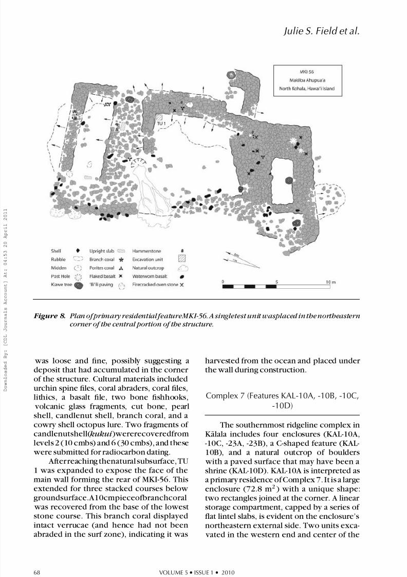
Complex 5e (Feature MKI-56)
Complex 5e is the most northerly res-idential complex in Makiloa, consisting of a large rectangular multi-component feature(MKI-56) with three internal spaces and anup-slope wall nearly 2 m thick (Figure 8).On the south, this is joined to a small “spacecell” which probably was the foundation for a separate thatched superstructure. On thenorth is a separate terrace, its interior floor
well paved with waterworn pebbles ( ‘ili‘ili ). A large upright slab and pieces of branch coral suggest that this terrace functioned asa shrine. Several large artifacts were foundon the surface, including a fragmented Cha- ronia sp. shell, waterworn stones, branch coral, Porites sp. coral, basalt flakes, seaurchin spine files, and a hammerstone. Thefeature is in close proximity to a series of retaining walls and platforms and commandsan excellent view of Kamilo Bay. The north-ern edge of this bay marks the boundary between Makiloa and K alala ahupua‘a, andimmediately beyond it in K alala is the largeKAL-1 heiau. In total, the interior space of MKI-56 is the largest in the study, at 84.8 m2.The size and complexity of MKI-56 and thepresence of midden and artifacts suggestedthat this large feature was an elite primary
Figure 7. Plan of primary residential feature MKI-25. Two excavations were placed in features MKI-25A, B. A third was placed in the midden that stretched across the center of thecomplex.
residence, either that of the konohiki (landmanager) or the ali‘i ‘ai ahupua‘a chief.
Time constraints limited excavation atMKI-56 to a single 0.50 × 0.50 m test unit(TU 1) in the northeast corner of the centralenclosure, revealing a dense midden deposit
extending to 47 cmbs. The uppermost 10cm of compact sediment included charcoal,a
shell scraper, sea urchin spine files, volcanicglass, lithics, coral abraders, bone fragments,candlenut endocarp, a bone fishhook, and
Figure 8. Plan of primary residential featureMKI-56. A singletest unit wasplaced in thenortheasterncorner of the central portion of the structure.
was loose and fine, possibly suggesting adeposit that had accumulated in the corner of the structure. Cultural materials includedurchin spine files, coral abraders, coral files,lithics, a basalt file, two bone fishhooks,
volcanic glass fragments, cut bone, pearlshell, candlenut shell, branch coral, and acowry shell octopus lure. Two fragments of candlenutshell( kukui )wererecoveredfromlevels 2 (10 cmbs) and 6 (30 cmbs), and these
were submitted for radiocarbon dating. Afterreaching thenatural subsurface, TU
1 was expanded to expose the face of themain wall forming the rear of MKI-56. Thisextended for three stacked courses below groundsurface.A10cmpieceofbranchcoral
was recovered from the base of the loweststone course. This branch coral displayedintact verrucae (and hence had not beenabraded in the surf zone), indicating it was
harvested from the ocean and placed under the wall during construction.
Complex 7 (Features KAL-10A, -10B, -10C,
-10D)
The southernmost ridgeline complex inK alala includes four enclosures (KAL-10A,-10C, -23A, -23B), a C-shaped feature (KAL-10B), and a natural outcrop of boulders
with a paved surface that may have been ashrine (KAL-10D). KAL-10A is interpreted asa primary residence of Complex 7. It is a largeenclosure (72.8 m2 ) with a unique shape:two rectangles joined at the corner. A linear
storage compartment, capped by a series of flat lintel slabs, is evident on the enclosure’snortheastern external side. Two units exca-
enclosure revealed thin cultural deposits thatcontainedmarinemidden,volcanicglass,andbone fishhooks.
KAL-10B, 15 m south of KAL-10A, is a C-shaped secondary residence feature locatedin the middle of a large midden scatter. A single unit, TU 3, in the southern portionof the feature revealed a rich assemblageof tools and manufacturing debris, includingpearl shell, cut bone, sea urchin spine files,and an adze fragment. A fragment of woodcharcoal recovered from the deepest portionof this deposit was submitted for radiocarbondating.
KAL-10C is a large rectangular enclosure
(68.75 m2 ) with an attached J-shaped featureon the south and a linear storage cupboardcapped with flat slabs on the southernexterior. This feature is also large and hassubstantial surface midden, which suggeststhat it too was a primary residence. ThreeunitswereplacedinKAL-10C:TU4containedmoderate amounts of midden to a depth of 40 cm; TU 5 and 6 had denser midden andalso several tools, including coral abraders,sea urchin spine files, fire-cracked rock, cut
bone, and pearl shell.KAL-10D incorporates a boulder outcrop
and a layer of stone paving and artifacts.Some of these artifacts include branch coral( Pocillopora sp.), water-rolled Porites coral,
water-rolled basalt pebbles, and shell mid-den. This feature may have been a shrine,or possibly a burial.
Complex 8 (KAL-23A, -23B)
Complex 8 lies along the same ridgelineas Complex 7, and consists of a primary and a secondary residential feature. KAL-23A is a moderate-sized (21.25 m2 ) enclosure.Two test excavations in the floor of thefeature revealed thin (15 cm) deposits, anda moderate amount of marine midden. Glassand ceramic beads dating to the early contactperiod were also found in each unit. Nearby,KAL-23B is a rectangular enclosure approx-imately 5 m long and 4 m wide, orientedon the same axis as KAL-23A. Similaritiesin construction style and size suggest thatthey are contemporaneous. A well-preservedcupboard with a large slab lintel is located in
the southeast interior corner. A test unit, TU2, placed in front of the cupboard reacheda depth of 45 cmbs, and revealed a densemidden deposit and yellow beach sand with lithics, historic glass, historic ceramic beads,andmetaldowntoadepthof35cmbs.Duetothe presence of eighteenth- and nineteenth-century Euro-American artifacts in KAL-23A and -23B, no charcoal was submitted for radiocarbon dating.
Complex 9 (KAL-30A, -30B, -37)
Complex 9 consists of two primary res-
idences, two of which (KAL-30A, KAL-37)are rectangular high-backed terraces with en-closing walls. A single secondary residentialfeature (KAL-30B) lay within a few meters of KAL-30A(Figure9).KAL-30Awasamoderate-sized primary residence,withaninteriorfloor space of 20 m2. Half of the interior floor space of this feature was excavated with two adjacent ∼2 m2 units. The excavationrevealed a dense deposit of midden, adzeflakes, coral abraders, sea urchin spine files,shell scrapers, bone fishhooks, and also twoslab-lined fire hearths at a depth of 15 cmbs.Fragments of koa wood were identified fromthe southernmost fire hearth, and submittedfor radiocarbon dating.
KAL-30B consisted of an enclosure with three interior space cells, a high-backed
wall, and an open front terrace. Severaldepressions in the upper portions of the
walls may have been post-holes for woodenimages. The presence of coral in the base of these depressions suggests that this structureserved as a religious shrine (possibly a ko‘a )for the adjacent main residence. The threespace cells and the terrace would haveprovided approximately 33 m2 of interior living space. Half of the interior of thenorthernmost space cell of KAL-30B wasexcavated, revealing an extremely dense butfragmented midden deposit. The conditionof the midden suggests that this floor wasrepeatedly trampled. Sea urchin spine files,coral abrader, a shell scraper, and bonefishhook were recovered from the depositsof KAL-30B, and also a portion of a bronzecoin inscribed with the words ‘TOTUM’and‘BRASIL’.Numismaticcataloguesidentify
Figure 9. Plan of residential feature KAL-30. Two test excavations were placed in KAL-30A, and a
third excavation bisects the northern space cell in KAL-30B.
this coin as a colonial currency that wasminted in Brazil between 1750 and 1777(American Numismatic Society 2008). Thiscoin had been cut, probably in order toutilize the bronze for a tool or ornament. Inaddition to a relative age of post-1777 for thisdeposit, a fragment of wood charcoal fromthe candlenut ( kukui ) tree was extractedfrom a depth of 15 cmbs and submitted for
radiocarbon dating.KAL-37 was not investigated archaeolog-
ically, as it has been disturbed considerably by modern camping and trash dumping.
Although portions of the stone walls havebeen knocked down, it had a high-backed
wall which enclosed a flat, open terrace. Thefeature would have had a living space of approximately 20 m2.
Complex 10 (KAL-2, -5, -6, -9)
Complex 10 is the northernmost com-plexintheK alalasurveyarea,anditisdefinedtopographically by a steep-sided ridgelinethat marks the edge of the Pololu volcanic
substrate. The complex consists of three sec-ondary residences (KAL-2, -6, -9) and a singleprimary residence (KAL-5). This residencehas two large interior space cells and a longL-shaped back wall that enclosed a partially pavedterrace.Thetotalinteriorlivingareafor this feature totaled 40 m2. Several Cypraeaspp. shells that had been perforated for use as octopus lures were found on thesurface of the site, along with abundant flakesand cores of volcanic glass. A single 2.2 ×
1.5 m2 excavation unit was placed in thenorthernmost space cell, revealing a thinlayer of midden with abundant Cellana sp.shell scrapers and coral abraders to a depth
of 35 cmbs. A fragment of corroded metal was recovered from 30 cmbs, suggestinga late post-contact era occupation for thisresidence.
KAL-2 is located due north of KAL-5, andconsists of an oval-shaped enclosure with afloor area of 18 m2. This feature was likely used for a small residence, as evidenced by the thick midden deposit on the outsideand inside of the walls. This feature wasnot investigated archaeologically. Lastly, Fea-
tures KAL-6, and -9 consist of enclosures andterraces that may have been used for smallshelters andcooking structures. Feature KAL-9 is directly south of KAL-5 and consists of a 3m wide C-shaped enclosure. Further downthe ridgeline, KAL-6 was composed of anL-shaped wall and a small terrace (6 m2 ).Neither of these structures was investigatedarchaeologically.
COMPARATIVE ANALYSIS OF COMPLEXARCHITECTURE AND CULTURAL
CONTENT
Residential complexes defined by our survey include the presence of both primary andsecondary residential features. However, thecharacter and quantity of architecture anddeposits within each complex are diverse,and we argue that this variability is informa-tive for understanding the transition from a DMP to a more integrated political economy.In the following discussion we compare thesize,configuration,andpresumedfunctionof architectural features within the complexes
that were investigated archaeologically, fol-lowed by a comparative analysis of their cultural content.
Primary and Secondary Residence Sizeand Number
A critical factor that we believe is in-dicative of the transition from domestic tosurplus production is the number and sizeof the primary residences, and the number and size of secondary residences that areassociated with the primary structure. Wehypothesize that under the DMP , households
would have been smaller in terms of number of residents, and required fewer and smaller structures for tool making, cooking, andother activities. A single, small-sized centralprimary residence would have sufficed for many of the activities related to householdeconomics, and fewer secondary residentialfeatures would be required. We hypothe-size that with the transition to a surplus-generating mode of production households
would have increased in size, in turn ne-cessitating additional and frequently larger structures. Primary residences would havebecome larger, and associated secondary residenceswouldhavebeenmorenumerous.This hypothesis suggests that a classificationof complexes according to residence size andnumber may be indicative of the transitionfrom a DMP to supra-household surpluseconomy.
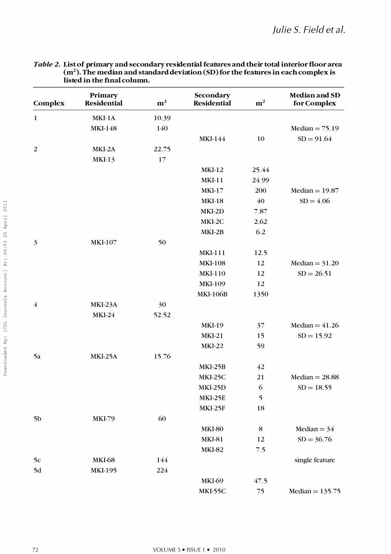
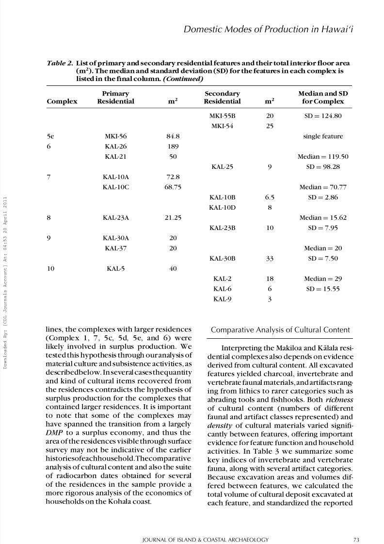
Our survey identified a wide range of floor areas among the individual features inthe complexes, from 10 to 1350 m2. Whencompared by complex, the median value for the individual feature floor areas ranged from15.86 to 135.75 m2, with standard deviationsbetween 2.86 and 124.8 m2 (Table 2). Wesuggest that two groups are apparent in thisdistribution: complexes with median floor areas of 40 m2 or less and relatively low standard deviations, and those with median
values of 70 m2 or greater and relatively high standard deviations. Complexes 2, 3, 4, 5a,5b,8,9,and10fallunderthelattercategoryof smaller-sized residences. We infer that thesecomplexes are likely to represent smaller households that were autonomous and didnot produce a surplus. Along those same
Table 2 . List of primary and secondary residential features and their total interior floor area (m 2). The median and standard deviation (SD) for the features in each complex islisted in the final column.
Complex Primary Residential m 2 Secondary Residential m 2 Median and SDfor Complex
Table 2 . List of primary and secondary residential features and their total interior floor area (m 2). The median and standard deviation (SD) for the features in each complex islisted in the final column. (Continued)
Complex Primary Residential m 2 Secondary Residential m 2 Median and SDfor Complex
MKI-55B 20 SD = 124.80
MKI-54 25
5e MKI-56 84.8 single feature
6 KAL-26 189
KAL-21 50 Median = 119.50
KAL-25 9 SD = 98.28
7 KAL-10A 72.8
KAL-10C 68.75 Median=
70.77KAL-10B 6.5 SD = 2.86
KAL-10D 8
8 KAL-23A 21.25 Median = 15.62
KAL-23B 10 SD = 7.95
9 KAL-30A 20
KAL-37 20 Median = 20
KAL-30B 33 SD = 7.50
10 KAL-5 40
KAL-2 18 Median = 29
KAL-6 6 SD = 15.55
KAL-9 3
lines, the complexes with larger residences(Complex 1, 7, 5c, 5d, 5e, and 6) werelikely involved in surplus production. Wetested this hypothesis through our analysis of material culture and subsistence activities, asdescribedbelow. In several casesthequantity
and kind of cultural items recovered fromthe residences contradicts the hypothesis of surplus production for the complexes thatcontained larger residences. It is importantto note that some of the complexes may have spanned the transition from a largely DMP to a surplus economy, and thus thearea of the residences visible through surfacesurvey may not be indicative of the earlier historiesofeachhousehold.Thecomparativeanalysis of cultural content and also the suite
of radiocarbon dates obtained for severalof the residences in the sample provide amore rigorous analysis of the economics of households on the Kohala coast.
Comparative Analysis of Cultural Content
Interpreting the Makiloa and K alala resi-dential complexes also depends on evidencederived from cultural content. All excavatedfeatures yielded charcoal, invertebrate and
vertebrate faunal materials,and artifactsrang-ing from lithics to rarer categories such asabrading tools and fishhooks. Both richnessof cultural content (numbers of differentfaunal and artifact classes represented) anddensity of cultural materials varied signifi-cantly between features, offering importantevidence for feature function and householdactivities. In Table 3 we summarize somekey indices of invertebrate and vertebratefauna, along with several artifact categories.
Because excavation areas and volumes dif-fered between features, we calculated thetotal volume of cultural deposit excavated ateach feature, and standardized the reported
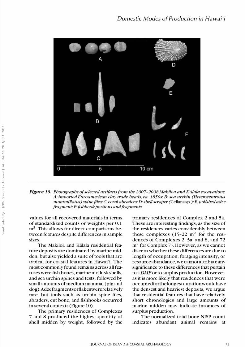
Figure 10. Photographs of selected artifacts from the 2007–2008 Makiloa and K alala excavations. A: imported Euroamerican clay trade beads, ca. 1850s; B: sea urchin (Heterocentrotusmammillatus) spine files; C: coral abraders; D: shell scraper ( Cellana sp. ); E: polished adze
fragment; F: fishhook portions and fragments.
values for all recovered materials in termsof standardized counts or weights per 0.1m3. This allows for direct comparisons be-tween features despite differences in samplesizes.
The Makiloa and Kalala residential fea-ture deposits are dominated by marine mid-den, but also yielded a suite of tools that aretypical for coastal features in Hawai‘i. Themost commonly found remains across all fea-tures were fish bones, marine mollusk shells,and sea urchin spines and tests, followed by small amounts of medium mammal (pig anddog).Adzefragmentsorflakeswererelatively rare, but tools such as urchin spine files,abraders, cut bone, and fishhooks occurredin several contexts (Figure 10).
The primary residences of Complexes7 and 8 produced the highest quantity of shell midden by weight, followed by the
primary residences of Complex 2 and 5a.These are interesting findings, as the size of the residences varies considerably betweenthese complexes (15–22 m2 for the resi-dences of Complexes 2, 5a, and 8, and 72m2 for Complex 7). However, as we cannotdiscern whether these differences are due tolength of occupation, foraging intensity, or resource abundance, we cannot attribute any significance to these differences that pertainto a DMP or to surplus production. However,as it is more likely that residences that wereoccupiedforthelongestdurationwouldhavethe densest and heaviest deposits, we arguethat residential features that have relatively short chronologies and large amounts of marine midden may indicate instances of surplus production.
The normalized total bone NISP countindicates abundant animal remains at
Complexes 5e, 7, and 8. When broken downby taxa, Complex 7, 8, and 5e have thegreatest amount of fish as well as pig, dog,and medium mammal bone (the “mediummammal” class is probably almostexclusively pig and dog bone as well). This abundance of animal remains reflects a greater productionand collection of protein by households that
we believe post-date the transition to a sur-plusmodeofproduction.Inthecaseof5ethegreater amounts fish and domestic animalslikely reflects the higher consumption of meat and richer food stuffs by elites, a patternsimilarlynotedbyKirchandO’Day(2002)for high-status residential features in Kahikinui,
Maui. When compared to residence size,the higher proportion of fish and mediummammal bone corresponds well to larger-sized households; in thiscase, Complexes5e,7, and 8 had interior floor spaces that rangedfrom a total of 31 to 156 m2.
Artifact content reveals other trendspertaining to fishing, food processing, andtool making. No whole basalt adzes wererecovered during the 2007–2008 seasons,but adze fragments were recovered from
Complex 1, 2, 7, and 9. These fragments pre-sumably derived from use on site, although adze chips were sometimes later reused ascutting tools. All of these adze fragmentsare made from dense, fine-grained basalt notlocally available in Makiloa or K alala. Thepresence of adzes at these features suggests
woodworking activities (such as carvingcanoes, bowls, or working other woodenimplements),whilethepresenceofnon-localbasalt implies an interaction network with
regions where basalt quarries were located.Other lithic artifacts such as flakes, cores,and volcanic glass were most abundant atComplexes 5a and 7, and were found in high numbers in Complexes 1, 2, and 5e. Adzefragments and lithics were recovered fromresidences of all sizes, and do not indicate any
visible trends towards increased productionof canoes or other work wood items.
Tools related to the manufacture of fishhooks and fishing equipment were found
at all of the excavated features, but were mostcommon at Complex 2, 5e, and 7. Abradersmade from coral, followed by the spines of the slate pencil sea urchin ( Heterocentrotus
mammillatus ) were the most common (seeSinoto 1967 for descriptions of these com-mon Hawaiian artifact classes), suggestinga focus on fishing for these households. Inthe case of 5e, the manufacture of fishhooks
was likely done by specialists residing in thehousehold of the chief or konohiki . A totalof 21 whole fishhooks and fishhook parts
were recovered in the excavations, and nor-malizing their counts by excavated volumeindicates that Complexes 5e and 7 producedthemost,followedbyComplex2.Complexes1, 9, and 10 produced one fishhook each. Wesuggest that the abundance of fishhooks atComplexes 5e and 7 are indicative of surplus
production. In the case of Complex 5e and 7,this corresponds well with the increased sizeof these households. The fishhooks includeboth one- and two-piece forms, as well astwo points that are probably from octopushook rigs (Emoryet al. 1959:28–29). With theexceptionof a single one-piece shank of pearlshell, all of the hooks are of mammal bone.No trolling lures or points were recovered.
All of the fishing gear is consistent with inshore angling, either from the rocky coast
or in the shallow benthic zone immediately offshore.
Imported Euro-American and Asian ar-tifacts were also recovered from some fea-tures, serving as a temporal marker for post-contacthabitation.Complexes2,4,and8hadthe most Euro-American artifacts, includingmilled wood, metal nails, fragments of glassbottles, trade beads, and a percussion capfrom a muzzle-loading firearm. The age of these items suggests occupation during the
mid to late 1800s. The absence of Euro- American artifacts at other features impliesthat these residences were abandoned prior to the late 1800s. This likely represents arapid depopulation of Makiloa and K alalasoon after contact with the West, a pattern
well documented from early historic records(Bushnell 1993; Schmidt 1968).
RADIOCARBON DATING AND FEATURE
CHRONOLOGY
Our third approach to analysis of the residen-tial features of Makiloa and K alala focused
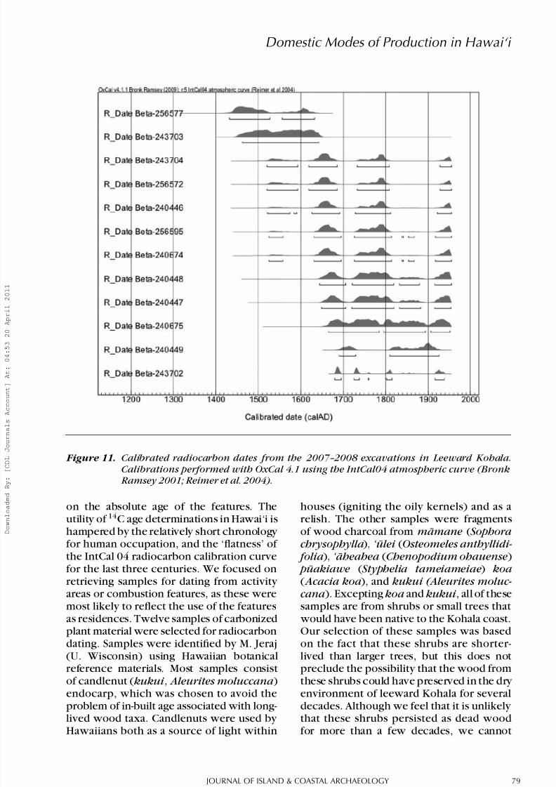
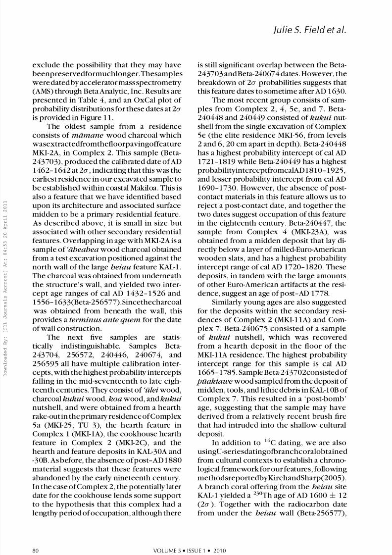
Figure 11. Calibrated radiocarbon dates from the 2007–2008 excavations in Leeward Kohala.Calibrations performed with OxCal 4.1 using the IntCal04 atmospheric curve (Bronk
Ramsey 2001; Reimer et al. 2004).
on the absolute age of the features. Theutility of 14C age determinations in Hawai‘i ishampered by the relatively short chronology for human occupation, and the ‘flatness’ of the IntCal 04 radiocarbon calibration curvefor the last three centuries. We focused onretrieving samples for dating from activity areas or combustion features, as these weremost likely to reflect the use of the featuresas residences. Twelve samples of carbonizedplant material were selected for radiocarbondating. Samples were identified by M. Jeraj(U. Wisconsin) using Hawaiian botanicalreference materials. Most samples consistof candlenut ( kukui , Aleurites moluccana )endocarp, which was chosen to avoid theproblem of in-built age associated with long-lived wood taxa. Candlenuts were used by Hawaiians both as a source of light within
houses (igniting the oily kernels) and as arelish. The other samples were fragmentsof wood charcoal from m¯ amane ( Sophorachrysophylla ), ‘ ulei ( Osteomeles anthyllidi- folia ), ‘ aheahea ( Chenopodium ohauense ) p¯ uakiawe ( Styphelia tameiameiae ) koa( Acacia koa ), and kukui (Aleurites moluc- cana ). Excepting koa and kukui , all of thesesamples are from shrubs or small trees that
would have been native to the Kohala coast.Our selection of these samples was basedon the fact that these shrubs are shorter-lived than larger trees, but this does notpreclude the possibility that the wood fromthese shrubs could have preserved in the dry environment of leeward Kohala for severaldecades. Although we feel that it is unlikely that these shrubs persisted as dead woodfor more than a few decades, we cannot
exclude the possibility that they may havebeenpreservedformuchlonger.Thesamples
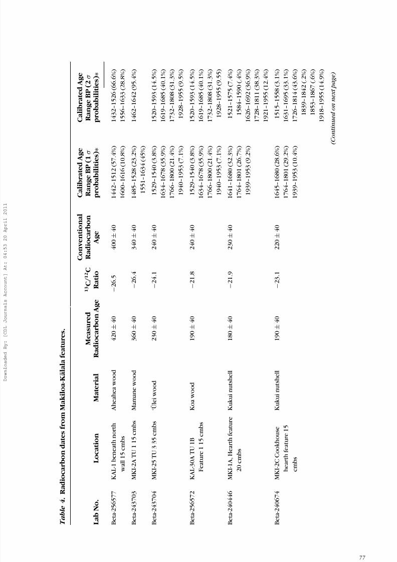
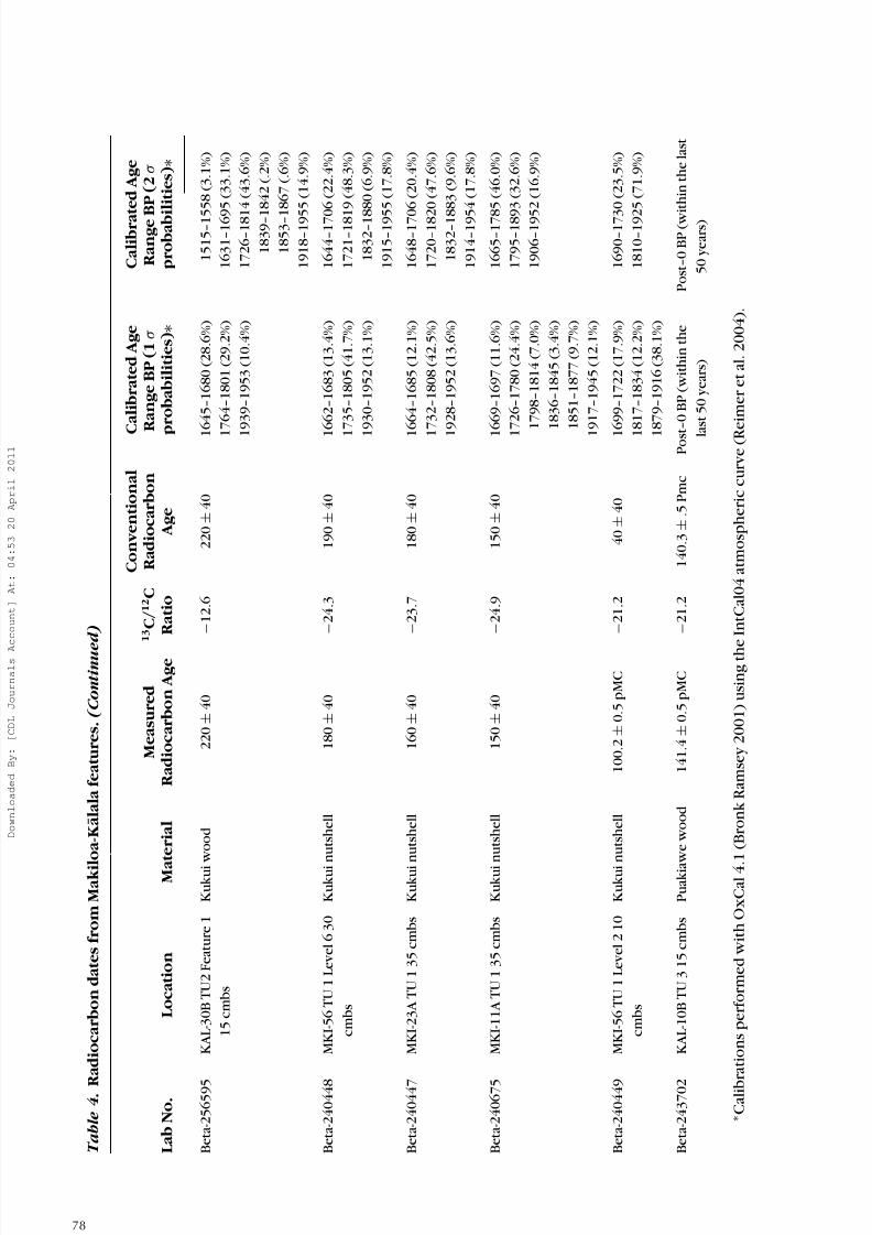
weredatedby accelerator massspectrometry (AMS) through Beta Analytic, Inc. Results arepresented in Table 4, and an OxCal plot of probability distributions for these dates at 2σ is provided in Figure 11.
The oldest sample from a residenceconsists of m¯ amane wood charcoal which
wasextractedfromthefloorpavingoffeatureMKI-2A, in Complex 2. This sample (Beta-243703), produced the calibrated date of AD1462–1642 at 2σ , indicating that this was theearliest residence in our excavated sample tobe established within coastal Makiloa. This is
also a feature that we have identified basedupon its architecture and associated surfacemidden to be a primary residential feature.
As described above, it is small in size butassociated with other secondary residentialfeatures. Overlapping in age with MKI-2A is asample of ‘ aheahea wood charcoal obtainedfrom a test excavation positioned against thenorth wall of the large heiau feature KAL-1.The charcoal was obtained from underneath the structure’s wall, and yielded two inter-
cept age ranges of cal AD 1432–1526 and1556–1633(Beta-256577).Sincethecharcoal
was obtained from beneath the wall, thisprovides a terminus ante quem for the dateof wall construction.
The next five samples are statis-tically indistinguishable. Samples Beta-243704, 256572, 240446, 240674, and256595 all have multiple calibration inter-cepts, with the highest probability interceptsfalling in the mid-seventeenth to late eigh-
teenth centuries. They consist of ‘ ulei wood,charcoal kukui wood, koa wood, and kukui nutshell, and were obtained from a hearth rake-out in theprimary residenceof Complex5a (MKI-25, TU 3), the hearth feature inComplex 1 (MKI-1A), the cookhouse hearth feature in Complex 2 (MKI-2C), and thehearth and feature deposits in KAL-30A and-30B. As before, the absence of post–AD1880material suggests that these features wereabandoned by the early nineteenth century.
In the case of Complex 2, the potentially later date for the cookhouse lends some supportto the hypothesis that this complex had alengthy period of occupation, although there
is still significant overlap between the Beta-243703 and Beta-240674 dates.However, thebreakdown of 2σ probabilities suggests thatthis feature dates to sometime after AD 1630.
The most recent group consists of sam-ples from Complex 2, 4, 5e, and 7. Beta-240448 and 240449 consisted of kukui nut-shell from the single excavation of Complex5e (the elite residence MKI-56, from levels2 and 6, 20 cm apart in depth). Beta-240448has a highest probability intercept of cal AD1721–1819 while Beta-240449 has a highestprobabilityinterceptfromcalAD1810–1925,and lesser probability intercept from cal AD1690–1730. However, the absence of post-
contact materials in this feature allows us toreject a post-contact date, and together thetwo dates suggest occupation of this featurein the eighteenth century. Beta-240447, thesample from Complex 4 (MKI-23A), wasobtained from a midden deposit that lay di-rectly below a layer of milled-Euro-American
wooden slats, and has a highest probability intercept range of cal AD 1720–1820. Thesedeposits, in tandem with the large amountsof other Euro-American artifacts at the resi-
dence, suggest an age of post–AD 1778.Similarly young ages are also suggested
for the deposits within the secondary resi-dences of Complex 2 (MKI-11A) and Com-plex 7. Beta-240675 consisted of a sampleof kukui nutshell, which was recoveredfrom a hearth deposit in the floor of theMKI-11A residence. The highest probability intercept range for this sample is cal AD1665–1785. Sample Beta-243702consisted of p¯ uakiawe wood sampled from the deposit of
midden, tools, and lithic debris in KAL-10B of Complex 7. This resulted in a ‘post-bomb’age, suggesting that the sample may havederived from a relatively recent brush firethat had intruded into the shallow culturaldeposit.
In addition to 14C dating, we are alsousingU-seriesdatingofbranchcoralobtainedfrom cultural contexts to establish a chrono-logical framework for our features, followingmethodsreportedbyKirchandSharp(2005).
A branch coral offering from the heiau siteKAL-1 yielded a 230Th age of AD 1600 ± 12(2σ ). Together with the radiocarbon datefrom under the heiau wall (Beta-256577),
this indicates a likely construction date for the temple around AD 1600. A second 230Th age of AD 1623 ± 5 (2σ ) was obtained froma piece of branch coral directly under thefoundation wall of feature MKI-56, the eliteresidence situated on the opposite side of Kamilo Gulch from the KAL-1 heiau. Thissuggests initial construction of this residenceearly in the seventeenth century, while thetwo radiocarbon dates from the occupationdeposit at MKI-56 indicate continued occu-pation of the feature into the eighteenth century, a reasonable interpretation giventhe depth of the cultural deposit in thisfeature. Additional U-series dates currently in
processwillbereportedinalaterpublication.
DISCUSSION AND CONCLUSIONS
The survey and excavation of residentialcomplexes within the ahupua‘a of Makiloaand Kalala reveal the changing dynamicsof population size, resource extraction, andsocial hierarchy during the late pre-contactperiod (ca. AD 1460–1880). We have identi-
fied 14 residential complexes in this sector of the Kohala coastline, and have determinedthe age of 10 of the primary and secondary residential features based on 14C and U-seriesdates and associated post-contact artifacts.These results indicate that the area wasfirst occupied between AD 1460 and 1640,initially by only a single household (MKI-2A)at Complex 2. Although the error rangesassociated with our 14C determinations donot allow us to trace with great precision
the chronological establishment of additionalhouseholds during the following centuries,it seems likely that Complexes 1, 5a, and9 were established as a product of popu-lation growth between AD 1520 and 1680.During this period these new households
were established near bays that affordedcanoe access. Preexisting households, such as Complex 2, were expanded and new secondary residences were constructed inthe immediate area of the primary residence.
Based upon the close proximity of thesestructures, the small size of the primary residences, and the moderate amounts of marine midden and pig and dog bone, we
argue that these complexes were producedbyhouseholdsoperatinglargelyinadomesticmode of production.
Baseduponoursurveydataand14Cdatesfrom Makiloa and K alala, we argue that thetransition from a DMP to a surplus-generatingeconomy occurred after about AD 1650. It
was during this period that many new pri-mary residences were established, and mul-tiple secondary residences were established
within pre-existing complexes. The primary residences were now generally larger in size,and their component structures exhibit a
wider range of architectural forms, includinginterior divisions, attached enclosures, and
adjacent shrines. Marine midden densitiesat primary residences also increase duringthis period, as do the amounts of pig, dog,and large fish bones. Prime examples areComplexes 5e, 7, and 8, which consist of sequences of large residences with a variety of associated components. Based upon our survey and excavation data, we suggest thatComplexes 3, 4, and 10 were establishedduring or after the transition to a surpluseconomy, resulting in a total population
of 12–15 households on the Makiloa-Kalalacoastline at the time of initial Europeancontact. This represents a roughly three-foldincrease in households from the earliest set-tlement period, with perhaps a simultaneousdoubling or tripling of the population alongthe coast.
These transformations match our expec-tationsforthetransitionfroma DMP inwhich households acted as largely autonomouseconomic units, to a regionally integrated
political economy. While it is likely thatthe increase in numbers of archaeologicalfeatures during this period was in part a re-flection of population growth (Kirch 2007b),the morphology and size of primary andsecondary residences is also indicative of changing patterns of residence. We attributethischangetothetransformationofHawaiianhouseholds, and an emphasis on surplusproduction of food and material goods, along
with increased specialization and probably
also the gender differentiation in activitiesdescribed from the contact period. Fishingand the exploitation of marine resources
this leeward coast, but NISP counts of fau-nal remains demonstrate an increase in thecollection of fish at complexes that date tothe late phase (post–AD 1650). Dog and pigappear to have been consumed rarely by theearlier households, but increase in frequency in the late period.
A final issue is whether the householdsthat occupied the coastal residential featuresin Makiloa-Kalala were strictly specializedin marine exploitation, exchanging marineproducts with farming households which resided permanently in the upland fieldsystem; or, whether these coastal featuresrepresent only the marine-focused parts of
households that integrated both farmingand marine exploitation into their domesticeconomies. These two opposed models havebeen debated for many years in Hawai-ian archaeology (e.g., Tuggle and Griffin1973). Our 2007–2008 coastal feature ex-cavations do not as yet support either of these two models exclusively. Excavations inupland residential complexes, to be under-taken as a part of our continuing research,may yield evidence to help resolve this
debate.Our data also imply a differentiation
between commoner and elite householdssometime after ca. AD 1650. The single elitehousehold in the sample, MKI-56 (Complex5e),liesattheboundarybetweenMakiloaandKalala, directly opposite the KAL-1 heiau,and Kamilo Bay, and based on the datedcoral sample from under the wall foundation
was first constructed sometime after AD1623. As described above, the position of an
elite residence at this important ahupua‘aboundary line, as well as the abundanceof artifacts, marine midden, and domesticanimal fauna suggests that this particular household participated in the collection of tribute from Makiloa and Kalala ahupua‘a.This residential complex also exhibits unusu-ally elaborated architecture for the Makiloaand Kalala survey sample, as it includes mul-tiple internal divisions within a single largestructure, an attached shrine with branch
coral, and a possible canoe shed. Other residential complexes in Kalala and Makiloaare smaller and simpler, more often com-posed of single-room structures, C-shapes,
and structures with attached semi-circular enclosures.
The 14C and U-series dates from theMKI-56 elite residence and from the KAL-1 heiau, which straddle the importantahupua‘a boundary between Makiloa andKalala, indicate that the temple was probably constructed around AD 1600, while theresidence site was constructed a few decadeslater in the early to mid seventeenth century.These key dates thus allow us to propose
with some confidence that the fissioningof an originally much larger territorial unitoccurred at the beginning of the seventeenth century.
In sum, the results of our survey andexcavation of residential features in Makiloa-K alala have begun to offer several linesof evidence that we expect will allow usto begin to parameterize the key variablesdefined graphically in Figure 1. The resultssummarized here are only the first in aprojected three seasons of fieldwork. Our future plans include expanding work to twosample ahupua‘a in the central core of the Kohala region, as well as to residential
features situated within the upland fieldsystem. Our eventual goal is to trace how changes in the domestic mode of productionin late pre-contact Hawai‘i may yield further insights into the transformation of this mosthierarchical and stratified of all Polynesiansocieties.
ACKNOWLEDGEMENTS
The 2007–2008 survey and excavationsin Makiloa-K alala were funded by Na- tional Science Foundation Human Social Dynamics program grant BCS-0624238. Additional financial support was provided by the Class of 1954 Fund of the UniversityofCalifornia,BerkeleyandtheUniversityof Auckland. We thank theState of Hawai‘iDe- partment of Land and Natural Resources,and the State Historic Preservation Office for permission to carry out archaeological
research on State lands. Students from theUniversity of Auckland and the Univer- sity of Hawai‘i HARP field school project assisted with the survey and excavations,
and students from The Ohio State Univer- sity assisted with the laboratory analyses. Robin Connors assisted throughout theexcavations. Warren Sharp of the BerkeleyGeochronology Center carried out the U- series dating of coral samples. We also wishto thank Michael Graves and Mark McCoyof the HARP project.
END NOTE
1. Throughout this paper weuse theterm‘feature’rather than the term ‘site’. This is in contrast tomany conventional approaches in archaeology
where ‘sites’ contain ‘features’. Our use of theterm ‘feature’ is an intentional rejection of this conventional site-based approach ( sensuDunnell and Dancey 1983; Kirch 1985; Weisler and Kirch 1985). Recording the archaeologicalrecordatthefeaturescaleallowsforgreaterpre-cision, and it removes the problems associated
with over-applying a functional classificationto spatially contiguous or adjacent features.This is particularly useful for the Hawaiianarchaeological record, in which many features(such as the kauhale residential system) had
specific functions, but were often in closespatial proximity to one another.
REFERENCES
American Numismatic Society. 2008. Web site,http://numismatics.org/collection/1940.88.650(accessed April 2009).
Ashmore, W. and R. Wilk. 1988. House andhousehold in the Mesoamerican past: An In-troduction. In Household and Community in
the Mesoamerican Past (W. Ashmore and R. Wilk, eds.):1–27. Albuquerque: University of New Mexico Press.
Barton, C. M., J. Bernabeu, J. E. Aura, O. Gar-cia, S. Schmich, and L. Molina. 2004. Long-term socioecology and contingent landscapes.
Journal of Archaeological Method and Theory11:253–295.
Bronk Ramsey, C. 2001. Development of theradiocarbon calibration program OxCal. Radio- carbon 43(2A):355–363.
Bushnell, O. A. 1993. The Gifts of Civilization:Germs and Genocide in Hawai‘i . Honolulu:University of Hawai‘i Press.
Chayanov, A. V. 1966. The Theory of Peasant Economy. Homewood, IL: American Economic Association.
Childe, V. G. 1951. Social Evolution. London: Watts and Co.
Chinen, J. J. 1958. The Great Mahele: Hawai‘i’s Land Division of 1848 . Honolulu: University of
Hawai‘i Press.Ciolek-Torello,R. S. 1989. Household,floor assem-
blages, and the “Pompeii Premise” at Grasshop-per Pueblo. In Households and Communities:
Proceedings of the Twenty-first Annual Con- ference of the Archaeological Association of the University of Calgary. (S. MacEachern, D.
Archer, and R. Garvin, eds.):201–208. Calgary:The University of Calgary.
Cordy, R. 1981. A Study of Prehistoric Social Change: The Development of Complex Soci- eties in the Hawaiian Islands. New York:
Academic Press.Cordy, R., M. Kaschko. 1980. Prehistoric ar-
chaeology in the Hawaiian Islands: Land unitsassociated with social groups. Journal of Field
Archaeology 7:403–416.Dunnell, R. C. and W. S. Dancey. 1983. The siteless
survey: A regional scale data collection strategy.In Advances in Archaeological Method and Theory (M. B. Schiffer, ed.): (6):267–287. New
York: Academic Press.Earle, T. 1997. How Chiefs Come to Power:
The Political Economy in Prehistory. Stanford:
Stanford University Press.Emory, K. P., W. J. Bonk, and Y. H. Sinoto.1959. Hawaiian Archaeology: Fishhooks. B.P. Bishop Museum Special Publication No. 47.Honolulu: Bishop Museum Press.
Flannery, K. V. (ed.). 1976. The Early Mesoamer- ican Village. New York: Academic Press.
Fox, J. J. (ed.).1993. Inside Austronesian Houses: Perspectives on Domestic Designs for Living .Canberra: Australian National University.
Graves, M. W., B. V. O’Connor, and T. N. Lade-foged. 2002. Tracking changes in community-scaledorganizationinKohalaandKona,Hawai‘iIsland. In Pacific Landscapes: Archaeological
Approaches (T. N. Ladefoged and M. W. Graves,eds.):231–254. Los Osos: Easter Island Founda-tion Press.
Handy, E. S. C. and M. K. Pukui. 1958. The Polynesian Family System in Ka‘u, Hawai‘i . Wellington: The Polynesian Society.
Hartshorn, A. S., P. V. Kirch, O. A. Chadwick, andP. M. Vitousek. 2006. Prehistoric agriculturaldepletion of soil nutrients in Hawai‘i. Proceed- ings of the National Academy of Sciences103:11092–11097.
Johnson, A. W., T. Earle. 1987. The Evolution of Human Societies: From Foraging Groups to Agrarian State. Stanford: Stanford University Press.
Kahn, J. G. and P. V. Kirch. 2004. Ethnographieprehistorique d’une “societe a maisons” dansla vallee de ‘Opunohu (Mo‘orea, ıles de laSociete). Journal de la Soci et e des Oc eanistes
119:229–256.Kirch, P. V. 1984. The Evolution of Polynesian
Chiefdoms. Cambridge: Cambridge University Press.
Kirch, P. V. 1985. Feathered Gods and Fishhooks: An Introduction to Hawaiian Archaeologyand Prehistory.Honolulu:UniversityofHawai‘iPress.
Kirch, P. V. 2006. From Chiefdom to Archaic State: Sociopolitical Evolution in Hawai‘i .Schalitt Memorial Lecture. Provo: Brigham
Young University.
Kirch, P. V. 2007a. Hawai‘i as a model systemfor human ecodynamics. American Anthropol- ogist 109:8–26.
Kirch, P. V. 2007b. “Like shoals of fish”: Archae-ology and population in pre-contact Hawai‘i.In The Growth and Collapse of Pacific Is- land Societies: Archaeological and Demo-
graphic Perspectives (P. V. Kirch and J.-L. Rallu,eds.):52–69. Honolulu: University of Hawai‘iPress.
Kirch, P. V. 2007c. Paleodemography in Kahik-inui, Maui: An archaeological approach. In
The Growth and Collapse of Pacific Island Societies: Archaeological and Demographic Perspectives (P. V. Kirch and J.-L. Rallu,eds.):90–107. Honolulu: University of Hawai‘iPress.
Kirch, P. V., O. Chadwick, S. Tuljapurkar, T. Lade-foged, M. Graves, S. Hotchkiss, and P. Vitousek.2007. Human ecodynamics in the Hawaiianecosystem, 1200–200 BP. In The Model-Based
Archaeology of Socionatural Systems (T. A.Kohler and S. E. van der Leeuw, eds.):121–139.Oxford: Oxford University Press (for Santa FeInstitute).
Kirch, P. V. and R. C. Green. 2001. Hawaiki, AncestralPolynesia: An Essay in Historical An- thropology. Cambridge: Cambridge University Press.
Kirch, P. V., A. Hartshorn, O. Chadwick, P. Vitousek, D. Sherrod, J. Coil, L. Holm, and W.Sharp. 2004. Environment, agriculture, and set-tlement patterns in a marginal Polynesian land-scape. Proceedings of the National Academyof Sciences, U.S.A. 101:9936–9941.
Kirch, P. V. and S. O’Day. 2002. New archae-ological insights into food and status: A case
from precontact Hawai‘i. World Archaeology34:484–497.
in precontact Hawai‘i. Science 307:102–104.Kolb, M. J. and J. E. Snead. 1997. It’s a small world
after all: Comparative analyses of community or-ganizationinArchaeology. American Antiquity
62:609–628.Ladefoged, T. N. 1991. Hawaiian architectural
transformations during the early historic era. Asian Perspectives 30(1):57–69.
Ladefoged, T. N. 1993. Evolutionary Process inan Oceanic Chiefdom: Intergroup Aggressionand Political Integration in Traditional Ro- tuman Society. Doctoral Dissertation, Depart-ment of Anthropology, University of Hawai‘i,Honolulu. Ann Arbor: University Microfilms.
Ladefoged, T. N. 1995. The evolutionary ecol-ogy of Rotuman political integration. Jour-
nal of Anthropological Archaeology 14:341–358.
Ladefoged, T. N. and M. W. Graves. 2000. Evolu-tionary theory and the historical developmentof dry landagriculture in North Kohala, Hawai‘i.
American Antiquity 65:423–448.Ladefoged T. N. and M. W. Graves. 2006. The for-
mation of Hawaiian territories. In Archaeologyof Oceania (I. Lilly, ed.):259–283, New York:Blackwell Press.
Ladefoged, T. N., M. W. Graves. 2008. Variabledevelopment of dryland agriculture in Hawai‘i:
Afine-grainedchronologyfromtheKohalaFieldSystem, Hawai‘i Island. Current Anthropology49:771–802.
Ladefoged, T. N., M. W. Graves, andR. P. Jennings.1996. Dryland agricultural expansion and inten-sification in Kohala, Hawai‘i Island. Antiquity70:861–880.
Ladefoged, T. N., C. Lee, and M. W. Graves.2008. Modeling life expectancy and surplusproduction of dynamic pre-contact territoriesin Leeward Kohala, Hawai‘i. Journal of Anthro-
pological Archaeology 27:93–110.Levi-Strauss, C. 1979. Nobles Suavages. In Cul-
ture, Science, et D eveloppement: Contributiona une Histoire de l’Homme: M elanges enl’Honneur de Charles Moraz e, pp. 41–55.Toulouse: Privat.
Malo, D. 1951. Hawaiian Antiquities. BerniceP. Bishop Museum Special Publication No. 2.Honolulu: Bishop Museum Press.
Massal, E. and J. Barrau. 1973. Food Plants of theSouth Sea Islands. South Pacific CommissionTechnical Paper No. 94. Noumea: South PacificCommission.
McGlade, J. 1995. Archaeology and the eco-
dynamics of human modified landscapes. An- tiquity 69:113–132.
O’Connor,B.V.1998. Spatial and Temporal Vari- ation in Hawaiian Residential Architecture: A
Seriation Study of Selected Coastal Settlementsin Northern Hawai‘i Island. Unpublished M.A.thesis, University of Auckland.
Reid, J. J. and S. M. Whittlesley, 1982. Households
at Grasshopper Pueblo. American Behavioral Scientist 25:687–704.
Reimer, P., M. Baillie, E. Bard, A. Bayliss, J. Beck,C. Bertrand, P. Blackwell, et al. 2004. Intcal04terrestrial radiocarbon age calibration 0–26 calkyr bp. Radiocarbon 46:1029–1058.
Rosendahl, P. H. 1972. Aboriginal Agricultureand Residence Patterns in Upland Lapakahi,
Island of Hawai‘i . Ph.D. Dissertation, Univer-sity of Hawai‘i.
Rosendahl, P. H. 1994. Aboriginal Hawaiian struc-tural remains and settlement patterns in the
upland agricultural zone at Lapakahi, Island of Hawai‘i. Hawaiian Archaeology 3:14–70.
Sahlins, M. D. 1972. Stone Age Economics.Chicago: Aldine.
Sahlins, M. D. 1992. Historical Ethnography. Vol. 2 of Anahulu: The Anthropology of History inthe Kingdom of Hawai‘i (P. V. Kirch and M. D.Sahlins). Chicago: University of Chicago Press.
Schmidt, R. C. 1968. Demographic Statistics of Hawai‘i, 1778–1965. Honolulu: University of Hawai‘i Press.
Service, E. 1975. Origins of the State and Civi-
lization: A Process of Cultural Evolution.New York: Norton.Sinoto,Y.H.1967.Artifactsfromexcavatedsitesin
theHawaiian,Marquesas,andSocietyIslands.In
Polynesian Culture History: Essays in Honor of Kenneth P. Emory (G. A. Highland, R. Force,
A. Howard, M. Kelly, and Y. Sinoto, eds.):341–361. Bernice P. Bishop Museum Special
Publication 56. Honolulu: Bishop MuseumPress.
Soehren, L. J. and D. P. Tuohy, 1987. Archaeolog- ical Excavations at Pu‘uhonua o H onaunau
National Historical Park, H onaunau, Kona, Hawai‘i . Department of Anthropology Report87–2. Honolulu: Bishop Museum.
Tuggle, H. D. and B. P. Griffin (eds.) 1973. Lapakahi, Hawai‘i: Archaeological Studies. Asian and Pacific Archaeology Series No. 5.Honolulu: Social Science Research Institute.
Valeri, V. 1985. Kingship and Sacrifice: Ritual
and Society in Ancient Hawai‘i . Chicago:University of Chicago Press.
Vitousek, P. M., T. Ladefoged, A. Hartshorn, P. V.Kirch, M. Graves, S. Hotchkiss, S. Tuljapurkar,and O. Chadwick. 2004. Soils, agriculture,and society in precontact Hawai‘i. Science304:1665–1669.
Weisler, M. and P. V. Kirch. 1985. The struc-ture of settlement space in a Polynesianchiefdom: Kawela, Molokai, Hawaiian Islands.
New Zealand Journal of Archaeology 7:129–158.
Wilk, R. R. and W. L. Rathje. 1982. Archaeol- ogy of the Household: Building a Prehistoryof the Domestic Life. Beverley Hills: SagePublications.