ST U DIA M Y T HOL O G IC A SL AV IC A X I X - 2 0 1 6 , 4 1 - 5 9 41 Islands as symbolic centres of the Early Medieval settlement patterns in Middle Pomerania (Northern Poland) Kamil Kajkowski Islands have played a significant role in the region of Pomerania. Isolated from the rest of the landscape, islands appealed to the human psyche in a highly distinct way. Be- cause of their geographic isolation, they allowed their inhabitants to develop relations of a transcendental character. According to scholars of religion, when people searched for a place of settlement, they looked, above all, for a specific, unique area. In a symbolic sense, such an area was regarded as a pivot around which social life would revolve. ose parts of land that were surrounded by water were associated with the mythic Primeval Land: the first land emerging from the Primeval Ocean and perceived as the centre of the world, axis mundi. Empirical material obtained in the course of archaeological research allows one to impute and follow such dynamics in traditional communities. By analysing selected sites, this paper explores the complex worldviews of pagan Pomeranians from the early Middle Ages. Material evidence of sacred space organization and relics of ritual activities visible in archaeological sites suggests that isolated parts of land, in the form of islands, were a key component in the creation of the religious and mythical worldview of the pre-Christian inhabitants of early medieval Pomerania. Keywords: Baltic Slavs, cult sites, islands, isolation, pagan rituals, Pomerania, symbolic centres Introduction: the phenomenology of an island Characterized by a specific geographic location including a substantial number of lakes, Pomerania is a region where the role of islands has been especially important. Isolated from the rest of the landscape, islands appealed to the human psyche in a very specific way. It seems that they may have been associated with paradise and yet were treated as a kind of prison. Because of their geographic isolation, islands allowed their inhabitants to develop relations of a new, unusual character. While living on an island, people could feel both deeply attached to the land and to each other (Hay 2006: 22–23). According to the scholars of religion, when people searched for a place of settlement, they looked, above all, for a specific, unique area. Symbolically, such a spot was treated as a “stable” space, an axis of orientation around which social life would revolve (Eliade 1974: 95). It was there that the transcendent powers and hierophanies were concentrated. “e macrocosm enters the microcosm and totally incorporates itself into it” (Czarnowski 1956: 226; author’s translation). Various scholars argue that sacral places were not chosen by
Transcript
ST
UD
IA
M
YT
HO
LO
GI
CA
S
LA
VI
CA
X
IX
-
2
01
6,
4
1
-
59
41
Islands as symbolic centres of the Early Medieval settlement patterns in Middle
Pomerania (Northern Poland)Kamil Kajkowski
Islands have played a significant role in the region of Pomerania. Isolated from the rest of the landscape, islands appealed to the human psyche in a highly distinct way. Be-cause of their geographic isolation, they allowed their inhabitants to develop relations of a transcendental character. According to scholars of religion, when people searched for a place of settlement, they looked, above all, for a specific, unique area. In a symbolic sense, such an area was regarded as a pivot around which social life would revolve. Those parts of land that were surrounded by water were associated with the mythic Primeval Land: the first land emerging from the Primeval Ocean and perceived as the centre of the world, axis mundi. Empirical material obtained in the course of archaeological research allows one to impute and follow such dynamics in traditional communities. By analysing selected sites, this paper explores the complex worldviews of pagan Pomeranians from the early Middle Ages. Material evidence of sacred space organization and relics of ritual activities visible in archaeological sites suggests that isolated parts of land, in the form of islands, were a key component in the creation of the religious and mythical worldview of the pre-Christian inhabitants of early medieval Pomerania.
Characterized by a specific geographic location including a substantial number of lakes, Pomerania is a region where the role of islands has been especially important. Isolated from the rest of the landscape, islands appealed to the human psyche in a very specific way. It seems that they may have been associated with paradise and yet were treated as a kind of prison. Because of their geographic isolation, islands allowed their inhabitants to develop relations of a new, unusual character. While living on an island, people could feel both deeply attached to the land and to each other (Hay 2006: 22–23). According to the scholars of religion, when people searched for a place of settlement, they looked, above all, for a specific, unique area. Symbolically, such a spot was treated as a “stable” space, an axis of orientation around which social life would revolve (Eliade 1974: 95). It was there that the transcendent powers and hierophanies were concentrated. “The macrocosm enters the microcosm and totally incorporates itself into it” (Czarnowski 1956: 226; author’s translation). Various scholars argue that sacral places were not chosen by
42
Islands as symbolic centres of the Early Medieval settlement patterns in Middle Pomerania (Northern Poland)
the people, but that they manifested themselves through different signs demonstrating their supernatural qualities.
Islands fulfilled these conditions. The parts of land manifesting themselves in watery surroundings were associated with the mythic Primeval Land, the first land emerging from the Primeval Ocean and at the same time the centre of the world, axis mundi. They were thus typographical points of a special emanation of sacral powers, places of epiphany of unusual numinous properties. As such they became the most perfect representations of the act of creation (Eliade 1988: 177). Unfortunately, in the sources concerning the lands of the Western Slavs, the information directly confirming the existence of the cosmogonic myth has not been preserved. For the Eastern Slavs, the primeval area was the Buyan is-land (Ralston 1872: 241, 345–346, 375), established in an act of creation by two demiurges, usually identified as Perun and Veles (Szyjewski 2003: 61–62; Gieysztor 2006: 98–102). The creation of space consisted of the separation of the chaotic (amorphic element symbolized by the water of the Primeval Sea or Ocean) from the “non-chaotic”.
In the religious and mythological perspective, it is a transformation of the chaos into cosmos … and in the human perspective – the “cultivation” consisting of the repetition of the divine act of cosmogony (Adamowski 1999: 14; author’s translation).
The most important are those points in the sacral valorization in which the act of creation was performed (Toporow 1977: 109–110). However, an analogous myth is developed for the Westerns Slavs on the basis of ethnographic sources. In fact, remi-niscences of such tales may be found in Slavic folklore (Tomiccy 1975: 24–25). We may summarize it in the following way: in the beginning, there was only the sea and ultimately, as a result of various actions undertaken by supernatural beings, islands emerged from it.
In folk tales, the supernatural or divine beings performing the act of creation are God and Devil. Their cooperation, while sometimes problematic, is essential. As already mentioned, when the attempts to reconstruct the pre-Christian cosmogonic myth are made, the formation of the Cosmos is attributed to the struggles between Perun (the god of thunder) and his adversary Veles (a god of an aquatic and chthonic nature). It is noteworthy that attracting thunder, a characteristic property of water bodies, and the reverberation of their sound on islands, could play a major role as a factor predestining these areas to become places of special hierophantic qualities (Karsten 1955: 27).
Sources
Can scholarly arguments be corroborated by evidence from the past? Here, a signifi-cant role could be played by the centres of worship located on the islands. Their existence and function in the Western Slavic area are confirmed both by written sources and the results of archaeological research. However, the various aspects of human existence on islands cannot be reduced to the islands’ roles as sanctuaries. The islands displayed not only numinous but also more utilitarian qualities associated with the symbolism of power, exchange, and their natural defensive properties.
43
Kamil Kajkowski
Unfortunately, no written sources concerning islands in Middle Pomerania exist; all analyses must, therefore, be based on the results of archaeological research. Archaeo-logical sources, however, can occasionally be supplemented by later materials collected by ethnographers and folklorists.
1. Żółte, Drawsko Pomorskie municipalityOne of the most distinctive complexes of the type discussed here is a site located on
a small, slightly elevated island on the Zarańskie lake. It is a part of a settlement micro-region comprising a stronghold and two adjacent settlements (Olczak, & Siuchniński 1966: 77–82). Based on the results of archaeological research, three phases in the history of this place have been identified. The first phase, dated to the 9th–10th centuries, is connected with relatively numerous and often large stones lying in the lower parts of the slope of the island and stone paving along the north-western slope. The latter was interpreted as a probable form of delimitation of space, separating this part of the land from the side of the peninsula (stronghold). A large boulder, weighing several tons and located in the northern part of the island, as well as the relics of a wooden road (?) are dated to the same chronological period. The road was separated from the shore with an oak palisade.
The second phase is connected with the hearth pits situated in the central part of the island, the third one, with the stone paving that covers them. Both phases (i.e. the 2nd and 3rd phase) date to the 11th century (Chudziak 2010: 303). Several hundred oak stakes were found around the island: the relics of a construction situated along the shore which, together with the remains of planks and loose, broken stones, originally formed a wooden waterfront with piers and platforms. Under one of the laths, two skulls of a horse and sheep were found along with an iron sickle and a ceramic vessel. The direct context of the find implies that this may have been a kind of “foundation offering” (Chudziak, Kaźmierczak & Niegowski 2007: 260). The researchers also found a few iron weights, a fragment of a folding bronze scale and luxurious objects, for example, gilded ferrules, a bronze cross with the figure of Christ and military equipment. According to the researchers working at the site in Żółte, “the waterfront and piers fulfilled numerous utilitarian and symbolic functions and were perceived in mythic and magical terms” (Chudziak, Kaźmierczak & Niegowski 2009: 372; author’s translation).
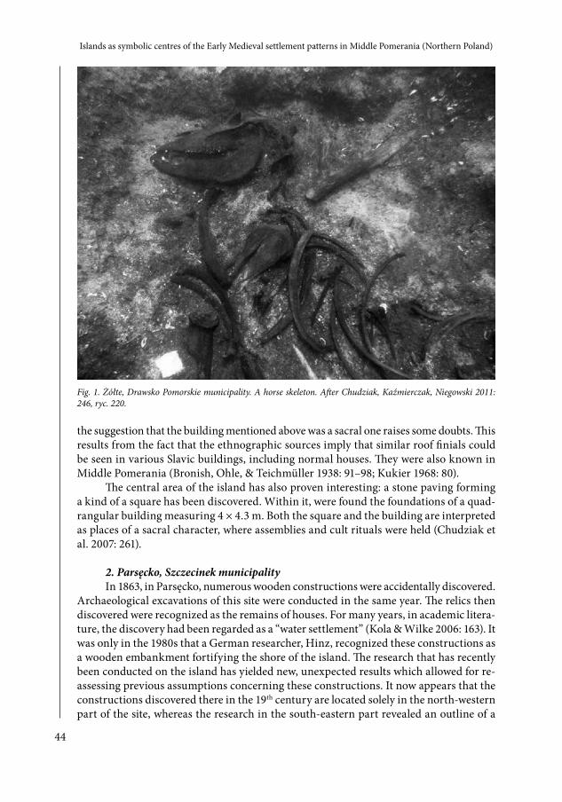
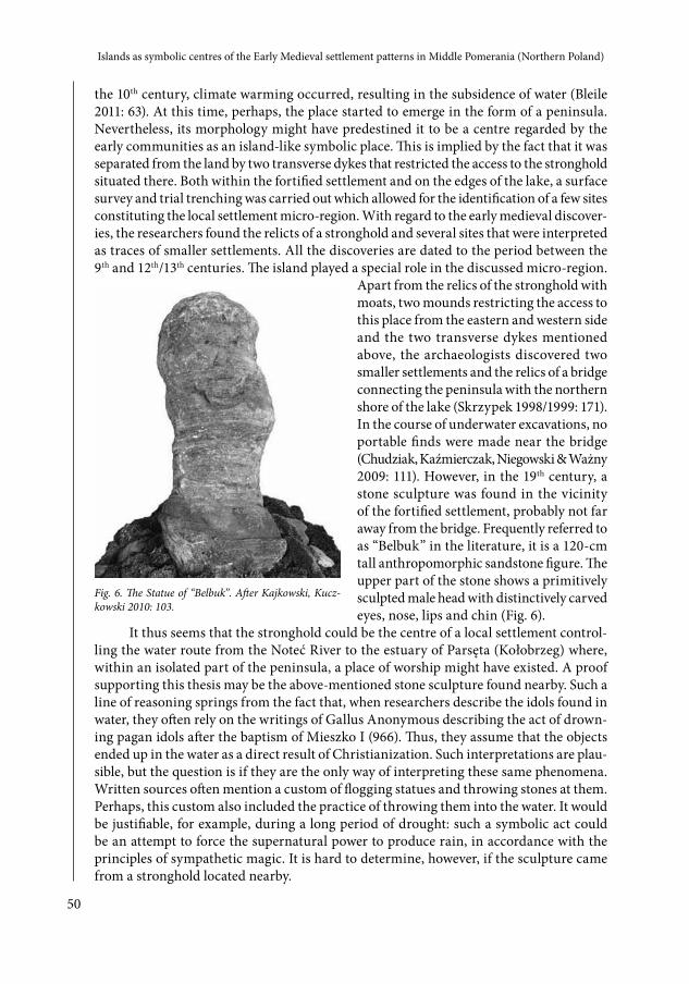
In the course of research, two stone mounds of a natural origin were discovered in the south-western part of the island. Many animal remains were discovered, and these included the bones of a horse discovered on one of the mounds together with a blade of an axe from the 11th or 12th century. According to archaeologists working at this site, they may be interpreted as a sacrificial offering in a once well-exposed place, easily noticeable from the surface of the water (Chudziak et al. 2007: 262). A similar interpretation is given for the bones of a horse found 20 m to the west of the island1 (Fig. 1), close to a construc-tion whose relicts are regarded as the remains of a palisade (Chudziak et al. 2009: 369).
These finds are quite significant in the context of another discovery made in Żółte: a wooden relief carving of a horse. According to some scholars, the features of this object may imply that it was placed on the roof ridge of a building that may have functioned as a temple. While the special role of horses in the beliefs of the Baltic Slavs is quite evident, 1 It resembles a pagan horse sacrifice probably made by Slavs besieging the stronghold of Guldborg on Lange-
land, a Danish island, between 1134 and 1157. The researchers found remains of a horse which was initially stuck on a stake through its anus in front of the gate of the stronghold (cf. Skaarup 2001).
44
Islands as symbolic centres of the Early Medieval settlement patterns in Middle Pomerania (Northern Poland)
the suggestion that the building mentioned above was a sacral one raises some doubts. This results from the fact that the ethnographic sources imply that similar roof finials could be seen in various Slavic buildings, including normal houses. They were also known in Middle Pomerania (Bronish, Ohle, & Teichmüller 1938: 91–98; Kukier 1968: 80).
The central area of the island has also proven interesting: a stone paving forming a kind of a square has been discovered. Within it, were found the foundations of a quad-rangular building measuring 4 × 4.3 m. Both the square and the building are interpreted as places of a sacral character, where assemblies and cult rituals were held (Chudziak et al. 2007: 261).
2. Parsęcko, Szczecinek municipalityIn 1863, in Parsęcko, numerous wooden constructions were accidentally discovered.
Archaeological excavations of this site were conducted in the same year. The relics then discovered were recognized as the remains of houses. For many years, in academic litera-ture, the discovery had been regarded as a “water settlement” (Kola & Wilke 2006: 163). It was only in the 1980s that a German researcher, Hinz, recognized these constructions as a wooden embankment fortifying the shore of the island. The research that has recently been conducted on the island has yielded new, unexpected results which allowed for re-assessing previous assumptions concerning these constructions. It now appears that the constructions discovered there in the 19th century are located solely in the north-western part of the site, whereas the research in the south-eastern part revealed an outline of a
Fig. 1. Żółte, Drawsko Pomorskie municipality. A horse skeleton. After Chudziak, Kaźmierczak, Niegowski 2011: 246, ryc. 220.
45
Kamil Kajkowski
building of a post and beam structure (3 × 3 m.). Moreover, in the northern part of the site, archaeologists have discovered the remains of piers significantly extending into the water. The area of the shore abounded with numerous discoveries of objects including military equipment as well as weaving and agricultural tools. A particularly fascinating discovery was a fragment of a carved zoomorphic plank which is frequently compared to similar representations of this type found in the Western Slavic areas of pagan worship (e.g. Gross Raden, Wrocław) (Chudziak 2010: 304).2 The site is dated to the period between the 11th and the 12th centuries (Chudziak, Kaźmierczak, Niegowski & Ważny 2009: 108).
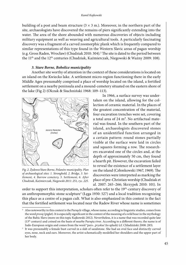
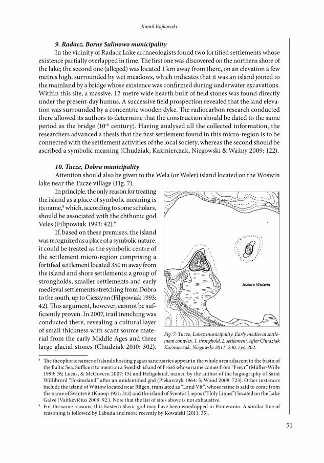
3. Stare Borne, Bobolice municipalityAnother site worthy of attention in the context of these considerations is located on
an island on the Kwiecko lake. A settlement micro-region functioning there in the early Middle Ages presumably comprised a place of worship located on the island, a fortified settlement on a nearby peninsula and a mound-cemetery situated on the eastern shore of the lake (Fig 2) (Olczak & Siuchniński 1968: 109–113).
In 1966, a surface survey was under-taken on the island, allowing for the col-lection of ceramic material. In the places of the greatest concentration of the material, four excavation trenches were set, covering a total area of 24 m². No artifactual mate-rial was found. In the southern part of the island, archaeologists discovered stones of an unidentified function arranged in a certain pattern: round stones partially visible at the surface were laid in circles and squares forming a row. The research-ers excavated one of the circles and, at the depth of approximately 50 cm, they found a hearth pit. However, the excavation failed to reveal the existence of a settlement layer on the island (Członkowski 1967, 1969). The discoveries were interpreted as marking the place of pre-Christian worship (Chudziak et al. 2007: 265–266; Skrzypek 2010: 101). In
order to support this interpretation, scholars often refer to the 19th-century discovery of an anthropomorphic stone sculpture3 (Łęga 1930: 527) and a local tradition recognizing this place as a centre of a pagan cult. What is also emphasized in this context is the fact that the fortified settlement was located near the Radew River whose name is sometimes 2 Also noteworthy in this context is the Parsęck village, whose name, according to linguistic studies, comes from
the word prosię (piglet). It is especially significant in the context of the meaning of a wild boar in the mythology of the Baltic Slavs (more on this topic Kajkowski 2012). Nevertheless, it is a name that was recorded quite late (13th century) and coined on the basis of nearby Parsęta river. According to a different theory, the name is of Indo-European origin and comes from the word *pers-, pryskać (to splash) (cf. Chludziński 2008: 283).
3 It was presumably a female bust carved in a slab of sandstone. She had an oval face and distinctly carved eyes, nose, neck and ears. Moreover, the artist schematically modelled her shoulders and the upper part of her body.
Fig. 2. Żydowo/Stare Borne, Polanów municipality. Plan of archaeological sites: 1. Stronghold, 2. Bridge, 3. Set-tlement, 4. Barrow cemetery, 5. Settlement, 6. After Chudziak, Kaźmierczak, Niegowski 2011: 251, ryc. 225.
46
Islands as symbolic centres of the Early Medieval settlement patterns in Middle Pomerania (Northern Poland)
said to come from Pre-Indo-European *rod-, *rad- meaning “scratch”, “dig”.4 This origin is said to be common to a number of places, often regarded in the literature as centres of pagan worship, such as Radogosc, Gross Raden, Radzikowo (Słupecki 1995: 53).
The site in Stare Borne, however, may also be interpreted differently. Based on the brief archaeological reports and comparing them with the results of the excavation of the cemetery on the eastern shore of the lake, it can be assumed that the oval stone construc-tions could be recognized as the relics of destroyed early medieval mounds. It should not be forgotten that the places of worship in the Slavic area most probably did not take the form of stone circles. Even if these two places were not used in the same period, one could assume that both types of mounds were visible to at least some inhabitants of the micro-region here described and constituted a part of a developed symbolic complex.
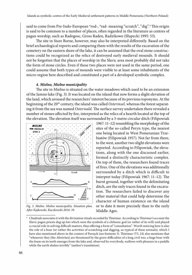
4. Mielno, Mielno municipalityThe site in Mielno is situated on the water meadows which used to be an extension
of the Jamno lake (Fig. 3). It was located on the island that now forms a slight elevation of the land, which aroused the researchers’ interest because of its previous toponyms. At the beginning of the 20th century, the island was called Osterinsel, whereas the forest separat-ing it from the sea was named Osterwald. The surface survey undertaken there revealed a number of stones affected by fire, interpreted as the relics of a hearth located at the top of the elevation. The elevation itself was surrounded by a 3-metre circular ditch (Filipowiak
1967: 11–12) resembling the morphology of the sites of the so-called Peryn type, the nearest one being located in West Pomeranian Trze-biatów (Filipowiak 1957). Not far from there, to the west, another two slight elevations were reported. According to Filipowiak, the eleva-tions, along with the one discussed earlier, formed a distinctly characteristic complex. On top of them, the researchers found traces of fires. One of the elevations was additionally surrounded by a ditch which is difficult to interpret today (Filipowiak 1967: 11–12). The burnt ground, together with the delimitating ditch, are the only traces found in the excava-tion. The researchers failed to discover any other material that could help determine the character of human existence on the island or to date it more precisely than to the early Middle Ages.
4 Chudziak associates it with the divination rituals recorded by Thietmar. According to Thietmar’s account the Slavic pagan priests dug up lots which were the symbols of a chthonic god (or rather of its will) and played a crucial role in solving difficult matters, thus offering a form of “consultation”. Worth noticing here is also the role of a boar (or rather the activities of scratching and digging, so typical of these animals), which I have also mentioned above in the context of Parsęck (see footnote 3). Thietmar (VI, 24) also mentions that “whenever they [the Abotrites] are threatened by the grave difficulties of a long civil war, a huge boar with the foam on its teeth emerges from the lake and, observed by everybody, wallows with pleasure in a puddle while the earth shakes terribly” (author’s translation).
5. Mielenko Drawskie, Drawsko Pomorskie municipalityTraces of hearths were also reported on an island on a nameless lake 600 m to the
north from Mielenko Drawskie. In the course of the excavation, one settlement layer 40 cm to 1 m thick was identified. It was a very sandy layer with a significant admixture of burnt material and stones affected by fire: probably the remains of destroyed hearths. Several hundred ceramic fragments were collected, along with animal bones and two clay spindle whorls. On the southern side, the researchers found relics of a causeway leading to the island. In the course of the archaeological excavations, ten test pits were dug. More than ten metres long, a few metres wide and up to one metre deep, the pits allowed for the full documentation of the stratigraphic context. The results turned out to be similar in different places on the island: they uncovered one settlement layer with traces of burnt material and scant remains of wooden beams. At the bottom of the layer, the archaeologists found broken stones covered with tar. According to Janocha (1999), they are the traces of a reinforcement construction built to make the swampy land stable enough for building purposes. Moreover, in the direct vicinity of the border of the island, a low construction made of large stones was discovered. Presumably, it constituted the foundations of a struc-ture intended to strengthen the shoreline. It was dated to the 9th–12th centuries. Based on the results of the archaeological research, it was difficult to determine the characteristics of the human existence on the island. According to Janocha investigating the site, it was probably a fortified settlement. However, this relatively moderate amount of the archaeo-logical material in relation to the large area examined may suggest that the settlement did not last long (which seems impossible given the site’s chronology mentioned above) or that groups of people only occasionally visited the island, with no intention of settling there.
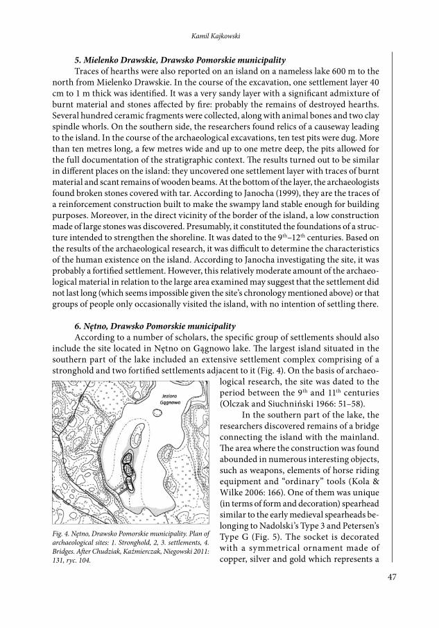
6. Nętno, Drawsko Pomorskie municipalityAccording to a number of scholars, the specific group of settlements should also
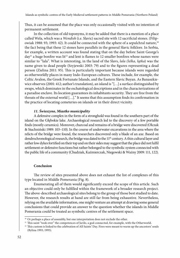
include the site located in Nętno on Gągnowo lake. The largest island situated in the southern part of the lake included an extensive settlement complex comprising of a stronghold and two fortified settlements adjacent to it (Fig. 4). On the basis of archaeo-
logical research, the site was dated to the period between the 9th and 11th centuries (Olczak and Siuchniński 1966: 51–58).
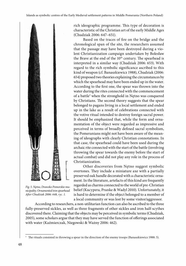
In the southern part of the lake, the researchers discovered remains of a bridge connecting the island with the mainland. The area where the construction was found abounded in numerous interesting objects, such as weapons, elements of horse riding equipment and “ordinary” tools (Kola & Wilke 2006: 166). One of them was unique (in terms of form and decoration) spearhead similar to the early medieval spearheads be-longing to Nadolski’s Type 3 and Petersen’s Type G (Fig. 5). The socket is decorated with a symmetrical ornament made of copper, silver and gold which represents a
Fig. 4. Nętno, Drawsko Pomorskie municipality. Plan of archaeological sites: 1. Stronghold, 2, 3. settlements, 4. Bridges. After Chudziak, Kaźmierczak, Niegowski 2011: 131, ryc. 104.
48
Islands as symbolic centres of the Early Medieval settlement patterns in Middle Pomerania (Northern Poland)
rich ideographic programme. This type of decoration is characteristic of the Christian art of the early Middle Ages (Chudziak 2006: 647–651).
Based on the traces of fire on the bridge and the chronological span of the site, the researchers assumed that the passage may have been destroyed during a vio-lent Christianization campaign undertaken by Bolesław the Brave at the end of the 10th century. The spearhead is interpreted in a similar way (Chudziak 2006: 653). With regard to the rich symbolic significance ascribed to this kind of weapon (cf. Banaszkiewicz 1988), Chudziak (2006: 654) proposed two theories explaining the circumstances by which the spearhead may have been ended up in the water. According to the first one, the spear was thrown into the water during the rites connected with the commencement of a battle5 when the stronghold in Nętno was conquered by Christians. The second theory suggests that the spear belonged to pagans living in a local settlement and ended up in the lake as a result of celebrations connected with the votive ritual intended to destroy foreign sacral power. It should be emphasized that, while the form and orna-mentation of the object were regarded as impressive and perceived in terms of broadly defined sacral symbolism, the Pomeranians might not have been aware of the mean-ing of ideographs with clearly Christian connotations. In that case, the spearhead could have been used during the archaic rite connected with the start of the battle (involving throwing the spear towards the enemy before the start of actual combat) and did not play any role in the process of Christianization.
Other discoveries from Nętno suggest symbolic overtones. They include a miniature axe with a partially preserved oak handle decorated with a characteristic orna-ment. In the literature, artefacts of this kind are frequently regarded as charms connected to the world of pre-Christian belief (Kucypera, Pranke & Wadyl 2010). Unfortunately, it is hard to determine if the object belonged to a member of a local community or was lost by some visitor/aggressor.
According to researchers, a non-utilitarian function can also be ascribed to the three fully-preserved sickles, as well as three fragments of other sickles and iron half-scythes discovered there. Claiming that the objects may be perceived in symbolic terms (Chudziak, 2005), some scholars argue that they may have served the function of offerings associated with water (Kaźmierczak, Niegowski & Ważny 2006: 462).
5 The rituals consisted in throwing a spear in the direction of the enemy troops (Banaszkiewicz 1988: 5).
Fig. 5. Nętno, Drawsko Pomorskie mu-nicipality. Ornamented iron spearhead. After Chudziak 2006: 648, ryc. 1.
49
Kamil Kajkowski
On the basis of the facts presented above, it is difficult to determine if the island on Gągnowo Lake functioned as a place of sacral importance in the early Middle Ages. This assumption has not been confirmed by archaeological research. Nevertheless, the discover-ies do suggest that this island played a significant role in the life of the local community.
7. Bobięcino, Miastko municipalityA similar interpretation can be ascribed to the site in Bobięcino (Miastko munici-
pality), where, in the course of archaeological prospection, numerous traces of early me-dieval settlements were found. The main element of the local micro-region was probably a stronghold located on the island on the lake. Underwater excavations revealed that it was connected with an open settlement on the mainland by a wooden bridge (cf. Wilke, 1985). The catalogue of the early medieval fortified settlements published by Olczak and Siuchniński (1989: 13) mentions that no archaeological research had been undertaken at this site. However, a surface search initiated by the Museum of Middle Pomerania in Słupsk was conducted there, which revealed a small collection of ceramic vessels dated to the early Middle Ages (Traczykówna, no date of issue). In the course of the field prospec-tion undertaken in the vicinity of the stronghold, which was presumably a seat of the local authorities, the researchers found the relics of a square also dated to this period. Separated from the surroundings by a stone and earth dyke, it probably fulfilled public functions (Chudziak 2011: 37).
The relicts of the bridge found during the underwater excavation have been dendro-chronologically dated to the 12th century. According to the researchers working at this site, the stronghold and the suburbium functioning there in the 9th century were not initially connected to the mainland by a bridge, forcing its inhabitants to use boats. It was only when a feudal seat was established there within old fortifications that the bridge could be built (Wilke 1985: 24). The underwater research revealed a significant number of port-able finds dated to the early Middle Ages (Matuszewska-Kola & Kola 1985). Apart from a group of “ordinary” artefacts (tools, vessels, etc.), the researchers found two iron axes with partially preserved handles6 which deserve special attention. Their form may sug-gest that they were used for military purposes, which is quite significant since no other military equipment7 was found at the bottom of the Bobięcino Lake. Particular attention should also be given to a dugout boat stuck between the remains of the bridge pillars. The interior of the boat was filled with large fieldstones, which suggests that it was deliberately sunk in that place. According to the authors of these investigations, the discovery can be interpreted as a foundation offering (Matuszewska-Kola & Kola 1985: 33). What cannot be excluded, however, is that it was a result of actions undertaken to prevent an enemy from accessing the harbour in the course of some military operation.
8. Rakowo, Borne Sulinowo municipalityOther interesting sites include Rakowo (Borne Sulinowo municipality) on Komorze
Lake. At present, it is an elongated peninsula, but taking paleo-ecological research into consideration, it seems that at least in the initial phase it could have been an island. In
6 In August 2010, the Department of Archeology of the Museum in Koszalin acquired a third weapon of this type. Unfortunately, the person responsible for the discovery could not indicate the exact place of its discovery.
7 It is noteworthy that the researchers also found a sword scabbard-chape there.
50
Islands as symbolic centres of the Early Medieval settlement patterns in Middle Pomerania (Northern Poland)
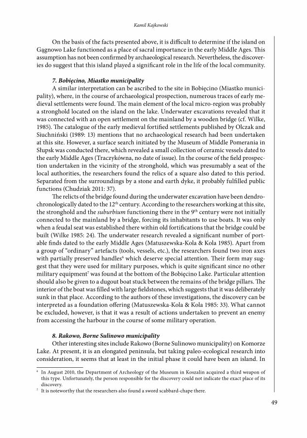
the 10th century, climate warming occurred, resulting in the subsidence of water (Bleile 2011: 63). At this time, perhaps, the place started to emerge in the form of a peninsula. Nevertheless, its morphology might have predestined it to be a centre regarded by the early communities as an island-like symbolic place. This is implied by the fact that it was separated from the land by two transverse dykes that restricted the access to the stronghold situated there. Both within the fortified settlement and on the edges of the lake, a surface survey and trial trenching was carried out which allowed for the identification of a few sites constituting the local settlement micro-region. With regard to the early medieval discover-ies, the researchers found the relicts of a stronghold and several sites that were interpreted as traces of smaller settlements. All the discoveries are dated to the period between the 9th and 12th/13th centuries. The island played a special role in the discussed micro-region.
Apart from the relics of the stronghold with moats, two mounds restricting the access to this place from the eastern and western side and the two transverse dykes mentioned above, the archaeologists discovered two smaller settlements and the relics of a bridge connecting the peninsula with the northern shore of the lake (Skrzypek 1998/1999: 171). In the course of underwater excavations, no portable finds were made near the bridge (Chudziak, Kaźmierczak, Niegowski & Ważny 2009: 111). However, in the 19th century, a stone sculpture was found in the vicinity of the fortified settlement, probably not far away from the bridge. Frequently referred to as “Belbuk” in the literature, it is a 120-cm tall anthropomorphic sandstone figure. The upper part of the stone shows a primitively sculpted male head with distinctively carved eyes, nose, lips and chin (Fig. 6).
It thus seems that the stronghold could be the centre of a local settlement control-ling the water route from the Noteć River to the estuary of Parsęta (Kołobrzeg) where, within an isolated part of the peninsula, a place of worship might have existed. A proof supporting this thesis may be the above-mentioned stone sculpture found nearby. Such a line of reasoning springs from the fact that, when researchers describe the idols found in water, they often rely on the writings of Gallus Anonymous describing the act of drown-ing pagan idols after the baptism of Mieszko I (966). Thus, they assume that the objects ended up in the water as a direct result of Christianization. Such interpretations are plau-sible, but the question is if they are the only way of interpreting these same phenomena. Written sources often mention a custom of flogging statues and throwing stones at them. Perhaps, this custom also included the practice of throwing them into the water. It would be justifiable, for example, during a long period of drought: such a symbolic act could be an attempt to force the supernatural power to produce rain, in accordance with the principles of sympathetic magic. It is hard to determine, however, if the sculpture came from a stronghold located nearby.
Fig. 6. The Statue of “Belbuk”. After Kajkowski, Kucz-kowski 2010: 103.
51
Kamil Kajkowski
9. Radacz, Borne Sulinowo municipalityIn the vicinity of Radacz Lake archaeologists found two fortified settlements whose
existence partially overlapped in time. The first one was discovered on the northern shore of the lake; the second one (alleged) was located 1 km away from there, on an elevation a few metres high, surrounded by wet meadows, which indicates that it was an island joined to the mainland by a bridge whose existence was confirmed during underwater excavations. Within this site, a massive, 12-metre wide hearth built of field stones was found directly under the present-day humus. A successive field prospection revealed that the land eleva-tion was surrounded by a concentric wooden dyke. The radiocarbon research conducted there allowed its authors to determine that the construction should be dated to the same period as the bridge (10th century). Having analysed all the collected information, the researchers advanced a thesis that the first settlement found in this micro-region is to be connected with the settlement activities of the local society, whereas the second should be ascribed a symbolic meaning (Chudziak, Kaźmierczak, Niegowski & Ważny 2009: 122).
10. Tucze, Dobra municipalityAttention should also be given to the Wela (or Weler) island located on the Woświn
lake near the Tucze village (Fig. 7). In principle, the only reason for treating
the island as a place of symbolic meaning is its name,8 which, according to some scholars, should be associated with the chthonic god Veles (Filipowiak 1993: 42).9
If, based on these premises, the island was recognized as a place of a symbolic nature, it could be treated as the symbolic centre of the settlement micro-region comprising a fortified settlement located 350 m away from the island and shore settlements: a group of strongholds, smaller settlements and early medieval settlements stretching from Dobra to the south, up to Cieszyno (Filipowiak 1993: 42). This argument, however, cannot be suf-ficiently proven. In 2007, trail trenching was conducted there, revealing a cultural layer of small thickness with scant source mate-rial from the early Middle Ages and three large glacial stones (Chudziak 2010: 302).
8 The theophoric names of islands hosting pagan sanctuaries appear in the whole area adjacent to the basin of the Baltic Sea. Suffice it to mention a Swedish island of Frösö whose name comes from “Freyr” (Müller-Wille 1999: 76; Lucas, & McGovern 2007: 15) and Heligoland, named by the author of the hagiography of Saint Willibrord “Fositesland” after an unidentified god (Piekarczyk 1964: 5; Wood 2008: 723). Other instances include the island of Wittow located near Rügen, translated as “Land Vit”, whose name is said to come from the name of Svantevit (Knoop 1921: 312) and the island of Šventos Liepos (“Holy Limes”) located on the Lake Galvė (Vaitkevičius 2009: 92.). Note that the list of sites above is not exhaustive.
9 For the same reasons, this Eastern Slavic god may have been worshipped in Pomerania. A similar line of reasoning is followed by Labuda and more recently by Kowalski (2011: 35).
Islands as symbolic centres of the Early Medieval settlement patterns in Middle Pomerania (Northern Poland)
Thus, it can be assumed that the place was only occasionally visited with no intention of permanent settlement.
In the collection of old toponyms, it may be added that there is a mention of a place called Wela, which was a Wendish (i.e. Slavic) sacred site with 12 sacrificial stones. (Filip-owiak 1988: 93; 1993: 42). It could be connected with the sphere of a sepulchral nature,10 the fact being that these 12 stones have parallels in the general Slavic folklore. In Serbia, for example, a written account was found stating that on the day before Saint George’s day11 a huge bonfire was lit12 and lent is flames to 12 smaller bonfires whose names were similar to “lala”. What is interesting, in the land of the Slavs, lala (lelka, łątka) was the name given to dead people (Szyjewski 2003: 79) and to the figures representing a dead person (Zielina 2011: 95). This is particularly important because islands were regarded as otherworldly places in many Indo-European cultures. These include, for example, the Celtic Avalon, the Greek Fortunate Islands, and the Eastern Slavic Buyan. As Banaszkie-wicz observes (2001: 412; author’s translation), an island is “[…] a surface distinguished by swaps, which dominates in the eschatological descriptions and in the characterizations of a paradise enclave. Its location guarantees its inhabitants security. They are free from the threats of the external world […].” It seems that this assumption finds its confirmation in the practice of locating cemeteries on islands or in their direct vicinity.
11. Świeszyno, Miastko municipalityA defensive complex in the form of a stronghold was found in the southern part of the
island on the Głębokie lake. Archaeological research led to the discovery of a few portable finds (mostly ceramics). Moreover, charcoal and remains of a bridge were discovered (Olczak & Siuchniński 1989: 103–110). In the course of underwater excavations in the area where the relicts of the bridge were found, the researchers discovered only a blade of an axe. Based on dendrochronological research, the bridge was dated to the 11th century. A thin cultural layer and rather low dykes fortified on their top and on their sides may suggest that the place did not fulfil settlement or defensive functions but rather belonged to the symbolic system connected with the public life of a community (Chudziak, Kaźmierczak, Niegowski & Ważny 2009: 111, 122).
Conclusion
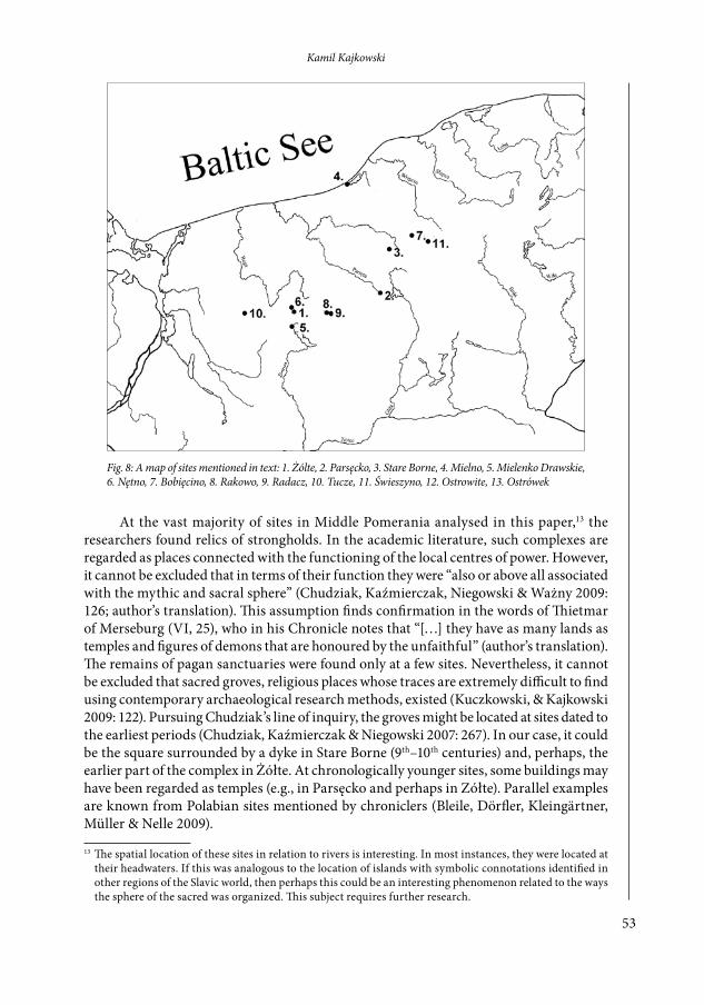
The review of sites presented above does not exhaust the list of complexes of this type located in Middle Pomerania (Fig. 8).
Enumerating all of them would significantly exceed the scope of this article. Such an objective could only be fulfilled within the framework of a broader research project. The above-described archaeological sites belong to the group of those best studied to date. However, the research results at hand are still far from being exhaustive. Nevertheless, relying on the available information, one might venture an attempt at drawing some general conclusions that could provide an answer to the question whether the islands in Middle Pomerania could be treated as symbolic centres of the settlement space.
10 Or perhaps a place of assembly, but one interpretation does not exclude the other. 11 This saint “took over” the competences of Jarilo, a god connected, for example, with the Otherworld.12 This custom is linked to the celebration of All Saints’ Day. Fires were meant to warm up the ancestors’ souls
(Bylina 1993; 1995).
53
Kamil Kajkowski
At the vast majority of sites in Middle Pomerania analysed in this paper,13 the researchers found relics of strongholds. In the academic literature, such complexes are regarded as places connected with the functioning of the local centres of power. However, it cannot be excluded that in terms of their function they were “also or above all associated with the mythic and sacral sphere” (Chudziak, Kaźmierczak, Niegowski & Ważny 2009: 126; author’s translation). This assumption finds confirmation in the words of Thietmar of Merseburg (VI, 25), who in his Chronicle notes that “[…] they have as many lands as temples and figures of demons that are honoured by the unfaithful” (author’s translation). The remains of pagan sanctuaries were found only at a few sites. Nevertheless, it cannot be excluded that sacred groves, religious places whose traces are extremely difficult to find using contemporary archaeological research methods, existed (Kuczkowski, & Kajkowski 2009: 122). Pursuing Chudziak’s line of inquiry, the groves might be located at sites dated to the earliest periods (Chudziak, Kaźmierczak & Niegowski 2007: 267). In our case, it could be the square surrounded by a dyke in Stare Borne (9th–10th centuries) and, perhaps, the earlier part of the complex in Żółte. At chronologically younger sites, some buildings may have been regarded as temples (e.g., in Parsęcko and perhaps in Zółte). Parallel examples are known from Polabian sites mentioned by chroniclers (Bleile, Dörfler, Kleingärtner, Müller & Nelle 2009).
13 The spatial location of these sites in relation to rivers is interesting. In most instances, they were located at their headwaters. If this was analogous to the location of islands with symbolic connotations identified in other regions of the Slavic world, then perhaps this could be an interesting phenomenon related to the ways the sphere of the sacred was organized. This subject requires further research.
Fig. 8: A map of sites mentioned in text: 1. Żólte, 2. Parsęcko, 3. Stare Borne, 4. Mielno, 5. Mielenko Drawskie, 6. Nętno, 7. Bobięcino, 8. Rakowo, 9. Radacz, 10. Tucze, 11. Świeszyno, 12. Ostrowite, 13. Ostrówek
54
Islands as symbolic centres of the Early Medieval settlement patterns in Middle Pomerania (Northern Poland)
In other cases, the sacral meaning of some complexes may be indirectly suggested by the cultural layers of small thickness implying a brief or temporary character of hu-man presence on the islands. Long-term settlement activities would have left significantly clearer traces associated with the transformation of the landscape in connection with the broadly defined economic sphere (Bleile 2011: 66). Moreover, at some sites, the research-ers recorded traces of ritual practices connected to the act of offering sacrifice. On the islands, they usually took place in the coastal area which, in many cultures, is valorized in sacral terms (Czarnowski 1956: 225 et seq.). In this context, particular attention should be given to bridges, the assumption being that, apart from the linking function, they could be associated with religious beliefs. A bridge was perceived as a place of special media-tory qualities (Stomma 1986: 163). It was a road suspended above the water, the unknown world, the domain of the chthonic forces, leading to the places which were isolated from their immediate surroundings. Thus, the bridge was a link between the world of the sacred and the sphere of the profane. In this context, the account of Adam of Bremen (Adam of Bremen II, 21) concerning the sedes ydolatriae of the Obotrites, Radogosc, appears meaningful. While describing the temple, the chronicler states that there existed a bridge that could be used by people who wanted to offer a sacrifice and have their fortunes read.
The sources available to us today allow for interpreting the sites discussed above as having particular characteristics referring to pre-Christian mythological or cosmogonic concepts. A number of features discovered at these sites, including wooden constructions and other traces of human activity, also imply their particular role in sacral topography. In contrast to sanctuaries located elsewhere and not surrounded by water, islands pos-sess many morphological features, which would have been essential for past societies and which would predestine them to become places of special, numinous nature. Due to their isolated character (and often their additional (anthropogenic) delimitation from immediate surroundings) the islands were places that accumulated transcendent powers. The concept of delimitating sacral space is also evident at other Pomeranian sites located, for example, on hilltops and often very close to lakes, bogs or (less frequently) rivers. In such instances, however, the interpretation of such localities as being sacred is not always as clear as in the case of islands. Moreover, traces of ritual activities, in the form of sacrificial offerings, are rarely found there. In the case of islands, however, remains of ritual acts are registered much more frequently, especially along their coasts and near the bridges. To conclude, in contrast to the sites located elsewhere (on land), the sanctuaries on islands often possess all the features that support their interpretation as places of numinous nature: spatial separation and delimitation, numinosum, adaptation, transformation and ritual activity.
To summarize, it should be stated that, with a certain degree of probability, in almost all of these complexes there existed places that belonged to the symbolic domain that comprises the sacral sphere manifesting itself through ritual and religious centres, places for the legitimation of power (strongholds) and sites associated with sacral and secular exchange. All aspects of human activity were characterized by a number of features referring to the mythic and sacral perception of the world. That is why ritual acts were performed in places that were perceived in a similar way. In Middle Pomerania, such a role could undoubtedly be played by islands: places marking a symbolic centre around which daily social life and settlement activities were organized.
55
Kamil Kajkowski
References
Adam of Bremen (1917). Magistri Adam Bremensis Gesta Hamburgensis ecclesiae pontifi-cum. In B. Schmeidler (Ed.), Monumentis Germaniae Historicis, Scriptores, Rerum Germanicum. Hannover – Leipzig: Hahnsche Buchhandlung.
Adamowski, J. (1999). Kategoria przestrzeni w folklorze. Studium etnolingwistyczne. Lublin: Wydawnictwo UMCS.
Banaszkiewicz, J. (1988). Włócznia i chorągiew. O rycie otwierania bitwy w związku z cu-dem kampanii nakielskiej Bolesława Krzywoustego (Kadłubek, III, 14). Kwartalnik Historyczny, 94(4), pp. 3–24.
Banaszkiewicz, J. (2001). Źródło Głomacz i jego rajska okolica. In M. Goliński and S. Rosik (Eds.), Viae historicae. Księga jubileuszowa dedykowana Profesorowi Lechowi A. Tysz-kiewiczowi w siedemdziesiątą rocznicę urodzin, pp. 407–414. Wrocław: Wydawnictwo Uniwersytetu Wrocławskiego.
Bleile, R. (2011). Zur Funktion slawischer Inselsiedlungen im 10. Jahrhundert. In F. Bier-mann, T. Kersting, & A. Klammt (Eds.), Der Wandel um 1000 Beträige der Sektion zur slawischen Frühgeschichte der 18. Jahrestagung des Mittel- und Osdeutschen Verbandes für Altertumsforschung in Greifswald, March 2009, pp. 63–83. Langenweissbach: Beier & Beran. Archäologische Fachliteratur.
Bleile, R., Dörfler, W., Kleingärtner, S., Müller, U., & Nelle, O. (2009). Das Projekt Olsborg. untersuchungen auf einer insel im grossen plöner see. In U. Müller, S. Kleingärtner & F. Huber (Eds), Zwischen Nord- und Ostsee 1997–2007. Zehn Jahre Arbeitsgruppefür maritime und limnische Archäologie (AMLA) in Aschleswig – Holstein. Bonn: Habelt.
Bronisch, G., Ohle, W., & Teichmüller H. (1938). Kreis Bütow, Stettin: Komissionsverlag L. Saunier.
Bylina, S. (1993). Słowiański świat zmarłych u schyłku pogaństwa. Wyobrażenia przestrzenne. Kwartalnik Historyczny, 5, pp. 73–88.
Bylina, S. (1995). Problemy słowiańskiego świata zmarłych. Światowit, 40, pp. 9–25. Chludziński, A. (2008). Toponimia powiatu białogardzkiego, Pruszcz Gdański: Wydawnictwo
Jasne.Chudziak, W. (2005). Z badań nad funkcją społeczną sierpów i półkosków na ziemiach
słowiańskich we wczesnym średniowieczu. Archaeologica Historica Polona 15, pp. 201–218.
Chudziak, W. (2006). Wczesnośredniowieczny grot włóczni z Nętna: przyczynek do studiów nad chrystianizacją Pomorza Środkowego. In M. Dworaczyk, A.B. Kowalska, S. Moździoch, & M. Rębkowski (Eds.), Świat Słowian wczesnego średniowiecza, pp. 647– 655. Szczecin, Wrocław: IAiE PAN.
Chudziak, W. (2010). Przestrzeń pogańskiego sacrum w krajobrazie przyrodniczo – kul-turowym Słowian pomorskich. In K. Bracha and C. Hadamik (Eds.), Sacrum pogańskie, sacrum chrześcijańskie. Kontynuacja miejsc kultu we wczesnośredniowiecznej Europie Środkowej, pp. 289–317. Warsaw: DiG.
Chudziak, W. (2011). Miejsca kultu pogańskiego w krajobrazie przyrodniczo – kulturowym Pomorza we wczesnym średniowieczu. In M. Adamczewski Polska i Europa w średniowieczu. Przemiany strukturalne. Podmioty i przedmioty w badaniach history-cznych, pp. 27–49. Warsaw: DiG.
56
Islands as symbolic centres of the Early Medieval settlement patterns in Middle Pomerania (Northern Poland)
Chudziak, W., Kaźmierczak, R., & Niegowski J. (2007). Niektóre problemy badawcze wczesnośredniowiecznych miejsc kultu przy śródlądowych akwenach jeziornych na Pomorzu Środkowym. In L. Bakalarska (ed.), Materiały z Konferencji Konserwatorstwa Archeologicznego zorganizowane przez Ośrodek Ochrony Dziedzictwa Archeologicznego. Jurata (8 – 20 V 2005 r.),Wigry (28 – 30 IX 2005 r.), Krynica (30 XI – 3 XII 2005 r.) pp. 257–270. Warsaw.
Chudziak, W., Kaźmierczak, R., & Niegowski, J. (2009). Z badań nad wczesnośredniowiecznym zespołem osadniczym w Żółtem (gmina Drawsko Pomorskie) (lata 2006 – 2007). In A. Janowski and K. Kowalski and S. Słowiński (eds.). XVI Sesja Pomorzoznawcza, Szczecin November 2007, r., część I: od epoki kamienia do okresu wczesnośredniowiecznego, pp. 231–247. Szczecin: SNAP.
Chudziak, W., Kaźmierczak, R., & Niegowski J. (2011). Podwodne dziedzictwo archeologiczne Polski: Katalog stanowisk (badania 2006–2009), Toruń: UMK.
Chudziak, W., Kaźmierczak, R., Niegowski J., & Ważny, T. (2009). Ze studiów nad genezą wczesnośredniowiecznych mostów na obszarze Pomorza. Przegląd Archeologiczny, 57, pp. 99–131.
Czarnowski, S. (1956). Podział przestrzeni i jej rozgraniczenie w religii i magii. In S. Czar-nowski, Dzieła, 3. Warsaw: PWN.
Członkowski, D. (1967). Sprawozdanie z ratowniczych badań archeologicznych na terenie Żydowa pow. Sławno w rejonie powstającej elektrowni wodnej w lecie 1966 roku. In H. Janocha and F. Lachowicz (Eds.), Sprawozdania z badań archeologicznych prow-adzonych na terenie województwa koszalińskiego w 1966 roku, pp. 43–47. Koszalin: Muzeum Okręgowe w Koszalinie.
Członkowski, D. (1969). Badania wykopaliskowe grodziska Stare Borne, pow. Koszalin. Wiadomości Archeologiczne, 34, pp. 421–434.
Eliade, M. (1974). Sacrum, mit, historia. Warsaw: PIW. Eliade, M. (1998). Obrazy i symbole. Szkice o symbolizmie religijno – magicznym. Warsaw:
Wydawnictwo KR.Filipowiak, W. (1957). Słowiańskie miejsce kultowe z Trzebiatowa pow. Gryfice. Materiały
Zachodniopomorskie, 3, pp. 75–95. Filipowiak, W. (1967). Słowiańskie miejsca kultowe Pomorza Zachodniego w świetle badań
archeologiczno-toponomastycznych. Przegląd Zachodniopomorski, 5, pp. 5–15.Filipowiak, W. (1993). Słowiańskie wierzenia pogańskie u ujścia Odry. In M. Wapiński
and H. Paner (Eds.), Wierzenia przedchrześcijańskie na ziemiach polskich, pp. 19–46. Gdański: Muzeum Archeologiczne.
Gieysztor, A. (2006). Mitologia Słowian, Warsaw: Wydawnictwo Uniwersytetu Warszawskiego. Hay, P. (2006). A phenomenology of islands. Island Studies Journal, 1(1), pp. 19–42. Janocha, H. (1999). Wczesnośredniowieczna osada na wyspie w Mielenku Drawskim, pow.
Drawsko Pomorskie. script in archive of Archaeology Department of Koszalin Museum. Kajkowski, K. (2011). Wyspy jako symboliczne centra wczesnośredniowiecznych mikrore-
gionów osadniczych Pomorza Środkowego. Nasze Pomorze, 13, pp. 23–42. Kajkowski, K. (2012). Boar in a symbolic and religious system of Baltic Slavs in the Early
Middle Ages. Studia Mythologica Slavica, 15, pp. 201–215.Karsten, S.R. (1955). The Religion of the Samek. Ancient Beliefs and Cults of the Scandinavian
and Finnish Lapps, Leiden: Brill Archive.
57
Kamil Kajkowski
Kaźmierczak, R., Niegowski, J., & Ważny, T. (2006). Wczesnośredniowieczny most z Nętna. In W. Chudziak & S. Moździoch (Eds.). Stan i potrzeby badań nad wczesnym średniowieczem w Polsce – 15 lat później, pp. 455–463. Toruń, Wrocław, Warsaw: Wydawnictwo UMK.
Knoop, O. (1921). Slawische Ortsnamenforschung in Pommern und der Name Stubben-kammer. Unser Pommerland, 6(9), pp. 311–316.
Kola, A., & Wilke, G. (2006) Wczesnośredniowieczne mosty na ziemiach polskich - stan i potrzeby badań. In W. Chudziak and S. Moździoch (eds.), Stan i potrzeby badań nad wczesnym średniowieczem w Polsce-15 lat później, pp. 151–173. Toruń, Wrocław, Warsaw: Wydawnictwo UMK.
Kucypera, P., Pranke, P., & Wadyl, S. (2010). Wczesnośredniowieczne miniaturowe toporki metalowe z Europy środkowo - wschodniej i północnej. Korpus zabytków. In P. Kucy-pera & S. Wadyl (Eds.), Kultura materialna średniowiecza w Polsce. Życie codzienne przez pryzmat rzeczy, pp. 103–176. Toruń: Adam Marszałek.
Kuczkowski, A., & Kajkowski, K. (2009). Die heiligen wälder der Slawen in Pommern im frühen mittelalter. Folklore, 42, pp. 111–128.
Kukier, R. (1968). Kaszubi bytowscy. Zarys monografii etnograficznej, Gdynia: Wydawnictwo Morskie.
Lucas, G., & McGovern, T. (2007). Bloody slaughter: ritual decapitation and display at the Viking settlement of Hofstađir, Iceland. European Journal of Archaeology, 10(1), pp. 7–30.
Łęga, W. (1930). Kultura Pomorza we wczesnem średniowieczu na podstawie wykopalisk, Toruń: Towarzystwo Naukowe.
Matuszewska-Kola, W., & Kola, A. (1985). Ruchome materiały źródłowe z archeologicznych badań podwodnych reliktów mostu wczesnośredniowiecznego w Bobęcinie koło Mi-astka, woj. słupskie z lat 1977–1983. Acta Universitatis Nicolai Copernici, Archeologia XI – Archeologia Podwodna 2. Nauki Humanistyczno – Społeczne, 166, pp. 27–51.
Müller-Wille, M. (1999). Opferkulte der Germanen und Slawen. Stuttgart: Theiss, Konrad. Olczak, J., & Siuchniński K. (1966). Źródła archeologiczne do studiów nad wczesnośredniowiecznym
osadnictwem grodowym na terenie woj. koszalińskiego, vol. 1. Poznań: UAM.Olczak, J., & Siuchniński K. (1968). Źródła archeologiczne do studiów nad wczesnośredniowiecznym
osadnictwem grodowym na terenie woj. koszalińskiego, vol. 2, Poznań: UAM.Olczak, J., & Siuchniński K. (1989). Źródła archeologiczne do studiów nad wczesnośredniowiecznym
osadnictwem grodowym na terenie województwa słupskiego. Poznań: UAM.Piekarczyk, S. (1964). Adaptacja - synkretyzm - mediewalizacja. Z preliminarnych rozważań
o chrześcijaństwie na progu średniowiecza. Część I. Euhemer: Przegląd Religioznaw-czy, 8(1), pp. 3–16.
Ralston, W. (1872). The songs of the Russian people, as illustrative of Slavonic mythology and Russian social life, London: Ellis & Green.
Skaarup, J. (2001). Guldborg: a Danish hillfort of the 1100’s attacked and conquered by the Wends. Castella Maris Baltici, 3–4, pp. 167–177.
Skrzypek, I. (1998/1999). W sprawie ‘Belbuka’. In E. Choińska-Bohdan (ed.), Z Otchłani Wieków Pomorza Gdańskiego. Zeszyt okazjonalny dla upamiętnienia Tysiąclecia Gdańska. 997 urbs Gyddanyze–1997 Gdańsk, pp. 166–173. Gdańsk: Muzeum Archeologiczne.
Skrzypek, I. (2010). Z pradziejów gminy Polanów. In W. Rączkowski and J. Sroka (eds.), Historia i kultura Ziemi Sławieńskiej,t. X: Miasto i gmina Polanów, pp. 39–115. Sławno, Polanów: Wydawnictwo Jasne.
58
Islands as symbolic centres of the Early Medieval settlement patterns in Middle Pomerania (Northern Poland)
Słupecki, L.P. (1995). Problem słowiańskich świątyń. Slavia Antiqua, 35, pp. 47–67. Stomma, L. (1985). Antropologia kultury wsi polskiej XIX w., Warsaw: PAX.Szyjewski, A. (2003). Religia Słowian, Kraków: Nomos. Thietmar. (2005). Kronika. Kraków: Universitas. Tomicka, J., & Tomicki, R. (1975). Drzewo życia. Ludowa wizja świata i człowieka. Warsaw:
Ludowa Spółdzielnia Wydawnicza. Toporow, W. (1977). O kosmologicznych źródłach wczesnohistorycznych opisów. In E. Janus
& M.R. Mayenowa (Eds.), Semiotyka kultury, pp. 103–131. Warsaw: PIW. Vaitkevičius, V. (2009). The sacred groves of the Balts: lost history and modern research.
Folklore, 42, pp. 81–94. Wilke, G. (1985). Most wczesnośredniowieczny z Bobęcina koło Miastka. Wstępne wyniki
archeologicznych badań podwodnych i analiz dendrochronologicznych jego reliktów. Acta Universitatis Nicolai Copernici, Archeologia XI - Archeologia Podwodna 2. Nauki Humanistyczno – Społeczne, 165, pp. 3–26.
Wood, I. (2008). Christianization and the dissemination of Christian teaching. In P. Fou-racre (Ed.), The new Cambridge medieval history, Vol. I: c.500-c.700, pp. 710–734. Cambridge: Cambridge University Press.
Zielina, J. (2011). Wierzenia Prasłowian, Kraków: Petrus.
59
Kamil Kajkowski
Wyspy jako symboliczne centra wczesnośredniowiecznych mikroregionów osadniczych Pomorza środkowego
Kamil Kajkowski
Pomorze to obszar charakteryzujący się specyficznym ukształtowaniem terenu. Duża liczba jezior powoduje, że istotne miejsce zajmują tutaj wyspy. Dzięki swojej izolacji względem krajobrazu w określony sposób oddziaływały one na ludzką psychikę. Takie właściwości mogły sprzyjać między innymi archetypowym skojarzeniom tych miejsc i jednocześnie waloryzacji tych miejsc w kategoriach sakralnych. Według ustaleń religio-znawców człowiek obierając jakąś przestrzeń na siedzibę, przede wszystkim poszukiwał obszaru specyficznego, wyróżniającego się w określonym otoczeniu. Symbolicznie był to punkt traktowany jako „stały”, będący w optyce myślenia symbolicznego osią orientacji, wokół której miało się w przyszłości koncentrować życie określonej społeczności. Takimi miejscami były wyspy. Skrawki ziemi manifestujące się w otoczeniu wodnym odnoszono do mitycznego Pralądu, pierwszej ziemi wyłaniającej się z wód Praoceanu, tworzącej środek świata, axis mundi. Były to więc punkty topograficzne o wyjątkowej emanacji sił sakral-nych, miejsca epifanii o szczególnych walorach numinotycznych. Materiał empiryczny pozyskany w wyniku badań archeologicznych pozwala przypisać i śledzić dynamikę takiego myślenia dawnym społecznościom charakteryzującym się tradycyjnym sposobem postrze-gania rzeczywistości. Badania wykopaliskowe prowadzone na stanowiskach wyspowych Pomorza ujawniają ślady wskazujące, iż we wczesnym średniowieczu wyspy zajmowały ważne miejsce w organizacji przestrzeni i aktywności obrzędowej stanowiąc zasadniczy element religijnego i mitycznego światopoglądu przedchrześcijańskich Pomorzan.