17
ISS–RapidScat Launch PRESS KIT/SEPTEMBER 2014 Module rotated to show instrument

Note: This press kit includes information on NASA’s ISS–RapidScat mission only. For an overview of the complete
SpaceX Cargo Resupply Services Mission 4, including a full mission timeline; details on the launch, Dragon capture
and berthing, Dragon return and recovery; other cargo and payloads; an overview of the Falcon 9 launch vehicle
and Dragon spacecraft; an overview of the International Space Station; additional graphics; and additional informa-
tion on SpaceX, please see the SpaceX/NASA CRS-4 Mission Press Kit.
Media Contacts
Steve Cole Policy/Program Management, 202-358-0918NASA Headquarters, Science Mission Directorate [email protected] Washington, DC 202-657-2194 (cell) Stephanie Schierholz Policy/Program Management, 202-358-1100NASA Headquarters, Human Exploration and Operations [email protected], DC Mission Directorate Alan Buis ISS–RapidScat Mission 818-354-0474Jet Propulsion Laboratory, [email protected] Pasadena, California
Dan Huot International Space Station 281-483-5111Johnson Space Center [email protected]
John Taylor Launch Vehicle/Dragon Spacecraft 310-363-6703SpaceX [email protected], California
George Diller Launch Operations 321-867-2468Kennedy Space Center, [email protected] Canaveral, Florida

Contents
Media Services Information. . . . . . . . . . . . . . . . . . . . . . . . . . . . . . . . . . . . . . . . . . . . . . . . . . . . . . 5
Quick Facts . . . . . . . . . . . . . . . . . . . . . . . . . . . . . . . . . . . . . . . . . . . . . . . . . . . . . . . . . . . . . . . . . 7
ISS–RapidScat Mission Overview . . . . . . . . . . . . . . . . . . . . . . . . . . . . . . . . . . . . . . . . . . . . . . . . 8
Why Study Ocean Winds? . . . . . . . . . . . . . . . . . . . . . . . . . . . . . . . . . . . . . . . . . . . . . . . . . . . . . 11
ISS–RapidScat Science Goals . . . . . . . . . . . . . . . . . . . . . . . . . . . . . . . . . . . . . . . . . . . . . . . . . . 14
ISS–RapidScat Instrument . . . . . . . . . . . . . . . . . . . . . . . . . . . . . . . . . . . . . . . . . . . . . . . . . . . . .15
Program/Project Management . . . . . . . . . . . . . . . . . . . . . . . . . . . . . . . . . . . . . . . . . . . . . . . . . . 17
ISS–RapidScat Launch 3 Press Kit

ISS–RapidScat Launch 4 Press Kit

Media Services Information
NASA Television Transmission
NASA Television is available in continental North America, Alaska and Hawaii by C-band signal on AMC-18C, at 105 degrees west longitude, Transponder 3C, 3760 MHz, vertical polarization. A Digital Video Broadcast (DVB)–compliant Integrated Receiver Decoder is needed for reception. Transmission format is DVB-S, 4:2:0. Data rate is 38.80 Mbps; symbol rate 28.0681, modulation QPSK/DVB-S, FEC 3/4.
NASA TV Multichannel Broadcast includes: NTV-1 (formally the Public Channel) and NTV-3 (formally the Media Channel) in high definition, and NTV-2 (formally the Education Channel) in standard definition.
For digital downlink information for each NASA TV chan-nel, access to all three channels online and a schedule of programming for SpaceX CRS-4 mission activities, visit http://www.nasa.gov/ntv.
Audio
Audio only of the news conferences and launch cover-age will be carried on the NASA “V” circuits, which may be accessed by dialing 321-867-1220, -1240, -1260 or -7135. On launch day, “mission audio,” the launch con-ductor’s countdown activities without NASA TV launch commentary, will be carried on 321-867-7135 starting at 10 p.m. PDT (1 a.m. EDT). Launch audio also will be available on local amateur VHF radio frequency 146.940 MHz heard within Brevard County on the Space Coast.
Briefings
NASA will host a series of prelaunch news conferences on Sept. 18 and Sept. 19 at the agency’s Kennedy Space Center in Florida, which will be carried live on NASA TV and the agency’s website. During panel dis-cussions Sept. 18 at 9, 10 and 11 a.m. EDT, scientists and researchers will discuss the various science and research studies, including RapidScat, 3-D printing in Zero-G, technology to measure bone density and model organism research using rodents, fruit flies and plants. NASA senior leaders will host a briefing Sept. 19 at 9 a.m. EDT, followed by a prelaunch news conference
at 10 a.m. EDT, at KSC. All these briefings, which are subject to a change in time, will be carried live on NASA TV and the agency’s website. A post-launch briefing will be held approximately 90 minutes after launch. Media advisories will be issued in advance, outlining details of these broadcasts.
Launch Media Credentials
Media events will take place at Cape Canaveral Air Force Station and Kennedy Space Center in Florida. The dead-line for U.S. media is noon EDT Monday, Sept. 15. The deadline has passed for international media without U.S. citizenship.
All media representatives must present two forms of legal, government identification to access Kennedy. One form must be a photo ID, such as a passport or driver’s license. Media credentials will be valid for mis-sion activities from launch through splashdown at both the Kennedy Space Center in Florida and the Johnson Space Center in Texas. For further information about media accreditation, contact Jennifer Horner at 321-867-6598.
NASA Social
A NASA Social will be held Sept. 18 to Sept. 20. Details may be found at http://www.nasa.gov/social-spacex4. Up to 50 social media representatives have been invited to cover launch. The KSC Press Site Annex will serve as their home base and they will view launch from the NASA Causeway. Social media will attend the same activities as the traditional news media. Social me-dia representatives will be given a tour of Space Launch Complex 40 and the Horizontal Integration Facility on launch minus one day.
News Center/Status Reports
The SpaceX CRS-4 News Center at KSC will be staffed beginning on launch minus two days and may be reached at 321-867-2468. Recorded status reports will be available beginning on launch minus three days at 321-867-2525.
ISS–RapidScat Launch 5 Press Kit

ISS–RapidScat Launch 6 Press Kit
NASA Web Prelaunch and Launch Coverage
Prelaunch and launch day coverage of the SpaceX CRS-4 flight will be available on the NASA website. Coverage will include live streaming and text updates beginning at 1 a.m. EDT as the countdown mile-stones occur. On-demand streaming video, podcast and photos of the launch will be available shortly
after liftoff. You can follow countdown coverage on our launch blog and learn more about the SpaceX CRS-4 mission by going to the mission home page at: http://www.nasa.gov/spacex. For more information about ISS–RapidScat, visit: http://winds.jpl.nasa.gov/missions/RapidScat/.

ISS–RapidScat Launch 7 Press Kit
Quick Facts
ISS–RapidScat Instrument
Primary components: RapidScat scatterometer instru-ment and nadir adapter
Radar: 80-watt pulse at frequency of 13.4 gigahertz, transmitted and received by 29.5-inch (0.75-meter) rotating dish antenna (18 revolutions per minute)
Dimensions of integrated instrument and nadir adapter: 49 x 46 x 83 inches (124 x 117 x 211 centimeters)
Weight: 1,280 pounds (580 kilograms)
Power consumption: 250 watts
Science data rate: continuous 40 kilobits per second average
Coverage: Data swath approximately 560 miles (900 ki-lometers) wide, covering the majority of Earth’s ocean between about 57 degrees north and south latitude within 48 hours
Measurements: Wind speeds 7 to 45 miles per hour (3 to 20 meters per second) with accuracy of about 4.5 miles per hour (2 meters per second); wind speeds of 45 to 70 miles per hour (20 to 30 meters per second) with an accuracy within 10 percent; wind direction with an accuracy of 20 degrees
Mission
Launch: No earlier than Sept. 20, 2014, at 2:14 a.m. EDT from SLC-40, Cape Canaveral Air Force Station, Kennedy Space Center, Florida
Launch vehicle: SpaceX Falcon 9 rocket with Dragon spacecraft
Grappling and berthing: No earlier than Sept. 22, 2014
Robotics setup and operations: 4 days
Nadir adapter and instrument installation: 3 days
Activation, checkout and stabilization: completed within 2 weeks of berthing
Preliminary calibration/validation: completed after 30 days of data collection
Primary mission period: 24 months
Total NASA investment: $30 million

ISS–RapidScat Launch 8 Press Kit
ISS–RapidScat Mission Overview
NASA’s International Space Station Rapid Scatterometer, or ISS–RapidScat, is the first near-global scientific Earth-observing climate instrument specifically designed and developed to operate from the exterior of the space station. The experimental mission will measure near- surface ocean wind speed and direction in Earth’s low and mid-latitudes in any kind of weather except heavy rain. The data will be used to support weather and marine forecasting, including tracking storms and hur-ricanes, and to study Earth’s climate.
ISS–RapidScat’s berth on the space station will put it in an orbit that is unique from any other wind measuring instrument currently in orbit. This vantage point will give scientists the first near-global direct observations of how ocean winds vary over the course of the day, while add-ing extra eyes in the tropics and mid-latitudes to track the formation and movement of tropical cyclones.
Oceans cover more than 70 percent of Earth’s surface. Scatterometers are the best remote-sensing system for providing accurate, frequent, high-resolution measure-ments of ocean–surface wind speed and direction in most weather and cloud conditions. These instruments play an increasingly important role in oceanographic, meteorological and climate studies.
Winds over the ocean are a critical factor in determining regional weather patterns and climate. In severe storms they can inflict major damage on shore populations and shipping. Ocean winds also enable ocean upwell-ing where nutrient-rich deep waters rise to the surface, nourishing marine life and benefiting coastal fisheries. Changes in ocean winds also help us monitor large-scale patterns in Earth’s atmosphere and oceans, such as El Niño.
Ocean winds have been measured from space since 1973. The most recent NASA scatterometer instrument was the SeaWinds instrument on the QuikScat satellite, launched in 1999. After that instrument exceeded all ex-pectations by collecting data for more than a decade, its antenna stopped spinning in 2009, although the satellite continues to collect limited data that are being used to calibrate other scatterometer instruments in orbit.
With the loss of SeaWinds’ full swath, the international constellation of satellites that measure ocean surface
winds suffered a significant reduction in observational capabilities. NASA developed ISS–RapidScat to miti-gate the lost capacity — an objective that became even more urgent after the loss of the Indian Space Research Organization’s OSCAT instrument — and to improve our understanding of how interactions between the ocean and atmosphere influence weather and climate.
In the summer of 2012, NASA’s space station program manager offered scientists at NASA’s Jet Propulsion Laboratory (JPL), Pasadena, California, a mounting loca-tion on the space station for a replacement instrument and a free ride on a space station resupply mission in 2014. The entire ISS–RapidScat mission has been built in the two years since then — an extraordinarily short timeline compared to most spaceborne missions.
Rather than designing and building a new instrument from scratch, the ISS–RapidScat team has adapted hardware for use on the space station from test parts of the QuikScat mission and has added a new, smaller reflector antenna. Although some QuikScat components had been warehoused since the 1990s, they offer all the needed capability for the ISS–RapidScat mission. The development approach leverages space station capa-bilities, inherited hardware and some new technology that was needed to marry the old hardware with space station interfaces. Combining old and new, space-grade and industrial-grade hardware allows great savings in cost and development schedule, but comes with a greater mission risk.
ISS–RapidScat will provide cross-calibration of the inter-national constellation of ocean wind satellites, extend-ing the continuity and usefulness of the scatterometer data record. Currently, the satellites in the constellation observe at different local times and do not see the same patch of ocean at the same time. In the space station or-bit, RapidScat will be able to periodically observe winds at the same time as each of the other scatterometers in the constellation. This capacity will allow scientists to correct any previously unknown errors and to extend the 10-year record from the SeaWinds instrument on QuikScat with RapidScat measurements, creating a continuous data set.
Mission data are processed by an adaptation of the QuikScat science data processing system funded by the
ISS–RapidScat Launch 9 Press Kit
ISS program. Science products and cross-calibration are funded by NASA’s Science Mission Directorate.
Launch, Orbit and Docking
ISS–RapidScat is scheduled for launch from Florida’s Cape Canaveral Air Force Station in 2014 on SpaceX’s fourth contracted mission of the Falcon-9/Dragon commercial cargo resupply spacecraft. The altitude of the space station’s orbit is at 233 to 270 miles (375 to 435 kilometers), and its inclination is 51.6 degrees. This orbit samples the tropics better than sun-synchronous orbits, providing an excellent platform for key observa-tions at these latitudes.
The ISS–RapidScat payload will launch as two sepa-rate parts — the instrument and the nadir adapter. The RapidScat instrument and nadir adapter are mounted inside the Dragon’s unpressurized trunk, which provides power to the payloads’ survival heaters from launch until they are removed for installation.
Upon reaching the space station, the Dragon spacecraft will be robotically berthed. Nine days after docking with the station, the RapidScat instrument and nadir adapter will be robotically installed on the External Payload Facility SDX site of the Columbus module over a three-day period by the station’s robotic arm, which is controlled by ground controllers at NASA’s Johnson Space Center. ISS–RapidScat is an autonomous payload, requiring no interaction from station astronauts.
Using a different end effector — a mechanical hand — the station’s robotic arm will first extract RapidScat’s nadir adapter from the trunk of the Dragon and install it on an external site on the Columbus module. The arm will then pluck the RapidScat instrument assembly from the Dragon’s trunk and attach it to the nadir adapter, completing the installation. Each of the two operations will take about six hours.
During the transfer, the instrument and nadir adapter will be unpowered, and they must be installed within a specific time frame to ensure that they do not get too cold. Once the nadir adapter has been installed, ground commands will be issued to restore power to its sur-vival heaters. While that is taking place, the RapidScat instrument will be heated in the Dragon trunk for at least 20 hours until it is warm enough to survive its unpowered transit and installation.
Once installed, RapidScat will be activated over a period of three days. Checkout of RapidScat will be completed approximately two weeks after installation. About two weeks of preliminary calibration and validation will then follow. RapidScat will then be ready to begin its two-year science mission. At the end of its science mission, RapidScat will be uninstalled from the space station and installed in a SpaceX Dragon trunk during a future space station cargo resupply mission. Upon the SpaceX Drag-on’s atmospheric reentry, the trunk, together with the RapidScat payload, will be jettisoned and will safely burn up in the atmosphere.
Science Data Processing
Once received on the ground, ISS–RapidScat data will be processed in two different streams by the mis-sion’s science data system at NASA’s Jet Propulsion Laboratory, Pasadena, California. The first stream produces near-real-time data within three to six hours of data collection. JPL supplies these data to various op-erational agencies, including the U.S. National Oceanic and Atmospheric Administration (NOAA), the European Organisation for the Exploitation of Meteorological Satellites (EUMETSAT) and the Indian Space Research Organisation (ISRO), who redistribute the data to their users for improved weather forecasting applications. These near-real-time data may suffer from data gaps due to delays in downloading them from the space station to the ground.
The complete data set, including delayed data, is processed again to a higher-quality science data product that is distributed freely to the public through JPL’s Physical Oceanography Distributed Archive (http://podaac.jpl.nasa.gov ).
Data Products
The main product delivered by the ISS–RapidScat mis-sion consists of wind speed and direction measurements at the ocean surface in an along-track grid with a spatial sampling of 7.8 miles (12.5 kilometers) and a swath of 497 to 559 miles (800 to 900 kilometers).
The ISS–RapidScat mission will produce two primary data products for both near-real-time and science data streams.
Level 1B: global measurements of radar brightness, geo-located by latitude and longitude, together with additional

ISS–RapidScat Launch 10 Press Kit
information needed to process them into wind speed and direction.
Level 2B: gridded wind speed and direction data with a spatial resolution of 7.8 miles (12.5 kilometers). This product includes estimates of measurement errors, rain contamination and model fields to assist scientists in interpreting and flagging the data.
In addition to these main products, the ISS–RapidScat project will produce secondary data sets to help users process the data independently or view the data at lower resolution.
Calibration
When QuikScat is decommissioned, ISS–RapidScat will take over its position as the calibration standard for all satellites in the international scatterometer constellation. To obtain the level of calibration required for this function, ISS–RapidScat relies on two types of measurements. First, it has an internal calibration loop that allows it to account for relative variations in the instrument power. Second, it uses its own simultaneous observations with NASA’s QuikScat mission, which happen almost hourly on average, for absolute calibration.
Validation
Validation of the ISS–RapidScat measurements will occur through comparison with multiple data sets collected on the ground, output from weather models and space-borne data sets. These include ocean buoys deployed on the U.S. coasts and globally across the tropics; numerical weather forecasts, such as those produced by the European Center for Medium-range Weather Forecasting; and independent measurements from NASA’s QuikScat satellite.
Science Team The primary science team for the ISS–RapidScat mission consists of scientists who were selected through NASA’s Research Opportunities in Space and Earth Sciences (ROSES) call for the Ocean Vector Wind Science Team. In addition, the science team includes scientists from multiple international institutions in the United States, Europe and Asia.

ISS–RapidScat Launch 11 Press Kit
Why Study Ocean Winds?
Ocean winds are central to a number of climate pro-cesses. They drive upper ocean circulation and waves that travel along the ocean surface. They determine the exchange of water vapor, heat and carbon dioxide be-tween Earth’s ocean and atmosphere, propelling critical climate cycles. They also help make nutrients available to ocean ecosystems.
Severe weather systems like hurricanes, typhoons and tropical cyclones are stimulated by ocean winds. When warm air rises from the tropical ocean’s surface and cre-ates a low-pressure area, breezes pull in nearby cool air, and it too warms and rises. Winds accelerate the growth and spinning of these systems, which can become dan-gerous storms that threaten human life.
Additionally, heat transport from the tropics to higher latitudes creates many of our planet’s climate patterns. Ocean circulation, driven by winds over the ocean’s sur-face, prompts this transport. Precise knowledge of these winds has improved scientific understanding of broad climate patterns.
Scatterometers: Taking the Global Pulse of Ocean Winds
NASA pioneered the study of ocean winds using scat-terometers. These instruments send pulses of micro-wave energy toward the ocean surface at an angle. When the surface is smooth, it reflects the pulses the way glass reflects a flashlight beam, sending most en-ergy away from the scatterometer and only a weak signal back toward the instrument. Small waves on the ocean’s surface scatter the pulses of energy, reflecting a stronger signal back toward the satellite. This reflected signal is called “backscatter.”
Scientists use scatterometers to measure the power of the backscatter created by the ocean. By combining several different measurements of backscatter from the same locations near the ocean’s surface, they can calcu-late the speed and direction of the winds.
Before the satellite age, researchers primarily collected wind readings on ships, which covered limited geo-graphical ranges and avoided active storms. Shipboard readings were often inaccurate due to the motion of the
vessels and other uncontrollable conditions. Wind data from moored buoys were, and still are, highly accurate, but these buoys are concentrated in coastal regions in the Northern Hemisphere.
Orbiting scatterometers can acquire hundreds of times more observations of surface wind velocity each day than ships and buoys combined. Scatterometer data are used for a number of applications, including storm detection, food production and climate modeling. In the last two decades, scatterometer data have become instrumental for monitoring Earth’s weather.
History of Scatterometry
The roots of scatterometry lie in early radar equipment used in World War II. During and after the war, radar operators on naval and merchant ships discovered noise in radar signals — noise that obscured small boats and low-flying aircraft. This “clutter” came from radar pulses interacting with wind-blown, rippling waves near the ocean’s surface, each about a half-inch to an inch (1 to 3 centimeters) in height. As researchers developed elec-tronics to reduce this interference in conventional radar, they realized instruments could be customized to take advantage of backscattering. In the 1960s, scientists established a link between the waves causing backscatter and the speed of wind at the ocean’s surface. They also learned that backscattered signals were influenced by the direction of wind, which they could deduce by measuring the backscatter from multiple angles and solving a mathematical function.
Skylab:The first scatterometer in space flew as part of NASA’s Skylab missions in 1973 and 1974 and demonstrated that spaceborne scatterometers were feasible. The Skylab missions carried a relatively simple radar instru-ment, which could make only single measurements of wind speeds at a single location at any given time.
SeaSat:NASA’s SeaSat satellite tested a number of spaceborne oceanographic instruments in 1978. Its scatterometer used a total of four fan-beamed antennas to take read-ings from a pair of swaths instead of a single point on

ISS–RapidScat Launch 12 Press Kit
Earth’s surface. It was capable of spatial resolution of approximately 30 miles (50 kilometers) in two swaths about 370 miles (600 kilometers) wide. Measurements from the various antennas were combined to estimate the wind’s speed and up to four possible directions. Due to a spacecraft malfunction, SeaSat lasted only from June to October 1978, but in that time, its scatterometer achieved a number of major technical milestones and returned a wealth of scientific information.
European Remote Sensing Satellites:The European Remote Sensing Satellite 1, active from 1991 to 2000, and European Remote Sensing Satellite 2, active from 1995 to 2011, carried radar in-struments that functioned both as imaging radar to take pictures of land masses and as scatterometers to study ocean winds. In scatterometer mode, the satellites’ instruments took readings across a 310-mile (500-kilo-meter) swath, sending and receiving radar pulses in the microwave C-band at a frequency near 5 gigahertz. The single-swath design and narrow width of the swath lim-ited coverage, but the ERS satellites provided a 20-year record of valuable data.
NASA Scatterometer on ADEOS-I:The NASA Scatterometer (NSCAT) took readings across two swaths of Earth’s surface simultaneously, using two arms with three stick-like antennas each, to obtain opti-mal resolution for each swath. NSCAT was launched in 1996 onboard the Japanese Space Agency’s Advanced Earth Observing Satellite (ADEOS-I). NSCAT took 190,000 wind measurements daily and mapped more than 90 percent of the world’s ice-free ocean every two days. During its 10-month life, the instrument provided more than 100 times the amount of ocean wind informa-tion available from ships and buoys. NSCAT’s operation ended when the ADEOS spacecraft malfunctioned.
SeaWinds on QuikScat:NASA’s Quick Scatterometer (QuikScat) was built in just 12 months after the loss of NSCAT, hence its name. The satellite carried the first of two SeaWinds scatterometer instruments and was launched in 1999. For a decade, the instrument’s rotating antenna with dual beams made about 400,000 daily measurements of wind speed and direction over 1,118-mile (1,800-kilometer) swaths of ocean. It covered more than 90 percent of Earth’s sur-face daily.
QuikScat’s consistent, reliable information became a high-priority dataset, which generated many applications
in addition to weather forecasting. When its antenna’s rotation mechanism failed in 2009, the SeaWinds instru-ment continued to measure a swath about 15 miles (25 kilometers) wide directly below it. Other agencies used this measurement to calibrate new satellites, and it will be used to calibrate NASA’s newest scatterometer, ISS–RapidScat.
SeaWinds on ADEOS-II:NASA launched a second SeaWinds instrument on the Japanese ADEOS-II spacecraft in 2002. Its design was identical to the instrument on QuikScat. It was intended to replace QuikScat after that satellite’s three-year mis-sion finished, but the spacecraft’s solar panels malfunc-tioned a year after its launch.
Advanced Scatterometer: In 2006 and 2012, respectively, the European Space Agency launched its ASCAT-A and ASCAT-B scatterom-eters on its MetOp spacecraft. These instruments use two sets of three antennas to measure two 340-mile (550-kilometer) swaths of Earth’s surface simultaneously. Like NSCAT, each swath’s data include multiple obser-vations of the same spots of ocean from fore-, mid- and aft-antennas. Both instruments remain active. Together they cover nearly the entire globe in five days.
OSCAT on Oceansat-2:The Indian Space Research Organization launched its first scatterometer, OSCAT, on its Oceansat-2 satel-lite in 2009. The instrument was the organization’s first active microwave payload. It helped fill the data gap left by QuikScat by collecting data in the same Ku-band wavelengths and using a rotating parabolic antenna dish like QuikScat’s until February 2014, when the instrument malfunctioned after nearly five years. ISRO is developing an Oceansat-3 satellite, which will carry another scat-terometer to space in the coming years.
HY-2A:The Chinese National Space Association launched its first scatterometer in 2011 on its HY-2A mission. Like Oceansat-2 and QuikScat, the satellite carries a pencil-beam, conically scanning Ku-band radar scatterometer. The instrument is still in operation, and CNSA is develop-ing a companion satellite, HY-2B.
Benefits of Scatterometry
In addition to improving weather forecasts, scatterom-eter data have had some unexpected applications. For

ISS–RapidScat Launch 13 Press Kit
example, these measurements have helped scientists monitor seasonal ice changes. When an iceberg broke away from Antarctica in 1992, scatterometer data fol-lowed it for seven years. Data showed the iceberg break-ing up and then being pulled into shipping lanes, where it threatened commercial, cruise and fishing ships.
Today’s ocean fishing industry makes extensive use of advanced technology to reduce the cost and to increase the value of every catch. Detailed wind data from scat-terometers can aid in the management of commercial seafood crops. Wind speeds and direction also influence the climate and vegetation of Earth’s rain forests. Data from the SeaWinds scatterometers augmented informa-tion from the Tropical Rainfall Measuring Mission, a joint U.S.–Japanese satellite that monitors rain over the trop-ics to help scientists observe changing types of vegeta-tion in rain forests.
What ISS–RapidScat Will Do
ISS–RapidScat will extend QuikScat’s 15-year record of ocean wind measurements and will be used to cross-calibrate an international array of ocean wind satellites and instruments. Every 48 hours, the ISS–RapidScat radar instrument will map wind speed and direction with near-complete coverage between 57 degrees latitude north and south of Earth’s equator. The combined data from ISS–RapidScat and the European Space Agency’s two ASCAT satellites will cover more than 90 percent of Earth’s ice-free ocean daily.
Investigating Earth’s diurnal wind cycles:Its berth on the International Space Station will make ISS–RapidScat the first modern scatterometer not locked in a sun-synchronous orbit. Previous scatterome-ter satellites have flown in these sun-synchronous orbits, in which they were constantly oriented at the same angle relative to the sun. That means they crossed the same locations on Earth at the same fixed times — for ex-ample, flying over the equator at 6 a.m. and 6 p.m. daily. However, solar heat causes wind patterns to vary over the course of each day, creating diurnal (daily) patterns that scientists do not yet fully understand. Scatterometer satellites have not been able to collect data that illumi-nates those patterns.
Flying in the space station’s unique orbit will allow ISS–RapidScat to measure ocean wind vectors over the same spots at many different times of day. After about two months of measuring, ISS–RapidScat will have
sampled 24 hours of local time in each location. These data detailing diurnal patterns will be the first of their kind sampled from satellites.
Helping with weather forecasting:ISS–RapidScat will augment familiar forecasting images by providing surface wind vector data at times and in places where they currently are not available, as fre-quently as QuikScat provided data when it was fully func-tioning. The RapidScat data will be processed by scien-tists at NASA’s Jet Propulsion Laboratory in Pasadena, California, and then made available to weather forecast-ers through NOAA’s National Environmental Satellite, Data, and Information Service (NESDIS).
ISS–RapidScat’s orbit will not carry it over the poles, so it will not measure polar ice as past NASA scatterometers have. The ASCAT instruments will continue collecting data above and below Earth’s 57-degree latitudes.
Detecting storms:ISS–RapidScat’s scatterometer will be able to deter-mine the location, structure and strength of storms at sea. Severe marine storms — hurricanes in the Atlantic, typhoons near Asia and mid-latitude cyclones world-wide — are among the most destructive of all natural phenomena. The instrument’s measurements can help identify the extent of gale force winds associated with storms and will provide inputs to computer models that provide advance warnings of high waves and flooding.
Scatterometers are optimized for mid-latitude cyclones that, while not usually as violent as hurricanes and typhoons, exact a heavy toll on human life and infrastruc-ture every year. These data will be especially valuable to users monitoring the Pacific, Indian and southern Atlantic oceans. The U.S. Air Force’s Hurricane Hunter squadron, which provides a wealth of data to U.S. forecasters, does not collect data in those areas.
Monitoring monsoons:The annual onset, intensity and retreat of monsoons vary greatly, and this variation can create widespread economic and human suffering. Besides bringing rain to land, monsoons also change ocean currents and stir up nutrients from the depths of the ocean that sustain great populations of fish and other sea life. ISS–RapidScat, in concert with the ASCAT instruments, will help scien-tists monitor the development, movement and potential strength of these seasonal systems.

ISS–RapidScat Launch 14 Press Kit
ISS–RapidScat Science Goals
The ISS–RapidScat mission has adopted the following science goals:
Provide an improved cross-calibration platform for ocean winds, which will increase the validity of NASA’s QuikScat data and stability.
NASA’s QuikScat instrument takes measurements at dif-ferent wavelengths than EUMETSAT’s currently orbiting Advanced Scatterometer (ASCAT) instruments in space and does not pass over the same Earth regions at the same time of day. This means there are limited opportu-nities to cross-calibrate data. ISS–RapidScat, however, will intersect the orbits of both ASCAT instruments and the QuikScat instrument, and will be used to cross-cali-brate all other scatterometer instruments in orbit.
Perform studies of diurnal cycles of winds over the ocean and evapotranspiration over land.
Heat from the sun can create winds over the tropi-cal oceans with strong diurnal and semi-diurnal cycles (patterns that recur every 24 or 12 hours, respectively). Modern scatterometers in sun-synchronous orbits, which pass over every location at the same fixed time on each orbit, cannot monitor how wind changes at differ-ent times of day. The ISS orbit, on the other hand, visits all points at latitudes between 51.6 degrees north and 51.6 degrees south at all times of day over a period of roughly two months. Scientists estimate that within about two years, they will be able to estimate diurnal winds from RapidScat data.
It may seem odd that scatterometers measuring ocean winds are concerned with evapotranspiration over land. However, scientists use tropical rainforests to calibrate the scatterometer instruments because radar backscat-ter from a wide area of tree cover is almost identical on each orbit, year after year, so any significant change in the data indicates an instrument problem. There are
currently uncertainties in cross-calibrating rainforest data from different scatterometers because each instrument passes over the forests at a different time of day. Plants absorb water during photosynthesis, and their water content changes throughout the day in a way that is known to alter backscatter significantly, but the cycle is not well understood. With its constantly varying orbit, RapidScat will be able to measure how the backscatter changes over the course of the day, which will improve scientists’ ability to cross-calibrate all spaceborne scat-terometers.
Provide useful data for weather forecasting of marine storms and data to complement the space-time sampling by the international constellation of scatterometers observing ocean winds.
The swath of the RapidScat instrument is approximately equal to that of ASCAT. The two systems combined achieve sampling over time that is approximately equiva-lent to that of QuikScat. This will be of great advantage in improving the sampling of the international scatterometer constellation during RapidScat’s lifetime.
ISS–RapidScat Launch 15 Press Kit
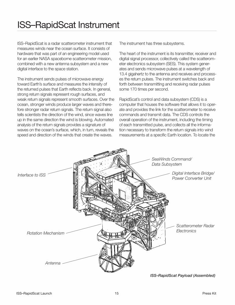
ISS–RapidScat Instrument
ISS–RapidScat is a radar scatterometer instrument that measures winds near the ocean surface. It consists of hardware that was part of an engineering model used for an earlier NASA spaceborne scatterometer mission, combined with a new antenna subsystem and a new digital interface to the space station.
The instrument sends pulses of microwave energy toward Earth’s surface and measures the intensity of the returned pulses that Earth reflects back. In general, strong return signals represent rough surfaces, and weak return signals represent smooth surfaces. Over the ocean, stronger winds produce larger waves and there-fore stronger radar return signals. The return signal also tells scientists the direction of the wind, since waves line up in the same direction the wind is blowing. Automated analysis of the return signals provides a signature of waves on the ocean’s surface, which, in turn, reveals the speed and direction of the winds that create the waves.
The instrument has three subsystems.
The heart of the instrument is its transmitter, receiver and digital signal processor, collectively called the scatterom-eter electronics subsystem (SES). This system gener-ates and sends microwave pulses at a wavelength of 13.4 gigahertz to the antenna and receives and process-es the return pulses. The instrument switches back and forth between transmitting and receiving radar pulses some 170 times per second.
RapidScat’s control and data subsystem (CDS) is a computer that houses the software that allows it to oper-ate and provides the link for the scatterometer to receive commands and transmit data. The CDS controls the overall operation of the instrument, including the timing of each transmitted pulse, and collects all the informa-tion necessary to transform the return signals into wind measurements at a specific Earth location. To locate the
ISS–RapidScat Payload (Assembled)
Interface to ISS
Rotation Mechanism
Antenna
SeaWinds Command/Data Subsystem
Digital Interface Bridge/Power Converter Unit
Scatterometer Radar Electronics

ISS–RapidScat Launch 16 Press Kit
precise position on Earth that returned each pulse, the computer collects the antenna’s rotational position and the time of each pulse. It also collects the scatterom-eter’s temperature, operating voltages and currents to monitor the overall health of the instrument.
The third major instrument subsystem is the antenna, which is newly designed and fabricated. The antenna transmits the microwave signals from the SES to Earth’s surface and routes the return signals back to the digital processor. The 29.5-inch (0.75-meter) parabolic reflec-tor antenna is mounted to a spin activator assembly. That assembly causes the antenna to rotate at a rate of 18 revolutions per minute, scanning a swath about 560 miles (900 kilometers) wide. A spin activator assem-bly provides very accurate spin control. Optical encoders — glass disks with small patterns printed on the surface — tell the CDS exactly where the antenna is pointing to about 1/100th of a degree accuracy. The antenna emits two beams of microwave pulses about 6 degrees apart; two beams are necessary to achieve accurate wind direction measurements. The pointing of these beams is precisely calibrated before launch so that the ground location of the return signals can be accurately determined.
A new feature was added to the instrument design to accommodate a space station docking port that is within the scatterometer’s field of view. To avoid either bombarding astronauts and visiting vehicles with mi-crowaves or turning off the instrument when the port is in use, the new system stops the SES from generating microwave pulses as the antenna scans across the port. The scatterometer operation is unaffected throughout the rest of its viewing range.
In addition to these three instrument subsystems, a new system was created to orient the RapidScat instrument correctly on its mounting point on the European Space Agency’s Columbus module of the space station. The nadir adapter is a very sophisticated bracket that allows
RapidScat to point at Earth even though the mounting site points toward space. It includes the mechanical and electrical interfaces needed for the robotic installa-tion of the RapidScat instrument onto the nadir adapter. It also houses new power and digital interface electron-ics that link between the heritage hardware (such as the CDS), the space station and the command center on the ground. To fit the entire instrument assembly inside the trunk of the SpaceX Dragon spacecraft, the nadir adapter was designed as a separate payload from the RapidScat instrument.
During RapidScat operations, the space station’s altitude will vary between 233 and 270 miles (375 and 435 kilometers), and its attitude will also vary depend-ing on what vehicles are visiting and where they are berthed. These variations affect the distance traveled by the RapidScat signals, so they required the engineers to make timing modifications to the hardware before launch and will also call for changes during day-to-day mission operations.
The space station orbit ranges between 51.6 degrees north and south latitudes. That orbit will allow RapidScat to assemble a complete map of the world’s ocean winds between about 57 degrees north and south latitudes in about 48 hours. (The instrument can collect data farther north and south than the space station’s orbit because its rotating antenna scans beyond the station’s footprint.) Because the space station passes over any particular spot at a slightly different local time of day on each orbit, RapidScat will sample all 24 hours of local time for each spot within about two months.
The accuracy of the wind speed measurements is bet-ter than 4.5 mph (2 meters per second) for speeds of about 7 to 45 mph (3 to 20 meters per second), and within 10 percent for speeds of about 45 to 70 mph (20 to 30 meters per second). Wind direction is accurate to within 20 degrees.

ISS–RapidScat Launch 17 Press Kit
Program/Project Management
The ISS–RapidScat mission is a partnership between NASA’s Jet Propulsion Laboratory (JPL), Pasadena, California, and the International Space Station Program Office at NASA’s Johnson Space Center, Houston, with support from the Earth Science Division of NASA’s Science Mission Directorate, Washington. Other mission partners include the Kennedy Space Center; NASA’s Marshall Space Flight Center, Huntsville, Alabama; the European Space Agency; and SpaceX. At NASA Headquarters, John Grunsfeld is the associ-ate administrator for the Science Mission Directorate. Mike Freilich is the Earth Science Division director for the Science Mission Directorate. Cheryl Yuhas is the ISS–RapidScat program executive. Eric Lindstrom is the ISS–RapidScat program scientist.
At JPL, Howard Eisen is the ISS–RapidScat project manager. The project scientist is Ernesto Rodriguez. JPL is responsible for overall project management; proj-ect engineering; mission assurance; instrument devel-opment, integration and test and ground data system; remote payload operations; and science data process-ing/archiving. The California Institute of Technology, Pasadena, manages JPL for NASA.
In the ISS Program, Michael Suffredini is the program manager. Julie Robinson is the program scientist. Rajib Dasgupta is the research integration manager. W. Rod Jones is the manager of the Research Integration Office, and Sharon Conover is manager of the ISS NASA Research Office. The ISS Program (with key personnel at Johnson Space Center, Kennedy Space Center and Marshall Space Flight Center) is responsible for program office funding, interface/requirements management, inte-gration management, safety, ISS operations and robotic installation of ISS–RapidScat on the station.
ESA provides accommodations on the ISS Columbus module.
SpaceX provides launch services aboard the Falcon-9 launch vehicle and Dragon commercial cargo resupply spacecraft.


