All you need to know to do business with GNSS Capital High Tech Page 17 IV. The Global Satellite Navigation Systems 1) GPS As mentioned previously although the acronym GPS is commonly used for designating GNSS, it only refers to the American GNSS system. The Global Positioning System (GPS) is currently the only fully functional Global Navigation Satellite System (GNSS). Developed by the United States Department of Defence , it is officially named NAVSTAR GPS (NAVigation Satellite Timing And Ranging Global Positioning System). The NAVSTAR GPS Joint Program Office manages the NAVSTAR Global Positioning System. The Global Positioning System (GPS) satellite network is operated by the U.S. Air Force to provide highly accurate navigation information to military forces around the world. A growing number of commercial products are also using the network. GPS transmits precise radio signals; the system enables a GPS receiver to determine its location, speed and direction. The idea for a global positioning system was first proposed in 1940. There are 4 generations of the GPS satellite: the Block I, Block II/IIA, Block IIR and Block IIF. § Block I satellites were used to test the principles of the system, and lessons learned from those 11 satellites were incorporated into later blocks. § Block II and IIA satellites make up the current constellation. § The third generation Block IIR satellites are currently being deployed as the Block II/IIA satellites reach their end-of-life and are retired. § Block IIF satellites will be the fourth generation of satellites and will be used for operations and maintenance (O&M) replenishment. 11 11 http://www.spaceandtech.com/spacedata/constellations/navstar-gps_consum.shtml
Transcript
All you need to know to do business with GNSS Capital High Tech Page 17
IV. The Global Satellite Navigation Systems
1) GPS
As mentioned previously although the acronym GPS is commonly used for designating GNSS, it only refers to the American GNSS system. The Global Positioning System (GPS) is currently the only fully functional Global Navigation Satellite System (GNSS). Developed by the United States Department of Defence, it is officially named NAVSTAR GPS (NAVigation Satellite Timing And Ranging Global Positioning System). The NAVSTAR GPS Joint Program Office manages the NAVSTAR Global Positioning System.
The Global Positioning System (GPS) satellite network is operated by the U.S. Air Force to provide highly accurate navigation information to military forces around the world. A growing number of commercial products are also using the network. GPS transmits precise radio signals; the system enables a GPS receiver to determine its location, speed and direction. The idea for a global positioning system was first proposed in 1940. There are 4 generations of the GPS satellite: the Block I, Block II/IIA, Block IIR and Block IIF. § Block I satellites were used to test the principles of the system, and lessons learned
from those 11 satellites were incorporated into later blocks. § Block II and IIA satellites make up the current constellation. § The third generation Block IIR satellites are currently being deployed as the Block
II/IIA satellites reach their end-of-life and are retired. § Block IIF satellites will be the fourth generation of satellites and will be used for
All you need to know to do business with GNSS Capital High Tech Page 18
Modernisation of GPS12
12 AEROSPACE VALLEY/DAS NPT - Journée PME/TPE – 03/05/2007- Introduction à la Navigation par Satellite : Luis RUIZ - CNES Toulouse
All you need to know to do business with GNSS Capital High Tech Page 19
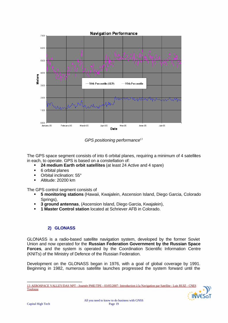
GPS positioning performance13
The GPS space segment consists of into 6 orbital planes, requiring a minimum of 4 satellites in each, to operate. GPS is based on a constellation of: § 24 medium Earth orbit satellites (at least 24 Active and 4 spare) § 6 orbital planes § Orbital inclination: 55° § Altitude: 20200 km
The GPS control segment consists of § 5 monitoring stations (Hawaii, Kwajalein, Ascension Island, Diego Garcia, Colorado
Springs), § 3 ground antennas, (Ascension Island, Diego Garcia, Kwajalein), § 1 Master Control station located at Schriever AFB in Colorado.
2) GLONASS GLONASS is a radio-based satellite navigation system, developed by the former Soviet Union and now operated for the Russian Federation Government by the Russian Space Forces, and the system is operated by the Coordination Scientific Information Centre (KNITs) of the Ministry of Defence of the Russian Federation. Development on the GLONASS began in 1976, with a goal of global coverage by 1991. Beginning in 1982, numerous satellite launches progressed the system forward until the
13 AEROSPACE VALLEY/DAS NPT - Journée PME/TPE – 03/05/2007- Introduction à la Navigation par Satellite : Luis RUIZ - CNES Toulouse
All you need to know to do business with GNSS Capital High Tech Page 20
constellation was completed 1995. Following completion, the system rapidly fell into disrepair with the collapse of the Russian economy. Beginning in 2001, Russia committed to restoring the system by 2011, and in recent years has diversified, introducing the Indian government as a partner, and accelerated the program with a goal of global coverage by 2009.14
15 The Global Navigation Satellite System (GLONASS) is based on a constellation of active satellites, which continuously transmit coded signals in two frequency bands, which can be received by users anywhere on the Earth's surface to identify their position and velocity in real time based on ranging measurements. The system is a counterpart to the United States Global Positioning System (GPS) and both systems share the same principles in the data transmission and positioning methods.
The operational space segment of GLONASS consists of 21 satellites in 3 orbital planes, requiring 8 satellites in each, including 3 on-orbit spares. The 3 orbital planes are separated 120 degrees, and the satellites within the same orbit plane by 45 degrees. Each satellite operates in circular 19,140 km orbits at an inclination angle of 64.8 degrees and each satellite completes an orbit in approximately 11 hours 15 minutes. Each satellite GLONASS has own frequencies and transmits both L1 and L2.
14 http://en.wikipedia.org/wiki/GLONASS 15 AEROSPACE VALLEY/DAS NPT - Journée PME/TPE – 03/05/2007- Introduction à la Navigation par Satellite : Luis RUIZ - CNES Toulouse
All you need to know to do business with GNSS Capital High Tech Page 21
GLONASS is based on a constellation of: § 24 medium Earth orbit satellites (including 3 on orbit spares) § Rotation on 3 orbital planes § Orbital of inclination plans 64.8° § Altitude is 19.140 Km
The ground control segment of GLONASS is entirely located within former Soviet Union territory. § Ground Control Centre and Time Standards is located in Moscow § 4 telemetry and tracking stations are in St. Petersburg, Ternopol, Eniseisk,
Komsomolsk-na-Amure.
Work is underway to modernise the system. The new GLONASS-M satellite will have better signal characteristics as well as a longer design life (7-8 years instead of the current 3 years). In the future, plans are being developed to transition to a low mass third generation GLONASS-K satellites with a guaranteed lifespan of 10 years.
3) GALILEO
The GALILEO positioning system, referred to simply as GALILEO, is the European GNSS programme. It is named after the Italian astronomer GALILEO Galilei. The GALILEO positioning system is referred to as "GALILEO" instead of as the abbreviation "GPS" to distinguish it from the existing United States system. GALILEO is designed to provide a higher precision to all users than is currently available through GPS or GLONASS, to improve availability of positioning services at higher latitudes, and to provide an independent positioning system upon which European nations can rely even in times of war or political disagreement. The GALILEO constellation should become operational by 2012.
GALILEO constellation (source ESA) è FOR MORE INFORMATION SEE CHAPTER “FOCUS ON EUROPEAN GNSS”
All you need to know to do business with GNSS Capital High Tech Page 22
4) COMPASS Navigation Satellite System (CNSS)/BeiDou 2
China is planning to build a navigation satellite constellation known as Compass Navigation Satellite System (CNSS), or “BeiDou 2” in its Chinese name. The BeiDou 2 system will be based on its current Compass Satellite Navigation Experimental System (BeiDou-1). BeiDou-1 will be able to provide navigation and positioning services to users in China and its neighbouring countries by 2008. The BeiDou 1 system will gradually be expanded into BeiDou 2 global navigation satellite constellation comprising 5 Geostationary Earth Orbit (GEO) satellites and 30 medium Earth orbit satellites. The BeiDou 2 system is intended to provide navigation and positioning services to global users. The CNSS will provide two types of services: § a free service for civilian users will have positioning accuracy within 10 metres,
velocity accuracy within 0.2 metre per second and timing accuracy within 50 nanoseconds;
§ a licensed service with higher accuracy for authorised and military users only. The system will initially cover China and its neighbouring countries only but will eventually extend into a global navigation satellite network.
The new generation BeiDou 2 will allow ground receiver to calculate its position by measuring the distance between itself and three or more satellites, similar to the method of operation of the GPS and GLONASS systems. An independent satellite navigation network would allow Chinese forces to maintain its satellite navigation capability in time of crisis without relying on foreign satellites. China successfully launched a first medium Earth orbit BeiDou 2 navigation satellite codenamed Compass-M1 on 14 April 2007. The satellite will operate at an altitude of 21,500km orbit. 16
All you need to know to do business with GNSS Capital High Tech Page 23
V. Regional Satellite Navigation Systems
1) BEIDOU 1
The Compass Navigation Satellite Experimental System, or BeiDou-1 in its Chinese name, is the 3 satellites constellation developed by China Academy of Space Technology (CAST). It is China’s first space-based regional navigation and positioning network. The system provides all weather, two-dimensional positioning data for both military and civilian users. The satellites are capable of communication and horizontal positioning for China’s military within their region. The network covers most areas of East Asia region and has both navigation and communication functions. The system will be able to provide navigation and positioning services to users in China and its neighbouring countries by 2008. The satellite network comprises three BeiDou-1 satellites (2 operational and 1 backup). The first two satellites of the BeiDou-1 navigation experimental system, the BeiDou-1A and BeiDou-1B, were launched on 31 October 2000 and 21 December 2000 respectively. The system began to provide navigation and positioning services in late 2001. The third satellite (backup) BeiDou-1C was launched on 25 May 2003, bringing the system fully operational. The navigation and positioning services became available to civilian users in April 2004. This has made China the third country in world to have deployed an operational space-based navigation and positioning network. Following the three successful launches of the BeiDou-1 satellites, a fourth GEO satellite was launched on 2 February 2007. The satellite suffered from a control system malfunction, which resulted in the solar power panel unable to expand. After some adjustment work from the ground control station, the satellite was said to be fully restored. The satellite was placed into the GEO, presumably to complement the three existing regional Beidou-1 geostationary satellites. At current time, we are not able to say if the satellite is being used. The ground systems include: § central control station, § 3 ground tracking stations for orbit determination (at Jamushi, Kashi and
Zhanjiang), § ground correction stations, § user terminals (receivers/transmitters).
The system provides positioning data of 100m accuracy. By using ground- and/or space-based (the 3rd and 4th satellites) differential methods, the accuracy can be increased to under 20m. The system capacity is 540,000 users per hour, and serve up to 150 users simultaneously. The method of operation is specific: Beidou 1 Satellite Navigation Experimental System requires dual-way transmissions between the user and the central control station via the satellite. Firstly, the central control station sends inquiry signals to the users via two satellites. When the user terminal received the signal from one satellite, it sends responding signal back to both satellites. The central station receives the responding signals sent by the user from two satellites, and calculates the user’s 2D position based on the time difference between the two signals. This position is then compared with the digital territorial map stored
All you need to know to do business with GNSS Capital High Tech Page 24
in the database to get the 3D position data, which is then sent back to the user via satellites using encrypted communications. The user can also transmit encrypted text messages (up to 120 Chinese characters) to the central station via the satellites.
BeiDou-1 method of operation (source sinodefence)
Because BeiDou system requires dual-way transmissions between the user and central control station via satellites at high-altitude geostationary orbit, its user segment needs extra space for transmitter and a more-powerful battery. Therefore the BeiDou system’s user segments are much bigger (20cm antenna), heavier and more expensive compared to GPS user receivers. Additionally, the number of users can be served by the system is limited by the communication capacity of the network.17
2) Indian Regional Navigational Satellite System (IRNSS) The Indian Regional Navigational Satellite System (IRNSS) is a developmental autonomous regional satellite navigation system that is being constructed and is controlled by the Indian government. It is intended to provide an absolute position accuracy of better than 20 meters throughout India and within a region extending approximately 1,500 to 2,000 km around it. A goal of complete Indian control has been stated, with the space segment, ground segment and user receivers all being built in India. The government approved the project in May 2006, with the intention to be implemented within 6 to 7 years (2012-2013).
All you need to know to do business with GNSS Capital High Tech Page 25
It is unclear if recent dealings with the Russian government to restore their GLONASS system will supersede the IRNSS project or feed additional technical support to enable its completion. The proposed system would consist of a constellation of 7 satellites and a support ground segment. § 3 of the satellites in the constellation will be placed in geostationary orbit § 4 in geosynchronous inclined orbit of 29° relative to the equatorial plane.
Such an arrangement would mean all 7 satellites would have continuous radio visibility with Indian control stations. The satellite payloads would consist of atomic clocks and electronic equipment to generate the navigation signals. The navigation signals themselves would be transmitted in the S-band frequency (2-4 GHz), and broadcast through a phased array antenna to maintain required coverage and signal strength. The satellites would weigh approximately 1,330 kg and their solar panels generate 1,400 watts of energy. The ground segment of IRNSS constellation would consist of: § a Master Control Centre (MCC), § ground stations to track and estimate the satellites' orbits and ensure the integrity of
the network (IRIM), § additional ground stations to monitor the health of the satellites with the capability of
issuing radio commands to the satellites (TT&C stations). The MCC would estimate and predict the position of all IRNSS satellites, calculate integrity, makes necessary ionospheric and clock corrections and run the navigation software. In pursuit of a highly independent system, an Indian standard time infrastructure would also be established.18
All you need to know to do business with GNSS Capital High Tech Page 26
VI. Augmentation systems Augmentation of a Global Navigation Satellite System is a method of improving the navigation system's attributes, such as accuracy, reliability, and availability, through the integration of external information into the calculation process. There are many such systems in place and they are generally named or described based on how the GNSS sensor receives the external information. § some systems transmit additional information about sources of error (such as clock
drift, ephemeris, or ionospheric delay), § others provide direct measurements of how much the signal was off in the past, § while a third group provide additional vehicle information to be integrated in the
calculation process.19
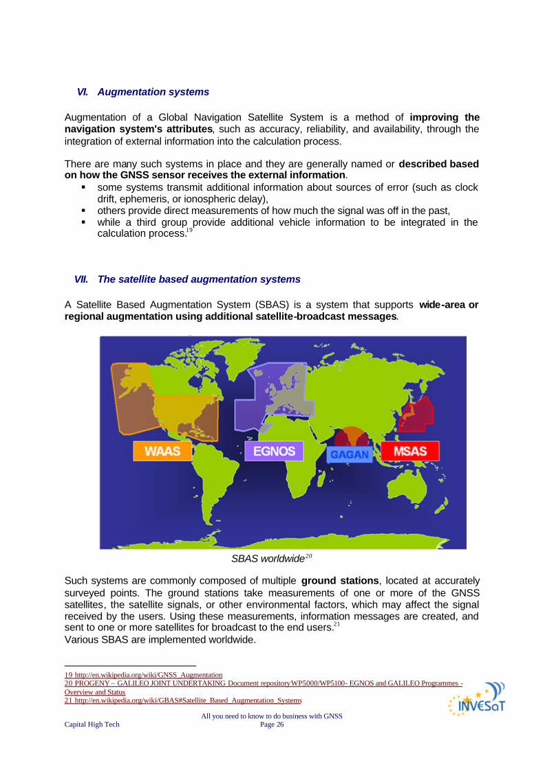
VII. The satellite based augmentation systems A Satellite Based Augmentation System (SBAS) is a system that supports wide-area or regional augmentation using additional satellite-broadcast messages.
SBAS worldwide20
Such systems are commonly composed of multiple ground stations, located at accurately surveyed points. The ground stations take measurements of one or more of the GNSS satellites, the satellite signals, or other environmental factors, which may affect the signal received by the users. Using these measurements, information messages are created, and sent to one or more satellites for broadcast to the end users.21 Various SBAS are implemented worldwide. 19 http://en.wikipedia.org/wiki/GNSS_Augmentation 20 PROGENY – GALILEO JOINT UNDERTAKING Document repository WP5000/WP5100- EGNOS and GALILEO Programmes - Overview and Status 21 http://en.wikipedia.org/wiki/GBAS#Satellite_Based_Augmentation_Systems
All you need to know to do business with GNSS Capital High Tech Page 27
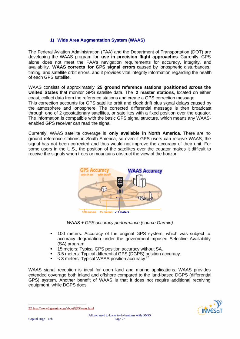
1) Wide Area Augmentation System (WAAS) The Federal Aviation Administration (FAA) and the Department of Transportation (DOT) are developing the WAAS program for use in precision flight approaches. Currently, GPS alone does not meet the FAA's navigation requirements for accuracy, integrity, and availability. WAAS corrects for GPS signal errors caused by ionospheric disturbances, timing, and satellite orbit errors, and it provides vital integrity information regarding the health of each GPS satellite. WAAS consists of approximately 25 ground reference stations positioned across the United States that monitor GPS satellite data. The 2 master stations, located on either coast, collect data from the reference stations and create a GPS correction message. This correction accounts for GPS satellite orbit and clock drift plus signal delays caused by the atmosphere and ionosphere. The corrected differential message is then broadcast through one of 2 geostationary satellites, or satellites with a fixed position over the equator. The information is compatible with the basic GPS signal structure, which means any WAAS-enabled GPS receiver can read the signal. Currently, WAAS satellite coverage is only available in North America. There are no ground reference stations in South America, so even if GPS users can receive WAAS, the signal has not been corrected and thus would not improve the accuracy of their unit. For some users in the U.S., the position of the satellites over the equator makes it difficult to receive the signals when trees or mountains obstruct the view of the horizon.
WAAS + GPS accuracy performance (source Garmin)
§ 100 meters: Accuracy of the original GPS system, which was subject to accuracy degradation under the government-imposed Selective Availability (SA) program.
§ 15 meters: Typical GPS position accuracy without SA. § 3-5 meters: Typical differential GPS (DGPS) position accuracy. § < 3 meters: Typical WAAS position accuracy.22
WAAS signal reception is ideal for open land and marine applications. WAAS provides extended coverage both inland and offshore compared to the land-based DGPS (differential GPS) system. Another benefit of WAAS is that it does not require additional receiving equipment, while DGPS does.
22 http://www8.garmin.com/aboutGPS/waas.html
All you need to know to do business with GNSS Capital High Tech Page 28
2) GPS Aided Geo Augmented Navigation GAGAN Indian Space Research Organization (ISRO), along with Airport Authority of India (AAI) has worked out a joint program to implement the Satellite Based Augmentation System (SBAS) for the Indian region to fill the gap between EGNOS and MSAS. The project called GAGAN (GPS Aided Geo Augmented Navigation) has been taken up with an objective to demonstrate the SBAS technology over the Indian region. There is a plan to have an operational system to provide a seamless navigation facility in the region, which is interoperable with other SBAS. The Airports Authority of India (AAI) plans to use Gagan to meet the civil aviation industry's growing needs in communications, navigation and surveillance and air traffic management. It will result in greater efficiency and safety in over 100 airports in India. Although primarily meant for civil aviation, it is also beneficial for other users. The GAGAN system will have a full complement of the SBAS inclusive of ground and onboard segment. The ground segment consists of § 8 reference stations distributed across the country, § 1 mission control centre in Bangalore § 1 up linking station also in Bangalore.
The onboard segment consists of a navigation payload onboard Indian geostationary satellite GSAT-4. The indigenously designed and developed navigational transponder has the latest features inclusive of L1 and L5 operation, higher EIRP of up to 33 dBw and higher bandwidth of 20 Mhz. The preliminary system acceptance test in 2006 for the Technology Demonstration System (TDS) of the GPS-aided Geo Augmented Navigation (GAGAN), being developed by the Indian Space Research Organisation (ISRO) to improve Air Traffic Control, was successful. The GAGAN -TDS network monitors Global Positioning Satellite (GPS) signals for errors and then generates correction messages to improve accuracy for users. During the test period, average accuracy of GAGAN-TDS was better than 1-metre horizontally and only slightly more than one metre vertically, thus surpassing the 7.6-metre requirement by a significant margin.2324
3) European Geostationary Navigation Overlay Service (EGNOS)
The European Geostationary Navigation Overlay Service (EGNOS) is Europe’s first venture into satellite navigation. It will augment the 2 military satellite navigation systems now operating, the US GPS and Russian GLONASS systems, and make them suitable for safety critical applications such as flying aircraft or navigating ships through narrow channels.
Consisting of 3 geostationary satellites and a network of ground stations, EGNOS will achieve its aim by transmitting a signal containing information on the reliability and accuracy of the positioning signals sent out by the Global Positioning System (GPS) and the Global Orbiting Navigation Satellite System (GLONASS). It will allow users in Europe and beyond to determine their position within 5 m, compared with about 20 m at present.
All you need to know to do business with GNSS Capital High Tech Page 29
EGNOS is a joint project of the European Space Agency (ESA), the European Commission (EC) and Eurocontrol, the European Organisation for the Safety of Air Navigation. It is Europe’s contribution to the first stage of the global navigation satellite system (GNSS) and is a precursor to GALILEO, the full global satellite navigation system under development in Europe.
è FOR MORE INFORMATION SEE CHAPTER “FOCUS ON EUROPEAN GNSS”
4) Multi-functional Satellite Augmentation System (MSAS)
Throughout Asia, Multi-functional Satellite Augmentation System (MSAS) provides satellite navigation correction and validation, making SBAS-enabled receivers at least 3 times more accurate than standard devices. MSAS relay stations have been set at known positions throughout Asia.
SBAS-enabled receivers do not require any additional equipment to use MSAS correction signals and, as with satellite navigation signals, there are no setup or subscription fees. MSAS is scheduled for full operation in 2005 providing accuracy to within 5 meters or less, and will expand safety and air-traffic capacity in the Asia pacific regions.25
All you need to know to do business with GNSS Capital High Tech Page 30
VIII. Ground Based Augmentation System (GBAS )
The Ground Based Augmentation System (GBAS) is an augmentation to GNSS that focuses its service on the airport area (approximately a 30 km radius). It broadcasts its correction message via a very high frequency (VHF) radio data link from a ground-based transmitter. GBAS will initially provide support for (Category I) Precision Approach operation and ultimately fulfil the extremely high requirements for accuracy, availability, and integrity necessary (for Category I, II, and III) precision approaches. In addition, it will provide the ability for more flexible, curved approach paths, terminal area and regional augmentation in regions, which desire such implementation. The current Instrument Landing System (ILS) suffers from a number of technical limitations such as, VHF interference, multi path effects (for example due to new building works at and around airports), as well as ILS channel limitations. The operational benefits of GBAS include: § One GBAS Ground Station will be able to support multiple runway ends; § Flight Inspection and maintenance requirements should be reduced compared to ILS; § More stable signal, and less interference with preceding aircraft.
Current GBAS demonstrated accuracy is less than 1 meter in both the horizontal and vertical axis. The Ground-Based Augmentation System (GBAS) supports all phases of approach, landing, departure, and surface operations within its area of coverage. 26
1) The United States' Local Area Augmentation System (LAAS) LAAS, or the Local Area Augmentation System, is the FAA version of the Ground Based Augmentation System, or GBAS, that has been defined by the International Civil Aviation Organization (ICAO). LAAS is based on a single GPS reference station facility located on the property of the airport being serviced. This facility has 3 or more (redundant) reference receivers that independently measure GPS satellite pseudo range and carrier phase (GPS measurements based on the L1 or L2 carrier signal) and generate differential carrier-smoothed-code corrections that are eventually broadcast to user via a 31.5-kbps VHF data broadcast (in the 108 - 118 MHz band) that also includes safety and approach-geometry information. This information allows users within 45 km of the LAAS ground station to perform GPS-based position fixes with 0.5-meter (95%) accuracy and to perform all civil flight operations up to non-precision approach. Aircraft landing at a LAAS-equipped airport will be able to perform precision approach operations up to at least Category I weather minima. The pseudolites shown in the diagram below are optional means of improving user ranging geometries with ground-based GPS-like transmitters but are not likely to be needed in the foreseeable future. 27 26 http://www.ecacnav.com/content.asp?CatID=64 27 http://waas.stanford.edu/research/laas.htm
All you need to know to do business with GNSS Capital High Tech Page 31
2) Differential GPS (DGPS) A Differential Global Positioning System (DGPS) is a system designed to improve the accuracy of Global Navigation Satellite Systems (GNSS) by measuring infinitesimal changes in variables to provide satellite positioning corrections.
DGPS infrastructure
In fact, 2 or more receivers observe the same set of satellites, taking similar measurements that produce similar errors when positioned closely together. A reference receiver, placed at a known location, calculates its theoretical position and compares it to the measurements provided by the navigation satellite signals. The difference between the two values reveals the measurement error. The reference receiver then transmits a corrected signal to any number of receivers at unknown positions within the area covered by the DGPS. Accuracy of global satellite positioning is thereby increased from 15 meters to within a few meters.
All you need to know to do business with GNSS Capital High Tech Page 32
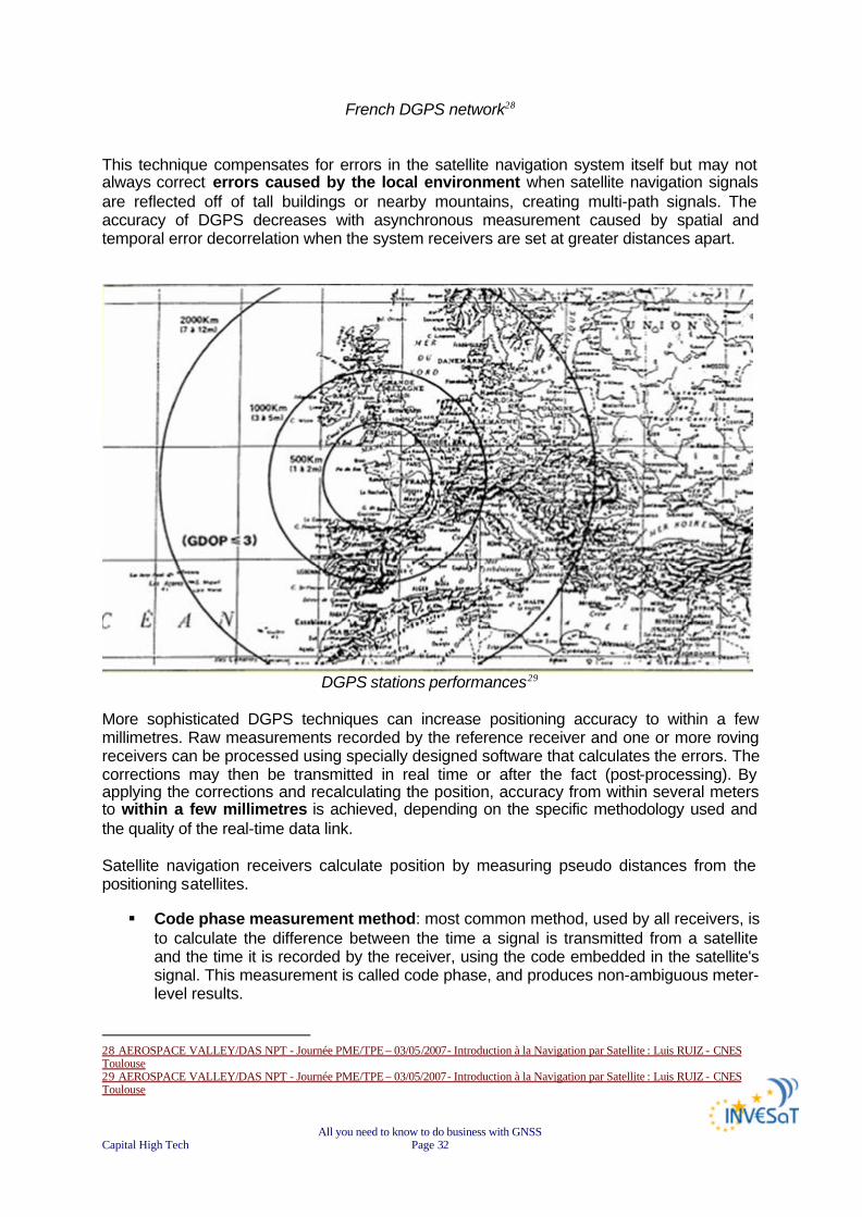
French DGPS network28 This technique compensates for errors in the satellite navigation system itself but may not always correct errors caused by the local environment when satellite navigation signals are reflected off of tall buildings or nearby mountains, creating multi-path signals. The accuracy of DGPS decreases with asynchronous measurement caused by spatial and temporal error decorrelation when the system receivers are set at greater distances apart.
DGPS stations performances29
More sophisticated DGPS techniques can increase positioning accuracy to within a few millimetres. Raw measurements recorded by the reference receiver and one or more roving receivers can be processed using specially designed software that calculates the errors. The corrections may then be transmitted in real time or after the fact (post-processing). By applying the corrections and recalculating the position, accuracy from within several meters to within a few millimetres is achieved, depending on the specific methodology used and the quality of the real-time data link. Satellite navigation receivers calculate position by measuring pseudo distances from the positioning satellites. § Code phase measurement method: most common method, used by all receivers, is
to calculate the difference between the time a signal is transmitted from a satellite and the time it is recorded by the receiver, using the code embedded in the satellite's signal. This measurement is called code phase, and produces non-ambiguous meter-level results.
28 AEROSPACE VALLEY/DAS NPT - Journée PME/TPE – 03/05/2007- Introduction à la Navigation par Satellite : Luis RUIZ - CNES Toulouse 29 AEROSPACE VALLEY/DAS NPT - Journée PME/TPE – 03/05/2007- Introduction à la Navigation par Satellite : Luis RUIZ - CNES Toulouse
All you need to know to do business with GNSS Capital High Tech Page 33
There are three types of DGPS using code phase measurement methods: o DGPS and LADGPS (Local Area DGPS) typically cover an area up to several
tens of kilometres. o WADGPS greatly increases the coverage area up to several thousand
kilometers by a more sophisticated method known as WADGPS (Wide Area DGPS). WADGPS classifies errors into position-dependent and position-independent components creating a secondary set of measurements that are transmitted to the rover receivers. The rover receivers are then able to reconstruct the pseudo range correction most applicable to their actual position and compute an accurate differential position.
§ Carrier phase serves to compliment code phase measurement by measuring the
satellite carrier wave. This method provides millimetres-level resolution with measurements that are ambiguous to about 19 centimeters. DGPS using the carrier phase achieves maximum accuracy only when measurement ambiguities are resolved in some way. The static method of ambiguity resolution is related to stationary receivers, with rover receiver point occupation from 30 minutes to several hours or even several days. The rapid static method reduces occupation periods to several minutes, while the kinematic method allows rover receivers to move without constraint.
Measurement Type
Real-time or Post-processing
System Type Accuracy Coverage Area
Code phase Post-processing
Post-processed DGPS, post-processed LADGPS or post-processed WADGPS
from < 1 m to ~10 m
From several x 10 km to several x 1000 km
Code phase Real time DGPS, LADGPS or WADGPS
from < 1 m to ~10 m
From several x 10 km to several x 1000 km
Carrier phase Post-processing
Kinematic, rapid static or static
from < 1 cm to several cm
From several km to several x 1000 km
Carrier phase Real time Real-time kinematic from < 1 cm to several cm
From several km to several x 10 km
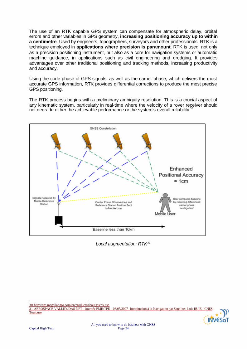
3) Real Time Kinematic (RTK) Real Time Kinematic (RTK) satellite navigation is a technique used in land survey based on the use of carrier phase measurements of the GPS, GLONASS and/or GALILEO signals where a single reference station provides the real-time corrections of even to a centimetre level of accuracy. When referring to GPS in particular, the system is also commonly referred to as Carrier-Phase Enhancement, CPGPS. RTK is a process where GPS signal corrections are transmitted in real time from a reference receiver at a known location to one or more remote rover receivers.
All you need to know to do business with GNSS Capital High Tech Page 34
The use of an RTK capable GPS system can compensate for atmospheric delay, orbital errors and other variables in GPS geometry, increasing positioning accuracy up to within a centimetre. Used by engineers, topographers, surveyors and other professionals, RTK is a technique employed in applications where precision is paramount. RTK is used, not only as a precision positioning instrument, but also as a core for navigation systems or automatic machine guidance, in applications such as civil engineering and dredging. It provides advantages over other traditional positioning and tracking methods, increasing productivity and accuracy. Using the code phase of GPS signals, as well as the carrier phase, which delivers the most accurate GPS information, RTK provides differential corrections to produce the most precise GPS positioning. The RTK process begins with a preliminary ambiguity resolution. This is a crucial aspect of any kinematic system, particularly in real-time where the velocity of a rover receiver should not degrade either the achievable performance or the system's overall reliability.30
Local augmentation: RTK31
30 http://pro.magellangps.com/en/products/aboutgps/rtk.asp 31 AEROSPACE VALLEY/DAS NPT - Journée PME/TPE – 03/05/2007- Introduction à la Navigation par Satellite : Luis RUIZ - CNES Toulouse