Javed Iqbal Saroash Iqbal School of Civil & Environmental Engineering(SCEE), Institute of Geographical Information System(IGIS), National University of Science & Technology(NUST) PROBABILISTIC SEISMIC HAZARD ANALYSIS, HAZARD MICROZONATION AND SEISMICITY IMPACTS ALONG KARAKORAM HIGHWAY IN THE CONTEXT OF CHINA PAKISTAN ECONOMIC CORRIDOR
Transcript
Javed Iqbal Saroash Iqbal
School of Civil & Environmental Engineering(SCEE),
Institute of Geographical Information System(IGIS),
National University of Science & Technology(NUST)
PROBABILISTIC SEISMIC HAZARD ANALYSIS, HAZARD MICROZONATION AND SEISMICITY IMPACTS ALONG KARAKORAM HIGHWAY IN THE CONTEXT OF CHINA
PAKISTAN ECONOMIC CORRIDOR
Background
• Seismically active region.
• Probabilistic assessment of earthquake recurrence.
• Building codes assessment for the region.
Source PMD
Seismic Zoning Map of Pakistan
Objectives
• To provide a probabilistic model for earthquake recurrence in northern Pakistan.
• To compute peak ground acceleration and generating hazard microzonation maps of the area.
• To study the impacts of seismicity on landslide vulnerability from Hasanabdal to Khunjerab Pass.
Materials & Methods
Study area
Study area
Study Area
Geology and Tectonics of the area
Dataset Used
Data Description Source
Earthquake data Earthquake catalogue considering all events in
account from 1900 to present.
PMD, ISC, WAPDA
and USGS
Rainfall data Rainfall historical and current data from weather
stations of KPK, GB and AJK
PMD,NWFC
Geological data Geological maps, tectonic map and Road log of
KKH
GSP, Shahzad Town,
Islamabad
Landslide data Previous landslide record, landslide inventory and
satellite imagery
GSP, Shahzad Town,
Islamabad
Software Required
CAPRA CRISIS Version 2015
SEISAN EXPLORER Version 10.1
ARCGIS Version 10.4.1
FZRISK & EZRISK
Methodology Flow Chart
Probabilistic Seismic Hazard Analysis
Earthquake catalogue declustering
Seismic source zonation
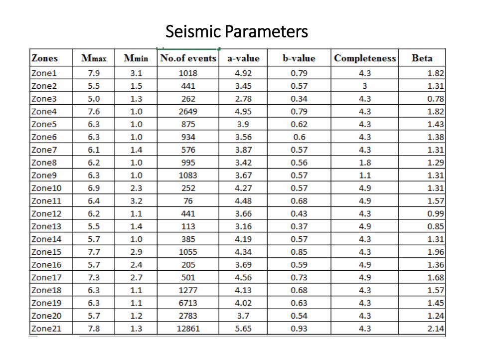
Seismic parameters determination
GR model : Log(N)=a – b(M)
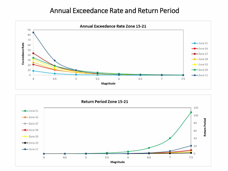
Annual Exceedance Rate
Return Period
PGA calculation
Hazard curves generation
Risk Analysis
Interpolation of VS-30 data with PGA values
Identification of hazard prone areas
Hazard microzonation along KKH
Rainfall data
Analytic hierarchal process technique
Interpolation of all data sets and processes
Landslide susceptibility mapping
Precipitation data of KPK, GB and AJK
observatories
Declustered earthquake catalogue
events
Geological maps, KKH
road log
Geological data
Previous and recent
landslides imagery
Seismicity data Satellite data
Progress till date
• Earthquake catalogues collection from United States Geological Survey
(USGS), International Seismological Center (ISC), Pakistan Metrological
Department (PMD) and Water and Power Development Authority
(WAPDA).
• Removal of duplicate data.
• Conversion of catalogue magnitudes into uniform moment magnitude Mw .
• Declustering of the catalogue is still in progress by identifying and
removing aftershocks and foreshocks for Catalogue Completeness.
• Seismic sources zonation.
• Determination of seismic paramters.
• Annual exceedance rates and return periods of each zone for different
magnitudes.
Declustered Earthquake Catalogue
Seismic Parameters
Annual Exceedance Rates and Return Periods of KKH Zones
Annual Exceedance Rate and Return Period
Annual Exceedance Rate and Return Period
Annual Exceedance Rate and Return Period
FINAL OUTCOME WHEN STUDY COMPLETED
• Probabilistic seismic hazard analysis along KKH.
• Detailed hazard microzonation map for the selected magnitudes of earthquake for KKH.
• Earthquake triggered landslides vulnerable sites prediction and mapping along KKH.