256
January 2013 U.S. Department of the Interior

7/29/2019 Jefferson National Expansion Memorial
http://slidepdf.com/reader/full/jefferson-national-expansion-memorial 1/256
January 201
U.S. Department of the Interior

7/29/2019 Jefferson National Expansion Memorial
http://slidepdf.com/reader/full/jefferson-national-expansion-memorial 2/256
THIS PAGE LEFT INTENTION ALLY BLANK

7/29/2019 Jefferson National Expansion Memorial
http://slidepdf.com/reader/full/jefferson-national-expansion-memorial 3/256
E N V I R O N M E N T A L A S S E S S M E N T / I M P L E M E N T I N G C I T Y A R C H R I V E R I N I T I A T I V E E L E M E N T S /EXECUTIVE SUMMARY i
PURPOSE OF AND NEED FORACTION
The purpose o the proposed action analyzed
in this Environmental Assessment (EA) is to
ulill the goal o revitalizing Jeerson National
Expansion Memorial, as called or by the
selected action in the November 2009 Recordo Decision (ROD) or the park’s General
Management Plan (GMP)/Environmental
Impact Statement. While the GMP provided
direction on the type o projects that could be
implemented, the 2009 selected action called
or the National Park Service (NPS), in close
coordination with its partners, to initiate a
design competition that would provide a wide
breadth o ideas on how to meet this goal,
and, ultimately, orm the basis or the design o
more speciic projects.
The design competition began in December
2009 and the winning team and design were
selected in September 2010. The NPS now
needs to evaluate projects proposed by the
winning team and park partners that have
the potential to cause physical changes to the
park grounds. Action is needed now so that
projects may be inished in time or the 50th
anniversary o completion o the Gateway
Arch (October 28, 2015).
OBJECTIVES IN TAKING
ACTIONThe National Park Service considers objectives
to be those goals that must be achieved to a
large degree or the action to be considered a
success (NPS 2001). All alternatives selected or
detailed analysis must meet project objectives
and resolve the purpose o and need or action.
Many o the objectives developed by NPS
or this action incorporate or relect the goals
Execuve Summary
o the design competition relevant to those
project components. Additionally, goals or
the Central Riverront have been identiied by
Great Rivers Greenway District, and are also
integrated in the objectives listed below.
GENERAL
• Ensure that revitalization o the park
relects the iconic status o the Gateway
Arch and embraces the Mississippi River,
but does not violate requirements in the
NPS Organic Act or NPS Management
Policies 2006.
• Working with partners, catalyze increased
vitality in the St. Louis region and create
attractors to promote extended visitation
to the Arch, the city, and the river.
CULTURAL RESOURCES
• Ensure that the revitalization o the
park and improvements to the Central
Riverront preserve the integrity and
honor the character- deining elements
o the National Historic Landmark
and relevant National Register Historic
Districts.
• Avoid unacceptable impacts on the
cultural landscapes, historic resources,
and archeological resources as a result o revitalizing the park and improving the
Central Riverront.
VISITOR USE AND EXPERIENCE
• Ensure that revitalization o the park and the
Central Riverront improves connections
amongst the city, the park, and the river.

7/29/2019 Jefferson National Expansion Memorial
http://slidepdf.com/reader/full/jefferson-national-expansion-memorial 4/256
J E F F E R S O N N A T I O N A L E X P A N S I O N M E M O R I A L/ EXECUTIVE SUMMARYii
• Enhance the experience at the park
and along the Central Riverront and
reduce the adverse impacts rom adjacent
transportation systems.
• Ensure that visitor saety and accessibility
or people with disabilities is improvedand that the experience at the park and
along the Central Riverront is enhanced
by creating a welcoming and accessible
environment.
INTERPRETATION/EDUCATION
• Improve visitor understanding o the
purpose o the park, including the story
o St. Louis as the gateway to American
westward expansion.
• Along the Central Riverront, provideopportunities or education connected
to the Mississippi River and the historic
levee.
PARK MANAGEMENT AND OPERATIONS
• Incorporate sustainable methods into
park management and operations while
minimizing impacts o revitalization on
inancial resources, staing requirements,
and long-term maintenance requirements;
improve Central Riverront operationsby reducing lood-related closures and
cleanup activities.
ALTERNATIVES CONSIDERED
The alternatives under consideration include
a required “no action” alternative and two
action alternatives that were developed by an
interdisciplinary planning team and through
eedback rom the public and the design team
during the planning process. The alternatives are
described below. There are a number o elements
that would be common to all alternatives as well ascommon to just the action alternatives, which are
described in detail in the “Alternatives” chapter o
this EA.
NO- ACTION ALTERNATIVE
The no-action alternative primarily relects current
conditions and activities at the park and the Central
Riverront. Under the no-action alternative,
the National Park Service would landscape the
surace o the Park Over the Highway structure
across I-70 ater its construction by the Missouri
Department o Transportation (MoDOT). The
other areas o the park and the Central Riverront
would continue to unction much the way they do
today. The no-action alternative “sets a baseline o existing impacts continued into the uture against
which to compare impacts o action alternatives”
(NPS 2001). Long-term deerred maintenance
projects could occur at the park over time as
unding becomes available.
ACTION ALTERNATIVES
The action alternatives (alternatives 2 and 3) would:
alter visitor accessibility both to and within the
park and the Central Riverront; create new and
enhance existing programming opportunities; and
improve plantings by implementing key unrealizedparts o Dan Kiley’s 1964 Final Conceptual
Planting Plan (Oice o Dan Kiley 1964). Changes
to the existing landscape would maintain the
integrity o the original design intent as deined in
the 2010 Cultural Landscape Report (NPS 2010),
and the park’s designation as a National Historic
Landmark (NHL).
ALTERNATIVE 2: MODERATE CHANGE
Under alternative 2, Luther Ely Smith Square
would be re-graded to provide a large plaza at itswestern edge that slopes gently downward to the
conluence o the extensions o the Processional
Walks across the Park Over the Highway over
I-70. Moving east, visitors would enter the lawn at
its western edge, approaching a small rise beore
coming to a shallow valley that descends to the
base o the Arch. The paths on either side o the
lawn would be lower than the lawn with planted
slopes o canopy trees on the exterior edges o the
pathways that shield pedestrians rom the noise
and pollution o I-70. These paths would transition
to meet with existing Processional Walks, creating
an accessible link to the Arch across the ParkOver the Highway. Plantings lining the paths
rom Luther Ely Smith Square and crossing over
the Park Over the Highway would be comprised
o shrubs that would not grow high enough to
interere with the Saarinen vista.
The Arch Parking Garage would remain under
alternative 2 and the majority o new plantings
in the North Gateway would be limited to the

7/29/2019 Jefferson National Expansion Memorial
http://slidepdf.com/reader/full/jefferson-national-expansion-memorial 5/256
E N V I R O N M E N T A L A S S E S S M E N T / I M P L E M E N T I N G C I T Y A R C H R I V E R I N I T I A T I V E E L E M E N T S /EXECUTIVE SUMMARY ii
northwest intersection, planting at or on the
structure o the garage as easible, and planting
o the streetscape adjacent to the garage. An
accessible route rom the North Gateway to the
existing Arch Parking Garage elevators would be
provided or visitors with disabilities to access the
park.
Changes to the highway and street inrastructure
introduced by MoDOT would alter access to the
garage. These changes would close Washington
Avenue between 1st Street and Memorial Drive
(at the northwest intersection). Access to the
Arch Parking Garage would be provided through
Laclede’s Landing, Leonor K. Sullivan Boulevard,
and via a “slip-lane” at the proposed northbound
exit o the interstate highway at Memorial Drive.
Alternative 2 would renovate existing exhibit
space at the Visitor Center/Museum. Accessibleinterior and exterior entrance and egress ramps
would be added to supplement the existing ramps
at the Arch legs entrances. Galleries and exhibits
would also be renovated in the Old Courthouse
and accessibility to and within the Old Courthouse
would be improved with ramps on the exterior o
the building and elevators on the interior o the
building.
Two to our universally accessible paths would be
integrated into the East Slopes rom the park to the
Central Riverront. Plantings along the East Slopeswould provide areas or sitting and gathering
space. Universally accessible paths to and around
the north and south relecting ponds would be
installed. Subtle grading and plantings would
create swales to catch and detain stormwater
runo. The Processional Walks would be replaced
to repair the subsurace and surace conditions.
The adjacent ash trees would also be replaced with
a more suitable species to protect against the loss o
trees due to the emerald ash borer.
The elevation o Leonor K. Sullivan Boulevard
would be raised to reduce the requency o loodevents and a multi-modal roadway would be
established.
ALTERNATIVE 3: MAXIMUM CHANGE
Alternative 3 proposes that the West Gateway
serve as a major point o arrival or visitors to
the park across the Park Over the Highway
landscape over I-70. It would provide outdoor
spaces or group orientation and gathering,
and spaces or individual rest and relaxation
in an expanded Luther Ely Smith Square. The
West Gateway would act as both a conceptual
and literal bridge between the park grounds,
the Old Courthouse, and downtown St. Louis.
A plaza and ground-level West Entrance to theVisitor Center/Museum complex beneath the
Gateway Arch would be installed. Plantings
directly in ront o the West Entrance to the
Visitor Center/Museum across the Park Over
the Highway would be comprised o shrubs
and small trees that would not grow higher
than the berm or interere with the Saarinen
vista.
The Arch Parking Garage would be
demolished under alternative 3, and replaced
with a new landscape in the North Gateway
that would take advantage o local adjacenciesto the Laclede’s Landing neighborhood
to the north and the Washington Avenue/
Convention Center corridor to the west. A
parking strategy would be implemented to
acilitate access to nearby parking or visitors,
park sta, and others accessing the park and
adjacent downtown activities. Demolition o
the Arch Parking Garage would occur only
ater implementation o an alternative parking
strategy.
The North Gateway slopes and valley betweenthe park and the Eads Bridge would be a
vegetated and mown area with scattered trees,
which would preserve views into the park. A
large lawn would use high-use tur intended to
withstand heavy use. An “Explorers” garden
would eature woodland plantings that would
serve as educational tools, such as illustrating
the botanical aspects o Lewis and Clark’s
journey.
Alternative 3 would create multiple accessible
pedestrian passages between the park, the
Washington Avenue corridor, Laclede’sLanding, and the Mississippi riverront. All
our existing connections underneath the Eads
Bridge between Laclede’s Landing and the
park would be made compliant or pedestrian
accessibility, creating ull access between
the two downtown attractions. Washington
Avenue between Memorial Drive and Leonor
K. Sullivan Boulevard would be closed to
through traic, a drop-o area would be

7/29/2019 Jefferson National Expansion Memorial
http://slidepdf.com/reader/full/jefferson-national-expansion-memorial 6/256
J E F F E R S O N N A T I O N A L E X P A N S I O N M E M O R I A L/ EXECUTIVE SUMMARYiv
established, and a shared pedestrian/bicycle
path would be installed that would provide a
pedestrian accessible route rom the city to the
Central Riverront. Smaller paths o this route
would make connections between Laclede’s
Landing and the rest o the park. An elevated
walk installed in the North Gateway wouldmake a connection over the bike path to create
an accessible route rom North 1st Street to the
park. The intersection o Washington Avenue
and Memorial Drive would become a our-way
intersection with the closure o Washington
Avenue to through traic between Memorial
Drive and Leonor K. Sullivan Boulevard.
The new West Entrance would provide an
accessible entrance and exit or visitors.
The existing spaces in the Visitor Center/
Museum beneath the Gateway Arch would be
selectively renovated and an additional 35,000-50,000 square eet o space constructed,
depending on design development. Accessible
egress ramps would be added to supplement
the existing ramps at the Arch legs entrances.
Galleries and exhibits would also be renovated
in the Old Courthouse and accessibility to and
within the Old Courthouse would be improved
with ramps on the exterior o the building and
elevators on the interior o the building.
Two to our universally accessible paths would
be integrated into the East Slopes rom thepark to the Central Riverront. The East Slopes
would be planted with areas or sitting and
gathering space. Universally accessible paths
to and around the north and south relecting
ponds would be installed. Subtle grading and
plantings would create swales to catch and
detain stormwater runo. The Processional
Walks would be replaced to repair the
subsurace and surace conditions. The
adjacent ash trees would also be replaced with
a more suitable species to protect against the
loss o trees due to the emerald ash borer.
The elevation o Leonor K. Sullivan Boulevard
would be raised to reduce the requency o
lood events and a multi-modal roadway would
be established.
ENVIRONMENTALCONSEQUENCES
The summary o environmental consequencesconsiders the alternatives being proposed
and the cumulative impacts to resources rom
occurrences inside and outside the park unit.
The potential environmental consequences
o the alternatives are addressed or: cultural
resources; vegetation; soundscape; loodplains;
water resources; visitor use and experience;
socioeconomics; and management and
operations. The table on the ollowing pages
summarizes the results o the impacts analysis
or these topics.

7/29/2019 Jefferson National Expansion Memorial
http://slidepdf.com/reader/full/jefferson-national-expansion-memorial 7/256
E N V I R O N M E N T A L A S S E S S M E N T / I M P L E M E N T I N G C I T Y A R C H R I V E R I N I T I A T I V E E L E M E N T S /EXECUTIVE SUMMARY v
Impact Topic Alternative 1: No-Action
Alternative
Alternative 2: Moderate Change Alternative 3: Maximum Change
Historic Buildings,
Structures, Sites,
Objects, and
Districts
Parkwide and locally,
construction-related impacts
under the no-action alternative
would result in short-term
minor adverse impacts to
character-deining eatures
o the NHL District such as
vegetation and topography.The addition o the Park Over
the Highway landscaping
would also have long-term
minor adverse impacts to these
eatures, but would also have
long-term beneicial impacts or
example on the setting o the
NHL District.
Parkwide and locally, construction
would result in short-term moderate
adverse impacts to the NHL District
due to, or example, addition o
ramps at the Visitor Center/Museum,
paths around the ponds and along
the East Slopes, and the addition
o the Park Over the Highwaylandscaping. Modiications or
accessibility would occur at the Old
Courthouse.
This alternative would involve some
alteration o historic buildings,
structures, sites, objects, and districts
through the addition o accessibility
and security measures that alter the
visual character o the resources and
their settings and parkwide and
local long-term moderate adverse
impacts would occur. Negligible to
minor short-term and long-term
impacts on resources within the
cultural resources impact area would
occur along the riverront, aecting
the NHL District and Eads Bridge.
Beneicial impacts would result rom
changes such as the replacement
o the ash trees and repair o the
Processional Walks.
Parkwide and locally, construction
would result in short-term moderate
adverse impacts to the NHL District
due to, or example, the addition
o the new West Entrance, ramps
at the Visitor Center/Museum,
paths around the ponds and along
the East Slopes, and changes to thepark landscape along the Central
Riverront. Modiications or
accessibility would occur at the Old
Courthouse.
This alternative would involve some
alteration o historic buildings,
structures, sites, objects, and
districts through changes addition o
accessibility and security measures
that alter the visual character o
the resources and their settings
and parkwide and local long-
term moderate adverse impacts
would occur. Negligible to minor
short-term and long-term impacts
on resources within the cultural
resources impact area would occur
along the riverront, aecting the
NHL District and Eads Bridge.
Beneicial impacts would result rom
changes such as the replacement
o the ash trees, repair o the
Processional Walks and removal o
the Arch Parking Garage.Cultural Landscapes Parkwide, the no-action
alternative would have
short-term minor adverse
impacts due to construction
activities that would disrupt the
cultural landscape. The Park
Over the Highway landscape
alterations and retention o
portions o the park landscape
with non-historic appearances
would have long-term minor
adverse impacts; however,
the Park Over the Highwaywould also have long-term
beneicial impacts by enhancing
the primary axial connection
between the Old Courthouse,
the park, and the river.
Parkwide, alternative 2 would
have short-term moderate adverse
impacts due to construction activities
that would disrupt the cultural
landscape. Long-term minor
adverse parkwide and local impacts
would occur due to the Park Over
the Highway landscape alterations,
the addition o paths at the ponds
and the East Slopes, ramps at the
Visitor Center/Museum, and changes
to the North and South Overlooks
and the Grand Staircase. Long-termbeneicial impacts would occur
due to changes that are in keeping
with the Saarinen/Kiley design
intent, such as the addition o the
landscaped Park Over the Highway
and the replacement o ash trees and
repair o the Processional Walks.
Parkwide, alternative 3 would
have short-term moderate adverse
impacts due to construction activities
that would disrupt the cultural
landscape. Long-term moderate
adverse parkwide and local impacts
would occur due to changes required
to construct the new West Entrance,
paths around the ponds and at the
East Slopes, ramps at the Visitor
Center/Museum, and changes to
the North and South Overlooks
and the Grand Staircase. Long-termbeneicial impacts would occur due
to changes that are in keeping with
the Saarinen/Kiley design intent, such
as the addition o the landscaped
Park Over the Highway and the
replacement o ash trees and repair
o the Processional Walks. Removal
o the non-historic parking garage
would and the reduction o looding
along the Central Riverront would
also contribute to beneicial impacts.

7/29/2019 Jefferson National Expansion Memorial
http://slidepdf.com/reader/full/jefferson-national-expansion-memorial 8/256
J E F F E R S O N N A T I O N A L E X P A N S I O N M E M O R I A L/ EXECUTIVE SUMMARYvi
Impact Topic Alternative 1: No-Action
Alternative
Alternative 2: Moderate Change Alternative 3: Maximum Change
Archeological
Resources
Ground-disturbing activities
related to maintenance activities
and the installation o the Park
Over the Highway landscape in
the no-action alternative coulddisturb as-yet unidentiied
archeological resources;
however, mitigation measures
would be implemented
to minimize impacts and
alternative 1 would result in
minor adverse impacts to
archeological resources.
Parkwide and along the Central
Riverront, ground disturbances
related to the project elements
including the Park Over the Highway
could disrupt or displace as-yetidentiied archeological resources;
however, mitigation measures would
be implemented and alternative 2
would result in moderate adverse
impacts to archeological sites.
Parkwide and along the Central
Riverront, ground disturbances
related to the project elements
including the Park Over the
Highway, the new West Entrance,and the Visitor Center/Museum
addition could disrupt or displace
as-yet identiied archeological
resources; however, mitigation
measures would be implemented
and alternative 3 would result
in moderate adverse impacts to
archeological sites.
Museum
Collections
Existing collections storage
and exhibit spaces, access, and
climate control conditions
would remain and alternative 1would result in minor short-
term adverse and long-term
negligible to minorAdverse
impacts to museum collections.
The temporary disruption in access
to museum collections during
construction under alternative 2
would result in short-term minoradverse impacts. The improvements
to collections storage, exhibit, and
interpretation spaces would have
long-term beneicial impacts to
museum collections.
The temporary disruption in access
to museum collections during
construction under alternative 3
would result in short-term minoradverse impacts. The expansion o
and improvements to collections
storage, exhibit, and interpretation
spaces would have long-term
beneicial impacts to museum
collections.
Vegetation The no-action alternative
would result in minor short-
term adverse impacts due
to temporary disturbances
during implementation o the
planted landscape across the
Park Over the Highway. Therewould be negligible long-term
impacts to vegetation as regular
maintenance and existing
conditions would continue.
Alternative 2 would result in
moderate short-term adverse
impacts due to temporary
disturbances o a relatively large
amount o vegetation during
construction. Minor long-term
adverse impacts to vegetation wouldoccur due to the permanent removal
o a limited amount o vegetation.
Long-term beneicial impacts would
also occur due to an increase in
vegetation health and diversity.
Alternative 3 would result in
moderate short-term adverse
impacts due to temporary
disturbances o a relatively large
amount o vegetation during
construction. Long-term beneicial
impacts would occur rom asubstantial increase in the amount o
vegetation as well as an increase in
vegetation health and diversity.
Soundscape The no-action alternative would
result in minor short-term
adverse impacts to soundscapes
rom noise generated by the
installation o the Park Over
the Highway landscape. The
continuation occasionaloperational noises above
background conditions would
cause minor long-term adverse
impacts to soundscapes.
Alternative 2 would result in
moderate short-term adverse
impacts to soundscapes due to
intermittent noise above background
conditions generated by construction
activities to implement project
elements. The continuation o occasional operational noises above
background conditions would cause
minor long-term adverse impacts
to soundscapes. The potential or
sound attenuation rom landscape
additions to the park would create
long-term beneicial impacts by
reducing noise intruding on the
park’s soundscape.
Alternative 3 would result in
moderate short-term adverse
impacts due to intermittent noise
above background conditions
generated by construction
activities to implement project
elements. The continuation o occasional operational noises above
background conditions would cause
minor long-term adverse impacts to
soundscapes. The potential sound
or attenuation rom landscape
additions to the park and the
removal o vehicular traic noise
sources in the North Gateway would
create long-term beneicial impacts
by reducing noise intruding on the
park’s soundscape.

7/29/2019 Jefferson National Expansion Memorial
http://slidepdf.com/reader/full/jefferson-national-expansion-memorial 9/256
E N V I R O N M E N T A L A S S E S S M E N T / I M P L E M E N T I N G C I T Y A R C H R I V E R I N I T I A T I V E E L E M E N T S /EXECUTIVE SUMMARY v
Impact Topic Alternative 1: No-Action
Alternative
Alternative 2: Moderate Change Alternative 3: Maximum Change
Floodplains There would be no disturbance
to loodplains and thereore no
short- or long-term impacts to
loodplains in alternative 1.
Construction-related activities under
alternative 2 would not change
loodplain unctions or values
and no short-term impacts would
occur. The changes to the CentralRiverront would not alter the nature
o the development in the loodplain
or its unctions and values and would
have negligible long-term impacts to
loodplains.
Construction-related activities under
alternative 3 would not change
loodplain unctions or values
and no short-term impacts would
occur. The changes to the CentralRiverront would not alter the nature
o the development in the loodplain
or its unctions and values and would
have negligible long-term impacts to
loodplains
Water Resources Construction-related impacts
under the no-action alternative
would result in short-term
minor adverse impacts to water
resources due to an increased
potential or soil erosion and
transport o surace pollutantsinto adjacent water bodies and
storm sewers. As the site would
continue to operate under
current conditions, pollutants in
stormwater runo would enter
the Mississippi River during
storm events and long-term
minor adverse impacts to water
resources and water quality
would occur.
Alternative 2 would result in minor
short-term adverse impacts during
construction due to an increased
potential or soil erosion and
transport o surace pollutants into
adjacent water bodies and storm
sewers. Minor long-term adverseimpacts would occur due to an
increase in water use or irrigation
in the park and the continued
stormwater runo that contains
pollutants entering the Mississippi
River during storm events. Beneicial
impacts would also occur as new
methods used to reduce and treat
stormwater and a reduction in
the use o pesticides would be
implemented.
Alternative 3 would result in
moderate short-term adverse
impacts to water resources during
construction due to an increased
potential or soil erosion and
transport o surace pollutants into
adjacent water bodies and stormsewers. Minor long-term adverse
impacts would occur due to an
increase in water use or irrigation
in the park and the continued
stormwater runo that contains
pollutants entering the Mississippi
River during storm events. Beneicial
impacts would also occur due
to new methods used to reduce
and treat stormwater, increased
vegetation, and a reduction in the use
o pesticides.
Visitor Use andExperience
Construction o the ParkOver the Highway landscape
under the no-action alternative
would result in short-term
negligible to minor adverse
impacts as visitor access to
the West Gateway would be
limited during construction.
Long-term negligible to minor
adverse impacts to visitor use
and experience would occur
as new destinations, activities,
and improvements would
not be added to the park and
looding events would continue
to limit access to the Central
Riverront. The Park Over the
Highway landscape would have
long-term beneicial impacts to
visitor use and experience due
to the improved landscaped
pedestrian connection between
downtown and the park.
Construction-related impacts underalternative 2 would result in short-
term moderate adverse impacts
to visitor access to activities and
destinations within areas o the park
that could be limited or changed to
accommodate construction. In the
long term, there would be beneicial
impacts to visitor experience and
satisaction due to the increase
in destinations, activities, and
accessibility within the park and
along the Central Riverront and the
improved landscaped pedestrian
connection between downtown and
the park. Minor adverse impacts to
visitor use and experience would also
occur due to a continued shortage
o oversize and short-term vehicle
parking.
Construction-related impacts underalternative 3 would result in short-
term moderate adverse impacts
to visitor access to activities and
destinations within areas o the park
that could be limited or changed
to accommodate construction.
Long-term minor adverse impacts
to visitor use and experience would
occur due to the change in the
designed visitor’s entry approach to
the Visitor Center/Museum and a
continued shortage o oversize and
short-term vehicle parking. In the
long term, there would be beneicial
impacts to visitor experience and
satisaction due to the increase in
opportunities, destinations, activities,
and accessibility within the park and
along the Central Riverront and the
new West Entry that would provide
a direct pedestrian connection
between downtown and the park.
7/29/2019 Jefferson National Expansion Memorial
http://slidepdf.com/reader/full/jefferson-national-expansion-memorial 10/256
J E F F E R S O N N A T I O N A L E X P A N S I O N M E M O R I A L/ EXECUTIVE SUMMARYviii
Impact Topic Alternative 1: No-Action
Alternative
Alternative 2: Moderate Change Alternative 3: Maximum Change
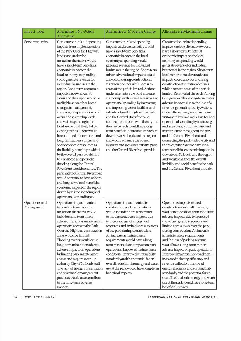
Socioeconomics Construction-related spending
impacts rom implementation
o the Park Over the Highway
landscape under the
no-action alternative wouldhave a short-term beneicial
economic impact on the
local economy as spending
could generate revenue or
individual businesses in the
region. Long-term economic
impacts in downtown St.
Louis and the region would be
negligible as no other broad
changes in management,
visitation, or operations would
occur and visitorship levels
and visitor spending in the
local area would likely ollow
existing trends. There would
be continued minor short- and
long-term adverse impacts to
socioeconomic resources as
the livability beneits provided
by the overall park would not
be enhanced and periodic
looding along the Central
Riverront would continue. The
park and the Central Riverront
would continue to have a short-and long-term local beneicial
economic impact on the region
driven by visitor spending and
operational expenditures.
Construction-related spending
impacts under 2 alternative would
have a short-term beneicial
economic impact on the local
economy as spending wouldgenerate revenue or individual
businesses in the region. Short-term
minor adverse local impacts could
also occur during construction i
visitation declines while access to
areas o the park is limited. Actions
under alternative 2 would increase
visitorship levels as well as visitor and
operational spending by increasing
and improving visitor acilities and
inrastructure throughout the park
and the Central Riverront and
connecting the park with the city and
the river, which would have long-
term beneicial economic impacts in
downtown St. Louis and the region
and would enhance the overall
livability and social beneits the park
and the Central Riverront provide.
Construction-related spending
impacts under 3 alternative would
have a short-term beneicial
economic impact on the local
economy as spending wouldgenerate revenue or individual
businesses in the region. Short-term
local minor to moderate adverse
impacts could also occur during
construction i visitation declines
while access to areas o the park is
limited. Removal o the Arch Parking
Garage would have long-term minor
adverse impacts due to the loss o a
revenue-generating acility. Actions
under alternative 3 would increase
visitorship levels as well as visitor and
operational spending by increasing
and improving visitor acilities and
inrastructure throughout the park
and the Central Riverront and
connecting the park with the city and
the river, which would have long-
term beneicial economic impacts in
downtown St. Louis and the region
and would enhance the overall
livability and social beneits the park
and the Central Riverront provide.
Operations and
Management
Operations impacts related
to construction under the
no-action alternative would
include short-term minor
adverse impacts as maintenance
operations access to the Park
Over the Highway construction
areas would be limited.
Flooding events would causelong-term minor to moderate
adverse impacts on operations
by limiting park maintenance
access and require clean-up
action by City o St. Louis sta.
The lack o energy conservation
and sustainable management
practices would also contribute
to the long-term adverse
impacts.
Operations impacts related to
construction under alternative 2
would include short-term minor
to moderate adverse impacts due
to increased use o energy and
resources and limited access to areas
o the park during construction.
An increase in maintenance
requirements would have a long-term minor adverse impact on park
operations. Improved maintenance
conditions, improved sustainability
standards, and the potential or an
overall reduction in energy and water
use at the park would have long-term
beneicial impacts
Operations impacts related to
construction under alternative 3
would include short-term moderate
adverse impacts due to increased
use o energy and resources and
limited access to areas o the park
during construction. An increase
in maintenance requirements
and the loss o parking revenuewould have a long-term minor
adverse impact on park operations.
Improved maintenance conditions,
increased ticketing eiciency and
revenue collection, improved
energy eiciency and sustainability
standards, and the potential or an
overall reduction in energy and water
use at the park would have long-term
beneicial impacts.

7/29/2019 Jefferson National Expansion Memorial
http://slidepdf.com/reader/full/jefferson-national-expansion-memorial 11/256
E N V I R O N M E N T A L A S S E S S M E N T / I M P L E M E N T I N G C I T Y A R C H R I V E R I N I T I A T I V E E L E M E N T S /TABLE OF CONTENTS ix
Executive Summary.................................................................................................................. i
Purpose o and Need or Action........................................................................................ i
Objectives in Taking Action......... ........... .......... .......... ........... .......... .......... ........... .......... .... iAlternatives Considered..................................................................................................... ii
Environmental Consequences........................................................................................... iv
Purpose and Need or Action.................................................................................. 1
Introduction.............................................................................................................. 1
Purpose and Need or Action............................................................................................ 3
Objectives in Taking Action......... ........... .......... .......... ........... .......... .......... ........... .......... ... 3
Project Area and Scope o the NPS Environmental Assessment.... ........... .......... ......... 5
Jeerson National Expansion Memorial Background................................................... 6
Scoping Process and Public Participation........................................................................ 9
Issues and Impact Topics.................................................................................................... 9
Issues Considered but Dismissed rom Further Analysis....... .......... .......... ........... ........ 11
Related Laws, Policies, Plans, And Regulations.............................................................. 14
Alternatives............................................................................................................. 23
Introduction......................................................................................................................... 23
Alternative 1: No-Action Alternative................................................................................. 25
Action Alternatives.............................................................................................................. 28
Elements Common to All Action Alternatives....... .......... ........... .......... .......... ........... ...... 28
Alternative 2: Moderate Change........ .......... ........... .......... .......... ........... .......... .......... ........ 37
Alternative 3: Maximum Change........ ........... .......... .......... ........... .......... .......... ........... ...... 42
Mitigation Measures......... .......... ........... .......... .......... ........... .......... .......... ........... .......... ..... 50
How Alternatives Meet Objectives........ .......... ........... .......... .......... ........... .......... .......... .... 54
Alternatives or Alternative Elements Considered but Not Carried Forward........ ...... 65
Environmentally Preerable Alternative......... .......... .......... ........... .......... .......... ........... .... 68
NPS Preerred Alternative.................................................................................................. 68
Afected Environment............................................................................................. 71
Introduction......................................................................................................................... 71
Cultural Resources.............................................................................................................. 71
Natural Resources............................................................................................................... 89
Visitor Use and Experience................................................................................................ 95
Socioeconomics................................................................................................................... 101
Operations and Management............................................................................................ 104
Table of Contents
7/29/2019 Jefferson National Expansion Memorial
http://slidepdf.com/reader/full/jefferson-national-expansion-memorial 12/256
J E F F E R S O N N A T I O N A L E X P A N S I O N M E M O R I A L/ TABLE OF CONTENTSx
Environmental Consequences.......................................................................... ...... 107
General Methodology or Establishing Impact Thresholds
and Measuring Eects by Resource................................................................................. 107
General Analysis Methods................................................................................................ 107
Impact Thresholds............................................................................................................. 107
Cumulative Impact Analysis Methodology.......... .......... ........... .......... .......... ........... ....... 108
Cultural Resources............................................................................................................. 114Natural Resources.............................................................................................................. 133
Visitor Use and Experience............................................................................................... 149
Socioeconomics.................................................................................................................. 155
Operations and Management........................................................................................... 162
Consultation and Coordination.............................................................................. 167
Cooperating Agencies........................................................................................................ 167
History o Public Involvement......................................................................................... 167
The Scoping Process.......................................................................................................... 168
List o Recipients o the Plan/Environmental Assessment........................................... 172
List o Preparers and Consultants.................................................................................... 173
Reerences........................................................................................................................... 174
Glossary.................................................................................................................. 180
Acronyms............................................................................................................... 183
Index...................................................................................................................... 185
List o Figures
Figure: 1 2009 General Management Plan Selected Alternative Management Zones 1
Figure: 2 Framing a Modern Masterpiece: The City + The Arch + The River Winning Design 2
Figure: 3 Jeerson National Expansion Memorial location.... ........... .......... .......... ...... 4
Figure: 4 Map showing vicinity and urban location o the park...... ........... .......... ....... 5
Figure 5: Alternative 1 site plan showing existing conditions and project areas.... ..... 24
Figure 6: MoDOT vehicular movement changes to the North Gateway.......... .......... 27
Figure 7: Proposed North Pond Allée Planting ........... .......... .......... ........... .......... ......... 32Figure 8: East Slopes........................................................................................................... 33
Figure 9: North and South Ponds..................................................................................... 34
Figure 10: Central Riverront Project Area....................................................................... 35
Figure 11: Central Riverront Leonor K. Sullivan Concept Section...... .......... ........... .. 36
Figure 12: Alternative 2 Site Plan....................................................................................... 37
Figure 13: Alternative 2 Proposed Security and Accessible Routes........... ........... ....... 38
Figure 14: Alternative 2 Proposed Plantings................................................................... 39
Figure 15: Alternative 2 West Gateway............................................................................. 40
Figure 16: Alternative 2 North Gateway.......... .......... .......... ........... .......... .......... ........... .... 41
Figure 17: Alternative 3 Site Plan...................................................................................... 42
Figure 18: Alternative 3 Proposed Security and Accessible Routes........... .......... ......... 43
Figure 19: View o North Gateway and Eads Bridge....................................................... 44
Figure 20: View o North Gateway and Eads Bridge......... .......... .......... ........... .......... .... 45Figure 21: Alternative 3 Proposed Planting...... .......... ........... .......... .......... ........... .......... 46
Figure 22: Alternative 3 West Gateway......... ........... .......... .......... ........... .......... .......... ....... 47
Figure 23: Alternative 3 North Gateway........................................................................... 49
Figure 24: Historic Architectural Resources within
the Cultural Resources Impact Area...... ........... .......... .......... ........... .......... .......... ........... . 73
Figure 25: Gateway Arch and Refecting Pond within the Park Grounds........ .......... . 74
Figure 26: The Old Courthouse and Luther Ely Smith Square..... ........... .......... .......... . 75
Figure 27: Lawn Directly Beneath the Gateway Arch.......... .......... ........... .......... .......... . 80
7/29/2019 Jefferson National Expansion Memorial
http://slidepdf.com/reader/full/jefferson-national-expansion-memorial 13/256
E N V I R O N M E N T A L A S S E S S M E N T / I M P L E M E N T I N G C I T Y A R C H R I V E R I N I T I A T I V E E L E M E N T S /TABLE OF CONTENTS x
Figure 28: Refecting Pond................................................................................................. 83
Figure 29: Processional Walks and Allées o Uniorm Trees along the Walks.......... ... 89
Figure 30: Flooding along the Central Riverront within the Floodplain.......... .......... 93
Figure 31: Project Area and 100-year Floodplain............................................................ 94
Figure 32: Transportation and Circulation Existing Conditions....... ........... .......... ........ 97
Figure 33: Pedestrian Bridge over I-70 across Memorial Drive.......... .......... ........... ...... 98
Figure 34: Accessible Walkways Existing Conditions..................................................... 100Figure 35: Visitors Gathering on the Grand Staircase and Central Riverront......... .. 101
Figure 36: Central Riverront along the Park................................................................... 106
List o Tables
Table 1: Summary o Alternatives........ .......... ........... .......... .......... ........... .......... .......... ..... 55
Table 2: Summary o Environmental Consequences............. .......... ........... .......... .......... 61
Table 3: Annual Attendance, Jeerson National Expansion Memorial......... .......... ..... 95
Table 4: Graph o Annual Attendance, Jeerson National Expansion Memorial...... 95
Table 5: Cumulative Action Scenario.... ........... .......... .......... ........... .......... .......... .......... .... 112
Appendices
Appendix A: Drat Floodplain Statement o Findings
Appendix B: U.S. Fish and Wildlie CorrespondenceAppendix C: Tribal Consultations
Appendix D: Programmatic Agreement

7/29/2019 Jefferson National Expansion Memorial
http://slidepdf.com/reader/full/jefferson-national-expansion-memorial 14/256
THIS PAGE LEFT INTENTION ALLY BLANK

7/29/2019 Jefferson National Expansion Memorial
http://slidepdf.com/reader/full/jefferson-national-expansion-memorial 15/256
1. Purpose and Need for ActionJeerson Naonal Expansion Memor
Environmental Assessment for Implemenng CityArchRiver Iniave Elemen

7/29/2019 Jefferson National Expansion Memorial
http://slidepdf.com/reader/full/jefferson-national-expansion-memorial 16/256
THIS PAGE LEFT INTENTION ALLY BLANK

7/29/2019 Jefferson National Expansion Memorial
http://slidepdf.com/reader/full/jefferson-national-expansion-memorial 17/256
E N V I R O N M E N T A L A S S E S S M E N T / I M P L E M E N T I N G C I T Y A R C H R I V E R I N I T I A T I V E E L E M E N T S /PURPOSE AND NEED 1
INTRODUCTION
The General Management Plan for Jefferson
National Expansion Memorial (NPS 2009)
established management zones and called
for an international design competition
to revitalize Jefferson National Expansion
Memorial (the park) by improving connectionsto downtown St. Louis, Missouri and the
riverfront and expanding programming,
facilities and partnerships, while enhancing the
visitor experience (Figure 1).
The winner of the design competition, Michael
Van Valkenburgh Associates (MVVA) of New
York, was selected by a jury from a field of five
finalists in September 2010 (Figure 2). MVVA
Purpose and Need for Acton
1
presented updated information about the
winning design to the public in January 2011
and January 2012 and has been refining their
concept design through a series of discussions
with the National Park Service (NPS) and the
Great Rivers Greenway District (GRG). Thisproject is part of a broader initiative known
as the CityArchRiver 2015 Initiative, and is a
unique and important opportunity to integrate
the Gateway Arch, the park surrounding it, and
the riverfront into the fabric of the city.
The park and the CityArchRiver 2015 Initiative
are also identified as part of the America’s
Great Outdoors (AGO) initiative launched
Figure 1 2009 General Management Plan Selected Alternative Management Zones

7/29/2019 Jefferson National Expansion Memorial
http://slidepdf.com/reader/full/jefferson-national-expansion-memorial 18/256
J E F F E R S O N N A T I O N A L E X P A N S I O N M E M O R I A L/ PURPOSE AND NEED2
by President Obama in 2011 to establish a 21st
century conservation and recreation agenda
and reconnect Americans to the outdoors. The
CityArchRiver 2015 Initiative aligns with goals
of the AGO by enhancing recreational access
and opportunities, providing better access
to the park’s cultural resources, and creatingpartnerships with a variety of agencies and
organizations.
As part of this effort, pursuant to Section
102(2)(C) of the National Environmental
Policy Act (NEPA) of 1969 (42 U.S.C. 4332(2)
(C)), the NPS has prepared an Environmental
Assessment (EA) for an evaluation of
alternatives to implement elements of the
CityArchRiver 2015 Initiative and revitalize
Jefferson National Expansion Memorial. The
2009 General Management Plan provided
a broad analysis of potential impacts of theexpansion of programs and facilities at the
park; this EA provides a more site-specific
analysis. The Council on Environmental
Quality (CEQ) regulations (40 CFR 1502.20)
encourage the use of a tiering process in
these types of situations, thereby eliminating
repetitive discussions of the same issues.
In addition, Department of the Interior
regulations implementing NEPA (43
CFR 46.140) state that an ‘‘environmental
assessment prepared in support of an
individual proposed action can be tiered
to a programmatic or other broader-scope
environmental impact statement. Tiering to theprogrammatic or broader-scope environmental
impact statement would allow the preparation
of an environmental assessment and a finding
of no significant impact for the individual
proposed action, so long as any previously
unanalyzed effects are not significant.’’ This
EA follows the tiering guidance in these
regulations.
The proposed action involves physical changes
to the park grounds and facilities and the
Central Riverfront as a method for improving
visitor access and experience, while betterintegrating the park into the downtown St.
Louis area. The NPS and the Great Rivers
Greenway District are using the EA process
to engage the public, to develop a range of
reasonable alternatives for implementing the
proposed action, and to analyze the impacts of
the alternatives.
Figure 2 Framing a Modern Masterpiece: The City + The Arch + The River 2015 Winning Design

7/29/2019 Jefferson National Expansion Memorial
http://slidepdf.com/reader/full/jefferson-national-expansion-memorial 19/256
E N V I R O N M E N T A L A S S E S S M E N T / I M P L E M E N T I N G C I T Y A R C H R I V E R I N I T I A T I V E E L E M E N T S /PURPOSE AND NEED 3
T J NE M 2009G M P
called for an international
design competition to revitalize
the park by improvingconnections to downtown St.
Louis and the riverfront and
expanding programming,
facilities and partnerships,
while enhancing the visitor
experience. The design
competition, Framing a Modern
Masterpiece: The City + The
Arch + The River 2015, explored
approaches to facilitate this goal
and led to the CityArchRiver
2015 Initiative elements
assessed in this EA.
PURPOSE + NEED FOR ACTION
The purpose of the proposed action analyzed
in this EA is to fulfill the goal of revitalizing
Jefferson National Expansion Memorial,
as called for by the selected action in the
November 2009 Record of Decision (ROD)
for the park’s General Management Plan/
Environmental Impact Statement (GMP).While the GMP provided direction on the
type of projects that could be implemented,
the 2009 selected action called for the NPS, in
close coordination with its partners, to initiate
a design competition that would provide a
wide breadth of ideas on how to meet this goal,
and, ultimately, form the basis for the design of
more specific projects.
The design competition began in December
2009 and the winning team and design were
selected in September 2010. The NPS now
needs to evaluate projects proposed by thewinning team and park partners that have
the potential to cause physical changes to the
park grounds. Action is needed now so that
projects may be finished in time for the 50th
anniversary of completion of the Gateway
Arch (October 28, 2015).
OBJECTIVES IN TAKINGACTION
The National Park Service considers objectives
to be those goals that must be achieved to a
large degree for the action to be considered a
success (NPS 2001). All alternatives selected fordetailed analysis must meet project objectives
and resolve the purpose of and need for action.
National Park Service objectives must be
grounded in the park’s enabling legislation,
purpose, significance, and mission goals,
and must be compatible with direction and
guidance provided by the GMP, strategic plan,
and/or other management guidance. Many
of the objectives developed by NPS for this
action incorporate or reflect the goals of the
design competition relevant to those project
components being considered in this EA.
Additionally, goals for the Central Riverfronthave been identified by the Great Rivers
Greenway District, and are also integrated in
the objectives listed below.
GENERAL
• Ensure that revitalization of the park
reflects the iconic status of the Gateway
Arch and embraces the Mississippi River,
but does not violate requirements in the
NPS Organic Act or NPS Management
Policies 2006.
• Working with partners, catalyze increased
vitality in the St. Louis region and create
attractions to promote extended visitation
to the Arch, the city, and the river.
CULTURAL RESOURCES
• Ensure that the revitalization of the
park and improvements to the Central
Riverfront preserve the integrity and
honor the character-defining elements
of the National Historic Landmarkand relevant National Register Historic
Districts.
• Avoid unacceptable impacts on the
cultural landscapes, historic resources,
and archeological resources as a result of
revitalizing the park and improving the
Central Riverfront.

7/29/2019 Jefferson National Expansion Memorial
http://slidepdf.com/reader/full/jefferson-national-expansion-memorial 20/256
J E F F E R S O N N A T I O N A L E X P A N S I O N M E M O R I A L/ PURPOSE AND NEED4
VISITOR USE AND EXPERIENCE
• Ensure that revitalization of the park
and the Central Riverfront improves
connections amongst the city, the park,
and the river.
• Enhance the experience at the park
and along the Central Riverfront and
reduce the adverse impacts from adjacenttransportation systems.
• Ensure visitor safety and accessibility
for people with disabilities is improved
and that the experience at the park and
along the Central Riverfront is enhanced
by creating a welcoming and accessible
environment.
Figure 3 Jeerson National Expansion Memorial Location
INTERPRETATION/EDUCATION
• Improve visitor understanding of the purpose
of the park, including the story of St. Louis as
the gateway to American westward expansion.
• Along the Central Riverfront, provide
opportunities for education connected to the
Mississippi River and the historic levee.
PARK MANAGEMENT AND OPERATIONS
• Incorporate sustainable methods into park
management and operations while minimizing
impacts of revitalization on financial resources,
staffing requirements, and long-term
maintenance requirements; improve Central
Riverfront operations by reducing flood-
related closures and cleanup activities.
NTS

7/29/2019 Jefferson National Expansion Memorial
http://slidepdf.com/reader/full/jefferson-national-expansion-memorial 21/256
E N V I R O N M E N T A L A S S E S S M E N T / I M P L E M E N T I N G C I T Y A R C H R I V E R I N I T I A T I V E E L E M E N T S /PURPOSE AND NEED 5
Department of Transportation (MoDOT) and the
Federal Highways Administration (FHWA) are
initiating a concurrent EA to assess the effects of
proposed changes to I-70 and Memorial Drive,
including the construction of a structure built over
the depressed section of I-70 as well as changesto the freeway’s ramp system. The surface of the
structure would be available to and managed
by the NPS to create a continuous landscape
connection - a Park Over the Highway. The NPS
and MoDOT/FHWA are formal cooperators
on each agencies’ NEPA documents, and will
continue to work together to ensure the necessary
compliance for these project elements are
completed.
Other projects outside the park property
associated with the CityArchRiver 2015 Initiative
include proposed changes to Kiener Plaza.In addition, proposed changes to the East St.
Louis side of the Mississippi River are still being
considered, and are not ready for a decision at
this time. While the projects noted above are not
considered as part of the NPS proposed action,
they have been addressed in this EA, where
appropriate, as part of the cumulative impacts
analysis in Chapter 4.
Figure 4 Map showing vicinity and urban location of the park
PROJECT AREA AND SCOPEOF THE NPS ENVIRONMENTALASSESSMENT
As described in the GMP, the Jefferson National
Expansion Memorial is located entirely withinthe urban area of downtown St. Louis, Missouri
(see Figures 3 and 4). It was the first Secretarial
designation under the Historic Sites Act of 1935 (NPS
1994). The 91-acre park sits on the west bank of the
Mississippi River and occupies what previously were
forty city blocks between Eads Bridge and Poplar
Street (NPS 1996a), bounded on the east by Leonor
K. Sullivan Boulevard and primarily on the west by
Memorial Drive, except for two blocks immediately
west of Memorial Drive occupied by Luther Ely
Smith Square and the Old Courthouse. The Central
Riverfront is located along Leonor K. Sullivan
Boulevard between the Mississippi River and thepark, to the east and west, and Biddle Street and
Chouteau Avenue on the north and south.
The projects being considered on park property
and the Central Riverfront are part of the broader
CityArchRiver 2015 Initiative. This initiative involves
non-NPS projects and NPS projects on a longer-
term planning horizon. For example, the Missouri
NTS

7/29/2019 Jefferson National Expansion Memorial
http://slidepdf.com/reader/full/jefferson-national-expansion-memorial 22/256
J E F F E R S O N N A T I O N A L E X P A N S I O N M E M O R I A L/ PURPOSE AND NEED6
JEFFERSON NATIONALEXPANSION MEMORIALBACKGROUND
HISTORY OF THE PARK
Jefferson National Expansion Memorialwas the brainchild of Luther Ely Smith, a
prominent St. Louis attorney. Smith convinced
the city mayor, Bernard Dickmann, and
prominent St. Louis businessmen that “...a
suitable and permanent public memorial
to the men who made possible the western
territorial expansion of the United States,
particularly President Jefferson,” should be
built on the St. Louis riverfront. On December
21, 1935, President Franklin D. Roosevelt signed
Executive Order 7253 providing direction to
the Secretary of the Interior for the acquisition
and development of Jefferson NationalExpansion Memorial. Between 1939 and
1942, forty blocks of condemned buildings,
remnants of the once-proud riverfront district,
were razed. Only the Old Courthouse and
the Old Cathedral are still standing today.
Just as progress was being made on the park’s
development, the United States was plunged
into World War II, and work on the park was
halted.
With the end of the Second World War,
Luther Ely Smith resumed the project with anarchitectural competition. Held in two stages,
the competition was judged by a jury of seven
nationally recognized architectural and design
professionals predisposed toward the Modern
style. This predisposition influenced most of
the entrants to assume a modern approach
to their design submissions. The competition
ended in February 1948 and, by secret ballot,
the panel of seven unanimously chose design
number 144, submitted by Eero Saarinen and
the design team that included sculptor and
artist Lily Saarinen (Eero’s spouse), landscape
architect Dan Kiley, illustrator J. HendersonBarr, and designer Alexander Girard. The
central feature of the design was a soaring
stainless steel arch. Ground breaking for the
Gateway Arch occurred on June 23, 1959,
and the structure was completed in October
of 1965. The GMP provides a more detailed
description of the park’s administrative history
in Chapter 1 (p. 1-3 and 1-4) and in Chapter 3
(p. 3-3 to 3-7). The full administrative history
of the park is covered in two Administrative
History reports, one by Sharon A. Brown
documenting the park’s administrative history
between 1933 and 1980 and one by Bob Moore
documenting the park’s history from 1980 to1991. Both of these documents are available on
the park’s website and are referenced in the
bibliography of this EA.
PURPOSE AND SIGNIFICANCE OF THE PARK
Every unit within the national park system
has specific reasons for its establishment as
a national park. Purpose statements reaffirm
the reasons each unit was designated,
help reinforce the foundation for future
management and use, and provide a rationale
against which all proposed actions can bemeasured. These statements help visitors,
cooperating agencies, partners, members of
the community, and other users to understand
the framework in which park managers make
decisions. The following purpose statements
have been refined over time and are based
on Jefferson National Expansion Memorial’s
designation by Executive Order 7253 and
subsequent legislative history, as well as laws
and policies governing the management of
all national park system units. The full text
of the executive order establishing the park,
its purpose and significance, and other parklegislative history can be found in Appendix A
of the GMP.
• The park commemorates, through a
designed memorial, Thomas Jefferson’s
vision of building a unified continental
nation and St. Louis’ role as a confluence
The Gateway Arch is an inverted,
weighted catenary curve (a type
of curve created by supporting
both ends of a hanging chain). It
soars 630 feet f rom its base on a
constructed landform on the bank
of the Mississippi River. The site
is recognized as a deliberate built
experience, a complete design for a
public monument, and a master piece
composition of integrated structure,
landscape, and interpretation.

7/29/2019 Jefferson National Expansion Memorial
http://slidepdf.com/reader/full/jefferson-national-expansion-memorial 23/256
E N V I R O N M E N T A L A S S E S S M E N T / I M P L E M E N T I N G C I T Y A R C H R I V E R I N I T I A T I V E E L E M E N T S /PURPOSE AND NEED 7
and gateway of the American westward
expansion during the 19th century.
• The park interprets the key individuals
and cultural groups involved in exploring,
exploiting, and inhabiting the western
lands from the Mississippi River to thePacific Ocean.
• The park preserves the architecturally
significant Old Courthouse as the site of
the Dred Scott case, which divided North
and South over the extension of slavery
into the western territories and led to the
American Civil War.
Significance statements capture the essence of
the park’s importance to our country’s natural
and cultural heritage and historical events
that occurred at this location. Significancestatements do not inventory resources, but
rather describe the unit’s distinctiveness and
place the park within its regional, national, and
international contexts. Defining significance
helps managers make decisions and focus
their efforts and funding on preserving the
resources and values necessary to accomplish
the park’s purpose.
St. Louis was politically and geographically
pivotal in the westward expansion of the
United States during the 19th century.Significant historic events associated with
westward expansion, exploration, and the
fur trade occurred at the site, including the
transfer of the Louisiana Territory from Spain
to France and then to the United States, the
negotiation of numerous treaties removing
Indian tribes from their lands, and the
provisioning and return of the Lewis and Clark
expedition. St. Louis was the starting point
for numerous explorers, fur traders, overland
pioneers, and others who made the journey
west.
In 1846, Dred and Harriet Scott sued for their
freedom from slavery at the Old Courthouse
in St. Louis. This historic case, argued in 1847,
1850, 1852, and 1854, resulted in an 1857 U.S.
Supreme Court decision which determined
that all “people of color,” enslaved or free,
could not become citizens of the United States,
and removed restrictions on the extension
of slavery into the U.S. Western Territories,
further dividing the North and South and
eventually leading to the Civil War.
The Old Courthouse is a prime example
of mid-19th century Greek Revival civic
architecture, utilizing the very latesttechnological innovations and materials
available at the time, including the first cast
iron dome completed in the United States.
The park is recognized globally as an
exceptional example of mid-20th century
Modern design. The soaring Gateway Arch
is one of the world’s great architectural and
engineering achievements. It is a tangible
symbol of St. Louis’ historical role as the
“Gateway to the West,” purposefully located
on the footprint of the original 1764 village of
St. Louis. The site is recognized as a deliberatebuilt experience, a complete design for a public
monument, and a masterpiece composition
of integrated structure, landscape, and
interpretation.
The museum objects and archival records in
the park’s collection document the westward
expansion of the United States and the
creation, planning, and building of the park.
The collection is used in ongoing research
by scholars and staff and is the basis of the
historic site’s interpretation programming andmuseum exhibits.
7/29/2019 Jefferson National Expansion Memorial
http://slidepdf.com/reader/full/jefferson-national-expansion-memorial 24/256
J E F F E R S O N N A T I O N A L E X P A N S I O N M E M O R I A L/ PURPOSE AND NEED8
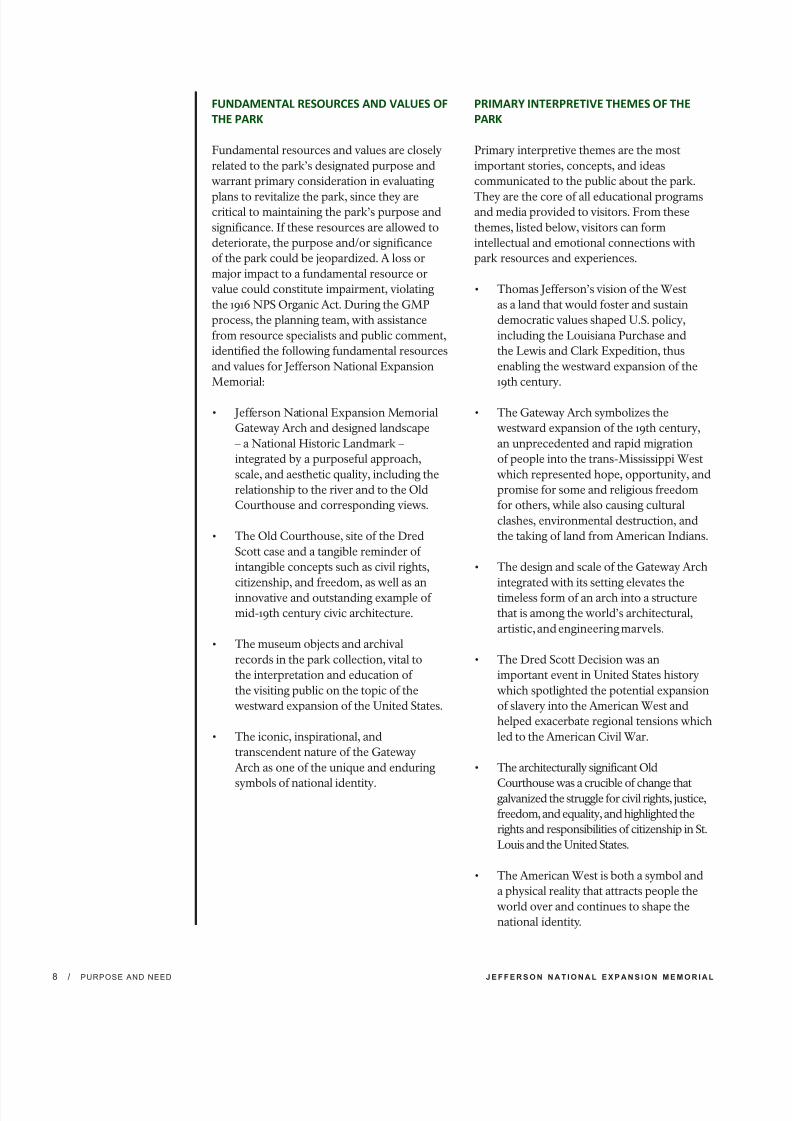
FUNDAMENTAL RESOURCES AND VALUES OF
THE PARK
Fundamental resources and values are closely
related to the park’s designated purpose and
warrant primary consideration in evaluating
plans to revitalize the park, since they arecritical to maintaining the park’s purpose and
significance. If these resources are allowed to
deteriorate, the purpose and/or significance
of the park could be jeopardized. A loss or
major impact to a fundamental resource or
value could constitute impairment, violating
the 1916 NPS Organic Act. During the GMP
process, the planning team, with assistance
from resource specialists and public comment,
identified the following fundamental resources
and values for Jefferson National Expansion
Memorial:
• Jefferson National Expansion Memorial
Gateway Arch and designed landscape
– a National Historic Landmark –
integrated by a purposeful approach,
scale, and aesthetic quality, including the
relationship to the river and to the Old
Courthouse and corresponding views.
• The Old Courthouse, site of the Dred
Scott case and a tangible reminder of
intangible concepts such as civil rights,
citizenship, and freedom, as well as aninnovative and outstanding example of
mid-19th century civic architecture.
• The museum objects and archival
records in the park collection, vital to
the interpretation and education of
the visiting public on the topic of the
westward expansion of the United States.
• The iconic, inspirational, and
transcendent nature of the Gateway
Arch as one of the unique and enduring
symbols of national identity.
PRIMARY INTERPRETIVE THEMES OF THE
PARK
Primary interpretive themes are the most
important stories, concepts, and ideas
communicated to the public about the park.
They are the core of all educational programsand media provided to visitors. From these
themes, listed below, visitors can form
intellectual and emotional connections with
park resources and experiences.
• Thomas Jefferson’s vision of the West
as a land that would foster and sustain
democratic values shaped U.S. policy,
including the Louisiana Purchase and
the Lewis and Clark Expedition, thus
enabling the westward expansion of the
19th century.
• The Gateway Arch symbolizes the
westward expansion of the 19th century,
an unprecedented and rapid migration
of people into the trans-Mississippi West
which represented hope, opportunity, and
promise for some and religious freedom
for others, while also causing cultural
clashes, environmental destruction, and
the taking of land from American Indians.
• The design and scale of the Gateway Arch
integrated with its setting elevates thetimeless form of an arch into a structure
that is among the world’s architectural,
artistic, and engineering marvels.
• The Dred Scott Decision was an
important event in United States history
which spotlighted the potential expansion
of slavery into the American West and
helped exacerbate regional tensions which
led to the American Civil War.
• The architecturally significant Old
Courthouse was a crucible of change thatgalvanized the struggle for civil rights, justice,
freedom, and equality, and highlighted the
rights and responsibilities of citizenship in St.
Louis and the United States.
• The American West is both a symbol and
a physical reality that attracts people the
world over and continues to shape the
national identity.

7/29/2019 Jefferson National Expansion Memorial
http://slidepdf.com/reader/full/jefferson-national-expansion-memorial 25/256
E N V I R O N M E N T A L A S S E S S M E N T / I M P L E M E N T I N G C I T Y A R C H R I V E R I N I T I A T I V E E L E M E N T S /PURPOSE AND NEED 9
• St. Louis’ strategic location near the
confluence of the Mississippi and
Missouri Rivers made it a logical hub of
exploration, commerce, military activity,
cultural encounter, and transportation
as the United States expanded westward
during the 19th century.
SCOPING PROCESS ANDPUBLIC PARTICIPATION
NEPA regulations require “an early and open
process for determining the scope of issues to
be addressed and for identifying the significant
issues related to a proposed action.” The scope
of issues to be addressed was discussed at an
internal scoping meeting on May 18, 2011, held
with the NPS Interdisciplinary Planning Team
convened for this plan, as well as many park
staff, design team members, CityArchRiver2015 Foundation representatives, and MoDOT
representatives.
NPS published a Notice of Intent to prepare
an EA in the Federal Register on July 26, 2011,
and in July 2011 the Superintendent announced
a 30-day public scoping period to solicit
comments on the scope of the project. During
this scoping period, the NPS invited the public
and all interested parties to comment on all
aspects of the project, including concerns or
issues related to the project’s impacts. The NPSaccepted comments via the NPS Planning,
Environment and Public Comment (PEPC)
website at www.parkplanning.nps.gov/jeff, by
mail, and by hand delivery to the park. The
public scoping process is ongoing throughout
the planning process. The “Consultation and
Coordination” chapter provides additional
information on the scoping process.
ISSUES AND IMPACT TOPICS
This EA considers the proposed action and
associated effects in light of the key resources
that contribute to the physical, cultural, and
human environment of Jefferson National
Expansion Memorial and the Central
Riverfront. To properly assess the relative
impacts of the alternatives, specific topics
that would be affected are evaluated. Through
the internal and public scoping process,the NPS identified the following topics and
issues associated with implementation of the
alternatives for analysis in this EA.
CULTURAL RESOURCES
This topic considers the cultural resources
that are present on the park site and within the
surrounding area. Cultural resources include
historic buildings, structures, sites, objects, and
districts; cultural landscapes; archeological
resources; and museum collections. As these
resources exist within the park and along theCentral Riverfront, and they could be affected
by construction and renovation activities and
new infrastructure and facilities, this impact
topic was retained for further analysis in this
EA. The Gateway Arch and Arch grounds are
designated as a National Historic Landmark
(NHL). Like all NHLs, the park’s historic
resources are vitally important to its existence
and purpose.
Agencies that have direct or indirect
jurisdiction over historic properties are
required by Section 106 of the NationalHistoric Preservation Act (NHPA) of 1966, as
amended, to take into account the effect of any
undertaking on properties listed or eligible
for listing in the National Register of Historic
Places. Consultation under Section 106 of the
NHPA is ongoing as a separate but concurrent
process with this EA. It is briefly described
below; the “Consultation and Coordination”
Scoping — An early and open
process for determining the extent
and variety of issues to be addressed
and for identifying the significant
issues related to a proposed action
(40 CFR 1501.7).
National Historic Landmark — A
district, site, building, structure,or object of national historical
significance, designated by the
Secretar y of the Interior under
authority of the Historic Sites Act
of 1935 and entered in the National
Register of Historic Places.

7/29/2019 Jefferson National Expansion Memorial
http://slidepdf.com/reader/full/jefferson-national-expansion-memorial 26/256
J E F F E R S O N N A T I O N A L E X P A N S I O N M E M O R I A L/ PURPOSE AND NEED10
chapter provides additional information on the
Section 106 process.
Section 106 consultation regarding proposed
changes at the park occurred during the
GMP planning process and for the design
competition, Framing a Modern Masterpiece:The City + The Arch + The River 2015 . In
January 2011, the NPS resumed consultation
with the Missouri State Historic Preservation
Officer, the Advisory Council on Historic
Preservation, Tribal Governments, and other
consulting parties. As part of the process, the
NPS identified historic properties listed in
or eligible for listing in the National Register
of Historic Places within the broadly defined
area of potential effects of the revitalization of
the Jefferson National Expansion Memorial.
However, due to the relative uncertainty of the
nature of all of the potential projects or actionsthat may stem from the revitalization, the NPS
and its consulting parties cannot yet fully
assess the potential effects of these projects
or actions on historic properties. Therefore,
the NPS and its consulting parties entered
into a programmatic agreement (PA) in order
to establish a process to review site specific
design as it becomes available and to asses and
resolve adverse effects in accordance with 36
CFR 800.14(b)(1)(ii). The PA is included in
Appendix D of this environmental assessment.
Therefore, this EA will document impacts to
cultural resources as a result of implementing
these projects on park properties and along the
Central Riverfront. A separate assessment of
effect under Section 106 of the NHPA will be
made as appropriate.
NATURAL RESOURCES
The physical and biological resources of
the park, the Central Riverfront, and its
surrounding environment are an important
component of the park. The park’s physicalsetting on the banks of the Mississippi
River shapes both the visitor experience
and surrounding environmental context.
Construction and renovation activities
and new infrastructure and facilities could
impact certain natural resources, including
vegetation, soundscape, and water resources
and stormwater management. Alternatives
considered in this EA would require
construction within the floodplain of the
Mississippi River. Therefore, this impact topic
was retained for further analysis.
VISITOR USE AND EXPERIENCE
Visitor use and experience includes visitoropportunities and use such as information,
interpretation, and education, as well as
recreational activities. It also includes
pedestrian and bicycle circulation, parking,
and accessibility, or barrier free access. Visitor
use and experience would be affected by
construction and renovation activities and
new infrastructure and facilities; therefore, this
impact topic was retained for further analysis.
SOCIOECONOMICS
Because the park is located in downtown St.Louis, regional socioeconomic trends affect
the park, and the park contributes to the
regional economy. The park attracts millions
of visitors each year. Given the importance of
the park as a regional attraction, as well as a
nationally and internationally recognized icon,
social and economic considerations extend
beyond the physical boundaries of the park.
Construction and renovation activities as well
as new infrastructure and facilities have the
potential to affect socioeconomic resources
and this topic was retained for further analysis.
NPS OPERATIONS AND PARTNERSHIPS
Each of the actions described in the proposed
alternatives would affect the operation and
management of the park in different ways.
Changes in staffing levels, visitor use activities,
new facilities, infrastructure improvements,
and visitor attractions all have implications
for NPS operations. These changes have the
potential to affect education and interpretation
programs and services, curatorial objects
management, grounds and facility maintenanceand management, law enforcement and
security functions, overall administrative
staffing and duties, and energy requirements
and conservation/sustainability efforts.
Therefore, this impact topic was retained for
further analysis.

7/29/2019 Jefferson National Expansion Memorial
http://slidepdf.com/reader/full/jefferson-national-expansion-memorial 27/256
E N V I R O N M E N T A L A S S E S S M E N T / I M P L E M E N T I N G C I T Y A R C H R I V E R I N I T I A T I V E E L E M E N T S /PURPOSE AND NEED 1
ISSUES CONSIDERED BUTDISMISSED FROM FURTHERANALYSIS
Some impact topics that are commonly
considered in an environmental assessment
were not relevant to this assessment, becausethe proposed action would have no impact or
a negligible to minor impact on the resource,
or because the resource does not occur within
the project area. These topics were identified
as follows:
LAND USE
Land uses surrounding the park and the
Central Riverfront would not be modified
by the alternatives analyzed in this EA.
Additionally, the proposed changes are
consistent with local land use laws. Therefore,this topic was dismissed from detailed analysis.
ENVIRONMENTAL JUSTICE
Executive Order 12898, Federal Action to
Address Environmental Justice in Minority
Populations and Low-Income Populations,
was published in February 1994 and requires
federal agencies to identify and address
disproportionately high and adverse human
health or environmental impacts of its
programs, policies, and activities on minorityand low-income populations. In their guidance
document, the Environmental Protection
Agency (EPA) defines a community with
potential Environmental Justice indicators as
one that has a greater percentage of minority
or low- income populations than an identified
reference community (state or county) (EPA
2004). The EPA guidance defines a minority
as “Individual(s) who are members of the
following population groups: American Indian
or Alaskan Native; Asian or Pacific Islander;
Black, not of Hispanic origin; or Hispanic.
Minority populations are considered groups of minority individuals in which, “(a) the minority
population of the affected area exceeds
50 percent or (b) the minority population
percentage of the affected area is meaningfully
greater than the minority population
percentage in the general population or other
appropriate unit of geographic analysis” (CEQ
1997).
EPA guidance further notes, “…Low-income
populations in an affected area should be
identified with the annual statistical poverty
thresholds from the Bureau of the Census’
Current Population Reports, Series P-60 on
Income and Poverty. In identifying low-income
populations, agencies may consider as acommunity either a group of individuals living
in geographic proximity to one another, or a
set of individuals (such as migrant workers
or Native Americans), where either type of
group experiences common conditions of
environmental exposure or effect” (CEQ 1997).
The Census Bureau defines a poverty area as
a census tract with 20 percent or more of its
residents below the poverty level (U.S. Census
2012).
According to the American Community
Survey, the census tract surrounding the parkhas a minority population of less than 50
percent and is not considered a poverty area;
however, the census tracts directly to the north
and south of the park, into which the Central
Riverfront extends, have minority populations
greater than 50% and higher poverty levels.
The census tract directly across the river in
East St. Louis also has a minority population
of greater than 50% and higher poverty levels
(U.S. Census 2010). The City of St. Louis has
higher percentages of individuals living in
poverty and a higher percentage of minoritypopulations than either St. Louis County or the
State of Missouri. In addition, the City of East
St. Louis has higher percentages of individuals
living in poverty, and a higher percentage of
minority populations than either St. Clair
County or the State of Illinois (U.S. Census
2010).
As low income and minority populations
exist within the City of St. Louis and the City
of East St. Louis, the EPA’s “Environmental
Justice in the NEPA Process” website (http://
www.epa.gov/compliance/nepa/nepaej/)was consulted to determine how to consider
potential impacts to Environmental Justice
communities (EPA 2012). The Environmental
Justice flowchart, provided in the U.S. Air
Force guidance on Environmental Justice
and available on EPA’s Environmental Justice
NEPA website as a model framework, indicates
that analysis of Environmental Justice does not
need to occur if no impact would be caused
7/29/2019 Jefferson National Expansion Memorial
http://slidepdf.com/reader/full/jefferson-national-expansion-memorial 28/256
J E F F E R S O N N A T I O N A L E X P A N S I O N M E M O R I A L/ PURPOSE AND NEED12
by the proposed action or if the impact is not
considered adverse. The guidance defines
an adverse impact as an impact that “would
have a negative effect on human health or the
environment that is significant, unacceptable,
or generally above accepted norms” (U.S. Air
Force 1997).
Adverse impacts, as defined by the U.S. Air
Force, are not anticipated as a result of the
proposed alternatives. It is also highly unlikely
that the actions taken by the project would
introduce materials into the environment that
would have indirect adverse health impacts
or impact the economic conditions of low
income populations in St. Louis or East St.
Louis. Any construction-related impacts from
noise and air emissions would be short-term
and temporary and best management practices
would be implemented during construction.While there are communities with populations
of minorities or low-income peoples in the
vicinity of the project, they would not be
directly affected by the alternatives and the
alternatives would not result in any impacts
that would be specific to a minority or
low-income community.
Therefore, based on the EPA and U.S. Air
Force guidance, Environmental Justice was
dismissed as an impact topic requiring detailed
analysis.
PRIME AND UNIQUE FARMLANDS
There are no farmlands within Jefferson
National Expansion Memorial or along the
Central Riverfront. Therefore, this topic was
dismissed from detailed analysis.
WILD AND SCENIC RIVERS, ECOLOGICALLY
CRITICAL AREAS, OR OTHER UNIQUE
NATURAL RESOURCES
The park and the Central Riverfront have beenheavily manipulated by human activity and
development; as such, there are no existing
ecologically critical areas or unique natural
resources within the bounds of the park or the
Central Riverfront. Thus, this impact topic was
dismissed from detailed analysis.
SACRED SITES
Currently there are no known sacred sites
in the general area of the park or Central
Riverfront, but continued efforts to consult
with interested groups will be made by the
NPS through the NEPA and Section 106processes. A sacred site must be identified by
an Indian tribe or individual, as defined by
Executive Order 13007:
any specific, discrete, narrowly delineated
location on Federal land that is identified
by an Indian tribe, or Indian individual
determined to be an appropriately
authoritative representative of an
Indian religion, as sacred by virtue of its
established religious significance to, or
ceremonial use by, an Indian religion;
provided that the tribe or appropriatelyauthoritative representative of an Indian
religion has informed the agency of the
existence of such a site.
Because no sacred sites have been identified
within the park, this issue was dismissed from
further analysis. Should any sacred sites be
identified after the publication of the EA,
they would be treated in accordance with the
applicable laws and policies, and appropriate
consultation would be undertaken.
INDIAN TRUST RESOURCES
Indian trust resources are “those natural
resources reserved by or for Indian tribes
through treaties, statutes, judicial decisions,
and executive orders, which are protected by a
fiduciary obligation on the part of the United
States” (NPS 2006).There are no Indian trust
resources within Jefferson National Expansion
Memorial and therefore the topic was
dismissed from detailed analysis.
ETHNOGRAPHIC RESOURCES
Ethnographic resources are defined by the
NPS as “the cultural and natural features of
a park that are of traditional significance to
traditionally associated peoples. These peoples
are the contemporary park neighbors and
ethnic or occupational communities that have
been associated with a park for two or more
generations (40 years), and whose interests in
7/29/2019 Jefferson National Expansion Memorial
http://slidepdf.com/reader/full/jefferson-national-expansion-memorial 29/256
E N V I R O N M E N T A L A S S E S S M E N T / I M P L E M E N T I N G C I T Y A R C H R I V E R I N I T I A T I V E E L E M E N T S /PURPOSE AND NEED 1
the park’s resources began before the park’s
establishment” (NPS 2006). No ethnographic
resources have been documented or are
known to be associated with the park. Thus,
this topic was dismissed from detailed
analysis. Should any ethnographic resources
be identified after the publication of the EA,they would be treated in accordance with the
applicable laws and policies, and appropriate
consultation would be undertaken.
AIR QUALITY AND CLIMATE CHANGE
Existing emission sources in the vicinity of
the park and the Central Riverfront include
vehicular emissions from sources such as
buses, visitors looking for parking, and visitor
drop-offs and pick-ups; emissions from facility
operations and park grounds maintenance
and operations; and riverfront activities suchas boat tours, shipping/commercial boating
activities, and helicopter tours. Global climate
change resulting from the accumulation
of emissions of heat-trapping gases in the
atmosphere has the potential to increase risks
to human health and to terrestrial and aquatic
ecosystems (EPA 1997). The Clean Air Act
of 1963 (42 USC 7401 et seq.) was established
to promote the public health and welfare by
protecting and enhancing the nation’s air
quality. The Clean Air Act and the 1970 and
1990 Clean Air Act Amendments requirepublic land managers, including NPS Park
Superintendents, to protect air quality in
national parks.
Construction activities associated with the
alternatives have the potential to produce dust
and result in short-term increases in vehicle
emissions in the vicinity of the proposed site.
However, these emissions would be temporary
in nature (only during construction). To
minimize potential effects, Best Management
Practices (BMPs) related to vehicle and
equipment emissions and dust suppressionwould be implemented. Construction
emissions would not impact regional or global
climatic patterns.
Increased emissions due to facility expansion
and an increase in visitation could occur in
the long term, but not to the point where
there would be more than negligible effects
from an increase in emissions and local
greenhouse gases or any measurable effects
on global greenhouse gas levels. Sustainable
maintenance and building practices would be
implemented to minimize potential effects.
Thus, short-and long-term impacts would be
negligible and air quality and climate change
were dismissed from further analysis.
WETLANDS
The National Wetlands Inventory (NWI)
indicates that there are at least two wetlands
in the park. Both of the wetlands are classified
in the NWI as excavated wetlands, indicating
they may be artificially created. A site visit
was conducted as part of the GMP to verify
the excavated wetlands illustrated on the
NWI maps. The wetlands shown on the park
grounds are the two designed reflecting pools.
The reflecting pools are not wetlands asdefined by the U.S. Army Corps of Engineers
(USACE) and EPA and do not fall under
the jurisdiction of the USACE. Therefore,
wetlands were dismissed from detailed study.
SOILS AND GEOLOGIC RESOURCES
The alternatives would require excavation
and site grading for proposed construction;
however, to the extent feasible, excavated soils
would be amended and stockpiled for reuse
on the site. Best management practices wouldbe utilized during construction to prevent soil
erosion. Because the types of soils that may
be impacted are either artificial fill or typical
soils that have no important characteristics,
this topic was dismissed from further
consideration.
WILDLIFE
The park and the Central Riverfront are
within a highly urbanized landscape and
resident wildlife found in the park and along
the Central Riverfront would be wildlifegenerally adapted to urban areas, including
small mammals such as squirrels and raccoons
as well as various birds and other transient
wildlife. The Mississippi River is also a major
corridor for migratory birds. The St. Louis
chapter of the National Audubon Society
forged an agreement with the National Park
Service to turn off the lights that illuminate
the Gateway Arch during the spring and fall
7/29/2019 Jefferson National Expansion Memorial
http://slidepdf.com/reader/full/jefferson-national-expansion-memorial 30/256
J E F F E R S O N N A T I O N A L E X P A N S I O N M E M O R I A L/ PURPOSE AND NEED14
migration to minimize any interference with
birds’ ability to navigate at night.
There is limited habitat for wildlife within the
park and no riparian habitat on the west bank
of the Mississippi River along the Central
Riverfront. The park grounds consist of well-maintained turf areas beneath an overstory
of ash, oak, pine, and cypress trees. There is
little cover and few sources of food available
for wildlife other than tree seeds and acorns.
Wildlife that utilizes the park and Central
Riverfront as habitat or for food sources could
be temporarily displaced during construction;
however, after construction the urbanized
landscape of the park and the Central
Riverfront would be maintained. Any impacts
to wildlife would be minimal due to a lack
of habitat in the park and along the Central
Riverfront. Therefore, this topic was dismissedfrom further analysis
FEDERALLY LISTED THREATENED AND
ENDANGERED SPECIES
According to the U.S. Fish and Wildlife
Service’s website, the following listed
threatened and endangered species are known
to occur in St. Louis City, Missouri, St. Louis
County, Missouri and St. Clair County, Illinois:
Gray bat ( Myotis grisescens), Indiana bat
( Myotis sodalis
), Least tern (Sterna antillarum
),Pallid sturgeon (Scaphirhynchus albus), Pink
mucket (pearlymussel) (Lampsilis abrupta),
Scaleshell mussel (Leptodea leptodon),
Sheepnose mussel (Plethobasus cyphyus),
Snuffbox mussel (Epioblasma triquetra),
Spectaclecase (Cumberlandia monodonta),
Illinois cave amphipod (Gammarus
acherondytes), Decurrent false aster (Boltonia
decurrens), Mead’s milkweed ( Asclepias
meadii ), Eastern prairie fringed orchid
(Platanthera leucophaea), and Running buffalo
clover (Trifolium stolonifereum) (USFWS 2012).
While the above listed threatened and
endangered species may be present at locations
within St. Louis City and County, Missouri
and St. Clair County, Illinois, the project
area includes only those lands in downtown
St. Louis within the existing park boundary
and the adjacent Central Riverfront. No
threatened and endangered species are known
to be present within the project area. Due
to the urban environment and associated
disturbances, it is highly unlikely that suitable
habitat to support listed species would be
available, now or in the future. Therefore, this
topic was dismissed from further analysis
Additionally, although improvements tothe east slopes of the park and the Central
Riverfront would occur within the 100-year
floodplain of the Mississippi River, the
project must be designed to ensure no rise
in the 100-year base flood elevation after
improvements are constructed. This would
minimize potential for any impacts to listed
species which may occur in or near the river.
The NPS sent a consultation letter to the
U.S. Fish and Wildlife Service regarding the
determination that the project would have
no effect on listed species, their habitats, or
proposed or designated critical (see AppendixB). Impacts to threatened and endangered
species would be minimal as there are no
known species within the project area and due
to a lack of habitat in the park and along the
Central Riverfront.
RELATED LAWS, POLICIES,PLANS, AND REGULATIONS
GUIDING LAWS AND POLICIES
Guiding legislative or judicial requirementsand formal agency agreements are often
established concurrently with the creation
of a unit of the national park system, but can
occur at a later date. The proposed action must
work within the framework of these laws and
policies. Relevant laws and policies include the
following:
1916 Organic Act
The Organic Act (16 USC § 1) provides the
fundamental management direction for all
units of the national park system:
[P]romote and regulate the use of the Federal
areas known as national parks, monuments,
and reservations…by such means and measure
as conform to the fundamental purpose of said
parks, monuments and reservations, which
purpose is to conserve the scenery and the
natural and historic objects and the wild life
therein and to provide for the enjoyment of the

7/29/2019 Jefferson National Expansion Memorial
http://slidepdf.com/reader/full/jefferson-national-expansion-memorial 31/256
E N V I R O N M E N T A L A S S E S S M E N T / I M P L E M E N T I N G C I T Y A R C H R I V E R I N I T I A T I V E E L E M E N T S /PURPOSE AND NEED 1
same in such manner and by such means as will
leave them unimpaired for the enjoyment of
future generations.
The national park system General Authorities
Act (16 USC § 1a-1 et seq.) affirms that while
all national park system units remain “distinctin character,” they are “united through their
interrelated purposes and resources into one
national park system as cumulative expressions
of a single national heritage.”
The act makes it clear that the NPS Organic Act
and other protective mandates apply equally
to all units of the system. Further, amendments
state that NPS management of park units
should not “derogat[e]…the purposes and
values for which these various areas have been
established.”
The 1978 Redwood Amendment supplemented
the General Authorities Act and amended
the Organic Act to direct the NPS to protect,
manage and administer park lands “in light
of the high public value and integrity of
the National Park System,” and to refrain
from administering park lands in a way that
degrades “the values and purposes for which
these various areas have been established,
except as may have been or shall be directly
and specifically provided by Congress” (16
USC 1a-1).
National Environmental Policy Act, 1969, as
Amended
NEPA is implemented through regulations of
the Council on Environmental Quality (40 CFR
1500–1508). The Department of Interior has
established regulations to use for compliance
with NEPA and CEQ regulations (43 CFR
46 10–450). The NPS has in turn adopted
procedures to comply with the act and the
CEQ regulations, as found in Director’s Order
12: Conservation Planning, EnvironmentalImpact Analysis, and Decision Making (NPS
2011), and its accompanying Handbook (NPS
2001). This EA complies with NEPA and the
procedures outlined in Director’s Order 12.
CEQ regulations (40 CFR 1502.20),
Department of Interior NEPA regulations
(43 CFR 46.140), and Section 7.4 of the NPS
DO-12 Handbook encourage the use of a
tiering process to establish a procedural
connection between a large-scale planning
document and the more site-specific projects
being developed. CEQ regulations (40 CFR
1502.20) encourage the use of a tiering process
to eliminate repetitive discussion of the same
issues when a broader NEPA document waspreviously published. The Department of
Interior NEPA regulations (43 CFR 46.140)
provide more specific direction on tiering
and state that an “environmental assessment
prepared in support of an individual proposed
action can be tiered to a programmatic or
other broader-scope environmental impact
statement. An environmental assessment may
be prepared, and a finding of no significant
impact reached, for a proposed action with
significant effects, whether direct, indirect, or
cumulative, if the environmental assessment
is tiered to a broader environmental impactstatement which fully analyzed those
significant effects. Tiering to the programmatic
or broader-scope environmental impact
statement would allow the preparation of an
environmental assessment and a finding of no
significant impact for the individual proposed
action, so long as any previously unanalyzed
effects are not significant.” In addition, these
regulations state that “to the extent that
any relevant analysis in the broader NEPA
document is not sufficiently comprehensive
or adequate to support further decisions, thetiered NEPA document must explain this and
provide any necessary analysis.”
National Historic Preservation Act (1966)
The NHPA of 1966, as amended, is the guiding
legislation for the preservation of historic
properties. As broadly defined by 36 CFR
800, historic properties are “any prehistoric
or historic district, site, building, structure,
or object included in, or eligible for inclusion
in, the National Register of Historic Places.”
Maintained by the NPS, the National Registerof Historic Places is the nation’s official list of
cultural resources worthy of preservation.
Pursuant to Section 106 of the NHPA, federal
agencies are required to consider the effects of
a proposed project on properties listed in, or
eligible for listing in, the National Register of
Historic Places. In the event that a project may
affect a historic property the lead agency must

7/29/2019 Jefferson National Expansion Memorial
http://slidepdf.com/reader/full/jefferson-national-expansion-memorial 32/256
J E F F E R S O N N A T I O N A L E X P A N S I O N M E M O R I A L/ PURPOSE AND NEED16
enter into consultation with the State Historic
Preservation Officer, the Advisory Council on
Historic Preservation, and other interested
agencies and individuals to identify historic
properties that could be potentially affected,
assess potential adverse effects, and resolve the
adverse effects through mutually agreed uponmitigation measures.
Section 110 of the NHPA sets out broad
historic preservation responsibilities for federal
agencies, ensuring that preservation is fully
integrated into ongoing programs.
The Secretary of the Interior designated
Jefferson National Expansion Memorial
Gateway Arch an NHL in 1987. The
government of the United States designates
NHLs as places of exceptional national
significance worthy of special protectionunder the National Historic Sites Act of 1935
and Section 110 (f ) of the National Historic
Preservation Act (NHPA) of 1966, as amended.
The over 62-acre Jefferson National Expansion
Memorial Gateway Arch National Historic
Landmark includes the Gateway Arch and
surrounding designed landscape.
Management Policies 2006
The NPS Management Policies 2006 (NPS
2006) is the basic NPS-wide policy document,adherence to which is mandatory unless
specifically waived or modified by the NPS
Director or certain Departmental officials,
including the Secretary of the Interior.
Actions under this EA are guided in part by
these management policies. In addition to
determining the environmental consequences
of implementing the preferred and other
alternatives, NPS Management Policies 2006
(Section 1.4) requires analysis of potential
effects to determine whether or not proposed
actions would impair a park’s resources and
values.
The fundamental purpose of the national
park system, established by the Organic Act
and reaffirmed by the General Authorities
Act, as amended, begins with a mandate to
conserve park resources and values. NPS
managers must always seek ways to avoid, or
to minimize to the greatest degree practicable,
adverse impacts on park resources and values.
However, the laws do give the National
Park Service the management discretion to
allow impacts on park resources and values
when necessary and appropriate to fulfill the
purposes of the park. That discretion is limited
by the statutory requirement that the National
Park Service must leave resources and valuesunimpaired unless a particular law directly and
specifically provides otherwise.
The prohibited impairment is an impact
that, in the professional judgment of the
responsible NPS manager, would harm the
integrity of park resources or values, including
the opportunities that otherwise would be
present for the enjoyment of those resources
or values (NPS 2006). Whether an impact
meets this definition depends on the particular
resources that would be affected; the severity,
duration, and timing of the impact; the directand indirect effects of the impact; and the
cumulative effects of the impact in question
and other impacts. An impact on any park
resource or value may, but does not necessarily,
constitute impairment. An impact would be
more likely to constitute impairment to the
extent that it affects a resource or value whose
conservation is:
• necessary to fulfill specific purposes
identified in the establishing legislation or
proclamation of the park, or;
• key to the natural or cultural integrity of
the park or to opportunities for enjoyment
of the park, or;
• identified in the park’s general
management plan or other relevant
NPS planning documents as being of
significance.
An impact would be less likely to constitute
an impairment if it is an unavoidable result
of an action necessary to preserve orrestore the integrity of park resources or
values and it cannot be further mitigated.
Impairment may result from visitor activities;
NPS administrative activities; or activities
undertaken by concessioners, contractors, and
others operating in the park. Impairment may
also result from sources or activities outside
the park.

7/29/2019 Jefferson National Expansion Memorial
http://slidepdf.com/reader/full/jefferson-national-expansion-memorial 33/256
E N V I R O N M E N T A L A S S E S S M E N T / I M P L E M E N T I N G C I T Y A R C H R I V E R I N I T I A T I V E E L E M E N T S /PURPOSE AND NEED 1
Impairment findings are not necessary for
visitor experience, socioeconomics, public
health and safety, environmental justice,
land use, and park operations, etc., because
impairment findings relate back to park
resources and values. Updated guidance in
Non-Impairment Determinations and the NPSNEPA Process, issued in October 2011, requires
the analysis of impairment be done only for the
selected alternative and that the determination
be appended to the decision document. An
impairment finding for the selected alternative
will be prepared based upon the analysis of
impacts in this document and made part of the
decision document.
Specific sections of the NPS Management
Policies 2006 are particularly relevant to
the proposed alternatives. The protection
of Natural Resources, addressed in Section4.1.3, Evaluating Impacts on Natural
Resources, requires the NPS to ensure that the
environmental costs and benefits of proposed
operations and development are fully and
openly evaluated before taking actions that
may impact the natural resources of parks,
and that mitigation measures that include
principles of sustainable park management be
included.
Floodplains are addressed in Section 4.6.4.
This section states that the NPS will: “ (1)manage for the preservation of floodplain
values; (2) minimize potentially hazardous
conditions associated with flooding; and (3)
comply with the NPS Organic Act and all other
federal laws and executive orders related to the
management of activities in flood-prone areas,
including Executive Order 11988 (Floodplain
Management), the National Environmental
Policy Act, applicable provisions of the
Clean Water Act, and the Rivers and Harbors
Appropriation Act of 1899.
Section 5.3.1 deals with the Protection andPreservation of Cultural Resources and
notes that the NPS will protect cultural
resources through effective means without
compromising the integrity of the resources.
The treatment of Archeological Resources,
Cultural Landscapes, Historic and Prehistoric
Structures, and Museum Collections are
addressed in Section 5.3.5.1, Section 5.3.5.2,
Section 5.3.5.4, and Section 5.3.5.5, respectively.
The proposed changes to the park would be
subject to the requirements set forth for the
protection of these resources.
Section 9.1.3 deals with Construction and
requires the incorporation of sustainable
principles and practices into design, siting,construction, building materials, utility
systems, recycling of all unusable materials,
and waste management. It also requires the
implementation best management practices
for all phases of construction activity.
Director’s Order 12: Conservation Planning,
Environmental Impact Analysis, and
Decision Making and Handbook
NPS Director’s Order 12 (NPS 2011) and
its accompanying handbook (NPS 2001)
provides the foundation for how the NPScomplies with NEPA. Director’s Order
12 and its handbook set forth a planning
process for incorporating scientific and
technical information and establishing a
solid administrative record for NPS projects.
Director’s Order 12 requires that impacts
to park resources be analyzed in terms of
their context, duration, and intensity. It is
crucial for the public and decision makers to
understand the implications of those impacts
in the short and long term, cumulatively, and
within context, based on an understandingand interpretation by resource professionals
and specialists.
Director’s Order 28: Cultural Resource
Management
This director’s order sets forth the guidelines
for management of cultural resources,
including cultural landscapes, archeological
resources, historic and prehistoric structures,
museum objects, and ethnographic
resources. This order calls for the NPS to
protect and manage cultural resources in itscustody through effective research, planning,
and stewardship.

7/29/2019 Jefferson National Expansion Memorial
http://slidepdf.com/reader/full/jefferson-national-expansion-memorial 34/256
J E F F E R S O N N A T I O N A L E X P A N S I O N M E M O R I A L/ PURPOSE AND NEED18
Director’s Order 42: Accessibility for Visitors
with Disabilities in National Park Service
Programs and Services
This director’s order was issued to establish
operational policies and procedural guidance
concerning accessibility for visitors withdisabilities in NPS programs, facilities, and
services. It is the goal of the NPS to ensure that
all people have the highest level of accessibility
that is reasonable to NPS programs, facilities,
and services in conformance with applicable
laws and regulations.
Director’s Order 77-2: Floodplain
Management
Director’s Order 77-2: Floodplain Management
was issued in response to Executive Order
11988, Floodplain Management. Director’sOrder 77-2 applies to all proposed NPS
actions that could adversely affect the natural
resources and functions of floodplains or
increase flood risks. This includes those
proposed actions that are functionally
dependent upon locations in proximity to the
water and for which non-floodplain sites are
not practicable alternatives. For all proposed
actions determined to be within a regulatory
floodplain, a Statement of Findings (SOF)
must be prepared. An SOF was prepared for
this project and is located in Appendix A of this EA.
National Icons and Monuments
As a matter of national security, the Gateway
Arch has been designated a National Icon by
the U.S. Department of the Interior. Icons are
internationally recognized symbols of national
identity that are seen as potential terrorist
targets. Increased security and antiterrorism
measures have been instituted that will
continue to influence management decision-
making for the foreseeable future.
OTHER LAWS/EXECUTIVE ORDERS
Executive Order 11988 – Floodplain
Management
This executive order requires federal agencies
to avoid, to the extent possible, the long- and
short-term adverse impacts associated with
construction within and modifications to
floodplains. Federal agencies are to avoid
direct and indirect support of floodplain
development whenever there is a practicable
alternative.
Executive Order 11593 – Protection and
Enhancement of the Cultural Environment
This executive order directs the NPS to
support the preservation of cultural properties,
to identify and nominate to the National
Register cultural properties within the park,
and to “exercise caution . . . to assure that any
NPS-owned property that might qualify for
nomination is not inadvertently transferred,
sold, demolished, or substantially altered.”
Executive Order 13514: Federal Leadership
in Environmental, Energy, and Economic
Performance
This executive order sets sustainability goals
for federal agencies and focuses on makingimprovements in their environmental,
energy, and economic performance. The
order expands on the energy reduction and
environmental performance requirements
identified in Executive Order 13423
Strengthening Federal Environmental, Energy
and Transportation Management. It requires
federal agencies to set a 2020 greenhouse
gas emissions reduction target; increase
Statement of Findings (SOF) —
Separately identifiable document
attached to NPS NEPA decision
documents that explains why an
action would adversely impact
wetlands or floodplains, what
alternatives were considered to
avoid these impacts and why they
are not suitable, mitigation measures
to minimi ze adverse impacts,
and what the effects would be on
floodplain and/or wetland values.
Preparation, review, and public
disclosure of statements of findings
are key elements of the NPS process
for implementing Executive Order
11990, Protect ion of Wetlands, and
Executive Order 11998, Floodplain
Management.

7/29/2019 Jefferson National Expansion Memorial
http://slidepdf.com/reader/full/jefferson-national-expansion-memorial 35/256
E N V I R O N M E N T A L A S S E S S M E N T / I M P L E M E N T I N G C I T Y A R C H R I V E R I N I T I A T I V E E L E M E N T S /PURPOSE AND NEED 1
energy efficiency; reduce fleet petroleum
consumption; conserve water; reduce waste;
support sustainable communities; and
leverage federal purchasing power to promote
environmentally responsible products and
technologies.
Architectural Barriers Act
This Act requires all buildings and facilities
constructed or renovated with Federal funds
to be accessible to, and usable by, physically
disabled persons. The U.S. Architectural
and Transportation Barriers Compliance
Board (Access Board) was created to monitor
and enforce compliance with the law. The
Uniform Federal Accessibility Standards were
established to provide uniform standards for
the design, construction, and alteration of
buildings so that individuals with disabilitieswill have ready access to and use of them in
accord with the Architectural Barriers Act
of 1968. All new and altered buildings and
facilities must be designed and constructed
in conformance with these standards unless
otherwise exempt.
Americans with Disabilities Act
The Americans with Disabilities Act of 1990
prohibits discrimination in employment,
telecommunications, transportation, accessto facilities and programs provided by State
and local government entities, and access to
the goods and services provided by places
of public accommodation such as lodging,
health, and recreation facilities. Under the Act,
buildings and facilities must be made accessible
to and usable by people with disabilities.
While the Act does not technically apply to the
Federal Government, its more comprehensive
accessibility design standards for buildings
and facilities, the Americans with Disabilities
Act Accessibility Guidelines, are used by the
Department of the Interior unless the UniformFederal Accessibility Standards provide a
higher degree of accessibility.
International Building Code
The International Building Code is a model
building code used throughout the United
States. Chapter 11 of the code addresses
accessible design and construction of facilities
for physically disabled persons, includingguidance for routes, entrance and egress,
parking and passenger loading, and other
features.
Public Rights of Way Accessibility Guidelines
The U.S. Architectural and Transportation
Barriers Compliance Board (Access Board)
publishes accessibility guidelines for public
rights-of-way that cover pedestrian access to
sidewalks and streets, including crosswalks,
curb ramps, street furnishings, pedestrian
signals, parking, and other components of public rights-of-way.
RELATED JEFFERSON NATIONAL EXPANSION
MEMORIAL PLANNING DOCUMENTS
General Management Plan/Environmental
Impact Statement
The park completed a GMP in 2009. The
impacts of the GMP were evaluated in an EIS
that was prepared concurrently with the GMP.
The GMP outlined a series of managementzones intended to articulate and implement
long-term goals for resource conditions, visitor
experience, and appropriate development
that could occur on the park grounds. The
preferred alternative identified in the GMP
(the Selected Action in the Record of Decision)
included the concept of revitalizing the park
through expanded programming, facilities,
and partnerships. A primary element of the
preferred alternative was an international
design competition (realized as Framing a
Modern Masterpiece: The City + The Arch
+ The River 2015) that explored variousapproaches for revitalizing the park grounds
and connections to surrounding downtown St.
Louis, as well as East St. Louis, Illinois, located
across the Mississippi River. The potential
impacts associated with implementation of the
winning design are being addressed in this EA.

7/29/2019 Jefferson National Expansion Memorial
http://slidepdf.com/reader/full/jefferson-national-expansion-memorial 36/256
J E F F E R S O N N A T I O N A L E X P A N S I O N M E M O R I A L/ PURPOSE AND NEED20
The preferred alternative of the GMP (the
Selected Action in the Record of Decision)
directs that cultural resources at the park
be managed to preserve and protect these
important resources. The significant cultural
resources and values of the park are to be
protected, although sensitive rehabilitation of the designed landscape is permitted as long as
the integrity of the NHL is preserved.
Rehabilitation, as defined by the Secretary’s
Standards for the Treatment of Historic
Properties, involves protecting and
maintaining the character-defining features of
the designed landscape, but allowing the repair
or replacement of deteriorated, damaged, or
missing features and compatible new additions
to accommodate new uses, provided they
do not radically change, obscure, or destroy
character-defining features. In support of theGMP, the Cultural Landscape Report (CLR)
was developed to provide definitions and
guidance for the character-defining features of
the park.
Long Range Interpretive Plan
A Long Range Interpretive Plan provides
a 5-7 year vision for a park’s interpretive
program and is consistent with other current
planning documents. Interpretation seeks to
make connections between a park’s naturaland cultural resources (those tangible and
intangible treasures that a park was established
to protect) and the lives, values, and
experiences of park visitors.
The park’s interpretive themes and the
purpose of the park’s museum collections are
identified in the Draft Long Range Interpretive
Plan, which drew from the 2009 GMP. The
park’s Draft Long Range Interpretive Plan also
includes management goals and objectives for
the park’s natural and cultural resources.
Cultural Landscape Report
The NPS updated the CLR in 2010,
documenting the park’s landscape and
analyzing its character-defining features.
Specifically, the CLR documents the
evolution of the Saarinen-Kiley plan and its
implementation by the NPS, and describes the
condition of landscape features and overall
character of the park grounds. The CLR
evaluates the significance of the landscape
based on the NHL nomination, assesses its
integrity using National Register of Historic
Places (National Register) standards, and
identifies contributing and noncontributing
features.
Landscape Preservation Maintenance Plan
The Landscape Preservation Maintenance
Plan, completed in 2010, provides guidance
for maintaining the character-defining woody
vegetation and site structures of the park
landscape in compliance with the Secretary of
Interior’s Standards and other NPS policies
and guidance. It also provides a format for the
recordation of ongoing maintenance practices
at the park.
Emerald Ash Borer Environmental
Assessment
The NPS completed an EA in 2011 that
analyzed strategies for addressing the impact
of the emerald ash borer ( Agrilus planipennis
Fairmaire) on the historic designed landscape
at Jefferson National Expansion Memorial.
Part of the strategy included identifying an
appropriate tree species for replacing the
Rosehill ash (Fraxinus americana ‘Rosehill’)
trees in the historic planting along the walkswith a different species that would be in
keeping with the designed landscape, while
minimizing the impact on NPS operations,
and maintaining and enhancing the visitor
experience (NPS 2011b).
OTHER FEDERAL AGENCY PLANS, POLICIES,
AND ACTIONS
The Missouri Department of Transportation,
in conjunction with FHWA, is conducting a
concurrent EA to assess the effects of proposed
changes to I-70 and Memorial Drive, includingthe potential for construction of a structure
built over the depressed section of I-70 as
well as changes to the freeway’s ramp system.
The NPS, MoDOT, and FHWA will continue
to work together to ensure the necessary
compliance for these project elements are
completed.

7/29/2019 Jefferson National Expansion Memorial
http://slidepdf.com/reader/full/jefferson-national-expansion-memorial 37/256
E N V I R O N M E N T A L A S S E S S M E N T / I M P L E M E N T I N G C I T Y A R C H R I V E R I N I T I A T I V E E L E M E N T S /PURPOSE AND NEED 2
In addition, the Illinois Department of
Transportation (IDOT), MoDOT, and FHWA
are in the process of constructing the new
Mississippi River Bridge, to the north of the
park. The bridge will provide a new connection
between St. Louis and southwest Illinois, and
includes the realignment and reconstructionof Interstate 70, as well as numerous local
roadways on both sides of the river. The new
bridge is anticipated to open in 2014.
STATE AND LOCAL LAWS, REGULATIONS,
AND POLICIES
Easements, Permits, and Other Agreements
Easements exist for all railroad, street, and
highway transportation corridors that cross
the park boundaries, as well as utility and
communication lines. Separate agreements forutility corridors and maintenance of associated
infrastructure exist on a case-by-case basis. An
indefinite permit authorized by the US Army
Corps of Engineers (USACE) covers NPS
buildings, retaining walls, planting areas, and
levee roadway along the west bank of the river
constructed before December 31, 1963.
A cooperative agreement between the NPS and
the City of St. Louis permits redevelopment
of the levee by the city and provides for joint
control of its use following development. Aneasement agreement, signed in 1963 between
the National Park Service, the State Highway
Commission of Missouri, and the City of St.
Louis, provides for the interstate highway
infrastructure and its maintenance and repair
within the park boundaries. Agreements with
Metro Business Enterprises (Metro) cover
the operation of the existing Arch Parking
Garage and Arch tram, and agreements with
Jefferson National Parks Association (JNPA)
cover the supplementing of interpretation
and education programs through the sale of
theme-related books and merchandise. Anagreement with the Archbishop of St. Louis
provides for cooperation in the preservation
and interpretation of the Old Cathedral.
City of St. Louis Land Use Planning
Planning actions at the park are exempt from
local planning and permitting requirements;
however, the park is an influential part of St.
Louis’ downtown fabric and the Gateway
Arch is symbolic of the city. Local planninggoals, policies, and plans for circulation, land
use, recreation, and cultural resources may
complement the park, and its goal to create
better connections to the surrounding city.

7/29/2019 Jefferson National Expansion Memorial
http://slidepdf.com/reader/full/jefferson-national-expansion-memorial 38/256
THIS PAGE LEFT INTENTION ALLY BLANK

7/29/2019 Jefferson National Expansion Memorial
http://slidepdf.com/reader/full/jefferson-national-expansion-memorial 39/256
2. AlternativesJeerson Naonal Expansion Memor
Environmental Assessment for Implemenng CityArchRiver Iniave Elemen

7/29/2019 Jefferson National Expansion Memorial
http://slidepdf.com/reader/full/jefferson-national-expansion-memorial 40/256
THIS PAGE LEFT INTENTION ALLY BLANK

7/29/2019 Jefferson National Expansion Memorial
http://slidepdf.com/reader/full/jefferson-national-expansion-memorial 41/256
E N V I R O N M E N T A L A S S E S S M E N T / I M P L E M E N T I N G C I T Y A R C H R I V E R I N I T I A T I V E E L E M E N T S /ALTERNATIVES 2
INTRODUCTION
This chapter describes the various actionsthat could be implemented to fulfill thegoal of revitalizing the park and the CentralRiverfront. NEPA requires federal agencies toexplore a range of reasonable alternatives that
address the purpose of and need for the action.The alternatives under consideration mustinclude a “no action” alternative as prescribedby 40 CFR 1502.14. Action alternatives mayoriginate from the proponent agency, localgovernment officials, or members of the publicat public meetings or during the early stagesof project development. Alternatives may alsobe developed in response to comments fromcoordinating or cooperating agencies.
The NPS and Great Rivers Greenway District(GRG) explored and objectively evaluatedthree alternatives in this plan/EA. A no-actionalternative (alternative 1) and two actionalternatives (alternatives 2 and 3) are describedin this chapter. Alternative 1, the no-actionalternative, is a continuation of current NPSmanagement with no major modificationsor improvements to the park or the CentralRiverfront. On park lands, the overalldesign approach of the action alternativeswas guided by the 2009 Final JeffersonNational Expansion Memorial GeneralManagement Plan and Environmental Impact
Statement and the analysis and treatmentrecommendations included in the 2010update to the Jefferson National ExpansionMemorial Cultural Landscape Report. Forthe two action alternatives, the preliminaryconcepts and schematic designs for the parkand the Central Riverfront were informed bythe goals established in Framing a ModernMasterpiece | The City + The Arch + The River2015 design competition, as well as extensive
Alternaves
2
stakeholder and public input. The findingsand recommendations of NPS Value Analysisworkshops, undertaken during the summer of 2011, further refined and developed conceptsfrom the design competition. These alternativesare the result of internal scoping and publicscoping, and in accordance with NEPA, they
meet the overall purpose of and need for theproject, and the objectives, as described inchapter 1.
In this chapter, the alternatives are describedby parkwide strategies that address the overallpark, seven distinct project areas within thepark, and an eighth project area that includesland within, adjacent to, and outside the park(the Central Riverfront). Parkwide strategiesinclude proposed changes to security,accessibility, topography and grading, planting,and parking. Descriptions of the eight projectareas are provided below. Actions that arecommon to the two action alternatives (2 and
3) for all project areas are also presented. Inaddition, this chapter describes mitigationmeasures, construction approaches, theenvironmentally preferred alternative, theNPS preferred alternative, and provides acomparison of environmental consequences.
Both action alternatives share the sameframework of project areas. However, eachalternative is distinct from the other based
on the scope and character of proposedimprovements within the framework of projectareas.
G depicting project elements
are provided for illustrative purposes to
convey the design concepts. As design
work continues during the detailed
design process, changes could occur.

7/29/2019 Jefferson National Expansion Memorial
http://slidepdf.com/reader/full/jefferson-national-expansion-memorial 42/256
J E F F E R S O N N A T I O N A L E X P A N S I O N M E M O R I A L/ ALTERNATIVES24
Figure 5 Alternative 1 site plan showing existing conditions + project areas
(Source: MVVA)
The project areas are shown in Figure 5 (theno-action alternative site plan) and include:
(1) The West Gateway encompasses LutherEly Smith Square and the western entrance tothe park, from North 4th Street at Luther Ely
Smith Square across Memorial Drive/I-70 tothe park.
(2) The Visitor Center/Museum includesthe existing facilities and exhibits at theunderground Visitor Center and Museum of Westward Expansion.
(3) The North Gateway is the areaencompassed by the existing Arch ParkingGarage, adjacent landscape, and WashingtonAvenue, up to the south face of the EadsBridge.
(4) The East Slopes include the east side slopesthat surround the railroad open cut walls andtunnels to the north and south of the sides of the Grand Staircase, parallel and adjacent toLeonor K. Sullivan Boulevard.
(5) The Reflecting Ponds comprise the areassurrounding and including the north and southreflecting ponds located between I-70 and theProcessional Walks.
(6) The Processional Walks include the existingsystem of pedestrian walkways and adjacentallées of trees.
(7) The Old Courthouse includes the blockoccupied by the Old Courthouse (boundedby Chestnut Street, North 4th Street, MarketStreet, and Broadway) as well as the OldCourthouse building.
(8) The Central Riverfront includes LeonorK. Sullivan Boulevard from Chouteau Avenueto Biddle Street, the adjacent historic cobble
levee along the Mississippi River, the sidewalkson both sides of Leonor K. Sullivan Boulevard,and the infrastructure between the road andthe historic levee. The area includes an existingfloodwall/levee system regulated by the USArmy Corps of Engineers.
Project Area

7/29/2019 Jefferson National Expansion Memorial
http://slidepdf.com/reader/full/jefferson-national-expansion-memorial 43/256
E N V I R O N M E N T A L A S S E S S M E N T / I M P L E M E N T I N G C I T Y A R C H R I V E R I N I T I A T I V E E L E M E N T S /ALTERNATIVES 2
ALTERNATIVE 1: NO-ACTION
The no-action alternative primarily reflectscurrent conditions and activities at the parkand the Central Riverfront (Figure 5). Underthe no-action alternative, the park and the
Central Riverfront would continue to functionmuch the way they do today. The no-actionalternative “sets a baseline of existing impactscontinued into the future against which tocompare impacts of action alternatives” (NPS2001).
Over time, potential long-term deferredmaintenance projects could occur at the parkas funding becomes available. These projectsare discussed in the Cumulative Impactssection in Chapter 4 of this EA. Actionsproposed by other agencies that could impact
the park are also discussed in the CumulativeImpacts section, including MoDOT’s actionto construct the Park Over the Highwaystructure. In alternative 1, the Park Over theHighway would be landscaped by NPS afterMoDOT’s construction is completed, creatinga landscaped connection between the park andthe city at the West Gateway.
PARKWIDE STRATEGIES
Security
Under the no-action alternative, the existingperimeter security would be maintained aswould the visitor security screening underthe Arch at the current building entrances.Existing perimeter security includes bollardssurrounding the edges of the park, while theexisting visitor security screening proceduresinvolve visitors passing through metaldetectors at both existing public entrances tothe Visitor Center/Museum at the Arch legs.
Topography and Grading
The Park Over the Highway landscape wouldrequire grading at the existing berm runningnorth-south along the western edge of the parknext to the Memorial Drive/I-70 corridor. Theexisting topography and grading in other areasof the park would remain unchanged.
Planting
The plantings and turf throughout the park’slandscape would remain. General landscapemaintenance and reconditioning would occur.
Parking
Parking would continue to be provided on thepark grounds in the Arch Parking Garage forvisitors and employees. Space for visitors to bedropped off in the parking lot adjacent to theOld Cathedral would continue to be available.Bus, RV, and oversize vehicle parking wouldcontinue to be accommodated along SouthLeonor K. Sullivan Boulevard/South Wharf Street south of the Poplar Street Bridge.
Accessibility
Circulation within and around the parkincludes pedestrian routes and pathways,
only some of which are accessible for visitorswith mobility disabilities. At present thereare no accessible routes from within the parkgrounds to the Central Riverfront. The existingentrances to the Visitor Center/Museumdo not meet accessibility codes, causingdifficulties for visitors with mobility disabilitiesto enter. The slopes of the exposed aggregatewalks heading east into the park from Memorial
N-A AThe alternative in which
baseline conditions and trends
are projected into the future
without any substantive changes
in management. Alternative 1 isthe no-action alternative in this
planning process .
A AAn alternative that proposes a
different management action or
actions to address the purpose,
need, and objectives of the
plan; one that proposes changes
to the current management.
Alternatives 2 and 3 are the
action alternatives in this
planning process.

7/29/2019 Jefferson National Expansion Memorial
http://slidepdf.com/reader/full/jefferson-national-expansion-memorial 44/256
J E F F E R S O N N A T I O N A L E X P A N S I O N M E M O R I A L/ ALTERNATIVES26
Drive do not meet accessibility requirements.The currently accessible street-level entranceto the Old Courthouse would remain at the liftinstalled on the exterior of the building and thefirst floor of the courthouse would be accessible.The Park Over the Highway landscape wouldprovide an accessible route between the park andthe city. Accessibility would remain unchanged inother areas in the no-action alternative, as wouldaccessible programs offered to visitors.
PROJECT AREAS
The West Gateway
The existing approach to the West Gatewayof the park, involving pedestrians crossingMemorial Drive at signalized intersectionswould be replaced by the Park Over the Highwaystructure, to be constructed by MoDOT. TheNPS would maintain the landscape portion of the Park Over the Highway, which would extendLuther Ely Smith Square and allow pedestriansdirect access from Luther Ely Smith Square to the
existing western approach to the Arch.
The Visitor Center/Museum
The existing Visitor Center/Museum and itsexhibits would remain and interpretive andeducational programs would continue to beprovided. More detail on the existing museumand exhibits is provided in Chapter 3 of thisdocument. The visitor fees collected at the park
would continue to include the fee for the Ride tothe Top of the Arch and the fee to view the filmsscreened in the theaters at the Visitor Center/Museum. Fees to access exhibits and programmingin the Visitor Center and the Museum of WestwardExpansion, to enter the Old Courthouse, or to
enter the Arch grounds would not be collected.
The North Gateway
The existing Arch Parking Garage, adjacentlandscape, and ranger station housed within theparking garage would remain. MoDOT’s proposedchanges to the highway and street infrastructurealong the I-70 corridor would alter access to theArch Parking Garage (Figure 6). These changeswould close Washington Avenue between 1stStreet and Memorial Drive (at the northwestintersection). Access to the Arch Parking Garage
would be provided both through Laclede’sLanding as well as via a “slip-lane” at the proposednorthbound exit off the interstate highway atWashington Avenue. With the Washington Avenueramps and intersection completed, the “slip-lane”would allow a single lane of traffic to turn right ontothe eastbound only lane segment of WashingtonAvenue between Memorial Drive and North 1stStreet, and proceed from there to the Arch ParkingGarage or to Leonor K Sullivan Boulevard.
An additional pedestrian crossing at the vehicular“slip-lane” from I-70 onto Washington Avenuewould be required to facilitate pedestrian accessfrom the Washington Avenue intersection into thepark. City access to the Arch Parking Garage wouldbe from Washington Avenue, to North 3rd Street,to Laclede’s Landing Boulevard, to North 2ndStreet and then to the Arch Parking Garage (see theCumulative Impacts section of Chapter 4 for moredetails about the proposed changes to the streetnetwork). Signage to address wayfinding to theArch Parking Garage would be implemented.
The East Slopes
The East Slopes would remain in their existingconfigurations.
The Reflecting Ponds
The plantings and turf around the pondswould remain. The ponds would continue theirstormwater retention function.
Aby is the design,
construction and/or alteration
of a building or facility that is
in compliance with officially
sanctioned design standards, and
that can be entered, a nd used byindividuals with a disability.
Architectural accessibility is used
in conjunction with the idea of
program accessibility, a concept
is used to ensure that programs,
activities and opportunities
provided to visitors and/or
employees will be provided in
such a way that individuals with
disabilities are not excluded
from, nor denied the benefits of,
that program or activity.
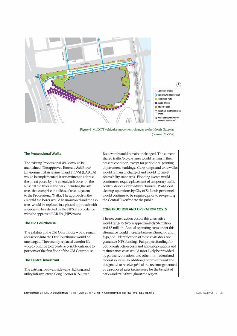
7/29/2019 Jefferson National Expansion Memorial
http://slidepdf.com/reader/full/jefferson-national-expansion-memorial 45/256
E N V I R O N M E N T A L A S S E S S M E N T / I M P L E M E N T I N G C I T Y A R C H R I V E R I N I T I A T I V E E L E M E N T S /ALTERNATIVES 2
The Processional Walks
The existing Processional Walks would bemaintained. The approved Emerald Ash BorerEnvironmental Assessment and FONSI (EAB EA)
would be implemented. It was written to addressthe threat posed by the emerald ash borer on theRosehill ash trees in the park, including the ashtrees that comprise the allées of trees adjacentto the Processional Walks. The approach of theemerald ash borer would be monitored and the ashtrees would be replaced in a phased approach witha species to be selected by the NPS in accordancewith the approved EAB EA (NPS 2011b).
The Old Courthouse
The exhibits at the Old Courthouse would remain
and access into the Old Courthouse would beunchanged. The recently replaced exterior liftwould continue to provide accessible entrance toportions of the first floor of the Old Courthouse.
The Central Riverfront
The existing roadway, sidewalks, lighting, andutility infrastructure along Leonor K. Sullivan
Boulevard would remain unchanged. The currentshared traffic/bicycle lanes would remain in theirpresent condition, except for periodic re-paintingof pavement markings. Curb ramps and crosswalkswould remain unchanged and would not meet
accessibility standards. Flooding events wouldcontinue to require placement of temporary trafficcontrol devices for roadway closures. Post-floodcleanup operations by City of St. Louis personnelwould continue to be required prior to re-openingthe Central Riverfront to the public.
CONSTRUCTION AND OPERATION COSTS
The net construction cost of this alternativewould range between approximately $6 millionand $8 million. Annual operating costs under thisalternative would increase between $100,000 and
$150,000. Identification of these costs does notguarantee NPS funding. Full project funding forboth construction costs and annual operations andmaintenance costs would most likely be providedby partners, donations and other non-federal andfederal sources. In addition, the project would bedesignated to receive 30% of the revenue generatedby a proposed sales tax increase for the benefit of parks and trails throughout the region.
Figure 6 MoDOT vehicular movement changes to the North Gateway
(Source: MVVA)

7/29/2019 Jefferson National Expansion Memorial
http://slidepdf.com/reader/full/jefferson-national-expansion-memorial 46/256
J E F F E R S O N N A T I O N A L E X P A N S I O N M E M O R I A L/ ALTERNATIVES28
ACTION ALTERNATIVES
ELEMENTS COMMON TO ALLACTION ALTERNATIVES
The action alternatives (alternatives 2 and
3) would: alter visitor accessibility bothto and within the park and the CentralRiverfront; create new and enhance existingprogramming opportunities; and changeplantings by implementing key unrealizedparts of Dan Kiley’s 1964 Final ConceptualPlanting Plan. Changes to the existinglandscape would maintain the integrity of the original design intent and the park’sdesignation as a National Historic Landmark.
PARKWIDE STRATEGIES
Security
In alternatives 2 and 3, a continuous securityperimeter would be established through theuse of vehicle ram barrier walls (cast-in-placeconcrete retaining structures integrated assite walls) and bollards, similar to the existingsecurity perimeter. The existing concreteplanter barriers along the east side of the parkwould be replaced by vehicle ram barrierwalls, designed with enough height andwidth to prevent pedestrian entry, exceptat designated walkways, which would havebollards. Bollards would also be located atthe bottom of the overlook stairs. Vehicularaccess to the park for authorized vehicleswould be provided at Luther Ely SmithSquare via retractable bollards near thepark entrances at the former intersectionsat Memorial Drive and Market Street andMemorial Drive and Chestnut Street. Thisaccess would be controlled and would beprimarily for park maintenance vehicles. Itwould also serve for loading during specialevents and would accommodate emergency
vehicle access. Day-to-day shipping andreceiving operations at the Arch wouldcontinue existing operations, utilizingthe existing delivery area at the GroundsMaintenance Facility. Where feasible, theexisting perimeter bollards would be retained.The visual impact of the security featureswould be minimized by integrating themwithin the landscape. Retaining walls woulddouble as vehicular ram barriers where
possible and bollards compatible with thehistoric landscape would be placed as needed.Coordination on the location access pointsthrough perimeter security, either via manualor hydraulic bollards, would occur with parkmaintenance and law enforcement.
The security concern near the ponds is theadjacency of the historic landscapes to theMemorial Drive/I-70 corridor. At the southpond, the existing line of security bollardswould be preserved. At the north pond, theconcurrent elimination of the MemorialDrive northbound lanes by MoDOT/City of St. Louis would allow for the retaining wallat the western edge of the park to serve as avehicle ram barrier wall until the depressedlanes return to surface grade, at which pointbollards would be used to continue the
security perimeter.
The primary security concern along theCentral Riverfront is the prevention of unauthorized vehicles from using the paths onthe East Slopes as a means to access the upperlevels of the park, while still accommodatingNPS maintenance vehicles. A concretevehicle ram barrier wall would run along thetoe of the East Slopes at Leonor K. SullivanBoulevard, with breaks at the Grand Staircase,the entrances to the accessible paths, andat the North and South Overlook stairs.Entrances to the East Slopes would have abollard system that meets vehicle protectioncriteria, and also provide a means to beremoved or lowered for maintenance needs.This wall and bollard system would replacethe existing concrete planters currentlyserving as vehicular barriers along the easternboundary to the park. The existing videosurveillance of the Central Riverfront wouldbe maintained and improved as needed by thePort Authority of the City of St. Louis. Otherbollards throughout the park (Service Rd.,
Poplar St., Old Cathedral, Washington Avenueand the Arch Parking Garage) would remainor be replaced in kind.
Security and access to the Old Courthousewould be supplemented with exteriorand street lighting, new traffic signals,and additional pedestrian and vehicularsignage. There would be no additionalvisitor screening. In the interior renovated
7/29/2019 Jefferson National Expansion Memorial
http://slidepdf.com/reader/full/jefferson-national-expansion-memorial 47/256
E N V I R O N M E N T A L A S S E S S M E N T / I M P L E M E N T I N G C I T Y A R C H R I V E R I N I T I A T I V E E L E M E N T S /ALTERNATIVES 2
exhibition space, mechanical, electrical, alarmand fire protection systems would be installed,upgraded, or replaced as needed.
Accessibility
In alternatives 2 and 3, site improvementsgenerally relate to accessibility for visitorswith mobility disabilities. Enhancements andchanges related to other disabilities would beaddressed during the detailed design processthrough Citizens Universal Design Group,which was established to address all types of accessibility holistically, including the park’sgrounds, buildings, and exhibits.
Pedestrian accessibility would be added via aselective re-grading of routes that do not meetaccessibility standards and the development of
a new, secondary network of paths that wouldbe compatible with and integrated into thehistoric landscape, including the landscapesaround the north and south reflecting ponds.All proposed pathways, sidewalks, curb cuts,ramps and roadway crossings would meet orexceed the requirements or guidelines of theAmericans with Disabilities Act, ArchitecturalBarriers Act, International Building Code,Public Rights of Way Accessibility Guidelines,Director’s Order 42 and NPS standards.Pathways would be graded so as not to exceedthe 5% slope and 2% maximum cross slope.New paths would provide access acrossformerly difficult slopes, opening theselandscapes up to all visitors. Mown lawn pathswould provide another level of circulationthroughout the pond landscapes. Theaccessible paths and routes for alternatives2 and 3 would vary based on the overallalternative concept, as described later for eachof the project areas.
Steep topographic change along Market Streetprevents a continuous accessible pathway
at the perimeter of Luther Ely Smith Squareand would require the use of a stair and aramp near the corner of Market and North4th Streets. However, visitors arriving at thesouth drop-off along Market Street wouldhave two additional points of access to thepark. Accessible pedestrian curb ramps andsignalized crossing areas would be providedat the public rights-of-way. Though the parkas a whole would be made accessible for all
visitors, at this time, a solution for making thetrams and operating deck at the top of the Archaccessible has not been identified.
Both alternatives would improve accessibilitybetween the park and the Central Riverfront,
ensuring universal access at multiple pointsalong the one and one-half mile stretch of riverfront. While the Grand Staircase wouldremain the most obvious route for much of thegeneral public, the accessible East Slope walkswould provide a secondary pathway that wouldbe used by many visitors. Benches and shadeplantings along their lengths would providevisitors with comfortable places to rest alongthe way. Depending on the location of theramps, visitors that need to access the site viaa ramp system would be able to move betweenthe Central Riverfront and the area at the top of
the Grand Staircase, and/or to the ProcessionalWalks near the top of the North and SouthOverlooks. Accessible pathways connectingthe Central Riverfront pedestrian sidewalksto the cobble levee would be included in bothalternatives.
Alternatives 2 and 3 would include new interiorand exterior ramps for the Visitor Center/Museum, supplementing the existing ramps atthe Arch legs entrances, whose slopes are notuniversally accessible. The ramps, handrail, andguardrail system would be designed to haveas minimal visual and structural impact to theexisting architecture and landscape as possible.The interior ramps would be placed on top of the east sections of the existing split-rampssystem. The ramps would lead from the VisitorCenter/Museum to a new level platform at thelocation of the existing security screening area.A passage would be created through existinginterior walls leading to doors opening ontothe exterior ramps. The exterior ramps wouldfollow the edge of existing pavement andterminate across from the Grand Staircase. A
guardrail system would be installed at gradealong the edges of the exterior ramps toprotect visitors from falling into the depressedramp. The guardrail would be designed tohave as minimal a visual impact as possible.These changes would be subject to additionaldesign review requirements and Section 106compliance to ensure impacts to the culturallandscape and National Historic Landmark areminimized.
7/29/2019 Jefferson National Expansion Memorial
http://slidepdf.com/reader/full/jefferson-national-expansion-memorial 48/256
J E F F E R S O N N A T I O N A L E X P A N S I O N M E M O R I A L/ ALTERNATIVES30
Alternatives 2 and 3 would provide newaccess to the first and second floors of theOld Courthouse. Two ramps would runalong the south façade of the building andbring visitors to the uppermost level of the steps. To mitigate visual impact on the
Courthouse exterior, these ramps would uselight-weight steel construction. Smaller rampsor connecting platforms would make up thedifference between the landing at the top of the Courthouse steps and the threshold to thefirst floor of the Old Courthouse. Within theOld Courthouse, access on the first floor ispresently limited by changes in the finish floorelevation. Ramps and low infill platformswould be used to connect adjacent floorareas. Additionally, two new elevators wouldbe installed to allow access to the second floorof the building. One would be located in the
north wing for visitor access to the secondfloor, and one in the south wing to provideaccess to the park’s administration office.These changes would be subject to additionaldesign review requirements and Section 106compliance to ensure impacts to the historicstructure are minimized.
Topography/Grading
Proposed topographic changes within theproject areas would be minimized by limitingre-grading to a few select areas, as driven byprogram and access requirements. At manylocations, including the Reflecting Ponds,the East Slopes, and the Central Riverfront,re-grading would be used primarily to enableaccess and reduce maintenance-relatedissues such as stormwater runoff, erosion andflooding at Leonor K. Sullivan Boulevard.
The most extensive re-grading would likelybe part of the proposed connection betweenthe Old Courthouse and Luther Ely SmithSquare to the west of the Memorial Drive/I-70
corridor and the park grounds to the east.Both alternatives 2 and 3 include the creationof park grounds situated on top of a structureover the depressed portion of I-70 betweenMarket and Chestnut streets. The proposedstructure would be constructed by MoDOTand NPS would landscape the structure. Itwould create continuous accessible west toeast routes and a connected landscape acrossthe Memorial Drive/I-70 corridor from Luther
Ely Smith Square across the park and to thebottom of the Grand Staircase.
Entering the park from the west, the existing
Processional Walks between the sidewalk atMemorial Drive and the existing entrancesto the Arch are separated by a steeply slopedberm. This creates conditions where slopesexceed what is required for pedestrianaccessibility compliance. The proposed actionwould re-grade the walks to both meet theproposed elevations at Luther Ely SmithSquare, as well as bring the grades withincompliance for pedestrian accessibility.
Implementing a well-integrated accessiblewest to east route across the park wouldrequire re-grading the existing bermrunning north-south along the westernedge of the park next to the MemorialDrive/I-70 corridor. This re-grading wouldbe implemented to improve drainage, provideaccessible pedestrian connections andaccommodate new program elements. Carewould be taken to minimize the visual impactof such topographic changes to the historiclandscape and protected viewsheds. Potentialberm changes for alternatives 2 and 3 wouldvary based on the overall alternative concept,
as described later for each of the project areas.These changes would be subject to additionaldesign review requirements and Section 106compliance to ensure impacts to the culturallandscape and National Historic Landmarkare minimized.
The elevation of Leonor K. Sullivan Boulevardwould be raised along the Central Riverfront,which would require the sidewalks adjacent
Sw help to manage stormwater
runoff as part of a vegetated,
open-channel management practice
designed specifically to treat and
attenuate stormwater runoff for
a specified water quality volume.As stormwater runoff flows
along these swales, or channels,
it is treated through vegetation
which slows the water to allow
sedimentation, filtering through a
subsoil matrix, and/or infiltration
into the underlying soils.

7/29/2019 Jefferson National Expansion Memorial
http://slidepdf.com/reader/full/jefferson-national-expansion-memorial 49/256
E N V I R O N M E N T A L A S S E S S M E N T / I M P L E M E N T I N G C I T Y A R C H R I V E R I N I T I A T I V E E L E M E N T S /ALTERNATIVES 3
to the park along the East Slopes, theoverlook stairs, and the Grand Staircase tobe raised as well. New grading would berequired between the East Slopes and thenew sidewalks adjacent to the raised heightof the roadway. To balance excavation and
fill requirements across the project, andreduce the need for hauling soils offsite andimporting additional soils, excavated soilfrom one project area may be used as fillin other project areas should it be deemedacceptable for use as fill material. A protocolfor fill material would be developed duringthe detailed design process to ensurere-used fill does not contain artifacts andis culturally sterile. Additionally, top soil of acceptable quality in impacted areas would bestockpiled and amended as needed for re-use.Soil amendment strategies would mitigate
existing deficiencies, and would reduce theneed for importation of expensive plantingsoils. The proposed new paths throughoutthe landscape would use subtle cut and fillto create the accessible path network. Soilamendments in these areas would reduce theneed to import additional planting soil.
Subtle grading around the ponds and newpaths would create swales to catch and detainstorm water runoff prior to infiltration.The new, gentle swale areas would haveoverflows directed to a discreet perimeterdrainage system at the back of the reflectingpond walls that would be connected to theexisting stormwater conveyance system.Shallow grass-lined swales along the uplandside of introduced pathways would furtherslow and redirect surface runoff and debrisfrom entering the reflecting ponds. Theimplementation of a conservation mowingregimen would also limit runoff whilemaintaining the original design intent of DanKiley’s 1964 Final Conceptual Planting Plan.New grading would be subtle and designed
to retain the overall character of the existingtopography.
Planting
Proposed plantings in alternatives 2 and 3 would support the goals of the CulturalLandscape Report (NPS 2010) regardingstrengthening of the plantings spatialorganization as intended per Dan Kiley’s
Final Conceptual Planting Plan (Office of Dan Kiley 1964). Proposed planting strategieswithin contributing areas follow the originaldesign intent and implement compatiblesustainable management practices. Withinnon-contributing areas, plantings would be
selected to be compatible with the historiclandscape, to enhance visitor experience, tocomplement existing features, and to facilitateprogrammatic requirements established inthe GMP. In these areas, plantings wouldbe designed to retain character-definingviewsheds. Existing trees would remain aspossible.
Planned planting typologies would include:
HIGH USE TURF: a grass mixture coupledwith appropriate soils and amendments to
prevent erosion and compaction. This wouldreduce the development of bald patcheswithin lawn surfaces. These plantings areintended to be used in areas where visitor useis expected to be moderate to heavy.
CONSERVATION MOWN AREAS: alow-maintenance grass mixture that requiresless mowing and irrigation than conventionallawn surfaces. This would reducemaintenance costs and surface runoff. Theseareas would retain the current monolithic,fine-textured, lawn character of the existingplantings. These plantings are intended to beused in areas where visitor use is expected tobe light to moderate.
New plantings of understory and canopy treesthroughout conservation mown areas wouldbe used to strengthen the historic integrityof the landscape’s spatial organization (i.e.,the open mown viewshed area would beframed by trees). Species selection would bedetermined based on a process evaluatingformal qualities as they relate to the original
design intent, as well as horticultural value forthe region.
WOODLAND PLANTINGS: areas of mixedvegetation, comprising the range of planttypes found in a hardwood forest, includingdeciduous canopy trees, smaller understorytrees and shrubs, and low groundcovers.These plantings are intended to be used inareas where visitor use is limited to pathways
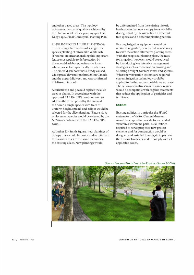
7/29/2019 Jefferson National Expansion Memorial
http://slidepdf.com/reader/full/jefferson-national-expansion-memorial 50/256
J E F F E R S O N N A T I O N A L E X P A N S I O N M E M O R I A L/ ALTERNATIVES32
and other paved areas. The typologyreferences the spatial qualities achieved bythe placement of denser plantings per DanKiley’s 1964 Final Conceptual Planting Plan.
SINGLE-SPECIES ALLÉE PLANTINGS:
The existing allée consists of a single treespecies planting of “Rosehill” White Ash(Fraxinus americana), making this importantfeature susceptible to deforestation bythe emerald ash borer, an invasive insectwhose larvae feed specifically on ash trees.The emerald ash borer has already causedwidespread devastation throughout Canadaand the upper Midwest, and was confirmedin Missouri in 2008.
Alternatives 2 and 3 would replace the alléetrees in phases. In accordance with the
approved EAB EA (NPS 2011b) written toaddress the threat posed by the emeraldash borer, a single species with trees of uniform height, spread, and caliper would beselected for the allée plantings (Figure 7). Areplacement species would be selected by theNPS in accordance with the EAB EA (NPS2011b).
At Luther Ely Smith Square, new plantings of canopy trees would be conceived to reinforcethe Saarinen vista in the same manner asthe existing allées. New plantings would
be differentiated from the existing historiclandscape in that new canopy trees would bedistinguished by the use of both a differenttree species and a different planting pattern.
Existing irrigation equipment would be
retained, upgraded, or replaced as necessaryto serve the action alternative planting areas.With the proposed planting plans, the needfor irrigation, however, would be reducedby introducing less intensive managementstrategies such as conservation mowing andselecting drought-tolerant mixes and species.Where new irrigation systems are required,current irrigation technology could beapplied to further reduce potable water usage.The action alternatives’ maintenance regimewould be compatible with organic treatmentsthat reduce the application of pesticides and
fertilizers.
Utilities
Existing utilities, in particular the HVACsystem for the Visitor Center/Museum,would be adapted to provide for expandedstructures within the park. New utilitiesrequired to serve proposed new projectelements and for construction would bedesigned and installed to mitigate impacts tothe historic landscape and to comply with allapplicable codes.
Figure 7 Proposed North Pond Allee Planting (Source: MVVA)

7/29/2019 Jefferson National Expansion Memorial
http://slidepdf.com/reader/full/jefferson-national-expansion-memorial 51/256
E N V I R O N M E N T A L A S S E S S M E N T / I M P L E M E N T I N G C I T Y A R C H R I V E R I N I T I A T I V E E L E M E N T S /ALTERNATIVES 3
PROJECT AREAS
East Slopes
As depicted in Figure 8, two to fouruniversally accessible paths discreetlyintegrated into the topography would leadvisitors from the top of the Grand Staircase
and the overlooks down to the CentralRiverfront. Benches along the paths wouldallow visitors to rest and enjoy long views of the river, and would be located to providetrainspotting opportunities as trains movethrough the railroad cuts and tunnels.
The combination of steep topography andoverhead clearance requirements for the rail
tunnels running across the site dictate theserpentine shapes of the proposed paths. Inorder to minimize their visual impact, thepaths would be set below grade within twolow retaining walls. Installation of the pathswould require fairly extensive regrading.
Grading across the site would be performedto balance cut and fill in order to limit theimport and export of fill where feasible.Utility connections would be necessary alongthe length of the paths in order to power thenew path lighting and drain stormwater. Thegeneral form of the existing slopes would beretained while accommodating the new pathsystems.
Figure 8 East Slopes (Source: MVVA)
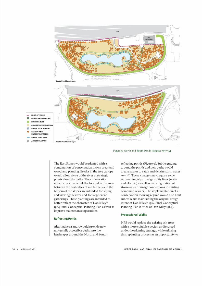
7/29/2019 Jefferson National Expansion Memorial
http://slidepdf.com/reader/full/jefferson-national-expansion-memorial 52/256
J E F F E R S O N N A T I O N A L E X P A N S I O N M E M O R I A L/ ALTERNATIVES34
The East Slopes would be planted with acombination of conservation mown areas andwoodland planting. Breaks in the tree canopywould allow views of the river at strategicpoints along the paths. The conservationmown areas that would be located in the areasbetween the east edges of rail tunnels and thebottom of the slopes are intended for sittingand viewing the river and for large event
gatherings. These plantings are intended tobetter reflect the character of Dan Kiley’s1964 Final Conceptual Planting Plan as well asimprove maintenance operations.
Reflecting Ponds
Alternatives 2 and 3 would provide newuniversally accessible paths into thelandscapes around the North and South
reflecting ponds (Figure 9). Subtle gradingaround the ponds and new paths wouldcreate swales to catch and detain storm waterrunoff. These changes may require someretrenching of path edge utility lines (waterand electric) as well as reconfiguration of stormwater drainage connections to existingcombined sewers. The implementation of aconservation mowing regime would also limit
runoff while maintaining the original designintent of Dan Kiley’s 1964 Final ConceptualPlanting Plan (Office of Dan Kiley 1964).
Processional Walks
NPS would replace the existing ash treeswith a more suitable species, as discussedunder the planting strategy, while utilizingthis replanting process as an opportunity to
Figure 9 North and South Ponds (Source: MVVA)

7/29/2019 Jefferson National Expansion Memorial
http://slidepdf.com/reader/full/jefferson-national-expansion-memorial 53/256
E N V I R O N M E N T A L A S S E S S M E N T / I M P L E M E N T I N G C I T Y A R C H R I V E R I N I T I A T I V E E L E M E N T S /ALTERNATIVES 3
repair and amend the conditions underneaththe walks. To accomplish this, NPS wouldincorporate new structural soil and repairor replace existing drainage and irrigationsystems. Alternatives 2 and 3 would allowfor the replacement in-kind of the exposed
aggregate concrete surface of the walksthroughout the Processional Walks andadjacent connections to the overlooks. Whereappropriate and if feasible, a cobble borderand tree pit treatment, similar to the Kileydesign, would be considered during thedesign process. These changes may requiresome retrenching of path edge utility lines(water and electric) as well as reconfigurationof stormwater runoff drainage connections toexisting combined sewers.
Old Courthouse
Alternatives 2 and 3 would renovate galleriesand install new exhibits within the firstand second floors of the Old Courthouse.Accessibility would be improved at boththe exterior and interior of the building, asdescribed under the accessibility strategy. Inthe interior spaces, mechanical, electrical, oralarm systems would be upgraded or replacedas necessary. The surrounding streetscapewould be improved to accommodateconcurrent, proposed changes to adjacentcity streets as well as improve accessibility atpedestrian crossings.
These improvements would include wideningsidewalks along Market and ChestnutStreets, as well as the installation of newcurb cuts. The sidewalks on the northside of Market Street and on the southside of Chestnut Street would be widenedto provide a stronger physical and visualconnection from Citygarden to the Archgrounds. Street trees would not be plantedaround the Old Courthouse in accordance
with the historic streetscape that has existedaround the perimeter of the building. Thesidewalk improvements would also includeaccessibility improvements to the Market andChestnut Street corridors.
Figure 10 Central Riverfront Project Area
(Source: MVVA)

7/29/2019 Jefferson National Expansion Memorial
http://slidepdf.com/reader/full/jefferson-national-expansion-memorial 54/256
J E F F E R S O N N A T I O N A L E X P A N S I O N M E M O R I A L/ ALTERNATIVES36
The sidewalk widening along Market Streetadjacent to the park would be possible with theremoval of an extra turn lane that exists betweenNorth Broadway and North 4th Street, where thesidewalk width would increase by approximately10’. The sidewalk modification to the north side
of Chestnut Street would be possible due to anexisting travel lane that is 15’ wide. The travel lanewould be reduced to a more typical 10’ width,allowing the sidewalk to increase in width by 5’to the north. Modifications of sidewalk widthsaround the Old Courthouse would be relativelyminimal, as the existing block is already widerthan other blocks along Market and ChestnutStreets. The proposed curb alignments wouldalign to the proposed limits at Kiener Plaza and atLuther Ely Smith Square.
The Central Riverfront
Alternatives 2 and 3 would transform the CentralRiverfront from Chouteau Avenue to BiddleStreet by raising the elevation of Leonor KSullivan Boulevard an average of 2.9 feet acrossthe project site, varying between one foot and 4.5feet, to reduce the frequency and impact of floodevents. Elevation changes to Leonor K. SullivanBoulevard would be subject to additional designreview requirements and Section 106 complianceto ensure the potential for adverse effectsunder Section 106 is and impacts to the park’s
NHL District, Eads Bridge, and other historicbuildings, structures, sites, objects, and districtsand cultural landscapes are minimized.
A new multi-modal roadway would beestablished, providing a critical link in the
regional system of bike trails, in this case betweenthe bike trails and areas north and south of theArch grounds. The proposed improvementswould convert the existing two-lane roadwaysection with periodic left turn lanes into anarrower two-lane roadway section with atwo-way bike path separated from the vehicletravel lanes and could include designated areasfor bus drop-off/pick-up lanes (Figures 10 and 11).
A new pedestrian promenade would be createdbetween the bike path and the historic cobblelevee and would feature new street trees, street
lighting, access to the historic cobble levee, anda central area for river viewing and programmedevents. Existing sidewalk paving along theeast side of the park would be replaced withexposed aggregate concrete to match existingpaving. Traffic calming measures include raisedpedestrian crossings at the base of the GrandStaircase and at the new crosswalk locations atthe base of the East Slope paths. Flush curbsand/or accessible curb ramps would be providedat all new crosswalks.
Figure 11 Central Riverfront Leonor K. Sullivan Concept Section (Source: MVVA)
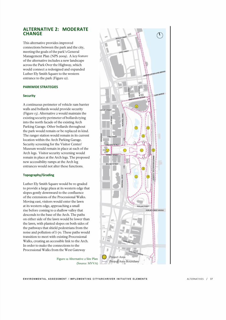
7/29/2019 Jefferson National Expansion Memorial
http://slidepdf.com/reader/full/jefferson-national-expansion-memorial 55/256
E N V I R O N M E N T A L A S S E S S M E N T / I M P L E M E N T I N G C I T Y A R C H R I V E R I N I T I A T I V E E L E M E N T S /ALTERNATIVES 3
ALTERNATIVE 2: MODERATECHANGE
This alternative provides improvedconnections between the park and the city,meeting the goals of the park’s General
Management Plan (NPS 2009). A key featureof the alternative includes a new landscapeacross the Park Over the Highway, whichwould connect a redesigned and expandedLuther Ely Smith Square to the westernentrance to the park (Figure 12).
PARKWIDE STRATEGIES
Security
A continuous perimeter of vehicle ram barrierwalls and bollards would provide security
(Figure 1 3). Alternative 2 would maintain theexisting security perimeter of bollards tyinginto the north facade of the existing ArchParking Garage. Other bollards throughoutthe park would remain or be replaced in kind.The ranger station would remain in its currentlocation within the Arch Parking Garage.Security screening for the Visitor Center/Museum would remain in place at each of theArch legs. Visitor security screening wouldremain in place at the Arch legs. The proposednew accessibility ramps at the Arch legentrances would not alter these functions.
Topography/Grading
Luther Ely Smith Square would be re-gradedto provide a large plaza at its western edge thatslopes gently downward to the confluenceof the extensions of the Processional Walks.Moving east, visitors would enter the lawnat its western edge, approaching a smallrise before coming to a shallow valley thatdescends to the base of the Arch. The pathson either side of the lawn would be lower than
the lawn, with planted slopes on both sides of the pathways that shield pedestrians from thenoise and pollution of I-70. These paths wouldtransition to meet with existing ProcessionalWalks, creating an accessible link to the Arch.In order to make the connections to theProcessional Walks from the West Gateway
Figure 12 Alternative 2 Site Plan
(Source: MVVA)
Project Area
Project Area Boundary

7/29/2019 Jefferson National Expansion Memorial
http://slidepdf.com/reader/full/jefferson-national-expansion-memorial 56/256
J E F F E R S O N N A T I O N A L E X P A N S I O N M E M O R I A L/ ALTERNATIVES38
accessible, portions of the walks would berebuilt at a lower elevation than currentlyexists. Roadway clearance requirements overthe interstate and structural requirementswould dictate the elevation of the surface of the Park Over the Highway structure to be
constructed by MoDOT. Any changes to theexisting berm and the lawn area underneaththe Arch would be subject to additionaldesign review requirements and Section 106compliance to ensure impacts to the culturallandscape and National Historic Landmark areminimized.
Slight re-grading of the northwest corner of the park (in the North Gateway) would occurin order to achieve an accessible connectioninto the park at the intersection of WashingtonAvenue and Memorial Drive. This would
require minimal modifications to the existingtopography and could likely be achievedwithout importing or exporting fill material.Due to the substantial removal of fill at theexisting West Gateway berm, it is expectedthat there would be a surplus of fill that wouldneed to be removed from the site. A protocolfor fill material would be developed duringthe detailed design process to ensure re-usedfill does not contain artifacts and is culturallysterile.
Accessibility
Under alternative 2, visitors with disabilitiesaccessing the park from the North Gatewaywould be directed to use existing elevatorfacilities within the Arch Parking Garage.Figure 13 shows which park paths andcirculation routes would be accessible underalternative 2.
Planting
Plantings lining the paths from Luther Ely
Smith Square and crossing over the depressedhighway would be comprised of shrubs thatwould not grow high enough to interferewith the Saarinen vista. Canopy trees wouldbe planted along the gentle berms at theexterior edges of the long lawn that would run
Figure 13 Alternative 2 Proposed Security and Accessible Routes (Source: MVVA)
Security PerimeterAccessible Paths
Inaccessible Paths
LEGEND:

7/29/2019 Jefferson National Expansion Memorial
http://slidepdf.com/reader/full/jefferson-national-expansion-memorial 57/256
E N V I R O N M E N T A L A S S E S S M E N T / I M P L E M E N T I N G C I T Y A R C H R I V E R I N I T I A T I V E E L E M E N T S /ALTERNATIVES 3
at a lower elevation over the Park Over theHighway and create a pair of densely plantedpassages. There would be limited opportunitiesfor planting at the North Gateway, with themajority of new plantings limited to thenorthwest intersection, planting at or on the
structure of the garage as feasible, and plantingof the streetscape adjacent to the garage.Proposed plantings for alternative 2 are shownin Figure 14.
Parking
The Arch Parking Garage would remain underalternative 2. Therefore, visitors and employeeswould be provided with a dedicated parkingfacility on park grounds for the remaininglifespan of the structure. Bus, RV, andoversize vehicle parking would continue to be
accommodated along South Leonor K. SullivanBoulevard/South Wharf Street south of thePoplar Street Bridge.
PROJECT AREAS
West Gateway
Alternative 2 proposes that the West Gatewayserve as a major point of arrival for visitors tothe park (Figure 15). It would provide outdoorspaces for group orientation and gathering andspaces for individual rest and relaxation. TheWest Gateway would act as both a conceptualand literal bridge between the park, the OldCourthouse and downtown St. Louis at anexpanded Luther Ely Smith Square from North4th Street to the existing western approachto the Arch. An agreement between MoDOTand the NPS would enable the creation of a structure built over the depressed sectionof I-70. While the structure itself wouldbe constructed, owned and maintained byMoDOT, the surface would be managed andmaintained by the NPS, in order to create a
continuous landscape connection - a ParkOver the Highway. Further description of thestructure over I-70 that would be constructedby MoDOT is located in the CumulativeImpacts section of this EA.
Some visitors would arrive at Luther Ely SmithSquare, with car and bus drop-offs flankingits north and south sides. Others would walkinto the park from the Arch Parking Garage
Figure 14 Alternative 2 Proposed Plantings
(Source: MVVA)
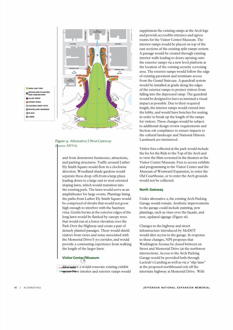
7/29/2019 Jefferson National Expansion Memorial
http://slidepdf.com/reader/full/jefferson-national-expansion-memorial 58/256
J E F F E R S O N N A T I O N A L E X P A N S I O N M E M O R I A L/ ALTERNATIVES40
and from downtown businesses, attractions,and parking structures. Traffic around LutherEly Smith Square would flow in a clockwisedirection. Woodland shade gardens wouldseparate these drop-offs from a large plazaleading down to a large east to west orientedsloping lawn, which would transition intothe existing park. The lawn would serve as anamphitheater for large events. Plantings liningthe paths from Luther Ely Smith Square wouldbe comprised of shrubs that would not growhigh enough to interfere with the Saarinenvista. Gentle berms at the exterior edges of thelong lawn would be flanked by canopy treesthat would run at a lower elevation over thePark Over the Highway and create a pair of
densely planted passages. These would shieldvisitors from views and noise associated withthe Memorial Drive/I-70 corridor, and wouldprovide a contrasting experience from walkingthe length of the larger lawn.
Visitor Center/Museum
Alternative 2 would renovate existing exhibitspace. New interior and exterior ramps would
supplement the existing ramps at the Arch legsand provide accessible entrance and egressroutes for the Visitor Center/Museum. Theinterior ramps would be placed on top of theeast sections of the existing split-ramps system.A passage would be created through existing
interior walls leading to doors opening ontothe exterior ramps via a new level platform atthe location of the existing security screeningarea. The exterior ramps would follow the edgeof existing pavement and terminate acrossfrom the Grand Staircase. A guardrail systemwould be installed at grade along the edgesof the exterior ramps to protect visitors fromfalling into the depressed ramp. The guardrailwould be designed to have as minimal a visualimpact as possible. Due to their requiredlength, the interior ramps would extend intothe lobby, and would have benches for seating,
in order to break up the length of the rampsfor visitors. These changes would be subjectto additional design review requirements andSection 106 compliance to ensure impacts tothe cultural landscape and National HistoricLandmark are minimized.
Visitor fees collected at the park would includethe fee for the Ride to the Top of the Arch andto view the films screened in the theaters at theVisitor Center/Museum. Fees to access exhibitsand programming in the Visitor Center and theMuseum of Westward Expansion, to enter theOld Courthouse, or to enter the Arch groundswould not be collected.
North Gateway
Under alternative 2, the existing Arch ParkingGarage would remain. Aesthetic improvementsto the garage could include painting, newplantings, such as vines over the façade, andnew, updated signage (Figure 16).
Changes to the highway and street
infrastructure introduced by MoDOTwould alter access to the garage. In responseto these changes, NPS proposes thatWashington Avenue be closed between 1stStreet and Memorial Drive (at the northwestintersection). Access to the Arch ParkingGarage would be provided both throughLaclede’s Landing as well as via a “slip-lane”at the proposed northbound exit off theinterstate highway at Memorial Drive. With
Figure 15 Alternative 2 West Gateway
(Source: MVVA)

7/29/2019 Jefferson National Expansion Memorial
http://slidepdf.com/reader/full/jefferson-national-expansion-memorial 59/256
E N V I R O N M E N T A L A S S E S S M E N T / I M P L E M E N T I N G C I T Y A R C H R I V E R I N I T I A T I V E E L E M E N T S /ALTERNATIVES 4
the Washington Avenue ramps and intersectioncompleted, the “slip-lane” would allow a singlelane of traffic to turn right onto the eastboundonly lane segment of Washington Avenuebetween Memorial Drive and North 1st Street,and proceed from there to the Arch Parking
Garage or to Leonor K Sullivan Boulevard. Anadditional pedestrian crossing at the vehicular“slip-lane” from I-70 onto WashingtonAvenue would be required to facilitatepedestrian access from the Washington Avenueintersection into the park. City access to theParking Garage would be from WashingtonAvenue, to North 3rd Street, to Laclede’sLanding Boulevard, to North 2nd Street andthen to the Arch Parking Garage (see theCumulative Impacts section of Chapter 4 formore details about the proposed changes to thestreet network). The graphic below is provided
for illustrative purposes to show the proposedchanges to the North Gateway and the locationof the slip-lane and street network changesproposed by MoDOT and the City of St. Louis.As design work continues during the detaileddesign process, changes could occur.
With the increased elevation of Leonor K.Sullivan Boulevard at the Central Riverfronta new sloped transition would be requiredfor the road and sidewalk surfaces from thewest edge of Leonor K. Sullivan roadway tothe existing surface of Washington Avenue
below the Railroad trestle, between the NorthOverlook wall and Eads Bridge.
CONSTRUCTION AND OPERATION COSTS
The net construction cost of this alternativewould range between approximately$75 million and $100 million. Annualoperating costs under this alternative wouldincrease between $800,000 and $1 million.Identification of these costs does not guaranteeNPS funding. Full project funding for bothconstruction costs and annual operations and
maintenance costs may not be available all atonce and would require a phased approach;it would most likely be provided by partners,donations and other non-federal and federalsources. In addition, the project would bedesignated to receive 30% of the revenuegenerated by a proposed sales tax increase forthe benefit of parks and trails throughout theregion.
Figure 16 Alternative 2 North Gateway
(Source: MVVA)

7/29/2019 Jefferson National Expansion Memorial
http://slidepdf.com/reader/full/jefferson-national-expansion-memorial 60/256
J E F F E R S O N N A T I O N A L E X P A N S I O N M E M O R I A L/ ALTERNATIVES42
ALTERNATIVE 3: MAXIMUMCHANGE
This alternative also provides extensiveimproved connections between the park andthe city, meeting the goals of the park’s General
Management Plan (NPS 2009). A key feature of this alternative would be a new entrance at theWest Gateway to the park that would lead to anexpanded underground Visitor Center/Museum.This entrance would connect to a redesignedand expanded Luther Ely Smith Square acrossthe landscaped Park Over the Highway structure,forming a new primary entrance to the park.Another substantial feature of this alternativewould be the removal of the existing ArchParking Garage after the implementation of analternative parking strategy, and its replacementwith a new landscape which would include an
Event space, Welcome Center, and Explorer’sGarden (Figure 17).
PARKWIDE STRATEGIES
Security
A continuous perimeter of ram barrier walls andbollards would provide site security (Figure 18).Facing Memorial Drive, Market Street, ChestnutStreet and North 4th Street, retaining wallsintegrated with the topography and plantings atthe outer edges of the Woodland Shade Gardenswould act as ram barrier walls and limit thepresence of bollards to only those points wherepaths connect the park to the surroundingstreets. Through much of the North Gateway,a shared pedestrian/bicycle path would beconstructed after removal of the Arch ParkingGarage. It would be lined on the south side witha retaining wall/ram barrier. At the east and westends of the path, this would transition to a lineof bollards which would complete the securityperimeter at the North Overlook wall and west tothe highway edge. A small new Welcome Center
with the potential to include restrooms wouldbe added in the North Gateway and park staff would greet and direct visitors to improve thesense of safety. This alternative would relocatethe existing ranger station to the maintenancefacility at the south end of the park.
Figure 17 Alternative 3 Site Plan (Source: MVVA)
Project Area
Project Area Boundary
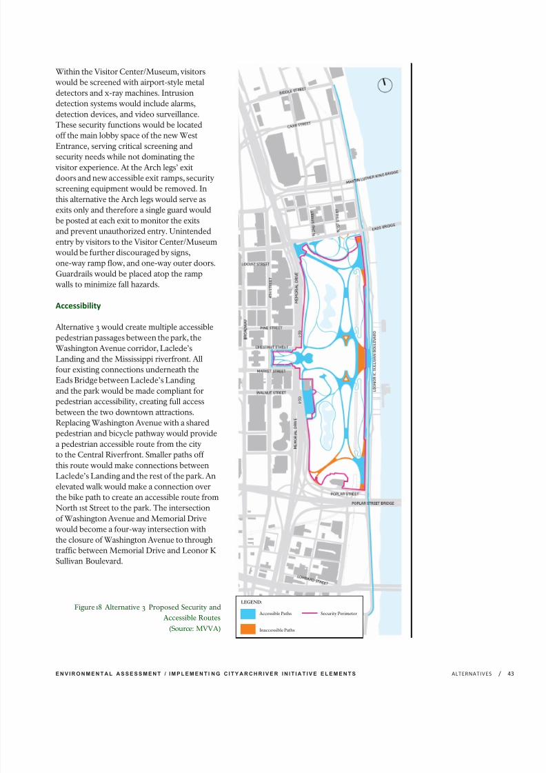
7/29/2019 Jefferson National Expansion Memorial
http://slidepdf.com/reader/full/jefferson-national-expansion-memorial 61/256
E N V I R O N M E N T A L A S S E S S M E N T / I M P L E M E N T I N G C I T Y A R C H R I V E R I N I T I A T I V E E L E M E N T S /ALTERNATIVES 4
Within the Visitor Center/Museum, visitorswould be screened with airport-style metaldetectors and x-ray machines. Intrusiondetection systems would include alarms,detection devices, and video surveillance.These security functions would be located
off the main lobby space of the new WestEntrance, serving critical screening andsecurity needs while not dominating thevisitor experience. At the Arch legs’ exitdoors and new accessible exit ramps, securityscreening equipment would be removed. Inthis alternative the Arch legs would serve asexits only and therefore a single guard wouldbe posted at each exit to monitor the exitsand prevent unauthorized entry. Unintendedentry by visitors to the Visitor Center/Museumwould be further discouraged by signs,one-way ramp flow, and one-way outer doors.
Guardrails would be placed atop the rampwalls to minimize fall hazards.
Accessibility
Alternative 3 would create multiple accessiblepedestrian passages between the park, theWashington Avenue corridor, Laclede’sLanding and the Mississippi riverfront. Allfour existing connections underneath theEads Bridge between Laclede’s Landingand the park would be made compliant forpedestrian accessibility, creating full accessbetween the two downtown attractions.Replacing Washington Avenue with a sharedpedestrian and bicycle pathway would providea pedestrian accessible route from the cityto the Central Riverfront. Smaller paths off this route would make connections betweenLaclede’s Landing and the rest of the park. Anelevated walk would make a connection overthe bike path to create an accessible route fromNorth 1st Street to the park. The intersectionof Washington Avenue and Memorial Drivewould become a four-way intersection with
the closure of Washington Avenue to throughtraffic between Memorial Drive and Leonor KSullivan Boulevard.
Figure 18 Alternative 3 Proposed Security and
Accessible Routes (Source: MVVA)
Security PerimeterAccessible Paths
Inaccessible Paths
LEGEND:

7/29/2019 Jefferson National Expansion Memorial
http://slidepdf.com/reader/full/jefferson-national-expansion-memorial 62/256
J E F F E R S O N N A T I O N A L E X P A N S I O N M E M O R I A L/ ALTERNATIVES44
The new West Entrance would provide anaccessible entrance and exit for visitors. Newinterior and exterior ramps in the areas of the Arch legs, described further in the VisitorCenter/Museum project area description,would provide additional accessible exits.
The plaza leading to the West Entrance wouldslope at an accessible grade of no more than5%. This would create a new arrival, visit,and departure sequence that would be fullyaccessible from the Old Courthouse throughthe West Gateway into the Visitor Center/Museum. Figure 18 depicts accessible parkpaths and circulation routes in alternative 3.
Topography/Grading
Creating a new entrance to the Visitor Center/Museum would require modification of the
topography of the berm that currently runs alongthe western edge of the park between the OldCathedral and Washington Avenue. Roadwayclearance requirements over the interstateand structural requirements would dictate theelevation of the surface of the Park Over theHighway structure. Accessibility requirementslimit the degree of slope that the plaza candescend to the West Entrance of the VisitorCenter/Museum to less than 5%. Additionalconstraints include programmatic, structural,mechanical and accessibility requirements
within the Visitor Center/Museum, whichwould require changes to the existing berm andthe lawn area underneath the Arch. In orderto make the connections to the ProcessionalWalks from the West Gateway compliant withaccessibility requirements, those portions of the
walks demolished for construction of the WestEntrance to the Visitor Center/Museum wouldbe rebuilt at a lower elevation than currentlyexists. The topographical changes would becoordinated with the proposed west entranceto the Visitor Center/Museum. These changeswould be subject to additional design reviewrequirements and Section 106 compliance toensure impacts to the cultural landscape andNational Historic Landmark are minimized.
Demolition of the existing Arch ParkingGarage would create a level surface of five
acres approximately 25 feet below the existingelevation of the Processional Walks. Fill wouldbe required to create a new landscape and pathtransitions between the park and the adjacentneighborhoods and amenities. The concretestructure of the existing garage could becrushed, re-used and/or recycled as appropriateto minimize the amount of fill needed. Thesetopographic changes would create new vistas forvisitors. From the park, eliminating the garagewould open up views to the Eads Bridge (Figure19). This would create a visual connection to
Figure 19 View of North Gateway and Eads Bridge (Source: MVVA)
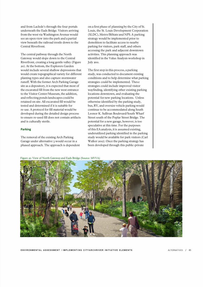
7/29/2019 Jefferson National Expansion Memorial
http://slidepdf.com/reader/full/jefferson-national-expansion-memorial 63/256
E N V I R O N M E N T A L A S S E S S M E N T / I M P L E M E N T I N G C I T Y A R C H R I V E R I N I T I A T I V E E L E M E N T S /ALTERNATIVES 4
and from Laclede’s through the four portalsunderneath the Eads Bridge. Visitors arrivingfrom the west via Washington Avenue wouldsee an open view into the park and a partialview beneath the railroad trestle down to theCentral Riverfront.
The central pathway through the NorthGateway would slope down to the CentralRiverfront, creating a long gentle valley (Figure20). At the bottom, the Explorers Gardenwould include several shallow depressions thatwould create topographical variety for differentplanting types and also capture stormwaterrunoff. With the former Arch Parking Garagesite as a depository, it is expected that most of the excavated fill from the new west entranceto the Visitor Center/Museum, the addition,and reflecting ponds landscapes could be
retained on site. All excavated fill would betested and determined if it is suitable forre-use. A protocol for fill material would bedeveloped during the detailed design processto ensure re-used fill does not contain artifactsand is culturally sterile.
Parking
The removal of the existing Arch ParkingGarage under alternative 3 would occur in aphased approach. The approach is dependent
on a first phase of planning by the City of St.Louis, the St. Louis Development Corporation(SLDC), Metro/BiState and NPS. A parkingstrategy would be implemented prior todemolition to facilitate access to nearbyparking for visitors, park staff, and others
accessing the park and adjacent downtownactivities. This planning approach wasidentified in the Value Analysis workshop in
July 2011.
The first step in this process, a parkingstudy, was conducted to document existingconditions and to help determine what parkingstrategies could be implemented. Thesestrategies could include improved visitorwayfinding, identifying other existing parkinglocations downtown, and evaluating thepotential for new parking locations. Unless
otherwise identified by the parking study,bus, RV, and oversize vehicle parking wouldcontinue to be accommodated along SouthLeonor K. Sullivan Boulevard/South Wharf Street south of the Poplar Street Bridge. Thepotential for a new garage, however, is toospeculative at this time. For the purposesof this EA analysis, it is assumed existing,underutilized parking identified in the parkingstudy would be available for park visitors (CarlWalker 2012). Once the parking strategy hasbeen developed through this public-private
Figure 20 View of North Gateway and Eads Bridge (Source: MVVA)
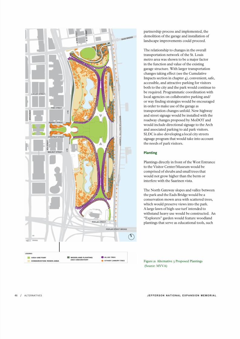
7/29/2019 Jefferson National Expansion Memorial
http://slidepdf.com/reader/full/jefferson-national-expansion-memorial 64/256
J E F F E R S O N N A T I O N A L E X P A N S I O N M E M O R I A L/ ALTERNATIVES46
partnership process and implemented, thedemolition of the garage and installation of landscape improvements could proceed.
The relationship to changes in the overalltransportation network of the St. Louis
metro area was shown to be a major factorin the function and value of the existinggarage structure. With larger transportationchanges taking effect (see the CumulativeImpacts section in chapter 4), convenient, safe,accessible, and attractive parking for visitorsboth to the city and the park would continue tobe required. Programmatic coordination withlocal agencies on collaborative parking and/or way finding strategies would be encouragedin order to make use of the garage astransportation changes unfold. New highwayand street signage would be installed with the
roadway changes proposed by MoDOT andwould include directional signage to the Archand associated parking to aid park visitors.SLDC is also developing a local city streetssignage program that would take into accountthe needs of park visitors.
Planting
Plantings directly in front of the West Entranceto the Visitor Center/Museum would becomprised of shrubs and small trees thatwould not grow higher than the berm orinterfere with the Saarinen vista.
The North Gateway slopes and valley betweenthe park and the Eads Bridge would be aconservation mown area with scattered trees,which would preserve views into the park.A large lawn of high-use turf intended towithstand heavy use would be constructed. An“Explorers” garden would feature woodlandplantings that serve as educational tools, such
Figure 21 Alternative 3 Proposed Plantings
(Source: MVVA)

7/29/2019 Jefferson National Expansion Memorial
http://slidepdf.com/reader/full/jefferson-national-expansion-memorial 65/256
E N V I R O N M E N T A L A S S E S S M E N T / I M P L E M E N T I N G C I T Y A R C H R I V E R I N I T I A T I V E E L E M E N T S /ALTERNATIVES 4
as illustrating the botanical aspects of Lewisand Clark’s journey. Plantings proposed foralternative 3 are shown in Figure 21.
PROJECT AREAS
West Gateway
Alternative 3 proposes that the West Gatewayserve as a major point of arrival for visitors tothe park (Figure 22). It would provide outdoorspaces for group orientation and gathering,and spaces for individual rest and relaxation.The West Gateway would expand Luther ElySmith Square from North 4th Street to thenew West Entrance and would act as both aconceptual and literal bridge between the parkgrounds, the Old Courthouse, and downtownSt. Louis. An agreement between MoDOT
and the NPS would enable the creation of astructure over the depressed section of I-70.While the structure itself would be constructedand maintained by MoDOT, the surface of thestructure would be available to and managedby the NPS to create a continuous physicalconnection - a Park Over the Highway. Furtherdescription of the structure over I-70 thatwould be constructed by MoDOT is located inthe Cumulative Impacts section of this EA.
Some visitors travelling to the park by caror bus would arrive at drop-offs along thenorth and south sides of Luther Ely SmithSquare. Others would walk into the parkfrom downtown businesses, attractions andparking structures, and would be greetedwith generous sidewalk gathering spaceswith long rows of benches shaded by trees.Entering from North 4th Street, visitors wouldfirst encounter a small plaza, introducing thehistoric Saarinen vista between the Arch andthe Old Courthouse. Paths flanking a centrallawn would lead visitors east to the plaza. Theplaza would serve both as a formal entrance
into the park and a visible connection to theproposed West Entrance to the Visitor Center/Museum. Visitors could also choose pathsleading north or south into the park.
The plaza area in front of the West Entranceto the Visitor Center/Museum would alsoprovide shade gardens and seating at its edgesto ensure it is a comfortable space for all. Itwould be sized to accommodate large groups
which could gather prior to entering the VisitorCenter/Museum.
Outside the viewshed of the Saarinen vista,along Chestnut and Market Streets, and theedges of the structure built over I-70, plantings
of canopy trees, shrubs and groundcoverwould be utilized to create densely plantedshade gardens. These would shield visitorsfrom vehicular noise and pollution, whileproviding comfortable spaces for relaxation.
Visitor Center/Museum
Under alternative 3, existing spaces in theVisitor Center/Museum beneath the GatewayArch would be selectively renovated andan additional 35,000-50,000 square feet of space, depending on design development,
is proposed, including visitor orientation,museum exhibit, and education space. Thenew addition would include a plaza andground-level entry to the Visitor Center/
Figure 22 Alternative 3 West Gateway (Source: MVVA)

7/29/2019 Jefferson National Expansion Memorial
http://slidepdf.com/reader/full/jefferson-national-expansion-memorial 66/256
J E F F E R S O N N A T I O N A L E X P A N S I O N M E M O R I A L/ ALTERNATIVES48
Museum complex beneath the Gateway Arch.The new West Entrance would be embeddedwithin the existing berm landform. A glassfaçade would frame a direct visual connectionto the Old Courthouse and this light-filledlobby would serve as the entrance to both
the exhibits and the Arch. It would also serveas the Visitor Center for the park. The newlobby at the entrance would be large enoughfor visitors to assemble and orient themselvesbefore moving into the Museum of WestwardExpansion’s exhibition spaces. An entrancefee for the Visitor Center/Museum, as wellas any other fees for visitor experiences suchas the Ride to the Top of the Arch, would becollected at ticket stations in the new lobby.A fee structure would be determined duringthe detailed design process. Free access to theArch grounds and the Old Courthouse would
continue.
New exhibits, casework, and lightingwould be provided throughout. Ticketing,restrooms, and security would be relocatedinto the new entry. Within the expansionand existing visitor center and museum area,alternative 3 would rearrange circulation,exhibit, administrative/support, and storespaces. The expansion in alternative 3would require new utility connections andadjustments to existing utilities such as water,steam, and telecommunication lines.
Alternative 3 would provide an accessibleegress route out of the Visitor Center/Museum near the Arch legs with new interiorand exterior ramps to supplement the existingramps at the Arch legs. The interior rampswould be placed on top of the east sectionsof the existing split-ramps system. A passagewould be created through existing interiorwalls leading to doors opening onto theexterior ramps via a new level platform at thelocation of the existing security screening
area.
The exterior ramps would follow the edge of existing pavement and terminate across fromthe Grand Staircase. A guardrail system wouldbe installed at grade along the edges of theexterior ramps to protect visitors from fallinginto the depressed ramp. The guardrail wouldbe designed to have as minimal a visual impactas possible. Due to their required length,
the interior ramps would extend into thelobby, and would have benches for seating, inorder to break up the length of the ramps forvisitors.
These changes would be subject to additional
design review requirements and Section 106compliance to ensure impacts to the culturallandscape and National Historic Landmarkare minimized.
The doors at the Arch legs ramps wouldno longer be entrances, and would bemodified to serve as exits only. As such, asingle guard would be posted at each exit tomonitor the exits and prevent unauthorizedentry. Unintended entry by visitors to theVisitor Center/Museum would be furtherdiscouraged by signs, one-way ramp flow, and
one-way outer doors. Guardrails would beplaced atop the ramp walls to minimize fallhazards.
North Gateway
Alternative 3 proposes to remove the existingArch Parking Garage and replace it with anew landscape that would take advantageof local adjacencies to the Laclede’sLanding neighborhood to the north andthe Washington Avenue/Convention Centercorridor to the west (Figure 23). WashingtonAvenue would be closed to through trafficand a drop-off area would be established. TheArch Parking Garage would be removed afterthe implementation of an alternative parkingstrategy. New programs in the North Gatewaywould include a large Orientation/EventLawn, a Welcome Center and a heritage-themed Explorers Garden for children.Additionally, a shared pedestrian/bicycle pathwould create an accessible link between thepark, the city, and the Central Riverfront.Should removal of the garage be delayed for
any period of time, the proposed increase inelevation of Leonor K. Sullivan Boulevardat the Central Riverfront may require a newsloped transition for the road and sidewalksurfaces from the west edge of Leonor K.Sullivan roadway to the existing surface of Washington Avenue below the Railroadtrestle between the North Overlook walland Eads Bridge. The removal of the ArchParking Garage would necessitate the

7/29/2019 Jefferson National Expansion Memorial
http://slidepdf.com/reader/full/jefferson-national-expansion-memorial 67/256
E N V I R O N M E N T A L A S S E S S M E N T / I M P L E M E N T I N G C I T Y A R C H R I V E R I N I T I A T I V E E L E M E N T S /ALTERNATIVES 4
resetting of underground electrical, watermains, and tie-ins to existing combined sewerinfrastructure.
CONSTRUCTION AND OPERATION COSTS
The net construction cost of this alternativewould range between approximately$180 million and $250 million. Annualoperating costs under this alternative wouldincrease between $2 million and $3 million.Identification of these costs does not guaranteeNPS funding. Full project funding for bothconstruction costs and annual operations andmaintenance costs may not be available all atonce and would require a phased approach;it would most likely be provided by partners,
donations and other non-federal and federalsources. In addition, the project would bedesignated to receive 30% of the revenuegenerated by a proposed sales tax increase forthe benefit of parks and trails throughout theregion.
Figure 23 Alternative 3 North Gateway (Source: MVVA)

7/29/2019 Jefferson National Expansion Memorial
http://slidepdf.com/reader/full/jefferson-national-expansion-memorial 68/256
J E F F E R S O N N A T I O N A L E X P A N S I O N M E M O R I A L/ ALTERNATIVES50
MITIGATION MEASURES
The NPS places a strong emphasis on avoiding,minimizing, and mitigating potentially adverseenvironmental impacts. Under any of theaction alternatives, best management practices
and mitigation measures would be used toprevent or minimize potential adverse effectsassociated with the project. These practicesand measures would be incorporated into theproject construction documents and plans.To help ensure the protection of culturalresources, natural resources, and the quality of the visitor experience, the following protectivemeasures would be implemented.
GENERAL CONSTRUCTION MITIGATION
MEASURES
The NPS would implement an appropriatelevel of monitoring throughout theconstruction process to help ensure thatprotective measures are being properlyimplemented and to achieve their intendedresults. The NPS would ensure theimplementation of the measures outlinedin the programmatic agreement (PA)to assess and resolve adverse effects tohistoric buildings, structures, sites, objects,districts and landscapes. The PA includesthe establishment of a Collaborative DesignReview Team to review draft schematic anddesign documents, evaluate how projects mayaffect resources within the Section 106 Area of Potential Effects, and make recommendationsto avoid any adverse effects. The PA isincluded in Appendix D of this environmentalassessment.
Construction and staging for constructionwould be coordinated with other ongoingconstruction efforts led by NPS and otherentities, as well as with seasonal constraintsand adjacent property owners as necessary.
Staging for selective excavation and materialdelivery would need to be coordinatedto keep visitor disruptions to a minimum.Construction would also be coordinated andtimed to minimize disruptions to visitors andaccessibility around the park.
Existing structures and newly completedconstruction would be protected from ongoingconstruction activity. Standard required
construction site fencing, temporary securitymeasures, and museum security would beprovided throughout duration of the workin the park. As the construction phases arecompleted, care would be taken to makeareas accessible to visitors where possible,
while ensuring that the new construction isadequately protected and maintained for thefinal use and occupancy.
Construction on the park site and the CentralRiverfront in all action alternatives wouldrequire the relocation of some utilities. Carewould be taken to comply with all permittingand approvals required and to minimizehorizontal movement, unnecessary disruption,and costs, and to avoid impacts to historicfeatures. The West Gateway’s new structureand landscape over the highway would require
utility reconfiguration, including an existingsteam pipe in the Market Street Bridge (to becoordinated with MoDOT), a water main,underground electrical lines, and possiblycable and telecom conduits. Coordinationwould occur with appropriate agencies andutility providers to maintain service duringconstruction and during the installation of any new connections. New utilities requiredto serve proposed project elements and forconstruction would be designed and installedto mitigate impacts to the historic landscapeand to comply with all applicable codes.
ARCHEOLOGY MITIGATION MEASURES
In accordance with the PA developed duringthe Section 106 process, prior to any grounddisturbing activities, all locations that may beimpacted by these activities would be testedand evaluated for potential to contributearcheological information. The NPS wouldconsult with the Missouri State HistoricPreservation Officer (SHPO) and the OsageNation regarding any necessary archeological
surveys to determine if any such archeologicalsites are present and whether such sites areeligible for the National Register. A protocolfor fill material would be developed duringthe detailed design process to ensure re-usedfill does not contain artifacts and is culturallysterile. Should unanticipated archeologicalresources be discovered during construction,all work in the immediate vicinity of thediscovery would stop immediately and the

7/29/2019 Jefferson National Expansion Memorial
http://slidepdf.com/reader/full/jefferson-national-expansion-memorial 69/256
E N V I R O N M E N T A L A S S E S S M E N T / I M P L E M E N T I N G C I T Y A R C H R I V E R I N I T I A T I V E E L E M E N T S /ALTERNATIVES 5
proper authorities would be notified. Workwould be halted until the resources could beidentified and documented and an appropriatemitigation strategy developed. Discoveredresources would be evaluated for theirpotential NRHP significance, and, if needed,
mitigation measures would be developedin consultation with the Missouri SHPOand appropriate representatives of affectedtribes. The NPS would conduct identificationand assessment of archeological resourcesconsistent with the measures described in thePA, which is included in Appendix D of thisEA.
In the unlikely event that human remains,funerary objects, sacred objects, or objectsof cultural patrimony are discovered duringconstruction, provisions outlined in the Native
American Graves Protection and RepatriationAct, as amended (43 CFR 10, Subpart B) andthe Archeological Resources Protection Act of 1979 (43 CFR 7) would be followed. AppendixD of the PA includes further stipulations thatwould be followed.
Mitigation measures would be cognizantof resource significance and preservationneeds, and could include such provisions aschanges in project design and/or archeologicalmonitoring of the project and data recoveryconducted by an archeologist meeting theSecretary of the Interior’s standards. NPSwould ensure that the measures outlined inthe PA are carried out to avoid, minimize, andmitigate adverse effects.
MITIGATION MEASURES BY PROJECT AREA
East Slopes
For concrete and grading work at the baseof the East Slopes, attempts would bemade to time construction so as to avoid
the usual seasonal high water conditionon the Mississippi River. Work would becoordinated with concurrent work throughoutthe park and with the work on the CentralRiverfront, specifically at the edges of theproject areas where the East Slopes meetthe allées at the head of the slopes and theNPS property boundary near the toes of theslopes. Construction activities would becoordinated to minimize interference with
current train or riverfront business operationswherever possible. Utility connections wouldbe necessary along the length of the paths inorder to power the new path lighting and drainstormwater. The path treatment and materialswould be compatible with the historic
landscape. Existing trees would be retainedwhen possible and would be protected duringconstruction to minimize disruptions tovegetation and soil.
Reflecting Ponds
Construction would need to be coordinatedwith MoDOT’s work at the formerMemorial Drive northbound area betweenChestnut Street and the Washington Avenueintersection. Work around the Walnut Streetarea would be coordinated with adjacent
property owners, including MoDOT and theArchdiocese of St. Louis. Work would also becoordinated with the design and constructionof the Processional Walks. The ReflectingPonds work may require some retrenching of path edge utility lines (water and electric) aswell as reconfiguration of stormwater drainageconnections to existing combined sewers.The path treatment and materials would becompatible with the historic landscape.
Processional Walks
During phased removal of the existing ashtrees, work would proceed on renovating thepavement of the walks, including associatedsoil amendments and irrigation improvements,to coordinate construction and limitdisruptions to the area. The ProcessionalWalks work may require some retrenching of path edge utility lines (water and electric) aswell as reconfiguration of stormwater runoff drainage connections to existing combinedsewers.
Visitor Center/Museum
Renovations to the lobby, Visitor Center, andexhibits would be staged so as to maintainvisitor flow and allow security screeningduring construction. The infill platform andinterior ramps needed to make the Arch legsan accessible entrance/exit would be designedso as to be constructed off-site and installedduring normal closing times. The exterior

7/29/2019 Jefferson National Expansion Memorial
http://slidepdf.com/reader/full/jefferson-national-expansion-memorial 70/256
J E F F E R S O N N A T I O N A L E X P A N S I O N M E M O R I A L/ ALTERNATIVES52
ramps would be constructed with minimalinterior disturbance, and then connectedthrough service spaces in off-peak season,when an Arch leg Visitor Center/Museumentrance might be able to be temporarilyclosed. With the construction of the new
pedestrian ramps at the Arch legs, substantialconsideration would be given to protectingthe Visitor Center/Museum’s material fabric,preserving the visual appearance of the Archleg entry, and respecting Kiley walkways. Theinterior ramps and steps would be constructedas light-weight infill platforms so that damageto the building is minimized should they needto be removed.
The accessible ramp routing would requirethe demolition of Visitor Center/Museuminterior walls, alterations to existing stairwells,
relocation of utilities, reconfiguration of administrative space, and a punch-throughof the Visitor Center/Museum exterior wall.These alterations would all take place outsidethe primary visitor area in adjacent servicespaces. The exterior ramps would requireretaining walls and guardrails to prevent falls.The existing edge of pavement would betapered into the ramp so as to minimize visualdiscontinuity.
Old Courthouse
Substantial consideration would be given toprotecting the Old Courthouse’s materialfabric, preserving its historic integrity, andrespecting the cultural landscape. Exteriorramps would be constructed so that damage tothe building would be minimized should theyneed to be removed. The existing pedestal,sundial, and fountain on the east side of theOld Courthouse and the statue of Dred andHarriet Scott on the southeast side of theOld Courthouse would be protected andpreserved. To mitigate visual impacts on the
Old Courthouse exterior, the accessible rampson the exterior of the building would uselight-weight steel construction. Existing soilsurrounding the building would be cleared,grubbed, and stockpiled to be replaced andreseeded with high use turf and augmentedwith additional planting soil as required.Construction work on the adjacent streets andsidewalks on Chestnut and Market Streetswould be coordinated with the city and would
be staged and implemented to comply with citypermit and construction requirements and tominimize impacts to visitor experience.
Accessibility improvements, exhibit spacerenovations, and detailed designs would be
sensitive to the historic fabric of the building.In the interior spaces, mechanical, electrical, oralarm systems would be upgraded or replacedas necessary. These interventions would besubject to Section 106 compliance and wouldbe accomplished according to the Secretary of the Interior’s Standards (NPS 1995).
The Central Riverfront
Construction would be coordinated andtimed to minimize disruptions to visitors andriverfront businesses. Existing structures
and newly completed construction would beprotected from ongoing construction activity.Standard required construction site fencing,temporary security measures, and temporarytraffic control devices would be providedthroughout the duration of work on theCentral Riverfront. Access to the riverfrontand levee by emergency vehicles would bemaintained at all times.
Raising the elevation of Leonor K. SullivanBoulevard would require the placementof fill at the bottom of the Grand Staircaseand the overlook steps, covering 4 or 5 of the Grand Staircase treads and 2 or 3 of theoverlooks treads. The existing stair treadsand foundations would be left intact and beburied. The stair treads would be covered withprotective barriers to prevent damage duringplacement and compaction of fill. The slopingbases of the overlook walls would also be leftintact and the surfaces would be protected byprotective barriers before burying to the depthof the new elevation. Modifications to stairhandrails would be in-kind with the existing
handrails.
Raising the elevation of Leonor K. SullivanBoulevard would require the placementof fill at the base of Eads Bridge. Effortswould need to be made to protect the EadsBridge, including documentation of existingconditions, protective barriers, seismicmonitoring and the monitoring of documentedexisting damaged and compromised elements
7/29/2019 Jefferson National Expansion Memorial
http://slidepdf.com/reader/full/jefferson-national-expansion-memorial 71/256
E N V I R O N M E N T A L A S S E S S M E N T / I M P L E M E N T I N G C I T Y A R C H R I V E R I N I T I A T I V E E L E M E N T S /ALTERNATIVES 5
during construction. Particular care would betaken along the base of the bridge. Protectivebarriers would be placed against all masonryfaces prior to placement and compactionof fill. The new elevation of the LeonorK. Sullivan roadway surface in the area of
the Eads Bridge would be such that limitedexposure of the existing red granite at the baseof the pier would be maintained.
Elevation changes to Leonor K. SullivanBoulevard would be subject to additionaldesign review requirements and Section 106compliance to ensure the potential for adverseeffects under Section 106 and impacts to thepark’s NHL District, Eads Bridge, and otherhistoric buildings, structures, sites, objects,and districts and cultural landscapes areminimized.
Construction of the bicycle and pedestrianpromenade improvements along the east sideof Leonor K. Sullivan Boulevard would requiresome disturbance to the cobblestones alongthe levee. Cobbles along the eastern edge of theproject would be salvaged and reset in order tomaintain the integrity of the cobble levee.
ALTERNATIVE 2 – CONSTRUCTION
MITIGATION
West Gateway
Construction would be coordinated withthat of the adjacent projects at the park andMoDOT work on the Memorial Drive/I-70corridor. Staging areas for constructionmaterials would be identified. Uponcompletion of MoDOT’s construction of thePark Over the Highway structure over I-70 andassociated retaining walls, NPS would haveaccess to the structure, and construction of theLuther Ely Smith Square new landscape andthe Park Over the Highway landscape could
commence. Changes to the West Gatewaywould be subject to additional design reviewrequirements and Section 106 compliance toensure impacts to the cultural landscape andNational Historic Landmark are minimized.
ALTERNATIVE 3 – CONSTRUCTION
MITIGATION
West Gateway
Construction would rely on extensive
coordination with the construction of theVisitor Center/Museum and the structureover the I-70/I-44 corridor that would beconstructed by MoDOT. Staging areas forconstruction materials would be identified.Upon completion, NPS would have accessto the Park Over the Highway structure andconstruction at Luther Ely Smith Square, thePark Over the Highway landscape, and theWest Entrance of the Visitor Center/Museumcould commence.
Restoration of the berm and walks would
require substantial completion of the WestEntrance of the Visitor Center/Museum,including interior elements requiring goodaccess to the Visitor Center/Museum interior.As construction is completed, constructionaccess would be limited to protect existing andnewly constructed facilities. The last piecesto be constructed would be the plaza and thelandscape across the Park Over the Highway, asthe needs for construction access and stagingwould be substantially reduced by this pointin construction. Changes to the West Gatewaywould be subject to additional design reviewrequirements and Section 106 compliance toensure impacts to the cultural landscape andNational Historic Landmark are minimized.
Visitor Center/Museum
The Visitor Center/Museum expansionin alternative 3 would require new utilityconnections and adjustments to existingutilities such as water, steam, and telecomlines. This work would be done per the generalconstruction mitigation practices described
above.
Staging for selective excavation and materialdelivery would need to be coordinated tokeep visitor disruptions to a minimum. Asthe construction phases are completed, care

7/29/2019 Jefferson National Expansion Memorial
http://slidepdf.com/reader/full/jefferson-national-expansion-memorial 72/256
J E F F E R S O N N A T I O N A L E X P A N S I O N M E M O R I A L/ ALTERNATIVES54
would be taken to make areas accessibleto visitors where possible, while ensuringthat the new construction is adequatelyprotected and maintained for the final use andoccupancy. Visitor security screening would beaccommodated during construction.
North Gateway
A parking strategy would be implementedprior to demolition of the Arch ParkingGarage to facilitate access to nearby parkingfor visitors, park staff, and others accessingthe park and adjacent downtown activities.Discovery of asbestos and lead paint duringdemolition of the Arch Parking Garageor other renovations are not anticipated;however, testing for asbestos and lead paintwould be performed prior to demolition.
Any other hazardous materials, such as thoseassociated with mechanical systems, would beremoved from the garage prior to demolition.
Garage demolition would occur in acontrolled manner as the parking garage isconstructed with concrete blocks that arereinforced with high-strength steel strandsthat are pulled tight to actively reinforce thebuilding (known as post-tensioning). Theexact demolition methods that would be usedwould be determined as part of a demolitionplan to ensure safe and efficient demolition.If possible, portions of the structure wouldbe salvaged for re-use and metal would berecycled.
Efforts would need to be made to protect theEads Bridge, including documentation of existing conditions, protective barriers, seismicmonitoring and the monitoring of documentedexisting damaged and compromised elementsduring construction. Particular care wouldbe taken along the base of the bridge wheremanipulation of grade may be required. Repair
of previously buried walls would also need tobe performed along the western face of theNorth Overlook as the proposed grade wouldbe lower than existing conditions, exposingpreviously buried portions of the overlook.
HOW ALTERNATIVES MEETOBJECTIVES
As stated in the “Purpose of and Need forAction” chapter, all action alternatives selectedfor analysis must meet all objectives to a large
degree. The action alternatives must alsoaddress the stated purpose of taking actionand resolve the need for action; therefore,the alternatives were individually assessedin light of how well they would meet theobjectives for this plan/EA, which are statedin the “Purpose of and Need for Action”chapter. Table 1 compares the alternatives bysummarizing the elements being considered.The section “How Alternatives Meet ProjectObjectives” discusses how the alternativesdescribed in this chapter would meet the planobjectives. Alternatives that did not meet the
objectives were not analyzed further (seethe “Alternatives or Alternative ElementsConsidered but Rejected” section in thischapter).
The “Environmental Consequences” chapterdescribes the effects of each alternative oneach impact topic, including the impact oncultural resources and visitor experience.These impacts are summarized in Table 2,“Summary of Environmental Consequences”.
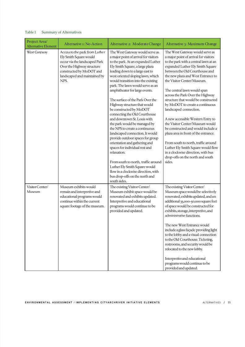
7/29/2019 Jefferson National Expansion Memorial
http://slidepdf.com/reader/full/jefferson-national-expansion-memorial 73/256
E N V I R O N M E N T A L A S S E S S M E N T / I M P L E M E N T I N G C I T Y A R C H R I V E R I N I T I A T I V E E L E M E N T S /ALTERNATIVES 5
Project Area/Alternative Element
Alternative 1: No-Action Alternative 2: Moderate Change Alternative 3: Maximum Change
West Gateway Access to the park from LutherEly Smith Square would
occur via the landscaped ParkOver the Highway structureconstructed by MoDOT andlandscaped and maintained byNPS.
The West Gateway would serve asa major point of arrival for visitors
to the park. At an expanded LutherEly Smith Square, a large plazaleading down to a large east towest oriented sloping lawn, whichwould transition into the existingpark. The lawn would serve as anamphitheater for large events.
The surface of the Park Over theHighway structure that wouldbe constructed by MoDOTconnecting the Old Courthouseand downtown St. Louis withthe park would be managed bythe NPS to create a continuouslandscaped connection. It wouldprovide outdoor spaces for grouporientation and gathering andspaces for individual rest andrelaxation.
From south to north, traffic aroundLuther Ely Smith Square wouldflow in a clockwise direction, withbus drop-offs on the north and
south sides.
The West Gateway would serve asa major point of arrival for visitors
to the park with a central lawn at anexpanded Luther Ely Smith Squarebetween the Old Courthouse andthe new plaza and West Entrance tothe Visitor Center/Museum.
The central lawn would spanacross the Park Over the Highwaystructure that would be constructedby MoDOT to create a continuouslandscaped connection.
A new accessible Western Entry tothe Visitor Center/Museum wouldbe constructed and would include aplaza area in front of the entrance.
From south to north, traffic aroundLuther Ely Smith Square would flowin a clockwise direction, with busdrop-offs on the north and southsides.
Visitor Center/Museum
Museum exhibits wouldremain and interpretive andeducational programs wouldcontinue within the currentsquare footage of the museum.
The existing Visitor Center/Museum exhibit space would berenovated and exhibits updated.Interpretive and educationalprograms would continue to beprovided and updated.
The existing Visitor Center/Museum space would be selectivelyrenovated, exhibits updated, and anadditional 35,000-50,000 square feetof space would be constructed forexhibits, storage, interpretive, andadministrative functions.
The new West Entrance wouldinclude a glass façade providing lightto the lobby and a visual connectionto the Old Courthouse. Ticketing,
restrooms, and security would berelocated to the new lobby.
Interpretive and educationalprograms would continue to beprovided and updated.
Table 1 Summary of Alternatives

7/29/2019 Jefferson National Expansion Memorial
http://slidepdf.com/reader/full/jefferson-national-expansion-memorial 74/256
J E F F E R S O N N A T I O N A L E X P A N S I O N M E M O R I A L/ ALTERNATIVES56
Project Area/Alternative Element
Alternative 1: No-Action Alternative 2: Moderate Change Alternative 3: Maximum Change
North Gateway The Arch Parking Garage,surrounding landscape, andranger station would remain.
Access to the Arch ParkingGarage would be providedvia a slip lane ontoWashington Avenue from thereconfigured I-70 ramp, fromLaclede’s Landing, and fromLeonor K. Sullivan Boulevard
The Arch Parking Garagewould remain and aestheticimprovements would be made tothe structure and landscape. The
ranger station would remain inthe Arch Parking Garage.
Access to the Arch ParkingGarage would be provided viaa slip lane onto WashingtonAvenue from the reconfiguredI-70 ramp, from Laclede’sLanding, and from Leonor K.Sullivan Boulevard.
After a parking strategy isimplemented, the Arch ParkingGarage would be demolished andreplaced with a new landscape
including an orientation/eventlawn, a welcome center, and achildren’s garden. WashingtonAvenue east of Memorial Drivewould be closed to throughtraffic, a shared pedestrian/bicycle path would be installed,and a drop-off area would beestablished.
The ranger station would bemoved to the maintenance facilityat the south end of the park.
East Slopes East Slopes would remain aspresently configured
Two to four universally accessible paths would be integrated intoEast Slopes leading from the park to the Central Riverfront. The EastSlopes would be planted with a combination of conservation mownareas and woodland planting. The conservation mown areas wouldbe used as places for visitors to sit.
Reflecting Ponds The plantings and turf around the ponds would beunchanged.
Universally accessible paths into the landscape around the North andSouth ponds, swales to catch stormwater runoff and a stormwatermanagement system would be installed.
Processional Walks The Processional Walkswould be maintained andimproved and the Rosehillash trees would be replacedin accordance with the EABEA.
The Rosehill ash trees would be replaced with another speciesin phases; the subsurface soil conditions, irrigation and drainagesystems would be repaired or replaced; and the aggregate concretesurface of the walks would be replaced. The ash tree replacementwould be guided by the EAB EA.
Old Courthouse Exhibits and access to theOld Courthouse wouldremain unchanged.
The galleries would be renovated and new exhibits would be installedon the first and second floors and the surrounding streetscape wouldbe improved.
Accessibility to the first floor of the Old Courthouse would beimproved by exterior ramps and to the second floor by interiorelevators
Central Riverfront The existing roadway,sidewalks, lighting, and utilityinfrastructure along Leonor
K. Sullivan Boulevard wouldremain unchanged.
The elevation of Leonor K. Sullivan Boulevard would be raised fromChouteau Avenue to Biddle Street. A multi-modal roadway wouldbe established providing a two-way bike path and a pedestrian
promenade along Leonor K. Sullivan Boulevard. The existingtwo-lane roadway would be narrowed and would include raisedpedestrian crossings at the base of the Grand Staircase and at thenew crosswalk locations at the base of the East Slope paths and couldinclude designated bus drop-off/pick-up lanes.

7/29/2019 Jefferson National Expansion Memorial
http://slidepdf.com/reader/full/jefferson-national-expansion-memorial 75/256
E N V I R O N M E N T A L A S S E S S M E N T / I M P L E M E N T I N G C I T Y A R C H R I V E R I N I T I A T I V E E L E M E N T S /ALTERNATIVES 5
Project Area/Alternative Element
Alternative 1: No-Action Alternative 2: Moderate Change Alternative 3: Maximum Change
Security Existing perimeter securityand visitor screening wouldbe maintained.
A continuous secure perimeterwould be established usingvehicle ram barrier walls andbollards. Remote operated
mechanical bollards wouldbe installed at the formerintersections Market andChestnut Streets with MemorialDrive, where emergency vehicleaccess would be provided.Entrances to the East Slopeswould have a bollard systemthat meets vehicle protectioncriteria, and also provide ameans to be removed or loweredfor maintenance needs. Otherbollards throughout the park(Service Rd, Poplar St, OldCathedral, Washington Avenueand the Arch Parking Garage)would remain or be replaced inkind.
Visitor security screening wouldremain in place at the Arch legs.
Same as alternative 2, except thatthe shared bicycle path wouldserve as the perimeter security inthe North Gateway.
Visitor screening would occur inthe main lobby of the new WestEntrance. The ramps at the Archlegs would serve as egress-onlyramps and a guard would beposted to monitor each exit andprevent unauthorized entry.
Accessibility Pedestrian routes that do notmeet accessibility standardswould remain from thepark grounds to the Central
Riverfront, and into theVisitor Center/Museum.Access between the parkand the city across the ParkOver the Highway would beaccessible.
Routes to and within the park wouldbe made accessible via selectivere-grading and the addition of a secondary network of paths,
including around the ponds andto the Central Riverfront from thepark. Access to the park across thePark Over the Highway would beaccessible.
Visitors with disabilities accessingthe Arch from the North Gatewaywould be directed to use existingelevator facilities in the Arch ParkingGarage in order to access the park.
At the Arch legs, lightweight, infill
ramps would be added on top of the existing ramps and exteriorramps would be added to provide anaccessible entrance and egress routeinto the Visitor Center/Museum.
Accessibility to and within the OldCourthouse would be improvedwith ramps on the exterior of thebuilding and elevators on the interiorof the building.
Same as alternative 2, exceptaccessible routes would beadded to the North Gateway. Theelevated walk would create an
accessible route from North 1stStreet to the park. An accessiblelink between the city, the park andthe Central Riverfront would beadded along Washington Avenuevia the pedestrian and bicyclepathway. The existing connectionsunderneath the Eads Bridge toLaclede’s Landing would beaccessible.
The new West Entrance to theVisitor Center/Museum would be
accessible.
The lightweight accessible rampsat the Arch legs described inalternative 2 would be egress-only

7/29/2019 Jefferson National Expansion Memorial
http://slidepdf.com/reader/full/jefferson-national-expansion-memorial 76/256
J E F F E R S O N N A T I O N A L E X P A N S I O N M E M O R I A L/ ALTERNATIVES58
Project Area/Alternative Element
Alternative 1: No-Action Alternative 2: Moderate Change Alternative 3: Maximum Change
Topography andGrading
No grading would occur andtopography would remainunchanged
Luther Ely Smith Square wouldbe re-graded to provide a largeplaza at its western edge thatslopes gently downward to the
confluence of the extensions of the Processional Walks, acrossthe Park Over the Highway overI-70 that would be constructedby MoDOT.
Any changes to the existingberm and the lawn areaunderneath the Arch wouldbe subject to additional designreview requirements and Section106 compliance.
Slight re-grading of thenorthwest corner of the park(in the North Gateway) wouldoccur to create an accessibleconnection into the park at theintersection of WashingtonAvenue and Memorial Drive.
The new entrance to the VisitorCenter/Museum would requiremodification of the topographyof the berm that currently runs
along the western edge of the parkbetween the Old Cathedral andWashington Avenue.
Any changes to the existing bermand the lawn area underneaththe Arch would be subjectto additional design reviewrequirements and Section 106compliance.
The Arch Parking Garage wouldbe demolished, creating a levelsurface below the existingelevation and would be filled tocreate a new landscape and pathtransitions between the park andthe adjacent neighborhoods andamenities.
The central pathway throughthe North Gateway would slopedown to the Central Riverfront,creating a long gentle valley. Atthe bottom, the Explorers Garden
would include several shallowdepressions.
Parking Parking for visitors and employees would be provided in theArch Parking Garage
The Arch Parking Garage wouldbe demolished and a parkingstrategy to facilitate access tonearby parking for visitors,park staff and others would beimplemented.

7/29/2019 Jefferson National Expansion Memorial
http://slidepdf.com/reader/full/jefferson-national-expansion-memorial 77/256
E N V I R O N M E N T A L A S S E S S M E N T / I M P L E M E N T I N G C I T Y A R C H R I V E R I N I T I A T I V E E L E M E N T S /ALTERNATIVES 5
Project Area/Alternative Element
Alternative 1: No-Action Alternative 2: Moderate Change Alternative 3: Maximum Change
Planting Plantings and turf wouldremain.
Proposed plantings would follow theoriginal design intent, be compatiblewith the historic landscape, andwould implement sustainable
management practices. Plantingtypologies would include high useturf, conservation mown areas,woodland plantings, and single-species allée plantings.
Plantings lining the paths fromLuther Ely Smith Square andcrossing over the depressed highwaywould be comprised of shrubs thatwould not grow high enough tointerfere with the Saarinen conceivedvista from the Old Courthouse tothe Arch. Canopy trees would beplanted along the gentle berms atthe exterior edges of the long lawnthat would run at a lower elevationover the Park Over the Highwayand create a pair of densely plantedpassages.
The majority of the plantings in theNorth Gateway would be limited tothe northwest intersection, plantingat or on the structure of the garage
as feasible, and planting of thestreetscape adjacent to the garage
Same as alternative 2, exceptplantings directly in front of theWest Entrance to the VisitorCenter/Museum would be
comprised of shrubs and smalltrees that would not grow higherthan the berm or interfere withthe Saarinen conceived vista fromthe Old Courthouse to the Arch.
The North Gateway, with theremoval of the Arch ParkingGarage, would includeconservation mown areas andhigh-use turf on the large lawn.

7/29/2019 Jefferson National Expansion Memorial
http://slidepdf.com/reader/full/jefferson-national-expansion-memorial 78/256
J E F F E R S O N N A T I O N A L E X P A N S I O N M E M O R I A L/ ALTERNATIVES60
HOW ALTERNATIVES MEET PROJECT
OBJECTIVES
As noted previously, the action alternativescarried forward for detailed analysis in this EAmust meet the project objectives described in
chapter 1. Both action alternatives (alternatives2 and 3) were evaluated against the objectivesas a way of assessing how well they satisfy thepurpose of the project and resolve the needfor action. These alternatives were developedfrom elements of the winning entry in thedesign competition called for by the park’srecently completed GMP. The park andits partners worked together to ensure thedesign competition itself and the subsequentrefinement of the winning design reflect thestatus of the Gateway Arch, and embrace theMississippi River. The interdisciplinary value
analysis processes generated recommendationsfor extensive improvements within andadjacent to the park while ensuringrequirements of the NPS Organic Act andManagement Policies 2006 are met. Throughsubstantial input from Section 106 consultingparties, character-defining elements of theNational Historic Landmark and NationalRegister Historic District are honoredand preserved to the extent possible, andunacceptable impacts to cultural resourceswithin and outside the park are avoided ormitigated. In some cases, some changes (e.g.,landscaping) would be more in line with theoriginal design intent for the park.
While alternative 3 would do a better job of providing opportunities to catalyze increasedvitality in the greater St. Louis metropolitanarea (by providing new and re-arranged spacein the underground Visitor Center/Museumand new park landscapes at the NorthGateway), both alternatives promote extendedvisitation in downtown by substantiallyincreasing connections between the city, the
park, and the river. Additional improvementswould enhance and expand visitorexperiences, and are expected to contributeto socioeconomic benefits, including:enhanced landscapes; enhanced accessibilityfor persons with disabilities; new and/orimproved museum exhibits, interpretation,and education opportunities; and the multi-modal roadway along the central riverfront.
Both alternatives improve accessibility forpersons with disabilities and create morewelcoming environments, including at the OldCourthouse. However, alternative 3 does abetter job by providing a new West Entranceto the Visitor Center/Museum and dedicated,
accessible egress from the Arch legs.
New exhibits and education opportunities,especially under alternative 3, give the NPS andits partners an avenue for improving visitorunderstanding of the purpose of the park.Reduced flooding along the Central Riverfrontprovides more opportunities for visitors touse this area and for partners to developprograms connected to the river and levee.A reduction in regular flood events along theCentral Riverfront would also help improveoperations in this project area. Within the
park, the proposed changes would improvepark management and operations and reducelong-term maintenance requirements byincorporating sustainable landscape practices;improving stormwater management; andimproving energy efficiency where possible.The NPS would also work with park partnersto minimize the impact of these projects onfinancial resources and staffing requirements.

7/29/2019 Jefferson National Expansion Memorial
http://slidepdf.com/reader/full/jefferson-national-expansion-memorial 79/256
E N V I R O N M E N T A L A S S E S S M E N T / I M P L E M E N T I N G C I T Y A R C H R I V E R I N I T I A T I V E E L E M E N T S /ALTERNATIVES 6
Impact Topic Alternative 1: No-ActionAlternative
Alternative 2: Moderate Change Alternative 3: Maximum Change
Historic Buildings,Structures, Sites,Objects, andDistricts
Parkwide and locally,construction-related impactsunder the no-action alternativewould result in short-term
minor adverse impacts tocharacter-defining featuresof the NHL District such asvegetation and topography.The addition of the Park Overthe Highway landscapingwould also have long-termminor adverse impacts to thesefeatures, but would also havelong-term beneficial impacts forexample on the setting of theNHL District.
Parkwide and locally, constructionwould result in short-term moderateadverse impacts to the NHL Districtdue to, for example, addition of
ramps at the Visitor Center/Museum,paths around the ponds and alongthe East Slopes, and the additionof the Park Over the Highwaylandscaping. Modifications foraccessibility would occur at the OldCourthouse.
This alternative would involve somealteration of historic buildings,structures, sites, objects, and districtsthrough the addition of accessibilityand security measures that alter thevisual character of the resourcesand their settings and parkwide andlocal long-term moderate adverseimpacts would occur. Negligible tominor short-term and long-termimpacts on resources within thecultural resources impact area wouldoccur along the riverfront, affectingthe NHL District and Eads Bridge.Beneficial impacts would result fromchanges such as the replacementof the ash trees and repair of the
Processional Walks.
Parkwide and locally, constructionwould result in short-term moderateadverse impacts to the NHL Districtdue to, for example, the addition
of the new West Entrance, rampsat the Visitor Center/Museum,paths around the ponds and alongthe East Slopes, and changes to thepark landscape along the CentralRiverfront. Modifications foraccessibility would occur at the OldCourthouse.
This alternative would involve somealteration of historic buildings,structures, sites, objects, anddistricts through changes addition of accessibility and security measuresthat alter the visual character of the resources and their settingsand parkwide and local long-term moderate adverse impactswould occur. Negligible to minorshort-term and long-term impactson resources within the culturalresources impact area would occuralong the riverfront, affecting theNHL District and Eads Bridge.Beneficial impacts would result from
changes such as the replacementof the ash trees, repair of theProcessional Walks and removal of the Arch Parking Garage.
Table 2 Summary of Environmental Consequences

7/29/2019 Jefferson National Expansion Memorial
http://slidepdf.com/reader/full/jefferson-national-expansion-memorial 80/256
J E F F E R S O N N A T I O N A L E X P A N S I O N M E M O R I A L/ ALTERNATIVES62
Impact Topic Alternative 1: No-ActionAlternative
Alternative 2: Moderate Change Alternative 3: Maximum Change
ArcheologicalResources
Ground-disturbing activitiesrelated to maintenance activitiesand the installation of the ParkOver the Highway landscape in
the no-action alternative coulddisturb as-yet unidentifiedarcheological resources;however, mitigation measureswould be implementedto minimize impacts andalternative 1 would result inminor adverse impacts toarcheological resources.
Parkwide and along the CentralRiverfront, ground disturbancesrelated to the project elementsincluding the Park Over the Highway
could disrupt or displace as-yetidentified archeological resources;however, mitigation measures wouldbe implemented and alternative 2would result in moderate adverseimpacts to archeological sites.
Parkwide and along the CentralRiverfront, ground disturbancesrelated to the project elementsincluding the Park Over the
Highway, the new West Entrance,and the Visitor Center/Museumaddition could disrupt or displaceas-yet identified archeologicalresources; however, mitigationmeasures would be implementedand alternative 3 would resultin moderate adverse impacts toarcheological sites.
MuseumCollections
Existing collections storageand exhibit spaces, access, andclimate control conditions
would remain and alternative 1would result in minor short-term adverse and long-termnegligible to minor Adverseimpacts to museum collections.
The temporary disruption in accessto museum collections duringconstruction under alternative 2
would result in short-term minoradverse impacts. The improvementsto collections storage, exhibit, andinterpretation spaces would havelong-term beneficial impacts tomuseum collections.
The temporary disruption in accessto museum collections duringconstruction under alternative 3
would result in short-term minoradverse impacts. The expansion of and improvements to collectionsstorage, exhibit, and interpretationspaces would have long-termbeneficial impacts to museumcollections.
Vegetation The no-action alternativewould result in minor short-term adverse impacts dueto temporary disturbancesduring implementation of theplanted landscape across the
Park Over the Highway. Therewould be negligible long-termimpacts to vegetation as regularmaintenance and existingconditions would continue.
Alternative 2 would result inmoderate short-term adverseimpacts due to temporarydisturbances of a relatively largeamount of vegetation duringconstruction. Minor long-term
adverse impacts to vegetation wouldoccur due to the permanent removalof a limited amount of vegetation.Long-term beneficial impacts wouldalso occur due to an increase invegetation health and diversity.
Alternative 3 would result inmoderate short-term adverseimpacts due to temporarydisturbances of a relatively largeamount of vegetation duringconstruction. Long-term beneficial
impacts would occur from asubstantial increase in the amount of vegetation as well as an increase invegetation health and diversity.
Soundscape The no-action alternative wouldresult in minor short-termadverse impacts to soundscapesfrom noise generated by theinstallation of the Park Overthe Highway landscape. The
continuation occasionaloperational noises abovebackground conditions wouldcause minor long-term adverseimpacts to soundscapes.
Alternative 2 would result inmoderate short-term adverseimpacts to soundscapes due tointermittent noise above backgroundconditions generated by constructionactivities to implement project
elements. The continuation of occasional operational noises abovebackground conditions would causeminor long-term adverse impactsto soundscapes. The potential forsound attenuation from landscapeadditions to the park would createlong-term beneficial impacts byreducing noise intruding on thepark’s soundscape.
Alternative 3 would result inmoderate short-term adverseimpacts due to intermittent noiseabove background conditionsgenerated by constructionactivities to implement project
elements. The continuation of occasional operational noises abovebackground conditions would causeminor long-term adverse impacts tosoundscapes. The potential soundfor attenuation from landscapeadditions to the park and theremoval of vehicular traffic noisesources in the North Gateway wouldcreate long-term beneficial impactsby reducing noise intruding on thepark’s soundscape.

7/29/2019 Jefferson National Expansion Memorial
http://slidepdf.com/reader/full/jefferson-national-expansion-memorial 81/256
E N V I R O N M E N T A L A S S E S S M E N T / I M P L E M E N T I N G C I T Y A R C H R I V E R I N I T I A T I V E E L E M E N T S /ALTERNATIVES 6
Impact Topic Alternative 1: No-ActionAlternative
Alternative 2: Moderate Change Alternative 3: Maximum Change
Floodplains There would be no disturbanceto floodplains and therefore noshort- or long-term impacts tofloodplains in alternative 1.
Construction-related activities underalternative 2 would not changefloodplain functions or valuesand no short-term impacts would
occur. The changes to the CentralRiverfront would not alter the natureof the development in the floodplainor its functions and values and wouldhave negligible long-term impacts tofloodplains.
Construction-related activities underalternative 3 would not changefloodplain functions or valuesand no short-term impacts would
occur. The changes to the CentralRiverfront would not alter the natureof the development in the floodplainor its functions and values and wouldhave negligible long-term impacts tofloodplains
Water Resources Construction-related impactsunder the no-action alternativewould result in short-termminor adverse impacts to waterresources due to an increasedpotential for soil erosion and
transport of surface pollutantsinto adjacent water bodies andstorm sewers. As the site wouldcontinue to operate undercurrent conditions, pollutants instormwater runoff would enterthe Mississippi River duringstorm events and long-termminor adverse impacts to waterresources and water qualitywould occur.
Alternative 2 would result in minorshort-term adverse impacts duringconstruction due to an increasedpotential for soil erosion andtransport of surface pollutants intoadjacent water bodies and storm
sewers. Minor long-term adverseimpacts would occur due to anincrease in water use for irrigationin the park and the continuedstormwater runoff that containspollutants entering the MississippiRiver during storm events. Beneficialimpacts would also occur as newmethods used to reduce and treatstormwater and a reduction inthe use of pesticides would beimplemented.
Alternative 3 would result inmoderate short-term adverseimpacts to water resources duringconstruction due to an increasedpotential for soil erosion andtransport of surface pollutants into
adjacent water bodies and stormsewers. Minor long-term adverseimpacts would occur due to anincrease in water use for irrigationin the park and the continuedstormwater runoff that containspollutants entering the MississippiRiver during storm events. Beneficialimpacts would also occur dueto new methods used to reduceand treat stormwater, increasedvegetation, and a reduction in the useof pesticides.
Visitor Use andExperience
Construction of the ParkOver the Highway landscapeunder the no-action alternativewould result in short-termnegligible to minor adverseimpacts as visitor access tothe West Gateway would belimited during construction.Long-term negligible to minoradverse impacts to visitor useand experience would occuras new destinations, activities,and improvements wouldnot be added to the park andflooding events would continueto limit access to the CentralRiverfront. The Park Over theHighway landscape would havelong-term beneficial impacts tovisitor use and experience dueto the improved landscapedpedestrian connection betweendowntown and the park.
Construction-related impacts underalternative 2 would result in short-term moderate adverse impactsto visitor access to activities anddestinations within areas of the parkthat could be limited or changed toaccommodate construction. In thelong term, there would be beneficialimpacts to visitor experience andsatisfaction due to the increasein destinations, activities, andaccessibility within the park andalong the Central Riverfront and theimproved landscaped pedestrianconnection between downtown andthe park. Minor adverse impacts tovisitor use and experience would alsooccur due to a continued shortageof oversize and short-term vehicleparking.
Construction-related impacts underalternative 3 would result in short-term moderate adverse impactsto visitor access to activities anddestinations within areas of the parkthat could be limited or changedto accommodate construction.Long-term minor adverse impactsto visitor use and experience wouldoccur due to the change in thedesigned visitor’s entry approach tothe Visitor Center/Museum and acontinued shortage of oversize andshort-term vehicle parking. In thelong term, there would be beneficialimpacts to visitor experience andsatisfaction due to the increase inopportunities, destinations, activities,and accessibility within the park andalong the Central Riverfront and thenew West Entry that would providea direct pedestrian connectionbetween downtown and the park.

7/29/2019 Jefferson National Expansion Memorial
http://slidepdf.com/reader/full/jefferson-national-expansion-memorial 82/256
J E F F E R S O N N A T I O N A L E X P A N S I O N M E M O R I A L/ ALTERNATIVES64
Impact Topic Alternative 1: No-ActionAlternative
Alternative 2: Moderate Change Alternative 3: Maximum Change
Socioeconomics Construction-related spendingimpacts from implementationof the Park Over the Highwaylandscape under the
no-action alternative wouldhave a short-term beneficialeconomic impact on thelocal economy as spendingcould generate revenue forindividual businesses in theregion. Long-term economicimpacts in downtown St.Louis and the region would benegligible as no other broadchanges in management,visitation, or operations wouldoccur and visitorship levelsand visitor spending in thelocal area would likely followexisting trends. There wouldbe continued minor short- andlong-term adverse impacts tosocioeconomic resources asthe livability benefits providedby the overall park would notbe enhanced and periodicflooding along the CentralRiverfront would continue. Thepark and the Central Riverfront
would continue to have a short-and long-term local beneficialeconomic impact on the regiondriven by visitor spending andoperational expenditures.
Construction-related spendingimpacts under 2 alternative wouldhave a short-term beneficialeconomic impact on the local
economy as spending wouldgenerate revenue for individualbusinesses in the region. Short-termminor adverse local impacts couldalso occur during construction if visitation declines while access toareas of the park is limited. Actionsunder alternative 2 would increasevisitorship levels as well as visitor andoperational spending by increasingand improving visitor facilities andinfrastructure throughout the parkand the Central Riverfront andconnecting the park with the city andthe river, which would have long-term beneficial economic impacts indowntown St. Louis and the regionand would enhance the overalllivability and social benefits the parkand the Central Riverfront provide.
Construction-related spendingimpacts under 3 alternative wouldhave a short-term beneficialeconomic impact on the local
economy as spending wouldgenerate revenue for individualbusinesses in the region. Short-termlocal minor to moderate adverseimpacts could also occur duringconstruction if visitation declineswhile access to areas of the park islimited. Removal of the Arch ParkingGarage would have long-term minoradverse impacts due to the loss of arevenue-generating facility. Actionsunder alternative 3 would increasevisitorship levels as well as visitor andoperational spending by increasingand improving visitor facilities andinfrastructure throughout the parkand the Central Riverfront andconnecting the park with the city andthe river, which would have long-term beneficial economic impacts indowntown St. Louis and the regionand would enhance the overalllivability and social benefits the parkand the Central Riverfront provide.
Operations andManagement
Operations impacts relatedto construction under theno-action alternative wouldinclude short-term minoradverse impacts as maintenanceoperations access to the ParkOver the Highway constructionareas would be limited.
Flooding events would causelong-term minor to moderateadverse impacts on operationsby limiting park maintenanceaccess and require clean-upaction by City of St. Louis staff.The lack of energy conservationand sustainable managementpractices would also contributeto the long-term adverseimpacts.
Operations impacts related toconstruction under alternative 2would include short-term minorto moderate adverse impacts dueto increased use of energy andresources and limited access to areasof the park during construction.An increase in maintenance
requirements would have a long-term minor adverse impact on parkoperations. Improved maintenanceconditions, improved sustainabilitystandards, and the potential for anoverall reduction in energy and wateruse at the park would have long-termbeneficial impacts
Operations impacts related toconstruction under alternative 3would include short-term moderateadverse impacts due to increaseduse of energy and resources andlimited access to areas of the parkduring construction. An increasein maintenance requirements
and the loss of parking revenuewould have a long-term minoradverse impact on park operations.Improved maintenance conditions,increased ticketing efficiency andrevenue collection, improvedenergy efficiency and sustainabilitystandards, and the potential for anoverall reduction in energy and wateruse at the park would have long-termbeneficial impacts.
7/29/2019 Jefferson National Expansion Memorial
http://slidepdf.com/reader/full/jefferson-national-expansion-memorial 83/256
E N V I R O N M E N T A L A S S E S S M E N T / I M P L E M E N T I N G C I T Y A R C H R I V E R I N I T I A T I V E E L E M E N T S /ALTERNATIVES 6
Westward Expansion. The design proposedto renovate the existing museum, and turnthe entrances at the legs of the Arch into exitsfor visitors. The proposed design includedapproximately 58,000 square feet of newmuseum space, and 72,000 square feet of
renovated existing gallery space.
In East St. Louis, the winning designproposed a green riverfront, the installation of wetland reserve, pedestrian and bicycle trails,and a water taxi between St. Louis and EastSt. Louis. At the North Gateway, the designproposed to replace the existing parking deckwith a new landscape park, which includedvarious programmed and passive recreationalspaces and a below-grade parking garage. Atthe South Gateway, the design proposed toremove the maintenance facility and add a
beer garden, and ice skating rink, and below-grade parking. An underground parkingstructure was also proposed below Luther ElySmith Square. Along the park’s east slopes, thedesign included partial re-grading and crashbarriers along Leonor K. Sullivan Boulevard.At the north and south service areas, rooftopterrace/structures were proposed. A structurewas also proposed near the Old Cathedral.
A substantial element of the winning designwas the proposed 1+ block landscapestructure over I-70, connecting Luther ElySmith Square (and by extension the largerGateway Mall) with a new west entrance tothe underground Visitor Center/Museum. Inthe design concept, a reconfigured MemorialDrive remained open to traffic in front of thenew Visitor Center and Museum entrance. AtLuther Ely Smith Square, tulip poplar-linedwalkways connected the Old Courthouse tothe new west entrance of the Visitor Centerand Museum.
Along the walks and allées within the park,
the design proposed to replace the existingash trees with a tulip poplar allée. Adjacentto the existing ponds within the park, theconstruction of new accessible walkwaysdown to the ponds was proposed. Theexisting lawn was replaced by a meadowand shrub woodland planting plan and newplantings were proposed throughout the park.
ALTERNATIVES OR ALTERNATIVE ELEMENTSCONSIDERED BUT NOTCARRIED FORWARD
Council of Environmental Quality (CEQ)
regulations for implementing NEPA requirefederal agencies explore and objectivelyevaluate all reasonable alternatives to thepreferred alternative, and to briefly discussthe rationale for eliminating any alternativesthat were not considered in detail. Thissection describes those alternatives oralternative elements that were identifiedduring the design process and internal andpublic scoping but were not carried forwardfor analysis in this EA. Justification foreliminating alternatives from further analysiswas based on factors relating to:
• Technical or economic feasibility;
• Conflicts with the statement of purposeand need, or other policies;
• Duplication with other, lessenvironmentally damaging or lessexpensive alternatives; and
• Severe impact on environmental orhistoric resources.
For the purposes of this process, the NPSconsidered but dismissed the original winningdesign competition entry from the MichaelVan Valkenburgh Associates team, as selectedby the jury during the CityArchRiver 2015competition, in September 2010. The conceptand rationale for its dismissal are describedbelow.
DESIGN COMPETITION ENTRY
Concept
The winning design competition entry, assubmitted by the MVVA team, proposednumerous changes to the park andsurrounding areas of downtown St. Louis, aswell as the riverfront in East St. Louis. Thewinning design called for a new west entrancewith skylights that led to an expandedunderground Visitor Center and Museum of

7/29/2019 Jefferson National Expansion Memorial
http://slidepdf.com/reader/full/jefferson-national-expansion-memorial 84/256
J E F F E R S O N N A T I O N A L E X P A N S I O N M E M O R I A L/ ALTERNATIVES66
Rationale
Many of the proposed concepts fromthe winning design competition entryevolved to become part of the actionalternatives previously described in this
chapter. Other elements were ultimatelydropped from consideration by the designteam, for a variety of reasons. Among thebiggest changes from the winning designcompetition entry to the revised designunveiled to the public in January 2011include:
• Changes to the structure over I-70 andthe closing of Memorial Drive;
• relocation of the beer garden to KienerPlaza and removal of the ice rink;
• addition of the aerial tram;
• the maintenance facility remaining in thesouth gateway;
• a smaller museum expansion;
• removal of the proposed undergroundparking garages at Luther Ely SmithSquare, the North Gateway, and theSouth Gateway;
• removal of skylights;
• changes to Cathedral Square; and
• the removal of the rooftop terrace/structure over the shipping and receivingentrance to the museum.
These changes to the winning designcompetition entry were facilitated bymeetings amongst the CityArchRiver 2015Foundation, the Technical Advisory Group
(TAG) convened by the CityArchRiver 2015Foundation, NPS, and the design team. Thesubsequent ongoing design discussions andthe Value Analysis workshops that occurredin the summer of 2011 all resulted in changesto the original winning design competitionentry. As a result, the team agreed that thewinning design competition alternativeshould be considered but dismissed.
Reasons for dismissal include:
• Incompatible elements not possibledue to NPS policy, such as removingthe recently constructed maintenancefacility on the south end of the park;
• proposed uses not consistent with thepark purpose and significance, such asbeer gardens and ice rinks;
• potential costs, such as the undergroundparking at Luther Ely Smith Square, orthe proposed square footage expansionof the underground museum;
• severity of impacts to cultural resources,in particular cultural landscapes andarcheological resources due to proposed
structures at the north and south serviceareas within the NHL, the visibilityof skylights at the west entrance, andsubstantial excavation for below-gradeparking structures; and
• not meeting the goals and objectives of the GMP, for instance, the continuedexistence of Memorial Drive in frontof the new western entrance to theunderground visitor center and museum,preventing improved connectivitybetween the park and the city.
The changes to the East St. Louis side of theMississippi River are still being consideredas part of the CityArchRiver 2015 Initiative;however, proposed actions in East St.Louis are not ready for a decision at thistime as project elements, funding, federalpermitting, and other issues are still beingdefined. Therefore, the project elements inEast St. Louis were not considered in thisEA.
OTHER CONCEPTS CONSIDERED
East Entry
During the Value Analysis process, theinterdisciplinary team considered theaddition of an east entrance to the VisitorCenter/Museum with an above-groundexpression to the east of the Arch, between

7/29/2019 Jefferson National Expansion Memorial
http://slidepdf.com/reader/full/jefferson-national-expansion-memorial 85/256
E N V I R O N M E N T A L A S S E S S M E N T / I M P L E M E N T I N G C I T Y A R C H R I V E R I N I T I A T I V E E L E M E N T S /ALTERNATIVES 6
the Arch legs and the Grand Staircase.This project element was dismissed due tosignificant impacts on the cultural landscapeand financial feasibility.
Old Courthouse Accessibility
In order to provide for accessibility into andaround the Old Courthouse, the installationof exterior masonry ramps and free standingelevators were considered. The impactsto cultural resources, in particular thehistoric fabric of the Old Courthouse, weretoo significant, and the alternative carriedforward in the EA would achieve the sameresults; therefore, these ideas were dismissed.
Arch Parking Garage
During a Value Analysis workshop, theinterdisciplinary team considered thepotential to renovate the Arch ParkingGarage with a landscape deck or demolish aportion of the garage. It was determined thatthese options had considerable technical,structural, and financial feasibility issuesand therefore were dismissed from furtheranalysis.
Central Riverfront
During a Value Analysis workshop severaladditional alternatives were considered bythe workshop group but were not carriedforward. One of these alternatives proposedraising the elevation of Leonor K. SullivanBoulevard approximately two feet onlybetween the North and South Overlookssteps. This alternative was dismissed as itonly provided additional pedestrian accessto the limited area between the steps andtherefore did not improve connectionsbetween the city, the park, and the riverfront.
Another alternative was consideredwhich would raise the roadway surfaceapproximately two feet from ChouteauAvenue to Biddle Street but also proposedthat the area in front of the Grand Staircasebe raised an additional two feet to provideadditional pedestrian and event protectionfrom flooding in the most highly used area.This alternative was dismissed because the
overall four-foot rise in front of the GrandStaircase was judged to be too significant anencroachment on this historic feature.
Another alternative considered during thedevelopment of the project concept was
complete refurbishment of the roadway, theaddition of a larger dedicated bike path, andan improved pedestrian promenade, butwithout elevating the roadway surface aboveexisting elevations. This alternative wasnot carried forward as it failed to improveCentral Riverfront operations by reducingflood-related closures and cleanup activities.
Another alternative considered wasraising the elevation of Leonor K. SullivanBoulevard to protect the road surfacefrom a 100-year base flood event. The
alternative was dismissed after a HydrologicEngineering Centers River Analysis Systemanalysis indicated that the Leonor K. Sullivanroadway would need to be elevated 14 feetto achieve protection from a 100-year floodevent. A 14-foot increase in elevation wouldbe unachievable from a constructabilitystandpoint, would have unacceptableimpacts to the park, and would increasethe 100-year base flood elevation of theMississippi River, which is prohibited underFederal Law.

7/29/2019 Jefferson National Expansion Memorial
http://slidepdf.com/reader/full/jefferson-national-expansion-memorial 86/256
J E F F E R S O N N A T I O N A L E X P A N S I O N M E M O R I A L/ ALTERNATIVES68
ENVIRONMENTALLY PREFERABLE ALTERNATIVE
The NPS is required to identify theenvironmentally preferred alternative inits NEPA documents for public review and
comment. The Department of Interiorregulations implementing NEPA state that theenvironmentally preferred alternative is thealternative “that causes the least damage to thebiological and physical environment and bestprotects, preserves, and enhances historic,cultural, and natural resources” (43 CFR Part46.30).
While the no-action alternative (alternative 1)would do little damage to the biological andphysical environment, alternatives 2 and 3would have limited adverse impacts on natural
resources, primarily from construction-relatedactivities. However, these alternatives wouldalso provide some long-term benefits tonatural resources, primarily by enhancingthe health of and expanding the amountof vegetation at the park, and improvingstormwater management practices.
Despite these benefits, implementation of either alternative 2 or 3 would cause adverseimpacts to integrity of cultural resources in andnear the park. While these impacts would beavoided, minimized, or mitigated to the extentpossible in accordance with the ProgrammaticAgreement developed under Section 106 of theNHPA, such impacts would not occur underalternative 1. As a result, the NPS has identifiedalternative 1 as the environmentally preferablealternative.
NPS PREFERRED ALTERNATIVE
To identify the preferred alternative, theplanning team held discussions based on theCEQ guidance for implementing NEPA, whichdefines the agency’s preferred alternative as
that alternative “which the agency believeswould fulfill its statutory mission andresponsibilities, giving consideration toeconomic, environmental, technical and otherfactors” (CEQ 1981). The deliberations on thepreferred alternative considered the missionof the NPS at Jefferson National ExpansionMemorial; how well each alternative meets thepurpose, need, and objectives of the EA andthe goals of the 2009 General ManagementPlan (from which this EA is tiered); the resultsof value analysis conducted during designdevelopment; and the results of the impact
analysis presented in the EA
The park has recommended alternative 3 as itspreferred alternative to the Regional Directorof the National Park Service’s Mid-WestRegional Office. The projects considered inalternative 3 were all developed from elementsof the winning entry in the design competitioncalled for by the park’s recently-completedGMP. The NPS refined these elementsthrough subsequent interdisciplinary valueanalysis processes and substantial input fromSection 106 consulting parties, and used therecommendations from those efforts as thebasis for alternative 3.
Although alternative 3 would cause someimpacts to the integrity of the designedlandscape and some historic structures, thisalternative best accomplishes the goals set outin the recently completed GMP to revitalizethe park by expanding visitor experienceand creating connections with downtown St.Louis and the riverfront. In light of potentialimpacts to cultural resources, the NPS has
worked with its Section 106 consulting partiesto develop a Programmatic Agreement thatoutlines measures to protect cultural resourcesand to the extent possible avoid, minimize,and mitigate impacts on the National RegisterHistoric District, the National HistoricLandmark, and other nearby NationalRegister-listed or eligible sites.
The alternative that best
protects, preserves, and
enhances historic, cultural,
and natural resources whilecausing the least damage
to the biological and
physical environment is the
“environmentally preferred
alternative.”

7/29/2019 Jefferson National Expansion Memorial
http://slidepdf.com/reader/full/jefferson-national-expansion-memorial 87/256
E N V I R O N M E N T A L A S S E S S M E N T / I M P L E M E N T I N G C I T Y A R C H R I V E R I N I T I A T I V E E L E M E N T S /ALTERNATIVES 6
Alternative 3 also best meets other objectivesdescribed in this EA by providing increasedconnections between the park, downtown,Laclede’s Landing, and the riverfront.Creating a new West Entrance to the parkwould provide benefits including a more
direct connection to downtown, a morewelcoming experience, and more efficiententry to the underground Visitor Center/Museum. Changes to the Old Courthouse, theunderground Visitor Center/Museum, andthe North Gateway would also provide moreaccess and opportunities for persons withdisabilities, opportunities to provide new andexpanded exhibits, and more opportunities toexperience the park’s stories and interpretivethemes.
Alternative 3 also minimizes the impacts
of flooding on the Central Riverfront,contributing to the overall socioeconomicbenefits of the projects by expandingopportunities for visitor access andprogramming in this area. Additional benefitswould also be realized through the use of moresustainable landscape and facility managementpractices which would improve the health of vegetation at the park, improve stormwatermanagement, and minimize the impact of theprojects on water and energy consumption andlong-term operation and maintenance needs.

7/29/2019 Jefferson National Expansion Memorial
http://slidepdf.com/reader/full/jefferson-national-expansion-memorial 88/256
THIS PAGE LEFT INTENTION ALLY BLANK

7/29/2019 Jefferson National Expansion Memorial
http://slidepdf.com/reader/full/jefferson-national-expansion-memorial 89/256
3. Affected EnvironmentJeerson Naonal Expansion Memor
Environmental Assessment for Implemenng CityArchRiver Iniave Elemen

7/29/2019 Jefferson National Expansion Memorial
http://slidepdf.com/reader/full/jefferson-national-expansion-memorial 90/256
THIS PAGE LEFT INTENTION ALLY BLANK

7/29/2019 Jefferson National Expansion Memorial
http://slidepdf.com/reader/full/jefferson-national-expansion-memorial 91/256
E N V I R O N M E N T A L A S S E S S M E N T / I M P L E M E N T I N G C I T Y A R C H R I V E R I N I T I A T I V E E L E M E N T S / AF FE CT ED EN VI RO NM EN T 7
INTRODUCTION
This chapter describes the existing environment
at Jefferson National Expansion Memorial and
along the Central Riverfront. The discussion
is focused on resources that could potentially
be affected by the implementation of any of
the alternatives and provides a baseline for the
subsequent evaluation of impacts documented
in Chapter 4.
The topics within this chapter are discussed in
the following order:
Cultural Resources
• Historic Buildings, Structures, Sites,
Objects, and Districts
• Cultural Landscapes
• Archeological Resources
• Museum Collections
Natural Resources
• Vegetation
• Soundscape
• Water Quality/Water Resources/
Stormwater Management
• Floodplains
Visitor Use and Experience
• Visitor Opportunities and Use
• Pedestrian and Bicycle Circulation
• Parking
•
Accessibility
Socioeconomics
Operations and Management
• Park Operations and Management
• Energy Requirements and Conservation/
Sustainability
• Central Riverfront Operations and
Management
Aected Environment
3
Several topics were initially considered for
evaluation, but were eliminated from detailed
study because impacts would be negligible
to minor. These topics are discussed in the
Issues Considered but Dismissed from Further
Analysis section in Chapter 1.
CULTURAL RESOURCES
This section documents the cultural resources
that are present at the park and within the
surrounding area, which include historic
buildings and structures; cultural landscapes;
archeological resources; and museum objects.
CULTURAL RESOURCES IMPACT AREAS
This EA is being prepared in parallel with
an ongoing Section 106 compliance process
for the CAR2015 projects, as required by the
NHPA of 1966. This EA will document impactsto cultural resources as a result of imple-
menting these projects on park properties and
along the Central Riverfront. A separate assess-
ment of effect under section 106 of the NHPA
will be made as appropriate. Figure 24 depicts
the Cultural Resources Impact Area for the EA
and the location of these cultural resources.
HISTORIC BUILDINGS, STRUCTURES,SITES, OBJECTS, AND DISTRICTS
There are multiple, overlapping National
Register of Historic Places and NationalHistoric Landmark (NHL) listed properties at
the Jefferson National Expansion Memorial.
The National Register of Historic Places
identifies five property types to categorize
listed and eligible properties, including
buildings, structures, sites, objects, and
districts. Properties are described in summary
below, organized by relationship to the park

7/29/2019 Jefferson National Expansion Memorial
http://slidepdf.com/reader/full/jefferson-national-expansion-memorial 92/256
J E F F E R S O N N A T I O N A L E X P A N S I O N M E M O R I A L/ AFFECTED ENVIRONMENT72
and the Central Riverfront project areas and
the cultural resources impact area. Each
property’s location is identified in Figure 24.
Listed historic properties are discussed in
greater detail in the GMP within Appendix C:
Detailed Descriptions of Historic Resources
within the APE. Some historic properties arelocated within the park; others are adjacent
to the park. Other historic properties, while
not in or adjacent to the park, are adjacent
to the Central Riverfront. Additional historic
properties fall within the project cultural
resources impact area but are not adjacent to
either the park or Central Riverfront.
Within the Park Grounds
There are historic properties that are listed in
the National Register of Historic Places and/or
the City of St. Louis Landmarks registry withinthe park boundary, including the Jefferson
National Expansion Memorial National
Register and NHL districts, the Gateway Arch,
and the Old Courthouse and its associated
sundial and fountain, described as follows.
Jefferson National Expansion Memorial
Jefferson National Expansion Memorial
was nominated to the National Register of
Historic Places in 1966 and accepted in 1977.
The nomination form identifies the property
as a historic district and includes the entire
park landscape, paying particular attention tothree historic features: the Gateway Arch, the
Old Courthouse, and the Old Cathedral. The
nomination lists the status of the property as a
“work in progress” (NPS 1966).
In 1987, the property was designated a NHL
district. The park was thought to be so
important and transcendent in its design
elements that the designation was made before
it reached 50 years old under the exception
in the National Register criteria that states, “a
property achieving national significance withinthe past 50 years [may be designated] if it is
of extraordinary national importance.” The
boundaries of the NHL are slightly different
from the previously designated National
Register historic district, and include only the
portion of the park east of Memorial Drive,
north of Poplar Street south of the Eads
Bridge (see Figure 24). The National Register
and NHL districts both encompass the park
landscape and several historic structures
including the Gateway Arch, Old Courthouse,
the Visitor Center and Museum of Westward
Expansion, the North and South Overlooks,Grand Staircase, and railroad tunnels. The
Arch, Old Courthouse, and Old Cathedral have
also been identified as individually eligible or
listed. The following are not listed separately
in the National Register, but are character-
defining for the designed landscape within the
Jefferson National Expansion Memorial NHL:
The Park Grounds
The Gateway Arch is sited within a distinctly
modern landscape. The product of a
collaboration between master architect EeroSaarinen and master landscape architect
Dan Kiley, the grounds design complements,
enhances, and carries out into the surrounding
landscape the graceful form and lines of the
Arch. The two men applied geometric forms
and classical landscape design elements to
create a setting that is both spectacularly and
subtly appropriate. The scale, impact, and
design of the grounds constitute an essential
mooring for the world-famous Gateway Arch.
The North and South Overlooks
The scenic overlooks were designed to
provide visitors with a vantage point from
which to view the Mississippi River. They
were originally intended to house museums
on the fur trade and the use of Mississippi
and Missouri rivers. The overlook stairs have
a unique form, in which the riser remains
constant while the tread increases in size as
The Jefferson National Expansion
Memorial is listed on t he National
Register of Historic Places and is
also designated a National Historic
Landmark due to its significance.
The park commemorates, through
a designed memorial, Thomas
Jefferson’s vision of building a
unified continental nation and
St. Louis’ role as a confluence and
gateway of the American westward
expansion during the 19th centur y.

7/29/2019 Jefferson National Expansion Memorial
http://slidepdf.com/reader/full/jefferson-national-expansion-memorial 93/256
E N V I R O N M E N T A L A S S E S S M E N T / I M P L E M E N T I N G C I T Y A R C H R I V E R I N I T I A T I V E E L E M E N T S / AF FE CT ED EN VI RO NM EN T 7
the steps descend to the Mississippi River.
This design element was also intended to be
used in the Grand Staircase, although it was
not realized there. Although the museums
on the overlooks were never completed, theoverlooks, constructed of concrete in a unique
form that employs both vertical and horizontal
catenary curve segments in both the walls
and the stairs, are major structural elements
of the Saarinen/Kiley designed landscape of
the park grounds, and thus contribute to the
significance of the NHL.
Grand Staircase
The Grand Staircase provides both a physical
and a visual connection between the Gateway
Arch and the Mississippi River. The staircaseis a symbolic representation of the movement
of settlers through St. Louis, the gateway to
the West. Although the relationship between
the treads and risers was modified in its final
design, it is representative of the Saarinen/
Kiley concept and is in its designed location.
It thus contributes to the significance of the
NHL.
Figure 24 Historic Architectural Resources within the
Cultural Resources Impact Area

7/29/2019 Jefferson National Expansion Memorial
http://slidepdf.com/reader/full/jefferson-national-expansion-memorial 94/256
J E F F E R S O N N A T I O N A L E X P A N S I O N M E M O R I A L/ AFFECTED ENVIRONMENT74
Railroad Tunnels
The north and south railroad cuts and three
tunnels were designed by Saarinen, and were
important components of his concept for the
site. Constructed between 1959 and 1962, the
entrances to the tunnels are curved to recallthe geometry of the Gateway Arch. The north
tunnel (548 feet long), the center tunnel (960
feet long), and the south tunnel (360 feet
long) carry the railroad through the site in
conjunction with the open north and south
cuts, which have poured concrete walls and
are 720 feet and 840 feet long, respectively.
The railroad tunnels and concrete floodwalls,
reflecting the Saarinen/Kiley design concept,
contribute to the significance of the NHL.
The Gateway Arch
The Gateway Arch, the centerpiece of
the park’s design, is listed separately from
the district as a NHL structure, as well as
contributing to the NHL district. It was
conceived by Eero Saarinen in 1947 as a
symbolic gateway to the West. Although the
placement of the Gateway Arch and the design
of the grounds evolved over the next several
decades, the original design of the Gateway
Arch endured with little change. An inverted,
weighted catenary curve (a type of curve
created by supporting both ends of a hanging
chain), the Gateway Arch soars 630 feet from
Figure 25 The Gateway Arch and Reecting Pond within the Park Grounds
its base on a constructed landform on the
bank of the Mississippi River. It is composed
of a series of stacked, triangular stainless steel
sections covered by a stressed steel skin. The
latter feature allows the exterior materials
to carry the structural load without major
interior framing. Inside the legs of the GatewayArch, a unique transportation system carries
visitors to an observation deck at the top of the
monument.
Entrance ramps at the base of the Gateway
Arch lead into the subterranean Visitor
Center and Museum of Westward Expansion.
Conceived by Saarinen and Kiley in 1959, the
placement of these triangular features beneath
the Gateway Arch, out of sight until one is
nearly upon them, reinforced the Saarinen/
Kiley concept of a unified landscape, in which
the curvilinear character of the Gateway Archis repeated throughout the design, such as in
the walkways and the landform. The museum
was designed by Aram Mardirosian and
completed in 1976.
The Gateway Arch is significant for its
commemoration of Thomas Jefferson’s role in
the nation’s westward expansion. In addition,
it is significant as a triumph of architecture
and engineering. It is an icon of Modernist
design, using the latest materials and sculptural
forms available in the late 1950s and early
1960s to develop a design that specifically

7/29/2019 Jefferson National Expansion Memorial
http://slidepdf.com/reader/full/jefferson-national-expansion-memorial 95/256
E N V I R O N M E N T A L A S S E S S M E N T / I M P L E M E N T I N G C I T Y A R C H R I V E R I N I T I A T I V E E L E M E N T S / AF FE CT ED EN VI RO NM EN T 7
which was built concurrently with the Old
Courthouse dome. The St. Louis project was
the first cast iron dome to be completed in
the U.S. The inside of the dome is decorated
with elaborate murals. The surrounding
reproduction sidewalks and fence have also
been identified by the National Park Service as
contributing to the interpretation of the Old
Courthouse.
The building is significant both for its
architectural and engineering merits, and also
as the site of important historic events. Early
in its history, the courthouse was a public
gathering space for people planning their travel
west. More notably, the structure was the site
of the historic Dred Scott case in which Scott,
a slave, sued for and was awarded his freedom.
Freedom was later taken away from the Scotts
by an appeal to the Missouri Supreme Court,
and the case was ultimately decided by the
U.S. Supreme Court in Dred Scott v. Sandford
in 1857. In the infamous decision of the court,
persons of color were denied citizenship.
Slavery in the Western territories was deemed
to be a property right that could not be
extinguished by legislation. In 1971, the Old
Courthouse was designated a City Landmark.
Associated features include two objects - the
Old Courthouse Sundial and Southeast
Courtyard Fountain.
responds to the site and fully integrates
architecture and landscape architecture. As
noted in the significance statement of the NHL
nomination, “Its structural system had never
been attempted before on so massive a scale.
Its highly complex and subtle design based on
a weighted catenary is unique in architecture.
The Arch is a symbolic architectural expression
of such simplicity and modernity that even
today . . . it still seems avant-garde.”
The Old Courthouse
The Old Courthouse stands within the
National Register district for the Jefferson
National Expansion Memorial as a contributing
building, as well as being individually eligible
for National Register listing. It was constructed
in several phases between 1839 and 1862. The
three-story Greek Revival brick and stone
building was constructed in the shape of a cross
with large classical porticoes (or porches) on
all four facades. A central rotunda is capped
by a Renaissance Revival cast iron dome and
lantern. The lightweight cast iron structure
of the dome was patented by the architect,
William Rumbold. It was one of the first uses of
this engineering technique in the United States.
The same materials were used, in conjunction
with a different patent, in the dome of the
U.S. Capitol Building in Washington, D.C.,
Figure 26 The Old Courthouse and Luther Ely Smith Square

7/29/2019 Jefferson National Expansion Memorial
http://slidepdf.com/reader/full/jefferson-national-expansion-memorial 96/256
J E F F E R S O N N A T I O N A L E X P A N S I O N M E M O R I A L/ AFFECTED ENVIRONMENT76
The Old Courthouse Sundial: Constructed of
bronze, copper, iron, and granite, the sundial
is the only surviving detached exterior feature
associated with the courthouse. The circular
bronze sundial face has Roman numerals and
is protected by a copper cover. The National
Park Service has determined that the object iseligible for listing in the National Register as
a contributing element to Jefferson National
Expansion Memorial National Register district
together with the Old Courthouse.
The Southeast Courtyard Fountain: Located in
the southeast courtyard of the Old Courthouse
grounds, this fountain is on the NPS List
of Classified Structures, and is considered
an historic structure. The National Park
Service has determined that the object is
eligible for listing in the National Register as a
contributing element to the Jefferson NationalExpansion Memorial National Register district
together with the Old Courthouse.
Adjacent to the Park
There are listed properties adjacent to
the park, including the Eads Bridge, Old
Cathedral, the Laclede’s Landing Historic
District, and the St. Louis Levee, summarized
as follows:
Eads Bridge
Eads Bridge, a National Historic Landmark,
borders the park to the north, connecting St.
Louis, Missouri and East St. Louis, Illinois
across the Mississippi River. Constructed
between 1867 and 1874 to accommodate rail,
pedestrian, and vehicular traffic, the bridge
employs a three-span deck arch design, with
ribbed steel arches and decks supported on
granite-faced limestone piers. At the time of its
construction, the spans were larger than any
previously constructed bridge. Significant for
its pioneering design, construction methods,and materials, the bridge was named a National
Historic Landmark in 1964, and a National
Historic Civil Engineering Landmark by the
American Society of Civil Engineers in 1971. It
was designated a City of St. Louis Landmark
that same year (NPS 1975a).
Old Cathedral
The Old Cathedral building is individually
eligible for the National Register. The parcel
occupied by the Old Cathedral was designated
for religious purposes when the city was
founded in the mid-18th century by PierreLaclede and Auguste Chouteau. A log house
and small church were built on the site in the
late 18th century. In 1826, St. Louis became
a Catholic diocese, and several years later
construction began on the current church.
Completed in 1834, the Greek Revival Style
structure was the first cathedral established
west of the Mississippi. In 1961, Pope John
XXIII named the building the “Basilica of
St. Louis, King of France,” the highest honor
bestowed upon an American Catholic church.
Laclede’s Landing Historic District
The Laclede’s Landing National Register
historic district is a nine-block area north of
the Memorial, bounded by the Mississippi
River to the east, Eads Bridge to the south,
3rd Street to the west, and the Dr. Martin
Luther King Memorial Bridge to the north.
The district is significant as the only surviving
portion of the city’s 19th-century commercial
waterfront. It preserves a large number of cast
iron commercial buildings, as well as the city’s
original 18th-century street grid and sloping
topography. Laclede’s Landing was listed
in the National Register in 1976. Within the
district, the Christian Peper Building at 719
North 1st Street is a City Landmark.
St. Louis Levee
The St. Louis levee is located between Carr
Street on the north and Lombard Street on the
south, and from the western edge of Leonor
K. Sullivan Boulevard on the west to the
Mississippi River on the east. The Missouri
SHPO has determined the levee to be eligiblefor inclusion on the National Register of
Historic Places under Criterion A in the area of
commerce. It also has strong associations with
transportation, and potentially ethnic heritage.
7/29/2019 Jefferson National Expansion Memorial
http://slidepdf.com/reader/full/jefferson-national-expansion-memorial 97/256
E N V I R O N M E N T A L A S S E S S M E N T / I M P L E M E N T I N G C I T Y A R C H R I V E R I N I T I A T I V E E L E M E N T S / AF FE CT ED EN VI RO NM EN T 7
The St. Louis levee is significant for its role in
supporting the commerce that transformed St.
Louis into the primary commercial emporium
of the American West. The levee has various
important social history associations and
was the point of departure for expeditions
of exploration, fur trade enterprises, andtroops headed to war with Mexico and later
the Southern Confederacy. The St. Louis
waterfront was inextricably bound up in
the larger story of the nation’s westward
expansion during the 19th century. The levee
was also a place with significant associations
with African-American heritage in terms of
both labor and cultural history. It was the
place where thousands of enslaved persons
were brought in chains to be herded up the
street to the auction houses and sold as strong,
“northern” slave stock to southern plantation
owners. Many free African Americans inSt. Louis were employed transporting and
storing goods for transfer to other vessels. The
historically paved portion of the St. Louis levee
retains sufficient integrity to be listed on the
National Register of Historic Places (NPS and
City of St. Louis 2012).
The International Fur Exchange Building
The International Fur Exchange Building,
located at 2-14 South 4th Street, is directly
southeast of the Old Courthouse. The period
of significance runs from 1920, when the
building was constructed, through 1948. The
building has national importance due to its
association with the primacy of the city in
the international fur trade. The commercial
structure is seven stories high and is clad
in multicolored brick with white terracotta
accents. It was listed in the National Register
in 1998.
Along the Central Riverfront
There are listed properties that are notadjacent to the park, but are located along
the Central Riverfront, such as the North
Riverfront Industrial Historic District and
the Ashley Street Power House, summarized
below.
North Riverfront Industrial Historic District
The North Riverfront Industrial Historic
District is located north of downtown St.
Louis adjacent to the Mississippi River, along
the Central Riverfront. The eight contributing
buildings are located on seven city blocksroughly bounded by Dickson, Lewis, O’Fallon,
2nd, Ashley, and Biddle Streets and the
Mississippi River. Heights range from one story
to six, with four large smokestacks on the roof
of the Ashley Street Power House towering
over the District. Most of the buildings are of
red brick, although two use brown brick as
their primary exterior material. The district is
listed on the National Register.
In a section of the city nearly wiped clean by
the tornado of 1896 but rich with connections
to rail lines and the Mississippi River, thissmall grouping is an important concentration
surviving in the midst of what was once a
larger linear industrial and commercial district.
Two specific industries, power generation
and cold storage, account for five of the eight
contributing buildings. All buildings and their
major additions were constructed between
1894 and 1919, most falling within the first
seven years of the 20th century (1900-1906).
The period of significance begins in 1894,
the construction date of the oldest building,
and ends in 1953, an arbitrary 50-year cutoff.
Although not every building is completely
intact, the district retains sufficient integrity
to convey the scale of the industrial and
commercial activities that thrived here in the
early 20th century (NPS 2002).
Ashley Street Power House
The Ashley Street Power House is located
in the North Riverfront Industrial Historic
District at the north edge of the Central
Riverfront, and is listed as a contributing
structure to that National Register listedhistoric district. The Power House is located
at the foot of Ashley Street on the Mississippi
River. Constructed in 1902 by engineer/
architect Charles Ledlic, it was the first large
electrical power plant to be erected by the
Union Electric Company. The classic exterior

7/29/2019 Jefferson National Expansion Memorial
http://slidepdf.com/reader/full/jefferson-national-expansion-memorial 98/256
J E F F E R S O N N A T I O N A L E X P A N S I O N M E M O R I A L/ AFFECTED ENVIRONMENT78
is organized by a series of terra cotta arches
supported on fluted, iconic pilasters which
read as two extra-tall stories high. The South
elevation may be considered the primary
elevation since it faces downtown St. Louis and
bears the original name (Union Electric Light
& Power Co.) in terra cotta across and belowtwo pediments. Above the arches is a dentil
course. The top story of large windows is
topped by a dentil cornice with two projecting
shallow pediments. Four large smokestacks
and a set of multi-story metal additions are
located on the building’s roof (NPS 2002).
The St. Louis riverfront has a storied history as
the focus of industrial and commercial activity.
Ashley Street Power House conveys the
character of an early 20th century industrial
center. This richly detailed building in close
proximity to rail and river offers a rare insightinto the way industry worked at the dawn of
the 20th century. The building became a City
Landmark in 1971.
MacArthur Bridge
The MacArthur Bridge is part of a 6.2 mile long
elevated track which crosses the Mississippi
River, connecting St. Louis with Illinois.
Construction of the bridge began in 1907, but
was not completed until 1917. The MacArthur
Bridge and elevated track is the second-longest
elevated steel structure across the Mississippi
River. Originally constructed with a road deck
over the rail deck, the bridge is currently used
only for railroad traffic (TRRA 2012 and St.
Louis Post Dispatch 2009).
Within the Study Area
The following historic properties fall within the
project cultural resources impact area but are
not directly adjacent to the park or the Central
Riverfront: the J. Kennard and Sons Carpet
Company Building, the Missouri Athletic ClubAssociation Building, the Security Building, the
Laclede Building, the Peabody Coal Company
National Headquarters, the Mississippi Valley
Trust Company Building, the American Zinc,
Lead and Smelting Company Building, Pet
Plaza, St. Mary of Victories Church, and the
Crunden-Martin Manufacturing Company
District. These properties are described in the
2009 General Management Plan Appendix C.
The Wainwright Building is also located
within the study area, but is not described in
Appendix C. The Wainwright Building, listed
in the National Register of Historic Places,
is a ten-story office building constructed
between 1890 and 1891. Dankmar Adler and
Louis Sullivan designed the building, whichwas their first commission involving the use
of completely iron and steel framing. The
resulting design represents Sullivan’s most
thorough attempt to create a special form
appropriate to the multi-story office block
(NPS 1975b).
CULTURAL LANDSCAPES
A cultural landscape is defined as “a
geographic area, including both cultural and
natural resources … therein, associated with
a historic event, activity, or person, or thatexhibit other cultural or aesthetic values” (NPS
1998).
Background
The Jefferson National Expansion Memorial
was acknowledged initially as a National
Register property in 1977 for the significance of
its outstanding architecture and engineering,
and for its memorialization of the nation’s
westward expansion. The park was designated
a National Historic Landmark in 1987.
The landscape was recognized in early
documentation as a vital part of the designed
resource, but a detailed documentation of its
significance for landscape design was lacking
for many years. To rectify this gap in the history
of the Arch and its grounds, the National
Park Service undertook a Cultural Landscape
Report (CLR), published in 1996 (NPS 1996).
The CLR provided a detailed history of the
designed landscape and its character-defining
features, an inventory and condition assessment
of existing landscape features, and an updated
significance of the park to include the designedlandscape (NPS 1996). The CLR was updated
in 2010 (NPS 2010). The revised CLR reflects
current conditions at the park, further develops
and expands the significance statement relating
to the grounds as an important example of
Modernism, and provides detailed treatment
recommendations in coordination with the 2009
General Management Plan (NPS 2010). The
2010 CLR also provides the basis for this section
of the report.

7/29/2019 Jefferson National Expansion Memorial
http://slidepdf.com/reader/full/jefferson-national-expansion-memorial 99/256
E N V I R O N M E N T A L A S S E S S M E N T / I M P L E M E N T I N G C I T Y A R C H R I V E R I N I T I A T I V E E L E M E N T S / AF FE CT ED EN VI RO NM EN T 7
Significance
The period of significance identified in the
2010 CLR for the park landscape is 1947-2003,
beginning the year the United States Territorial
Expansion Commission sponsored a national
design competition, marking the inceptionof the Memorial idea (NPS 2010), and ending
with the completion of the central section of
the Grand Staircase.
According to National Register Criteria for
Evaluation, properties which are less than
50 years old may be listed on the National
Register of Historic Places if they are of
“exceptional importance.” The Gateway Arch
is recognized as significant because it has
architectural and engineering design value
which will endure the “test of time.” The
merits of the design to the architecture andlandscape architecture design professions are
eternal and could be recognized before the
customary 50-year “test of time.”
The Jefferson National Expansion Memorial
is listed on the National Register and is also
designated a NHL due to its exceptional
significance. The Arch and surrounding
designed landscape have national significance
under National Register Criterion A for the
commemoration of Thomas Jefferson and
others responsible for the nation’s expansion
to the West. The Arch and grounds mark the
symbolic economic hub and embarkation
point of westward expansion. In addition,
and perhaps most importantly, the park is
significant under National Register Criterion C
for its architectural and engineering merit, and
as the collaboration of a master architect and
landscape architect.
An exploration into Saarinen and Kiley’s
design philosophies, their design intent for
the park, and their working relationship is
undertaken in the CLR (NPS 2010). The twomen not only created a unique monument to a
historic American event, but also collaborated
on many other important projects. Their
winning design for the Arch and grounds in
1947-1948 launched their respective careers.
The Arch and surrounding grounds are an
extraordinary example of a Modernist design
principle of architecture that addresses the
total environment. The impressive Gateway
Cultural Landscape Report — A
report that serves as the primary
guide to treatment and use of
a cultural la ndscape, and that
prescribes the treatment and
management of the physical
attributes and biotic systems
of a la ndscape, and use, when
use contributes to historical
significance.
Arch was not intended to be an isolated object
separate from the site planning and landscape
design. Early on, the designers generated the
idea of a forested, park-like setting, a simple
complement to the majesty of the Gateway
Arch, yet with a function and purpose of its
own. Saarinen and Kiley’s compelling vision
for the park had the strength to sustain theirintentions through the subsequent decades
of incremental changes, including alterations
due to budget constraints and other designers’
development of their concepts.
Integrity
Typically, when a particular feature existed
at the time of the landscape’s period of
significance and also retains integrity to
that period, then it supports the landscape’s
significance. The National Register Bulletin
How to Apply the National Register Criteria for
Evaluation states that “integrity is the ability of
a property to convey its significance… Historic
properties either retain integrity (convey their
significance) or they do not… The retention of
specific aspects of integrity is paramount for a
property to convey significance.” At the park
grounds, some features constructed during
the period of significance do not contribute
to the significance of the park landscape, due
to major departures from the 1964 design and
the Saarinen/Kiley vision. The seven aspects of
integrity are location, design, setting, materials,workmanship, feeling, and association. The
park grounds cultural landscape possesses
integrity of all seven aspects.

7/29/2019 Jefferson National Expansion Memorial
http://slidepdf.com/reader/full/jefferson-national-expansion-memorial 100/256
J E F F E R S O N N A T I O N A L E X P A N S I O N M E M O R I A L/ AFFECTED ENVIRONMENT80
Landscape Characteristics, Contributing
Features, and Character-defining Features
According to the NPS, landscape
characteristics are “processes and physical
forms that characterize the appearance of a
landscape and aid in understanding its culturalvalue” (NPS 1998a). Landscape characteristics
include topography, spatial organization,
views and vistas, buildings and structures,
circulation, vegetation, constructed water
features, and small-scale features.
Landscape characteristics that were
determined to embody the original design
intent of Saarinen and Kiley are considered
to be contributing features of the designed
landscape of the park grounds. Contributing
features are defined as “biotic or abiotic
feature[s] associated with a landscapecharacteristic that contributes to the
significance of the cultural landscape” (NPS
1998a). Key contributing features are discussed
below.
Character-defining features represent
the essential historic (and in this case,
design) qualities that lend the landscape its
significance. They are the most “prominent
or distinctive aspect(s), quality(ies), or
characteristic(s) of a historic property that
contributes significantly to its physical
character. Structures, objects, vegetation,
spatial relationships, views…may be such
features” (NPS 1998). According to the NPS
CLR Guide, “The term ‘character-defining
feature’ was conceived to guide the appropriate
treatment and management of historic
structures (and later of cultural landscapes),so that features conveying historic character
would be retained by treatment activities”
(NPS 1998).
The major character-defining landscape
features that contribute to the significance of
the park include the Gateway Arch; the overall
landform and spatial organization; designed
views; the system of walks; the single species
allées; the two ponds; the overlooks including
the stairs; the railroad open cuts and tunnels;
the Grand Staircase; the baldcypress circles;
the screen plantings and depressed serviceareas; the entrance ramps into the Gateway
Arch; and the concrete benches.
Topography
The landform of the park grounds was created
with a substantial amount of fill to raise its
elevation further above the Mississippi River.
From a level expanse of land directly beneath
the Gateway Arch, the ground rises to the
north and south of the site. Service areas are
located at the low points in the landscape.
Figure 27 Lawn Directly Beneath the Gateway Arch, Looking Back Towards the Old Courthouse

7/29/2019 Jefferson National Expansion Memorial
http://slidepdf.com/reader/full/jefferson-national-expansion-memorial 101/256
E N V I R O N M E N T A L A S S E S S M E N T / I M P L E M E N T I N G C I T Y A R C H R I V E R I N I T I A T I V E E L E M E N T S / AF FE CT ED EN VI RO NM EN T 8
Constructed overlooks stand at high points
at the north and south ends, providing views
of the Mississippi River. The landforms are
both functional (concealing railroad tracks
and service areas) and extend the curvilinear
form of the Arch’s geometry into the grounds,
as intended by Saarinen/Kiley. The ponds,overlooks, and berms define spaces within the
park, orchestrate views and visitor circulation,
and provide drainage. The designed
topography complements the monumental
character of the Gateway Arch, and creates a
distinction between it and the service areas on
the periphery, the railroad tracks, and the more
intimate pond areas to the north and south.
Topography is a character-defining feature
of the park grounds. The landform was
implemented as originally intended, and
remains intact today. The few changes madeover time have resulted in minimal divergence
from the design concept. Some of the berms
along Memorial Drive were built taller than
designed, but function to conceal views of the
roadway and reduce noise and pollution in the
park, and are therefore functionally important
to the visual quality of the landscape.
• Contributing Feature: Topography.
Spatial Organization
The arrangement of spaces in the landscape
is designed to emphasize a contrast among
the monumentality of the Gateway Arch
and surrounding open lawn, the overlooks
with their long vistas, and the more enclosed
human-scale spaces under the trees. A major
spatial organizing feature is the primary east-
west axis connection from the Old Courthouse
through the Gateway Arch to the Mississippi
River. A secondary axis, the north-south
system of walks, orchestrates movement within
the park. The closely spaced trees along the
walks form an enclosing, uniform canopy.
Symmetry is another important organizing
feature of the landscape. The curving
pathways, allées of trees, irregular ponds,
and structures in the northern portion of the
grounds mirror the features of the southern
end. This symmetry enhances the formality
established by the major north-south and
east-west axes.
The major concepts of the park—the historical
importance of the movement from east to
west, and the city’s crucial relationship to
the river—are expressed through the spatial
organization of the design. In addition, the
designed contrast between the monumental
spaces of the Gateway Arch environs and theintimate spaces along the canopy-shaded walks
supports the narrative essential to the story of
westward expansion—that is, the movement
from the populated, small-scale spaces of the
east to the less-populated, vast spaces of the
west.
The overall spatial organization of the property
remains the same as the Saarinen/Kiley plan.
A few minor departures from their plan occur
in the planted forms and density used along
the east-west axis, Memorial Drive, around the
operations areas, in Luther Ely Smith Square,and around the ponds. However, the strength
of the designed spatial organization of the park
grounds continues to be character-defining.
Contributing Features:
• System of walks and allées
• Primary axis between the Old Courthouse
and the river
• Pond areas
• Overlooks (including staircases)
• Old Courthouse block
• Service areas
Views and Vistas
Views are a key feature of the Saarinen/Kiley
design. The most well-known of these, the
view east from the Old Courthouse through
the Gateway Arch to the Mississippi River, is
along the primary designed axis that organizes
the park grounds, described above in Spatial
Organization. This view establishes a crucial
connection between the park, the city, and the
river.
The secondary north-south axis and
associated views along the walks leading to
the Arch are key elements of the Saarinen/
Kiley design. Views towards the Gateway
Arch from the north and south emphasize the
immense verticality of the monument. Views
of the park from the base of the Gateway
Arch are dominated by the views along the
central east-west axis and by the enclosing

7/29/2019 Jefferson National Expansion Memorial
http://slidepdf.com/reader/full/jefferson-national-expansion-memorial 102/256
J E F F E R S O N N A T I O N A L E X P A N S I O N M E M O R I A L/ AFFECTED ENVIRONMENT82
rows of ash trees. The designed topography
and vegetation control visitors’ perception
of the Gateway Arch by framing its immense
scale and sculptural form. In addition, they
screen undesirable views, hiding the service
areas to the west of the Arch and the structures
at the north and south ends of the park fromview. The views from the system of walks and
from the north and south reflecting ponds
to the Arch are also created by the designed
topography and plantings. The alternation of
enclosing tree canopy and open areas were
intended by Saarinen and Kiley to provide
dramatic views of the Gateway Arch from
certain points along the visitor’s journey
through the park towards the Arch.
The North and South Overlooks were
designed by Saarinen and Kiley to provide
expansive views of the Mississippi Riverand the Arch. These views encompass the
variety and complexity of the park’s urban
landscape - the soaring Gateway Arch, the
expanse of the Mississippi River, the industrial
uses on the river’s east bank, and the dense
plantings of trees within the park. As such,
they are important elements within the cultural
landscape.
Contributing Features:
• View from the Old Courthouse to the
Gateway Arch
• View along the north-south axis
• Views around the ponds
• Views between the park grounds and East
St. Louis
• Views from the overlooks
• Screened views of service areas
Buildings and Structures
The Gateway Arch, the Old Courthouse, the
Visitor Center and Museum of Westward
Expansion, the North and South Overlooks,
the Grand Staircase, and the North and SouthRailroad Tunnels are contributing features
to the historic landscape. They are discussed
in detail above under Historic Buildings,
Structures, Sites, Objects, and Districts.
Contributing Features:
• Gateway Arch
• Old Courthouse
• Visitor Center and Museum of Westward
Expansion
• Grand Staircase
• North and South Overlooks
• Railroad open cut walls and tunnels
Vegetation
Dan Kiley proposed a plant palette of 16
tree species in dense plantings to structure
and define spaces. His intent was to rely on
an intentionally limited number of species,
creating a consistent and dense planting to
give park landscape spaces a strong sense of
character and definition, including circles of
baldcypress trees and dense single-species
allées of trees along the walks, creating an
idealized “forest” contrasting with open areas
representing an idealized “meadow.”
By the time of major planting installation
after the Arch was completed, changes had
been made to the Kiley plan as planting was
implemented: NPS plans showed an increase
in the number of species, and a reduction in
the overall number of trees to be planted. The
forms of the tree species as planted were also
less distinctive and varied in their character
than Kiley’s proposed species. The greater
variety of species, spread more evenly over the
landscape, obscured the original intent of the
planting.
The overall plant composition in some respects
reflects Kiley’s design intent, particularly the
distinctive planted form of the dense allées of
uniform trees along the walks, the open lawn
on the vista from the Old Courthouse to the
Gateway Arch, and the baldcypress circles.
However, in the pond areas, the concept
of forest and meadow has been somewhat
obscured by the development of a manicured,
park-like character composed of small groups
and single tree plantings set in a closely clipped
lawn. The original intent in tree structure,form, and texture have not always been taken
into consideration when tree replacements
were made. Areas along the railroad open cuts
were not planted as densely as intended in
the Kiley planting plan (Office of Dan Kiley
1964). The other existing plantings, including
vegetative screening at service areas, open
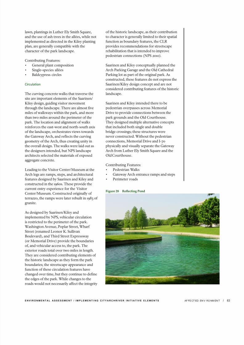
7/29/2019 Jefferson National Expansion Memorial
http://slidepdf.com/reader/full/jefferson-national-expansion-memorial 103/256
E N V I R O N M E N T A L A S S E S S M E N T / I M P L E M E N T I N G C I T Y A R C H R I V E R I N I T I A T I V E E L E M E N T S / AF FE CT ED EN VI RO NM EN T 8
lawn, plantings in Luther Ely Smith Square,
and the use of ash trees in the allées, while not
implemented as directed in the Kiley planting
plan, are generally compatible with the
character of the park landscape.
Contributing Features:• General plant composition
• Single-species allées
• Baldcypress circles
Circulation
The curving concrete walks that traverse the
site are important elements of the Saarinen/
Kiley design, guiding visitor movement
through the landscape. There are almost five
miles of walkways within the park, and more
than two miles around the perimeter of the
park. The location and alignment of walksreinforces the east-west and north-south axis
of the landscape, orchestrates views towards
the Gateway Arch, and reflects the curving
geometry of the Arch, thus creating unity in
the overall design. The walks were laid out as
the designers intended, but NPS landscape
architects selected the materials of exposed
aggregate concrete.
Leading to the Visitor Center/Museum at the
Arch legs are ramps, steps, and architectural
features designed by Saarinen and Kiley and
constructed in the 1960s. These provide the
current entry experience for the Visitor
Center/Museum. Constructed originally of
terrazzo, the ramps were later rebuilt in 1983 of
granite.
As designed by Saarinen/Kiley and
implemented by NPS, vehicular circulation
is restricted to the perimeter of the park.
Washington Avenue, Poplar Street, Wharf
Street (renamed Leonor K. Sullivan
Boulevard), and Third Street Expressway
(or Memorial Drive) provide the boundariesof, and vehicular access to, the park. The
exterior roads total over two miles in length.
They are considered contributing elements of
the historic landscape as they form the park
boundaries; the streetscape appearance and
function of these circulation features have
changed over time, but they continue to define
the edges of the park. While changes to the
roads would not necessarily affect the integrity
of the historic landscape, as their contribution
to character is generally limited to their spatial
function as boundary features, the CLR
provides recommendations for streetscape
rehabilitation that is intended to improve
pedestrian connections (NPS 2010).
Saarinen and Kiley conceptually planned the
Arch Parking Garage and the Old Cathedral
Parking lot as part of the original park. As
constructed, these features do not express the
Saarinen/Kiley design concept and are not
considered contributing features of the historic
landscape.
Saarinen and Kiley intended there to be
pedestrian overpasses across Memorial
Drive to provide connections between the
park grounds and the Old Courthouse.
They designed multiple alternative conceptsthat included both single and double
bridge crossings; these structures were
never constructed. Without the pedestrian
connections, Memorial Drive and I-70
physically and visually separate the Gateway
Arch from Luther Ely Smith Square and the
Old Courthouse.
Contributing Features:
• Pedestrian Walks
• Gateway Arch entrance ramps and steps
• Perimeter roads
Figure 28 Reecting Pond

7/29/2019 Jefferson National Expansion Memorial
http://slidepdf.com/reader/full/jefferson-national-expansion-memorial 104/256
J E F F E R S O N N A T I O N A L E X P A N S I O N M E M O R I A L/ AFFECTED ENVIRONMENT84
Constructed Water Features
The north and south reflecting ponds are
part of the Saarinen/Kiley concept for the
park. Each pond is sited within a topographic
depression. The original design for the
ponds included deeply incised and irregularedges, creating intimate spaces on their
banks. The ponds were also to include small
islands on their northern ends, which were
to be connected to the landscape by means
of narrow footbridges. Neither pond, as
constructed, was as large as originally designed
by Saarinen and Kiley, nor did they include
the islands and footbridges. Their edges
were much simplified, and the surrounding
planting was also reduced during NPS design
development. Despite changes to the details,
the ponds remain important elements of the
historic designed landscape. Their placementprovides separate and intimate spaces that
contrast with the more monumental spaces
along the east-west axis and beneath the
Gateway Arch. In addition, their, stylized
curving edges are in keeping with the modern
design of the landscape and enhance the
overall character of the design.
Contributing Features:
• North and South Ponds
Small-Scale Features
The Saarinen/Kiley team created designs for
benches in the park in 1960. The design detail
showed ten-foot-long benches, built with
limestone seats set on a limestone block with a
concrete foundation. The NPS implementation
of the benches was almost identical, but
fabricated of concrete. These benches were
initially placed on the east side of each rest
area north and south of the Arch. Eventually,
additional benches of this design were added
to the landings of the Grand Staircase as well.
Benches of an entirely different design—metalframe with iron slats—were installed in Luther
Ely Smith Square at an unknown date.
The Saarinen/Kiley team also designed a
light standard for the park, but it was never
implemented. The early plans for the park
did not show proposed lighting locations.
The NPS developed plans and details for the
lighting at the park that included a twelve-
foot-tall single pole with globe luminaire,
which was ultimately installed along the walks,
approximately ninety feet apart. They are
considered compatible but not contributing to
the historic landscape.
Contributing Features: Benches
ARCHEOLOGICAL RESOURCES
Physical History: Park Grounds and Central
Riverfront
Development of the city of St. Louis has
been ongoing from its earliest times as a
Euro-American settlement in the 18th century.
Archeological information regarding earlier
occupation is sparse and known existingarcheological resources date to after the
Louisiana Purchase. Therefore the potential
for early archeological sites from before 1850,
including prehistoric archeological sites, is
largely unknown on the park grounds and the
Central Riverfront.
Archival and photographic documentation
demonstrates a multi-layered history of
building construction and deposition of
materials along the St. Louis riverfront
since the city’s inception as a fur trading
center. Population expansion accompanied
a steamboat trade boom in the 1830s that
stimulated riverfront development including
establishment of a tenement and boarding
house district in the old French settlement
south of Market Street. An 1849 fire along the
wharf engulfed “numerous business and [left]
thousands homeless” (Roselle et al 1999). On
July 7, 1849, “the City Council instructed the
City Engineer to have the rubbish then being
hauled from the burned district deposited in
the low places on the wharf near Plum Street,”
at the southern edge of what is now the parkgrounds (NPS 1954).
Just prior to the Civil War, St. Louis
experienced an economic and industrial boom
as a result of its river and rail connections,
which were strengthened as the waterfront
area devastated by the 1849 fire was rebuilt

7/29/2019 Jefferson National Expansion Memorial
http://slidepdf.com/reader/full/jefferson-national-expansion-memorial 105/256
E N V I R O N M E N T A L A S S E S S M E N T / I M P L E M E N T I N G C I T Y A R C H R I V E R I N I T I A T I V E E L E M E N T S / AF FE CT ED EN VI RO NM EN T 8
as a fledgling industrial area. Residential
occupation along the riverfront shifted away
to the west, “as residents fled the pollution and
noise caused by the development, the number
of industrial and commercial buildings quickly
grew” along the river’s edge (Roselle et al
1999).
A 1907 Sanborn Fire Insurance Company map
shows multi-story commercial brick structures
dominating the landscape in the area that
would later become the park. The 1908 and
1909 Sanborn maps illustrate that the area
south of Market Street was almost exclusively
industrial warehouses with just a few dwellings,
tenements, and lodging houses between Clark
and Poplar Streets (Sanborn Fire Insurance
Company 1908, 1909). North of Market Street,
industrial manufacturing was the dominant
land use. Despite this growth, the turn of thecentury subsequently saw the waning of river-
based commerce, with the commercial area
slowly abandoned and its structures declining.
The park’s substantial overlay of fill in the
20th century is well known. The remaining
buildings in the area designated to become
the park grounds were cleared in anticipation
of construction of the park between 1939
and 1942. Many of these structures “had at
least one, and sometimes two full basements,
entailing a minimum of 15-30 feet of ground
disturbance” resulting from both their
construction and demolition (York 1983). If
archeological evidence remains, basement
foundations and a variety of subsurface
features could be present beneath the park
grounds, such as wells and refuse disposal
features. In addition, the fill is believed to
be composed at least in part of demolition
materials, although the origin of the materials
is undocumented, possibly originating from
buildings razed on the site and/or brought in
from elsewhere (NPS 2010).
Regrading of the park was a major operation
involving extensive fill and a complete
reshaping of the landscape. Starting in late
December 1954, the Missouri Highway
Department dumped 80,000 cubic yards of
earth and rubble fill on the site northward
from Clark Street toward the Eads Bridge,
between Memorial Drive and Leonor K.
Sullivan Boulevard. Almost 300,000 cubic
yards had already been deposited from Clark
Street south to the park boundary (NPS 1984).
Again in 1958, hundreds of cubic yards of fill
were deposited on the site as stipulated by
the grading plans and a remaining warehouse
south of the Cathedral was removed (NPS
1984).
Archeological Sites
The study area for archeological resources is
the park boundary, depicted on the Cultural
Resources Impact Area map (Figure 24); as
well as the linear path of the Central Riverfront
along the levee. This study area was established
based on areas of potential ground disturbance
and excavation in the alternatives.
Within the Study Area
Archeological surveys previously completed
within a one-mile radius of the project area
have identified seventeen archeological
sites that date to the historic period. In
addition, a group of prehistoric mounds
known as the St. Louis mound group were
documented just outside the one-mile radius
to the north of Laclede’s Landing. Early
19th-century accounts describe the mounds
site as consisting of 26 pyramids with a two
hectare plaza, with the largest “Big Mound”
at the northern end of the site (Pauketat
2004). Because of these mounds, St. Louis
was nicknamed “Mound City.” The St. Louis
mound group was demolished as St. Louis
development spread north in the 19th century.
The majority of mounds were leveled by the
1870s, and little is known about the site as a
result (Milner 1998).
St. Louis
Archeological sites 23SL976, 23SL2229, and
23SL2234, previously recorded within St.
Louis but outside the park boundaries, includerefuse and construction debris dating to the
1840s and 1850s. Like the blocks within the
park, the areas where these three sites were
found appear to have undergone the pattern
of razing buildings and constructing new
ones atop the construction debris. Cochran
Gardens (Site 23SL2229) provides a good
example of this. Located at the southeast
corner of O’Fallon Avenue and North Seventh

7/29/2019 Jefferson National Expansion Memorial
http://slidepdf.com/reader/full/jefferson-national-expansion-memorial 106/256
J E F F E R S O N N A T I O N A L E X P A N S I O N M E M O R I A L/ AFFECTED ENVIRONMENT86
Street, the Cochran Gardens site was a densely
populated residential and commercial area
from the mid-19th to the mid-20th century.
Here, 19th-century buildings were razed in
1950 and the debris spread on the parcel as
the base for an apartment complex. After
the apartments were themselves razed in2002, the rubble was used to fill basements
and level the site, and subsequently capped
by fill (Altizer, McLaughlin and Harl 2005).
This pattern appears to have been the case
even in the absence of modern construction.
Phase II testing at the Walsh’s Row site (Site
23SL2234), remains of row houses built c. 1845
and demolished c. 1935, indicates that modern
fill from the demolition overlies brick streets
or sidewalks as well as 19th-century brick and
mortar building debris (Meyer 2004). These
sites were found during excavations for new
construction, mostly on blocks that werepresumed to have no intact archeological
features due to development in the 20th
century. In each of the sites, intact deposits
including refuse deposits, privies and cistern,
were encountered below the rubble.
To the north of the park, there are ongoing
archeological investigations due to excavation
related to the construction of the New
Mississippi River Bridge. Ten historic sites have
been identified. The historic sites date from the
mid-19th and early-20th centuries and include
civic, residential, and commercial property
types. Two locations where prehistoric
sites were once present in the area were
also investigated. The prehistoric sites were
associated with Big Mound and the St. Louis
Mound group. Testing of the prehistoric sites
yielded only a handful of prehistoric artifacts
in disturbed contexts and no intact prehistoric
deposits or features were identified (MoDOT
2011).
No sites have been documented in Chouteau’s
Landing to the south of the park, thoughconstruction to the south along Lafayette
Avenue (site 23SL338) revealed four cisterns
intact with artifacts dating from the mid- to
late 19th century (Fairchild 1979, in Roselle et.
al. 1999).
Within the Park Grounds
In addition to the sites and surveys in the
vicinity, several archeological investigations
have taken place within the park grounds.
These excavations and subsurface
examinations were focused on identifyingintact pre-1849 features and deposits within
the park. Excavations within the park
boundaries were undertaken in 1960 by NPS
Archeologist Zorro Bradley. Subsequently,
Bradley suggested that 35 sites of historic
importance were beneath the ten to thirty feet
of fill deposited east of the 2nd Street area on
the basis of historic documentation (Bradley
1960). The deepest portion of this fill extends
east from a north-south line in the vicinity of
2nd Street to the area of the railroad cut along
Commercial Street. Seven additional sites
were identified between 2nd and Memorial,presumably under little to no fill; two were
thought to have been previously disturbed
or obliterated by more recent construction.
Remnants of the 1810 office of Dr. Farrar, an
important early St. Louis physician, were
tentatively identified in this area. An additional
four sites were thought to exist in proximity to
the Old Cathedral (Bradley 1960). Following
additional limited excavation in 1961, it was
determined that “the historic structures …
sought no longer existed or were too deeply
buried to warrant excavation” (Bradley 1976).
The subsequent two excavations yielded a few
artifacts, none of which appear to have been
recovered from in situ deposits.
In 1984-1985, monitoring of construction
activities for the Arch Parking Garage spanning
the former 1st and 2nd Street areas at the
northern edge of the park identified six
archeological features, none of which was
confirmed as containing intact resources
dating to before 1849 (Wells and Williams
1985). In the location of the garage, remnants
of the 1st Street limestone block retainingwall were observed at an elevation of 443
feet above mean sea level sitting directly
on bedrock and capped by the street’s 1882
cobblestones. While some apparently sterile
soil was observed below the cobblestones,
efforts to remove the capping and examine
7/29/2019 Jefferson National Expansion Memorial
http://slidepdf.com/reader/full/jefferson-national-expansion-memorial 107/256
E N V I R O N M E N T A L A S S E S S M E N T / I M P L E M E N T I N G C I T Y A R C H R I V E R I N I T I A T I V E E L E M E N T S / AF FE CT ED EN VI RO NM EN T 8
the deposits below the street were deemed
inadvisable (Wells and Williams 1985). West
of 1st Street, excavation revealed a deposit of
building and structural debris about nine feet
deep sitting directly on bedrock. East of 1st
Street, two exposed features were observed
within trenches five meters deep, consisting of limestone foundation walls and remnants of
an aqueduct or sewer. The foundation walls,
while corresponding to the location of the
“Cadet” Chouteau House built c. 1825, were
more probably a portion of the later W.H. Bull
Medicine Factory, which was demolished by
the National Park Service between 1939 and
1942 (Woods 1984).
Two additional features were observed
running west from 1st Street for nine meters
and sitting directly on bedrock. The first, a
limestone foundation with a top elevation of 435 feet above mean sea level, was associated
with a small amount of late 19th- and early
20th-century material; the second was a
brick foundation corner directly to the
north. A third feature at the west end of
the site was associated with late 19th- and
early 20th-century material. No associated
diagnostic information or artifacts were found,
and the matrix of building rubble encountered
led to the conclusion that “…in situ features if
they exist, will be located below the 436.0-foot
elevation that excavation is now, or up slope
west of 1st Street” (Wells and Williams 1984
and Woods 1985). The findings suggested that
“post-1849 urban renewal had destroyed any
earlier structures present above grade elevation
[436.0 feet above mean sea level] prior to
commencement of excavation for construction
of the parking facility” (Wells and Williams
1984 and Woods 1985).
Archeological monitoring in 1999 for the
construction of the maintenance facility at
the south end of the park also indicated the
potential for archeological resources. Here,auger bore samples hit the limestone bedrock
at 9.25 to 13.5 feet below surface, trending
to a maximum of 38.5 feet below surface in
the northernmost boring observed. Dense
brick rubble was seen in many of the borings
ranging from below the present asphalt surface
to depths of three to ten feet; an undated
abandoned sewer line also appeared to have
been hit in a separate boring. NPS Archeologist
Vergil Noble concluded that “it is well known
that the grounds here were landscaped on
urban fill after the buildings were razed”
(Noble 1999).
The archeological investigations within
the park have typically yielded historical
construction debris and partially disturbed
architectural and infrastructure features
dating to the second half of the 19th century.
The focus of many investigations has been
on identifying pre-1849 resources; as a
result, little is known regarding later historic
features. However, the post-1850 architectural
and infrastructural features that have been
identified indicate the potential presence
of additional historic resources that maymeet National Register eligibility criteria.
Much of the park has not been subjected
to archeological investigations. While all
archeological reports acknowledge that the
deep fill in the eastern portion of the park
severely limits the potential for archeological
deposits to be disturbed in future construction,
the presence of intact deposits and features
cannot be discounted.
In a 1960 memorandum between the park’s
Archeologist and Superintendent, the
archaeologist pointed out the following:
Over the past four years an artificial fill
running from 10 to over 30 feet deep has been
dumped over the Memorial area in preparation
for final landscaping. The deepest portion of
this fill extends eastward from a north-south
line in the vicinity of Second Street to the area
of the railroad cut along Commercial Street.
Due to the slope of the original ground surface,
the section of the park west of 2nd Street has
the highest potential to yield archeologicaldeposits that are not covered by deep fill and
that may be affected by future development.
Unexamined areas in the central western area
of the park in particular may yield additional
information, including areas around the Old
Courthouse and Luther Ely Smith Square

7/29/2019 Jefferson National Expansion Memorial
http://slidepdf.com/reader/full/jefferson-national-expansion-memorial 108/256
J E F F E R S O N N A T I O N A L E X P A N S I O N M E M O R I A L/ AFFECTED ENVIRONMENT88
that are in relatively undisturbed contexts
and could contain intact, relatively shallow
deposits pre-dating the industrial development
of the area. The area between 1st and 2nd
Streets, however, may also have a medium to
high archeological potential depending on the
depths of future ground disturbing activities.Portions of the southern area are expected
to have medium archeological potential as
a result of the rubble fill. Sites like Cochran
Gardens, Walsh’s Row, and Lafayette Avenue
in Chouteau’s Landing illustrate that, even
under deep fill and building rubble, intact
material may remain. Further, the piercing
of a possible 19th-century sewer line in the
southern area of the park suggests the potential
presence of intact infrastructural remains that
may pre-date or be contemporaneous with the
Fire of 1849, including waterworks developed
in 1830, gas light infrastructure from c. 1847,and sewer systems in place by 1850.
MUSEUM COLLECTIONS
The park’s collection consists of 1,347,086
cataloged items: 10,257 objects and 45 archival
collections. There are 8,941 history objects,
860 archeological objects, 342 ethnology
objects, 54 geology objects, and 60 natural
history objects. There are 411 cataloged objects
on display in the Museum of Westward
Expansion and 529 items on display in the Old
Courthouse (NPS 2009). The purpose of the
collection is to preserve historic artifacts and
to support understanding of the park’s themes
through exhibits, research, and interpretive
programs.
The cultural collection is sub-divided into
four disciplines: archeology, ethnology,
history, and archives. Collections are used
for permanent and temporary exhibits in the
Museum of Westward Expansion and Old
Courthouse, and for staff and public research.
Archeological holdings from excavations donein association with site work are administered
by the NPS Midwest Archeological Center
in Lincoln, Nebraska. Ethnological materials
in the collection consist of American Indian
clothing, weapons, tools, and domestic items
such as basketry and pottery. A collection of
architectural materials is on long-term loan to
Southern Illinois University, Edwardsville for
cataloging and study.
The history collection forms the bulk of the
Museum of Westward Expansion collection,
and focuses on the history of westward
expansion, St. Louis history, the Old
Cathedral, and Gateway Arch construction.
Objects associated with the history of
westward expansion include clothing, tools,equipment, weapons, household goods,
personal items, and transportation devices that
are representative of those used in exploring
and settling the Trans-Mississippian West
between 1804 and 1890. To interpret the city’s
growth and development of the “Gateway to
the West,” objects in the collection include
many of these items manufactured in St. Louis.
Included in this category are documented
furnishings of the Old Courthouse and
selected samples of historic fabric removed
from park structures during approved
restoration projects. Also included in thiscategory is a large collection of pharmaceutical
artifacts and documents from a St. Louis
pharmacy in the 1890s. There is also a small
collection of fine art, including works by
Thomas Moran and Ansel Adams.
The park archives include materials which
document the creation of the park, the clearing
of the site, the architectural competition of
1947-1948, the selection of the Saarinen/Kiley
design concept, the planning and construction
of the Gateway Arch and landscape, the
restoration of the Old Courthouse, and other
important events in the park’s history. Another
notable collection in the archives consists
of extremely detailed records, including
photographs of the buildings that were razed
to create the park site. The archives also
contains other collections relevant to park
resources and themes, including interviews
and papers related to widows of frontier
soldiers, a collection of papers and images of
western forts, a research collection of Lewis
and Clark materials, insolvent debtor records
from 1815-1870 and a small but importantcollection of contracts awarded for original
construction of the Old Courthouse in the
1850s-1860s.

7/29/2019 Jefferson National Expansion Memorial
http://slidepdf.com/reader/full/jefferson-national-expansion-memorial 109/256
E N V I R O N M E N T A L A S S E S S M E N T / I M P L E M E N T I N G C I T Y A R C H R I V E R I N I T I A T I V E E L E M E N T S / AF FE CT ED EN VI RO NM EN T 8
NATURAL RESOURCES
The inventory and characterization of physical
and biological resources provide a baseline
for analysis of potential impacts discussed
in Chapter 4. The natural resources at the
Jefferson National Expansion Memorial andalong the Central Riverfront discussed in
this section include vegetation, soundscapes,
water quality/stormwater management, and
floodplains. Other natural resources that
have been dismissed from further analysis
are discussed in Chapter 1. The study area for
the inventory and analysis of physical and
biological resources is the park grounds and
the Central Riverfront. The park is bounded by
Eads Bridge to the north, Leonor K. Sullivan
Boulevard to the east, Poplar Street Bridge to
the south, and Interstate 70 to the west, plus
a two-block extension to incorporate the Old
Courthouse and Luther Ely Smith Square. The
Central Riverfront is located along Leonor K.
Sullivan Boulevard between the Mississippi
River and the park, to the east and west, and
Biddle Street and Chouteau Avenue to the
north and south.
VEGETATION The park grounds are a formally planned,
designed, and planted landscape. It is highly
maintained with no extant naturally occurring
native plant communities. The park’s plants
include a mixture of ornamental native and
non-native deciduous and evergreen trees, as
well as a few shrubs, expanses of maintained
turf lawn, and ground cover. Mature Rosehill
ash trees (Fraxinus americana “Rosehill”),
the park’s major planting, are planted in tree
pits and along the park’s paved walks. The
majority of the trees in this urban planting are
approximately 40 years of age, far older thanthe typical lifespan expected for urban plantings
in similar conditions. The ash trees have begun
to decline and will continue to do so as they
age and naturally reach senescence; a number
of them have already been removed (NPS
2011a). Vegetation along the Central Riverfront
consists of street trees along portions of Leonor
K. Sullivan Boulevard and several small grass-
covered areas. Vegetation is limited due to the
urban and paved nature of the area.
Of major concern is the vulnerability of the park’s
predominant ash plantings to the emerald ashborer (Agrilus planipennis Fairmaire). This exotic
wood-boring insect feeds primarily on ash trees.
The emerald ash borer larvae feed under the
bark of a tree and cut off the flow of water and
nutrients in the tree’s vascular system. Affected
ash trees die within several years of infestation
(NPS 2011a). As of July 2010, the emerald ash
borer has been detected in 15 states including
Missouri (Missouri Department of Conservation
2011). At this time, the emerald ash borer has not
been detected within 150 miles of St. Louis or at
the park. The emerald ash borer’s life cycle does
not include traveling long distances; it typicallyis spread through the transportation of infested
wood and wood products.
Figure 29 Processional Walks and Allées of Uniform Trees along the Walk

7/29/2019 Jefferson National Expansion Memorial
http://slidepdf.com/reader/full/jefferson-national-expansion-memorial 110/256
J E F F E R S O N N A T I O N A L E X P A N S I O N M E M O R I A L/ AFFECTED ENVIRONMENT90
SOUNDSCAPE
National Park Service Policy on Soundscape
Management
A portion of the National Park Service
mission includes protecting and enhancingsoundscapes within units of the national
park system. Director’s Order 47 provides
guidance on soundscapes. A soundscape
refers to the total acoustic environment of an
area. Depending on the purposes and values
of the park, both natural and human-caused
sounds may be desirable and appropriate in a
soundscape. Soundscapes often vary in their
character from day to day and from season to
season and can be affected by changes in the
numbers of visitors who introduce human-
caused sounds into the environment. The
NPS policies require that the National ParkService restore degraded park soundscapes
to the natural condition wherever possible,
and protect natural soundscapes from
unacceptable impacts (NPS 2006).
Noise is generally defined as unwanted or
objectionable sound that alters or disturbs
quality of life or communication. It also may
affect physical health. Most environmental
noise, particularly in urban areas, consists
of a variety of frequencies of common,
distant noises that create relatively constant
background noise levels. Periodic loud noises
such as horns honking, trucks driving by,
or low-level aircraft overflights are easily
perceived above background noise levels.
Noise levels are usually measured and
expressed in decibels (dB) that are weighted
to frequencies perceivable by the human ear,
known as A-weighted sound levels or dBA.
Noise levels are typically measured over a
set period of time (one hour, eight hours, or
24 hours) and are commonly expressed as
dBA Leq, which represents the equivalent or
average noise level in dBA for a given timeperiod.
Noise Regulations and Policies
The City of St. Louis Revised Code Chapter
15.51 regulates stationary sources of industrial
noise and sets permissible noise levels for
various zoning districts. Stationary noise
sources are defined as any equipment, motor
vehicle, aircraft, or facility, fixed or movable,
capable of emitting audible sound. Noise from
stationary sources within the central business
district is generally limited to 70 dBA or less
if the duration of the noise generating activity
exceeds 60 minutes. This limitation would
apply to construction and other activitieson the park grounds. In addition, Chapter
15.50.081 prohibits construction activity within
1000 feet of a residential property before
6:00 a.m. and after dusk, except in case of an
“urgent necessity.”
Current Conditions on the Park Grounds
The park is surrounded on three sides by
major roadways which include the elevated
Eads Bridge to the north, Interstate 70 and
Memorial Drive to the west, and the elevated
Poplar Street Bridge to the south. To the east,it is bounded by Leonor K. Sullivan Boulevard
along the Mississippi riverfront. A below-grade
railroad corridor runs parallel to the river
below-grade along the eastern part of the park
grounds.
In general, the soundscape at the park is
typical of a busy urban area. The soundscape
at the park is dominated by fairly loud urban
background noise from traffic on surrounding
roadways. The traffic noise is loudest closest
to the roadways. While the background
traffic noise is perceptible everywhere, it
diminishes towards the center of the park
near the Gateway Arch and reflecting ponds
due to natural attenuation and intervening
topography and plantings. Trains moving
across Eads Bridge and in the below-grade
cuts in the eastern portion of the park can be
periodically perceived above background noise
levels. Commercial aircraft fly over or near
the park on approach to and departure from
the international airport at Lambert Field,
but these noise events are typically of short
duration. Horns from ships on the MississippiRiver and other noises from the surrounding
urban environment contribute to the existing
soundscape.
Other sources of noise at the park include:
• The emergency generators which are
tested monthly;
• Grounds maintenance equipment such as
lawn mowers;

7/29/2019 Jefferson National Expansion Memorial
http://slidepdf.com/reader/full/jefferson-national-expansion-memorial 111/256
E N V I R O N M E N T A L A S S E S S M E N T / I M P L E M E N T I N G C I T Y A R C H R I V E R I N I T I A T I V E E L E M E N T S / AF FE CT ED EN VI RO NM EN T 9
• Helicopters taking visitors on aerial tours
from a barge moored on the riverbank
below the park;
• Music broadcast from nearby riverboats;
and
• Music from riverfront and park special
events.
Visitors near the emergency generator building
when the generators are operating would
likely be able to hear the generators above
the background noise. Similarly, visitors near
maintenance activities such as
lawn mowing would hear noise from the
maintenance equipment. As discussed above,
visitors near the below-grade railroad tracks
when trains are passing are able to hear the
trains above background noise levels. During
special events at the park, there is increasednoise due to crowds, vehicles, and amplified
sound systems.
While not covered by the NPS policy on
protecting and restoring soundscapes within
national parks, noise along the Central
Riverfront is considered in this EA. Like the
park, noises perceived along the Central
Riverfront come from the surrounding urban
environment, in particular roadway noise from
Leonor K. Sullivan Boulevard, noise from
helicopters taking off and landing at the barge
moored along the riverbank in front of the
park, and noise from riverboats. The Central
Riverfront passes underneath three bridges
that carry interstate highway traffic, the Poplar
Street Bridge, Eads Bridge and the Martin
Luther King Bridge, which each generate
roadway noise.
WATER QUALITY/ STORMWATERMANAGEMENT
Water Quality
The park grounds and Central Riverfront are
located in the Cahokia-Joachim watershed.
The surface waters in the watershed flow to the
Mississippi River along the eastern boundary
of the park and along the Central Riverfront.
The water quality of the Mississippi River
is affected by human activities throughout
the watershed. Water pollution is generated
by non-point source pollution, such as
stormwater runoff; and point source pollution,
such as wastewater treatment or industrial
discharges.
The section of the Mississippi River in
proximity to the park has been placed on the
303(d) list by the State of Illinois for havinghigh levels of fecal coliform, manganese, and
PCBs (EPA 2004). The Section 303(d) list is
one of two basic approaches the Clean Water
Act uses to protect and restore water bodies.
The 303(d) list includes those water bodies and
watersheds that exhibit levels of degradation
requiring investigation and restoration. Once
a water body has been identified on the
Section 303(d) list, a Total Maximum Daily
Load (TMDL) must be developed for each
pollutant that is impairing the water body. A
TMDL is the maximum amount of a pollutant
that can be introduced into a water body inorder for that water body to achieve or remain
in compliance with applicable water quality
standards (EPA 2010). Missouri developed a
TMDL for the Mississippi River as it passes
along the state to reduce levels of chlordane
and PCBs in fish tissues (MDNR 2006).
Section 305(b) of the Clean Water Act requires
that local agencies issue a report to the EPA
and Congress every two years describing
the water quality of 303(d) listed streams. In
305(b) reports, water bodies are categorized
based on the degree to which water quality
affects the use of the water bodies. According
to Illinois Section 303(d) list for the section
of the Mississippi River that passes through
the study area, water quality only partially
supports the uses of the river as a public water
supply, for primary contact recreation, and
for fish consumption due to fecal coliform,
Polychlorinated biphenyls, mercury, and
manganese contamination (Illinois EPA 2011).
Stormwater Management
The storm sewer system within the park is
quite complex, as there are numerous local
storm drains and storm sewer lines located
across its 91 acres. Some of these storm drains
direct runoff into the reflecting ponds on the
park grounds. The ponds are therefore an
integral component of the site’s stormwater
system. Both ponds have algal blooms, likely
related to the use of fertilizer on the park’s

7/29/2019 Jefferson National Expansion Memorial
http://slidepdf.com/reader/full/jefferson-national-expansion-memorial 112/256
J E F F E R S O N N A T I O N A L E X P A N S I O N M E M O R I A L/ AFFECTED ENVIRONMENT92
lawns which runs off into the ponds both
directly and via the stormwater system.
Stormwater collection sumps are located on
both the north and south sides of the central
portion of the park. One of these stormwater
collection sumps is located near the emergencygenerator building. A submerged pump moves
stormwater from this collection area into the
North Reflecting Pond. A similar stormwater
collection sump is located near the shipping
and receiving area at the south service tunnel.
A submerged pump moves stormwater from
this collection area into the South Reflecting
Pond.
Storm flow is held in the North and South
Reflecting Ponds where it is then re-circulated
or allowed to drain offsite once the water level
reaches the top of the overflow structures. TheNorth Pond overflow is directed through a
36-inch storm outfall directly to the Mississippi
River (described below), and the overflow
from the south pond is directed to the
Metropolitan St. Louis Sewer District (MSD)
system.
According to the utility map of the park, there
are six stormwater outfalls into the Mississippi
River between Washington Avenue and Poplar
Street:
• The northernmost of these outfalls is a
36-inch reinforced concrete pipe (RCP)
storm sewer just north of Washington
Avenue that outfalls into the Mississippi
River northeast of the North Overlook.
• A 36-inch RCP storm sewer collects
runoff from the North Overlook and Arch
Parking Garage, running beneath the
North Overlook and outfalling into the
Mississippi River.
•
A 15 inch RCP storm sewer collects runoff from the north railroad cut and a tile
subsurface drainage system and flows
beneath Leonor K. Sullivan Boulevard,
outfalling into the Mississippi River.
• A 15-inch RCP storm sewer collects runoff
from the Grand Staircase and east slopes.
This storm sewer also flows beneath
Leonor K. Sullivan Boulevard and outfalls
into the Mississippi River.
• South of the Gateway Arch, a large
54-inch storm sewer runs across the park
beneath the south reflecting pond, thesouth railroad cut, and Leonor K. Sullivan
Boulevard, outfalling into the Mississippi
River.
• On the south side of the park, a 36-inch
storm sewer outlet from the south
reflecting pond runs southeast to a
junction with a main storm sewer line
beneath the eastbound lanes of Poplar
Street outside the park boundary. This
large storm sewer also collects runoff from
the area around the railroad tunnel and
the South Overlook.
In addition to the active storm sewer lines
described above, there are a number of
abandoned storm sewer lines shown on
the utility map. These inactive lines may be
encountered during construction activities at
the park. They are assumed to present minimal
hazards or interference with construction
activities, and are therefore not described in
detail in this EA.
Stormwater systems along the Central
Riverfront are relatively simple. A large
portion of the storm flow south of Poplar
Street is allowed to sheet flow from Leonor K.
Sullivan Boulevard directly to the levee without
being collected or channeled. North of Poplar
Street, the storm flow is collected by a system
of curb inlets, trench drains, and area drains
which connect to storm trunk sewers that
discharge directly to the Mississippi River.
The 1% annual chance flood(100-year flood), also known
as the base flood, is the flood
that has a 1% chance of being
equaled or exceeded in any
given year.

7/29/2019 Jefferson National Expansion Memorial
http://slidepdf.com/reader/full/jefferson-national-expansion-memorial 113/256
E N V I R O N M E N T A L A S S E S S M E N T / I M P L E M E N T I N G C I T Y A R C H R I V E R I N I T I A T I V E E L E M E N T S / AF FE CT ED EN VI RO NM EN T 9
FLOODPLAINS
Portions of the East Slopes and the entireCentral Riverfront lies within the regulatory
Federal Emergency Management Agency
(FEMA) National Flood Insurance Program
(NFIP) 100-year (1%) Mississippi River
floodplain (see Figure 31). The floodway
portion of the river is confined by a
floodwall/levee system on both the east side of
the River (Illinois bank) and the west side of
the river (Missouri bank). The floodwall/levee
system essentially “squeezes” the floodplain
into a relatively narrow floodway.
Floodplains contain flood waters and alsoprovide numerous functions besides storing
flood waters. Floodplains can also provide
habitat for various flora and fauna especially
the islands that are temporarily formed by
shifting river sediments. The Mississippi
River, below its confluence with the Missouri
River, transports a considerable volume of
sediment (sand, gravel, silt, etc.). This portion
of the Mississippi River floodplain adjacent
to Leonor K. Sullivan Boulevard has been
highly industrialized with several river ports /transfer loading facilities located within what
is referred to as the St. Louis Harbor. The
channel is routinely dredged by commercial
sand and gravel suppliers.
The City of St. Louis is a member of the NFIP
and must abide by the rules and regulations of
this program. It will be necessary to apply for
and obtain a Floodplain Development Permit.
Because the Central Riverfront improvements
propose raising Leonor K. Sullivan Boulevard
to reduce the frequency of flooding, it will be
necessary to perform a Riverine HydraulicAnalysis of the proposed improvements to
assure the city that a “no-rise” to the 100-year
base flood elevation will exist after the
proposed improvements are constructed.
This is typically referred to as a “no-rise”
analysis. This analysis will be performed after
approximately 40% of the final design is
completed.
Figure 30 Flooding along the Central Riverfront within the Floodplain

7/29/2019 Jefferson National Expansion Memorial
http://slidepdf.com/reader/full/jefferson-national-expansion-memorial 114/256
J E F F E R S O N N A T I O N A L E X P A N S I O N M E M O R I A L/ AFFECTED ENVIRONMENT94
Figure 31 Project Area and 100-year Floodplain (Source: Great Rivers Greenway District)

7/29/2019 Jefferson National Expansion Memorial
http://slidepdf.com/reader/full/jefferson-national-expansion-memorial 115/256
E N V I R O N M E N T A L A S S E S S M E N T / I M P L E M E N T I N G C I T Y A R C H R I V E R I N I T I A T I V E E L E M E N T S / AF FE CT ED EN VI RO NM EN T 9
VISITOR USE ANDEXPERIENCE
VISITOR OPPORTUNITIES AND USE
The Jefferson National Expansion Memorial
receives most of its visitation within itsstructures: the Visitor Center/Museum
complex beneath the Gateway Arch, the
ride to the top of the Gateway Arch, and the
observation deck at the top of the Gateway
Arch. The underground complex includes a
lobby, the Museum of Westward Expansion
gallery, visitor loading areas for the Gateway
Arch’s transportation system, and two theaters
that screen films related to the park’s themes.
Additions to the visitor center and museum
have included the American Indian Peace
Medal Exhibit, two museum stores, and a ticket
purchasing area. The Old Courthouse includes
the Diorama Room and the Competition
Room, as well as exhibits on the history of the
City of St. Louis and a museum store.
Between the years of 2000 and 2010, an
estimated 2.7 million people visited the park
annually, including individuals using the site
only for the parking garage (non-recreational
visits) and special event attendance. Excluding
those uses, the park averaged 1.9 million
visitors per year. During the same time period,
an average of 1.7 million people visited the
Visitor Center underneath the Arch, an average
of 1.1 million people visited the Museum
of Westward Expansion, and an average of
99,000 people visited the Old Courthouse
(NPS 2011b). Table 3 below provides estimated
annual visitation to the park from 2000 to 2010.
YEAR ATTENDANCE
2000 3,458,956
2001 3,532,524
2002 3,333,454
2003 2,685,219
2004 2,779,350
2005 2,944,976
2006 2,572,072
2007 2,385,387
2008 1,954,810
2009 2,360,109
2010 2,436,110
Table 3 Annual Attendance, Jefferson
National Expansion Memorial
Source: National Park Service Public Use Statistics Oce
(NPS 2011d)
Table 4 Graph of Annual Aendance, Jeerson National Expansion Memorial (Source: NPS)
ATTENDANCE

7/29/2019 Jefferson National Expansion Memorial
http://slidepdf.com/reader/full/jefferson-national-expansion-memorial 116/256
J E F F E R S O N N A T I O N A L E X P A N S I O N M E M O R I A L/ AFFECTED ENVIRONMENT96
Results of two surveys conducted by Metro,
one in 2003-2004 and one in 2006-2007,
indicate that: two-thirds of visitors reside
within 500 miles of the park; most visitors
return within 11 years for another visit; the
average park visit lasts just over two hours;
and, at least 19 percent of visitors cited theGateway Arch experience, consisting of the
tram ride and the view from the top of the
Gateway Arch, as the primary reason for
visiting. Further information about these
surveys is discussed in the Chapter 3 of the
GMP on page 3-34 (NPS 2009).
Visitor contact stations currently include the
visitor information desk in the lobby of the
George B. Hartzog Visitor Center underneath
the Arch; ticket takers in front of the two
theaters; interpreters stationed at the entrance
of the Museum of Westward Expansion and
roving within the museum; and interpreters
stationed at the top of the Gateway Arch and
in the Old Courthouse (NPS 2009). Other
facilities at the park include exhibit galleries in
the Old Courthouse, and museum shops. The
park also offers many educational programs
to groups, ranging from pre-school to high
school, college, and senior citizens.
The Museum of Westward Expansion
commemorates the people and events of the
19th century American westward movementthrough artifacts, quotations, photographs,
and animatronic figures. The Museum’s
collection focuses on the history of westward
expansion, St. Louis history, and Gateway Arch
construction. The collection includes clothing,
tools, equipment, weapons, household goods,
personal items, and transportation devices that
are representative of those used in exploring
and settling the Trans-Mississippian West
between 1804 and 1890 (NPS 2009).
The park grounds are used by visitors on
their way to the Gateway Arch, as well as bylocal downtown workers and residents who
utilize the park as an urban green space. The
park is used by visitors as well as downtown
residents and workers for picnics, lunch
hours, and passive and active recreation. Some
recreational activities are permitted in the
park, as long as they do not conflict with the
stated memorial purpose of the park or its
setting. Recreational activities include walking,
jogging, biking, photography, watching the
river, sitting, reading, and informal recreation
such as Frisbee tossing. Organized sporting
events are not permitted. St. Louis residents
and visitors also take advantage of interpretive
programming at the park such as the Nightat the Museum program, the Family Junior
Ranger programs, ranger led bike tours,
Arch grounds walking tours, and seasonal
programming. The park annually hosts a series
of special events including Fair St. Louis,
African American Heritage Month, Fourth of
July celebrations, Constitution Day, Victorian
Holidays and St. Louis Traditions, and others.
The Central Riverfront provides a place for
visitors and downtown workers to experience
an intimate encounter with the Mississippi
River while experiencing a variety of passiveand active recreational opportunities. An
existing promenade on the east side of Leonor
K. Sullivan Boulevard features concrete paved
sidewalks, street trees, benches, and outlooks
for river viewing. Opportunities for food
concessions, horse-drawn carriage rides,
and bicycle rentals are available. The Central
Riverfront also provides a glimpse into the
character of a commercial riverfront through
its available riverboats cruises and excursion
boat tours. Replica 19th-century paddle-
wheel boats, Tom Sawyer and Becky Thatcher,
located on the Central Riverfront include
cruise narration which offers a historical
overview of the area and the role this working
river still plays today.
PEDESTRIAN AND BICYCLECIRCULATION
Sidewalks of varying widths and conditions
are located along the streets of downtown
St. Louis. As is typical in a downtown urban
setting, many trips can be made on foot
within the vicinity of the park. One-quarterto one-half mile (a five- to ten-minute walk)
is typically considered to be a comfortable
walking distance.
While the Gateway Arch is within one-quarter
mile of both the Arch Parking Garage and the
Old Courthouse, the south end of the park
is further than one-half mile from either of

7/29/2019 Jefferson National Expansion Memorial
http://slidepdf.com/reader/full/jefferson-national-expansion-memorial 117/256
E N V I R O N M E N T A L A S S E S S M E N T / I M P L E M E N T I N G C I T Y A R C H R I V E R I N I T I A T I V E E L E M E N T S / AF FE CT ED EN VI RO NM EN T 9
Figure 32 Transportation and Circulation Existing Conditions
these facilities. This contributes to its relative
isolation. The park is largely cut off from
the rest of downtown St. Louis by Interstate
70, impeding pedestrian access from thedowntown streets south of Walnut Street.
The largest impediment to pedestrian
access is the need to cross Memorial Drive
at the Walnut, Market, Pine, and Chestnut
Street bridges. Recent pedestrian-oriented
improvements include accessible, paved
crosswalks across Memorial Drive. Memorial
Drive is four lanes with a pedestrian island in
the middle. While waiting at the pedestrian
islands, high-speed freeway traffic is visible
and audible in the I-70 trench below (Figure
3 3). These conditions and vehicles converging
from multiple directions, however, continue
to create disorienting pedestrian conditions
between the Old Courthouse and the Gateway
Arch.
Within the park, there are approximately five
miles of exposed-aggregate concrete sidewalks,
as well as more than two miles of concrete
sidewalks around the perimeter (NPS 1996a).
While the Grand Staircase leading from the
park to the riverfront is in good condition,
there is currently no means of reaching the
riverfront directly from the Gateway Archfor persons with mobility impairments.
In addition, the concrete north and south
staircases that reach from the North and
South Overlooks down to Leonor K. Sullivan
Boulevard have some surface deterioration and
cracking.
With few designated on-street bicycle lanes in
downtown St. Louis, most cyclists must share
the roadway with automobiles. The park is
a destination for bicyclists, primarily via the
Riverfront Trail, an off-road facility that is
part of the River Ring Greenways system. This
trail links the Mississippi riverfront with the
Greater St. Louis region. The park is a hub of
this trail system and its planned expansion.
The Riverfront Trail runs along the edge of
park grounds along The Central Riverfront.
This segment of the trail shares the street
lanes with vehicular traffic. Poplar Street,
Memorial Drive, and Washington Avenue are
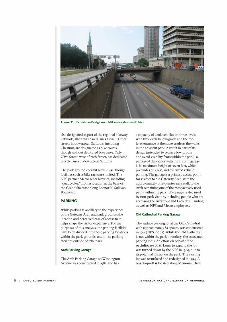
7/29/2019 Jefferson National Expansion Memorial
http://slidepdf.com/reader/full/jefferson-national-expansion-memorial 118/256
J E F F E R S O N N A T I O N A L E X P A N S I O N M E M O R I A L/ AFFECTED ENVIRONMENT98
Figure 33 Pedestrian Bridge over I-70 across Memorial Drive
also designated as part of the regional bikeway
network, albeit via shared lanes as well. Other
streets in downtown St. Louis, including
Chestnut, are designated as bike routes,
though without dedicated bike lanes. Only
Olive Street, west of 20th Street, has dedicated
bicycle lanes in downtown St. Louis.
The park grounds permit bicycle use, thoughfacilities such as bike racks are limited. The
NPS partner Metro rents bicycles, including
“quadcycles,” from a location at the base of
the Grand Staircase along Leonor K. Sullivan
Boulevard.
PARKING
While parking is ancillary to the experience
of the Gateway Arch and park grounds, the
location and perceived ease of access to it
helps shape the visitor experience. For the
purposes of this analysis, the parking facilities
have been divided into those parking locations
within the park grounds, and those parking
facilities outside of tche park.
Arch Parking Garage
The Arch Parking Garage on Washington
Avenue was constructed in 1983, and has
a capacity of 1,208 vehicles on three levels,
with two levels below-grade and the top
level entrance at the same grade as the walks
in the adjacent park. A result in part of its
design (intended to retain a low profile
and avoid visibility from within the park), a
perceived deficiency with the current garage
is its maximum height of seven feet, which
precludes bus, RV, and oversized vehicleparking. The garage is a primary access point
for visitors to the Gateway Arch, with the
approximately one-quarter mile walk to the
Arch remaining one of the most actively used
paths within the park. The garage is also used
by non-park visitors, including people who are
accessing the riverfront and Laclede’s Landing,
as well as NPS and Metro employees.
Old Cathedral Parking Garage
The surface parking lot at the Old Cathedral,
with approximately 87 spaces, was constructed
in 1961 (NPS 1996a). While the Old Cathedral
is not within the park boundary, the associated
parking lot is. An effort on behalf of the
Archdiocese of St. Louis to expand the lot
was turned down by the NPS in 1969, due to
its potential impact on the park. The existing
lot was resurfaced and redesigned in 1994. A
bus drop-off is located along Memorial Drive

7/29/2019 Jefferson National Expansion Memorial
http://slidepdf.com/reader/full/jefferson-national-expansion-memorial 119/256
E N V I R O N M E N T A L A S S E S S M E N T / I M P L E M E N T I N G C I T Y A R C H R I V E R I N I T I A T I V E E L E M E N T S / AF FE CT ED EN VI RO NM EN T 9
adjacent to the Old Cathedral Parking lot.
The pedestrian path from the Old Cathedral
Parking lot provides the shortest barrier free
accessible route to the Gateway Arch and the
Visitor Center/Museum, making it a desirable
drop-off and pick-up location for visitors.
Maintenance Parking Facility
The maintenance facility is located at the south
end of the park. The current facility was built
in 2002, and includes a small parking lot for use
by NPS employees and visitors to the facility.
The lot was expanded from five to ten spaces
in 2007.
On-Street Parking Spaces (Within the Park
Boundary)
Since the official boundary of JeffersonNational Expansion Memorial extends to the
middle of Market and Chestnut Streets, the
area used for on-street parallel parking spaces
on the north side of Market Street, adjacent to
Luther Ely Smith Square, falls within the park
boundary. These 10 spaces are illegal parking
areas, as the street is clearly marked as a no
parking zone, yet they continue to be used
despite frequent issuances of tickets by the
City of St. Louis Parking Violations Bureau.
The other streets around the park (Memorial
Drive, Washington Avenue, Poplar Street, and
Leonor K. Sullivan Boulevard) do not have
on-street parking spaces, though at times
illegal on-street parking occurs along Leonor
K. Sullivan Boulevard, particularly in times of
flooding, when the adjacent levee parking is
underwater.
Off-Site Parking Facilities
Visitors have numerous options for parking
off-site within one-quarter mile of the park and
Central Riverfront. Given the park’s location
in downtown St. Louis, there are many optionsincluding on-street parking, parking along
the levee, nearby private and public parking
garages, and surface lots.
For the purposes of this plan, only those
parking facilities located within one-quarter
mile of the park are considered. It is assumed
that most visitors arriving via private
automobile would typically park within
one-quarter mile (a five-minute walk) of the
park. Some portions of the park, such as the
Old Courthouse and the southern end of the
park grounds, are closer to off-site parking
facilities than they are to the Arch Parking
Garage or the Old Cathedral Parking lot.
Parking Garages and Lots
There are approximately 46,000 parking
spaces located within downtown St.
Louis, with 2,700 of them on-street spaces
(Downtown St. Louis Partnership 2008).
Of these, many off-street spaces are within
one-quarter mile of the park boundary.
The majority of these facilities is utilized by
long-term users, but most have space available
for public use as well. According to the Arch
Parking Alternatives Study Final Report,
prepared for Metro in 2012, there are 28,440public parking spaces, with an estimated 13,000
available to park visitors on a daily basis, within
the downtown area identified in the parking
study (Carl Walker 2012).
Bus and RV Parking
In addition to the bus drop-off location
alongside the Old Cathedral Parking lot,
Leonor K. Sullivan Boulevard, along the east
border of the park, is also used for bus loading
and unloading. Bus and oversize vehicle
parking is currently accommodated along
South Leonor K. Sullivan Boulevard/South
Wharf Street south of the Poplar Street Bridge.
ACCESSIBILITY
NPS Director’s Order 42 defines architectural
accessibility as “the design, construction and/
or alteration of a building or facility that is in
compliance with officially sanctioned design
standards, and that can be entered, and used
by individuals with a disability.” Architectural
accessibility is used in conjunction withthe idea of program accessibility, a concept
used to ensure that “the programs, activities
and opportunities provided to visitors and/
or employees will be provided … in such a
way that individuals with disabilities are not
excluded from, nor denied the benefits of, that
program or activity.”

7/29/2019 Jefferson National Expansion Memorial
http://slidepdf.com/reader/full/jefferson-national-expansion-memorial 120/256
J E F F E R S O N N A T I O N A L E X P A N S I O N M E M O R I A L/ AFFECTED ENVIRONMENT100
Circulation within and around the park
includes both accessible and inaccessible
routes and pathways. The area of the park
that is the least accessible is the East Slopes
between the Gateway Arch and the riverfront.
However, the park has implemented many
measures to ensure that facilities and programsmeet architectural and program accessibility
standards. Accessible architectural and
program experiences are provided through
physical modifications to the park, as well as
through self-activated video programs, large-
print brochures, and telecommunications
device for the deaf (TDD) equipment, and
wheelchairs on request.
The most extensive physical modification
to accommodate barrier-free access was
completed in 1994, when the Old Cathedral
Parking lot was redesigned and reconstructedto provide a bus pull-off along Memorial
Drive. This enables drivers to drop off or pick
up passengers close to the Gateway Arch’s
south leg, near the Old Cathedral. Accessible
parking for visitors is also provided at the Arch
Parking Garage. The most common visitor
complaint about accessibility at the park is the
distance between the Arch Parking Garage and
the Gateway Arch (approximately 1,100 feet).
To provide more accessibility at the Old
Courthouse, a wheelchair lift was installed in
the southwest courtyard in 2007 and replaced
in 2012. This is the only courtyard that may
be accessed by the public. The wheelchair lift
allows access to the first floor and galleries of
the Old Courthouse, which contains exhibits
and visitor information. The second floor of
the courthouse is not accessible as it can only
be reached via a staircase.
The visitor center beneath the Gateway Arch is
accessed via ramps with an eight percent slope
at both the south and north legs. Although the
ramps fall within the Architectural Barriers ActAccessibility Standard (ABAAS) requirements
for steepness of grade, they exceed the
Figure 34 Accessible Walkways Existing
Conditions (Source: MVVA)
Accessible Paths
Inaccessible Paths
Security Perimeter

7/29/2019 Jefferson National Expansion Memorial
http://slidepdf.com/reader/full/jefferson-national-expansion-memorial 121/256
E N V I R O N M E N T A L A S S E S S M E N T / I M P L E M E N T I N G C I T Y A R C H R I V E R I N I T I A T I V E E L E M E N T S / AF FE CT ED EN VI RO NM EN T 1
acceptable length at this grade. In addition,
physically challenged visitors who do not have
a problem conquering the ramps may have
difficulty opening the heavy glass doors once
they reach the visitor center entrances.
Circulation along the Central Riverfrontincludes both accessible and inaccessible
routes and walkways. The sidewalks along
the west side of Leonor K. Sullivan Boulevard
are generally compliant with current ADA
standards. However, there are no ADA
compliant connections between this sidewalk
and the paths and walkways at the top of the
East Slopes of the Arch grounds. Sidewalks
along the east side of Leonor K. Sullivan
Boulevard between Poplar Street and
Washington Avenue do not provide continuous
barrier-free access.
Additionally, there are no accessible routes
along the Central Riverfront south of Poplar
Street, or north of Carr Street. Access from
Leonor K. Sullivan Boulevard to the levee is
provided via concrete switch-back ramps at
two locations near the south and north legs
of the Arch, respectively. These ramps are not
compliant with current ADA standards, and
ADA compliant access along the levee is not
provided. Figure 34 indicates the walkways that
are accessible and areas of the park and the
Central Riverfront that are inaccessible.
SOCIOECONOMICS
Jefferson National Expansion Memorial is
located within the urban area of St. Louis,
Missouri. The park, a major, iconic tourist
attraction, draws millions of visitors each year.
As individuals and families travel to the areathey provide economic stimulus through their
local spending. Given the importance of the
park as a regional attraction, the influence area
for social and economic consideration has
been defined as the City of St. Louis, where
most of the park visitor spending is likely to
occur. The project team collected data for
socioeconomic baseline conditions for the
City of St. Louis. Data was also collected for
St. Louis County, where available, to provide a
broader regional perspective.
ECONOMIC CONTRIBUTIONS OF THE PARK
From 2000 to 2010, the park averaged 2.7
million visitors per year. This includes
individuals coming to the site solely to use
the parking facilities (non-recreation visits)
and those that come to the site during special
events (e.g. Fair of St. Louis). When these two
types of uses are excluded, the park averaged
1.9 million visitors per year over this period
(NPS 2011b). Table 3.1 on page 3-43 of the GMP
provides a breakdown of the annual estimated
visitation to the park from 1998 to 2007.
Figure 35 Visitors Gathering on the Grand Staircase and Central Riverfront during a Special Event

7/29/2019 Jefferson National Expansion Memorial
http://slidepdf.com/reader/full/jefferson-national-expansion-memorial 122/256
J E F F E R S O N N A T I O N A L E X P A N S I O N M E M O R I A L/ AFFECTED ENVIRONMENT102
The economic contribution of the park
during 2010 was estimated by the NPS Money
Generation Model Version 2, developed by
Michigan State University (Stynes 2011a and
2011b). According to this analysis, the park
hosted 2.44 million recreational visitors who
spent $98.44 million in the area (Stynes 2011c).This spending generates additional economic
activity in the form of sales, income, and jobs
through businesses that provide goods and
services to visitors. The jobs cited include full-
time and part-time jobs with seasonal positions
adjusted to an annual basis (Stynes 2011a).
Local and non-local visitor spending is
included to capture all economic activity
associated with park visits in the local area.
Estimates of the economic impact of visitor
spending in the local area generally exclude
spending by local residents, as it is assumedthat if park opportunities were unavailable,
local residents would still spend the money
on other local activities, while visitors from
outside the region would not make the
trip. The economic impacts generated by
visitor spending should be interpreted as the
expected loss in economic activity within the
region if the park were closed (Stynes 2011a). In
2010, the economic impacts of non-local visitor
spending equaled $86.62 million in sales, $37.4
million in labor income, $60.98 million in
value added and 1,309 jobs (Stynes 2011c). The
economic sectors most directly affected by the
economic contribution of the park are lodging,
and restaurants and bars (Stynes 2011b). In
2009, the park directly employed 130 Full
Time Equivalent (FTE) employees and park
partners, Metro and Jefferson National Parks
Association, employed 110 FTE employees
(NPS 2009). These jobs generated additional
labor income in the local area.
SOCIAL CONTRIBUTIONS OF THE PARK
As discussed in the Visitor Use and Experiencesection of this EA, the park serves as an
open green space in the urbanized area of
downtown St. Louis. The park is a resource
for downtown residents and workers, as well
as out of town visitors, as access to parks and
open spaces increases the livability of an area
by providing space for outdoor active and
passive recreation. The pedestrian connections
to the park that are available from downtown
to access the open space can be difficult or
unpleasant to navigate, as discussed above in
the Pedestrian and Bicycle Circulation section
of Visitor Use and Experience.
EMPLOYMENT AND ECONOMICWELFARE
The 2006-2010 American Community Survey
5-Year Estimates list the top five industries
in the City of St. Louis as: (1) educational
services, and health care and social assistance;
(2) arts, entertainment, and recreation,
and accommodation and food services; (3)
professional, scientific, and management, and
administrative and waste management services;
(4) retail trade; and (5) manufacturing. These
occupation sectors make up approximately 69
percent of the civilian employed populationage 16 years and over residing in the city (U.S.
Census Bureau 2010).
Within St. Louis County, the top five industries
for the same time period were identified as:
(1) educational services, and health care and
social assistance; (2) professional, scientific,
and management, and administrative and
waste management services; (3) retail trade; (4)
manufacturing; and (5) finance and insurance,
and real estate and rental and leasing. These
occupation sectors make up approximately 67
percent of the civilian employed population
age 16 years and over residing in the county
(U.S. Census Bureau 2010).
The difference in economic structure of the
City of St. Louis and St. Louis County is shown
in the data reflecting employment by industry.
Both the city and the county have a strong
concentration in the education and health
industry sector, with a higher percentage of
jobs related to health care and social assistance
than to education. The City of St. Louis shows
a stronger concentration in arts, entertainment,and recreation, and accommodation and
food services than the county. Within the
arts and entertainment industry sector in the
city, the largest concentration of jobs is in
accommodation and food services. St. Louis
County shows a stronger concentration in
professional services, finance and real estate,
and trade and manufacturing.
7/29/2019 Jefferson National Expansion Memorial
http://slidepdf.com/reader/full/jefferson-national-expansion-memorial 123/256
E N V I R O N M E N T A L A S S E S S M E N T / I M P L E M E N T I N G C I T Y A R C H R I V E R I N I T I A T I V E E L E M E N T S / AF FE CT ED EN VI RO NM EN T 1
Unemployment over the last ten years in the
St. Louis metro area has tended to follow the
trend of the national economy; however, the
city averages a higher unemployment rate
than the county. In the 2006-2010 American
Community Survey 3-Year Estimates, the
unemployment rate in the City of St. Louiswas approximately 12.7 percent. In St. Louis
County it was estimated at 7 percent (U.S.
Census Bureau 2010a). The Bureau of Labor
Statistics estimated that the seasonally adjusted
unemployment rate in the St. Louis, MO-IL
Metropolitan Statistical Area (MSA), which
includes the City of St. Louis and St. Louis
County, was 10 percent in 2010 (BLS 2011a).
The principal cities in the St. Louis, MO-IL
MSA are St. Louis and St. Charles, Missouri.
The surrounding counties on both sides of the
Mississippi River are also included in the MSA.
In comparison, in 2010 the annual averageunemployment rate for Missouri was estimated
at 9.5 percent, as compared to the national rate
of 9.6 percent (BLS 2011b).
The labor force employed within the city
limits is drawn from both residents and
non-residents. In 2009, approximately 26
percent of the labor force employed within
the City of St. Louis also resided in the city,
while 56 percent of the labor force living in
the City of St. Louis was employed outside of
the city. Approximately 74 percent of the labor
force employed within the City of St. Louis
resided outside of the city and commuted in
for employment purposes (U.S. Census Bureau
2009).
Another perspective on economic welfare is
provided by looking at median household
income and poverty rates. The City of St. Louis
has a lower median household income than
St. Louis County, according to the 2006-2010
American Community Survey 5-year Estimates.
Median household income levels within the
city were 58 percent of those in the county. TheCity of St. Louis also reported poverty levels
that are much higher than the county and the
U.S. as a whole (U.S. Census Bureau 2010a).
ECONOMIC CONTRIBUTIONS OF THECENTRAL RIVERFRONT
An economic impact study of the effect of
ongoing operations along Leonor K. Sullivan
Boulevard and their contributions to the local
economy was undertaken by the Great RiversGreenway District in 2012 (GRG 2012). The
study included the portions of Leonor K.
Sullivan Boulevard along Laclede’s Landing,
the park, and Chouteau’s Landing.
The study estimated that there are
approximately 397,900 local and non-local
visitors to Leonor K. Sullivan Boulevard per
year. Of those visitors, approximately 258,600
are estimated to be non-local visitors. The
overall annual economic impact of visitor
spending along Leonor K. Sullivan Boulevard
on the city’s economy is estimated to be $12.2million. This includes direct spending, the
estimated multiplier effect of the spending,
earnings for jobs along Leonor K. Sullivan
Boulevard, and multiplier jobs for other city
residents. The total number of jobs related
to the economic activity along Leonor K.
Sullivan Boulevard is estimated at 46, with
11 jobs directly related to Leonor K. Sullivan
Boulevard. In addition, the total economic
activity generated by the City of St. Louis’
operations and maintenance of Leonor K.
Sullivan Boulevard is approximately $193,000
annually and supports 2.15 jobs (GRG 2012).

7/29/2019 Jefferson National Expansion Memorial
http://slidepdf.com/reader/full/jefferson-national-expansion-memorial 124/256
J E F F E R S O N N A T I O N A L E X P A N S I O N M E M O R I A L/ AFFECTED ENVIRONMENT104
OPERATIONS ANDMANAGEMENT PARK OPERATIONS ANDMANAGEMENT
The park is administered by theSuperintendent headquartered in the
Old Courthouse. The Superintendent’s
office includes a Deputy Superintendent,
Management Assistant, and Secretary. The
Management Assistant is responsible for all
Special Use Permits, Filming Permits, and
other commercial uses of the park.
There are 130 FTE at the park including
administrative staff, interpretive staff, facilities
and grounds management and maintenance,
and law enforcement. Partner groups provide
staff which account for an additional 110 FTE
(NPS 2009).
Ranger Activities Division
This division is responsible for 24-hour,
365-day law enforcement and physical security
throughout the park grounds and the Gateway
Arch. The park has concurrent jurisdiction
and commissioned rangers enforce state
and federal laws and regulations intended
to safeguard visitors and park resources. In
addition to law enforcement, this divisionis responsible for dispatch and emergency
medical services throughout the park. Rangers
make routine park visitor contacts to ensure
that park regulations are understood and
being met, to check for safety and resource
protection violations, and to respond to or
direct visitor inquiries to appropriate park
staff. As a designated icon park, the Gateway
Arch’s physical security is of paramount
importance. All visitors to the Gateway Arch
are screened via x-ray and magnetometer at
one of the two entrances prior to entering the
facility.
Museum Services and Interpretation
Division
This division includes an Education
Department, Exhibits Department, Theater
and Audio-Visual Department, Curatorial
Department, and Interpretation Department.
The Education Department plans, promotes
and presents education programs, events
and materials about National Park themes,
and resources at the Gateway Arch and
Old Courthouse for families, school and
scout groups, and educators. The Exhibits
Department is responsible for planning andbuilding temporary exhibits on park themes,
and routine maintenance and cleaning of
museum exhibits. The Theater and Audio-
Visual Department handles the operation
and maintenance of the park’s two theaters
and provides the park with AV needs such as
photographs and videos of events, programs,
training, and personnel. The Curatorial
Department manages the park’s library,
provides assistance to researchers, and catalogs
and preserves the park’s archival holdings. The
Interpretation staff is responsible for staffing
public contact points in the park, assistingvisitors with directions, answering questions,
and providing background and historical
information about the park. The staff also plan
and implement public programs and events.
Administration Division
The Division of Administration is responsible
for the park’s budget and financial accounting,
property management, payroll, human
resource management, contracting and
procurement, mail services, filing, and
management of the computer system. This
division is also responsible for concession
management and the park’s telephone system.
Maintenance Division
The Maintenance Division consists of the
Grounds Section, Custodial Services, Building
Services, and Gateway Arch Transportation
System. The Grounds Section is responsible for
caring for the unique, man-made environment
on the park grounds. Staff has an extensive
knowledge not only of horticulture, butseveral other disciplines as well, and manages
vegetation based on NPS policies pertaining to
Integrated Pest Management (IPM). For more
information on tree maintenance practices
on the park grounds, refer to the Jefferson
National Expansion Memorial Landscape
Preservation Maintenance Plan (NPS 2010b).
The Landscape Preservation Maintenance
Plan, completed as a sequel to the 2010 CLR,

7/29/2019 Jefferson National Expansion Memorial
http://slidepdf.com/reader/full/jefferson-national-expansion-memorial 125/256
E N V I R O N M E N T A L A S S E S S M E N T / I M P L E M E N T I N G C I T Y A R C H R I V E R I N I T I A T I V E E L E M E N T S / AF FE CT ED EN VI RO NM EN T 1
provides detailed guidance on best practices
for maintaining the historic character of the
park, and for preventing damage to vegetation
resources due to construction or other
activities.
Duties of the maintenance division includesnow removal, mowing, turf maintenance, pest
management, tree maintenance, irrigation,
landscaping and equipment maintenance,
snow removal, and emptying litter containers.
Custodial Services is responsible for the
cleanliness of the park buildings including
the museum and exhibit areas in the Old
Courthouse. Building Services is responsible
for maintaining the complex heating and air
conditioning units at the park. The Gateway
Arch Transportation System Department is a
group of skilled technicians responsible for
maintaining and repairing the Gateway Archtram system. In addition to work on the trams,
these employees perform extensive work on
electrical and wiring systems in the park.
PARK PARTNERS The park has working relationships with
a variety of groups and organizations in
order to meet operational, interpretive, and
programmatic goals, and will continue to build
on these partnerships. The park is committed
to strengthening relationships with universities,
schools, institutes, and organizations as well as
local, state, and federal agencies to accomplish
a variety of operational needs. In particular, the
park partners described below contribute to
the daily operation of the park.
Metro Business Enterprises
Metro (also known as the Bi-State
Development Agency) was established in 1949
as an interstate compact between Missouri and
Illinois and provides public transit for the St.
Louis metropolitan region. Metro funded andbuilt the Gateway Arch Transportation System
in the 1960s, and continues to administer its
operation. Metro also constructed the Arch
Parking Garage and continues to operate
and maintain the garage. In addition, they
collect park fees and fund exhibits and
other improvements. A large portion of the
fees collected by Metro go towards park
operations.
Jefferson National Parks Association
JNPA operates three stores in the park, and a
wide variety of projects are funded through
their donations including special exhibits and
programs. They play a vital role in the park’s
interpretive effort, with contributions to themuseum education program, exhibits, and
library and archival staffing.
ENERGY REQUIREMENTS ANDCONSERVATION/SUSTAINABILITY Sustainability can be described as the result
achieved by doing things in ways that do not
compromise the environment or its capacity
to provide for present and future generations.
Sustainable practices minimize the short- and
long-term environmental impacts activities
through resource conservation, recycling,waste minimization, and the use of energy
efficient and ecologically responsible materials
and techniques. NPS pursues sustainable
practices whenever possible in all decisions
regarding NPS operations and facilities
management.
The buildings and facilities at the park require
energy and resources for operations and
maintenance. The park’s current energy
requirements include the electrical and
HVAC systems that provide power, heating,
and cooling to the Gateway Arch complex of
104,560 square feet, including the underground
Visitor Center/Museum; the observation
deck at the top of the 630-foot-tall Gateway
Arch; and throughout the facility’s support
rooms and tunnels. The energy needs at
the Old Courthouse include electricity and
steam heating. Cooling is provided in the Old
Courthouse exhibit galleries and second floor
offices via electric window air conditioning
units.
The park grounds and Arch Parking Garagealso require energy and resources for general
maintenance and operations. Energy is
required for mowing, landscaping, snow
removal, and other maintenance activities.
Water resources are needed for irrigation
of the grounds. The Arch Parking Garage
is not fully enclosed and therefore is not
climate-controlled. The turf grass at the park is
maintained to a very high level, using standard

7/29/2019 Jefferson National Expansion Memorial
http://slidepdf.com/reader/full/jefferson-national-expansion-memorial 126/256
J E F F E R S O N N A T I O N A L E X P A N S I O N M E M O R I A L/ AFFECTED ENVIRONMENT106
chemical fertilizers and pesticides. These
inputs contribute to the pollution of the ponds,
the Metropolitan St. Louis Sewer District
(MSD) system, and the Mississippi River. The
complex irrigation system overwaters the turf
which then leads to faster grass growth which
requires increased mowing. Mowing burnsfossil fuels and contributes to urban air and
noise pollution (NPS 2010b).
CENTRAL RIVERFRONT OPERATIONSAND MANAGEMENT The Central Riverfront lies within the
operational and management authority of the
City of St. Louis. The city’s Street Department
is responsible for maintaining over 1,000
miles of city streets and 600 miles of city
alleys. This includes all of the streets along
the Central Riverfront. The City of St. LouisStreets Department is also in charge of the
city’s refuse and recycling programs, traffic
signals, street lighting, and street signs, salting
and plowing city streets, towing abandoned
or damaged cars from the roadways, and for
permitting street or mobile vendors.
The floodwall and levee system along the
Central Riverfront is a Federal Levee built by
the U.S. Army Corps of Engineers, and turned
over to the City of St. Louis for operation and
maintenance. As such, the Street Department
is responsible for all manpower, tools, and
equipment necessary to install, remove,and maintain the closure structures on the
floodwall along the Central Riverfront. The
Street Department also performs and manages
all post-flood cleanup operations on Leonor K.
Sullivan Boulevard and the levee.
Other entities (e.g., the U.S. Army Corps
of Engineers, U.S. Coast Guard) have
jurisdictional responsibilities for management
of the Mississippi River along the Central
Riverfront. However, the operations and
management of these organizations would not
be affected by the proposed Central Riverfrontimprovements, and therefore, they are not
discussed further in this EA.
Figure 36 Central Riverfront along the Park

7/29/2019 Jefferson National Expansion Memorial
http://slidepdf.com/reader/full/jefferson-national-expansion-memorial 127/256
4. Environmental ConsequencesJeerson Naonal Expansion Memor
Environmental Assessment for Implemenng CityArchRiver Iniave Elemen

7/29/2019 Jefferson National Expansion Memorial
http://slidepdf.com/reader/full/jefferson-national-expansion-memorial 128/256
THIS PAGE LEFT INTENTION ALLY BLANK

7/29/2019 Jefferson National Expansion Memorial
http://slidepdf.com/reader/full/jefferson-national-expansion-memorial 129/256
E N V I R O N M E N T A L A S S E S S M E N T / I M P L E M E N T I N G C I T Y A R C H R I V E R I N I T I A T I V E E L E M E N T S /ENVIRONMENTAL C ONSEQUENC ES 1
This “Environmental Consequences” chapter
analyzes both beneficial and adverse impacts
that would result from implementing any of
the alternatives considered in this EA. This
chapter also includes definitions of impact
thresholds (e.g., negligible, minor, moderate,
and major), methods used to analyze impacts,
and the analysis methods used for determiningcumulative impacts. As required by the CEQ
regulations implementing NEPA, a summary
of the environmental consequences for each
alternative is provided in Table 2 which can
be found in “Chapter 2: Alternatives.” The
resource topics presented in this chapter, and
the organization of the topics, correspond to
the resource discussions contained in “Chapter
3: Affected Environment.”
GENERAL METHODOLOGY
FOR ESTABLISHING IMPACTTHRESHOLDS AND MEASURINGEFFECTS BY RESOURCE
The following elements were used in the
general approach for establishing impact
thresholds and/or measuring the effects of the
alternatives on each resource category:
• general analysis methods as described in
guiding regulations, including the context
and duration of environmental effects;
•
basic assumptions used to formulate thespecific methods used in this analysis;
• thresholds used to define the level of
impact resulting from each alternative; and
• methods used to evaluate the cumulative
impacts of each alternative in combination
with unrelated factors or actions affecting
the resources analyzed.
Environmental Consequences
4
These elements are described in the following
sections.
GENERAL ANALYSISMETHODS
The analysis of impacts follows CEQ
guidelines and Director’s Order 12 handbookprocedures (NPS 2001) and is based on the
underlying goal of providing for long-term
protection and conservation of cultural
and natural resources while implementing
CityArchRiver 2015 Initiative projects. This
analysis incorporates the best available
literature applicable to the region, setting,
and the actions being considered in the
alternatives.
As described in Chapter 1, the NPS created an
interdisciplinary team to provide importantinput to the impact analysis. For each resource
topic addressed in this chapter, the applicable
analysis methods are discussed, including
assumptions and impact intensity thresholds.
IMPACT THRESHOLDS
Impact thresholds provide the reader with
an idea of the intensity of a given impact on
a specific topic. The intensity is determined
primarily by comparing the effect to relevant/
appropriate regulations or guidance, scientific
literature and research, or best professionaljudgment. Because intensity varies by impact
topic, impact thresholds are provided
separately for each topic analyzed in this
document. The definitions of these thresholds
are provided throughout the analysis for
negligible, minor, moderate, and major
impacts. In all cases, the impact thresholds are
defined for adverse impacts. Beneficial impacts
are addressed qualitatively.
7/29/2019 Jefferson National Expansion Memorial
http://slidepdf.com/reader/full/jefferson-national-expansion-memorial 130/256
J E F F E R S O N N A T I O N A L E X P A N S I O N M E M O R I A L/ ENVIRONMENTAL C ONSEQUENC ES108
Potential impacts of all alternatives are
described in terms of type (beneficial or
adverse); context; duration (short- or
long-term); and intensity (negligible, minor,
moderate, major). Definitions of these
descriptors include:
Beneficial: A positive change in the condition
or appearance of the resource or value.
Adverse: A change that diminishes or degrades
a resource or value, or detracts from its
appearance or condition.
Context: Context is the environment within
which an impact would occur, such as local,
parkwide, regional, global, affected interests,
society as whole, or any combination of
these. Context is variable and depends on the
circumstances involved with each impact topic.As such, the impact analysis determines the
context, not vice versa.
Duration: The duration of the impact
is described as short-term or long-term.
Duration is variable with each impact topic;
therefore, definitions related to each impact
topic are provided in the specific impact
analysis narrative.
Intensity: Because definitions of impact
intensity (negligible, minor, moderate,and major) vary by impact topic, intensity
thresholds are provided separately for each
impact topic analyzed.
CUMULATIVE IMPACTANALYSIS METHODOLOGY
The CEQ regulations implementing NEPA
require assessment of cumulative impacts
in the decision-making process for federal
projects. Cumulative impacts are defined
as the results of the impact of the proposed
action added to the impacts of other past,present, and reasonably foreseeable future
actions, regardless of what agency (federal or
non-federal) or person undertakes such other
actions (40 CFR 1508.7). These impacts can be
beneficial or adverse. Cumulative impacts are
considered for all alternatives, including the
no-action alternative.
The analysis of cumulative impacts was
accomplished using four steps:
Step 1—Identify Resources Affected: Fully
identify resources affected by any of the
alternatives.
Step 2—Set Boundaries: Identify an
appropriate spatial and temporal boundary for
each resource.
Step 3—Identify Cumulative Action Scenario:
Determine which past, present, and reasonably
foreseeable future actions to include with each
resource.
Step 4—Cumulative Impact Analysis:
Summarize the impacts of these other actions
(x) plus the impacts of the proposed action (y)
to arrive at the total cumulative impact (z).
PAST, PRESENT, AND REASONABLYFORESEEABLE ACTIONS
Cumulative impacts were determined by
combining the impacts of the alternative
being considered with other past, present, and
reasonably foreseeable future actions. Therefore,
it was necessary to identify other past, present, or
reasonably foreseeable future projects and plans
at the park and within the surrounding area. The
projects described below were determined to bepotential contributors to cumulative impacts on
the affected resources, in conjunction with the
potential impacts of the alternatives presented
in this document. Table 5 identifies the past,
present, and future actions that could result in
cumulative impacts to the resources of interest
for this plan. The past actions considered in
this EA are those that have occurred since the
publication of the GMP in 2009. As discussed
in chapter 1, this document is tiered from the
GMP. The present actions considered are those
ongoing at the time this EA was prepared. The
future actions considered are those not yetoccurring but which are planned, programmed,
or scheduled for implementation at the time this
EA was prepared.

7/29/2019 Jefferson National Expansion Memorial
http://slidepdf.com/reader/full/jefferson-national-expansion-memorial 131/256
E N V I R O N M E N T A L A S S E S S M E N T / I M P L E M E N T I N G C I T Y A R C H R I V E R I N I T I A T I V E E L E M E N T S /ENVIRONMENTAL C ONSEQUENC ES 1
Past Actions
Citygarden. Centered on the Gateway Mall,
Citygarden is a recently constructed public
sculpture garden bounded by 8th, 10th, Market,
and Chestnut Streets. The land is owned by the
City of St. Louis, and the sculptures are ownedand maintained by the private nonprofit Gateway
Foundation. The garden includes 24 sculptures
by internationally renowned artists, including
Fernand Leger, Mark di Suvero, and Keith
Haring, with the landscape designed by Nelson
Byrd Woltz. Citygarden had the potential to
impact archeological resources, visitor use and
experience, and socioeconomics.
Cupples Station Ballpark Lofts. These former
warehouses, located west of Busch Stadium,
were constructed in the late 1800s and were
recently converted into loft condos withcommercial/retail space on the first two floors.
Renovation plans for other warehouses also
include residential, office, and retail space but
have not yet been initiated. Cupples Station
Ballpark Lofts had the potential to impact
socioeconomics.
Hyatt Regency St. Louis Riverfront.
Renovations to the hotel were completed in
2010, and include a remodeling of all rooms and
renovation of the sports bar, event spaces and
lobby restaurant. The Hyatt Regency had thepotential to impact socioeconomics.
Old Post Office Plaza. This public space is used
for outdoor events such as weekend markets, film
series, music, and theater. It is part of the Old
Post Office Square area that includes the restored
1884 US Customs House and Post Office, and
retail, residential, and office space. The Old
Post Office Plaza project had the potential to
impact archeological resources, visitor use and
experience, and socioeconomics.
Federal Reserve Bank of St. Louis. The existingFederal Reserve Bank office building on Locust
Street between North Broadway and 4th Street
was renovated, the former Marquette parking
garage was remodeled, an existing parking garage
was demolished, and an outdoor plaza and a
six-story, 100,000-square-foot office addition was
constructed. The Federal Reserve Bank had the
potential to impact archeological resources and
socioeconomics.
Current Actions
Old Courthouse renovations and repairs.
The Old Courthouse copper roof was replaced
in 2011. Four paintings by Karl Ferdinand
Wimar that surround the interior of the
rotunda underwent professional cleaning andconservation in 2011 and 2012. Renovation of the
stone cornices on the exterior of the building
is ongoing, with an expected completion date
of December 2012. A life-sized statue of Dred
and Harriet Scott was installed in front of the
Old Courthouse in June 2012. The following
resources could be impacted by the Old
Courthouse renovations and repairs: historic
buildings, museum collections, soundscape,
visitor use and experience, and operations and
management.
Eads Bridge Restoration. This structuralrehabilitation project includes replacement of
support steel, paint removal and repainting, and
the repair of MetroLink light rail tracks. The
project is expected to be completed by fall 2015.
The Eads Bridge Restoration has the potential
to impact historic buildings and structures,
soundscape, visitor use and experience, and
socioeconomics.
The Mercantile Exchange (MX). The
Mercantile Exchange complex is being
developed to include a hotel, office buildings,a movie theater, and residential and retail
space. This project includes the renovation of
the One City Centre office building, St. Louis
Centre and The Laurel, and the old Dillard’s
building. The MX will be a full-service retail,
dining, entertainment, arts and culture, and
residential district along Washington Avenue.
Streetscape improvements are planned to
include sidewalk cafes, landscaping, and public
art. The development also includes space for
the proposed National Blues Museum, for
which fundraising and planning is ongoing.
The Mercantile Exchange has the potential toimpact archeological resources, visitor use and
experience, and socioeconomics.
Mississippi River Bridge. The I-70 Mississippi
River Bridge project will create a new gateway
between Illinois and Missouri, providing
connections to and throughout St. Louis.
It is located one mile north of the Martin
Luther King Bridge and is currently under

7/29/2019 Jefferson National Expansion Memorial
http://slidepdf.com/reader/full/jefferson-national-expansion-memorial 132/256
J E F F E R S O N N A T I O N A L E X P A N S I O N M E M O R I A L/ ENVIRONMENTAL C ONSEQUENC ES110
construction. The four-lane bridge was designed
to accommodate construction of a companion
bridge in the future. Construction of the bridge
will create a partial interchange with existing
I-70 near Cass Avenue for local street access. A
roadway connection will be constructed between
the existing I-55/64/70 Interchange and the newbridge along the I-64 Connector alignment.
The following resources could be impacted
by the Mississippi River Bridge: archeological
resources, soundscape, floodplains, visitor use
and experience, and socioeconomics.
Future Actions
Kiener Plaza and streetscape improvements.
As part of the CityArchRiver 2015 Initiative,
Kiener Plaza is being redesigned to include
elements such as a water feature, a children’s’
play area, concessions, and programming. Theroadway along Chestnut Street and Market Street
from Tenth Street to Memorial Drive would be
narrowed and the sidewalk expanded, creating
more visual access to the park for pedestrians.
New street trees and landscaping would also
be added. The design intends to increase the
pedestrian activity and connectivity along the
Gateway Mall, from Citygarden through to
Luther Ely Smith Square and the park grounds.
The following resources could be impacted by
the Kiener Plaza and streetscape improvements:
archeological resources, historic buildings andstructures, visitor use and experience, and
socioeconomics.
Construction of the Park Over the Highway
structure. The preferred alternative in MoDOT’s
EA addressing transportation projects adjacent
to the park includes the construction of a
structure over the depressed section of I-70, to
create the park connection over the highway
between Market and Chestnut Streets. The
existing Washington Avenue ramps for I-70/I-44
would be reversed, allowing the existing
five-leg intersection at Washington Avenue andMemorial Drive to be simplified to a four-way
intersection and signalized. The existing bridges
at the Chestnut, Market, and Walnut Street
overpasses would be removed, replaced with
the new single span structure between Chestnut
and Market Streets, and a new bridge at Walnut
Street. The Pine Street bridge would remain and
would be converted to pedestrian use. East of
Memorial Drive, the NPS is considering closing
all or portions of Washington Avenue to through
traffic and so MoDOT is providing for a slip lane
off of I-70 to facilitate vehicular access to the
Arch Parking Garage should it remain.
The structure over I-70 would close northboundMemorial Drive to through-traffic from Walnut
Street to the new Washington Avenue ramps
and southbound Memorial Drive between
Chestnut Street and Market Street. Traffic
around Luther Ely Smith Square would flow
from south to north in a clockwise direction,
going one-way west on Market Street, one-way
north on North 4th Street and one-way east on
Chestnut Street. Bus/car pick-up and drop-off
would occur on the north and south sides of
Luther Ely Smith Square. The structure over I-70
has the potential to impact cultural landscapes,
historic buildings and structures, archeologicalresources, vegetation, soundscape, visitor use
and experience, socioeconomics, and operations
and management.
Visitor Center/Museum roof replacement. The
roof of the Visitor Center/Museum below the
Arch (last repaired in the early 1990s) needs to be
replaced in order to address leaks. The project is
identified by the park as a necessary long-term
maintenance project. Installation of the new
roof would require the removal of the ground
surface above the Visitor Center/Museum roof,directly below the Arch. The existing roof system
would be removed and a new roof structure,
waterproofing, and drainage installed. The lawn
would then be re-graded and seeded to return it
to its existing condition. The following resources
could be impacted by the Visitor Center/
Museum roof replacement: cultural landscapes,
museum collections, vegetation, soundscape,
water resources, visitor use and experience, and
operations and management.
Repair North and South Overlook stairs.
The North and South Overlook stairs needto be repaired to eliminate tripping hazards.
The project is identified by the park as a
necessary long-term maintenance project.
The project would remove cracked and loose
surface material to solid substrate and install
a new stair system. Construction would be
completed at one staircase before construction
at the other staircase begins to facilitate visitor

7/29/2019 Jefferson National Expansion Memorial
http://slidepdf.com/reader/full/jefferson-national-expansion-memorial 133/256
E N V I R O N M E N T A L A S S E S S M E N T / I M P L E M E N T I N G C I T Y A R C H R I V E R I N I T I A T I V E E L E M E N T S /ENVIRONMENTAL C ONSEQUENC ES 1
access between the park and the riverfront.
The demolition and disposal of the existing
step systems at the overlook stairways and the
repair of the stairs would follow the intent of the
Saarinen site design. The adjacent area would be
re-vegetated where any damage occurs during
the construction process. The repair of the northand South Overlook Stairs has the potential
to impact historic buildings and structures,
cultural landscapes, vegetation, soundscape,
water resources, visitor use and experience, and
operations and management.
Emerald Ash Borer Environmental
Assessment. The Rosehill ash trees in the
park, including those that line the Processional
Walk, are monitored for the emerald ash borer.
Once they are detected to be threatened by
the emerald ash borer, the ash trees would be
replaced in phases with a species selected bythe NPS in accordance with the approved EAB
EA (NPS 2011b). The EAB EA has the potential
to impact soundscape, water resources, and
socioeconomic resources. The impacts of the
Rosehill ash tree replacement on park vegetation
was documented in the approved EAB EA.
Metropolitan St. Louis Sewer District
Improvements. The Metropolitan St. Louis
Sewer District (MSD) combined sewer systems
throughout the project area are part of a larger
regional system that collects and treats domestic,commercial and industrial wastewater from
a population of approximately 1.4 million in
the City of St. Louis and nearly all of St. Louis
County. The system covers more than 525 square
miles, and includes seven wastewater treatment
plants, 294 pumping stations and more than
9,630 miles of sewer lines, making it the fourth
largest sewer system in the United States.
In response to a settlement reached between
the United States, the Missouri Coalition for
the Environment Foundation and MSD, MSD
has agreed to make extensive improvementsto its sewer systems and treatment plants, at an
estimated cost of $4.7 billion over the next 23
years, to eliminate illegal overflows of untreated
raw sewage, including basement backups, and
to reduce pollution levels in urban rivers and
streams.
MSD will install a variety of pollution controls,
including the construction of three large storage
tunnels, and expand capacity at two treatment
plants. These controls and similar controls that
MSD has already implemented will result in the
reduction of almost 13 billion gallons per year of
overflows into nearby streams and rivers.
MSD will also develop and implement a
comprehensive plan to eliminate more than 200
illegal discharge points within its sanitary sewer
system as well as comprehensive and proactive
cleaning, maintenance and emergency response
programs to improve sewer system performance
and to eliminate overflows.
MSD will also substantially advance the use
of large scale green infrastructure projects to
control wet weather sewer overflows by investing
at least $100 million in an innovative greeninfrastructure program. Green infrastructure
involves the use of properties to store, infiltrate
and evaporate stormwater to prevent it from
getting into the combined sewer system.
Examples of potential green infrastructure
projects include green roofs, bioretention, green
streets, rain barrels, rain gardens and permeable
pavement (US EPA 2011). The Metropolitan
St. Louis Sewer District Improvements has the
potential to impact water resources.
Poplar Street Bridge Improvements.Theproject would remove the eastbound ramp from
I-70 to the Poplar Street Bridge and provide a
two-lane onramp to the Poplar Street Bridge
from northbound I-55 as well as widen the
eastbound section of the Poplar Street Bridge
to add a third eastbound I-64 lane over the
bridge. These improvements would help to
accommodate eastbound traffic accessing Illinois
communities south of I-64 and ease congestion
on the eastbound lanes of the Poplar Street
Bridge and would occur after completion of
the Mississippi River Bridge construction. The
Poplar Street Bridge Improvements have thepotential to impact transportation resources.

7/29/2019 Jefferson National Expansion Memorial
http://slidepdf.com/reader/full/jefferson-national-expansion-memorial 134/256
J E F F E R S O N N A T I O N A L E X P A N S I O N M E M O R I A L/ ENVIRONMENTAL C ONSEQUENC ES112
Impact Topic Study Area Past Actions Current Actions Future Actions
Historic Buildings,
Structures,
Sites, Objects,
and Districts;and Cultural
Landscapes
The cultural
resources impact
area as defined
in this EA isdepicted in Figure
23 of the Affected
Environment
Section.
NA Old Courthouse
renovations and
repairs; Eads Bridge
Restoration
Construction of
Park Over the
Highway structure;
Kiener Plaza;Visitor Center/
Museum roof
replacement; Repair
North and South
Overlook stairs;
Poplar Street Bridge
improvements
Archeological
Resources
Historic downtown
St. Louis
Citygarden; Old
Post Office Plaza;
Federal Reserve
Bank of St. Louis
The Mercantile
Exchange;
Mississippi River
Bridge
Kiener Plaza;
Construction
of Park Over the
Highway structure;
Poplar Street Bridge
improvements
Museum
Collections
Park boundary NA Old Courthouse
renovations and
repairs
Visitor Center/
Museum roof
replacement
Vegetation Park boundary and
Central Riverfront
NA NA Visitor Center/
Museum roof
replacement;
Repair North and
South Overlook
stairs; Construction
of Park Over the
Highway structure
Soundscape Park boundary and
Central Riverfront
NA Old Courthouse
renovations and
repairs; Eads
Bridge Restoration;
Mississippi River
Bridge
Construction
of Park Over the
Highway structure;
Visitor Center/
Museum roof
replacement;
Emerald Ash Borer
Environmental
Assessment; Repair
North and South
Overlook stairs;
Poplar Street Bridge
improvementsFloodplains Central riverfront NA Mississippi River
Bridge
NA
Table 5 Cumulative Action Scenario

7/29/2019 Jefferson National Expansion Memorial
http://slidepdf.com/reader/full/jefferson-national-expansion-memorial 135/256
E N V I R O N M E N T A L A S S E S S M E N T / I M P L E M E N T I N G C I T Y A R C H R I V E R I N I T I A T I V E E L E M E N T S /ENVIRONMENTAL C ONSEQUENC ES 1
Impact Topic Study Area Past Actions Current Actions Future Actions
Water Resources Park boundary,
Central Riverfront,
and the Mississippi
River adjacent tothe park
NA NA Visitor Center/
Museum roof
replacement; Repair
North and SouthOverlook stairs;
Emerald Ash Borer
Environmental
Assessment;
Construction
of Park Over the
Highway structure;
Metropolitan St.
Louis Sewer District
Improvements
Visitor Use and
Experience
Park boundary,
Central Riverfront,downtown St. Louis
area adjacent to the
park
Citygarden; Old
Post Office Plaza;Eads Bridge
Restoration
Old Courthouse
renovations andrepairs; Mississippi
River Bridge;
The Mercantile
Exchange
Visitor Center/
Museum roof replacement;
Repair North and
South Overlook
stairs; Kiener Plaza
and streetscape
improvements;
Construction
of Park Over the
Highway structure;
Poplar Street Bridge
improvements
Socioeconomics Park boundary,
Central Riverfront,downtown St. Louis
area adjacent to the
park
Citygarden; Cupples
Station BallparkLofts; Hyatt
Regency St. Louis
Riverfront; Federal
Reserve Bank of
St. Louis; Old Post
Office Plaza; Eads
Bridge Restoration
Old Courthouse
renovationsand repairs;
The Mercantile
Exchange;
Mississippi River
Bridge
Visitor Center/
Museum roof replacement; Repair
North and South
Overlook stairs;
Emerald Ash Borer
Environmental
Assessment;
Kiener Plaza
and streetscape
improvements;
Park Over the
Highway structure;
Poplar Street Bridge
improvements
Operations and
Management
Park boundary NA Old Courthouse
renovations and
repairs
Visitor Center/
Museum roof
replacement; Repair
North and South
Overlook stairs;
Park Over the
Highway structure

7/29/2019 Jefferson National Expansion Memorial
http://slidepdf.com/reader/full/jefferson-national-expansion-memorial 136/256
J E F F E R S O N N A T I O N A L E X P A N S I O N M E M O R I A L/ ENVIRONMENTAL C ONSEQUENC ES114
CULTURAL RESOURCES
METHODOLOGY AND ASSUMPTIONSFOR ASSESSING IMPACTS
In this environmental assessment impacts to
cultural resources are evaluated consistentwith the CEQ regulations implementing
NEPA by (1) determining the cultural
resources impact area; (2) identifying
cultural resources present in this area that
are either listed in, or eligible to be listed in,
the National Register of Historic Places; (3)
evaluating the type, context, duration, and
intensity of impacts to National Register
eligible or listed cultural resources; and
(4) considering ways to avoid, minimize
or mitigate adverse effects. These impact
analyses are not intended, however, to comply
with the requirements of Section106 of theNational Historic Preservation Act (a separate
consultation process for compliance with
Section 106 has been initiated; see chapter 5
for additional details).
CEQ regulations and the National Park
Service’s Director’s Order 12 also call for a
discussion of mitigation, as well as an analysis
of how effective the mitigation would be in
reducing the intensity of a potential impact,
e.g. reducing the intensity of an impact from
major to moderate or minor. Any resultantreduction in intensity of impact due to
mitigation, however, is an estimate of the
effectiveness of mitigation under NEPA only
and does not suggest that an adverse effect
under Section 106 of the National Historic
Preservation Act has been avoided. Cultural
resources are non-renewable resources and
adverse effects generally consume, diminish,
or destroy the original historic materials or
form, resulting in a loss in the integrity of
the resource that can never be recovered.
Therefore, although actions determined to
have an adverse effect under Section 106 maybe mitigated, the effect remains adverse.
The NPS guidance for evaluating
impacts (DO-12: Conservation Planning,
Environmental Impact Analysis, and Decision
Making; NPS 2001) requires that impact
assessment be scientific, accurate, and
quantified to the extent possible. For cultural
resources, it is seldom possible to measure
impacts in quantifiable terms; therefore,
impact thresholds must rely heavily on the
professional judgment of resource experts.
HISTORIC BUILDINGS, STRUCTURES,SITES, OBJECTS, AND DISTRICTS
PARKWIDE STRATEGIES
Cultural Resources Impact Area
The cultural resources impact area
encompasses the park boundaries, the
Central Riverfront, and historic buildings,
structures, sites, objects, districts in the
immediate vicinity of the project area that are
listed on, or determined eligible for listing
on, the National Register, or listed in the
City Landmarks Registry. It also includes
cultural landscapes as identified by the
National Park Service. The cultural resourcesimpact area is bounded by Biddle Street to
the north, Leonor K. Sullivan Boulevard and
the levee to the east, and Chouteau Avenue
to the south. The western boundary includes
several demarcations: I-55 south of the park,
Broadway along the park edge including two
blocks further west to encompass Kiener
Plaza, and I-70 north of the MLK Bridge.
A graphic depicting the cultural resources
impact area is provided in chapter 3.
Impact Thresholds
For purposes of analyzing potential impacts
on historic buildings, structures, sites, objects
and districts, the thresholds of change for the
intensity of an impact are defined as follows:
Negligible: Impacts would be at the lowest
levels of detection – barely measurable with
no perceptible consequences.
Minor: Impacts would affect character-
defining features but would not diminish the
overall integrity of the building, structure, site,object or district.
Moderate: Impacts would alter a character-
defining feature(s), diminishing the overall
integrity of the building, structure, site, object
or district. A programmatic agreement is
executed among the National Park Service,
applicable state or tribal historic preservation
officer, and the Advisory Council on Historic

7/29/2019 Jefferson National Expansion Memorial
http://slidepdf.com/reader/full/jefferson-national-expansion-memorial 137/256
E N V I R O N M E N T A L A S S E S S M E N T / I M P L E M E N T I N G C I T Y A R C H R I V E R I N I T I A T I V E E L E M E N T S /ENVIRONMENTAL C ONSEQUENC ES 1
C-
— A prominent or distinctive
aspect, quality, or characteristic of
a historic property that contributes
significantly to its physical
character. Structures, objects,vegetation, spatial relationships,
views, furnishings, decorative
details, and materials may be such
features.
Preservation in accordance with 36 CFR
800.14(b). Measures identified in the
programmatic agreement to minimize or
mitigate adverse impacts reduce the intensity
under NEPA from major to moderate.
Major: Impacts would alter a character-defining feature(s), diminishing the overall
integrity of the building, structure, site, object
or district. Measures to minimize or mitigate
adverse impacts cannot be agreed upon and
the National Park Service and applicable state
or tribal historic preservation officer and/
or Advisory Council are unable to negotiate
and execute a programmatic agreement in
accordance with 36 CFR 800.14(b).
Duration: Short-term impacts would occur
during construction. Long-term impacts
would continue or occur after construction iscomplete.
Impacts of the Alternaves
Alternave 1: No-Acon Alternave
Under alternative 1, the NPS would
landscape the surface of the Park Over
the Highway structure after MoDOT
completes its construction, as discussed in
Cumulative Impacts. During construction
of the landscape, activities such as grading,planting, and staging would be evident in the
short term and have an impact on the NHL
District’s character due to the disturbance
of character-defining features such as
vegetation and topography. This construction-
period change would be reversed once
the construction was completed, so would
not constitute a permanent disruption or
diminishment of the historic integrity of the
district.
The Park Over the Highway landscaping
would create continuous green space betweenLuther Ely Smith Square and the park
grounds would provide enhanced setting
and pedestrian access, both of which are in
keeping with Saarinen/Kiley’s unrealized
design goal of better connecting these
sections of the park. It could also change
the NHL District due to alterations to the
topography and planting, which may alter
the visual relationship between the Old
Courthouse and the Arch. Measures would be
taken to minimize the impact of topographic
changes, which would be subject to additional
design review requirements and Section 106
compliance to ensure the integrity of the
NHL District.
In this alternative, few other changes to the
existing condition of the historic buildings,
structures, sites, objects, and districts would
occur. Historic properties would retain
their integrity and remain in their current
conditions. The Old Courthouse would
remain largely unchanged in appearance and
function; however, the addition of an exterior
lift for accessibility purposes would not have a
substantial impact to the building’s structure,
but would be visible as a noticeable but small
change to the building’s exterior appearance.
In contrast to the action alternatives, with theexception of the creation of the Park Over
the Highway landscape, no other noticeable
changes would occur in the park or along the
levee.
Parkwide and locally, construction-related
impacts under the no-action alternative would
result in short-term minor adverse impacts
to character-defining features of the NHL
District such as vegetation and topography.
The addition of the Park Over the Highway
landscaping would also have long-term minor
adverse impacts to these features, but would
also have long-term beneficial impacts for
example on the setting of the NHL District.
Cumulave Impacts for Alternave 1
Past, ongoing, and reasonably foreseeable
projects within the area of the Jefferson
National Expansion Memorial that have
7/29/2019 Jefferson National Expansion Memorial
http://slidepdf.com/reader/full/jefferson-national-expansion-memorial 138/256
J E F F E R S O N N A T I O N A L E X P A N S I O N M E M O R I A L/ ENVIRONMENTAL C ONSEQUENC ES116
potential impacts on historic buildings,
structures, sites, objects, and districts include:
• Old Courthouse renovations and repairs
• Visitor Center/Museum roof replacement
• Repair North and South Overlook stairs
• Construction of the Park Over the
Highway structure
• Kiener Plaza
• Poplar Street Bridge improvements
The Old Courthouse renovations and repairs
are ongoing, and are expected to improve
the condition of the historic building, as well
as maintain and enhance its integrity. Thereplacement of the roof on the underground
Visitor Center/Museum is anticipated to
occur whether or not the action alternatives
occur. During the construction period, the
roof replacement would require extensive
ground surface and structural disturbance
to the Visitor Center/Museum as well as
the lawn within the park’s primary axis and
vista directly beneath the Arch. However,
the long-term impacts would be beneficial
due to the roof repair; the reduction in leaks
would benefit the historic structure as wellas the collections maintained within it. The
repair of the North and South Overlook
stairs would occur in the future to eliminate
hazards and repair degraded materials. It is
expected to result in negligible short-term
disturbance within the NHL District during
construction that would dismantle the
stairs and limit access, but would support
the historic integrity and condition of the
structure and the district in the long term
due to the resource being repaired and
hazards eliminated. The construction of
the Park Over the Highway structure overI-70 would require demolition, excavation,
grading, construction and staging activities,
and disruptions to pedestrian circulation
in the West Gateway. This construction-
period change would be finished once the
construction was completed, so it would
not constitute a permanent disruption or
diminishment of the historic integrity of the
district. The construction at Kiener Plaza
and surrounding streetscape as well as the
Poplar Street Bridge improvements would
involve construction and staging activities
in the short-term that would be visible from
adjacent historic structures and districts.
The no-action alternative, as noted above,would result in minor short- and long-
term adverse impacts to historic buildings,
structures, sites, objects, and districts.
Combined with the other past, present, and
reasonably foreseeable future actions, there
would be short-term moderate adverse and
long-term minor adverse as well as beneficial
impacts to historic buildings, structures,
sites, objects, and districts. However, this
alternative would contribute minimally to
those impacts.
Alternave 2: Moderate Change
During construction, disruption to traffic,
grading, and other construction-related
impacts would be evident in the short
term and have an effect on the NHL
District’s character due to the disturbance
of character-defining features such as
vegetation, topography, and circulation
features. This construction-period change
would be reversed once the construction
was completed, so it would not constitute
a permanent disruption or diminishmentof the historic integrity of the district. The
historic buildings and structures, objects, and
sites within the park would only be affected
by temporary alterations of appearance
(scaffolding, fencing) to protect visitors or
resources during the construction period.
The most noticeable long-term adverse
impacts would result from the proposed
accessibility changes that would affect
the Gateway Arch and the Visitor Center/
Museum. The addition of both interior
and exterior ramps, handrails, guardrails,and security would alter the structure and
the entrance/exit experience of visitors as
designed by Saarinen. The Park Over the
Highway could change the NHL District due
to alterations to the topography and planting,
which may alter the visual relationship
between the Old Courthouse and the Arch,
Changes to the Old Courthouse to provide
additional access to the first and second

7/29/2019 Jefferson National Expansion Memorial
http://slidepdf.com/reader/full/jefferson-national-expansion-memorial 139/256
E N V I R O N M E N T A L A S S E S S M E N T / I M P L E M E N T I N G C I T Y A R C H R I V E R I N I T I A T I V E E L E M E N T S /ENVIRONMENTAL C ONSEQUENC ES 1
floors would affect the Old Courthouse due
to the addition of ramps on the south façade,
ramps at the doors, and elevators in the
interior; these changes, as well as renovation
of galleries and installation of new exhibits
on the first and second floors would alter
the appearance of the building and may alsoresult in modification to its historic materials
(for example, to install elevator mechanisms).
Changes that would noticeably affect historic
buildings, structures, sites, objects, and
districts in minor ways include topographic
alterations, such as grading around the
North and South Ponds and along the East
Slopes for accessible paths and to control
stormwater runoff. The alteration to adjacent
topography would change the landform
within the grounds adjacent to character-
defining features of the NHL district suchas the overlooks, Grand Staircase, and
railroad tunnels. The addition of two to
four accessible paths on the East Slopes
would require extensive grading, similarly
changing the surrounding topography and
therefore the visitor’s experience as intended
by Kiley-Saarinen. The proposed changes
at the Reflecting Ponds have the potential
to affect character-defining features of the
NHL District, and as a result, the historic
setting of the Gateway Arch. They also
have the potential to affect the setting of adjacent historic properties such as the Old
Cathedral.
The establishment of a continuous security
perimeter would affect the Grand Staircase
and overlooks as bollards are proposed to be
placed at the foot of each of these, creating
a visual barrier that alters the structure’s
character. Alterations to Luther Ely Smith
Square, which is part of the setting of the
Old Courthouse and adjacent historic
buildings such as the International Fur
Exchange, would result in increased trafficand idling vehicles along some of the streets
around the square as visitors are dropped
off. The increased traffic and idling could
affect the historic buildings due to increased
air pollution from particles from exhaust that
are known to cause soiling and damage on
historic façade materials such as stonework.
Also, the proposed changes to the Central
Riverfront would noticeably affect character-
defining features of the NHL District
including the North and South Overlooks
and the Grand Staircase due to the raising
of Leonor K. Sullivan Boulevard’s elevation,
which would change the relationship of thesefeatures to the street, possibly impacting the
structure of the staircase and the overlook
walls’ distinct curved form which is character-
defining. The Central Riverfront project
would not physically alter the historic fabric
of the Eads Bridge, but the addition of fill
adjacent to the footings of the bridge would
have the potential to alter the visual setting of
the bridge, and could obscure portions of the
historic structure from view. These changes
would also alter the historic levee along the
Mississippi River by changing the relationship
of the road and the levee, possibly resultingin the removal or alteration of some of the
levee’s historic cobblestone materials.
The proposed planting plan and mowing
regime in this alternative would not
noticeably affect historic buildings, structures,
sites, objects, and districts due to the
minimal changes proposed, compared to
the vegetation’s existing appearance. The
identified historic buildings, structures,
sites, objects, and districts outside the park
boundary and within the Cultural ResourcesImpact Area would in general not be affected
by the proposed alternative as it is not visible
from the vast majority of them and the
physical changes are small and localized. The
Central Riverfront project would not have a
noticeable impact on the historic buildings
that compose the Laclede’s Landing historic
district, although the grade change at Leonor
K. Sullivan Boulevard along the riverfront
would potentially change the relationship of
the street grades to the levee where they meet.
Some beneficial impacts are expected to arisefrom this alternative. Proposed changes to the
Processional Walks would enhance character-
defining features of the NHL District as well
as the setting of the Gateway Arch. The repair
of drainage and surfacing, potential addition
of cobbles per the Kiley-Saarinen design,
as well as replacement of the declining ash

7/29/2019 Jefferson National Expansion Memorial
http://slidepdf.com/reader/full/jefferson-national-expansion-memorial 140/256
J E F F E R S O N N A T I O N A L E X P A N S I O N M E M O R I A L/ ENVIRONMENTAL C ONSEQUENC ES118
planting with a tree species in a form closer
to the design intent, would have an overall
beneficial impact. Likewise, between Luther
Ely Smith Square and the park grounds the
addition of continuous green space would
provide an enhanced setting and pedestrian
access, both of which are in keeping withSaarinen/Kiley’s unrealized design goal
of better connecting these sections of the
park; this would benefit historic resources.
Proposed changes at the East Slopes would
include denser woodland plantings that
would enhance the intended appearance of
this area, in keeping with how it was designed
by Kiley-Saarinen. In the Central Riverfront,
there would be improved protection from the
river flooding that currently causes risks to
the concrete structure of the overlooks and
the Grand Staircase.
Mitigation measures would be undertaken
to minimize the impact of alterations, such
as topographic and visual changes, which
would be subject to additional design review
requirements and Section 106 compliance to
ensure the integrity of the NHL District and
the historic resources in the Area of Potential
Effects identified in the programmatic
agreement developed during the Section
106 process. The programmatic agreement
includes the establishment of a Collaborative
Design Review Team to review draftschematic and design documents, evaluate
how projects may affect resources within the
Section 106 Area of Potential Effects, and
make recommendations to avoid any adverse
effects.
Parkwide and locally, construction-related
impacts under alternative 2 would result
in short-term moderate adverse impacts
to character-defining features of the NHL
district such as vegetation and topography, as
well as temporary alterations of appearance.
The addition of interior and exterior rampsinto the Visitor Center/Museum, accessibility
modifications at the Old Courthouse, paths
around the North and South ponds and
along the East Slopes, noticeable changes to
character-defining features of the park along
the Central Riverfront, and the addition
of the Park Over the Highway landscaping
would also have parkwide and local long-term
moderate adverse impacts to character-
defining features of the NHL district, such
as vegetation and topography. Negligible to
minor short-term and long-term impacts on
resources outside the park boundary within
the cultural resources impact area wouldoccur due to changes to the relationship
between Leonor K. Sullivan Boulevard and
the historic levee and the addition of fill
adjacent to the Eads Bridge footings. The Park
Over the Highway landscaped connection,
replacement of ash trees and repair of the
Processional Walks, and additional plantings
on the East Slopes would also have long-term
beneficial impacts to other character-defining
features such as circulation features and the
setting of the NHL District.
Cumulave Impacts for Alternave 2
Past, ongoing, and reasonably foreseeable
projects within the area of the Jefferson
National Expansion Memorial that have
potential impacts on historic buildings,
structures, sites, objects, and districts include
the same projects discussed under alternative
1, the no-action alternative, earlier in this
chapter. Cumulative projects described
in alternative 1 that are expected to be
incorporated into the design and construction
process under alternative 2 include the VisitorCenter/Museum roof replacement and repair
of the North and South Overlook stairs.
Alternative 2, as noted above, would involve
some alteration of historic buildings,
structures, sites, objects, and districts, in
particular through changes to their settings
and addition of accessibility and security
measures that alter the visual character of
the resources or their settings. Combined
with the other past, present, and reasonably
foreseeable future actions, there would be
short-term moderate adverse and long-term moderate adverse as well as beneficial
impacts to historic buildings, structures, sites,
objects, and districts. The coordination of
these projects with the implementation of
alternative 2 would serve to lessen the short-
term impacts of each project occurring on its
own.

7/29/2019 Jefferson National Expansion Memorial
http://slidepdf.com/reader/full/jefferson-national-expansion-memorial 141/256
E N V I R O N M E N T A L A S S E S S M E N T / I M P L E M E N T I N G C I T Y A R C H R I V E R I N I T I A T I V E E L E M E N T S /ENVIRONMENTAL C ONSEQUENC ES 1
Alternave 3: Maximum Change
During construction, disruption to traffic,
grading, and other related impacts would
be evident in the short term and would have
an effect on the NHL District’s character
due to the disturbance of character-definingfeatures such as vegetation, topography,
and circulation features. This construction-
period change would be finished once the
construction was completed, so it would
not constitute a permanent diminishment
of the historic integrity of the district. The
historic buildings and structures, objects, and
sites within the park would only be affected
by temporary alterations of appearance
(scaffolding, fencing) to protect visitors or
resources during the construction period.
The greatest impacts would result fromthe addition and alterations to the Visitor
Center/Museum and the West Gateway
area. In alternative 3, changes at the West
Gateway have the potential to affect the
NHL District, the Gateway Arch, the Visitor
Center/Museum, and the Old Courthouse;
and adjacent historic buildings such as the
International Fur Exchange on the south side
of Luther Ely Smith Square. The addition
of grade changes and new structures to add
a new West Entrance to the Visitor Center/
Museum would reshape this section of thepark landscape, resulting in some changes to
the settings of the adjacent historic properties,
as well as altering the physical fabric of the
Visitor Center/Museum and the NHL District
along its primary view axis between the Old
Courthouse and the river. The new glass
façade would have a direct visual connection
to the Old Courthouse and the existing berm
height would be modified, altering the visual
relationship between the Old Courthouse and
the Arch. The use of this area as the park’s
main entryway would result in increased
bus and car traffic at the proposed drop-off area at Luther Ely Smith Square, which
could affect historic buildings and structures
surrounding the square due to increased air
pollution from particles from exhaust that
are known to cause soiling and damage on
historic façade materials such as stonework.
Proposed accessibility changes would affect
the Gateway Arch and the Visitor Center/
Museum through the addition of interior
and exterior ramps, handrails, guardrails, and
security features that would alter the structure
and the entrance/exit experience of visitors as
designed by Saarinen.
Changes that would noticeably affect historicbuildings, structures, sites, objects, and
districts in minor ways include topographic
alterations, such as grading around the
North and South Ponds and along the East
Slopes for accessible paths and to control
stormwater runoff. The alteration to adjacent
topography would change the landform
surrounding the overlooks, Grand Staircase,
and railroad tunnels within the NHL district.
The addition of two to four accessible paths
on the East Slopes would require extensive
grading, similarly changing the surrounding
topography and therefore the visitor’sexperience as intended by Kiley-Saarinen.
The proposed changes at the Reflecting
Ponds have the potential to affect character-
defining features of the NHL District, which
comprises the historic setting of the Gateway
Arch. They also have the potential to affect
the setting of adjacent historic resources such
as the Old Cathedral.
In this action alternative, similar to the
impacts discussed in alternative 2, the
proposed changes to the Old Courthousewould affect this historic building due to
addition of ramps to the building exterior and
elevators in the interior, as well as renovation
of galleries and installation of new exhibits on
the first and second floors. In addition, the
proposed changes to the Central Riverfront,
as described in alternative 2, would affect
character-defining features of the NHL
District including the North and South
Overlooks and the Grand Staircase due to
the raising of Leonor K. Sullivan Boulevard’s
elevation. These changes would also affect
the Eads Bridge and the historic levee alongthe Mississippi River, also as noted above
in alternative 2. Some actions, such as the
proposed planting and mowing regime
(similar to the one discussed in alternative
2), would not have a detectable impact upon
historic buildings, structures, sites, objects,
and districts.
7/29/2019 Jefferson National Expansion Memorial
http://slidepdf.com/reader/full/jefferson-national-expansion-memorial 142/256
J E F F E R S O N N A T I O N A L E X P A N S I O N M E M O R I A L/ ENVIRONMENTAL C ONSEQUENC ES120
Some beneficial impacts would occur under
alternative 3. The proposed addition of
planted park connection across I-70 would
have a beneficial impact on historic buildings,
structures, sites, objects, and districts, as
described under alternative 2 above. In
alternative 3, changes proposed at the NorthGateway would be beneficial, as removal
of the non-historic parking garage would
enhance the setting of character-defining
features of the NHL District as well as
adjacent resources such as Eads Bridge, the
Laclede’s Landing Historic District, and the
North Overlook. Another beneficial result of
eliminating the Arch Parking Garage would
be the opening up of views between the
park and the Eads Bridge, as well as a visual
connection between Laclede’s Landing and
the park through the four portals underneath
the Eads Bridge. In this action alternative,proposed changes at the East Slopes could
have beneficial impacts on character-defining
features of the NHL District including the
railroad tunnel cuts and Grand Staircase
due to the addition of denser woodland
plantings that would enhance the intended
appearance of this area, in keeping with how
it was designed by Kiley-Saarinen. Proposed
changes to the Processional Walks would
have beneficial impacts on character-defining
features of the NHL District as well as the
setting of the Gateway Arch, as the repair of drainage and surfacing, the potential addition
of cobbles per Kiley-Saarinen design, as well
as replacement of the declining ash planting
with a tree species closer to the design intent
would have an overall beneficial impact.
There would also be beneficial impacts
due to improved protection from flooding
that currently causes risks to the concrete
structure of the overlooks and the Grand
Staircase.
Mitigation measures and additional design
review requirements and Section 106compliance would occur as described under
alternative 2.
Parkwide and locally, construction-related
impacts under alternative 3 would result
in short-term moderate adverse impacts
to character-defining features of the NHL
district such as vegetation and topography, as
well as temporary alterations of appearance.
The addition of the new West Entrance façade
and its associated vegetation, circulation,
and topographic changes, the installation of
interior and exterior ramps into the Visitor
Center/Museum, accessibility modifications
at the Old Courthouse, paths around the
North and South ponds and along the EastSlopes, and noticeable changes to the park
landscape along the Central Riverfront
would have parkwide and local long-term
moderate adverse impacts to character-
defining features of the NHL District, such
as vegetation and topography. Negligible to
minor short-term and long-term impacts on
resources outside the park boundary within
the cultural resources impact area would
occur due to changes to relationship between
Leonor K. Sullivan Boulevard and the historic
levee and the addition of fill adjacent to the
Eads Bridge footings. The Park Over theHighway landscaped connection, the removal
of the non-historic Arch Parking Garage,
replacement of ash trees and repair of the
Processional Walks, and additional plantings
on the East Slopes would have long-term
beneficial impacts to other character-defining
features such as circulation features and the
setting of the NHL District.
Cumulave Impacts for Alternave 3
Past, ongoing, and reasonably foreseeableprojects within the area of the Jefferson
National Expansion Memorial that have
potential impacts on historic buildings,
structures, sites, objects, and districts include
the same projects discussed under alternative
1, the no-action alternative. Some cumulative
projects are expected to be incorporated into
the design and construction process under
alternative 3, such as the Visitor Center/
Museum roof replacement and repair of
the North and South Overlook stairs. This
coordination would serve to lessen the short-
term impacts of each project occurring on itsown.
Alternative 3, as noted above, would involve
some alteration of historic buildings,
structures, sites, objects, and districts, in
particular through changes to their settings
and addition of accessibility and security
measures that alter the visual character of
the resources or their settings. Combined
7/29/2019 Jefferson National Expansion Memorial
http://slidepdf.com/reader/full/jefferson-national-expansion-memorial 143/256
E N V I R O N M E N T A L A S S E S S M E N T / I M P L E M E N T I N G C I T Y A R C H R I V E R I N I T I A T I V E E L E M E N T S /ENVIRONMENTAL C ONSEQUENC ES 1
with the other past, present, and reasonably
foreseeable future actions, there would be
short-term moderate adverse and long-term
moderate adverse as well as beneficial impacts
to historic buildings, structures, sites, objects,
and districts.
CULTURAL LANDSCAPES
Study Area/Impact Area
The cultural landscape impact area
encompasses the park boundaries, the Central
Riverfront, and cultural landscapes identified
by the NPS in the immediate vicinity of the
project area. The cultural landscape impact
area is bounded by Biddle Street to the
north, Leonor K. Sullivan Boulevard and the
levee to the east, and Chouteau Avenue to
the south. The western boundary includesseveral demarcations: I-55 south of the park,
Broadway along the park edge including two
blocks further west to encompass Kiener Plaza,
and I-70 north of the MLK Bridge. A graphic
depicting the cultural landscape impact area is
provided on page 64 of chapter 3.
Impact Thresholds
For purposes of analyzing potential impacts
on cultural landscapes, the thresholds of
change for the intensity of an impact aredefined as follows:
Negligible: Impacts would be at the lowest
levels of detection-barely measurable with no
perceptible impacts.
Minor: Impacts to a pattern(s) or feature(s) of
the landscape would not diminish the overall
integrity of the landscape.
Moderate: Impacts to a pattern(s) or
feature(s) of the landscape would diminish
the overall integrity of the landscape. Aprogrammatic agreement is executed among
the National Park Service, applicable state or
tribal historic preservation officer, and the
Advisory Council on Historic Preservation in
accordance with 36 CFR 800.14(b). Measures
identified in the programmatic agreement to
minimize or mitigate adverse impacts reduce
the intensity under NEPA from major to
moderate.
Major: Impacts to a pattern(s) or feature(s)
of the landscape would diminish the overall
integrity of the landscape. Measures to
minimize or mitigate adverse impacts
cannot be agreed upon and the National
Park Service and applicable state or tribal
historic preservation officer and/or AdvisoryCouncil are unable to negotiate and execute a
programmatic agreement in accordance with
36 CFR 800.14(b).
Duration: Short-term impacts would occur
during construction. Long-term impacts
would continue or occur after construction is
complete.
IMPACTS OF THE ALTERNATIVES
Alternave 1: No-Acon Alternave
NPS would landscape the surface of the Park
Over the Highway structure under alternative
1 after MoDOT completes its construction,
as discussed in Cumulative Impacts. During
construction of the landscape, activities
such as grading, planting, and staging would
be evident and would have an impact on
the cultural landscape’s character in the
short term due to temporary alteration
of appearance such as excavation, loss of
vegetation, or fencing.
The landscaping of the Park Over the
Highway would change the cultural landscape
by altering the topography, planting, and
visual relationship along the primary axis
between the Old Courthouse and the Arch.
The Park Over the Highway landscape would
also enhance the primary axial connection
between the Old Courthouse, Arch, and
river, and would be in keeping with Saarinen/
Kiley’s unrealized design goal of better
connecting these sections of the park.
The Processional Walks, an importantcultural landscape feature together with its
adjacent allées of trees, would be maintained.
Please see the approved EAB EA for detailed
assessment of the plans to address the
possible threat of the emerald ash borer on
the Rosehill ash trees in the park, including
the allées (NPS 2011b).

7/29/2019 Jefferson National Expansion Memorial
http://slidepdf.com/reader/full/jefferson-national-expansion-memorial 144/256
J E F F E R S O N N A T I O N A L E X P A N S I O N M E M O R I A L/ ENVIRONMENTAL C ONSEQUENC ES122
The Central Riverfront would remain largely
unchanged; the features of the cultural
landscape including the North and South
Overlooks and Grand Staircase would
continue to risk periodic damage by river
flooding that could result in the loss of the
resource over time.
The East Slopes and Reflecting Ponds would
remain unchanged, with plantings and
lawn retaining their current non-historic
appearance, as rehabilitation of its historic,
denser planted appearance would not be
undertaken.
The Park Over the Highway landscape could
result in perceptible changes to the cultural
landscape of the West Gateway. Mitigation
measures would be undertaken to minimize
the impact of alterations, such as topographicand visual changes, which would be subject
to additional design review requirements and
Section 106 compliance to ensure the integrity
of the cultural landscape. This alternative
would not result in perceptible changes to
cultural landscape features elsewhere in the
park, including the Gateway Arch; the overall
designed landform and spatial organization;
the designed views; the system of Processional
Walks; the single-species allées; the two
ponds; the overlooks, including the stairs; the
railroad open cuts and tunnels; the GrandStaircase; the baldcypress circles; the screen
plantings and depressed service areas; the
entrance ramps into the Gateway Arch; and
the concrete benches.
Parkwide, the no-action alternative would
have short-term minor adverse impacts
due to construction activities that would
disrupt cultural landscape features such as
vegetation and views. The Park Over the
Highway landscape alterations to the visual
relationship between the Old Courthouse
and the Arch and retention of portions of thepark landscape with non-historic appearances
would have long-term minor adverse
impacts to the Jefferson National Expansion
Memorial cultural landscape. However, the
Park Over the Highway would also have
long-term beneficial impacts by enhancing
the primary axial connection between the Old
Courthouse, the park, and the river.
Cumulave Impacts for Alternave 1
Past, ongoing, and reasonably foreseeable
projects within the area of the Jefferson
National Expansion Memorial that have
potential impacts on cultural landscapes
include:
• Construction of the Park Over the
Highway structure
• Visitor Center/Museum roof replacement
• Repair North and South Overlook stairs
The construction of the Park Over the
Highway structure over I-70 would require
demolition, excavation, grading, and other
construction and staging activities in the
West Gateway. It would connect Luther ElySmith Square to the western portion of the
park over the I-70 depressed highway and
change some associated traffic patterns. It is
expected to have a beneficial impact on the
cultural landscape as it would implement
an unrealized connection that is part of the
Saarinen/Kiley conceptual design for the
park; and it would reduce the noise and
views of the highway below, reinforcing
and strengthening the main axis of the
park design, without appreciably altering
character-defining features of the culturallandscape.
The replacement of the roof on the
underground Visitor Center/Museum would
require extensive temporary ground surface
disturbance to the lawn within the park’s
primary axis and vista directly beneath the
Arch. The repair of the North and South
Overlook stairs would also require temporary
ground disturbance and during construction.
The no-action alternative, as noted above,
would involve short- and long-term minoradverse impacts to the cultural landscape,
as well as beneficial impacts. Combined
with the other past, present, and reasonably
foreseeable future actions, there would be
short- and long-term minor adverse and
long-term beneficial impacts to the cultural
landscape. However, this alternative would
contribute minimally to those impacts.

7/29/2019 Jefferson National Expansion Memorial
http://slidepdf.com/reader/full/jefferson-national-expansion-memorial 145/256
E N V I R O N M E N T A L A S S E S S M E N T / I M P L E M E N T I N G C I T Y A R C H R I V E R I N I T I A T I V E E L E M E N T S /ENVIRONMENTAL C ONSEQUENC ES 1
Alternave 2: Moderate Change
During construction, disruption to
traffic, grading and excavation, and other
construction-related impacts would be
evident and would have an impact on the
cultural landscape’s character. The culturallandscape parkwide and locally would be
affected by limiting of access to different areas
as construction is phased, and temporary
alteration of appearance (excavation, loss
of vegetation, fencing) to protect visitors or
resources during the construction period.
Under this alternative, the proposed changes
that would most affect the character-defining
features of the cultural landscape in the long-
term include those planned for accessibility
and involving topographic change. The
landscaping of the Park Over the Highwaywould change the cultural landscape due to
alterations to the topography and planting
that may alter the visual relationship along the
primary axis between the Old Courthouse
and the Arch. The alterations to Luther
Ely Smith Square would also enhance the
primary axial connection between the Old
Courthouse, Arch, and river, resulting in a
beneficial impact from the landscaping of the
Park Over the Highway structure over I-70,
in keeping with Saarinen/Kiley’s unrealized
design goal of better connecting thesesections of the park.
Grading around the North and South
Ponds for accessible paths would affect the
ponds and views in these areas as well as
the sculpted topography of the pond areas.
The addition of accessible paths on the East
Slopes connecting the park to the riverfront
would affect the sculpted topography and
processional routes, and thus alter the visitor’s
experience as intended by Kiley-Saarinen.
New accessibility ramps at the Arch legs;
and park perimeter walls and bollards wouldnoticeably alter the cultural landscape. Slight
regrading in the northwest corner of the park
and the addition of accessible paths on the
East Slopes and pond areas would result in
minor, but noticeable, impacts to the overall
landform and spatial organization. The
proposed changes to the Central Riverfront
could noticeably alter character-defining
features of the cultural landscape including
the North and South Overlooks and the
Grand Staircase due to the raising of Leonor
K. Sullivan Boulevard’s elevation.
Some beneficial impacts are expected to
arise from this alternative. For example, /
proposed changes to the Processional Walksincluding repair of drainage and surfacing,
the potential addition of cobbles per Kiley-
Saarinen design, and replacement of the
declining ash planting with a tree species in a
form closer to the design intent would have a
beneficial impact on the cultural landscape.
Proposed new planting on the East Slopes
with a denser woodland character would
enhance the intended appearance of this
area, in keeping with how it was designed and
originally planted. In the Central Riverfront
area, improved protection from river flooding
by raising Leonor K. Sullivan Boulevardwould be beneficial, protecting the park
landscape more effectively from damage
and erosion by river flooding. Mitigation
measures would be undertaken to minimize
the impact of alterations to the landscape,
such as topographic and spatial organization
changes, which would be subject to additional
design review requirements and Section
106 compliance to ensure the integrity of
the cultural landscape. The programmatic
agreement includes the establishment of a
Collaborative Design Review Team to reviewdraft schematic and design documents,
evaluate how projects may affect resources
within the Section 106 Area of Potential
Effects, and make recommendations to avoid
any adverse effects.
Parkwide, alternative 2 would have short-
term moderate adverse impacts due to
construction activities that would disrupt
the cultural landscape, including vegetation,
topography, and views. Long-term minor
adverse parkwide and local impacts to the
Jefferson National Expansion Memorialcultural landscape would occur due to the
Park Over the Highway landscape alterations
to the visual relationship between the Old
Courthouse and the Arch, changes to the
sculpted topography due to the addition
of paths around the ponds and at the East
Slopes, as well as the addition of interior and
exterior ramps at the Visitor Center/Museum,
and the changes to character-defining features

7/29/2019 Jefferson National Expansion Memorial
http://slidepdf.com/reader/full/jefferson-national-expansion-memorial 146/256
J E F F E R S O N N A T I O N A L E X P A N S I O N M E M O R I A L/ ENVIRONMENTAL C ONSEQUENC ES124
of the landscape such as changes to the North
and South Overlooks and the Grand Staircase.
Long-term beneficial impacts on the cultural
landscape would occur under alternative 2
due to the addition of the landscaped Park
Over the Highway that would reinforce the
Saarinen/Kiley design intent for a connection.In addition, the replacement of the ash
trees and repair of the Processional Walks,
as well as the replanting of the East Slopes
would be in keeping with the Saarinen/Kiley
design intent and would enhance the cultural
landscape.
Cumulave Impacts for Alternave 2
Past, ongoing, and reasonably foreseeable
projects within the area of the Jefferson
National Expansion Memorial that have
potential impacts on cultural landscapesinclude the same projects discussed under
alternative 1, the no-action alternative, earlier
in this section. Some cumulative projects are
expected to be incorporated into the design
and construction process under alternative
2, such as the Visitor Center/Museum roof
replacement and repair of the North and
South Overlook stairs.
Alternative 2, as noted above, would involve
some alteration of cultural landscapes.
Combined with the other past, present, andreasonably foreseeable future projects, there
would be short-term moderate and long-
term minor adverse impacts to the cultural
landscape. There would also be beneficial
impacts. The coordination of these projects
with the implementation of alternative 2
would serve to lessen the short-term impacts
of each project occurring on its own.
Alternave 3: Maximum Change
During construction, disruption to traffic,
grading and excavation, and other relatedimpacts would have an impact on the cultural
landscape. The cultural landscape parkwide
and locally would be affected by limiting
of access to different areas as construction
is phased, and temporary alteration of
appearance (excavation, loss of vegetation,
fencing) to protect visitors or resources
during the construction period.
The greatest impacts to the cultural landscape
would result from the addition and alterations
to the Visitor Center/Museum and especially
in the West Gateway area. In alternative 3,
changes at the West Gateway have the potential
to affect the overall landform and spatial
organization of the park, altering the culturallandscape’s appearance, such as the current
visual axis between the Old Courthouse and
the Arch. The landscaping of the Park Over the
Highway structure over I-70 and a new West
Entrance to the Visitor Center/Museum would
alter the route of pedestrians approaching
the Gateway Arch, the existing berm height
would be modified, and the new glass façade
would have a direct visual connection to the
Old Courthouse, altering the current views
along this primary axis. Proposed accessibility
changes could affect the cultural landscape.
The addition of ramps, handrails, guardrails,and security features would physically and
visually alter the entrances at the Arch legs and
Visitor Center/Museum as well as changing the
overall entrance/exit experience of visitors as
intended by Saarinen.
Changes that would also noticeably affect
cultural landscapes include topographic
alterations, such as grading around the North
and South Ponds and along the East Slopes
for accessible paths and to control stormwater
runoff. This would result in minor alterationsof character-defining features of the cultural
landscape including the landform and spatial
organization, the designed views, and the system
of Processional Walks. The proposed changes
to the Central Riverfront could noticeably
alter character-defining features of the cultural
landscape including the North and South
Overlooks and the Grand Staircase due to
the raising of Leonor K. Sullivan Boulevard’s
elevation. Existing roads, which form the
boundaries of the park, would include altered
traffic patterns and types of traffic. With the
exception of the removal of the through trafficportions of Washington Avenue and portions
of Memorial Drive near the North Gateway,
the existing roads would continue to define
the boundaries of the park, retaining their
spatial role in the cultural landscape. The park’s
pedestrian circulation, the primary circulation
feature of the cultural landscape, would be
maintained and vehicular circulation would
continue to be restricted to the perimeter of the
park.
7/29/2019 Jefferson National Expansion Memorial
http://slidepdf.com/reader/full/jefferson-national-expansion-memorial 147/256
E N V I R O N M E N T A L A S S E S S M E N T / I M P L E M E N T I N G C I T Y A R C H R I V E R I N I T I A T I V E E L E M E N T S /ENVIRONMENTAL C ONSEQUENC ES 1
Some impacts would not have a detectable
effect upon cultural landscapes. For example,
the accessibility changes proposed for the
Old Courthouse and elimination of the Arch
Parking Garage would not have a substantial
impact on the cultural landscape. The Old
Courthouse ramps would be a noticeableaddition to the exterior of the building,
which is part of the larger landscape. The
parking garage area was initially designated
by Saarinen/Kiley for parking, but was not
refined any further in initial designs; the
current garage is relatively low in profile and
unobtrusive within the park, so its removal
would neither alter the historic nor the
existing appearance of the overall landscape
substantially. Plantings would be selected to
be compatible with the historic landscape.
Some beneficial impacts are expected to arisefrom alternative 3, similar to those described
in alternative 2 above. The landscaping of the
Park Over the Highway and related alterations
to Luther Ely Smith Square would strengthen
the primary axial connection between the
Old Courthouse, Arch, and river, in keeping
with Saarinen/Kiley’s unrealized design goal
of better connecting these sections of the
park. In alternative 3, changes proposed at
the North Gateway, such as removal of the
non-historic parking garage, would enhance
the cultural landscape. Proposed changes tothe Processional Walks, including repair of
drainage and surfacing, the potential addition
of cobbles per Kiley-Saarinen design, and
replacement of the declining ash planting
with a tree species in a form closer to the
design intent would enhance these character-
defining features of the cultural landscape.
Proposed new planting on the East Slopes
with a denser woodland character would
enhance the intended appearance of this
area, in keeping with how it was designed
and originally planted although changing
its current appearance. There would alsobe beneficial impacts from raising Leonor
K. Sullivan Boulevard that would improve
protection from flooding and minimize
the potential for loss or damage to the East
Slopes, overlooks, and Grand Staircase. A
programmatic agreement was executed to
identify measures to minimize or mitigate
adverse impacts. Mitigation measures and
additional design review requirements and
Section 106 compliance would occur, as
described under alternative 2.
Parkwide, alternative 3 would have short-
term moderate impacts due to construction
activities that would disrupt the cultural
landscape, including vegetation, topography,and views. Long-term moderate adverse
parkwide and local impacts to the Jefferson
National Expansion Memorial cultural
landscape would occur due to the addition
of the new West Entrance and its associated
paving, planting, and topographic changes; it
would also alter the views along the primary
axis between the Old Courthouse and the
Arch. Changes to the sculpted topography
due to the addition of paths around the
ponds and at the East Slopes, as well as the
addition of interior and exterior ramps at the
Visitor Center/Museum, grading around theponds, and changes to the North and South
Overlooks and the Grand Staircase the along
the Central Riverfront would also contribute
to these adverse impacts. Long-term
beneficial impacts to the cultural landscape
would occur under alternative 3 due to the
addition of the Park Over the Highway in
keeping with the Saarinen/Kiley design intent
for a pedestrian connection. In addition,
beneficial impacts would arise from the
replacement of the ash trees and repair of the
Processional Walks as well as the replanting of the East Slopes, as these changes would be in
keeping with the Saarinen/Kiley design intent
and would enhance the cultural landscape.
Removal of the non-historic parking garage
would enhance the cultural landscape and
the reduction of flooding along the Central
Riverfront would improve protection of the
landscape from flooding,, contributing to the
beneficial impacts.
Cumulave Impacts for Alternave 3
Past, ongoing, and reasonably foreseeableprojects within the area of the Jefferson
National Expansion Memorial that have
potential impacts on cultural landscapes
include the same projects discussed under
alternative 1, the no-action alternative, earlier
in this section. Some cumulative projects are
expected to be incorporated into the design
and construction process under alternative
3, such as the Visitor Center/Museum roof
7/29/2019 Jefferson National Expansion Memorial
http://slidepdf.com/reader/full/jefferson-national-expansion-memorial 148/256
J E F F E R S O N N A T I O N A L E X P A N S I O N M E M O R I A L/ ENVIRONMENTAL C ONSEQUENC ES126
replacement and repair of the North and
South Overlook stairs. This coordination
would serve to lessen the short-term impacts
of each project occurring on its own.
Alternative 3, as noted above, would result
in moderate short-term and long-termadverse impacts to cultural landscapes. There
would also be beneficial impacts. Combined
with other past, present, and reasonably
foreseeable future projects, there would also
be short- and long-term moderate adverse
impacts and some beneficial impacts.
ARCHEOLOGICAL RESOURCES
As archeological resources exist essentially
in subsurface contexts, potential impacts
to archeological resources are assessed
according to the extent to which the proposedalternatives would involve ground disturbing
activities such as excavation or grading.
Analysis of possible impacts to archeological
resources was based on a review of previous
archeological studies, consideration of
the proposed design concepts, and other
information available on the archeological
context of the area.
Study Area/ Area of Potenal Eect
The impact area for archeological resourcesis broadly defined to extend between Biddle
Street and Chouteau Avenue along the
riverfront and bounded on the east by the
Mississippi River and west by Broadway.
While much of the proposed work would
focus on the park grounds and Central
Riverfront, some elements of the project –
particularly elements of the utility systems
such as water lines, electrical lines, and
stormwater management features – may
involve ground-disturbing activities beyond
the park boundary and the Central Riverfront.
Impact Thresholds
For purposes of analyzing potential impacts
on archeological resources, the thresholds
of change for the intensity of an impact are
defined as follows:
Negligible: Impact is at the lowest level of
detection. Impacts would be measurable but
with no perceptible adverse or beneficial
consequences.
Minor: Disturbance of a site(s) results in
little, if any, loss of integrity.
Moderate: Disturbance of a site(s) results inloss of integrity. A programmatic agreement
is executed among the National Park Service,
applicable state or tribal historic preservation
officer, and the Advisory Council on
Historic Preservation in accordance with 36
CFR 800.14(b). Measures identified in the
programmatic agreement to minimize or
mitigate adverse impacts reduce the intensity
under NEPA from major to moderate.
Major: Disturbance of a site(s) results in loss
of integrity. Measures to minimize or mitigate
adverse impacts cannot be agreed upon andthe National Park Service and applicable state
or tribal historic preservation officer and/
or Advisory Council are unable to negotiate
and execute a programmatic agreement in
accordance with 36 CFR 800.14(b).
Duration: Archeological resources are
non-renewable. Once an impact occurs, the
effect is irreversible and permanent; therefore
duration is not identified within this analysis.
IMPACTS OF THE ALTERNATIVES
Alternave 1: No-Acon Alternave
In the cultural resources impact area,
archeological resources are located in
subsurface contexts, and are primarily
anticipated to be affected by ground-
disturbing activities such as excavation or
grading. Under alternative 1, the NPS would
landscape the surface of the Park Over the
Highway structure after MoDOT completes
its construction, as discussed in Cumulative
Impacts. During construction, activitiessuch as grading the berm at Memorial Drive
and planting would occur and could disturb
archeological resources if unanticipated
resources are located in the vicinity of these
activities. Prior to initiating any ground-
disturbing activities, the area would be
evaluated for its potential to contribute
archeological information. The guidance and
mitigation measures regarding the treatment
7/29/2019 Jefferson National Expansion Memorial
http://slidepdf.com/reader/full/jefferson-national-expansion-memorial 149/256
E N V I R O N M E N T A L A S S E S S M E N T / I M P L E M E N T I N G C I T Y A R C H R I V E R I N I T I A T I V E E L E M E N T S /ENVIRONMENTAL C ONSEQUENC ES 1
of archeological resources developed through
the Section 106 process would be followed
if previously unreported and unanticipated
resources were to be found during
construction of the Park Over the Highway
to ensure the resources would be properly
handled.
Various maintenance activities such as tree
and shrub removal and replacement, turf
replacement, irrigation and pavement repair
or replacement, and utility work could result
in excavation and grading within the park
and may have an impact on archeological
resources if they exist below ground in those
locations. If archeological resources were
encountered during ground disturbances
proposed under the no-action alternative
related to ongoing and planned maintenance
at the park, they would be addressed by theNPS standard operating procedures which
encourage monitoring of excavation activities
in high-potential areas as well as resource
preservation through avoidance.
Any ground disturbance related to
maintenance activities would be limited in
size and depth and would occur primarily in
previously disturbed areas. The Park Over
the Highway landscape would constitute a
larger disruption at Luther Ely Smith Square
and the western edge of the park alongMemorial Drive and could disturb as-yet
unidentified archeological resources, which
could result in a loss of integrity; however, the
mitigation measures described above would
be implemented to minimize impacts. Overall,
alternative 1 would cause minor adverse
impacts to archeological resources.
Cumulave Impacts for Alternave 1
Past, ongoing, and reasonably foreseeable
projects within the area of the Jefferson
National Expansion Memorial that havepotential impacts on archeological resources
include:
• Citygarden
• Old Post Office Plaza
• Federal Reserve Bank of St. Louis
• The Mercantile Exchange (MX)
• The Mississippi River Bridge
• Kiener Plaza and streetscape
improvements
• Construction of the Park Over the
Highway structure
• Visitor Center/Museum roof replacement
• Ballpark Village
• Bottle District
• Poplar Street Bridge improvements
These cumulative projects involve some
amount of excavation and/or grading. Asdescribed in the GMP (on pages 3-24 to
3-27), archeological sites recorded within
St. Louis such as Cochran Gardens, Walsh’s
Row, and Lafayette Avenue illustrate that
even under significant amounts of building
rubble, intact material remains below the
surface of St. Louis. The projects at Old
Post Office Plaza, Federal Reserve Bank
of St. Louis, Mercantile Exchange (MX),
the Mississippi River Bridge, the Poplar
Street Bridge improvements, and the Park
Over the Highway structure all involve newconstruction requiring excavation and ground
disturbance, increasing the likelihood that
as-yet unidentified archeological resources
could be affected by being uncovered from
their subsurface context and/or damaged
by construction equipment before they can
be properly evaluated. The Kiener Plaza
and streetscape improvements also have the
potential for ground disturbance to uncover
or affect archeological resources.
The Visitor Center/Museum Roof
Replacement would require excavation inareas that were disturbed when the Visitor
Center/Museum was originally constructed,
but could affect as-yet unrecorded adjacent
archeological resources.
The no-action alternative, as noted above,
would result in minor adverse impacts
to archeological resources. Combined
with other past, present, and reasonably

7/29/2019 Jefferson National Expansion Memorial
http://slidepdf.com/reader/full/jefferson-national-expansion-memorial 150/256
J E F F E R S O N N A T I O N A L E X P A N S I O N M E M O R I A L/ ENVIRONMENTAL C ONSEQUENC ES128
foreseeable future actions, there could be
moderate adverse cumulative impacts to
archeological resources in historic downtown
St. Louis from ground-disturbing activities
associated with the combined projects. This
alternative would contribute minimally to
these impacts.
Alternave 2: Moderate Change
As archeological resources are located in
subsurface contexts, they are primarily
anticipated to be affected by ground-
disturbing activities such as excavation or
grading. In this alternative, several project
elements would require ground disturbance
activities that would be somewhat limited in
size and depth and would occur primarily
in previously disturbed areas of the park.
Excavation for implementation of perimetersecurity measures such as bollards would
occur in limited areas. Some grading would
occur to create new accessible paths at the
ponds and the East Slopes. The removal
and replacement of the Rosehill ash trees
would include excavation and ground
disturbance along the Processional Walks
to remove and replant the trees, as well as
to provide improved drainage. The addition
of new exterior ramps to access the Visitor
Center/Museum would require some ground
disturbance as would the planting of newtrees and other vegetation along the East
Slopes, ponds, and other areas within the
park. Ground-disturbing activities would
occur along the Central Riverfront in order to
construct the multi-modal roadway.
The regrading of the berm at Memorial Drive
and grading at Luther Ely Smith Square would
be required to facilitate the Park Over the
Highway landscape connection across I-70
between Luther Ely Smith Square and the
park. These activities would create a larger
area of disruption and could disturb as-yetunidentified archeological resources.
As the precise locations of archeological
resources are not known throughout the
entire project area, it is possible that many
project elements could disturb previously
unknown archeological resources. The
programmatic agreement developed during
the Section 106 process provides mitigation
measures and guidance on archeological
resources identification prior to any ground
disturbance, as well as treatment measures
if resources are identified. The parameters
of the programmatic agreement would be
used to determine procedures to be followed
in the event that previously unreported andunanticipated resources were to be found
during construction, and would provide
guidance to ensure the resources are properly
handled.
Parkwide and along the Central Riverfront,
ground disturbances related to the project
elements could disrupt or displace unknown
archeological resources and result in a loss
of integrity of the archeological resource.
However, the mitigation measures established
in the programmatic agreement would be
implemented to minimize or mitigate adverseimpacts. As a result, alternative 2 would have
moderate adverse impacts to archeological
resources in the cultural resources impact
area.
Cumulave Impacts for Alternave 2
Past, ongoing, and reasonably foreseeable
projects within the area of the Jefferson
National Expansion Memorial that have
potential impacts on archeological sites
include the same projects discussed underalternative 1, the no-action alternative, earlier
in this section. Some cumulative projects are
expected to be incorporated into the design
and construction process under alternative
2, such as the Visitor Center/Museum roof
replacement.
Alternative 2, as noted above, would result in
moderate adverse impacts to archeological
sites. Combined with other past, present,
and reasonably foreseeable future actions,
there could be moderate adverse cumulative
impacts to archeological resources in historicdowntown St. Louis from ground-disturbing
activities associated with the combined
projects. These cumulative projects, mostly
within the vicinity but not inside the areas of
the park affected by alternative 2, are identical
to the impacts noted under cumulative
impacts in alternative 1 above. This alternative
would contribute somewhat to impacts on
archeological resources.

7/29/2019 Jefferson National Expansion Memorial
http://slidepdf.com/reader/full/jefferson-national-expansion-memorial 151/256
E N V I R O N M E N T A L A S S E S S M E N T / I M P L E M E N T I N G C I T Y A R C H R I V E R I N I T I A T I V E E L E M E N T S /ENVIRONMENTAL C ONSEQUENC ES 1
Alternave 3: Maximum Change
As noted earlier, archeological resources are
located in subsurface contexts. Alternative
3 would include the ground-disturbing
activities described in alternative 2 and
would have similar impacts on archeologicalresources. In addition, the expansion of
the Visitor Center/Museum underground
to the west of the existing Visitor Center/
Museum and the addition of the new West
Entrance would have an impact on any as-yet
unidentified archeological resources in that
area due to extensive subsurface excavation.
The removal of the parking garage would
require extensive excavation and could
disturb as-yet intact subsurface archeological
resources in the vicinity of the existing
garage, although this area has been previously
disturbed due to the garage’s construction.
As noted in alternative 2, the precise
locations of all archeological resources in
the project area are not known and therefore
the project elements have the potential to
disturb previously unknown archeological
sites. Therefore, as part of the programmatic
agreement developed during the Section 106
process, mitigation measures and guidance
on archeological resources identification
prior to any ground disturbances were
developed, as well as treatment measures if resources are identified. The parameters of
the programmatic agreement would be used
to determine procedures to be followed in
the event that previously unreported and
unanticipated resources were to be found
during construction and would provide
guidance to ensure the resources are properly
handled.
Parkwide and along the Central Riverfront,
ground disturbances related to the project
elements could disrupt or displace unknown
archeological resources and therefore havethe potential to result in a loss of integrity
of archeological resources. However,
the mitigation measures established in
the programmatic agreement would be
implemented to minimize or mitigate adverse
impacts. As a result, alternative 3 would have
moderate adverse impacts to archeological
resources in the cultural resources impact
area.
Cumulave Impacts for Alternave 3
Past, ongoing, and reasonably foreseeable
projects within the area of the Jefferson
National Expansion Memorial that have
potential impacts on archeological sites
include the same projects discussed underalternative 1, the no-action alternative, earlier
in this section. Some cumulative projects are
expected to be incorporated into the design
and construction process under alternative
3, such as the Visitor Center/Museum roof
replacement.
Alternative 3, as noted above, would result in
moderate adverse impacts to archeological
sites. Combined with other past, present,
and reasonably foreseeable future actions,
there could be moderate adverse cumulative
impacts to archeological resources in historicdowntown St. Louis from ground-disturbing
activities associated with the combined
projects. These cumulative projects, mostly
within the vicinity but not inside the
areas of the park affected by alternative 3,
are identical to the impacts noted under
cumulative impacts in alternatives 1 and 2
above. This alternative has the potential to
contribute substantially to adverse impacts
on archeological resources.
MUSEUM COLLECTIONS
Study Area
The study area for museum collections is
defined by the park’s boundar y.
Impact Thresholds
The following thresholds were used to
determine the magnitude of impacts on
museum collections.
Negligible: Impact is at the lowest levelsof detection — barely measurable with no
perceptible consequences.
Minor: Impact(s) would affect the integrity of
few items in the museum collection but would
not degrade the usefulness of the collection
for future research and interpretation.

7/29/2019 Jefferson National Expansion Memorial
http://slidepdf.com/reader/full/jefferson-national-expansion-memorial 152/256
J E F F E R S O N N A T I O N A L E X P A N S I O N M E M O R I A L/ ENVIRONMENTAL C ONSEQUENC ES130
Moderate: Impact(s) would affect the integrity
of many items in the museum collection and
diminish the usefulness of the collection for
future research and interpretation.
Major: Impact(s) would affect the integrity
of most items in the museum collection anddestroy the usefulness of the collection for
future research and interpretation.
Duration: Short-term impacts would occur
during construction. Long-term impacts
would occur during operations after
construction is complete.
Impacts of the Alternaves
Alternave 1: No-Acon Alternave
Under the no-action alternative, there wouldbe no changes to museum collections. At
the Visitor Center/Museum, existing space,
access, electrical and HVAC, and pest control
issues that currently exist would continue and
collections could be damaged by poor storage
conditions, lack of access for curatorial care,
temperature and humidity-related conditions
outside of acceptable range, and damage from
pests that may infest delicate materials such
as historic paper or fabric items. At the Old
Courthouse, access, poor storage conditions
and other issues such as insufficient buildingclimate control systems, would remain as well.
While these conditions could cause damage
to or affect the integrity of a limited number
of items in the museum collection, they
would not cause the overall degradation of
the collection or its usefulness for future
research and interpretation. Visitors and
researchers would continue to have access to
the collections and they would be maintained
using existing practices and protocols.
Therefore, alternative 1 would have minor
short-term adverse impacts and long-termnegligible to minor adverse impacts to
museum collections.
Cumulave Impacts for Alternave 1
Past, ongoing, and reasonably foreseeable
projects within the area of the Jefferson
National Expansion Memorial that have
potential impacts on museum collections
include:
•Old Courthouse renovations and repairs
•Visitor Center/Museum roof replacement
In the short term, access to exhibits and
collections could be interrupted during
construction related to the Old Courthouse
renovations and the Visitor Center/
Museum roof replacement and resources
may be temporarily removed to protect
them. The renovations and repairs on the
Old Courthouse would help to protect the
collections with updated systems such as
improved temperature and humidity control.
The repair or replacement of the roof on the
existing Visitor Center/Museum, a previously
planned project, would result in long-termbeneficial impacts as it would diminish the
possibility of damage to collections as a result
of the roof leaking.
Alternative 1 would result in minor short-term
adverse and long-term negligible to minor
adverse impacts to museum collections.
Combined with other past, present, and
reasonably foreseeable future actions,
there would be minor short-term adverse
cumulative impacts and long-term negligible
to minor adverse cumulative impacts as wellas some long-term beneficial cumulative
impacts. This alternative would contribute
minimally to those impacts.
Alternave 2: Moderate Change
The renovation activities at the Visitor Center/
Museum and the Old Courthouse would
limit visitor, researcher, and staff access to
collections as portions would be moved or
put into storage. This limited access to various
exhibits and collections would be temporary
as the collections would be returned toexhibition and storage locations after the
completion of renovations.
The proposed renovations to the Visitor
Center/Museum would remedy existing
electrical and HVAC limitations to help
improve climate control for the collections.
This would help to preserve the integrity
of the museum collections. The proposed

7/29/2019 Jefferson National Expansion Memorial
http://slidepdf.com/reader/full/jefferson-national-expansion-memorial 153/256
E N V I R O N M E N T A L A S S E S S M E N T / I M P L E M E N T I N G C I T Y A R C H R I V E R I N I T I A T I V E E L E M E N T S /ENVIRONMENTAL C ONSEQUENC ES 1
renovations could also provide easier access
to the collections to help facilitate their
management, preservation, interpretation,
and research. Proposed changes at the Old
Courthouse include renovations of the
galleries and spaces on the first and second
floors and would also provide improvedbuilding systems that could help improve
climate control to better preserve collections
held there.
Under alternative 2, the temporary disruption
to visitor, researcher, and staff access to the
collections would cause short-term minor
adverse impacts as the collections would
continue to be protected and managed by
staff while in storage or in alternate locations
and visitor and researcher access would
be only be limited temporarily, with access
to the collections provided as feasible.The improvements in climate control, the
renovation of existing collections spaces
within the Visitor Center/Museum and the
Old Courthouse, the improved access to the
collections, and updated space for collections
management, preservation, and interpretation
would help to preserve the long-term
usefulness of the collections for research and
interpretation and would result in long-term
beneficial impacts to museum collections.
Cumulave Impacts for Alternave 2
Past, ongoing, and reasonably foreseeable
projects within the area of the Jefferson
National Expansion Memorial that have
potential impacts on museum collections
include the same projects discussed above
under alternative 1, the no-action alternative.
Some cumulative projects are expected to be
incorporated into the design and construction
process under alternative 2, such as the Visitor
Center/Museum roof replacement and repairs
and renovations of the Old Courthouse.
This coordination would serve to lessen theshort-term impacts of each project occurring
on its own.
Alternative 2, as noted above, would result
in short-term minor adverse and long-term
beneficial impacts to museum collections.
Combined with other past, present, and
reasonably foreseeable future actions, there
would also be short-term minor adverse and
long-term beneficial cumulative impacts.
Alternative 2 would contribute somewhat
considerably to impacts on museum
collections.
Alternave 3: Maximum Change
Under alternative 3, during construction
activities for renovations and the addition
of new space at the Visitor Center/Museum
and renovations at the Old Courthouse,
access to collections would be limited and
exhibits would be moved or put in storage.
This limited access to various exhibits and
collections would be temporary as the
collections would be returned to exhibition
and storage locations after the completion of
construction.
Proposed actions include the renovationof existing space and the addition of new
space within the Visitor Center/Museum
and renovation of galleries on the first and
second floors of the Old Courthouse. The
renovations and increased museum collection
space at the Visitor Center/Museum would
remedy existing electrical and HVAC
limitations to help improve climate control for
the collections. This would help to preserve
the integrity of the museum collections.
The proposed renovations and new Visitor
Center/Museum space would provide easieraccess to the collections for management,
preservation, interpretation, and research.
The addition of the West Entrance would
introduce some natural l ight into the Visitor
Center/Museum and the placement and
types of museum collections exhibits and
storage would take this into account in
order to properly protect collections. The
renovation of galleries on the first and second
floors of the Old Courthouse would provide
improved building systems that could help
improve climate control to better preserve the
collections held there.
During construction of alternative 3, the
temporary disruption to visitor, researcher,
and staff access to the collections would cause
short-term minor adverse impacts as the
collections would continue to be protected
and managed by staff while in storage or in
alternate locations and visitor and researcher
access would be only be limited temporarily,

7/29/2019 Jefferson National Expansion Memorial
http://slidepdf.com/reader/full/jefferson-national-expansion-memorial 154/256
J E F F E R S O N N A T I O N A L E X P A N S I O N M E M O R I A L/ ENVIRONMENTAL C ONSEQUENC ES132
with access to the collections provided
as feasible. The improvements in climate
control, the updated and increased space for
collections in the Visitor Center/Museum
and renovated space in the Old Courthouse,
the improved access to the collections, and
improved space for collections management,interpretation, and preservation would help
to preserve the long-term usefulness of the
collections for research and interpretation
and would result in long-term beneficial
impacts to museum collections.
Cumulave Impacts for Alternave 3
Past, ongoing, and reasonably foreseeable
projects within the area of the Jefferson
National Expansion Memorial that have
potential impacts on museum collections
include the same projects discussed aboveunder alternative 1, the no-action alternative.
Some cumulative projects are expected to be
incorporated into the design and construction
process under alternative 3, such as the Visitor
Center/Museum roof replacement and repairs
and renovations of the Old Courthouse.
This coordination would serve to lessen the
short-term impacts of each project occurring
on its own.
Alternative 3, as noted above, would result
in short-term minor adverse and long-termbeneficial impacts to museum collections.
Combined with other past, present, and
reasonably foreseeable future actions, there
would also be short-term minor adverse and
long-term beneficial cumulative impacts.
Alternative 3 would contribute somewhat
considerably to impacts on museum
collections.

7/29/2019 Jefferson National Expansion Memorial
http://slidepdf.com/reader/full/jefferson-national-expansion-memorial 155/256
E N V I R O N M E N T A L A S S E S S M E N T / I M P L E M E N T I N G C I T Y A R C H R I V E R I N I T I A T I V E E L E M E N T S /ENVIRONMENTAL C ONSEQUENC ES 1
NATURAL RESOURCES
VEGETATION
Methodology for Assessing Impacts
Available information on the vegetationwas compiled and reviewed. Impacts
on vegetation were based on general
characteristics of the site and vicinity, site
observations, previous studies on the health
of park vegetation and potential threats, and
proposed encroachment into vegetated areas
associated with the proposed construction
and project elements.
Study Area
The study area for the inventory and analysis
of vegetation is the area encompassed bythe park’s boundaries. The study area also
includes the area along the Central Riverfront
adjacent to the levee and the Mississippi
River, between Biddle Street and Chouteau
Avenue.
Impact Thresholds
The thresholds of change for the intensity of
an impact on vegetation are as follows:
Negligible: Very few individual trees, maturelandscape plantings, or turf would be
affected.
Minor: A few individual trees and mature
landscape plantings, or a small amount of
turf would be affected. Mitigation measures
such as replanting to avoid or offset impacts
on trees could be implemented and would
be effective in replacing or reducing losses of
vegetation.
Moderate: A relatively large number of
individual trees, mature landscape plantings,or turf would be affected. Mitigation
measures such as replanting to avoid or offset
impacts on trees and other landscaping of
greater concern could be implemented and
would be effective in replacing or reducing
losses of vegetation, but extended time may
be needed for the regeneration of lost mature
vegetation.
Major: A substantial volume of individual
trees, mature landscape plantings, and turf
would be affected, and numerous older
mature trees would also be impacted,
either directly or indirectly. Actions would
substantially change the vegetation over
a large area in the study area. Extensivemitigation would be needed to offset adverse
impacts, and its success would not be assured.
Duration: Short-term impacts would occur
during construction and would take less than
one year to recover after the disturbance or
change occurs; long-term impacts would
occur or continue after construction is
complete.
Impacts of the Alternaves
Alternave 1: No-Acon Alternave
Under alternative 1, MoDOT would construct
the Park Over the Highway structure over
I-70, as discussed in Cumulative Impacts. The
National Park Service would landscape the
surface of the structure after completion of
MoDOT’s construction. Grading, planting,
and landscaping staging activities at the West
Gateway and on the eastern side of Luther
Ely Smith Square would temporarily disturb
and remove some vegetation, primarily turf
grass, in these locations. Upon completionof construction, grassed areas would be
re-vegetated.
Due to its location in an urban park, the
park vegetation undergoes daily wear and
tear and the turf grass lawn is heavily used.
This wear and tear is expected to continue
through normal visitor use. In areas of the
park where special events are held, high levels
of pedestrian foot traffic occur in vegetated
areas. Vegetation would be maintained
in accordance with current practices that
were developed as a routine maintenanceprogram for the reha¬bilitation of damaged or
degraded vegetation that is described in the
Landscape Preservation Maintenance Plan
(NPS 2010b). The surface on the Park Over
the Highway structure would be landscaped
and would increase the amount vegetative
area in the park, which would be maintained
as part of the park’s maintenance program.

7/29/2019 Jefferson National Expansion Memorial
http://slidepdf.com/reader/full/jefferson-national-expansion-memorial 156/256
J E F F E R S O N N A T I O N A L E X P A N S I O N M E M O R I A L/ ENVIRONMENTAL C ONSEQUENC ES134
As the park’s vegetation is comprised of a
formally planned landscape, impacts to the
landscape design are analyzed in this EA
under Cultural Landscapes. Overall, under
alternative 1, there would be short-term minor
adverse impacts to vegetation in the park
during construction and while the vegetationmatures along the Park Over the Highway and
negligible long-term impacts to vegetation in
the park and along the Central Riverfront as
these areas would remain largely unchanged.
There would also be long-term beneficial
impacts to vegetation due to the increase
in vegetative surface on the Park Over the
Highway.
Cumulave Impacts for Alternave 1
Past, present, and reasonably foreseeable
future projects within the area of the JeffersonNational Expansion Memorial that have
potential impacts on vegetation include:
• Visitor Center/Museum roof replacement
• Repair North and South Overlook stairs
• Construction of the Park Over the
Highway structure
These projects would require construction
activities that would disturb vegetation inthe park. Replacement of the Visitor Center/
Museum roof would require the removal
of the turf grass lawn covering the existing
Visitor Center/Museum. The lawn would be
re-vegetated when construction is complete.
The demolition and construction required
to repair the North and South Overlook
stairs would remove some existing vegetation
adjacent to the Overlook steps, which would
be replaced following completion of the
construction process. The construction of the
Park Over the Highway structure over I-70
would disturb vegetation at Luther Ely SmithSquare and the West Gateway. Turf grass and
a limited number of trees would be removed
due to demolition, excavation, grading, and
staging of construction equipment. Best
management practices would be implemented
during construction of these projects to
protect existing vegetation. Upon completion
of construction, grassed areas would be
re-vegetated and trees would be replaced.
As described above, short-term minor
adverse impacts would occur to vegetation
due to temporary disturbances during the
implementation of a planted landscape
across the Park Over the Highway under
alternative 1. There would be long-term
negligible impacts as the regular maintenanceand the park and existing conditions along
the Central Riverfront would continue and
long-term beneficial impacts would occur
due to the addition of landscaped area in the
park. Combined with other past, present, and
reasonably foreseeable future actions, there
would be a short-term moderate adverse
cumulative impacts and long-term minor
adverse cumulative impacts to vegetation.
Long-term beneficial impacts would also
occur. However, this alternative would
contribute minimally to these impacts.
Alternave 2: Moderate Change
During construction, various project
elements in alternative 2 would disturb or
remove a relatively large number of trees,
landscape plantings, and turf. These project
elements include perimeter security, site
grading for pedestrian accessibility elements,
grading for drainage improvements and
stormwater management, installation of
utilities, streetscape improvements at the
Old Courthouse, grading at Luther Ely SmithSquare and the West Gateway to landscape
the new plaza at Luther Ely Smith Square and
the Park Over the Highway structure over
I-70, replacement in-kind of the Processional
Walks, and the replacement of some existing
vegetation with other species and types.
Construction along the Central Riverfront
would remove the existing street trees.
Construction projects would be coordinated
and phased to limit the time and amount of
vegetation disturbed by overlapping projects
where feasible. After construction, areas
disturbed by construction activities would bere-vegetated.
Several project elements in alternative 2
would alter or remove existing vegetation
once completed. The grading and excavation
on the East Slopes for new paved ramps to the
riverfront and near the Arch legs for paved

7/29/2019 Jefferson National Expansion Memorial
http://slidepdf.com/reader/full/jefferson-national-expansion-memorial 157/256
E N V I R O N M E N T A L A S S E S S M E N T / I M P L E M E N T I N G C I T Y A R C H R I V E R I N I T I A T I V E E L E M E N T S /ENVIRONMENTAL C ONSEQUENC ES 1
ramps into the Visitor Center/Museum would
permanently remove a limited amount of
vegetation to accommodate the ramps. The
Rosehill ash trees in the park and along the
Processional Walks would be replaced under
this alternative with a species selected by the
NPS in accordance with the approved EABEA (NPS 2011b). A portion of the grass lawn
in Luther Ely Smith Square would be replaced
with a paved surface in order to create a large
plaza.
The planting plan in alternative 2 proposes
the use of various types of vegetation that
would decrease maintenance issues, increase
the health of the vegetation, and increase
the diversity of vegetation on the park
grounds. Alternative 2 would implement soil
amendment strategies to mitigate existing
soil deficiencies to promote vegetation healthand would augment these with additional
planting soil as needed. High-use turf would
be planted in areas where moderate to heavy
visitor use is expected in order to reduce bald
patches in lawn surfaces, including at the
West Gateway from Luther Ely Smith Square
and extending underneath the Arch as well as
along the interior of the Processional Walks.
Additional plantings would be added to the
North Gateway around the Arch Parking
Garage and at the northwest intersectionwhere feasible. Trees and other vegetation
would be added to Luther Ely Smith Square
and across the Park Over the Highway
structure over I-70. Additional understory
and canopy trees would be added around the
park, increasing the amount of vegetation in
the park. New street trees would be planted
along the Central Riverfront as part of the
pedestrian promenade. This alternative would
raise the elevation of Leonor K. Sullivan
Boulevard, which could help to protect
vegetation along the Central Riverfront from
seasonal flooding events associated with theMississippi River.
Short-term moderate adverse impacts would
occur during construction of project elements
that would disturb or remove a relatively large
number of trees, landscape plantings, and
turf; however, construction and staging would
be phased and coordinated and existing
trees would remain wherever possible. The
permanent removal of a limited amount of
vegetation would cause long-term minor
adverse impacts. Some new vegetation would
be added to the park, which would require
time to mature, and would result in long-term
beneficial impacts. Long-term beneficial
impacts due to an increase in the health of vegetation as well as diversified planting types
would also occur.
Cumulave Impacts for Alternave 2
Past, present, and reasonably foreseeable
future projects within the area of the Jefferson
National Expansion Memorial that have
potential impacts on vegetation include the
same projects discussed under alternative
1, the no-action alternative, earlier in this
chapter. Some cumulative projects are
expected to be incorporated into the designand construction process under alternative
2, such as the Visitor Center/Museum roof
replacement and repair of the North and
South Overlook stairs. This coordination
would serve to lessen the short-term
impacts of each project occurring on its
own; however, the amount of vegetation
disturbance would be greater in this
alternative than under alternative 1.
Alternative 2, as noted above, would disturb
or remove vegetation during constructionand the implementation of project elements
and would result in moderate short-term
and minor long-term adverse impacts to
vegetation. Beneficial impacts would also
occur. Combined with other past, present,
and reasonably foreseeable future actions,
there would be cumulative moderate
short-term and minor long-term adverse
impacts and long-term beneficial impacts.
Actions directly related to alternative 2
would contribute somewhat to impacts on
vegetation.
Alternave 3: Maximum Change
As in alternative 2, construction of various
project elements in alternative 3 would
disturb or remove a relatively large number
of trees, landscape plantings, and turf. These
project elements include those listed in
alternative 2, as well as the addition of the

7/29/2019 Jefferson National Expansion Memorial
http://slidepdf.com/reader/full/jefferson-national-expansion-memorial 158/256
J E F F E R S O N N A T I O N A L E X P A N S I O N M E M O R I A L/ ENVIRONMENTAL C ONSEQUENC ES136
West Entrance to the Visitor Center/Museum,
the demolition of the Arch Parking Garage,
and the installation of the Explorers Garden
in the North Gateway. Construction projects
would be coordinated and phased to limit the
time and amount of vegetation disturbed by
overlapping projects where feasible. Theseareas would be re-vegetated after completion
of construction.
Project elements described in alternative
2 which would alter or remove existing
vegetation once completed would also occur
under alternative 3. In addition to those
elements, a small portion of the park’s turf
grass would be removed under alternative
3 by a paved entry that would be installed
at the western edge of the park in the West
Gateway to facilitate the West Entrance to
the Visitor Center/Museum. The plantingplan in alternative 3 is similar to the plan
described in alternative 2. Under alternative
3, the removal of the Arch Parking Garage
would create additional vegetated acreage,
increasing the amount of vegetation in the
park. Plantings in the North Gateway would
encourage the use of identified paths to
traverse the park, reducing the potential for
the formation of social trails. New vegetation
would be installed along the segments of
Washington Avenue that would be closed to
vehicular traffic and converted to parkland.The Explorers Garden would include
additional trees and other plantings, would
capture stormwater runoff, and would feature
plantings to serve as educational tools and
support native biodiversity, such as illustrating
the botanical aspects of Lewis and Clark’s
journey. Trees and other vegetation would
also be added to Luther Ely Smith Square
and across the Park Over the Highway over
I-70 to create shade gardens, and additional
understory and canopy trees would be added
around the park, increasing the amount of
vegetation in the park.
As in alternative 2, new street trees would be
planted along the Central Riverfront and the
elevation of Leonor K. Sullivan Boulevard
would be raised to limit seasonal flooding.
These efforts could help protect vegetation
along the Central Riverfront.
Short-term moderate adverse impacts would
occur during construction of project elements
that would temporarily disturb or remove a
relatively large number of trees, landscape
plantings, and turf; however, construction
and staging would be phased and coordinated
and existing trees would remain whereverpossible. While some vegetation would be
permanently removed in limited areas of
the park and new vegetation would require
time to mature, overall long-term beneficial
impacts would occur due to a substantial
increase in vegetation in the park at Luther
Ely Smith Square and the new West Entrance
as well as at the North Gateway where the
Arch Parking Garage and the through traffic
portions ofWashington Avenue would
be removed and the areas re-vegetated.
Beneficial impacts would also stem from
an increase in the health of vegetation anddiversified planting types.
Cumulave Impacts for Alternave 3
Past, present, and reasonably foreseeable
projects within the area of the Jefferson
National Expansion Memorial that have
potential impacts on vegetation include the
same projects discussed under alternative 1,
the no-action alternative. Some cumulative
projects are expected to be incorporated
into the design and construction processunder alternative 3, such as the Visitor
Center/Museum roof replacement and
repair of the North and South Overlook
stairs. This coordination would serve to
lessen the short-term impacts of each
project occurring on its own; however the
amount of vegetation disturbance would
be greater in this alternative than under
alternative 1. Alternative 3 would cause slightly
more disturbance than in alternative 2, but
alternative 3 would add a greater amount of
newly vegetated area.
Alternative 3, as noted above, would disturb
or remove vegetation during construction
and the implementation of project elements
and would result in moderate short-term
and minor long-term adverse impacts to
vegetation. Long-term beneficial impacts
would also occur. Combined with other past,
present, and reasonably foreseeable future
actions, there would be cumulative moderate

7/29/2019 Jefferson National Expansion Memorial
http://slidepdf.com/reader/full/jefferson-national-expansion-memorial 159/256
E N V I R O N M E N T A L A S S E S S M E N T / I M P L E M E N T I N G C I T Y A R C H R I V E R I N I T I A T I V E E L E M E N T S /ENVIRONMENTAL C ONSEQUENC ES 1
short- and long-term adverse impacts and
long-term beneficial impacts. Actions directly
related to alternative 3 would contribute
somewhat considerably to impacts on
vegetation.
SOUNDSCAPE
Methodology for Assessing Impacts
The impacts of each alternative on the
soundscape of the park were assessed
qualitatively by evaluating the noise generated
from construction, noise generated from the
operation of various project components, and
the noise reduction potential of certain design
elements.
Within this analysis, it is assumed that the
construction contractor would manageconstruction operations to comply with local
noise ordinances and restrictions at all times,
and that the majority of construction activities
would occur between 7:00 a.m. and 7:00 p.m.,
Monday through Friday.
Study Area
The study area for the inventory and analysis
of soundscape is the park grounds, bounded
by Eads Bridge to the north, Leonor K.
Sullivan Boulevard to the east, PoplarStreet Bridge to the south, and Interstate
70 to the west, plus a two-block extension
to incorporate the Old Courthouse and
Luther Ely Smith Square. The study area also
includes the area along the central riverfront
adjacent to the levee and the Mississippi
River, between Biddle Street and Chouteau
Avenue. All impacts on the soundscape are
assumed to be local impacts that affect only
the immediate area of the noise source.
Impact Thresholds
Impact thresholds are as follows:
Negligible: The noise generated during
construction or operation is not above
background noise levels.
Minor: The noise generated during
construction or operation is sometimes above
background noise levels.
Moderate: The noise generated during
construction or operation is typically above
background noise levels, but remains below
levels established by regulatory guidelines.
Major: The noise generated by the
construction or operation of the proposedelements is frequently above background
noise levels and exceeds levels established by
regulatory guidelines.
Duration: Short-term impacts would occur
during construction. Long-term impacts
would occur during operations after
construction is complete.
Impacts of the Alternaves
Alternave 1: No-Acon Alternave
Under alternative 1, MoDOT would construct
the Park Over the Highway structure over
I-70, as discussed in Cumulative Impacts.
The National Park Service would landscape
the surface of the structure after completion
of MoDOT’s construction. Intermittent
noise generated by motorized construction
equipment utilized for grading and planting
activities at the West Gateway and on the
eastern side of Luther Ely Smith Square would
temporarily disturb the park’s soundscape.
Routine maintenance activities at the park
including lawn mowing and other noise-
generating landscaping activities, as well
as emergency generator testing and trains
passing through the railroad tunnels would
continue. The noise generated by these
activities would be above background noise
levels and therefore perceptible within the
park. Along the Central Riverfront, noise
generating activities and infrastructure
would not be added and existing conditions
would remain. Noise generating activities
and infrastructure would not be added underalternative 1.
Construction-related impacts under the
no-action alternative would result in short-
term minor adverse impacts from noise
generated by grading and planting activities
at the West Gateway and Luther Ely Smith
Square, which would be intermittently
perceptible above background conditions
7/29/2019 Jefferson National Expansion Memorial
http://slidepdf.com/reader/full/jefferson-national-expansion-memorial 160/256
J E F F E R S O N N A T I O N A L E X P A N S I O N M E M O R I A L/ ENVIRONMENTAL C ONSEQUENC ES138
and would temporarily disturb the park’s
soundscape. The continuation of existing
operational conditions with occasional noises
above background conditions would cause
long-term minor adverse impacts to the park’s
soundscape.
Cumulave Impacts for Alternave 1
Past, present, and reasonably foreseeable
future projects within the area of the Jefferson
National Expansion Memorial that have
potential impacts on soundscape include:
• Old Courthouse Renovations and
Repairs
• Eads Bridge Restoration
• Mississippi River Bridge
• Visitor Center/Museum roof replacement
• Repair North and South Overlook stairs
• Construction of the Park Over the
Highway structure
• Emerald Ash Borer Environmental
Assessment
•
Poplar Street Bridge improvements
Overall, noise generated by construction
activities from each of the projects listed
above would be greatest in the immediate
vicinity of the construction activity and
would diminish with distance from the
activity. The Old Courthouse renovations
and repairs, the Eads Bridge restoration and
structural rehabilitation, and the Mississippi
River Bridge construction are ongoing. The
replacement of the roof on the underground
Visitor Center/Museum and the repair of
the North and South Overlook stairs aredeferred maintenance projects that would
occur as funding permits. The replacement
of the Rosehill ash trees would be completed
in phases and according to the approved
EAB EA (NPS 2011b) after detection of the
emerald ash borer. Noise generated from
these projects would include motorized and
non-motorized construction equipment
used for demolition, excavation, grading,
tree removal, and building and repairing the
structures.
Construction of the Park Over the Highway
structure over I-70 and the Poplar Street
Bridge improvements would require
motorized and non-motorized constructionequipment for activities such as demolition,
excavation, grading, and structural
construction, all of which would generate
noise. Upon completion of the Park Over the
Highway structure, it could help to attenuate
noise from vehicular traffic within the park
by adding a barrier between the park and the
depressed section of I-70 between Market
Street and Chestnut Street. Construction
noise generated from these projects would
have short-term moderate adverse impacts
to the soundscape within the park. Upon
completion of both project, long-termimpacts to soundscapes would be negligible,
and possibly beneficial.
The no-action alternative, as noted above,
would result in minor short- and long-
term adverse impacts to soundscapes due
to construction activities related to the
landscaping of the Park Over the Highway
and Luther Ely Smith Square and the ongoing
operational noises produced at the park.
Combined with other past, present, and
reasonably foreseeable future actions, therewould be a short-term moderate adverse
cumulative impacts to soundscapes. Long-
term cumulative impacts to soundscapes
would be negligible and possibly beneficial;
alternative 1 would contribute minimally to
those impacts.
Alternave 2: Moderate Change
During construction of the project elements
in alternative 2, activities such as excavation
and grading, construction of pedestrian paths
and ramps, perimeter security elements, thereplacement of the Rosehill ash trees and
Processional Walks, renovation activities,
and construction to raise the elevation of,
and create pedestrian and bicycle paths
on, Leonor K. Sullivan Boulevard would
take place. Motorized and non-motorized
construction equipment used during these
activities would be intermittently perceptible
above background levels within the park.

7/29/2019 Jefferson National Expansion Memorial
http://slidepdf.com/reader/full/jefferson-national-expansion-memorial 161/256
E N V I R O N M E N T A L A S S E S S M E N T / I M P L E M E N T I N G C I T Y A R C H R I V E R I N I T I A T I V E E L E M E N T S /ENVIRONMENTAL C ONSEQUENC ES 1
Construction of project elements would
be coordinated and phased, which would
help to limit multiple concurrent sources
of construction-generated noise. Noise
generated by construction activities would
be greatest in the immediate vicinity of the
activity, would diminish with distance, andwould comply with City of St. Louis noise
regulations.
Routine maintenance activities at the park
including lawn mowing, landscaping and
other noise-generating activities, and
emergency generator testing would continue.
The noise generated by these activities
would be above background noise levels
and therefore perceptible within the park.
Alternative 2 would not add additional
noise-generating operational activities or
infrastructure within the park.
The slopes planted with trees and other
vegetation along the Park Over the Highway
could help to attenuate traffic noise from I-70
by buffering the park from vehicular noises
in the depressed section of I-70. Along the
Central Riverfront, additional activities and
special events could create new sources of
noise; however, these noises would be similar
to existing noises within the park and would
be compatible with the use of the area. Noise
generating infrastructure would not be addedto the Central Riverfront.
Construction-related impacts under
alternative 2 would result in short-term
moderate adverse impacts from intermittent
noise above background conditions that
would be generated by excavating, grading
and planting activities to implement project
elements, which would temporarily disturb
the park’s soundscape. The continuation
of existing operational conditions with
occasional noises above background
conditions would cause long-term minoradverse impacts to the park’s soundscape.
The potential sound attenuation from
landscape additions to the park would create
long-term beneficial impacts by reducing
noise intruding on the park’s soundscape.
Cumulave Impacts for Alternave 2
Past, present, and reasonably foreseeable
future projects within the area of the Jefferson
National Expansion Memorial that have
potential impacts on soundscapes include the
same projects discussed under alternative 1,the no-action alternative. Some cumulative
projects are expected to be incorporated into
the design and construction process under
alternative 2, such as the Visitor Center/
Museum roof replacement and repair of the
North and South Overlook stairs. As such,
construction activities could be coordinated
and phased and could lessen the short-term
impacts of the projects; however, alternative
2 would generate more noise associated with
construction than alternative 1
Alternative 2, as noted above, would resultin short-term moderate adverse impacts
and long-term minor adverse impacts to
soundscapes due to construction activities
and ongoing operational noises at the park.
Beneficial impacts would also occur due to
vegetation acting as a noise buffer between
the park and a portion of the depressed
section of I-70. Combined with other past,
present, and reasonably foreseeable future
actions, there would be short-term moderate
adverse cumulative impacts, long-term
minor adverse cumulative impacts and somebeneficial impacts. Actions directly related to
alternative 2 would have limited contributions
to impacts on soundscapes.
Alternave 3: Maximum Change
The same noise-producing construction
activities discussed in alternative 2 would
also occur in alternative 3. In addition, the
construction of the new West Entrance to the
Visitor Center/Museum and the demolition
of the Arch Parking Garage would occur.
Motorized and non-motorized equipmentused during construction would be
intermittently perceptible above background
levels within the park. Construction of project
elements would be coordinated and phased
which would help to limit multiple concurrent

7/29/2019 Jefferson National Expansion Memorial
http://slidepdf.com/reader/full/jefferson-national-expansion-memorial 162/256
J E F F E R S O N N A T I O N A L E X P A N S I O N M E M O R I A L/ ENVIRONMENTAL C ONSEQUENC ES140
sources of construction-generated noise.
Noise generated by construction activities
would be greatest in the immediate vicinity
of the activity, would diminish with distance,
and would comply with City of St. Louis
noise regulations. Operational activities at
the park described in alternative 2, includingroutine maintenance activities and emergency
generator testing, would continue. Alternative
3 would not add additional noise-generating
activities or infrastructure.
Slopes with plantings of canopy trees, shrubs,
and groundcover would create planted shade
gardens along the Park Over the Highway
structure over I-70, which could help to
attenuate traffic noise from I-70 by acting as a
buffer between the park and a portion of the
depressed highway. The removal of the Arch
Parking Garage and the vehicular through-lanes of Washington Avenue adjacent to the
park at the North Gateway would direct most
automobile traffic in the North Gateway away
from park visitor areas and could reduce
vehicular noise. Additional plantings would
be added at the North Gateway after the
removal of the Arch Parking Garage and could
attenuate some noise from Laclede’s Landing
and Eads Bridge.
Construction-related impacts under the
alternative 3 would result in short-termmoderate adverse impacts from intermittent
noise above background conditions that
would be generated by excavating, grading
and planting activities to implement project
elements, which would temporarily disturb
the park’s soundscape. The continuation
of existing operational conditions with
occasional noises above background
conditions would cause long-term minor
adverse impacts to the park’s soundscape.
The potential sound attenuation from
landscape additions to the park and removal
of vehicular traffic noise sources in the NorthGateway would create long-term beneficial
impacts by reducing noise intruding on the
park’s soundscape.
Cumulave Impacts for Alternave 3
Past, present, and reasonably foreseeable
future projects within the area of the Jefferson
National Expansion Memorial that have
potential impacts on soundscapes include the
same projects discussed under alternative 1,
the no-action alternative. Some cumulative
projects are expected to be incorporated into
the design and construction process under
alternative 3, such as the Visitor Center/
Museum roof replacement and repair of theNorth and South Overlook stairs. As such,
construction activities could be coordinated
and phased and could lessen the short-term
impacts of the projects; however, alternative
3 would generate more noise associated with
construction than alternatives 1 and 2.
Alternative 3, as noted above, would result
in short-term moderate adverse impacts
and long-term minor adverse impacts to
soundscapes due to construction activities
and ongoing operational noises at the park.
Beneficial impacts would also occur due tovegetation acting as a noise buffer between
the park and a portion of the depressed
section of I-70. Combined with other past,
present, and reasonably foreseeable future
actions, there would be short-term moderate
adverse cumulative impacts, long-term
minor adverse cumulative impacts and some
beneficial impacts. Actions directly related to
alternative 3 would have limited contributions
to impacts on soundscapes.
FLOODPLAINS
Methodology for Assessing Impacts
Floodplains are defined by the NPS
Procedural Manual 77-2: Floodplain
Management (NPS 2003) as “the lowland
and relatively flat areas adjoining inland and
coastal waters, including flood-prone areas of
offshore islands, and including, at a minimum,
that area subject to temporary inundation
by a regulatory flood.” Executive Order
11988: “Floodplain Management” requires an
examination of impacts on floodplains and of the potential risk involved in placing facilities
within floodplains as well as the protection
of floodplain values. The NPS has adopted
the policy of preserving floodplain values and
minimizing potentially hazardous conditions
associated with flooding (NPS 2003).
A portion of the proposed project would be
constructed within an existing regulatory

7/29/2019 Jefferson National Expansion Memorial
http://slidepdf.com/reader/full/jefferson-national-expansion-memorial 163/256
E N V I R O N M E N T A L A S S E S S M E N T / I M P L E M E N T I N G C I T Y A R C H R I V E R I N I T I A T I V E E L E M E N T S /ENVIRONMENTAL C ONSEQUENC ES 1
floodplain. As such, impacts on floodplain
functions and values were assessed. These
assessments were based on the known
and potential 100-year floodplains within
the study area, information provided by
experts in the NPS and other agencies, and
professional judgment.
Study Area
The study area for the inventory and
analysis of floodplains is the area within
the floodplain along the Central Riverfront
adjacent to the levee and the Mississippi
River, between Biddle Street and Chouteau
Avenue.
Impact Thresholds
The following thresholds were usedto determine the degree of impacts on
floodplains in the project area.
Negligible: Impacts would result in a
change to floodplain functions and values,
but the change would be so slight that
it would not be of any measurable or
perceptible consequence.
Minor: Impacts would result in a
detectable change to floodplain functions
and values, but the change wouldbe expected to be small, and of little
consequence. Mitigation measures, if
needed to offset adverse effects, would be
simple and successful.
Moderate: Impacts would result in a
change to floodplain functions and
values that would be readily detectable,
measurable, and consequential. Mitigation
measures, if needed to offset adverse
effects, could be extensive, but would
likely be successful.
Major: Impacts would result in a
substantial change to floodplain functions
and values. Extensive mitigation measures
would be needed to offset any adverse
effects, and their success would not be
guaranteed.
Duration: Short-term impacts would
occur during construction or sporadically
throughout the course of a year. Long-term
impacts would occur after completion of
construction and would last more than one
year.
Impacts of the Alternaves
Alternave 1: No-Acon Alternave
Under alternative 1, there would be no
disturbance to any floodplains. Therefore, the
alternative would not result in any changes
to the functions or values of the current
designated floodplains in the project area.
There would be no short- or long-term
impacts to floodplains in alternative 1.
Cumulave Impacts for Alternave 1
Because there would be no impacts on
floodplain functions or values under the
no-action alternative, no cumulative impactswould occur.
Alternave 2: Moderate Change
Alternative 2 would include project elements
in the designated 100-year floodplain,
which is described in the Natural Resources
section of the Affected Environment chapter
N- —
Section 60.3 (d) (3) of the National
Flood Insurance Program (NFIP)
regulations states that a community
shall “prohibit encroachments,
including fill, new construction,substantial improvements, and
other development within the
adopted regulatory floodway
unless it has been demonstrated
through hydrologic and hydraulic
analyses performed in accordance
with standard engineering practice
that the proposed encroachment
would not result in any increase in
flood levels within the community
during the occurrence of the base
(100-year) flood discharge.” This
“no-rise” certification must beobtained prior to activity in a
regulatory floodway.

7/29/2019 Jefferson National Expansion Memorial
http://slidepdf.com/reader/full/jefferson-national-expansion-memorial 164/256
J E F F E R S O N N A T I O N A L E X P A N S I O N M E M O R I A L/ ENVIRONMENTAL C ONSEQUENC ES142
(see Figure 30). The elevation of Leonor
K. Sullivan Boulevard would be raised as
a strategy to reduce the frequency and
impact of flood events that just overtop
Leonor K. Sullivan Boulevard on Central
Riverfront infrastructure and activities.
These flood occurrences can last up totwo weeks, cause the closure of Leonor K.
Sullivan Boulevard, and are more frequent
than the larger 100-year flood events that
close the floodgates. Raising the elevation
of Leonor K. Sullivan Boulevard would
require modifications to the floodwall and
levee system along the Mississippi River.
Modifications to floodwall closure structures
at Chouteau Avenue, Poplar Street, and
Carr Street would be required. This work
would include raising the sills of the closure
structures and modifications to the closure
structure panel systems at each location.Additionally, raising Leonor K. Sullivan
Boulevard would require the placement of fill
against existing structures within the public
right-of-way as well as construction of new
retaining walls along the levee. Two lanes
of vehicular traffic would be maintained,
a bicycle trail and pedestrian promenade
would be installed along the existing width
of Leonor K. Sullivan Boulevard, and paved
paths to the riverfront would be installed on
the East Slopes.
Although development in the 100-year
floodplain would occur, floodplain values
would be protected to the maximum degree
possible and the extent of development,
placement of structures, and types of
structures would be selected to minimize
impacts. The East Slopes would remain
vegetated, with some loss to accommodate
the addition of paved paths to the riverfront.
However, this would not change the nature
of the development in the floodplain. The
functions and values of the floodplain
along the Central Riverfront would remainunchanged.
The City of St. Louis is a member of
the National Flood Insurance Program
(NFIP) and must adhere to the NFIP’s
regulations concerning development
within the floodplain and particularly the
floodway. Because fill would be placed into
the floodplain and floodway, a “no-rise”
analysis and a “no-rise” certificate would
be required to assure the City of St. Louis
and the NFIP that all floodplain regulations
are in compliance and that the development
would not increase base flood heights. A
Riverine Hydraulic Analysis of the proposed
project elements must be completed priorto development in the floodplain to ensure
that a “no-rise” to the 100-year base flood
elevation would exist after construction of
the proposed project elements. As a result,
the project would be designed to minimize
the number of flood events that close the
roadway, but would not affect the100-year
flood base elevations.
Construction-related activities under
alternative 2 would not change floodplain
functions or values and no short-term impacts
would occur. The “no-rise” analysis andcertificate would ensure that no long-term
adverse impacts to the 100-year designated
floodplain would occur. The raised elevation
of Leonor K. Sullivan Boulevard and the
addition of pedestrian and bicycle paths
would have negligible long-term impacts to
floodplains as they would not alter the nature
of the development in the floodplain and
the functions and values of the floodplain
along the Central Riverfront would remain
unchanged.
Cumulave Impacts for Alternave 2
Past, present, and reasonably foreseeable
future projects within the area of the Jefferson
National Expansion Memorial that have
potential impacts on floodplains include:
• Mississippi River Bridge
Construction of the Mississippi River Bridge
is ongoing and is located to the north of the
park and the Central Riverfront. According to
the Mississippi River Crossing FEIS, impactsfrom the bridge on the Mississippi River
floodplain during the base flood event would
affect only storage, and not conveyance, and
can be mitigated by providing compensatory
storage using roadside ditches along the
affected areas (IDOT and MoDOT 2001). The
project’s compensatory flood storage areas
would be designed to ensure no rise in the
base flood elevation (100-year flood), or one

7/29/2019 Jefferson National Expansion Memorial
http://slidepdf.com/reader/full/jefferson-national-expansion-memorial 165/256
E N V I R O N M E N T A L A S S E S S M E N T / I M P L E M E N T I N G C I T Y A R C H R I V E R I N I T I A T I V E E L E M E N T S /ENVIRONMENTAL C ONSEQUENC ES 1
or more Conditional Letters of Map Revision
would be obtained in accordance with federal
and state guidelines.
As noted above, under alternative 2 long-term
impacts to floodplains would be negligible.
Combined with other past, present, andreasonably foreseeable future actions, long-
term cumulative impacts would be negligible.
This alternative would contribute minimally
to those impacts.
Alternave 3: Maximum Change
The proposed changes to the East Slopes
and Central Riverfront described under
alternative 2 would also be implemented
under alternative 3. As in alterative 2,
floodplain values would be protected to the
maximum degree possible and the extentof development, placement of structures,
and types of structures would be selected
to minimize impacts. The proposed actions
in alternative 3 would not change the nature
of the development in the floodplain and
the functions and values of the floodplain
along the Central Riverfront would remain
unchanged. A “no-rise” analysis and a
“no-rise” certificate would be required to
assure the City of St. Louis and the NFIP that
all floodplain regulations are in compliance
and that the development would not increasebase flood heights.
Construction-related activities under
alternative 3 would not change floodplain
functions or values and no short-term impacts
would occur. The raised elevation of Leonor
K. Sullivan Boulevard and the addition of
pedestrian and bicycle paths would have
negligible long-term impacts to floodplains as
they not alter the nature of the development
in the floodplain and the functions and values
of the floodplain along the Central Riverfront
would remain unchanged.
Cumulave Impacts for Alternave 3
Past, present, and reasonably foreseeable
future projects within the area of the Jefferson
National Expansion Memorial that have
potential impacts on floodplains are the same
projects discussed under alternative 2.
As noted above, like alternative 2, long-term
negligible impacts to floodplains would occur
under alternative 3. Combined with other
past, present, and reasonably foreseeable
future actions, long-term cumulative impacts
would be negligible. This alternative would
contribute minimally to those impacts.
WATER RESOURCES
Methodology for Assessing Impacts
For the purposes of this document, the
term “water resources” is inclusive of the
water supply (or source), water quality,
and stormwater management. The NPS
Management Policies 2006 states that the
NPS will “take all necessary actions to
maintain or restore the quality of surface
waters and ground waters within the Parks,consistent with the Clean Water Act and all
other applicable federal, state, and local laws
and regulations” (NPS 2006).
A water quality standard defines the water
quality goals of a water body by designating
uses to be made of the water, setting
minimum criteria to protect the uses, and
preventing degradation of water quality
through anti-degradation provisions. The
anti-degradation policy is only one portion
of a water quality standard. Part of this policy(40 CFR 131.12(a)[2]) strives to maintain water
quality at existing levels if it is already better
than the minimum criteria. Anti-degradation
should not be interpreted to mean that “no
degradation” can or will occur, as even in
the most pristine waters, degradation may be
allowed for certain pollutants as long as it is
temporary and short-term.
Potential impacts of actions comprising the
alternatives often cannot be defined relative
to site-specific locations. Consequently, water
resource impacts of the alternatives wereassessed qualitatively.
Study Area
The geographic study area for water
resources, water quality, and stormwater
management includes the area encompassed
by the park’s boundaries and the Central
Riverfront. This includes the North and South

7/29/2019 Jefferson National Expansion Memorial
http://slidepdf.com/reader/full/jefferson-national-expansion-memorial 166/256
J E F F E R S O N N A T I O N A L E X P A N S I O N M E M O R I A L/ ENVIRONMENTAL C ONSEQUENC ES144
Reflecting Ponds and the Mississippi River in
the vicinity of the project.
Impact Thresholds
The following thresholds were used to
determine the magnitude of impacts onwaters resources and water quality.
Negligible: Impacts on water resources would
not be readily measurable or detectable and
would be within historical or desired water
quality conditions.
Minor: Impacts on water resources would be
small, detectable, and measurable, but would
be within historical or desired water quality
conditions.
Moderate: Impacts on water resources wouldbe easily detectable. Historical or desired
water quality conditions would be temporarily
altered.
Major: Impacts on water resources would
be substantial and obvious. The historical or
desired water quality conditions would be
altered.
Duration: Short-term impacts would occur
during construction and would take less than
one year to recover after the disturbance orchange occurs; long-term impacts would
occur or continue after construction is
complete.
Impacts of the Alternaves
Alternave 1: No-Acon Alternave
Under alternative 1, MoDOT would construct
the Park Over the Highway structure over
I-70, as discussed in Cumulative Impacts.
The NPS would landscape the surface of
the structure after completion of MoDOT’sconstruction. Construction activities such as
grading and planting at the West Gateway and
on the eastern side of Luther Ely Smith Square
would temporarily disturb soils, creating an
increased potential for soil erosion and/or
transport of surface pollutants via stormwater
runoff into adjacent water bodies and storm
sewers. An erosion and sediment control plan
would be developed prior to construction
in order to reduce erosion of exposed soils,
slow the rate at which water leaves the site,
and capture eroded soils and concentrated
nutrients before entering adjacent stormsewers or the Mississippi River.
Alternative 1 would not alter the existing
stormwater management conditions. Existing
pervious surfaces on the site, such as turf
grass and other vegetated areas would
continue to absorb water at their respective
varying rates. Stormwater would continue to
be collected in the north and south reflecting
ponds and would also continue to drain into
the storm sewer system and to the Mississippi
River. Stormwater runoff from Leonor K.
Sullivan Boulevard would continue to flowuntreated into the Mississippi River, either
directly from Leonor K. Sullivan Boulevard or
via inlets and drains that feed into a portion
of the storm sewer system that outflows
directly into the Mississippi River. During
storm events, pollutants and sediment
from roadways and surrounding urban
development would continue to contaminate
stormwater runoff from the project area,
negatively affecting water quality.
Construction-related impacts under the
no-action alternative would result in short-
term minor adverse impacts to water quality
as disturbed soils and altered stormwater
flows could create an increased potential
for soil erosion and transport of surface
pollutants into adjacent water bodies and
storm sewers. As the site would continue to
operate under current conditions, pollutants
in stormwater runoff would enter the
S is generated
when precipitation from rain and
snowmelt events flows over land
or impervious surfaces and does
not percolate into the ground. As
the runoff flows over the la ndor impervious surfaces (paved
streets, parking lots, and building
rooftops), it accumulates debris,
chemicals, sediment or other
pollutants that could adversely
affect water quality if the ru noff is
discharged untreated.

7/29/2019 Jefferson National Expansion Memorial
http://slidepdf.com/reader/full/jefferson-national-expansion-memorial 167/256
E N V I R O N M E N T A L A S S E S S M E N T / I M P L E M E N T I N G C I T Y A R C H R I V E R I N I T I A T I V E E L E M E N T S /ENVIRONMENTAL C ONSEQUENC ES 1
Mississippi River during storm events and
long-term minor adverse impacts to water
resources and water quality would occur.
Cumulave Impacts for Alternave 1
Past, present, and reasonably foreseeablefuture projects within the area of the Jefferson
National Expansion Memorial that have
potential impacts on water resources include:
• Visitor Center/Museum roof replacement
• Repair North and South Overlook stairs
• Construction of the Park Over the
Highway structure
• Metropolitan St. Louis Sewer District
Improvements
• Emerald Ash Borer Environmental
Assessment
The replacement of the roof on the
underground Visitor Center/Museum and
the repairs to the North and South Overlook
stairs are deferred maintenance projects
that would occur in the future as funding
permits. The replacement of the Rosehill
ash trees would be completed in phases and
according to the approved EAB EA (NPS2011b) after detection of the emerald ash
borer. The construction of the Park Over
the Highway structure over I-70 would
occur as part of MoDOT’s transportation
infrastructure changes in the vicinity of the
park. Demolition, excavation, and site grading
performed to complete these projects would
disturb soils and alter existing stormwater
flows during construction, creating an
increased potential for soil erosion and/or
transport of surface pollutants via stormwater
runoff into adjacent water bodies and storm
sewers. Best management practices would beimplemented during construction to minimize
soil erosion and slow the rate at which water
leaves the site. These construction projects
would be coordinated as necessary.
The Metropolitan St. Louis Sewer District
Improvements would upgrade the system’s
sewer systems and treatment plants as well
as implement large scale green infrastructure
projects. This would help to reduce pollution
levels in urban rivers and streams across the
district, including the Mississippi River in the
vicinity of the park.
The no-action alternative, as noted above,
would result in minor short- and long-term adverse impacts to water resources.
Combined with past, present, and reasonably
foreseeable future projects, there would
be short- and long-term minor adverse
cumulative impacts to water resources. Long-
term beneficial impacts would also occur;
however this alternative would contribute
minimally to those impacts.
Alternave 2: Moderate Change
During construction, excavation, grading,
and the replacement of some existingvegetation would temporarily disturb soils
and alter existing stormwater flows, creating
an increased potential for soil erosion
and/or transport of surface pollutants via
stormwater runoff into adjacent water
bodies and storm sewers. Best management
practices, as described in the Alternatives
chapter Mitigation Measures section, would
be implemented during construction to
minimize soil erosion, slow the rate at which
water leaves the site, and capture eroded soils
and concentrated nutrients before enteringthe Mississippi River and adjacent storm
sewers. These best management practices
would include an erosion and sediment
control plan that would be developed prior to
construction. Construction projects would be
coordinated to minimize soil disturbance.
In alternative 2, there would be an increase
in vegetation on site, both in area and
amount, which would increase water usage
for irrigation. Plantings and landscape
treatments, such as conservation mown areas
and drought-tolerant plant species, would beinstalled on the park grounds and could help
reduce the need for irrigation which would
reduce surface runoff and the use of potable
water for irrigation purposes. Any irrigation
systems that would require replacement
under alternative 2 would utilize current
technology to reduce potable water usage. A
landscape maintenance regime could include
organic treatments, which would reduce the

7/29/2019 Jefferson National Expansion Memorial
http://slidepdf.com/reader/full/jefferson-national-expansion-memorial 168/256
J E F F E R S O N N A T I O N A L E X P A N S I O N M E M O R I A L/ ENVIRONMENTAL C ONSEQUENC ES146
need for the use of pesticides and fertilizers.
This would help to improve the water quality
in the reflecting ponds and could reduce algal
blooms in the ponds, which are used to hold
stormwater runoff from the park grounds.
Various project elements in alternative 2would reduce stormwater generated on the
park grounds and increase the amount of
stormwater runoff that is handled on-site.
While some additional impervious surface
area would be added to Luther Ely Smith
Square, new pervious surfaces would be
added to the Park Over the Highway structure
over I-70. Surface runoff would be reduced
through grading that would improve drainage
in areas such as the reflecting ponds, the
East Slopes and across the West Gateway;
the installation of swales around the ponds
would catch, detain, and filter stormwaterrunoff; and soil amendments would be made
in various locations of the park to improve
vegetation growth and increase infiltration
properties. The park’s green spaces and
swales around the ponds would help to
promote infiltration to improve groundwater
recharge, increase the amount of stormwater
utilized by vegetation, capture stormwater
runoff before it leaves the site, reduce the
velocity and quantity of stormwater during
intense storm events, and treat the stormwater
runoff to remove pollutants before it leavesthe park and enters adjacent water bodies,
thereby improving water quality. Stormwater
flows that could not be handled on the park
grounds would be directed to the existing
stormwater conveyance system.
Stormwater along the Central Riverfront
would continue to flow untreated into the
Mississippi River, either as sheet flows from
Leonor K. Sullivan Boulevard across the
levee and into the Mississippi River or via
inlets and drains that feed into a portion
of the storm sewer system that outflowsdirectly into the Mississippi River. Sheet flows
move rapidly across the land surface and
arrive at the adjacent water source in short,
concentrated bursts rather than infiltrating
slowly into the ground surface. During storm
events, pollutants and sediment from the
Central Riverfront and surrounding urban
development would continue to contaminate
stormwater runoff from the project area,
negatively affecting water quality.
Construction-related impacts under
alternative 2 would result in short-term minor
adverse impacts to water quality as disturbed
soils and altered stormwater flows couldcreate an increased potential for soil erosion
and transport of surface pollutants into
adjacent water bodies and storm sewers. An
increase in water use for irrigation in the park
and the continued stormwater runoff that
contains pollutants entering the Mississippi
River during storm events would result in
long-term minor adverse impacts to water
resources and water quality. However, new
methods used to reduce and treat stormwater
runoff before it enters adjacent water bodies
and a reduction in the use of pesticides would
have long-term beneficial impacts on waterquality.
Cumulave Impacts for Alternave 2
Past, present, and reasonably foreseeable
future projects within the area of the Jefferson
National Expansion Memorial that have
potential impacts on water resources include
the same projects discussed under alternative
1, the no-action alternative. Some cumulative
projects are expected to be incorporated into
the design and construction process under
alternative 2, such as the Visitor Center/Museum roof replacement and repair of the
North and South Overlook stairs. As such,
construction activities could be coordinated
and phased and could lessen the short-term
impacts to water quality from the potential
erosion of disturbed soils and/or altered
stormwater flows during construction;
however soil disturbance during construction
under alternative 2 would be greater than
under alterative 1.
Alternative 2, as noted above, would result in
minor short- and long-term adverse impactsto water resources. Beneficial impacts would
also occur. Combined with other past,
present, and reasonably foreseeable future
actions, there would be minor short- and
long-term adverse cumulative impacts as well
as long-term beneficial cumulative impacts.
Actions directly related to alternative 2 would
have limited contributions to impacts on
water resources.

7/29/2019 Jefferson National Expansion Memorial
http://slidepdf.com/reader/full/jefferson-national-expansion-memorial 169/256
E N V I R O N M E N T A L A S S E S S M E N T / I M P L E M E N T I N G C I T Y A R C H R I V E R I N I T I A T I V E E L E M E N T S /ENVIRONMENTAL C ONSEQUENC ES 1
Alternave 3: Maximum Change
Construction activities including excavation
and grading of parts of the park grounds and
for the expanded Visitor Center/Museum
and new Visitor Center/Museum entrance,
demolition of the Arch Parking Garage, andthe replacement of some existing vegetation
would temporarily disturb soils and alter
existing stormwater flows. This would
create an increased potential for soil erosion
and/or transport of surface pollutants via
stormwater runoff into adjacent water
bodies and storm sewers. Best management
practices, as described in the Alternatives
chapter Mitigation Measures section, would
be implemented during construction to
minimize soil erosion, slow the rate at which
water leaves the site, and capture eroded soils
and concentrated nutrients before enteringthe Mississippi River and adjacent storm
sewers. These best management practices
would include an erosion and sediment
control plan that would be developed prior to
construction. Construction projects would be
coordinated to minimize soil disturbance.
In alternative 3, there would be an increase
in vegetation on the site, both in area and
amount, which would increase water usage
for irrigation. Plantings and landscape
treatments, such as conservation mown areasand drought-tolerant plant species, would be
installed on the park grounds and could help
to reduce the need for irrigation which would
reduce surface runoff and the use of potable
water for irrigation purposes. Any irrigation
systems that would require replacement
under alternative 3 would utilize current
technology to reduce potable water usage. A
landscape maintenance regime could include
organic treatments, which would reduce the
need for the use of pesticides and fertilizers.
This would help to improve the water quality
in the reflecting ponds and could reduce algalblooms in the ponds, which are used to hold
stormwater runoff from the park grounds.
Various project elements in alternative 3
would reduce stormwater generated on the
park grounds and increase the amount of
stormwater runoff that is handled on-site.
While a limited amount impervious surface
area would be added to the park grounds
at the plaza area in front of the new West
Entrance to the Visitor Center/Museum, a
large amount of new pervious surfaces would
be added to the park after demolition of the
Arch Parking Garage is complete and the
new landscape installed. Some new pervious
surfaces would also be added on the ParkOver the Highway structure over I-70. Surface
runoff would be reduced through grading that
would improve drainage in areas such as the
reflecting ponds, the East Slopes and across
the West Gateway; the installation of swales
around the ponds and shallow depressions
in the Explorers Garden would catch,
detain, and filter stormwater runoff; and
soil amendments would be made in various
locations of the park to improve vegetation
growth and increase infiltration properties.
The increased green space and vegetationand swales around the ponds and Explorers
Garden would help to promote infiltration to
improve groundwater recharge, increase the
amount of stormwater utilized by vegetation,
capture stormwater runoff before it leaves
the site, reduce the velocity and quantity
of stormwater during intense storm events,
and treat the stormwater runoff to remove
pollutants before it leaves the park and enters
adjacent water bodies, thereby improving
water quality. Stormwater flows that could
not be handled on the park grounds wouldbe directed to the existing stormwater
conveyance system.
Construction-related impacts under
alternative 3 would result in short-term
moderate adverse impacts to water quality as
disturbed soils and altered stormwater flows
from multiple construction projects could
create an increased potential for soil erosion
and transport of surface pollutants into
adjacent water bodies and storm sewers. An
increase in water use for irrigation in the park
and the continued stormwater runoff thatcontains pollutants entering the Mississippi
River during storm events would result in
long-term minor adverse impacts to water
resources and water quality. However, new
methods used to reduce and treat stormwater
runoff before it enters adjacent water bodies,
increased vegetation, and a reduction in
the use of pesticides would have long-term
beneficial impacts on water quality.

7/29/2019 Jefferson National Expansion Memorial
http://slidepdf.com/reader/full/jefferson-national-expansion-memorial 170/256
J E F F E R S O N N A T I O N A L E X P A N S I O N M E M O R I A L/ ENVIRONMENTAL C ONSEQUENC ES148
Cumulave Impacts for Alternave 3
Past, present, and reasonably foreseeable
future projects within the area of the Jefferson
National Expansion Memorial that have
potential impacts on water resources include
the same projects discussed under alternative1, the no-action alternative. Some cumulative
projects are expected to be incorporated into
the design and construction process under
alternative 3, such as the Visitor Center/
Museum roof replacement and repair of the
North and South Overlook stairs. As such,
construction activities could be coordinated
and phased and could lessen the short-
term impacts of the projects; however soil
disturbance during construction under
alternative 3 would be greater than the
disturbance under alternatives 1 and 2.
Alternative 3, as noted above, would result
in moderate short-term adverse impacts and
minor long-term adverse impacts to water
resources. Beneficial impacts would also
occur. Combined with other past, present,
and reasonably foreseeable future actions,
there would be moderate short-term adversecumulative impacts and minor long-term
adverse cumulative impacts. Long-term
beneficial cumulative impacts would also
occur. Actions directly related to alternative 3
would have limited contributions to impacts
on water resources.

7/29/2019 Jefferson National Expansion Memorial
http://slidepdf.com/reader/full/jefferson-national-expansion-memorial 171/256
E N V I R O N M E N T A L A S S E S S M E N T / I M P L E M E N T I N G C I T Y A R C H R I V E R I N I T I A T I V E E L E M E N T S /ENVIRONMENTAL C ONSEQUENC ES 1
VISITOR USE ANDEXPERIENCE
METHODOLOGY FOR ASSESSINGIMPACTS
The purpose of this impact analysis is toassess the effects of the alternatives on the
visitor experience goals of the Jefferson
National Expansion Memorial and visitor
experience in the park, as well as access to the
surrounding area and adjacent destinations in
downtown St. Louis. To determine impacts,
the current uses of the area were considered
and the potential effects of the construction
and implementation of the revitalization of
the park on visitor opportunities and use
were analyzed. Available activities and the
types of visitor uses that exist in the park
and which might be affected by the proposedactions, including recreation and interpretive
experiences, pedestrian and bike access
to the park, convenient vehicular parking,
and universal access were evaluated. These
evaluations included consideration of the
park’s purpose, significance, fundamental
resources and values, and what contributes or
detracts from desirable visitor opportunities.
The visual character of the area and noises
experienced by the visitors were also
considered.
STUDY AREA
The study area for visitor opportunities and
use includes the area encompassed by the
park’s boundaries, the Central Riverfront
adjacent to the levee and the Mississippi
River between Biddle Street and Chouteau
Avenue, and the area of downtown St. Louis
area adjacent to the park within a comfortable
walking distance (between one-quarter to
one-half mile, which is a five- to ten-minute
walk).
IMPACT THRESHOLDS
The impact intensities for the assessment
of impacts on visitor opportunities and use
follow.
Negligible: Visitors would likely be unaware of
any effects associated with implementation of
the alternative. There would be no noticeable
change in visitor use and experience or in any
defined indicators of visitor satisfaction or
behavior.
Minor: Changes in visitor use and/or
experience would be slight and detectable
but would not appreciably limit criticalcharacteristics of the visitor experience.
Visitor satisfaction would remain stable.
Moderate: A few critical characteristics of
the desired visitor experience would change
and/or the number of participants engaging
in a specified activity would be altered. Some
visitors who desire their continued use and
enjoyment of the activity/visitor experience
might pursue their choices in other available
local or regional areas. Visitor satisfaction
would begin to decline.
Major: Multiple critical characteristics of
the desired visitor experience would change
and/or the number of participants engaging
in an activity would be greatly reduced or
increased. Visitors who desire their continued
use and enjoyment of the activity/visitor
experience would be required to pursue their
choices in other available local or regional
areas. Visitor satisfaction would markedly
decline.
Duration: Short-term impacts would occurduring construction. Long-term impacts
would continue or occur after construction is
complete.
IMPACTS OF THE ALTERNATIVES
Visitor Use and Experience covers impacts
related to visitor opportunities and use, at
the park and Central Riverfront, as well as
bicycle and pedestrian circulation, parking
and accessibility.
Alternave 1: No-Acon Alternave
Under alternative 1, the no-action alternative,
the National Park Service would landscape
the surface of the Park Over the Highway
structure over I-70 after completion of
MoDOT’s construction, as described in
Cumulative Impacts. Construction activities
such as grading and planting at the West
Gateway and on the eastern side of Luther

7/29/2019 Jefferson National Expansion Memorial
http://slidepdf.com/reader/full/jefferson-national-expansion-memorial 172/256
J E F F E R S O N N A T I O N A L E X P A N S I O N M E M O R I A L/ ENVIRONMENTAL C ONSEQUENC ES150
Ely Smith Square would temporarily disrupt
the existing visitor experience at the West
Gateway as visitors would be directed away
from construction activities, which could
reduce access to Luther Ely Smith Square
and the pedestrian crossings and Market and
Chestnut Streets.
Access to and from downtown at the
West Gateway area and other pedestrian
connections to and within the park would
be improved due to the landscaping of the
Park Over the Highway. Visitors would
continue to have access to the exhibits and
programming currently offered, including
at the Old Courthouse, the Visitor Center
and Museum of Westward Expansion, the
Ride to the Top of the Arch, and on the park
grounds. Visitor fees would continue to
be collected for the Ride to the Top of theArch and the films screened in the Visitor
Center/Museum. While the connections
between the park and downtown would be
improved, new destinations and activities
would not be added to the park; the overall
visitor use and experience at the park would
not be considerably enhanced, and visitor
attendance would be anticipated to follow
past patterns.
The Central Riverfront would remain largely
unchanged and visitor activity along theriverfront would continue to be periodically
interrupted due to seasonal flooding along
the Mississippi River which inundates
Leonor K. Sullivan Boulevard, resulting in
roadway closures and reduced pedestrian and
vehicular access along the Central Riverfront.
On-site visitor parking facilities would
remain, including the Arch Parking Garage
and limited parking at the Old Cathedral.
The Arch Parking Garage is currently utilized
by the majority of visitors to the park, which
provides convenient access for those arrivingby vehicle. Vehicular access to the riverfront
from downtown St. Louis would change at
Washington Avenue due to the slip ramp.
Visitor access to the Central Riverfront and
the Arch Parking Garage would require a
different route through Laclede’s Landing to
Washington Avenue. A shortage of oversized
vehicle (RV) parking and short-term parking
or loading and unloading passengers near the
park grounds would persist and could create
inconveniences for visitors seeking those
types of parking.
In the no-action alternative, a lack of barrier-
free access points within the park grounds
would continue, and would limit the abilityof visitors with mobility disabilities to access
some areas of the park including into the
Visitor Center/Museum under the Arch, the
Overlook stairs and Grand Staircase, and the
Central Riverfront.
Construction of the Park Over the Highway
landscape under the no-action alternative
would result in short-term negligible to minor
adverse impacts to visitor access to the West
Gateway which would be limited during
construction. Long-term negligible to minor
adverse impacts to visitor use and experiencewould occur as new destinations, activities,
and improvements would not be added to
the park and flooding events would continue
to limit access to the Central Riverfront.
Landscaping of the Park Over the Highway
would have long-term beneficial impacts
to visitor use and experience due to the
improved landscaped pedestrian connection
between downtown and the park.
Cumulave Impacts for Alternave 1
Past, present, and reasonably foreseeable
projects within the area of the Jefferson
National Expansion Memorial and Central
Riverfront that have potential impacts on
visitor use and experience include:
1. Citygarden
2. Old Post Office Plaza
3. Eads Bridge Restoration
4. Old Courthouse Renovations andRepairs
5. Mississippi River Bridge
6. The Mercantile Exchange
7. Visitor Center/Museum roof replacement
7/29/2019 Jefferson National Expansion Memorial
http://slidepdf.com/reader/full/jefferson-national-expansion-memorial 173/256
E N V I R O N M E N T A L A S S E S S M E N T / I M P L E M E N T I N G C I T Y A R C H R I V E R I N I T I A T I V E E L E M E N T S /ENVIRONMENTAL C ONSEQUENC ES 1
8. Repair North and South Overlook stairs
9. Kiener Plaza and streetscape
improvements
10. Construction of the Park Over the
Highway structure
11. Poplar Street Bridge improvements
Public space development projects in
downtown St. Louis including Citygarden and
the Old Post Office Plaza improve conditions
surrounding the park in downtown St.
Louis by providing additional destinations
and attractions for visitors and residents.
The Eads Bridge restoration and structural
rehabilitation and the Mississippi River Bridge
construction are ongoing projects, which
will provide improved access in downtownSt. Louis for visitors and residents alike. The
Old Courthouse renovations and repairs are
ongoing, and are expected to improve the
condition of the historic building, creating a
more attractive destination for visitors.
The replacement of the roof on the
underground Visitor Center/Museum is
anticipated to occur whether or not the action
alternatives occur, as it is needed to address
leaks. The repair of the North and South
Overlook stairs is a deferred maintenanceproject that would occur in the future to
eliminate hazards and repair degraded
materials. These projects would contribute to
an improved visitor experience at the park by
maintaining and improving facilities used by
visitors.
The construction of the Park Over the
Highway structure would change vehicular
access to the riverfront from downtown St.
Louis at Washington Avenue due to the slip
ramp. Visitor access to the Central Riverfront
and the Arch Parking Garage would require adifferent route through Laclede’s Landing to
Washington Avenue. Bicycle access to streets
designated as part of the regional bikeway
network via shared lanes with vehicular
traffic, Memorial Drive and Washington
Avenue, and a designated bike route, Chestnut
Street, would be modified by the Park Over
the Highway structure. Bicyclists would be
routed with vehicular traffic around the
permanent northbound closure of Memorial
Drive, moving from south to north in a
clockwise direction around Luther Ely Smith
Square. Bicyclists would be routed around the
southbound closure of Memorial Drive onto
the Pine Street pedestrian bridge. The PoplarStreet Bridge improvements would also
modify the access to the Poplar Street Bridge
from downtown St. Louis. These ongoing
and future projects could limit visitor access
to areas of the park and downtown during
construction, causing short-term adverse
impacts to visitor use and experience.
The no-action alternative, as noted above,
would result in negligible to minor short- and
long-term adverse impacts to visitor use and
experience. There would also be beneficial
impacts. Combined with other past, present,and reasonably foreseeable future actions,
there would be short-term minor adverse
cumulative impacts and long-term beneficial
cumulative impacts to visitor use and
experience.
Alternave 2: Moderate Change
During construction of project elements at
the park and along the Central Riverfront,
visitor access would be limited and changed
to accommodate construction locally atproject sites. These projects include the
grading and landscaping of the Park Over
the Highway, installation of the plaza at
Luther Ely Smith Square, renovations to
the Visitor Center/Museum and the Old
Courthouse, the installation of universally
accessible paths around the ponds, along the
East Slopes down to the riverfront, and into
the Visitor Center/Museum under the Arch,
the replacement in-kind of the Processional
walks, the installation of stormwater
management and new vegetation, streetscape
improvements at the Old Courthouse, andconstruction of the project elements along
the Central Riverfront. During construction,
signage and other accommodations to allow
for maximum visitor access to the park would
be implemented. Construction would be
coordinated and phased to limit disruptions
to visitors wherever possible.

7/29/2019 Jefferson National Expansion Memorial
http://slidepdf.com/reader/full/jefferson-national-expansion-memorial 174/256
J E F F E R S O N N A T I O N A L E X P A N S I O N M E M O R I A L/ ENVIRONMENTAL C ONSEQUENC ES152
Under alternative 2, additional activities and
destinations would be added to the park
for local and non-local visitors. The exhibit
space in the Visitor Center/Museum would
be renovated and updated as would the
galleries and exhibits on the first and second
floors of the Old Courthouse, improving theinterpretive opportunities available to visitors.
Visitor fees would continue to be collected
for the Ride to the Top of the Arch and the
films screened in the Visitor Center/Museum.
Areas for passive recreation, gathering spaces,
seating during large events, and places to view
the trains and the riverfront would be added.
Providing these additional activities for
visitors would enhance the visitor experience
and could increase overall visitor satisfaction.
Visitation would be expected to increase
due to the updated exhibits and additional
activities.
Accessibility improvements would increase
visitor comfort and satisfaction by creating
additional access to destinations in the park
for all visitors, including to the first and
second floors of the Old Courthouse and
accessible entrance and egress ramps to the
Visitor Center/Museum. Paths across the
Park Over the Highway landscape would
provide an accessible route to the park from
downtown at the West Gateway, which would
act as a bridge between the Old Courthouse,downtown St. Louis, and the park. The
addition of two to four accessible paths on the
East Slopes would provide more pedestrian
access to the Central Riverfront and riverfront
businesses. New pedestrian and bicycle
circulation elements would be added to the
park grounds, including paths at the ponds,
rehabilitation of the Processional Walks,
and the addition of a bus drop-off at Luther
Ely Smith Square. These pedestrian and
accessibility improvements would increase
the ways to get to and between the park, the
city, and the riverfront, and to destinationswithin the park. These improvements may
attract additional visitors to the site and could
encourage return visits. They would also
enhance access to the park for downtown
workers and residents, creating easier, more
approachable and more enjoyable access
to the park and the riverfront, expanding
visitation to the park by downtown visitors,
workers, and residents.
Along the Central Riverfront, improved
protection from river flooding due to the
raised elevation of Leonor K. Sullivan
Boulevard would limit roadway closures
and provide more predictable access to
riverfront businesses and activities. The
bicycle and pedestrian promenade alongLeonor K. Sullivan Boulevard would improve
the safety, variety, and quality of recreational
opportunities along the Central Riverfront.
Improving the variety and quality of
recreational activities would also improve the
visitor experience.
The Arch Parking Garage would remain,
with aesthetic improvements, and vehicular
access would be provided via a slip lane
onto Washington Avenue from the I-70
ramp and from Laclede’s Landing. The
Arch Parking Garage is currently utilized bythe majority of visitors to the park, which
provides convenient access for those arriving
by vehicle. Vehicular access to the riverfront
from downtown St. Louis would change at
Washington Avenue due to the slip ramp.
Visitor access to the Central Riverfront and
the Arch Parking Garage would require a
different route through Laclede’s Landing
to Washington Avenue. In this alternative, a
shortage of oversized vehicle and short-term
parking for loading and unloading near the
park would persist.
Actions under alternative 2 would improve
resource conditions, visitor facilities,
and infrastructure throughout the park
and connect it with the city and the river,
positively affecting local users and non-local
visitors. Alternative 2 would provide new
and upgraded opportunities, destinations,
activities, services, and amenities for visitors
that could make them stay longer. Improved
connections and visitor amenities would
create safer and more comfortable conditions
for all visitors. These actions could contributeto increased overall visitation levels from first-
time visitors and return visitors and could
encourage visitors to extend their stay while
at the park.
Construction-related impacts under
alternative 2 would result in short-term
moderate adverse impacts to visitor access
to activities and destinations within areas of
7/29/2019 Jefferson National Expansion Memorial
http://slidepdf.com/reader/full/jefferson-national-expansion-memorial 175/256
E N V I R O N M E N T A L A S S E S S M E N T / I M P L E M E N T I N G C I T Y A R C H R I V E R I N I T I A T I V E E L E M E N T S /ENVIRONMENTAL C ONSEQUENC ES 1
the park that could be l imited or changed
to accommodate construction. In the long
term, there would be beneficial impacts
to visitor experience and satisfaction due
to the increase in destinations, activities,
and accessibility within the park and along
the Central Riverfront and the improvedlandscaped pedestrian connection between
downtown and the park. Minor adverse
impacts to visitor use and experience would
also occur due to a continued shortage of
oversize and short-term vehicle parking.
Cumulave Impacts for Alternave 2
Past, present, and reasonably foreseeable
projects within the area of the park that
have potential impacts on visitor experience
include the same projects discussed under
alternative 1, the no-action alternative. Somecumulative projects would be incorporated
into the design and construction process
under alternative 2, such as the Visitor Center/
Museum roof replacement and repair of the
North and South Overlook stairs.
Alternative 2, as noted above, would result
in moderate short-term adverse impacts to
visitor use and experience. There would also
long-term minor adverse impacts and long-
term beneficial impacts. Combined with other
past, present, and reasonably foreseeablefuture actions, there would be short-term
moderate adverse cumulative impacts during
construction and long-term beneficial
cumulative impacts.
Alternave 3: Maximum Change
During construction of project elements at
the park and along the Central Riverfront,
visitor access would be limited and changed to
accommodate construction locally at project
sites. In addition to the construction activities
and locations described under alternative2, other construction activities would occur
under alternative 3 including construction
of the new Visitor Center/Museum entry at
the West Gateway and expanded the Visitor
Center/Museum structure under the Arch.
Alternative 3 would also demolish the Arch
Parking Garage and install new landscape
features in the North Gateway including the
Explorers Garden and new pedestrian paths
and bikeways. As in alternative 2, signage and
other accommodations to allow for maximum
visitor access to the park during construction
would be implemented. Construction
would be coordinated and phased to limit
disruptions to visitors wherever possible.
An increase in activities and destinations
would be anticipated at the park in this
alternative. The new Visitor Center/Museum
entry at the West Gateway in alternative 3
would include a plaza area in front of the
entrance, visitor amenities such as ticket
stations, and security in the new lobby. The
Visitor Center/Museum addition would
include visitor orientation, museum exhibit,
and education space, while existing exhibit
space in the Visitor Center/Museum would be
renovated. The galleries and exhibits on thefirst and second floors of the Old Courthouse
would be renovated and updated. These
changes would increase and improve the
interpretive opportunities available to visitors.
The ticket stations in the new lobby would
create a central entry point that would
facilitate the collection of an entrance fee
for the Visitor Center/Museum, as well as
any other fees for visitor experiences such
as the Ride to the Top of the Arch. A fee
structure would be determined during thedetailed design process. Free access to the
Arch grounds and the Old Courthouse
would continue. The creation of an entrance
fee would create a more inclusive way of
collecting visitor fees that support the visitor
experience at the park. The centralized
ticketing could make the experience of
entering the Visitor Center/Museum and
obtaining tickets to desired experiences easier
than the existing configuration which requires
visitors to wait in line to enter the Visitor
Center/Museum and then again for tickets
to Ride to the Top of the Arch and for filmscreenings.
The West Gateway and Visitor Center/
Museum entry would serve as a major point
of arrival for visitors and would act as a bridge
between the Old Courthouse, downtown
St. Louis, and the park. Visitors would no
longer enter the Visitor Center/Museum at

7/29/2019 Jefferson National Expansion Memorial
http://slidepdf.com/reader/full/jefferson-national-expansion-memorial 176/256
J E F F E R S O N N A T I O N A L E X P A N S I O N M E M O R I A L/ ENVIRONMENTAL C ONSEQUENC ES154
the Arch legs. Entry at the Arch legs is part of
the design of the park’s integrated purposeful
approach and the loss of this historic
designed entry experience would negatively
affect the visitor experience. The NPS would
install accessible egress routes from the
Visitor Center/Museum at the Arch legs,which would help mitigate these effects.
Park-wide activities and destinations would
be added for local and non-local visitors,
providing additional services and activities,
which could increase overall satisfaction.
These include areas for passive recreation,
pedestrian and bicycle paths, seating during
large events, gathering spaces, and places to
view the trains and the riverfront. Providing
these additional activities for visitors would
enhance the visitor experience and could
increase overall visitor satisfaction. Visitationwould be expected to increase due to the
updated exhibits and additional activities.
New pedestrian and bicycle circulation
elements would be added to the park
grounds, including paths and bikeways at the
ponds, circulation to the Central Riverfront
from the park via accessible paths, and a
bicycle path at the north end of the park
grounds; as well as improved access to the
MetroLink station in Eads Bridge (due to
the removal of the Arch Parking Garage),rehabilitation of the Processional Walks, and
the addition of a bus drop-off at Luther Ely
Smith Square. The dedicated bicycle path
along Washington Avenue would enhance its
use as part of the regional bikeway network.
Collectively, these changes would enhance the
ability of visitors to access the park through
a variety of transportation modes and new
entry points. These improvements may
attract additional visitors to the site and could
encourage return visits.
Accessibility improvements would increasevisitor comfort and satisfaction by creating
additional access to destinations in the park
for all visitors, including to the first and
second floors of the Old Courthouse. The
new West Entrance to the Visitor Center/
Museum would be accessible. Accessibility
would be improved to both the first and
second floors of the Old Courthouse.
Accessible paths would be added at the ponds
and the addition of two to four accessible
paths on the East Slopes would provide more
pedestrian access to the Central Riverfront
and riverfront businesses. These pedestrian
and accessibility improvements would
increase the ways to get to and betweenthe park, the city, and the riverfront, and
to destinations within the park, improving
visitor access and circulation. Local users
would also enjoy easier, more approachable
access to the park and the riverfront.
The Arch Parking Garage would be
demolished after the implementation of
an alternative parking strategy. Open space
and a lawn that could be used for event
space, a children’s garden, a drop-off area,
and accessible pedestrian and bicycle paths
would be installed in the North Gateway,creating more visitor amenities and a more
pleasant visitor experience at the north end
of the park. The removal of the garage would
adversely impact the access and experience
of those visitors seeking on-site parking
close to the Arch. Washington Avenue would
be closed to through traffic and a shared
pedestrian/bicycle path would be installed.
This path could encourage visitation to the
riverfront businesses by pedestrian and
bicyclists; however, it would also change
vehicular access and parking for thosevisitors who use this area to access riverfront
businesses. The shortage of oversized
vehicle parking near the park would persist.
However, the new loading/unloading areas
around Luther Ely Smith Square would
improve short-term drop-off/loading areas
for oversize vehicles, such as buses.
Along the Central Riverfront, improved
protection from river flooding due to the
raised elevation of Leonor K. Sullivan
Boulevard would limit roadway closures
and provide more predictable access tothe riverfront. The bicycle and pedestrian
promenade along Leonor K. Sullivan
Boulevard would improve the safety, variety,
and quality of recreational opportunities
along the Central Riverfront. Improving the
variety and quality of recreational activities
could also lead to increased visitation and
enhanced experience.

7/29/2019 Jefferson National Expansion Memorial
http://slidepdf.com/reader/full/jefferson-national-expansion-memorial 177/256
E N V I R O N M E N T A L A S S E S S M E N T / I M P L E M E N T I N G C I T Y A R C H R I V E R I N I T I A T I V E E L E M E N T S /ENVIRONMENTAL C ONSEQUENC ES 1
Construction-related impacts under
alternative 3 would result in short-term
moderate adverse impacts to visitor access
to activities and destinations within areas of
the park that could be l imited or changed
to accommodate construction. Long-term
minor adverse impacts to visitor use andexperience would occur due to the change
in the designed visitor’s entry approach to
the Visitor Center/Museum and a continued
shortage of oversize and short-term vehicle
parking. In the long term, there would be
beneficial impacts to visitor experience
and satisfaction due to the increase in
opportunities, destinations, activities, and
accessibility within the park and along the
Central Riverfront and the new West Entry
that would provide a direct pedestrian
connection between downtown and the park.
Cumulave Impacts for Alternave 3
Past, present, and reasonably foreseeable
projects within the area of the park that
have potential impacts on visitor use and
experience include the same projects
discussed earlier in this section under
alternative 1, the no-action alternative. Some
cumulative projects would be incorporated
into the design and construction process
under alternative 3, such as the Visitor Center/
Museum roof replacement and repair of theNorth and South Overlook stairs.
Alternative 3, as noted above, would result in
moderate short-term adverse impacts. There
are also long-term minor adverse impacts and
long-term beneficial impacts to visitor use
and experience. Combined with other past,
present, and reasonably foreseeable future
actions, there would be short-term moderate
adverse cumulative impacts and long-term
beneficial cumulative impacts.
SOCIOECONOMICS
METHODOLOGY FOR ASSESSINGIMPACTS
This section analyzes the impacts of
the alternatives on the socioeconomicenvironment surrounding the park in
downtown St. Louis, including the Central
Riverfront. While the description of
the socioeconomic impacts focuses on
downtown St. Louis, regional impacts are also
addressed. To determine impacts, current
socioeconomic conditions were considered
and the potential effects of the construction
and implementation of the revitalization of
the park on socioeconomics were analyzed.
The economic contribution of the park and
riverfront businesses, and visitor spending
in the local economy, as well as population,employment, and income were evaluated.
STUDY AREA
The study area for socioeconomics includes
the area encompassed by the park’s
boundaries and the Central Riverfront, and
the area of downtown St. Louis adjacent to
the park that is within a comfortable walking
distance (between one-quarter to one-half
mile, which is a five- to ten-minute walk).
Regional impacts within the City of St. Louisare also considered.
IMPACT THRESHOLDS
The impact intensities for the assessment of
impacts on socioeconomics follow.
Negligible: No effects would occur, or the
effects on businesses or other socioeconomic
conditions would be below or at the level of
detection.
Minor: The effects on businesses or othersocioeconomic conditions would be small
but detectable and would only affect a limited
number of businesses, organizations, or
individuals.
Moderate: The effects on local businesses
or other socioeconomic conditions would
be readily apparent. Changes in economic

7/29/2019 Jefferson National Expansion Memorial
http://slidepdf.com/reader/full/jefferson-national-expansion-memorial 178/256
J E F F E R S O N N A T I O N A L E X P A N S I O N M E M O R I A L/ ENVIRONMENTAL C ONSEQUENC ES156
or social conditions would affect many
businesses, organizations, or individuals.
Major: The effects on businesses or other
socioeconomic conditions would be readily
apparent. Changes in social or economic
conditions would be substantial and affectthe majority of businesses, organizations, or
individuals.
Duration: Short-term impacts would occur
during construction. Long-term impacts
would continue or occur after construction is
complete.
IMPACTS OF THE ALTERNATIVES
Economic analyses for proposed projects
are ongoing, including a museum analysis
and a business plan. As such, the analysis of potential economic impacts of park actions
provided in this EA is largely qualitative.
The proposed action cannot be quantified
without the further data being generated in
these ongoing studies. Once available, these
studies would be considered in the design and
planning process.
Alternave 1: No-Acon Alternave
Under alternative 1, the National Park Service
would landscape the surface of the ParkOver the Highway structure over I-70 after
completion of MoDOT’s construction of the
structure, as described in Cumulative Impacts.
Construction-related spending for activities
such as grading and planting at the West
Gateway and on the eastern side of Luther
Ely Smith Square could generate revenue
for individual businesses in the region.
Potential disruptions caused by construction
such as grading and excavating and other
construction actions could close or limit areas
of the park, could make them less desirable to
visit, which could reduce visitor spending inthe local area during construction.
In alternative 1, visitors would continue to
have access to the exhibits and programming
currently offered, including at the Old
Courthouse, the Visitor Center/Museum, the
Ride to the Top of the Arch, and on the park
grounds. The connection between the West
Gateway and downtown would be improved;
however, other connections between the
park, downtown, and the riverfront would
not be improved and new destinations and
activities would not be added to the park.
Therefore, the overall livability and social
benefits the park provides to downtown
would not be enhanced.
The Arch Parking Garage would remain in
place and its use continued. Vehicular access
to the parking garage from Washington
Avenue would remain open; however, access
to Washington Avenue from Memorial
Drive could be modified by MoDOT’s
proposed changes to the highway and street
infrastructure along the I-70 corridor. The
Arch Parking Garage bonds are scheduled
to be paid in full in 2012. Once these bonds
are paid, the revenue stream to NPS and
NPS park partner, Metro, is anticipated toincrease for the structural and useful lifetime
of the parking garage. However, long term,
maintenance needs on the garage would
increase, as the structure reaches the end of
its usable life. Any increase in revenues from
the Arch Parking Garage would likely generate
additional spending in the local economy.
Revenue from visitor fees would continue
to be collected at the existing ticket counter
locations for the Ride to the Top of the Arch
and the films screened in the Visitor Center/
Museum.
The Central Riverfront would remain largely
unchanged and business activity along the
riverfront would continue. Access would
continue to be periodically interrupted due
to seasonal flooding along the Mississippi
River that would inundate Leonor K. Sullivan
Boulevard, resulting in roadway closures and
reduced pedestrian and vehicular access to
businesses and activities along the Central
Riverfront.
The economic contribution to industriessuch as hotels and restaurants in downtown
St. Louis would persist and the park would
continue to have a long-term local beneficial
economic impact on the region; however,
local and non-local visitor spending is less
than 3% of all tourist-related spending that
occurs in the in the St. Louis Area (CVC 2011
and NPS 2011b). The no-action alternative
would continue the activities at the park that

7/29/2019 Jefferson National Expansion Memorial
http://slidepdf.com/reader/full/jefferson-national-expansion-memorial 179/256
E N V I R O N M E N T A L A S S E S S M E N T / I M P L E M E N T I N G C I T Y A R C H R I V E R I N I T I A T I V E E L E M E N T S /ENVIRONMENTAL C ONSEQUENC ES 1
generate spending in the local area and in the
region, including operational expenditures
made by the National Park Service, and
visitor spending. The NPS would continue
current management practices under the
no-action alternative. Standard maintenance
activities would continue and would expandto include the maintenance of the landscape
along the Park Over the Highway. Deferred
maintenance projects, as described in the
Cumulative Impacts section, would be
undertaken as funding permits. No major new
initiatives would be undertaken. Operational
expenditures such as payroll, supplies, and
materials to maintain the park would continue
and visitorship levels would likely follow
existing visitorship trends.
Construction-related spending impacts from
implementation of the Park Over the Highwaylandscape under the no-action alternative
would have a short-term beneficial economic
impact on the local economy as spending
could generate revenue for individual
businesses in the region. Long-term economic
impacts in downtown St. Louis and the region
would be negligible as no other broad changes
in management, visitation, or operations
would occur and visitorship levels and visitor
spending in the local area would likely follow
existing trends. There would be continued
minor short- and long-term adverse impactsto socioeconomic resources as the livability
benefits provided by the overall park would
not be enhanced and periodic flooding
along the Central Riverfront would continue.
The park and the Central Riverfront would
continue to have a short- and long-term local
beneficial economic impact on the region
driven by visitor spending and operational
expenditures.
Cumulave Impacts for Alternave 1
Past, present, and reasonably foreseeableprojects within the area of the Jefferson
National Expansion Memorial that have
potential impacts on socioeconomic
resources include:
• Citygarden
• Cupples Station Ballpark Lofts
• Hyatt Regency St. Louis Riverfront
• Federal Reserve Bank of St. Louis
• Old Post Office Plaza
• Eads Bridge Restoration
• Old Courthouse Renovations and
Repairs
• Mississippi River Bridge
• The Mercantile Exchange
• Visitor Center/Museum roof replacement
• Repair north and south overlook stairs
• Kiener Plaza and streetscapeimprovements
• Construction of the Park Over the
Highway structure
• Emerald Ash Borer Environmental
Assessment
• Poplar Street Bridge improvements
Development projects in downtown St.
Louis including Citygarden, CupplesStation Ballpark Lofts, the renovation of
the Hyatt Regency St. Louis Riverfront, the
Federal Reserve Bank of St. Louis and the
Old Post Office Plaza have all contributed
investments and infrastructure improvements
in downtown St. Louis. The Old Courthouse
renovations and repairs, the Eads Bridge
restoration and structural rehabilitation, the
Mississippi River Bridge, and the Mercantile
Exchange complex are ongoing, creating
business opportunities for the construction
industry and providing investments and
infrastructure improvements in downtown St.Louis.
The replacement of the roof on the
underground Visitor Center/Museum and the
repair of the North and South Overlook stairs
are deferred maintenance projects that would
occur as funding permits. The replacement
of the Rosehill ash trees would be completed
in phases and according to the approved EAB

7/29/2019 Jefferson National Expansion Memorial
http://slidepdf.com/reader/full/jefferson-national-expansion-memorial 180/256
J E F F E R S O N N A T I O N A L E X P A N S I O N M E M O R I A L/ ENVIRONMENTAL C ONSEQUENC ES158
EA after detection of the emerald ash borer.
Replacement and deferred maintenance
expenditures would likely occur over time
and would positively influence individual
businesses; however, regional earnings
would be minor. The Poplar Street Bridge
improvements would also create investmentand new infrastructure downtown, as well as
some local earnings during construction.
Cumulative impacts from other projects and
planning activities including Citygarden,
Cupples Station Ballpark Lofts, the Old Post
Office Plaza, the Mercantile Exchange, and
Kiener Plaza and streetscape improvements
have the potential to increase visitation to
the park and downtown, creating benefits for
downtown retailers and businesses. These
projects and activities would also increase
the amount and quality of infrastructure,facilities, and activities for downtown
residents, workers, and visitors.
The no-action alternative, as noted above,
would result in negligible to minor short- and
long-term adverse impacts to socioeconomic
resources. There would also be beneficial
impacts. Combined with other past, present,
and reasonably foreseeable future actions,
there would be short- and long-term
negligible to minor adverse cumulative
impacts and short- and long-term beneficialcumulative impacts to socioeconomic
resources; however this alternative would
contribute minimally to those impacts.
Alternave 2: Moderate Change
Under alternative 2, construction-related
spending would occur to implement
CityArchRiver 2015 Initiative projects at the
park and along the Central Riverfront. Net
construction cost estimates for alternative
2 range between approximately$75 million
and $100 million; however, it is assumed thatexpenditures would occur over several years
and are not guaranteed. Economic impacts
to individual businesses could be substantial,
but regional construction earnings would
be minor. Potential disruptions caused by
construction such as grading and excavating
and other construction actions could close
or limit areas of the park, could make them
less desirable to visit, and could reduce
visitor spending in the local area during
construction.
Under alternative 2, the galleries and exhibits
on the first and second floors of the Old
Courthouse would be renovated and updated,as would the existing exhibit space in the
Visitor Center/Museum. Additional activities
and destinations would be added for local
and non-local visitors, such as pedestrian and
bicycle paths, areas for passive recreation,
seating during large events, gathering
spaces, and places to view the trains and the
riverfront. Visitation would be expected to
increase due to the updated exhibits and
additional activities, which could lead to
increased spending.
Pedestrian connectivity and accessibilitymeasures would be implemented around
the park, including paths within the park
and paths across the new West Gateway
and the Park Over the Highway. The Park
Over the Highway landscape at the West
Gateway would create a link between the
Old Courthouse, downtown St. Louis, and
the park. Accessibility improvements would
create additional access to the first and
second floors of the Old Courthouse and
accessible entrance and egress routes to
the Visitor Center/Museum. The additionof two to four accessible paths on the East
Slopes would provide more pedestrian access
to the Central Riverfront and riverfront
businesses. Increased connectivity between
the city, the park, and the riverfront could
increase patronage of local businesses by park
visitors. These pedestrian and accessibility
improvements would increase the ways to
get to and between the park, the city, and
the riverfront, and to destinations within
the park. This would attract additional
visitors to the site and could encourage
return visits, both of which would increasecontributions to the local economy. It would
also enhance access to the park for local
users, creating easier, more approachable
and more enjoyable access to the park and
the riverfront, increasing the vitality of the
downtown area and enhancing the overall
livability and social benefits the park provides
to downtown visitors, workers, and residents.

7/29/2019 Jefferson National Expansion Memorial
http://slidepdf.com/reader/full/jefferson-national-expansion-memorial 181/256
E N V I R O N M E N T A L A S S E S S M E N T / I M P L E M E N T I N G C I T Y A R C H R I V E R I N I T I A T I V E E L E M E N T S /ENVIRONMENTAL C ONSEQUENC ES 1
The Arch Parking Garage would remain,
with aesthetic improvements, and vehicular
access would be provided via a slip lane
onto Washington Avenue from the I-70
ramp and from Laclede’s Landing. The
Arch Parking Garage bonds are scheduled
to be paid in full in 2012. Once these bondsare paid, the revenue stream to NPS and
NPS’ park partner, Metro, is anticipated to
increase for the structural and useful lifetime
of the parking garage. However, long term
maintenance needs on the garage would
increase, as the structure reaches the end of
its usable life. Any increase in revenues from
the Arch Parking Garage would likely generate
additional spending in the local economy.
Revenue from visitor fees would continue
to be collected at the existing ticket counter
locations for the Ride to the Top of the Arch
and the films screened in the Visitor Center/Museum.
Along the Central Riverfront, improved
protection from river flooding due to the
raised elevation of Leonor K. Sullivan
Boulevard would limit roadway closures
and provide more predictable access to
riverfront businesses, which would minimize
revenue lost during such events. The bicycle
and pedestrian promenade along Leonor
K. Sullivan Boulevard would provide an
outdoor amenity that could attract visitorsand local users to the Central Riverfront. The
promenade would provide local users with a
place to exercise and recreate outdoors and
it could contribute to the social vitality of the
local area. It would also connect communities
and provide access to The River Ring, a
series of interconnected greenways, parks,
and trails throughout the St. Louis region.
The Central Riverfront would provide a key
link in The River Ring by connecting the
Mississippi Greenway to the Confluence
Greenway. Improving the variety and quality
of recreational activities and could also leadto increased visitation and extended stays,
which would increase visitor spending and
economic contributions to the local economy.
Increased operations and maintenance due
to the new destinations and activities in the
park would result in an increase in spending
and local employment, generating local
economic activity. The economic contribution
of park and Central Riverfront visitors to
some industries such as hotels and restaurants
in downtown St. Louis would continue and
could increase.
Alternative 2 would provide new and
upgraded opportunities, services, andamenities for visitors that could make them
stay longer. Improved connections and
visitor amenities would create safer and more
comfortable conditions for all visitors. These
actions could contribute to increased overall
visitation levels from first-time visitors,
encourage visitors to extend their stay, and
possibly promote more repeat visitation.
Resulting impacts from increased visitation
on the local and regional economy would
be beneficial; however, local and non-local
visitor spending is less than 3% of all tourist-
related spending that occurs in the in the St.Louis Area (CVC 2011 and NPS 2011b).
Construction-related spending impacts
under 2 alternative would have a short-term
beneficial economic impact on the local
economy as spending would generate revenue
for individual businesses in the region.
Short-term minor adverse local impacts
could also occur during construction if
visitation declines while access to areas of
the park is limited. Actions under alternative
2 would increase visitorship levels as wellas visitor and operational spending by
increasing and improving visitor facilities
and infrastructure throughout the park and
the Central Riverfront and connecting the
park with the city and the river, which would
have long-term beneficial economic impacts
in downtown St. Louis and the region. The
pedestrian and accessibility improvements
would also have long-term beneficial impacts
to socioeconomic resources by enhancing the
overall livability and social benefits the park
and the Central Riverfront provide.
Cumulave Impacts for Alternave 2
Past, present, and reasonably foreseeable
projects within the area of the park that
have potential impacts on socioeconomic
resources include the same projects discussed
earlier in this section under alternative 1,
the no-action alternative. Some cumulative
projects would be incorporated into the
7/29/2019 Jefferson National Expansion Memorial
http://slidepdf.com/reader/full/jefferson-national-expansion-memorial 182/256
J E F F E R S O N N A T I O N A L E X P A N S I O N M E M O R I A L/ ENVIRONMENTAL C ONSEQUENC ES160
design and construction process under
alternative 2, such as the Visitor Center/
Museum roof replacement and repair of the
North and South Overlook stairs.
Alternative 2, as noted above, would result
in minor short-term adverse impacts tosocioeconomic resources. There would also
be short- and long-term beneficial impacts.
Combined with other past, present, and
reasonably foreseeable future actions, short-
term minor adverse cumulative impacts and
short- and long-term beneficial cumulative
impacts would occur. Actions directly
related to alternative 2 would have limited
contributions to impacts on socioeconomic
resources.
Alternave 3: Maximum Change
Under alternative 3, construction-related
spending would occur to implement
CityArchRiver 2015 Initiative projects at the
park and along the Central Riverfront. Net
construction cost estimates for alternative 3
range between approximately$180 million and
$250 million; however, as with alternative 2,
it is assumed that expenditures would occur
over several years and are not guaranteed. The
economic impacts to individual businesses and
the region would be the same as those discussed
under alternative 2.
In addition to the additional activities and
destinations that would be added as described
in alternative 2, a new West Entrance to the
Visitor Center/Museum would be constructed
at the West Gateway in alternative 3 and would
include a plaza area in front of the entrance
and visitor amenities and security in the new
lobby. The entry and Visitor Center/Museum
addition would include visitor orientation,
museum exhibit, and education space and
renovation of the existing exhibit space in the
Museum of Westward Expansion. Visitationwould be expected to increase due to expanded
and updated exhibits, additional activities, and
new event spaces. These improvements could
encourage return visits, both of which would
increase contributions to the local economy.
The pedestrian connectivity and accessibility
measures described in alternative 2 would be
implemented under alternative 3. Alternative 3
would also include the new accessible Visitor
Center/Museum entrance in the West Gateway.
The West Gateway and Visitor Center/Museum
entry would serve as a major point of arrival
for visitors and would create a link between
the Old Courthouse, downtown St. Louis, and
the park. These pedestrian and accessibilityimprovements would increase the ways to
get to and between the park, the city, and the
riverfront, and to destinations within the park
which may attract additional visitors to the site
and could encourage return visits. It would
also enhance access to the park for local users,
creating easier, more approachable and more
enjoyable access to the park and the riverfront,
increasing the vitality of the downtown area
and enhancing the overall livability and social
benefits the park provides to downtown visitors,
workers, and residents.
The Arch Parking Garage would be removed
after implementation of an alternative parking
strategy under this alternative and a lawn that
could be used for event space, a children’s
garden called the Explorers Garden, and
accessible pedestrian and bicycle paths would
be installed in the North Gateway. Washington
Avenue would be closed to through traffic,
a shared pedestrian/bicycle path would
be installed, and a drop-off area would be
established.. This path could encourage
visitation to the riverfront businesses bypedestrian and bicyclists; however, it would
also change vehicular access to the riverfront.
The removal of the Arch Parking Garage
would provide views between the park and
Laclede’s Landing, which could encourage
visitors to move between the two destinations
and patronize venues such as restaurants in
Laclede’s Landing as well as visit the park.
Removal of the Arch Parking Garage would
eliminate the revenue stream currently
generated by the garage for NPS and NPS’ park
partner, Metro. An entrance fee for the VisitorCenter/Museum, as well as any other fees for
visitor experiences such as the Ride to the Top
of the Arch, would be collected at ticket stations
in the new lobby. The entrance fee could
generate additional revenue, depending on the
fee structure and visitation levels into the Visitor
Center/Museum. A fee structure would be
determined during the detailed design process.
Free access to the Arch grounds and the Old
Courthouse would continue.

7/29/2019 Jefferson National Expansion Memorial
http://slidepdf.com/reader/full/jefferson-national-expansion-memorial 183/256
E N V I R O N M E N T A L A S S E S S M E N T / I M P L E M E N T I N G C I T Y A R C H R I V E R I N I T I A T I V E E L E M E N T S /ENVIRONMENTAL C ONSEQUENC ES 1
Eliminating on-site parking could encourage
visitors to park downtown and visit more
attractions, which could extend visitor stays
and lead to increased visitor spending. This
could improve the utilization of parking
facilities in downtown if existing facilities are
used to meet visitor parking needs. A parkingstudy conducted for Metro considers existing
supplies and the construction of a new garage
as potential options for parking solutions (Carl
Walker 2012). The parking study would be used
to identify parking strategies for park visitors in
alternative 3 to continue easy access to parking
for visitors.
Along the Central Riverfront, the actions
proposed by alternative 3 are the same as
those described in alternative 2. The improved
protection from river flooding, increase in
recreational outdoor space, and connectionsto the regional greenway, parks, and trails
system would improve the variety and quality
of recreational activities and could lead to
increased visitation and extended stays and
increase local economic contributions.
Increased operations and maintenance due to
the new facilities, destinations, and activities in
the park would result in an increase in spending
and local employment, generating local
economic activity. The economic contribution
of park visitors to some industries such as hotelsand restaurants in downtown St. Louis would
continue and the park would continue and
could increase.
This alternative would improve resource
conditions, visitor facilities, and infrastructure
throughout the park and connect it with
the city and the river. It would provide new
and upgraded opportunities, services, and
amenities for visitors that could make them stay
longer. Improved and increased connections
and visitor amenities would create safer and
more comfortable conditions for all visitors.These actions could contribute to increased
overall visitation levels from first-time visitors,
encourage visitors to extend their stay, and
possibly promote more repeat visitation.
Resulting impacts from increased visitation
on the local and regional economy would be
beneficial; however, local and non-local visitor
spending is less than 3% of all tourist-related
spending that occurs in the in the St. Louis Area
(CVC 2011 and NPS 2011b).
Construction-related spending impacts under
3 alternative would have a short-term beneficial
economic impact on the local economy as
spending would generate revenue for individualbusinesses in the region. Short-term local minor to
moderate adverse impacts could also occur during
construction if visitation declines while access to
areas of the park is limited. Removal of the Arch
Parking Garage would have long-term minor
adverse impacts due to the loss of a revenue-
generating facility. Actions under alternative 3
would increase visitorship levels as well as visitor
and operational spending by increasing and
improving visitor facilities and infrastructure
throughout the park and the Central Riverfront
and connecting the park with the city and the river,
which would have long-term beneficial economicimpacts in downtown St. Louis and the region.
The pedestrian and accessibility improvements
would also have long-term beneficial impacts to
socioeconomic resources by enhancing the overall
livability and social benefits the park and the
Central Riverfront provide.
Cumulave Impacts for Alternave 3
Past, present, and reasonably foreseeable projects
within the area of the park that have potential
impacts on socioeconomic resources include thesame projects discussed under alternative 1, the
no-action alternative. Some cumulative projects
would be incorporated into the design and
construction process under alternative 3, such as
the Visitor Center/Museum roof replacement and
repair of the North and South Overlook stairs.
Alternative 3, as noted above, would result
in minor to moderate short-term adverse
impacts and long-term minor adverse impacts
to socioeconomic resources. There would also
be short- and long-term beneficial impacts.
Combined with other past, present, andreasonably foreseeable future actions, there
would be short-term minor to moderate adverse
cumulative impacts, long-term minor adverse
impacts, and short- and long-term beneficial
cumulative impacts. Actions directly related to
alternative 3 would have limited contributions to
impacts on socioeconomic resources.
7/29/2019 Jefferson National Expansion Memorial
http://slidepdf.com/reader/full/jefferson-national-expansion-memorial 184/256
J E F F E R S O N N A T I O N A L E X P A N S I O N M E M O R I A L/ ENVIRONMENTAL C ONSEQUENC ES162
OPERATIONS ANDMANAGEMENT
METHODOLOGY FOR ASSESSINGIMPACTS
Operations and management, for the purposeof this analysis, refers to the ability of the NPS
staff to protect and preserve park resources
and facilities, and to provide for an effective
visitor experience. It also addresses the
effectiveness and efficiency with which the
NPS staff are able to perform such tasks. This
includes an analysis of energy conservation
and sustainability measures. Within this
analysis, it is assumed that the expansion of
existing facilities or the construction of new
facilities would require necessary increases
in staff, for which funding is not guaranteed.
This analysis also accounts for impacts onthe operations and management of entities
with responsibilities associated with the
Central Riverfront improvements. Staff
who are knowledgeable of these issues were
members of the planning team that evaluated
the impacts of each alternative. The impact
analysis is based on the current description
of operations and management presented in
“Chapter 3: Affected Environment” of this
document.
STUDY AREA
The study area for operations and
management is the area encompassed by the
park’s boundaries, and the area along the
Central Riverfront adjacent to the levee and
the Mississippi River, between Biddle Street
and Chouteau Avenue.
IMPACT THRESHOLDS
The impact intensities for the assessment
of impacts on operations and management
follow.
Negligible: Operations would not be impacted
or the project would not have a noticeable or
appreciable impact on operations.
Minor: Impacts would be noticeable, but
would be of a magnitude that would not result
in an appreciable or measurable change to
operations.
Moderate: Impacts would be readily apparent
and would result in a substantial change in
operations that would be noticeable to staff
and the public. Mitigation could be required
and may be effective.
Major: Impacts would be readily apparentand would result in a substantial change
in operations that would be noticeable
to staff and the public and would require
organizations to readdress their ability to
sustain current operations.
Duration: Short-term impacts would occur
during construction. Long-term impacts
would continue or occur after construction is
complete.
IMPACTS OF THE ALTERNATIVES
Park operations and management covers
impacts related to the operations of the
park, as well as along the Central Riverfront,
and impacts to energy requirements and
conservation/sustainability
Alternave 1: No-Acon Alternave
Under alternative 1, the National Park Service
would landscape the surface of the Park
Over the Highway structure over I-70 after
completion of MoDOT’s construction of the structure, as described in Cumulative
Impacts. Construction activities such as
grading and planting at the West Gateway
and on the eastern side of Luther Ely Smith
Square would temporarily alter maintenance
operations in the vicinity of the construction.
Activities such as mowing, turf maintenance,
and irrigation would be accomplished around
any active construction or staging areas.
Current management practices would
continue within the park and along the
Central Riverfront. Standard maintenanceactivities would continue and would
increase in time and costs to maintain the
landscape along the Park Over the Highway,
utilizing existing park resources. Deferred
maintenance projects, as described in the
Cumulative Impacts section, would be
undertaken as funding permits. Operation
of the park could decline if staffing and
maintenance levels are not increased to meet

7/29/2019 Jefferson National Expansion Memorial
http://slidepdf.com/reader/full/jefferson-national-expansion-memorial 185/256

7/29/2019 Jefferson National Expansion Memorial
http://slidepdf.com/reader/full/jefferson-national-expansion-memorial 186/256
J E F F E R S O N N A T I O N A L E X P A N S I O N M E M O R I A L/ ENVIRONMENTAL C ONSEQUENC ES164
would occur. In the long-term, these projects
would not lead to an increase in energy use. If
the Visitor Center/Museum roof replacement
is more energy-efficient, beneficial impacts
due to a reduction in energy consumption
could occur.
The no-action alternative, as noted above,
would result in minor short-term and minor
to moderate long-term adverse impacts to
operations and management. Combined with
past, present, and reasonably foreseeable
future actions, there would be short-term
minor cumulative adverse impacts and long-
term minor to moderate adverse cumulative
impacts to operations and management.
Long-term beneficial cumulative impacts
would also occur.
Alternave 2: Moderate Change
Park operations and management practices
would be disrupted by construction and
renovation activities proposed under
alternative 2. Construction to install perimeter
security elements, site grading for pedestrian
accessibility elements, grading for drainage
improvements and stormwater management,
installation of utilities, streetscape
improvements at the Old Courthouse,
grading at Luther Ely Smith Square and the
West Gateway to landscape the new plaza atLuther Ely Smith Square and the Park Over
the Highway structure over I-70, replacement
in-kind of the Processional Walks, and the
replacement of some existing vegetation,
renovations at the Visitor Center/Museum,
and renovations at the Old Courthouse would
all alter operations at the park for the duration
of the construction period by limiting access
to areas of the park. The construction to
raise the elevation of Leonor K. Sullivan
Boulevard and the pedestrian promenade
and bicycle paths would limit access for park
staff and maintenance to the East Slopes of the park during construction. In alternative
2, construction activities would increase
energy and materials use and other resource
requirements at the park along the Central
Riverfront.
There would be long-term alterations to
operations due to an increased need for NPS
management of activities and destinations on
the park grounds and higher park visitation.
In addition, while the revenue stream of the
Arch Parking Garage would be maintained,
the continued existence of the Arch
Parking Garage would result in long-term
maintenance needs. The new landscape onthe Park Over the Highway would increase
demands on park maintenance staff and
increase maintenance costs. Collectively,
these increased demands on park staff and
operations would place additional burden
existing budgets and schedules, without an
increase in staff. Revenue from visitor fees
would continue to be collected at the existing
ticket counter locations for the Ride to the
Top of the Arch and the films screened in the
Visitor Center/Museum without a change to
operations.
Improved maintenance conditions would
include new HVAC and other facility
systems, stormwater management that
could help to control algae growth in the
ponds, soil amendments and replacement
of the aggregate concrete surfaces of the
Processional Walks, and improved drainage.
More sustainable landscape practices on the
park grounds could result in increased energy
and water conservation. The raising of the
elevation of Leonor K. Sullivan Boulevard
would reduce maintenance needs from floodclean-up.
Operations impacts related to construction
under alternative 2 would include short-term
minor to moderate adverse impacts due to
increased use of energy and resources and
limited access to areas of the park during
construction. An increase in maintenance
requirements would have a long-term
minor adverse impact on park operations.
Improved maintenance conditions, improved
sustainability standards, and the potential for
an overall reduction in energy and water useat the park would have long-term beneficial
impacts.
Cumulave Impacts for Alternave 2
Past, present, and reasonably foreseeable
projects within the area of the park that
have potential impacts on operations and

7/29/2019 Jefferson National Expansion Memorial
http://slidepdf.com/reader/full/jefferson-national-expansion-memorial 187/256

7/29/2019 Jefferson National Expansion Memorial
http://slidepdf.com/reader/full/jefferson-national-expansion-memorial 188/256
J E F F E R S O N N A T I O N A L E X P A N S I O N M E M O R I A L/ ENVIRONMENTAL C ONSEQUENC ES166
efficiency and sustainability standards, and
the potential for an overall reduction in
energy and water use at the park would have
long-term beneficial impacts.
Cumulave Impacts for Alternave 3
Past, present, and reasonably foreseeable
projects within the area of the park that
have potential impacts on operations and
management include the same projects
discussed earlier in this section under
alternative 1. The Visitor Center/Museum
roof replacement and repair of the North and
South Overlook stairs are cumulative impact
projects that would be incorporated into
the design and construction process under
alternative 3.
As noted above, this alternative would resultin short-term moderate adverse impacts and
long-term minor to moderate adverse impacts
to operations and management. Long-
term beneficial impacts would also occur.
Combined with past, present, and reasonably
foreseeable future actions, there would be
short-term moderate adverse cumulative
impacts, minor to moderate long-term
adverse cumulative impacts, and long-term
beneficial cumulative impacts.

7/29/2019 Jefferson National Expansion Memorial
http://slidepdf.com/reader/full/jefferson-national-expansion-memorial 189/256
5. Consultation and CoordinationJeerson Naonal Expansion Memor
Environmental Assessment for Implemenng CityArchRiver Iniave Elemen

7/29/2019 Jefferson National Expansion Memorial
http://slidepdf.com/reader/full/jefferson-national-expansion-memorial 190/256
THIS PAGE LEFT INTENTION ALLY BLANK

7/29/2019 Jefferson National Expansion Memorial
http://slidepdf.com/reader/full/jefferson-national-expansion-memorial 191/256
E N V I R O N M E N T A L A S S E S S M E N T / I M P L E M E N T I N G C I T Y A R C H R I V E R I N I T I A T I V E E L E M E N T S /CONSULTATION AND COORDINATION 1
The intent of NEPA is to encourage the
participation of federal and state-involved
agencies and affected citizens in the assessment
process, as appropriate. Throughout
the development of this EA, substantial
coordination efforts have been undertaken to
provide and solicit information from federal,
state, and local officials, as well as the generalpublic. This chapter provides a summary of the
outreach and consultation activities associated
with the proposed project, as well as a list of
preparers and a list of the recipients receiving
notification of the document’s publication.
COOPERATING AGENCIES
FHWA and MoDOT manage the highway
infrastructure around the park and are
completing a concurrent environmental
assessment on the construction of theproposed structure over the depressed
lanes of I-70 and other transportation
infrastructure changes adjacent to the park.
NPS and FHWA/MoDOT are simultaneously
preparing NEPA documents which address
CityArchRiver 2015 Initiative project
components, and because of jurisdiction and/
or special expertise, each agency requested
the participation of the other as a cooperator.
On October 7, 2011, NPS, FHWA and MoDOT
signed a Memorandum of Understanding
(MOU) formalizing that cooperation. Per this
agreement, the NPS, FHWA, and MoDOT arecoordinating to ensure that alternatives are
fully explored, and impacts of the proposed
projects are accurately assessed.
Consultaon and Coordinaon
5
HISTORY OF PUBLICINVOLVEMENT
Coordination, consultation, and public
involvement in this overall planning process
began with the initiation of the GMP in 2008.
The GMP public involvement process is
detailed in Chapter 5 of the GMP on pages5-1 to 5-7 and involved the publication of
newsletters and press releases, public meetings
and open houses, information posted to the
park’s planning website, public comment
periods for the draft and final GMP, and
agency consultation.
With the initiation of the CityArchRiver 2015
design competition, as recommended by the
GMP, further public involvement occurred
both during the design competition and after
the winner was announced. In September 2010the jury identified Michael Van Valkenburgh
Associates (MVVA) as the winner of the
design competition. After being chosen to
move forward with their design, the design
team coordinated with the National Park
Service, the City of St. Louis and others, and
this coordination is ongoing. The design team
provided information to the public about the
design’s progress at public presentations in
January 2011 and January 2012. MoDOT held a
public meeting on the alternatives considered
in the FHWA/MoDOT EA in April 2012, and on
the FHWA/MoDOT EA in August 2012.
The public involvement activities described
below for this plan/EA fulfill the requirements
of NEPA and the NPS Director’s Order 12
(NPS 2011a).

7/29/2019 Jefferson National Expansion Memorial
http://slidepdf.com/reader/full/jefferson-national-expansion-memorial 192/256
J E F F E R S O N N A T I O N A L E X P A N S I O N M E M O R I A L/ CONSULTATION AND COORDINATION168
THE SCOPING PROCESS
The NPS divides the scoping process into two
parts: internal scoping and external or public
scoping. Internal scoping involves discussions
among NPS personnel regarding the purpose
of and need for actions, issues, alternatives,mitigation measures, the analysis boundary,
appropriate level of documentation, available
references and guidance, and other related
topics.
Public scoping is the early involvement of
the interested and affected public in the
environmental assessment process. The
public scoping process helps ensure that
people have an early opportunity to comment
and contribute early in the decision-making
process. Taken together, internal and public
scoping are essential elements of the NEPAplanning process. The following sections
describe the various ways scoping was
conducted for this EA.
INTERNAL SCOPING
Internal scoping meetings were held at the
park grounds maintenance building training
facility on May 18, 2011. The meeting was held
with the NPS Interdisciplinary Planning Team
convened for this plan, as well as other park
staff, design team members, CityArchRiver2015 Initiative representatives, and MoDOT
representatives. These personnel attended
the meeting to define the purpose, need,
and objectives of the plan, identify potential
issues, discuss preliminary alternatives, define
data needs, and discuss the project schedule
and overall coordination. The results of the
meetings were captured in a report now on file
as part of the administrative record.
PUBLIC SCOPING
A public scoping newsletter was publishedon July 22, 2011 for review and comment,
and initiated an early opportunity to submit
comments on the scope of the project. The
scoping newsletter summarized the purpose,
need, and objectives for this plan/EA,
described the scope of the EA, and listed the
proposed impact topics for the EA analysis.
The scoping newsletter and questions to
initiate public comment were posted on the
NPS Planning, Environment, and Public
Comment (PEPC) website. Additionally, a
postcard announcing the availability of the
newsletter on PEPC was mailed to the project’s
preliminary mailing list of governmentagencies, tribes, organizations, businesses, and
individuals. The scoping newsletter was also
emailed to those on the mailing list with an
email address. Hard copies of the newsletter
were available at the park. NPS published
a Notice of Intent to prepare this EA in the
Federal Register on July 26, 2011.
Through August 30, 2011, the public was invited
to submit comments on the scope of the
planning process; the statements of purpose,
need and objectives; alternatives; and potential
impacts of the proposed project. The NPSaccepted comments via the NPS PEPC website
at www.parkplanning.nps.gov/jeff, by mail,
and by hand delivery to the park. During the
scoping period 123 pieces of correspondence
were entered into the PEPC system either via
direct entry by the commenter, or by uploading
emails and hard-copy letters that had been sent
to the NPS.
A correspondence is the entire
document received from a
commenter. It can be in the form of a
letter, email, written comment form,
note card, open house transcript, or
petition.
PUBLIC SCOPING COMMENTANALYSIS PROCESS
Comment analysis is a process used to compile
and correlate similar public comments into a
format that can be used by decision makers and
the Jefferson National Expansion MemorialEA team. Comment analysis assists the team in
organizing, clarifying, and addressing technical
information pursuant to NEPA regulations. It
also aids in identifying the topics and issues to
be evaluated and considered throughout the
planning process and the development of the
EA.

7/29/2019 Jefferson National Expansion Memorial
http://slidepdf.com/reader/full/jefferson-national-expansion-memorial 193/256
E N V I R O N M E N T A L A S S E S S M E N T / I M P L E M E N T I N G C I T Y A R C H R I V E R I N I T I A T I V E E L E M E N T S /CONSULTATION AND COORDINATION 1
The process includes five main components:
• Developing a coding structure;
• Employing a comment database for
comment management;
• Reading and coding the public comments;
• Interpreting and analyzing the comments to
identify issues and themes; and
• Preparing a comment summary.
A coding structure was developed to help
sort comments into logical groups by topics
and issues. It was developed using planning
issues identified during internal NPS scoping,
past planning documents such as the park’s
2009 General Management Plan and the
CityArchRiver 2015 design competition goals,and from the comments themselves. The
coding structure was designed to capture all
comment content rather than to restrict or
exclude any ideas.
The NPS PEPC database was used for
management of the comments. The database
stores the full text of all correspondence and
allows each comment to be coded by topic
and issue. Analysis of the public comments
involved the assignment of codes to statements
made by the public in their PEPC entries,
letters, and email messages. All commentswere read and analyzed, including those of
a technical nature; opinions, feelings, and
preferences of one element or one potential
alternative over another; and comments
of a personal or philosophical nature. All
comments were considered, whether they were
presented by several people saying the same
thing or by a single person expressing a unique
viewpoint.
A Comment Analysis Report was then
prepared that summarized concern statementsas well as the full text of all comments
corresponding to the appropriate concern
statement. All scoping comments were
considered to be important as useful guidance
and public input to the public scoping process.
With regard to development of the plan/EA,
comments in favor of or against the proposed
action or alternatives, those that only agree or
disagree with NPS policy, and those that offer
opinions or provide information not directly
related to the issues or impact analysis, such as
for projects outside the scope of this EA, wereconsidered non-substantive comments.
A comment is a portion of the
text within a corr espondence that
addresses a single subject. It could
include such information as an
expression of support or opposition
to the use of a potential management
tool, additional data regarding the
existing condition, or an opinion
debating the adequacy of an
analysis.
PUBLIC SCOPING COMMENTS
After reviewing and categorizing all of the
comments within each correspondence
received during public scoping, 329 comments
were identified and coded appropriately.
The coded comments were released to the
public on PEPC. Of these, 77 comments
were considered substantive. The topic
addressed by the majority of the commentswas transportation infrastructure surrounding
the park and in particular, the removal of
the depressed lanes of I-70. Transportation
infrastructure is being considered under a
separate but concurrent EA being prepared by
the Missouri Department of Transportation,
and is outside NPS jurisdiction and the scope
of this EA. Therefore, the comments were
considered non-substantive for the NPS EA.
The comments received by NPS pertaining to
transportation infrastructure were provided to
MoDOT to inform their EA process. Within
the scope of this EA, topics that receivedcomments considered substantive included:
requests for a specific visitor experience
and/or a particular visitor amenity or
opportunity at the park; ideas or suggestions
for new alternatives; and the need for greater
connectivity in the vicinity of the park.

7/29/2019 Jefferson National Expansion Memorial
http://slidepdf.com/reader/full/jefferson-national-expansion-memorial 194/256
J E F F E R S O N N A T I O N A L E X P A N S I O N M E M O R I A L/ CONSULTATION AND COORDINATION170
responsibility for the consequences of their
actions on historic properties and are publicly
accountable for their decisions.
Federal agencies are responsible for initiating
Section 106 review, much of which takes
place between the agency, the ACHP, andstate and/or tribal officials. The state historic
preservation officer administers the national
historic preservation program at the state level,
coordinates the state’s historic preservation
program, and consults with federal agencies
during Section 106 review. Federal agencies
also consult with officials of federally
recognized American Indian tribes when tribal
lands or historic properties of significance
to such tribes are involved, as well as
representatives of state and local governments,
agencies and organizations, and the general
public.
The NPS has identified historic properties
listed in or eligible for listing in the National
Register of Historic Places within the
broadly defined area of potential effects of
the revitalization of the Jefferson National
Expansion Memorial. However, due to the
relative uncertainty of the nature of potential
projects or actions on park lands, the NPS and
its consulting parties cannot yet fully assess the
potential effects of these projects or actions on
historic properties. Therefore, the NPS and itsconsulting parties entered into a programmatic
agreement (PA), in accordance with 36 CFR
800.14(b), which records the terms and
conditions agreed upon for review of site
specific design as it becomes available. The
NPS commits to complete Section 106 review
for each project or action that may stem from
the revitalization of the Jefferson National
Expansion Memorial in accordance with
the terms and conditions of this PA, which is
included in Appendix D of this environmental
assessment.
Great Rivers Greenway has pursued Section
106 compliance for the Central Riverfront
improvements separately from the process
for projects covered by the PA. Consultation
and coordination between GRG and NPS are
ongoing for this process, and documentation
of the results will be included in the NEPA
decision document.
AGENCY SCOPING ANDCONSULTATION
The NPS has coordinated and consulted with
local, state, and federal agencies and tribal
governments during the NEPA process to
identify issues and/or concerns related toproposed projects at the park and along the
Central Riverfront. During scoping, these
entities received a postcard and/or newsletter
described under ‘Public Scoping’. In addition,
certain agencies have specific consultation
requirements that must also be met. These
consultations are described in more detail
below. Consultation is ongoing throughout the
NEPA process and in some cases will continue
after its conclusion.
Section 106 and National Historic Preservation
Act (Public Law 89-665; 16 U.S.C. 470 et seq.)
By passage of the NHPA in 1966, Congress
established a comprehensive program to
preserve the historical and cultural foundations
of the nation as a living part of community
life. Section 106 of the NHPA requires federal
agencies to take into account the effects of
their undertakings on historic properties either
listed in or eligible to be listed in the National
Register of Historic Places. The National
Register includes districts, sites, buildings,
structures, and objects important for theirsignificance in American history, architecture,
archeology, engineering, and culture. Historic
properties listed in the National Register can
be significant to a local community, a state,
an American Indian tribe, or the nation as a
whole.
The historic preservation review process
required by Section 106 is outlined in
regulations (36 CFR Part 800, Protecting
Historic Properties) issued by Advisory
Council on Historic Preservation (ACHP), an
independent federal agency established by theNHPA in 1966 to promote the preservation,
enhancement, and productive use of our
nation’s historic resources. The goal of the
Section 106 review process is to seek ways
to avoid, minimize, or mitigate any adverse
effects to historic properties. Section 106
review ensures that preservation values are
factored into federal agency planning and
decision making, that federal agencies assume

7/29/2019 Jefferson National Expansion Memorial
http://slidepdf.com/reader/full/jefferson-national-expansion-memorial 195/256
E N V I R O N M E N T A L A S S E S S M E N T / I M P L E M E N T I N G C I T Y A R C H R I V E R I N I T I A T I V E E L E M E N T S /CONSULTATION AND COORDINATION 1
requesting a copy of the EA and from the
Peoria Tribe of Oklahoma requesting to be
added to all relevant mailing lists for the park
and expressing an interest in consulting on the
project (see Appendix C for a copy of these
responses). In addition, numerous other tribes
have been consulted as part of the Section 106process described previously. These tribes (see
“List of Recipients of the Plan/Environmental
Assessment” on page 172)have all been notified
of the availability of the EA.
Metropolitan St. Louis Sewer District
The NPS and design team have met with the
Metropolitan St. Louis Sewer District (MSD)
to discuss the CityArchRiver 2015 Initiative
and the planning and permitting necessary
for implementing elements on park property.
Issues addressed have included applicabilityof federal versus local guidelines, review
process for connections to existing outfall
systems, best management practices, and
opportunities to use cost-effective, sustainable,
and environmentally friendly infrastructure.
The NPS and design team anticipate future
coordination with MSD as the project moves
into schematic design.
U.S. Fish and Wildlife Service
Pursuant to the Endangered Species Act, the
NPS initiated informal consultation with the
U.S. Fish and Wildlife Service by sending a
memorandum to the Columbia Ecological
Services Field Office and Marion IllinoisSub-Office on July 21, 2011 (see Appendix B).
This memorandum documented the NPS
determination that the project elements under
consideration at that time were not likely to
have an adverse effect on listed species, their
habitats, or proposed or designated critical
habitat.
Because of the addition of the Central
Riverfront project and the time that has passed
since the first letter was sent to USFWS, the
NPS sent a follow-up letter to the Columbia
Ecological Services Field Office and theMarion Sub Office, on August 28, 2012 (see
Appendix B). Despite this addition, the NPS
still determined that the project would have no
effect on listed species, their habitats, or critical
habitat, and is awaiting concurrence from the
U.S. Fish and Wildlife Service.
U.S. Army Corps of Engineers
Portions of the Central Riverfront project
would be constructed below the ordinary
high water mark of the Mississippi River.In addition, this project would require
adjustments to the floodwall closure systems
and floodgates in the vicinity of the park. As a
result, consultations have been conducted with
the U.S. Army Corps of Engineers—St. Louis
District Regulatory Group regarding permits
required pursuant to Section 404 of the Clean
Water Act; and with the U.S. Army Corps of
Engineers—St. Louis District Readiness Group
regarding regulatory review of the floodwall
changes.
Tribal Consultations
The appropriate level of Tribal government
has been consulted during development
of this EA. Representatives from the Osage
Nation and the Peoria Tribe of Indians of
Oklahoma were consulted during scoping. A
response was received from the Osage Nation
7/29/2019 Jefferson National Expansion Memorial
http://slidepdf.com/reader/full/jefferson-national-expansion-memorial 196/256
J E F F E R S O N N A T I O N A L E X P A N S I O N M E M O R I A L/ CONSULTATION AND COORDINATION172
LIST OF RECIPIENTS OF THEPLAN/ENVIRONMENTALASSESSMENT
Notification of the availability of this EA
will be sent to the following agencies, tribes,
organizations, and businesses, as well as otherentities and individuals who requested a copy,
are on the park’s mailing list, or participated
during the public scoping process.
FEDERAL DEPARTMENTS ANDAGENCIES
Advisory Council of Historic Preservation
Federal Executive Board of St. Louis
Federal Highway Administration
Library of Congress
National Trust for Historic Preservation
U.S. Army Corps of EngineersU.S. Coast Guard
U.S. Environmental Protection Agency
U.S. Department of Interior
Fish and Wildlife Service
National Park Service
Denver Service Center
Harpers Ferry Center
Midwest Archeological Center
Midwest Regional Office
Ulysses S. Grant National Historic Site
U.S. Department of Justice, US. Attorney’sOffice
STATE AGENCIES
Bi-State Development Agency
Illinois Department of Transportation
Illinois Division of State Parks
Illinois Historic Preservation Agency
Missouri Department of Natural Resources
Missouri Department of Transportation
Missouri Division of Tourism
Missouri State Archives
Missouri State Emergency ManagementAgency
Missouri State Historic Preservation Office
COUNTY AND LOCAL GOVERNMENTS
City of East St. Louis-Mayor
City of St. Louis Board of Aldermen
City of St. Louis Fire Department
City of St. Louis Office of the Mayor
City of St. Louis Office of Special EventsCity of St. Louis Parks and Recreation
City of St. Louis Planning and Urban Design
Agency
City of St. Louis Police Department
City of St. Louis Port Authority
City of St. Louis Street Department
East West Gateway Council of Governments
Great Rivers Greenway District
Madison County Board
Madison County Transit
Metro East Parks and Recreation District
Metropolitan St. Louis Sewer District
St. Louis County Office of the Executive
St. Louis County Parks and Recreation
NATIVE AMERICAN TRIBES
Absentee-Shawnee Tribe of Indians of
Oklahoma
Delaware Tribe of Indians of Oklahoma
Eastern Shawnee Tribe of Oklahoma
Iowa Tribe of Kansas and Nebraska
Iowa Tribe of Oklahoma
Kaw Nation
Kickapoo Tribe in Kansas
Miami Tribe of Oklahoma
Muscogee (Creek) Nation of Oklahoma
Osage Nation
Peoria Tribe of Oklahoma
Ponca Tribe of Nebraska
Quapaw Tribe of Oklahoma
Sac and Fox Tribe of the Mississippi in Iowa
Sac and Fox Tribe of the Missouri in Kansas
and Nebraska
OTHER ORGANIZATIONS
CityArchRiver 2015 Foundation
Landmarks Association of St. Louis
Missouri Preservation
7/29/2019 Jefferson National Expansion Memorial
http://slidepdf.com/reader/full/jefferson-national-expansion-memorial 197/256
E N V I R O N M E N T A L A S S E S S M E N T / I M P L E M E N T I N G C I T Y A R C H R I V E R I N I T I A T I V E E L E M E N T S /CONSULTATION AND COORDINATION 1
LIST OF PREPARERS ANDCONSULTANTS
NATIONAL PARK SERVICEENVIRONMENTAL QUALITY DIVISION
Dan Niosi, Project Manager and
Environmental Protection Specialist
Doug Wetmore, Environmental Protection
Specialist
NATIONAL PARK SERVICE MIDWESTREGIONAL OFFICE
Nicholas Chevance, Regional Environmental
Coordinator
Donald Stevens, Chief, History and National
Register Program
NATIONAL PARK SERVICE JEFFERSONNATIONAL EXPANSION MEMORIAL
Tom Bradley, Superintendent
Ed Dodds, Chief of Facility Management
Ann Honious, Chief of Museum Services &
Interpretation
Rose Hoots, Management Assistant
Jim Jackson, Chief of Law Enforcement
Frank Mares, Deputy Superintendent
Robert Moore, Historian
Larry Sandarciero, Administrative Officer
Kathy Schneider, Project Manager
Kathryn Thomas, Museum Curator
AECOM
Alan Harwood, Principal
Eric Wright, Project Manager
Susan Bemis, Planner
Adriane Fowler Truluck, Landscape ArchitectStephanie Dyer-Carroll, Cultural Resources
Planner
John VanKirk, Natural Resources Planner
Jennifer O’Brien, Planner and Graphic
Designer
Laura Bandara, Landscape Designer
Claire Sale, Planner
MVVA
Gullivar Shepard, Associate Principal
James Smith, Senior Associate
James Bennett
GREAT RIVERS GREENWAY DISTRICT
Susan Trautman, Executive Director
Janet Wilding, Deputy Director for
Administration
DAVID MASON & ASSOCIATES
Paul Stayduhar, Vice President, Program
Manager of Special Projects

7/29/2019 Jefferson National Expansion Memorial
http://slidepdf.com/reader/full/jefferson-national-expansion-memorial 198/256
J E F F E R S O N N A T I O N A L E X P A N S I O N M E M O R I A L/ CONSULTATION AND COORDINATION174
REFERENCES
Altizer, Valerie, Meredith McLaughlin and Joe Harl
2005 “Proposed Redevelopment of Cochran Gardens in St. Louis City. Report
Number SL-597.” Prepared by Archeological Research Center of St Louis, Inc.
Report on file at the Missouri Department of Natural Resources, State Historic
Preservation Office.
Bradley, Zorro
1960 Memorandum from Jefferson National Expansion Memorial Archaeologist to
Superintendent, Jefferson National Expansion Memorial. November 4, 1960. On
file at Jefferson National Expansion Memorial archives.
1976 Memorandum from Zorro Bradley to Supervisory Archaeologist, Midwest
Archaeological Center. April 19, 1976. On file at Jefferson National Expansion
Memorial archives.
Carl Walker, Inc.
2012 Gateway Arch Parking Alternatives Study Final Report. Prepared for Metro
(Bi-State Development Agency). July 2012.
City of St. Louis
2005 St. Louis Strategic Land Use Plan. Available on the Internet at <http://stlcin.
missouri.org/landuse/index.cfm>.
Council on Environmental Quality (CEQ)
1981 Forty Most Asked Questions Concerning CEQ’s National Environmental Policy
Act Regulations. Available on the Internet at < http://ceq.hss.doe.gov/nepa/
regs/40/40p1.htm>.
1997 Environmental Justice: Guidance Under the National Environmental Policy
Act. Available on the Internet March 2012 at http://www.epa.gov/environmentaljustice/resources/policy/ej_guidance_nepa_ceq1297.pdf.
Downtown St. Louis Partnership
2008 Public Parking Map and Index of Parking Facilities. Available on the Internet at
<http://www.downtownstl.org/docs/ParkingGuide%2708.pdf>.
Great Rivers Greenway District (GRG)
2012 Economic Impact Potential of Proposed Improvements to Leonor K.
Sullivan Boulevard on the City of St. Louis and the Great Rivers Greenway
Region. Prepared by Development Strategies for Great Rivers Greenway
District. August 2012.
Hughes, Mary1999 “Dan Kiley’s Site Design for the Gateway Arch.” In Preserving Modern
Landscape Architecture: Papers from the Wave Hill – National Park Service
Conference, edited by Charles Birnbaum, 29-32. Cambridge, Massachusetts:
Spacemaker Press.

7/29/2019 Jefferson National Expansion Memorial
http://slidepdf.com/reader/full/jefferson-national-expansion-memorial 199/256
E N V I R O N M E N T A L A S S E S S M E N T / I M P L E M E N T I N G C I T Y A R C H R I V E R I N I T I A T I V E E L E M E N T S /CONSULTATION AND COORDINATION 1
Illinois Department of Transportation (IDOT) and Missouri Department of Transportation
(MoDOT)
2001 Mississippi River Crossing Relocated I-70 and I-64 Connector Final
Environmental Impact Statement / Section 4(f) Evaluation. March 2001.
Available online at http://www.newriverbridge.org/newsroom-library.html.
Illinois EPA
2011 Draft Illinois Integrated Water Quality Report and Section 303(d) List - 2010.Springfield, IL: Illinois Environmental Protection Agency. Accessed online in
March 2012 at http://www.epa.state.il.us/water/tmdl/303d-list.html
Meyer, Michael J.
2004 Phase I Survey and Phase II Archeological Investigations of the Walsh’s Row site
(MoDOTSL6). Prepared for the Missouri Department of Transportation.
Report on file at the Missouri Department of Natural Resources, State Historic
Preservation Office.
Milner, George R
1998 The Cahokia Chiefdom: The Archaeology of a Mississippian Society.
Washington, D.C.: Smithsonian Institution Press.
Missouri Department of Conservation
2011 “Frequently Asked Questions – Emerald Ash Borer.” Available at: http://mdc.
mo.gov/landwater-care/animal-management/invasive-animal- management/
emer
Missouri Department of Natural Resources (MDNR)
2006 “Total Maximum Daily Loads (TMDLs) for Chlordane and Polychlorinated
Biphenyls in the Mississippi River.” Prepared by the Water Protection Program.
Available on the Internet at <http://www.dnr.mo.gov/env/wpp/tmdl/0001-1707-
3152-mississippi-r-tmdl.pdf>.
Missouri Department of Transportation2011 “Archaeological Investigations for the New Mississippi River Bridge.”
Available on the Internet November 2011 at http://www.modot.org/ehp/sites/
NewMissRiverProject.htm.
National Park Service, U.S. Department of the Interior (NPS)
1954 The Changing Scene on the St. Louis Riverfront: 1764-1954, prepared by John A.
Bryan. Report on file at the Jefferson National Expansion Memorial.
1975a National Register of Historic Places Inventory, Nomination Form for Eads
Bridge. Prepared by Stephen Lissandrello; updated by Sarah Pearce, 1983.
1975b National Register of Historic Places Inventory, Nomination Form for the
Wainwright Building. Prepared by Stephen Lissandrello.
1984 Jefferson National Expansion Memorial Administrative History, 1935-1981.
Prepared by Sharon Brown. Available at http://www.nps.gov/history/history/
online_books/jeff/adhit.htm
1985 National Register of Historic Places Inventory, Nomination Form for Jefferson
National Expansion Memorial. Prepared by Laura Souilliere Harrison.

7/29/2019 Jefferson National Expansion Memorial
http://slidepdf.com/reader/full/jefferson-national-expansion-memorial 200/256
J E F F E R S O N N A T I O N A L E X P A N S I O N M E M O R I A L/ CONSULTATION AND COORDINATION176
1990 National Register Bulletin 15, “How to Apply the National Register Criteria for
Evaluation.” Washington, D.C.: National Park Service, 1990; revised for the
Internet, 2002.
1994 Urban Innovation and Practical Partnerships: An Administrative History of
Jefferson National Expansion Memorial, 1980-1991. Prepared by Bob Moore.
Available at http://www.nps.gov/history/history/online_books/jeff/adhit.htm.
1995 The Secretary of the Interior’s Standards for the Treatment of Historic
Properties. Available online at http://www.nps.gov/history/local-law/
arch_stnds_8_2.htm.
1996 Cultural Landscape Report for Jefferson National Expansion Memorial. Omaha,
Nebraska: National Park Service Midwest Field Area.
1998 A Guide to Cultural Landscape Reports: Landscape Lines, prepared by Robert
R. Page, Cathy A. Gilbert, Susan A. Dolan. Washington, D.C.: Cultural Resource
Stewardships and Partnerships, Park Historic Structures and Cultural Landscape
Program.
2000 Director’s Order #42: Accessibility for Visitors with Disabilities in National Park
Service Programs and Services. Available on the Internet at http://www.nps.gov/
policy/DOrders/DOrder42.html
2001 Director’s Order #12 Handbook for Environmental Impact Analysis..
Washington, DC. Available at <http://www.nps.gov/policy/DOrders/RM12.pdf>.
2002 National Register of Historic Places Inventory, Nomination Form for North
Riverfront Industrial Historic District. Prepared by Lynn Josse.
2003 NPS Procedural Manual 77-2: Floodplain Management. Director’s Order 77-2.
2006 Management Policies: A Guide to Managing the National Park System.
Washington, D.C. Available on the Internet at <http://www.nps.gov/policy/mp/
policies.html>.
2009 Jefferson National Expansion Memorial General Management Plan /
Environmental Impact Statement. Available on the Internet December 2011 at
http://parkplanning.nps.gov/projectHome.cfm?projectID=21706.
2010 Cultural Landscape Report for Jefferson National Expansion Memorial. Omaha,
Nebraska: National Park Service Midwest Regional Office. May 2010.
2010 b Landscape Preservation Maintenance Plan for the Jefferson National Expansion
Memorial. Plan on file at the Jefferson National Expansion Memorial.
2011a Director’s Order #12: Conservation Planning, Environmental Impact Analysis,
and Decision-making. Washington, DC. Available at <http://www.nps.gov/
policy/DOrders/RM12.pdf>.
2011b Emerald Ash Borer Strategy Environmental Assessment. July 2011. Available on
the Internet December 2011 at http://parkplanning.nps.gov/projectHome.
cfm?projectID=29875.

7/29/2019 Jefferson National Expansion Memorial
http://slidepdf.com/reader/full/jefferson-national-expansion-memorial 201/256
E N V I R O N M E N T A L A S S E S S M E N T / I M P L E M E N T I N G C I T Y A R C H R I V E R I N I T I A T I V E E L E M E N T S /CONSULTATION AND COORDINATION 1
2011c Non-Impairment Determinations and the NPS NEPA Process. October 2011.
2011d NPS Stats. National Park Service Public Use Statistics Office. Available on the
Internet December 2011 at http://www.nature.nps.gov/stats/.cfm.
National Park Service and City of St. Louis
2012 Draft Evaluation of the St. Louis Levee as a Historic Property. Jefferson NationalExpansion Memorial and St. Louis Cultural Resources Office. April 2012. On file
at the Jefferson National Expansion Memorial.
Noble, Vergil
1999 Trip Report: Jefferson National Expansion Memorial (JNEM); December 16-23,
1998. Letter dated January 7, 1999. On file at JNEM archives.
Office of Dan Kiley
1964 Office of Dan Kiley, final conceptual planting plan, 1964. The National Park
Service approved this plan in February 1966. Jefferson National Expansion
Memorial Archives, Record Unit 120, Drawer 12, Folder 10. Drawing number
3071C.
Pauketat, Timothy R.2004 Ancient Cahokia and the Mississippians. Cambridge University Press.
Roselle, Eric, Janet Kneller, Jennifer Spence, and John Fulmer
1999 Archival Search and Architectural Survey within the Area of Potential Effect
for a New Mississippi River Bridge, St. Louis City, Missouri. Prepared for Illinois
Transportation Archaeological Research Program.
Sanborn Fire Insurance Company
1908 Map of Congested District, St. Louis, Vol. I, Sheets 18-22, 71-78, and 98.
1909 Map of Congested District, St. Louis, Vol. II, Sheets 20-24 and 44-48.
St. Louis Convention & Visitors Commission (CVC)
2011 St. Louis Convention & Visitors Commission Annual Report Fiscal Year 2011.
Available on the Internet June 2012 at http://explorestlouis.com/st-louis-cvc/
about-us/annual-report/.
St. Louis Post Dispatch
2009 “Look Back: St. Louis’ MacArthur Bridge.” Available on the Internet September
2012 at http://stltoday.mycapture.com/mycapture/folder.asp?event=892646&Cat
egoryID=23105&view=1.
Stynes, D. J.
2011a Economic Benefits to Local Communities from National Park Visitation And
Payroll, 2009. Natural Resource Report NPS/NRPC/SSD/NRR—2011/281.National Park Service, Fort Collins, Colorado.
2011b “Visitor Spending and Economic Impacts for National Park Units: Economic
Impacts of Visitor Spending by Parks for 2009.” Available on the Internet
November 2011 at http://35.8.125.11/mgm2_new/.
2011c Economic Benefits to Local Communities from National Park Visitation and
Payroll, 2010. Natural Resource Report NPS/NRSS/EQD/NRR—2011/481.
National Park Service, Fort Collins, Colorado.

7/29/2019 Jefferson National Expansion Memorial
http://slidepdf.com/reader/full/jefferson-national-expansion-memorial 202/256
J E F F E R S O N N A T I O N A L E X P A N S I O N M E M O R I A L/ CONSULTATION AND COORDINATION178
Terminal Railroad Association of St. Louis
2012 “Terminal Railroad Association History.” Available on the Internet September
2012 at http://www.terminalrailroad.com/About/TRRAHistory.aspx.
U.S. Air Force
1997 Guide for Environmental Justice Analysis with the Environmental Impact
Analysis Process (EIAP). Available on the Internet May 2012 at http://www.afcee.lackland.af.mil/eq/guidance/ejustice.pdf.
U.S. Bureau of Labor Statistics
2011a “Civilian labor force and unemployment by metropolitan area, seasonally
adjusted.” Available on the Internet December 2011 at http://www.bls.gov/lau/
metrossa.htm.
2011b “Labor Force Statistics from the Current Population Survey.” Available on the
Internet December 2011 at http://www.bls.gov/cps/#data.
U.S. Census Bureau.
2009 “OnTheMap Application and LEHD Origin-Destination Employment
Statistics.” Available on the Internet December 2011 at http://lehdmap.did.census.gov/.
2010 2006-2010 American Community Survey 5-Year Estimates. Available on the
Internet December 2011 at http://factfinder2.census.gov.
2011 State & County QuickFacts. Available on the Internet November 2011. http://
quickfacts.census.gov.
2012 “Poverty Definitions.” Available on the Internet September 2012. http://www.
census.gov/hhes/www/poverty/methods/definitions.html#poverty thresholds.
Accessed online September 2012.
U.S. Environmental Protection Agency (EPA)
1997 Climate Change and Missouri. EPA 230-F-97-008y. Washington, DC: Office of
Policy, Planning and Evaluation, September 1997. Available on the Internet at
<http://yosemite.epa.gov/oar/globalwarming.nsf/UniqueKeyLookup/
SHSU5BUTGH/ $File/mo_impct.pdf>.
2004 Toolkit for Assessing Potential Allegations of Environmental Injustice. Office
of Environmental Justice. Available on the Internet September 2012 at http://
www.epa.gov/environmentaljustice/resources/policy/ej-toolkit.pdf
2010 Overview of Impaired Waters and Total Maximum Daily Loads Program.
February 25, 2010. <http://water.epa.gov/lawsregs/lawsguidance/cwa/tmdl/intro.
cfm>.
2011 Metropolitan St. Louis Sewer District in Missouri to Pay $4.7 Billion to Cut
Sewer Overflows. <http://www.epa.gov/compliance/resources/cases/civil/cwa/
stlouis.html>.
2012 Environmental Justice Considerations in the NEPA Process. Available at http://
www.epa.gov/compliance/nepa/nepaej.

7/29/2019 Jefferson National Expansion Memorial
http://slidepdf.com/reader/full/jefferson-national-expansion-memorial 203/256
E N V I R O N M E N T A L A S S E S S M E N T / I M P L E M E N T I N G C I T Y A R C H R I V E R I N I T I A T I V E E L E M E N T S /CONSULTATION AND COORDINATION 1
2012 EJ View Mapper Available on the Internet at http://epamap14.epa.gov/ejmap/
entry.html
U.S. Fish and Wildlife Service (USFWS)
2012 Endangered Species Program: Endangered Species Database. Available on the
Internet August 2012 at http://www.fws.gov/endangered/.
Wells, Christy L. and Joyce A. Williams
1985 “A Report of Archaeological Monitoring of Parking Facility Construction at the
Jefferson National Expansion Memorial National Historic Site,” prepared for the
National Park Service and the Bi-State Development Agency, 61-62.
Woods, William
1984 Arch Parking Facility: Archeological Monitoring Progress Report #4, 26 March
through 6 April 1984. Report Prepared by Southern Illinois University at
Edwardsville. On file at Jefferson National Expansion Memorial archives.
York, Jill
1983 Memorandum of telephone call from Jill York, Regional Historian, Midwest
Region to Michelle Aubry. June 27, 1983. On file at Jefferson National ExpansionMemorial archives.
7/29/2019 Jefferson National Expansion Memorial
http://slidepdf.com/reader/full/jefferson-national-expansion-memorial 204/256
J E F F E R S O N N A T I O N A L E X P A N S I O N M E M O R I A L/ CONSULTATION AND COORDINATION180
GLOSSARY
Accessibility — the design, construction and/
or alteration of a building or facility that is in
compliance with officially sanctioned design
standards, and that can be entered, and used
by individuals with a disability. The conceptis used to ensure that programs, activities
and opportunities provided to visitors and/or
employees will be provided in such a way that
individuals with disabilities are not excluded
from, nor denied the benefits of, that program
or activity. See also “universally accessible.”
Action Alternative — An alternative that
proposes a different management action or
actions to address the purpose, need, and
objectives of the plan; one that proposes
changes to the current management.
Alternatives 2 and 3 are the action alternativesin this planning process. See also: “No-Action
Alternative.”
Affected Environment — The existing
environment which may be affected by the
alternatives considered.
Character-defining feature — A prominent or
distinctive aspect, quality, or characteristic of a
historic property that contributes significantly
to its physical character. Structures, objects,
vegetation, spatial relationships, views,furnishings, decorative details, and materials
may be such features.
Code — A grouping used to sort public
comments by similar topics or issues.
Comment — A comment is a portion of
the text within a correspondence that
addresses a single subject. It could include
such information as an expression of support
or opposition to the use of a potential
management tool, additional data regarding
the existing condition, or an opinion debatingthe adequacy of an analysis.
Concern — Concerns are statements that
summarize the issues identified by each code.
Each code was further characterized by
concern statements to provide a better focus
on the content of comments. Some codes
required multiple concern statements, while
others did not.
Correspondence — A correspondence is the
entire document received from a commenter.
It can be in the form of a letter, email, written
comment form, note card, open house
transcript, or petition.
Council on Environmental Quality (CEQ) —Established by Congress within the Executive
Office of the President with passage of the
National Environmental Policy Act of 1969.
CEQ coordinates federal environmental efforts
and works closely with agencies and other
White House offices in the development of
environmental policies and initiatives.
Cultural Landscape — A geographic area
(including both cultural and natural resources
and the wildlife or domestic animals therein)
associated with a historic event, activity, or
person or exhibiting other cultural or aestheticvalues.
Cultural Landscape Report — A report that
serves as the primary guide to treatment and
use of a cultural landscape, and that prescribes
the treatment and management of the physical
attributes and biotic systems of a landscape,
and use when use contributes to historical
significance.
Cultural Resources — Prehistoric and historic
districts, sites, buildings, objects, or any otherphysical evidence of human activity considered
important to a culture, subculture, or
community for scientific, traditional, religious,
or other reason.
Cumulative Impacts — Those impacts on the
environment that result from the incremental
effect of the action when added to the past,
present, and reasonable foreseeable future
actions regardless of what agency (federal or
nonfederal) or person undertakes such other
actions. Cumulative impacts can result from
individually minor but collectively significantactions taking place over a period of time and
can be adverse or beneficial (40 CFR 1508.7).
Environmental Assessment (EA) — An
environmental analysis prepared pursuant to
the National Environmental Policy Act that
discusses the purposes and need for an action,
and provides sufficient evidence and analysis
of impacts to determine whether to prepare an

7/29/2019 Jefferson National Expansion Memorial
http://slidepdf.com/reader/full/jefferson-national-expansion-memorial 205/256
E N V I R O N M E N T A L A S S E S S M E N T / I M P L E M E N T I N G C I T Y A R C H R I V E R I N I T I A T I V E E L E M E N T S /CONSULTATION AND COORDINATION 1
environmental impact statement or finding of
no significant impact.
Environmental Consequences —
Environmental effects of project alternatives,
including the proposed action, any adverse
environmental effects which cannot beavoided, the relationship between short-term
uses of the human environment, and any
irreversible or irretrievable commitments
of resources which would be involved if the
proposal should be implemented (40 CFR
1502.16).
Environmental Impact Statement (EIS)
— A detailed written statement required by
Section 102(2)(C) of NEPA, analyzing the
environmental impacts of a proposed action,
adverse effects of the project that cannot
be avoided, alternative courses of action,short-term uses of the environment versus
the maintenance and enhancement of long-
term productivity, and any irreversible and
irretrievable commitment of resources (40
CFR 1508.11).
Executive Order — Official proclamation
issued by the President that may set forth
policy or direction or establish specific duties
in connection with the execution of federal
laws and programs.
Finding of No New Significant Impact--A
finding of no significant impact other than
those already disclosed and analyzed in the
environmental impact statement to which an
environmental assessment is tiered (43 CFR
46.140(c); see also definition of tiering).
Finding of No Significant Impact (FONSI)
— A document prepared by a federal agency
showing why a proposed action would not
have a significant impact on the environment
and thus would not require preparation of an
Environmental Impact Statement. A FONSIis based on the results of an Environmental
Assessment.
Floodplain — The flat or nearly flat land
along a river or stream or in a tidal area that is
covered by water during a flood.
General Management Plan - A plan developed
to guide park management, usually for 15
to 20 years. The purpose of the plan is to
ensure that each park has a clearly defined
direction for decision making with regard to
resource preservation and visitor use. It is
developed in consultation with servicewideprogram managers, interested parties, and
the general public, and is subject to NEPA.
Human Environment — The natural and
physical environment and the relationship of
people with that environment (40 CFR 1508.14)
Mitigation — Modification of a proposal to
lessen the intensity of its impact on a particular
resource.
National Historic Landmark — A district,
site, building, structure, or object of nationalhistorical significance, designated by the
Secretary of the Interior under authority of the
Historic Sites Act of 1935 and entered in the
National Register of Historic Places.
National Register of Historic Places
(National Register) — A register of districts,
sites, buildings, structures, and objects
important in American history, architecture,
archaeology, and culture, maintained by the
Secretary of the Interior under authority of
Section 2(b) of the Historic Sites Act of 1935and Section 101(a)(1) of the National Historic
Preservation Act of 1966, as amended.
No-Action Alternative — The alternative
in which baseline conditions and trends
are projected into the future without any
substantive changes in management (40 CFR
1502.14(d)). Alternative 1 is the no-action
alternative in this planning process.
Record of Decision — The document which
is prepared to substantiate a decision based
on an analysis (e. g., an EIS). When applicable,it includes a detailed discussion of rationale
and reasons for not adopting all mitigation
measures analyzed.
Scoping — An early and open process for
determining the extent and variety of issues to
be addressed and for identifying the significant
issues related to a proposed action (40 CFR
1501.7).

7/29/2019 Jefferson National Expansion Memorial
http://slidepdf.com/reader/full/jefferson-national-expansion-memorial 206/256
J E F F E R S O N N A T I O N A L E X P A N S I O N M E M O R I A L/ CONSULTATION AND COORDINATION182
Section 106 Compliance — Section 106 of
the National Historic Preservation Act of 1966
requires federal agencies to take into account
the effects of their proposed undertakings on
properties included or eligible for inclusion
in the National Register of Historic Places
and give the Advisory Council on HistoricPreservation a reasonable opportunity to
comment on the proposed undertakings. The
Section 106 review process seeks ways to avoid,
minimize, or mitigate any adverse effects to
historic properties.
Soil amendment — Material added to a soil to
improve its physical properties, such as water
retention, permeability, water infiltration,
drainage, aeration and structure.
Statement of Findings — Separately
identifiable document attached to NPS NEPAdecision documents that explains why an
action would adversely impact wetlands or
floodplains, what alternatives were considered
to avoid these impacts and why they are not
suitable, mitigation measures to minimize
adverse impacts, and what the effects on
floodplain and/or wetland values would be.
Preparation, review, and public disclosure
of statements of findings are key elements of
the NPS process for implementing Executive
Order 11990, Protection of Wetlands,
and Executive Order 11998, FloodplainManagement.
Stormwater — Stormwater runoff is generated
when precipitation from rain and snowmelt
events flows over land or impervious surfaces
and does not percolate into the ground. As
the runoff flows over the land or impervious
surfaces (paved streets, parking lots, and
building rooftops), it accumulates debris,
chemicals, sediment or other pollutants that
could adversely affect water quality if the
runoff is discharged untreated.
Swale — In the context of stormwater
management, the term swale (a.k.a. grassed
channel, dry swale, wet swale, biofilter, or
bioswale) refers to a vegetated, open-channel
management practices designed specifically
to treat and attenuate stormwater runoff for a
specified water quality volume. As stormwater
runoff flows along these channels, it is treated
through vegetation slowing the water to allow
sedimentation, filtering through a subsoil
matrix, and/or infiltration into the underlying
soils
Tiering - Refers to covering general matters in
broader environmental impact statements (e.g.,
the GMP for Jefferson National ExpansionMemorial) with subsequent narrower
statements or environmental analyses (e.g., this
EA) focused on specific issues; tiering to the
programmatic or broader-scope environmental
impact statement allows the preparation of an
environmental assessment and a finding of no
(or no new) significant impact for a proposed
action, so long as any previously unanalyzed
effects are not significant (40 CFR 1508.28; 43
CFR 46.140)
Universally Accessible - The design of
products, communications, and environmentsto be simple and usable by people of all ages,
size, and abilities (including disabilities),
without the need for special adaptations or
specialized design.

7/29/2019 Jefferson National Expansion Memorial
http://slidepdf.com/reader/full/jefferson-national-expansion-memorial 207/256
E N V I R O N M E N T A L A S S E S S M E N T / I M P L E M E N T I N G C I T Y A R C H R I V E R I N I T I A T I V E E L E M E N T S /CONSULTATION AND COORDINATION 1
ACRONYMS
ACHP: Advisory Council on Historic
Preservation
ADA: Americans With Disabilities Act
ABAAS: Architectural Barriers Act Accessibility
Standard
APE: Area of Potential Effects
BLS: Bureau of Labor Statistics
BMP: Best Management Practice
CEQ: Council on Environmental Quality
CFR: Code of Federal Regulations
CLR: Cultural Landscape Report
CVC: St. Louis Convention & Visitors
Commission
dB: Decibel
DO: Director’s Order
EA: Environmental Assessment
EAB EA: Emerald Ash Borer EnvironmentalAssessment
EIS: Environmental Impact Statement
EO: Executive Order
EPA: Environmental Protection Agency
FEMA: Federal Emergency Management
Agency
FHWA: Federal Highway Administration
FIRM: Flood Insurance Rate Map
FTE: Full-time equivalent staff position
GMP: General Management Plan
GRG: Great Rivers Greenway District
HVAC: Heating, ventilation, and air
conditioning system
IDOT: Illinois Department of Transportation
IMP: Integrated Pest Management
JNPA: Jefferson National Parks Association
MDNR: Missouri Department of Natural
Resources
MoDOT: Missouri Department of
Transportation
MOU: Memorandum of Understanding
MSA: Metropolitan Statistical Area
MSD: Metropolitan Sewer District
MVVA: Michael Van Valkenburgh Associates
MX: Mercantile Exchange
NEPA: National Environmental Policy Act
NFIP: National Flood Insurance Program
NHL: National Historic Landmark
NHPA: National Historic Preservation Act
NPS: National Park Service
NWI: National Wetlands Inventory
PA: Programmatic Agreement
PEPC: Planning, Environment and Public
Comment
RCP: Reinforced concrete pipe
ROD: Record of Decision
RV: Recreational Vehicle
SHPO: State Historic Preservation Officer
SLDC: Saint Louis Development Corporation
SOF: Statement of Findings
7/29/2019 Jefferson National Expansion Memorial
http://slidepdf.com/reader/full/jefferson-national-expansion-memorial 208/256
J E F F E R S O N N A T I O N A L E X P A N S I O N M E M O R I A L/ CONSULTATION AND COORDINATION184
TAG: Technical Advisory Group
TDD: Telecommunications Device for the
Deaf
TMDL: Total Maximum Daily Load
TRRA: Terminal Railroad Association
USACE: United States Army Corps of
Engineers
USC: United States Code
USFWS: United States Fish and Wildlife
Service
7/29/2019 Jefferson National Expansion Memorial
http://slidepdf.com/reader/full/jefferson-national-expansion-memorial 209/256
E N V I R O N M E N T A L A S S E S S M E N T / I M P L E M E N T I N G C I T Y A R C H R I V E R I N I T I A T I V E E L E M E N T S /CONSULTATION AND COORDINATION 1
INDEX
1st Street iii, iv, 26, 40, 41, 43, 58, 76, 86, 87
2nd Street 26, 41, 86, 87
3rd Street 26, 41, 76
Aaccessibility ii, iii, iv, v, vii, 4, 10, 18, 19, 23, 25,
26, 27, 28, 29, 30, 35, 37, 43, 44, 50, 58, 60, 63,
67, 99, 100, 115, 116, 118, 119, 120, 123, 124, 125,
134, 61, 149, 152, 153, 154, 155, 158, 159
ADA 101, 183. See also Americans with
Disabilities Act
alternative 1 vi, vii, 23, 25, 62, 63, 68, 115, 118,
120, 121, 124, 125, 126, 127, 128, 129, 130, 131, 132,
133, 134, 135, 136, 137, 138, 139, 140, 141, 144, 146,
148, 149, 153, 155, 156, 159, 161, 162, 165, 166
alternative 2 ii, v, vi, vii, viii, 38, 39, 40, 57, 58,
62, 63, 64, 68, 118, 119, 120, 123, 124, 125, 128, 129,131, 134, 135, 136, 138, 139, 140, 142, 143, 145, 146,
152, 153, 158, 159, 160, 161, 164, 165
alternative 3 iii, v, vi, vii, viii, 44, 45, 47, 48, 53,
60, 61, 62, 63, 64, 68, 119, 120, 124, 125, 129, 131,
132, 135, 136, 137, 139, 140, 143, 147, 148, 153, 155,
160, 161, 165, 166
Americans with Disabilities Act 19, 29
archeological resources i, vi, 3, 9, 17, 50, 51, 62,
66, 71, 84, 85, 87, 109, 110, 126, 127, 128, 129
Arch Parking Garage ii, iii, v, viii, 21, 24, 25, 26,
28, 37, 38, 39, 40, 41, 42, 44, 45, 48, 54, 56, 57,
58, 59, 64, 67, 83, 86, 92, 96, 98, 99, 100, 105,
110, 120, 125, 135, 136, 139, 140, 61, 147, 150, 151,152, 153, 154, 156, 159, 160, 161, 163, 164, 165
Bbicycle 10, 27, 42, 43, 48, 53, 57, 58, 65, 96, 97,
98, 138, 142, 143, 149, 152, 154, 158, 159, 160, 164,
165
Ccatenary 6, 73, 74, 75
Central Riverfront i, ii, iii, iv, v, vi, vii, viii, 2, 3,
4, 5, 9, 10, 11, 12, 13, 14, 23, 24, 25, 27, 28, 29, 30,
33, 35, 36, 41, 43, 45, 48, 50, 51, 52, 56, 57, 58,
59, 60, 62, 63, 64, 67, 69, 71, 72, 77, 78, 84, 85,
89, 91, 92, 93, 96, 97, 99, 101, 103, 106, 112, 113,
114, 117, 118, 119, 120, 121, 122, 123, 124, 125, 126,
128, 129, 133, 134, 135, 136, 137, 139, 141, 142, 143,
144, 146, 149, 150, 151, 152, 153, 154, 155, 156, 157,
158, 159, 160, 161, 162, 163, 164, 165, 170, 171, 61
character-defining v, 3, 20, 31, 60, 61, 72, 78,
80, 81, 114, 115, 116, 117, 118, 119, 120, 122, 123, 124,
125
Chestnut Street 24, 28, 35, 36, 42, 51, 97, 110,
138, 151
Chouteau Avenue 5, 24, 36, 56, 57, 89, 114, 121,
126, 133, 137, 141, 142, 149, 162CityArchRiver 2015 Foundation 9, 66, 172
CityArchRiver 2015 Initiative 1, 2, 3, 5, 66, 107,
110, 158, 160, 167, 168, 171
CLR 20, 78, 79, 80, 83, 104, 183. See
also Cultural Landscape Report
Council on Environmental Quality 2, 15, 174,
180, 183. See also CEQ
Cultural Landscape Report ii, 20, 23, 31, 78, 79,
176, 180, 183
cultural landscapes i, 3, 9, 17, 36, 53, 66, 71, 80,
110, 111, 114, 121, 122, 124, 125, 126
cultural resources iv, v, 2, 9, 10, 15, 17, 20, 21,
50, 54, 60, 66, 67, 68, 71, 72, 78, 114, 118, 120,126, 128, 61
cultural resources impact area v, 72, 78, 114,
118, 120, 126, 128, 61
DDepartment of the Interior 2, 18, 19, 175
design competition i, 1, 3, 10, 19, 23, 60, 65, 66,
68, 79, 167, 169
Dred and Harriet Scott 7, 52, 109
Dred Scott case 7, 8, 75
E
Eads Bridge iii, v, 5, 24, 36, 41, 43, 44, 45, 46,
48, 52, 53, 54, 58, 72, 76, 85, 89, 90, 91, 109, 112,
113, 117, 118, 119, 120, 137, 138, 140, 61, 150, 151,
154, 157
East Slopes iii, iv, v, 24, 26, 28, 30, 31, 33, 34,
51, 56, 57, 93, 100, 101, 117, 118, 119, 120, 122, 123,
124, 125, 128, 134, 142, 143, 61, 146, 147, 151, 152,
154, 158
East St. Louis 5, 11, 12, 19, 65, 66, 76, 82, 172
Environmental Justice 11, 12, 174, 178
Environmental Protection Agency 11, 172, 175,
178, 183
FFederal Register 9, 168
floodplains iv, vii, 18, 63, 89, 110, 140, 141, 142,
143, 182

7/29/2019 Jefferson National Expansion Memorial
http://slidepdf.com/reader/full/jefferson-national-expansion-memorial 210/256
J E F F E R S O N N A T I O N A L E X P A N S I O N M E M O R I A L/ CONSULTATION AND COORDINATION186
GGateway Arch i, iii, iv, 1, 3, 6, 7, 8, 9, 13, 16, 18,
21, 47, 48, 60, 72, 73, 74, 79, 80, 81, 82, 83, 84,
88, 90, 92, 95, 96, 97, 98, 99, 100, 104, 105, 116,
117, 119, 120, 122, 124, 174
Gateway Mall 65, 109, 110
General Management Plan i, 1, 2, 3, 19, 23, 37,42, 68, 78, 169, 176, 181, 183
GMP i, 3, 5, 6, 8, 10, 13, 19, 20, 31, 60, 66, 68,
72, 96, 101, 108, 127, 167, 183. See also General
Management Plan
GPRA. See also Government Performance and
Results Act of 1993
Great Rivers Greenway District i, 1, 2, 3, 23, 94,
103, 172, 174, 183
GRG 1. See also Great Rivers Greenway
District
Iimpact topics 11, 168impairment 8, 16, 17
infrastructure iii, viii, 9, 10, 21, 24, 26, 27, 40,
49, 57, 64, 87, 88, 111, 137, 139, 140, 142, 145, 152,
156, 157, 158, 159, 161, 163, 167, 169, 171
J Jefferson National Expansion Memorial i, 1,
2, 3, 4, 5, 6, 8, 9, 10, 12, 16, 20, 23, 68, 71, 72, 75,
76, 78, 79, 89, 95, 99, 101, 104, 115, 118, 120, 122,
123, 124, 125, 127, 128, 129, 130, 131, 132, 134, 135,
136, 138, 139, 140, 142, 143, 145, 146, 148, 149, 150,
157,
163,
168,
170,
174,
175,
176,
177,
179
KKiener Plaza 5, 36, 66, 110, 112, 113, 114, 116, 121,
127, 151, 157, 158
Dan Kiley ii, 6, 28, 31, 32, 34, 72, 82, 174, 177
LLEED. See also Leadership in Energy and
Environmental Design
Leonor K. Sullivan Boulevard iii, iv, 5, 24, 25,
27, 28, 30, 36, 39, 41, 45, 48, 52, 53, 56, 57, 65,
67, 76, 83, 85, 89, 90, 91, 92, 93, 96, 97, 98, 99,
101, 103, 106, 114, 117, 118, 119, 120, 121, 123, 124,125, 135, 136, 137, 138, 142, 143, 144, 146, 150, 152,
154, 156, 159, 163, 164, 165
levee ii, 4, 21, 24, 29, 36, 52, 53, 60, 76, 77, 85,
92, 93, 99, 101, 106, 114, 115, 117, 118, 119, 120, 121,
133, 137, 141, 142, 146, 149, 162, 163
Locust Street 109
Luther Ely Smith Square ii, iii, 5, 24, 26, 28, 29,
30, 32, 36, 37, 38, 39, 40, 42, 47, 53, 55, 58, 59,
65, 66, 75, 81, 83, 84, 87, 89, 99, 110, 115, 117, 118,
119, 122, 123, 125, 127, 128, 133, 134, 135, 136, 137,
138, 144, 146, 149, 150, 151, 152, 154, 156, 162, 164
MManagement Policies 2006 i, 3, 16, 17, 60, 143
Market Street 24, 28, 29, 35, 36, 42, 50, 84, 85,
99, 110, 138Memorial Drive iii, iv, 5, 20, 24, 25, 26, 28, 30,
38, 40, 41, 42, 43, 51, 53, 56, 57, 58, 59, 65, 66,
72, 81, 83, 85, 90, 97, 98, 99, 100, 110, 124, 126,
127, 128, 151, 156
Metro 21, 45, 96, 98, 99, 102, 105, 156, 159,
160, 161, 165, 172, 174. See also Metro Business
Enterprises
Metro Business Enterprises 21, 105
MetroLink 109, 154
Mississippi River i, ii, vii, 3, 4, 5, 6, 7, 10, 13, 14,
19, 21, 24, 51, 60, 63, 66, 67, 72, 73, 74, 76, 77,
78, 80, 81, 82, 86, 89, 90, 91, 92, 93, 96, 103, 106,
109, 110, 111, 112, 113, 117, 119, 126, 127, 133, 135,
137, 138, 141, 142, 144, 145, 146, 147, 149, 150, 151,
156, 157, 162, 171, 175, 177
Missouri Department of Transportation ii, 5,
20, 169, 172, 175, 183. See also MoDOT
mitigation vi, 16, 17, 18, 23, 50, 51, 53, 62, 114,
126, 127, 128, 129, 133, 141, 168, 181, 182
MoDOT ii, iii, 5, 9, 20, 21, 25, 26, 28, 30, 38,
39, 40, 41, 46, 47, 50, 51, 53, 55, 58, 59, 86, 110,
115, 121, 126, 133, 137, 142, 144, 145, 149, 156, 162,
163, 167, 168, 169, 175, 183. See also Missouri
Department of Transportation
museum collections vi, 9, 20, 62, 109, 110, 129,130, 131, 132
Museum of Westward Expansion 24, 26, 40,
48, 65, 72, 74, 82, 88, 95, 96, 150, 160
NNational Environmental Policy Act 2, 15, 17,
180, 183. See also NEPA
National Flood Insurance Program 93, 141, 142,
183
National Historic Landmark i, ii, 3, 8, 9, 16, 28,
29, 30, 38, 40, 44, 48, 53, 60, 68, 71, 72, 76, 78,
181, 183. See also NHL
National Historic Preservation Act 9, 15, 16,114, 170, 181, 182, 183
National Park Service i, ii, 1, 3, 13, 16, 18, 21, 75,
76, 78, 87, 90, 95, 114, 115, 121, 126, 133, 137, 149,
156, 157, 162, 167, 172, 174, 175, 176, 177, 179, 183
National Register of Historic Places 9, 10, 15,
20, 71, 72, 76, 77, 78, 79, 114, 170, 175, 176, 181,
182

7/29/2019 Jefferson National Expansion Memorial
http://slidepdf.com/reader/full/jefferson-national-expansion-memorial 211/256
E N V I R O N M E N T A L A S S E S S M E N T / I M P L E M E N T I N G C I T Y A R C H R I V E R I N I T I A T I V E E L E M E N T S /CONSULTATION AND COORDINATION 1
natural resources 10, 12, 17, 18, 50, 68, 78, 89,
107, 180
NEPA 2, 5, 9, 11, 12, 15, 17, 18, 23, 65, 68, 107,
108, 114, 115, 121, 126, 167, 168, 170, 177, 178, 181,
182, 183. See also National Environmental
Policy Act ; See also National Environmental
Environmental ActNHL ii, v, 9, 16, 20, 36, 53, 61, 66, 71, 72, 73,
74, 75, 79, 115, 116, 117, 118, 119, 120, 61, 61. See
also National Historic Landmark
NHPA 9, 10, 15, 16. See also National Historic
Preservation Act
no action. See also Alternative 1
no-action alternative ii, v, vi, vii, viii, 23, 24, 25,
26, 61, 62, 63, 64, 68, 108, 115, 116, 118, 120, 122,
124, 125, 127, 128, 129, 130, 131, 132, 135, 136, 137,
138, 139, 140, 141, 144, 145, 146, 148, 149, 150, 151,
153, 155, 156, 157, 158, 159, 161, 163, 164, 165, 181.
See also alternative 1
noise ii, vi, 12, 37, 40, 47, 62, 81, 85, 90, 91, 106,
122, 137, 138, 139, 140
North 4th Street 24, 36, 39, 42, 47, 110
North and South Reflecting Ponds 92, 143
North Gateway ii, iii, iv, vi, 24, 26, 27, 38, 39,
41, 42, 44, 45, 46, 48, 49, 54, 56, 57, 58, 59, 60,
65, 66, 69, 120, 124, 125, 135, 136, 140, 153, 154,
160, 165
North Overlook 41, 42, 48, 54, 92, 120
NPS i, ii, 1, 2, 3, 5, 8, 9, 10, 12, 13, 14, 15, 16, 17,
18, 20, 21, 23, 25, 26, 27, 28, 29, 30, 31, 32, 34, 35,
37, 39, 40, 41, 42, 45, 47, 49, 50, 51, 52, 53, 55,
60, 65, 66, 68, 72, 76, 77, 78, 79, 80, 82, 83, 84,85, 86, 87, 88, 89, 90, 91, 95, 96, 97, 98, 99, 101,
102, 104, 105, 106, 107, 110, 111, 114, 115, 121, 126,
127, 133, 135, 138, 140, 141, 143, 144, 145, 156, 157,
159, 160, 161, 162, 163, 164, 165, 167, 168, 169, 170,
171, 175, 176, 177, 182, 183. See also National Park
Service
OOld Cathedral 6, 21, 25, 28, 44, 58, 59, 65, 72,
76, 83, 86, 88, 98, 99, 100, 117, 119, 150
Old Cathedral Parking lot 83, 99, 100
Old Courthouse iii, iv, v, 5, 6, 7, 8, 24, 26, 27,
28, 30, 35, 36, 39, 40, 44, 47, 48, 52, 55, 56, 58,60, 65, 67, 69, 72, 75, 76, 77, 80, 81, 82, 83, 87,
88, 89, 95, 96, 97, 99, 100, 104, 105, 109, 112, 113,
115, 116, 117, 118, 119, 120, 121, 122, 123, 124, 125,
130, 131, 132, 134, 137, 138, 61, 150, 151, 152, 153,
154, 156, 157, 158, 160, 163, 164
operations and management 106, 109, 110, 111,
162, 163, 164, 165, 166
Organic Act i, 3, 8, 14, 15, 16, 17, 60
Ppark grounds i, iii, 2, 3, 13, 14, 19, 20, 25, 30, 39,
47, 58, 73, 79, 80, 81, 82, 83, 84, 85, 86, 89, 90,
91, 96, 97, 98, 99, 104, 105, 110, 115, 118, 126, 135,
137, 145, 146, 147, 150, 152, 154, 156, 163, 164, 165,
168
parking iii, v, vii, viii, 10, 13, 19, 23, 25, 26, 39,40, 42, 45, 46, 47, 48, 54, 56, 58, 61, 63, 64, 65,
66, 87, 95, 98, 99, 100, 101, 109, 120, 125, 129,
144, 149, 150, 152, 153, 154, 155, 156, 159, 160, 161,
165, 182
parking garage. See also Old Courthouse
Parking Garage
Park into the City. See also Alternative 5
Park Over the Highway ii, iii, v, vi, vii, viii, 5,
25, 26, 37, 38, 39, 40, 42, 44, 47, 53, 55, 58, 59,
61, 62, 63, 64, 110, 112, 113, 115, 116, 118, 120, 121,
122, 123, 124, 125, 126, 127, 128, 133, 134, 135, 136,
137, 138, 139, 140, 144, 61, 145, 146, 147, 149, 150,
151, 152, 156, 157, 158, 162, 163, 164pedestrian iii, iv, vii, 10, 19, 24, 25, 26, 28, 29,
30, 35, 36, 41, 42, 43, 48, 52, 53, 56, 57, 58, 63,
67, 76, 83, 97, 99, 102, 110, 115, 116, 118, 124, 125,
133, 134, 135, 138, 142, 143, 149, 150, 151, 152, 153,
154, 155, 156, 158, 159, 160, 161, 164, 165
PEPC 9, 168, 169, 183. See also Planning,
Environment and Public Comment
Pine Street 110, 151
Planning, Environment and Public Comment
9, 183. See also PEPC
planting iii, 20, 21, 23, 31, 32, 34, 39, 45, 52, 59,
65,
82,
83,
84,
89,
115,
116,
117,
118,
119,
120,
121,
123, 125, 126, 128, 133, 135, 136, 137, 139, 140, 144,
149, 156, 162, 177
Poplar Street 5, 25, 39, 45, 72, 83, 89, 90, 91, 92,
97, 99, 101, 111, 112, 113, 116, 127, 137, 138, 142, 151,
157, 158
Poplar Street Bridge 25, 39, 45, 89, 90, 91, 99,
111, 112, 113, 116, 127, 137, 138, 151, 157, 158
Portals. See also Alternative 4
preferred alternative 19, 20, 23, 65, 68, 110
Processional Walks ii, iii, iv, v, 24, 27, 29, 30,
34, 35, 37, 44, 51, 56, 59, 89, 117, 118, 120, 121, 122,
123, 124, 125, 128, 134, 135, 138, 61, 152, 154, 164
public comment 8, 167, 168
RReflecting Ponds 24, 26, 30, 34, 51, 56, 92, 117,
119, 122, 144
rehabilitation 20, 83, 109, 122, 138, 151, 152, 154,
157

7/29/2019 Jefferson National Expansion Memorial
http://slidepdf.com/reader/full/jefferson-national-expansion-memorial 212/256
J E F F E R S O N N A T I O N A L E X P A N S I O N M E M O R I A L/ CONSULTATION AND COORDINATION188
SEero Saarinen 6, 72, 74
Lily Saarinen 6
Secretary of the Interior 6, 9, 16, 51, 52, 176, 181
security v, 10, 18, 23, 25, 28, 29, 37, 40, 42, 43,
48, 50, 51, 52, 54, 55, 57, 104, 116, 117, 118, 119,
120, 124, 128, 134, 138, 61, 153socioeconomics iv, 17, 109, 110, 155
soundscape iv, vi, 10, 62, 90, 109, 110, 111, 137,
138, 139, 140
South Overlook 28, 92, 110, 111, 112, 113, 116, 118,
120, 122, 124, 126, 134, 135, 136, 138, 139, 140, 145,
146, 148, 151, 153, 155, 157, 160, 161, 163, 165, 166
spatial organization 31, 80, 81, 122, 123, 124
Standards for the Treatment of Historic
Properties 20
State Historic Preservation Officer 10, 16, 50,
183
stormwater iii, iv, vii, 10, 26, 30, 31, 33, 34, 35,
45, 51, 56, 60, 63, 68, 69, 89, 91, 92, 111, 117, 119,
124, 126, 134, 136, 143, 144, 145, 146, 147, 151, 163,
164, 165, 182
sustainability viii, 10, 18, 64, 162, 163, 164, 165,
166
Ttopography and grading 23, 25
UU.S. Army Corps of Engineers 13, 106, 171, 172.
See also Corps of Engineers
U.S. Fish and Wildlife Service 14,
171,
179
Vvegetation iv, v, vi, vii, 10, 20, 30, 31, 51, 61, 62,
63, 68, 69, 80, 82, 89, 104, 105, 110, 111, 115, 116,
117, 118, 119, 120, 121, 122, 123, 124, 125, 128, 133,
134, 135, 136, 137, 139, 140, 145, 146, 147, 148, 164,
180, 182
Visitor Center/Museum iii, iv, v, vi, vii, 24, 25,
26, 29, 32, 37, 40, 42, 43, 44, 45, 46, 47, 48, 51,
52, 53, 55, 58, 59, 60, 62, 63, 65, 66, 69, 83, 95,
99, 105, 110, 112, 113, 116, 118, 119, 120, 122, 123,
124, 125, 127, 128, 129, 130, 131, 132, 134, 135, 136,
138, 139, 140, 61, 145, 146, 147, 148, 150, 151, 152,153, 154, 155, 156, 157, 158, 159, 160, 161, 163, 164,
165
visitor opportunities 10, 149
visitor use iv, vii, 10, 31, 63, 109, 110, 111, 133, 135,
149, 150, 151, 153, 155
WWalnut Street 51, 97, 110
Washington Avenue iii, iv, 24, 26, 28, 38, 40,
41, 43, 44, 45, 48, 51, 56, 57, 58, 59, 83, 92, 97,
98, 99, 101, 109, 110, 124, 136, 140, 150, 151, 152,
154, 156, 159, 160
water resources iv, vii, 10, 63, 110, 111, 143, 144,145, 146, 147, 148
wayfinding 26, 45
West Gateway iii, vii, 24, 25, 26, 37, 38, 39, 40,
42, 44, 47, 50, 53, 55, 63, 116, 119, 122, 124, 133,
134, 135, 136, 137, 144, 146, 147, 149, 150, 152, 153,
156, 158, 160, 162, 164, 165, 172
westward expansion ii, 4, 7, 8, 72, 74, 77, 78,
79, 81, 88, 96
wetlands 13, 18, 182

7/29/2019 Jefferson National Expansion Memorial
http://slidepdf.com/reader/full/jefferson-national-expansion-memorial 213/256
AppendicesJeerson Naonal Expansion Memor
Environmental Assessment for Implemenng CityArchRiver Iniave Elemen

7/29/2019 Jefferson National Expansion Memorial
http://slidepdf.com/reader/full/jefferson-national-expansion-memorial 214/256
THIS PAGE LEFT INTENTION ALLY BLANK

7/29/2019 Jefferson National Expansion Memorial
http://slidepdf.com/reader/full/jefferson-national-expansion-memorial 215/256
APPENDIX A
DRAFT FLOODPLAIN STATEMENT OF FINDINGS

7/29/2019 Jefferson National Expansion Memorial
http://slidepdf.com/reader/full/jefferson-national-expansion-memorial 216/256

7/29/2019 Jefferson National Expansion Memorial
http://slidepdf.com/reader/full/jefferson-national-expansion-memorial 217/256
E X P E R I E N C E Y O U R A M E R I C A
The National Park Service cares for special places saved by the American people so that all may experience our heritage.
FLOODPLAIN STATEMENT OF FINDINGS
For the implementation of the CityArchRiver 2015 at the East Slopes and Central Riverfront
St. Louis, Missouri
September, 2012
Recommended:
Tom Bradley Date
Superintendent JEFF
Concurred:
Bill Jackson Date
Division Chief - Water Resources
Approved:
Michael Reynolds Date
Regional Director – Midwest Region
Jefferson National
Expansion Memorial
11 North 4th Street
St. Louis, MO 63102
314-655-1700 phone
314-655-1641fax
National Park Service
U.S. Department of the Interior
Midwest Region
7/29/2019 Jefferson National Expansion Memorial
http://slidepdf.com/reader/full/jefferson-national-expansion-memorial 218/256
Draft September 5, 2012
1
STATEMENT OF FINDINGS
INTRODUCTION
Executive Order 11988 (“Floodplain Management”) requires the National Park Service (NPS) and other agencies to
evaluate the likely impacts of actions in floodplains. It is NPS policy to preserve floodplain values and minimize
potentially hazardous conditions associated with flooding. If a proposed action is in an applicable regulatory
floodplain, then flood conditions and associated hazards must be identified, and a formal Statement of Findings
(SOF) must be prepared. The NPS Procedural Manual #77-2, Floodplain Management provides direction for the
preparation of a floodplain SOF. This SOF has been prepared to comply with EO 11988 and with Procedural Manual
#77-2.
PROJECT DESCRIPTION
The National Park Service (NPS) has prepared an Environmental Assessment (EA) to evaluate a range of
alternatives to implement elements of the CityArchRiver 2015 Initiative (Figure 1) at Jefferson National Expansion
Memorial (the park) in St. Louis, Missouri. Some of the actions contemplated in the EA would occur between the East
Slopes of the park and the Mississippi River within the regulated floodplain. This includes the revitalization of the
Central Riverfront by Great Rivers Greenway District (GRG), which the NPS has provided funding for, and is located
adjacent to the park. As part of this action, Leonor K. Sullivan (LKS) Boulevard, from Chouteau Avenue to Biddle
Street, will be raised to reduce the frequency and impact of flood events. The proposed improvements would alsoconvert the existing 2-lane roadway section with periodic left turn lanes into a narrower 2-lane roadway section with
designated areas for bus drop-off/pick-up lanes and establish a new 2-way bike path separated from the vehicle
travel lanes. A new pedestrian Promenade would be created between the bike path and the historic cobble of the
levees adjacent to the river. Traffic calming measures include raised pedestrian crossings at the base of the Grand
Staircase and at the new crosswalk locations at the base of the East Slope paths.
Raising the elevation of LKS would require modifications to the floodwall and levee system along the Mississippi
River. Modifications to floodwall closure structures at Chouteau Avenue, Poplar Street, and Carr Street would be
required. This work would include raising the sills of the closure structures and modifications to the closure structure
panel systems at each location. Additionally, raising LKS would require the placement of fill against existing
structures within the public right-of-way as well as construction of new retaining walls along the levee.
In addition, the East Slopes would be regraded, and subsequently replanted, to develop two-four universallyaccessible serpentine paths between the riverfront and Arch grounds and raise the sidewalk at the base of the slopes
to meet the new roadway elevations. Grading of the slopes would be performed to balance cut and fill in an effort to
limit the import and export of fill when feasible. The general form of the existing slopes would be retained while
accommodating the myriad of new path systems.
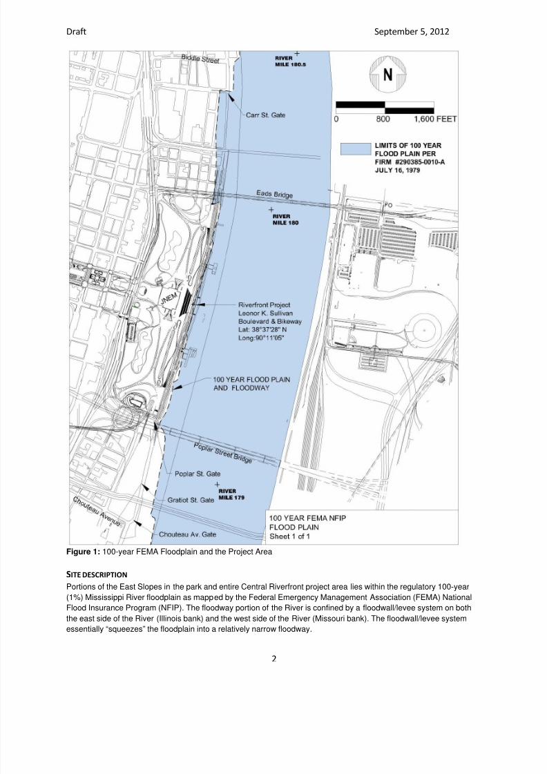
7/29/2019 Jefferson National Expansion Memorial
http://slidepdf.com/reader/full/jefferson-national-expansion-memorial 219/256
Draft September 5, 2012
2
Figure 1: 100-year FEMA Floodplain and the Project Area
SITE DESCRIPTION
Portions of the East Slopes in the park and entire Central Riverfront project area lies within the regulatory 100-year
(1%) Mississippi River floodplain as mapped by the Federal Emergency Management Association (FEMA) National
Flood Insurance Program (NFIP). The floodway portion of the River is confined by a floodwall/levee system on both
the east side of the River (Illinois bank) and the west side of the River (Missouri bank). The floodwall/levee system
essentially “squeezes” the floodplain into a relatively narrow floodway.

7/29/2019 Jefferson National Expansion Memorial
http://slidepdf.com/reader/full/jefferson-national-expansion-memorial 220/256
Draft September 5, 2012
3
Floodplains are defined by the NPS Procedural Manual 77-2: Floodplain Management (NPS 2003) as “the lowland
and relatively flat areas adjoining inland and coastal waters, including flood-prone areas of offshore islands, and
including, at a minimum, that area subject to temporary inundation by a regulatory flood.” Typically floodplains
function to contain flood waters. Floodplains can also provide habitat for various flora and fauna especially the islands
that are temporarily formed by shifting river sediments. This portion of the Mississippi River floodplain has been highly
industrialized with several river ports / transfer loading facilities located within what is referred to as the St Louis
Harbor.
JUSTIFICATION FOR USE OF THE FLOODPLAIN
Portions of the project area are located within designated high hazard floodplains. Although the NPS is under
executive order and policy to reduce or eliminate development in floodplains, this is not possible in the project area
because the proposed improvements to the East Slopes, Central Riverfront, and LKS Boulevard are located within a
100-year floodplain.
DESCRIPTION OF SITE-SPECIFIC FLOOD RISK
The Central Riverfront lies at a low elevation and is relatively flat. The project area, stretching from Choteau Avenue
to Biddle Street from the bank of the Mississippi River to the railroad on the East Slopes within the park is currently
designated as Zone AE, which is within the 100-year floodplain (per the current FEMA mapping). West of this area,
the park is shown to be protected from the 1% annual chance or greater flood hazard due to the levee system that
has been provisionally accredited (per current FEMA mapping).
A one-hundred-year flood is calculated to be the level of flood water expected to be equaled or exceeded every 100
years on average. The 100-year flood can also be thought of as a 1 percent flood, since it is a flood that has a 1
percent chance of being equaled or exceeded in any single year. Along the Central Riverfront, flood occurrences that
just overtop LKS Boulevard are far more frequent than the larger 100-year flood events that close the floodgates.
These higher-frequency floods typically last up to two weeks and cause the closure of LKS.
DESCRIPTION AND EXPLANATION OF FLOOD MITIGATION PLANS
The proposed project itself constitutes a strategy for the reduction of flood risk. By raising LKS Boulevard along the
Central Riverfront, the project aims to mitigate the effects of annual flooding and the associated impacts to public
safety, visitor use and experience, and historic resources. Because the City of St. Louis is a member of the National
Flood Insurance Program, Great Rivers Greenway District would need to apply for and obtain a Floodplain
Development Permit. A Riverine Hydraulic Analysis of the proposed improvements must be completed in advance toassure the City that a “no-rise” to the 100-year base flood elevation will exist after the proposed improvements are
constructed. As a result, the project would be designed to minimize the number of flood events that closes the
roadway but would not affect the100-year flood base elevations.
During site preparation and construction, efforts to preserve existing vegetation within the floodplain would be
undertaken as standard procedures. Any vegetation removed to accommodate the proposed improvements would be
replaced within the flood zone. Floodplain values would be protected to the maximum extent possible. Although the
project must occur within the floodplain, the extent of development, placement of structures, and types of structures
would be selected to minimize impacts.
SUMMARY
The proposed project constitutes enhancements for public safety, visitor use and experience, and historic resources,
and must be carried out within the 100-year floodplain. Specifically, the proposed improvements to the East Slopes,Central Riverfront, and Leonor K. Sullivan Boulevard are within the 100-year floodplain. There are no other siting
alternatives that could be considered for this project. Mitigation and compliance with regulations and policies to
prevent impacts to water quality, floodplain values and loss of property or human life would be strictly adhered to
during and after construction. Potential flood hazards would be minimized and there would be no long-term adverse
impacts to the 100-year designated floodplain. To the contrary, the decreased flood events along the Central
Riverfront would have beneficial effects on public safety, visitor use and experience, and historic resources at
Jefferson National Expansion Memorial and along the Central Riverfront.
7/29/2019 Jefferson National Expansion Memorial
http://slidepdf.com/reader/full/jefferson-national-expansion-memorial 221/256
APPENDIX B
U.S. FISH AND WILDLIFE CORRESPONDENCE

7/29/2019 Jefferson National Expansion Memorial
http://slidepdf.com/reader/full/jefferson-national-expansion-memorial 222/256

7/29/2019 Jefferson National Expansion Memorial
http://slidepdf.com/reader/full/jefferson-national-expansion-memorial 223/256
United States Department of the Interior
NATIONAL PARK SERVICE
Jefferson National Expansion Memorial
11 North Fourth Street
St. Louis, Missouri 63102-1882
August 28, 2012
L76 (JEFF)
XDl8
Memorandum
To: Amy Salveter, Field Supervisor, Columbia Ecological Services Field Office,
U.S. Fish & Wildlife Service
From: Tom Bradley, Superintendent, Jefferson National Expansion Memorial,
National Park Service
Subject: Informal Consultation under the Endangered Species Act—Implementation of
CityArchRiver 2015 Initiative at Jefferson National Expansion Memorial and Along
the Central Riverfront
Per our initial communication dated July 22, 2011, the National
Park Service (NPS), in accordance with the National
Environmental Policy Act, is preparing an Environmental
Assessment (EA) to evaluate alternatives for implementing
CityArchRiver 2015 initiative elements at Jefferson National
Expansion Memorial (the park) in St. Louis, Missouri. The scope
of the EA has since been expanded to include not only projectswithin the park boundary, but also the central riverfront, as
depicted in figure 1.
The proposed action involves physical changes to the park and
the central riverfront as a method for improving visitor access
and experience, while better connecting the river and the park
into downtown St. Louis. The project does not involve the
development of any properties on the east side of the Mississippi
River.
The major components of the project currently under consideration include:
• a landscaped "Park Over the Highway" (to be constructed
by the Missouri Department of Transportation) over the
depressed lanes of Interstate 70 between the Gateway
Arch grounds and downtown;
• renovation of the underground museum and a new
entrance;
IN REPLY REFER TO:
Figure 1. Project Area
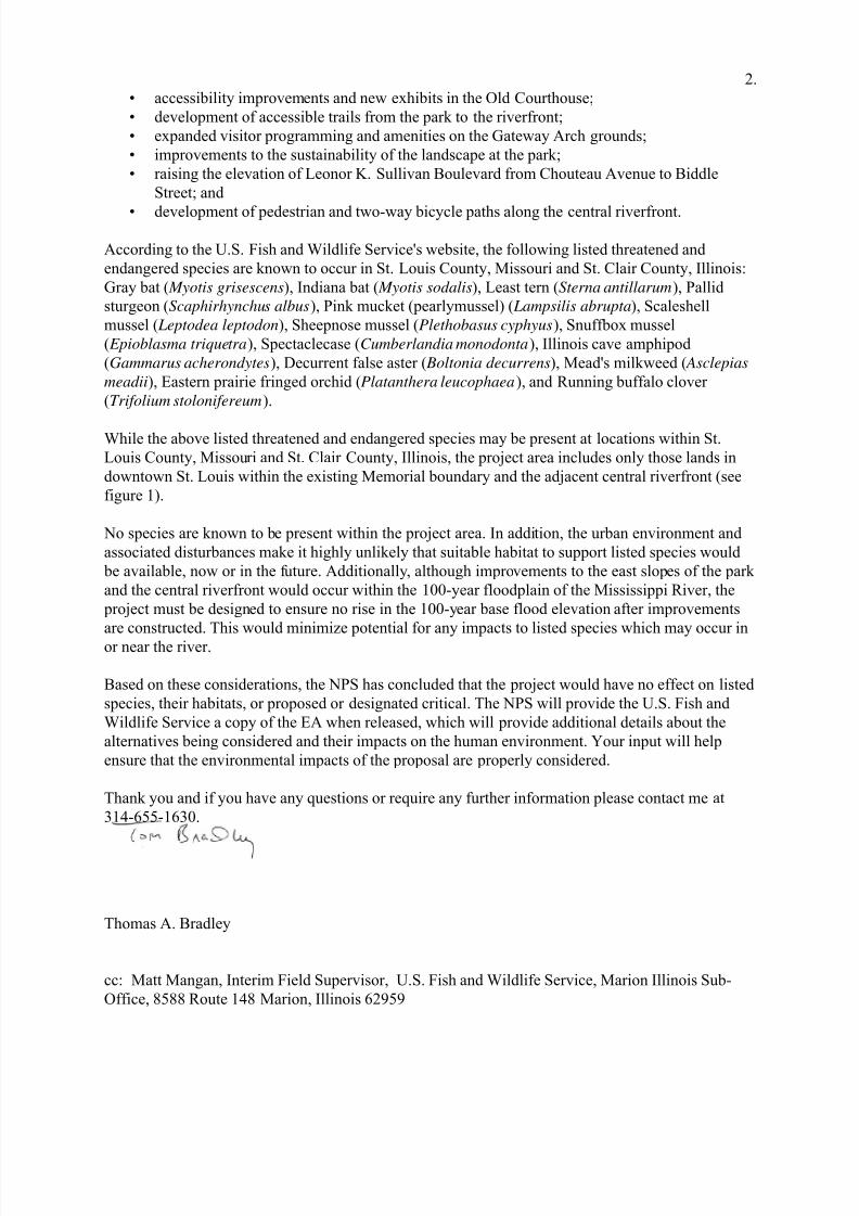
7/29/2019 Jefferson National Expansion Memorial
http://slidepdf.com/reader/full/jefferson-national-expansion-memorial 224/256
2.
• accessibility improvements and new exhibits in the Old Courthouse;
• development of accessible trails from the park to the riverfront;
• expanded visitor programming and amenities on the Gateway Arch grounds;
• improvements to the sustainability of the landscape at the park;
• raising the elevation of Leonor K. Sullivan Boulevard from Chouteau Avenue to Biddle
Street; and
• development of pedestrian and two-way bicycle paths along the central riverfront.
According to the U.S. Fish and Wildlife Service's website, the following listed threatened and
endangered species are known to occur in St. Louis County, Missouri and St. Clair County, Illinois:
Gray bat ( Myotis grisescens), Indiana bat ( Myotis sodalis), Least tern (Sterna antillarum), Pallid
sturgeon (Scaphirhynchus albus), Pink mucket (pearlymussel) ( Lampsilis abrupta), Scaleshell
mussel ( Leptodea leptodon), Sheepnose mussel (Plethobasus cyphyus), Snuffbox mussel
( Epioblasma triquetra), Spectaclecase (Cumberlandia monodonta), Illinois cave amphipod
(Gammarus acherondytes), Decurrent false aster ( Boltonia decurrens), Mead's milkweed ( Asclepias
meadii), Eastern prairie fringed orchid (Platanthera leucophaea), and Running buffalo clover
(Trifolium stolonifereum).
While the above listed threatened and endangered species may be present at locations within St.
Louis County, Missouri and St. Clair County, Illinois, the project area includes only those lands in
downtown St. Louis within the existing Memorial boundary and the adjacent central riverfront (see
figure 1).
No species are known to be present within the project area. In addition, the urban environment and
associated disturbances make it highly unlikely that suitable habitat to support listed species would
be available, now or in the future. Additionally, although improvements to the east slopes of the park
and the central riverfront would occur within the 100-year floodplain of the Mississippi River, the
project must be designed to ensure no rise in the 100-year base flood elevation after improvements
are constructed. This would minimize potential for any impacts to listed species which may occur in
or near the river.
Based on these considerations, the NPS has concluded that the project would have no effect on listed
species, their habitats, or proposed or designated critical. The NPS will provide the U.S. Fish and
Wildlife Service a copy of the EA when released, which will provide additional details about the
alternatives being considered and their impacts on the human environment. Your input will help
ensure that the environmental impacts of the proposal are properly considered.
Thank you and if you have any questions or require any further information please contact me at
314-655-1630.
Thomas A. Bradley
cc: Matt Mangan, Interim Field Supervisor, U.S. Fish and Wildlife Service, Marion Illinois Sub-
Office, 8588 Route 148 Marion, Illinois 62959
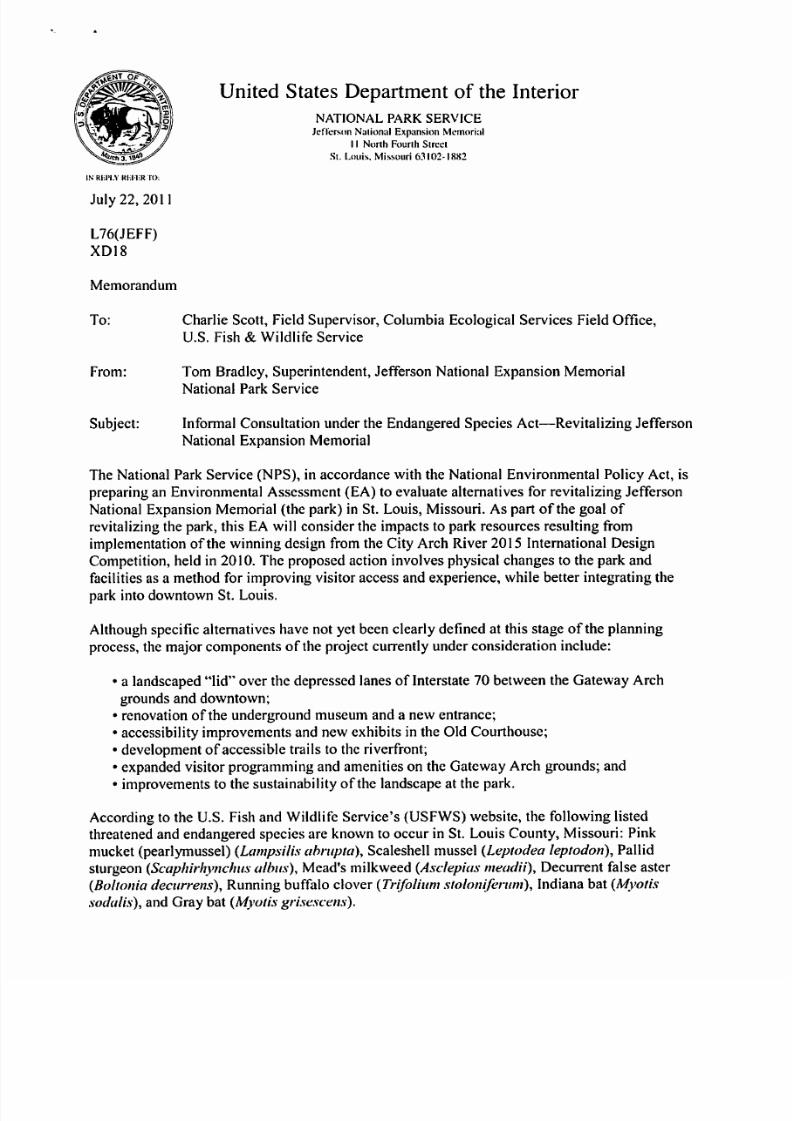
7/29/2019 Jefferson National Expansion Memorial
http://slidepdf.com/reader/full/jefferson-national-expansion-memorial 225/256
7/29/2019 Jefferson National Expansion Memorial
http://slidepdf.com/reader/full/jefferson-national-expansion-memorial 226/256

7/29/2019 Jefferson National Expansion Memorial
http://slidepdf.com/reader/full/jefferson-national-expansion-memorial 227/256
APPENDIX C
TRIBAL CONSULTATIONS

7/29/2019 Jefferson National Expansion Memorial
http://slidepdf.com/reader/full/jefferson-national-expansion-memorial 228/256

7/29/2019 Jefferson National Expansion Memorial
http://slidepdf.com/reader/full/jefferson-national-expansion-memorial 229/256
7/29/2019 Jefferson National Expansion Memorial
http://slidepdf.com/reader/full/jefferson-national-expansion-memorial 230/256

7/29/2019 Jefferson National Expansion Memorial
http://slidepdf.com/reader/full/jefferson-national-expansion-memorial 231/256
APPENDIX D
PROGRAMMATIC AGREEMENT

7/29/2019 Jefferson National Expansion Memorial
http://slidepdf.com/reader/full/jefferson-national-expansion-memorial 232/256

7/29/2019 Jefferson National Expansion Memorial
http://slidepdf.com/reader/full/jefferson-national-expansion-memorial 233/256

7/29/2019 Jefferson National Expansion Memorial
http://slidepdf.com/reader/full/jefferson-national-expansion-memorial 234/256

7/29/2019 Jefferson National Expansion Memorial
http://slidepdf.com/reader/full/jefferson-national-expansion-memorial 235/256

7/29/2019 Jefferson National Expansion Memorial
http://slidepdf.com/reader/full/jefferson-national-expansion-memorial 236/256

7/29/2019 Jefferson National Expansion Memorial
http://slidepdf.com/reader/full/jefferson-national-expansion-memorial 237/256
7/29/2019 Jefferson National Expansion Memorial
http://slidepdf.com/reader/full/jefferson-national-expansion-memorial 238/256

7/29/2019 Jefferson National Expansion Memorial
http://slidepdf.com/reader/full/jefferson-national-expansion-memorial 239/256

7/29/2019 Jefferson National Expansion Memorial
http://slidepdf.com/reader/full/jefferson-national-expansion-memorial 240/256

7/29/2019 Jefferson National Expansion Memorial
http://slidepdf.com/reader/full/jefferson-national-expansion-memorial 241/256
7/29/2019 Jefferson National Expansion Memorial
http://slidepdf.com/reader/full/jefferson-national-expansion-memorial 242/256

7/29/2019 Jefferson National Expansion Memorial
http://slidepdf.com/reader/full/jefferson-national-expansion-memorial 243/256

7/29/2019 Jefferson National Expansion Memorial
http://slidepdf.com/reader/full/jefferson-national-expansion-memorial 244/256

7/29/2019 Jefferson National Expansion Memorial
http://slidepdf.com/reader/full/jefferson-national-expansion-memorial 245/256

7/29/2019 Jefferson National Expansion Memorial
http://slidepdf.com/reader/full/jefferson-national-expansion-memorial 246/256

7/29/2019 Jefferson National Expansion Memorial
http://slidepdf.com/reader/full/jefferson-national-expansion-memorial 247/256
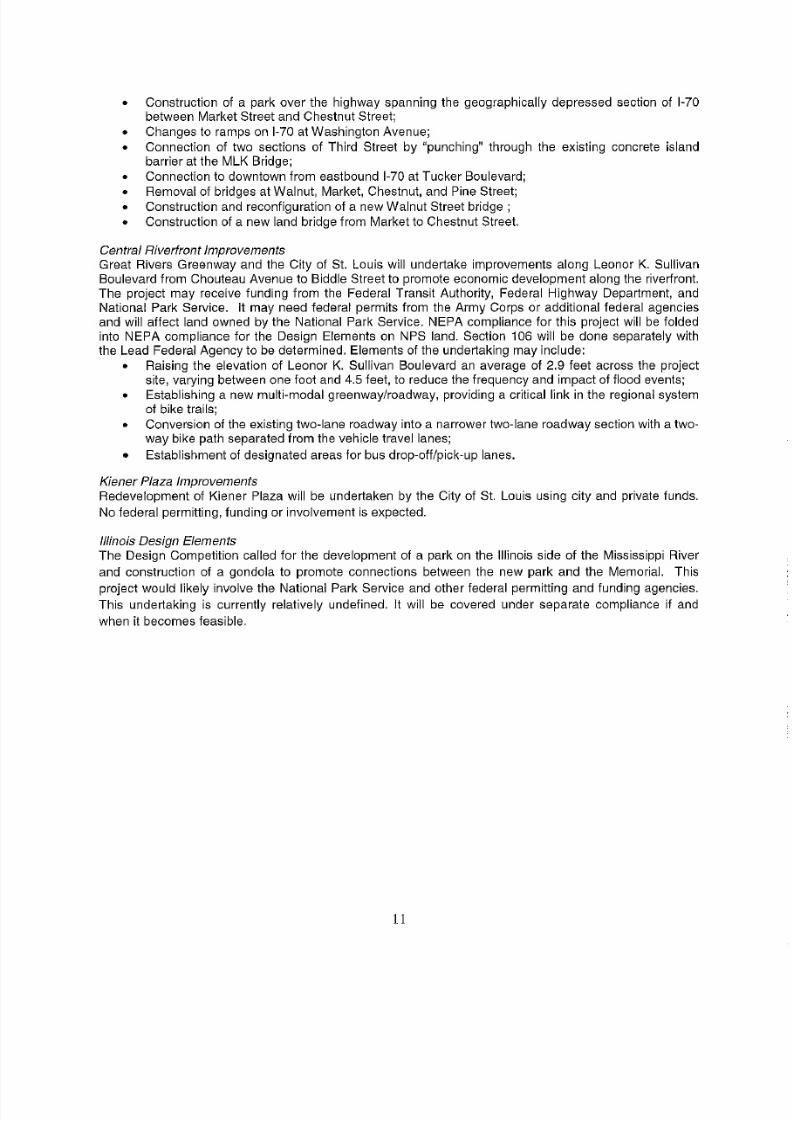
7/29/2019 Jefferson National Expansion Memorial
http://slidepdf.com/reader/full/jefferson-national-expansion-memorial 248/256
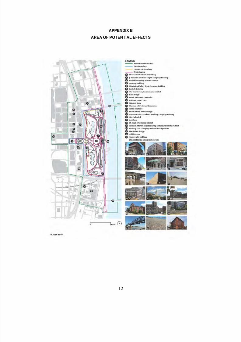
7/29/2019 Jefferson National Expansion Memorial
http://slidepdf.com/reader/full/jefferson-national-expansion-memorial 249/256
12
APPENDIX B
AREA OF POTENTIAL EFFECTS

7/29/2019 Jefferson National Expansion Memorial
http://slidepdf.com/reader/full/jefferson-national-expansion-memorial 250/256

7/29/2019 Jefferson National Expansion Memorial
http://slidepdf.com/reader/full/jefferson-national-expansion-memorial 251/256

7/29/2019 Jefferson National Expansion Memorial
http://slidepdf.com/reader/full/jefferson-national-expansion-memorial 252/256

7/29/2019 Jefferson National Expansion Memorial
http://slidepdf.com/reader/full/jefferson-national-expansion-memorial 253/256

7/29/2019 Jefferson National Expansion Memorial
http://slidepdf.com/reader/full/jefferson-national-expansion-memorial 254/256
7/29/2019 Jefferson National Expansion Memorial
http://slidepdf.com/reader/full/jefferson-national-expansion-memorial 255/256
As the nation’s principal conservation agency, the Department of the Interior has responsibility for most of our
nationally owned public lands and natural resources. This includes fostering sound use of our land and waterresources; protecting our fish, wildlife, and biological diversity; preserving the environmental and cultural values
of our national parks and historical places; and providing for the enjoyment of life through outdoor recreation.
The department assesses our energy and mineral resources and works to ensure that their development is in the
best interests of all our people by encouraging stewardship and citizen participation in their care. The department
also has a major responsibility for American Indian reservation communities and for people who live in island
territories under U.S. administration.
NPS 366/115943 January 2013

7/29/2019 Jefferson National Expansion Memorial
http://slidepdf.com/reader/full/jefferson-national-expansion-memorial 256/256


![Curry J{o[{ow Jwarl, Pitts6urg, '.P Jefferson :M.enioria ... · jefferson memorial circle j o s e c' a"' \ key otree w evergreen .e§} shrubs = garden seat trash it] receptacle 0](https://static.documents.pub/doc/80x56/6013371d9b1c7071d70b37ba/curry-joow-jwarl-pitts6urg-p-jefferson-menioria-jefferson-memorial.jpg)


