JOINT AREA COMMITTEES IN SOUTH SOMERSET Officer Report On Planning Application: 09/00937/FUL (Excepted Business) Proposal : Demolition of existing hospital buildings and erection of a new stroke/rehabilitation/community hospital and ancillary accommodation with car parking, service yard, access drive and improvements and associated works. (GR 343974/117374) Site Address: South Petherton Hospital Hospital Lane South Petherton Parish: South Petherton Ward : (SSDC Members) SOUTH PETHERTON Mr Paull Robathan (Cllr) Mr Keith Ronaldson (Cllr) Division (SCC Member) SOUTH PETHERTON Mr John Sharpe (Cllr) Recommending Case Officer: Dave Norris Tel: 01935 462382 Email: [email protected]Target date : 2nd June 2009 Applicant : Mrs Wendy Marshfield Application Type : Major Other f/space 1,000 sq.m or 1 ha+ REASON(S) FOR REFERRAL TO COMMITTEE This is a major application that has an impact upon the wider community and it has been agreed between the Planning Team Leader, Ward Members and the Chairman that the application should be considered at the committee. SITE DESCRIPTION AND PROPOSAL South Petherton Hospital is a long established facility located on the north-western edge of the settlement. The site is approximately 1.4 ha in area and is perched on the edge of an escarpment 67
Transcript
JOINT AREA COMMITTEES IN SOUTH SOMERSET
Officer Report On Planning Application: 09/00937/FUL
(Excepted Business) Proposal : Demolition of existing hospital buildings and erection of a new
stroke/rehabilitation/community hospital and ancillary accommwith car parking, service yard, access drive and improvementsassociated works. (GR 343974/117374)
Site Address: South Petherton Hospital Hospital Lane South Petherton Parish: South Petherton Ward : (SSDC Members) SOUTH PETHERTON Mr Paull Robathan (Cllr)
Mr Keith Ronaldson (Cllr) Division (SCC Member) SOUTH PETHERTON Mr John Sharpe (Cllr) Recommending Case Officer:
Target date : 2nd June 2009 Applicant : Mrs Wendy Marshfield Application Type : Major Other f/space 1,000 sq.m or 1 ha+ REASON(S) FOR REFERRAL TO COMMITTEE This is a major application that has an impact upon the wider community and it has been agreebetween the Planning Team Leader, Ward Members and the Chairman that the application shoconsidered at the committee. SITE DESCRIPTION AND PROPOSAL
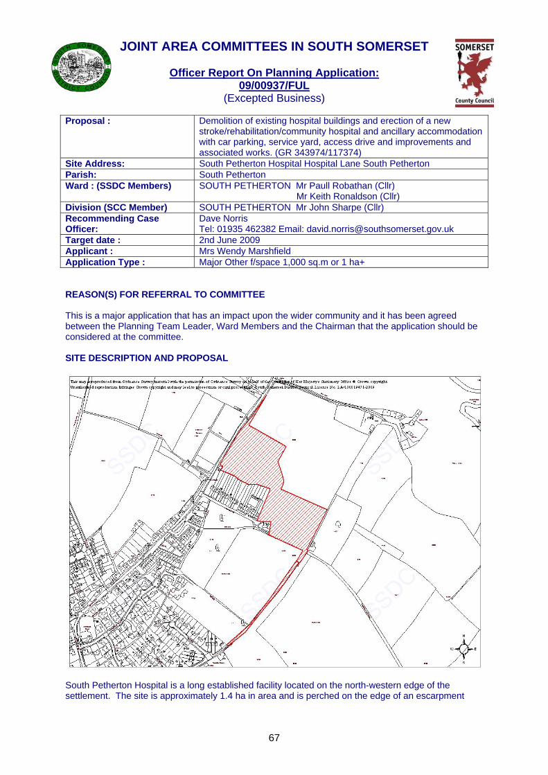
South Petherton Hospital is a long established facility located on the north-western edge of thesettlement. The site is approximately 1.4 ha in area and is perched on the edge of an escarpm
67
odation and
k
d uld be
ent
overlooking the Parrett valley. The northern edge of the site enjoys views over open countryside whereas the other boundaries are fairly well vegetated, reducing views in to the site. The existing facility is accessed from Hospital Lane; a no-through road that also serves in the region of 20 houses and there are also several footpaths that pass through and next to the hospital. The original hospital was constructed in 1939 and further buildings were added in 1986. In 2004 the majority of the buildings on the site were closed as they were in poor condition although various functions are still carried out at the site including limited outpatient and x-ray services and assessment and rehabilitation. This application seeks full planning permission to demolish the existing facility and construct a new hospital together with access and parking. The applicant (NHS Somerset Primary Care Trust) has submitted a detailed description of the development including the `rationale' for the proposal and it is considered appropriate to reproduce this for the benefit of members. `The way the hospital will function in the future will be based on `leading edge' approaches in the provision of care in a local community hospital facility providing specialist stroke and neuro rehabilitation facilities as well as 8 GP beds for the local health community. It will use the latest technology in diagnostics, IT and communications to maximise the availability of services locally. The approach is based around 5 interlocking elements that provide the overall comprehensive range of services suitable for the delivery of health services with plurality of choice, local rapid access to one-stop services and the facility for a variety of providers to become involved if necessary.' The building will therefore carry out a variety of functions, namely:
• Inpatients (24 beds: 16 stroke/neuro & 8 GP) • Therapy/rehab (occupational, physio, speech and language) • Diagnostics (radiology and ultrasound) • Health and Wellbeing Centre • Wheelchair Assessment Unit • Staff Support and Administration • Facilities Management
The application also proposes to create a new access and roadway from Pitway Hill, a car park with a capacity of over 120 spaces, a plant/facilities building with biomass boilers together with landscaping and other associated works. Members may also be aware of the aspiration to relocate the existing doctors facility to the hospital site or land adjoining the hospital site. The creation of a surgery within the curtilage of the hospital is no longer considered to be viable and at the time of writing this report only informal discussions have taken place with a representative of the practice. HISTORY 06/01253/OUT - Outline permission was granted in July 2006 for the: 'demolition of hospital buildings and construction of stroke/rehabilitation/community hospital and residential care home with new access road, staff/visitor parking'. Previous permissions have previously been granted for minor developments at the site. POLICY Section 38(6) of the Planning and Compulsory Purchase Act 2004 repeats the duty imposed under S54A of the Town and Country Planning Act 1990 and requires that decision must be made in accordance with relevant Development Plan Documents unless material considerations indicate otherwise, Relevant Development Plan Documents Sustainable Community Strategy 2008-2026 Goal 1 - Safe and Inclusive Goal 2 - Voluntary and Community Sector
68
Goal 3 - Healthy and Active Goal 4 - Quality Public Services Goal 7 - Distinctiveness Goal 8 - Quality Development Goal 10 - Energy Goal 11 - Environment Somerset and Exmoor National Park Joint Structure Plan (adopted April 2000) STR1 - Sustainable Development STR5 - Development in Rural Centres and Villages STR6 - Development Outside Rural Centres and Villages STR7 - Infrastructure Requirements Policy 1 - Nature Conservation Policy 5 - Landscape Character Policy 13 - Archaeology Policy 42 - Walking Policy 43 - Cycling Policy 45 - Bus Policy 48 - Access and Parking Policy 49 - Transport Requirements of New Development Policy 50 - Transport Management South Somerset Local Plan (adopted April 2006) ST1 - Settlements Listed as Rural Centres ST3 - Development outside Towns and Villages ST5 - General Principles of Development ST6 - Quality of Development ST8 - Energy Conservation ST10 - Infrastructure Requirements EC3 - Protection of Landscape EC7 - Natural Habitat Protection EC8 - Protected Species EH11 - Archaeology EP2 - Noise Generating Developments EP3 - Lighting/Sky Glow EP4 - Disposal of Waste EP5 - Contaminated Land EP6 - Demolition/Construction Works EU1 - Renewable Energy EU3 - Disposal of sewerage EU4 - Water Supply/Disposal EU5 - Flooding EU7 - Quality of Groundwater TP1 - Access Provision for Pedestrians/Cyclists TP2 - Travel Plan TP3 - Bicycle Parking TP5 - Access to Public Transport CR10 - Development Affecting Rights of Way TP6 - Parking Standards Policy-related Material Considerations PPS1 - General Principles PPG13 - Transport PPS9 - Ecology/Nature Conservation PPS22 - Renewable Energy PPS25 - Development and Flood Risk CONSULTATIONS The applicants have been involved in lengthy negotiations with all of the key consultees for some period and have carried out various amendments to address some of the concerns. The applicants have also made a presentation to the Parish and consider that the scheme has been influenced by the
69
comments that have been received. South Petherton Parish Council: South Petherton Parish Council recommend approval in principle providing that pedestrianisation and cycle access can be improved as part the development and SPPC can be involved in the decision on what needs to be done. As discussed on the phone SPPC would like to submit their suggestions for the proposed improvements to the footpath access to the hospital and these will follow. South Petherton Parish Council Footpath Group: 1. Prior to the Primary Care Trust (PCT)'s Outline Planning Application for the replacement of South Petherton Hospital, the Chief Executive of South Somerset PCT, Virginia Pearson, held Public Meetings for parishioners to learn of the development proposals. At these meetings the need for sustainable transport plans was agreed by both the PCT and parishioners, and the PCT pledged that the hospital development would include enhanced routes for cyclists and pedestrians linking with Lightgate Lane. Although the possible concurrent relocation of the GPs' surgery was discussed, the PCT made it clear that this was a matter for the GPs themselves, and the travel improvements were in no way dependent on this separate issue. 2. The County Council's response to the Outline Planning Application (Reference A) subsequently submitted by the PCT refers to the need for such a cycle and pedestrian route from Lightgate Lane. This would not have been through any knowledge of a pledge from PCT to Parishioners, but because such travel arrangements are a key component of any modern sustainable Travel Plan. SCC, at Reference B, states " it would be required for a footway/cycle link to the hospital from Lightgate Lane. In addition to which, improvements to the footway/cycle way along Lightgate Road would also be necessary and have been identified by the Local Transport Plan Group." This letter is quoted at Reference C - " The letter goes on to mention the need for a footway/cycle route to link the hospital from Lightgate Road. In the submitted plan, it shows this connection." 3. On this basis the Parish Council e-mailed SSDC Planners stating that the Outline Planning Application had the support of the Parish Council. 4. In response to the full Planning Application 09/00937/FUL, SCC at Reference D advised SSDC of its travel recommendations - the enhancement of the link from Lightgate Lane (including the track adjacent to the hospital site) as a cycle and pedestrian way, and the surfacing of footpaths Y24/54 and 55 to enable all-weather year-round pedestrian access from the Persimmon site and Pitway. These recommendations were endorsed by SSDC's own Rights of Way officer after discussion with Parish Council representatives, who concluded that SCC's recommendations reflected earlier PCT pledges and SCC's own statements concerning the earlier Outline Planning Application. 5. Consequently it was both a surprise and disappointment for the Parish Council to learn of the Faber Maunsell letter at Reference E. This letter appears to reject all of the earlier PCT pledges and agreements of the Outline Planning Application: (1). Safety. The proposed cycle/pedestrian way from Lightgate Lane is not crossed by any road; in contrast footpath Y24/54 is crossed by the main vehicular access road into the new Persimmon site, creating a hazard for pedestrians and cyclists. Additionally the route through Lightgate Lane offers better cycle access onto the new cycle way and avoids the busy Lightgate Road/St Michael's Gardens link, which has never been considered as a satisfactory cycle route. The Outline Application and Parish Briefings from the PCT specifically rejected the use of Hospital Lane as a cycle and pedestrian access as it was a narrow vehicular road, and the construction of a parallel cycle/pedestrian way in place of the existing hedge does not remove the potential conflict between motorised vehicles and pedestrians/cycles. (2). Utility. The proposed cycle /pedestrian way from Lightgate Lane provides a more direct link to the hospital for all those to the South and West - Over Stratton, Yeabridge, Watergore, Drayton, as well as for those living in the south and west of South Petherton itself. (3). Practicability. The new Faber Maunsell proposal is that Y24/55 (west) should be diverted along Hospital Lane. Hospital Lane has a steep gradient at its western end, unsuitable for cyclists, pedestrians and disabled access. The land is privately owned, and to "benefit from street lighting and natural surveillance", the hedge would have to be removed and the surface re-made. The current route of Y24/55 is a well-used pedestrian route for those linking with Y24/63 and Hamsfield Lane, and
70
walkers would be likely to object to any diversion. Currently it links directly with the point of pedestrian access to the New Hospital, on a level surface, so the proposed diversion makes little sense anyway. a. Instead of a cycle and pedestrian way from Lightgate Lane, the enhancement of footpath Y24/54 and 55 is recommended as a cycle and pedestrian way in lieu. The Parish Council is of the opinion that this solution is not acceptable for reasons of safety, utility and practicability: b. The so-called Option 2 suffers the same disadvantages, and how cyclists would access Y24/53 has not been stated; the potential conflict of pedestrians/cyclists with vehicular traffic on the Persimmon site would be even greater than in Option 1. c. The Parish Council does agree that the SCC suggested improvement of Hamsfield Lane beyond the edge of the Hospital site, whilst it would be welcomed, is not strictly relevant to the development. 6. In conclusion, South Petherton Parish Council does not support the alternative proposals forwarded by Faber Maunsell at Reference E. The previous proposals were mature and reached by consensus between the PCT, SCC, SSDC and the Parish Council. The new proposals are unsafe, of less utility and impracticable, and should be rejected by SSDC. The Travel Plan and S278 Legal Agreement should mandate the earlier agreed proposals of improvements to Lightgate Lane itself for pedestrians and cyclists, and the SCC recommendations at Reference D with the exception of the change of status of Hamsfield Lane to Restricted Byway. South Petherton Parish Council wish to continue to be involved in the discussions on what will constitute the most appropriate foot and cycle routes to the hospital. Planning Policy: Further to your consultation regarding the erection of a new hospital, ancillary accommodation with car parking , service yard, access drive and improvements with associated works at South Petherton Hospital, Hospital Lane, South Petherton, my comments from a planning policy perspective are as follows: The key issue in this instance relates to the proposed location of the access road, whilst the majority of the proposal is centred on the site of the existing hospital buildings and is within the Development Area for South Petherton, the proposed access road is not located within the Development Area, but within the open countryside to the north of the site, and as such is contrary to adopted South Somerset Local Plan (2006) Policy ST3: Development Areas which strictly controls development outside of Development Areas and restricts it to that which benefits economic activity, maintains or enhances the environment and does not foster growth in the need to travel. The applicants design and access statement explains that the County Highways Authority consider the existing vehicular access along Hospital Lane to be inadequate for use as the main access to the new hospital; it is therefore proposed to use Hospital Lane for pedestrian and cycle access only. I have spoken to the Council's Landscape Architect who has explained that whilst this is not an ideal location for the access road, particularly give the fact that the Peripheral landscape study - South Petherton (2008) indicates that the land has a moderate-low capacity to accommodate built development, there are good reasons in highway terms why the road is located as it is and whilst not ideal, it is acceptable in landscape terms. Additionally I note that there is an extant outline planning consent (06/01253/OUT) for an alternative hospital proposal which includes an access road in a similar, if not exactly the same, location to that currently proposed. To conclude therefore, whilst the location of the access road is, in the strictest sense, contrary to SSLP Policy ST3, I believe that it is proposed to be located as it is in order to satisfy the requirements of the County Highways Authority. In addition, the provision of adequate health facilities is essential in helping to fulfil the aims of Planning Policy Statement 7: Sustainable Development in Rural Areas, by ensuring that people who live and work in rural areas have access to a range of services and facilities, and given that there is an extant planning permission for an access road in a similar location, on balance in this instance no planning policy objection is raised. Local Highway Authority: I refer to the above-mentioned planning application received on 13th March 2009 and my letter dated 2nd April requesting an extension of time so that highway aspects of this development could be fully assessed.
71
I understand however that you require a formal response from the Highway Authority prior to the 17th April and in response to your request I would make the following observations on the highway and transportation aspects of this proposal (although it should be noted that issues still exist with the Travel Plan and requires some additional work, albeit limited in nature, on the developers part):- As the planning officer will be aware this site has been the subject of a previous application 06/01253/OUT to which no highway objection was raised by the Highway Authority and was subsequently approved by the LPA on the 11th July 2006 subject to conditions, including one relating to the provision of a Travel Plan. In the case of the present application, whilst the Highway Authority has no objection in principle to the redevelopment of the hospital site, there was a significant amount of pre-application discussion with the PCT and its highway consultants regarding the means of access to the site and general agreement has been reached on the majority of the highway related matters in terms of both detail and principle. Turning to the major issues, I have dealt with them individually below in order that Members are fully briefed on the current situation, please note however they are not listed in any order of priority: Vehicular Access - . The development itself will be served by a new vehicular access constructed onto Pitway Hill, meeting modern day standards in terms of its width, visibility and construction specification, with the current use of Hospital Road being discontinued apart from emergency access to the hospital site via a gated (or such like) emergency entrance into the main site car park. The design of this new access road has been the subject of a Stage 1 Safety / Technical Audit and the access layout shown on Faber Maunsell drawing Figure 20/ 08223483/1 /A is therefore considered to be generally acceptable and could therefore be included within a S278 Legal Agreement to ensure its eventual construction to an appropriate standard, although it should be noted that it is not intended that the access road be adopted by the Highway Authority at this time. With regard to the speed limit in the vicinity of the new access road, the new access itself has been designed with visibility splays that are commensurate with the speed of traffic and it is not intended to extend the current 30mph limit beyond its current location, as after having sought the views of the appropriate officer within the Highway Authority it is self evident that the criteria laid down in the latest Department for Transport Circular 01/2006 'Setting of Local Speed Limits' would not be met in this case and therefore it is unlikely that any proposal to extend the 30 mph limit northward would be supported by the Highway Authority. Traffic Impact - The Transport Assessment (TA) submitted with the application is considered to be robust and no issues are raised regarding trip generation or any detrimental impact on the surrounding highway network resulting from the proposed development. Please note however that the TA has not included any additional traffic movements associated with any potential GP surgery which I understand is proposed to the south of the hospital site (albeit yet to be the subject of a formal planning application) and as such, any future planning application for such a surgery would need to be accompanied by a TA that dealt satisfactorily with the increase in vehicle movements and included appropriate enhancements to the off site cycle/pedestrian works secured as part of the present hospital redevelopment application to reduce reliance on the motor car as the principal mode of travel to the hospital site. Rights of Way - Whilst not discussed in detail at the pre application stage, I have taken the opportunity to consult with my rights of way colleagues in respect of any potential impact on the existing ROW network and they have identified that Public Footpaths Y 24/52, 55 & 60 will be affected by the development and possibly Y 24/63 and as such development, insofar as it affects a right of way should not be started, and the right of way should be kept open for public use until the necessary (stopping up/diversion/temporary closure) Order has come into effect. Failure to comply with this request may result in the developer being prosecuted if the path is built on or otherwise interfered with. A temporary closure can be obtained from Sarah Hooper on (01823) 483091. The access improvements that have been put forward to the footpaths are welcomed, however we feel there are additional access improvements that could be achieved through this development and secured through the S278 Agreement required to construct the main vehicular access onto Pitway Hill. These being: 1) The eastern half of Y24/55 should be diverted into the parallel lane (highlighted blue on attached plan) and upgraded to public bridleway status. Not only will this allow public pedestrian and cycle access it will also benefit local horse riders. South Somerset District Council would be able to process such a diversion. This lane should be metalled to an adoptable standard for use by walkers/cyclists and horse riders.
72
2) Public footpaths Y 24/52 & 60 (highlighted pink) should also be upgraded to a public bridleway to allow use by walkers, riders and cyclists. In this instance the negotiation of a grass strip alongside a metalled path would be desirable for horse-riders to use. Specification to be agreed. 3) The negotiation of or a commuted sum to achieve the addition of a public bridleway along Hamsfield Lane from the junction of footpaths Y 24/55 & 60 to Bridgeway Cottages (highlighted green) would also be of considerable benefit to the local access network. The above suggested improvements have been put forward by the public as a result of consultation for the Rights of Way Improvement Plan (RoWIP) and score highly against the RoWIP Desktop Scorecard. It should also be noted that there is also a Modification Application that was recently submitted for Hamsfield Lane, which is for the addition of a Restricted Byway. Furthermore the future development of a doctor's surgery to the south of the site could possibly affect public footpaths Y 24/54 & 55 and the sections highlighted yellow would potentially benefit from being metalled to adoptable standard for access from the Pitway area and furthermore consideration should be given to achieving this as part of the hospital development. Revised comments received in relation to footpath issue: David - With regard to the public rights of way (PROW) issues that were raised in the latest letter dated 29th April 2009 received from Iain McNeill (Faber Maunsell) I have now had an opportunity to meet and discuss this matter with Peter Hobley who is the PROW officer responsible for this area. The consensus of opinion following this meeting was that it was not felt that the proposals put forward by Iain could be supported by the Highway Authority, as they offered little overall benefit and that the preferred option of the Highway Authority is that amongst other things, the existing Y24/55 footpath route be retained (in an improved state) rather than being diverted around the edge of the field adjacent to Hospital Lane and that works take place on the existing footpath Y24/60 linking the hospital site to Lightgate lane (to the south) in a manner to be agreed, with actual works being provided by the developer in this case rather than a financial contribution as suggested by Iain in his letter. I believe the best way to deal with this situation and avoid any further delays, is for us to recommend that a Grampian style condition be applied to the PROW issue and include any works within the S278 Agreement required to construct the new vehicular entrance off Pitway Hill. Such works could therefore be designed, funded and completed by the developer prior to the new hospital being brought into use. Landscape Officer: I have read and reviewed the revised plans, which indicate minor changes to the layout and site treatment following my original comments and our subsequent meeting with he application team. The changes include; 1) random layout of roadside tree planting by the access road 2) removal of hamstone wall along N/E facing elevation 3) inclusion of native hedgerow planting along N/E boundary, to tie in with surrounding landscape elements 4) additional compact canopied trees to the N/E side of hospital 5) changes to the main entrance and its approach. Whilst I continue to have reservations over the visual prominence of the new building relative to the Parrett Vale, I accept the above changes to be improvements to the overall proposal and sufficient to overcome a landscape objection. I would recommend conditions relating to a detailed landscaping scheme, protection of existing trees and samples of materials to be approved in advance. Ecology: Further surveys required for bats and slow worms before development commences. County Archaeologist: Evidence of brickworks/kiln on site and as such a desktop assessment should be carried out before work starts. Footpaths Officer: My concerns are that there seems to be no reference to improving pedestrian and cycle access to the site and no detail supporting the area edged red that includes Lightgate Lane which I understood from the outline application was to become a cycle route for access to the proposed hospital. This would
73
also entail a link in the track between Hospital Lane and Lightgate Lane to the existing entrance, including the section south of The Lodge that is not within the area edged red. This section is shown blue by SCC (Drawing EH040-2009) and needs to include a diversion of Footpath Y24/55 onto the track (which SSDC or SCC could process)and upgrade to Bridleway (By SCC creation or agreement) and the surface needs to be agreed by SCC as it is also a private access for motor vehicles. Generally I agree with the comments of SCC ROW, passed to you by County Highways. The SCC pink route may need to accommodate private vehicular access (Lightgate Lane) so the type of surface will be by agreement with SCC after investigation of private rights. The link Y24/54 & Y24/55 (SCC yellow) needs to be surfaced with tarmac as a pedestrian link as part of this development, other sections of Y24/ 54 & Y24/53 are being tarmaced as part of the Persimmon development of 55 houses currently under construction. This would be the main pedestrian access rather than following Hospital Lane and is currently well walked. SCC (link green) would be a welcome addition to the recorded network as a bridleway enabling increased circular route opportunities for both the local community and patients of the Hospital through healthy walking initiatives etc. Environment Agency: Thank you for consulting the Environment Agency on the above planning application. We object to the proposed development on flood risk grounds. This objection is discussed below: Flood Risk The application lies in an area classified as Flood Zone 1 (low risk) and is greater than 1 hectare, therefore, requires a Flood Risk Assessment (FRA) to be submitted under Planning Policy Statement 25, Development and Flood Risk (PPS25). The FRA submitted in support of this application, by Faber Maunsell dated February 2009, is unsatisfactory under PPS25. We request the following information to ensure that the design of the surface water drainage system will function satisfactorily: analysis of the proposed pipe network, storage tanks and discharge points to demonstrate that buildings will not flood under design storm conditions and that water will be contained and managed on site to ensure third parties are not affected. We require additional detail as to how, and by whom, the attenuation system will be maintained and adopted? We can confirm under PPS25 that the vulnerability of the use is compatible with the flood zone. Council Engineer: Flood risk assessment required. Need to incorporate sustainable drainage techniques to control surface water run-off. Wessex Water: No objection in principle as discussions have taken place with applicant in advance. Somerset Disability Forum: Need to ensure that the proposal accords with the relevant legislation. Also suggest adequate Blue Badge parking and coloured, tactile surfaces for the visually impaired. REPRESENTATIONS 1 letter received from neighbour stating that they do not want large trees and bushes planted in front of their property as it will reduce their views. CONSIDERATIONS Principle of Development: The redevelopment of the hospital was established by the granting of an outline planning permission in 2007. This consent was for a range of facilities and the creation of a new access road. The current application cannot 'rely' upon this outline permission as the mixture of facilities are different - the most notable difference being that the previous consent included a residential care home. Nevertheless this previous permission did accept that the existing hospital could be demolished and that a range of more substantial buildings could be accommodated in the site. It also accepted that Hospital Lane was not suitable as a means of access for the new facility and that a new access could be created directly from Pitway Hill with an access road being formed on the side of the north east slope.
74
Highway Safety: The principle and position of the new access was accepted by the previous outline planning permission. It is understood that there is a local aspiration to extend the 30mph limit to beyond the new access however the County Highway Authority have indicated that they would be unlikely to support any formal request. The creation of the visibility splays will result in a loss of hedgerow alongside the lane however it is anticipated that the existing hedge can be transplanted and reinforced where necessary. Access/Travel Plans: The response from the Highway Authority and the council's Rights of Way Officer have made requests that some local routes are either improved or diverted. The purpose of these changes is to make the routes more conducive to pedestrians and cyclists thereby increasing the potential for some staff/users to access the hospital using a more sustainable mode of transport. The principle of improving the local rights of way network is fully supported however it is important to make sure that any requirements are justified and are directly linked to the development. The proposed improvements are detailed in the response from the Highway Authority and these have been fully discussed with the applicant. The upgrading of Lightgate Lane is probably the most important of the improvements as it links to the major residential area of the town as well as the new developments in the area. Improvements to this route were also included within the previous outline approval although the actual nature of the works was never specified. The actual `mechanism' for achieving these improvements is the Section 278 agreement that is agreed between the developer and the Highway Authority. Before the agreement is completed details of the actual works will have to be agreed between these parties and these negotiations can take place during the construction phase. Visual Impact: The hospital site is located in a prominent position at the top of an escarpment with superb views to the north and west. This does of course mean that the site is very visible from these directions and these views into the site were considered very carefully during the pre-application negotiations. Various orientations and forms were considered and finally a scheme was produced with a strong, symmetrical building that is positioned to address the views rather than shy away them. Members will see from the drawings that the building has a strong central element with wings, the height of which has been kept to a minimum to allow two storeys. The use of materials has been carefully considered by the applicant and the Landscape Architect and a consensus was reached on the use of timber cladding and stone coloured render for the walls and a modern grey sheeting for the roof. The application has also taken into account the potential for lighting to draw attention to this development outside of daylight hours. This has been achieved by ensuring that the large glazed areas on the prominent north elevation will have integral blinds that will be controlled by staff. Additionally, a plan of external lighting has been submitted showing that any lights that are considered to be essential will be positioned away from the most prominent locations. Trees/Landscaping: The site benefits from some established tree cover although not all of it is particularly worthy of retention. There are 2 copper beech trees on the northern edge of the site and these are to be retained The applicants have always been very keen to achieve outside amenity space for users of the site and the landscape layout incorporates terraces at the front of the building from which people can enjoy the views and these will be planted and levelled to ensure that there is a less obvious division between the hospital and the countryside. Much thought has also gone in to the design of hard and soft landscaping within the site and a suitable pallet of materials has been proposed for these area. Additionally, the planting has been designed to create a more 'organic' feeling within the parking areas to try and avoid creating a sterile, utilitarian area.
75
Ecology: The applicants have carried out a full ecological survey of the site and there is no clear evidence of protected species. There is potential for bats to be in the locality and it is requested that a further survey be carried out. Flooding: The site does not fall within an area that is known to experience flooding problems however as the application site exceeds 1 hectare the applicant was required to submit a Flood Risk Assessment to ensure that the development doesn't create problems elsewhere. The initial response from the Environment Agency indicated that they were generally satisfied with the technical information that had been submitted by the applicants but there were a couple of technical issues that needed to be addressed. They therefore have issued a `holding' objection that will be removed when the applicants have produced the additional information. It is anticipated that this will occur before the committee meeting and members will be advised accordingly. The District Council's Engineers has not raised any concerns relating to localised flooding issues. Sustainable Construction and Renewable Energy: Policies within local and national guidance and the Sustainable Community Strategy emphasise the need for all development to be designed to ensure that energy use is kept to a minimum and on larger developments such as this scheme there is a requirement to produce energy from renewable energy on site. The NHS PCT have similar `in-house' requirements and as such have designed the building to minimise the use of energy and to make provision for generation. Their submission lists 6 areas that address these requirements: 1) Strategic design: Building designed to make use of natural light and ventilation, extensive new planting and sustainable drainage. 2) BREEAM: NHS requirement for all buildings to achieve a high rating on the BREEAM scoring system which is used to assess the `green' credentials of the building. 3) Energy Targets: Building is designed to exceed the government's benchmark target for reduction in energy use. 4) Biomass: 2 biomass boilers will be installed to provide 80% of the annual heating requirements. 5) Green Specification: Materials chosen to achieve Grade A in the Green Guide to specification. 6) Transport Plan: To encourage staff to use sustainable modes of transport. Future Development: As members will be aware it is essential that every application is considered on its own merits. Discussions have been undertaken concerning the provision of a doctors surgery both within the hospital site and on the adjoining piece of land. At the time of writing this report there has been no obvious further progress with this scheme and therefore it should not influence the determination of this application. Despite this lack of certainty the plans for the hospital have taken into account the potential for a surgery and the access road and layout are designed to accommodate the facility. Summary: It is clearly in the interests of the community (and wider community) to create a high quality facility. The existing hospital is in a poor state of repair and is only going to deteriorate further and therefore the NHS PCT have made a decision to construct a bespoke hospital that will provide users with the most up to date care in an energy efficient and attractive environment. The building will have an impact with the landscape however the design is considered to be of a high standard, which will result in the building becoming a local landmark. The new access will reduce the pressure on the existing sub standard access and also reduce the impact upon existing properties. The improvements to footpaths in the area and the Travel Plan will also hopefully encourage users of the site to move away from the reliance on the private motor vehicle. SECTION 106 PLANNING OBLIGATION/UNILATERAL UNDERTAKING None RECOMMENDATION It is recommended that planning permission be approved subject to the appropriate conditions being imposed.
76
01. The replacement of the existing facility with an improved facility will undoubtedly enhance the capacity and effectiveness of care provision within the district and therefore the principle of the scheme meets with the aims of Sustainable Community Strategy, the Corporate Plan and Development Plan Documents. The scheme has been designed in cooperation with the relevant consultees and it is considered that the outcome is a development that will respect the natural and built environment, provide a locally distinctive building that incorporates the principles of sustainability and provides safe access and preserves the amenity of adjoining residents. SUBJECT TO THE FOLLOWING: 01. The development hereby permitted shall be begun before the expiration of three years from the
date of this permission. Reason: To accord with the provisions of section 91(1) of the Town and Country Planning Act
1990. 02. The development hereby permitted shall not be commenced (other than for demolition works
and construction of access road to base course level) until particulars of the materials (including the provision of samples where appropriate) to be used for external walls and roofs have been submitted to and approved in writing by the Local Planning Authority.
Reason: In the interests of visual amenity and to accord with ST5 and ST6 of the South
Somerset Local Plan 2006. 03. The development hereby permitted shall not be commenced (other than for demolition works
and construction of access road to base course level) until there has been submitted to and approved in writing by the Local Planning Authority a scheme of landscaping, which shall include indications of all existing trees and hedgerows on the land, and details of any to be retained, together with measures for their protection in the course of the development, as well as details of any changes proposed in existing ground levels; all planting, seeding, turfing or earth moulding comprised in the approved details of landscaping shall be carried out in the first planting and seeding season following the occupation of the building or the completion of the development, whichever is the sooner; and any trees or plants which within a period of five years from the completion of the development die, are removed or become seriously damaged or diseased shall be replaced in the next planting season with others of similar size and species, unless the Local Planning Authority gives written consent to any variation.
Reason: To protect the character of the area and to accord with EC3, ST5 and ST6 of the South
Somerset Local Plan 2006. 04. The development hereby permitted shall not commence until a Construction Management Plan
has been submitted to and approved in writing by the Local Planning Authority (in consultation with Somerset County Council). The plan shall include construction vehicle movements, construction operation hours, construction vehicular route to and from site - which for the avoidance of doubt all vehicles will be via the new vehicular access onto Pitway Hill rather than Hospital Lane, construction delivery hours, expected number of construction vehicles per day, car parking for contractors, specific measures to be adopted to mitigate construction impacts in pursuance of the Environmental Code of Construction Practice and a scheme to encourage the use of public transport amongst contractors. The development shall be carried out strictly in accordance with the approved Construction Management Plan.
Reason: In the interests of neighbour amenity and to accord with ST6 of the South Somerset
Plan 2006. 05. In this condition 'retained tree' means an existing tree which is to be retained in accordance with
the approved plans and particulars as detailed in condition 3 of this approval; and paragraphs a) and b) below shall have effect until the expiration of 5 years from the date of occupation of the building for its permitted use.
a) No retained tree shall be cut down, uprooted or destroyed, nor shall any retained tree be topped or lopped other than in accordance with the approved plans and particulars, without the
77
written approval of the Local Planning Authority. Any topping or lopping approved shall be carried out in accordance with British Standard 3998 (Tree Work).
b) If any retained tree is removed, uprooted or destroyed or dies, another tree shall be planted at the same place and that tree shall be of such size and species, and shall be planted at such time, as may be specified in writing by the Local Planning Authority.
c) The erection of fencing for the protection of any retained tree shall be undertaken in accordance with the approved plans and particulars before any equipment, machinery or materials are brought onto the site for the purposes of the development, and shall be maintained until all equipment, machinery and surplus materials have been removed from the site. Nothing shall be stored or placed in any area fenced in accordance with this condition and the ground levels within those areas shall not be altered, nor shall any excavation be made, without the written consent of the Local Planning Authority.
Reason: In the interests of landscape amenity and to accord with EC3, ST5 and ST6 of the
South Somerset Local Plan 2006. 06. The development hereby approved shall not be brought into use until a proposal for the
improvements to the PROW network in the vicinity of the site (principally but not exclusively relating to public footpaths Y24/55, Y24/60 and Y24/54) have been submitted to and approved in writing by the Local Planning Authority. This proposal shall include details and specifications of improvements together with a programme of work and the approved scheme shall be fully implemented within the approved timescales, unless otherwise agreed in writing with the Local Planning Authority - such works themselves to be the subject of a suitable legal Agreement (S278).
Reason: To improve relevant rights of way in the locality and to accord with CR9 of the South
Somerset Local Plan 2006. 07. No work shall commence on the development site (excluding demolition of the existing buildings
and formation of cut and fill earthworks) until the base course level of new vehicular access onto Pitway Hill, as shown generally in accordance with submitted drawing 2867.03 SP/DK/00/SP/002/P03 has been provided in accordance with a design and specification to be approved in writing by the Local Planning Authority and to be fully implemented in accordance with the approved details, unless otherwise agreed in writing with the Local Planning Authority. Such works to be the subject of suitably worded legal Agreement (e.g. S278 Highways Act).
Reason: To provide a safe and adequate access in accordance with Policy 49 of the Somerset
Structure Plan. 08. The new development shall not be commenced (other than for demolition works and
construction of access road to base course level) until a detailed Travel Plan has been submitted to and approved in writing by the Local Planning Authority. No part of the new development shall be occupied prior to implementation of those parts identified in the Approved Travel Plan as capable of being implemented prior to occupation. Those parts of the Approved Travel Plan that are identified therein as capable of implementation after occupation shall be implemented in accordance with the timetable contained therein and shall continue to be implemented as long as any part of the development is occupied.
Reason: To reduce the demand on the private motor vehicle and to accord with TP2 of the
South Somerset Local Plan 2006. 09. Before any building or engineering works are carried out on the site (other than for demolition
works and construction of access road to base course level), the construction access and contractors' parking/compound area shall be provided, surfaced and drained in accordance with a detailed scheme, which shall be submitted to and approved in writing by the Local Planning Authority. Such scheme shall also indicate the eventual use of that area.
Reason: In the interest of neighbour amenity and to accord with EP6 and ST6 of the South
Somerset Local Plan 2006. 10. The applicant shall ensure that all vehicles leaving the site are in such condition as not to emit
dust or deposit mud, slurry or other debris on the highway. In particular (but without prejudice to the foregoing), efficient means shall be installed, maintained and employed for cleaning the
78
wheels of all lorries leaving the site, details of which shall have been agreed in advance in writing by the Local Planning Authority and fully implemented prior to commencement of the development and thereafter maintained until the completion of construction works.
Reason: In the interest of amenity and to accord with EP6 of the South Somerset Local Plan
2006. 11. Provision shall be made within the site for the disposal of surface water so as to prevent its
discharge onto the highway, details of which shall have been submitted to and approved in writing by the Local Planning Authority. The approved measures shall be thereafter permanently maintained.
Reason: In the interests of safety and to accord with EU4 of the South Somerset Local Plan
2006. 12. The area allocated for parking on the submitted plan shall be kept clear of obstruction at all
times and shall not be used other than for the parking of vehicles in connection with the development hereby permitted.
Reason: In the interests of highway safety and to accord with TP6 of the South Somerset Local
Plan 2006. 13. Before the development hereby approved is occupied, sheltered, secured cycle parking facility
shall be provided within the site for both staff and users of the facility in accordance with details that shall have been submitted to and approved in writing by the Local Planning Authority.
Reason: To reduce the reliance on the private motor vehicle and to accord with TP1 of the
South Somerset Local Plan 2006. 14. The existing vehicular access from Hospital Lane shall be stopped up and its use permanently
abandoned (other than for emergency vehicles, pedestrians and cyclists) within 1 month of the new access hereby permitted being first brought into use, details of the means of closure to be submitted and approved in writing by the LPA prior to any works being undertaken on site.
Reason: In the interests of highway safety and to accord with Policy 49 of the Somerset
Structure Plan. 15. At the proposed access onto Pitway Hill there shall be no obstruction to visibility greater than
300mm above adjoining road level within the visibility splays shown on the submitted plan Drawing No 2867.03 SP/DK/00/SP/002/P03. Such visibility splays shall be constructed in accordance with details to be first agreed with the local planning authority and shall thereafter be maintained at all times.
Reason: In the interests of highway safety and to accord with Policy 49 of the Somerset
Structure Plan. 16. No demolition works shall be undertaken unless additional surveys relating to bats and slow
worms are carried out and submitted to the Local Planning Authority together with proposals for any mitigation works that may be necessary. Should any such works be necessary then they shall be carried out in accordance with a scheme that must first be approved in writing by the Local Planning Authority.
Reason: In the interests of biodiversity and the protection of species and to accord with EC8 of
the South Somerset Local Plan 2006. 17. The development hereby commenced shall be constructed in accordance with the levels
indicated on drawing no. SP/DK/00/SE/006/P02 dated 17th April 2009 unless otherwise agreed in writing by the Local Planning Authority.
Reason: In the interests of visual amenity and to accord with ST5 and ST6 of the South
Somerset Local Plan.
79
18. The developer shall afford access at all reasonable times to any archaeologist nominated by the Local Planning Authority, and shall allow him/her to observe the excavations and record items of interest and finds. Furthermore, should it become evident that there are any archaeological remains within the site then the developer shall cease work on the relevant part of the project and contact the Local Planning Authority immediately.
Reason: Although there is no clear evidence of archaeology within the site it is essential that the
site can be accessed by an appropriate professional should any archaeological remains become evident.