USDA Forest Service Proceedings RMRS-P-41. 2006. 769 In: Andrews, Patricia L.; Butler, Bret W., comps. 2006. Fuels Management—How to Measure Success: Conference Proceedings. 28-30 March 2006; Portland, OR. Proceedings RMRS-P-41. Fort Collins, CO: U.S. Department of Agriculture, Forest Service, Rocky Mountain Research Station. 1 USDA Forest Service, North Central Research Station, East Lansing, MI. [email protected]Abstract—This paper presents an assessment of fire weather and fire behavior predic- tions produced by a numerical weather prediction model similar to those used by operational weather forecasters when preparing their forecasts. The PSU/NCAR MM5 model is used to simulate the weather conditions associated with three fire episodes in June 2005. Extreme fire behavior was reported across the Southwest, Great Basin, and Southern California Incident Areas during this time period. By comparing the simulation results against reports of extreme fire behavior, the ability of the model to differentiate between the three episodes is assessed, and relationships between weather conditions and extreme fire behavior are suggested. The results of these comparisons reveal that the most extreme fire behavior occurred in locations where near-ground temperatures were the highest. While relative humidity did not vary substantially across the three episodes, variations in temperature led to a greater potential for evaporation and fuel drying, which could have been a factor in the observed extreme fire behavior. Addi- tional analyses reveal that the diurnal variations in mixed layer processes also explain some of the variability in fire behavior in the episodes. This paper represents a step towards realizing the full potential of atmospheric physics models for fire weather and fire behavior forecasting. As researchers and operational personnel come to understand the relationships between fire behavior and atmospheric processes that can be predicted by weather forecast models, these concepts can be tested in the broader context of day-to-day fire weather forecasting. Eventually, these techniques could provide additional information for the fire weather forecasters and fire managers, using tools that are already available and used routinely in weather forecast offices. Introduction The fi re weather tools that are currently employed in National Weather Service (NWS) forecast offices are typically the product of empirical stud- ies that were designed to establish statistical relationships between certain types of fi re danger or fi re behavior and observed weather conditions (see e.g. Fosberg 1978, Lavdas 1986, Haines 1988). As these indices were being developed by the fi re weather community, the broader atmospheric science community was more focused on severe storms and hurricane research, and developed tools such as radar and high-resolution numerical weather pre- diction (NWP) models to aide in those research endeavors. As the research evolved, these tools became intrinsic to the operational weather forecasting process, and are now used every day throughout the world for forecasting extreme weather events. Until very recently, these same tools were seldom if ever used as part of NWS fi re weather forecasting, nor were they applied in research projects Employing Numerical Weather Models to Enhance Fire Weather and Fire Behavior Predictions Joseph J. Charney 1 and Lesley A. Fusina
Transcript
USDA Forest Service Proceedings RMRS-P-41. 2006. 769
In: Andrews, Patricia L.; Butler, Bret W., comps. 2006. Fuels Management—How to Measure Success: Conference Proceedings. 28-30 March 2006; Portland, OR. Proceedings RMRS-P-41. Fort Collins, CO: U.S. Department of Agriculture, Forest Service, Rocky Mountain Research Station.
1USDA Forest Service, North Central Research Station, East Lansing, MI. [email protected]
Abstract—This paper presents an assessment of fi re weather and fi re behavior predic-tions produced by a numerical weather prediction model similar to those used by operational weather forecasters when preparing their forecasts. The PSU/NCAR MM5 model is used to simulate the weather conditions associated with three fi re episodes in June 2005. Extreme fi re behavior was reported across the Southwest, Great Basin, and Southern California Incident Areas during this time period. By comparing the simulation results against reports of extreme fi re behavior, the ability of the model to differentiate between the three episodes is assessed, and relationships between weather conditions and extreme fi re behavior are suggested. The results of these comparisons reveal that the most extreme fi re behavior occurred in locations where near-ground temperatures were the highest. While relative humidity did not vary substantially across the three episodes, variations in temperature led to a greater potential for evaporation and fuel drying, which could have been a factor in the observed extreme fi re behavior. Addi-tional analyses reveal that the diurnal variations in mixed layer processes also explain some of the variability in fi re behavior in the episodes.
This paper represents a step towards realizing the full potential of atmospheric physics models for fi re weather and fi re behavior forecasting. As researchers and operational personnel come to understand the relationships between fi re behavior and atmospheric processes that can be predicted by weather forecast models, these concepts can be tested in the broader context of day-to-day fi re weather forecasting. Eventually, these techniques could provide additional information for the fi re weather forecasters and fi re managers, using tools that are already available and used routinely in weather forecast offi ces.
Introduction
The fi re weather tools that are currently employed in National Weather Service (NWS) forecast offi ces are typically the product of empirical stud-ies that were designed to establish statistical relationships between certain types of fi re danger or fi re behavior and observed weather conditions (see e.g. Fosberg 1978, Lavdas 1986, Haines 1988). As these indices were being developed by the fi re weather community, the broader atmospheric science community was more focused on severe storms and hurricane research, and developed tools such as radar and high-resolution numerical weather pre-diction (NWP) models to aide in those research endeavors. As the research evolved, these tools became intrinsic to the operational weather forecasting process, and are now used every day throughout the world for forecasting extreme weather events.
Until very recently, these same tools were seldom if ever used as part of NWS fi re weather forecasting, nor were they applied in research projects
Employing Numerical Weather Models to Enhance Fire Weather and Fire Behavior Predictions
Joseph J. Charney1 and Lesley A. Fusina
770 USDA Forest Service Proceedings RMRS-P-41. 2006.
Charney and Fusina Employing Numerical Weather Models to Enhance Fire Weather and Fire Behavior Predictions
trying to improve our understanding of fi re-atmosphere interactions. While radar observations have limited application for fi re weather forecasting, beyond determining when and where precipitation is and will soon occur, NWP models can provide temporally and spatially detailed information about numerous aspects of fi re-weather that could directly or indirectly impact fi re behavior. Researchers can employ these models to establish physical relation-ships between weather phenomena and observed fi re behavior, rather than relying upon empirical and statistical relationships whose broad applicability is questionable (Potter 2002). These physical relationships lead to the de-velopment of new fi re weather indices and diagnostic techniques (Charney and Keyser, 2003) that can, in turn, be passed on to operational fi re weather forecasters for use in day-to-day fi re weather forecasting. Fire weather fore-casters can then implement these new tools to analyze output from existing NWP models, enabling them to provide guidance to fi re managers making decisions that pertain to prescribed burn planning and ignition, as well as wildfi re decision support that can help save lives and property.
This paper will examine the performance of an NWP model during three periods of June, 2005: June 17-18 (hereafter referred to as Episode 1), June 23-24 (Episode 2), and June 27-28 (Episode 3), during which very high to extreme fi re indices were reported in Arizona, New Mexico, and Nevada. Despite the extreme fi re indices, reports of extreme fi re behavior varied considerably across the three episodes. We hypothesize that variations in weather conditions during these periods can help explain the variability in observed fi re behavior. In section 2, we will detail the observed fi re behavior reports. Section 3 will discuss the NWP model employed to study the weather conditions during the three periods identifi ed above. Section 4 will present the fi re-weather predictions from the NWP model, and discuss relationships between the simulated weather conditions and the observed fi re behavior. Section 5 will include discussion and concluding statements.
Observed Fire Behavior
In May and June 2005, extreme fi re indices were reported in the National Interagency Coordination Center (NICC) Incident Management Reports across the Southwest, Southern California, and Eastern Great Basin Incident Areas (see e.g. http://iys.cidi.org/wildfi re/ for archived NICC Incident Management Reports). This extended period of extreme fi re indices was associated with numerous fi res during the period. For the purposes of this study, we choose to focus our attention on three periods in the last two weeks of June, during which particularly extreme fi re behavior was reported, including rapid spread rates, crown fi res, spotting and torching, and fl ame lengths of 50 to 80 feet.
Episode 1 occurred on June 17-18 (Fig. 1a). In the areas of interest, extreme fi re indices were reported. Three large fi res were reported in New Mexico and Arizona, two of which were designated as Wildland Fire Use (WFU) fi res. The non-WFU fi re in Arizona reported active but not extreme fi re behavior.
Episode 2 occurred about a week later, on June 23-24 (Fig. 1b). During this time period, eight large fi res were reported across central Arizona and more than twelve fi res were active across southern California, southern Ne-vada, northwestern Arizona, and southwestern Utah. Extreme fi re behavior was observed at all of these fi res. The central Arizona fi res were reported to
USDA Forest Service Proceedings RMRS-P-41. 2006. 771
Employing Numerical Weather Models to Enhance Fire Weather and Fire Behavior Predictions Charney and Fusina
Figure 1—Locations of NICC Incident Management Reports of extreme fi re behavior during large fi re incidents on a) 17-18 June, 2005, b) 23-24 June, 2005, and c) 27-28 June, 2005. Red dots indicate wildfi re incidents and green dots indicate large fi res designated as Wildland Fire Use fi res.
772 USDA Forest Service Proceedings RMRS-P-41. 2006.
Charney and Fusina Employing Numerical Weather Models to Enhance Fire Weather and Fire Behavior Predictions
exhibit plume-dominated behavior, with active running and crowning, and rapid uphill rates of spread. Additionally, there was one report of thunder-storm activity in the vicinity of the fi re generating downdrafts that impacted fi re behavior. The fi res in California, Nevada, and Utah exhibited extreme rates of spread and fl ame lengths. Gusty winds, fl ashing fuels, crowning, and dry thunderstorm outfl ow boundaries also inhibited fi refi ghting activities in the area.
Episode 3 occurred three days later on June 27-28 (Fig. 1c). On these dates, the fi res in central Arizona had slowed considerably, such that few reports of extreme fi re behavior were submitted. Rapid spread rates, downdrafts from dry thunderstorms, and isolated torching were reported in California, Nevada, and Utah.
Overall, the reported fi re behavior can be characterized as moderate to high in isolated areas during Episode 1, high to extreme across the region with very large fl ame lengths and running fi res during Episode 2, and decreasing intensity with localized incidents of extreme fi re behavior during Episode 3. It should be noted, however, that situation reports fi led during and after large fi re incidents do not accurately represent all of the variations in fi re behavior across the region. It is quite probable that extreme fi re behavior occurred on smaller fi res that either went unobserved or unreported. The purpose of this study is to determine if the extreme fi re behavior that was reported can be explained by changes in the weather conditions at those locations and across the region.
Numerical Weather Predictions
The variability in fi re behavior reported during the three episodes could have been caused by a wide variety of mechanisms, including local terrain infl uences (e.g. north vs. south facing slopes), fuel moisture and fuel type, and varying weather conditions. Given that fi re indices were reported as extreme throughout the period, and that fuel conditions are an important component of the fi re indices, we assume for the purposes of this study that differences in fuel conditions were not the main reasons for the differences in observed fi re behavior. Information is not readily available on all of these fi res concerning the specifi cs of the local terrain. Thus, we propose to explore whether variations in weather conditions both at the ground and aloft can help explain the differences in observed fi re behavior. We explore this question by using an NWP model. An NWP model is a physical atmospheric model that employs equations describing spatial and temporal variations in weather conditions at the ground and aloft to predict future weather conditions. An NWP model is initiated with observations that characterize the current state of the atmosphere, and then predicts the future weather from that observed state. NWP models allow weather forecasters to forecast the weather with some degree of accuracy multiple days in advance.
An NWP model can also be used to simulate the weather conditions of events in the past, using the observations from that time to initiate the model and then simulating the evolution of the weather conditions throughout the event. The main advantage of this technique is that the NWP models generate much more information about the weather conditions at the ground and aloft than can readily be observed. In the vicinity of a fi re and across the region, this information can be analyzed to try to understand how the atmospheric conditions simulated by the NWP model might have impacted the fi res.
USDA Forest Service Proceedings RMRS-P-41. 2006. 773
Employing Numerical Weather Models to Enhance Fire Weather and Fire Behavior Predictions Charney and Fusina
The NWP model employed for this study is referred to as the Penn State University/National Center for Atmospheric Research Mesoscale Model ver-sion 5.3 (MM5) (Grell et al., 1995). This model has been developed over the last thirty years by the meteorological research community, and is one of the most widely used “mesoscale” models in the world. A mesoscale model is an NWP model that is designed to simulate the weather conditions across an area roughly 1/2-1/4 the size of the United States and resolve the detailed fl ows associated with thunderstorms, fronts, and other local weather phe-nomena. As indicated in the Introduction, these models are used routinely by NWS (and other) forecasters to produce forecasts of severe storms and precipitation systems.
We have employed the MM5 as a research tool to simulate the weather conditions associated with the three episodes defi ned in the previous section. Separate simulations were performed for the three episodes, such that hourly weather conditions at the ground and aloft were generated from 0000 UTC on the fi rst day of each episode and continuing for 48 hours. Model output is generated in the form of a 3-dimensional cube of weather data (temperature, winds, humidity, clouds, rain, sunlight, etc) which can then be analyzed in detail. This output is then analyzed to produce horizontal maps and time series at specifi c locations.
Fire Weather Predictions
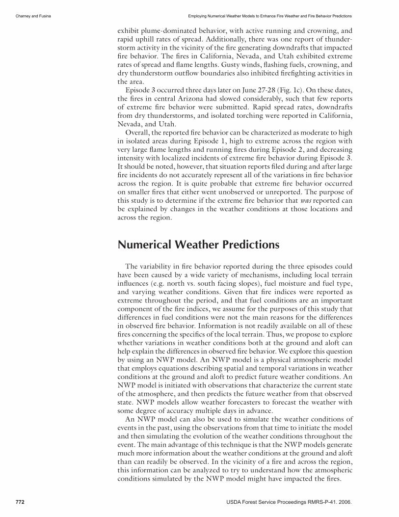
The model results for the three episodes indicate similarities that would be expected considering the season and the region, while also revealing some notable differences between the episodes. The surface weather conditions were very hot and dry throughout the three episodes, as one would expect climatologically. Figure 2 shows the surface relative humidity (RH) and wind speed and direction for episodes 1, 2, and 3. It is noteworthy that while there are variations in RH and wind speeds across the three episodes, the varia-tions are not particularly noteworthy. The RH in central Arizona, southern California, and southern Nevada vary from between about 10-15%. While these are very low RH values, particularly for a model that is known to often overestimate RH, differences of this magnitude would not by themselves explain the observed differences in fi re behavior. Similarly, the simulated wind speeds across the region were moderately high, with speeds of about 15 mph commonly occurring, but do not indicate pronounced variations among the episodes.
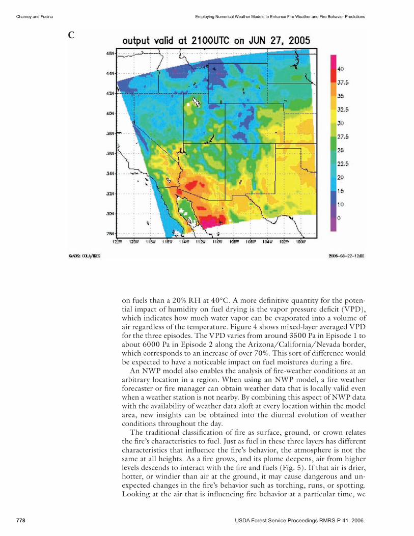
One of the huge advantages of working with NWP model output instead of observations is that the weather conditions aloft are as straightforward to generate as surface weather conditions. Thus, the model includes information about the diurnal evolution of the mixed layer for each of the episodes. This enables us to analyze the weather conditions in the layers of the atmosphere that are most likely to interact with a fi re, rather than focusing almost exclu-sively on surface weather conditions. Figure 3 shows mixed-layer averaged temperatures for the three episodes. Clearly, the mixed-layer air in the areas where extreme fi re behavior was reported was considerably warmer in Episode 2 than in Episode 1. However, this increase in temperature did not manifest as a pronounced change in RH. RH is often used by fi re weather forecasters and fi re managers to anticipate when the atmosphere will contribute to fuel drying and, by association, more extreme fi re behavior. But RH is dependant upon temperature, such that a 20% RH at 30°C indicates a different impact
774 USDA Forest Service Proceedings RMRS-P-41. 2006.
Charney and Fusina Employing Numerical Weather Models to Enhance Fire Weather and Fire Behavior Predictions
Figure 2—Simulated a) surface relative humidity and b) surface wind speed and direction for 2100 UTC 17 June, 2005. c) and d) are the same as a) and b) for 2100 UTC 23 June, 2005. e) and f) are the same as a) and b) for 2100 UTC 27 June, 2005.
a
b
USDA Forest Service Proceedings RMRS-P-41. 2006. 775
Employing Numerical Weather Models to Enhance Fire Weather and Fire Behavior Predictions Charney and Fusina
c
d
776 USDA Forest Service Proceedings RMRS-P-41. 2006.
Charney and Fusina Employing Numerical Weather Models to Enhance Fire Weather and Fire Behavior Predictions
e
f
USDA Forest Service Proceedings RMRS-P-41. 2006. 777
Employing Numerical Weather Models to Enhance Fire Weather and Fire Behavior Predictions Charney and Fusina
Figure 3—Simulated mixed-layer averaged temperature for: a) 2100 UTC 17 June, 2005, b) 2100 UTC 23 June, 2005, c) 2100 UTC 27 June, 2005.
a
b
778 USDA Forest Service Proceedings RMRS-P-41. 2006.
Charney and Fusina Employing Numerical Weather Models to Enhance Fire Weather and Fire Behavior Predictions
c
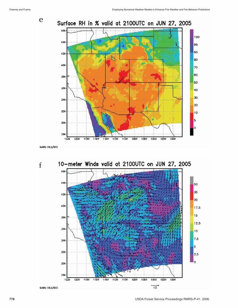
on fuels than a 20% RH at 40°C. A more defi nitive quantity for the poten-tial impact of humidity on fuel drying is the vapor pressure defi cit (VPD), which indicates how much water vapor can be evaporated into a volume of air regardless of the temperature. Figure 4 shows mixed-layer averaged VPD for the three episodes. The VPD varies from around 3500 Pa in Episode 1 to about 6000 Pa in Episode 2 along the Arizona/California/Nevada border, which corresponds to an increase of over 70%. This sort of difference would be expected to have a noticeable impact on fuel moistures during a fi re.
An NWP model also enables the analysis of fi re-weather conditions at an arbitrary location in a region. When using an NWP model, a fi re weather forecaster or fi re manager can obtain weather data that is locally valid even when a weather station is not nearby. By combining this aspect of NWP data with the availability of weather data aloft at every location within the model area, new insights can be obtained into the diurnal evolution of weather conditions throughout the day.
The traditional classifi cation of fi re as surface, ground, or crown relates the fi re’s characteristics to fuel. Just as fuel in these three layers has different characteristics that infl uence the fi re’s behavior, the atmosphere is not the same at all heights. As a fi re grows, and its plume deepens, air from higher levels descends to interact with the fi re and fuels (Fig. 5). If that air is drier, hotter, or windier than air at the ground, it may cause dangerous and un-expected changes in the fi re’s behavior such as torching, runs, or spotting. Looking at the air that is infl uencing fi re behavior at a particular time, we
USDA Forest Service Proceedings RMRS-P-41. 2006. 779
Employing Numerical Weather Models to Enhance Fire Weather and Fire Behavior Predictions Charney and Fusina
Figure 4—Simulated mixed-layer averaged vapor pressure defi cit for: a) 2100 UTC 17 June, 2005, b) 2100 UTC 23 June, 2005, c) 2100 UTC 27 June, 2005.
a
b
780 USDA Forest Service Proceedings RMRS-P-41. 2006.
Charney and Fusina Employing Numerical Weather Models to Enhance Fire Weather and Fire Behavior Predictions
c
Figure 5—Conceptual diagram of the 3-layer model showing potential interactions between a fi re and layers of the atmosphere.
USDA Forest Service Proceedings RMRS-P-41. 2006. 781
Employing Numerical Weather Models to Enhance Fire Weather and Fire Behavior Predictions Charney and Fusina
ask three questions: 1) what type of air infl uences a fi re while it is forming a plume, 2) what type of air infl uences a fi re right after it ignites, and 3) what type of air infl uences a fi re that has established an identifi able plume? These questions lead to a conceptual model which we refer to as the three-layer model (Potter, 2002; Charney et al., 2005), in which we employ the NWP model to calculate weather variables at the ground, averaged throughout the mixed layer, and averaged from the ground to a point 500 m above the mixed layer. By looking at how these quantities vary at a point through the day, the impact of mixed-layer processes on surface conditions can be diagnosed and, in some cases, predicted hours or even days in advance.
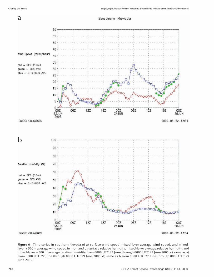
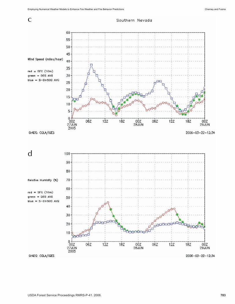
Figure 6 shows time series of 3-layer model quantities for Episodes 2 and 3 for a point in extreme southern Nevada. It is noteworthy that when the mixed-layer starts to grow during the daytime, the wind speed at the ground in both episodes increases and the RH decreases dramatically. This progres-sion indicates the importance of mixed-layer processes in the development of dry and windy conditions for both episodes. The time series for Episode 2 suggests that prior to sunrise on June 23rd, the surface air was drier and windier than the air 500m above the ground. As the mixed layer grew after sunrise, this signal was eliminated and the usual structure of drier and windier air aloft than at the ground transpired. However, the unusual vertical struc-ture prior to sunrise on the 23rd preceded the fi re reports of extremely high fl ame lengths (50-80 feet) on the 23rd. Without exploring the details of the atmospheric processes that led to the formation of the anomalous structure during the night, we cannot state whether the fi re reports and this unusual mixed-layer structure is related. But the anomalous the mixed-layer structure and anomalous fi re behavior suggest that a possible cause and effect relation-ship should be explored in future studies.
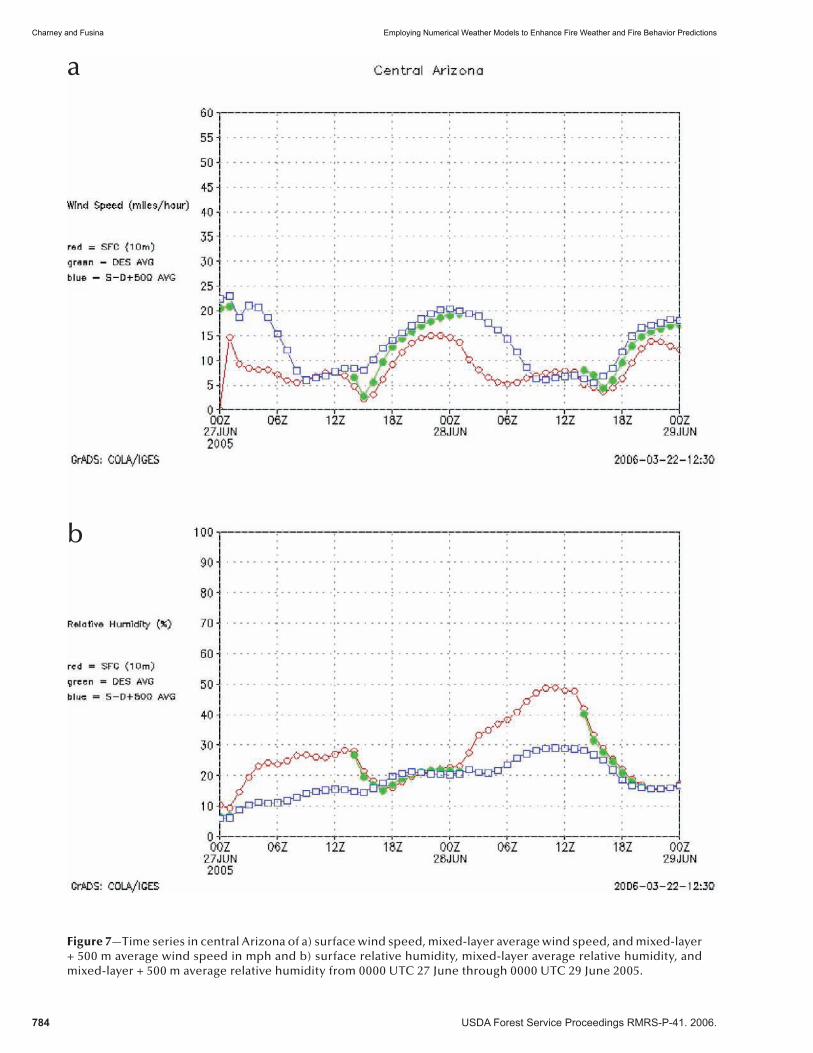
Figure 7 shows a time series of 3-layer model quantities for Episode 3 for a point in central Arizona. The development of the surface and mixed-layer averaged winds is notable in this case. At sunrise, the winds were quite light, with values on the order of 3 mph. As the mixed layer grew through the day, surface wind speeds increased rapidly to about 15 mph. The wind speeds just above the mixed layer, however, remained sharply higher than the mixed-layer wind speeds throughout the day. This is noteworthy in that a strong fi re circulation in that environment could “tap into” air above the mixed layer and transport momentum from outside of the mixed layer to the ground, leading to anomalously strong surface winds, possibly with gusts that are even higher than indicated by the time series. Furthermore, note that the strong winds aloft remained in place even after the mixed layer collapsed (e.g. when the green line in the plot disappears) indicating that even at night, this fi re might continue to experience stronger winds than expected.
Discussion And Conclusion
The NWP model results presented in the last section indicate that varia-tions in weather conditions associated with three fi re episodes in late June, 2005 can help explain some of the variations in observed fi re behavior. The simulations demonstrate that substantial differences occurred in the fi re-atmosphere interactions during the episodes. And while these interactions appear to rely upon the presence of dry air, the simulations reveal that RH is not the best quantity for assessing the impact of dry air on fuel conditions, and by association, fi re behavior. Since the most pronounced difference
782 USDA Forest Service Proceedings RMRS-P-41. 2006.
Charney and Fusina Employing Numerical Weather Models to Enhance Fire Weather and Fire Behavior Predictions
Figure 6—Time series in southern Nevada of a) surface wind speed, mixed-layer average wind speed, and mixed-layer + 500m average wind speed in mph and b) surface relative humidity, mixed-layer average relative humidity, and mixed-layer + 500 m average relative humidity from 0000 UTC 23 June through 0000 UTC 25 June 2005. c) same as a) from 0000 UTC 27 June through 0000 UTC 29 June 2005. d) same as b from 0000 UTC 27 June through 0000 UTC 29 June 2005.
a
b
USDA Forest Service Proceedings RMRS-P-41. 2006. 783
Employing Numerical Weather Models to Enhance Fire Weather and Fire Behavior Predictions Charney and Fusina
c
d
784 USDA Forest Service Proceedings RMRS-P-41. 2006.
Charney and Fusina Employing Numerical Weather Models to Enhance Fire Weather and Fire Behavior Predictions
a
b
Figure 7—Time series in central Arizona of a) surface wind speed, mixed-layer average wind speed, and mixed-layer + 500 m average wind speed in mph and b) surface relative humidity, mixed-layer average relative humidity, and mixed-layer + 500 m average relative humidity from 0000 UTC 27 June through 0000 UTC 29 June 2005.
USDA Forest Service Proceedings RMRS-P-41. 2006. 785
Employing Numerical Weather Models to Enhance Fire Weather and Fire Behavior Predictions Charney and Fusina
between the episodes was found in near-ground temperatures, RH would be expected to be ambiguous. However, the vapor pressure defi cit shows a more pronounced change in conditions between the episodes, and in these situations, represents a more precise means of diagnosing the potential fuel drying due to atmospheric processes.
The potential for local conditions at the ground and aloft to affect the fi res was addressed using the so-called three-layer conceptual model, which employs NWP model output to calculate the surface, mixed-layer, and mixed-layer plus 500 m winds and humidities. These analyses highlighted highly anomalous mixed-layer structures coinciding with the most extreme fi re be-havior reported during the episodes. In other locations, the analyses indicate the potential for a fi re to tap into fast-moving air just above the mixed layer; air that could be mixed down to the surface and produce unexpected and potentially hazardous changes in fi re behavior. The preliminary analyses of these time series indicate that the three-layer model could be used to anticipate the potential for anomalous fi re behavior associated with diurnal variations in atmospheric mixed layer processes. Additional work is necessary, however, before the ultimate usefulness of this diagnostic tool can be determined.
This paper represents a step towards realizing the full potential of at-mospheric physics models for fi re weather and fi re behavior forecasting. As researchers and operational personnel come to understand the relationships between fi re behavior and atmospheric processes that can be predicted by weather forecast models, these concepts can be tested in the broader context of day-to-day fi re weather forecasting. Eventually, these techniques could provide additional information for fi re weather forecasters and fi re managers, producing new information from tools that are already available and used routinely in weather forecast offi ces.
References
Charney, J. J., and D. Keyser, 2003: Using mesoscale model simulations to better understand the role of surface mixed-layer dynamics in fi re-atmosphere interactions. 20th Conference on Numerical Weather Prediction, 12-15 January 2004, Seattle, WA, American Meteorological Society.
Charney, J. J., B. E. Potter, W. E. Heilman, and X. Bian, 2005: Assessing the potential for atmospheric conditions aloft to contribute to extreme fi re behavior. EastFIRE Proceedings, May 11-13, 2005, George Mason University, Fairfax, VA.
Fosberg, M.A. 1978: Weather in wildland fi re management: the fi re weather index. Proceedings of the Conference on Sierra Nevada Meteorology, South Lake Tahoe, NV. pp. 1-4.
Grell, G. A., Dudhia, J. and Stauffer, D. R., 1995: A description of the fi fth-generation Penn State/NCAR mesoscale model (MM5). NCAR Technical Note, NCAR/TN-398#STR, 122 pp.
Haines, D.A., 1988: A lower atmosphere severity index for wildland fi res. National Weather Digest 13:23-27.
Lavdas, L.G., 1986: An atmospheric dispersion index for prescribed burning. USDA Forest Service Research Paper SE-256. Asheville, NC: Southeastern Forest Experiment Station.
Potter, B. E., 2002: A dynamics based view of atmosphere-fi re interactions. Int. J. Wildland Fire,11, 247-255.


![Conifer expansion [Chapter M.] - fs.fed.us](https://static.documents.pub/doc/80x56/61cace1c98ffe14ced450e01/conifer-expansion-chapter-m-fsfedus.jpg)


