82 .JOURNAL OF BIBLICAL LITERATURE The Ruins in Widt Suweil NATHANIEL SOHMIDT COB.lf.LL 111UVD81TY Direcfor of tile .d.rMrican Bchool in Palutine, wADI SUWEIL (J..A_, .... on the east side of the Dead Sea, is not found on any map, and the ruins at its mouth have not been described by any traveller. No earlier explorer seems to have gone to the exact part of the coast where it enters the Dead Sea, although several have visited the neighboring mountains, the peninsula, and the mouth of the Mojib. On the 23d of January, 1807, Ulrich Jasper Seetzen came down to the sea from the mountains at the mouth of WAdi Kerak <clf According to his description, this wddi pours a pa1·t of its water into the northern gulf, while another part is led through several canals to the village of El Mezra•ah <u;_;Jf). Itour days later, on his return from the southern end of the lake, he descended to the shore just below the Mojib.' He had, therefore, no opportunity to examine the coast between the peninsula and the Arnon. J. L. Burckhardt was not able to go down to the Dead Sea from Kerak, but he spent three weeks in this place, from the 14th of July to the 4th of August, 1812, and gathered some items of information concerning the coast from people who used to go to Ghor el Mezra·ah ;,_;:.)to buy tobacco. "About the middle of the lake," he says, "on the same east- em shore, are some ruins of an ancient city, called Towahein el Sukkar <r'-Jf the Sugar Mills. Farther 1 Rmen dt1rcA !Jrrlen, PaliUtiM, PlalSnieien, cUe Tra&Vonfa11-Lander, A.rabia Pelnua t1fld Umer-.Aegrplen, l1. 18M, p. 860. 2 Retun, lL p. 864. Digitized by G oog I e
Transcript
82 .JOURNAL OF BIBLICAL LITERATURE
The Ruins in Widt Suweil
NATHANIEL SOHMIDT
COB.lf.LL 111UVD81TY
Direcfor of tile .d.rMrican Bchool in Palutine, 1~1901S
wADI SUWEIL (J..A_,.... ~t,), on the east side of the Dead Sea, is not found on any map, and the ruins at
its mouth have not been described by any traveller. No earlier explorer seems to have gone to the exact part of the coast where it enters the Dead Sea, although several have visited the neighboring mountains, the peninsula, and the mouth of the Mojib.
On the 23d of January, 1807, Ulrich Jasper Seetzen came down to the sea from the mountains at the mouth of WAdi Kerak <clf ~l)f,).1 According to his description, this wddi pours a pa1·t of its water into the northern gulf, while another part is led through several canals to the village of El Mezra•ah <u;_;Jf). Itour days later, on his return from the southern end of the lake, he descended to the shore just below the Mojib.' He had, therefore, no opportunity to examine the coast between the peninsula and the Arnon.
J. L. Burckhardt was not able to go down to the Dead Sea from Kerak, but he spent three weeks in this place, from the 14th of July to the 4th of August, 1812, and gathered some items of information concerning the coast from people who used to go to Ghor el Mezra·ah <~;.;Jf ;,_;:.)to buy tobacco. "About the middle of the lake," he says, "on the same eastem shore, are some ruins of an ancient city, called Towahein el Sukkar <r'-Jf ~'.,»),i.e. the Sugar Mills. Farther
SClDIIDT : THE RUINS IN W .!Dt SUWEIL 83 . north the mountains run down to the lake, and 11. steep cliff overhangs the sea. for about an hour, shutting out all passage along the shore." a
Charles L. Irby and James Mangles came from the Ghor el ~afiyeh (~f ;~) to the peninsulA. on the lOth of May, 1818, but at once ascended to the upper course of the DerA.' <e~~ Jf) and Kerak. On the 1st of June they went down to the Ghor el Mezra'ah from Kerak, spent the night in the village of El Mezra'a.h, went southwest the following morning, apparently as far as to the neighborhood of Cape Molyneux, and returned towards noon to Kerak.'
On the 4th of September, 1847, Lieutenant Molyneux went in his boat within less than five miles of the peninsula. He then deemed it necessary to return, and observed, in passing, the peculiar hills and terraces about IUs el 'fafileh (&J!al:Lff u-o~). "The eastern hills about Rls el 'fafileh," he remarks, .. abreast of which we were drifting, are peculiar, the different strata being distinctly marked." 6 Molyneux mentions .. three remarkable points of laud projecting from the ei\Stern shore into the Dead Sea- RA.s el Bel\mh, RA.s el 'failleh, and R&.s el Kerah." e
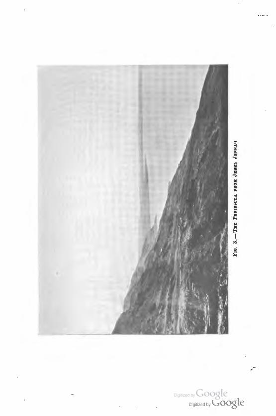
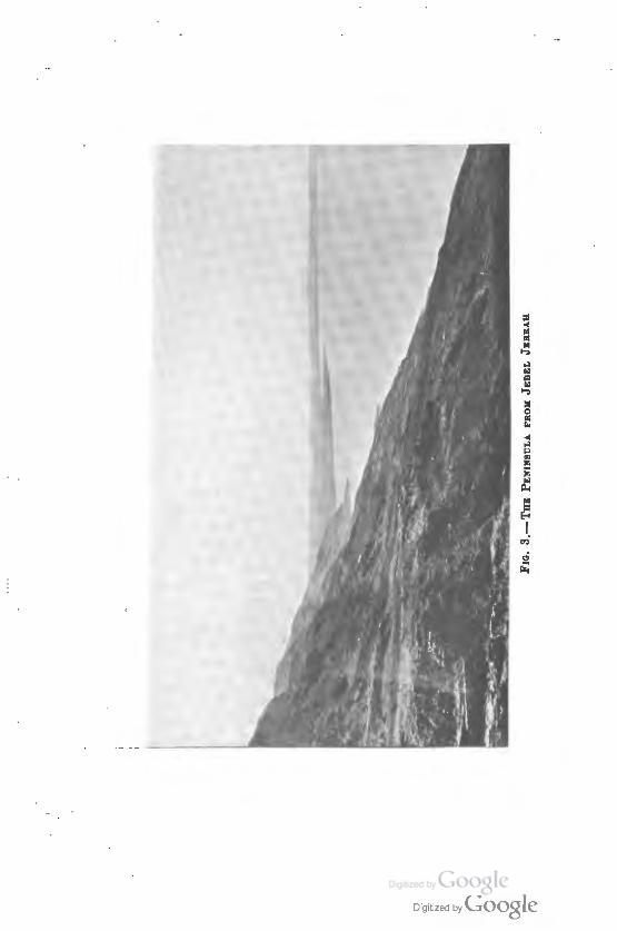
Lieutenant W. F. Lynch, on the 80th of April, 1848, started from 'Ain Jidi at 12.15 P.M., reached Cape Costigan at 4.10 P.M., steered S.S.E. and landed one mile and a half,north of El Mezra'ah. On the 1st of May be sent Dale and Aulick to sketch the shore, to verify the position of the mouth of WA.di Kerak, and to sound down the middle of the bay. A comparison between Lynch's map and the photograph from Jebel Jerrah accompanying this article will show how unsafe it is to rely upon such sketches of the shore. The line of soundings seems to show that the boat did not go near the eastern coast, and the Sell !Jaditheh appears to have been mistaken for Widi Beni ~ammideh, which, according to Lieutenant Lynch, waters the Mezra'ah. On
• lravez. l11 Syria a!ld the Holy Land, 1822, p. 891. • lra11eZ.. f11 Emt a11d Nubia, Sgria, a!ld the Holv Land, 1845, pp. 137 tr. 1 Jouf'II(Jl of the Royal Geograpldccd SocMtV of Lo!ldo11, :nUL 1848, p. 128. • Journal, p. 129.
Digitized by G oog I e
84 JOURNAL OF BIBLICAL LITERATURE
that day Lynch visited the ruins of "Zoar,. (ijurbet Abd el Ra\Um), and on the next he ascended to Kerak by W&di Beni l;lammideh (?) and WAdi Kerak. Returning on the Sd, he started at 1.55 P.M in his boat toward WAdi el Mojib, which he reached at 5.25 P.M. He did not stop anywhere to examine the coast, and records no feature except an arch spanning the chasm of a ravine, which he passed at 4.45 P.M.T
Felicien de Saulcy, on the 14th of January, 1851, at 2.15 P.M., arrived from the south at WAdi el 'A,al (J.,.a.aJf ~lo)t,). At 2.47 P.M. he was at the entrance of W&di Kathrabba ~fS' ~lo)f,, "w4di of the multitude of trees"?). Ascending the next morning, with WAdi el • A,al to the right, he reached Jebel el ijarazeh ('5.ft ~) after an hour's climb.
Half an hour later he arrived at the immense rock from which issues W&di el Kerak, also called WAdi el DerA', and at the foot of the rock he found the Taw&}.lin el Sukkar <?.t ~~ ), or Sugar Mills. From this point to the hills in the west he estimated the distance at five or six kilometres. The intervening plain was called Ghor el Mezra'ab. Besides the main stream, called N ahr el Deri.', he croesed six other streams before arriving at the village of El Mezra'ah. On the 16th of June he left at 8.06 A.M., crossed a ravine at 8.25, visited ijurbet Abd el Ra}.lim, and at 8.46 reached Sell WAdi Beni Hammideh. Ten minutes later he was at W&di . . Jerrab (" Djerrah ou Adjerrah "), and had to his right, as be ascended, the plain of ij:aditheh (" El Hadits "). On the 17th he found, west of Jebel ~i\lA.n, WAdi el ~e:~Filf. (twit)i ,.tdf ~lo)f,), and on the 21st he again crOBBed WAdi el DerA', going to Ghor el ~afiyeh.e
The Due de Luynes and his companions left Jebel Usdum for the peninsula on the 24th of March, 1864, and arrived there on the 25th. The following morning they rode to Nahr el Deti.', but not to the village, then ascended the mountains, after an hour passed, on the left, WAdi el ijarazeh,
' Narratioe of the Unittd Statu Expedition to the Rioer Jord4n alld tM Dead Sea, 1M9, pp. 886-867.
1 Yovage a•tour de laMer Mortt et dau lu terre• bibliquu, t. 1868, pp. 289-399.
Digitized by G oog I e
SCHMIDT: THE RUINS IN W ..i.Dl BUWEIL 85
explained as "the w4di of the Pearl," and finally reached Kerak. He returned on the 28th, lost the 29th in an attempt to sail around Cape Molyneux, and was not able until late in the night to use a favorable wind which brought him past Cape Costigan and to the mouth of the M&jib early in the morning of the 30th. It was, of course, impossible to make any observations of the eastern coast.'
Towards the end of April, 1870, E. H. Palmer and C. F. Tyrwhitt Drake walked up from Ghor el ~afiyeh to the peninsula. They noticed the shrines of Abu Ketaineh and Nebi Salah, and pitched their tents in the village. The next morning they made a tour of the northern end of the peninsula, finding some ruins and the depression called • Aril (Ji~ ), in which water collected in the rainy season. They then passed the ruined fort called Tell 'Abd el RaJ.llm, and crossing the Seil ij;aditheh ascended the Na~b Jerrah into the mountains.1o
On the 24th of April, 187 4, H. Rothe, with three companions of the Beni ijammideh, climbed up the mountains from the mouth of the W&di el Mojib, starting at 6 A.M.,
and reaching the top of the wall at 7 A.M. After two hours. of march he descended again to the sea, where he found a. petroleum spring ten feet from the shore, and near it a. spring of cool and sweetish water. Ascending a_gain, he· found the needle of rock forty feet ta.ll, called Bint SeQ!. LU.~After another hour's march he reached a plain jutting out into the sea, and evidently passed it in fifty minutes on the· heights above. Beyond this plain he followed the coast for· forty-five minutes until opposite Cape Costigan. Two hours and a half before reaching the first Bedawin camp of El Mezra'ah he mentions a wddi, called WA.di 'U~i\t. The entire walk had taken nine hours, but there had been much ascending and descending the mountains. It is quite impossible that Rothe could have passed the ruins and aqueduct at the mouth of WA.di Suweil without being
t Voyage d'ezplomtion a la Mer Mom, a Pttra, ee "" la rit1t gtJtiCAt dw Jowrdaln, 1874, pp. 94 ff., 114.
10 The Dt~rt of lilt E:todtu, ll. 1871, pp. 466 fL
Digitized by G oog I e
86 JOURNAL OF BIBLICAL LITERATURE
attracted by them. He must have passed by this place on the mountains above. When he met Dr. Kersten on the 25th he reported that he had often been "ausser Sicht des Todten Meeres." On the following day Kersten and Rothe went in two hours as far as Cape Costigan. They con-.tinued on the 27th to Ghor e1 ~afiyeh.n ·
Sir Gray Hill, on the 6th of April, 1895, "camped at lEI Mczra'ah, near to the stream which courses down tho Wady el Deraah," "crossed the Lisan and descended to t1Ae watet·'s edge," and then rode down to Ghor el ~afiyeh.ll
La September, 1895, Mr. Alexander Hornstein and Mr. A. Ford went, in the government boat which was then running between the northern end of the lake and the peninsula., to Ghor el Mezra.'ah. Starting at 6 P.M., they landed on the peninsula at 1 A.M. The darkness of the night was somewhat relieved by moonlight. They immediately proceeded to Kerak. 13
It is evident that, aside from Mr. Rothe, none of these travellers have had a chance to examine at close range the eastern coast between the Mojib and the Wadi Beni Hammideh, and that he came down to the shore some distance below the WAdi Suweil.
In the course of our circumnavigation of the Dead Sea, my students and I left the delta of the Mojib on the 28d of February, 1905, at 1.10 P.M. We passed the natural bridge across a chasm mentioned by Lynch, at 1.84. At 1.66 we saw an impressive rock-needle on a bill above the rocks, and supposed it to be the Bint ~eib Lu~ (~,J ~ ~)dis-covered by Palmer and seen by Rothe, though the semblance of a woman was far more marked in the case of a figure observed south of Rls el 'farlleh, at 8.17. At 2.25 we photographed the most striking feature of the coast between the Mojib and the peninsula. It is a promontory which stretches out as vertical as a wall for a mile from the moun-
u Otto Kersten, "Umwanderung des Todten Keerea," In ZritlcAr(ft du Pulaulina-Yerdu, 1879, pp. 212 f. and .ArtAang, p. 223.
u Paluttne Ezploratton And, Quarmlr ~c, 1806, pp. 24-46. u Paluline EzplONJCion .hrad, Quarftrlr 8tGinlttd, 1898, pp. "' tr.
Digitized by G oog I e
SOWIIDT: THE RUINS IN W Ani SUWEIL 87
tain, with top almost perfectly level and a long beach fronting it on the northern side. This I take to be the Ria el '.fsilleh of Molyneux, the Rls el Bel)fsh being north of the Mojib, and !U.s el Kerah probably a mispronunciation for RAs el Kerak, and meant to indicate what Lynch called Cape Costigan. The name Rls el '.fafileh seems to have been derived from that of the tribe, which once apparently extended their in6.uence further north than at present.l'
At 2.88 we were opposite the wddi which comes down just north of this promontory, and which, following the map, we then supposed to be WAdi Jerrah. I now believe that it is . Wadi el ~e)fi)f (~I ~1)1,). This wddi seems to be connected with the 'Ain Sgtlk mentioned by Seetzen south of the Amon. De Saulcy 16 found the name used of 11. w4di running north for some distance, to the west of Jebel ~il)An, and then taming west. De Luynes,16 recognizing the accuracy of De Saulcy's description, found no reason to doubt that the name of this wdd£ was also correctly given.
When I visited Jebel ~il.tAn on the 13th of July, 1905, I was ~tinctly told by the Beni J1ammideh that this WAdi el &~i)f turned to the west just north of Jebel ~1l,l&n and debouched in the Dead Sea a considerable distance north of WAdi Jerrah, and that immediately north of it WAdi el Bediyeh 6.owed into the Mojib. The name means "the riven wAdi," and this characterizes its appearance both in its upper course and at its mouth. "WAdi 'U]f.i)f" (should be 'U~i)f) in Rothe's itinerary 17 is one hour south of the hills about RAs el 'failleh. The name may be a conjecture of a guide not familiar with the coast, as no other names are given in the itinerary. At 2.47 the mouth of this wddi was photographed.
The promontory proved to be a broad terrace with perfectly level top but broken up near the water by many cuts through which the water evidently comes down after rains.
14 De Luynee, Yore19e d'e%.J>loratfon, p. 109. 11 Vore19e aueour de laMer More., t. pp. 823, 884 fl. » Vorage d'~loraliofl, p. 170. 17 ZeUicAr(fl du cleuCIChen Palaulifla- Verrilli, 1879, p. !28.
Digitized by G oog I e
88 JOURNAL OF BIBLICAL LITERATURE
A wide beach ran all along the foot of the terrace, large black basalt stones were seen on the shore, and the slopes of the lower hills were covered with brushwood. After a quarter of an hour from W&di el Se,il~ we reached the end of the low hills, where the beach continued, forming a plain covered with brushwood. At 3.17 we were opposite another wddi which came down in a northerly direction and turned suddenly to the southwest. Here the figure of a. woman, referred to above, was seen on the northern side on a high hill. At 3.52 Jebel Jerrah was seen, and at 4.11 we landed on a broad beach in front of a wddi. If it runs far enough back, this may be the W&di Emdebea mentioned by de Saulcy 18
as going directly west to the coast from a point below Jebel Sil;l&n. I heard Madbea};l (e'~; cf. Ma#Jaxtk).
Here we were detained by a storm until the 26th, and used the opportunity to explore the neighborhood. From the top of Jebel Jerrah photographs of the coast down to the peninsula and of Cape Costigan (R&s el Kerak) were taken by .Messrs. Wrench and Charles. On the 26th I went down the coast, accompanied by Mr. Olmstead and Mr. Charles, Mr. Wrench remaining to guard the boat. We left at 10.51 A.M., crossed several small wddi• at 10.54, 11.01, 11.06, and 11.09, and at 11.12 came to a promontory of great height where there was no passage along the shore, the cliffs overhanging the sea. Between the ends of the promontory there were three deep ravines. The wddi at the southern end had a. high stone at its mouth. At 11.40 we came to a great wddi with two arms, enclosing a delta half a mile long. Here were large trees, tamarisks, and brushwood. Beyond the second arm the level was fifteen feet higher, and the sides were undercut by the stream. There was no water here, but at 11.45 we found a large pool in the delta. At 12.07 we reached the beginning of another delta, three-quarters of a. mile long. At 12.15 we arrived at the mouth of Wadi Suweil, and made the interesting discovery of an ancient aqueduct and the ruins of some houses.
I learned the name of this wddi on my second visit to the ll Y?ragt autour dt la Mer Jlorti!, I. pp. 826, 882, 3M.
Digitized by G oog I e
SCHMIDT : THE RUINS IN WADi BUWEIL 89
place five months later. Suweil (J:?,-) is a diminutive of Seil (J.t,w) and characterizes the river as the wddi of "the small stream." The name is appropriate, for when we ascended the wddi as far as it was possible to go, we found a small stream trickling down from a circular basin twelve feet above, which was filled with sweet water. There was apparently no change in the amount of water in July. In the chasm there were no ruins, but a short distance from the entrance were the remains of an ancient aqueduct.
The length of this aqueduct was 160 feet, its width 2 feet 2 inches, its height 5 feet 6 inches. It rested on round arches. Three of these remained, and were 3 feet in height and 8 feet 3 inches wide at the bottom. The covered trough was 9 inches wide, and 7! inches deep. While the arches were of large sandstones and the aqueduct itself evidently built of sandstone, the channel had been filled up with limestone deposit, and much of tho structure was covered with the same limestone. On the top the coating was 2 inches deep, and all along the centre ran a little channel from lt to 2 inches deep, down which the water found its way after the trough had been filled up. The course of the aqueduct could be followed by the dlbri• for 270 feet to the west, where there was a high wall 6 feet above the river bed, near the top of which could be seen 25 feet more of the trough. Fifty feet farther west it was visible again, curving off to the north, with another branch going south to the ruins of a large building.
Nearer the sea we found the ruins of a house, 70 feet long and 50 feet wide. At the south entrance two well-cut door jambs and a number of hewn stones were seen. I found a piece of ribbed pottery here. Southwest of this ruin were the foundations of another building, 78 feet by 72 feet, and nearer the sea, but 30 feet above it, the remains of two other buildings.
The appearance of one of the Ghawarineh and the sight of a camp beyond, not noticed in the excitement of discovery, led us to return hastily to the boat. We set out that night for the western shore, which we reached after eight hours of
Digitized by G oog I e
90 JOURNAL OF BmLICAL LITERATURE
battling with a fierce northwesterly wind and billows heavy as lead.
In the middle of July, coming to Kerak from Arabia Petrooa, I decided, in spite of the exceBBive heat, to descend to the peninsula and to explore the coast from there to the place where the aqueduct was discovered. Accompanied by Mr. Wrench and Mr. John Whiting, I left Kerak on the 12th of July at 2 P.M. At 2.80 we reached 'Ain SA.rah (a)'- ~ ), a beautiful spring issuing from a rock ; at 8.80 W ft.di Sakkarah (a;:- ~l)f,) was seen to enter WAdi Kerak. For two hours the road was so level that it was poBBible to gallop along and make good speed. We came to Jebel el ij:arazeh (l)ft ~), "the Mountain of the Pearl," at 5 P.M. At o P.M. we were told that El DerA.', which comes from the southeast and carries water into the Seil el Kerak, was at a short distance to the north, and at 6.80 we arrived at the 'fawll;tin el Sukkar <.,..G-Jf ~t,.»). A mountain which we photographed the next morning stretches between the village and El Deri.', which issues from the high rock near the " Sugar Mills." We arrived at El Mezra'ah at 7.80 and spent the night there, being very courteously received by the Ghawarineh. The village con· sista of about fifty tents and probably has about two hundred inhabitants.
The next morning Mr. Wrench went back to the 'fawll;tin el Sukkar to photograph it and to take its bearings. Sebbeh (Maslda) bore 29or, 'Ain Jidi 8311°; it is consequently located in 85° 80' 56" E. longitude, and 81° 14' 85" N. latitude.
We left El Mezra'ah at 5.80 .AaM., and crOBBed some smaller creeks and the wider stream of Sell I;Iaditheh (~~ ~). This stream seems to come from the WA.di Kerak, 1lowing northwest from a point above the 'fawA.l;tin el Sukkar. The other streams on the peninsula come from the "Sugar Mills." The reason the river in ita lower course is sometimes called WA.di el DerA.', sometimes WA.di Kerak, is that the WA.dt Kerak is not a perennial stream above the
Digitized by G oog I e
SCHMIDT: THB RUINS IN W ADl SUWEIL 91
place where it receives the water of El Der&•. Soon after cr088ing the Seil ij:aditheh, we came to the village of ij:aditheh. This consists of a number of mud houses like those of Jericho, and seems to be of recent origin, as it has not been mentioned by any previous explorer. It is not inhabited in the summer. This village bears Sebbeh 281!0
, •Ain Jidi 827°. Its exact location, therefore, is 85° 80' 44" E. and sr 17' 18" N. We left at 6.05.
Five minutes after leaving El I;Iaditheh we arrived at WAdi Beni ij:ammideh (a~ ~ ~l)f,), and ten minutes later cro88ed W&di Jerrah (a~ ~l)f,). The first impor
tant wddi north of this was W&di Sebaieh (~ ~l)f,), which was crossed about fifteen minutes after leaving .. W&di Jerrah. At 6.40 we found the first section of an ancient Roman road. It was broken off suddenly, the sea having apparently scooped out a bay, beyond which a second section of the road could be followed for a distance until it again disappeared owing to the action of the sea. A third section led up to the ruins at the mouth of Wadt Suweil. These were no doubt remains of the Darb el Lisan (~l..JJI ~)1)), said to have extended in earlier times from the north, acr088 the peninsula, to the southern bay.19
At 7.15 I arrived for the second time at the mouth of W&dt Suweil. This bore Sebbeh 266!0
, •Ain Jidi 891t,o and is consequently situated in 85° 80' 44" E. longitude, and 81° 19' 87" N. latitude. On my first visit I had been satisfied with identifying the aqueduct with the 'faw&l;lin el Sukkar mentioned to Burckhardt by the people of Kerak. There could be little doubt about this. I did not dare to a88ign to the ruins a higher age than the period of the Crusades. There were various centres of the sugar industry near the Dead Sea in the twelfth and thirteenth centuries, among which were the 'fawal;lin el Sukkar near Jericho, those in the Ghor el ~afiyeh, on the peninsula, and at the mouth of W&di Suweil, and there seem to have been still others. Coming back from my second expedition to Arabia Petrma, where
1t F. de S&ulcy, Vo,age autour dt laMer Norte, L 1868, p. 291.
Digitized by G oog I e
92 JOURNAL OF BIBLICAL LITERATURE
there had been ample opportunities for the study of the architecture and types of pottery characteristic of the Roman period, I could not resist the impression that the aqueduct was built in Roman times, and that the foundations of the houses belonged to the same age. The arches were built exactly in the same manner as those I had seen in numerous Byzantine city ruins. The plan of the houses and the shape of the door-jambs reminded me of some places recently visited; and the piece of pottery was of the same type as those I had picked up at the ijurbet Nu,rA.ni. The earlier name of this " Christian ruin " was not known to the Bedawin squatting near the ancient city which we had discovered only three days before between })ana and Bu~rah in a position commanding a view of the Dead Sea.z
The aqueduct was probably built to supply the little community with water, as branches were led to the different buildings. It may be conjectured that a caatellum once stood here for the defence of the road. It is not probable that this "ancient city," as the people of Kerak called it, was the objective point of the Roman road. North of WA.di Suweil, however, as Burckhardt says, "the mountains run down to the lake, and a steep cliff overhangs the sea." This.statement made almost one hundred years ago is true, as I found it on my first visit. But as the Roman road south of WA.di Suweil has manifestly been in part destroyed by the invasion of the sea, so it is possible that this road once ran in front of the cliff which to-day, as well as in Burckhardt's time, "shuts out all passage along the shore."
In establishing their sugar mills around the Dead Sea, the Crusaders naturally availed themselves of such aqueducts. There must once have been an abundance of water in W&di Suweil, but except for the small quantity of water that trickles down from the basin, the lower part of the wddi seems at present to be dry both in winter and in summer. What. is the cause of the change? The heavy limestone coating suggests the answer. It is a well-known fact that a river may
to Schmidt, Report of tlu Dire«or of 1M .American School of .Arehalologr in PIJlutine, lD<K-1006, pp. 87 fL
Digitized by G oog I e
SCHMIDT: THE RUINS IN W ADf SUWEIL 93
by its deposits of lime create bar1iers preventing its progress in the accustomed direction and changing the course.21
That is apparently what has happened here. The ruined locality is called Abu'l ll'elus by the natives of the peninsula, and the name, here as elsewhere, indicates a belief that treasures are hidden in the place.
From Wadi Suweil we returned to W&di Beni I;lammideh, ascended this wddi some distance, then turned up the side of Wadi Jerrah, and slept in the village of the Beni I;Iammideh at Jebel ~il;t&n on the night of the 13th of July.
The southern part of the peninsula was seen by us on the 28th of February, and three photographs were taken representing the northeastern corner of the bay, the peculiar rocks halfway between this point and the cape, and Cape Molyneux itself from E.S.E. At 2.15 P.M. we saw the finest sample of the famous white line, with a remarkable haze above it toward the west. It ran due east and west. This disposes of the brilliant generalization of Blanckenhorn in 1896 21 from one fact observed by Molyneux in 1847.28 This impreSiiive belt of foam cannot be an indication of the existence at the present time of a fault at the bottom of the lake, running north and south. Gautier's observation in March, 1889,:M is not even sufficient to show a preference for this direction. Not only south of the peninsula, but also north of it, we once saw the line lying athwart the sea as well as in other directions, though it was never so extensive and finely cut as on this last occasion. The wind bloweth where it listeth on the Dead Sea, and the foam forms into belts regardless of geological theories. That night we slept on the peninsula just north of the cape. Burckhardt's Arabs had assured him that there was a ford three hours north of ~afiyeh by which the lake could be crossed in · three hours and a half, that " there are spots in this ford
11 Cf. tlill6e Recloa, La ttrre : Ducription du pM11omHe1 de la vie du globt,1 1870, pp. 460, 476 If.
11 Zeitlchrlft de• Deutlchen Palautina-Verein1, 18116, p. 69. 11 Journal of the Royal Geographical Society of London, xvill 1848, p.
129. II Encyclop«dia Bibllca, ar\lcle • The Dead &a,' col. 1046.
Digitized by G oog le
94 JOURNAL OF BIBLICAL LITERATURE
where the water is quite hot, and where the bottom is of red earth," that "the ford is nowhere deeper than three or four feet," and generally only two feet, and that "the water is so impregnated with salt that the skin of the legs of those who wade across it soon afterward peels entirely off." • This ford must, of course, have been between Cape Molyneux and the nearest point on the opposite side. As we were forced to jump into the water to drag the boat ashore, we had an opportunity of verifying the statements made to Burckhardt, and although we found the water hot, and the bottom slippery and of a reddish tint, neither here nor anywhere else on the lake did we observe any oil. Lynch does not seem to have made his soundings where the ford once was. Though our feet were bare and for days were exposed to the water in the lake and in the leaky boat, our shoes having shrunk too much to be used, the skin was never badly affected ; and, on the whole, our experience confirmed the statement of some fishermen at the mouth of the Jordan that "the water of the Dead Sea is good for the body, but bad for one's clothes."
In the present article I have avoided the use of the term " Lis&n '' for the peninsula, for the reasou that some notes taken while I was there last July have raised a doubt in my mind in reference to the name. De Saulcy appears to have been the first to use it. He maintains that the peninsula has to-day the same name that it bore in Hebrew antiquity, and finds the evidence that it was then called J'llt'r,M in Josh. 152- 5
and 1819. He regards the boundary line of Judah as running from a point on the western shore just opposite the peninsula.• Even de Luynes, who, on the authority of de Saulcy, accepts El LisA.n as the modern name of the peninsula, is unable to adopt this explanation of nr,~;, c~ J'llt'r, in the passages in Joshua ; IT and all exegetes are agreed that ~~~:, 152 refers to the southern bay, i.e. the southern end of the lake ( cf. N um. 84•), while c~M J'llt'r, 156 and ~., c~ ~ 1819 refer to the northern bay, the northern end of the lake.
• 7hn!tll in Sfrla and tilt Holr LaRd, 1822, p. SM. • Vorage, l. 1863, p. 289ft II Vorage d'e%J1loration, 1874, p. 90.
Digitized by G oog I e
SCHMIDT: THE RUINS IN WADI SUWEIL 95
But de Saulcy's statement that the peninsula is now called El Lisln has not been questioned; and it does not seem to have been noticed that careful observers like Seetzen, Burckhardt, Irby and Mangles, Lynch, Palmer, and Drake have not used the term. The similarity to a tongue struck de Luynes; and the custom of denoting such a projecting slip of land a •• Landzunge," or "tongue of land," naturally led German and English scholars to accept the IIame. On the peninsula, however, I was told that "this," the peninsula, was called Ghor el Mezra•ah, and "that," the southern bay, LisAn el Bahr. The term l:JW is never used in Arabic for a tongue of land. At least I am not aware of any passage in Arabic literature where ~~ l:JW is used of a peninsula, and can find no evidence that it is so used in any modern dialect. It always signifies a bay; and rll l:JW is con-sequently an accurate translation of c~:-1 l,~"·
Digitized by G oog I e
..
/
Digitized by Coogle
DigltizedbyGO gle
Digitized by Goog le
/
Digitized by Coogle
Digitized by Coogle
Digitized by Coogle
Digitized by G oog le
l.
o;9,tized by Goog le
w = f-o I
...:
Digitized by Goog I e
F1n. 8.- CAr·~: CosTWAN (RAs EL KERAK) •·aox JEBEL J~:RRAII
Fro. 9 . -1\lom<TAIN BETWEEN TAWAJ;IIN EL St:KitAR ANDEL Mr::za.o~.' .o~.u
Digitized by G oog I e
FIG, 10.- WADi KL 'A~AL AND NKCK OF THK Pt:!llli8ULA FROX THB SoUTH