4
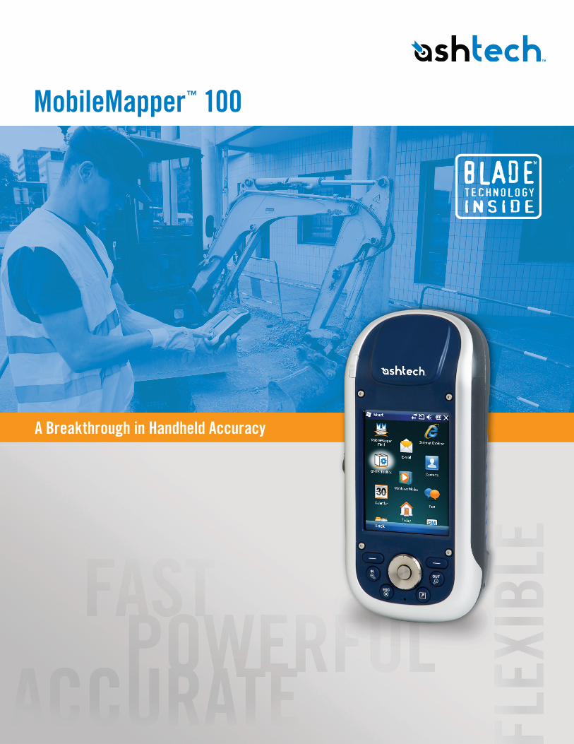
A Breakthrough in Handheld Accuracy MobileMapper ™ 100
| Date post: | 14-Apr-2017 |
| Category: |
Engineering |
| Upload: | budi-anto |
| View: | 116 times |
| Download: | 4 times |
A Breakthrough in Handheld Accuracy
MobileMapper™ 100
Mob
ileM
appe
r 10
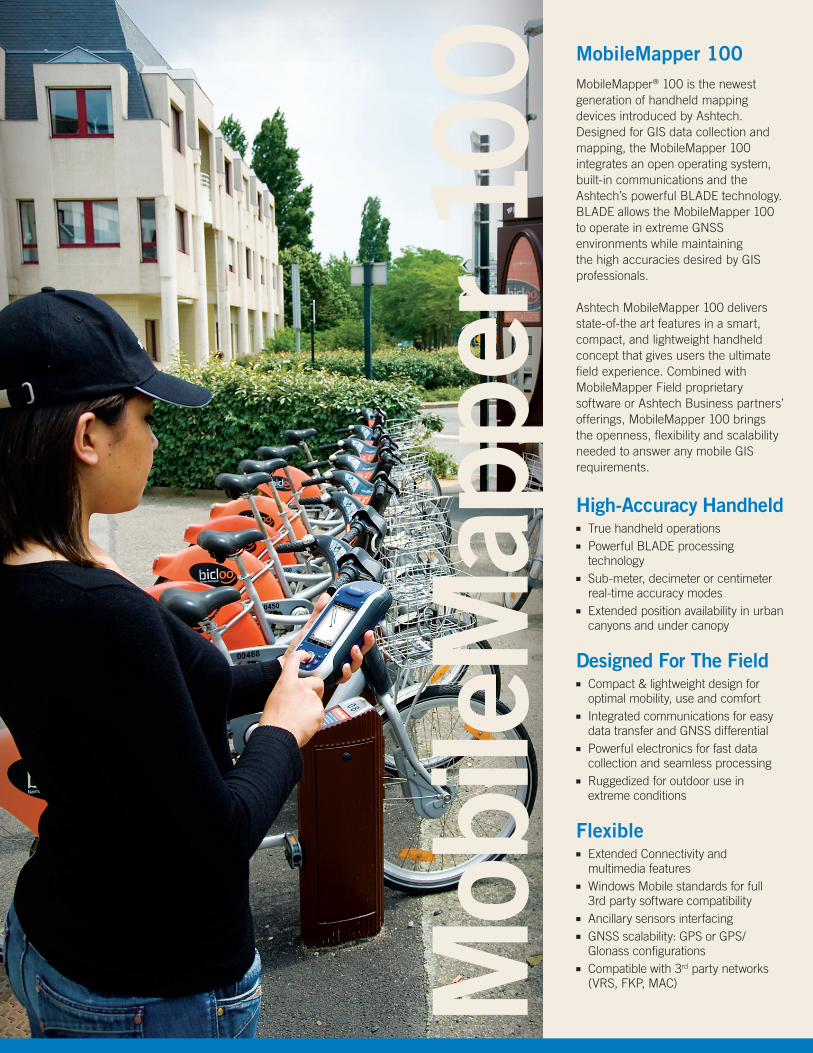
0 MobileMapper 100MobileMapper® 100 is the newest generation of handheld mapping devices introduced by Ashtech. Designed for GIS data collection and mapping, the MobileMapper 100 integrates an open operating system, built-in communications and the Ashtech’s powerful BLADE technology. BLADE allows the MobileMapper 100 to operate in extreme GNSS environments while maintaining the high accuracies desired by GIS professionals.
Ashtech MobileMapper 100 delivers state-of-the art features in a smart, compact, and lightweight handheld concept that gives users the ultimate field experience. Combined with MobileMapper Field proprietary software or Ashtech Business partners’ offerings, MobileMapper 100 brings the openness, flexibility and scalability needed to answer any mobile GIS requirements.
High-Accuracy Handheld■■ True handheld operations■■ Powerful BLADE processing
technology■■ Sub-meter, decimeter or centimeter
real-time accuracy modes ■■ Extended position availability in urban
canyons and under canopy
Designed For The Field■■ Compact & lightweight design for
optimal mobility, use and comfort ■■ Integrated communications for easy
data transfer and GNSS differential ■■ Powerful electronics for fast data
collection and seamless processing■■ Ruggedized for outdoor use in
extreme conditions
Flexible■■ Extended Connectivity and
multimedia features■■ Windows Mobile standards for full
3rd party software compatibility ■■ Ancillary sensors interfacing ■■ GNSS scalability: GPS or GPS/
Glonass configurations ■■ Compatible with 3rd party networks
(VRS, FKP, MAC)
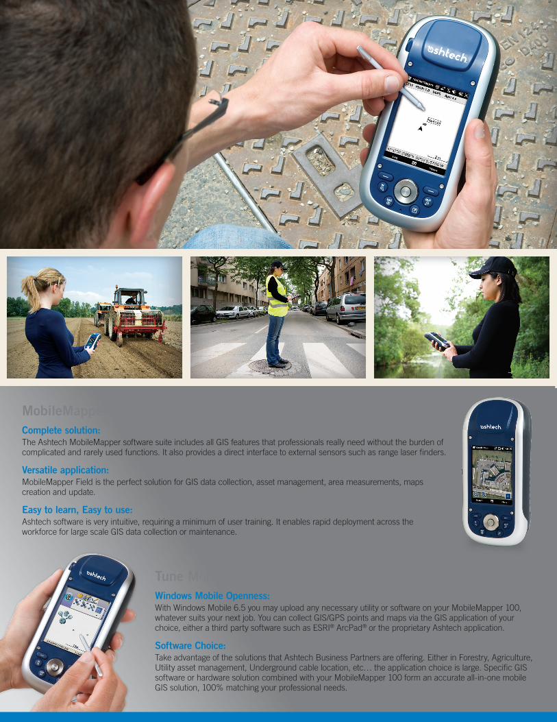
MobileMapper Field and Office SoftwareComplete solution:The Ashtech MobileMapper software suite includes all GIS features that professionals really need without the burden of complicated and rarely used functions. It also provides a direct interface to external sensors such as range laser finders.
Versatile application:MobileMapper Field is the perfect solution for GIS data collection, asset management, area measurements, maps creation and update.
Easy to learn, Easy to use:Ashtech software is very intuitive, requiring a minimum of user training. It enables rapid deployment across the workforce for large scale GIS data collection or maintenance.
Tune MobileMapper 100 to your ApplicationsWindows Mobile Openness:With Windows Mobile 6.5 you may upload any necessary utility or software on your MobileMapper 100, whatever suits your next job. You can collect GIS/GPS points and maps via the GIS application of your choice, either a third party software such as ESRI® ArcPad® or the proprietary Ashtech application.
Software Choice:Take advantage of the solutions that Ashtech Business Partners are offering. Either in Forestry, Agriculture, Utility asset management, Underground cable location, etc… the application choice is large. Specific GIS software or hardware solution combined with your MobileMapper 100 form an accurate all-in-one mobile GIS solution, 100% matching your professional needs.
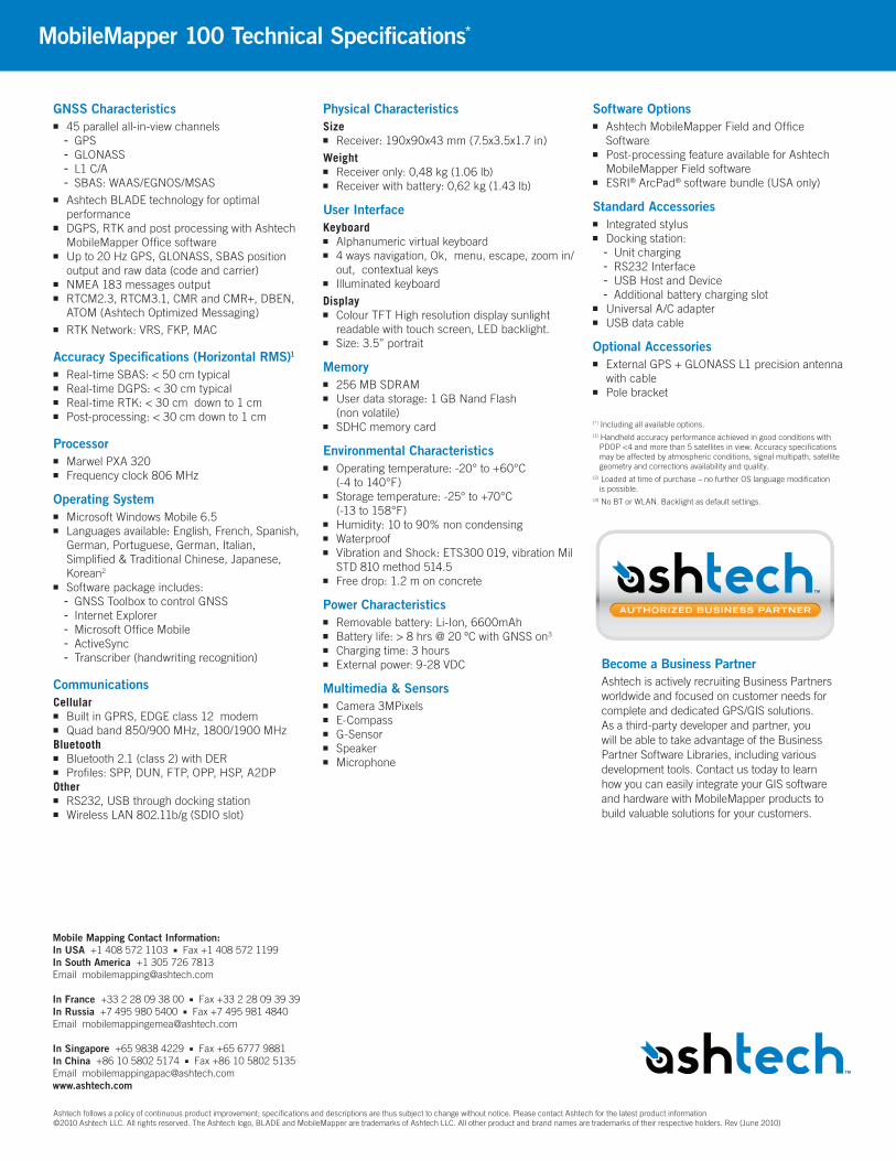
GNSS Characteristics■■ 45 parallel all-in-view channels - GPS- GLONASS- L1 C/A- SBAS: WAAS/EGNOS/MSAS
■■ Ashtech BLADE technology for optimal performance
■■ DGPS, RTK and post processing with Ashtech MobileMapper Office software
■■ Up to 20 Hz GPS, GLONASS, SBAS position output and raw data (code and carrier)
■■ NMEA 183 messages output■■ RTCM2.3, RTCM3.1, CMR and CMR+, DBEN,
ATOM (Ashtech Optimized Messaging)■■ RTK Network: VRS, FKP, MAC
Accuracy Specifications (Horizontal RMS)1■■ Real-time SBAS: < 50 cm typical ■■ Real-time DGPS: < 30 cm typical ■■ Real-time RTK: < 30 cm down to 1 cm ■■ Post-processing: < 30 cm down to 1 cm
Processor■■ Marwel PXA 320■■ Frequency clock 806 MHz
Operating System■■ Microsoft Windows Mobile 6.5 ■■ Languages available: English, French, Spanish,
German, Portuguese, German, Italian, Simplified & Traditional Chinese, Japanese, Korean2
■■ Software package includes:- GNSS Toolbox to control GNSS- Internet Explorer- Microsoft Office Mobile- ActiveSync- Transcriber (handwriting recognition)
CommunicationsCellular■■ Built in GPRS, EDGE class 12 modem■■ Quad band 850/900 MHz, 1800/1900 MHz Bluetooth■■ Bluetooth 2.1 (class 2) with DER■■ Profiles: SPP, DUN, FTP, OPP, HSP, A2DPOther■■ RS232, USB through docking station ■■ Wireless LAN 802.11b/g (SDIO slot)
Physical CharacteristicsSize■■ Receiver: 190x90x43 mm (7.5x3.5x1.7 in)
Weight■■ Receiver only: 0,48 kg (1.06 lb)■■ Receiver with battery: 0,62 kg (1.43 lb)
User InterfaceKeyboard■■ Alphanumeric virtual keyboard■■ 4 ways navigation, Ok, menu, escape, zoom in/
out, contextual keys■■ Illuminated keyboard
Display■■ Colour TFT High resolution display sunlight
readable with touch screen, LED backlight.■■ Size: 3.5” portrait
Memory■■ 256 MB SDRAM■■ User data storage: 1 GB Nand Flash
(non volatile) ■■ SDHC memory card
Environmental Characteristics■■ Operating temperature: -20° to +60°C
(-4 to 140°F)■■ Storage temperature: -25° to +70°C
(-13 to 158°F)■■ Humidity: 10 to 90% non condensing■■ Waterproof■■ Vibration and Shock: ETS300 019, vibration Mil
STD 810 method 514.5 ■■ Free drop: 1.2 m on concrete
Power Characteristics■■ Removable battery: Li-Ion, 6600mAh■■ Battery life: > 8 hrs @ 20 ºC with GNSS on3 ■■ Charging time: 3 hours ■■ External power: 9-28 VDC
Multimedia & Sensors ■■ Camera 3MPixels■■ E-Compass■■ G-Sensor■■ Speaker■■ Microphone
Software Options■■ Ashtech MobileMapper Field and Office
Software ■■ Post-processing feature available for Ashtech
MobileMapper Field software■■ ESRI® ArcPad® software bundle (USA only)
Standard Accessories■■ Integrated stylus ■■ Docking station:- Unit charging- RS232 Interface- USB Host and Device- Additional battery charging slot
■■ Universal A/C adapter■■ USB data cable
Optional Accessories■■ External GPS + GLONASS L1 precision antenna
with cable■■ Pole bracket
(*) Including all available options. (1) Handheld accuracy performance achieved in good conditions with
PDOP <4 and more than 5 satellites in view. Accuracy specifications may be affected by atmospheric conditions, signal multipath, satellite geometry and corrections availability and quality.
(2) Loaded at time of purchase – no further OS language modification is possible.
(3) No BT or WLAN. Backlight as default settings.
Become a Business PartnerAshtech is actively recruiting Business Partners worldwide and focused on customer needs for complete and dedicated GPS/GIS solutions. As a third-party developer and partner, you will be able to take advantage of the Business Partner Software Libraries, including various development tools. Contact us today to learn how you can easily integrate your GIS software and hardware with MobileMapper products to build valuable solutions for your customers.
MobileMapper 100 Technical Specifications*
Mobile Mapping Contact Information:In USA +1 408 572 1103 ■ Fax +1 408 572 1199In South America +1 305 726 7813 Email [email protected]
In France +33 2 28 09 38 00 ■ Fax +33 2 28 09 39 39In Russia +7 495 980 5400 ■ Fax +7 495 981 4840Email [email protected]
In Singapore +65 9838 4229 ■ Fax +65 6777 9881In China +86 10 5802 5174 ■ Fax +86 10 5802 5135 Email [email protected]
Ashtech follows a policy of continuous product improvement; specifications and descriptions are thus subject to change without notice. Please contact Ashtech for the latest product information ©2010 Ashtech LLC. All rights reserved. The Ashtech logo, BLADE and MobileMapper are trademarks of Ashtech LLC. All other product and brand names are trademarks of their respective holders. Rev (June 2010)


