Page 1
1
PLANNING CONSIDERATIONS FOR SITE SELECTION OF
LOW INCOME SETTLEMENT PROJECTS
by
Harold A. Ruck
B. Arch., University of Tennessee
1975
M.Arch.A.S., Massachusetts Institute of Technology
1980
Submitted in partial fulfillment of the requirements
of the Degree of
MASTER OF CITY PLANNING
at the
MASSACHUSETTS INSTITUTE OF TECHNOLOGY
January 1983
© Harold A. Ruck
The Author hereby grants to M..I.T. permission to reproduceand to distribute copies of this thesis document in wholeor in part.
Signature of AuthorDepartment of Urban Studies and Planning
January 1983
Certified by
Accepted by
Lisa'R. PeattieThesis Supervisor
Chairman, Department Graduate Committee
RotchMASSACHUSETTS INSTITUTE
OF TECHNOLOGY
JUL 21 1983
cImARIES
Page 2
2
PLANNING CONSIDERATIONS FOR SITE SELECTION OF
LOW INCOME SETTLEMENT PROJECTS
by
Harold A. Ruck
Submitted to the Department of Urban Studies and Planning
on January 1983
in partial fulfillment of the requirements for the Degree of
Master of City Planning
ABSTRACT
Of the issues involved in the development of low incomesettlement projects, important consideration must be givento the selection of the site. This is because it affectsthe affordability of the development for the targetedincome group along with the ability to satisfy their needs.This work aims to address the criteria that planners shoulduse and the current "state of the art" for site selection,by investigating its key elements of concern, existingmethods and tools for evaluation; and the current involve-ment within institutions. These aspects are then broughttogether in a case study illustrating the points indicatedabove, and that 1) it is necessary to determine prioritiesof importance that many times involve trade-offs of cri-teria; 2) there is a process involved in selection of sites;and 3) other political concerns are just as, or more, in-fluencial in site selection than existing technical cri-teria.
Thesis Supervisor: Dr. Lisa R. Peattie
Title: Professor of Urban Studies andPlanning, M.I.T.
Page 3
3
PREFACE
This study intends to describe and explain planning
criteria, methodologies and process of site selection for
low income settlement projects. It is applicable to
people, professionals or otherwise, concerned with
development of housing for the poor particularly in
developing countries but it is appropriate to other
localities as well.
The specific elements, methodologies, discussions, and data
for the study are derived principally from individual
research of information documented in relevant literature,
and conversations with persons knowledgeable on the
subject. The case study of Cairo, Egypt, was chosen
because of the availability of studies on 1) the existing
urban features; 2) proposed growth patterns and policies;
and 3) site selection for this urban area; and persons
knowledgeable about the dynamics of its land market, and
capabilities of its political and institutional frameworks.
The attitudes and points of reference for this study are
reflected in the background and experience of the author.
This includes four years, from 1974 to 1978, connected with
the Vice Ministry of Urban Planning in Managua, Nicaragua,
(Central America), where I was employed as an
Architect/Planner during the era of General A. Somoza.
Also influencial was the author's participation in the
Urban Settlement Design Program (U.S.D.P.) at M.I.T., from
Page 4
4
19'8 to 1980. This program emphasized the evaluation of
existing urban dwelling environments, i.e., traditional,
public and private, and the design and evaluation of
alternative solutions, particularly site and sevice
projects.
The author gratefully acknowledges the support, guidance,
and advice of Professor Lisa Peattie, whose direction has
been invaluable in the preparation of this work. I am also
indebted to Reinhard Goethert and Tunney Lee for their
assistance, constructive criticism and suggestions; and to
Mauricio Silva for sharing his insite of institutional
involvement and concerns in site selection with the author.
Finally, I would like to thank my wife, Maria, --who with
her constant interest and support, was instrumental in my
finishing this work-- and my children, Carlos, Alan and
Brian, for their patience and their love.
Page 5
TABLE OF CONTENTS
PREFACE . . . . - - - -. - - - - - - - - - - -.
TABLE OF CONTENTS - - . . . . . . . . . . - - - -
LIST OF FIGURES . . . . - - - - - - - - - - - -..
INTRODUCTION - - - - - - - - - - - - - - - - - -
CHAPTER II:
PLANNING CRITERIA FOR SITE SELECTION-
A: Physical Characteristics - - - - - .
1. Size2. Shape3. Soil Conditions4. Topography
B. Social Criteria . . . -
1. Accessibility2. Nuisances/Hazards
C. Economic Criteria . - .
1. Land Cost2. Development Costs
D. Planning Policies . . .
1. Project Criteria2. Development Controls3. Institutional Structure
- - - - 10
11131315
- -- 20
2027
- . . . 29
3035
. . . . 38
384759
EXISTING METHODOLOGIES FOR SITE SELECTION -EVALUATION
A. Matrix . .. . . . . . . . . . . . .- - -B. Bertaud Model . . . . . - -. . . - - - -aC. Existing Organizational Participation - - -
CHAPTER III. CASE EXAMPLE: CAIRO, EGYPT - - - - - - - -
CHAPTER IV. CONCLUSION - - - - - - - - - - - - - - - -
FOOTNOTES . . . - - - - - - - - - -. - - - - -. . . .
BIBLIOGRAPHY . . . . . - . . . . - . . - - . . - . .
65
657080
86
- 107
- 112
114
5
Page
CHAPTER I:
3
5
6
7
- - - - -
. . . - .a
. . . . .a
Page 6
6
LIST OF FIGURES
FIGURE
FIGURE
FIGURE
FIGURE
FIGURE
FIGURE
FIGURE
FIGURE
FIGURE
FIGURE
FIGURE
FIGURE
1:
2:
3:
4:
5:
6:
7:
8:
9:
10:
11:
12:
FIGURE 13:
FIGURE 14:
FIGURE 15:
FIGURE 16:
Ranges of Modes of Travel . . a . a .
Preferred Distances of Activities/Facilities
Major Cost Components in Sites & ServiceProjects - - - - - - -
A Site Evaluation Chart . . . . . .
The Evaluation Matrix. . . . . . .
Rating Site Development Potential (Example).
Bertaud Model: Program 1 - Affordability
Bertaud Model: Program 1 - Variables forPrecise Values for Circulation Space andOn-Site Infrastructure Costs . . . .
Cairo Metropolitan Area (CMA)-Urbanization.
C.M.A. - Major Parcels of Vacant Land .
Districts of Cairo. . . . . . . a
Greater Cairo Region (GCR)-Existing RoadNetwork . . . . . . . . . . .
G.C.R. - Long Range Urban DevelopmentScheme . . . . . . . . . . . .
Preliminary Analysis of Property No. 0 -
El Khanka . . . . . . . . . .
Preliminary Analysis of Property No. 16 -El Owraniah West . . . . . . . .
Weighted Development Potential Scores .
- 25
. 26
- 31
. 66
. 67
. 69
- 73
. 76
. 87
. 88
. 91
. 94
. 97
* 99
.100
.103
Page 7
7
INTRODUCTION
In developing countries, the continued migration of poor
rural families to the urban centers in search of employment
creates problems in the availability of low income housing.
A particularly acute problem is that of affordability. In
part, this is a question of housing standards, in part a
result of high land and development costs. As a result,
low income squatters or illegal developments are becoming
permanent features of the urban centers in order to be
close to employment sources and benefit from central city
infrastructure and services. To deal with this problem
governments are now developing alternative low income
settlement projects. For these projects to be acceptable
and affordable to the low income, however, the government
must consider numerous development issues in- project
formulation and implementation including acceptable
financial terms per household, project funding, project
design; cost recovery, site selection, etc.
Of the issues involved in the development of low income
settlement projects, important consideration must be given
to the selection of the site. This is because it affects
the affordability of the development for the targeted
income group along with the ability to satisfy their needs.
Presently, the tendency has been to utilize the cheapest
possible land which is often of poor quality and located
well out of town due to the fact that there is little
Page 8
8
easily developable land available for low cost settlement
projects in the urban center. That which is, is generally
economically and/or politically suited for other land uses
which although cheaper to develop is too costly to purchase
and be affordable to the urban poor. However, the
peripheral locations with poor physical standards (soil,
topography, etc.) can increase development costs of land
preparation and infrastructure installation (depending on
costs of off-site infrastructure) which when combined with
raw land cost may still jeopardize the affordability for
the desired urban poor population. Apart from
affordability, another concern is that these sites may not
provide for the needs of the people involved. For
instance, it is necessary that the site be accessible to
transportation, major employment and economic sources,
community services and infrastructure, and be capable of
long term development and expansion opportunity.
Experience has shown that families will not stay if the
site is not acceptable to the people served.
These concerns and others influence the selection of the
site for low income housing projects and have an effect on
its success. This thesis aims to address the criteria that
planners should use for the selection of sites that will
allow the project to be affordable while also providing for
the needs of the targeted low income group. It will
investigate the key elements of concern in site selection,
i.e., physical, social, economical, and political, and will
Page 9
9
also look at the current "state of the art" of site
selection for low income settlement projects. It will
particularly review existing methods of evaluation; a
current tool being utilized, the Bertaud Model, relating
its advantages and disadvantages; and lastly, the existing
involvement in site selection of appropriate institutions.
To support this, it will also utilize case studies from
Cairo, Egypt, in which alternative sites will be compared.
In this way, the site selection process and a real
evaluation of locational criteria will be illustrated.
Based on this discussion and case studies, observations and
conclusions will be made in relation to the key element of
concern in site selection.
In closing, this work focuses on the physical and technical
aspects of site selection as opposed to the political.
Though potentially more influencial (to the extent that
unreasonable sites do get developed) political aspects are
difficult to generalize, changing from locality to
locality, and from government to government. Therefore,
they would be better discussed only within a particular
context.
Page 10
10
CHAPTER I.
PLANNING CRITERIA FOR SITE SELECTION
Site selection is a complex process and underestimating its
importance risks the success of a project. To assure that
the sites for urban settlement projects will be adequate
for the targeted low income groups, basic considerations
for selection must be analyzed in regard to the site itself
and the area where the settlement is to be located. These
key elements can be classified under headings of pertinent
physical characteristics of the site; necessary
socio-economic criteria relating to the needs of the
residents which may be enhanced by the site location area;
economic realities of the site location and the planning
policies which govern the project. These factors must be
evaluated in order to produce a livable environment that
satisfies the needs of the residents, is affordable to
them, while still respecting the character of the land.
Common cases of site selection include a) given an intended
use, find suitable sites, or b) given a site, determine
options for its use/development.
Page 11
ll
A. PHYSICAL CHARACTERISTICS
The physical characteristics which influence its selection
for urban settlements are its size, shape, soil conditions,
and topography of a given site. They reflect the
acceptability/suitability of the site for development by
determining the constraints of physical planning, and the
economic and practical feasilibity of development.
1. Size
The size of the site is its physical magnitude defined by
the total area in hectares or square meters within its
boundaries and the unusable areas. Its influence to site
location pertains to its impact on the suitability for
development. Given a site with a known size , for
instance, it is possible to determine options for
populations, areas for land utilization and number of units
to see if the site can support established project
criteria, i.e., population, densities, number of dwelling
units, etc. and be a settlement of sufficient scale that is
worthwhile to justify administration and start up costs and
cost recovery. It should be large enough to lessen illegal
invasion of land (squatter, slums) and reduce pressure for
increasing land values from scarcity and speculation. On
the other hand, if given a proposed population, acceptable
sizes of sites can be determined by finding options of
densities, number of units, and areas for land utilization.
Page 12
12
These size requirements can then be compared to alternative
site locations.
In addition, the size of a site influences the type of
community or urbanization which will develop along with the
future expansion potential of the initial site. For
instance, generally, projects with sizes of 12 hectares or
less can be considered small and are not able to or need to
include all community elements. Those with greater sizes
can and must. Those with sizes greater than 30 hectares
are large projects and begin to include other elements not
related to basic community life and activities; secondary
schools, large playgrounds, parks, etc. (1) Because of
this, for a small site, a community is more likely to
develop as a part of an adjacent urbanization. They are
generally infill sites not capable of expansion. Larger
sites, however, can produce a single self-contained large
community or numerous subcommunities or neighborhoods
since, in general, they have a larger variety of services
and population in terms of income, ages, household
compositions, education, skills, cultures, aspirations,
ambitions, etc. These large urban sites are generally
those located in the periphery and maybe capable of
expansion as demand increases. Another important
determinant of project size is that is should be within a
range conditioned by the local characteristics of culture,
income, topography, climate, etc.
Page 13
13
In addition, a multitude of small sites will be more costly
to develop and administer than a few larger sites.
2. Shape
The shape of the site is its surface form or configuration
defined by its boundaries. Its impact is reflected in the
suitability or usability for development of a site in terms
of land utilization, lot and street layout. Generally,
compact shapes allow more efficient development, because
they provide more uniform symetric conditions for land
utilization, subdivision and circulation; irregular,
dispersed shapes, however, result in unusable areas and/or
inefficient layouts.(2)
3. Soil Conditions
An analysis of soil conditions assists in making decisions
about alternatives for settlement locations as well as land
utilization within a project. This is through its data
which identifies: 1) the location of streams and valleys
for drainage purposes; 2) excessive slopes where soils are
susceptible to erosion; 3) impervious areas; 4) flood
plains; (3) and 5) the nature and type of veget.ation,
infrastructure and building types, i.e., roadways,
foundations, sewage systems, that can be sustained, (4)
while also assisting in guiding sound subdivision layouts
and designs.
The soil conditions are analyzed through survey ranging
from simple examinations of surface soils to elaborate
Page 14
14
subsurface boring. The data is recorded on soil maps and
reports which show the location of the different soil types
and capabilities of the soils for various purposes.
Soil survey data is particularly influencial in predicting
potential problems that maybe encountered at a site.
Unfavorable soils, for instance, may cause difficulties
resulting in, 1) the structural instability of buildings
from soils with shallow depth of bedrocks, poor bearing
capacity, or high shrink-swell potential; 2) the failure of
roads and highways in terms of cracking, potholing,
settling or heaving from poor bearing capacity soils; 3)
the corrosion of pipes; 4) the failure of septic systems
(because of soils with poor effluent absorption); 5)
pollution from rubbish being buried in unstable soils; and
6) flooding because of soils that have high water tables or
allow excessive surface runoff, etc. (5) Oversite of poor
soil conditions will cause extra development and
maintenance costs.
Structurally, soils consist of particles of various types
differing in size, shape, stability, and degree of
adhesiveness to one another. This gives soils properties
that distinguish one from another and makes differences in
the soils potentials and limitations. Generally, gravel
soils with particles ranging from 2mm and greater in
diameter are the most desirable for development. This is
followed by sand soils with particles ranging from 2mm to
Page 15
15
0.06mm in diameter, silt soils with particles ranging from
0.06mm to 0.002mm in diameter.(6) A last type is organic
soils, composed mostly of plant materials, which is very
poor to unsuitable for development.
Because of these characteristics, the kinds of soils and
their locations do make a difference for development
potential and costs incurred. An awareness of soil
conditions and the development problem they create can
prevent these extra development and maintenance costs from
arising by either assisting in identifying special design
precautions necessary to deal with the specific soil
problems of the site or indicating the necessity for an
alternative site if soil conditions cannot be improved or
improvements are not economically feasible. Generally, the
soils must have acceptable characteristics for the sub-base
of streets, foundations of buildings, sewage disposal as
well as drainage.
4. Topography
Topography is the configuration of the land surface
including the relief and position of its natural and
man-made features. Its primary importance to site
selection is judging the economic feasibility and
development potentials and limitations of the site.
The most important elements of reference to judge the
economic feasibility of a site are the aspects of
terracing, especially the amounts of cut and fill of land
Page 16
16
and retaining walls necessary to develop lots, streets,
public and semipublic areas, and to provide the basic
services of infrastructure. This is significant since the
greater the amounts of cut and fill (earthmovement) and
retaining walls, the greater the development costs. This
earthmovement is reflected in the topography (slope) of the
site since the smaller the percentage of slope, the less
the cut and fill and necessary retaining walls. This is
verified also in the design layouts of the sites. In
general, lots whose long sides are parallel to the
contours, minimize earthmovement and are utilized for more
gentile slopes of less than 3%. However, because this
configuration restricts utilization of patios for
playgrounds and other social activities, lots perpendicular
to the slope are utilized for steeper slopes greater than
3%.
Because of the small amounts the urban poor can pay for
housing, low income settlements are particularly concerned
with minimizing costs, therefore, earthmovement must be
minimized. For this target group topography is a primary
planning and design consideration. Topographies differ
from site to site and selection of locations for low income
settlements must reflect this difference that identifies
sites that minimize earthmovement to a point that costs are
economically feasible for the low income residents.
Page 17
17
Site selection must also consider physical development
potential of the site. Topography, for instance,
identifies the potential and limitations of the site in
regard to the physical aspects of the project layout, ie.,
sewage and storm drainage, landuse, land subdivision,
vehicular circulation, land development and maintenance,
buildings, and surface projection. The main indicator of
topography is the slope or angle of inclination'of the
ground in relation to a horizontal plane which is measured
in terms of degrees. Generally, those sites whose slopes
are between 5% and 10% are the most suitable and feasible
for the development of these physical aspects. Less than
5% can create problems requiring special attention for
drainage and also monotony from a lack of visual relief.
Slopes over 10% have problems in sewage and storm drainage,
and in developing small lot subdivisions. Since general
land development and maintenance costs for streets,
infrastructure, and lot terracing are high to prohibitive
in this case, special treatment is needed to preserve the
natural terrain, vegetation and other features.
The topography also influences the decision of development
types, whether it is small lot subdivision or large lot
subdivision of walk-ups and high rises for low income
settlements. Although low income groups are more suited to
small lot subdivision, the decision of small versus large
lot subdivision for a site must be made in conjunction with
that which minimizes the costs per family of land,
Page 18
18
development and maintenance for low income groups.
While the location aids in determining land costs, the
topography is important in determining development and
maintenance costs. Generally, sites of predominantly less
than 20$ slopes are feasible for small lot development
since adequate placement of the physical aspects of the
project layout and other site improvements can be made.
However, sites with slopes ranging between 5% to 10% are
the most economical to develop for small lot subdivisions
as opposed to flat or steeper slopes since they further
minimize costs by more easily facilitating storm and sewage
drainage.
If slopes are predominantly greater than 20%, the site is
not adequate for small lots since development and
maintenance costs will increase sharply. For instance,
there will be retaining wall and foundation complications,
drainage and erosion concerns, plus street layout
restrictions which require roads parallel or diagonal to
the contours to reduce its slope. The cost of utilities
will also increase. Therefore, to reduce the cost per
family requires greater population densities which are
achievable only through walk-ups and/or high rise
development.
Because of topography of a site, small or large lot
subdivision is determined by tradeoffs between preferences
and acceptable development costs. If the preference is not
Page 19
19
flexible it may be necessary to locate an alternative site
with a more suitable location and topography if development
costs are too great. In regard to site selection, this
implies two alternatives for low income settlement project
locations: a) given a desired subdivision preference,
locate a suitable site, and; 2) given a site determine the
suitable subdivision alternative.
Page 20
20
B. SOCIAL CRITERIA
1. Accessibility -
The location of low income settlement projects have social
influences since location determines access to employment
opportunities (jobs), community facilities (health,
educational facilities), and infrastructure (water,
drainage, etc.). Since these are critical needs of the low
income residents the provision of access is vital to the
success of the projects.
To understand this fact it is necessary to look at the
characteristics of the urban poor and their needs. For
instance, the poverty of the low income residents results
from a lack of education, skills, political power. This
results in limited access and- mobility to satisfy needs
because of a lack of money and adequate transportation
service. The low income sector predominantly uses public
transport, with owners shifting the worst conditioned units
to the poorer localities. In addition, poorly paved
streets can cause transport vehicles to reduce or deny
service altogether. Because of this, time, distance, and
monetary costs are important to poor persons and affect
housing location. Their primary need, however, is for
work. They desire housing at locations where they can find
employment opportunites at reduced transportation cost;
along with the provision of minimal utilities and community
services, rather than the provision of dwellings. This is
Page 21
21
because, to low income people, housing, in addition to
providing shelter for families, serves as the center of
their total environment that maintains access to
social-economic resources, and is a symbol of their
achievements.
Locating housing for the poor depends on trade-offs between
project costs of land and development and transportation
costs to satisfy their needs that together must fit within
their family income. Activities centers, however, have
fixed locations, and the movement of persons and goods to
and from their locations involves costs. Therefore, for
the urban poor, where they live is of greater importance
than the conditions under which they live. For the poor,
cheaper projects located for instance, in the periphery,
far from employment opportunities and social services are
in the long run more expensive than identically prices
units with better access because travel or transport costs
are a part of the cost of living at a given location. This
is particularly important to multi-earner families. Long
costly travel to work utilizes a high percentage of their
income which is especially damaging to the family economy.
This poor access may mean exclusion for the urban poor from
economic opportunities in the city center or other
periphery areas where the large percentage of low skill
employment and cheap shopping opportunities are located.
Poor families are aware of the value of locations that have
convenient access to jobs and social services and try to
Page 22
22
obtain it in the best possible way.
Consequently, accessibility is a vital criteria for the
location of housing for low income families that involves
searching and finding employment and other incomes earning
opportunities, community facilities, and infrastructure.
However, access to the urban centers, other centers of
urban activities, friends and relatives are also
influencial.
A benefit of taking into account the spatial location for
sites, that promotes accessibility for residents, and
provides for their needs, is that it leads to cheaper
housing for the urban poor, by indirectly adding to their
income by reducing commuting costs.
Improved access to the needs of the urban poor can best be
achieved by emphasizing either the proximity of the project
location and social economic sources to each other or by
linking the locations and sources by improved
transportation facilities including both modes of transport
and roads. In the first instance, proximity can be
achieved by locating the site, 1) close to existing urban
utilities, 2) near employment concentrations and community
services (within walking or bicycling distance) by locating
activities near or within low income housing projects, 3)
to have direct access to some form of public
transportation. This will effectively reduce travel time
and costs for the residents and also may eliminate the need
Page 23
23
for a number of trips. This is crucial for those who
cannot afford public transport or even a bicycle but must
walk.
The second alternative to improved access can expand
location opportunities through emphasizing the mobility of
the poor by improving existing mass transportation
services. Transportation is a particularly important
consideration in the location of low income settlement
projects in developing countries, since it is a means to
facilitate satisfying the needs of the low income
residents. By providing access and communication, links
are created among people, places and things such that
people and goods can travel from one place to another.
These links are facilitated by a circulation system (i.e.
streets, paths, waterways, railways) and different modes of
transport whether public (i.e. bus, subway, taxi, etc.),
private (i.e. auto, jitney, etc.), or walking, or
bicycling, and are measured in terms of distance, time and
monetary costs. However, because of the level of bus
service, etc., that the poor can afford and the inability
to obtain private autos, intermediate, less centralized
systems of personal transport should be stimulated.
Collective taxis, minibuses (by individuals or
cooperatives), jitneys, etc., that can maintain lower costs
than buses are well suited to meet the needs of the low
income sector. Licensing procedures should also be
liberalized and taxation should be reduced to make them
Page 24
24
more attractive as ways of earning income and making them
cheaper for use.(7)
To complement this action, street paving programs between
residential locations, and sources of social services and
economic opportunities outside and within the neighborhoods
themselves, could increase penetration for buses and allow
access for fire engines, public utility maintenance,
garbage collection, etc. Bicycle and pedestrian traffic
could be enhanced as well by the installation of bicycle
paths, sidewalks, footpaths, pedestrian overpasses, etc.
(8).
The impact of access to the location of settlement projects
is further exemplified in "Figure 1 and 211 illustrating
ranges of modes of travel in terms of speed, time, and
distance, along with preferred distances of
activities/facilities in terms of travel and distance.
An additional aspect for consideration is how the
transportation of materials can influence housing location
of the low income sector. A main reason for this is that
transport costs account for a large difference between
factory and retail prices of materials, i.e.., costs of
sana, gravel, stone brick, etc. Affecting this cost is the
size of the order and the distance from the source. For
instance, the transportation of small quantities of
building materials is one of the difficult problems of the
low income sector housing. Single small deliveries are
Page 25
25
FIGURE 1
RANGES OF MODES OF TRAVEL
Speed (km/hr)
4
16
30
20
Time (Min.)
6
14
28
15
30
30
60
30
60
Distance (M)
400
1,000
2,000
4,000
8,000
15,000
30,000
10,000
20,000
Maximum Walking Distance: 2,000 m.
Maximum Bicycling Distance: 8,000 m.
SOURCE: Caminos, H., URBANIZATION PRIMER, MIT Press,Cambridge, MA 1978, Figure 1, p. 61.
Modes
Walking
Bicycling
Motorized
Water
Page 26
26
FIGURE 2
PREFERRED DISTANCES OF ACTIVITIES/FACILITIES
Activities/Facilities
Education
.Kindergarten;playground
.Primary; playground
.Secondary; playground
.Community
Recreation (Social)
.Local: ChildrenAdolescentAdults
.Regional
Frequency of Travel
Daily
Daily
Daily
Daily, Weekly
Daily, WeeklyDaily, WeeklyDaily, Weekly
Occasionally
Distance (m)
400
1,000
8,000
1,000
4001,000
400
(over)30,000
Shopping
.Local
. Regional
Employment
Daily, Weekly
Daily, Weekly
.Low Income Groups
.Other Incz-me Groups
Daily(Walking)(Bicycling)(Motorized)
Daily
2,0008,000
15,000
30,000
SOURCE: Caminos, H., URBANIZATION PRIMER, MIT PRESS,Cambridge, MA., 1978, Figure 1, p. 61.
400
15,000
Page 27
27
difficult to arrange, very expensive, and time consuming,
since customers must wait until a truck lines up a series
of deliveries in the same direction.
Another problem of transportation of materials is that even
though the demand for materials grows steadily, predictably
because of the continuous stages of housing consolidation,
the supply can fluctuate, not according to the popular
sector but to the public sector. Intensive public
construction creates shortages for the low income sector
ana causes inflated prices.(9)
Remedies for this transport problem of materials pertain to
housing locations in close proximity to material
distributors and the utilization of transport modes for
small conveyance that are economical on fuel and
maintenance costs, and do not require high quality road
surfaces.
2. Proximity to Off-site - Nuisances/Hazards
Additional social criteria that influences site potential,
are the offsite visual, auditory (sound), olfactory (smell)
nuisances, and safety hazards that may affect the site when
in proximity to it. For instance, disruptive visual
elements can consist of power lines, water towers,
billboards, industrial complexes, highways, garbage dumps,
while possible auditory elements can include heavy auto,
rail, air and pedestrian traffic. Olfactory elements may
Page 28
28
originate from odors from dumps and other chemical wastes.
Safety hazards that may impact the site result from a lack
of joining roads in areas of heavy traffic; sewer and
sudden changes in land, i.e. cliffs, vibrations, floods,
dust/dirt, fumes, fire/explosion hazards, air pollution.
If one or more of these problems is uncontrollable, an
alternative site may have to be chosen.(10)
Page 29
29
C. ECONOMIC CRITERIA
Acceptability of locations for low income settlements
projects are influenced by the economic costs that will be
incurred in providing for the needs of the settlers. The
advantages and disadvantages of site locations influence
the economic costs of acquiring housing at that particular
location. Since these costs must be compatible with
income, location and/or availability impacts on the
affordability of housing.
Though economic costs may not present a problem for middle
to high income groups, they have a tremendous impact on
acceptable and affordable locations for housing of the low
income groups. Generally, housing locations, which provide
the best access to employment needs will have the highest
direct front-end economic costs because of high land price.
However, since distance has costs over time to the people
who are commuting, their economic costs are minimized
thereafter because of improved access. As access
deteriorates, front-end costs decrease with an increase in
commuting costs. In other words, you generally pay at the
beginning at better locations and pay later in poorer
locations. Since the poor, who pay 15-20 percent of their
income on housing, have minimal economic resources, it
places a burden on them by reducing or prohibiting their
ability to afford housing at the better locations. This
can have an effect on their upward mobility since they can
Page 30
30
only afford locations with reduced accessibility which
require increased transportation and travel costs. To
provide housing locations which satisfies their needs
requires methods to reduce the economic costs of housing
for the low income to the point where housing is truly
affordable.
The major cost components of low income settlement projects
are land, site preparation, on-site infrastructure and plot
development. Based on site and service projects sponsored
by the World Bank, the mean percent distribution of costs
of these components are shown in Figure 3. Any reduction
in economic costs, therefore, will have to be made in one
or more of these cost components.
Site selection is influenced by the first three cost
components of land, site preparation, and on site
infrastructure. These are also known as the Real Land
Costs" that the poor must pay to acquire land for shelter.
The importance of site location on housing costs,
therefore, becomes apparent when it is realized that these
components account for 67% of the total costs.
1. Land Costs
Raw land cost is one major component in determining the
real land cost at a given location. Principally, its
market value differs as a result of varying demand. The
most valuable or high priced land is primarily that which
is near to the city centers (the central business district)
Page 31
31
FIGURE 3
MAJOR COST COMPONENTS IN SITES & SERVICE PROJECTS
Cost Item
.Land Acquisition
.Site Preparation
Earthmovement/Survey Work
.On-site Infrastructure
Water/Sewage/Drainage
Roads/Lighting/Electricity
.Plot Development
Core Housing/Material loans for Construction
TOTAL
UnweightedMean (%)
21
13
33
33
100%
SOURCE: Popko, E., Ph.D. Thesis, p. 56 from World Bank, "HousingSector Policy Paper", (Washington, D.C. , World Bank, May1975), pp. 40, 72.
Page 32
32
along with economic activities in other locations. This is
because these areas maintain a high proportion of the total
employment, commercial and social services, and other urban
facilities of the city. Since these activities and
facilities attract people and the low income groups desire
to live within easy access to these areas, the demand for
land in or in close proximity increases. This demand is
reflected in higher land prices.
In addition, land in or near the city centers is demanded
by not only residential uses, but also commercial,
industrial, institutional, governmental, rinancial,
recreational uses, etc., as well as infrastructure and
transport systems. These alternative uses, on one hand,
affect availability of land and make it difficult to locate
any land for residential use at all, particularly in the
most desirable areas of the city centers which are usually
allocated to the most profitable uses, generally
commercial. This competition and demand for scarce
resources leads to even higher land prices.
For this reason, maximum land values occur in the city
centers with the price declining as the distance from the
city centers increase. Land is generally cheapest in the
periphery also because the provision of infrastructure is
often poor, and inadequate urban transport make access to
employment and urban facilities costly and time consuming.
As a result, land available for housing in the centers is
Page 33
33
generally too costly and rents are too high to permit
residential locations, particularly for the urban poor.
However, in the periphery, locational demands are less such
that land costs may be low enough to permit affordability
of a small parcel of land in a low density settlement
project. In intermediate zones, with improved access and
higher land prices, it may also be possible to develop land
by utilizing high density units to reduce the cost per
capita. This would dictate row housing or multi story
buildings characteristic of large lot subdivisions of
walkup and high rise construction.
Variation to this pattern of land prices will result from
the demands for areas that provide the best access to
secondary employment centers within the metropolitan area
and other amenities such as schools, parks, markets, health
facilities, and transport facilities which raise the price
of land in proximity to them. Because of this pattern of
demand, which affects land prices, slums develop in many
cases in or near the city center as the only alternative
for access to employment opportunities and services for the
lowest income groups. Though they cannot compete for
long-term tenure in such locations, they can occupy, on a
short-term rental basis, at relatively high levels of
density, land which is "not yet" redeveloped for its most
profitable use.
Page 34
34
Additional factors that affect land costs for settlement
sites are the land tenure or ownership patterns and land
speculation. For instance, publicly owned land does not
require the same land acquisition costs as privately owned
land would. In this case, the values or costs of land are
absorbed entirely or partially by the government by either
donating public land for projects or purchasing private
land and then donating or selling it to the beneficiaries
on a subsidy basis. This can reduce the real land costs of
settlement projects to low income groups. Such land also
minimizes costs to government since land is acquired and
transferred to projects at prices that reasonably reflect
market conditions at the particular locality. Privately
owned land, however, is susceptible to the phenomena of
land speculation. The holding of land and imposing high
selling prices jeopardizes the prospects for a project at a
specific locality by increasing real land costs to a point
that it may not be affordable for low income groups. This
is possible when there is a fixed quantity of land in a
given location; when demand is greater than supply; when
there is uncertainty as to where and when land development
will take place.(11) Means to control this phenomena and
consequent increases in land values for public use are
through direct interventions of land banking to acquire
needed land for development ahead of time and the indirect
methods of zoning and planning restrictions; rent controls;
and taxation such.as site value tax and capital gains tax.
Page 35
35
2. Development Costs
The site preparation and on site infrastructure costs, also
known as the "development costs" make up the other
components in determining the real land costs that the
residents would pay for housing in a settlement project.
Site preparation costs- pertain to land leveling,
earthmovement, surveying, etc., while infrastructure costs
reflect the installation of services in terms of roads,
water, sewage, drainage, and other utilities. Together,
they turn raw land into land suitable for housing.
Principally, development costs vary as a result of
topography and other natural features. The worse the
conditions, the more expensive the development costs. For
instance, steep slopes, unfavorable soil conditions (See
Section on Physical Characteristics) or sites susceptible
to seismic risk are relatively difficult and costly to
develop. Lowest development costs will occur on nearly
flat land.
Along with this, development costs can also be high if
services must be carried long distances to less accessible
land. By locating low income settlement projects close or
adjacent to existing facilities, or more appropriately, to
higher income development projects with existing
facilities, these costs can be reduced. Services can be
provided at relatively low costs by paying only the
additional costs of supplying both projects together. This
arrangement also provides the additional benefits of
Page 36
36
facilitating urban expansion and desired heterogenity among
income groups.
To reduce the economic costs that low income groups will
pay for housing, the site must minimize the real land
costs. This means that after determining the amount the
prospective residents can pay for housing, a site must be
chosen that minimizes either the raw land costs or the
development costs, or both enough to be affordable to them.
Generally, governments pick locations a great distance from
the city center in the periphery on public land. Their
criteria is to use the cheapest land possible even if it is
unsuitable in terms of location (transport and economic
opportunities), topography and soil conditions. This, over
time, can be more expensive to the low income groups, since
transport costs are a cost of living at a given location as
opposed to higher priced land with better access
(location). More times than not this criteria leads to
continued development and expansion of squatter and illegal
settlements in and near the city centers.
A better strategy for the government to influence
affordability of housing for low income, would be to work
within a system of tradeoffs or substitutions that reflect
the general trend in decreasing land prices as the distance
from the city center increases. For instance, given an
income level with the particular ability to pay for
housing, a site location could be based on trade offs
Page 37
37
between socially accessible land with higher land costs
(Refer to Section on Social Criteria) and the costs of
development of services. If periphery locations lack
adequate access it may be better to reduce standards of
development to maintain access at the more expensive site.
Reduced standards could be achieved through 1) changing
high cost materials for indigenous materials and
traditional building methods, and 2) reducing services to
minimal levels through communal facilities.(12) Cheaper
land is capable of more services.
Another substitutional prospect pertains to considering
dwelling type options and variations in densities.
Generally, the higher densities reduce real land costs per
dwelling unit provided, of course, that high density does
not require more expensive construction systems. In this
case, costs may actually go way up with increasing density.
For example, where raw land costs are low as in the
periphery low density small lot subdivisions are possible.
As land prices increase, however, large lot subdivisions of
walkups and high rise construction with higher densities
may become economic to reduce settlement costs per dwelling
unit. This allows the poor some options of improved access
without compromizing construction and service standards.
Page 38
38
D. PLANNING POLICIES
The previous physical, social, and economic factors that
influence site selection for low income settlement projects
are given external constraints that a government must
consider and has little control over. As such, they must
be viewed as they presently exist and evaluated in terms of
additional costs. and necessary trade offs. If they are
unacceptable, a different site location might be necessary.
However, there are additional aspects to consider called
"Planning Policies" which the government does have control
over that influence the feasibility, acceptance, and
affordability of a project location to the low income and
promotes desired urban growth patterns. These policies can
be classified according to project criteria, urban land
development policies, and institutional structures.
1. Project Criteria
For the development of a settlement project, the government
must make initial policy decisions that have implications
on the selection of sites. These policies are primarily
concerned with, 1) the limits of population, density, and
number of dwelling units of the projects; and 2)
determining who is the target income group of the project.
These factors influence the site selection through
requirements of size, location, and dwelling types
preferences.
Page 39
39
For the government, adequate population ranges are
important to provide for the continuing growth of the
population, particularly the low income groups, into the
urban areas from natural growth and in migration. This
means the project site should be large enough to relieve
overcrowded slums and lessen the prospect for additional
illegal invasions. This reflects the criteria of size, and
location requirements of the site. For instance, if policy
dictates a project population, alternative sites of
sufficient sizes can be determined by finding acceptable
options of population densities, number of dwelling units,
and areas of land utilization. Also, population standards
reflect size and location of site through the levels of
required community facilities, i.e., clinics, markets,
schools, police and fire protection, etc. Projects with
smaller populations require less facilities which allow
smaller site sizes. Furthermore, they are more likely to
develop as part of an adjacent urbanization in infill areas
to make use of adjacent facilities. Because of this, they
are not generally capable of urban expansion. Those
projects with larger projected populations, however, can
support, need more facilities, and are more self
sufficient. Thus, they require larger size sites which are
generally located in the periphery and may be capable of
expansion as demand increases.
Additional policies on population densities are also
relevant to site selection. For a given population, a
Page 40
4o
lower density project requires a larger site than if it had
a higher density. Lower densities also result in higher
costs per capita in land and infrastructure, while too high
densities show negative impacts of excessive service loads
and social conditions. Based on existing projects
evaluated by Horacio Caminos and Reinhard Goethert and
documented in their UBANIZATION PRIMER the most reasonable
net density ranges from 200 persons/hectare in initial
phases to 600 persons/hectare in the saturated phase.
Limits in the number of dwelling units, or lots, are also
important policy considerations for site selection of a
project. Generally, there is a minimal number of units
needed to justify administration, start-up costs and make
it worthwhile to implement cost recovery mechanisms. For
this reason sites are becoming larger and larger,
particularly in site and service projects, and are being
located in the periphery. This, however, raises problems
for employment accessibility.
Though these policy limits of population, density, and
number of dwelling units are significant because of their
own individual impacts on site selection it is important to
be aware of their interrelationships. Based on the costs
of affordability and services required for a population,
each policy element influences or is influenced by the
others. For instance, for a given site, population can be
estimated by options of density and/or numbers of dwelling
Page 41
41
units (with knowledge of number of persons/family). The
same is true for densities and number of dwelling units.
Density can be reflected by population estimates and number
of dwelling units; while the number of dwelling units can
be reflected by population estimates and densities.
An apparent conclusion from this interrelationship is that
it may be possible for a government to make decisions on
only one of the limiting factors, the one with the highest
priority, and calculate the other two limits for a given
site. However, the impacts of all three factors must be
considered within their optimal ranges and reflected in
site selection.
A second project criteria that impacts on site selection
concerns the analysis of those for whom the project is
intended. Making decisions on the targeted income group
initially is a most important criteria because of its
impact and implication on the total development of the
project. It particularly indicates the social economic
needs and the level of cost affordable to the group that
the project must resolve to be successful. Location of the
site impacts on these constraints by providing desired
levels of accessibility to these needs at affordable
prices.
Though it is understandable that the needs and levels of
affordability of different income groups will vary, i.e.,
high to middle to low incomes, for the success of a low
Page 42
42
income settlement project target income groups means more
than just general low income groups standards. It is
imperative to understand that there are different levels
and type of needs and interest priorities even within the
same low income group. The settlement location must be
responsive to each of the specific needs of each case.
Settlement projects, therefore, must be responsive to the
variations in the low income group. This means identifying
relevant and necessary characteristics about the
beneficiary group and how they interact to realize optimal
project location and design. For instance, what are their
present conditions and future expectations and aspirations
concerning economic, social and geographic mobility. This
can be realized through an understanding of the income
group patterns of, 1) "consumption" of food, water,
sanitation, power, fuel, etc., 2) capital assets of health,
education, skills, rights, and access to urban land and
credit, etc., 3) employment/ occupation characteristics, 4)
income, and 5) territorial orientation whether it be
"externally oriented", "in transit" or "consolidation".
These variables are indicators of present and potential
well being as well as a committment to particular
localities in which projects might be undertaken. (13)
Different low income groups are best exemplified through
the territorial orientation that is particularly important
in determining site location which reflect income and time
Page 43
43
within an urban area. These can be considered as stages to
consolidate as conditions improve. The initial stages are
the "externally oriented types" who are interested in
locating in areas only for the purpose of sending income
back to family and relatives who live elsewhere. In
transit groups are a second stage and are interested in
locating temporarily to gain a "foot hold" in an urban area
to move later to more permanent locations when they are
capable. These first two stages are typically
characterized by types of people who are the poorest income
groups and who 1) have no interest in investing permanently
in the particular area, 2)are more concerned with location
than dwellings. For these reasons, these people probably
desire rental units in the central or intermediate zones
achieved through high density development.
The third "consolidating" type, however, desires to
establish permanent residence in their present locality and
intend to invest and improve their conditions there. These
types are characterized as people in the middle to high
stratum of the low income group, and are interested in more
amenities and capable of living further from work places,
in intermediate and periphery zones. This last type,
because of its ability for cost recovery potential, is the
primary focus of most low income settlement projects,
particularly site and service projects.(14)
Page 44
44
In addition to territorial orientation and characteristic,
the low income groups have similar preferences that differ
from higher income group that impact on dwelling types and
project locations. Consideration must be given to this for
site selection as it affects access at affordable costs.
These preferences are apparent through the social economic
and cultural tendencies of the group. The predominant
economic characteristic of low income, for instance, can
impact on the family structure that may lead to a tendency
of larger families, i.e., children, extended families, for
their survival. This influences their social
characteristics of: a) little mobility, b) need for
community facilities, i.e., schools, parks, clinics, c)need
for larger family dwelling areas, d) the desire to be close
to sources of employment because of a lack of transport
possibilities. This is in contrast to the higher income
groups who generally maintain smaller families with social
characteristics of, a) higher mobility, b) smaller dwelling
requirements (though preference is for large plots, in many
cases) and c) less need to be in close proximity to
employment sources.
Based on these characteristics, low income groups are more
suited to small lot subdivision rather than large lot
subdivision of walk ups and high rise developments. With
small lots each family can at least maintain ownership of a
piece of land and with the use of lot clusters greater
community involvement can be promoted. In addition, this
Page 45
45
allows for animal breeding, home industry and incremental
construction of housing. These are important elements to
low income families for the development of a viable
neighborhood. This type of subdivision influences
locational criteria because it results in a lower density
which requires large sites with less expensive land costs.
For this reason these type of settlement projects are
generally in the periphery.
For higher income, large lot subdivisions may be more
acceptable including not only walk ups and high rises but
in many cases, large individual plots. Because of economic
advantages, the location of these sites are less
restricted. For instance, required land sizes and
preferences for large plots may result in periphery
locations but central and intermediate zones are also
possible.
For the low income, however, their preferences may not
indicate a final subdivision type. The decision of small
lot subdivision versus large lot subdivision for sites must
also be made in conjunction with affordability of costs per
unit family of land, development and maintenance. For low
income groups these costs must be at a minimum. As costs
increase, densities must rise to reduce costs per capita
such that walk ups and high rise developments become more
appealing. To arrive at a solution, trade offs of
preferences versus costs may be required. If they cannot
Page 46
46
be made, it may be necessary to evaluate other alternative
site location. In general, walk ups and high rises for low
income groups are solutions dictated by costs and do not
provide desired social benefits.
An alternative policy concerning project criteria of the
target income group is to utilize a mixed income approach
which mixes higher and lower income groups into small but
still homogeneous groups not individual plots. This
alternative can, 1) allow greater ranges in site location
to more accessible and costly land and 2) allow
affordability to a greater percentage of the poorest of the
low income groups. This would be by improving
affordability while maintaining cost recovery by having
higher income groups pay higher prices for their plots
which could cross subsidize the lowest income groups.
Optimistically, this alternative allows for more
heterogenity that avoids class segretation and can promote
local employment opportunities for the poorest income
groups by acquiring services and jobs from the higher
income group. It also promotes improved qualities of
utilities, services, transportation and the avoidance of
ghetto slums. However, in practice this mixed income
approach turns out to be somewhat limited because of the
difficulty of having a sufficient variation in incomes to
allow cross subsidization to work.
Page 47
47
2. Urban Land Development Controls
Site selection for low income housing is particularly
impacted by the availabity of land. For governments to
insure an adequate supply of land for housing, requires not
only anticipating housing needs and economic situations but
maintaining appropriate legal policies or mechanisms to
acquire sufficient land and influence development at
acceptable locations and at reasonable costs, in view of
scarce resource limitations on the part of both the
governments and low income groups. These mechanisms are
known as urban land development controls. Governments can
use these controls in influencing location of settlement
projects that influence positive urban growth pattern by:
directing urban expansions; stabilizing or reducing land
costs on government by controlling speculation in ideal
areas; and raising revenue for public use by acquiring a
portion of betterment values in private land associated
with the provision of urban infrastructure and services.
Policies to achieve these objectives can be distinguished
by direct and indirect controls. While both are designed
to influence private development and raise revenue for
public development, direct controls are also designed to
substitute public for private sector development. These
direct controls which require adequate legislation,
appropriate political support, and administrative capacity,
allow for public acquisition of land and public land
Page 48
48
development schemes; while indirect controls use legal
measures such as land use controls and fiscal incentives to
influence behavior. These governmental actions guide,
limit and regulate the use of land. It is important to
consider that both direct and indirect measure are highly
interdependent, and for the greatest probability of success
in providing adequate land at acceptable and affordable
locations, they should be utilized simultaneously. Appart
from the benefits from these development controls, they are
still only legal policies or mechanisms. As such, they are
confronted with issues of political feasibility. Those
that stand to lose the most from these controls are the
small minority with the most land, wealth, and political
power. Therefore, implementation of these policies can
become very difficult.
Direct Controls:
- Public Land Acquisition
The most direct and effective means of supplying land for
specific purposes, i.e. housing, is for governments to
directly participate in the land market. This means
becoming involved in public acquisition of land through
direct purchases of land. This purchase of raw land can be
either for immediate development or to form publicly owned
land reserves through advance acquisition.
For advance acquisition, land values are generally cheaper
since costs are at current use values as opposed to future
Page 49
49
use or speculated values if land is for immediate
development. Land reserves are used as land banks and are
particularly advantageous to governments in ensuring an
adequate supply of land for the future (10-30 yrs.) to meet
the needs of development projects or also withholding land
from development for environmental reasons. In addition,
advance acquisition of land provides a control over land
resources that has benefits or reducing land speculation by
keeping prices down through increasing supply; allowing
increases in land values to go to the governments,i.e..,
public sector; and providing greater governmental control
over land development to provide orderly, timely and
rational urban expansion that include efficient extensions
of public services, housing, and maintenance of natural
resources for the realization of the socio-economic
potential of the land. This approach particularly can
impact government selections of sites for settlement
projects at acceptable and affordable locations.
Apart from these benefits, however, there can be concern
with large scale advanced land acquisition. For instance,
governments may not be able to acquire very much land
because there can be considerable costs, administratively,
financially, and politically, on land holdings until
project implementation. It can tie up large sums of money,
which strains budgets, and can increase demand to a point
that land prices still increase. It can also create
dissatisfaction and alienate all the classes of people
Page 50
50
through unfulfilled expectations, negative impacts, etc.,
raising pressure against large advance land acquisition.
Finally, governments may be unable to hold large land
reserves because of the wide spread squatting that may
follow on the most prime land with the most accessible
locations.
Apart from purchasing land on the free market, other
techniques are available to the government to facilitate
public acquisition and control of land. These include
mechanisms of eminent domain and expropriation; pre
emption, and purchase of development rights. The degree of
success of these mechanisms depends on the appropriate
legislation giving the government power to use and enforce
them.
Eminent Domain and Expropriation allow governmental take
over of private land and are the least costly of the
available techniques. However, the government must prove
that acquisition is in the public interest and allow the
owner to defend his right to the land and demand
compensation. Powers of eminent domain allow acquisition
of only land scheduled for a specific development, not
nearby land. It also does not allow for acquisition of
land reserves for future unspecified uses. Expropriation
is an alternative technique which has the same use but also
allows for excess acquisition of surrounding areas or other
areas for land banking purposes. These techniques do have
Page 51
difficulties since neighbors are free to keep or sell
adjacent land at speculated values on the free market.
Because of this it may be necessary to freeze land prices
in an area to reduce speculation selling.
Pre-emption is a means of transferring ownership from
private to public by giving the government the right of
first priority to acquire land in instances where the land
owner is interested in selling. If they are interested in
buying the land, a price is negotiated such that both sides
are able to reject each others offer. For this reason,
this mechanism must also be supported by the power of
expropriation. If the government is not interested, the
owner can then sell the land on the free market.
This mechanism allows the government to 1) control land
changes and land market prices, etc., to some degree, 2)
create land reserves without being forced to purchase large
areas in a short period of time and 3) influence
development, simultaneously in more than one geographical
location.
The Purchase of Development Rights allows the government to
acquire the development rights to property without
transferring land titles. For this reason it is more
regulatory and less restrictive than the other acquisition
techniques. The owner still maintains land titles but can
be restricted in how he uses it, i.e., right of ways,
Page 52
52
scenic or environmental purposes, etc. This technique is
particularly advantageous in providing the government with
control over the rate and type of development planned while
reducing the cost of full land purchase.
- Land Development Schemes
An alternative to direct acquisition is public land
development. this strategy is concerned with the provision
of infrastructure, i.e.., roads, sewage systems, water
facilities, public utilities, etc., for efficient urban
expansion along with the construction of housing, secondary
centers and even new towns. It is the single most
effective method, short of actual land acquisition, for
governments to supply land for low income housing and
guiding growth with respect to desired urban patterns. New
development, i.e.., housing, generally depends on the
availability of public services. Without it, development
will not occur. For that reason infrastructure should be
prohibited from being extended to questionable areas which
will curtail development of new settlement projects while
locating services in favorable areas, promoting
development.
One method the government has to direct infrastructure and
housing is through the land development scheme of "land
readjustment". This is a mixed public and private scheme
with temporary public ownership. It involves the "pooling"
together by public authorities of numerous small land
Page 53
53
parcels, without paying monetary compensation, creating a
large site in which all parties, public and private, have
an interest. The land is then subdivided according to a
master plan with the government retaining land for public
services. Most of the building plots are returned to the
owners in respect to the value of land contributed. The
remainder is sold by the public authority to recover costs.
Though similar to public acquisition, this scheme is
advantageous since no governmental purchase of land is
necessary which minimizes governmental financing of
services and development costs.
Indirect Controls:
- Land Use Controls
Land use controls are legal regulations that governments
can use to influence settlement locations by guiding
physical growth according to desired patterns of
development. This is done by placing locational
restrictions and minimum standards on the specific types of
land uses and activities. The most influencial of these
controls are, master planning, zoning, subdivision
regulations, and building regulations.
Master Planning is a planning process that sets the
direction, location, and limits for desired long term land
use development. One of these land uses is housing for low
income. This can be done on national, regional and urban
Page 54
54
scales. However, this type of planning has many problems.
These plans are characterized as being too elaborate,
sophisticated, and costly; time consuming and static.
Because of the continual changes that must be made in the
future, these plans cannot reflect future reality of needs
and become obsolete very fast and too inflexible to legally
enforce.
Because of this, "strategic planning" is gaining favor as
an alternative planning process for making decisions about
the ,physical environment that can respond to changes. This
alternative focuses on critical issues and areas of
development, i.e.., housing; and establishes priorities for
investment, i.e.., infrastructure. It proves to be a more
flexible and dynamic approach to influence urban growth
patterns, and encourage efficiencies in resources, time and
space.
Zoning is another valuable technique of urban land policy
that governments can use to indirectly control the growth
of urban areas. This is by placing locational restrictions
and regulations on specific land use types. For instance,
the urban areas are divided into an array of districts or
"zones" by prominent land uses including residential,
industrial, commercial, institutional (i.e.., governmental,
educational, religious, etc.) recreational, undeveloped,
etc. Regulations are then established within each zone
which affect heights, shapes and bulk of buildings, floor
Page 55
55
area ratios, set backs, population densities, etc. This
technique is particularly useful for insuing proper amounts
of land for all activities in the most efficient manner at
optimal locations.
A particular zoning regulation that affects low income
housing settlements is population density. It influences
the number of developed families and dwelling units that
can be developed per hectare. For instance, permitted
densities that are too low may effectively prevent the use
of site and service projects at a particular location. The
real land costs per capita will be unaffordable to the low
income. Zoning can also influence site location by
excluding project areas that are near industrial,,
commercial, or high income zones which provide income
earning opportunities. The opposite should be true.
Zoning should allow industrial and commercial activities
adjacent to chosen project areas.
This phenomena has led to an alternative zoning concept of
planned unit development in which a large parcel of land
can be developed in a number of ways. Within one area,
various forms of housing, social services, and economic
activities may be introduced without regard to lot
configuration. the emphasis is on total physical,
socio-economical development.
Page 56
56
Subdivision Regulations provide governments with another
land use control over the proper development of raw land
for designated purposes. This is through establishing
restrictions on the exact way land is to be subdivided, the
provision of public facilities and the infrastructure. For
low income settlement projects it is particularly useful
for its influence over location and timing of development
to ensure proper growth patterns. For instance, it can
preserve land from being developed, or prevent low income
housing by requiring high standards that make cost
unaffordable. On the other hand, it can promote, for
example, numerous subdivisions located in one area
eliminating piece-meal and spot development which
contributes greatly to high costs of human settlements.
The regulatory instrument of Building Codes is a final land
use control concerned with how a development is to be
built. It establishes minimum controls over building
design, construction techniques, materials, maintenance,
etc., to protect life and health of residents. For low
income people, h.owever, if these controls are too stringent
and uniform over the entire urban area, low income
settlement projects will be unaffordable because of high
costs of materials and labor. It will allow only
alternatives of squatting, and illegal settlements that do
not have enforced standards.
Page 57
57
An alternative for governments is to maintain variation of
standards that relate to probabilities of vulnerability.
The highest standard would be in the most hazardous areas
while minimum controls would be in the less hazardous
areas. The concept of performance standards could be
utilized to reduce costs further. In this way, building
codes would influence the affordability of low income
settlement projects to the poor at locations of least
hazardous risks.
- Fiscal Incentives
Fiscal incentives are another indirect control which
influences urban settlement locations. This is by
affecting the behavior of land owners through incentives
that can stabilize land prices, raise revenue, and promote
development that corresponds to desired urban growth
patterns. Two principal approaches to fiscal incentives
are through subsidies and land taxation. Subsidies
encourage development with financial assistance in the form
of capital grants and low interest loans for the purchase
of materials and building at appropriate locations. For
settlement projects the recipients would be the low income
land owners who comply with urban and land use regulations.
Land taxation measures, on the other hand, penalize land
owners in a monetary sense for uses that are inconsistent
with desired urban land patterns. This can influence
desired locations for projects while importantly allowing
Page 58
58
the benefit of raising revenues for the city. For
instance, desired settlement locations have problems with
high land prices resulting from speculation. These
problems could be addressed by (1) a tax on vacant land
which is designed to encourage land being put into
productive use, and discouraging withholding for
speculation purposes; (2) a capital gains tax which
discourages excess profits from land sales which reduces
speculation; and (3) a betterment tax which discourages
undesirable land improvements from being made on a site
which increases land values as well. In addition,
favorable development at a particular location could be
encourage through a property tax. This measure has great
potential for low income settlement locations. With the
use of a differential tax rate, land can be taxed more
favorably if developed for low income housing than for
other uses. This would discourage land owners from
developing alternative uses for the same land.
Together, these subsidies and land taxation measures that
reduce speculation, raise revenues by benefiting from rises
in land prices, and influence the type and location of
development, contributing to the land supply for low income
settlement sites at desired locations, and payments of
expenditures for urban growth.
Page 59
59
3. Institutional Structure
Site selection for low income settlement projects is
affected by the governments ability and capacity for
acquiring and developing land. In most developing
countries this is determined both by the influences of a
market system, and most importantly, the institutional
structure or framework under which the government operates.
As elaborated in the section on economic criteria, in a
market system, values of urban land reflect a demand for
limited supply of the scarce resource, land. Usually, the
areas in greatest demand are those that have the most
economically productive and profitable land uses. These
areas attract people who compete to place similar
profitable activities in these same locations and who
desire to live within easy access to such activity areas.
This increases demand which is reflected in higher land
prices. Land values decrease as locational demand
diminishes.
This market system is further characterized by a profit
motivation called speculation on the part of the private
sector who withhold favorable land from sale. This forces
prices to go even higher. As a result of this system,
governmental acquisition and development of land for
residential settlements are either poorly located in
relation to access to activities, or acquired and developed
at high costs in better locations.
Page 60
6o
In many cases this situation is reinforced by an existing
weak institutional and political framework that does not
permit overcoming these free market traits and inhibits
governmental intervention. For instance, the
governmental structure can be characterized by a strong
over centralization of authority and resources. This
results in a preoccupation with authoritative control of
regions and cities rather than development. Under this
condition the role of the city becomes more administrative
with little consideration for urban development. Under
other instances, the political system can operate under a
framework that promotes urban development. However, this
type of development generally promotes economic profit or
other personal gains at the expense and or neglect of the
low income groups.
There are also problems within the bureaucratic system in
which departmental jurisdiction within and between
municipal, state and national governments creats a
confusion as to who is responsible for what.(15) For
instance, there are overlaps in governmental authority such
that in any one level of government different departments
are responsible for aspects of housing, land, public works,
etc., with no real coordinating or controlling mechanism.
Even a planning unit is usually without authority over
other departments and often cannot control compliance with
a Master Plan. Therefore, housing can be considered or
built by one unit of government and be denied services,
Page 61
61
i.e.., schools, public transport, permits for water, etc.,
which are the responsibility of other departments. Because
of these institutional characteristics, resulting in a lack
of policy, scattering of activities and responsibilities,
adequate governmental response to acquiring and developing
land for low income housing is impeded. The consequences
of the land market situation and the politican and
institutional framework is the erection of slum, squatter,
and illegal settlements. These settlements are located
within close proximity to the city and are generally of
poor quality with inadequate standards of services; they
are considered a disgrace to the community.
Political solutions for governments to alleviate the urban
conditions resulting from these settlements range from
upgrading to establishing new settlement projects utilizing
site and service schemes. The advantages of upgrading are
that the residents are not relocated from employment
opportunities but maintain low cost housing, acquire
security of tenure and gain improved access to facilities
and activity areas. However, these upgrading schemes do
not add to the housing stock and many have difficult sites.
An alternative is for governments to develop new settlement
projects such as site and service schemes which expand
housing stock at minimal cost and adequate locations that
satisfy the residents needs.
Page 62
62
Since governments are generally responsible for housing at
adequate locations, an alternative institutional structure
is necessary with appropriate powers and capacity to
implement policy and deal with the problems created by the
land market, speculation and rapid urban growth, i.e..,
squatting, illegal development and urban sprawl. An
alternative could be the establishment of a separate public
"Land Acquisition and Development Agency" mandated to
assist low income needs. This type of agency would be an
independent, autonomous entity established for the purpose
of guiding and controlling land use development in general,
and promoting affordable urban residential development for
low income groups in particular. This purpose could be
achieved by ensuring available land for development while
controlling the location, timing, scale and type of
development. To accomplish these goals the agency would be
responsible for the functions of (1) long range planning;
(2) providing land assembly through acquisition if
necessary for immediate residential development or land
banking according to established housing policies; (3)
developing land or arranging sales to developing companies;
(4) monitoring implementation schedules and regulations;
and (5) funding/financing for infrastructure, land, low
income assistance for credit, lot sales, building
materials, and administrative, planning and management
costs.
Page 63
63
To be successful this agency will have to perform its
functions effectively. This implies that it be able to
utilize adequate devices for intervention and maintain
sources for adequate funding. These intervention devices
would pertain to urban land development controls including
both direct measures of public intervention in the land
market, and indirect measures of legal land use controls
and fiscal incentives (See section of Land Development
Controls). Adequate funding sources would include national
governments, loans from local and foreign banks, land bond
issues, earnings from projects, etc. (16) It should also
be operated under a political system that serves everyone;
not corrupt or that serves only the ruling class. This
implies the possibility of a monitoring system for this
purpose.
In closing, this alternative institutional structure of a
Land Acquisition and Development Agency addresses two
principal problems apparent in developing countries for
governments to adequately supply and develop land. Through
its intervention in the land market, land becomes more
available and affordable for low income groups by
stabilizing land prices. Finally, through its impact on
the institutional framework of the country, jurisdictional
responsibility and authority for acquisition and
development of land for low income housing, it provides
better coordination among departments. This should
facilitate governments to supply sites and develop low
Page 64
64
income housing according to desired growth patterns.
ADDITIONAL COMMENTS
From the previous discussion there are numerous aspects for
government or other organizations to consider for site
selection of low income settlement projects. Those
mentioned under the categories of physical, social,
economical, and policy criteria are basic minimum qualities
to be considered to increase the probability of success of
the project.
However, these criteria are not all encompassing. Every
geographical location or country has its own
characteristics because of cultural, financial,
environmental or political reasons. Therefore, the
criteria for site selection and administrative structures
may need to be revised, to reflect its own unique
qualities. For instance, some physical aspects may not be
of concern while others such as social aspects may change
allowing differences in accessibility requirements in terms
of distance and facilities required. In addition, some
aspects, not previously mentioned, may be important as
well. For example, depending on the region, seismic
characteristic, elevation advantages, etc., may also need
to be considered.
Page 65
65
CHAPTER II.
EXISTING METHODOLOGIES FOR SITE SELECTION EVALUATIONS
A. Matrix
Apparent from the discussion is that any one single factor
cannot determine acceptability of a site for low income
housing. They are all interrelated and decisions are made
accordingly. This must be reflected in any evaluation
procedure. This can be done in various levels of detail
and complexity. At the simplest level, criteria can be
established for site selection and each "weighted evenly".
One method for this, is to use a matrix and check off each
criteria to insure that the site has at least the basic
qualities. An example of this is seen in Figure 4. This
method gives a visual sense of where one site's potential
lies in relation to another, but lacks detail and accuracy
especially among sites with roughly equal potential with
only slight differences and/or lie in different areas. To
improve on this, another type of matrix can be used that
designates an "initial score" for each criteria ranging,
for instance, from 0 to 4. The higher the score, the
better the development potential for the given criteria.
The scores for each quality can then be totaled for each
site and compared. An example of this is seen in Figure 5.
This numerical system of indicating a degree of potential
for each criteria gives more information and confidence in
decision making especially among sites whose potentials
cannot be easily evaluated.
Page 66
66
FIGURE 4
A SITE EVALUATION CHART
SITESCRITERIA
A B C ETC.
Convenient Shapea) -4 Absence of Steep Slopes
5C Adequate Soils4- Absence of Flooding
> Suitable Environment Conditionsr.
Less than 500M from existingtransport route
Less than 3 km. from major-o
employment centersLess than 3 km. from existing
market or shops
U Less than 5 km. from existing
secondary school
Local Water Supply
: Existing Sewers .earby.4-h
Existing Electricity nearby
Existing Access (roads)
Acquisition LowModerate
CnHigh
rnDevelopment Low
Moderate 0High
4..
* Actual distances should be adjusted to specific region.
SOURCE: Alan Turner, THE CITIES OF THE POOR, St.
New York, 1980, Figure 9.7, pp. 270.Martin's Press,
Page 67
67
FIGURE 5
THE EVALUATION MATRIX
A.
B.
C.
D.
E.
F.
G.
H.
I.
J.
K.
L.
M.
N.
Size (expansion potential)
Accessibility to Employment
Accessibility to Utilities
Accessibility to Services
Public Transportation
Topography
Soil Quality
Absence of Flooding
Site Cost
Site Ownership
Site Availability
Plan Designations
Mixed Use/Density Potential
Acceptability to Users
TOTAL SCORE42 46
SOURCE: M. L. Rivkin, "Techniques of Site Selection" for USAID,Shelter Workshop, 1979-80, p.35, p--10.
Site I Site II Site III Site IV
3 4
4 2
2 2
2 3
4 3
4 3
3 4
4 4
2 4
3 4
3 3
3 3
2 3
3 4
Page 68
68
A more sophisticated matrix attaches "weighted scores" to
each quality. In this way it acknowledges that certain
criteria are more important or have a higher priority than
others. Depending on the region, for instance, topography
may be more important than a proximity to employment
sources, or roads may be more important than proximity to
an existing electrical supply. Therefore, location
decisions in reality must involve trade offs among
criteria. This can be accounted for by giving weighted
values (percentages) to each assumed criteria relating its
importance or priority to others. These values can then be
combined with the assigned developmental potential or
"initial score" of each criteria, and summed to arrive at a
"total weighed score". (See Figure 6) This score can be
computed for each alternative site and ranked accordingly
and/or related to an acceptable minimal value or
standard.(17)
An important factor in this type of analysis is that each
region, country, city, etc., represents a unique situation
and combination of influences. To account for this,
acceptable distances or basis for arriving at an initial
score for developmental potential of each criteria, as well
as, priority, weighting (%) of each criteria will vary
accordingly to account for this.
Page 69
69
FIGURE 6
RATING SITE DEVELOPMENT POTENTIAL (Example: Al Berka #5)
Criteria Initial WeightedCRITERIA Weight Score Score
% (0-4)
Topographic Conditions 15 3 45
Environmental Hazards 10 4 40
Accessibility to Water System 12 4 48
Accessibility to Sewerage System 8 4 32
Accessibility to Electricity System 8 4 32
Accessibility to Primary Road Network 10 4 40
Accessibility to Major Work Places 10 1 10
Proximity to Central Business District 5 3 15
Ownership 12 4 48
Land Price 10 2 20
TOTALS 33 330
Source: Dames & Moore, Center for International Development andTechnology (CIDAT), CAIRO METROPOLITAN AREA LAND USE/INFRASTRUCTURE DEVELOPMENT STUDY, FINAL REPORT. USAIDContract No. AID/OTR-1-1853, September 1981, Table 3-3,pp. 3-16
Page 70
70
B. The Bertaud Model
Because of the number, complexity and interrelationships of
the variables involved in the development of low income
settlement projects, tools have been and are being
developed to assist in its planning processes. One such
tool is the "Bertaud Model". This tool aids technical
staff, administrators, polic.y makers, user groups and
international agencies responsible for low income
settlement projects in developing areas to facilitate and
accelerate decisions in various phases of project
formulation, implementation, and appraisal. This is by
dealing specifically with physical design and project
financing questions, important for formulating feasible
settlement projects. The Bertaud Model also uses computer
programs that establish mathematical relationships to
project components. Therefore, consequences of changing
components can be easily and quickly identified.
These specific features of the model reflect a recognition
of the importance of "affordability" for responsible
institutions and households, (regardless of political and
social acceptability), as well as participation of the
beneficiaries. This recognition is based on the rapid
growth of the poor in urban areas which increases demand
for housing solutions compounded by the limited resources
of both governmets, institutions, and the urban poor.
This phenomena necessitates. responsible agencies to finance
Page 71
71
only public services, i.e.., infrastructure, while the
majority of costs, i.e.., land costs, etc., must be
recovered from the beneficiary. Through participation by
the beneficiary, an understanding of what the income group
can afford, their upper limits, along with their
preferences and priorities, trade-offs can be made, among
components (sizes of plots, and levels of services), that
can reduce costs.
In considering affordability, the Bertaud Model assists in
answering questions important for making decisions that are
significant to a feasible settlement project. These
particularly concern funding, financial terms, cost
recovery, project design, and site selection. These are
reflected in the five programs or submodels, that make up
the Bertaud Model. Each covers a significant aspect. For
instance, program 1 analyzes relationships among basic
variables in a settlement project which have layouts
approximate to a grid. When changes are made in some
variables, the consequences and changes are identified in
the others. Program 2 analyzes variables which affect
circulation space and cost of on-site infrastructure in
more complex layouts. Program 3 analyzes the consequences
of differential land pricing. It identifies, for example,
what cross subsidies are possible that still cover project
costs and allow for lower income groups to participate.
Program 4 helps analyze the impacts of a graduated monthly
loan payment which reflect expected increases in household
Page 72
72
incomes. Finally, Program 5 helps identify subsidies
implied by alternative settlement options together with
their institutional cash flow options (18). Each is a
computer program consisting of an equation or set of
equations that represent relationships that help establish
realistic priorities among project variables.
Of the five programs, Program 1 is the most appropriate for
assisting in decisions for project formulation, including
site selection, as well as early stages of design. This is
because the program, by analyzing the financial
consequences of change in the major variables of a project,
can identify whether the basic features of a project,
including location, are likely to be cost effective and
workable, or close enough to be made so by detailed design,
differential land pricing, graduated monthly payments, and
acceptable low subsidies. In addition, precise data is not
needed. Only typical data or reliable estimates from
experience are necessary for localities and general types
of layouts.
The twenty major variables of the Bertaud Model are listed
in Figure 7. They are used to calculate the most useful
determinants for project formulation that has highest
likelyhood of a feasible project. When values have been
stipulated for all the other variables, the Financial
Variables category calculates the capital investment
affordable per household for housing (k), while the Design
Page 73
73
FIGURE 7
PROGRAM 1 - AFFORDABILITY
The Principal Trade-Offs Between Project Variables
PROJECT VARIABLES SYMBOLS
I. FINANCIAL VARIABLES
1. Monthly payment f2. Yearly interest rate (%) I3. Recovery period (yrs.) N
4. Downpayment (%) h
5. Capital affordable per household* k
II. DESIGN STANDARDS AND UNIT COSTS
5. Capital affordable per household* k
6. Land cost per m2 e
7. On-site infrastructure cost per m 2 of project area cl8. Off-site infrastructure cost per m 2 of project area c29. Construction cost per m2 of floor area al
10. Connection cost per plot a211. Special feature cost a312. Community facilities cost a413. Core house size (m2 ) b
14. Number of households sharing community facilities y15. Persons per plot
16. Gross residential density(persons per hectare)* d
III. PROJECT LAYOUT VARIABLES
16. Gross residential density* d
17. Circulation space (%) p18. Parks and open space (%) m
19. Community facilities space (m2 per person) m220. Plot size (m2)
* Linking variables
SOURCE: PADCO, THE BERTAUD MODEL, prepared for the World Bank,December 1981, p. 9.
Page 74
74
Standards and Unit Cost category allocates (k) among the
other various cost items which make up the total cost of
the project and calculates an affordable gross residential
density (d). Finally, the Project Layout variables use (d)
and calculates an affordable plot size (j). Of the three
variables, density (d) is a key parameter since it is the
means or link that equalizes the capital affordable per
household with project costs.
In general, any of the variables included in the program
can be solved for as long as values for the other are
given. However, the model is programed to calculate
outputs for affordable capital available (k), gross density
(d), and plot size (j) in that order of priority since it
seems practical to base design standards on household
affordability. Therefore, the program generally begins
with (k) and calculates (d) and (j). This can be reversed,
however, to begin with (j) and calculate for (d) and (k).
In addition to these outputs, if the other variables are
stipulated, the program can also calculate the variables of
affordable core house costs a1 , a2 , a3 ), affordable on-site
infrastructure costs (c), and affordable land costs (e).
This last variable is especially important for site
selection purposes, since it is a principal cost component
of a settlement project.
Sometimes typical data or estimates are not available or
more accuracy is needed for the major variable of specific
Page 75
75
circulation space and on site infrastructure. In such
cases the model can make use of nine additional variable
(21-29) that can calculate more precise values as long as
the specific type layout is known and values for detailed
layout design variables are stipulated, i.e.., street
width, block width, plot ratios, and contractor costs for
infrastructure and circulation. (See Figure 8)
Program 1, generally is characterized as a way of assisting
in project formulation by a trial and error process. It
makes trade offs and adjusts project variables in the model
according to weighted importance priorities, and costs to
arrive at the most acceptable mix or compromise that is
financially feasible. For instance, if (k) is fixed, it
can reduce other standards, i.e.., infrastructure, land
costs, etc., to increase plot size to an acceptable level,
or reduce plot sizes to maintain higher service standards.
This trial and error process is characteristic of the other
four submodels of the Bertaud Model as well.
The usefulness of Program 1 of the Bertaud Model can be
illustrated in numerous ways. One is that its outputs
determine a range of feasibility among the principal
variables of monthly payments (f), density (d), and plot
size (j) and indicates the effect one has on the other.
For instance, ad (d) increases, (f) and (j) will decrease
and vise versa. The amount of change in (f) will be
dependent on the changes made in the financial variables,
Page 76
76
FIGURE 8
Variables Used in Program 1 in the Calculation
of More Precise Values for Circulation Space
and On-Site Infrastructure Cost
VARIABLES SYMBOLS
20. Plot size (m 2 )
21. Width of primary streets (m) u
22. Width of secondary streets (m) v
23. Block length (m) w
24. Plot ratio (length: front) x
25. CIRCULATION SPACE (percentage) p
26. Network length per m2 t
27. Net work cost per linear m c32
28. Circulation cost per m c4
29. ON-SITE INFRASTRUCTURE COST PER m2
SOURCE: PADCO, THE BERTAUD MODEL, prepared for the World Bank,
December 1981, p. 23.
Page 77
77
and the design standard and unit cost variables, while the
amount of change in (j) will depend on the changes made in
the project layout variables.
In addition, the program is also beneficial in
demonstrating the consequences of present housing
development standards. Are the costs that they imply
feasible or beyond the level of affordability for the
specific low income group? Generally, it illustrates the
need for a more affordable mix of standards whether smaller
acceptable plot sizes and/or reduced service standards.
For the purposes of this thesis, however, this program is
particularly useful as a tool for site selection by
assisting in the location of feasible, and affordable
project sites. This is through its calculation of
affordable land prices. For instance, existing sites
designated for low income housing can be evaluated to
determine whether the location is feasible for shelter
solution possibilities given the constraint on land price.
Can trade offs be made among major variables that can still
maintain affordability, i.e'.., reduce plot sizes or service
standards? Related to this, the program can aid in
locating new sites as well. For instance, to what extent
must housing types and costs be reduced to achieve
preferred locations on higher priced land. Also, if
assuming minimum plot sizes, service standards, financial
terms, the program can assist in locating feasible project
Page 78
78
sites with affordable land prices that are less than or
equal to the maximum price identified in the program.
Though the Bertaud Model is useful to identify the range of
financially feasible solutions for involved institutions
and individual households, it is still only a tool for
exploratory purposes. Because of this, not only its
benefits need to be understood but is limitations as well.
For instance, it deals only with physical features and some
financial aspects of low income settlements. It does not
take into account all the constraints, desires, needs, land
forms etc., since they cannot all be represented in
mathematical formulas. Therefore, the Bertaud Model cannot
determine whether the consequences of its solutions are
culturally, physically, socially, economically, and even
politically acceptable or desirable. For the selection of
sites for low income settlement projects this leaves many
concerns unanswered. For instance, excluded are the
relationship of acceptable accesses to social services,
transportation, job opportunities, markets, etc; the
impacts on the adjacent areas including the increase or
decrease of land values; and the surrounding systems,
i.e.., transportation, infrastructure, etc., in nearby
areas; sufficient information about residential demand for
housing in a given location; the image of the project in a
particular area to the community; the institutional
feasibility of acquiring necessary permits; and the
political attitudes and preferences about the site for the
Page 79
79
decision makers to support the site location or not.
Analysis and implications of these points and others, with
their trade-offs are important to the success of the
project and require close coordination and cooperation
among relevant institutions and close participation of the
people affected.
An understanding of these limitations of the Bertaud Model
and their implications imply that caution should be taken
to introduce relevant political, locational and design
constraints, initially, that are derived from analysis of
the attitudes of decision makers and the beneficiaries.
Then for acceptable and desirable sites, the model can be
utilized imputting minimum plot sizes, maximum monthly
payments, and affordable land prices that will indicate
whether the site is affordable or requires subsidies and/or
reductions in costs of components through reducing
standards or plot sizes; or an alternative site with lower
land costs if necessary.
Page 80
80
C. Existing Organizational Participation in Site Selection
Generalizations about theoretical criteria for site
selection of low income settlement projects and
methodologies for their evaluations are important for
understanding the difficult problem of finding acceptable
locations. However, it is also valuable to have an idea of
what organizations or institutions are involved in this
problem and how. From examples, it becomes apparent that
the realities of site selection by these institutions can
be similar, different, or constrained from what would be
considered a rational planning criteria to acquire the best
site for those affected.
Institutions involved in selection can be considered
through their participation, on a direct or indirect level.
The most important are those that consider selection on a
direct level. They generally consist of the local
responsible and executing agencies of the particular
countries, including both private organizations and public
agencies. This is because housing is the primary
responsibility of the individual country and only on the
local level can political, institutional, socio-economical,
and cultural land issues can be resolved.
One example of an institution directly involved in site
selection is the "Fundacion Salvadore'a de Desarrollo y
Vivienda Minima", in the small but highly populated country
of El Salvador in Central America. This private
Page 81
81
organization is noted as one of the most successful
developers of low income housing and is used as a reference
model for other organizations to emulate. Based on his
experience, the former director of the Fundacion, Mr.
Mauricio Silva, was able to identify a general set of
criteria and priorities that continually surfaced. For
him, the critical issues for site selection in order of
priority, were: 1) Availability of land; 2) Institutional
constraints; 3) Location; 4) Costs. He noted that in San
Salvador, the land market was extremely tight such that the
availability of land became the major limitation for site
selection. Secondly, the institutional constraints of
acquiring appropriate permits such as for the extension of
water line to the site, was also a significant problem.
Without this, it wold not be worthwhile to consider the
proposed site alternative. Following these two restricting
criterias, locational acceptability was evaluated. For the
Fundacion, this pertained to access to socio-economic
opportunities and other activity centers from the site as
well as the advantages or disadvantages of proximity to the
primate city of San Salvador or other secondary cities.
For the Funda-cion, costs were the last criteria and least
restrictive. For instance, innovative design could provide
a flexibility that reduced costs of development.
Though these elements are relatively constant, their
general priorities are not automatic. They can change in
order of priority and based on their interrelationships,
Page 82
82
trade-offs can be made that provide an acceptable site to
benefit best those affected, both institutionally and
individually.
Appart from the major criteria related to, other concerns,
though not directly identified, are considered. For
instance, soil conditions were not critical factors to the
Fundacion in site selection. This is because soil
conditions in their region are generally grid and do not
pose major problems. Any, of this kind, are included in
development costs. In addition, these locational issues
must consider the needs and constraints of the
"responsible" institution, the beneficiaries and the
government policies. It is important to be aware that many
times these concerns may differ and present possible
conflicts. For instance, the Fundacion developed a site
close to an illegal settlement away from the city center.
Though the site was beneficial to the government policies
that promoted the elimination of illegal settlements, it
was not an acceptable alternative to the beneficiaries
which created problems for the Fundacion in the short run.
The costs of the plots and services were more expensive
than the illegal settlement. Legal tenure was not a
priority. Thus, the demand for the project was
insufficient to recover costs and reach the desired income
groups. They continued to go to illegal settlements.
However, in the long run, if the illegal settlement is
removed by the government, the benefits to the institution
Page 83
83
would increase as the demand for the project would increase
by eliminating the alternative. According to the former
director, these issues were the major determinants of site
location for the Fundacion.
Differing from the local private organizations, local
public agencies such as housing and planning ministries,
may be more restrictive in their rational site selection
determinants. For instance, in many cases they lack the
land development controls, such as powers of eminent
domain, expropriation, and/or preemption, to direct site
selection and keep land costs to a minimum. In addition,
politics can play an important part. For example, some
governments have a maximum ceiling on land payments for
site acquisition. Many times this results in sites
disastrously located on poor land.at the worst locations.
Also, profits may be a determining motive in site
selection. Strategic locations for sites can provide
monetary gains for the most powerful individuals or major
land owners by increasing the value of their land by
reaping benefits from being in close proximity to
infrastructure lines constructed to project site at the
governments expense. Because of these factors, public
agencies in order to be effective in housing the poor,
require the successful implementation of land controls and
a caution that public interests are central to site
selection, not private individuals.
Page 84
84
Other institutions get involved on a limited basis in the
site selection process. These are primarily the
international organizations who give assistance to the
local agencies in developing settlement projects. The most
exempliary of these, is probably the World Bank; also known
as the International Bank for Reconstruction and
Development (IBRD), that gives financial assistance and
technical aid for urban and regional development. An
important part of this, is for low income settlement
projects. However, based on conversations with
knowledgeable personnel from this institution, their
influence on site selection is limited. This is because
they do not finance land acquisition but only development
costs. In addition, project officers are placed typically,
in the role of appraisers of a project submitted by a
country for financing. At this point, the site is already
chosen and the evaluation is based on the merits of the
entire project package. Therefore, generally, their impact
in site selection lies in the acceptance or rejection of
funding for a submitted project. For instance, if a site
is considered unacceptable for reasons such as excessive
development costs incurred, it does not generally assist in
site selection of a new site, but would require the local
government to comply with recommendations and submit the
revised project package for approval. Because of this
procedure, direct participation in site selection is the
exception rather than the rule. . They only assit if
Page 85
85
requested by the local government or responsible
institution.
Because the World Bank is only indirectly involved with
site selection, it does not have a well documented
locational criteria and methodology of selection. It does,
however, have personnel knowledgeable on aspects of
development including site selection for low income
settlement projects. It is generally learned intuitively
through experience retaine' or. an "adi hoc" basis with no
standard set criteria, guidelines, or checklist
established. In this way, it is dealt with case by case by
involved personnel.
Other public and private international institutions, such
as the Agency for International Development (AID); the
Foundation for Cooperative Housing (FCH), and the Planning
and Development Collaborative Inter. (PADCO), assist with
the site selection in a similar fashion (or even to a less
extent) as the World Bank.
Page 86
86
CHAPTER III. CASE EXAMPLE: CAIRO, EGYPT
A process for site selection of low income settlement
projects can be illustrated more clearly through an
adaptation of a real setting or case example. For this, a
study of the locality of the Cairo Metropolitan area in
Egypt will be utilized.
In a locality such as this the site selection process
begins by obtaining an inventory of potentially suitable
sites within the study or urban area. This means gathering
information that identifies existing developed or urbanized
areas, land which is undevelopable because of topography or
soil conditions, land constrained from development because
of ownership status. From this information, along with
minimum size requirements, (for the Cairo study, greater
than 10 hectares or 25 feddens), vacant land and
potentially available sites can be determined. For the
Cairo Metropolitan area, this type of information inventory
identified twenty-five potentially suitable sites as
illustrated in Figures 9 and 10.
Following this, it is now important to acquire additional
information from which to assess these sites development
potential. This includes data about the proposed
settlement project (if it is known) and critical urban
features. Relevant project data (as elaborated in the
section on project criteria) pertains to limits on its
population and/or densities, the proposed number of lots,
Page 87
87
FIGURE 9: CAIRO METROPOLITAN AREA-URBANIZATION... . e . e.. e . . .. . o... . o... .e...e.....e. e.. eoe . .. . . .
\ t ::::::QALYMBlYAH S
.~X.
*0 0 0 0 0 .. .00 0
e ~ ~ ~ ~ ~ ~ ~ . G . ..e o - * e * ' e 0 a 0 0 , e* * * * *e0 . 0 0 e. ~ . . e e e 0 e e e e* 0 0 e. * . . o. e e e e e e
.. - . . .. .. .... . . .O
. . .e. . .. . . .............. o .. .e...e
-09,040 0 e e .. .. 0 0 e . . . . . e 0 0 .. ... 0 ... . .. . . . . . . .
e e e 0 e e o e e e e e - 0 e 0 e 0
DEER LANDT
AGRICULTURE. .LAND .1
e e o e e~ ~ ~~~ a 0 e o0.. e o e e 0 0 e 0
e0000090 e ... .. . . .. . .. o . . .. . . . .. .o. . . . .ees
VACA. . OR .e........ DE0E. . . . .e .
SOURE: Des and Moe, (CDAT), CAIRO LAND Ue E/ aINFRASTRUCTUReE EELOPME .STUDY. epemer 1981Figure 2-2, pg.e 2-4
e~~~~~~~~~ e e 4 e e e e e .e e ees . eee .eeeo es .e ees
e~ ~ ~ ~ ~ ~ ~~~~,,,, 0 e 9 ~ eee s eeeeeeo eee o
e e e o e ee e e e e eo e e o e e e o e0 0 e e e0 0 . e eeeeeeo 00 eeoe oea
e ee .e eeo oe eo oee oe ee eee ee ee e. oe ee e e e e eo ee, ee eeo oe eeo ee ee e ee oee eo oe ee e e900e ee 006000e oe
e~~~~~~ X oeoeeoee.e ee ee ee ee ee ee ee ee ee ee ee ee ee ee ee ee ee ee ee e e
essesseesseeeesseeesee ~ *000* . ee e e e e e e e ee s s e e se~~~~~~~~~~~ e e e .e e eI- ~ ~ ~ ~ ~ ~ ~ 0 0 0 0 0 6 s0se s e e s s e e e e en s e e e e e s e n s ee ee ee e ee ee e ee eo e ee ee e eo ee e e e esee e e e e e .e eo e e ee eo e e e ee e .e.e eo ee e eseese000000e000e0*0ee a 0 seesRess
. . 0 a . e . e e . o . e e o e .. .
e e e eo ee e e ee ee o e oe eo e e.. Z 00.***00e.e ee.. e M
e~ ~~~~~~~~0 e0*0 e e
LE ED- eee eeeeoe e a a 0 e e
DEER LAN o,0060ei e o eeeoeeee
~~~~~- - - - - - - - - - - - - - - - - -
SOUCE Dam eeee e s an Mooe, (C T , CAR LAN USE/
Figur e ee 2-2 pg 2-4.eee eee
Page 88
88
FIGURE 10: CAIRO METROPOLITAN AREA-MAJOR PARCELS OFVACANT LAND
SQALhfU4'AH-R\ NcGovmoIa /
():y10uena
U
c4mGOVEQ20AT
GIZA-OV&DJJODT~
AMBfe8I1N ,
/ N N
25SCALE 1:250,000
SOURCE: Dames and Moore, CAIRO LAND USE/INFRASTRUCTUREDEVELOPMENT STUDY, September 1981, Figure 2-8.
Page 89
89
the subdivision type, utility and road standards, and
target income groups; while the urban features include
existing and proposed water and sewage systems, areas
served by public transportation, location of industrial and
commercial activities, major roads and land and development
costs. This inventory of the urban features is particularly
important in understanding the urban growth patterns and
infrastructure potential of the available sites from which
to access their development potential.
Tools for acquiring this inventory of information for
identifying available sites and their development potential
include: aerial photography, land use maps, land vacancy
maps, location inventories of utilities and services,
master plans for land uses and utility systems, reviews of
development controls currently in place, land capability
analysis (i.e., topography, soil conditions, bearing
capacity, environmental hazards, etc.), land ownership
data, land cost data. (19)
This type of information inventory process identifies
significant characteristics about the greater Cairo region
and their influences on the available sites necessary for
assessing their development potential. For instance,
located at the mouth of the Nile River, Cairo is the
capital of Egypt, and is an international center of major
importance in Africa and the Middle East both politically
and economically. It is also becoming a prominent
Page 90
90
financial center.
The greater Cairo region (G.C.R.) is comprized of the
entire Governorate or cities of Cairo, and portions of Giza
on the west and Qaliubiah on the north. They form an
almost continuous urbanized area with Giza and Cairo
separated by the Nile River. (In the United States this is
similar to Boston, Cambridge, and Newton in Massachusetts).
In addition, the population of the Cairo region, as
estimated by the National Urban Policy Study, 1982, was
approximately 6.8 million in 1976 and 8 million in 1981.
By the year 2000, this should increase to 16.5 million, an
increase of 141% since 1976. Because of this there is and
will continue to be a tremendous need for housing in the
region. Relevant project data for low income settlements
in Cairo consist of land available in small plots with 4 to
5 persons per dwelling; and minimum utilities, i.e. main
roads, water, and electricity. Improvement will be made
progressively.
The urban features identify the following characteristics
of the Cairo urban land'scape. The economic locations
within Cairo are, first of all, similar to other urban
centers with development districts and important economic
activity clustered on or along major transportation routes
(see Figure 11 for reference to locations). Industrial
locations are principally located in the Central Business
District (C.B.D.) along the river front and at two other
Page 91
wl
0 C:
tij
~C zI-4
(10
81-3
0d
c-4
-
t3.j
-KC
)
I0
F-3
0
1zj
ci tj 0 Uz)
H I-I
H C) 0 I-H
H
Page 92
92
major areas or poles in Shubra Al Kheima, Mostorod, and
along Ismailia Canal up to Abu Zaabal in the north, and
Helwan/Tebbin on the south. Commercial and trade activites
are also heavily concentrated within the C.B.D., that is,
within the triangle formed by Ramses, Tahrir, and Alaba
Squares for modern trade, and the corridors connecting them
and the adjoining Mouski District, for traditional trade.
In addition, Giza, on the west, has a significant
employment base with consumer goods, factories, and private
services. Finally, the main markets are located in Rod el
Faraq, Ataba, Bab el Luk and Tewfikiya in the city center;
in Giza and Embaba in the periphery with a fish market on
Port Said Road (20).
Important to development potential is the accessibility to
infrastructure and public utilities. This pertains
predominantly to sewage, water, road and transportation
networks. In Cairo, sanitation, first of all, is
administered by a separate regional authority extending
over part of the territory of all three governorates. It
is served by thee sewage networks: the Cairo System in the
central and east, the Giza System in the west, and the
Helwan System in the South. In the Cairo region this
sewage system is over loaded, disposing more than five
times the combined capacity of the three systems. Water
needs, secondly, are administered by a regional water
authority. It is responsible for five water supply systems
serving the Cairo region: the Cairo-Heliopolis system in
Page 93
93
the central and eastern areas; the Cairo-Maadi system in
the south central areas; the Giza-Embaba system in the
west; the Helwan system in the south; and the Shoubra Al
Kheima System in the north. As with sewage, the capacity
of the system is being strained by the population demands.
Thirdly, the road capacity of Cairo presently is thought to
be inadequate. There are limited number of high volume
roads and little separation between through and local
traffic. There is a substancial need for additional modes
of transportation, widening of some streets, and extending
rapid transit to the periphery (21). The existing road
system of Cairo is illustrated in Figure 12.
Of particular importance to site selection is the cost of
land and development construction costs. For Cairo, this
means looking at the difference in agricultural land and
desert land. For instance, land costs on agricultural land
on the urban fringe vary between 50 L.E./m 2 when far from
the road (more than 100 meters) to 100 L.E./m 2 and up in
locations with good access and close to existing utilities..
With a flow area ratio of 3.5 (lot coverage of 85%, four
floors) the cost per dwelling is between L.E. 750 and 3000
per dwelling for floor areas between 50 and 100 m2.
Utility costs, however, are minimized though with poor
quality and main streets are free. These costs are
estimated at L.E. 100/dwelling. For desert land, utility
and roads are the important cost components since land in
desert areas is free. Using 1980 prices, utility costs,
Page 94
94
FIGURE 12: GREATER CAIRO REGION-EXISTING ROAD NETWORK
ToShibin
El-Kom
To Alexendria To laellie
To
To
)
/ ToGulf of
Suez
/Helwan
ToFaty urn
ToUpper Egypt
SOURCE: General Organization for Physical Planning(G.O.P.P.), PLANNING OF THE ENTRANCES TO THECAIRO URBAN AREA, April 1976, Figure 11-5,pg. 11-14.
Page 95
95
i.e. water, sewage, electricity, telecommunication, roads,
are estimated at L.E. 750 per capita, or L.E. 3000 to 3750
per dwelling. This is compared to the total costs for
agricultural land which vary between L.E. 850 and L.E. 3100
(22).
Of particular importance are the existing and proposed
development growth patterns of the Cairo region. Up to the
present, development has predominantly spread
north-northeast, on agricultural land. This is
particularly true of the low income sector with higher
incomes locating on free desert land. A reason for this is
that the total cost of a dwelling on agricultural land is
cheaper than on desert land since there are no underground
aquafiers on desert land. Therefore, water must be
supplied from distant intake areas, i.e. Nile and Delta
aquafrier, which increases development costs. Also, for
low income, agricultural land is available in small plots,
in existing continuity with existing urbanizations, and
close to major employment areas. Finally, the law
prohibiting the changing of agricultural land to other uses
is not enforced, making this land flexible in its supply.
Because of this, precious agricultural land is being wiped
out. To counter this trend, the government is proposing to
slow down and stop urban growth in the northern arable
land. This is by producing strong development poles in the
desert areas. One mean for this is by proposing a highway
system based on an outer ring road circling Cairo to limit
Page 96
96
future development; an inner ring road to serve the
heavily urbanized area; a southern ring road on the eastern
side of the Nile extending south between Maadi and Helwan
and circling back to Cairo, and finally, a system of
radials and other highways. This is supported by a concept
of new settlement and corridors (see Figure 13). It
proposes stages of development consisting of 1) three
satellite cities of Al Obour, 15th of May, and 6th of
October that act as anchorage points for new settlements;
2) four new towns of 10th of Ramaden, Al Bade, Al Amal, and
Sadat City to give direction to development corridors; and
3) the agricultural areas, i.e. Delta, being a green space.
This last stage involved completing only the eastern
section of the outer ring road, and canceling the western
section which crosses agricultural land. All these stages
will be supported by land use controls that establish zones
that accept urbanizations, another that accepts
urbanizations under certain conditions and another that
prevents development (23).
A final influence on site selection in the Cairo case is an
implementation constraint highlighted by the fact that the
range of available sites span more than one governorate
jurisdiction. Each governorate has control over land
development within its own boundaries and there are also
numerous agencies within each governorate involved and
competing for development locations and uses. For
efficiency in implementation it is necessary to achieve a
Page 97
97
FIGURE 13: LONG RANGE URBAN DEVELOPMENT SCHEME
ALEXANDRIA
SUEZ
6 th OCTOBRE
AL AMAL. 4
AIN SUKHNA
NILE A
New Towns
Main Development Corridor
Major Highway
Airport
SOURCE: General Organization for Physical Planning(G.O.P.P.), GREATER CAIRO REGION, STRATEGY PLAN,April 1982, Figure 5.1, pg. 5.2.
Page 98
98
level of coordination among the three governorates
jurisdiction and involved agencies. This could mean either
vesting responsibility for the entire system within a
single agency or establishing a coordinating body to make
collective decisions. Also, facilitating implementation
would be the effective use of existing development control
mechanisms. For Cairo this pertains particularly to their
legal powers of expropriation when necessary, and enforcing
betterment taxes to control land prices.
Based on such an information inventory, a preliminary
analysis of the available sites can be made according to
their relationships to the "existing" urban features of
Cairo. These (as elaborated in the chapter on Planning
Criteria) include physical characteristics, accessbility to
employment, infrastructure and transportation, land and
development costs. This kind of analysis for two of the
sites, Number 0, "El Khanka", and Number 16, "El
Ownraniah West", is summarized in Figures 14 and 15. For
instance, El Khanka, located in the southern limit of the
Giza urban area, presently has good physical features, is
readily accessible to employment in Giza and central Cairo,
infrastructure, and transportation (in proximity to main
route to the pyramids). Consequently, it has a high land
price with relatively low development costs. El
Ownraniah, located in the eastern portion of the Qalyubiyah
Governorate, has good physical features also, but presently
does not have convenient access to infrastructure,
Page 99
99
FIGURE 14
Property No. 0 - El Khanka
Location: The property is located at the western side of ElKhanka neighborhood, in the eastern part of
Qalyubiyah Governorate.
180 feddans.
Designation:
Ownership:
TopographicConditions:
Sewerage:
Water:
Major Roads andTransportationSystem:
BusinessActivities, Social-Services, andAccessibility toMajor Workplaces:
EnvironmentalHazards:
Development CostsCategory (notincluding landacquisition):
Nonagricultural land suitable for development.
Private ownership.
The land is flat and considered very suitable fordevelopment.
The property is not covered by the Cairo seweragesystem, but could be served by a local system.
The property is not serviced by the Cairo watersupply system.
The subject property is not covered, nor it isscheduled to be covered, by any major road network.However, it is presently serviced by the auxiliaryroads which service the El Khanka neighborhood.
Because the property is close to El Khanka neighbor-hood, it will benefit from the existing businessactivities and social services . Any housing develop-ment will also have access to several workplaces inthe neighborhood.
The property does not have any known environmentalconstraints which would affect its development forhousing.
Relatively high cost per feddan (LE64,000) because ofinfrastructure gaps. Sum for 180 feddans = LE 12 mil-lion, infrastructure, earthwork, and engineering.
SOURCE: Dames & Moore (CIDAT), CAIRO METROPOLITAN AREA LAND USE/
INFRASTRUCTURE DEVELOPMENT STUDY - Final Report, for USAID,September 1981, Appendix E.
Area:
Page 100
100
FIGURE 15
Property No. 16 - El Owraniah West
Location:
Area:
Close to the southern limit of the Giza urban limit.
240 feddans.
Designation:
Ownership:
TopographicConditions:
Sewerage:
Water:
Major Roads andTransportationSystem:
BusinessActivities, SocialServices, andAccessibility toMajor Workplaces:
EnvironmentalHazards:
Development CostCategory (notincluding landacquisition):
Agricultural land.
Mixed public/private.
Flat.
The property is already served by the existing
system.
The property is already served by the existing
system.
The property is close to existing road networksand is adjacent to the Pyramids Road.
The Cairo and Giza business districts are nearby.
No environmental hazards.
Medium low cost per feddan (LE 42,000). Sum for240 feddans = LE 10 million, engineering, earthwork,and infrastructure.
SOURCE: Dames & Moore (CIDAT), CAIRO METROPOLITAN AREA LAND USE/
INFRASTRUCTURE DEVELOPMENT STUDY - Final Report, for USAID,September 1981, Appendix E.
Page 101
101
transportation and only limited employment opportunities in
the vecinity. Therefore, it has a low land price and a
relatively high development cost because of the distance to
existing infrastructure sources.
An evaluation of these site characteristics can give a
preliminary view of the sites development potential. This
can be achieved either graphically through maps and
overlays, or more scientifically, through a matrix. Of the
two methods, the matrix format has the advantage of
allowing each site to be compared with the other on the
basis of established criteria appropriate for the
particular region (in this case, Cairo, Egypt). Each
criteria can be given the same relative importance or
weight and either checked off as in Figure 4 or scored on a
range of 4-0 as in Figure 5. In the first instance, it
identifies which of the criteria are favorably represented
by the site while the latter gives a range of favorability,
i.e., 4:excellent, 3:good, 2:fair, 1:poor, O:site
exclusion. (The scale can be reversed). The results are
then summed for a total score and either be compared to an
acceptable range or sites numerically ranked. If desired,
criteria can also be weighted more heavily than others,
i.e., land costs, and for access to employment, etc.
reflecting instituional, geographical, social or economic
priorities, and scored accordingly as illustrated in Figure
6.
Page 102
102
In the Cairo example this weighted priority method was
utilized in this preliminary evaluation. The results of
the matrix for the two sites are illustrated in Figure 16.
At this level, these two sites are extremes in desireable
and least desireable potential for the study area.
This type of preliminary evaluation that relates sites to
existing conditions, though informative and with.a purpose,
in many cases is not enough. It will give only a partial
idea of the development potential of the sites that can
many times arrive at unrealistic results. Such is the case
of Cairo. For evaluating development potential of sites in
Cairo, it is necessary to also consider the additional
factors of future urban growth patterns and policies, the
land market factors, and the ability of the government to
develop settlement projects. In the case of El Ownraniah
West, these concerns present restrictions which compromise
its preliminary positive development potential. For
instance, the site is on private agricultural land. Future
development policies of Cairo prohibit (or looks
unfavorable upon) development on this type of land use. In
addition, if alternative uses are permitted, this highly
accessible land will quickly go to competitive and more
economically profitable uses than housing, raising land
prices considerably. Therefore, the only solution for the
government to develop this land for housing would be for it
to act quickly if not immediately, to purchase and develop
land. This is unrealistic in the case of Cairo! It would
Page 103
FIGURE 16
WEIGHTED DEVELOPMENT POTENTIAL SCORES
Weight Initial Score (0-4)/Weighted Score
CRITERIA % (16) "El Omraniah West" (0) "El Khanka"
Topography 15 4/60 4/60
Environmental 10 4/40 4/40
Water 12 4/48 2/24
Sewage 8 4/32 1/ 8
Electricity 8 3/24 1/ 8
Roads 10 4/40 2/20
Workplace 10 4/40 3/30
C.B.D. 5 4/20 4/20
Ownership 12 2/24 2/24
Land Price 10 1/10 2/20
TOTALS 34/338 25/254
SOURCE: Dames & Moore (CIDAT), CAIRO METROPOLITAN AREA LAND USE/INFRASTRUCTURE DEVELOPMENTSTUDY, Final Report, for USAID, September 1981, Appendix F.
H-0
Page 104
104
also necessitate walk-up units as opposed to sites and
services since in Cairo they can be developed much more
quickly at reduced costs per capita.
In the case of El Khanka, poor preliminary development
potential is mitigated by the other factors of
consideration. For instance, though located in the
northeastern sector some distance from the urban center of
Cairo, it will in the future, be in close proximity to the
proposed new town of "El Obour" as elaborated in the
strategic planning concept. This means that
infrastructure, transportation, and employment
opportunities will be extended into this area improving
access and reducing development costs. Therefore, this
site will have tremendous development potential in the
future. To take advantage of this, the most opportunistic
strategy would be to acquire the land in the immediate
future before land prices and demand for land increase and
develop it when infrastructure networks are established for
the new town. With the time elerient and the reduced land
and development prices that are possible, a small lot
subdivision project of sites and services is feasible for
this site.
The significance of these additional concerns is that the
development of settlement projects take time to complete,
and the political and market situations and proposed
growth concepts will impact and/or constraint project
Page 105
105
feasibility and, therefore, its success. Though the
existing urban features indicate a degree of short range
potential, future long range potential is important for a
realistic evaluation. In the case of Cairo, these
additional factors in fact, reverse the desireability of
the two sites for development derived from the existing
conditions.
Although this evaluation for development potential reaches
some conclusions about the desireability of the available
sites to the settlers, a final consideration of
affordability for those affected, i.e., institution and
residents, still needs to be evaluated in more detail for
the most desireable sites. The Bertaud Model is a
particularly useful tool for doing this. Using realistic
estimates of land and development costs, it assists in
determining if costs can be minimized within the reach of
the settlers ability to pay. In the Cairo example, the
maximum affordable payments by the targed low income groups
is L.E. 30/year for land for housing (24). Furthermore,
for desert land to be feasible, it will have to be as
affordable as agricultural land. This means that for the
desert settlements only minimal utilities and road networks
should be supplied (at least in the first stage) to
minimize total average costs per dwelling.
With this type of process, as exemplified through the Cairo
case example, sites can be identified, analyzed, determined
Page 106
106
and evaluated for their development potential and design
constraints. This is important for increasing the
possibility of a successful project. The format, however,
implies that locational needs are of greater priority than
issues of affordability. If the site is affordable but
locational needs are not met, the likelyhood of success of
the project is reduced, particularly for the lowest income
group because of the added costs overtime in transport,
etc.
This type of format should be performed by either or both
the personnel of the responsible local agency and/or the
international consultants in considering sites for projects
of this type.
Page 107
107
CHAPTER IV.
CONCLUSION
Site selection is an important phase, or aspect of the
development process for low income settlement projects.
Though all phases have their importance, site selection is
one concern that has particular impact on the success of
the project. This is because location affects the
residents' ability to acquire their needs and their
affordability of the project. If the site is not
acceptable to the settlers, they will not live there, at
least for very long. Therefore, site selection should be
regarded with seriousness within a structured framework of
analysis.
In the selection process it is important to consider and
evaluate a range of criteria. Generally, it is not
uncommon, particularly by public organizations, to consider
land costs as the principal factor. The cheaper the site
the more acceptable. However, utilizing this factor alone
has generally led to inappropriate choices, because of
increased costs of living at a location with poor access,
physical features, and/or environmental hazards. For this
reason other criteria as elaborated in the thesis are
necessary.
In the evaluation process it is also important to
understand that sites are not perfect and that there are no
two sites similar in advantages and disadvantages.
Page 108
108
Generally, for instance, the better sites with good
physical featues and/or access, have higher land ccsts. In
addition, one site may have poor physical features but good
access while another mray have the opposite. This situation
means that "trade-offs" are necessary among key planning
elements for a selection that best provides for the needs
of the settlers but which is also affordable. This places
an importance on priorities based on cultural, social,
economic, and political characteristcs of the region and of
the beneficiaries of the project.
To facilitate the site selection process, methods and tools
are available. For instance, a matrix method of evaluation
is convenient and advantageous because it is visually
readable, and sites evaluations can be readily summarized
and compared to -alternative sites. In addition,
mathematical models such as the "Eertaud Model" are also
valuable tools. However, precaution must be taken to
understand their limitations. In isolation, it can not
guarantee a successful project. For instance, the Bertaud
Model deals with affordability and utilizes limited data.
Other important information such as the extent of
accessibility and other locational characteristics, cannot
be incorporated into the model to make a realistic
assessment of alternative sites. This limitation implies a
selection "process" for greater prospects of a successful
project. Selection should first consider identification of
sites, analysis and evaluation based on locational
Page 109
109
qualities and then, with the assistance of mathematical
models, evaluate ranges of affordability for the most
desireable sites.
In addition, though it is desireable to select a site for
low income settlement projects from a creditable plannning
process to ensure best prospects of success, the realities
of developing countries do not dictate or allow this to
happen. This is because of an existing free land market
which, when uncontrolled, tends toward higher land prices
because of speculation. This is reinforced by an existing
political framework and its response to control it. The
public institutions are, for example, excessively
bureaucratic which makes them slow to respond. Sometimes,
they also have conflicting responsibilities which creates
confusion, competition and power struggles not condusive to
a planning process. This framework is reinforced by
decision makers who take advantage of the land market and
select sites based on their own personal monetary motives
regardless of the needs and desires of the low income
beneficiaries. These political conditions create problems
in implementing land controls necessary to acquire land at
desireable and affordable locations.
An option to alleviate this situation is the establishment
of a "Land Acquisition and Development Agency" concerned
for the needs of the low income sector. This institution
could facilitate land acquisition and development of
Page 110
110
suitable sites through the use of a viable planning
process. However, it would require the support of the
government to implement appropriate land development
controls and adequate funding to accomplish its objectives.
In closing, appart from the technical issues of site
selection for settlement projects that are necessary to
satisfy the needs of the low income at affordable prices
elaborated in this work, there is another factor that is
potentially more influencial in site selection and needs
mentioning: the political objectives of the decision
makers. Housing for the poor is a tremendous problem for
the government particularly in developing countries and can
be politically explosive. Therefore, governments
sometimes, in order to survive politically, must
demonstrate that they are doing something about this issue.
They consequently, pick a highly visible site for maximum
political impact. This is at the expense of technical
considerations. These sites are generally poor sites with
high development costs and/or high costs because of reduced
accessibility. In the long run, these sites may never get
developed and if they do, they may be unsuccessful. As a
result, new sites will be needed later when the political
impacts wear off and realities set in.
This situation implies that just as there are trade-offs
among the technical factors there is a need for trade-offs
between the political and technical factors as well. When
Page 111
111
there are political objectives involved, they should be
weighed and evaluated against the technical aspects of the
site which may, in the long run have more positive
political impact, than it would have otherwise.
Page 112
112
NOTES
1. Horacio Caminos and Reinhard Goethert, URBANIZATIONPRIMER, (Cambridge, Ma, 1978), pp. 105-106.
2. Caminos, pp. 65, 105.
3. American Society of Planning Officials (ASPO), SOILS ANDLAND USE PLANNING, (Chicago, Ill., 1966), p. 12.
4. Caminos, p. 68.
5. Donald A. Davidson, SOILS AND LAND USE PLANNING, (NewYork, 1980), p. 60.
6. W. H. Ransom, SOIL STABILIZATION, A PREVIEW OF PRINCIPLESAND PRACTICE, Tropical Building Studies No. 5, Departmentof Scientific and Industrial Research, Building ResearchStation, (London, 1963), p. 5.
7. Tomas Sudra, LOW INCOME HOUSING SYSTEM IN MEXICO CITY,Ph.D., Thesis, MIT, Cambridge, 1976, p. 407.
8. Johannes F. Linn, "Policies for Efficient and EquitableGrowth of Cities in Developing Countries", World BankStaff Working Paper No. 342, July 1979, pp. 186-187.
9. Sudra, pp. 335-336.
10. Harvey M. Rubenstein, A GUIDE TO SITE AND ENVIRONMENTALPLANNING, (New York, 1969, first edition, 1980, secondedition), pp. 26-1, 33-2.
11. Caminos, p. 76.
12. Orville Grimes, HOUSING FOR LOW-INCOME URBAN FAMILIES,(Baltimore, 1976), pp. 71-72.
13. Planning and Development Collaborative International,Inc. (PADCO), GUIDELINES FOR FORMULATING PROJECTS TOBENEFIT THE URBAN POOR IN DEVELOPING COUNTRIES, Vol. 1,prepared for AID, (Washington, D.C., April 1976), pp.18-19.
14. PADCO, GUIDELINES, p. 26.
15. United States Agency for International Development (USAID),FOCUS ON URBAN DEVELOPMENT: PERCEPTIONS, PROBLEMS,APPROACHES, AND NEEDS, (Washington, D.C., October 1972),pp. 73-83.
Page 113
113
16. Dames and Moore (CIDAT), CAIRO METROPOLITAN AREA LANDUSE/INFRASTRUCTURE DEVELOPMENT STUDY (FINAL REPORT),(for USAID, September 1981), pp. 4:8-17.
17. For more complete discussion of this alternative, seeDames and Moore document, Section 3.3.
18. PADCO, "The Bertaud Model", Technical Paper No. 2, forWorld Bank, (December 1981), p. 4.
19. Malcolm D. Rivkin, Techniques for Site Selection, pre-pared for USAID Shelter Workshop, 1979-1980, pp.35. p-2-5.
20. Ministry of Transport, GREATER CAIRO TRANSPORTATIONPLANNING STUDY, Vol. A., May 1973, pp. 2-20,-24.
21. Dames and Moore, pp. Appendix G.
22. General Organization for Physical Planning (G.O.P.P.)etal, GREATER CAIRO REGION, STRATEGY PLAN, April 1982, pp.6.1-3.
23. General Organization for Physical Planning (G.O.P.P.)etal, pp. 5.3-5.
24. Dames and Moore, pp. Appendix J-l.
Page 114
114
BIBLIOGRAPHY
Abrams, C., MAN'S STRUGGLE FOR SHELTER IN AN URBANIZINGWORLD, the MIT Press, Cambridge, MA, 1964.
American Society of Planning Officials (ASPO), SOILS ANDLAND USE PLANNING, Soil Science Society of America, Chicago,Illinois, 1966.
Bartelli, L.J., Klingebiel, A.A., Baird, J.V., and Heddleson,M.R., SOILS SURVEYS AND LAND USE PLANNING, published by theSoil Science Society of America and American Society ofAgronomy, Madison, Wisconsin, 1966.
Caminos, H. and Goethert, R., URBANIZATION PRIMER, MIT Press,Cambridge, MA, 1978.
Chana, Tara S., SITE AND SERVICES HOUSING PROJECTS IN KENYA,Thesis M.C.P., MIT, 1975.
Dames and Moore (CIDAT), CAIRO METROPOLITAN AREA LAND USE/INFRASTRUCTURE DEVELOPMENT STUDY (FINAL REPORT), for USAID,September 1981.
Davidson, Donald A., SOILS AND LAND USE PLANNING, LongmanGroup Limited, Inc., New York, N.Y., 1980.
De Chiara J. and Koppelman, L., MANUAL OF HOUSING/PLANNINGAND DESIGN CRITERIA, Prentice-Hall, Inc., Englewood.Cliffs,N.J., 1975.
Doebele, William A., "The Chartwell Notebooks: TwoCautionary Tales on Public Land in Developing Countries",In Dalton Kehoe and Others (eds.), PUBLIC LAND OWNERSHIP:FRAMEWORKS FOR EVALUATION, Lexington, MA, D.C. Helath, 1976.
Dunkerley, Harold, et al, "Urban Land Policy Issues andOpportunities - Vol. 7, Staff Working Paper No. 283", WorldBank, Washington, D.C., May 1978.
Flores-Rangel, Maria G., LAND OWNERSHIP PATTERNS ASDETERMINANT OF THE AVAILABILITY AND ACCESSIBILITY OF URBANLAND FOR RESIDENTIAL USE. CASE STUDY OF MERIDA, VENEZUELA,Thesis, MCP, MIT, January 1981.
Gakenheimer, R., "The Urban Transportation Plan: A CompositeCase Study", 1978.
General Organization for Physical Planning (G.O.P.P.), etal, EL-OBOUR MASTER PLAN STUDY, PHASE A/B, AREA ANALYSIS,Prepared for the Ministry of Reconstruction and State forHousing and Land Reclamation, Cairo, Egypt, 1980.
Page 115
115
General Organization for Physical Planning (C.O.P.P.), etal, GREATER CAIRO REGION, LONG RANGE URBAN DEVELOPMENTSCHEME, STRATEGY PLAN, prepared for the Ministry of Develop-ment, State Ministry for Housing and Land Reclamation,Cairo, Egypt, April 1982.
General Organization for Physical Planning (G.O.P.P.), etal, PLANNING OF THE ENTRANCES TO THE CAIRO URBAN AREA,SUMMARY REPORT, prepared for the Ministry of Housing andReconstruction of the Arab Republic of Egypt, Advisory Com-mittee for Reconstruction, April 1976.
Grimes, 0., HOUSING FOR LOW-INCOME URBAN FAMILIES, JohnHopkins University Press, Baltimore, 1976.
Grindley, William and Merrill, Robert, SITES AND SERVICES:THE EXPERIENCE AND POTENTIAL, International Bank for Recons-truction and Development (IBRD), International DevelopmentAssociation, Washington, D.C., May 1973.
Herbert, John D., URBAN DEVELOPMENT IN THE THIRD WORLD,POLICY GUIDELINES, Praeger Publishers, New York.
IBRD, "Housing", Sector Policy Paper, World Bank, May 1975.
Linn, Johannes, F., "Policies for Efficient and EquitableGrowth of Cities in Developing Countries", World Bank StaffWorking Paper No. 342, July 1979.
Masaya-Marotta, Fernando, POPULAR URBAN SETTLEMENTS INGUATEMALA: GUIDELINES FOR PHYSICAL DEVELOPMENT, Thesis,M.Arch.A.S., MIT, June 1980.
Ministry of Transport, Arab Republic of Egypt, GREATER CAIROTRANSPORTATION PLANNING STUDY, VOL. A., May 1973.
Nez, George, "Low Cost Housing Potential Locations", USAID,1973.
Oh, Byungho, URBAN TRANSPORTATION PLANNING IN.LOW INCOMEAREAS, Ph.D., Thesis, MIT, January 1980.
Parker Jr., George R., PHYSICAL GUIDELINES FOR POPULAR URBANSETTLEMENTS IN DEVELOPING COUNTRIES, Thesis, M.Arch., MIT,June 1970.
Planning and Development Collaborative International, Inc.(PADCO), GUIDELINES FOR FORMULATING PROJECTS TO BENEFIT THEURBAN POOR IN DEVELOPING COUNTRIES, VOL. l, BACKGROUNDGOALS, AND PROJECT OPPORTUNITIES, prepared for Agency forInternational Development, Office of Urban DevelopmentBureau for Technical Assistance, Washington, D.C., April,1976.
Page 116
116
PADCO, "The Bertaud Model, A Model for the Analysis ofAlternatives for Low-Income Shelter in the Developing World",prepared for Urban Development Department, Technical PaperNo. 2, World Bank, December 1981.
Popko, Edward, SITES AND SERVICES POLICIES FOR LOW INCOMEHOUSING IN COLOMBIA, Thesis, Ph.D., Urban Studies, MIT,1980.
Ransom, W.H., SOIL STABILIZATION, A PREVIEW OF PRINCIPLESAND PRACTICE, Tropical Building Studies No. 5, Departmentof Scientific and Industrial Research, Building ResearchStation, Her Majesty's Stationary Office, London, 1963.
Rivkin, Makolm D., "Techniques of Site Selection", preparedfor USAID, Shelter Workshop, 1979-80.
Rubenstein, Harvey M., A GUIDE TO SITE AND ENVIRONMENTALPLANNING, John Wiley and Sons, Inc., New York, 1969 (1st.ed.), 1980 (2nd. ed.).
Ruck, Harold A., IMPACT OF TOPOGRAPHY ON LOW INCOME SETTLE-MENT PROJECTS, A MODEL APPROACH, Thesis, M.Arch.A.S., MIT,June 1980.
Stone, P.A., THE STRUCTURE, SIZE AND COSTS OF URBAN SETTLE-MENTS, the University Press, Cambridge, Great Britain, 1973.
Sudra, Tomas, LOW INCOME HOUSING SYSTEM IN MEXICO CITY,Thesis, Ph.D., Urban Studies, MIT, Vol. I., and II, 1976.
THE URBAN EDGE, "Site Selection", published by the Councilfor International Urban Liason, 3/2, Washington, D.C.,February, 1979.
Turner, Alan, THE CITIES OF THE POOR, St. Martin's Press,New York, 1980.
United Nations, DISASTER PREVENTION AND MITIGATION, LANDUSE ASPECTS, VOL. V., Office of the United Nations DisasterRelief Organization, Geneva and New York, 1978.
United Nations, IMPROVEMENTS OF SLUMS AND UNCONTROLLEDSETTLEMENTS, Department of Economic and Social Affairs,ST/TAO/SER.C/124, New York, 1971.
United Nations, LAND FOR HUMAN SETTLEMENTS, Department ofEconomic and Social Affairs, ST/ESA/69, New York, 1977.
United States Agency for International Development (USAID),FOCUS ON URBAN DEVELOPMENT: PERCEPTIONS, PROBLEMS,APPROACHES, AND NEEDS, Bureau for Technical Assistance,Urban Development Staff, Washington, D.C., October 1972.
Page 117
117
USAID, PROPOSED MINIMUM STANDARDS, IDEAS AND METHODS,Exchange No. 64, 602.2, Housing Codes and Standards, Dept.of Housing and Urban Development, Office of InternationalAffairs, Washington, D. C., May 1966, June 1970 (Reprint).
Van Huyck, Alfred, PLANNING FOR SITES AND SERVICE PROGRAMS,Agency for International Development, Office of Internation-al Affairs, Washington, D. C., July 1971.
Way, D.S., TERRAIN ANALYSIS: A GUIDE TO SITE SELECTIONUSING AERIAL PHOTOGRAPHY INTERPRETATION, Dowden, Hutchinsonand Ross, Inc., Stroudsburg, Pa., (Community DevelopmentSeries), 1973.
World Bank, "Sites and Serivces Projects", a World BankPaper, April 1974.
World Bank, "Urbanization", Sector Working Paper, June 1972.
World Bank, "Urban Transport", Sector Policy Paper, May 1975.


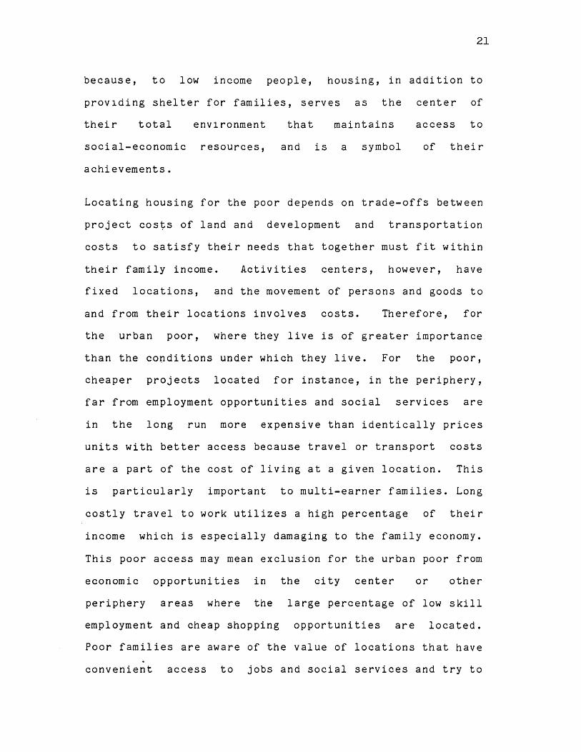
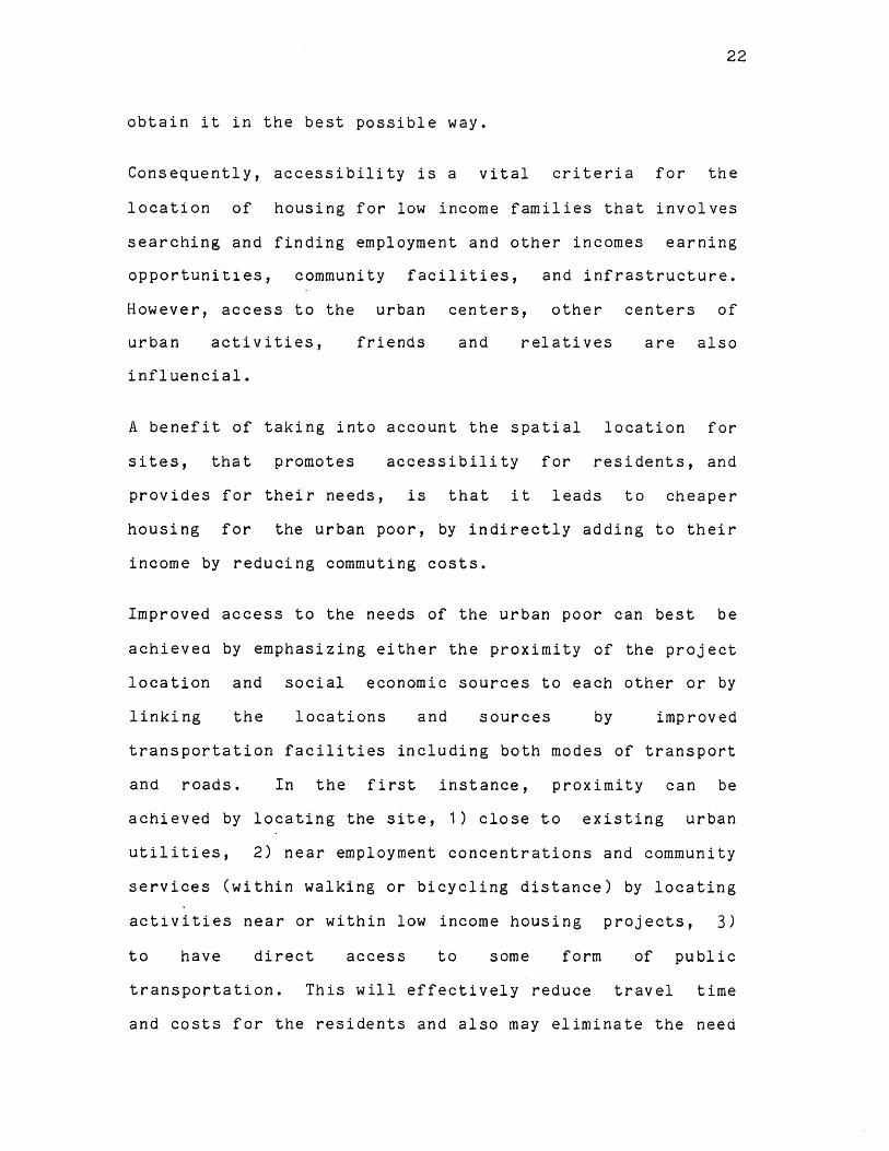

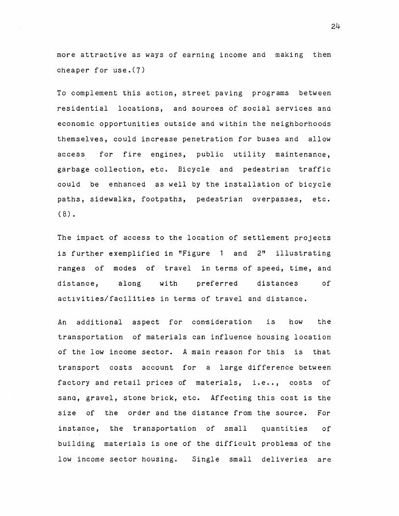


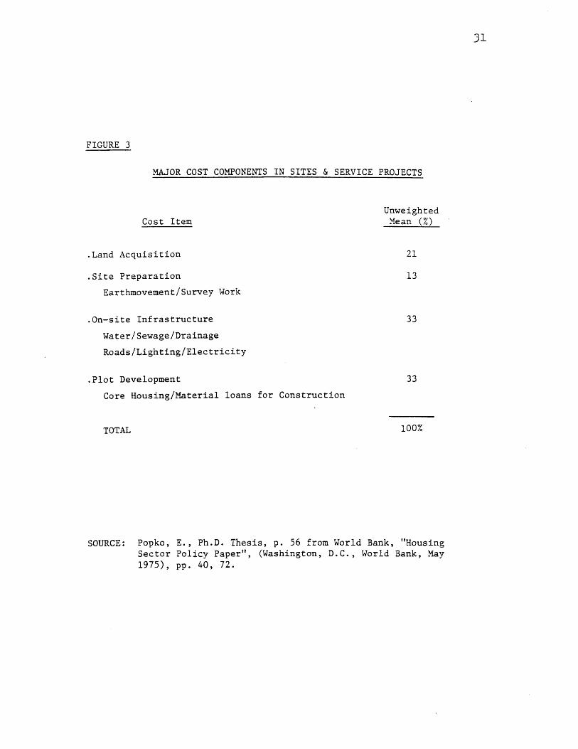


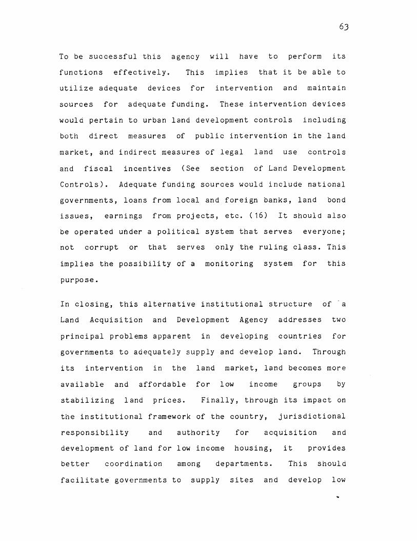
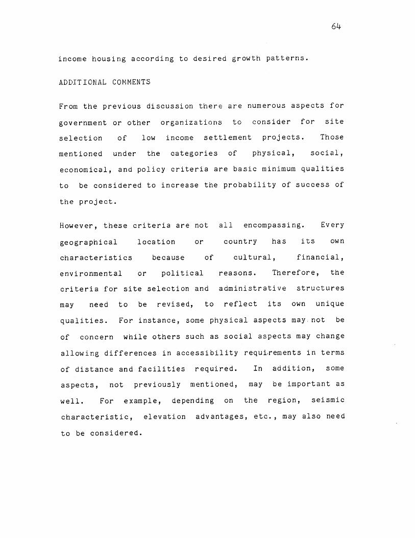
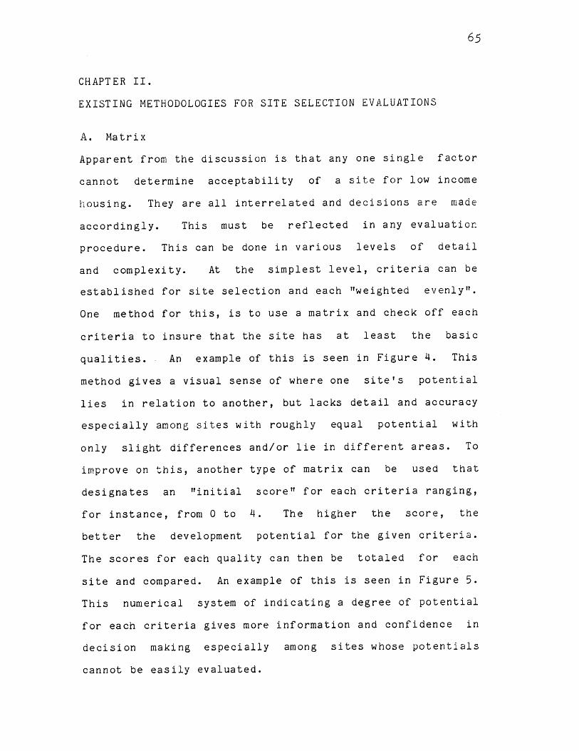

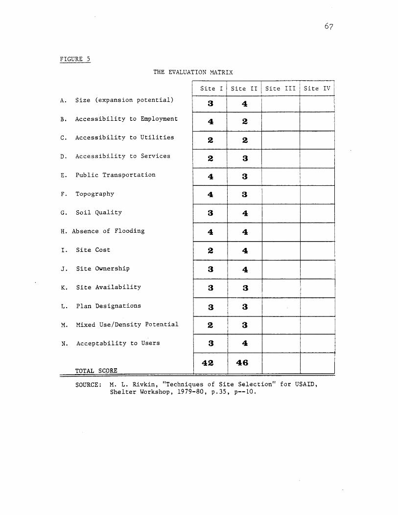


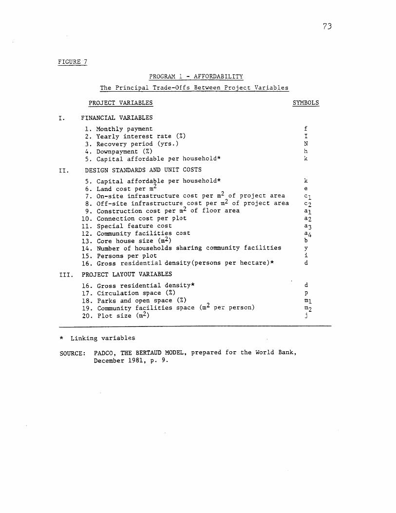
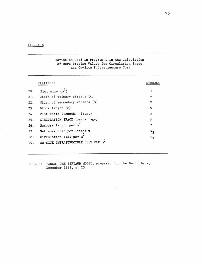


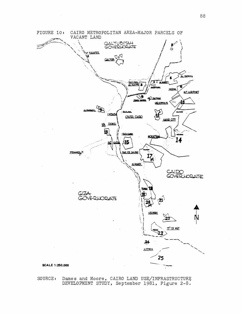
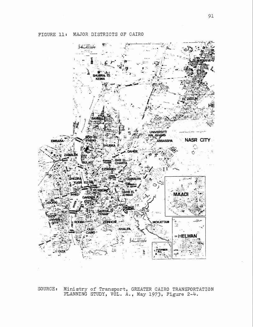


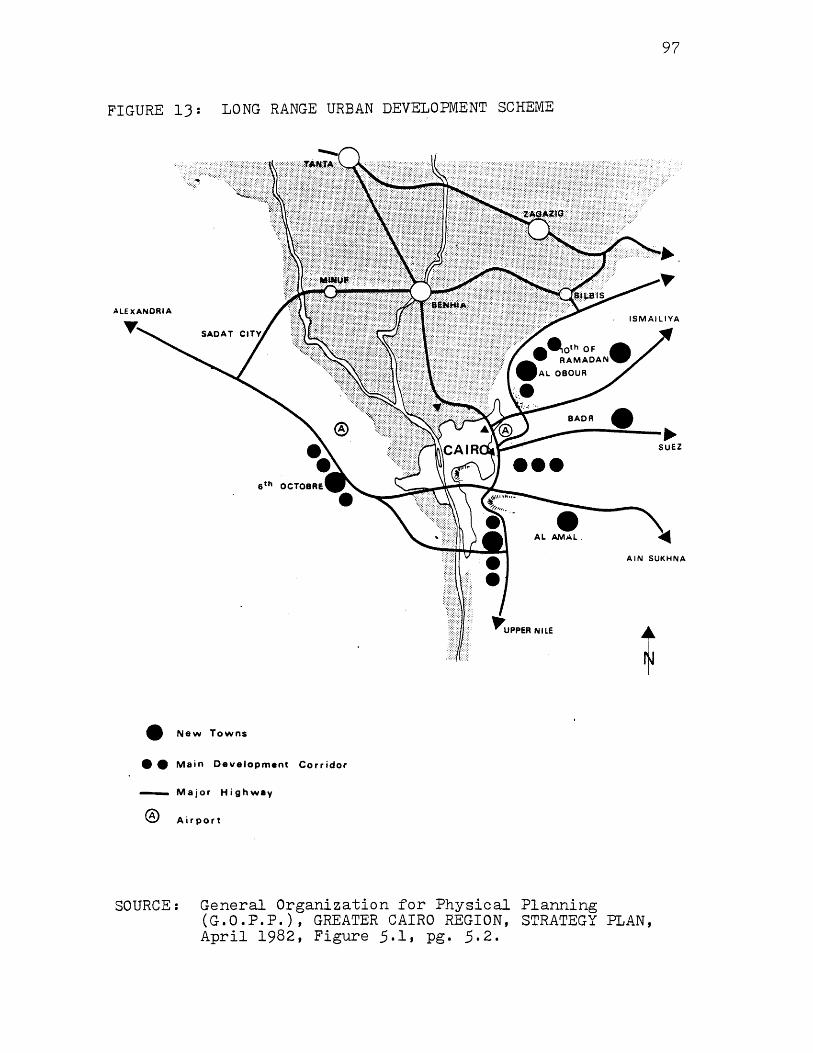

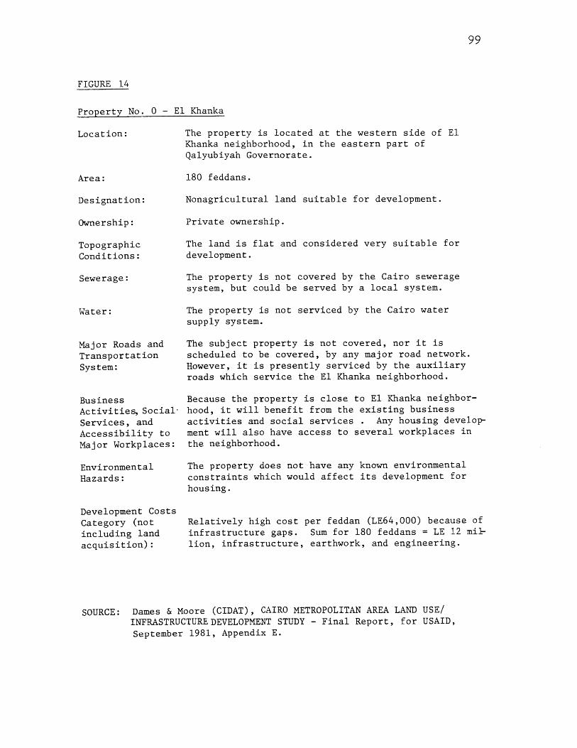
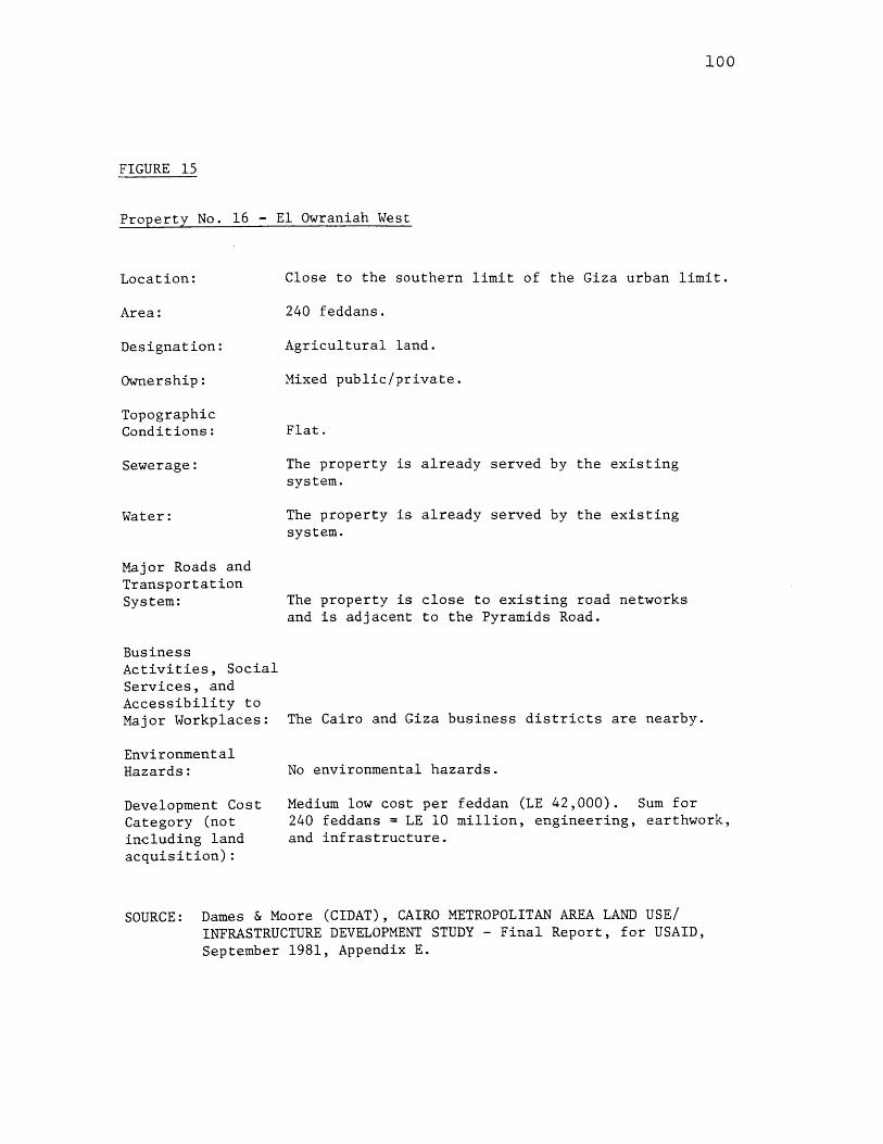


![arXiv:2007.11112v1 [cs.OS] 21 Jul 2020](https://static.documents.pub/doc/80x56/61df82c41d2b9922ce2b25b9/arxiv200711112v1-csos-21-jul-2020.jpg)


![arXiv:2106.14675v2 [q-bio.NC] 21 Jul 2021](https://static.documents.pub/doc/80x56/6253fa80f744791eed08c781/arxiv210614675v2-q-bionc-21-jul-2021.jpg)
![a arXiv:2107.10980v1 [econ.GN] 21 Jul 2021](https://static.documents.pub/doc/80x56/61d16b84e9c3aa6266486637/a-arxiv210710980v1-econgn-21-jul-2021.jpg)


![arXiv:1007.3672v1 [astro-ph.CO] 21 Jul 2010](https://static.documents.pub/doc/80x56/58a04b401a28ab78628b9718/arxiv10073672v1-astro-phco-21-jul-2010.jpg)