Master in Landscape Architecture, Harvard University Graduate School of Design / Fall 2008 - Spring 2010
Bachelor of Fine Arts in Landscape ArchitectureCatholic Fu Jen University College of Arts, Taipei / Fall 2001 - Spring 2005
AWARD + HONOR PROFESSIONAL EXPERIENCE
SKILLS
Summer 2009 Dept. of Sustainable Urban Engineering, Tokyo University, Tokyo Research Assistant- Cooperated with Toyo Ito & Associates, Architects in researching various urban / suburban projects in Japan, China, and Taiwan- Rendered concept / analysis diagrams, perspectives, and design models for multiple projects.
Apr. 2006 - Apr. 2008
ICON Space Design Ltd., Taipei Project Designer- Conferred with clients on needs, preferences and scope of projects- Developed schematic designs, design development for mulitple housing architecture / interior / landscape projects.- Rendered design concepts in form of physical / 3d model, perspectives- Built construction documents and detail drawings.- Estimated construction costs, material durability, budget control in housing architecture / interior projects.
- Managed construction schedule, workflow and monitored on construction quality.
Studying Abroad Fellowship in the Field of Architecture and Urban Design ($50,000)Ministry of Education, Taiwan / 2008
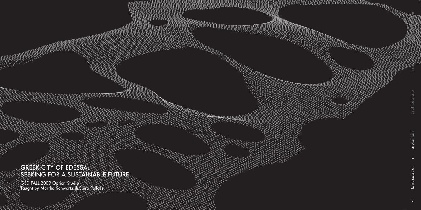
Work Selected for Exhibition / The Greek City of Edessa: Seeking for a Sustainable FutureOption Studio Taught by Martha Schwartz + Spiro Pollalis, GSD / Fall 2009
Distinction in Bachelor Degree ProjectCatholic Fu Jen University / 2005
Distinction in Design Studio IV, V, VICatholic Fu Jen University / 2002, 2003, 2004
Jun. 2005 - Apr. 2006
Tony Hsueh Architect & Associates, Taipei Assistant Designer- Built and rendered physical / 3d models and design drawings - Drawn construction documents
Summer 2003, 2004
ChiaLin Tsao Urban Design Studio, Taipei Summer Intern- Built and rendered physical / 3d models
GREEK CITY OF EDESSA: SEEKING FOR A SUSTAINABLE FUTURE
ULI COMPETITION 2010: SAN DIEGO EAST VILLAGE
BEYOND PARIS: A NEW CAMPUS FOR UNIV. OF ORSAY
FUSION: CHIANG RESIDENCE INTERIOR DESIGN
2
24
32
54
GREEK CITY OF EDESSA: SEEKING FOR A SUSTAINABLE FUTUREGSD FALL 2009 Option StudioTaught by Martha Schwartz & Spiro Pollalis
+
lan
dsc
ap
eu
rba
nism
arc
hite
ctu
rein
terio
rre
pre
sen
tatio
n
2
Edessa is a small historic town in northern Greece, 1 hr drive from the second largest city in Greece, Thesaloniki. Edessa is facing an uncertain future. The city is losing its young population and the economy is steadily declining. Edessa has an unusual and beautiful natural environment: pristine wetlands, and a rivier that passes through the town leading to aspectacular waterfalls. Yet, wrong planning decisions, by today’s standard, and questionable architecture have transformed Edessa like any other town in Greece.
The studio aims to address sustainability at the social, environmental and economic level and propose developments that enhance nature and take into account the well-being of future generations
A masterplan was proposed with the entire studio’s effort. The masterplan proposed the town will develop along the East - West and the North - South axes and reinforce the cliff edge, “the brow.”
The existing soccer stadium will be demolished and transformed into a new cultural / touristic center of the city.
site issues: adressing sustainability of the city masterplan: 2 axis & “the brow”
4
train / bus station
proposed pedestrian connection
the brow
varosi
archaeological site
linear centercommercial centerecological preserve
former soccer stadium
existing commercial
proopossed
iaddstaa
pdestrd
edrian cononneectionion
er sr soccemerormffff me
teeceent
lcial
f The d the No
udi
br- Wbrow
maaste
ll
ioW
maNor
ii
East - “
shed and
owroww.
t
v
effoest a
ffost anand
rt. Thort. forees
’s es f’’West
”-b- ow
trantran
be
r
istat
ast - “
shed and
ssiossi
new
olog iteolog
new
te
P
The existing major vehicular circulatoin passes through current soccer stadium site and creates massive congestion. In order to make the site a pedestrian friendly cultural center, the masterplan proposed that future vehicular circulation enters the town from the west side to avoid congestion in the center of the town.A large parking garage under the site is proposed to accommodate future demand.A new pedestrian connection that connects major attractions is also proposed to enhance future recreational / commercial network.
existing major vehicular circulation
proposed major vehicular circulation
panoramic view of the site
proposed pedestrian connection
circulation systems: a pedestrian friendly network case studies: what makes a successsful urban plaza?
Covent Garden, London
figure - ground / scale comparison
edge program
pedestrian flow
Cultural Center Plaza, Edessa
Dam Square, Amsterdam
Grand Place, Brussel
Trafalgar Square, London
Pompidou Plaza, Paris
Waterfront Plaza, Thessaloniki
6
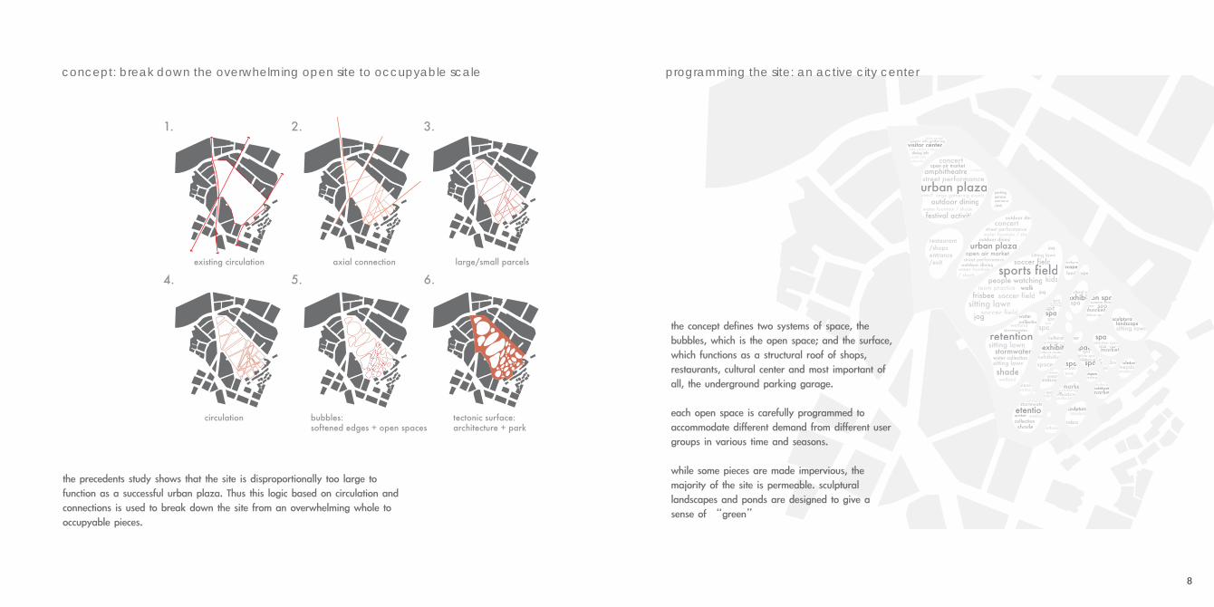
the precedents study shows that the site is disproportionally too large to function as a successful urban plaza. Thus this logic based on circulation and connections is used to break down the site from an overwhelming whole to occupyable pieces.
concept: break down the overwhelming open site to occupyable scale
the concept defines two systems of space, the bubbles, which is the open space; and the surface, which functions as a structural roof of shops, restaurants, cultural center and most important of all, the underground parking garage.
each open space is carefully programmed to accommodate different demand from different user groups in various time and seasons.
while some pieces are made impervious, the majority of the site is permeable. sculptural landscapes and ponds are designed to give a sense of “green”
10
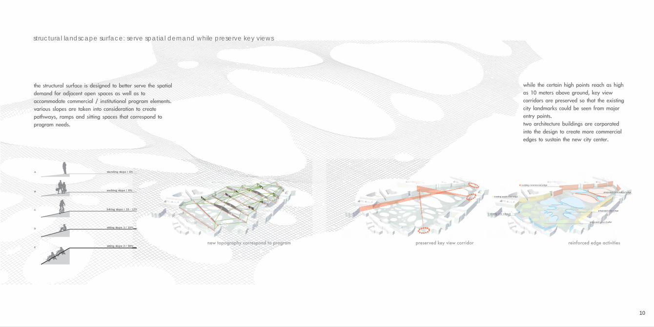
structural landscape surface: serve spatial demand while preserve key views
sitting slope 1 / 15%
sitting slope 2 / 30%
walking slope / 8%
biking slope / 10 - 12%
standing slope / 6%A
B
C
D
E
%%%
%%%
12%122%12%1
%%%%
B
A
B
B
BB
B
B
B
B
E
E
C
C
C
B
D
D
DD
D
A
AA
A
A
AA
A
A
A
A
A
B
existing commercial edge
proposed commercial edge
proposed civic edge
proposed green buffer
existing residential edge
existing civic edge
new topography correspond to program preserved key view corridor reinforced edge activities
the structural surface is designed to better serve the spatial demand for adjacent open spaces as well as to accommodate commercial / institutional program elements.various slopes are taken into consideration to create pathways, ramps and sitting spaces that correspond to program needs.
while the certain high points reach as high as 10 meters above ground, key view corridors are preserved so that the existing city landmarks could be seen from major entry points.two architecture buildings are corporated into the design to create more commercial edges to sustain the new city center.
tourist information centeredessa civic plaza A
plaza B
pavalionexit/entrance to garage / shops / cafeʼ
landscape sculpture park
edessa culture center
5 vs. 5 soccer field
12
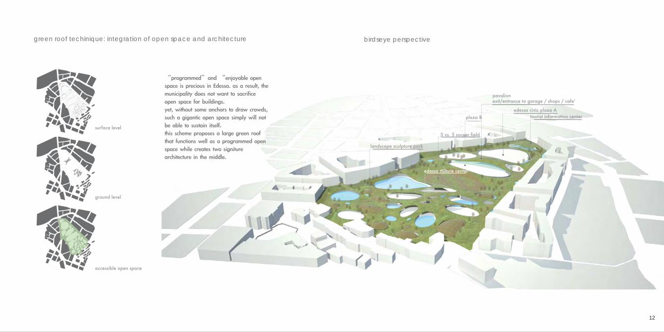
“programmed”and “enjoyable open space is precious in Edessa. as a result, the municipality does not want to sacrifice open space for buildings. yet, without some anchors to draw crowds, such a gigantic open space simply will not be able to sustain itself.this scheme proposes a large green roof that functions well as a programmed open space while creates two signiture architecture in the middle.
surface level
ground level
accessible open space
green roof techinique: integration of open space and architecture birdseye perspective
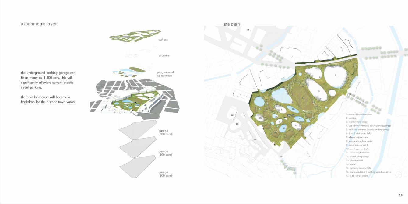
the underground parking garage can fit as many as 1,800 cars. this will significantly alleviate current chaotic street parking.
the new landscape will become a backdrop for the historic town varosi
14
1.
3.
2.
4.
5.
3.
6.
10.
10.
14.
15.
10.
10.
8.
12.
13.
16 .
9.
9.
9.
5.5.5.55.
1. tourist information center
2. pavilion
3. civic fountain plaza
4. pedestrian entrance / exit to parking garage
5. vehicular entrance / exit to parking garage
6. 5 vs. 5 mini soccer field
7. edessa culture center
8. entrance to culture center
9. maket space / exit B
10. spa / open air bath
11. varosi amphi theater
12. church of agia skepi
13. plateia varosi
14. varosi
15. pathway to water falls
16. commercial core / existing pedestrian zone
17. road to train station
surface
structure
garage (600 cars)
garage (600 cars)
garage (600 cars)
programmed open space
axonometric layers site plan
arrive by public transportation
station tourist info center culture centerpavilion
commerical core
varosi
browparking garage culture center (exit B)
pavilion (exit A) commercial core
culture center (exit C)
varosi
brow
tion tourist info center culture centerpavilion
commerical core
varosi
browparking garage culture center (exit B)
pavilion (exit A) commercial core
culture center (exit C)
varosi
brow
arrive by private vehicles
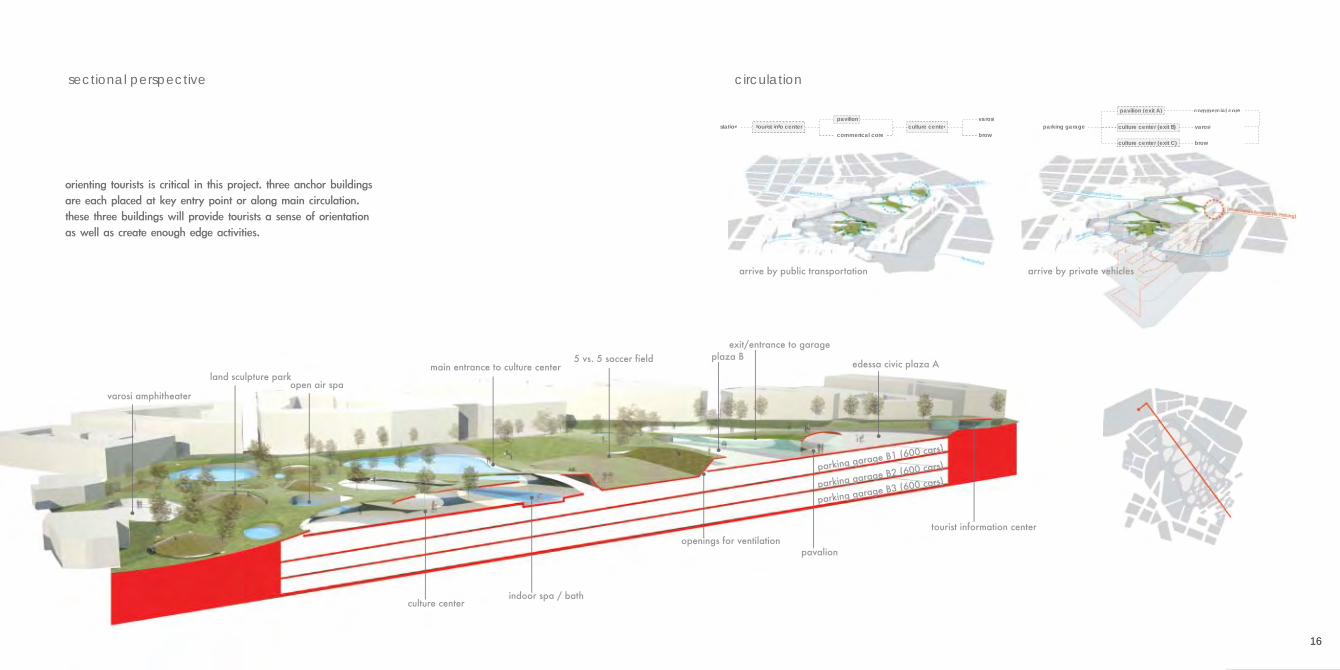
orienting tourists is critical in this project. three anchor buildings are each placed at key entry point or along main circulation. these three buildings will provide tourists a sense of orientation as well as create enough edge activities.
16
sectional perspective circulation
arrive by public transportation arrive by private vehicles
tourist information center
parking garage B1 (600 cars)
parking garage B2 (600 cars)
parking garage B3 (600 cars)
edessa civic plaza A5 vs. 5 soccer fieldmain entrance to culture center
culture center
openings for ventilation
indoor spa / bath
open air spaland sculpture park
varosi amphitheater
plaza B exit/entrance to garage
pavalion
18
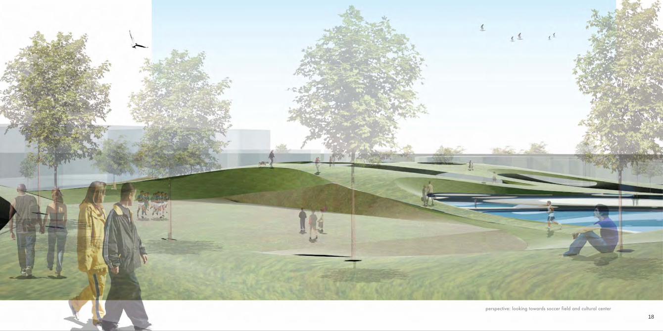
perspective: looking towards soccer field and cultural center
20
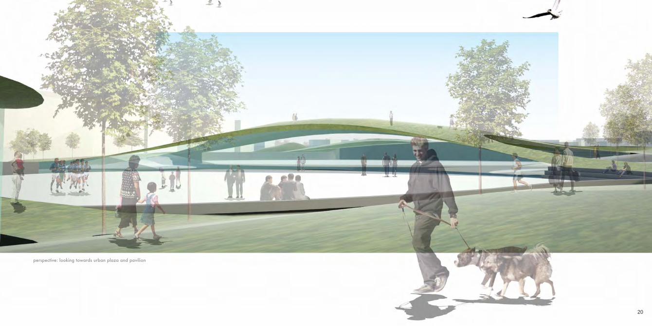
perspective: looking towards urban plaza and pavilion
22
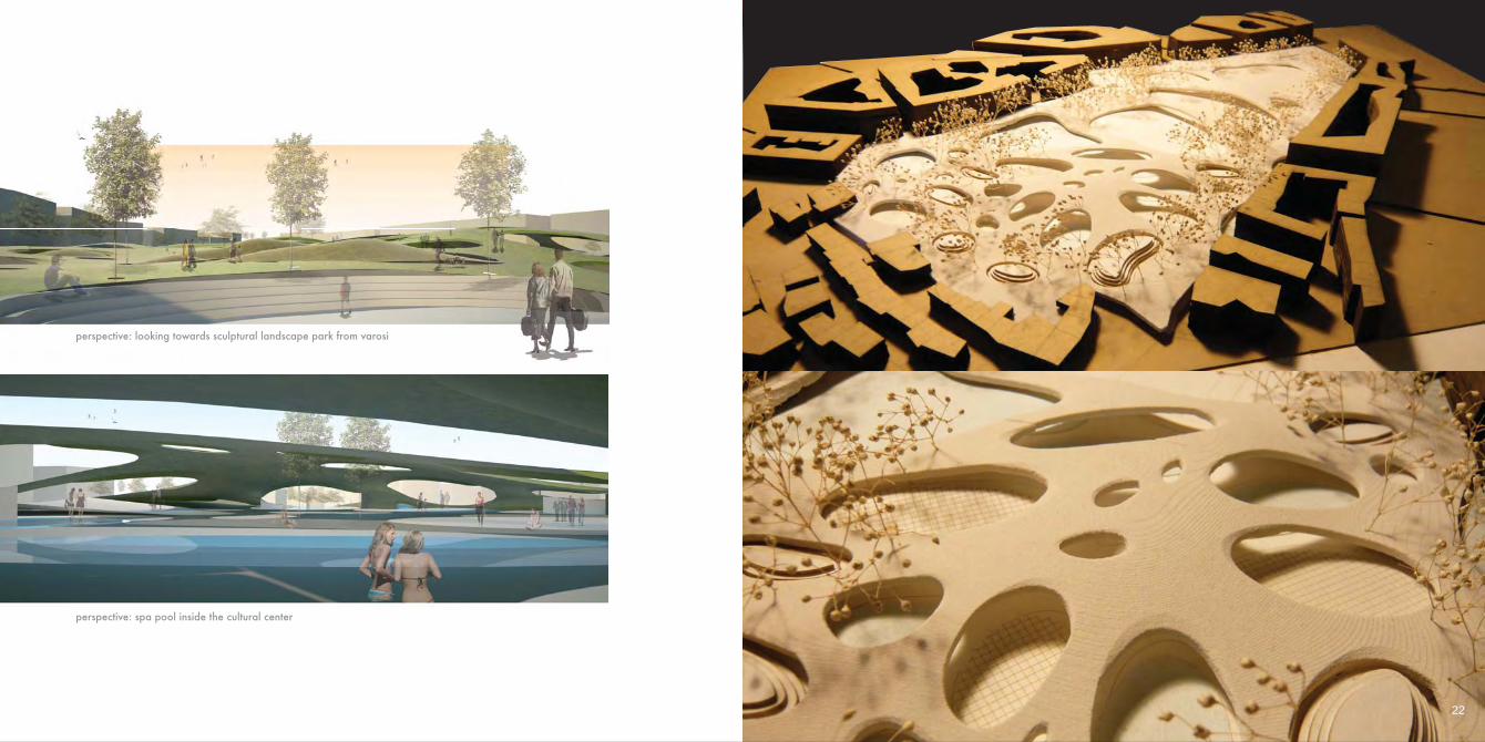
perspective: looking towards sculptural landscape park from varosi
perspective: spa pool inside the cultural center
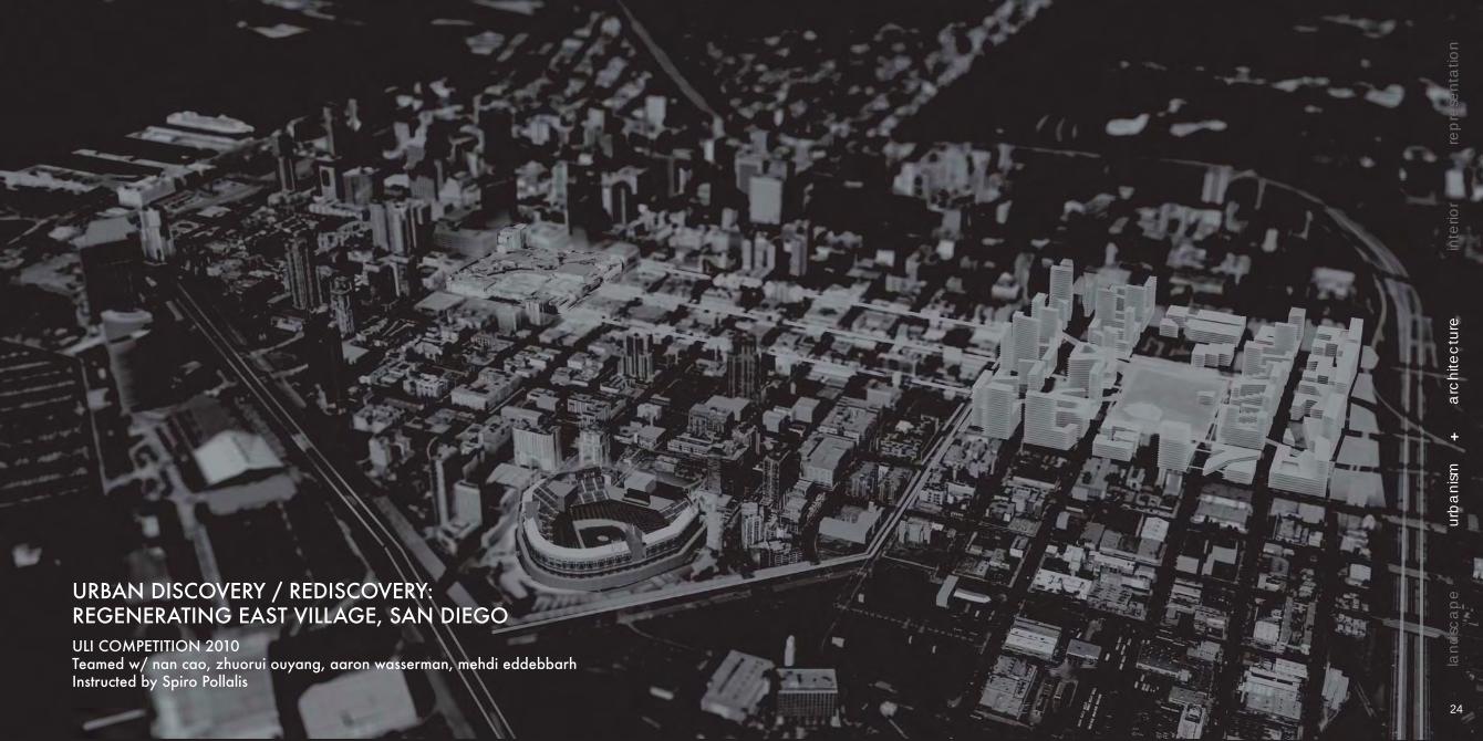
URBAN DISCOVERY / REDISCOVERY: REGENERATING EAST VILLAGE, SAN DIEGOULI COMPETITION 2010Teamed w/ nan cao, zhuorui ouyang, aaron wasserman, mehdi eddebbarhInstructed by Spiro Pollalis
+
lan
dsc
ap
eu
rba
nism
arc
hite
ctu
rein
terio
rre
pre
sen
tatio
n
24
To Horton Plaza
To P
etco
Par
k
Trolley Blue/Orange Line
Inte
rsta
te 5
Market St.
Civic Center
Hospital
Research &Development
r&d
r&d
r&d
r&d
community garden/urban farm
UCSD Med. School
Touted as “America’s Finest City” by civic leaders and boosters, San Diego enjoys world-renown for its laid-back lifestyle, beautiful beaches and temperate climate. However, since 1975, downtown San Diego has been suffering from urban decay and high vacancies. While today things have gotten better due to the establishment of large mall and major league baseball stadium, the eastern half of the downtown remain troubled. Its proximity to state highway makes it undesirable for developers. The task for this competition is to regenerate the region through proposing new program and new design interventions.
site issues: adressing sustainability of the city site plan
26
The new East Village rejuvenates the city by channeling its existing strengths downtown. The economy surges with a new University of California San Diego hospital and medical research facility, spurring a hub of R&D companies to locate in a science corridor that turns San Diego into a medical powerhouse.
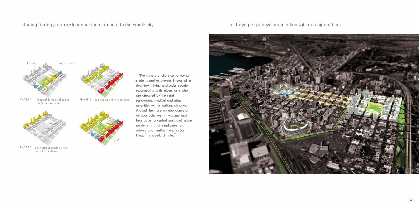
phasing strategy: establish anchor then connect to the whole city birdseye perspective: connection with existing anchors
28
hospital & medical school anchors the district
med. schoolhospital
connections made to the rest of downtown
n
science corridor is createdPHASE 2.PHASE 1.
PHASE 3.
“From these anchors come young students and employees interested in downtown living and older people reconnecting with urban form who are attracted by the retail, restaurants, medical and other amenities within walking distance. Around them are an abundance of outdoor activities – walking and bike paths, a central park and urban gardens – that emphasize fun, activity and healthy living in San Diego’s superb climate.”
100 ft 500 ft0 I-5 freeway16th St.
Las Fuentes Park
Civic CenterWetland
green wall
green roof
green roofgreentrolleysystem
wind turbine
13th St.Park Blvd
green roof
roof terrace
HospitalMedical School
100 ft 500 ft0
Market St.G St.F St.E St.Broadway
wind turbine
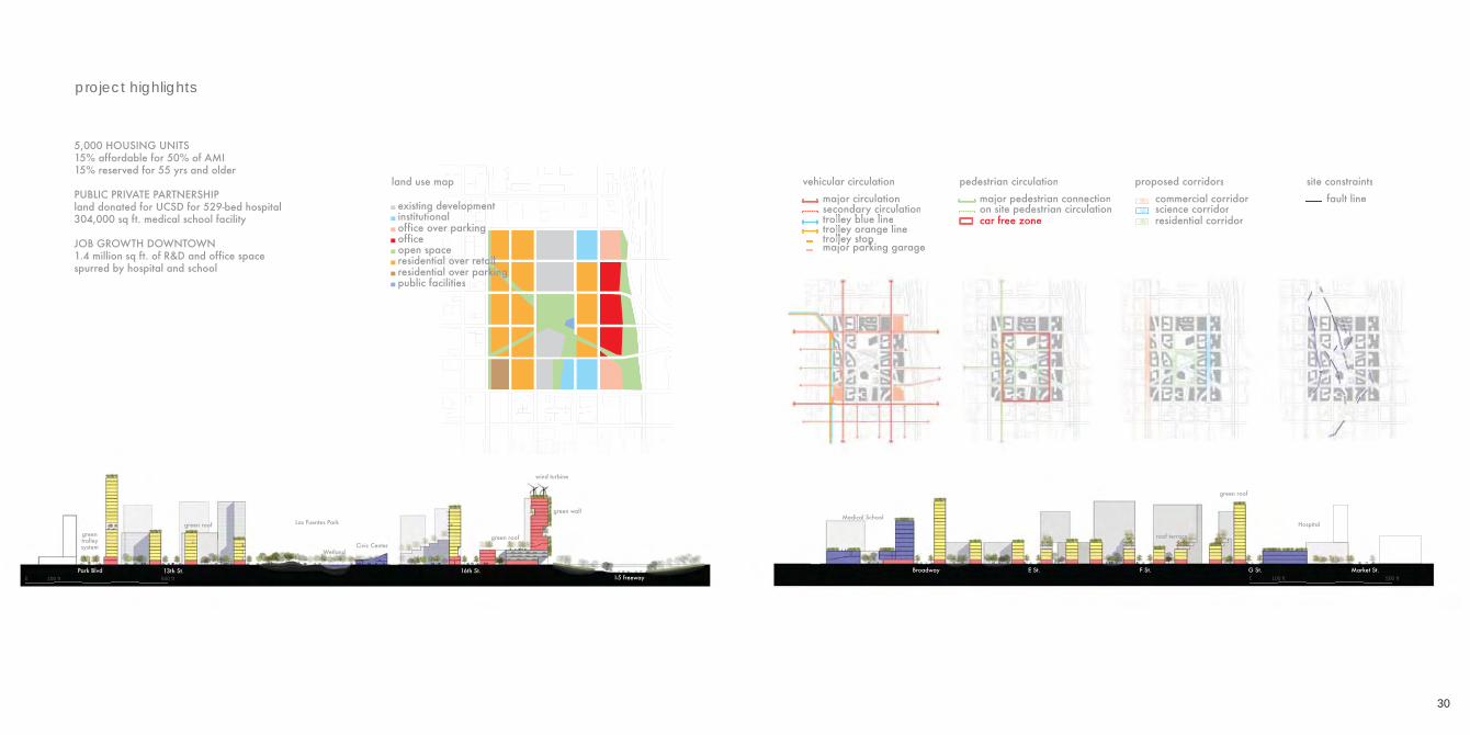
land use map
existing developmentinstitutionaloffice over parkingoffice open spaceresidential over retailresidential over parkingpublic facilities
pedestrian circulationmajor pedestrian connectionon site pedestrian circulationcar free zone
5,000 HOUSING UNITS15% affordable for 50% of AMI15% reserved for 55 yrs and older
PUBLIC PRIVATE PARTNERSHIPland donated for UCSD for 529-bed hospital304,000 sq ft. medical school facility
JOB GROWTH DOWNTOWN1.4 million sq ft. of R&D and office space spurred by hospital and school
BEYOND PARIS [suite]: A NEW CAMPUS FOR UNIVERSITY OF ORSAYGSD SPRING 2010 Option StudioTaught by Andrea Leers
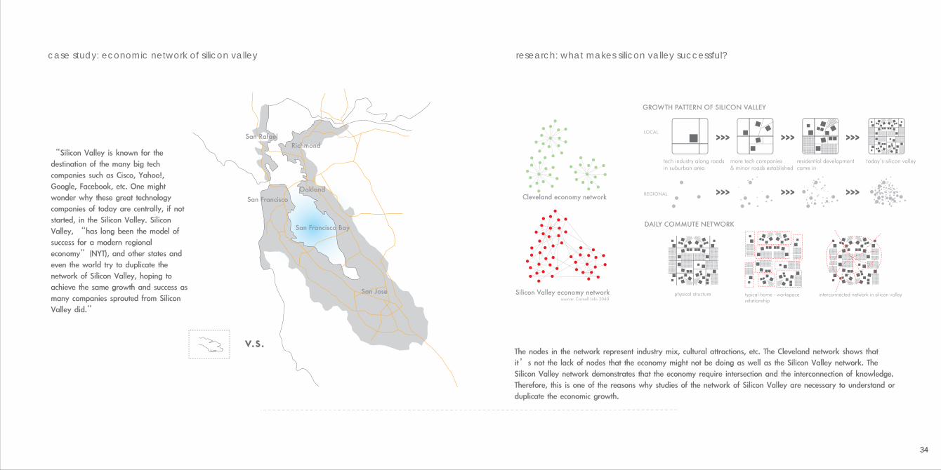
case study: economic network of silicon valley research: what makes silicon valley successful?
34
source: Cornell Info 2040
Cleveland economy network
Silicon Valley economy network
San Francisco
San RafaelRichmond
San Francisco Bay
Oakland
San Jose
v.s.
“Silicon Valley is known for the destination of the many big tech companies such as Cisco, Yahoo!, Google, Facebook, etc. One might wonder why these great technology companies of today are centrally, if not started, in the Silicon Valley. Silicon Valley, “has long been the model of success for a modern regional economy”(NYT), and other states and even the world try to duplicate the network of Silicon Valley, hoping to achieve the same growth and success as many companies sprouted from Silicon Valley did.”
physical structure typical home - workspacerelationship
interconnected network in silicon valley
DAILY COMMUTE NETWORK
The nodes in the network represent industry mix, cultural attractions, etc. The Cleveland network shows that it’s not the lack of nodes that the economy might not be doing as well as the Silicon Valley network. The Silicon Valley network demonstrates that the economy require intersection and the interconnection of knowledge. Therefore, this is one of the reasons why studies of the network of Silicon Valley are necessary to understand or duplicate the economic growth.
tech industry along roads in suburban area
more tech companies & minor roads established
residential development came in
today’s silicon valley
GROWTH PATTERN OF SILICON VALLEY
LOCAL
REGIONAL
>>> >>> >>>
>>> >>> >>>
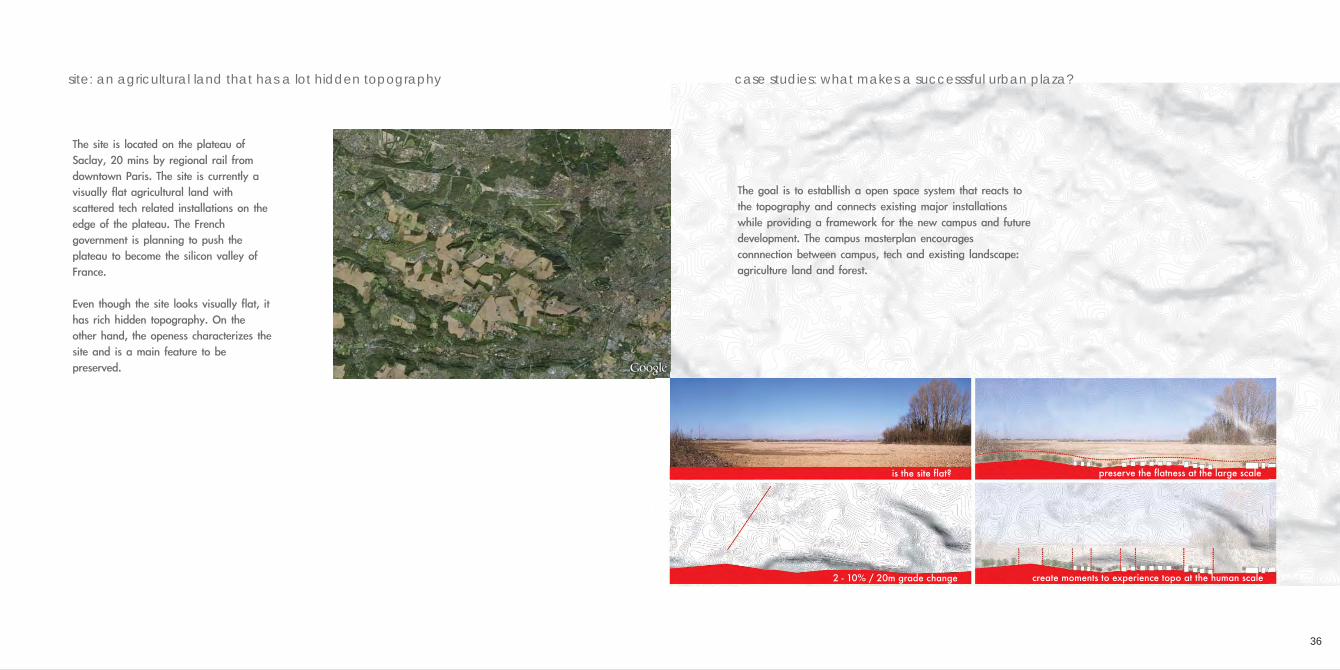
site: an agricultural land that has a lot hidden topography case studies: what makes a successsful urban plaza?
36
The site is located on the plateau of Saclay, 20 mins by regional rail from downtown Paris. The site is currently a visually flat agricultural land with scattered tech related installations on the edge of the plateau. The French government is planning to push the plateau to become the silicon valley of France.
Even though the site looks visually flat, it has rich hidden topography. On the other hand, the openess characterizes the site and is a main feature to be preserved.
The goal is to establlish a open space system that reacts to the topography and connects existing major installations while providing a framework for the new campus and future development. The campus masterplan encourages connnection between campus, tech and existing landscape: agriculture land and forest.
create moments to experience topo at the human scale
is the site flat?
2 - 10% / 20m grade change
preserve the flatness at the large scale
concept: react to current development pattern and site topography
38
The existing development pattern does not reflect the nature of the plateau but depends on existing roadway structures. In a effort to encourage interaction between educational institutions and tech, a new open space will allow more diverse connections.
The form was generated from current development pattern and site topography. The walking radius is taken from the major entry points of existing installations and topographical low and highpoints. This form defines the edge of open space. The open space will bridge either side of the highway and make the south plateau as a whole.
The open space will function as a collective space for the campus and future development as well as providing a new pedestrian network.
existing development pattern
existing road network
existing connections
walking radius from installations
concept collage
buffer from topographic extremes
bridge across infrastructure proposed diverse connections
40
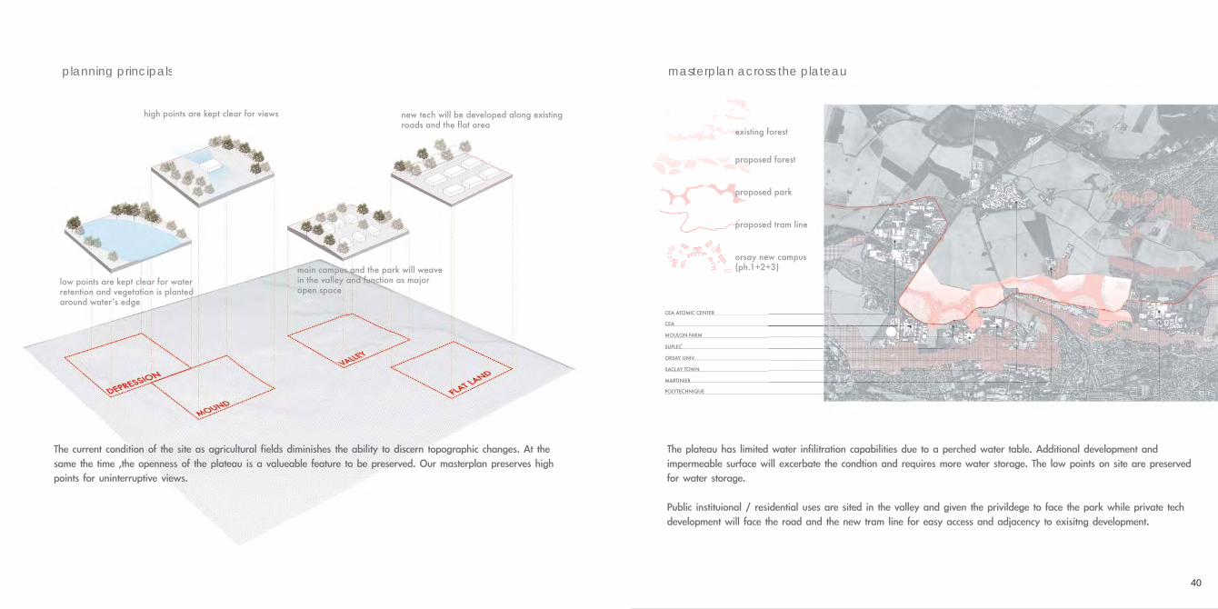
planning principals masterplan across the plateauplanning principals
low points are kept clear for water retention and vegetation is planted around waterʼs edge
main campus and the park will weave in the valley and function as major open space
high points are kept clear for views new tech will be developed along existing roads and the flat area
The current condition of the site as agricultural fields diminishes the ability to discern topographic changes. At the same the time ,the openness of the plateau is a valueable feature to be preserved. Our masterplan preserves high points for uninterruptive views.
The plateau has limited water infilitration capabilities due to a perched water table. Additional development and impermeable surface will excerbate the condtion and requires more water storage. The low points on site are preserved for water storage.
Public instituional / residential uses are sited in the valley and given the privildege to face the park while private tech development will face the road and the new tram line for easy access and adjacency to exisitng development.
POLYTECHNIQUE
MARTINIER
SACLAY TOWN
ORSAY UNIV.
SUPLEC
MOULON FARM
CEA
CEA ATOMIC CENTER
proposed forest
proposed park
proposed tram line
orsay new campus(ph.1+2+3)
existing forest
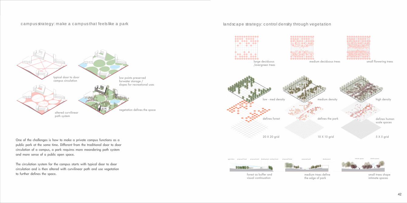
One of the challenges is how to make a private campus functions as a public park at the same time. Different from the traditional door to door circulation of a campus, a park requires more meandering path system and more sense of a public open space.
The circulation system for the campus starts with typical door to door circulation and is then altered with curvilinear path and use vegetation to further defines the space.
42
campus strategy: make a campus that feels like a park landscape strategy: control density through vegetation
typical door to door campus circulation
altered curvilinear path system
low points preserved forwater storage / slopes for recreational uses
vegetation defines the space
20 X 20 grid 10 X 10 grid 5 X 5 grid
defines forest defines the park defines human scale spaces
low - med density medium density high density
large deciduous/evergreen trees
medium deciduous trees small flowering trees
agriculture proposed forest proposed park development existing forest
forest as buffer and visual continuation
medium trees define the edge of park
small trees shape intimate spaces
proposed forest proposed park development intimite spacesintimite spaces
44
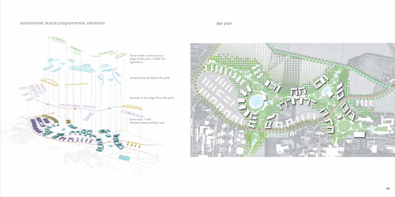
axonometric layers: programmatic elements site plan
future tech + r&d develop along existing road
housing on the edge faces the park
campus faces & frames the park
forest make a more porous edge to the park / buffer for agriculture
forest make a more porous edge to the park / buffer for agriculture
the new campus of university of orsay will functionas a connec-tive tissue that connects different pieces of installations of the plateau while providing a great open space for exchange to happen. The forest will become the buffer zone for the greater agriculature land and most importantly defines the boundaries of the campus
46
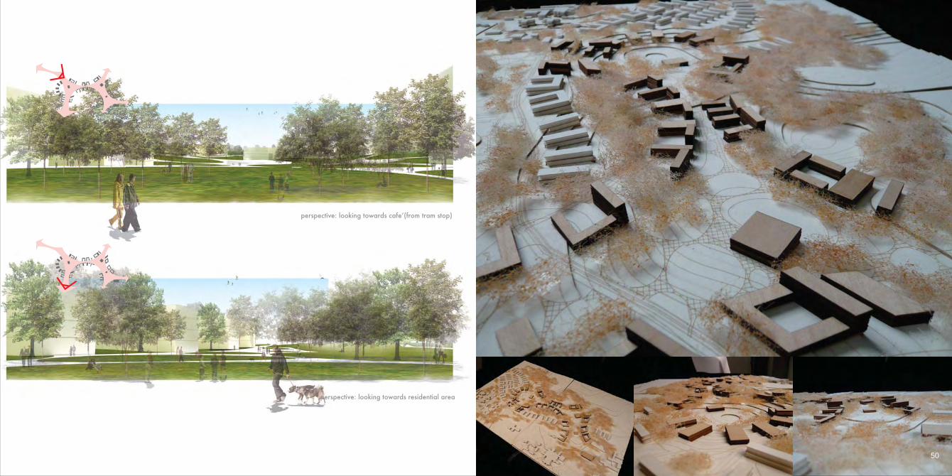
sectional perspective birdseye perspective
48
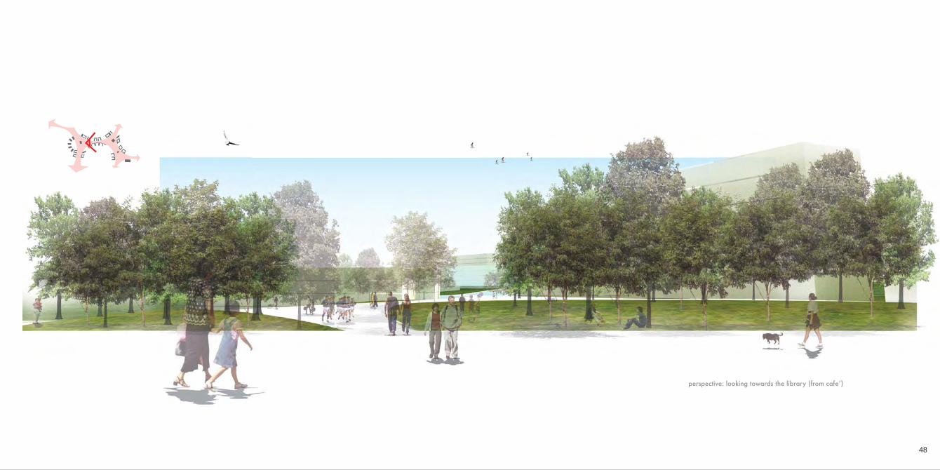
perspective: looking towards the library (from cafeʼ)
50
perspective: looking towards cafeʼ(from tram stop)
perspective: looking towards residential area
FUSION: CHIANG RESIDENCE INTERIOR DEISGNICON SPACE DESIGN LTD. 2007 PROFESSIONAL PROJECTAs lead designer + construction manager
+
lan
dsc
ap
eu
rba
nism
arc
hite
ctu
rein
terio
rre
pre
sen
tatio
n
52
The owner of this apartment is a lady in her 40’s. She lives usually alone and occasionally with her housekeerper. The demand was simple yet challenging. She basically wants a two bedroom with a large walk-in closet. She loves the simplicity of Scandinavian style with a little oriental touch intoit.
The floor area of the apartment is 2,500 square ft. It is a 15 year old apartment which requires a lot of renovation. The challenges are to give each living space an appropriate dimension while satisfying client’s demand.
porch floor: pine light grey marble teak wooden floor teak wooden floorkitchen: corian cabinet: oakwardrobe: oak
ceiling plan lighting plan
material & lighting plan perspective view of living room / 3dmax+vray
56
ch = 270 cm
ch = 240 cm
ch = 220 cm
The location of columns sets great restriction on the layout of the space. A “hidden order”is used to give the space a sense of continuity and integrity.
perspective view of living room & master bedroom / 3dmax+vray
58
elevational design: a hidden order
n1
n2s1
e1 e2 e3 e4 e5 e6
w1 w2 w3 w4 w5 w6
s2
Ceiling type A allows light to go further and project on the ceiling. This is used in rooms which more lights is needed
Ceiling type B produce bar lights which is used to emphasize the pathway
Ceiling type C allows lights to shine on the wall. This is used to emphasize a certain facade or an object
type A
type B
type C
detail design: the function of ceiling perspective view of walk-in closet & dining room / 3dmax+vray