+ All Categories
Home > Documents > Katholieke Universiteit Leuven Faculty of Arts

Katholieke Universiteit Leuven Faculty of Arts

Date post: 02-Feb-2022
Category:
Upload: others
View: 3 times
Download: 0 times
Share this document with a friend
61
1 Katholieke Universiteit Leuven Faculty of Arts Settlement Pattern in Southeast Anatolia: An analyse of the structures at the site of Nevalı Çori. Thesis submitted in partial fulfilment of the requirements for the degree of Master of Eastern Mediterranean Archaeology by Ercoskun Pakize Supervisor: Prof.Dr. Joachim Bretschneider Leuven 2007
Transcript

1

Katholieke Universiteit Leuven

Faculty of Arts

Settlement Pattern in Southeast Anatolia:

An analyse of the structures at the site of Nevalı Çori.

Thesis submitted in partial fulfilment of the

requirements for the degree of

Master of Eastern Mediterranean

Archaeology

by Ercoskun Pakize

Supervisor: Prof.Dr. Joachim Bretschneider

Leuven 2007

2

Acknowledgements

I sincerely thank my supervisor Prof.Joachim Bretschneider for his interest and support

and Prof. P.M.Vermeersch for his time, guidance, critisism and patience.

3

Table of Contents

Chapter I. Introduction 5

Chapter II. Conditional settings and nature of the site Nevalı Çori 6

II.a. Geographical settings 6

II.a.a. Geographical settings of Upper-Mesopotamia 6

II.a.b. Geographical settings of Southeastern Anatolia 7

II.a.c. Şanlıurfa 7

II.b. Climatical conditions 8

II.c. Vegetation and fauna 9

II.d. Neolithic site 10

II.d.a. The Anatolian Neolithic 10

II.d.b. Subsistence at Nevalı Çori 11

Chapter III. The position of Nevalı Çori in the study area 14

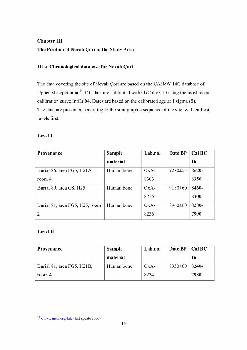
III.a. Chronological database of Nevalı Çori 14

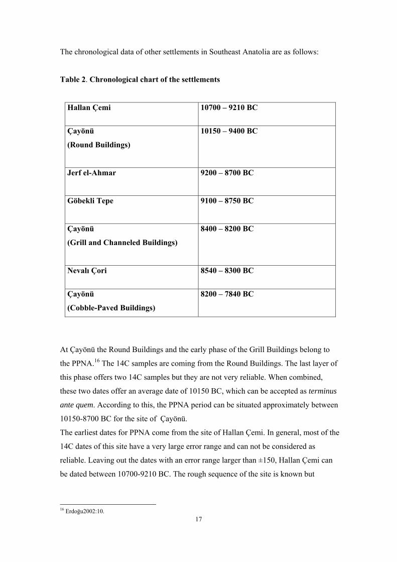
III.b. Database of other sites and the correlation with Nevalı Çori 16

III.c. Relation of Nevalı Çori with other settlements in the region 18

Chapter IV. Nevalı Çori 21

IV.a. The archaeology of Nevalı Çori 21

IV.b. The settlement of Nevalı Çori 22

IV.c. The structures 22

IV.d. Analyse of the buildings 23

IV.d.a. Level I 23

IV.d.b. Level II 25

IV.d.c. Level III 29

IV.d.c.1. Level IIIA 30

IV.d.c.2. Level IIIB 31

IV.d.d. Level IV 32

IV.d.e. Level V 32

Chapter V. Evaluation of the site Nevalı Çori 34

V.a. The building forms at Nevalı Çori 34

V.a.a. Rectangular buildings 34

V.a.a.1. Type of buildings 35

V.a.b. Round structures 36

4

V.a.c. The square building 36

V.b. The settlement plan of Nevalı Çori 37

Chapter VI. Function assessment 38

VI.a. The rectangular buildings 38

VI.b. The round structures 39

VI.c. The square building 40

VI.c.a. Architectural elements 40

VI.c.b. Sculptures and reliefs 43

VI.c.c. Other sites in the region 47

VI.c.c.1. Çayönü 47

VI.c.c.2. Göbekli Tepe 50

VI.d. Conclusions on function assessment 53

Chapter VII. Conclusions on the site of Nevalı Çori 55

Bibliography 57

List of Tables 60

List of illustrations 60

5

Chapter I

Introduction

The region of Upper-Mesopotamia provides a lot of sites that have the greatest

importance for the understanding of the archaeology of this region.

Especially the area of Southeast Anatolia within this region turns out to have an

eminent position that has been revealed by the excavations and researches during the

last decade. The importance of Southeast Anatolia can not be minimized, especially

when dealing with Neolithic sites. Among the remarkable sites of Çayönü and Göbekli

Tepe, there is a third Neolithic site that also deserves the attention: Nevalı Çori in the

province of Şanlıurfa.

The main objective of this study is to discuss the site of Nevalı Çori in order to obtain a

picture of its settlement pattern. By analysing the settlement of Nevalı Çori from an

architectural point of view, the buildings of the settlement will be attempted to be

classified. First we will look what kind of buildings the settlement consisted of, then an

attempt will be made to classify them into types where possible. Finally, this analyse

will form the base to support suggestions about the function of the structures at the site.

In order to do so, interior features and findings will be involved into the discussion

besides architectural features. Complementary information coming from other sites in

the region, such as Çayönü and Göbekli Tepe, will contribute to the interpretation of

the analyse where necessary.

To work out this subject in systematic way, following steps will create the structure of

this writing. The following two chapters will deal with the nature and position of

Nevalı Çori; its geographical position will be discussed starting from Upper-

Mesopotamia, focusing on Southeast Anatolia and finally ending with Şanlıurfa. As

determinants of the nature of the site climate, vegetation and faunal data are included.

These conditional settings together with the chronological data create the platform on

which the Neolithic nature of the site is based. The analyse of the structures at the site

in Chapter IV is based on the sites building levels. The discussion is supported with

illustrational maps and plans for each building level. In Chapter V the evaluation of the

analyse follows, creating the base for the next chapter that deals with function

assessment. In the last chapter conclusions are formulated on the site of Nevalı Çori.

6

Chapter II

Conditional Settings and Nature of the Site Nevalı Çori

II.a. Geographical settings

II.a.a Geographical settings of Upper-Mesopotamia

In broader perspective the study area is Upper Mesopotamia, consisting of Northern

Syria and Southeastern Turkey. It must be conceded that there is often significant

overlap between these two regions, both geographical and cultural.1 Especially

concerning the Neolithic sites it is not easy to distinguish culturally and geographically

Northern Syria from Southeastern Turkey (Ill.1).

Subregions of Upper Mesopotamia are as follows2:

- East Taurus intermontane basins belt and Upper Tigris basin (sites Çayönü and

Hallan Çemi)

- Gaziantep-Urfa-Mardin plateau (Southeast Turkey) (sites Göbekli Tepe and

Nevali Çori)

- Harran plain and Balikh valley

- Syro-Mesopotamian steppes and Middle Euphrates (Southeastern Turkey and

Northern Syria)

- West Zagros valleys (Northern Iraq)

The Syrian natural environment is characterized by mountain ranges.3 The

northernmost range is the Amanus, in what is now the Turkish province of Hatay. The

Upper Mesopotamian plain is across the Euphrates river in northeast Syria, extending

into northern Iraq and southeast Turkey. This region is a relatively flat semi-arid steppe

traversed by the Tigris and Euphrates and by the latter's tributaries the Balikh and

Khabur.

The main focus is Southeastern Turkey during this writing.

1 Akkermans and Schwartz2003:2. 2 CANeW website

7

II.a.b Geographical settings of Southeast Anatolia

Southeast Anatolia is basically the area lying between the southeastern Taurus

Mountains and the modern Turkish-Syrian border.4

Starting from the southern piedmont of the Taurus, the plateau (500-1000 m) spreads

out and descends in altitude towards the Syrian plain with a fairly uniform topography.

Southeast Anatolia is considered to be a transition zone between the highlands of East

Anatolia and the semi-arid Syrian plain.

Geographically many areas of this region are extensions of the Syro-Mesopotamian

landscape. This zone consists of steppe like plateaus on the southern flanks of the

Amanus and the southeastern Taurus Mountains.

The outer edge of this crescent-shaped region is bordered by more humid mountainous

areas which were part of the natural forest zone. Its inner curve is bordered by the

northern extremities of the Syrian Desert. This zone is bordered on the north by

strongly folded mountains which separate it from the high altitude (2000-3000 m) and

very cold eastern Anatolia.

II.a.c Şanlıurfa

The site of Nevalı Çori is located in Şanlıurfa (19.615 km²) in Southeast Anatolia.

The geograhical position of Urfa determined by Gaziantep in the west, Adıyaman in

the northwest, Diyarbakır in the notheast, Mardin in the east and Syria in the south

(Ill.2). Urfa is located on the southern flanks of the central part of the southeastern

Taurus Mountains and the nothern part of the Suudi-Arabic platform, which explains

the wide valleys.5

The most remarkable aspect of Urfa is that its environment is varied. The region is

showing a mountainous character for 22% of the area, steppe-like for 1.3%, while

valleys cover 16.3% of the area, leaving the resulting 60.4% for hills.

Besides the Euphrates there are not many streams in the region; the Kantara, the

Hortum Çay or Incesu, which are tributaries of the Euphrates, fed by springs. 25 karstic

3 Akkermans and Schwartz2003:5. 4 Erinç1980:78, Yakar1994:32. 5 www.urfali.de

8

springs feed the Karakoyun stream, which flows around the old city of Urfa on the

north and east.

Along the Euphrates there are narrow alluvial bands; Samsat-Arapkantar-Lidar in the

north and Halfeti-Birecik in the west.

Urfa shows a lot of mountains and hills in the north. The most important mountain is

the volcanic massive Karacadağ Mountain (1957 m), which is forming the border with

Diyarbakır. The altitude decreases moving southwards. The most important valleys are

in the southern half of Urfa; Harran, Suruç and Viranşehir. The plain of Harran has an

average altitude of 375 meters, which makes it the lowest plain in the region. It spreads

over 150 000 hectares and consists of reddish alluvial soil. The fertile Suruç plain of

710 km² consists also of red alluvial soil. The third important plain in Urfa, the

Viranşehir plain, is also alluvial and the largest of all, covering 1200 km². It is located

between the Tektek and Karacadağ Mountains.

The extensive plains of Suruç, Urfa-Harran and Viranşehir are seperated from each

other by high ranges.

In the west the Arat Mountains are spreading along the Euphrates Valley. The Tektek

Mountains (801 m) border the Urfa-Harran plain on the north while the Şebeke

Mountains (750 m) further west form a chain with the Tektek Mountains together with

the Susuz Mountains (817 m).

The fertile farmland is cut off in the east by the Germuş Mountains (800 m). The open

depression to the south descends with 400 meters and meets with the desert-like zone

and the semi-arid steppes of Northern Syria.

The lavas of the Karacadağ Mountain are spread out over a wide area and are basaltic in

nature. The southern, southwestern, western and nothern parts of the Urfa region is

surrounded by hills with varying altitudes between 600-800 meters. A great part of the

region consist of calchite, which causes surface formations of carstic topography.

II.b Climatical conditions

Today the climate dominating Southeastern Anatolia as a whole can be described as an

extreme continental Mediterranean climate. Although summers are very hot and dry,

winters are mild and relatively humid. This is a function of distance from the

Mediterranean, expressed by a wide annual range of temperatures and a small amount

of precipitation. The area has an average precipitation of 500 to 700 mm per year and

9

most of it falls in winter. Two rivers, Euphrates and Tigris, and their tributaries drain

the plateau.

In Syria the climate is also characterized by dry and hot summers and cool, rainy

winters with regional variability. In the Upper Mesopotamian plain, the more rainier

parts of the area are in the north, near the Turkish frontier.

In the semi-arid steppe the average annual rainfall is 200-600 mm.

The valleys of the Euphrates, Khabur and Balikh are amenable to irrigation. The

Euphrates creates a fertile alluvial valley incized into the dry steppe.

II.c Vegetation and fauna

The vegetation varies from dense forests to steppes towards lower altitudes. Forests of

oak are found mainly in the eastern Taurus Mountains at elevations higher than 700-

800 m. Areas below 700 m are covered with steppe formations and reddish-brown

steppe soils, which are rich in lime and potassium, making the soil appropriate for

cereal production. This reddish brown alkaline steppe soils with a medium to low

organic content are suitable for cultivation with irrigation. Legumes, peas, cereal,

pistachio, almond, grape, wild grasses were gathered by the people of this region. The

economy of the Northern Mesopotamian site Jerf el-Ahmar was based on intensive

exploitation of wild species.6 It is remarkable that at Jerf el-Ahmar barley in stead of

wheat was predominantly harvested in the wild. This reflects local environmental

variation or cultural preferences.

Light forest or forest steppe habitats were the natural abode of aurochs (Bos

primigenius). Wild sheep (Ovis orientalis) prefer a habitat in the mountains, hills of

high plateaux. While in the summer this animal grazes the meadows and grassy slopes

of mountains, in winter it descends to valleys and piedmonts. The wild boar (Sus

scrofa) is an animal of wet environments such as swamps, lake shores and river banks.

It needs the vegetation cover provided by trees, bushes and reeds.Wild cattle, wild goat

(Capra aegrus), wild bear (Ursus arctus), common fox (Vulpes vulpes), gazelle

(Gazella), wild cat (Felis sylvestris), land turtle, birds and fresh water fish were the

most hunted animals.

10

Natural roads follow the river valleys of the Euphrates and Tigris and the few

mountain passes. Passages and roads in the region are leading to the inlands of

Anatolia. As well as interaction and sharing information, those routes were used also

for trading, for instance, obsidian, native copper, timber and exotic material like

seashells.

Together with the raw material resources of Taurus in easy reach, the region had very

suitable living conditions. The most common architectural media in Syria and

throughout Mesopotamia are mudbrick or pisé.

II.d Neolithic site

II.d.a The Anatolian Neolithic

The Neolithic of the Anatolian plateau is of major importance, being a part of the

formative zone of the period.7 With the geography of Turkey, the Anatolian Neolithic

can not be considered as a single entity as is the Neolithic of the Syro-Levant region.

Anatolia comprises of a number of distinct ecological zones, being cultural entities

with in between vast and also ecological varied areas. This obscures cross-cultural

comparisons.

PPN settlements of the southeast Anatolian region seem to be gathered in three sub-

regions (Ill.3):

The first sub-region is along Tigris and its tributaries in the east.

The Tigris region is represented by two settlements, Çayönü and Hallan Çemi.

The distance between them is about 75 km.

Evidence from Hallan Çemi suggests that the evolution of Neolithic societies in this

area took a somewhat different trajectory than did the evolution of Neolithic societies

in the Levant, one that did not always involve the intensive exploitation of cereals.8

The economy of site's inhabitants was based primarily on the hunting-gathering of wild

animals and plants.

The Urfa Plateau is the most important sub-region considering this time-period.

6 Akkermans and Schwartz2003:72. 7 Özdoğan1991:10. 8 Rosenberg1994:25, Roosenberg1999:38.

11

The Urfa region in southeast Turkey has been the meeting point of routes that

connected Syro-Mesopotamian lowlands with the Anatolian highlands.9 It is no

coincidence that this spot has been a favorite for settlements since Early Neolithic

times. From the beginnings of the Holocene the southern piedmont of the Taurus

presented a climatically superior habitat in which man found an environment ideal for

a Neolithic way of life.

Urfa Plateau has the highest number of settlements: Nevalı Çori, Göbekli Tepe,

Karahan Tepe, Hamzan Tepe and Yeni Mahalle Höyük. All of them are located on the

foothills and on the banks of streams, but not close to Euphrates. Nevalı Çori is the

nearest to the river, yet there is still a distance of 3 km in between.

PPN settlements of the third sub-region are located along the Euphrates in the

southwest.

As suggested by the CANeW 14C Chart, a distribution line around 8 000 cal BC seems

to point out two main types of settlements corresponding to different subsistence

strategies: hunter settlements in hills, mountains and high places between 10 000-8 000

cal BC (e.g., Hallan Çemi, Çayönü till cobble-paved phase, Göbekli Tepe, Nevali Çori;

and subsequently herder settlements in the valleys or near the rivers after 8 000 cal BC

(e.g., Akarçaytepe, Cafer Höyük, Gritille, Kumartepe, Mezraa/Teleilat).

This second distribution is easy to follow at the periphery of Southeastern Turkey, on

the Middle Euphrates (Halula for example).

As in South Levant, a major change took place around 8000-7500 cal BC in Upper

Mesopotamia. From a dynamic point of view, it is becoming clear that the phase of

‘neolithisation’ went over to an ‘achieved Neolithic’.

II.d.b Subsistence at Nevalı Çori

Opinions about subsistence at Nevalı Çori are based on data from the site.

Archaeological arguments for understanding the subsistence of the inhabitants are both

botanical and zoological in nature. The zoological remains consist of animal bones that

are analysed in order to shed light on the question which species were involved in the

9 Hauptmann1999:66.

12

inhabitants dietary. Most common among the animal bones are the gazelles.10 From

Levels I/II at the site to Levels IV/V their percentage decrease from 60% to 40%.

The site of Nevalı Çori provides evidence of livestock domestication for the species

goat, sheep and pig.11 Research has pointed out that Nevalı Çori is one of the two

distinct places for domestication of goats with consistent archaeological data. Nevalı

Çori revealed that goats were actually kept in captivity in the southern Turkish region

of the Euphrates Valley. The calibrated date derived from directly-dated fossil material

is established as approximate 8500-8000 BC.

Sheep and goats were domesticated as is indeed attested by their increasing percentage

among all the animal bones from 10% in Levels I/II to 17% in Levels IV/V.12

The plants and legumes that are attested by the botanical remains are presented below

together with the other components of the inhabitants diet.

These other components are hunting and gathering. The botanical and zoological

remains do indeed support the view that the inhabitants have lived from agriculture and

husbandry. Still, the main dietary components seem to have come from hunting and

gathering at Nevalı Çori. Analyse of animal bones (mentioned above) proves the

increase in husbandry and the decreasing hunting activities.13 There is also a high

percentage of hunting weapons in the chipped stone inventory, which proves the

maintained importance of hunting in the inhabitants diet.

In conclusion, the site of Nevalı Çori can be termed Neolithic based on its subsistence

pattern. However, it dietary habit seems to be quite diverse. Terminologic answers for

this situation can be ‘sedentary hunter-gatherers’ or ‘mixed economy’ to define this

dietary variety but it is most safely to conclude that the inhabitants of Nevalı Çori still

lived from hunting and gathering, with an increasing emphasis on agriculture and

husbandry.

The environment that Nevalı Çori provided for its inhabitants, as described by its

geography, climate, vegetation and fauna above, was ideal for a Neolithic way of life.

10 Hauptmann1999:78. 11 Luikart et al.2001:5929. 12 Hauptmann1999:78. 13 Hauptmann1999:78.

13

Table 1: Diet at Nevalı Çori

Cultivation Gathering Hunting

Plants

Einkorn

(Triticum boeoticum)

(Triticum monococcum)

Wheat (two-grained)

(Triticum dicoccoides)

(Triticum dicoccum)

Barley (wild)

(Hordeum distichon)

(Hordeum spontaneum)

Pistachios

Almonds

Grapes

Wild grasses

Spelt

(Aegilops

squarosa)

True gazelle (gazella gazella)

Persian gazelle (gazella subgutturosa)

Aurochs (bos primigenius)

Wild boar (sus scrofa)

Red and fallow deer (certidae)

Wild sheep (ovis orientalis)

Goats (capra aegrarus)

Wild donkey (equus africanus and

hemionus)

Legumes

Lentils (Lens culinaris)

Peas (Pisum sativum)

Vetch (Vicia ervilia)

Pulses (Lathyrus

“sativus”)

Broad beans (Vicia faba)

14

Chapter III

The Position of Nevalı Çori in the Study Area

III.a. Chronological database for Nevalı Çori

The data covering the site of Nevalı Çori are based on the CANeW 14C database of

Upper Mesopotamia.14 14C data are calibrated with OxCal v3.10 using the most recent

calibration curve IntCal04. Dates are based on the calibrated age at 1 sigma (б).

The data are presented according to the stratigraphic sequence of the site, with earliest

levels first.

Level I

Provenance Sample

material

Lab.no. Date BP Cal BC

Burial 86, area FG5, H21A,

room 4

Human bone OxA-

8303

9280±55 8620-

8350

Burial 89, area G8, H25 Human bone OxA-

8235

9180±60 8460-

8300

Burial 81, area FG5, H25, room

2

Human bone OxA-

8236

8960±60 8280-

7990

Level II

Provenance Sample

material

Lab.no. Date BP Cal BC

Burial 81, area FG5, H21B,

room 4

Human bone OxA-

8234

8930±60 8240-

7980

14 www.canew.org/data (last update 2006)

15

Level I/II15

Lab.no. Date BP Cal BC 1б

Hd-16781-835 9261±181 8740-8280

Hd-16782-351 9243±55 8560-8340

Hd-16783-769 9212±76 8540-8310

Level IIIA

Provenance Sample

material

Lab.no. Date BP Cal BC

Burial 55, area G4/76-77, H2,

room10, pit 22

Human bone OxA-

8302

9205±55 8530-

8310

Burial 76, area FG6, H7, room 9 Human bone OxA-

8382

8990±90 8290-

7980

Burial 61, area G4, H2, room 8 Human bone OxA-

8381

8710±100 7940-

7590

Level IIIA

Provenance Sample

material

Lab.no. Date BP Cal BC

Burial 72, area G5, H6, room 4,

wall 6

Human bone OxA-

8247

8610±90 7740-

7550

15 No dates available for sample material, reference for provenance: Hauptmann1999:78.

16

Level III-V

Provenance Sample

material

Lab.no. Date BP Cal BC

Area H5, pit 277 No data

available

Hd-16784-

768

9882±224 9900-

8900

Area H5, pit 277 (NC 0108) Bone KIA-14756 9663±42 8570-

8350

Area G7, pit 314 (NC 0102) Bone KIA-14762 9207±43 8470-

8320

Area F5, pit 217 (NC 0104) Bone KIA-14760 9100±43 8325-

8255

Area G4/5, H1 (NC 0107) Bone KIA-14757 9020±41 8285-

8235

Area F7, pit 291 (NC 0106) Bone KIA-14758 8864±48 8210-

7950

Area F5, pit 176 (NC 0103) Bone KIA-14761 8778±46 7940-

7740

Area F5, pit 249 (NC 0101) Bone KIA-14763 8381±157 7590-

7190

Area H4N, pit 278, spit 29

(NC 0105)

Bone KIA-14759 8213±132 7450-

7060

III.b Data of other settlements in the area and the correlation with Nevalı Çori

Most of the settlements in presented in the time chart below are dating to PPNB, while

some of them are dating to PPNA, which helps to understand the development and

changing patterns of buildings, since the buildings of PPNB Anatolia seems to have

their roots in the earlier PPNA buildings of the region. Although the time charts seems

to vary, it is between early 11th millennium to 8th millennium BC for Southeast

Anatolia.

17

The chronological data of other settlements in Southeast Anatolia are as follows:

Table 2. Chronological chart of the settlements

Hallan Çemi 10700 – 9210 BC

Çayönü

(Round Buildings)

10150 – 9400 BC

Jerf el-Ahmar

9200 – 8700 BC

Göbekli Tepe

9100 – 8750 BC

Çayönü

(Grill and Channeled Buildings)

8400 – 8200 BC

Nevalı Çori 8540 – 8300 BC

Çayönü

(Cobble-Paved Buildings)

8200 – 7840 BC

At Çayönü the Round Buildings and the early phase of the Grill Buildings belong to

the PPNA.16 The 14C samples are coming from the Round Buildings. The last layer of

this phase offers two 14C samples but they are not very reliable. When combined,

these two dates offer an average date of 10150 BC, which can be accepted as terminus

ante quem. According to this, the PPNA period can be situated approximately between

10150-8700 BC for the site of Çayönü.

The earliest dates for PPNA come from the site of Hallan Çemi. In general, most of the

14C dates of this site have a very large error range and can not be considered as

reliable. Leaving out the dates with an error range larger than ±150, Hallan Çemi can

be dated between 10700-9210 BC. The rough sequence of the site is known but

16 Erdoğu2002:10.

18

assignments of the dates to the three excavated Aceramic building levels has not yet

been published.

The first two radiocarbon dates for Göbekli Tepe dates the site between 9130-8610

BC. Two other dates are yielded by pedogenic carbonate coatings of pillars constitute a

terminus post quem for the buildings structure B and C.

The PPNB period in Anatolia is situated between 8500-6700 BC. The late phase of the

Grill-

Planned Buildings, the Channeled Buildings, the Cobble-Paved Buildings and the Cell

Buildings of Çayönü belong to this period. According to the 14C dates the PPNB

period at Çayönü between approximately 8600-7300 BC.

Most of the dates coming from the Channeled Buildings are earlier than the dates

belonging to the late phase of the Grill-Planned Buildings. The ‘independent’ transition

phase from the Cell Building Subphase into the Large Room Subphase appears to

cover the late phase of the former and the early phase of the latter. The Large Room

Building Subphase is included in the PPNC period. The only date of this period is

6640-6240 BC. Nevertheless, it could be considered that some of the dates of the

transitional phase belong to the Large Room Building Subphase. 6640 BC can be taken

as the end of the Aceramic Neolithic in the settlement of Çayönü.

The settlement of Nevalı Çori consists of five building phases (I-V). The Nevalı Çori

building phases I-V are considered to be contemporaneous with the Cobble-Paved

Buildings of the Grill-Planned Building Subphase. Based on the reliable 14C dates

Nevalı Çori I can be dated between 8530-7540 BC.

III.c Relation of Nevalı Çori with other settlements in the region

The number of mounds with Neolithic occupation in Southeast Anatolia is around 60

when survey results are included.17 Urfa appears to be the densest area with 27 sites,

14 of them are in Birecik District, mostly gathered along Euphrates. Four of them have

Palaeolithic material on their surfaces as well as Neolithic. Adıyaman and Diyarbakır

are represented by nine sites each. In Diyarbakır, the sites are dense in Ergani District,

19

where Çayönü is also located. Çayönü Tepesi was occupied almost without a break

from 10 000 BP to modern times.18 This permanency can be explained by its location

at the transition point of zones of different periods. Its location also enabled the people

of Çayönü to communicate with different regions distinct in tradition.

Different subsistence strategies are thought to be the reason behind such a

distribution.19 The early settlements, whose subsistence was highly depended on

hunting, were located carefully according to the particular spots where animals were

crossing the river. Nevalı Çori, for instance, is close to such a crossing spot, but still in

a safe distance to the route of animals. After 8000 BC, when hunting became less

important, settlements moved closer to the river.

Geomorphologic and archaeological surveys conducted in the Ergani plain in 1990-

1991 demonstrated a relationship between soil composition and the distribution of

settlements in various periods.20 The earlier settlements, usually low mounds or flat

sites grouped near another, were located on the plio-quaternary deposits at the edge of

the alluvial plain and in the northernmost part of it, close to the rocky ridges. Exception

is the site of Çayönü, where the locations of the PPN settlements were not suitable for

agriculture.

Çayönü and Nevalı Çori are 160 km, and Nevalı Çori and Göbekli Tepe are 70 km

apart.

The Ergani plain, ca 15 hectars in the N-NW of the Southeast Anatolian region, is

surrounded by different geographical zones21:

- In the north, the Southeastern Taurus mountain range, a series of plains of different

character running in an E-W direction on the hilly flanks

- At the west of the Erani plains, the area cut by two water systems, the Tigris and

Euphrates with their tributaries

- In the south, the Diyarbakır basin

17 Data taken from TAY GIS on www.TAYproject.org 18 Özdoğan1991:36. 19 Schmidt2001:10. 20 Özdoğan1999:38. 21 Özdoğan1999:37.

20

Çayönü is located in the middle of the second zone. Its location enabled the people to

access various raw material within the vicinity, such as basalt from Karaca Dağ, copper

and malachite from the sources between Ergani and Çermik, marble from limestone

outcroppings, and various other metamorphic and sedimentary rocks within a distance

of 10-20 km. Obsidian was brought from sources near Bingöl, about 150 km from

Çayönü.

Generally seen, Çayönü seems to represent an exception within the PPN and PN

periods by being in the middle of a plain far from a main water source. The intermittent

stream in the north (Bestakot) and the series of springs formed ponds and or a wider

and deeper river surrounded by marshes and swamps that were relatively close to the

settlement.

The settlement pattern of each PPN phase seemed to be established depending on the

fluctuations of this water system.

The relation between these settlements is a matter of debate. Even in Urfa Plateau

where a density can be observed, the distance between two settlements is at least 50

km. Çayönü in the Upper Tigris region is 100 km far from Nevalı Çori. Although

Göbekli Tepe was proposed to be a ritual centre dominating the region, such a

hierarchy is doubtful since we are still far from understanding the nature of the

settlements.22 It is worth mentioning here, Göbekli Tepe, when it was first noticed by

scholars in 1960’s, was thought to be a Roman settlement on top of a Neolithic lithics

workshop. Perhaps, with our knowledge of PPN cultures today, the region should be

reinvestigated; it is likely that Göbekli Tepe is not the only example of PPN

settlements on an unusual elevation and without a stream running nearby.

21

Chapter IV

Nevalı Çori

In the previous chapters the position of the site Nevalı Çori in Upper-Mesopotamia and

more specifically in Southeast Anatolia, is enlighted concerning its geography,

chronology and economy. In the following chapter Nevalı Çori will be evaluated as an

archaeologic site with a main focus on its architectural remains (Ill.4).

What kind of buildings did the settlement of Nevalı Çori consist of?

To obtain a clear picture of the settlement pattern of the site, two levels of observation

will be followed.

On the first level, the settlement of Nevalı Çori will be evaluated. In order to do so, the

building levels of the settlement will be traced down.

The second level of observation will deal with the architectural remains, the structures

that are traceable on each building level. The individual building is considered here as

a significant determinant of the settlement pattern.

Once we have a total view of all the structures, an attempt will be made to categorize

these structures, based on the building forms. If possible, the analyse of the structures

will lead to the recognition of specific types of buildings and/or function assessment.

Therefore, whereas findings are included, they will be involved into the discussion.

Data such as findings or inventory will be considered as characterizing elements in

order to help identifying the function of the building.

IV.a The archaeology of Nevalı Çori

The discovery of the site of Nevalı Çori took place in 1980, during the survey of

H.G.Gebel. From 1983 until 1991 rescue excavations were conducted by the

University of Heidelberg with collaboration of the Archaeological Museum of

Şanlıurfa.23 The architectural remains from the site, which is under the Atatürk Dam

since 1992, are displayed in the Şanlıurfa Museum.24

In the province of Şanlıurfa, the village called Kantara is cut in two sections by the

small stream Kantara Çayı. The site of Nevalı Çori is located 750 m northwest of 22 Schmidt2001:11. 23 www.TAYproject.org

22

Kantara Village, located on an elevation of 490 m, 3 km southward of the Euphrates.

On the right bank of the Kantara stream a limestone hill of Yangıntepe is located. The

eastern section of the site displays Early Neolithic architecture (Nevalı Çori I) and is

also better preserved than the western section, which lays below this hill. This western

part of the settlement (Nevalı Çori IV) has been obliterated due to erosion. Two dry

wadis are bordering the terrace (90 m long and 40 m wide) on which this part of the

settlement is located.25

The latest findings at Nevalı Çori date back to the Early Bronze Age I. The Halaf

period is also represented at the site.

IV.b The settlement of Nevalı Çori

The Early Neolithic occupation at Nevalı Çori is divided into five phases.26 Only two

of the building levels were represented on the left bank. The architectural sequence of

the site starts with Level I ,the earliest one, right on the virgin soil and is to be followed

up to Level V.

The earliest levels, Level I and Level II, are dated between 8400 and 8100 BC.27

The total number of excavated buildings is 29.28 It has been claimed that after

demolition and leveling, old foundations were used again for the construction of new

buildings.29

IV.c The structures

The basic plan of the structures at Nevalı Çori is that of a freestanding rectangle with

consistent interior division. The walls are of limestone bounded by a thick mortar of

mud. The width of the external walls varies from 0.30 to 0.60m.

An important issue concerning the construction of a building is the division of the

structure into units. The main division of a building can display a main unit, a front and

back unit etc. This is determined by the construction of the foundations. The inner

division of a building on the other hand is created by interior walls.

24 Hauptmann1993:39. 25 Hauptmann1993:39, Hauptmann1999:70. 26 Hauptmann1999: 70. 27Hauptmann 1999: 78. 28 Hauptmann1999: 70, Schmidt1996: 363. 29 Hauptmann 1999: 70.

23

While constructing the foundation platform of many buildings, open spaces are left in

order to create channels. Such open spaces are called sub-floor channels. These

buildings belong to the type channel house (e.g. House 4 in Level IV).

The basic type of a channel house displays a smaller front unit and entrance with a

larger main unit that is regularly divided.

Channels can be inserted crosswise in the foundation platform (e.g. House 25 in Level

I and House 4 in Level IV) or can run lenghtwise the building (e.g. House 21A in

Level I).

If the larger main unit is divided in lenghtwise two spaces, the building is termed two-

tier channel house.

A fine example of the two-tier channel type architecture is House 26 in Level II.

According to the excavators30 the building process of the foundation and the channels

of House 26 must have been as follows: the foundation of the building is a platform,

built of six lines of large blocks. While building the platform, some thirty cm wide

spaces are left and when the platform was covered with stone slabs these spaces

formed five channels under the floor. Both the exterior and the interior walls were built

after the construction of the platform.

The plaster of the exterior walls was applied in such a way that the ends of the

channels were not closed and it is thought that the openings were in order to keep the

rooms ventilated and cool or maintain the drainage.

Another variant of the channel house is the three-tier channel house.

During the analyse of all the structures of each building level, these architectural

arguments will help us to define some building types where possible.

IV.d Analyse of the buildings

IV.d.a Level I

On the map of building level I of Nevalı Çori seven structures are recognizable (Ill.5).

Of these seven structures, one structure, House 27, is not excavated. Two of the

30 Hauptmann 1999: 71, Hauptmann 1997: 132.

24

structures of this earliest level, House 25 and House 21A, are fully uncovered and

display individual plans.

House 13A

The structure called House 13A is located in the northwest of the settlement. House

13A is represented by remnants of a wall and there is no plan of it available. However,

these remnants prove the earliest existence of this building House 13A, that continues

at the same location during the two following levels, II (House 13B) and III (House

13C). The remains consist only of a 4 meters long outer wall in the southeast, set

against the slope.31

Before the erection of House 13A, there was a pit, scraped off from the conglomerate

slope to the valley side of the area, which went at least 3 m deep in northeast.

The building was standing on this "planned" ground, its back walls leaning on the

vertically scraped slope and an entrance towards the valley. With this location the

building was hanging above the rectangular buildings and gaining a safe, almost cave-

like characteristic while still providing the monumental image when looking at it from

south, the valley side.

It is suggested that House 13A was demolished and cleaned away before the

construction of House 13B. Some of its building material, such as broken stones and

pillars, were re-used while building House 13B and the rest of the building material

was reused within the settlement.

House 24

House 24 is located some north of all the other structures and it seems to be oriented

north-south as the House 25. House 24 is poorly preserved.

House 22B

House 22B is in the west side of House 25 and it has two almost parallel walls that are

curving slightly on their northern edges.

House 25

Like it is mentioned above, House 25 of Level I has the same noth-south orientation as

House 24. Unlike the latter, it is possible to make an analyse of this structure due to the

25

walls that are preserved up to 13.25 x 5.40 meters. However, the walls are disturbed by

the later Level II.

The rectangular structure called House 25 consists of three main units.32 The front unit

is located in the south. The second room or main section in the middle is divided into

four cells while the third room at the back shows two long divisions. Three stone

settings were located about a meter apart from the outer wall. They are tought to be

related to the posts supporting the roof. Also close to the north-western outer wall there

is one channel running crosswise to the longitudinal axis.

House 27

As it was the case for House 13A, House 27 is also only recognizable by remnants of

its walls on the map. This structure is unexcavated. It is built close to House 21A,

although their orientation is not quite the same.

House 21A

House 21A is mainly divided into two units seperated by a joint: a front unit and a back

unit, measuring respectively 3 x 4.40 meters and 8.20 x 4.50 meters. The smaller front

unit has two partitions while the back unit is divided into six irregular cell-like small

rooms that are created by two longitudinal tiers cut crosswise by two walls. The

building is 11.30 meters long and 4.50 meters wide, with two sub-floor channels

running along the length. These channels were 0.30 m wide.

House 14

The last structure that is displayed on the map of building level I is House 14. This

building consists of two pieces of wall, running in the northeast-southwest direction,

which makes it roughly parallel to House 21A.

IV.d.b Level II

In this level, a total of seven buildings are to be found (Ill.6).

When the two maps of building level I and building level II are being compared, it is

remarkable that the structures from building level I overlap with some of the structures

31 Hauptmann1993:41. 32 Hauptmann1999:70.

26

from building level II. Exceptions are House 25 and House 22B. House 23 stands in

the north as House 24 from Level I did. Stratigraphic correlation points out that House

23, House 26, House 21B, and House 12 are indeed located almost at the same places

as respectively House 24, House 27, House 21A, House 14 of Level I, their

predecessors.

In the southeast section of the settlement three houses are facing the stream. They are

not lying exactly parallel to each other but in an obvious line-up. These structures,

House 26, House 21B and House12, are separated from the other structures in the west

by a ravine running down the slope of the Yangıntepe hill.

House 26

House 26 of Level II measures 18.20 x 6.20 meters with interior walls of 0.40 meter

thick and exterior walls measuring 0.50 meter. This building is one of the largest

rectangular buildings in Nevalı Çori. It consists of two main sections with no passage

between the back unit and the front part. The latter is one single rectangular chamber

while eight rooms form the 16.10 meters long back unit. 33

The rubble floor was covered with a thick coat of plaster, which continued up to the

interior side of the walls and also applied to the exterior, in some places up to 10 cm

thick.

There are some stone settings found along the long walls of the building, which were

possibly supporting the posts carrying the roof. In earlier publications34, a stone bench

surrounding the building was mentioned.

House 21B

House 21B, 12.70 meters long and 4.64 meters wide, has two units.35 The front one is

divided into four rooms and the back unit into six chambers, all unequal in size. The

back unit has door openings to connect the rooms and two channels lying on the cross

axis.

33 Hauptmann 1999: 71. 34 Hauptmann 1997: 132. 35 Hauptmann 1999: 71.

27

House 12

House 12 is not so well preserved as the other two buildings and measures12 x 5.3

meters. Although it is not clear, it can be suggested that the space was divided into two

sections, one front room and a main unit. Interior divisions are not recognizable. The

foundation platform is better preserved than the rest of the building. There are six

channels left open crosswise to the long axis and in this case two more channels

lengthwise, connected to the ones running crosswise. A line of postholes was again

found in both long sides of the building, about one meter far from the walls.

House 23

Up north of these three buildings House 23 stands with only a couple of its walls

remaining, however its plan seems quite similar to those with two main units and inner

divisions and at least two channels running crosswise the long axis.

Round House 2

Although named as “round house 2”, it is not clear what the structure actually looked

like, given the fact that the remnants are not more than a group of walls.

Round House 2 is a group of walls, situated close to the northeast corner of House 26.

House 22A

House 22A must have been the northern edge of another building or two buildings.

The rest of the structure is not preserved.

House 13B

In the western end of the settlement stands House 13B, located northwest of the other

buildings, in northeast-southwest direction. Its eastern side facing the dry valley, 5 m

from the nearest structure in Level II (Ill.7).

Measuring 13.90x13.50 m, House 13B was built on an area of 188 m², which is almost

two times larger than the area House 26 covers, the largest rectangular structure of

Level II.36

There is a wall, running from northwest to southeast, whose northwestern end is

connected to the eastern outer wall of House 13B. It has been argued that it could have

36 Hauptmann1999:74, Hauptmann1993:43.

28

limited the settlement for safety and functioned as a barrier37 or a terrace wall cutting

off the settlement from the slope.38

The northeastern walls of the structure are preserved up to a height of 2.80 m. The

thickness of the walls is changing between 0.50 and 0.90 m.39 The entrance faces the

stream and it is placed 0.50 m towards the southwest and not exactly in the middle of

the southwestern wall. Two 1.15 m wide steps lead into the building, the top one is

0.35 m, and the bottom one 0.30 m high.

It is claimed that the entrance should have continued as an open portico with two

pillars standing on both left and right sides of the entrance.

The structure was made of a soft, easy to work, white limestone, carefully broken into

pieces.

The floor is up to 15 cm thick and of pieces of limestone fitted into a mortar bed, with

a hard, grayish-white shimmering terrazzo surface, covering an area of 81 m².

Inside the building, there is a stone bench, surrounding the structure except the

southwestern side, where the entrance is. In construction of the bench, quarry-stones

and clay were used and that was covered with large, hard, limestone slabs, which are

preserved only in the northern corner. The rest were used in the bench of the later

building, respectively House 13C from Level III.

On the southeast wall, a 1.85 m wide, 2.50 m deep opening was left while building the

bench, to form a niche. It is suggested that there could have been a pedestal at the back

of the niche, since the terrazzo floor does not reach inside the niche more than 0.60 cm

and this pedestal could have had a statue standing on it.40 The back wall of the niche is

formed by a part of the southeastern wall of House 13A of Level I.

Along the bench, 13 pillars were regularly erected.41 In a later building stage in Level

II, a rectangular podium was situated on the east corner of the bench. It was covered

with a stone slab and two new "T-shaped" pillars were set into this podium.42

The interior of the building, including the front façade of the bench and the walls, were

plastered with white clay, which is 2 cm thick and has traces of black and red paint.

37 Hauptmann 1993: 41. 38 Hauptmann 1999: 72. 39 Hauptmann1993:43. 40 Hauptmann2003:626, Hauptmann1999:74. 41Hauptmann1993:45. 42 Hauptmann1999:74, Hauptmann1993:47-48.

29

IV.d.c Level III

Level III has the highest number of buildings when compared to other phases of Nevalı

Çori and is divided into two sub-phases, IIIA and IIIB (Ill.8). One structure, House

13C, remained in the northwest of the settlement during both sub-phases. Close to

House 13C, a ‘U-shaped’ structure was situated on the slope.

House 13C

In Level III, House 13C remained exactly in the same location, rebuilt inside the older

structure.43 It was built into the walls of the earlier House 13B, which caused a

decrease in its area. The space the structure covers is almost a square, each side

measuring 13.30 m. The outer wall is 1 m wide (Ill.9).

In the northeast, it leans towards the wall of the old House 13B, which creates a

thickness of 1.50 m.

In southeast the new wall was built in such a way, that a distance of 0.60-1.40 m were

left between the two lines of walls and the total thickness measures 2.50 m. This

opening was filled with rubble and lines of stones.

The inner sides of the walls give both the structures (House 13B and House 13C) a

"bowl-like" shape, leaning slightly towards the outside (Ill.10). Unlike the ones in

House 13B, the edges here are rounded.

The entrance is in the same location as it was in House 13B, almost untouched.

Its form remains unclear due to the erosion and some modern disturbance that caused

damage on the southwest side, where the entrance is. However, it is thought to be an

open entrance, with two pillars on both sides, in order to let light into the building, if

the building was roofed at all.44 The roof is suggested to be flat and constructed with

timber, reed and clay, which was carried by pillars.45

Because of the new southeastern wall, the niche of House 13B was closed.

Instead of the old one, a new niche was opened right against the entrance, about 0.50 m

above the bench on the back wall. It is 0.70 m wide, 0.60 m deep and its preserved

height is 1.20 m.

Both the bench and the pillars in the middle are made of a hard limestone.

The pillars on the bench are made of a softer kind of limestone. 43 Hauptmann1993:48. 44 Hauptmann1993:51.

30

A stone bench again, this time up to 1.30 m, surrounds the walls on three sides. The

sidelines measure 7.30 m from northwest to southeast and 7.90 m from northeast to

southwest.46 It is made of 5 to 7 lines of stones, bounded with clay, and covered with

stone slabs. The slabs are up to 1.90 m long and 0.15 – 0.20 m thick with a polished

surface.

A total of 12 pillars are set into the bench, each with a distance of about 2.50 m to the

next one. It is suggested that two pillars stood in the middle of the building, set into the

floor.

IV.d.c.1 Level IIIA

The development and distribution of the structures is best seen in Level IIIA.

In this earlier Level IIIA, the southeastern line-up that was remarkable on the plan of

building level II appears again with a new building added.

Some of the structures are built again right on top of structures from the previous

building level.

House 7

House 7 is almost on top of the earlier House 26 from Level II, and parallel to House 6.

The structure is 14.30 meters long and 6m wide. The inner division consisted of eleven

rooms.

House 6

House 6 displays probably more or less the same dimensions as House 7. The main

division could have existed of two or three units. During the construction four channels

were built.

House 2

House 2 is also parallel to House 6 and built over its possible predecessor House 12

from Level II. The dimensions of this building are 15.60 x 6.15 m. As was the case in

House 7, the interior space of the building existed of 11 separate rooms. The main

division consisted of four units.

45 Hauptmann1993:53. 46 Hauptmann1993:51.

31

House 3

The new, relatively smaller House 3 stands in the east of House 2. These four buildings

are all facing the stream as the earlier ones in Level II. This building is 8.10 m long

and 5.40 m wide.

House 10

West of this group of four buildings, there is a “M-shaped”, small structure, House 10.

House 15

Moving west, House 15 is oriented differently than the other five buildings. House 15

also differs with its long and narrow plan.

House 16

Built somewhat north of House 15, House 16 shares a similar orientation. Dilensions of

this building are 9 x 6.10 meters.

IV.d.c.2 Level IIIB

Level IIIB saw minor changes. The free standing houses were retained and new

structures were built only in the middle of the settlement. They differ from the

buildings in the southeastern part in plan and orientation.

Round House 1

Round House 1 is located slightly above the northern edge of House 10 but has no

relation to it. There is also very less known about this structure.

House 8

House 8 is a very large rectangular building; it must have been one of the largest

structures in Nevali Çori. House 8 was built above House 15 and a small part of House

16, roughly in east-west direction. Only its northeastern corner is preserved. This

presumably bipartite channel-house has noticeable thick exterior walls (0.85m across)

than those of the other houses. Four channels were apparent in the scant remnants.

32

IV.d.d Level IV

Several parallel structures in a row belong to this level, but they are only represented

by remnants of walls (Ill.11).47

House 4

House 4, located in the southeastern section, is the only structure, identified as a

building in this level. It is identifiable as a typical channel house. It is 8m wide and

preserved to a length of 12m. Probably, its plan resembled that of House 2 or 7 in

Level III. The northeastern rooms show a buttress-like feature along the walls. Three

cross-wise channels were inserted in the foundation platform.

House 5

On the west side of House 4, there are remnants of three walls; two parallel walls

cutting the third one in a right-angle. The third wall is slightly longer than the other

two, who measure approximately 3.5 meters.

House 9

House 9 is very poorly preserved; there are only some remnants of walls.

IV.d.e Level V

House 1

The final level is represented by House 1, the only architectural evidence, which is

oriented east-west. The western part of it was disturbed by pits and erosion, the

northern side is not preserved either due to later disturbance.48 It differs from the

typical channel-type houses in dimensions (10 x 6m) as well as in interior divisions.49

However, the foundation platform was constructed according to the same basic

principles, but the subterranean channels were lacking. The bench along the exterior

facade is innovative. Its division into a cross-wise front unit and a two-tiered main unit

is following the tradition.

47 Hauptmann1999:73. 48 Hauptmann 1988: 102.

33

Table 3. Building levels and buildings at Nevalı Çori

Level Level I Level II Level III Level IV Level V

Sub-phase Level IIIA Level IIIB

Building House 21A House 21B House 6 House 4 House 1

House 24 House 23 House 2 House 9

House 27 House 26 House 7 House 5

House 14 House 12 House 3

House 25 Round House

2

House 10

Round

House 1

House 22B House 22A House 15 House 8

House 16

House 13A House 13B House 13C

Note: Buildings with in arrow placed in between have more or less the same location with or without a relation

between the two building levels.

49 Hauptmann1999:73.

34

Chapter V

Evaluation of the site Nevalı Çori

V.a The building forms at Nevalı Çori

Based on the building levels and the remnants of the settlement, three different forms

of construction can be seen at Nevalı Çori: rectangular, round and square planned

buildings.

V.a.a Rectangular buildings

Regarding the buildings from the five building levels, it becomes clear that

freestanding rectangular buildings are the most common type at the site. 24 of the 29

excavated buildings are rectangular in plan, with inner walls, dividing the space into

small rooms- cells and sub-floor channels. The following table presents an overview of

all the buildings of the settlement that have been identified as being rectangular in form

with certainty. For the rectangular structures certain types can be recognized.

35

Table 4. Rectangular buildings at Nevalı Çori (drawn after Hauptmann 1999a)

Level Building Size in m Main Division Inner Division Channels

I H25 13.25 x 5.40 3 7 1

I H21A 11.30 x 4.50 2 7 2

II H26 18.20 x 6.20 2 9 5

II H21B 12.70 x 4.64 2 10 2

II H12 12 x 5.3 2? ? 6

II H23 ? 2? ? 2?

III H7 14.30 x 6 2 11 10

III H6 2-3 4

III H2 15.60 x 6.15 4 11 7

III H3 8.10 x 5.40 3? ? 3

III H16 9 x 6.10 ? ? 4

III H8 ? 2? ? 4+?

IV H4 12 x 8 2? 7+? 3

V H1 10 x 6 2 7 -

V.a.a.1 Type of buildings

The buildings categorized under the heading Rectangular buildings are mainly channel

houses (Ill.12 and 13). Under the previous heading architectural details of channel

houses were explained together with structures that display a ground plan fitting or

diverging the picture.

36

Table 5. Channel houses at Nevalı Çori

Two-tier Channel House Three-tier Channel House

H12 (Level II) H2 (Level III)

H21B (Level II) H4 (Level IV)

H26 (Level II) H16? (Level III)

H3 (Level III) H7? (Level III)

H8 (Level III)

H21A (Level I)

H25 (Level I)

H23? (Level II)

V.a.b Round structures

There are two round structures to be found at the site, Round House 2 (Level II) and

Round House 1 (Level III), both of them poorly preserved.

The plan and size of these large round buildings can only be traced by the postholes

and lines of pebbles, which also indicate that they were built without using any stone

foundations or mudbrick.50

V.a.c The square building

The square planned building is obviously different from the other two forms of

structure, not only by its plan, also by its size and interior features such as benches and

pillars. The succeeding of a square planned building during three following levels at

the same location leads to the conclusion that the settlement knew just one square

building that continued to be used. The earliest remains of this building are called

House 13A (Level I), to be found in Level II as House 13B and finally resulting in the

construction called House 13C in Level III.

50 Schmidt 1996: 363.

37

V.b The settlement plan of Nevalı Çori

The settlement plan shows a developing character considering the simple layout of

Level I with only a couple of buildings and some walls, whereas Levels II and III

display a more complex picture when looking at the line-up of rectangular structures

and the square building appearing with its all interior elements. Level IV and Level V

can be called as the end of this development, for there are only several structures in

Level IV and just one building in Level V.

Another distinction remarkable is the direct sequence of the individual structures

throughout Levels I-IV. The square building kept its place in the northwestern part of

the settlement from Level II onwards. Similarly most of the rectangular buildings,

especially the ones that are lined up in the southern area, are rebuilt almost in the same

spots throughout the Neolithic occupation.51 In general, the structures display the same

orientation ( NNW-SSE), except House 1 in the most recent building level.

38

Chapter VI

Function Assessment

To obtain a function assessment for the distinct building forms and house types, the

findings and inventory of the structures will be evaluated. These will be considered as

characterizing elements in order to understand what purposes these buildings have

actually served for.

VI.a The rectangular buildings

The rectangular building form like in Nevali Çori is a common type of architecture in

the Taurus piedmont in Southeastern Anatolia. Freestanding rectangular buildings are

unusual in Syria and the Levant.52 Another site in Southeastern Anatolia that show this

kind of architecture is Çayönü.

Since there is very little information on the artifact distributions, it is difficult to

understand the function of the rectangular structures.53 Clear deposits on the floor of

the rooms are very rare. Also, the area is affected by erosion; therefore artifacts were

usually not recovered in situ.

The buildings categorized under the heading Rectangular Buildings (V.a.a) are mainly

houses of the two-tier channel type. The basic type of the channel-house consisted of a

smaller front unit and entrance and a larger, regularly divided main unit. It is thought to

have combined two functions: residence in the front unit and storage in the main unit,

based on archaeological findings. For these channel houses the most likely function

assessment that can be obtained is residence-depots.54

However, the height of the sub-floor channels is not known for each structure, which

makes it difficult to obtain a function with certainty. The sub-floor channels probably

provided ventilation of the rooms, which could indicate a storage facility in this rooms.

In general, it is believed that the rectangular structures with ventilation openings have

been storage places for dry food (grain, wheat etc.).55 Storage could have been kept

cool in the small separate chambers and dry by the channels under the floor.

51 Schmidt 1996: 366. 52 Akkermans and Schwartz2003:61. 53 Schmidt1996:363. 54 Hauptmann1999:74. 55 Günenç2000:2.

39

Another difficulty is the lack of any meaningful differentiation between the sizes of the

rooms. Some buildings consist of rooms with spaces differing from 11 m² to 3 m².

There are also buildings with rooms of 4-5 m². In this case one should be careful to

suggest that the rectangular buildings were used both for storage and living purposes.

This view does not fit the situation perfectly either but the possibility can not be

excluded until further research confirms this opinion.

One of the rectangular structures, House 6 in Level III, will be discussed in detail as an

example.

House 6 is a channel house but it displays a different plan.56 The house is divided in

two: a (probable) front unit and a main unit. The main unit is irregularly divided into

rooms of varying dimensions. The usual channel houses have a regular ground plan

with maximum ten channels. House 6 had only four channels.

What is remarkable in House 6 is that it also had different furnishings: two hearths, a

stone roasting pit, in one room a limestone mortar and pestle, a pounding stone and an

antler shaft was found. This is likely the inventory of an atelier. Aside from these

findings, two cores and an antler hammer are interpreted as indications for the

production of stone tools.

Remains of House 6 from Level IIIA in Level IIIB are two pits sunk into seperate

rooms. Findings such as a limestone waste, several small sculptures, and a pillar with a

Γ-capital leads to the interpretation that this area became the workshop of a stone

mason and sculptor.

In conclusion, House 6 can be called a residence if it did indeed originally have a front

unit. More probable is that House 6 served as a workshop or an atelier. This function

assessment is supported by the findings that have been listed above.

VI.b The round structures

The round structures at Nevalı Çori are first of all not to be considered as buildings,

although they are called ‘round house 1 and 2’. The round structures at Nevali Çori are

to be interpreted with caution. This type of construction is not comparable to the round

houses of Çayönü sub-phases 1-4 or to those of Hallan Çemi.57

56 Hauptmann1999:72. 57 Hauptmann1999:73.

40

Very less is known about the structure of Round House 1 and Round House 2 consists

of a group of walls.

For the function of these round structures Round House 1 and Round House 2 there are

no strong arguments. Based on its location and topography of the site, for Round

House 2 of Level II the suggestion has been made that this group of walls could have

been preventing the stream running downhill towards the buildings.58 The group of

walls is located close to the northeast corner of House 26. Still, the function of Round

House 2 is not clear.

The only clue for Round House 1 from Level IIIB is its location; it is located slightly

above the northern edge of House 10 without having any relation to it. For this round

structure too, nu definte function can be assigned.

Round structures in the open areas at Nevalı Çori are related to the daily activities. The

distribution of lithics at Nevalı Çori display high concentrations in the open areas and

inside the round structures, pointing out that the daily activities were held in the open

areas and the round structures could be functioned as workshops for tool-making,

retooling etc.

Although being contemporary with the other structures, the function of these round

structures are thought to be different, especially considering the large number of lithics

found inside and around them.

VI.c The square building

According to the excavators, among the three distinct building forms at Nevalı Çori,

only the Square Building (House 13A, 13B and 13C) has a clearly defined function and

is named after it: Cult Building. First the characterizing elements of this square

planned building will be discussed. Which data have lead to the identification of the

Square Building as ‘Cult Building’? Then other sites in the region will be involved to

trace parallels that may contribute to this identification.

VI.c.a Architectural elements

First of all, the particular architectural elements are the strongest arguments to identify

this building as "different" than the other structures. Before discussing the furnishing,

41

the Square Buildings general architecture displays remarkable aspects. Its plan and

more elaborate construction set it apart from the rectangular houses.59 During the five

building levels, this structure remained the only square planned building of the

settlement. Considering the eminent location of the Square Building, the three

structures (House 13A, 13B and 13C) again follow each other up very well in the

western end of the settlement.

Although the other buildings were mostly re-built, still some minor changes in the

location occurred. The Square Building, however, was exactly in the same location.

Moreover, in Level III, the new building (House 13C) was built right inside the old one

(House 13B), which caused shrinkage of the area covered, from 188 m² to 178 m².60

Other characteristics of the Square Building can be listed as follows: subterranean or

semi-subterranean, large, and single-roomed structure, specially made and multiple

times renewed floors, deliberately filling and/or burning and rebuilding of the structure

in the same location, which on its turn is on the fringe of the settlement.

One of the common features of these buildings (House 13A,B and C), the terrazzo

floors and narrow channels along the floors, could indicate an activity including

liquids. The terrazzo floor of House 13B was mainly re-used and renewed in some

places. Besides all the architectural elements, the effort given in the construction of the

buildings and especially the floors, pillars and walls, maintaining and rebuilding can be

considered as too much for a temporary dwelling.

The architectural elements that furnish the Square Building are remarkable and consist

of stone benches along the walls, podia, and stone monoliths and/or pillars, which are

decorated. The interior features of the Square Building are discussed above in detail.

Therefore, we will focus here mainly on the benches, podia and pillars.

Although the first phase of the structure, House 13A in Level I provided not many

architectural remains due to re-use of its material, pillars were present, as they are re-

used in House 13B in Level II. Also remnants of wall suggest that it may well have

been the predecessor of House 13B. Given the fact that none of the pillars has been

found in situ, it is a matter of debate wether they have been introduced from

somewhere else or not. The presence of pillars in the earliest building House 13A of 58 Hauptmann 1999: 71. 59 Hauptmann1999:74.

42

the Square Building indicates the use and function in the structure, which becomes

more clear in the later structures House 13B and 13C (Ill.14).

In House 13B (Level II) two pillars are flanking the entrance, being part of an open

portico, as is the situation in House 13C (Level III). Also remained in the two phases

of the structure are the stone bench that surrounds the interior, leaving the entrance

open and the niche, located above the bench.

The stone bench in House 13B is 1 m wide, measuring 2.30-2.50 m wide in the

southeast (Ill.15).

13 monolithic, decorated, "T-shaped" pillars were placed with a distance about 2.30-

2.40 m left between each pillar.61 In cross-section, they are rectangular and measuring

about 0.40 to 0.50 m. In this level there are no fully preserved pillars found, they are

either only the bottom parts or some fragments. One of the fragments is a "T- shaped"

capital.62

The rectangular podium in House 13B measures 1.70 x 1.30 m.

The two pillars set into the podium were also "T-shaped". The one at the corner was

1.70 m high and had an incised line on its narrow and visible side. It was standing

diagonally with an east-west orientation.63

The second one was 1.95 m high, standing in the corner between the northeastern wall

and podium.

Of the 12 pillars set into the bench in House 13B, not every pillar is found in-situ or

preserved within the building. The number is given according to the spaces left along

the bench, where the pillars are supposed to be set into.

One pillar is fully preserved, even with the "T-shaped" top. However it was found

lying on the ground, not in its original place. It is 2.35 m high from top to the pointed

bottom.

Because of the pointed bottom, it is suggested to be the eastern one of the two pillars,

which were standing in the middle of the building, set into the floor. It has two slightly

bent arms on its wide sides and two hands with five fingers each under an incised line

on the narrow side, in low-relief (Ill.16).

60 Hauptmann1993:48. 61 Hauptmann1993:45. 62 Hauptmann1999:75, Hauptmann2000:9. 63 Hauptmann1993:48.

43

The pillars are defined as "anthropomorphic" because of the arm-like lines incised on

the sides According to the excavators, the same style is visible on the rest of the pillars.

Even most of them are broken into pieces.64

The western pillar standing in the middle of the building was found in situ, but only the

bottom half of it was preserved. It stands 4 m far from the entrance and 2.25 m from

the northwestern bench. It was originally 3 m high and measures 0.80 to 0.33 m in

cross-section. Like the other one, this pillar has the arms and hands as well in low

relief on its sides.

VI.c.b Sculptures and reliefs

Besides its structural features that distinguish the Square Building from the others, the

sculptures found within play an important role. All the large sculptures except one

piece were found within the Square Building. The problem here is that none of them

were found in situ. They were either buried into the walls or found in the deposit.

The monumental sculpture is integrally related to the Square Building.65 Even if one

considers the anthropomorphic pillars as supporting elements of a flat roofing, there

remain 11 sculptures in soft limestone to vouch for the special significance of the

buildings.

With only one exception from the podium in House 3 all the sculptures were found in

secondary context, quite properly ‘interred’ in the later House 13B and 13C.

A head larger than life-size (0.37 m) with jug ears and the face broken away, preserves

a snake curled up on the back of its bald head. This must have belonged to a large cult

statue that might have originally placed in the niche of House 13B. Especially the

snake figures on the narrow side of the pillar are made with the style, characterized by

a triangular head and curling body.

A small torso with the head, arms and lower part broken away displays a collar-like

ridge across the front, above which there is a nose-like projection that would look

better completed with a bird's head than with that of a human. The fully rendered back,

64 Hauptmann1993:50. 65 Hauptmann1999:75.

44

on the other hand, looks human. It may have been a hybrid creature combining the

attributes of man and bird (Ill.18).

One statuette has the shape of a bird with the head of a man with strongly stylized

features.

The front of a pillar displays a large, presumably female head apparently in the

clutches of a bird's talons. Based on the evident cheekbones, the head is more likely to

be female rather than male; however the sex is still not very clear.

Fragments of a composite sculpture were found built within the stone structure of the

northeastern bench of House 13B (Ill.19).

There are four pieces joining together, forming a column with a height of more than 1

meter. (‘Totem-pole’ in the publications) In the lower part of it, there are two human

figures standing back to back, one of them is very poorly preserved and misses the face

and the neck. Their long hair looks like gathered in a net, falling over the shoulders.

The more preserved one has deeply incised eyes, which could have had inlays of some

sort, a long nose and a pursed mouth.66 As for the body part of the figure, there are two

different interpretations, in early publications the body is thought to have bird-like

elements.

Later, the body is defined as female, with respect to the rounded belly and breasts and

perhaps with respect to the new joint to the top of those human figures, an obvious

bird.

This bird is 34 cm high and located on top of the human heads. It is depicted in a

standing position, the head is broken away. The figure has a rounded belly and the

feathers of its wings are shown by incised thin lines.

Another pillar fragment portrays two birds opposite one another. A vulture-like bird,

also sculpted in the round, might have belonged to such a composite piece although the

pegs on its tail suggest that it might even have been fastened to a wall of the Square

Building. Neither is there any further interpretation yet in hand for the frog-like

creature in high relief.

A limestone bowl fragment has a scene showing three figures standing side by side in

relief. (Fig. 26) The 13.5 cm high fragment was found in the foundation of House 3.

The centered figure is smaller than the others, has a pointed head, a very rounded belly

and four legs. Because of its head being pointed, it is suggested that the centered figure

is a Euphrates tortoise. The two other figures are carved on the left and right of the

45

centered one. Both have their arms raised up; their fingers are depicted as small,

incised lines. Their bellies are bulging and the legs are open. The left figure is claimed

to be male since it is taller than the right figure, which is supposed to be female. In

more recent publications, both the human figures are interpreted as pregnant, whereas

rounded bellies do not necessarily indicate just pregnancy, but could also be linked to

food and well fed people and still be related to fertility.67

Except the ‘pillar with the female head’ and the limestone bowl fragment with the

‘human and tortoise’ relief, sculpture at Nevalı Çori seems to be associated with the

Square Building.

Although all the sculptures were buried within the walls or benches of the building,

found in their secondary contexts, it is possible that the sculpture was somehow

connected (perhaps limited) to the function of these buildings.

In House 13C (Level III), all the three sculptures were found either inside or around

the niche.

In House 13B (Level II), both the sculptures are associated with the particular

architectural elements, such as the bench and the podium.

In this aspect, the two fragments from House 3 could be an exception or this building

had some sort of significance although it is not different at all by plan, but smaller in

size when compared to the other rectangular buildings of its level. At this point, since

there is no information about the actual size of the settlement, there is a chance that

House 3 could not be the only exception.

66 Voigt2000:271. 67 Voigt2000:272.

46

Table 6. Sculptures at Nevalı Çori

Building Figure Size Position Condition

House 13C

Human head

with a snake on

its back (Ill.17)

37 cm Inside the niche Face damaged

House 13C

Human-bird

creature

23 cm Below the niche Front side and

lower part

damaged

House 13C Human torso (Ill.17 and 18)

(possibly male)

37 cm In the deposit

below the niche

Lower part,

arms, head

broken

House 13B Vulture-like

Bird (Ill.19)

50 cm In the podium Well preserved

House 13B

Composite

column (totempole)

above 1 m Built within the

stone bench

Partly

preserved.

The column is

incomplete

House 3

(Level III)

Pillar with

female (?) head (Ill.20)

29 cm Built inside the

podium

Lower part of

the face

damaged

House 3

(Level III)

Limestone bowl

fragment with

relief (two human and a

tortoise) (Ill.21)

13.5 cm in the

foundation

The bowl is

partly

preserved, the

scene is

incomplete

? Frog-like

Human (Ill.20)

45 cm unspecified Upper part

damaged?

? Lion head (Ill.21) 4.4 cm ? Probably the

head of a

complete

figure

47

IV.c.c Other sites in the region

When we look at other sites in the region, different sites provide structures with

common architectural features. For the site of Nevalı Çori the following two sites offer

a lot of similarities.

The Square Building displays following features that are characteristic:

- subterranean or semi-subterranean

- large, and single-roomed structure

- specially made and multiple times renewed floors

- deliberately filling and/or burning and rebuilding of the structure in the same

location

- location on the fringe of the settlement

IV.c.c.1 Çayönü

Nevalı Çori and Çayönü can be considered as two sites that stand very close to each

other when both settlements are analysed. The direct sequence of the individual

structures that is very remarkable in the settlement of Nevalı Çori is also to be seen in

Çayönü (Ill.22).68

The ‘basal pits’ at Çayönü are to be compared with the ‘roasting pits’ at Nevalı Çori

that are encountered in Level I only. Also the presence of one-room structures is

testified for Çayönü as well as for Nevalı Çori. 69 The chronological link between the

two sites had been explained in Chapter III.

However, the most remarkable link between Nevalı Çori and Çayönü concerns the

architectural differentiation that leads to the identification of ‘special buildings’.

These buildings differ from the others in a settlement, depending on their plan, size,

construction, interior features and finds. 'Special Buildings' are structures in which no

domestic activities were being held.

The site of Çayönü offers structures that are termed ‘Special Buildings’, based on

similar arguments as the Square Building or ‘Cult Building’ in Nevalı Çori.

68 Hauptmann1999:70. 69 Hauptmann1999:75.

48

The buildings in Çayönü belonging to the monumental class are as follows (Ill.23):

- the Flagstone Building with central pillars (subphase 4)

- the Plaza with monoliths like menhirs

- the Bench Building and Skull Building (Subphase 5) with stone benches

- the Terrazzo Building with its special floor (Subphase 6)

These are the basic architectural features that are also found in the Square Building at

Nevalı Çori.

Table 7. Buildings associated with the subphases of Çayönü

1 Round Buildings Subphase (10200-9400 BP)

Earliest Skull Building

Possibly earliest Flagstone Building

2 Grill Buildings Subphase (9400-9100?)

Flagstone Building

Skull Building (2 phases)

3 Channeled Buildings Subphase (9100-9000)

Flagstone Building

Skull Building (?)

4 Cobble-paved Buildings Subphase (9000-8600?)

Skull Building (2 phases)

Bench Building

Building BL

Pebble Plaza

5 Cell Buildings Subphase (8600-8300)

Terrazzo Building

Clayey plaza with standing stones

The Flagstone Building is named after its floor built of large flagstones. It is a

rectangular structure with rounded corners, located in the southeastern edge of the

settlement as the other two cult buildings. As a result of the destruction the stream has

49

caused, the southern part of the building is lost and the dimensions of the whole

structure cannot be revealed; only the width was measured approximately 10.70 m.70

The building was terraced into the slope. The northern wall, built of flat broken stones,

is preserved up to a height of 1.30 m and has two buttresses that are 1.20 m wide and

50 cm deep.71 Two meters south from the buttresses, there are two standing stones,

aligned with the buttresses and a third one is set in the east of the building, right in

front of a bench.

The Skull Building at Çayönü went through several modifications and stood more or

less at the same place during the first four levels of occupation. The earliest Skull

Building was in shape of a half circle with double walls. There is a gap of 30 cm left

between the walls, covered with large stones. Several skulls were found on the floor

and many skeletons were recovered in a pit dug in the center of the building. There are

about 70 skulls and skeletons of at least 400 individuals counted. Whether the southern

half of the structure was circular or rectangular like its successors remains indefinite

due to the disturbance caused by the later building levels.72

The later phases of the Skull Building display roughly the same layout. It is a

rectangular structure, measuring 9.70 to at least 8 m. The northern part of it is set into

the slope and the southern end, that is where the entrance is supposed to be, is heavily

destroyed by erosion.73 The southern part of the building is a courtyard-like large space

with a plastered floor. There are three interconnecting, small rooms in the north of the

building (four rooms in earlier phases), which measure 1.80 to 2.30 m and these are

separated from the rest of the space by a mudbrick bench, which has two standing

stones set into it.74 Later, a high wall was built on this bench, which made the rooms

more isolated but still connected to the main space by two openings. At its latest phase,

the Skull Building had a polished ‘altar’ in front of the western wall and the rooms

were paved with pebbles.75

70 Schirmer1990:378. 71 Schirmer1983:473. 72 Schirmer1990:381. 73 Schirmer1983:469, Schirmer1990:381 see also Özdogan,A.1999:50 where she claims that the destruction was caused by EBA terracing and also the presence of a southern wall is questionable. 74 Schirmer1983:469. 75 Özdogan,A.1999:50.

50

The Terrazzo Building was constructed after the burning down of the Skull Building,

some meters north of it. It is a single roomed structure, measuring 11.75 x 9 m, with

outer walls 0.8 to 1.2 m wide.76 The walls are built of rough stones and have buttresses

along, which are 1m wide and 0.25 m deep. The building was named after its red

terrazzo floor that consists of limestone set in lime mortar.

The Bench Building is a small, rectangular, single-roomed structure set into the slope

and was in use during the Cobble-Paved Buildings Sub-phase, contemporary with the

latest phase of the Skull Building and before the Terrazzo Building. A massive stone

bench is running along its walls, its floor is of fine sand and there is drainage

channel.77

Right from the earliest levels, non-domestic buildings appear only in the eastern

section of Çayönü. The ‘plaza’ was also located in this area, covered with pebbles

during the Cobble-Paved Buildings Sub-phase and coated with a reddish clayey soil in

the Cell Buildings Sub-phase. This clayey plaza covers an area of 60x20 m and had

two rows of large standing stones set into its floor, which were broken and laid flat

before the renewal of the floor.78

IV.c.c.2 Göbekli Tepe

The greatest similarity between Göbekli Tepe and Nevalı Çori concerns the ‘T’-shaped

pillars. The T-pillars with miniature reliefs indicate according to the excavators a

different building perception of the inhabitants.

Two buildings in Göbekli Tepe, the Lion Pillar Building and the

Schlangenpfeilergebäude show remarkable similarities with findings in Nevalı Çori

concerning the architecture, relief and sculpture.

To the southeast of the settlement, the Lion Pillar Building is the only structure of

Level II that has decorated pillars. The ‘Löwenpfeilergebäude’ (Ill.24) is a semi-

subterranean, single-roomed, rectangular structure, which measures 6.5 x 4.4 m and is

located in the southeast of the mound. It has four T-shaped pillars standing and two 76 Schirmer1990:382. 77 Özdogan,M and Özdogan,A.1989:71.

51

more built into the side walls facing each other.79 Two of the freestanding pillars (1.60

and 1.45 in height) have lions depicted in low-relief on their upper parts. The lions

have open mouths as they were growling and clearly shown male organs as it is the

case in almost all the animal figures at Göbekli Tepe.

The southern pillar (1m high) built into the wall is decorated as well and thought to be

in secondary context. Reminding very much of Nevalı Çori pillars, it has parallel lines

(hands) and a deep vertical line (tie or krawatten) above them, incised on it.80

Between the northeastern pillar and the northeast corner of the structure, a stone bench

was placed. The floor of the ‘Löwenpfeilergebäude’ is terrazzo.

The Schlangenpfeilergebäude (Ill.25) of the earliest level81 of the settlement is

represented by four round or oval structures, with benches and decorated T-shaped

pillars that are more than 3 m in height. In this layer several monolithic architectural

features appeared.82 One room is accentuated by two central pillars, 3.1 m high, with

T-capitals. In a later phase these were incorporated into a curving wall, diminishing the

size of the room. Both pillars were framed by a bench of stone slabs. The pillars are set

as they were delineating the structures and there are two of them in each structure,

standing in the center. In some cases, pillars look as if they were set before the walls.

This type of arrangement resembles the Nevalı Çori Cult Building very much, both

concerning the monumentality and the placement of pillars, however the motifs on the

pillars demonstrate a different world.

Reliefs of Göbekli Tepe show very often common motifs as in Nevalı Çori.

Three of the total of five pillars boasted relief decoration. Pillar 1 is decorated with a

"tapestry" of interwoven snakes and scattered individual snakes in low relief, depicted

below is a ram. Snakes seem to be quite commonly chosen to decorate pillars (Ill.25).

There are single snakes, groups of them, even a ‘net’ of them. They are depicted as

wavy lines that form the body and slightly pointed heads.

78 Özdogan,A.1995:87. 79 Schmidt1999:16. 80 Schmidt1999:17. 81 Two 14C samples taken from the fill are dating around 9000 BC (cal.), see Schmidt2001:49. 82 Hauptmann1999:79.

52

On one narrow face of Pillar 2 is a bucranion. On one of the wide faces, three animals

arranged one above the other: a bovine, a canine and a bird possibly representing a

crane.

Another pillar shows the relief of a fox in the same style like Pillar 2 and probably

being the part of a similar narrative scene.

The collection so far recovered includes foxes, boars, wild cattle, gazelle, ram, birds

(duck-like birds, long-legged birds, perhaps storks), insects, spiders, bucrania and some

geometric motifs like H-shapes and rings.

Animals appear both alone and in groups of two or three. Pillar 33 of Structure D

displays the most crowded scene at Göbekli Tepe, which has large birds, two small

foxes, H-shaped motifs and snake bodies on its wide sides and spiders, heads of the

snakes and rows of triangles on the narrow side. The wide side on the left contains

some wavy lines and a single fox, which is a very rare example of animal without male

indication at Göbekli Tepe.83

Pillar 18 of Structure D is the only example from the oldest level that has Nevalı Çori

type of bent arms carved on the wide sides of the pillar. Unlike the pillar with the same

motif of Löwenpfeilergebäude, Pillar 18 is decorated also with a fox and some

geometric motifs.84

Portrayed from above in high relief are wild animals resembling reptiles, their bared

frangs, however, suggest rather that they be interpreted as panthers or lions.85

Two bone objects from Hallan Çemi depict snakes, which is an animal that is

frequently represented in sculptures of Nevali Çori and Göbekli tepe. But the

sculptures of Göbekli Tepe testify more similarities with Nevalı Çori.

Göbekli Tepe has a wide collection of sculptures. Many pieces of sculpture came to

light, both from the rooms and among the surface materials.

Two pillars are sculptured with animal figures. The first one is a reptile-like animal

depicted in high-relief on the upper, T-shaped part. The animal is about 80 cm long and

has a long tail and legs bent upwards. Similar reptile reliefs are to be found on

limestone fragments and as small, broken parts of figurines.

A second sculptured pillar is 1.20 m high. It is crowned by an animal, sculptured in the

round. A bear (or perhaps a lion) sitting at the top of the pillar seems to be holding a 83 Schmidt2003:6-7. 84 Schmidt2002:24, Schmidt2004:103.

53

human head between its paws. More animals on human heads are present at Göbekli

Tepe.

A 40 cm long fragment, found in the fill of an early structure, displays the lower body

of an unidentified animal holding a human head.

Another fragment, 34 m long, is suggested to be a bird on a human head.

This time the human face is clearly visible, although there is only a wing-like line on

one side to prove the bird.86 Ithyphallic animals and persons, bird-like animals, lions,

boars, a torso, a life-sized human head, large phalloi are among the plastic finds.

On the eastern plateau, there are three phalloi carved on the bedrock, three of them in

same style, the largest one is 25 cm long.87

There are also carved stone fragments present at the site, such as small limestone

fragments with incised parallel lines or snakes.

In conclusion, besides the architecture, the sculptures and reliefs of Nevalı Çori show

also similarities with other sites in the region, especially with Göbekli Tepe, as is

explained above. There is no doubt that the sculptures of Nevalı Çori reflect the Early

Holocene fauna of the Middle Euphrates Valley: lion, bear, wild boar, wild horse etc.

IV.d Conclusions on function assessment

Among the three building forms that could be distinguished for the settlement of

Nevalı Çori, evaluations on their functions can only been put forward for the

rectangular and square planned buildings.

Channel houses are accepted as residences, in some cases as ateliers (House 6) or as

storage spaces based on their specific features. In other words, when it is not clear

which specific purpose the buildings were serving, the question of how these buildings

were used remains unanswered. It can be concluded that function assessment of these

certain type of buildings is limited to defining them as either residences, workshops or

storages. More detailed research in the future will point out which of these functions

can be established for which structure with certainty.

Only for the Square Building a definite answer can be given corcerning its function:

based on its architecture, location, and findings inside such as pillars, sculpture, reliefs, 85 Hauptmann1999:80. 86 Schmidt1998a:2-3.

54

podia and benches, this monumental and remarkable building was a cult building. This

view is also supported by similarities with other monumental buildings in other sites in

the region as is mentioned above. The special character of the Square Building is

supported by structures with similar architectural features of Göbekli Tepe and

Çayönü.

Still, it is prefered by some archaeologists to restrict the definition of the Square

Buildings function to 'public' in stead of 'cult' because of the lack of knowledge about

any form of spiritual behaviour in this early period of time.

Function assessment of certain type of buildings is difficult due to a number of reasons.

The lack of knowledge of the original form of the buildings limits any definition.

For example, wether a building was roofed or not is an issue that is closely related to

its function.

In the case of Nevali Çori, it has been the question wether or not the buildings were

roofed.

Also, the population of a settlement, as far as it can be approached by demographic

studies, has implementations on the idea a specific type of building gives.

Based on demographic studies, it seems that in the case of the Square Building, it was

only a small percentage of the population that could fit in. 88 A roofed structure gives

more privacy, so it can be pictured as a small group gathering in the structure in

privacy. On the other hand, if the building was not roofed, these gatherings would

become more public in character.

87 Schmidt1998b:30. 88 Sentek2005:32.

55

Chapter VII

Conclusions on the Site of Nevalı Çori

The site of Nevalı Çori is discussed in detail as it has been put forward in the

introduction of this writing. The settlement is analysed by following the building

levels, based on the plans of each level. For each building level the structures have

been described to conclude which building forms come to the fore at the site. These

building forms are categorized as rectangular, round and square buildings. After

analyse, we have come to the conclusion that indeed types of buildings can be

recognized with the exception for one building form. Only the round structures can not

be called building for the reasons that have been explained during their analyse and

therefore remain unclear in terms of type and function.

For the rectangular structures, and especially the ones that could be recognized as

channel houses it was possible to formulate some plausible suggestions as it has been

concluded in the previous chapter. The type and function of the Square Building could

be defined and proved (with complementary information from other sites) with more

certainty.

To formulate conclusions corcerning the settlement pattern of Nevalı Çori, it is worth

mentioning that the excavated area is only a fraction of the original settlement.

Since sites are usually excavated to some degree, which is usually a 10 to 20 %, the

full layout of the settlement of Nevalı Çori and how much of the whole area was in use

cannot be figured out. Based on the area exposed, the settlement pattern includes a

division between the rectangular structures and the Square Building. The Square

Building is located west of the area with a distance to the rectangular structures in

southeast, standing side by side.

The round structures are situated in between, closer to the rectangular buildings.

The open areas of the settlements, where several roasting pits and fire-pits were found,

are where daily life has been mostly spent, outside the houses.

It is remarkable that the two last building levels show very few structures, compared to

the earlier building levels. Moreover, the Square Building, which is showing continuity

from Level I onwards up to Level III, seems to remain untouched in Level IV and V.

Regarding the timeperiod and the region, this phenomenon fits in the picture.

56

By the end of PPNB most of the settlements of Southeast Anatolia were either

abandoned or got smaller in size. Based on the evidence recovered from the site, it

seems that at Nevalı Çori the settlement was gradually shrinking. The settlement of

Nevalı Çori has a short life span, around 200 years, and its permanency may be

questioned.

During the previous chapters the meaning of Nevalı Çori has been explained as a

settlement and as a site in Southeast Anatolia.

In a broad perspective it can be established for Nevalı Çori that it has been a site that

fits in perfectly in the Neolithic of this region.

Nevalı Çori reveals numerous indications that support the view that this site is very

likely one of the most important sites in the region to understand the Southeast

Anatolian Neolithic.

Together with Çayönü it can be put forward that the settlement pattern displays an

architectural organization by the distinction of areas with different functions. Stone

buildings are seperated from the storage houses both by their architecture and furniture.

These buildings that are considered by their excavators as the earliest cultural

structures of the Near East have lead to the definition of the ‘Çayönü Culture’ and

respectively the ‘Nevalı Çori Culture’.89 This indicates a central organization with the

production of sculptures and reliefs with stone tools in ateliers and workshops and with

an isolated cult building belonging to the settlement.

57

Bibliography

Akkermans P.M.M.G and Schwartz G.M. 2003, The Archaeology of Syria, From

Complex Hunter-Gatherers to Early Urban Societies (ca. 16.000-300 BC), Cambridge.

Erdoğu, B. 2002. Türkiye Arkeolojik Yerlesmeyerleri: Karsilastirmali Tablolara Göre

Anadolu Kronolojisi [Turkey Archaeologic Settlements: Anatolian chronology

according to comparing schemes], Istanbul.

Güvenç, Ayşegül Yılmaz.Başlangıçta Anadolu vardı [In the beginning there was

Anatolia]. TÜBITAK Bilim ve Teknik, Eylül 2000.

Erinç, S. 1980, “Human Ecology in Southeastern Anatolia”, The Joint Istanbul-

Chicago Universities’ Prehistoric Research in Southeastern Anatolia, ed. By Çambel,

H., Braidwood, R.J., Istanbul, 73-81

Hauptmann, H. 1993, “Ein Kultgebäude in Nevali Çori”, Between the rivers and over

the mountains, Archaeologica Anatolica et Mesopotamica, Alba Palmieri dedicata, ed.

by Frangipane, M. et al., Rome, 37-69

Hauptmann H. 1997, “Nevalı Çori”, The Oxford Encyclopedia of Archaeology in the

Near East 4, NY-Oxford, 131-134

Hauptmann, H. 1999, “The Urfa region”, Neolithic in Turkey: the cradle of

civilization, Istanbul, 65-87

Hauptmann, H. 2000, “Ein frühneolitisches Kultbild aus Kommagene“, Gottkönige am

Euphrat, ed. by Wagner J., Mainz, 5-9

Hauptmann, H. 2003, “Eine frühneolitische Kultfigur aus Urfa”, Studies Presented to

Ufuk Esin-From Village to Cities, ed. by Özdogan, M. et al., Istanbul, 623-637

89 http:/arkeoloji.cukurova.edu.tr.

58

Luikart G., Gielly L., Ecoffier L., Vigne J-D., Bouvet J., Taberlet P. , Multiple

maternal origins and weak phylogeographic structure in domestic goats, PNAS 98, 10,

May 2001: 5925-5931

Özdogan, A. 1995, “Life at Çayönü during the Pre-pottery Neolithic period”, Readings

in prehistory: Studies presented to Halet Çambel, Istanbul, 79-97

Özdogan, A. 1999, “Çayönü”, Neolithic in Turkey:the cradle of civilization, Istanbul,

35-65

Özdogan, M. 1995, “Yakın Dogu Neolitigi ve Güneydogu Anadolu: Elestirisel bir

degerlendirme”, Eski Yakındogu kültürleri üzerine incelemeler [Near Eastern Neolithic

and Southeast Anatolia, Investigations on ancient cultures of the Near East], Metin

Akyurt-Bahattin Devam Anı Kitabı, Istanbul, 267-80

Özdogan, M. 1999, “Concluding remarks”, Neolithic in Turkey:the cradle of

civilization, Istanbul, 225-36

Özdogan, M. and Özdogan, A. 1989, “Çayönü. A Conspectus of Recent Work”,

Paléorient 15/1, 65-74

Rosenberg, M. 1994, “Hallan Çemi Tepesi: Some further observations concerning

stratigraphy and material culture”, Anatolica XX, 121-140

Rosenberg, M. 1999, “Hallan Çemi”, Neolithic in Turkey:the cradle of civilization,

Istanbul, 24-33

Schirmer, W. 1990, “Some aspects of building at the ‘aceramic-neolithic’ settlement of

Çayönü Tepesi”, World Archaeology 21:3, 363-387

Schmidt, K. 1996, “Nevalı Çori: Chronology and Intrasite Distribution of Lithic Tool

Classes. Preliminary Results”, Neolithic Chipped Stone Industries of the Fertile

Crescent, and Their Contemporaries in Adjacent Regions. Studies in Early Near

Eastern Production, Subsistence, and Environment 3, Berlin, 363-376

59

Schmidt, K. 1998a, “Beyond Daily Bread: Evidence of Early Neolithic Ritual From

Göbekli Tepe”, Neo-Lithics 2, 1-5

Schmidt, K. 1998b, “Frühneolithische Tempel. Ein Forschungsbericht zum

präkeramischen Neolithikum Obermesopotamiens”, Mitteilungen der Deutschen

Orient-Gesellschaft 130, Berlin, 17-51

Schmidt, K. 1999, “Frühe Tier- und Menschenbilder vom Göbekli Tepe –Kampagnen

1995-98. Ein Kommentierter Katalog der Großplastik und der Reliefs”, Istanbuler

Mitteilungen 49, 5-21

Schmidt, K. 2000, “Zuerst kam der Tempel, dann die Stadt.Vorläufiger Bericht zu den

Grabungen am Göbekli Tepe und am Gürcütepe 1995-1999”, Istanbuler Mitteilungen

50, 5-40

Schmidt, K. 2001, “Göbekli Tepe, Southeastern Turkey. A Preliminary Report On The

1995-1999 Excavations”, Paléorient 26/1, 45-54

Schmidt, K. 2002, “Göbekli Tepe-Southeastern Turkey. The Seventh Campaign,

2001”, Neo-Lithics 1, 23-25

Schmidt, K. 2003, “The 2003 Campaign at Göbekli Tepe (Southeastern Turkey)”, Neo-

Lithics 2, 3-8

Schmidt, K. 2004, “Frühneolithische Zeichen vom Göbekli Tepe”, TÜBA-AR VIII,

93-105

Sentek, M. 2005, Cult Buildings in Aceramic Neolithic Southeast Anatolia: A case

study of Nevali çori. Unpublished Masters Thesis, Middle East Technical University,

Department of Social Sciences.

Voigt, M.M. 2000, “Çatal Höyük in Context: Ritual at Early Neolithic Sites in Central

and Eastern Turkey”, Life in Neolithic Farming Communities, Social Organization,

Identity, and Differentiation, ed.by Kuijt, I., 253-290

60

Yakar, J. 1994, Prehistoric Anatolia: the Neolithic transformation and the Early

Chalcolitic period, Supplement No.1, Monograph series of The Institute of

Archaeology, Tel Aviv University, Jerusalem.

Electronic sources

http://arkeoloji.cukurova.edu.tr

http://www.CANeW.org

http://www.urfali.de

http://www.TAYproject.com

List of tables

Table 1. Diet at Nevalı Çori

Table 2. Chronological chart of the settlements

Table 3. Building levels and buildings at Nevalı Çori

Table 4. Rectangular buildings at Nevalı Çori

Table 5. Channel houses at Nevalı Çori

Table 6. Sculptures at Nevalı Çori

Table 7. Buildings associated with the subphases of Çayönü

List of illustrations

1. Map of Turkey with bordering countries

2. Map of Southeast Anatolia showing Şanlıurfa

3. Map showing Nevalı Çori and other sites in the region

4. View on Nevalı Çori from the southeast

5. Nevalı Çori building level I (Hauptmann1999:39-40)

6. Nevalı Çori building level II (Hauptmann1999:39-40)

7. House 13B (Hauptmann1999:42)

8. Nevalı Çori building level III (Hauptmann1999:39-40)

9. House 13C (Hauptmann1999:42)

10. Section drawing and ground plans of House 13B and 13C (Hauptmann1993:44-49)

11. Nevalı Çori building level IV (Hauptmann1999:39-40)

61

12. The two-tier channel houses (300% enlarged detail of map, original scale 1/20m)

13. The three-tier channel houses (300% enlarged detail of map, original scale 1/20m)

14. House 13B: podium and pillars in the southern corner and bench and pillars

(Hauptmann1993:47-48)

15. House 13B from the northeast: bench and niche with limestone head in the

backwall of the niche (Hauptmann1993:52-53)

16. House 13B: pillars with carved arms

17. Limestone head with a snake relief and limestone torso (Hauptmann1993:59-62)

18. Limestone torso (h 0.37m) and limestone hybrid creature (h 0.23m)

(Hauptmann1999:45-62)

19. Vulture-like bird and limestone composite sculture (Hauptmann1999:47-48)

20. Pillar with a female head on top, limestone frog-like human and limestone plate

with stylized figures (Hauptmann1999:46-48)

21. Limestone bowl fragment with relief and miniature lion head

(Hauptmann1999:50)

22. Map showing Çayönü

23. Buildings of Çayönü

24. Göbekli Tepe: Löwenfpeilergebäude and detail from the pillar

(Hauptmann1999:51), pillar with reliefs of a gazelle, pillar with reliefs of a fox and a

snake (Schmidt2003:4), pillar with reliefs of a fox, a wild boar and three birds (left),

pillar with reliefs of a fox (Schmidt2003:6)

25. Göbekli Tepe: Schlangenfpeilergeäude: pillar with reliefs of wild cattle, fox and

bird, bucrania on the narrow side (Hauptmann1999:50, Schmidt1998:38), pillar with

reliefs of snakes (Hauptmann1999:54)


Recommended