Page 1
Language: English Original: English
AFRICAN DEVELOPMENT BANK GROUP
PROJECT : Lake Turkana Transmission Line Delay Partial Risk Guarantee
COUNTRY: KENYA _________________________________________________________
EXECUTIVE SUMMARY OF THE ENVIRONMENTAL AND SOCIAL IMPACT ASSESSMENT
H. CHEIKHROUHOU N. ENGEDASEW U. DURU E. Fluet E. Oragunye
Director ONEC Division Manager ONEC2 Environmental Specialist ONEC3 Socio-Economist ONEC3 Power Engineer ONEC2
Ext. 2140 Ext. 3931 Ext. 3817 Ext. 2929 Ext. 2687
Page 3
Project Title: Lake Turkana Transmission Line Delay Partial Risk Guarantee
Project Number: P-KE-FA0-006 Country: Kenya
Department: ONEC Division: ONEC.3
---------------------------------------------------------------------------------------------------------------------
ENVIRONMENTAL AND SOCIAL IMPACT ASSESSMENT SUMMARY
1. Introduction
The government of Kenya has approached the Bank for Partial Risk Guarantee (PRG) in the favour of
Lake Turkana Wind Farm Project and its associated facility, specifically the high voltage transmission
line for the evacuation of power from the wind farm. The Lake Turkana Transmission Line Delay Partial
Risk Guarantee supports the Lake Turkana Wind Power (LTWP) Project financed in part by the Bank’s
private lending window under a separate operation.
The ADF Partial Risk Guarantee (ADF PRG) will mitigate the financial risks associated with the
construction of a transmission line and associated substation needed to connect the LTWP Project to the
Kenyan national grid and provide comfort to Lake Turkana Wind Power Limited and the providers of
debt financing to the LTWP Project.
An Environmental and Social Impact Assessment as well as a Full Resettlement Action Plan have been
developed in view of the impacts of the transmission line as required by the policy and legal framework
of the Government of Kenya and the African Development Bank.
2. Project Description
The 400kV transmission line will extend from Suswa due north to the Lake Turkana Wind Power site
near Loyangalani, via Naivasha, Gilgil, Nyahururu, Rumuruti, Maralal and Baragoi, a distance of 428km
(the proposed route alignment is shown below). The wayleave corridor is 60m wide. The transmission
line will connect to the switchyard on the wind farm site and a terminal switchyard at Suswa, where it will
join the existing transmission line between Olkaria and Nairobi.
The development of the transmission line will be carried out by the Kenya Electricity Transmission
Company (KETRACO). KETRACO is a wholly owned Government entity that was incorporated in
December 2008. Its mandate is to build the new high voltage electricity transmission infrastructure that
will serve as a backbone of the national transmission grid in line with Vision 2030. KETRACO will own
the transmission line and a tolling arrangement with the utility, Kenya Power. The works for the
transmission line will primarily be funded by the Spanish Government, a Spanish bank under guarantee
issued by the Spanish Export Credit Agency CESCE with the remaining portion funded by the Kenyan
Government. The construction works will be undertaken by Spanish contractor, Isolux Corsan S.A., and
overseen by KETRACO.
The Power generated at Lake Turkana wind farm will be transmitted through a proposed alignment that
run from Lake Turkana at Loyangalani,South Horr, Baragoi, Marti, Morijo, Poro, Losuk, Longewan,
Lonyek,Almiran, Rumuruti, Ndaragwa, Shamata, Rudisha, Olmogogo, Turasha,Maraigishu, Maguna,
Kijabe Hill, Longonot, to Suswa, from the source.
Page 4
Figure 1 represents the proposed transmission line route.
The project will involve the construction of the following:
Substations which will include both electro-mechanical and civil works.
Steel lattice transmission towers
Page 5
Site Clearance for the way leave which will involve the selective clearance of trees and shrubs d
to a distance of 30m on either side of the centre-line of the route creating a way leave of 60 m.
Trees and plants will be cut down to a height of not more than 1.25m above ground level hence
not completed eliminated. In addition, tall trees outside the cleared area, of such height that they
could fall within 2m of conductors shall be felled by the contractor after obtaining the necessary
permission from owners.
Excavation of the holes and concrete of the foundation
Erection of towers
Stringing of Conductors
3. Project Rationale
Kenya is currently experiencing significant shortages of power due to insufficient generation capacity; the
GoK is seeking to address this by encouraging private sector participation in the power sector as IPPs.
Kenya’s power industry generation and transmission system planning is undertaken on the basis of a 20-
year rolling Least Cost Power Development Plan (LCPDP) that is updated every year. According to the
latest LCPDP, the country has an installed electricity generation capacity of 1,424 MW and a reliable
capacity of 1,397MW under average hydrological conditions. The unsuppressed peak demand stands at
1,146MW. This leaves no reserve margin to allow for reduced hydro generation, as is being experienced
currently, and plant breakdowns.
The line will serve as the backbone of Kenya’s transmission system allowing the 300MW wind power
farm and future geothermal power plants to deliver low cost, renewable power to the nation. The absence
of this transmission line preclude the development of reliable wind and geothermal sources and will force
Kenya to rely on more expensive fossil fuels serving power plants in the already congested coastal region.
4. Policy, Legal & Administrative Framework
ESIA and RAP for the transmission line have been developed in accordance with the requirement of
national policies and legislations. An EIA Licence has been issued by the Kenyan environmental authority,
the National Environmental Management Authority (NEMA) since 2008. However, KETRACO has also
committed to developing the transmission line to meet the requirements of international lenders including
the African Development Bank. In Kenya, the project shall meet the following legal and policy
provisions:
The Environmental management and Co-ordination Act 1999
The 2nd
Schedule of the Environmental (Impact Assessment and Audit) Regulations of 2003,
contained in Kenya Gazette Supplement No. 56, Legal Notice 101, the Project requires an
Environmental Impact Assessment Study and specifically the requirement of Part IV, Section 18
(1) of the 2003 regulation.
The Electric Power Act (1998), Workmen’s Compensation Act (rev. 1988), Geothermal
Resources Act (1982) and Regulations (1990),
Public Health Act (rev 1972), Physical Planning Act (1996), Water Act (2002), Wildlife
(Conservation and Management) Act (1985), B
Building Code (1997),
Local Government Act (rev. 1998), Local Government Regulations (1963),
Factories Act (rev. 1972), and
Lakes and Rivers Act (rev. 1983).
Water Act 2002
Occupational Safety and Health Act 2007
Page 6
Agricultural Act
Land Act, Way Leaves Act, Land Acquisition Act, Public Health Act, The Chiefs Authority Act,
Forest Act, Thrust Land Act,
The National Environmental Action Plan (NEAP)
The Poverty Reduction Strategy Paper (PRSP)
Sessional Paper No. 6 of 1999 on Environment and Development
International environmental and social requirements of the project financing institutions have also been
taken into account. These include the African Development Bank policies. The assessment of the T-line
was therefore carried out in consideration of the following;
AfDB Policies and guidelines typically applicable to ESIA process are as follows:
Policy for Integrated Water Resources Management (2000);
Procedures in Environmental Study on Private Sector Operations (2001);
Handbook on Stakeholder Consultation and Participation (2001);
Integrated Environmental and Social Impact Assessment Guidelines (2003);
Involuntary Resettlement Policy (2003);
AfDB Group’s Policy on the Environment (2004);
Environmental and Social Assessment Procedures (2009);
Energy Sector Policy of the African Development Bank (Draft, 2011); and
AfDB Bank Group Policy on Disclosure and Access to Information (May 2011).
Several international conventions and agreements are considered applicable to the project, including,
convention on biological diversity; convention on wetlands of international importance (RAMSAR);
convention on conservation of migratory species of wildlife animals; and African convention on
conservation of nature and natural resources.
5. Description of Project Environment
5.1 Topography and Physiography of the project area
From an extended perspective, the Proposed project traverses four major physiographic zones; Rift
Valley, Nyandarua escarpment,3. Laikipia plateau, The basement uplands. High altitude in this area vary
from 2600m at the Marmanet forest to 1190m at the Ewaso Ngiro valley. Other land marks within the
area include the Loriki Plateau, Kirisia hills, Lake Kisima.
5.2 Drainage
The drainage system within this physiographi areas include the Ewaso Narok – Ewaso Ngiro systems
which drain into the Indian ocean, the Ol Keju Losera –Seiya Rivers, the Suguta River, Milgis Rivers, and
Korante plain water courses.
5.3 Geology of the project area
The northern section of the project area consists of vast alluvial inland plains, inclining from altitudes of
about 1200 m to the North of Mt. Kenya to barely 400 m around Lake Turkana. On the Southwest, a
chain of mountains consisting of old crystalline Precambrian basement rocks, mainly extremely durable
gneisses and granites, borders the plains. In contrast to the soils of the plains, which consist mainly of
Vertisols, Regosols, Lithosols and Cambisols, the mountain slopes are mainly covered with humic
Acrisols over the basement formations, and deep, humic Andosols in volcanic areas.
Page 7
5.4 Climate
The the northern plains are dominated by a part of the hot, arid tropical climate, with two short subhumid
seasons. Mean monthly temperatures range from 20–26°C in the plains, to 17–19°C in the mountains. The
average annual rainfall can be as low as 100–150 mm in the Hedad plain and Chalbi desert, rising to 500
mm in the valleys of the Nyiru and Ndoto mountains. In the mountain forest zone, a rainfall of about 1200
mm can be reached. The main rainfall is concentrated in two wet seasons, from March to May and from
October to December.
5.5 Vegetation
In general, most mountain areas in northern region of the project area are covered with evergreen
montane forest. However, these forests have been impacted by human activating due to charcoal burning,
timer logging, fires and overgrazing.
5.5.1 Rumuruti - Longewan
The vegetation cover in this area is influenced by the arid and semi-arid climate of the area. It consists
mainly of dry grassland, acacia, and cactus and dwarf shrubs. The vegetation along the river valley is
greenish and characterized by peasant bucket type farming. This is the case on Pesi and Ewaso Narok
swamps.
5.5.2 Longewan – Morijo
The vegetation profile on this section of the proposed transmission route is highland like. The vegetation
cover is influenced by Polo Mountains whose elevation is 2500masl. The highland climate supports small
and large scale agricultural activities mainly maize and wheat. At Morijo location and parts of Poro
location a fairly dense forest cover occurs with minimal undergrowth as a result of widespread livestock
grazing. The forest cover is however under extreme pressure from timber logging and charcoal burning
activities.
5.5.3 Morijo – Marti – South Horr
The climate of the area is arid and semi-arid. The vegetation consists mainly of dry grassland, acacia, and
cactus and dwarf shrubs with no agricultural activities. Between Morijo and Marti the undergrowth
grassland cover is fairly dense. This area is largely uninhabited and is reputed to be a battle zone among
Pokot, Samburu and Turkana
people.
5.5.4 South Horr Valley
The vegetation of South Horr valley comprises of sparsely spread acacia trees vegetation and dry
undergrowth grassland. Within the valley and close to South Horr valley market centre the community
members practice minimal irrigated agriculture.
5.5.5 South Horr Valley – Loyangalani
The vegetation between South Horr and Gatab varies with the changing altitude. From South Horr
moderately scattered acacia trees abound. These are then replaced by dwarf vegetation
5.6 Wildlife
The proposed corridor has a rich mix of animal and bird species distributed along the entire corridor.
There are a number of wildlife conservancies especially in area of Rumuruti. From the inception stage,the
selection of the transmission power route aimed to avoid interference /encroaching to the wildlife
sanctuaries which in some cases host some of the endangered species such as black Rhino sanctuary
.These include zebras, Thompson’s gazelles, grant’s gazelles, Dik dik, spring hare, Irrands, giraffes,
Page 8
elephants, hyenas, baboons, Impala, warthog, spring hare, hart beasts, wild beasts, buffalo, lions, cheetahs
and leopards, wild dogs etc. Numerous bird species also exist including swifts,
swallows, white fronted bee eaters, augur buzzards, helmeted guinea fowls, owls, vultures, doves,
ostriches, etc.
5.7 Ecological Observations Specific to the Projects Direct Area of Impact.
The direct area of impact for the project has been studied through aerial surveys and transit walk-throughs
as part of the EIA process. The following discussion highlight the important findings which has informed
the development of the environmental and social management plan (ESMP).
The route is shown on figures below. Points along the transmission line referred to in the text are shown
on Figures below.
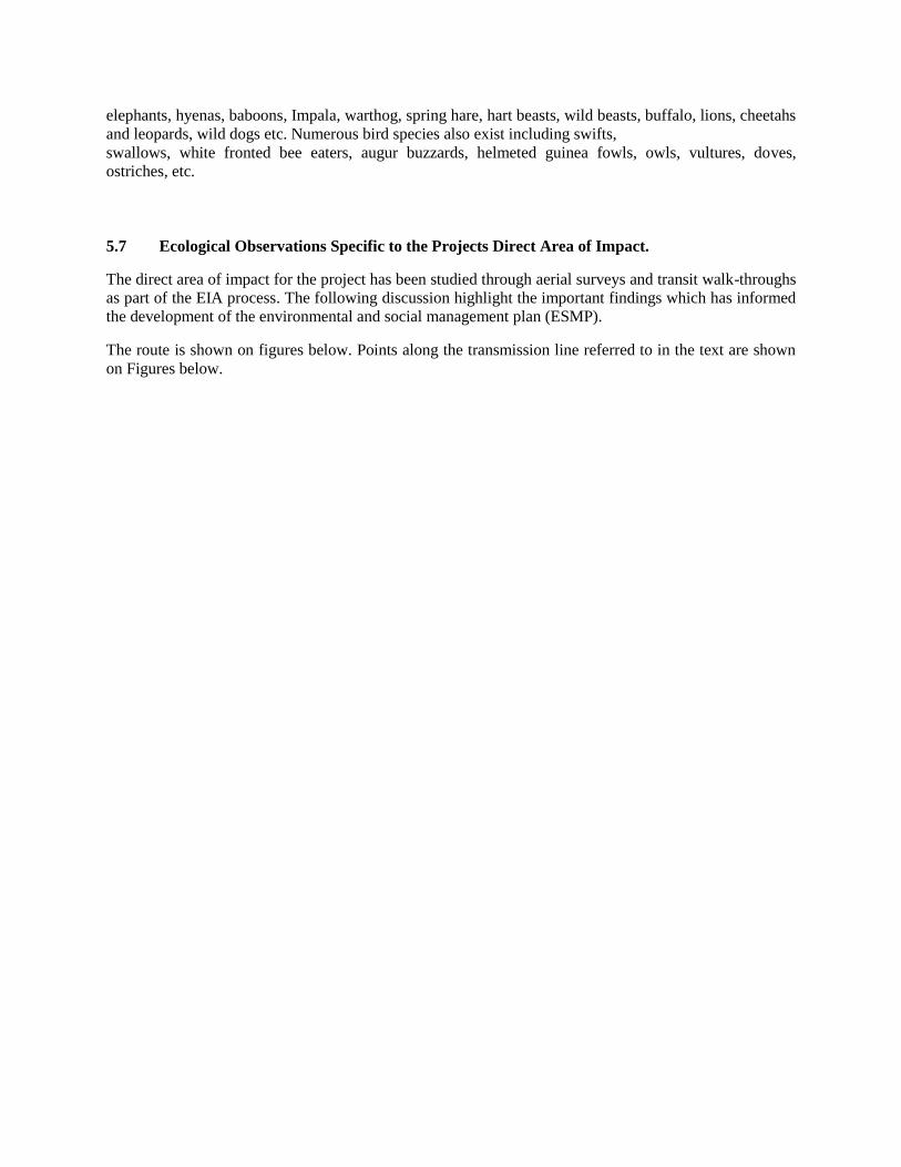
Page 9
Figure 2: Collage of Biophysical Locations along the Route
Page 10
At AP2 there were numerous vulture nests located within tall trees nearby the proposed route.
Consideration will need to be given to avoid removal of the trees containing vulture nests. Where
tree removal is required this should be undertaken in consultation with an ornithologist who can
advise on avoidance during the sensitive nesting season (e.g. February to April for Egyptian
Vultures.)
At AP8 there were three stream crossings then lush forested valleys with numerous stream
crossings at AP9. The transmission line towers will need to be spaced to span these watercourses
and allow a buffer (e.g. >10 metres) from the tower to the watercourses to prevent run-off,
siltation and bank disturbance during construction. Any removal of trees along river banks may
cause bank instability and will be carefully planned. Consideration will be given to nesting birds
and bats roosts in mature trees prior to removal.
At AP10 there were grazing land with steep wooded valleys and a lake with an African Fish
Eagle (AP11). A few small reservoirs were seen up to 2km from the transmission line route, with
a stream crossing at AP16.
At AP17 there is a largely forested area with scattered small pools and at AP18 a marshy area
(600m in length), but with no obvious water birds in the vicinity. This water bodies would form a
source of construction water.
From AP18 to 21 the habitats were open savannah plains with zebra and oryx. From AP21 to 26
were irrigated crops, small river crossings and a small lake at AP25 containing egrets and
Egyptian geese. At AP26 was a small river with zebra and gazelle.
Between APs22 and 23 was Pesi Swamp. This was dominated by Papyrus with some small areas
of open water nearby. The distance the transmission line would pass over the swamp would be a
maximum of 600m. Ibis and egrets were seen here. It is recommended that at this swamp/marshy
area vegetation clearance is not undertaken within these habitats. The towers should ideally be
placed either side of these habitats on more solid ground to avoid any habitat loss and
disturbance. Where the transmission line passes over the Pesi Swamp and other such wetlands
some large water birds may be killed if they fly into the cables. Where there is a recognized flight
path, and thus a danger to birds, marker buoys, placed on these cables, make them more visible
and greatly reduce the numbers of these fatal collisions.
At about AP35 Malewa River is located which the proposed transmission line crosses up to
mature cedar woodland on a ridge at AP36. The transmission line has been rerouted to avoid any
impact on the cedar forest. From AP36 south the transmission line passes small scale settlements
with cattle ranches, crops to AP42 with shrubs and dry rivers.
Pesi swamp and Malewa River were noted as areas of interest warranting further consideration in the
designing of the project. For Pesi Swamp, following the latest evaluation, it is recommended that towers
should ideally be placed such that they avoid the marsh habitats. Vegetation clearance in these habitats
should be minimised. It is also recommended that that marker buoys, are placed on the cables to make
them more visible to larger water birds, reducing the potential for collisions. With regard to Malewa
River, it is recommended that any loss of woodland is off-set/compensated through the planting of new
native woodlands. Ketraco has transmission mitigation reforestation policies that will compensation for
loss of woodlands.. As to number of tress the figure extrapolated from areas and counts is in the order of
55,000 of which compensation will be paid as per the RAP report.
Page 11
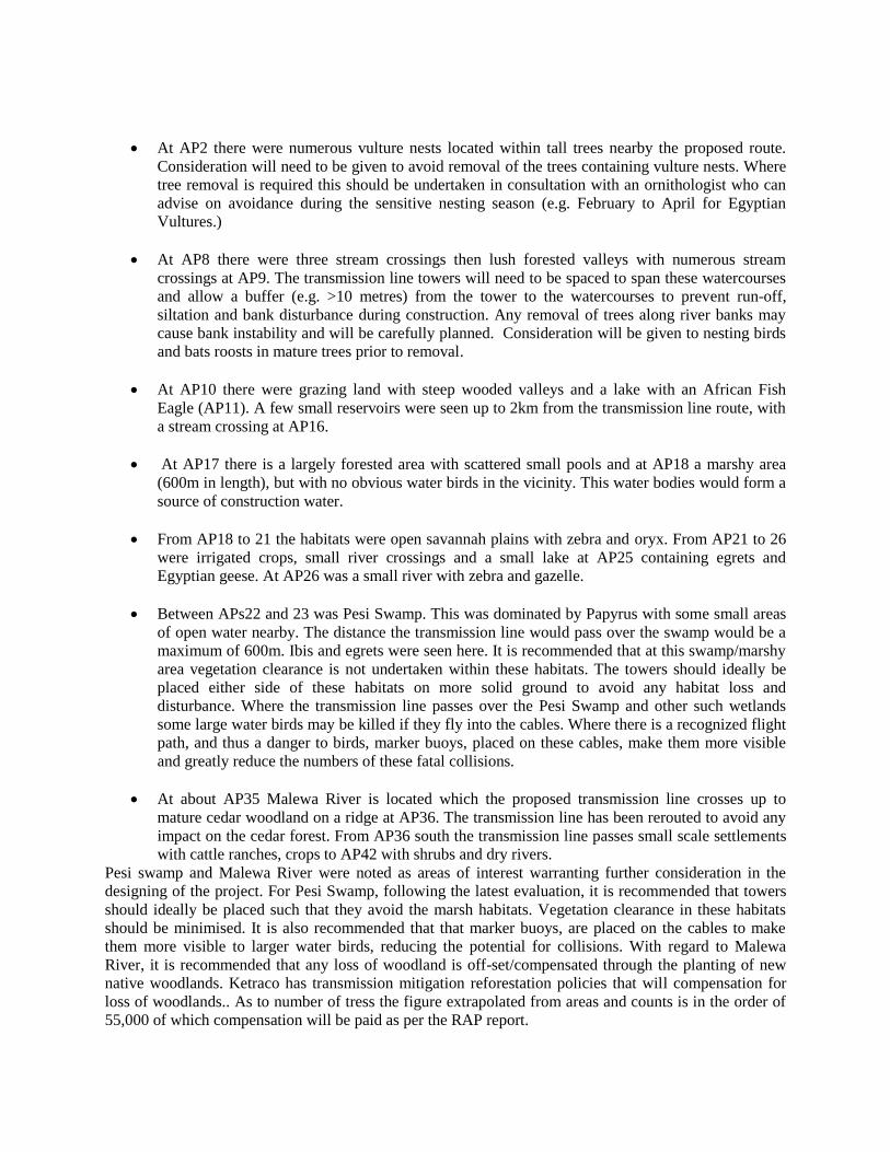
The main aquatic habitat that the transmission line traverses is the Pesi swamp however concern was also
raised regarding the Malewa River. The environmental and social management plan details the mitigation
measures to be undertaken during construction of the transmission line in this location, AP23. During the
alignment survey, particular attention was paid to the crossing of the swamp and identified a point where
the span was minimal and the selected crossing point is estimated to be around 500m to 550m.
The area is inhabited with small scale farming nearby with associated roads and paths traversing the
swamp as shown by the light grey lines in the figure 3 below. The area around where the transmission line
will cross has been disturbed and impacted by local settlement.
Figure 3: Pesi Swamp Crossing Illustration
In order to minimise further degradation it is recommended that towers should ideally be placed such that
they avoid the marsh habitats of about 500m width. Vegetation clearance in this habitat will be minimised
and following completion of the works restoration of the area by the contractor should be confirmed as
satisfactory by Ketraco. The impact from construction of (2 to 3 towers) in this marshy land will be of a
temporary nature and Ketraco should ensure strict monitoring of the contractor during the works period to
certify that mitigation measures in the ESMP are adhered.
The Malewa River rises in the western slopes of Aberdare Range in Kenya and meanders south and west
into Lake Naivasha in the Great Rift Valley. The Malewa River has a basin catchment area of 1,730
square kilometres and provides about 90% of the water flowing into Lake Naivasha, with most of the
remainder coming from the Gilgil River. The Malewa River water quality has deteriorated over time due
to human settlement activities in the upper catchment area and down the rift valley by Kikuyu farmers
since 1960, ploughing much of the land to grow maize, wheat, cabbage and potatoes. The river is
threatened by deforestation and siltation, increasing diversion of water for irrigation, and pollution by
fertilisers and pesticides. The transmission line will traverse the Malewa River and associated tributaries
along the Turasha ridge and Malu area between AP25 and AP31 many times as shown in the Figure 4
below. Fortunately the river at its largest crossing is around 50m and easy span for transmission towers. It
is essential that construction works do not add to the siltation impact and it is recommended that Ketraco
once the detail tower spotting has been completed ensures that tower foundation are not closer than 30m
to nearest banks.
Page 12
Figure 4: Malewa River and Tributaries
5.8 Socio-Economic Profile
There are two distinct identifiable zones based on the demography and settlement patterns viz a
moderately highly populated area between Suswa and Rumuruti and a sparsely populated area between
Rumuruti and Loyangalani.
5.3.1 Suswa -Rumuruti section
Communities occupying this section include Maasai, Kikuyu and Samburu whose socio-economic
orientations are greatly influenced by the climatic conditions of the areas they occupy. The section
manifest a mix of economic activities ranging from cattle rearing and wheat farming at Suswa - Longonot
area to small scale mixed farming section lying in Nyandarua District. The favourable climatic conditions
in the area promote growth of food crops such as maize, beans cabbages, peas, potatoes and rearing of
high quality grade cattle. In some area around Kipipiri and Ol Kalou settlements going up to Aberdare
escarpment at Shamata, there are small scale commercial Eucalyptus farming with most of the trees being
sold to power utility. The average annual incomes for the families range from between Kshs 75,000 to
350,000. There are few white owned flower farms in this area. From sample survey on area, it was
observed that the average size of household is 6 persons housed in temporary shacks, semi-permanent and
a limited number in permanent houses.
Malewa River&
Tributaries
Lake Naivasha Location
Page 13
Residents of the area between Suswa and Longonot experience severe water shortage as there are no
perennial surface water sources. The main sources of water in this area are boreholes drilled through
government interventions and local NGOs. In contrast the section lying in Nyandarua District has a
number of water sources including tributaries of the Wanjohi and Turasha Rivers and in part tributaries to
the Malewa river system. In addition, there are several springs that have been tapped by the local
community. In this section, it was observed that the main public health concern is the threat of occasional
malaria, typhoid and eye infections.
5.3.2 Rumuruti- Loyangalani section
The area between Rumuruti and Loyangalani occupies a total of 250km of the proposed transmission line.
The area is inhabited by communities Samburu, Turkana, Pokot and Rendille. In some areas between
Rumuruti and Maralal, there are a number of white ranchers.
The population densities are low and the area is characterized by large parcel of land occupied by large-
scale beef ranchers and local communities engaging in pastoral nomadism. While the few ranchers in the
area live in permanent structures, the locals dwell in temporary clustered shacks due to insecurity. The
average household sizes vary from 6 to 10 persons. There are numerous wildlife conservancies in the
area. Land ownership in this area falls into four different categories trust land under the county councils,
leasehold and communal ownership and a few individuals holding registered titles. Individual household
incomes vary from between Kshs 45,000 to 2,000,000. The main water sources in the area include rivers,
small dams, pans and boreholes. Also observed was the fact that malaria, typhoid, eye infections are the
common diseases affecting communities living in this area.
The water quality for the samples obtained from Malewa and Pesi rives indicate that the water is fairly
turbid and requires minimum treatment to be potable. Samples obtained from Poro River and Baragoi
dam indicate contents of salts and suspended solids within treatable limits. These result would be used for
comparison purposes in future monitoring of the water sources in relation to the power transmission line.
Page 14
6. Project Alternatives:
The development of the transmission route, inception stage, studied 6 alternatives alignments and various
options of these alignments before selecting the preferred route. The main consideration were, to the
extent possible, aim to avoid interference/encroaching on large settlement areas, conservancy sites,
wildlife sanctuaries, terrestrial habitats, aquatic habitats, cultural sites and sensitive receptors. The route
selected does this and consultations with stakeholder agree with the findings of the EIA that the
transmission line when implemented in accordance with the mitigation guidelines in the ESMP
(Environmental and Social Management Plan) will not pose adverse environmental impacts on nature
conservation sites, wildlife sanctuaries or terrestrial and aquatic habitats.
There are a number of wildlife conservancies shown in the figures below especially in the Rumuruti area.
From the inception stage through to the selected alignment, the transmission line route avoids any
interference /encroaching on wildlife sanctuaries.
The figures below illustrate the transmission line route from Suswa to Loiyangalani with the various
nature conservancy sites, names clearly shown. The nearest area of interest in this respect to the
transmission line is at Mugie Wildlife Conservancy where particular attention was paid to the alignment
due to the sensitive nature of the area, refer to Figure 5 for general location of the conservancy area that
exist along the transmission line route. The alignment, taking cognizance of wildlife, terrestrial fauna will
run adjacent to the western boundary and parallel to the existing murram road that runs around the
perimeter of the conservancy. The impact will be of a temporary nature during construction of the works.
The road along this section is frequently traversed by visitors to this privately run conservancy by patrons
on safari and Malu administration vehicles.
Figure 5: Conservancy General Locations
Figure 6: below depicts the minor encroachment upon Mugie Wildlife Conservancy perimeter.
Page 15
Figure 6: Detailed View Mugie Alignment
The EIA confirms that project activities close to the conservation area are assessed as a minor impact and
“Consultation with KWS (Kenyan Wildlife Society) officials in the Mt Kenya and Central Rift
Conservation areas indicated that the proposed line does not have negative impact on the wildlife,
environment, dispersal areas, habitats and migratory route of wild animals”.
Consultations were recently undertaken in respect to potential conservancy encroachment/ impact of the
Loiyangalani line in Laikipia County. A meeting was convened with Laikipia tourism stakeholders and
outcome of the meeting confirmed that these stakeholders are happy with the alignment of the
Loiyangalani line as it does not encroach nor will the route impact on the livelihoods of the Laikipia
conservancy tourism sector as the line avoids this ‘wilderness area’ that they are endeavouring to protect.
Given the above studies undertaken and feedback from stakeholders it is recommended that KETRACO
work closely with the owners of Mugie Wildlife Conservancy during the period of construction in this
section of the corridor and ensure that the construction works are in compliance with recommendations in
the environmental and social management plan.
Page 16
7 Potential Impacts and Mitigation/Enhancement Measures
Potential Impact
Proposed Mitigation/ Reason
Responsibility for
Monitoring
Monitoring
Indicator
Monitoring
Means
Time
Frame
Cost
(Ksh)
Public Consultation and
Community Engagement - Dissemination of project
information
- Public safety
- Minimisation of disturbance
KETRACO Consultation/
community
engagement
meetings held
Meeting
reports
Continuous
Employment
Statement of intent. Contractors Reports listing
permanent and
temporary
employees by
function and
gender and days/
months employed
and salary paid.
The minimum
salary should not
be below Kenyan
rate.
Client Monthly
Reports
monthly basis
Page 17
Management of change
and chance find procedure
for natural and cultural
habitat
Minimise impact on cultural heritage. Contractors Statement of finds
and actions taken
Client Reports Monthly Reports
Training Organise environmental management
and occupational health and safety
training. All contractors, their
employees both contractual and
temporary shall attend the training and
receive accreditation certificate
confirming understanding and
completion of the course.
Contractors Staff trained Training reports On site at least 1
month prior to
commencement
of construction
30,000
Public & Occupation
Health and Safety e.g.
accidents resulting from
sharp and falling objects
Preparation of a Health and Safety Plan
for workers and impacted communities
addressing issues including:
- Education of workers and impacted
communities
- Provision of appropriately fitting
personal protective equipment
(PPE) to workers during
construction
- Incident/accident reporting through
keeping log of incidents/accidents
and remedial actions (in the event of
an accident)
- Emergency contingency plan
- Work instructions
- Use of child labour to be prohibited
KETRACO &
Contractors
Protected workers
at sites
Workers using
appropriate and
fitting PPE
- Monthly
meeting reports
- Site
inspection
reports
Before
commencement
of construction
and statement to
effectiveness in
Monthly Reports
1,000,000
Road safety - Enforce speed limits for
construction vehicles; where
possible design separate vehicle
entries different from the common
entrances with the residents;
KETRACO &
Contractors
Reduced accidents Number of
reported cases/
complaints
from the
residents &
Continuous
throughout the
construction
phase and
statement to
40,000
Page 18
streamline traffic flow into and out
of the premises; initiate changes in
traffic flow in the micro-area upon
commissioning; install approximate
cautionary signage for motorists
entering the premises.
- Ensure appropriate road safety
signage
- Ensure all drivers adhere to the
traffic laws and requirements
Erection of bumps where human and
vehicular traffic have high interaction
opportunities
inconveniences
from visiting
motorists
effectiveness in
Monthly Reports
Risk of leaks or spills - Regular maintenance of site
equipment
- Safety procedures for fuel storage
and refuelling
- Dispose of oil residues carefully
KETRACO &
Contractors
Spot checks by
KETRACO
Regular
inspection
Continuous and
statement to
effectiveness in
Monthly Reports
110,000
Noise and vibration - Sensitise the workforce and truck
drivers on issues of equipment
maintenance.
- Supervise construction traffic
- Maintain plant and equipment
- Undertake construction only during
the daytime for peace of the
neighbours
- Workers to wear ear plugs, muffs as
part of their PPE
KETRACO &
Contractors - Not to exceed
84 decibels
- Not to exceed
40 working
hours/per week
- Sound
proofing
material
Routine
inspection
Continuous and
statement to
effectiveness in
Monthly Reports
100,000
Page 19
Canteen eating areas and
washing facilities - Housekeeping standards employed
by the Contractors and any sub-
contractors must be as good as that
of KETRACO
- Food and drink should not be
consumed in any area where Lead
work is being carried out
- Washing of hands and face and
changing of contaminated clothes
should take place before entering
canteen areas.
KETRACO &
Contractors
Sound
housekeeping
practices
Quarterly
monitoring
reports
During
construction
Contractor camps - All sewage and waste water
discharges from contractor camps
shall be collected and treated in an
approved system installed on site;
- Solid wastes shall be stored in
proper containers, collected and
disposed of using public or private
companies entrusted with solid
waste collection in the communities
where such wastes are collected
(camp sites) and disposed in
landfills/dumpsites approved by
NEMA;
- Erosion shall be minimised and
sedimentation prevented through a
drainage system with sedimentation
traps and/or screens;
- All refuelling and servicing areas
shall be situated on impermeable
surfaces served by an oil trap and
run-off collection facilities;
Upon completion of the contract, all
elements of the camp shall be removed
and the site, as far as possible, be
KETRACO &
Contractors
Sound
environmental
practices in camps
Quarterly
monitoring
reports
Construction
phase
300,000
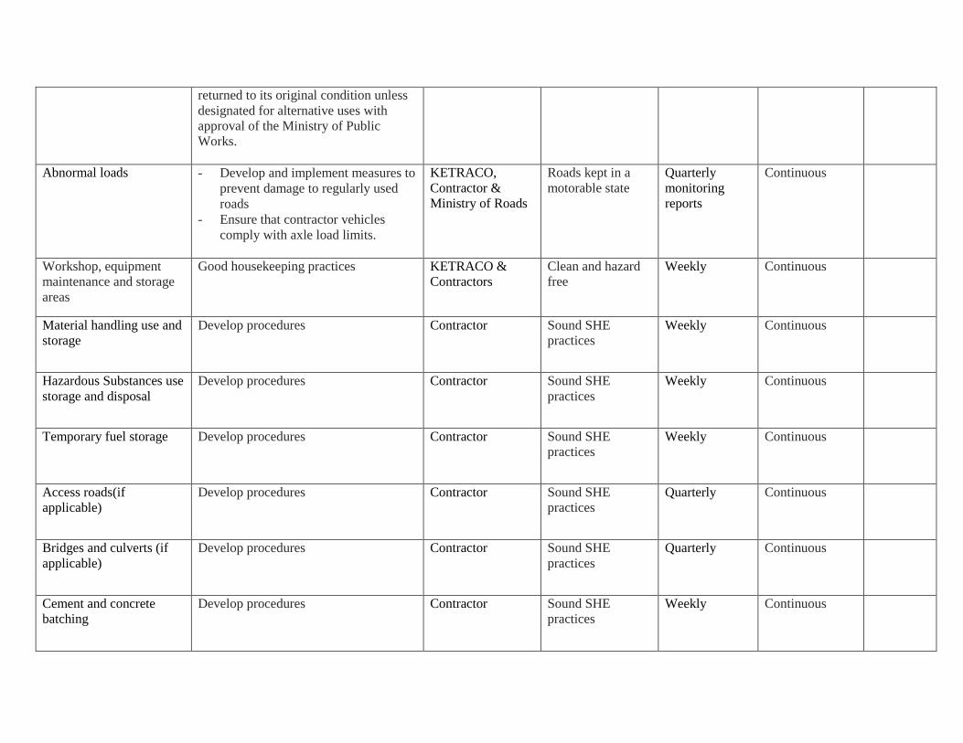
Page 20
returned to its original condition unless
designated for alternative uses with
approval of the Ministry of Public
Works.
Abnormal loads - Develop and implement measures to
prevent damage to regularly used
roads
- Ensure that contractor vehicles
comply with axle load limits.
KETRACO,
Contractor &
Ministry of Roads
Roads kept in a
motorable state
Quarterly
monitoring
reports
Continuous
Workshop, equipment
maintenance and storage
areas
Good housekeeping practices KETRACO &
Contractors
Clean and hazard
free
Weekly Continuous
Material handling use and
storage
Develop procedures Contractor Sound SHE
practices
Weekly Continuous
Hazardous Substances use
storage and disposal
Develop procedures Contractor Sound SHE
practices
Weekly Continuous
Temporary fuel storage Develop procedures Contractor Sound SHE
practices
Weekly Continuous
Access roads(if
applicable)
Develop procedures Contractor Sound SHE
practices
Quarterly Continuous
Bridges and culverts (if
applicable)
Develop procedures Contractor Sound SHE
practices
Quarterly Continuous
Cement and concrete
batching
Develop procedures Contractor Sound SHE
practices
Weekly Continuous
Page 21
Crushing (if applicable) Develop procedures Contractor Sound SHE
practices
Weekly Continuous
Earth works & restoration
and replacement offsets
Develop procedures Contractor Sound SHE
practices
Quarterly Continuous
Power tools Develop procedures Contractor Sound SHE
practices
Weekly Continuous
Lay-down areas Develop procedures Contractor Sound SHE
practices
Weekly Continuous
Pumping and sumping (if
applicable)
Develop procedures Contractor Sound SHE
practices
Weekly Continuous
Contaminated water Treating contaminated water before
release to the aquatic environment
KETRACO &
Contractors
Biodiversity health
(both terrestrial
and aquatic)
Quarterly
monitoring
reports
Continuous 100,000
Storm water control Providing, installing, maintaining,
removing and disposing of storm water -
control measures such as gravel filter
berms, dykes, catch basin inlet
protection, end of pipe filtering devices,
silt fences, dams, sediment basins,
netting, bale barriers, slope drains and
other erosion control devices or
methods.
KETRACO &
Contractors
Storm water well
channelled
Quarterly
monitoring
reports
During
construction
300,000
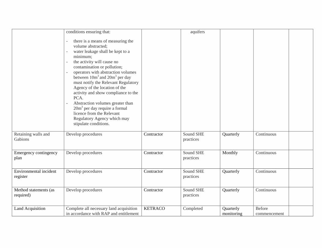
Water abstraction Small scale activities with abstraction
volumes less than 10m3 per day are not
required to notify the relevant Water
Regulatory Agency but must adhere to
Permitted Controlled Activities (PCA)
KETRACO &
Contractors - Water volume
in reservoirs
(if any)
- Status of
underground
Quarterly
reports
Continuous 50,000
Page 22
conditions ensuring that:
- there is a means of measuring the
volume abstracted;
- water leakage shall be kept to a
minimum;
- the activity will cause no
contamination or pollution;
- operators with abstraction volumes
between 10m3 and 20m
3 per day
must notify the Relevant Regulatory
Agency of the location of the
activity and show compliance to the
PCA.
- Abstraction volumes greater than
20m3 per day require a formal
licence from the Relevant
Regulatory Agency which may
stipulate conditions.
aquifers
Retaining walls and
Gabions
Develop procedures Contractor Sound SHE
practices
Quarterly Continuous
Emergency contingency
plan
Develop procedures Contractor Sound SHE
practices
Monthly Continuous
Environmental incident
register
Develop procedures Contractor Sound SHE
practices
Quarterly Continuous
Method statements (as
required)
Develop procedures Contractor Sound SHE
practices
Quarterly Continuous
Land Acquisition Complete all necessary land acquisition
in accordance with RAP and entitlement
KETRACO Completed Quarterly
monitoring
Before
commencement
Page 23
- Loss of land due to
construction of
temporary and
permanent access
routes leading to the
transmission lines,
tower sites and sub-
stations
- Temporary loss of
land use during
establishment of
right-of-way (ROW)
Framework prior to the commencement
of any construction works.
acquisition process
reports of construction
Terrestrial Habitat
Alteration
Protection of flora &
fauna
- Re-vegetation of disturbed areas
with native plant species;
- Undertake selective clearance by
removing tall woody species leaving
saplings, for quick regeneration of
vegetation along the way-leave
(sections where vegetation clearance
will be done);
- No pesticides will be used during
bush clearing;
- Stipulate no hunting of bush meat or
cutting of firewood by contractor
staff
KETRACO &
Kenya Forest
Service
Re-vegetation of
disturbed areas
Routine
inspection
Continuous 130,000
Aquatic habitat alteration
(including wetlands)
- Minimising clearing and disruption
to riparian vegetation;
- Consider rerouting to avoid or
minimise effect on wetlands e.g.
Pesi Swamp
KETRACO &
Contractors - Siltation of
soil in rivers
from
construction
activities
- Physical water
quality
- Species
diversity
Routine
Maintenance
Continuous Nil
Page 24
Power line related
avifauna mortalities
- To minimise collision, undertake
wire-marking to alert birds to the
presence of power line
- Build raptors platforms on top of
pylons for roosting and nesting
KETRACO &
Contractors
Physical
structures
Routine
Maintenance
Inspection
Records
Continuous 180,000
Soil erosion
- Soils excavated for the erection of
towers should be used for re-filling
and should not be left exposed to
wind or water for long periods;
- Contractors should avoid steep
terrain during the transportation of
construction material by using
alternative routes or use light
vehicles where appropriate;
- Riverine vegetation should be
minimally disturbed during the
construction phase to reduce soil
erosion and safeguard riverbank
protection;
- Re-plant degraded areas with local
species common in the area to
complement natural vegetation
regeneration to improve ground
cover.
KETRACO &
Contractors
Status of ground
cover in
constructed areas
Re-vegetation
Continuous 90,000
Air Pollution (dust, fuel,
emissions)
- Control speed of construction
vehicles;
- Prohibit idling of vehicles;
- Water should be sprayed during the
construction phase on excavated
areas;
- Regular maintenance of plant and
equipment;
- Provision of dust masks for use
when working in dusty conditions;
- Sulphur hexafluoride (SF6)
KETRACO &
Contractors
- Visible
particulate
matter in the
air;
- Increase in
upper
respiratory
tract ailments;
Number and
status of PPE;
- Vehicle
Respiratory
Protection
devices
Continuous 20,000
Page 25
switchgear
- Ensure factory acceptance test is
carried out to ensure switchgear is
sealed tightly;
- Regular inspection and pressure
monitoring to ensure zero leakages
.
service.
Contamination of ground
and surface water
- Maintenance of construction
vehicles should be carried out in the
contractor’s camps and a recognised
garage;
- Proper storage, handling and
disposal of oil wastes from
machinery, discourage servicing of
machinery and vehicles in
construction sites.
KETRACO &
Contractors
Water quality.
Nature of surface
runoff from the
site
Routine
inspection
Continuous 30,000
Management of Solid
Waste
- Contractors must dispose solid
wastes away from the site to an
approved disposal site;
- Temporary pit latrine for
construction workers.
KETRACO &
Contractors
Nil visible solid
waste heaps on site
Routine
maintenance
Continuous
through
construction
30,000
Risk of fire
- Establishing a network of fuel
breaks of using inflammable
materials or clearing land to slow
progress of fires and allow fire
fighting access;
- Provision of fire safety system that
includes training, fire fighting
equipment; regular maintenance of
machinery, vehicles and equipment;
and no burning activities to be
allowed close to or within the site.
KETRACO &
Contractors
Records
Routine
maintenance
Continuous 70,000
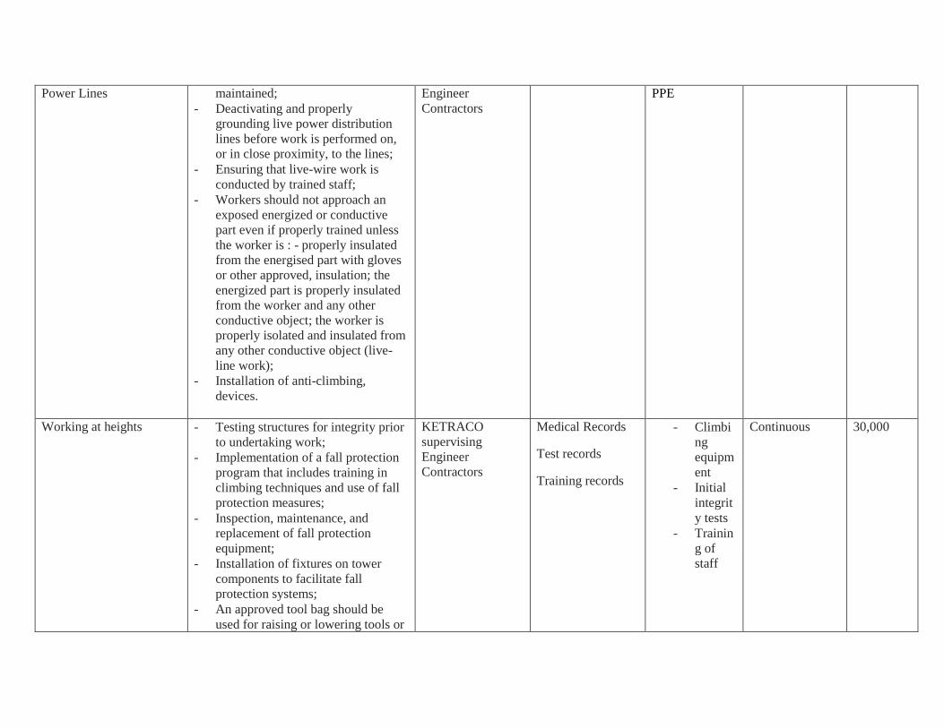
Electrocution from Live - A maintenance system to ensure
physical integrity of structures is
KETRACO
supervising
Medical Records Provision of Continuous 20,000
Page 26
Power Lines
maintained;
- Deactivating and properly
grounding live power distribution
lines before work is performed on,
or in close proximity, to the lines;
- Ensuring that live-wire work is
conducted by trained staff;
- Workers should not approach an
exposed energized or conductive
part even if properly trained unless
the worker is : - properly insulated
from the energised part with gloves
or other approved, insulation; the
energized part is properly insulated
from the worker and any other
conductive object; the worker is
properly isolated and insulated from
any other conductive object (live-
line work);
- Installation of anti-climbing,
devices.
Engineer
Contractors
PPE
Working at heights
- Testing structures for integrity prior
to undertaking work;
- Implementation of a fall protection
program that includes training in
climbing techniques and use of fall
protection measures;
- Inspection, maintenance, and
replacement of fall protection
equipment;
- Installation of fixtures on tower
components to facilitate fall
protection systems;
- An approved tool bag should be
used for raising or lowering tools or
KETRACO
supervising
Engineer
Contractors
Medical Records
Test records
Training records
- Climbi
ng
equipm
ent
- Initial
integrit
y tests
- Trainin
g of
staff
Continuous 30,000
Page 27
materials to workers on structures;
- Use of helmets and other protective
devices will mitigate against
scratches, bruises, punctures,
lacerations and head injuries due to
dropping objects.
Spread of Diseases
- Education, guidance and counselling
on HIV/AIDS and other sexually
transmitted diseases – construction
staff;
- Avail condoms to construction staff.
KETRACO &
Contractors
Medical Records
Regular
inspection on
availability of
condoms
Continuous 10,000
Spread of HIV/AIDS - Review activities of the project to
integrate with HIV/AIDS
campaigns;
- Develop appropriate training and
awareness materials on HIV/AIDS;
- Identify other players like
community and non-governmental
organisations etc on HIV/AIDS for
enhanced collaboration;
- Integrate monitoring of HIV/AIDS
proactive activities.
KETRACO - Continuous 80,000
Land acquisition and
Resettlement
Ensure that the displaced persons are:
- Informed about their options and
rights pertaining to resettlement;
- Consulted on, offered choices
among, and provided with
alternatives;
- Provided prompt and effective
compensation at full replacement
cost for losses of assets attributable
directly to the project;
Contractors &
KETRACO
Relocation
Compensation for
loss
Compliance with
KETRACO RPF
No complaints
for lack of
compensation
Before
commencement
of construction
To be
covered
under
RAP
Page 28
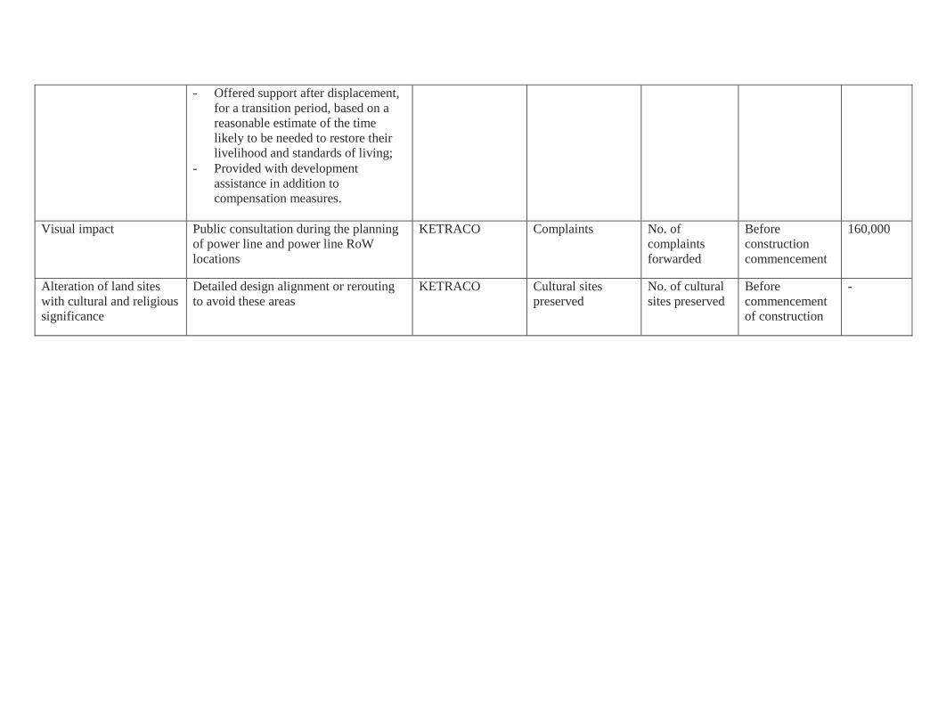
- Offered support after displacement,
for a transition period, based on a
reasonable estimate of the time
likely to be needed to restore their
livelihood and standards of living;
- Provided with development
assistance in addition to
compensation measures.
Visual impact
Public consultation during the planning
of power line and power line RoW
locations
KETRACO
Complaints No. of
complaints
forwarded
Before
construction
commencement
160,000
Alteration of land sites
with cultural and religious
significance
Detailed design alignment or rerouting
to avoid these areas
KETRACO Cultural sites
preserved
No. of cultural
sites preserved
Before
commencement
of construction
-
Page 29
8. Monitoring Programme
Arrangements for the implementation the ESMP and RAP are largely the responsibility of project’s
implementing agency KETRACO who will be overseeing the activities of its contractors. In addition the
Bank and the country’s regulatory agency will provide periodic supervisory functions during the
construction and operational phases of the project. Currently, KETRACO has 4 socio-economists, 4
environmentalists, 5 land surveyors and 4 land valuers/economists. Following earlier observation on other
projects being handled by KETRACO, the Bank has provided recommendation to strengthen the
institutional capacity of the agency. These recommendations relate to the capacity for planning and
scheduling of related activities. In addition recommendations have been provided on the need for
KETRACO to further fine tune its organisational structure to give greater independence to its E&S
technical staff. its technical staff in such a way that The Bank has provided recommendation Mission
observed and discussed issues pertaining to capacity in the two countries to adequately supervise and
monitor implementation of the ESMP and RAP implementation.
9. Public Consultation and Public Disclosure
Public consultation and disclosure was initiated during the EIA process in 2008. Since then community
engagement has continued as part of the way-leave acquisition process. For each project, as part of the
on-going community engagement, KETRACO has instated a dedicated Resettlement Working Group to
address and deal with any grievances which may occur comprising of the local leaders and
representatives. KETRACO will also monitor the implementation of the RAP. Disclosure is an important
aspect of stakeholder and public consultations. The ESIA and RAP documents have been disclosed at
different locations in Kenya. Additional information has been requested by the Bank, and this update will
be equally disclosed at these locations and these documentations will be published on the respective
websites of the utilities. On its part, the Bank has posted on this information on its website, since March
2011 as part of information on the wind farm project since the transmission line was considered an
associated project at that time, these information will be updated accordingly and disclosed according to
the Bank’s disclosure requirements.
10. Conclusion:
An evaluation of the impacts resulting from implementation of the proposed project indicates that the
ESMP developed provides for adequate redress to all these impacts. In view of this therefore, the project
does not pose any serious and negative environmental and social impacts that cannot be mitigated.
CONTACTS
Mr Kurt Lonsway, Division Manager, Energy, Environment and Climate Change, BP 323 - 1002
Tunis Belvédère, Tunisia. Tel.: +216 71 10 3313, Email: [email protected]
Mr Uche Duru, Senior Environmental Specialist, Energy, Environment and Climate Change
(ONEC.3), BP 323 - 1002 Tunis Belvédère, Tunisia. Tel.: +216 71 10 3817, Email:
[email protected]
Ms Eloïse Fluet, Senior Socioeconomist, Energy, Environment and Climate Change (ONEC.3),
BP 323 - 1002 Tunis Belvédère, Tunisia. Tel.: +216 71 10 29 29, Email: [email protected]