24
Kerang Wetlands Ramsar Site Boundary Description Technical Report
| Date post: | 24-Aug-2019 |
| Category: |
Documents |
| Upload: | truongkien |
| View: | 237 times |
| Download: | 0 times |

Kerang Wetlands Ramsar Site Boundary Description Technical Report
Published by the Victorian Government Department of Environment and Primary Industries Melbourne, December 2013
© The State of Victoria Department of Environment and Primary Industries Melbourne 2013 This publication is copyright. No part may be reproduced by any process except in accordance with the provisions of the Copyright Act 1968.
Authorised by the Victorian Government, 8 Nicholson Street, East Melbourne.
ISBN 978-1-74287-773-0 (online).
For more information contact the DEPI Customer Service Centre 136 186
Citation: DEPI (2013) Kerang Wetlands Ramsar Site Boundary Description Technical Report. Department of Environment and Primary Industries, East Melbourne, Victoria.
Disclaimer
This publication may be of assistance to you but the State of Victoria and its employees do not guarantee that the publication is without flaw of any kind or is wholly appropriate for your particular purposes and therefore disclaims all liability for any error, loss or other consequence which may arise from you relying on any information in this publication.
Accessibility
If you would like to receive this publication in an accessible format, such as large print or audio, please telephone 136 186, or email [email protected]
Deaf, hearing impaired or speech impaired? Call us via the National Relay Service on 133 677 or visit www.relayservice.com.au
This document is also available in PDF format on the internet at www.depi.vic.gov.au
Cover photo: Yvette Baker (2010).

Kerang Wetlands Ramsar Site Boundary Description Technical Report
Contents
Introduction 1
Methodology of RAMSAR 100 GIS layer boundary realignment 2
Location 3
Written description of the Kerang Wetlands Ramsar Site boundary 4
References 9
Appendix 1 10
Appendix 2 11

Kerang Wetlands Ramsar Site Boundary Description Technical Report 1
Introduction
Ramsar wetlands are wetlands of international importance listed under the Convention on Wetlands (Ramsar, Iran 1971). Victoria has 11 wetlands listed under this convention including the Kerang Wetlands Ramsar Site.
It is a requirement of the Convention on Wetlands that a suitable map or maps are provided for each Ramsar wetland. The Department of Sustainability, Environment, Water, Population and Communities (SEWPAC), requires that both the written description and the spatial data of the Ramsar site boundaries are accurate. This information is used to gazette the boundary of the declared Ramsar wetland in accordance with Section 327 of the Environment Protection and Biodiversity Conservation Act 1999 (EPBC Act). Under the EPBC Act there are requirements for approval of activities which have, or are likely to have a significant impact on the ecological character of a declared Ramsar wetland. Precise identification of site boundaries helps to ensure that the exact boundaries of the Ramsar site can be easily identified, which can facilitate compliance with the EPBC Act as well as its effective enforcement.
The RAMSAR100 spatial dataset is a polygon layer that identifies each Victorian Ramsar area individually. RAMSAR100 was produced in conjunction with a report describing each Ramsar site (DCNR 1995). The Department of Environment and Primary Industries (DEPI) is the custodian of RAMSAR100. Most of the line work in RAMSAR100 was initially derived from 1:100,000 reference data. Because of its broader scale, this data was not always consistent with the cadastre and other more accurate features that have now been used to better define the majority of the Kerang Wetlands Ramsar Site. The updated spatial definition of Kerang Wetlands Ramsar Site is identified in a new RAMSAR25 spatial dataset.
This report details the written description of the Kerang Wetlands Ramsar Site to explicitly define the Ramsar boundaries, along with accompanying maps.
Kerang Wetlands Ramsar Site Boundary Description Technical Report 2
Methodology of RAMSAR 100 GIS layer boundary realignment
An expert panel was convened to provide advice on the original intent of the Ramsar site boundaries based on the description in DCNR (1995) and the RAMSAR100 spatial dataset.
Certificates of Title were obtained as required from the Office of the Surveyor–General, Victoria, to further clarify the intent of the Ramsar boundary.
DEPI manages the RAMSAR100 spatial dataset. The RAMSAR100 boundary of the Ramsar site was used as a guide to select appropriate features from the following 1:25,000 datasets:
• Vicmap Transport Road (1 February 2011)
• Vicmap Property (26 October 2010)
• Vicmap Hydro (1 January 2011)
• Public Land Management (PLM25) (8 December 2010).
High quality digital aerial photography was used where it was necessary to further clarify the original intent of the Ramsar boundary.
• moira-shepparton_2009dec14_air_vis_30cm_mga55.
These datasets are represented in spatial products available through Vicmap1 - http://www.land.vic.gov.au. Alternatively the Ramsar site boundaries can be viewed through the Department of Sustainability and Environments website, at Interactive Maps - http://www.dse.vic.gov.au/about-dse/interactive-maps.
The geographical coordinates (latitude, longitude) used in this report are based on Geographic Datum of Australia 1994 (GDA94) and the areas are calculated using Albers Equal Area projection. The hectares of the site presented in the body of the report have been calculated using Albers Equal Area projection and rounded to the nearest whole number (see Appendix 1 the site’s area calculated to two decimal places).
1 Terms and conditions do apply.

Kerang Wetlands Ramsar Site Boundary Description Technical Report 3
Location
The Kerang Wetlands Ramsar site is located approximately 300 km northwest of Melbourne. The Ramsar site wetlands cover an area of approximately 9,793 ha and feature a variety of permanent and temporary wetlands, including permanent freshwater lagoons, permanent open freshwater lakes, deep freshwater marshes, saline and hyper saline lakes. The site consists of 23 wetlands which receive water from the Murray River, via the Torrumbarry Irrigation System, Avoca and Loddon Rivers.
Figure 1: Kerang Wetlands Ramsar Site location.

Kerang Wetlands Ramsar Site Boundary Description Technical Report 4
Written description of the Kerang Wetlands Ramsar Site boundary
The Kerang Wetlands Ramsar Site consists of 23 wetlands. The generated boundary of the Ramsar site described below is represented by the spatial data in RAMSAR25 held in the DEPI Corporate Spatial Data Library. The datum used is Geographic Datum of Australia 1994(GDA94). Points referred to in the description are shown on the maps in Appendix 2.
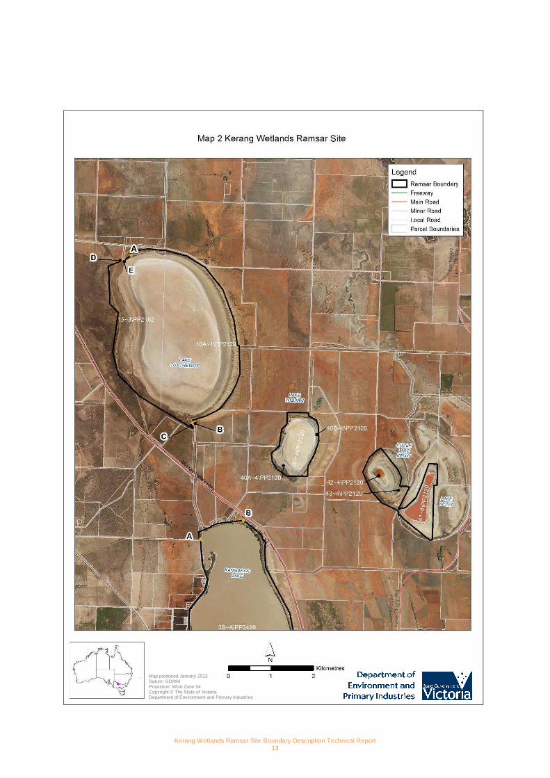
Lake Tutchewop
The boundary begins south east of Lake Boga at the point nearest to coordinate 143°44'27.158"E 35°29'53 .549"S (labelled as Point A on the map) on the southwest corner of parcel 14~3\PP2162. The boundary follows the northern edge of parcel 14~3\PP2162 to the north eastern corner (at the point closest to 143°44'58.692"E 35°29'48 .91"S). The boundary continues along the eastern edge of parcel 10A~1\PP2120 around the lake in a generally southerly direction to the point closest to 143°45'29.145"E 35°32'0.116"S ( point B).
From point B the boundary continues in a straight line in a southerly direction to the point closest to 143°45'28.967"E 35°32'1.368"S (point C) on the corner of 10A~1\PP2120. From point C the boundary continues in a north westerly direction along the boundary of parcel 10A~1\PP2120 to the point closest to 143°44'58.536"E 35°31'50.167 "S. The boundary continues around the lake along the western edge of parcel 15~3\PP2162 to the point closest to 143°44'18.435"E 35°29'57.702"S (point D). The bounda ry continues in a straight line to the south west corner of parcel 13~3\PP2162 (point E). The boundary continues along the northern edge of parcel 15~3\PP2162 returning to the starting point at A.
Lake William
The site is comprised of parcels 40B~4\PP2120, 40~4\PP2120, and 40A~4\PP2120.
Lake Kelly & Little Lake Kelly
The site is comprised of parcels 41~4\PP2120, 42~4\PP2120, 43~4\PP2120, 44~4\PP2120, 45~4\PP2120.
Kangaroo Lake & Racecourse Lake
The boundary commences at the point closest to 143°45'39.163"E 35°33'28.992"S (point A) on the north wes t corner of parcel 28B~6\PP2162. From this point the boundary heads in a generally westerly then north easterly direction along the northern edge of parcels 11D~6\PP2162 and 3B~A\PP2499 to 143°46'18.826"E 35°33'13.597"S (point B).
The boundary continues along the cadastral boundary of 3B~A\PP2499 in a generally southerly direction to the corner nearest to 143°46'38.826"E 35°36'21.295"S (point C). From point C the boundary follows the southern and eastern edge of parcel 1\TP383681 to the corner nearest to 143°47 '40.189"E 35°36'3.252"S (point E).
From this point the boundary continues in a generally southerly direction along the cadastral boundary of parcel 1D~C\PP2499 to 143°48'0.531"E 35°36'34.741"S (point F ). The boundary continues in a straight line in a southerly direction to 143°47'59.853"E 35°36'38.246"S (point G ) on the corner of parcel 4D~C\PP2499. From point G the boundary continues along the cadastral boundary (4D~C\PP2499) in a generally southerly direction to 143°47'58.813"E 35°36'48.821"S (point H).
The boundary continues along the cadastral boundary in a westerly direction to 143°47'51.017"E 35°36'4 8.766"S (point I) on the corner of parcel 4D~C\PP2499.
From point I the boundary continues in a straight line in a south westerly direction to 143°47'47.407" E 35°36'49.716"S (point J) on the corner of parcel 1D~C\PP2499.
The boundary continues along the southern edge of parcels 1D~C\PP2499 and 1E~C\PP2499 to the corner nearest to 143°46'40.3"E 35°36'50.71"S (point K).
From point K the boundary continues along the eastern edge of parcel 1\TP880594 in a generally northerly direction to the corner nearest to 143°46'18.84"E 35°36'24.834" S (point L).
From point L the boundary continues in a generally north westerly direction through parcel 1\TP880594 via a series of straight line segments joined by the following points (143°46'18.54"E 35°36'24.566"S, 143°46'13.97"E 35 °36'22.909"S,
Kerang Wetlands Ramsar Site Boundary Description Technical Report 5
143°46'11.783"E 35°36'23.113"S, 143°46'5.432"E 35°36 '17.393"S, 143°46'5.404"E 35°36'17.273"S) to the co rner of parcel 2\TP173103 nearest to 143°46'4.397"E 35°36'17 .248"S (point N). This line approximates the southern edge of Kangaroo Lake.
From point N the boundary continues northerly along the eastern edge of parcels 2\TP173103 and 1\TP675824 to the corner nearest to 143°46'5.032"E 35°36'0.433"S (poi nt O). From point O the boundary continues northerly in a straight line to the corner of parcel 10C~D\PP2038 closest to 143°46'5.021"E 35°35'59.783"S (point P). The boundary continues in a generally northerly direction along the western edges of parcels 10C~D\PP2038, 10H~D\PP2038, and 28B~6\PP2162, returning to the starting point at A.
Lake Charm & Little Lake Charm
The site is comprised of parcels 3E~B\PP2499, 3C~B\PP2499, 2~4\PP5445, 2001\PP2499, 21A~A\PP2499, 2002\PP2499, 2D~B\PP2499, 2~B\PP2499, and 2B1~B\PP2499.
Stevensons Swamp
The boundary matches the Stevensons Swamp Wildlife Reserve boundary that is represented by Crown parcel 10A~B\PP2499.
Third Lake, Middle Lake & Reedy Lake
The site is comprised of parcels:
• 7F~G\PP2499
• 26E~G\PP2499
• 26B~G\PP2499
• 26H~G\PP2499
• 2J~G\PP2499
• 26D~G\PP2499
• 26F~G\PP2499
• 2K~G\PP2499
• 26C~G\PP2499
• 7A~G\PP2499
• 6D~G\PP2499
• 7C~G\PP2499
• 7B~G\PP2499
• 6C~G\PP2499
• 26G~G\PP2499
• 26K~G\PP2499
Also included in the site are two road reserves.
The road reserve between Third Lake and Middle Lake is defined at the northeast end by a line joining the corner of parcel 6D~G\PP2499 (at the point nearest to 143°52'33 .353"E 35°39'14.357"S, point C) and the corner of pa rcel 26E~G\PP2499 (at the point nearest to 143°52'34.15"E 3 5°39'14.653"S, point D).
The southwest end is defined by a line joining the corner of parcel 26E~G\PP2499 (at the point nearest to 143°52'27.566"E 35°39'20.241"S, point J) and a point on the boundary of parcel 6D~G\PP2499 (at the point nearest to 143°52'26.962"E 35°39'19.76"S, point K).
The other road reserve between Middle Lake and Reedy Lake is defined at the eastern end by a line joining a corner of parcel 26F~G\PP2499 (at the point nearest to 143°52'5 9.7"E 35°40'17.383"S, point E) and a corner of parce l 26H~G\PP2499 (at the point nearest to 143°52'57.835"E 35°40'18.077"S, point F).
The western end is defined by a line joining corner of parcel 2\TP819144 (at the point nearest to 143°5 2'10.505"E 35°40'19.835"S, point I) and a corner of parcel 26G~ G\PP2499 (at the point nearest to 143°52'10.668"E 35°40'20.912"S, point H).
Kerang Wetlands Ramsar Site Boundary Description Technical Report 6
Lake Cullen
The site is comprised of parcels 7B~C\PP2499 and 31B~D\PP2038.
Town Swamp & Back Swamp
The site is comprised of parcels:
• 2D~A\PP3088
• 12A~27\PP5413
• 21A~46\PP5413
• 2C~A\PP3088
• 12B~27\PP5413
• 9A~A\PP3088
• 2020\PP3088
• 2004\PP5413
• 2002\PP5413
• 2016\PP3088
• 2019\PP3088
• 2021\PP3088
• 2018\PP3088
• 2017\PP3088
Third Marsh, Second Marsh, First Marsh, & Lake Bael Bael
The Koorangie Wildlife Reserve forms part of the Ramsar site.
The boundary begins at the point closest to coordinate 143°42'9.99"E 35°35'16.464"S (point A) on the no rth west corner of parcel 14A~D\PP2038. The boundary commences in an easterly direction along the northern edge of parcel 14A~D\PP2038 to the point closest to 143°44'36.416"E 3 5°35'16.645"S (point B) on the corner of parcel 14A~D\PP2038.
From point B the boundary continues in a generally southerly direction along the eastern edge of parcel 14A~D\PP2038, around the northern, eastern and southern edge of parcel 12E~D\PP2038. The boundary continues along the eastern edge of parcel 14A~D\PP2038 and 18A~D\PP2038, to the corner of parcel 18A~D\PP2038 at the point closest to 143°44'17.961"E 35°40'13.569"S (point C).
The boundary continues in a straight line (i.e. line extended) in a southerly direction to 143°44'18.2 64"E 35°40'16.397"S (point D) on the edge of parcel 25C~D\PP2038. The boundary continues in a generally north easterly then south westerly direction along the edge of parcel 25C~D\PP2038 to the point closest to 143°44'53.93"E 35°40'25.037"S (p oint E) on the corner of parcel 24C\PP2912.
The boundary continues in a southerly direction along the eastern edge of parcel 24C\PP2912 and 22A\PP2912, and continues along the southern and western edges of parcel 22A\PP2912 to the point closest to 143°43'49.29 5"E 35°40'34.684"S (point F) on the corner of parcel 24C \PP2912. From point F the boundary continues in a straight line in a westerly direction to the point closest to 143°43'4 5.57"E 35°40'34.339"S (point G) on the corner of par cel 18A~D\PP2038.
The boundary continues along the northern and western edge of parcel 24~D\PP2038 and along the southern edge of parcels 23~D\PP2038 and 22~D\PP2038 to the point closest to 143°43'22.192"E 35°40'33.707"S (point H) on th e south west corner of parcel 22~D\PP2038.
The boundary continues in a generally northerly direction along the western edge of parcel 22~D\PP2038, along the northern edge of parcels 22~D\PP2038 and 23~D\PP2038, along the western edge of parcels 18A~D\PP2038 and 14A~D\PP2038, returning to the starting point at A.

Kerang Wetlands Ramsar Site Boundary Description Technical Report 7
Cemetery Swamp
The site is comprised of parcels:
• 4E~B\PP2862
• 3C~B\PP2862
• 3J~B\PP2862
• 3G~B\PP2862
• 3F~B\PP2862
• 23E~B\PP2862
• 3E~B\PP2862
• 4D~B\PP2862
• 3D~B\PP2862
• 2014\PP2862
Fosters Swamp
The site is comprised of parcel 17A~B\PP2862.
Johnson Swamp
The Johnson Swamp Wildlife Reserve forms part of the Ramsar site.
The boundary begins at the point closest to 144°4'1 3.101"E 35°48'0.738"S (Point A) on the northeast corne r of parcel 3\TP229697. The boundary commences in an easterly direction along the southern edge of parcel 19C\PP2633 to the point nearest to 144°4'18.511"E 35°48'0.846"S and co ntinues in a straight line (i.e. continuation of cadastre) to the point closest to 144°4'20.867"E 35°48'0.893"S (point B) on the edge of parcel 2\TP425105.
From point B the boundary continues in a generally southerly direction along the western edge of parcel 2\TP425105 to the point closest to 144°4'21.362"E 35°48'15.254"S ( point C) on the corner of parcel 2\TP425105. The boundary continues in a straight line to the point closest to 144°4'21.678"E 35°48'15.857"S (point D) on the cor ner of parcel 1\PS520530.
The boundary continues in a generally southerly direction along the western edge of parcel 1\PS520530, along the eastern edge of parcels 7D~E\PP3028 and 7E~E\PP3028 to 144°5'32.36"E 35°49'55.784"S (point E) on the edge of parcel 7E~E\PP3028.
From point E the boundary continues in a straight line in a westerly direction to the point closest to 144°5'25.406"E 35°49'55.757"S (point F) on the corner of parcel 7D~ E\PP3028. From point F the boundary continues in a generally northerly direction along the southern and western edge of parcel 7D~E\PP3028, and western edge of parcel 7E~E\PP3028, returning to starting point at A.
Hird Swamp
The Hird Swamp Wildlife Reserve forms part of the Ramsar site.
The boundary begins at the point closest to 144°5'2 7.643"E 35°50'58.697"S (point A) on the western corne r of parcel 22E~F\PP3028. The boundary heads in a north easterly direction along the northern edge of parcel 22E~F\PP3028 to the point nearest to 144°5'33.814"E 35°50'57.322"S a nd continues in a straight line (i.e. continuation of cadastre) to the point closest to 144°5'38.939"E 35°50'56.193"S (poin t B) on the corner of parcel 22D~F\PP3028. The boundary continues in a generally south easterly direction along the northern edge of parcels 22D~F\PP3028 and 22C~F\PP3028, and along the eastern edge of parcels 22C~F\PP3028 and 22D~F\PP3028 to the corner of parcel 22D~F\PP3028 at the point closest to 144°6'8.672"E 35°51'7.845"S (point C).
From point C the boundary continues in a southerly direction in a straight line to 144°6'9.412"E 35°51 '10.308"S (point D) on the northeast corner of parcel 6A~C\PP3028.
From point D the boundary continues in a generally southerly direction along the eastern edge of parcels 6A~C\PP3028 and 2B~C\PP3028 to 144°6'17.354"E 35°52'55.597"S (po int E) on the corner of parcel 2B~C\PP3028.
From point E the boundary continues in a straight line in a south westerly direction to 144°6'13.887"E 35°52'56.718"S (point F) on the edge of parcel 2004\PP3028.
Kerang Wetlands Ramsar Site Boundary Description Technical Report 8
From point F the boundary continues in a generally northerly direction along the southern edge of 2004\PP3028 to the point closest to 144°6'2.938"E 35°52'49.643"S and th en continues along the southern edge of parcels 2B~C\PP3028 and 6A~C\PP3028 to the point closest to 144°5'59.878" E 35°52'49.307"S and then along the western edge of parcels 6A~C\PP3028 and 2B~D\PP3028, to the point closest to 144°5'36.163"E 35°51'2.723"S (point G) on the corner of 6A~C\PP3028.
From point G the boundary continues in a straight line in a northerly direction to 144°5'36.798"E 35°5 1'0.841"S (point H) on the edge of parcel 7E~E\PP3028. From point H the boundary continues in a north westerly direction along the southern edge of parcels 7E~E\PP3028 and 22E~F\PP3028, returning to the starting point A.
Kerang Wetlands Ramsar Site Boundary Description Technical Report 9
References
DEWHA (2011). Additional guidelines for written boundary descriptions for Australian Ramsar wetlands, September 2011, Department of the Environment, Water, Heritage and the Arts. Canberra.
DEWHA (2010). Guidelines for Written Boundary Descriptions for Australian Ramsar Wetlands, Version 1, 27 August 2010. Department of the Environment, Water, Heritage and the Arts. Canberra.
DEWHA (2008). Mapping Specifications for Australian Ramsar Wetlands. Module 1 of the National Guidelines for Ramsar Wetlands – Implementing the Ramsar Convention in Australia. Department of the Environment, Water, Heritage and the Arts. Canberra.
DCNR (1995). Victorian Ramsar Sites: Definition and Boundary Clarification Project Report. National Parks Service, Department of Conservation and Natural Resources. Victoria.
DSE (2004). Kerang Wetlands Ramsar Site: Strategic Management Plan. Department of Sustainability and Environment. Victoria.
Kerang Wetlands Ramsar Site Boundary Description Technical Report 10
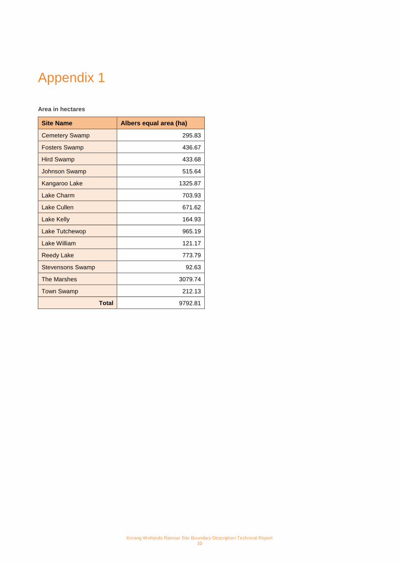
Appendix 1
Area in hectares
Site Name Albers equal area (ha)
Cemetery Swamp 295.83
Fosters Swamp 436.67
Hird Swamp 433.68
Johnson Swamp 515.64
Kangaroo Lake 1325.87
Lake Charm 703.93
Lake Cullen 671.62
Lake Kelly 164.93
Lake Tutchewop 965.19
Lake William 121.17
Reedy Lake 773.79
Stevensons Swamp 92.63
The Marshes 3079.74
Town Swamp 212.13
Total 9792.81
Kerang Wetlands Ramsar Site Boundary Description Technical Report 11
Appendix 2
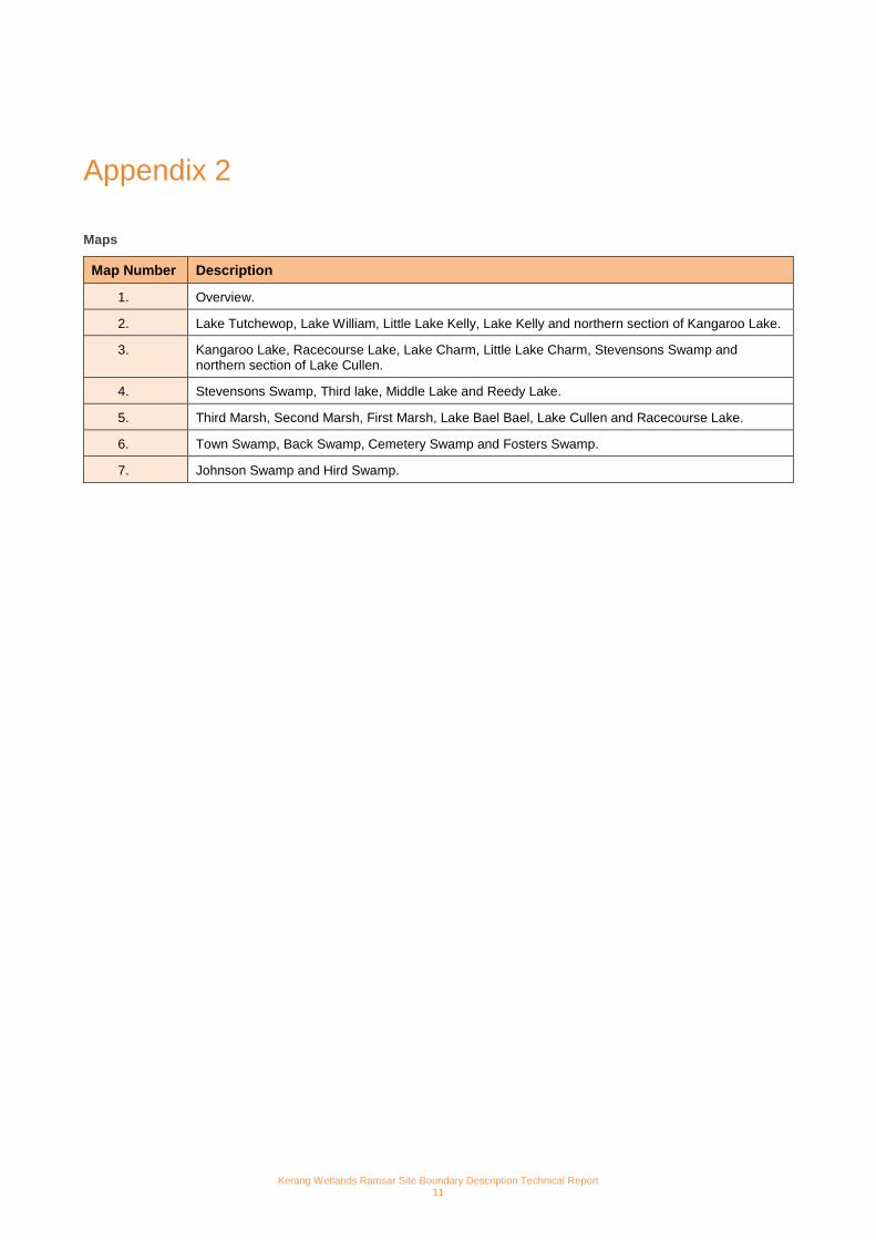
Maps
Map Number Description
1. Overview.
2. Lake Tutchewop, Lake William, Little Lake Kelly, Lake Kelly and northern section of Kangaroo Lake.
3. Kangaroo Lake, Racecourse Lake, Lake Charm, Little Lake Charm, Stevensons Swamp and northern section of Lake Cullen.
4. Stevensons Swamp, Third lake, Middle Lake and Reedy Lake.
5. Third Marsh, Second Marsh, First Marsh, Lake Bael Bael, Lake Cullen and Racecourse Lake.
6. Town Swamp, Back Swamp, Cemetery Swamp and Fosters Swamp.
7. Johnson Swamp and Hird Swamp.

Kerang Wetlands Ramsar Site Boundary Description Technical Report 12
Map produced February 2013 Datum: GDA94 Projection: MGA Zone 54 Copyright © The State of Victoria Department of Environment and Primary Industries
Kerang Wetlands Ramsar Site Boundary Description Technical Report 13
Map produced January 2013 Datum: GDA94 Projection: MGA Zone 54 Copyright © The State of Victoria Department of Environment and Primary Industries

Kerang Wetlands Ramsar Site Boundary Description Technical Report 14
Map produced January 2013 Datum: GDA94 Projection: MGA Zone 54 Copyright © The State of Victoria Department of Environment and Primary Industries

Kerang Wetlands Ramsar Site Boundary Description Technical Report 15
Map produced January 2013 Datum: GDA94 Projection: MGA Zone 54 Copyright © The State of Victoria Department of Environment and Primary Industries

Kerang Wetlands Ramsar Site Boundary Description Technical Report 16
Map produced February 2013 Datum: GDA94 Projection: MGA Zone 54 Copyright © The State of Victoria Department of Environment and Primary Industries

Kerang Wetlands Ramsar Site Boundary Description Technical Report 17
Map produced January 2013 Datum: GDA94 Projection: MGA Zone 54 Copyright © The State of Victoria Department of Environment and Primary Industries

Kerang Wetlands Ramsar Site Boundary Description Technical Report 18
Map produced January 2013 Datum: GDA94 Projection: MGA Zone 54 Copyright © The State of Victoria Department of Environment and Primary Industries

Kerang Wetlands Ramsar Site Boundary Description Technical Report 19

Kerang Wetlands Ramsar Site Boundary Description Technical Report 20