24
Govt. of India MINISTRY OF WATER RESOURCES CENTRAL GROUND WATER BOARD OF KHURDA DISTRICT South Eastern Region Bhubaneswar May , 2013

Govt. of India
MINISTRY OF WATER RESOURCES
CENTRAL GROUND WATER BOARD
OF
KHURDA DISTRICT
South Eastern Region
Bhubaneswar
May , 2013

DISTRICT AT A GLANCE
SL.
NO
ITEMS STATISTICS
1. GENERAL INFORMATION
i) Geographical area (Sq.Km)
2,813
ii) Administrative Division No.of Tehsil/Block
No.of Panchayats/villages
7 Tehsils/10 Blocks
168 G.Ps, 1,551 villages
iii) Population (As on 2011 census)
2,24,6341
2. GEOMORPHOLOGY
Major physiographic units Coastal sand dunes, Lateritic
uplands, Alluvial plains, Hilly terrain.
Major Drainages The Mahanadi, Kuakhai,
Kushabhadra, Daya, Ran, Kalijiri,
Sulia, Kharia & the Kusumi.
3. LAND USE (Sq. Km)
a) Forest area: 620 Sq.Km
b) Net area sown: 1,330 Sq.Km
4. MAJOR SOIL TYPES Alfisols, Ultisols, Entisols
5. IRRIGATION BY DIFFERENT SOURCES
(Area and number of structures)
Dugwells 30,875
Tube wells/ Borewells 2603 Filter point tube well, 225
Shallow tub well,
22 Medium tube well
Gross irrigated area 268.36 Sq.Km

6. NUMBERS OF GROUND WATER
MONITORING WELLS OF CGWB (As on
31.3.2011)
33
No.of Dug Wells 28
No of Piezometers 5
7. PREDOMINANT GEOLOGICAL
FORMATIONS
1) Precambrians:Khondalite,
Charnockite ,
2) Mesozoic Upper Gondwana
Semi-consolidated rocks
3) Quaternary: Alluvium
8. HYDROGEOLOGY
Major water bearing formation
Premonsoon depth to water level during 2011
Post-monsoon Depth to water level during 2011
Long term water level trend in 10 yrs (2001-2011) in m/yr
Consolidated &Unconsolidated
formations
Min 2.12 m bgl (Balipatna)
Max 13.30 m bgl (Tangi)
Min 0.78 mbgl (Balipatna),
Max 7.27 m bgl (Tangi)
Maximum rise 0.18 m/yr &
Fall 0.006 m/yr
9. GROUND WATER EXPLORATION BY
CGWB AS ON 31.03.2011)
No.of wells drilled( EW, OW, PZ, SH, Total) 23 (18 EW, 5 OW, 4 PZ)
Depth Range(m) 41.30 m to 200 m ( Hard rock)&
54.65 m to 114.17 m ( Semi-
Consolidated rocks)

Discharge( liter/second)
2-5 lps (Hard rock),
5-7 lps (semi-consolidated
formations)
10. GROUND WATER QUALITY
Presence of chemical constituents more than
permissible limit ( e.g. E.C, F, As, Fe)
High Iron > 1mg/l at
Khandagiri( 2.8 mg/l),
Bharatpur (2.1mg/l),
Jagannathprasad( 4.6 mg/l)
11. DYNAMIC GROUND WATER RESOURCES(
2009) IN MCM
Annual replenishable ground water resources 47618 Ham
Net annual ground Water Draft 14141 Ham
Projected demand for Domestic and Industrial
uses up to 2025
8603
Stage of Ground Water development 29.70%
12. AWARENESS AND TRAINING ACTIVITY Nil
Date
Place
No.of Participants
20.12.2007
Bhubaneswar
550

Water Management Programme Organised
Date
Place
No.of Participants
18.12.2007
Bhubaneswar
120
13. EFFORTS OF ARTIFICIAL RECHARGE &
RAINWATER HARVESTING
Projects completed by CGWB (No. & Amount
spent)
One Artificial Recharge & Rain
water harvesting project was
completed at Rajbhawan,
Bhubaneswar
Amount Spent: 14 lakh
Projects under technical guidance of CGWB
(Numbers)
Nil
14. GROUND WATER CONTROL AND
REGULATION
Number of OE blocks Nil
No.of Critical blocks Nil
No.of blocks notified Nil
1.0 Introduction:
Khurda district with an area of 2813 sq km is bounded between latitudes 190 40’ N and
200 27’ N and longitudes 840 56’ E and 860 05’ E. It is bounded in the north and northeast by
Cuttack district, on the west and southwest by Nayagarh and Ganjam districts, on the southeast
by Chilika Lake and Puri district. The Population of the district as per 2001 census is 18,78,000,
which is 5.10 % of the total population of the state. The male and female population of the
district is 9,87,000 & 8,91,000 respectively. The density of the population is 667 per sq. km. The
total literate person of the district is 13,11,000. The district is divided in to 2 subdivisions,
namely Bhubaneswar and Khurda which are further subdivided in to 10 C.D blocks such as
Bhubaneswar, Jatni, Balipatna, Balianta, Khurda, Bolagarh, Begunia, Tangi, Banpur and
Chilika. The district headquarter is connected to all the block headquarters and important towns
by all weather roads.
The district is drained by a number of streams which are mostly tributaries and
distributaries of the river Mahanadi and a few other streams discharging in to lake Chilika. The
important distributaries of Mahanadi are the Kuakhai, Bhargabi, Kushabhadra and the Daya
River. The tributaries of the Mahanadi are the Ran and Kalijiri. The streams draining the
southern parts of the district are Sulia, Kharia and the Kusumi. All the streams are ephemeral
and effluent in nature. Chilika, the largest salt water lake of India is situated in the southeastern
part of the district.
Systematic ground water survey was first carried out by the geologists of the Geological
Survey of India and later completed by Central Ground Water Board. Subsequently reappraisal
hydrogeological survey was carried out in different parts of the district during 88-89, 91-92, and
95-96 by CGWB. Under the ground water exploration programme a considerable number of
exploratory boreholes were drilled by CGWB. Besides these quite a few numbers of tube wells
were also constructed by CGWB on deposit basis for drinking water supply.
2. Climate & Rainfall:
The district is characterized by a tropical monsoon climate having three distinct seasons
in a year, viz winter, summer and rainy seasons. May is the hottest month with mean daily
maximum temp of 380 C, while December is the coldest month with mean daily temperature of
15.70 C. The normal annual rainfall is 1449.1mm & the annual average rainfall is 1436.1mm.
The relative humidity varies from 48 to 85 % at Bhubaneswar. The mean monthly potential
evapotranspiration values of the district ranges from 57mm in January to 284mm in May.
3. Geomorphological Set up:
Based on the physiographic set up, the district may be broadly divided in to four natural
divisions such as (a) Coastal sand dune (b) Alluvial plain, (c) Lateritic upland and (d) Hilly
terrain.
The dunes having limited width occur along the Chilika coast discontinuously. These
deposits are fluvio aeoline in origin and are of longitudinal type.
Alluvial plain is the most potential hydrogeomorphic unit. It occurs as narrow strip along
Chilika coast in the south east & along the courses of major rivers. The Alluvial plain in the
northeast is a part of Mahanadi delta system.

The lateritic upland constitutes the major parts of the district. This forms an undulating
terrain covered with lateritic capping over Gondwana sand stone and Precambrian rocks.
The hilly terrain is prominent in southwestern and western part. The area is underlain by
Precambrian hard rocks and major part of this terrain is capped by laterities and lateritic gravels.
The subunits in this terrain are (a) shallow buried pediplain (b) Moderately buried pediment (c)
pediments (d) intermontane valley (e) residual hills (f) structural hills etc.
Soil & Landuse:
There are three types of soil generally found in the district
1) Alfisols 2) Ultisols 3) Entisols
Alfisols: The deltaic alluvial soil in the eastern part of the district and the red loamy soils in the
northwestern part of the district come under this class. It consists of a wide range of soils
including mixed red and black soils, red earth, red loamy soils, red sandy soils, red gravelly soils
and other alluvial soils. The red soils are light textured, usually devoid of lime concretions
deficient in nitrogen, phosphate & organic matter. The PH of the soil varies from 6.5 to 7.3.
These soils are suitable for cultivation of paddy and other crops.
Ultisols: These include laterite & lateritic soil, red and yellow soils of the northern and north
central part of the district. They are characterized by low contents of Nitrogen, Phosphate,
Potassium & Organic matter. The PH of the soils ranges from 4.5 to 6.0. Due to granular nature
of these soils cultivation is possible immediately after heavy rains without the danger of any
unsatisfactory physical state.
Entisols: these include the coastal alluvial soils along the Chilika lake and younger alluvial soils
in the central part of the district. The texture in general is sandy to loamy and soils in general
are deficient in nitrogen, phosphoric acid and humus. These soils are suitable for wide variety of
crops including paddy.
4.0 Ground Water Scenario
4.1 Hydrogeology:

Aquifer system of the area may be divided in to (a) fissured (b) porous types based on
the lithological characteristics of the area.
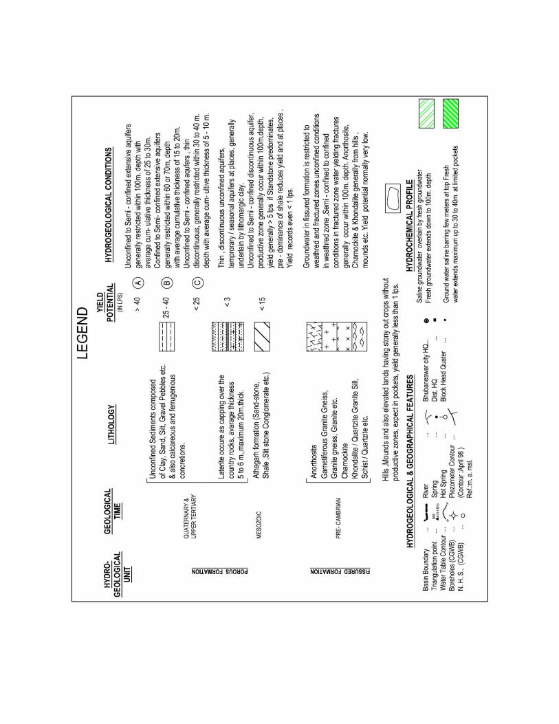
(a) Fissured formation: The Precambrian crystalline rocks which mainly consists of granite and granite gneiss, Khondalites, Charnockites and Anothosites occupy major parts of the district covering western as well as central and parts of eastern sector of the district. Ground water in these rock types occurs under unconfined conditions within weathered residuum and under semi confined to confined conditions in fractures at greater depths. The thickness of weathered residuum varies from negligible to 35/40m depending on rock types. The thickness of the weathered zone is minimum in Charnockites and Anothosites while the same is maximum in Khondalites. These weathered zones form shallow aquifer where ground water occurs under unconfined conditions. The average yield of dug wells in granitic rocks is around 20 to 22 m3/day with the maximum around 36 to 40 m3/day. In other hard rocks the yield is restricted within 25 m3/day with the average value around 12 to 15 m3/day.
(b) Porous formation: The porous formation in the district are a) Semi-consolidated Athagarh formation of upper Gondwana Group b) Quarternary alluvium and upper Tertiary sediments and also laterites and lateritic gravels with limited extent with respect to time and space.
(a) Athagarh formation: This aquifer system occurs at shallow as well as deeper depths, are mainly formed of sandstones. The shale form mainly pheratic aquifers and that also with limited potential. The weathered zone extends down to 12 to 15m and top weathered part up to 5 to 6m is lateritised. The yield of dug wells in the weathered zone is on an average is around 20 to 25 m3/day. The yield at deeper fractures is on an average 7 to 10 lps.
(b) Quarternary Alluvium & Upper tertiary formations: This formation occurs in the extreme northeast corner of the district covering Balianta and Balipatna blocks of the district. The ground water occurs under pheratic condition at shallow depth and under semi -confined to confined condition at deeper depths. The bedrocks occur at 119m depths at Bhingarpur of Balianta block and at 198m depth at Balipatna and 230 m at Orakhand in the southern part of Balipatna block. Quarternary alluvial deposits occur in minor pockets near Chilika lake area with limited thickness and ground water is mostly saline barring few meters at top. The aquifer zones at deeper depth generally occur within 100m depths. The Transmissivity values are generally high, more than 7000m2/day
Laterites: Laterites occur as capping over consolidated and semiconsolidated formation and
prominent occurrences are found in Bolagarh, Khurda town, Bhubaneswar and Tangi area. The
average thickness is around 20m.
Depth to water level:
The pheratic zone constitutes the most potential ground water reservoir in the district.
This zone has been mapped in course of hydrogeological surveys. With a view to ascertain the
changes in the ground water regime and make an over all assessment of the ground water
resources CGWB has, so far, established 28 network hydrograph stations through out the
district which are monitored manually 4 times in a year, during January, April, August and

November. The depth to water table values depend on several factors like rainfall, topography,
drainage characteristics, proximity to drainage channels, lithology, water bearing and water
yielding properties of the rocks.
The depth to water level of hydrograph network stations in Khurda district for the year 2011
Well No Location Jan-11 Apr-11 Aug-11 Nov-11
73H-4D30 Badlasason 1.64 2.05 0.18 0.78
73H-4C3 Baghmari 5.11 6.69 0.55 2.1
73H-4D5 Balipatna 1.04 1.84 0.4 0.73
74E-2A3 Balugaon 1.91 2.51 1.34 0.64
73H-3D9 Bhubaneswar-i 1.84 4.44 1.16 4.12
73H-4D25 Bhudiapara 8.32 1.9 0.25 1.3
74E-1B3 Bhusundapur 6.92 9.4 2.85 5.7
73H-4B3 Bolagarh 3.13 8.92 1.86 4.76
73H-4C1 Jankia 8.33 3.71 1.79 4.4
73H-4C4 Jatni 6.56 8.45 0.95 6.64
73H-4D16 Kapilaprasad 11.95 6.15 0.79 2.01
73H-3D5 Khandagiri 6.01 12.15 2.12 9.54
73H-4C5 Khurda 5.7 9.95 1.73 5.46
73H-4D20 Kuha 7.78 7.23 2.95 4.39
74E-1C1 Nirakarpur 5.4 7.53 3.2 6.45
73H-4B1 Pichkuli 10.42 6.37 0.54 2.31
74E-1B1 Tangi - 12.33 3.7 7.45
The above table shows that, the depth to water level in the hydrograph network stations of the district mostly ranges from 1.84 to 12.33m below ground level during premonsoon period. The water table is shallow in most part of the district. The depth to water table contour map of both pre and post monsoon seasons are attached in the
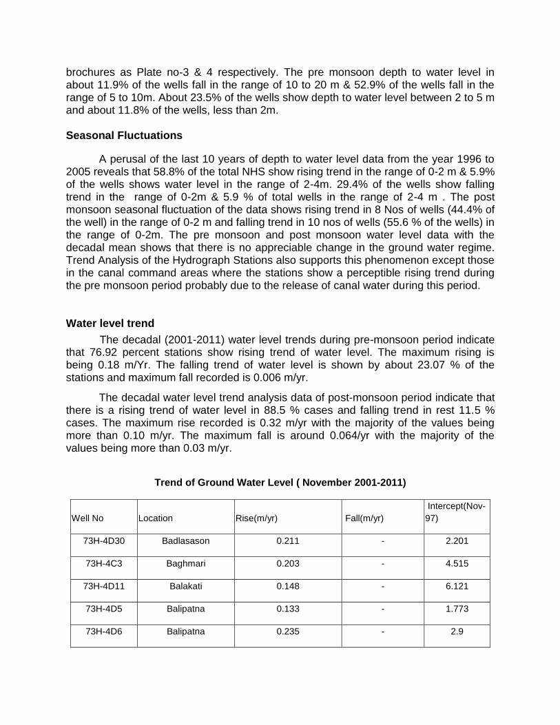
brochures as Plate no-3 & 4 respectively. The pre monsoon depth to water level in about 11.9% of the wells fall in the range of 10 to 20 m & 52.9% of the wells fall in the range of 5 to 10m. About 23.5% of the wells show depth to water level between 2 to 5 m and about 11.8% of the wells, less than 2m. Seasonal Fluctuations
A perusal of the last 10 years of depth to water level data from the year 1996 to 2005 reveals that 58.8% of the total NHS show rising trend in the range of 0-2 m & 5.9% of the wells shows water level in the range of 2-4m. 29.4% of the wells show falling trend in the range of 0-2m & 5.9 % of total wells in the range of 2-4 m . The post monsoon seasonal fluctuation of the data shows rising trend in 8 Nos of wells (44.4% of the well) in the range of 0-2 m and falling trend in 10 nos of wells (55.6 % of the wells) in the range of 0-2m. The pre monsoon and post monsoon water level data with the decadal mean shows that there is no appreciable change in the ground water regime. Trend Analysis of the Hydrograph Stations also supports this phenomenon except those in the canal command areas where the stations show a perceptible rising trend during the pre monsoon period probably due to the release of canal water during this period. Water level trend
The decadal (2001-2011) water level trends during pre-monsoon period indicate that 76.92 percent stations show rising trend of water level. The maximum rising is being 0.18 m/Yr. The falling trend of water level is shown by about 23.07 % of the stations and maximum fall recorded is 0.006 m/yr.
The decadal water level trend analysis data of post-monsoon period indicate that there is a rising trend of water level in 88.5 % cases and falling trend in rest 11.5 % cases. The maximum rise recorded is 0.32 m/yr with the majority of the values being more than 0.10 m/yr. The maximum fall is around 0.064/yr with the majority of the values being more than 0.03 m/yr.
Trend of Ground Water Level ( November 2001-2011)
Well No Location Rise(m/yr) Fall(m/yr)
Intercept(Nov-
97)
73H-4D30 Badlasason 0.211 - 2.201
73H-4C3 Baghmari 0.203 - 4.515
73H-4D11 Balakati 0.148 - 6.121
73H-4D5 Balipatna 0.133 - 1.773
73H-4D6 Balipatna 0.235 - 2.9

74E-2A3 Balugaon 0.052 - 1.774
73H-3D9 Bhubaneswar-i 0.1 - 3.901
73H-4D25 Bhudiapara 0.089 - 2.385
74E-1B3 Bhusundapur 0.232 - 7.792
73H-4B3 Bolagarh 0.258 - 7.315
73H-4C2 Delang 0.156 - 1.373
73H-4C1 Jankia - 0.047 2.775
73H-4C4 Jatni 0.278 - 7.642
73H-4C6 Kanas 0.073 - 1.848
73H-4D16 Kapilaprasad 0.299 - 4.975
73H-3D5 Khandagiri 0.156 - 9.396
73H-4C5 Khurda 0.223 - 6.708
73H-4D20 Kuha 0.054 - 5.172
73H-3D10 Kundaidarapatna 0.131 - 1.958
74E-1C1 Nirakarpur 0.32 - 7.383
73H-4D24 Panikata 0.109 - 1.142
73H-3D13 Patia 0.011 - 4.084
73H-4B1 Pichkuli 0.27 - 5.807
73H-3D6 Raghunathpur 0.325 - 3.461
74E-1B2 Sunkhala - 0.064 4.834
74E-1B1 Tangi - 0.009 9.223
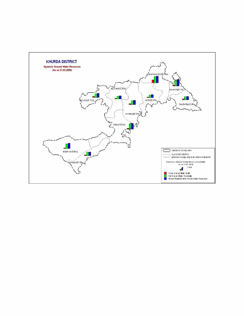
4.2 Ground Water Resources
The principal source of recharge to ground water are rainfall, seepage from
canals, return flow from applied irrigation, seepage from tanks and ponds. Ground water
exploitation for domestic use in the district is mainly through private dug wells and hand pump
fitted government bore wells. Data pertaining to various parameters such as rainfall, water level
fluctuation, specific yield, ground water abstraction structures for various utilities, irrigation and

other data recorded and / or collected by CGWB, SE region and GWS & I, Government of
Orissa and other state government agencies have been utilized to estimate the dynamic ground
water resource of Khurda district. Block wise availability of ground water resources has been
estimated, based on norms recommended by Ground Water Estimation Committee (G.E.C.
1997). The total annual dynamic ground water resource of Khurda district is assessed to be
47618 hectare metre. The annual utilizable ground water resource earmarked for domestic and
industrial use is 5001 hectare metre which is based on the projection of requirement by the year
2025. The gross annual draft for all uses is 14141 hectare metre leaving a balance ground
water resource of 29874 hectare metre for further development for irrigation use. The present
average stage of groundwater development in the district has been worked out to be only
29.7%. The stage of ground water development varies from a maximum of 48.7% in
Bhubaneswar block to a minimum of 18.56 % in Banapur block.
Ground water Resource Potential of Khurda District As on 31.03.2009
Sl.
No.
Assessment
unit/block
Net
Annual
Ground
Water
Availabil
ity
Existing
gross
ground
water
draft for
irrigation
Existing
gross
ground
water
draft for
domestic
and
industrial
water
supply
Existing
gross
ground
water
draft for
all uses
Allocation
for
domestic
and
industrial
requiremen
t supply up
to next 25
years
Net ground
water
availability
for future
irrigation
developme
nt
Stage of
ground
water
develop
ment
1 Balianta 6655 1138 272.65 1411 473 5043 21.20
2 Balipatna 3691 1058 267.10 1325 478 2155 35.90
3 Banapur 5400 667 335.39 1002 593 4140 18.56
4 Begunia 3385 968 293.00 1261 527 1890 37.25
5 Bhubaneswar 6810 1243 2076.89 3320 3497 2070 48.75
6 Bolagarh 4368 1078 308.00 1386 540 2750 31.73
7 Chilika 3861 886 277.19 1163 486 2489 30.12
8 Jatani 3097 335 387.30 722 644 2118 23.31
9 Khurda 4395 1002 416.00 1418 726 2667 32.26
10 Tangi 5956 765 368.00 1133 639 4552 19.02

11 District Total 47618 9140 5001.00 14141 8603 29874 29.70
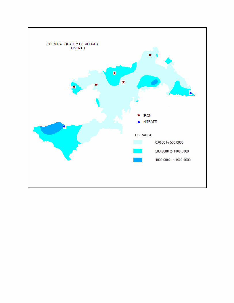
4.3 Ground Water Quality
Quality of ground water is an important factor for assessing its suitability for various uses. Ground water quality depends upon the lithological and chemical composition of the aquifer, climatic conditions, quantum of recharge made and its movement, activities of microorganisms, temperature and presence of contaminants in the environment.
High Nitrate concentration viz. more than 100 mg/l (as per BIS-10500) has adverse effect on human health. High nitrate may cause infant Methaemoglobinaemia, a disease commonly known as Blue Babies that causes reduction in oxygen carrying capacity of blood. The process of high nitrate in drinking water causes Gastric cancer and adversely affect the central nervous system and cardio vascular system. High nitrate concentration (> 100mg/l) has been found in a few wells of Khandagiri (130 NO3), Jatni (117 mg/l), Balakati (104) of Khurda district. The concentration of fluoride is within the permissible limit (1.5 mg/l) in both shallow and deeper aquifer except at few isolated pockets. At Chatu in Jatani block deeper aquifer water contains 1.67 mg/l of fluoride. In shallow zones high fluoride concentration has been noted from Balasing-Singhpur area of Bolagarh block.
High concentration of Iron in ground water gives bittersweet astringent taste making it aesthetically undesirable in colour, odour and turbidity. Intake of high dose of Iron present in ground water may result in Haemochromotosis i.e. accumulation of Iron in kidneys, lungs, liver etc. resulting in stone formation and malfunctioning of these organs. The concentration of Iron more than permissible limit (> 1.0 mg/l as per BIS 10500) have been recorded in wells from Khandagiri (2.8 mg/l), Bharatpur (2.1 mg/l), & Jagannathprasad (4.6 mg/l) in Khurda district. 4.4 Status of Ground Water Development
Ground water development in the district is mainly through dug wells, Dug-cum-
bore wells and bore wells. Ground water is mainly used for domestic and irrigation
purpose and in a limited scale for industrial purpose. The present average stage of
groundwater development in the district is only 13.82% having a vast scope for further
ground water development for irrigation purpose. Poor infrastructure facilities,
fragmented land holdings coupled with traditional cropping pattern, unreliable power
supply, non availability of diesel in remote areas are some of the constraints in non
viability of individual investment in ground water sector and speedy and optimal
development of ground water in the district. In fact, as per the estimate, 73914 hectare
metre balance ground water resource remains to be utilized for irrigation purpose.

In Khurda district 30875 numbers of dugwells, 225 numbers of shallow tube wells, 22
numbers of medium deep tube wells & 2603 numbers of filter point tube wells are in operation.
5. Ground Water Management Strategies
5.1 Ground Water Development
A total of 18 exploratory, 5 observation wells and 4 piezometers were drilled in the
district. In addition to these, a number of production wells were also drilled on payment basis by
CGWA.
The depth of the exploratory boreholes drilled in hard rock varied from 41.30m to 200m.
The yield of these wells varied from 0.25 to 10 liters/second with the draw down varying from
8.30 to 33 m with the average value being 20 to 30m. The static water levels varied from 1.02 to
6.25m below ground level.
The depth of the exploratory wells in semi consolidated formation varied from 54.65 to
114.17m and that of piezometers were up to 186m depth. The yield of these wells varied from
2.10 to 30 lps with the average around 5 to 10 lps. The static water levels varied from 4.88 to
25.2 m bgl with the average around 12 to 15 m bgl.
The depth of the exploratory wells in unconsolidated formation was 80m drilled at
Bhingarpur. The drilling depths of piezometers are 43 and 230m at Orakhand and at Balipatna
its about 198.70m. The yield of the wells was 65 lps with draw down of 6.77m.
Dugwells:
Dug wells are the most common ground water abstraction structures in the district.
Dugwells are feasible in the buried pediment areas, valley fills and flood plains, underlain by the
crystalline formations. The design of the dugwell is dependent on the irrigation water
requirement of the crops, depth to water level, thickness of the saturated zone and seasonal
water level fluctuation. The depth of the dugwells in hard and semi-consolidated sediment
should be 10 to 12 m while that in unconsolidated sediments is 8 to 10 m. The diameter of dug
wells should range from 4 to 6m. The expected yield of wells from unconsolidated formation is
up to 50 m3/day while in other formations around 40 m3/day. The distance between any two dug
wells should be kept at least 100m to avoid interference.

Filter point tube wells:
These wells are feasible in unconsolidated formation i.e. mainly in the eastern part of the district. The depth may be 15 to 30m and diameter 10X5 cm or al through 5 cm and 2 HP centrifugal pumps may be fitted. The yield of these wells is generally within 5 lps. The distance between any two structures should be kept at least 150m to avoid interference.
Shallow tubes well:
The tube wells are feasible in the unconsolidated deposits in the eastern part of the
district. The depth of the tube wells may be restricted within 50m. The diameter should be 15cm
and pump of 5 HP may be installed. The expected yield is up to 12 to 15 lps. The spacing
should be kept at least 300m.
Medium deep tube wells: The tube wells are feasible in the eastern part covering Balipatna and parts of Balianta
blocks. The depth of the tube wells may be restricted within 100m. The diameter should be 25X
20 cm and pump of 10 HP or more may be installed. The expected yield is up to 30 lps. The
spacing should be kept atleast 500m.
Borewells The bore wells are feasible in the Athagarh formation. The depth of the wells
may be restricted within 100m. The expected yield is on an average 5 to7 lps. The spacing
should not be less than 150 m.
5.2 Ground water Conservation and Artificial Recharge:
Some parts of the district show deeper water level condition during the post
monsoon period. This is mainly due to the prevailing topographic conditions and water table gradient, which facilitates flow of ground water through nalas, rivers and streams as base flows. To arrest the rapid decline of water table in these areas special studies may be taken up to pin point the areas where water scarcity problems are more pronounced during pre-monsoon period. In these pockets suitable sites are required to be pin pointed to adopt artificial recharge techniques and rain water-harvesting methods based on site-specific conditions. This artificial recharge will help in increase of ground water storage and also in improving the quality of ground water. The most feasible artificial recharge and rain water harvesting structures are percolation tanks, nala/contour bunding, small check dams/weirs, renovation of old tanks to percolation tanks, water spreading, gully plugging, gabion structures etc.
In Rajbhawan premises of Bhubaneswar one artificial recharge scheme by harvesting rainwater has been completed by CGWB, SER, Bhubaneswar. In this project both shallow and deeper aquifer will be recharged by an additional quantity of 24700m3 of water per year 23670 m3/year to deeper aquifers and 1030 m3/ year to shallow aquifers. This additional recharge will help to increase the ground water resource in and around Rajbhawan area. Studies based on hydrogeological, hydrological, meteorological, geophysical, remote sensing and other parameters like cropping intensity, cropping pattern etc should be taken up in the canal command areas mainly in the eastern part of the district in Balipatna, balianta block and suitable methods for better management of surface and ground water should be devised. Suitable ground water development plan should be brought out through ground water flow modeling. Water logging problem can be avoided through conjunctive use of surface water and ground water. The demand of water for 200% cropping intensity can be met from surface water and ground water in suitable and optimal proportions for both the seasons. The existing cropping pattern may be modified wherever necessary. Diversification of crops from paddy to non-paddy crops like oil seed, pulses, vegetables during rabi season, at least in the high land and in parts of medium land areas is essential. Conjunctive use of surface water and ground water can rectify water-logging condition, augment irrigation potentials and ensure safe agricultural practices in periods of delayed monsoon rainfall. 6.0 Ground Water Related issues & Problems:
The northeastern part of the district is underlain by alluvial deposit of the Mahanadi delta and this alluvial area also enjoys irrigation facilities from delta stage-II major irrigation project. Normally the depth to water level in this track is shallow & the area gets surface irrigation from major irrigation system and the chance of water logging is more. There is no large-scale pollution in the district. Only in pockets higher concentration of nitrate, fluoride etc. has been noticed. The long-term water level trend analysis data indicate that no significant water level depletion has taken place in the district.
7.0 Awareness & Training Activity 7.1 Mass Awareness programme (MAP) & Water Management Training programme (WMTP) by CGWB
One Mass Awareness programme (MAP) on the theme “Ground Water Development Protection & Consevation” was organized under the aegis of CGWA (Central Ground Water Authority) on 20th December 2007 at Sri Aurobindo Integral Education, Khandagiri, Bhubaneswar. About 550 school children, teachers participated in the programme.
One Water Management Training programme (WMTP) on Rain Water Harvesting
was organized by CGWB under the aegis of CGWA (Central Ground Water Authority)

on 18th December 2007 at the Alumni Conference Hall, P.G Department of Geology, Vani Vihar, Bhubaneswar. About 120 participants took part in the programme. 7.2 Participation in Exhibition, Mela, Fair etc
CGWB, SER, Bhubaneswar actively participated in “National Development
Festival-2007” at exhibition ground, Bhubaneswar from 03.07.2007 to 10.07.2007 organized by Gandhiji Seva Sangha. 8.0 Areas notified by CGWA/SGWA None of the areas of the district has been declared notified by CGWA or SGWA. Reccommendations
1) As there is large scope for development of ground water, suitable schemes may be launched for ground water development to boost agricultural production in the district. The financial institutions should generously finance such schemes.
2) In construction of ground water abstraction structures, such as dug wells, dug cum bore wells and bore wells, for irrigation minimum safe spacing should be maintained to avoid interference of the wells.
3) For optimum utilization of the groundwater potential, necessary steps should be taken for energisation of the wells.
4) The yield of existing dug wells may be enhanced by converting those into dug cum bore wells wherever feasible and the wells should be provided with brick lining which will facilitate the free flow of ground water into the well.
5) Detailed surface geophysical survey aided by photogeological & remote-sensing studies may be taken up in the district to identify the exact thickness of weathered zone and occurrence and extent of lineaments, which form potential aquifer zones.
6) The agricultural extension services should motivate and guide the farmers to adopt suitable cropping patterns to maximize the benefits of irrigation through dug wells / bore wells.
7) Construction of check dams, nalla bunds and percolation tanks at suitable locations will help in effecting additional recharge to the ground water reservoir. Sub-surface dams may also be constructed at hydrogeologically suitable sites to arrest sub-surface out flow of ground water in the weathered mantle of hard massive rocks. This will increase the dynamic ground water storage in the adjacent phreatic aquifer.
8) Ground water monitoring in the district, for water level and water quality, through National Hydrograph Stations should be strengthened to assess the impact of envisaged ground water development on the ground water regime and to find out the status of water logging in the canal command areas.