Áras Chill Dara, Devoy Park, Naas, Co Kildare Telephone (045) 980200 Fax (045) 980240 Email: [email protected]www.kildare.ie/countycouncil Kildare County Council Collinstown Local Area Plan 2010 Plean Cheantar Áitiúil 2010 Baile Uí Choiléain Adoption Date: 25th January 2010 Kildare County Council
CollinstownLocal Area Plan 2010Plean Cheantar Áitiúil 2010 Baile Uí Choiléain
Adoption Date: 25th January 2010
Kildare County Council
THE AIM OF THIS PLAN IS TO ESTABLISH A FRAMEWORK FOR THE
PHYSICAL, SOCIO-ECONOMIC, CULTURAL AND RECREATIONAL GROWTH
OF COLLINSTOWN IN A PLANNED, CO-ORDINATED AND SUSTAINABLE MANNER
THIS LOCAL AREA PLAN SETS OUT A NUMBER OF POLICIES AND OBJECTIVES
THAT WILL HELP TO ACHIEVE THIS AIM.
Collinstown Cover 26/05/2010 11:11 Page 1
1
Contents
Table of Contents Page
PART A 3
1 Introduction 3
Layout of this Document 5
2 Strategic Context and Relevant Policy Documents 6
3 Strategic Environmental Assessment 11
4 Appropriate Assessment 12
5 Population 13
6 Public Utilities 14
7 Conservation 15
8 Land Uses 16
9 Development Vision for Collinstown 17
PART B 21
1 Introduction 21
2 Housing 23
3 Industry and Employment 26
4 Community, Educational, Childcare and Cultural 27
5 Public Utilities 28
6 Transportation 30
7 Amenity and Recreation 33
8 Major Town Centre 35
9 Heritage 41
10 Environment 43
Part C – Specific Objectives 44
List of Tables Page
Table 1 Preparation of the Collinstown Local Area Plan 3
Table 2 Major Town Centre Zoning 16
Table 3 Specific Land Use Zoning Objectives 44
Table 4 Land Use Zoning Matrix 46
(ii) has a population in excess of 2,000 and
(iii) is situated within the functional area of a planning authority which is a County Council.
The statutory time frame as set out in the Planning andDevelopment Act 2000 (as amended) commences upon thedate of public display of the Local Area Plan. The followingtable sets out the timeframe of the preparation of this LocalArea Plan.
3
1.1 LAP Status and Process Part II, Chapter II, Section 19 of the Planning and DevelopmentAct 2000 (the Act), as amended, provides that a Local AreaPlan (LAP) may be prepared in respect of any area which aPlanning Authority considers suitable, in particular for areaswhich require economic, physical and social renewal and forareas likely to be the subject of large-scale development within the lifetime of the Plan.
A local area plan shall be made in respect of an area which –
(i) is designated as a town in the most recent census of population, other than a town designated as a suburb or environs in that census,
Part A - 1. Introduction
--Procedure involved in the preparation of a Local Area Plan Relevant dates
(a) Public Display of Draft Local Area Plan 18th June – 29th July 2009(6 weeks)
(b) Preparation of Manager’s Report 30th July - 9th September 2009(12 weeks from date notice is placed in press - see (a) above)
(c) Consideration of the Manager’s Report by the Members of the Authority 10th September - 19th October 2009(6 weeks after the furnishing of the Manager’s Report to the Members) (Council meeting held on 19th October)
Where, following the consideration of the Manager’s Report, it appears to the Members of the Authority that the proposal (being a proposal to make the local area plan) should be varied or modified, and the proposed variation or modification would, if made, be a material alteration of the proposal concerned, the following process is enacted.
(d) Publication of the notice of the proposed variation or modification. (3 weeks)
(e) Public display of variation or modification 29th October – 25th November 2009(4 weeks)
(f) Preparation of Manager’s Report Published on 18th December 2009 (8 weeks from date of publication of notice – see (d) above
(g) Consideration of the Manager’s Report by the Members of the Authority. 19th December 2009 – 25th January 2010The Local Area Plan is either made or amended 6 weeks after the furnishing (Council meeting held on 25th January of the Manager’s Report to the Members of the Authority. 2010)
Table 1: Preparation of the Collinstown Local Area Plan
M4
M4
3
2a2
R406
R449 R148R406
R405
R157
R157
R156
R156
R148
R405
R120
R120
R403
R403
Leixlip
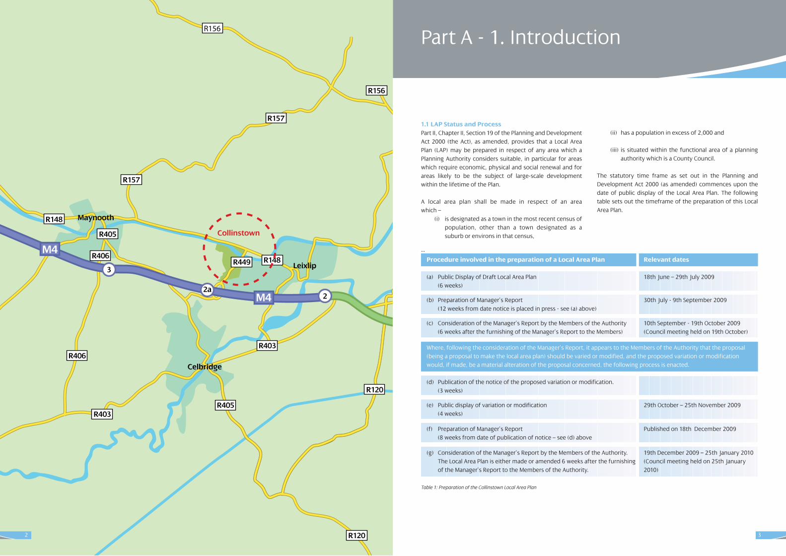
Collinstown
Maynooth
Celbridge
2
5
This Local Area Plan for Collinstown consists of a WrittenStatement comprising;
(i) Part A (Background Information)
(ii) Part B (Specific objectives together with all relevant maps)
(iii) Part C (Zoning objectives, zoning matrix and zoning map)
The Written Statement shall take precedence over the mapsshould any discrepancy arise between them. In the fullinterpretation of all objectives for Collinstown, it is essentialthat both the County Development Plan (CDP) and the LocalArea Plan (LAP) are read in tandem. Where conflicting objectives arise between the CDP and the LAP, the objectivesof the CDP shall take precedence. It shall be noted that thegeneral development control standards applicable to the Planarea are included in the County Development Plan. Only specific objectives applicable to Collinstown are included inthis LAP.
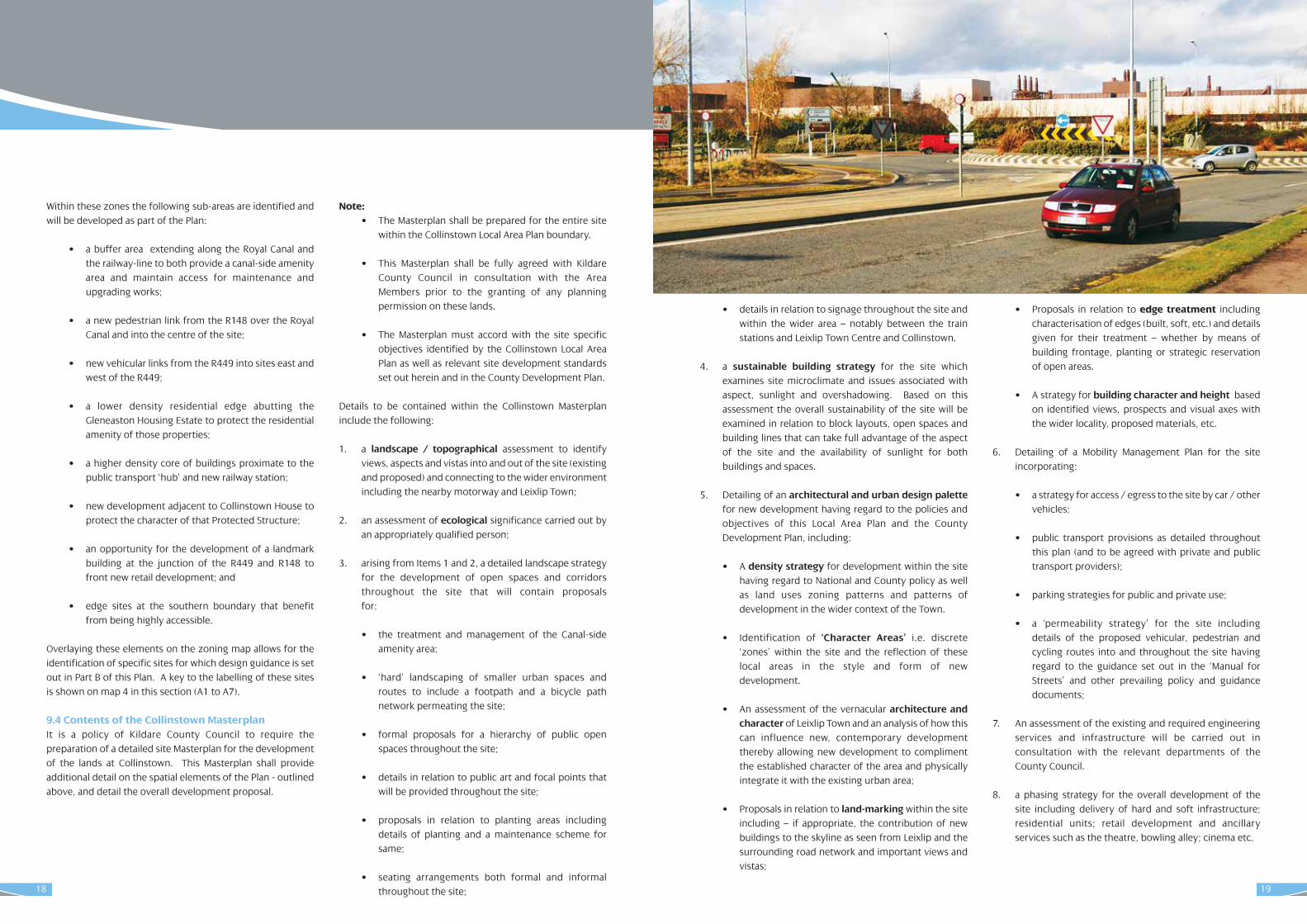
1.2 Plan Area The Collinstown lands are located to the west of the town ofLeixlip in north County Kildare. The site is directly south of theIntel manufacturing facility and currently accommodates anumber of warehousing industries associated with ‘spin off’logistical operations. The northern portion of the site iscrossed by the Royal Canal and the Dublin – Sligo railway lineand bounded by the R148. The western boundary is definedby open lands – typically in agricultural or low density residential use. The eastern boundary is with the Glen Easton residential housing estate while the southern boundary iswith small local roads - the Kilmacredock Lower roads. Tworailway stations serve Leixlip – at Louisa Bridge some 1.3 kmfrom the subject lands and at Confey station to the north ofthe Town Centre. The link road to the M4 motorway lies within the site, to the east.
Collinstown was designated in the Kildare CountyDevelopment Plan 2005 as the location of a Major TownCentre to serve north east Kildare. That designation – and theassociated land use zoning, is contingent on the preparation,adoption and implementation of this Local Area Plan.
Strategically, Collinstown lies some 2.5km from the centre ofLeixlip town which is located on the confluence of the RyeWater and River Liffey, 15km from Dublin City Centre and onthe border of Fingal and South Dublin County Councils. Thetown is bypassed by the M4 motorway and served by theArrow Rail service on the Dublin Sligo line. The R148 (formerly the N4 National Primary Road) runs through theMain Street linking Leixlip to Maynooth.
4
Layout of this Document
7
• To have excellent high capacity road connections to all four towns;
• To be linked by dual carriageway to the Celbridge / Leixlip West junction of the M4 which has spare capacity; and
• To provide a context for the detailed design and development of the lands within a site Masterplan.
jThe County Development Plan clearly states that the lands atCollinstown are currently zoned for a mix of industrial andtransportation uses as per the prevailing Leixlip Local AreaPlan and are subject to a proposed Action Area Plan. This itemis now addressed by this Local Area Plan which gives effect tothe new land use strategy having regard to the requirementsunder the County Plan and the County Retail Strategy.
Specific policies, set out in the County Development Plan2005 - 2011 in relation to the development of Collinstown are:
RP6 To assist in the promotion and development of Collinstown in west Leixlip as the Major Town Centre, within the Metropolitan area of North East Kildare, to ensure that the retail needs of this area of the County are fully met and to enable it to grow into one of the key retail centres within the GDA.
RP7 To identify and zone, where required, the specific location for the Major Town Centre and work with other public agencies and the private sector to achieve this.
RP8 To prepare a Local Area Plan for the area covering the extent of the Town Centre that will identify the location of the different land uses and strategic infrastructure required. An integral component of the Local Area Plan will be the Masterplan for the Major Town Centre that will incorporate a design brief and concept plan.
RP9 To assist, as required, in achieving the land assembly necessary to achieve the Major Town Centre and work in partnership with the private sector in same.
RP10 To prepare in tandem consolidation and enhancement strategies for the towns within the North East to assist in the potential vitality and viability of these centres being maximised.
RP11 To ensure that the Masterplan for the provision of a Major Town Centre at Collinstown identifies adequate land in the immediate vicinity to accommodate further substantial inward investment in industry to this area.
Again, these policies are implemented through this Local AreaPlan.
2.4 Kildare 2012 – An Economic, Social and CulturalStrategy The Kildare County Development Board Strategy “Kildare 2012– An Economic, Social and Cultural Strategy” sets the framework within which Kildare County Development Boardwill operate for the next number of years. The vision of thisstrategy is to make “Kildare – the first choice as a place to live,learn, work, visit and do business”.
The strategy focuses on six key objectives, which are vital toensuring this vision. These are to;
1. Develop transport and communications2. Respond to new settlement patterns3. Respond to contrasts within the county and towns4. Protect the environment5. Develop education, training and capacity building and 6. Develop a sense of place.
6
2.1 National Spatial Strategy The National Spatial Strategy (NSS) was published inDecember 2002. The Strategy is a 20-year planning framework designed to achieve a better balance of social, economic, physical development and population growthbetween centres.
The National Spatial Strategy identifies Leixlip as a town in theDublin and Mid East Region with a population of over 5,000.There are a large number of towns of this size in the GreaterDublin Area located mostly on the main transportation corri-dors radiating from Dublin.
2.2 Regional Planning Guidelines for the GreaterDublin Area 2004-2016The Regional Planning Guidelines for the Greater Dublin Area2004-2016 (RPG’s) establish a broad planning framework forthe Greater Dublin Area (GDA). The classification of ‘ModerateGrowth Towns’ is synonymous with the category of CountyTowns and Towns with over 5,000 population as defined within the NSS. Leixlip has been identified as a ‘ModerateGrowth Town’ within the Metropolitan Area. Leixlip is also partof the ‘Primary Dynamic Cluster’ consisting of Leixlip,Maynooth, Celbridge and Kilcock.
The Guidelines note that future development in theMetropolitan Area will be located so as to maximise the potential of the public transportation system. It is stated thatadditional population will be accommodated through limitedfurther development of the north Kildare towns of Leixlip,Celbridge, Maynooth and Kilcock, focused on the publictransport network, especially rail.
2.3 Kildare County Development Plan 2005-2011 The Kildare County Development Plan 2005-2011 sets thebroad development framework for the county of Kildare andthe development areas within its jurisdiction.
The County Development Plan notes that the largest percentage increase in population has occurred in towns inproximity to and within commuting distance of Dublin. TheDevelopment Plans analysis of growth rates of towns inKildare County reveal substantial growth experienced by thenorth east towns, including Leixlip.
Following on the 2001 Retail Strategy for the GDA, it wasdecided that a location for a Major Town Centre should beidentified within the Metropolitan Area of North East Kildare.Following an assessment of the opportunities within the fourmain towns – Celbridge, Kilcock, Leixlip or Maynooth, theCounty Council decided that the most appropriate locationwas Collinstown, west Leixlip.
The Development Plan states that the development ofCollinstown will help promote the attractiveness of NorthKildare for further economic development by providing arange of high-quality lifestyle facilities to serve the cosmopol-itan needs of the workforces of existing major employees inthe area. It further states that a substantial area of land willremain at Collinstown to accommodate further inward invest-ment projects, in addition to the town centre.
Key characteristics of the development at Collinstown are:
• Development of a centre attractive to leading national and multiple retailers to compete with other Metropolitan Major Town Centres such as Liffey Valley, Blanchardstown, Dundrum, etc.;
• Provision of integrated leisure facilities such as multiplex cinema, bowling alley, theatre;
• Redress of the deficit of existing shopping facilities in Leixlip;
• Provision of a new railway station on the Maynooth – Connolly commuter rail line;
• Provision of a Park-and-Ride facility;
• Potential to be served by a QBC corridor and local bus interchange;
2. Strategic Context and RelevantPolicy Documents
9
2.9 Retail Planning GuidelinesThe Retail Planning Guidelines for Planning Authorities werepublished by the Department of the Environment, Heritageand Local Government in December 2000 and updated inJanuary 2005. The Retail Planning Guidelines provide a comprehensive framework to guide local authorities both inthe preparation of Development Plans and the assessment ofapplications for planning permission and retailers and developers in formulating development proposals.
2.10 Greater Dublin Area –Retail Strategy 2008 – 2016The Retail Strategy 2008 – 2016 was adopted by the Dublinand mid-East Regional Authorities in July 2008. The Strategyproposes to guide activities and policies for retail planningacross the seven constituent Councils – namely Dublin City,Dun Laoghaire Rathdown, Fingal, South Dublin, Kildare, Meathand Wicklow.
Having regard to the change in the retail market since the preceding Strategy was published in 2001, the 2008 Strategyhas regard to the impact of slowed growth in the Irish economy on projected rates of increase in retail sales as wellas developments in the market place – namely the opening ofnew shopping centres within and outside the GDA.
At the core of the Strategy is a revised retail hierarchy for theregion. That hierarchy identified Leixlip – includingCollinstown as a Level 2 – Major Town Centre and CountyTown Centre noting that Leixlip and the Collinstown area willgradually develop along a 20 year time period reaching Level2 status.In that regard the Strategy states that it is recommended thatKildare County Council should incorporate the following provisions into their individual retail strategy to give directionto future retail growth on the site:
• To seek to provide quality opportunities for comparison and convenience retail shopping in the North East Kildare area, specifically in the towns of Leixlip, Maynooth, Kilcock and Celbridge, including the expansion of Leixlip into the Collinstown area as a key site to meet the future needs for comparison shopping in this area.
• Future development at west Leixlip / Collinstown should be associated with the opening of a new train station to link Maynooth and Kilcock centres to the area and provision for the development of a new community incorporating a range of uses including leisure, amenity, community, cultural, retail, employment and residential, developed over an extended phasing arrangement to ensure sustainable integrated planning.
The Strategy provides Retail Floorspace Need Estimates forthe period to 2016. Estimates for County Kildare indicate thatsome 13,224 sq.m. of gross lettable floorspace will be neededfor convenience goods, and between 70,731 and 96,453sq.m. for comparison goods in that time period, allowing forsome flexibility in the delivery of planning schemes.
2.11 Draft County Retail Strategy 2005The Draft County Retail Strategy for Kildare was prepared in2005. The terms of this Strategy have been incorporated into chapter seven of the Kildare County Development Plan 2005-2011.
A revised County Retail Strategy for Kildare must be preparedfollowing on from the completion of the Retail Strategy forthe Greater Dublin Area 2008. That Strategy is currently beingprepared by Consultants on behalf of Kildare County Council.
8
2.5 Competing in a Globalised World - An EconomicDevelopment Strategy for KildareAn Economic Development Strategy for Kildare was carriedout to inform economic development policies in the Countyfor the period to 2016, with the key aim of promoting Kildare,both nationally and internationally as a place in which to live,work and invest. Kildare County Council is committed toimplementing and building upon this strategy both nationallyand internationally.
2.6 Kildare County Housing Strategy Part V The Kildare County Housing Strategy 2005 – 2011 was adopted as part of the Kildare County Development Plan 2005– 2011. The strategy determines that the ratio of social housing is 8% and affordable housing is 12%. The primarypurpose of the legislative provisions is to secure completedsocial and affordable housing, more quickly and more efficiently.
2.7 ‘Sustainable Urban Housing: Design Standards forNew Apartments’ 2007The primary aim of these guidelines is to promote sustainableurban housing, by ensuring that the design and layout of newapartments will provide satisfactory accommodation for avariety of household types and sizes – including families withchildren – over the medium to long term.
2.8 ‘Sustainable Residential Development in UrbanAreas’ and ‘Urban Design Manual – A best practiceguide’ May 2009.The ‘Sustainable Residential Development in Urban Areas’Guidelines set out the key planning principles which shouldbe reflected in Development Plans and Local Area Plans andwhich should guide the preparation and assessment of planning applications for residential development in urbanareas.
The Urban Design Manual is a best practice design guide thatillustrates how policy principles can be translated into practiceby developers and their design teams and by local authorityplanners. These guidelines promote sustainable urban housing by ensuring that the design and layout of urbanhousing provides satisfactory accommodation for a variety ofhousehold types and sizes.
3.1 IntroductionThe Strategic Environmental Assessment (SEA) process is theformal systematic evaluation of the likely significant environmental effects of implementing a plan or programmebefore a decision is made to adopt the plan or programme. Itinforms the plan making process of the likely environmentalimpacts of alternative actions and contributes to the integration of environmental considerations into plan making.
3.2 Legal FrameworkOn the 21st of July 2004, the Strategic EnvironmentalAssessment (SEA) Directive (2001/42/EC) was transposed intoIrish law through the European Communities (EnvironmentalAssessment of Certain Plans and Programmes) Regulations2004 (S.I. 435 of 2004) and the Planning and Development(Strategic Environmental Assessment) Regulations 2004 (S.I.436 of 2004). Relevant ‘Guidelines for Planning and RegionalAuthorities’ were subsequently issued by the Minister for theEnvironment, Heritage and Local Government in November2004.
SEA is mandatory for plans for areas with a population of10,000 or more. Where the population involved is less than10,000, the EU Directive requires screening of the plan inorder to establish if development resulting from objectiveswill cause significant environmental effects. The designatedenvironmental authorities are formally consulted as part ofthe screening exercise.
The designated authorities are the Environmental ProtectionAgency (EPA), the Department of the Environment, Heritageand Local Government and the Department ofCommunications, Marine and Natural Resources. While theEPA must be consulted in all cases, consultation with the twoDepartments is conditional on the plan having significanteffects within the remit of those Departments.
3.3 Consultation with Environmental AuthoritiesIn accordance with Article 13D of the Planning andDevelopment (Strategic Environmental Assessment)Regulations 2004, a Scoping Assessment was prepared for theCollinstown Local Area Plan and sent to the EnvironmentalAuthorities.
The following consultation bodies (statutory and non statutory):
(1) Environmental Protection Agency
(2) Department of the Environment, Heritage and Local Government
(3) Department of Communications, Marine and Natural Resources
(4) Office of Public Works
(5) Eastern Regional Fisheries Board
(6) Liffey Valley Strategy Steering group
(7) Leixlip Town Council
(8) South Dublin County Council
(9) Fingal County Council
(10) Waterways Ireland
(11) Intel Rye River committee
2.12 Strategic Transportation StrategiesTwo key transportation strategies – namely “A Platform forChange” (2000) and “Transport 21”, are of significance to thedevelopment of the lands at Collinstown.
A “Platform for Change”, published by the DTO in 2000, provides a transport strategy to compliment the strategic landuse planning framework set out in the 1999 Strategic PlanningGuidelines. The document sets out a long term transportationstrategy for the GDA for the period 2001 – 2016 and seeks totransform the transportation system in the GDA by extensive,high quality, fully accessible, integrated networks forDART/suburban rail, LUAS, METRO, bus, roads, cycling andwalking. A revised strategy is due for publication in 2010.
“Transport 21”, was launched in 2006 and provides a capitalinvestment framework through which the transport system inIreland will be developed over the period 2006 to 2015. TheNational Development Plan, 2007, sets out the investmentplan for the next 7 years within five priority areas.
Key elements of the Greater Dublin Area InvestmentProgramme related to the development of Collinstowninclude:
• The completion of the upgrade of the M50 route and interchanges;
• Completion of the motorway network extending from the M50 including the upgrading of the N4 in South Dublin and Kildare;
• Creation of public transport interchanges to allow easy transfer between the different forms – namely Luas, Bus, Rail, Metro; and
• The provision of park and ride facilities at appropriate locations.
10
3. Strategic Environmental Assessment
11
13
5.1 Background The Local Area Plan for Leixlip indicates a ‘year on year’ growthin the population of the Town of 616 persons, between 2006and 2016. Based on development trends etc, the Leixlip LAPthen establishes that a maximum population growth of 4,076persons may be provided for in Leixlip during the period ofthe Leixlip LAP. This growth would be accommodated within1,617 units assuming a household size of 2.52.
This growth will be accommodated on suitably zoned landswithin the boundary of both the Collinstown and Leixlip LAPareas.
5.2 Relevant Planning HistoryThere is limited planning history on the site and this relatessolely to the industrial / logistics related buildings to the northof the site. The remainder of the lands are in agricultural use.
The purpose of Appropriate Assessment (AA) of land useplans is to ensure that protection of the integrity of Europeansites is a part of the planning process at a regional and locallevel. The requirement for AA of plans or projects is outlinedin Article 6(3) and (4) of the European Communities (1992)Council Directive 92/43/EEC on the conservation of naturalhabitats and of wild fauna and flora (“Habitats Directive”).
Local Area Plans are screened for any potential impact onareas designated as Natura 2000 sites. In any case where, following screening, it is found that the plan may have animpact, a full ‘appropriate assessment’ must be carried out.The Collinstown Local Area Plan 2010 was screened for AA.This screening found that effects on the integrity of the RyeWater Valley / Carton Special Area of Conservation, (Site Code002162), arising from the Local Area Plan were not likely, andtherefore full Appropriate Assessment was not warranted.However the recommendations of that screening documenthave been incorporated into the plan.
4. Appropriate Assessment 5. Population
12
15
7.1 Natural Heritage 7.1.1 Natural Heritage Areas and Special Areas ofConservationThe most important habitats in the County are afforded protection under National and/or European legislation by wayof designation as proposed Natural Heritage Areas (pNHA) andcandidate Special Areas of Conservation (cSAC). The pNHAsites, afforded protection under the Wildlife (Amendment)Act 2000, were formerly designated as Areas of ScientificInterest. The SAC sites are designated under the EU HabitatsDirective (92/43/EEC) which was transposed into Irish law inthe European Communities (Natural Habitats) Regulations,1997.
The designation of these sites at a national level is the responsibility of the National Parks and Wildlife Division of theDepartment of the Environment, Heritage and LocalGovernment. The designation of these sites is an ongoingprocess as boundaries are revised and adjusted and new sitesadded. The Council will take cognisance of any change inboundaries that may occur in designated sites within the lifeof this Plan.
There is a diversity of natural and semi-natural habitats withinthe Leixlip environs including woodland, river and grasslandhabitats that shall be protected through the objectives in PartB of this Local Area Plan.
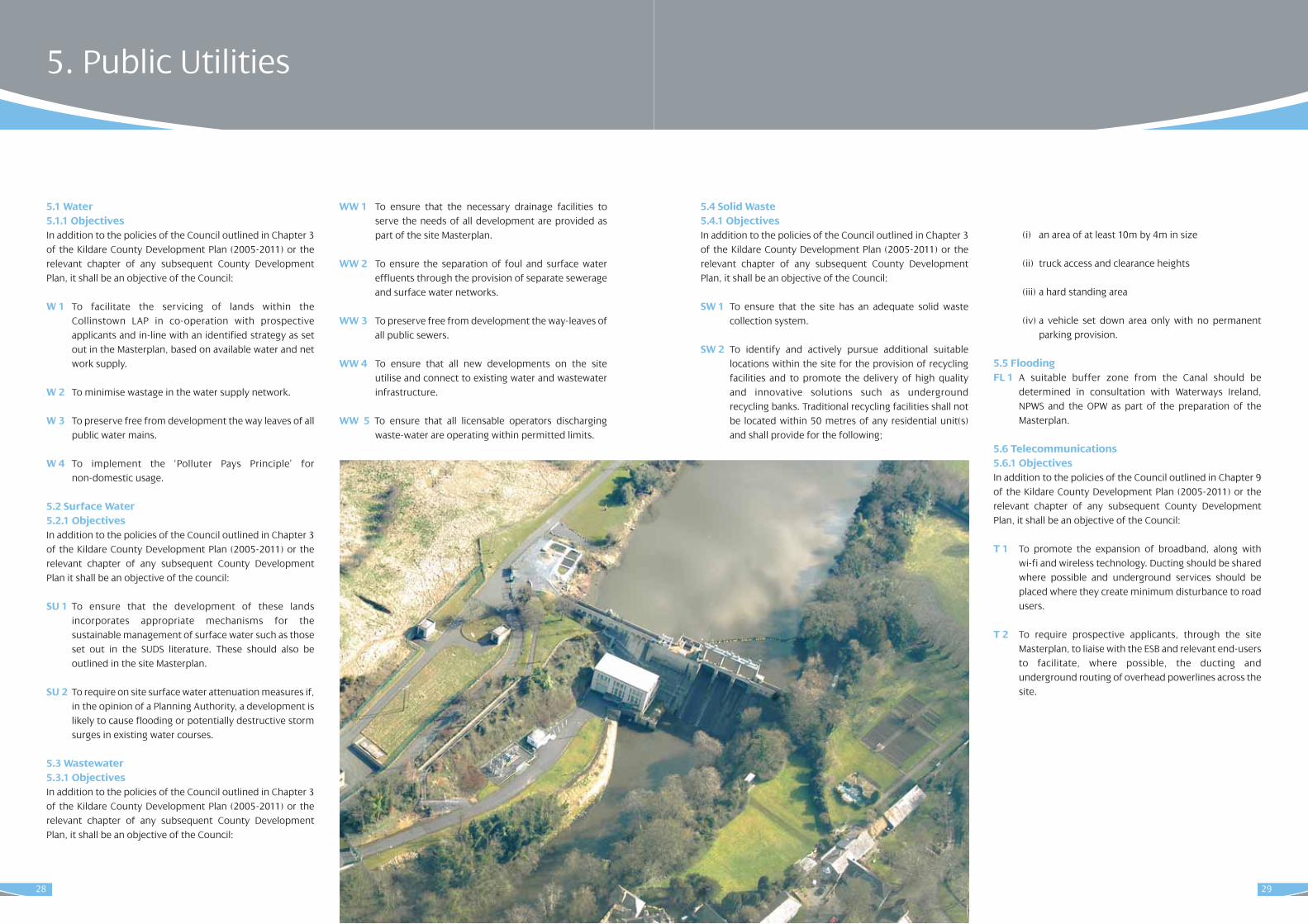
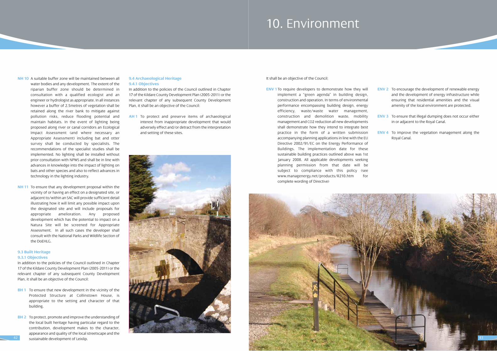
The Royal Canal pNHA traverses the site to the north. TheCanal is home to the legally protected Opposite-leavedPondweed (Groenlandia densa) under the Flora ProtectionOrder 1987 and Tolypella intricate, a Red Data Book protectedstonewort. Both of these species are present in the Dublinsection of the Canal. The main extent of the canal boundaryis dominated by hedgerow, tall herbs, calcareous grassland,reed fringe, open water, scrub and woodland. The canal towpath is predominantly made up of various species exceptwhere the canal was built through bog. There is diversehedgerow present along the canal.
In the wider Leixlip area there is an additional proposedNational Heritage Area (pNHA) - the Liffey Valley which islocated to the south east of the Town. The Special Area forConservation (cSAC), the Rye Water Valley/Carton, also lies tothe north.
7.2 Built Heritage There is one Protected Structure within the site itself – namely Collinstown House, recorded as IP62. The ProtectedStructure Deey Bridge (IP61) is also found in the vicinity. * Please consult the current record of protected structures for the most up to date list.Leixlip itself has a strong architectural character – as recognised in the designation of the historic core of the Townas an Architectural Conservation Area.
7.3 Archaeological Heritage7.3.1Sites and Monuments Records The Sites and Monuments Records (SMR) list all certain or possible archaeological sites and monuments mainly datingto before 1700AD. These lists were in many cases based initially on cartographic, documentary and aerial photographic sources. The record is updated on a constantbasis and focuses on monuments that predate 1700AD.There are no recorded SMR sites within the Collinstown landsor proximate to it.
14
6.1 Water Supply Leixlip town is connected to the North Regional Water Supplyscheme. The water treatment plant upgrades at Leixlip andBallymore Eustace are due for completion by 2011. TheKildare County Council Engineering Department is currentlyundertaking a review of the network capacity of all the largetowns in Kildare.
Specific service requirements for development at Collinstownwill be subject to detailed assessment by potential applicantsin the preparation of a site masterplan (see foreword). Allsuch assessments will be subject to detailed pre-application meetings and discussions with the Water Services Departmentin Kildare County Council.
6.2 Waste Water The Leixlip Wastewater Treatment Plant currently has capacityto serve 80,000 population equivalent (p.e). The plant is currently being expanded to serve a p.e of 150,000.This expansion is due to be completed in 2011.
Specific service requirements for development at Collinstownwill be subject to detailed assessment by potential applicantsin the preparation of a site masterplan (see foreword). Allsuch assessments will be subject to detailed pre-application meetings and discussions with the Water Services Departmentin Kildare County Council.
6.3 Surface Water Flooding has been identified as a problem in Leixlip. In 2000and 2002 Leixlip Main Street flooded. However, flood alleviation works have been undertaken in association withthe Office of Public Works (OPW).
Specific service requirements for development at Collinstownwill be subject to detailed assessment by potential applicantsin the preparation of a site masterplan (see foreword). Allsuch assessments will be subject to detailed pre-application meetings and discussions with the Water Services Departmentin Kildare County Council.
6.4 Waste Kildare County Council has adopted a Waste Management Planfor Kildare (2005-2010). The Plan highlights current levels ofwaste and sets objectives whereby overall levels will bereduced and stabilised in order to comply with both nationaland European legislative guidelines.
The guidelines set down a hierarchy of preferential modes ofwaste management, focusing on prevention, minimisation,re-use/recycle, disposal with energy recovery and disposal ofresidual waste.
Leixlip is adequately serviced in terms of refuse collectionwhich is carried out by a number of contractors.
6.5 Electricity, Gas and TelecommunicationsElectricity is supplied by the ESB transmission system, whichis adequate to serve the needs of Leixlip for the period of thisplan.
Significant powerlines currently traverse the Collinstown siteand these provide the dual supply necessary to guaranteecontinuous electricity to the Intel facility to the north of theLAP boundary. Detailed consideration of how these lines willbe managed must be addressed in the Collinstown Masterplan(see foreword) and consultation will form a key part of thisprocess.
Leixlip is currently served by the Gas network.
The telecommunications network in Leixlip is being upgradedprogressively. There is an increased demand for mobilephones, broadband and other telecommunications equipment to improve the telecommunications network andprovide a global system for mobile communications.Broadband is currently available in the Leixlip area.
Kildare County Council acknowledges the importance of thetelecommunications sector to the local and regional economy. Access to advanced information and communications infrastructure is essential to developmentand offers a competitive advantage in attracting economicdevelopment and inward investment.
7. Conservation6. Public Utilities
17
The Strategic Vision and Strategic Policy Objectives, as set outbelow, provide the overall strategy of Kildare County Councilfor the proper planning and sustainable development ofCollinstown. The Vision and Policy Objectives are framed within the socio-economic, environmental and strategic planning contexts for the future development of the lands atCollinstown.
9.1 Overall Strategy for CollinstownThe overall vision for Collinstown is the development of aMajor Town Centre in-line with the provisions of the CountyDevelopment Plan and the prevailing Retail Strategies for theGreater Dublin Area (GDA) and County Kildare.
The development of Collinstown will serve to meet the growing needs for higher order retail and service provision inNorth Kildare as identified in the retail strategies. It will further serve to consolidate the links between the key settlements in the north of the County and within theMetropolitan area of the GDA – namely Leixlip, Celbridge,Maynooth and Kilcock. Finally – though perhaps most importantly, it will provide an opportunity for the enhancement of the service and retail profile of Leixlip Townand to provide higher order facilities for this growing urbancommunity.
The development of Collinstown is estimated to take placeover a period of 20 years and will be subject to a siteMasterplan. That Masterplan should be prepared by landown-ers – ideally working together, and in consultation with KildareCounty Council and any other service providers
– notably the public transport providers and the ESB. TheMasterplan must comply with all of the policies and objectivesof this Local Area Plan.
9.2 Strategic Policy ObjectivesIt shall be the policy of the Council:
• To promote and facilitate the growth and sustainable development of Collinstown as a Major Town Centreas recognised by the Regional Planning Guidelines for the Greater Dublin Area and the Kildare County Development Plan.
• To support and facilitate the development of Collinstown as a vibrant, mixed use area which accommodates employment, services, retailing, residential and community uses within an attractive and sustainable context and founded on the principles of sustainable mobility and development.
• To establish a plan-led context for the preparation of a detailed Masterplan for the development of the lands.
• To facilitate implementation of the Local Area Plan and subsequent Masterplan.
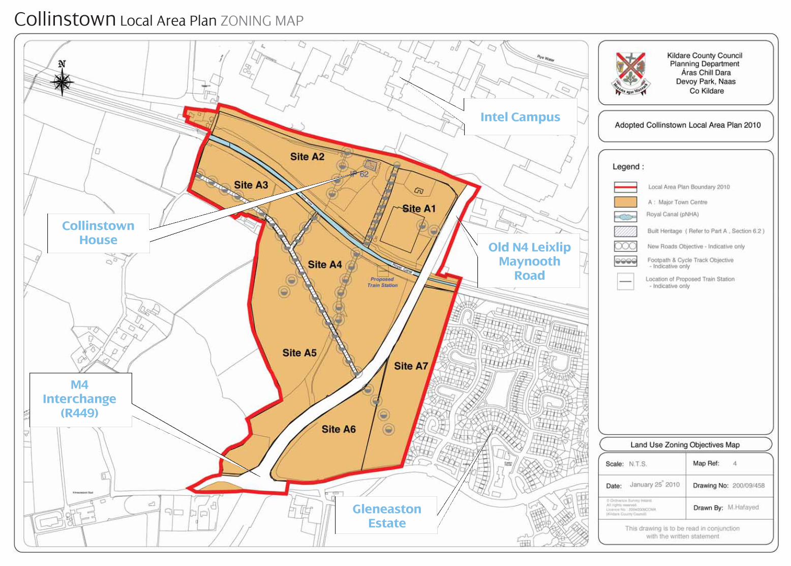
9.3 Key Spatial Elements of the Development Strategyfor CollinstownBoth maps included as part of this section show the existingcontext of the site in terms of Leixlip and also surroundingfeatures such as Collinstown House, the Royal Canal and theadjacent roads – the R449 and R148.
16
8.1 Major Town CentreAs per the County Development Plan, and subject to the provisions of this Plan and the preparation of a siteMasterplan, the lands within the Collinstown LAP boundaryare zoned ‘Major Town Centre’.
The objective of this land use zoning is to provide for majortown centre facilities comprising an appropriate mix ofemployment, retail, recreational, civic, cultural and residentialuses within a high quality urban environment linked to thelocal community, town and Leixlip, and wider County andRegion.
The development of higher order retail provisions within thisland use will be phased over approximately 20 years i.e. overthe life of this Plan and approximately two future Local AreaPlans for the site and Leixlip town. The ultimate long term aimis to facilitate the development of a Major Town Centre suchas Liffey Valley, Blanchardstown, Dundrum, etc which wouldhave national, regional and local catchments. It is envisagedthat this Centre may ultimately comprise some 65,000 sq.m.of comparison retailing with associated ancillary retail services and activities – though it is emphasised that phaseddevelopment will ensure that the delivery of retail floorspaceon the site will occur in-line with the orderly development andenhancement of the retail and service offering in the locality,County and Region as set out in the prevailing County RetailStrategy.
In parallel with retailing facilities, the Collinstown site willaccommodate a range of amenities and recreational facilitiesincluding public and private open spaces, and facilities suchas a multiplex cinema, bowling alley, theatre, etc. It is proposed that the key amenity – namely the provision of apublicly accessible display or theatre space – as detailedbelow, would be an initial element of the development atCollinstown.
Public transport is critical in the delivery of development atthe Major Town Centre. It is envisaged that the Major TownCentre zoning will facilitate the development of four phasesof public transport provision as set out under policy TR3.
8.2 New ResidentialThe pattern of residential development in Collinstown will beinfluenced by site services – particularly proximity to publictransport, as well as prevailing patterns of land use in the area,in particular the site bounding the Glen Easton housing estate.It is noted that lower densities in the region of 25 units / Hawill be required close to the boundary with those existinghousing estates, with an increase in density permitted in awesterly direction where impacts on existing residentialamenity are unlikely.
8.3 Industry and Warehousing Leixlip is home to two large manufacturing industries - Inteland Hewlett Packard both of which employ a large number ofpeople from the community. A high proportion of the town’spopulation also commutes to work outside the area (mainly toDublin).
Industrial and related uses shall be incorporated intoCollinstown to provide for the development of spin-off industries, incubator units and also associated commercialenterprises. This area should be designed and landscapedwith the image of a modern and contemporary ‘business park’fronted by office and warehousing type activities including anelement of retail warehousing in-line with the Retail Strategyand the principles of sustainable development.
8.4 Open Space and AmenityThe lands in the vicinity of the Royal Canal are of significancefor their amenity, recreational and ecological potential. Thedevelopment of the Collinstown Lands creates an opportunity for the delivery of publically accessible parklands.
9. Development Vision for Collinstown8. Land Uses
Zoning Area as per 2010 Objective Draft LAPTown Centre 42.26 Ha *inclusive of all
road corridors, etc. shown
Table 2: Major Town Centre Zoning
19
• details in relation to signage throughout the site and within the wider area – notably between the train stations and Leixlip Town Centre and Collinstown.
4. a sustainable building strategy for the site which examines site microclimate and issues associated with aspect, sunlight and overshadowing. Based on this assessment the overall sustainability of the site will be examined in relation to block layouts, open spaces and building lines that can take full advantage of the aspect of the site and the availability of sunlight for both buildings and spaces.
5. Detailing of an architectural and urban design palettefor new development having regard to the policies and objectives of this Local Area Plan and the County Development Plan, including:
• A density strategy for development within the site having regard to National and County policy as well as land uses zoning patterns and patterns of development in the wider context of the Town.
• Identification of ‘Character Areas’ i.e. discrete ‘zones’ within the site and the reflection of these local areas in the style and form of new development.
• An assessment of the vernacular architecture and character of Leixlip Town and an analysis of how this can influence new, contemporary development thereby allowing new development to compliment the established character of the area and physically integrate it with the existing urban area;
• Proposals in relation to land-marking within the site including – if appropriate, the contribution of new buildings to the skyline as seen from Leixlip and the surrounding road network and important views and vistas;
• Proposals in relation to edge treatment including characterisation of edges (built, soft, etc.) and details given for their treatment – whether by means of building frontage, planting or strategic reservation of open areas.
• A strategy for building character and height based on identified views, prospects and visual axes with the wider locality, proposed materials, etc.
6. Detailing of a Mobility Management Plan for the site incorporating:
• a strategy for access / egress to the site by car / other vehicles;
• public transport provisions as detailed throughout this plan (and to be agreed with private and public transport providers);
• parking strategies for public and private use;
• a ‘permeability strategy’ for the site including details of the proposed vehicular, pedestrian and cycling routes into and throughout the site having regard to the guidance set out in the ‘Manual for Streets’ and other prevailing policy and guidance documents;
7. An assessment of the existing and required engineering services and infrastructure will be carried out in consultation with the relevant departments of the County Council.
8. a phasing strategy for the overall development of the site including delivery of hard and soft infrastructure; residential units; retail development and ancillary services such as the theatre, bowling alley; cinema etc.
18
Within these zones the following sub-areas are identified andwill be developed as part of the Plan:
• a buffer area extending along the Royal Canal and the railway-line to both provide a canal-side amenity area and maintain access for maintenance and upgrading works;
• a new pedestrian link from the R148 over the Royal Canal and into the centre of the site;
• new vehicular links from the R449 into sites east and west of the R449;
• a lower density residential edge abutting the Gleneaston Housing Estate to protect the residential amenity of those properties;
• a higher density core of buildings proximate to the public transport ‘hub’ and new railway station;
• new development adjacent to Collinstown House to protect the character of that Protected Structure;
• an opportunity for the development of a landmark building at the junction of the R449 and R148 to front new retail development; and
• edge sites at the southern boundary that benefit from being highly accessible.
Overlaying these elements on the zoning map allows for theidentification of specific sites for which design guidance is setout in Part B of this Plan. A key to the labelling of these sitesis shown on map 4 in this section (A1 to A7).
9.4 Contents of the Collinstown MasterplanIt is a policy of Kildare County Council to require the preparation of a detailed site Masterplan for the developmentof the lands at Collinstown. This Masterplan shall provideadditional detail on the spatial elements of the Plan - outlinedabove, and detail the overall development proposal.
Note:• The Masterplan shall be prepared for the entire site
within the Collinstown Local Area Plan boundary.
• This Masterplan shall be fully agreed with Kildare County Council in consultation with the Area Members prior to the granting of any planning permission on these lands.
• The Masterplan must accord with the site specific objectives identified by the Collinstown Local Area Plan as well as relevant site development standards set out herein and in the County Development Plan.
Details to be contained within the Collinstown Masterplaninclude the following:
1. a landscape / topographical assessment to identify views, aspects and vistas into and out of the site (existing and proposed) and connecting to the wider environment including the nearby motorway and Leixlip Town;
2. an assessment of ecological significance carried out by an appropriately qualified person;
3. arising from Items 1 and 2, a detailed landscape strategy for the development of open spaces and corridors throughout the site that will contain proposals for:
• the treatment and management of the Canal-side amenity area;
• ‘hard’ landscaping of smaller urban spaces and routes to include a footpath and a bicycle path network permeating the site;
• formal proposals for a hierarchy of public open spaces throughout the site;
• details in relation to public art and focal points that will be provided throughout the site;
• proposals in relation to planting areas including details of planting and a maintenance scheme for same;
• seating arrangements both formal and informal throughout the site;
21
Introduction This Section states the objectives of Kildare County Councilwith regards to the development of land within the boundaryof the Local Area Plan for Collinstown. It is the overarchingobjective of the Council to implement all development inaccordance with these stated objectives in order to facilitateland use in a manner that will promote proper planning andsustainable development.
The development of a large-scale site such as this, createsunique challenges with respect to the implementation ofdesign strategies. Primarily, the key concern is the creation ofa visually and architecturally monotonous style and characterreflecting the development of the scheme over a reasonably short period of time. Kildare County Council proposes to proactively address this issue with the establishment of a broad range of “location specific” policieswhich aim to ensure that the site is developed in an interesting and innovative manner while incorporating thehighest standards with regard to sustainable mobility andenergy use and conservation.
Central to this will be the preparation of a site Masterplan (asset out in Section 9.4 above) to provide a context for thephased development of these lands. That Masterplan shouldbe prepared by the relevant landowners – ideally workingtogether, and in consultation with Kildare County Council andany other service providers. The Masterplan must complywith all of the policies and objectives of this LAP as set outherein.
Part B
20
23
2.1 Objectives In addition to the policies of the Council outlined in Chapter 5of the Kildare County Development Plan (2005-2011) or therelevant chapter of any subsequent County DevelopmentPlan, it shall be an objective of the Council:
H1 To ensure that land to the east of the R449 road is developed in-line with best practice given the need toprotect the amenities of the existing residential properties in the area.
H2 To provide additional residential development to thewest of the R449 road. Residential densities to thewest of the R449 road will be high – having regard tothe proximity to public transport; the separationbetween the development site and existing residential units; as well as the overall desire to create a strong sense of place and belonging. Residential units will be provided within these areaswith site-specific densities depending on the distancefrom public transport; location within the site; etc. Strong adherence to the development objectives setout under Major Town Centre – particularly with respect to the provision of public and private openspace, will be critical in achieving these high development yields. Site specific objectives for eachsite are set out below under policies in relation to theMajor Town Centre.
H3 To ensure that the Masterplan for Collinstown includes a detailed design palette for the site. Innovative design will deliver higher developmentyields in parallel with higher quality lasting developments which perform in an increasingly sustainable manner. High quality architectural design and treatment will be required, including:
(i) The incorporation of the principles of energy conservation and efficient use of resources;
(ii)The use of high quality materials only, in the delivery of a high standard of design.
(iii) Variety in the unit / house types, styles, designs andsizes of proposed dwelling units throughout the development. In this regard only the highest qualityproposals shall be considered and all house types shall be sympathetic with each other. Variety in the amountof floor area to be provided shall form an integral partof any new Residential development scheme in order to allow for adequate trading up and down opportunities.
2 Housing
• Staggered building linesgive this contemporary terrace an interesting lookwith hard and soft landscaping creatingattractive shared parkingand play areas
• A mixture of buildingmaterials and heights isused here to good effect in marking out this urbancorner.
• Colour and the unusual orientation of thishouse relative to the publicroad, ensure privacy forthe occupiers and create a more interesting buildingline here.
• Landscaping and different materials areused to good effect at thisend of terrace site.
Examples of Good Practice
22
Once the estate has been taken in charge it will be a matter for the residents of the estate to organise and arrange for the management and maintenance of the public open spaces in the estate. This could be done either through the residents associations or some form of voluntary co-operation. The Council will continue to assist residents in maintaining the public open space. The level of assistance will be dependant on the availability of resources.
In the limited number of cases where control of the management company has transferred to the residents of the estate and where the residents wish to retain the company solely for the management and maintenance of the public open spaces and for no other purpose or function, the Council will consider proposals from the residents of an estate to retain the management company on this basis once the estate has been taken in charge. Each individual case will be assessed on its merits.
H7 To require applicants for developments of greater than 50 units, or where the Planning Authority deems necessary, to submit a Social Infrastructure Assessment (SIA) which demonstrates the facilities available to adequately service the proposed development. This should include details regarding the type and location of facilities available in the locality including education, childcare, health, recreational facilities and others such as shops and post offices. It shall be demonstrated, as part of any planning application that deficiencies, found to be arising in the availability of such services in the locality, shall be provided as part of the proposed scheme together with the type and location of same. In addition, the onus shall be on the developer to satisfactorily demonstrate how the proposed increase in population will be accommodated in terms of education provision. In this regard, it shall be noted that 12% and 8.5% of a population at any time is assumed to be of primary and secondary school going age respectively. With particular regard to the effect development proposals would have on education provision, developers shall;
(i) calculate the assumed population arising out of a particular development proposal that would require primary and secondary school places, having regard to the figures of 8.5% and 12% as above.
(ii) provide details of the total available places and the current spare capacity in local schools (a letter from the principal of the schools shall be required as part of the planning application).
(iii) Where there is found to be a shortfall with regard to facilitating the population of the proposed development in local schools the onus shall be on the developer to demonstrate how additional capacity can be achieved.
H8 To ensure that the names of residential developments reflect local place names, language or topographical features as appropriate and the use of old names from the locality as far as possible.
H9 To adopt the ‘White Light’ Compact Fluorescent Lamp (CFL) public lighting concept for all new residential estates.
24
(iv) The consideration of the requirements of the elderly and those with particular mobility requirements in the design of development schemes.
(v) That solar panels be encouraged in the design of development schemes in the interests of sustainability, particularly on south facing walls. All proposed developments shall have due regard to the energy performance of buildings as noted in EC Directive 2002/91/EC www.managenergy.net/products/R210.htm http://www.managenergy.net/products/R210.htm for complete wording of Directive).
(vi) All extensions to residential buildings shall be sympathetic in massing and scale to the existing building.
The Collinstown Masterplan must clearly show howthese principles are incorporated into the designscheme for the site.
H4 To ensure that all residential and mixed use development proposals comply with the following recent DoEHLG publications:
(i) ‘Sustainable Residential Development in UrbanAreas –Guidelines for Planning Authorities’ (December 2008) and
(ii) ‘Urban Design Manual – A best practice guide, A companion document to the Planning Guidelines on Sustainable Residential Development in Urban Areas’ (December 2008).
It is considered that both documents provide essential guidance to improving the quality of design and layout of development schemes and should be used by;
(i) developers/agents, in the preparation of development proposals,
(ii) the public, in gaining a greater understanding of the development proposals,
(iii) planners, in the assessment of development proposals.
It is strongly advised that all relevant parties have regard toboth documents when preparing or assessing developmentproposals. Both documents can be viewed in full on theDoEHLG website www.environ.ie/en/ > Planning /Development > Publications and Documents).
H5 To ensure that all new residential accommodation meets the necessary standards of health, sanitation and design, and are carried out in accordance with the ‘Recommendations for Site Development Works for Housing Areas’ (DoEHLG 1998).
H6 To take the conventional housing element of residential developments in charge once they have been completed to the satisfaction of the planning authority.
In mixed developments that consist of ‘conventional houses’, apartments and commercial/retail developments, the public infrastructure should be laid out and constructed in such a manner so that there is clear distinction between the areas and infrastructure that are to be taken in charge and those that will be managed by a management company.
Kildare County Council recognises that certain development types, (such as apartment blocks or developments that consist predominantly of apartment blocks and where it would not be practical to isolate the infrastructure serving the apartment blocks from the conventional housing element of the development) require the creation of management companies to manage and maintain the communal areas in the development.
In developments where management companies are required, these companies should be constituted in accordance with ‘The Draft Guidelines on the Governance of Apartment Owners’ Management Companies’ published by the Office of the Director of Corporate Enforcement, December.2006) or any future national legislation or guidelines.
Where management companies have been formed for conventional housing estates or for the conventional housing element of mixed use estates, the County Council will take these estates in charge when they have been completed to the satisfaction of the County Council on condition that the management company is wound up when the estate has been taken in charge. 25
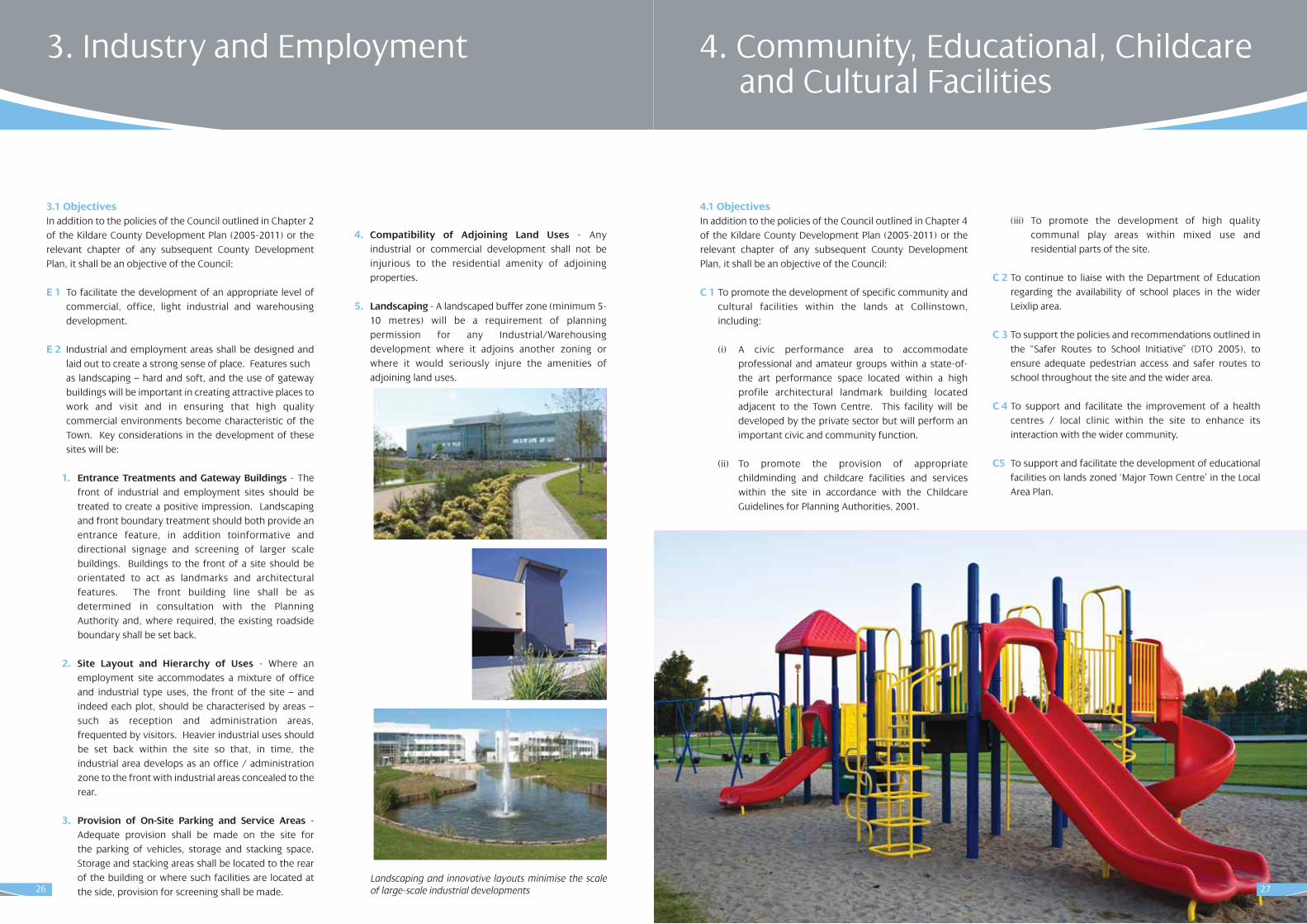
4.1 Objectives In addition to the policies of the Council outlined in Chapter 4of the Kildare County Development Plan (2005-2011) or therelevant chapter of any subsequent County DevelopmentPlan, it shall be an objective of the Council:
C 1 To promote the development of specific community and cultural facilities within the lands at Collinstown, including:
(i) A civic performance area to accommodate professional and amateur groups within a state-of-the art performance space located within a high profile architectural landmark building located adjacent to the Town Centre. This facility will be developed by the private sector but will perform an important civic and community function.
(ii) To promote the provision of appropriate childminding and childcare facilities and services within the site in accordance with the Childcare Guidelines for Planning Authorities, 2001.
(iii) To promote the development of high quality communal play areas within mixed use and residential parts of the site.
C 2 To continue to liaise with the Department of Education regarding the availability of school places in the wider Leixlip area.
C 3 To support the policies and recommendations outlined in the “Safer Routes to School Initiative” (DTO 2005), to ensure adequate pedestrian access and safer routes to school throughout the site and the wider area.
C 4 To support and facilitate the improvement of a health centres / local clinic within the site to enhance its interaction with the wider community.
C5 To support and facilitate the development of educational facilities on lands zoned ‘Major Town Centre’ in the Local Area Plan.
26
3.1 ObjectivesIn addition to the policies of the Council outlined in Chapter 2of the Kildare County Development Plan (2005-2011) or therelevant chapter of any subsequent County DevelopmentPlan, it shall be an objective of the Council:
E 1 To facilitate the development of an appropriate level of commercial, office, light industrial and warehousing development.
E 2 Industrial and employment areas shall be designed and laid out to create a strong sense of place. Features such as landscaping – hard and soft, and the use of gateway buildings will be important in creating attractive places to work and visit and in ensuring that high quality commercial environments become characteristic of the Town. Key considerations in the development of these sites will be:
1. Entrance Treatments and Gateway Buildings - The front of industrial and employment sites should be treated to create a positive impression. Landscaping and front boundary treatment should both provide an entrance feature, in addition toinformative and directional signage and screening of larger scale buildings. Buildings to the front of a site should be orientated to act as landmarks and architectural features. The front building line shall be as determined in consultation with the Planning Authority and, where required, the existing roadside boundary shall be set back.
2. Site Layout and Hierarchy of Uses - Where an employment site accommodates a mixture of office and industrial type uses, the front of the site – and indeed each plot, should be characterised by areas – such as reception and administration areas, frequented by visitors. Heavier industrial uses should be set back within the site so that, in time, the industrial area develops as an office / administration zone to the front with industrial areas concealed to the rear.
3. Provision of On-Site Parking and Service Areas - Adequate provision shall be made on the site for the parking of vehicles, storage and stacking space. Storage and stacking areas shall be located to the rear of the building or where such facilities are located at the side, provision for screening shall be made.
4. Compatibility of Adjoining Land Uses - Any industrial or commercial development shall not be injurious to the residential amenity of adjoining properties.
5. Landscaping - A landscaped buffer zone (minimum 5-10 metres) will be a requirement of planning permission for any Industrial/Warehousing development where it adjoins another zoning or where it would seriously injure the amenities of adjoining land uses.
Landscaping and innovative layouts minimise the scale of large-scale industrial developments
3. Industry and Employment 4. Community, Educational, Childcare and Cultural Facilities
27
29
5.4 Solid Waste 5.4.1 ObjectivesIn addition to the policies of the Council outlined in Chapter 3of the Kildare County Development Plan (2005-2011) or therelevant chapter of any subsequent County DevelopmentPlan, it shall be an objective of the Council:
SW 1 To ensure that the site has an adequate solid waste collection system.
SW 2 To identify and actively pursue additional suitable locations within the site for the provision of recycling facilities and to promote the delivery of high quality and innovative solutions such as underground recycling banks. Traditional recycling facilities shall not be located within 50 metres of any residential unit(s) and shall provide for the following;
(i) an area of at least 10m by 4m in size
(ii) truck access and clearance heights
(iii) a hard standing area
(iv) a vehicle set down area only with no permanent parking provision.
5.5 FloodingFL 1 A suitable buffer zone from the Canal should be
determined in consultation with Waterways Ireland, NPWS and the OPW as part of the preparation of the Masterplan.
5.6 Telecommunications 5.6.1 ObjectivesIn addition to the policies of the Council outlined in Chapter 9of the Kildare County Development Plan (2005-2011) or therelevant chapter of any subsequent County DevelopmentPlan, it shall be an objective of the Council:
T 1 To promote the expansion of broadband, along with wi-fi and wireless technology. Ducting should be shared where possible and underground services should be placed where they create minimum disturbance to road users.
T 2 To require prospective applicants, through the site Masterplan, to liaise with the ESB and relevant end-users to facilitate, where possible, the ducting and underground routing of overhead powerlines across the site.
28
5.1 Water 5.1.1 Objectives In addition to the policies of the Council outlined in Chapter 3of the Kildare County Development Plan (2005-2011) or therelevant chapter of any subsequent County DevelopmentPlan, it shall be an objective of the Council:
W 1 To facilitate the servicing of lands within the Collinstown LAP in co-operation with prospective applicants and in-line with an identified strategy as set out in the Masterplan, based on available water and network supply.
W 2 To minimise wastage in the water supply network.
W 3 To preserve free from development the way leaves of all public water mains.
W 4 To implement the ‘Polluter Pays Principle’ for non-domestic usage.
5.2 Surface Water 5.2.1 ObjectivesIn addition to the policies of the Council outlined in Chapter 3of the Kildare County Development Plan (2005-2011) or therelevant chapter of any subsequent County DevelopmentPlan it shall be an objective of the council:
SU 1 To ensure that the development of these lands incorporates appropriate mechanisms for the sustainable management of surface water such as those set out in the SUDS literature. These should also be outlined in the site Masterplan.
SU 2 To require on site surface water attenuation measures if, in the opinion of a Planning Authority, a development is likely to cause flooding or potentially destructive storm surges in existing water courses.
5.3 Wastewater5.3.1 ObjectivesIn addition to the policies of the Council outlined in Chapter 3of the Kildare County Development Plan (2005-2011) or therelevant chapter of any subsequent County DevelopmentPlan, it shall be an objective of the Council:
WW 1 To ensure that the necessary drainage facilities to serve the needs of all development are provided as part of the site Masterplan.
WW 2 To ensure the separation of foul and surface water effluents through the provision of separate sewerage and surface water networks.
WW 3 To preserve free from development the way-leaves of all public sewers.
WW 4 To ensure that all new developments on the site utilise and connect to existing water and wastewater infrastructure.
WW 5 To ensure that all licensable operators discharging waste-water are operating within permitted limits.
5. Public Utilities
31
6.2 Public Transport6.2.1 ObjectivesIn addition to the policies of the Council outlined in Chapter 3of the Kildare County Development Plan (2005-2011) or therelevant chapter of any subsequent County DevelopmentPlan, it shall be an objective of the Council:
PT 1 To enact the land use zoning set out in this Plan in-line with the delivery of specific improvements to the public transport facilities servicing the site, namely:
• The development of a new train station at the centre of the site to serve the Collinstown development and also proximate facilities such as the Intel facility;
• The development of a new Park and Ride facility at a central location on the site, ideally utilising largely underground car parking and serving public transport connections as well as the commercial and residential elements of the development. A strategic Park and Ride facility shall form part of the overall development scheme. Part of this Park and Ride facility shall be dedicated for the sole use of rail line users.
• The development of a sub-regional bus hub within the site, where feasible, making Collinstown a focal point for public and private buses servicing the North Kildare area.
• The interim development of a bus link between the Collinstown site and Park and Ride facility, Intel, the Louisa Bridge railway station and Leixlip Town Centre to provide access to higher quality public transportation and to facilitate development on the site. It is envisaged that this bus link may be provided by the site developers as a mechanism within the Sustainability Mobility Strategy for the site.
In the interests of clarity, Kildare County Council will require significant detailing of the delivery of such proposals within the Mobility Management Plan associated with the site Masterplan including details of the proposed services costs of service provision and delivery dates. The railway station shall be delivered as part of Phase 1 of the overall development proposal.
Furthermore, the permitting of developments under this Local Area Plan will be contingent on the delivery of these improvements. Where planned improvements are not forthcoming, applications for development may be refused permission on the basis of prematurity pending the delivery of improved facilities.
PT 2 To ensure where possible, that all public transport is accessible to the disabled.
6.3 Pedestrian and Cycle Networks6.3.1 ObjectivesIn addition to the policies of the Council outlined in Chapter 3of the Kildare County Development Plan (2005-2011) or therelevant chapter of any subsequent County DevelopmentPlan, it shall be an objective of the Council:
PC1 To implement the key principles of permeability of accessibility in the development and masterplanning of the site through the proactive planning of links and routes through the site.
A permeability strategy will be prepared at the Masterplan stage for the site to address the key issues of moving people and vehicles through and into the site. This Plan provides for the creation of enhanced links into and throughout the site having regard to the guidance set out in the ‘Manual for Streets’ and other prevailing policy and guidance documents. These must be explored and refined in the Masterplan to the satisfaction of the Planning Authority.
Development layouts must be designed to provide / address the following:
(i) Layouts must prioritise and maximise the safe movement of pedestrians and allow for traffic calming by design, throughout the scheme. In this regard curved routes shall be preferred as opposed to long, straight stretches of roadway – particularly on higher grade roads where traffic speeds are likely to be more problematic.
30
6.1 Roads, Streets and Car Parking6.1.1 ObjectivesIn addition to the policies of the Council outlined in Chapter 3of the Kildare County Development Plan (2005-2011) or therelevant chapter of any subsequent County DevelopmentPlan, it shall be an objective of the Council:
TR1 To implement a Mobility Management Strategy promoting the principles of sustainable mobility throughout the site, in-line with the principles underlying the site Masterplan, having regard to the recommendations of the Dublin Transportation Office and the relevant Council’s Departments.
This Strategy will address the mobility issues associated directly with the site as well as with the links with Leixlip. Where appropriate it may identify mitigation measures outside the Collinstown Site – such as road improvements, signage improvements etc. which may be undertaken and appropriately funded to facilitate the development of Collinstown.
This strategy will be prepared in consultation with Kildare County Council as part of the Masterplan for Collinstown.
TR2 To maintain, and improve as required, the local road network serving the site and to ensure a high standard of road quality and safety in the creation of a limited number of new access / egress points onto these roads.
TR3 To require the delivery of improved public transport facilities serving the site, namely:
• Development of a shuttle bus service between the site and key facilities in the locality including Intel, Louisa Bridge and Confey Railway Stations, and Leixlip Town Centre;
• Development of a shuttle bus service between Leixlip, Celbridge, Maynooth and Kilcock to provide for car-free trips between these urban centres;
• Provision of a Park-and-Ride facility within the Collinstown development;
• Development of a new station to serve Collinstown and West Leixlip within the subject lands.
Negotiations to secure the delivery of these services will form a key part of the Mobility Management Strategy for Collinstown. In the preparation of this Strategy, a detailed phasing plan for the implementation of these services must be provided and agreed. The railway station shall be delivered as part of Phase 1 of the overall development proposal. The Transport Hub shall be located adjacent to the train station.
TR 4 To ensure that local roads within residential developments are designed and used as multi-purpose spaces or ‘home zones’. These roads will provide controlled access for vehicles at calmed and reduced traffic speeds with shared use for bicycles. Paths will be separated at-grade and will link with road / vehicular corridors as well as open spaces. Full compliance with prevailing road engineering standards will be required along with good practice in terms of road layout and the design of the relationship between buildings and spaces.
TR 5 To ensure the orderly provision of dedicated car parking to serve all aspects of development in Collinstown – including public / commuter parking and parking directly associated with residential, retail and commercial developments.
TR 6 To ensure insofar as possible that all transport facilities and services (including car parking) are accessible to people with mobility needs. Car parking shall generally be provided in accordance with “Buildings for Everyone” 2002 published by the National Disability Authority.
TR 7 To facilitate and encourage cycling as a more convenient, popular and safe method of transport, through the designation of a cycle network, linking population, commercial, community facilities and transport nodes.
TR 8 To ensure the provision of permanent durable surfaces to all public and private car parking facilities, cycle and walking tracks.
TR 9 To promote the planting of native species when considering the landscaping requirements of new transport networks.
6. Transportation
33
7.1 ObjectivesIn addition to the policies of the Council outlined in Chapter13 of the Kildare County Development Plan (2005-2011) or therelevant chapter of any subsequent County DevelopmentPlan, it shall be an objective of the Council:
AR 1 To require the preparation of a landscaping strategy for the site within the Collinstown Masterplan area to ensure that new development delivers a high quality local environment for all users.
The integration of this landscaping strategy with the permeability strategy will be promoted by the Council thereby ensuring that pedestrian links are well integrated into both the built environment and open spaces set within the development.
The Landscape strategy will be a central element of the site Masterplan and must be prepared by a suitably qualified person. It will include proposals for the following:
I. An urban space to the north of the site centred on the Royal Canal. This space will incorporate the buffer zone associated with the Canal which shall be determined in consultation with Waterways Ireland, NPWS and the OPW as part of the preparation of the Masterplan for Collinstown. The urban space will also accommodate a new pedestrian bridge(s) which will link this northern section of the site and the proposed railway station and mixed use developments to the south, as well as opening up the site to the proximate developments at Intel and along the R148. It will be designed and detailed having regard to the environmental sensitivity of the Canal and will be subject to a detailed environmental assessment;
II. Hard landscaping treatment for a new pedestrian crossing across the R449 linking lands to the east and west;
III. ‘hard’ landscaping proposals for smaller urban spaces and links to include a footpath and a bicycle path network permeating the site;
IV. formal proposals for a hierarchy of public open spaces throughout the site to include;
(i) landscaped pedestrian and cyclist link routes along desire lines (e.g. connecting residential areas with commercial, community, educational and employment uses). These routes shall also be suitable for the requirements of disabled users. Communal bicycle racks shall be provided as an integral part of any residential scheme.
(ii) central, functional, accessible and adequately overlooked areas of public open space.
(iii) smaller areas of usable, functional, accessible and central areas of open space throughout the remainder of the development site.
(iv) having regard to both (ii) and (iii) above, residential units or focal points of activity – such as clusters of retail units, shall front onto areas of open space. Gable walls or stretches of blank walls shall not be permitted to front onto these areas.
V. details in relation to public art and focal points that will be provided throughout the site;
VI. proposals in relation to planting areas including details of planting and a maintenance scheme for same;
VII. seating arrangements both formal and informal throughout the site;
VIII. details in relation to signage throughout the site and within the wider area – notably between the train stations and Leixlip Town Centre and Collinstown;
32
(ii) Priority shall be given to the movement of pedestrians throughout the site, providing footpaths and lighting along appropriate desire lines, for example connecting residential units to areas of open space and transport hubs, and connecting areas of open space to each other. Furthermore, desire lines between facilities within the site and also those lying outside the site boundaries – including Leixlip Town Centre, should be ‘built into’ site layout and design.
(iii) Variety in the layout of the development scheme particularly with regard to the provision of key development features namely open space, car parking, etc. having regard to the indicated development densities. The monotony of long stretches of residential units in a linear format shall not be permitted.
(iv) Interaction with the local environment will be important in creating a strong sense of place. Excessive stretches of blank wall shall not front any public road within the development scheme.
(v) New developments shall not closely overlook or over-shadow the rear curtilage of existing dwellings and where this is found to be the case, planning permission will not be favourably considered.
(vi) Development shall not be permitted on designated areas of open space that form part of a site layout for previously permitted development.
(vii) Parking areas shall be sensitively designed, appropriately landscaped and carefully integrated into the overall development scheme.
PC2 To ensure that adequate secure bicycle parking facilities are provided as part of new recreational, retail and commercial developments and that cycle lanes are provided to complete a network of safe, convenient and pleasant cycle and pedestrian links between facilities on the site as well as Leixlip town centre, schools, recreational facilities, the railway stations, major employers and residential areas.
PC3 To ensure the development of ‘shared surface’ and similarly passively calmed environments within housing developments. Surfaces should be different colours to distinguish the intended uses.
7. Amenity and Recreation
35
8.1 Town Centre ObjectivesIn addition to the policies of the Council outlined in Chapter 7of the Kildare County Development Plan (2005-2011) or therelevant chapter of any subsequent County DevelopmentPlan, it shall be an objective of the Council:
MTC1 To facilitate the development of a large-scale retail core within the Collinstown Town Centre over a 20 year period.
This phased development will be permitted on an incremental basis having regard to prevailing retail strategies and plans over time. Kildare County Council anticipates that this significant quantum of development will be facilitated in a number of planning applications. Each application will be subject to detailed assessment. Where Kildare County Council considers that an impact may be inappropriate and that the proposed development does not comply with the provisions of the Regional and County Retail Strategy and County Development Plan, planning permission may be refused.
These lands represent a key opportunity for the development of buildings of a contemporary style and architecture. Innovation in design, layout and approach will be welcomed. It will be a policy of Kildare County Council to grant permission for development only where such high standards of site design are achieved.
Residential densities will have regard to the proximity to public transport and the separation between the development site and existing residential units as well as the overall desire to create a strong sense of place and belonging.
Site-specific densities will depend on the distance from public transport, location within the site etc. but overall net development densities of 50 units per hectare (as specified in the prevailing residential density guidelines) should be achieved.
Strong adherence to the development objectives set out here – particularly with respect to the provision of public and private open space, will be critical in achieving these high development yields.
The lands zoned Major Town Centre in this Plan comprise seven sites – A1 to A7. Figure 1 and the text below identifies the site specific advice for each site.
34
Key principles for all development will be:
(i) At an application stage, detailed individual landscaping / planting schemes shall include the location, number and types of plants/native trees, together with a clear and concise planting programme. Existing trees/planting on site shall be incorporated into any development scheme unless the poor condition of such trees/planting would merit the removal of same. In such instances a case shall be made in writing, together with the planning application, for their removal. Existing mature hedgerows provide a unique habitat for wildlife and all new developments shall protect mature hedgerows and include them as an integral part of the overall development design.
(ii) The preservation and reinforcement of existing mature trees and hedgerows in new residential areas where feasible. The felling or elimination of existing mature trees and hedgerows shall be strongly resisted
AR 2 To promote the development of a new civic public space and plaza focussed on the Royal Canal to the north of the site. This space will link with the Royal Canal Walk and also accommodate a new pedestrian bridge(s). It may also provide an outdoors performance space to link with the adjacent Civic Performance facility.
AR 3 To protect existing open spaces and recreational uses from encroachment by other unsuitable and incompatible uses.
AR 4 To improve existing open space areas in housing developments that have been taken in-charge by the Council.
AR 5 To continue to co-operate with community and sports bodies in the development of the Canal and other recreational areas in Collinstown.
AR 6 To prohibit the loss of existing public and private recreational open space unless alternative recreational facilities are provided at a suitable location.
8. Major Town Centre
37
Site A1Size and Zoning: 4.27 Ha of land zoned for Major Town Centre– A (c. 4.2 Ha). Land use policies as per the land use zoningmatrix.
Site sensitivities: Key corner site at the entrance to Leixlip andproximate to Collinstown House – a Protected Structure.
Development Density: Indicative net residential development density of 50 units per hectare having regard tothe proximity to public transport etc.
Access: Direct access from a new road joining with the R148into the site is proposed. The site lies due north of the site ofthe proposed new railway station.
Building Form and Height:
• Residential units will be in the form of apartments.
• Buildings will be typically four-storeys in height although a taller building may be appropriate at the corner site (as indicated) where this contributes to the creation of a landmark junction and edge.
• Buildings should create new formal spaces within the site and opportunities for the use of outdoor play, display and activity areas by all users.
Public Open Space: 15% of the overall site shall be reservedfor the provision of public open space with appropriate separation of spaces for residential users. This will includeopen space along the Royal Canal which shall be landscapedand developed as a publicly accessible amenity area in-linewith the protection of its ecological and amenity value.
Private Open Space: Development Plan standards apply.
Street Frontage: Creation of a strong frontage onto theadjoining roads (existing and proposed) is appropriate.
Frontage onto the canal should maximise the overlooking andpassive observation of that public amenity area and contribute to its character as a public space.
Circulation / Permeability: Site should be highly permeable– particularly given proximity to the new train station.
Site A2Size and Zoning: 6.7 Ha of land zoned for Major Town Centre– A. Land use policies as per the land use zoning matrix.
Site sensitivities: Key site at the entrance to Leixlip and alongthe Royal Canal; includes Collinstown House – a ProtectedStructure.
Development Density: Indicative net residential development density of 50 units per hectare depending onproximity to public transport etc.
Access: Direct access from a new road joining with the R148into the site.
Building Form and Height:
• Residential units will be in the form of apartments.
• Buildings will be typically two- to three-storeys in height except adjacent and to the rear of Collinstown House where building height will be in the region of one- to two-storeys depending on the impact on the character and setting of the protected structure.
Public Open Space: 15% of the overall site shall be reservedfor the provision of public open space with appropriate separation of spaces for residential users.
In addition the development of this site will provide for thedelivery of open space along the Royal Canal which shall belandscaped and developed as a publicly accessible amenityarea in-line with the protection of its ecological and amenityvalue.
Private Open Space: Development Plan standards apply.
Street Frontage: Creation of a strong frontage along the R148is desirable. Frontage onto the canal should maximise theoverlooking and passive observation of that public amenityarea and contribute to its character as a public space.
Circulation / Permeability: Site should be highly permeable– particularly to ensure sustainable links to the nearby publictransport facilities.
36
Figu
re 3
: Det
aile
d ad
vice
for s
ites
A1 –
A7
39
Private Open Space: Development Plan standards apply.
Street Frontage: Creation of a strong frontage onto the R449is critical to achieving a sense of place and context for the site.Frontage onto the canal should maximise the overlooking andpassive observation of that public amenity area and contribute to its character as a public space.
Circulation / Permeability: Site should be highly permeable –particularly given the need to accommodate access for all tothe new train station and other public transport service.
Site A5Size and Zoning: 10.06 Ha. Zoned for Major Town Centre A.Land use policies as per the land use zoning matrix.
Site sensitivities: The south-western edge marks the urban-rural edge to the site and Leixlip town.
Access: Direct access from the new road which bisects thesite. A single access road from this point is preferred for roadsafety reasons over any new entrances from the R449.
Building Form and Height:
• Building size and scale will be dictated by technical and operational requirements but will be typically 2 to 3 storeys.
• Site landscaping will be required to minimise the visual impact of buildings – particularly when viewed from the approach into Leixlip and the adjoining rural lands.
Street Frontage: Creation of a strong frontage onto the R449may be appropriate where this can enhance the approach intoLeixlip.
Circulation / Permeability: Parking and circulation routes willbe designed having regard to the requirement for a variety ofvehicles to move through the site while protecting the qualityof the environment for residents, visitors and staff who wishto walk or cycle. Pedestrian and cycle routes should be integrated into site design and layout and comply withCouncil standards.
Site A6Size & Zoning: 4.7 Ha. zoned for ‘Major Town Centre’ (A) Landuse policies as per the land use zoning matrix;
Site sensitivities: The road frontage onto the R449 establishes the character of the entrance to Leixlip.
Development Density: Net development density shall haveregard to the proximity to public transport.
Access: Direct access from the R449 into the site is proposedand there will be a restriction to one single vehicular openingonto that road.
Building Form and Height:
• Residential units will predominantly be in the form of houses.
• Buildings will typically be two to three-storey in height.
Public Open Space: 15% of the overall site shall be reservedfor the provision of open space.
Private Open Space: Development Plan standards apply.
Street Frontage: Creation of a strong frontage onto the R449may be appropriate where this can enhance the approach intoLeixlip.
Circulation / Permeability: Pedestrian and cycle routesshould be integrated into the site design and layout and com-ply with Council standards. Links and routeways should bedesigned having regard to the Council’s requirements withrespect to road safety and passive design to control speedsand create safe ‘home zones’.
38
Site A3Size and Zoning: 4.5 Ha of land zoned for Major Town Centre– A. Land use policies as per the land use zoning matrix.
Site sensitivities: Edge site directly adjoining agriculturalland.
Development Density: Indicative net residential development density of 50 units per hectare depending onproximity to public transport etc.
Access: Direct access from the new road that links with theR449.
Building Form and Height: Buildings will be smaller scale inorder to establish a demarcation between rural and urbandevelopment.
• Residential units will be in the form of apartments and housing.
• Buildings due south of the Canal will be typically three-storeys in height to provide a strong edge along this open space.
• The edge to the east – adjoining site A4, could accommodate a three- to four-storey building if appropriate and where this contributes to the creation of a strong streetscape between sites A3and A4.
• Buildings on the southern edge will be 1- to 2-storey and should be set within a band of landscaping.
Public Open Space: 15% of the overall site shall be reservedfor the provision of public open space with appropriate sepa-ration of spaces for residential users.
In addition the development of this site will provide for thedelivery of open space along the Royal Canal which shall belandscaped and developed as a publicly accessible amenity in-line with the protection of its ecological and amenity value.
Private Open Space: Development Plan standards apply.
Street Frontage: Frontage onto the canal should maximisethe overlooking and passive observation of that public amenity area and contribute to its character as a public space.
Circulation / Permeability: Site should be highly permeableto ensure a strong link between services on this and adjoiningsites.
Site A4Size and Zoning: 7.1 Ha site zoned for Major Town Centre – ALand use policies as per the land use zoning matrix.
Site sensitivities: Key central site accommodating servicessuch as the new train station.
Access: Direct access from the R449 new access road into thesite is proposed.
Building Form and Height
• Residential units will be in the form of apartments.
• Buildings will be typically four-storeys in height to create a critical mass of development in the centre of the site.
• Public access to facilities – namely the train station and other public transport services in the site will be key.
• Buildings should create new formal spaces within the site and opportunities for the use of outdoor play, display and activity areas by all users.
Development Density: Indicative net residential development density of 50 units per hectare depending onproximity to public transport etc.
Public Open Space: 15% of the overall site shall be reservedfor the provision of public open space with appropriate separation of spaces for residential users. This will includeopen space along the Royal Canal which shall be landscapedand developed as a publicly accessible amenity area in-linewith the protection of its ecological and amenity value.
41
9.1 General Heritage – ObjectivesIn addition to the policies of the Council outlined in Chapter17 of the Kildare County Development Plan (2005-2011) or therelevant chapter of any subsequent County DevelopmentPlan, it shall be an objective of the Council:
HE1 To protect, conserve and enhance the natural, built and archaeological heritage through all plans, programmes and policies.
HE2 In relation to designated sites, recorded monuments and places and built heritage items, potential developers should consult with relevant agencies as early as possible to ensure that heritage concerns are considered early in the planning process.
9.2 Natural Heritage – ObjectivesIn addition to the policies of the Council outlined in Chapter17 of the Kildare County Development Plan (2005-2011) or therelevant chapter of any subsequent County DevelopmentPlan, it shall be an objective of the Council:
NH 1 To promote the development of the Royal Canal as a natural heritage area and to protect that designated wildlife site from any development that would adversely affect its conservation value.
NH 2 To protect, by way of Tree Preservation Orders, trees and groups of trees of special amenity value along the north bank of the Canal at Collinstown.
NH 3 To identify, protect, conserve, and enhance, wherever possible, wildlife habitats and species of local importance, not otherwise protected by legislation. Such habitats would include woodland, river, grassland areas and field boundaries (hedgerows, stone walls and ditches). Such features form part of a network of habitats and corridors, which allow wildlife to exist and flourish.
NH 4 To have regard to the County Bio-Diversity Plan, when completed and integrate the consideration of bio-diversity into all development proposals in order to ensure the protection and enhancement of this important aspect of the local environment.
NH 5 To ensure that any development proposal within the vicinity of or having an effect on the Canal, will provide sufficient detail illustrating how it will limit any possible impact upon it and will include proposals for appropriate amelioration. In all such cases the developer shall consult with the National Parks and Wildlife Section of the DoEHLG.
NH 6 To Prohibit development where it is likely that damage would be caused either to trees protected by a Tree Preservation Order or, to those which have a particular local amenity or nature conservation value. Development that requires the felling of mature trees of amenity value, conservation value or special interest notwithstanding the fact that they may not be listed in this Plan, will be discouraged.
NH 7 To encourage the protection of hedgerows, which provide a unique habitat for wildlife. It shall be expected that all new developments protect mature hedgerows and include hedgerows as an integral part of the overall development design.
NH 8 To preserve views and prospects of The Royal Canal and Aquaduct and that form the settings and environs of all Protected Structures.
NH 9 Planning applications must;
(i) Identify all ecological corridors which are present on the proposed development lands (including hedgerows and masonry stone walls) that are likely to be affected by the development proposal,
(ii) Identify any losses to these corridors which would result if the application in question was granted, and
(iii) Show that such losses would be fully offset, if the application was to be granted, through the replacement of the relevant corridors, with corridors composed of similar species prior to any losses to the existing corridors.
40
Site A7Size & Zoning: 5.7 Ha. zoned ‘Major Town Centre’ (A) Land usepolicies as per the land use zoning matrix.
Site sensitivities: Need to protect the amenities of existingresidential properties in the area; Existing high voltage power-lines crossing the site.
Development Density: Indicative net development densityof 25 units per hectare to protect the amenities of existingproperties at Gleneaston.
Access: Direct access from the R449 into the site is proposedand there will be a restriction to one single vehicular openingonto that road to service both the A6 and A7 site.
Building Form and Height:
• Residential units will predominantly be in the form of houses.
• Buildings will be of a low scale and typically limited to two storey in height. Single storey buildings may be appropriate where specialised housing needs such as housing for the mobility impaired, older persons, etc. are being met.
• A three storey ‘edge’ may be provided along the frontage with the R449 subject to compliance with Development Plan standards and the principles of good design.
Public Open Space: 15% of the overall site shall be reservedfor the provision of open space.
Private Open Space: Development Plan standards apply.
Street Frontage: Creation of a strong frontage onto the R449may be appropriate where this can enhance the approach intoLeixlip.
Circulation / Permeability: Pedestrian and cycle routesshould be integrated into site design and layout and complywith Council standards. Links and routeways should bedesigned having regard to the Council’s requirements withrespect to road safety and passive design to control speedsand create safe ‘home zones’.
MTC2 To support the provision of integrated leisure facilities within the Mixed Use Town Centre, including a multiplex cinema, bowling alley, etc in addition to a dedicated theatre / performance space. The location of the aforementioned theatre / performance space should be at a high profile location ideally within the most accessible sites – Site A1 or Site A4.
MTC3 To redress the deficit of existing shopping facilities in the wider context of Leixlip Town through the implementation of this Plan and the County Retail Strategy.
MTC4 To require a strong street frontage where possible onto roads and footpaths, creating definite building lines and continuity of the town structure.
MTC5 To ensure that the design of all commercial units is of a high standard and respects the character of the surrounding built environment, respects existing building lines and contributes toward the creation of a well-defined streetscape. The development of large-scale retail, retail warehousing or buildings of a warehouse/shed like design shall not be permitted in the town or in close proximity to residential units.
MTC6 To ensure that all shopfronts, signage and advertisements do not visually detract from the quality of the streetscape. Poor signage, inappropriate signage (in particular neon and plastic signs), projecting lights, internally illuminated signs and projecting signs shall not be permitted.
9. Heritage
It shall be an objective of the Council;
ENV 1To require developers to demonstrate how they will implement a “green agenda” in building design, construction and operation. In terms of environmental performance encompassing building design, energy efficiency, waste/waste water management, construction and demolition waste, mobility management and CO2 reduction all new developments shall demonstrate how they intend to integrate best practice in the form of a written submission accompanying planning applications in line with the EU Directive 2002/91/EC on the Energy Performance of Buildings. The implementation date for these sustainable building practices outlined above was 1st January 2008. All applicable developments seeking planning permission from that date will be subject to compliance with this policy (see www.managenergy.net/products/R210.htm for complete wording of Directive)
ENV 2 To encourage the development of renewable energy and the development of energy infrastructure while ensuring that residential amenities and the visual amenity of the local environment are protected.
ENV 3 To ensure that illegal dumping does not occur either in or adjacent to the Royal Canal.
ENV 4 To improve the vegetation management along the Royal Canal.
42
NH 10 A suitable buffer zone will be maintained between all water bodies and any development. The extent of the riparian buffer zone should be determined in consultation with a qualified ecologist and an engineer or hydrologist as appropriate. In all instances however a buffer of 2.5metres of vegetation shall be retained along the river bank to mitigate against pollution risks, reduce flooding potential and maintain habitats. In the event of lighting being proposed along river or canal corridors an Ecological Impact Assessment (and where necessary an Appropriate Assessment) including bat and otter survey shall be conducted by specialists. The recommendations of the specialist studies shall be implemented. No lighting shall be installed without prior consultation with NPWS and shall be in line with advances in knowledge into the impact of lighting on bats and other species and also to reflect advances in technology in the lighting industry.
NH 11 To ensure that any development proposal within the vicinity of or having an effect on a designated site, or adjacent to/within an SAC will provide sufficient detail illustrating how it will limit any possible impact upon the designated site and will include proposals for appropriate amelioration. Any proposed development which has the potential to impact on a Natura Site will be screened for Appropriate Assessment. In all such cases the developer shall consult with the National Parks and Wildlife Section of the DoEHLG.
9.3 Built Heritage 9.3.1 ObjectivesIn addition to the policies of the Council outlined in Chapter17 of the Kildare County Development Plan (2005-2011) or therelevant chapter of any subsequent County DevelopmentPlan, it shall be an objective of the Council:
BH 1 To ensure that new development in the vicinity of the Protected Structure at Collinstown House, is appropriate to the setting and character of that building.
BH 2 To protect, promote and improve the understanding of the local built heritage having particular regard to the contribution, development makes to the character, appearance and quality of the local streetscape and the sustainable development of Leixlip.
9.4 Archaeological Heritage 9.4.1 ObjectivesIn addition to the policies of the Council outlined in Chapter17 of the Kildare County Development Plan (2005-2011) or therelevant chapter of any subsequent County DevelopmentPlan, it shall be an objective of the Council:
AH 1 To protect and preserve items of archaeological interest from inappropriate development that would adversely effect and/or detract from the interpretation and setting of these sites.
10. Environment
43
45
Uses other than the primary use for which an area is zonedmay be permitted provided they are not in conflict with theprimary use zoning objective. The Zoning Matrix (see Table 4)illustrates a range of land uses together with an indication oftheir broad acceptability in each of the land use zones. Theland use-zoning matrix is intended to provide guidance tolandowners and developers and is not intended to supplantthe normal planning process. An indication that a proposalwould be ‘permitted in principle’ from the matrix should notbe taken to imply a granting of permission, or indeed that aplanning application may necessarily be successful.
Application of Zoning PolicyIt is an objective of the Council to carry out its developmentcontrol function in accordance with the Matrix Table for eachzone. However, it should not be assumed that if a proposeddevelopment complies with the Matrix Table, it would necessarily be accepted. The matrix relates to land use only.Other factors including density, building height, design standards, traffic generation, environmental factors and soon, are also relevant in establishing whether or not a development proposal would be acceptable in a particularlocation and conforms to the proper planning and development of the town.
Definition of TermsPermitted in PrincipleThe Council will seek to ensure the development of lands andproperties in accordance with the Zoning Objectives set out inthis section of the plan. Land uses designated under each zoning objective as 'Permitted in Principle' are generallyacceptable, subject to compliance with those objectives as setout in Part B of this Local Area Plan and the policies and objectives of the Kildare County Development Plan 2005-2011.
Open for ConsiderationLand uses shown as 'Open for Consideration' are uses that arenot considered acceptable in principle in all parts of the relevant use zone. However, such uses may be acceptable incircumstances where the Council is satisfied that the proposed use would not conflict with the general objectivesfor the zone and the permitted or existing uses as well asbeing in the interests of the proper planning and sustainabledevelopment of the area.
Not Permitted
Land uses which are indicated as 'Not Permitted' in the LandUse Zoning Matrix (Table 4) will not be permitted.
Other UsesProposed land uses not listed in the matrix will be consideredon the merits of the individual planning application, with reference to the most appropriate use of a similar nature indicated in the table and in relation to the general policiesand zoning objectives for the area in question of the Plan.
Non-Conforming UsesExisting established uses that are inconsistent with the primary zoning objective, where legally established by continuous use for the same purpose prior to 1st October1964 or by a planning permission, will not be subject to legalproceedings under the Act in respect of their continued use.Where extensions or improvements of premises accommodating these uses are proposed each shall be considered on their merits in accordance with the proper planning and sustainable development of the area.
Transitional AreasWhile the zoning objectives indicate the different uses permitted in each zone it is important to avoid abrupt transitions in scale and use at the boundary of adjoining landuse zones. In these areas it is necessary to avoid developments that would be detrimental to amenity.
In zones abutting residential areas, particular attention will bepaid to the uses, scale, density and appearance of development proposals and to landscaping and screeningproposals in order to protect the amenities of residentialproperties.
Development abutting amenity and open space will generallyfacilitate the passive supervision of that space, where possibleby fronting onto it.
10.1 Land Use and Zoning ObjectivesThe key method of implementing this plan is through theidentification of Land Use Zonings and Objectives for specificsites in Collinstown. These are shown on the accompanyingmap, with terms and indicative land uses set out below.
The purpose of land use zoning is to indicate to property owners and to the general public, the types of developmentthat the Council considers most appropriate in each zone. Italso promotes redevelopment and renewal, which allows thedeveloper to plan investment with some certainty. In the control of development, zoning seeks to limit competing andincompatible uses in order to promote greater sustainabilityand environmental quality.
With due consideration to the extent and types of land usezoning objectives, the following factors have been taken intoconsideration:
(a) the present development area and recent trends in development;
(b) the amount of committed and uncommitted land within the existing development area;
(c) the accessibility, availability and location of land for development;
(d) the accessibility of public transport, particularly rail;
(e) the location and adequacy of existing social infrastructure (schools, community facilities, etc.);
(f) the character of the town with regard to the scale and pattern of development;
(g) the need to promote planning and sustainable development in accordance with national, regional and local policies and framework plans in this regard;
(h) physical features and amenities of the town;
(i) the present and future situation regarding the provision of essential physical infrastructure – especially water, wastewater and roads;
(j) the pattern of development in Leixlip Town and its environs and the need to rationalise connectivity and integration with the new Major Town Centre at Collinstown.
The following specific planning and land use objectives referto land zonings as identified on the accompanying map andare defined on Table 3 below:
Zoning Matrix
Part C. - Specific Objectives
Reference Use Specific Zoning Objective
A
Table 3 Specific Land Use Zoning Objectives
Major Town Centre To provide for major town centre facilities comprising an appropriate mix ofemployment, office, warehousing, retail, recreational, civic, cultural and residential uses within a high quality urban environment linked to the localcommunity, town and Leixlip, and wider County and Region.
The development of higher order retail provisions within this land use will be phasedover approximately 20 years i.e. over the life of this plan and approximately twofuture Local Area Plans for the site and Leixlip town. This will facilitate the development of a Major Town Centre which would have national, regional and localcatchments while complimenting the enhancement of the retail offering in LeixlipTown.
This zoning will also accommodate a range of amenities and recreational facilitiesincluding public and private open spaces and facilities such as a multiplex cinema,bowling alley, theatre, etc. as well as improved public transport facilities.
The detail of exact locations of uses within the site will be subject to detailed designin the context of a site Masterplan.
Please also refer to Part B of this Local Area Plan, which refers to specific MajorTown Centre objectives.
44
46
Land use ADwelling YGuest house/hotel/hostel YRestaurant YPub YShop (Convenience) YShop (Comparison) YRetail warehouse OSchool YMedical and related consultant YHealth centre YNursing Home YCemetery NCommunity Hall & Sports Halls YRecreational buildings YCultural uses, library YOffices YGarages, panel beating and car repairs NPetrol Station NMotor Sales YCar Parks YHeavy commercial vehicle parks NCinema, dancehall, disco YWarehouse (wholesale) YRepository, store, depot OIndustry YIndustry (light) YWorkshops OPlaying fields NPlace of Worship YPark/playground YTourist related facilities YCattleshed/slatted unit NBroiler house NStable yard NHot food take-away OUtility structures OFuneral homes NCrèche/playschool YAmusement Arcade YIncinerator NAdult Education/Literacy/Basic Education/ YYouth Reach facility
Table 4 – Land Use Zoning Matrix (To be read in conjunction with accompanying Zoning Map)
Y = permitted in principle O = open for considerationN = not permitted