Talking Points Kingfisher Bulletin JANUARY 2018 Over 7,000 km of pipelines, 95 platforms, and 1,500 wells – that’s just some of the planned decommissioning activity on the UKCS over the next ten years. And that’s only the start. Overall, decommissioning is expected to continue for the next 50 years. Most fixed structures are required to be fully removed at decommissioning. The 500m Safety Zone is surveyed and a trawl ‘sweep’ takes place to ensure no obstructions remain. Such sweeps have already been carried out successfully throughout the North Sea at the Maureen, Indefatigable, Horne & Wren, Hutton, Ivanhoe & Rob Roy and other fields. In some fields, however, operators may be permitted by regulators to leave all or part of the oldest and largest steel and concrete structures in place after decommissioning, or subsea structures and pipelines. Decisions are based on a balance of safety, environmental and societal impact and economic criteria. Decommissioning is a huge task for operators on the UKCS, and a big deal for fishermen. There’ll be new types of hazards you’ve never come across previously Where permission is given to leave structures in place, discussions will take place with the fishing industry to decide how best to leave them – as they are, or removed to a particular height below the water line. This may leave significant and unfamiliar structures on the seabed – such as platform footings (see page 5) or cut ends of pipelines. Currently, when a platform ceases to project out of the water, the statutory Safety Zone no longer applies. Though operators may apply for a short-term Safety Zone to cover the seabed equipment, the Safety Zone will be revoked once decommissioning works are complete. Any structures or pipelines left in place will continue to be marked on FishSAFE updates, and the fishing federations are assessing the use of Fishing Advisory Safety Zones on FishSAFE data to highlight areas of significant risk. But this is very much new territory for the oil & gas and fishing industries, and fishermen should watch how this story unfolds. The next big thing in oil & gas t: +44 (0)1472 252 307 | e: kingfisher@seafish.co.uk d @KingfisherInfo | www.kingfishercharts.org STAY UP TO DATE - ALWAYS ENSURE YOU HAVE THE LATEST KINGFISHER BULLETIN AND OFFSHORE FISHING PLOTTER DATA ON-BOARD. The
Transcript
Talking Points Kingfisher Bulletin
JANUARY 2018
Over 7,000 km of pipelines, 95 platforms, and 1,500 wells – that’s just some of the planned decommissioning activity on the UKCS over the next ten years. And that’s only the start. Overall, decommissioning is expected to continue for the next 50 years.
Most fixed structures are required to be fully removed at decommissioning. The 500m Safety Zone is surveyed and a trawl ‘sweep’ takes place to ensure no obstructions remain.
Such sweeps have already been carried out successfully throughout the North Sea at the Maureen, Indefatigable, Horne & Wren, Hutton, Ivanhoe & Rob Roy and other fields.
In some fields, however, operators may be permitted by regulators to leave all or part of the oldest and largest steel and concrete structures in place after decommissioning, or subsea structures and pipelines. Decisions are based on a balance of safety, environmental and societal impact and economic criteria.
Decommissioning is a huge task for operators on the UKCS, and a big deal for fishermen. There’ll be new types of hazards you’ve never come across previously
Where permission is given to leave structures in place, discussions will take place with the fishing industry to decide how best to leave them – as they are, or removed to a particular height below the water line. This may leave significant and unfamiliar structures on the seabed – such as platform footings (see page 5) or cut ends of pipelines.
Currently, when a platform ceases to project out of the water, the statutory Safety Zone no longer applies. Though operators may apply for a short-term Safety Zone to cover the seabed equipment, the Safety Zone will be revoked once decommissioning works are complete.
Any structures or pipelines left in place will continue to be marked on FishSAFE updates, and the fishing federations are assessing the use of Fishing Advisory Safety Zones on FishSAFE data to highlight areas of significant risk.
But this is very much new territory for the oil & gas and fishing industries, and fishermen should watch how this story unfolds.
STAY UP TO DATE - ALWAYS ENSURE YOU HAVE THE LATEST KINGFISHER BULLETIN AND OFFSHORE FISHING PLOTTER DATA ON-BOARD.
The
The Kingfisher Bulletin
2
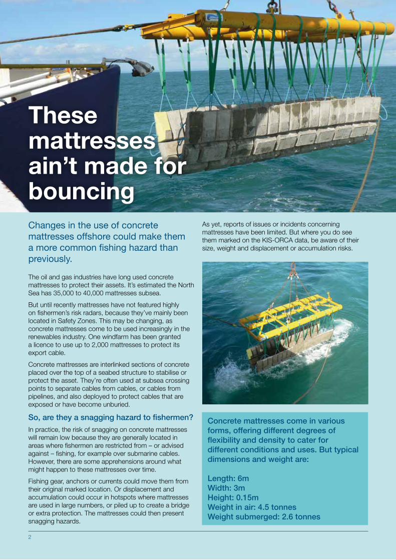
Changes in the use of concrete mattresses offshore could make them a more common fishing hazard than previously.
The oil and gas industries have long used concrete mattresses to protect their assets. It’s estimated the North Sea has 35,000 to 40,000 mattresses subsea.
But until recently mattresses have not featured highly on fishermen’s risk radars, because they’ve mainly been located in Safety Zones. This may be changing, as concrete mattresses come to be used increasingly in the renewables industry. One windfarm has been granted a licence to use up to 2,000 mattresses to protect its export cable.
Concrete mattresses are interlinked sections of concrete placed over the top of a seabed structure to stabilise or protect the asset. They’re often used at subsea crossing points to separate cables from cables, or cables from pipelines, and also deployed to protect cables that are exposed or have become unburied.
So, are they a snagging hazard to fishermen?
In practice, the risk of snagging on concrete mattresses will remain low because they are generally located in areas where fishermen are restricted from – or advised against – fishing, for example over submarine cables.However, there are some apprehensions around what might happen to these mattresses over time.
Fishing gear, anchors or currents could move them from their original marked location. Or displacement and accumulation could occur in hotspots where mattresses are used in large numbers, or piled up to create a bridge or extra protection. The mattresses could then present snagging hazards.
Concrete mattresses come in various forms, offering different degrees of flexibility and density to cater for different conditions and uses. But typical dimensions and weight are:
As yet, reports of issues or incidents concerning mattresses have been limited. But where you do see them marked on the KIS-ORCA data, be aware of their size, weight and displacement or accumulation risks.
2
These mattresses ain’t made for bouncing
Talking Points
3
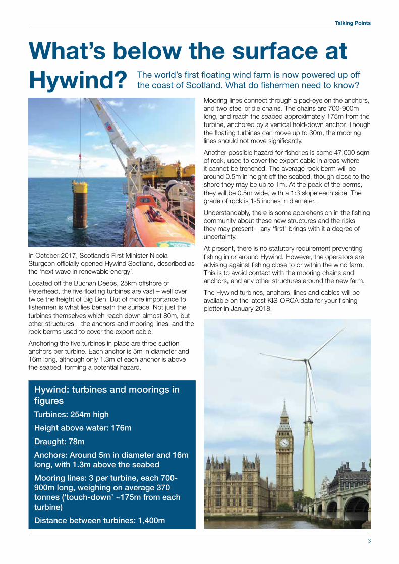
Hywind: turbines and moorings in figuresTurbines: 254m high
Height above water: 176m
Draught: 78m
Anchors: Around 5m in diameter and 16m long, with 1.3m above the seabed
Mooring lines: 3 per turbine, each 700-900m long, weighing on average 370 tonnes (‘touch-down’ ~175m from each turbine)
Distance between turbines: 1,400m
What’s below the surface at Hywind? The world’s first floating wind farm is now powered up off
the coast of Scotland. What do fishermen need to know?
In October 2017, Scotland’s First Minister Nicola Sturgeon officially opened Hywind Scotland, described as the ‘next wave in renewable energy’.
Located off the Buchan Deeps, 25km offshore of Peterhead, the five floating turbines are vast – well over twice the height of Big Ben. But of more importance to fishermen is what lies beneath the surface. Not just the turbines themselves which reach down almost 80m, but other structures – the anchors and mooring lines, and the rock berms used to cover the export cable.
Anchoring the five turbines in place are three suction anchors per turbine. Each anchor is 5m in diameter and 16m long, although only 1.3m of each anchor is above the seabed, forming a potential hazard.
Mooring lines connect through a pad-eye on the anchors, and two steel bridle chains. The chains are 700-900m long, and reach the seabed approximately 175m from the turbine, anchored by a vertical hold-down anchor. Though the floating turbines can move up to 30m, the mooring lines should not move significantly.
Another possible hazard for fisheries is some 47,000 sqm of rock, used to cover the export cable in areas where it cannot be trenched. The average rock berm will be around 0.5m in height off the seabed, though close to the shore they may be up to 1m. At the peak of the berms, they will be 0.5m wide, with a 1:3 slope each side. The grade of rock is 1-5 inches in diameter.
Understandably, there is some apprehension in the fishing community about these new structures and the risks they may present – any ‘first’ brings with it a degree of uncertainty.
At present, there is no statutory requirement preventing fishing in or around Hywind. However, the operators are advising against fishing close to or within the wind farm. This is to avoid contact with the mooring chains and anchors, and any other structures around the new farm.
The Hywind turbines, anchors, lines and cables will be available on the latest KIS-ORCA data for your fishing plotter in January 2018.
The Kingfisher Bulletin
4
What are the key issues for fishermen?Cables have been installed on the seabed since the 1850s, so they rarely make headlines around new hazards or new technology. But the processes around installing and repairing them can impact fisheries activities, and it’s useful to know what’s entailed.
In addition, the high cost of repairing subsea cables has recently led some cable companies to take legal action to recover these costs from third parties who damage charted cables.
With around 70% of cable faults caused by fishing gear, this is a development that fishermen shouldn’t ignore. The cost of repairing a subsea telecoms cable is £750,000 on average, and for power cables it can rise in excess of £5million.
These costs do not cover the downtime and loss of service costs that a cable company may experience, and which they also may seek to recover.
Repair costs aside, subsea cables are critical national infrastructure, essential for providing internet access to people and industry alike (including the UK fishing industry).
On the basis that avoiding damage is greatly preferable to repairing it, operators are keen to emphasise to fishermen the importance of charting cables on plotters and then steering clear of them, even outside periods of installation and repair.
Installing and repairing cables
InstallationCable installation is generally carried out using an offshore cableship. Where possible, cables are buried to a depth of 1m, often using a subsea cable plough towed by the cableship. Other burial ‘tools’ are also used, or post-lay burial can take place using an ROV (remotely operated vehicle).
Landing each shore end generally takes less than a day, and the installation of the cable between them will take around 0.7km/hr. There may also be seabed clearance operations beforehand to remove abandoned fishing gear, old cables or other materials.
Fishermen should receive a notice well in advance of any installation operations through Kingfisher and other channels.
Talking Points
5
Details to note include the distance vessels are advised to remain clear from the cable-laying vessel – usually 1nm – and the prior removal of static fishing gear to allow the cableship’s entry to the area.
Exposed cablesBurial of cables is the preferred option, but is not always possible, commonly because the seabed is too rocky. In areas where marine activity is low, or where burial would make the cable installation too expensive, cables may be laid on the surface of the seabed.
In addition, buried cables may become unburied as a result of seabed disturbance or mobile sediment. Fishing in such areas – especially demersal/bottom trawling – can then lead to cable damage and put fishing vessels at risk of snagging. There are around 25 cable breaks a year on the UKCS.
RepairsRepairs are generally carried out by cableships. Cables are raised to the surface using a grapnel or ROV, the damaged area is removed, a new section inserted, and the fibres and cables jointed together with a ‘final splice’.
It’s worth remembering that after a repair, a bight of cable – at least 2 x water depth – will remain at the new joint, usually laid at right angles to the cable. These sections can end up partially or wholly unburied and can be a hazard for fishing gear.
As with installation, fishermen are notified about repairs through Kingfisher and direct contact, and asked to steer clear of the area. Repairs generally take 10-14 days.
Don’t assume that all cables are buried or stay buried
Be alert to notices around installation and repairs to cables
When offshore platforms are decommissioned, an operator may be granted permission to leave the structure, or part of the structure, in place.
One possibility is that the ‘platform footings’ may be left in situ. This is the structure closest to the seabed, holding the platform in place.
The decommissioning of the North West Hutton platform in the North Sea was completed in 2012. Decommissioning involved removing the platform topside, cutting the legs and bracings over 40m above seabed (140m water depth), removing the platform template, trenching the 20” oil export / 10” gas import, and decommissioning the 12” pipeline to the Hutton Tension Leg Platform.
Due to the nature of foundation - i.e. multiple large diameter piles into each leg footing - it was not feasible to remove the entire structure. The NW Hutton footings were therefore left in place and will remain in place for the future, standing 50m above the seabed.
Although the main pipelines into and out of NW Hutton are now trenched and are not thought to be a hazard to fishermen, the remaining footings certainly present a snagging hazard and should be avoided.
In focus: Platform footings post-decommissioning
5
The Kingfisher Bulletin
6
Structures designed to be overtrawlable individually may be less so given their close proximity to each other, causing instability in the fishing gear
Fishermen should beware of four protective structures over the North Sea CATS trunkline near the T5 connection point, at 57°01.752’N 001°12.124’E. The structures are large – almost 6m high and 25m long in one case.
The four structures are located in a cluster on the gas import pipelines connecting to the CATS (Central Area Transmission System) trunkline, which transports natural gas along 400km of subsea pipeline from the Central North Sea to processing terminals on Teesside.
Each of the structures is designed to be overtrawlable when standing alone. But their positions grouped together, within 75m of each other in open water, means
they present a possible snagging threat.
Trawl gear could lose its stability when coming into contact with the first installation, and not have enough time or distance to recover before coming into contact with a second structure.
The CATS trunkline has six connections, known as ‘tees’, spaced along the pipeline. T5 connects the Banff and Stella fields to the pipeline and also has a structure in place to connect the Culzean field. The structures are constructed with steel tubulars with mesh covering. The pipelines from the fields as they approach the structures, and the infield pipe spools between the structures, are all covered by mattresses.
Fabricated onshore and piled to the seabed, the structures will remain in place until the CATS pipeline is no longer required. The anticipated life is around 30 more years.
The SFF is working with CATS to discuss if a Safety Zone would be suitable to cover the T5 location. This would avoid any interaction between the structures and fishing vessels in this area, and also protect the equipment from damage.
In the meantime, it is recommended that fishermen install the latest FishSAFE data in January 2018 and treat this area with great caution.
CATS cluster could present snagging risk
Structure Size (L x B x H) Position (WGS84)Banff PLEM structure 18.1 x 12.3 x 3.3m high 57°01.734’N 001°12.154’ECATS T5 structure 20.5 x 11.0 x 4.7m high 57°01.752’N 001°12.124’ECulzean PLEM structure 24.9 x 21.9 x 5.6m high 57°01.763’N 001°12.193’EStella PLEM structure 18.1 x 12.3 x 3.3m high 57°01.741’N 001°12.190’E
Talking Points
7
""
"
"
"
"""
"
"
""
"
"
"
"""
""""""
"
"
"
"
"
""
"
"
"
""
"
"
"
"
"
"
"
"
""
"
""
"
"
"" "
"
"
"
""
"
"
"""""
"
"
"
"
"
"
"
"
""
"
""
"
""""""
""
"
"
"
"
""
"
"
""
"
"
""
"""
"
""
"
"
"
"
"
"
"
"
"
""
"
"
""
""
"
"
"
"
"
"
"
"
""
"
"
"
"
"
"
"
"
"
"
"
"
"
"
"
"
"
""
"
"
""
"
"
"
" ""
"
"
"
"
""
"
"
" "
"
"
"
"
"
""
""
"
""
#
#
#
###
### #
###
# ##
#
##
#
#
#
#
#
#
##
#
#
#
##
##
#
## ####
####
#
###
#
##
#
#
##
#
#
#
###
#
##
##
#
#
#
#
##
##
###
###
##
##
###
#
#
#####
#
#
#
##
#
##
##
#
#
##
#
#
#
#
#
#
#
#
#
#
#
#
#
######
#
#
#
#
#
#
#
#
#
#
#
#
#
##
#
#
##
###
#
##
#
##
#
####
####
#
#
#
#
#
#
#
#
#
#
#
#
#
###
#
#
####
######
###
###
#
#
#
#
#
#
#
#
#
##
#
#
#
#
#
##
########
#
#
#
#
#####
#
#
#
#
#
#
#
##
#
##
#
####
#
##
#
####
##
##
#
#
#
#
###
#
########
####
#
#
#
#
##
#
#
#
#
#
##########
#
#
#
##
#
#
## ##
###
##
#
#
#
#
#
#
#
#
#
#
#
#
###########
##
#
#
###
#####
####
#
#
#
#
#
###
###
#
#
#
#
#
#
#
#
######
#####
#
#
#
#
#
#
#
##
#
##
#
#
#
##
#
##
#
#
#
#
#
##
#
#
#
#
#
#
#
#
#
#
#####
#
#
#
#
#
#
##
!
!!!
!!
!!
!!!!!!!!!!!!!!!!
!
!
!
!
!
!!!
!
!
!!
!!!!!!!!!!!!
!
!
!
!
!
!
!!
!!
!
!
!
!!
!
!
!
!
!
!
!
!!!!
!
!
!
! !
!
!
!!
!
!!
!
!!!!!!!!!!
!!!
!!!!!!!!
!
!
!
!!!!
!
!
!
!
!!!
!
!
!
!
!
!
!
!
!!!
!!!
!!!!
!!!!!!!!!!!!!!!!!!!!!!!
!!
!!!!!!!!!!!!!!!!
!
!
!
!
!!!!!!!!!!!
!
!!!!!!!!!
!
!
!
!
!!
!!!
!
!
!!!!!!!!
! !!!!!!!!!!!!!!
!
!!!
!
!
!
!!!!!!!!!!!!!!!!!
!
!
!
!
!
!
!
!
!
!
!
!
!!!!!!!!
!
!
!!!
!
!!!
!
!
!
!!
!!!!
!
!
!
!!
!!
!
!
!
!!!!!!!!
!
!!
!
!!!!!!!!!!!!!!!!!!!!!!!!
!
!!!!!!!!!!!!!!
!
!
!
!!
!
!!!
!
!
!
!
!!!!!
!!
!
!!!!!!!!!
!!!
!
!!!!
!!!!
!!!
!!!!
!!!!!
!
!
!
!!!!
!!!
!
!
!
!
!!
!!!
!
!
!
!!
!!
!
!
!
!!!
!!
!
!
!
!
!
!
!!
!!
!
!
!!!!!!!!!!!!!!
!
!
!
!!!!!!!!!!!
!!!!!!!!!!
!!
!!!!!!!!!!
!
!!
!
!
!
!
!
!
!
!
!
!
!
!
!
!!!!!!!!!
!!!!!
!
!
!
!
!
!
!
!
!!
!!
!!! !!
!!!
!
!!
!
!
!!!
!
!
!!
!!
!!!!!!!
!
!
!
!
!!!
!!!!
!!
!!!!!!!!!!!!
!!!!!!!!!!!!!
!
!
!
!!!!!!!!!!!!
!!!!
!!!!
!
!
!
!!!
!
!
!
!!!!!!!!!
!
!
!
!!
!
!
!!
!!
!!!!!!
!
!
!
!
!
!!
!!!!!
!
!!!!!!!!!
!
!!!!!!
!
!
!
!
!
!
!
!
!
!
!
!
!
!
!
!!
!
! !
!
!
!
!
!
!
!
!
!
!!
!!
!
!!!!!!!!
!
!!
!
!
!
!!
!!!
!
!!!! !!!!!!
!
!!!!!
!
!!!!!
!!
!
!!
!
!
!
!!
!
!!!
!
!
!
!
!
!
!
!
!!!!!!!!
!
!!!
!
!!!!!!
!
!
!!!!!!!!!!!!!!
!
!
!
!
!
!
!!!!!!!
!
!!!!!!!!!!!!!!
!!
!!!
!!!!!!!!!!!!!
!
!
!
!
!
!!
!
!!
!
!
!!
!
!!!!!!
!!! !!!!!!!!!!!!!!!
!
!!
!
!
!
!
!
!
!
!!
!
!!
!!
!
!
!
!
!
!
!
!!
!
!
!
!
!
!
!
!
!
!
!
!
!
!
!
!!
!
!!
!
!
!!
!
!
!
!
!
!
!
!
!
!
!
!
!!!!
!
!
!
!
!
!
!
!
!
!
!
!
!
!
!
!
!
!!
!!
!
!
!
!!!!!!!!!!!!
!!
!
!
!
!
!
!
!
!
!
!
!
!
!
!
!!
!
!
!
!
!
!!
!
! !
!!!
!
!
!
!
!
!
!!
!
!
!
!
!
!!
!!
!
!
!
!
!
!
!
!
!
!!!
!
!
!
!
!
!
!!!
!
!
!
!!!
!!
!
!!!
!!
!
!!
!!
!
!
!
!
!
!
!
!!
!
!
!!!!
!
!
!!
!!
!
!
!
!
!
!
!!
!
!
!!
!
!
!!!
!
!
!
!
!!
!
!!!!
!
!
!!
!
!
!!
!
!!
!!
!
!!! !
!
!
!!!!
!
!
!
!
!
!
!
!
!!
!
!
!
!
!!!
!
!!
!
!!!!
!
!
!
!
!
!
!!!!
!
!!
!!!
!
!!
!!
!!!!!
!!
!!
!
!!
!!! !
!
!
!!
!
!
!
!
!
!
!!
!!
!
!!
!!!
!!
!
!
!
!!
!
!
!!!!
!
!
!
!
!
!!
!
!!!
!
!!!!
!
!
!!
!!
!
!!
!
!
!
!
!
!
!
!
!!!!
!
!
!
!!
!
!
!!!
!!!!!
!
!
!
!
!
!
!!
!
!
!!!!
!
!
!!
!
!!!
!
!
!
!
!
!
!
!
!
!!
!
!
!
!
!
!
!
!
!
!
!
!
!
!!
!
!
!
!
!
!
!
!
!!!!
!
!
!
!
!
!!
!
!
!!!
!
!
!
!
!
!!!
!
!
!
!!!
!
!
!
!
!
!!
!
!
!
!
!
!
!
!
!!!!
IVa
VIa
IIa2
IVb
Vb1b
VIb2
VIIj2
IVc
VIIk2
VIIa
Va2
VIIe
VIIh
VIIg
VIIc2 VIIb
Vb2
VIId
VIb1
VIIk1
VIIf
VIIIaVIIIe1 VIIId2
Vb1a
VIIId1
VIIj1
XIIa4
XIIa2
Esri, DeLorme, GEBCO, NOAA NGDC, and other contributors, Sources: Esri, GEBCO, NOAA, NationalGeographic, DeLorme, HERE, Geonames.org, and other contributors
5°E
5°E
0°
0°
5°W
5°W
10°W
10°W
15°W
15°W60
°N
60°N
55°N
55°N
50°N
50°N
UK Offshore Asset Density
Low
High
! Subsurface Structure
# Surface Structures
" Suspended Wells
Pipeline
Power Cables
Non Members Power
Proposed
Out of Service Subsea
In Use Subsea Telecomms
Renewable Cables
Active Windfarms
ICES Areas
UK Exclusive Economic Zone
UK OFFSHORE ASSET DENSITY OVERVIEW
The Kingfisher Bulletin
8
Oil & gas decommissioning may create new hazards - Always have the latest Kingfisher Bulletin and fishing plotter data.