111
STS51C-143- 0027 Mississippi River Delta and Coastal Louisiana, U.S.A. Janua ry 1985 NASA PHOTO

STS51C-143-0027 Mississippi River Delta and Coastal Louisiana, U.S.A. January 1985
NASA PHOTO

78
STS61A-42-0051 Mississippi River Delta, Louisiana, U.S.A.October 1985
NASA PHOTO
20 mi
N

2
Outline
Petroleum systems Geologic principles and geologic time Rock and minerals, rock cycle, reservoir
properties Hydrocarbon origin, migration and accumulation Sedimentary environments; stratigraphic traps Plate tectonics, structural geology Structural traps Geophysical methods Importance to Schlumberger
4
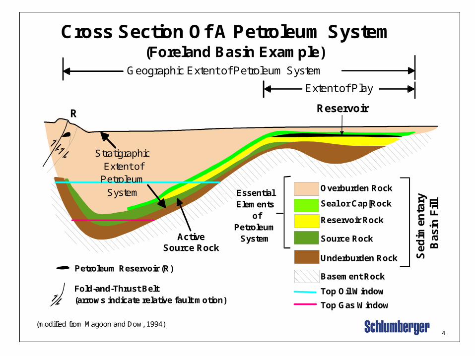
Cross Section Of A Petroleum System
Overburden Rock
Seal or Cap[Rock
Reservoir Rock
Source Rock
Underburden Rock
Basement Rock
Top Oil Window
Top Gas Window
Geographic Extent of Petroleum System
Petroleum Reservoir (R)
Fold-and-Thrust Belt(arrows indicate relative fault motion)
EssentialElements
ofPetroleum
System
(Foreland Basin Example)
(modified from Magoon and Dow, 1994)
Reservoir
Sed
imen
tary
Bas
in F
ill
R
Stratigraphic Extent of
PetroleumSystem
ActiveSource Rock
Extent of Play

Petroleum System A Petroleum System requires timely convergence of certain geologic factors and geologic events.
These Include:
Mature source rockMigrationReservoir rockSeal or cap rock

Petroleum Geology

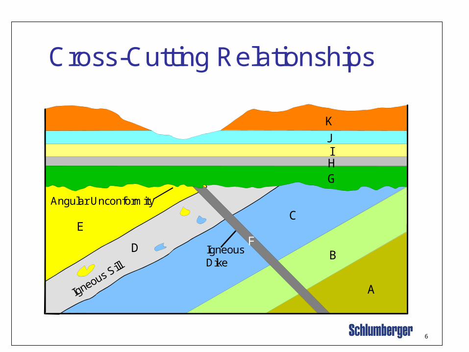
•Law of cross-cutting relationships. In the figure above, the igneous dike (F) is younger than layers A-E but older than layer G, because a geologic feature is younger than any other geologic feature that it cuts. This is an important law for determining the relative ages of geologic features.
• According to the “Law of Superposition,” layer “I” is older than layer “J,” and the rocks beneath the unconformity are older from right to left. From the “Principle of Original Horizonality,” we infer that layers “A” through “F” have been deformed.
•Sedimentary rock are deposited in successive layers that record the history of their time, much like the pages in history book. However, the rock record is never complete. Missing layers (gaps in time) result in unconformities.
• An unconformity is a surface of non-deposition or erosion that separates younger rocks from older rocks. The slide shows an angular unconformity. A nonconformity is an unconformity in which younger sedimentary rocks overlie older metamorphic or intrusive igneous rocks

The following are basic principles or laws are used to evaluate the relative ages and the relations among rock layers.
Uniformitarianism - “The present is the key to the past.” By studying modern geologic processes, we can interpret past geologic events and rock-forming processes.
Original Horizonality - “Sedimentary layers are deposited in a horizontal or nearly horizontal position.” If sedimentary layers are tilted or folded, they have been subjected to deforming stresses.
Superposition - “Younger sedimentary beds occur on top of older beds, unless they have been overturned or faulted.”
Cross-Cutting Relations - “Any geologic feature that cuts another geologic feature is younger than the feature that it cuts.”
6
Cross-Cutting Relationships
Angular Unconformity
Igneous Sill
A
B
C
D
EF
GHIJ
K
IgneousDike

7
0
50
100
150
200
250
300
350
400
450
500
550
600
0
10
20
30
40
50
60
Cry
pto
zoic
(Pre
cam
bri
an)
Phanerozoic
Quaternary
Tertiary
Cretaceous
Jurassic
Triassic
Permian
Pennsylvanian
Mississippian
Devonian
Silurian
Ordovician
Cambrian
Mill
ion
s o
f ye
ars
ago
Mill
ion
s o
f ye
ars
ago
Bill
ion
s o
f ye
ars
ago
0
1
2
3
4
4.6
Paleocene
Eocene
Oligocene
Miocene
Pliocene
PleistoceneRecent
Qu
ate
rnar
yp
eri
od
Te
rtia
ryp
eri
od
Eon Era Period Epoch
Geologic Time Chart
Pa
leoz
oic
Mes
ozo
ic
Cen
ozoi
c E
ra
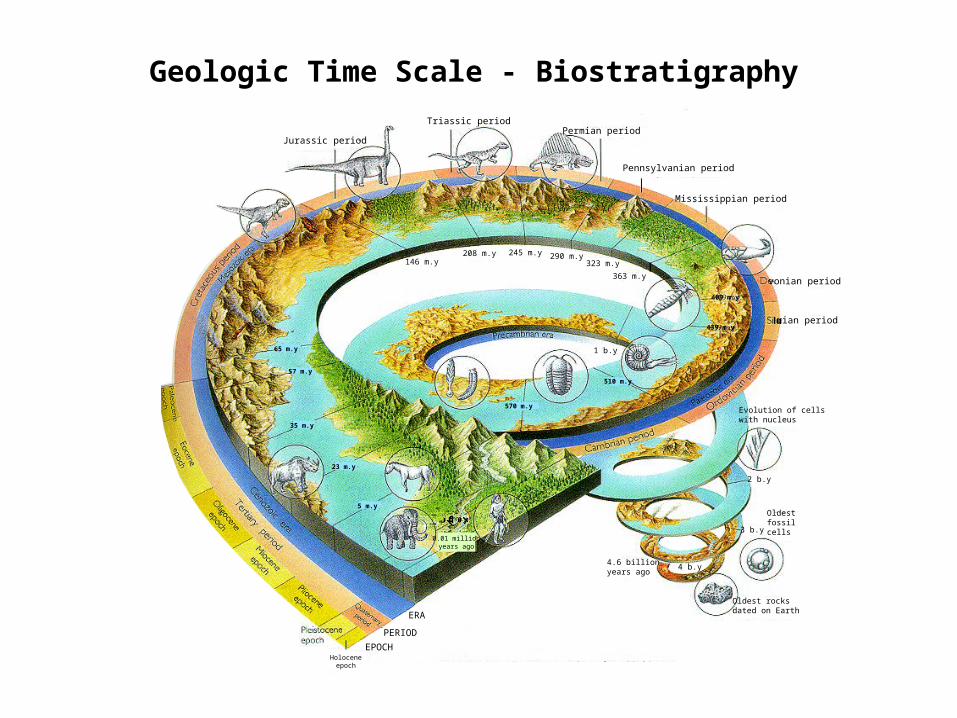
Geologic Time Scale - Biostratigraphy
Triassic period
Jurassic periodPermian period
Pennsylvanian period
Mississippian period
vonian period
rian period
Evolution of cellswith nucleus
Oldestfossilcells
Oldest rocksdated on Earth
4 b.y4.6 billionyears ago
3 b.y
2 b.y
1 b.y
146 m.y208 m.y 245 m.y 290 m.y
323 m.y
363 m.y
65 m.y
57 m.y
35 m.y
23 m.y
5 m.y
0.01 millionyears ago
ERA
PERIOD
EPOCHHolocene
epoch
570 m.y
510 m.y
439 m.y
409 m.y

5
Basic Geologic Principles
Uniformitarianism - “The present is the key to the past.”
Original Horizonality - “Sedimentary layers are deposited in a horizontal or nearly horizontal position.”
Superposition - “Younger sedimentary beds occur on top of older beds, unless they have been overturned or faulted.”
Cross-Cutting Relations - “Any geologic feature that cuts another geologic feature is younger than the feature that it cuts.”

10
Classification of RocksSEDIMENTARY
Ro
ck-f
orm
ing
pro
ces
sS
ou
rce
of
ma
teri
al
IGNEOUS METAMORPHIC
Molten materials in deep crust andupper mantle
Crystallization(Solidification of melt)
Weathering anderosion of rocks
exposed at surface
Sedimentation, burial and lithification
Rocks under high temperatures
and pressures in deep crust
Recrystallization due toheat, pressure, or
chemically active fluids
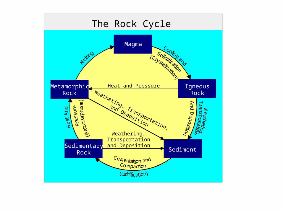
The Rock Cycle
Magma
MetamorphicRock
SedimentaryRock
IgneousRock
Sediment
Heat and Pressure
Weathering,Transportationand Deposition
Weathering, Transportation,
and Deposition
Cooling and
Solidification
Mel
ting
(Crystalization)
He
atA
nd
Pre
ssur
e
(Met
amor
phi
sm)
Weath
ering,T
ransp
ortation
An d
Dep
osition
Cementation andCompaction
(Lithification)

12
Igneous RocksComprise 95% of the Earth's crust.
Originated from the solidification of molten material from deep inside the Earth.
There are two types:
•Volcanic - glassy in texture due to fast cooling.
•Plutonic - slow-cooling, crystalline rocks.

13
Igneous Rocks and Reservoirs
Igneous rocks can be part of reservoirs. Fractured granites form reservoirs in some parts of the world. Volcanic tuffs are mixed with sand in some reservoirs.
Example: Granite Wash - Elk City, Okla., Northern Alberta,CA

17
Siltstone, mudand shale
~75%
Sedimentary Rock Types
• Relative abundanceSandstone
and conglomerate~11%
Limestone anddolomite
~13%
18
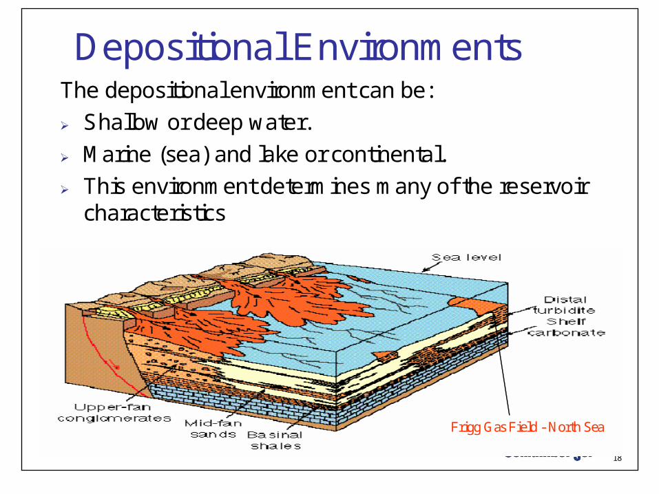
Depositional EnvironmentsThe depositional environment can be: Shallow or deep water. Marine (sea) and lake or continental. This environment determines many of the reservoir
characteristics
Frigg Gas Field - North Sea
19
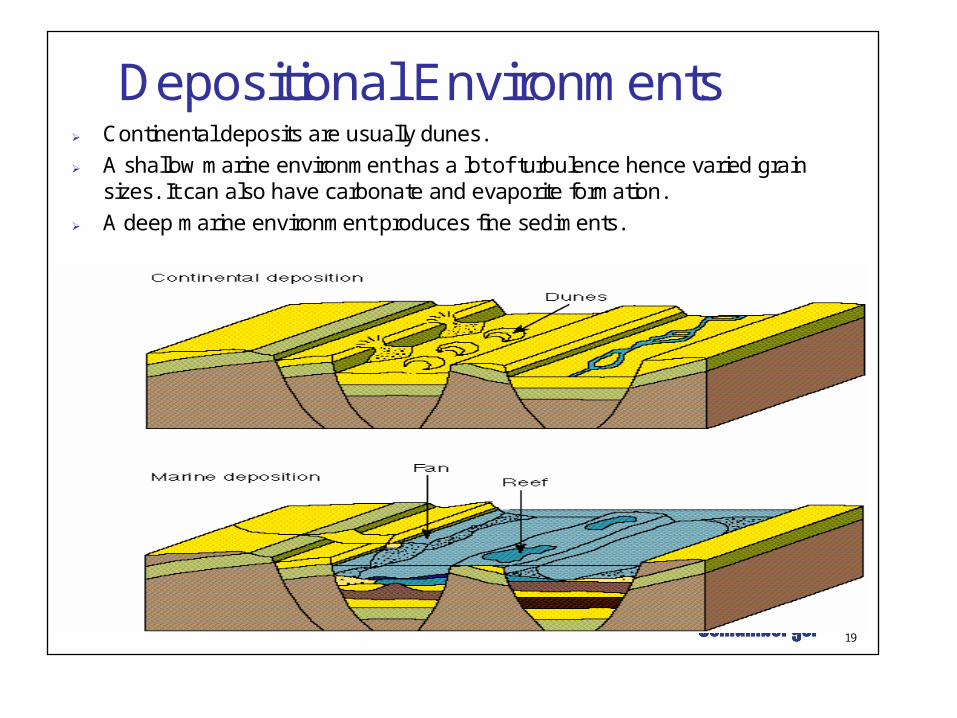
Depositional Environments Continental deposits are usually dunes. A shallow marine environment has a lot of turbulence hence varied grain
sizes. It can also have carbonate and evaporite formation. A deep marine environment produces fine sediments.

21
Clastic Reservoirs
Consolidated and unconsolidate sands
Porosity• Determined mainly by the packing and mixing of grains.
Permeability• Determined mainly by grain size and packing, connectivity
and shale content.
Fractures may be present.
ExampleExample
BrecciaBreccia
SandstoneSandstone
ConglomerateConglomerate
ShaleShale
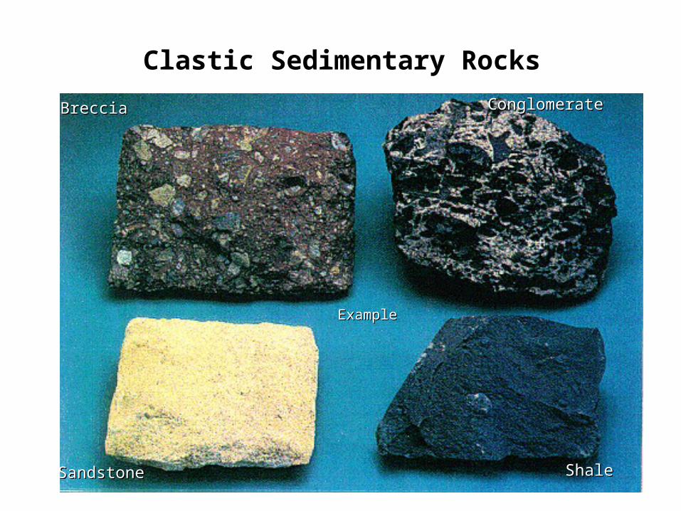
Clastic Sedimentary Rocks

•Some sedimentary rock types•Breccia - Coarse-grained, angular fragments - little transport; •Conglomerate - Coarse-grained, mixture of rounded pebbles and sand ranging widely in size; well rounded pebbles imply some transport in a high energy system•Sandstone - commonly quartz, feldspar, or rock fragments; deposited in many environments•Shale - very fine grained; composed primarily of clay; deposited in low-energy environments such as lakes, bays, lagoons, of deep marine settings

24
Clastic Rocks
Clastic rocks are sands, silts and shales. The difference is in the size of the grains.
Size ??
23
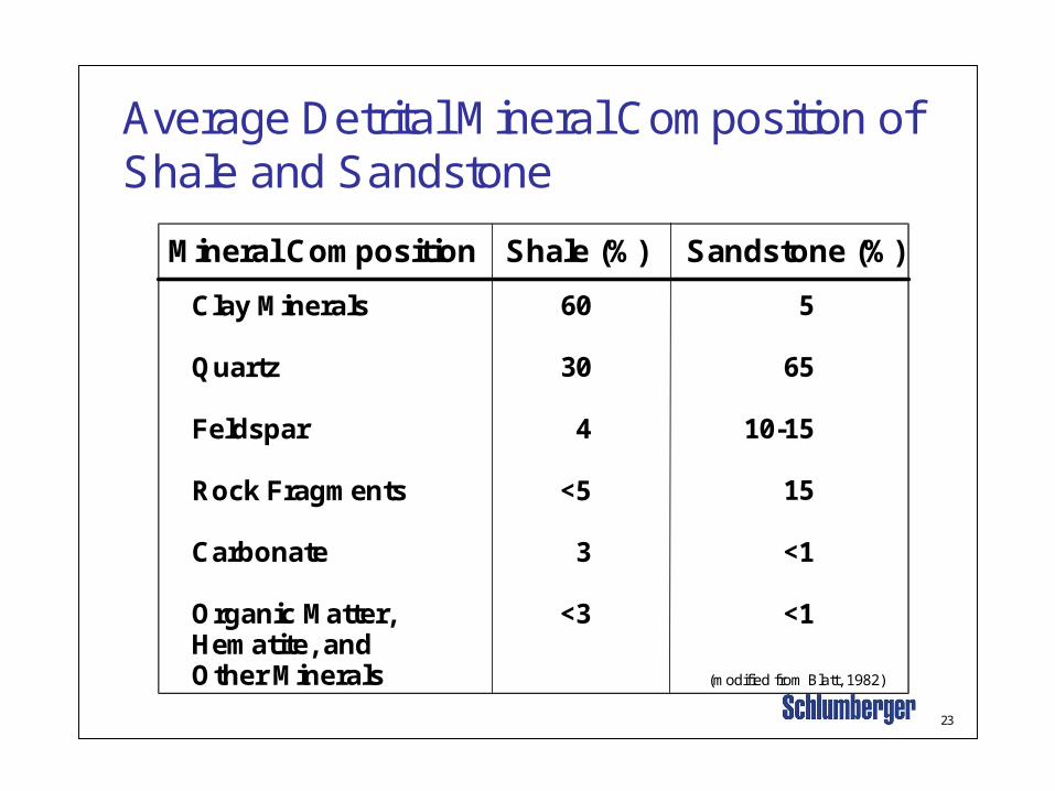
Average Detrital Mineral Composition of Shale and Sandstone
Mineral Composition Shale (%) Sandstone (%)
Clay Minerals
Quartz
Feldspar
Rock Fragments
Carbonate
Organic Matter,Hematite, andOther Minerals
60
30
4
<5
3
<3
5
65
10-15
15
<1
<1
(modified from Blatt, 1982)
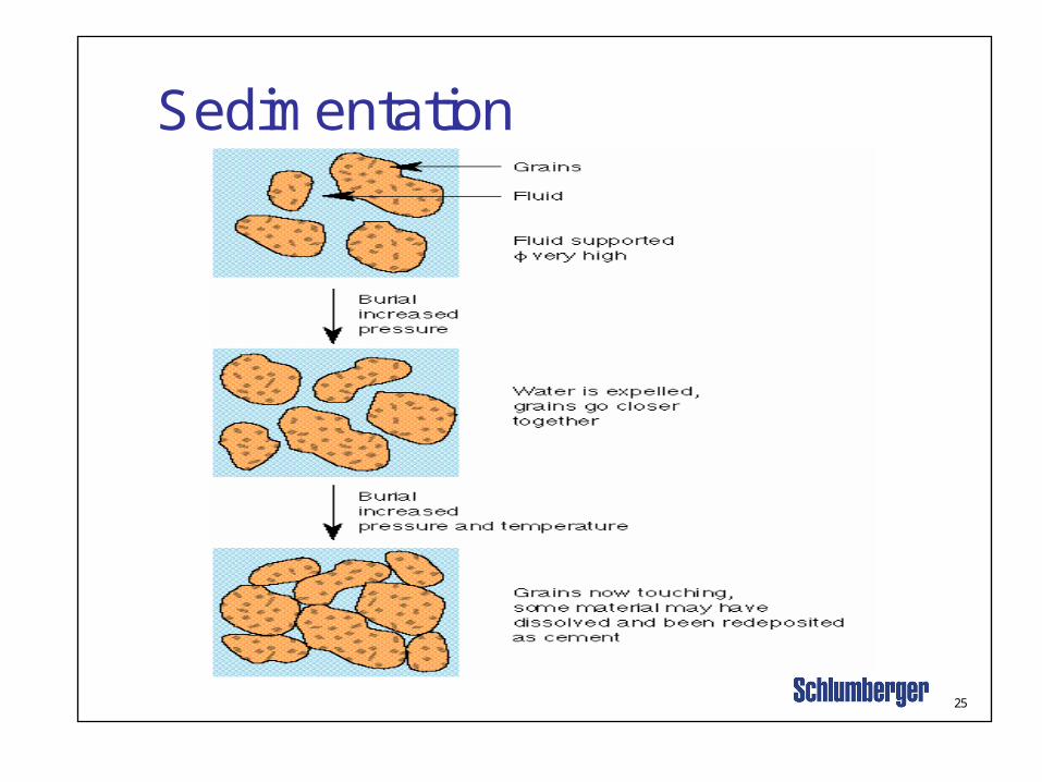
25
Sedimentation

27
Environment Agent Of TransportationDeposition
Sediments
Alluvial Rivers Sand, gravel, mud
Lake Lake currents, waves Sand, mud
Desert Wind Sand, dust
Glacial Ice Sand, gravel, mud
Delta River + waves, tides Sand, mud
Beach Waves, tides Sand, gravel
Shallow shelf Waves, tides Sand, mud
Deep sea Ocean currents, settling Sand, Mud
Clastic Sedimentary Environments
Organic Material =

28
Depositional Environment - Delta Sediments are transported to the basins by rivers. A common depositional environment is the delta where the river empties into the sea. A good example of this is the Mississippi (Miocene and Oligocenesands)

29
Rivers
Some types of deposition occur in rivers and sand bars. The river forms a channel where sands are deposited in
layers. Rivers carry sediment down from the mountains which is then deposited in the river bed and on the flood plains at either side.
Changes in the environment can cause these sands to be overlain with a shale, trapping the reservoir rock.


31
Sandstone Composition Framework Grains
Qtz
Qtz
Qtz
Qtz
Ankerite
Quartz
Quartz
Quartz
Qtz
Framework
Cement
Pores
Matrix

32
Scanning Electron MicrographNorphlet Formation, Offshore Alabama, USA
Pores Provide theVolume to ContainHydrocarbon Fluids
Pore Throats RestrictFluid Flow
PoreThroat
Porosity in Sandstone
33
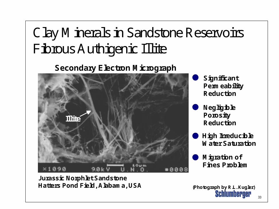
Secondary Electron Micrograph
Jurassic Norphlet SandstoneHatters Pond Field, Alabama, USA (Photograph by R.L. Kugler)
Illite
SignificantPermeabilityReduction
Negligible PorosityReduction
Migration ofFines Problem
High IrreducibleWater Saturation
Clay Minerals in Sandstone ReservoirsFibrous Authigenic Illite
34
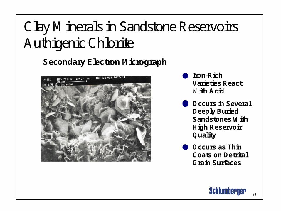
Secondary Electron Micrograph
Occurs as ThinCoats on DetritalGrain Surfaces
Occurs in SeveralDeeply BuriedSandstones WithHigh Reservoir Quality
Iron-Rich Varieties ReactWith Acid
Clay Minerals in Sandstone ReservoirsAuthigenic Chlorite
35
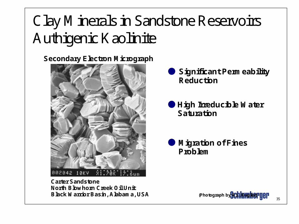
Secondary Electron Micrograph
Carter SandstoneNorth Blowhorn Creek Oil UnitBlack Warrior Basin, Alabama, USA
Significant PermeabilityReduction
High Irreducible WaterSaturation
Migration of FinesProblem
(Photograph by R.L. Kugler)
Clay Minerals in Sandstone ReservoirsAuthigenic Kaolinite

36
100
10
1
0.1
0.01 0.01
0.1
1
10
100
1000
2 6 10 14 2 6 10 14 18
Per
mea
bili
ty (
md
)
Porosity (%)
Authigenic Illite Authigenic Chlorite
(modified from Kugler and McHugh, 1990)
Effects of Clays on Reservoir Quality
37
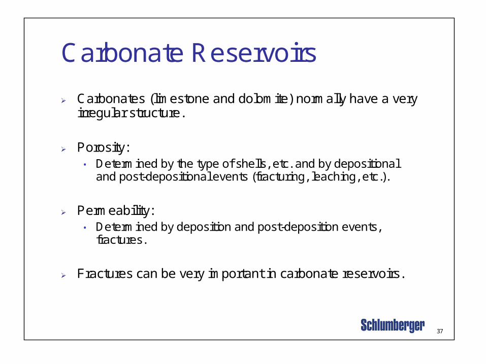
Carbonate Reservoirs
Carbonates (limestone and dolomite) normally have a very irregular structure.
Porosity:• Determined by the type of shells, etc. and by depositional
and post-depositional events (fracturing, leaching, etc.).
Permeability:• Determined by deposition and post-deposition events,
fractures.
Fractures can be very important in carbonate reservoirs.

38
Carbonate types Chalk is a special form of limestone (CaCO3) and is
formed from the skeletons of small creatures (cocoliths).
Dolomite (CaMg(CO3)2) is formed by the replacement of some of the calcium by a lesser volume of magnesium in limestone. Magnesium is smaller than calcium, hence the matrix becomes smaller and more porosity is created. • ???
Evaporites such as Salt (NaCl) and Anhydrite (CaSO4) can also form in these environments.• ??

39
Depositional Environment Carbonates
Carbonates are formed in shallow seas containing features such as:• Reefs.• Lagoons.• Shore-bars.

40
Diagenesis The environment can also involve subsequent alterations of the rock
such as:• Chemical changes.• Diagenesis is the chemical alteration of a rock after burial. An example is the
replacement of some of the calcium atoms in limestone by magnesium to form dolomite.
• Mechanical changes - fracturing in a tectonically-active region.
42
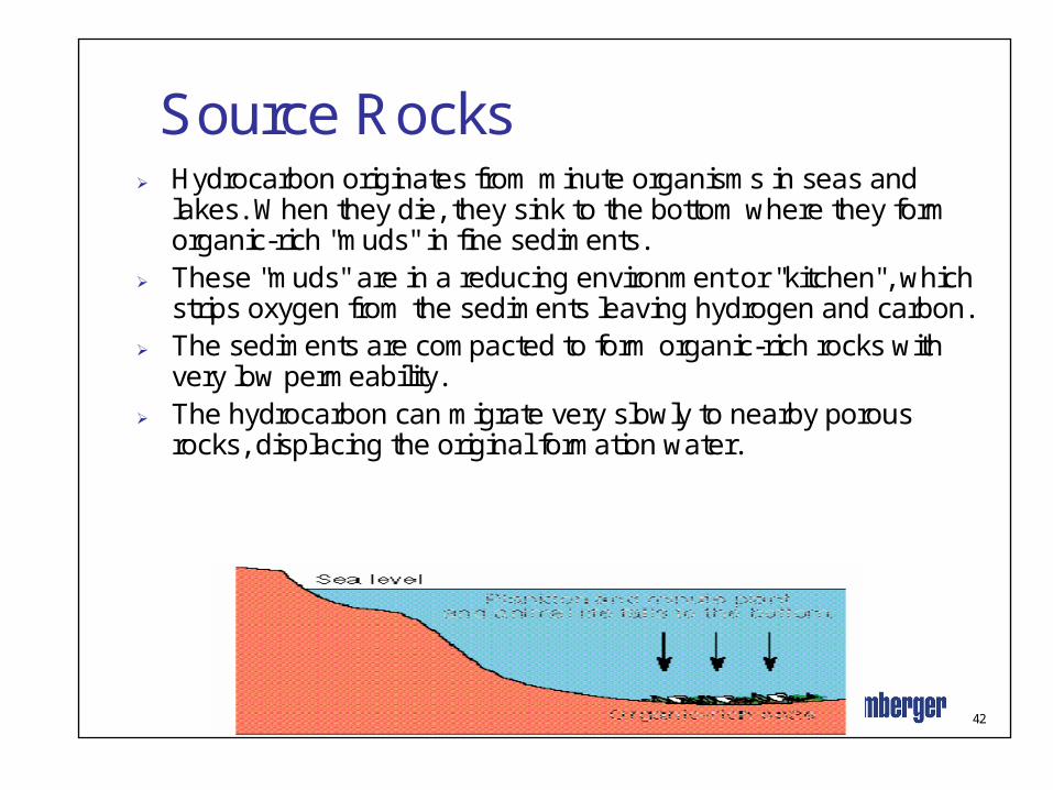
Source Rocks Hydrocarbon originates from minute organisms in seas and
lakes. When they die, they sink to the bottom where they form organic-rich "muds" in fine sediments.
These "muds" are in a reducing environment or "kitchen", which strips oxygen from the sediments leaving hydrogen and carbon.
The sediments are compacted to form organic-rich rocks with very low permeability.
The hydrocarbon can migrate very slowly to nearby porous rocks, displacing the original formation water.

43
Hydrocarbon Migration
Hydrocarbon migration takes place in two stages:Primary migration - from the source rock to a porous rock. This is a complex process and not fully understood.It is probably limited to a few hundred metres.Secondary migration - along the porous rock to the trap.This occurs by buoyancy, capillary pressure and hydrodynamics through a continuous water-filled pore system.It can take place over large distances.
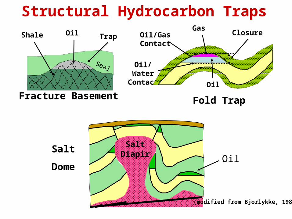
Structural Hydrocarbon Traps
SaltDiapir
Oil/WaterContact
GasOil/GasContact
Oil
ClosureOilShale Trap
Fracture Basement
(modified from Bjorlykke, 1989)
Fold Trap
Seal
OilSalt
Dome

44
Organic Matter in Sedimentary Rocks
Reflected-Light Micrographof Coal
Vitrinite
KerogenDisseminated Organic Matter inSedimentary Rocks That is Insolublein Oxidizing Acids, Bases, andOrganic Solvents.
VitriniteA nonfluorescent type of organic materialin petroleum source rocks derived primarily from woody material.
The reflectivity of vitrinite is one of thebest indicators of coal rank and thermalmaturity of petroleum source rock.
45
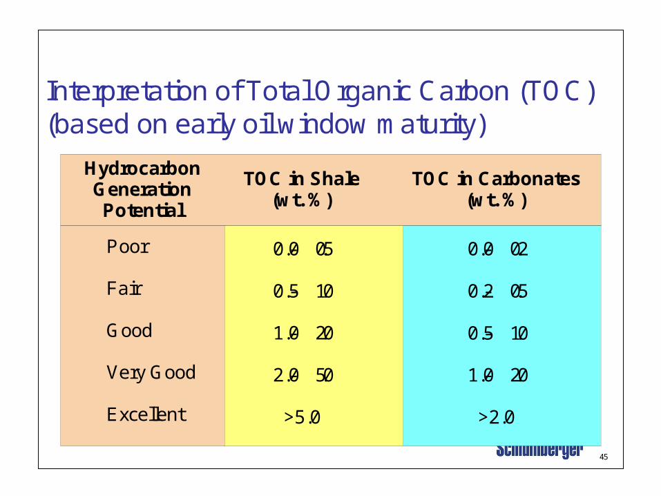
Interpretation of Total Organic Carbon (TOC)(based on early oil window maturity)
HydrocarbonGenerationPotential
TOC in Shale(wt. %)
TOC in Carbonates(wt. %)
Poor
Fair
Good
Very Good
Excellent
0.0- 0.5
0.5- 1.0
1.0- 2.0
2.0- 5.0
>5.0
0.0- 0.2
0.2- 0.5
0.5- 1.0
1.0- 2.0
>2.0

Magma risingMagma rising
AsthenosphereAsthenosphere
Magma Magma formingforming
• Distribution ofearthquakes
Lithosphere
Oceanic crustMid-ocean ridge
DIVERGENT BOUNDARY:Seafloor spreading
Volcanism
CONVERGENT BOUNDARY:Plate subduction
Mountain building
Continental crust
Basic Elements of Plate Tectonics

48
Wrench fault
Sedimentary Basin andStress Fields
Pull-apart Basin(Lateral Stress)
Normal fault
Thrust fault
Foreland Basin(Compressive Stress)
Rift Related Basin(Extensional Stress)
Fault Types Basin Geometries
Sedimentary Fill

50
Folded Structures
Anticline Syncline
Convex upward
?? Age
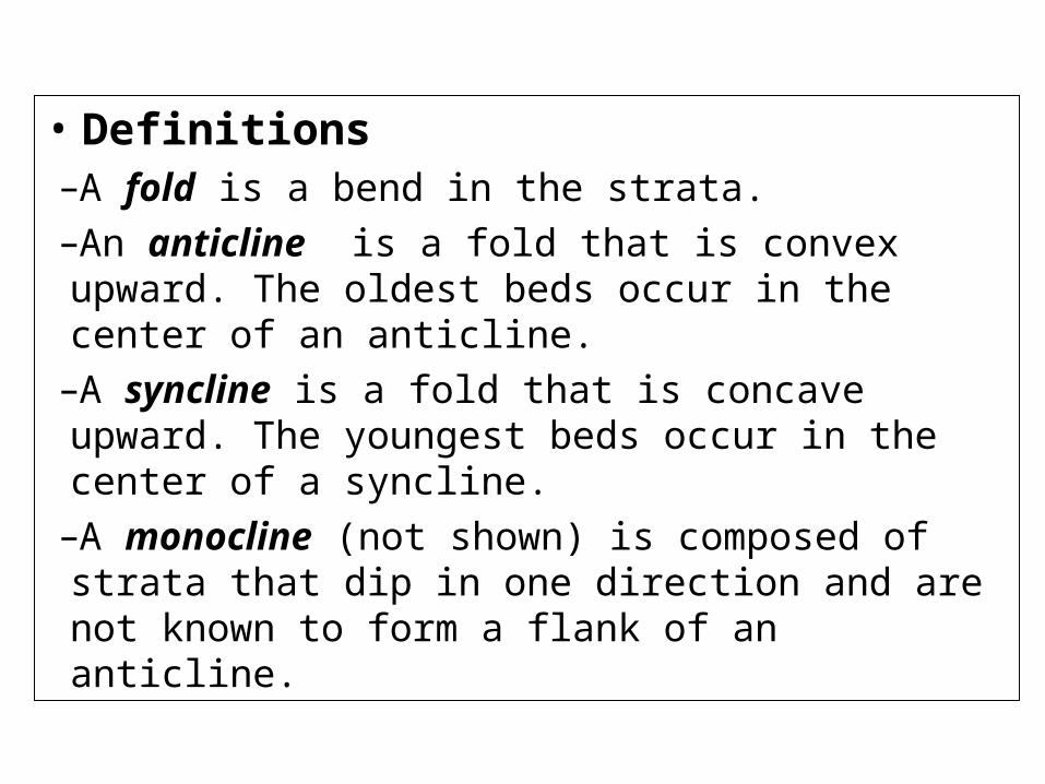
• Definitions–A fold is a bend in the strata.–An anticline is a fold that is convex upward. The oldest beds occur in the center of an anticline.
–A syncline is a fold that is concave upward. The youngest beds occur in the center of a syncline.
–A monocline (not shown) is composed of strata that dip in one direction and are not known to form a flank of an anticline.

51
Fold Terminology
Anticline
Syncline
Oldest rock
Youngest rock
Modified from xxx)
Limb
Limb
N
Limb

Faulting

54
Strike Slip Fault(Left Lateral)
N
Fault Plane
Stri
ke Dip Angle

52
H.W.
FaultScarp
Dow
nthrown
Upthrow
n
Strike direction
F.W.
Fault plane
Dip angle
Normal Fault
Key bed
Fault scarp
Dow
nthrown
Upthrow
n
F.W.
H.W.
Fault plane
Dipangle
Strike direction
Reverse Fault
Faults
Fracture: Joint and Fault

56
Geologic Reservoir Heterogeneity

57
Scales of Geological Reservoir Heterogeneity
Fie
ld W
ide
Inte
rwel
lW
ell-
Bo
re
(modified from Weber, 1986)
Hand Lens orBinocular Microscope
Unaided Eye
Petrographic orScanning Electron
Microscope
DeterminedFrom Well Logs,Seismic Lines,
StatisticalModeling,
etc.
10-100'sm
10-100'smm
1-10'sm
100'sm
10'sm
1-10 km
100's m
Well WellInterwell
Area
ReservoirSandstone

58
Hydrocarbon Traps
Structural traps
Stratigraphic traps
Combination traps
59
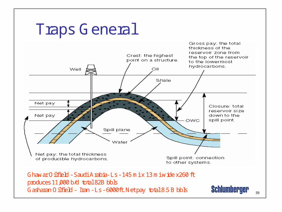
Traps General
Ghawar Oilfield - Saudi Arabia- Ls - 145 mi x 13 mi wide x260 ftproduces 11,000 b/d total 82B bblsGasharan Oilfield - Iran - Ls - 6000ft. Net pay total 8.5 B bbls

60
Structural Hydrocarbon Traps
SaltDiapir
Oil/WaterContact
GasOil/GasContact
Oil
ClosureOilShale Trap
Fracture Basement
(modified from Bjorlykke, 1989)
Fold Trap
Seal
OilSalt
Dome

61
Fault Traps Faults occur when the rock shears due to stresses. Reservoirs
often form in these fault zones. A porous and permeable layer may trap fluids due to its location
alongside an impermeable fault or its juxtaposition alongside animpermeable bed.
Faults are found in conjunction with other structures such as anticlines, domes and salt domes.
Normal Faults - Nigeria,Hibenia (E. Canada), VicksburgTrends (Victoria, TX)
Drag Faults - Wyoming,most Rocky Mountains
Normal or Reverse Fault???

62
Stratigraphic Traps
Point Bars - Powder River Basin, WY, Clinton SS in Western Ok,
Michigan - Belle River Mills
Devonian reefs (Barriers and Atolls) -Alberta CA. (Leduc & Redwater)
Midland Basin &Delaware Basin of West TX - Barrier Reefs

64
Petroleum Exploration-Geophysical Methods
Gravity methods
Magnetic surveys
Seismic surveys

65
-3-2-1+1
Salt2.1 gm/cm3
Corrected Gravity(Bouguer Anomaly)
UncorrectedGravity
Clastics2.4 gm/cm3
Meter
GravityValue (mgal)
Principle of Gravity Surveys
66
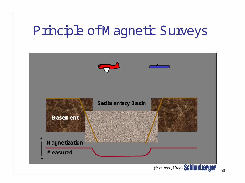
Principle of Magnetic Surveys
+
-
Basement
Sedimentary Basin
Magnetization
Measured
(from xxx, 19xx)

67
Seismic Surveys
The seismic tools commonly used in the oil and gas industry are 2-D and 3-D seismic data
Seismic data are used to:– Define and map structural folds and faults– Identify stratigraphic variations and map sedimentary
facies– Infer the presence of hydrocarbons
68
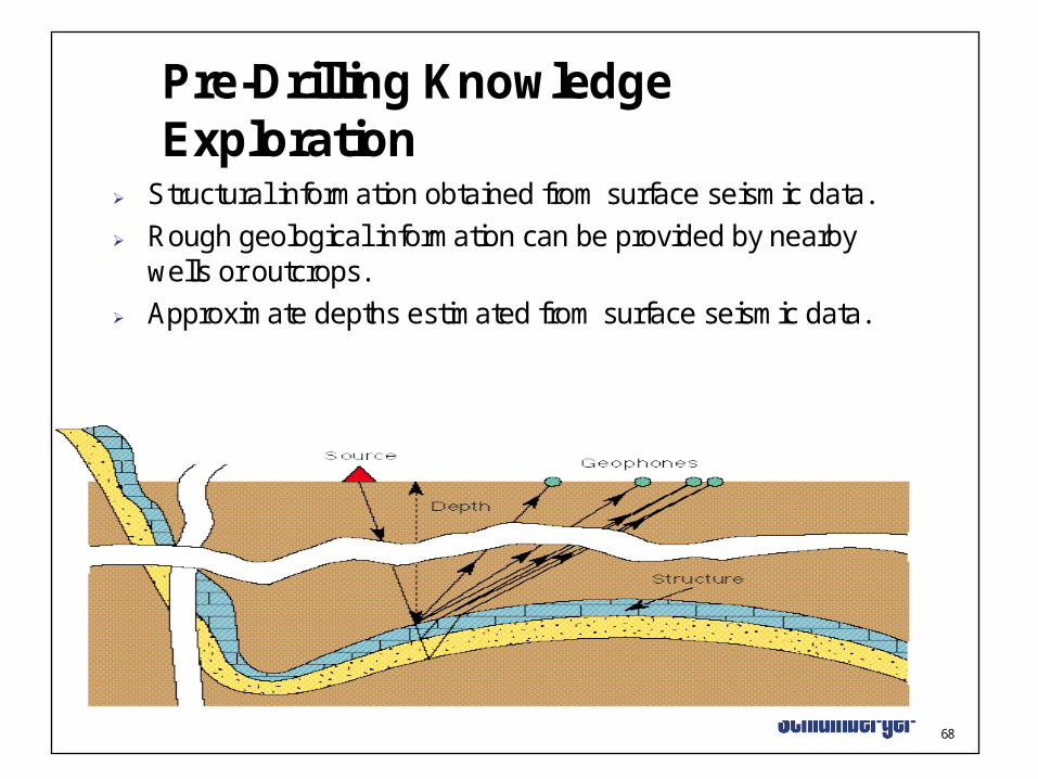
Pre-Drilling Knowledge Exploration
Structural information obtained from surface seismic data. Rough geological information can be provided by nearby
wells or outcrops. Approximate depths estimated from surface seismic data.
69
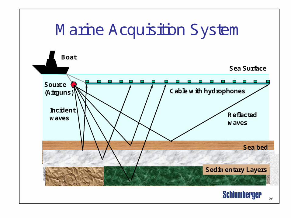
Sea bed
Boat
Cable with hydrophones
Sea Surface
Source(Airguns)
Sedimentary Layers
Incidentwaves Reflected
waves
Marine Acquisition System

70
Crossline 470 (East)
N S
Source
Reservoirs
Seal (unconformity)
71
Applications of Seismic Data
Make a structural model of the reservoir Delineate and map reservoir-quality rocks Establish gas/water contacts
72
VL
E 4
00
Fa
ult
- 128
00
- 12800
00621
-
- 12600
- 11400
- 12600
00821-
00821-
- 12400
-1
2000
-11800
00611-
-11600
-12400
- 126
00
- 124
00
- 130
00
00421-
00621-
00621-
- 128
00
- 12800
-124
00
-12
20
0
-11
60
0- 1
24
00
-12
40
0
-13
00
0
-12
80
0
-1260 0
W
N
m
0 3000
0 1000
ft
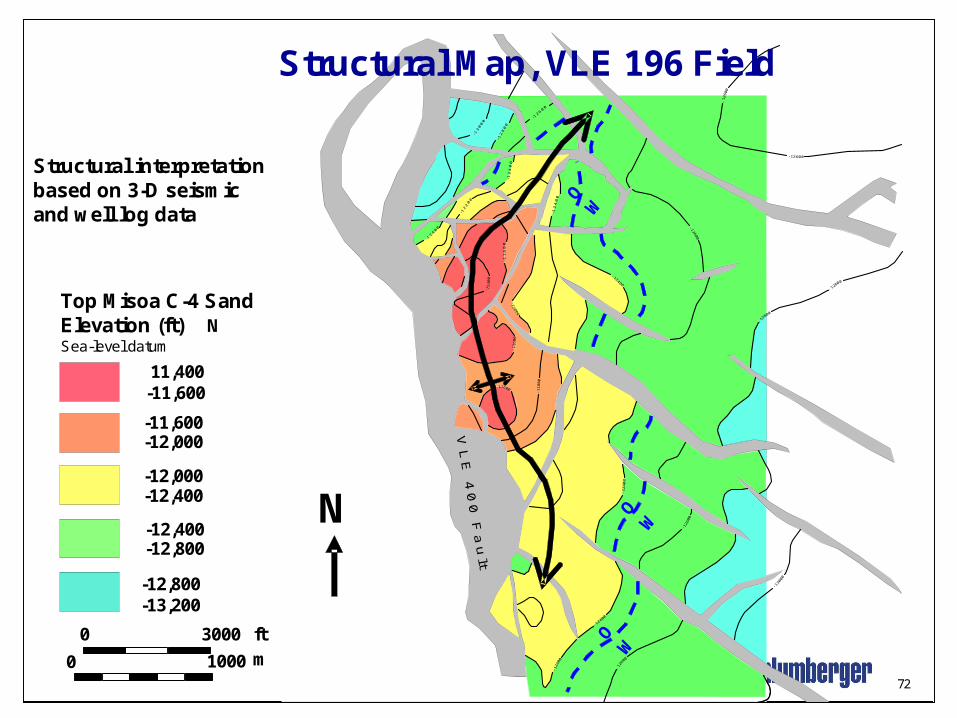
-11,600-12,000
-12,000-12,400
11,400-11,600
Top Misoa C-4 SandElevation (ft)Sea-level datum
-12,400-12,800
-12,800-13,200
OW
OW
O
Structural Map, VLE 196 Field
N
Structural interpretationbased on 3-D seismic and well log data

73
SeismicAmplitude
Mapof a
Horizon
Channels
Modified from Brown, 1996
3-D Seismic datadefine reservoir-quality,channel-fillsand deposits
74
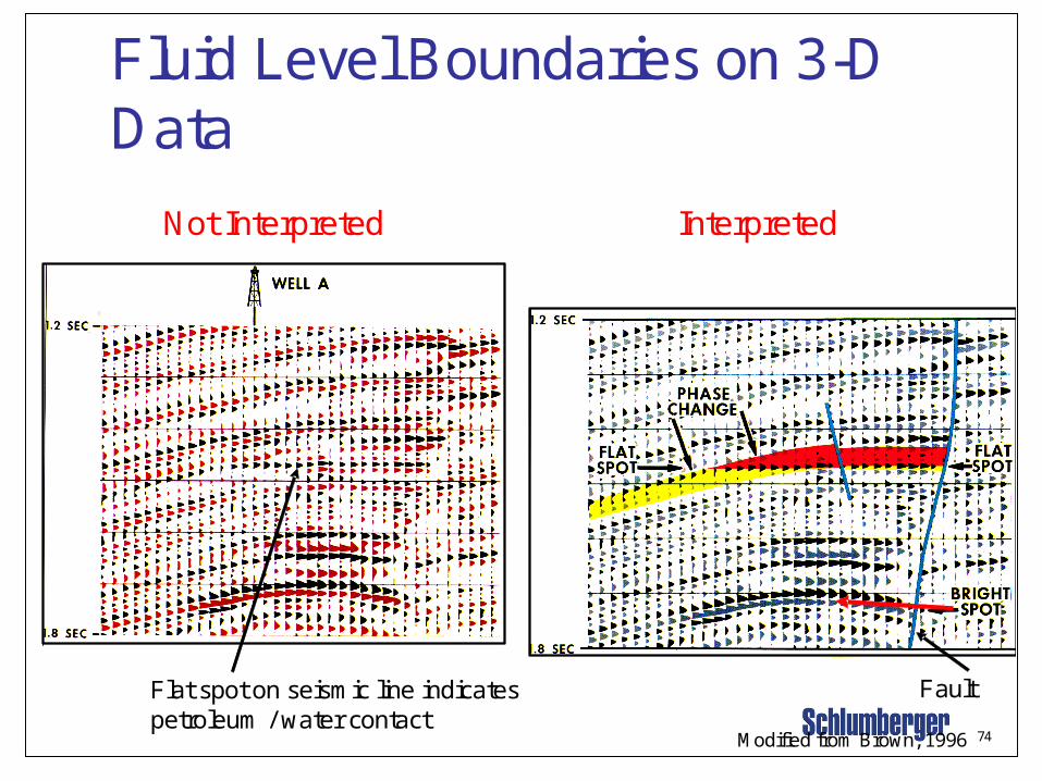
Fluid Level Boundaries on 3-D Data
Modified from Brown, 1996
Not Interpreted Interpreted
Flat spot on seismic line indicates petroleum / water contact
Fault

Exercise 11. Oil forms at lower temperatures than gas. T_____ F ______
2. The law of (original horizontality, uniformitarianism, superposition) states that, in a normal sedimentary sequence, younger layers occur on top of older layers.
3. The largest division of geologic time is the (era, eon, period, epoch).
4. Hydrocarbons are most abundant in (metamorphic, igneous, sedimentary) rocks.
5. The most abundant sedimentary rock type is shale. T____ F ______
6. Name 3 clay minerals common in sandstone reservoirs
A. _____________________ B.____________________ C. _________ ___________
7. Clastic rocks are formed from the materials of older rocks by the actions of erosion, transportation and __________________.
8. Clastic rocks are sedimentary. T___ F____
9. Name two non-clastic sedimentary rocks. A.______________ B.________________
10.Alluvial, desert, delta, beach and shallow shelf sediment make the best reservoirs
T_______ F_______
81
Exercise 21. 1. Diagenesis is the chemical alteration of a rock after burial. T___ F ___
2. (Magnesium, Iron, or Sulfate) must be in the formation water in order to convert limestone to dolomite.
3. Limestone is (CaCO3 or Ca(CO3)2).
4. Dolomite is MgCaCO3 or MgCa(CO3)2.
5. Reef deposits are classified as (clastic, carbonate) sedimentary rocks.
6. The source rock must contain (organic material, coal, methane).
7. Fault and anticline traps occur only in gas wells. T___ F___
8. The oil water contact can be observed using seismic T___ F___
9. (Historical, structural, tectonic) geology addresses the occurrence and origin of smaller scale deformational features, such as folds and faults, that may be involved in hydrocarbon migration or which may form structural hydrocarbon traps.
10. Good quality sandstone reservoirs normally contain ~ (1-10 or 25-30% silt and clay).
82
N
a b
c d
23
1
4
34 4
Well
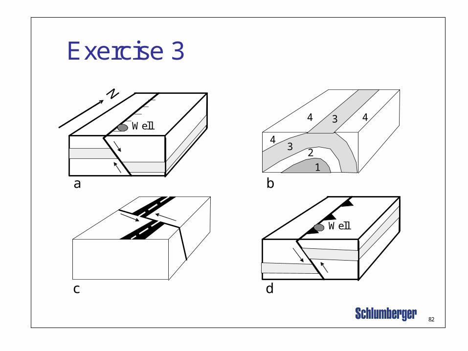
Exercise 3
Well
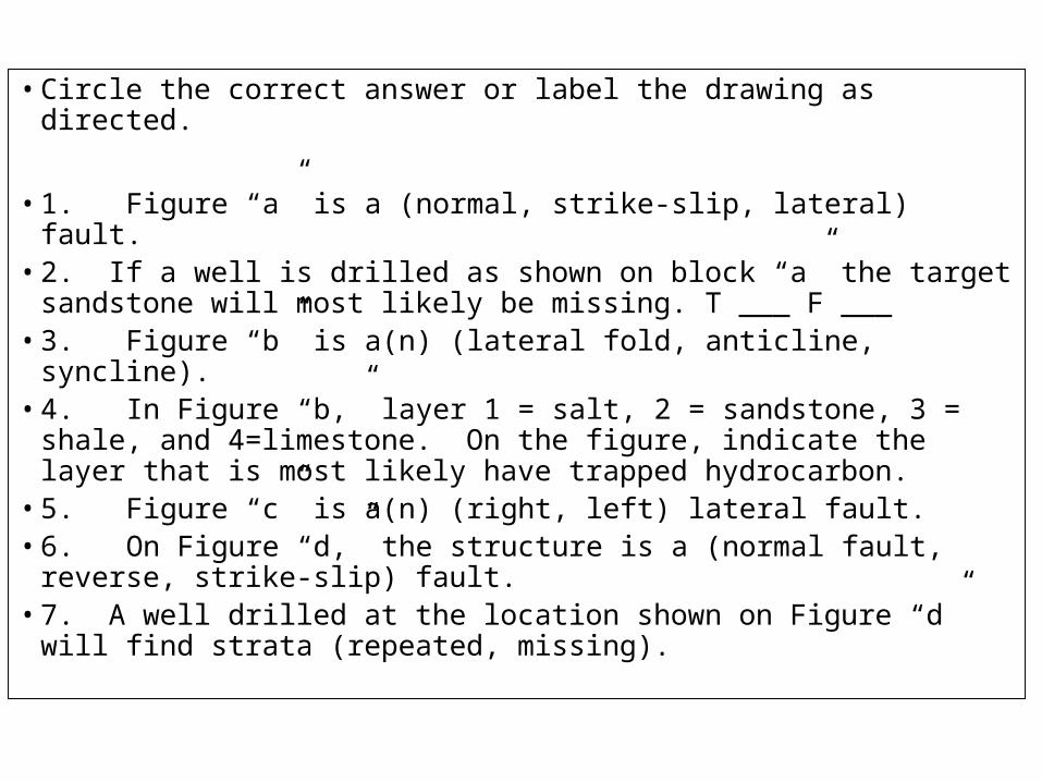
• Circle the correct answer or label the drawing as directed.
• 1. Figure “a” is a (normal, strike-slip, lateral) fault.• 2. If a well is drilled as shown on block “a” the target
sandstone will most likely be missing. T ___ F ___• 3. Figure “b” is a(n) (lateral fold, anticline, syncline).• 4. In Figure “b,” layer 1 = salt, 2 = sandstone, 3 = shale,
and 4=limestone. On the figure, indicate the layer that is most likely have trapped hydrocarbon.
• 5. Figure “c” is a(n) (right, left) lateral fault.• 6. On Figure “d,” the structure is a (normal fault, reverse,
strike-slip) fault.• 7. A well drilled at the location shown on Figure “d” will find
strata (repeated, missing).
83
Exercise 41. Hydrocarbons reservoirs are normally in (igneous, metamorphic,
sedimentary) rocks.
2. Fluorescence of drill cuttings or core indicates (oil, gas, water) is present.
3. Reservoir traps are (very impermeable, highly permeable).
3. What are 2 uses of seismic data in petroleum exploration and development?
1. ________________________________________________
2. _________________________________________________
4. In inclined reservoir rocks, what is the significance of a “flat spot” in seismic sections?
5. What is a 4-D seismic evaluation?
5
Basic Geologic Principles
Uniformitarianism - “The present is the key to the past.”
Original Horizonality - “Sedimentary layers are deposited in a horizontal or nearly horizontal position.”
Superposition - “Younger sedimentary beds occur on top of older beds, unless they have been overturned or faulted.”
Cross-Cutting Relations - “Any geologic feature that cuts another geologic feature is younger than the feature that it cuts.”

•The following are basic principles or laws are used to evaluate the relative ages and the relations among rock layers.
•Uniformitarianism - “The present is the key to the past.” By studying modern geologic processes, we can interpret past geologic events and rock-forming processes.•Original Horizonality - “Sedimentary layers are deposited in a horizontal or nearly horizontal position.” If sedimentary layers are tilted or folded, they have been subjected to deforming stresses.•Superposition - “Younger sedimentary beds occur on top of older beds, unless they have been overturned or faulted.”•Cross-Cutting Relations - “Any geologic feature that cuts another geologic feature is younger than the feature that it cuts.”

KLASIFIKASI BATUAN Batuan merupakan agregat padat yang terdiri dari mineral atau mineraloid, kebanyakan batuan terdiri atas beberapa jenis mineral (mineral, gelas, ubahan mineral organik, dan kombinasi dari komponen-komponen tersebut) (Ernest G. Ehlers & Harvey Blatt, 1980).
Batuan didefinisikan juga sebagai kumpulan mineral alamiah yang terkristalkan oleh ‘proses pembentukan batuan’ (Huckenholz, 1982).

• BERDASARKAN GENESA DAN KOMPOSISI
– Batuan Beku– Batuan Piroklastik– Batuan Sedimen– Batuan Metamorf

Distribusi batuan di bumi :
• Batuan beku di kerak bumi bagian atas
• Batuan sedimen di permukaan
• Batuan metamorf di inti dalam, mantel, kerak bumi bagian bawah
BATUAN BEKU
• Batuan beku adalah batuan yang terbentuk akibat membekunya magma pada waktu perjalannya menuju ke permukaan bumi.
• Hasil dari pembekuan magma tersebut membentuk berbagai jenis mineral yang mengikuti aturan tingkat diferensiasi dari magma.
• Magma adalah cairan silikat yang panas dan pijar yang terdiri atas unsur-unsur O, Si, Al, Fe, Mg, Ca, Na, K dan sebagainya.
• Komposisi batuan beku dapat dibedakan dari komposisi secara mineralogi.:
– Mineral utama (olivin, piroksen, felspar, kuarsa, plagioklas, dsb)
– Mineral tambahan: mineral yang terbentuj dari kristalisasi magma tapi kehadirannya sedikit (contoh: apatit, rutil, mineral bijih, dsb)
– Mineral sekunder: mineral hasil ubahan dari mineral-mineral primer (contoh: klorit, epidot, dll)

Kimiawi
• Unsur utama (major element): seperti unsur oksoda SiO2, Al2O3, dll.
• Unsur jejak (trace element): seperti Sr, Rb, Ba, dll.
• Unsur tanah jarang (rare earth element): seperti La, Ce, Pr, dll.
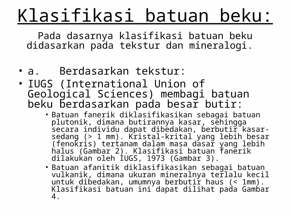
Klasifikasi batuan beku:Pada dasarnya klasifikasi batuan beku didasarkan pada
tekstur dan mineralogi.
• a. Berdasarkan tekstur:• IUGS (International Union of Geological
Sciences) membagi batuan beku berdasarkan pada besar butir:
• Batuan fanerik diklasifikasikan sebagai batuan plutonik, dimana butirannya kasar, sehingga secara individu dapat dibedakan, berbutir kasar-sedang (> 1 mm). Kristal-krital yang lebih besar (fenokris) tertanam dalam masa dasar yang lebih halus (Gambar 2). Klasifikasi batuan fanerik dilakukan oleh IUGS, 1973 (Gambar 3).
• Batuan afanitik diklasifikasikan sebagai batuan vulkanik, dimana ukuran mineralnya terlalu kecil untuk dibedakan, umumnya berbutir haus (< 1mm). Klasifikasi batuan ini dapat dilihat pada Gambar 4.

• Berdasarkan mineralogi (Gambar 5)• Dasar klasifikasi:• Komposisi (%) mineral utama• Kimiawi:
• silika (% SiO2) : ultrabasa (SiO2 < 45%)
• basa (SiO2 45 – 52%)• intermediate (SiO2 52 – 66%)• asam (SiO2 > 66%)
• alumina saturation– peralumina : jenuh terhadap alumina (Al2O3 > Na2O + K2O +CaO)– peralkaline : oksida alkalin > oksida alumina– subalumina : oksida alumina =/> oksida alkalin (Na2O + K2O)– metalumina : oksida alumina =/> Na2O + K2O +CaO
• color index proporsi mineral felsik dan mafik
• Batuan Piroklastik adalah batuan hasil letusan gunungapi. Terdiri atas material-material piroklastik, yaitu pecahan gelas/abu/debu gunungapi, kristal, lithik.
• Klasifikasi batuan piroklastik:• Pada dasarnya pembagian batuan piroklastik
didasarkan pada ukuran butir. Penamaan: tuf, tuf lapili, breksi piroklastik atau breksi vulkanik (Gambar 6). Untuk yang berbutir halus (<4 mm): tuff gelas, tuf kristal, tuf lithik (Tabel 1).
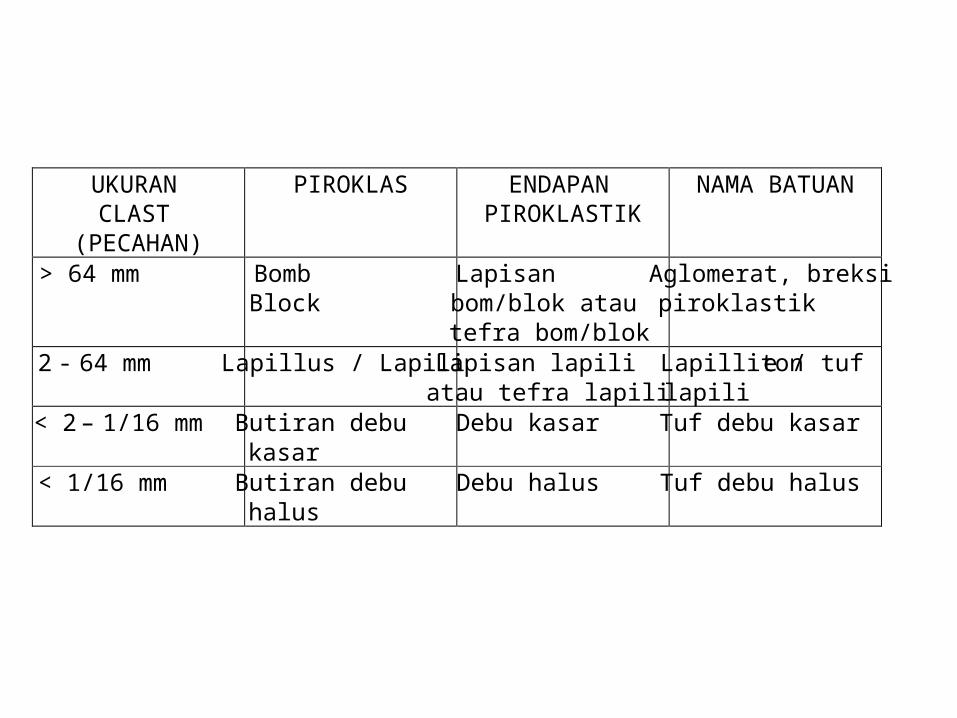
UKURAN CLAST
(PECAHAN)
PIROKLAS ENDAPAN PIROKLASTIK
NAMA BATUAN
> 64 mm Bomb Block
Lapisan bom/blok atau tefra bom/blok
Aglomerat, breksi piroklastik
2 - 64 mm Lapillus / Lapili Lapisan lapili atau tefra lapili
Lapillitone / tuf lapili
< 2 – 1/16 mm Butiran debu kasar
Debu kasar Tuf debu kasar
< 1/16 mm Butiran debu halus
Debu halus Tuf debu halus

• Selain batuan piroklastik ini juga dikenal batuan epiklastik, yaitu batuan yang terbentuk dari campuran atau rombakan material-material batuan piroklastik (vulkanik) (Gambar 7). Contoh: batupasir vulkanik, tuf pasiran, dll.
BATUAN SEDIMEN
• Batuan sedimen adalah batuan yang berasal dari rombakan batuan yang telah ada yang telah mengalami siklus sedimentasi (pelapukan-transportasi-sedimentasi-diagenesa) (Gambar 9).

• Komposisi batuan sedimen:– Fragmen mineral/batuan hasil rombakan (terigen)– Material hasil proses kimiawi (material auttigenik), contoh:
karbonat, fosfat.– Material allochem (rombakan hasil presipitasi terdahulu),
contoh: fosil, mineral organik, dll.
• Penggolongan batuan sedimen
• Batuan sedimen dapat diklasifikasikan berdasarkan beberapa cara:
» Berdasarkan proses pembentukannya (Gambar 10):» Sedimentasi mekanis, contoh batulanau,
batulempung, batupasir, dll.» Sedimentasi organis, contoh batubara, batugamping
terumbu, batugamping bioklastik, dll» Sedimentasi kimiawi, contoh batugamping kristalin,
dolomit, batugamping oolith, gips, anhidrit, dll.
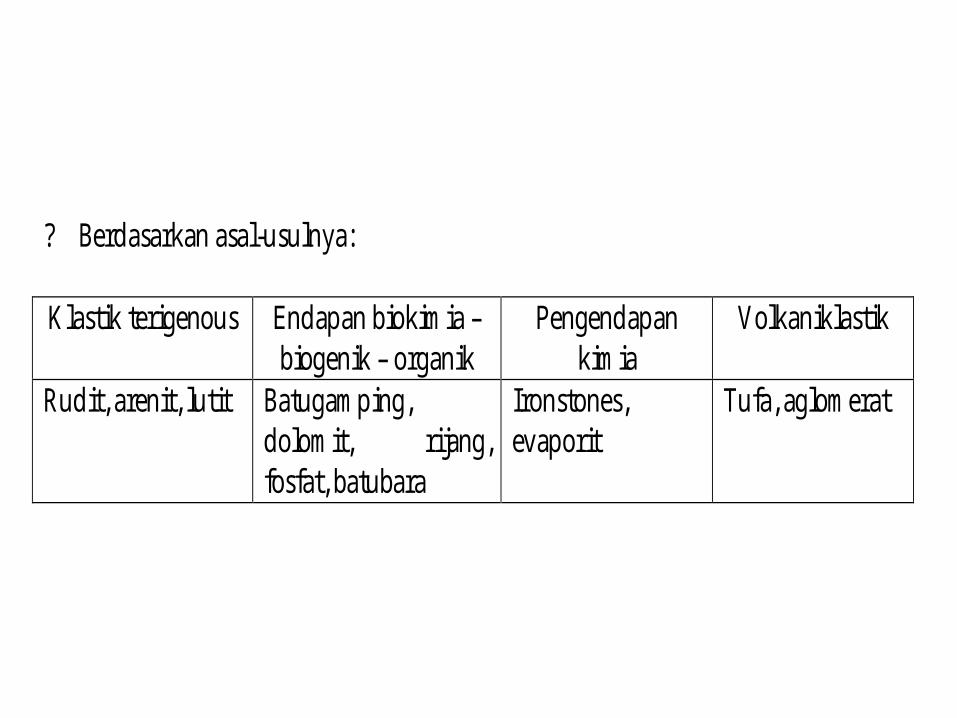
? Berdasarkan asal-usulnya: Klastik terigenous Endapan biokimia –
biogenik – organik Pengendapan
kimia Volkaniklastik
Rudit, arenit, lutit Batugamping, dolomit, rijang, fosfat, batubara
Ironstones, evaporit
Tufa, aglomerat

Batuan Sedimen Berdasarkan Tekstur
• Berdasarkan teksturnya dibagi menjadi dua, yaitu yang bertekstur klastik (berdasarkan mekanisme pengendapan), dan batuan yang bertekstur non klastik (kristalin).

• Batuan Sedimen Klastik
• Terdiri atas material detritus (hasil rombakan / pecahan), memperlihatkan tekstur klastik. Ukuran butir halus – kasar (Gambar 11), dibagi berdasarkan skala yang dinyatakan oleh Wentworth (Gambar 12).

Unsur-unsur tekstur batuan sedimen klastik:
• Butiran (grain) : klastik yang tertransport yang disebut sebagai fragmen.• Matriks (masa dasar) : lebih halus dari fragmen/butiran, mengisi rongga antar fragmen,
diendapkan bersama-sama dengan fragmen.• Semen : berukuran halus, mengikat butiran/fragmen dan matriks, diendapkan ditempat
sedimentasi setelah fragmen dan matriks.• Pemilahan (sorting) : derajat kesamaan atau keseragaman butir. Dinyatakan dalam skala baik,
sedang, atau buruk.• Porositas : perbandingan volume pori terhadap volume batuan secara keseluruhan. Biasanya
dinyatakan dalam % atau dalam kualitas (baik, sedang atau buruk). Batuan dengan butir yang seragam (terpilah baik) akan mempunyai porositas yang relatif lebih besar dari batuan dengan pemilahan buruk. Clay memiliki porositas yang paing besar, lalu batupasir dan kemudian breksi atau konglomerat.
• Kebundaran : menyatakan kebundaran atau ktajaman butiran yang mencerminkan tingkat abrasi selama transportasi. Merupakan sifat permukaan dari butiran yang disebabkan oleh pengaruh transportasi terhadap butiran.
• Kemas (fabric) : merupakan sifat hubungan antar butir sebagai fungsi orientasi atau packing. Dinyatakan dalam skala terbuka (kontak antar butiran tidak bersentuhan) dan tertutup (kontak antar butiran saling bersentuhan).
• Permeabilitas : kemampuan batuan meloloskan fluida, yang mencerminkan poriyang saling berhubungan. Batupasir merupakan batuan dengan permeabilitas yang baik, sedangkan clay walaupun memiliki porositas baik tapi permeabilitasnya yang buruk. Karena mineral dalam clay termasuk kedalam minera pirosilika yang bersifat konduktif, sehingga clay ini mengikat kation yang akan mengikat OH. Oleh karena itu clay memiliki sifat swelling (dapat mengembang bila terkena air), yang menyebabkan resistivity dari clay ini sangat rendah (Gambar 13).
• Struktur sedimen : penyimpangan dari bidang perlapisan. Struktur sedimen ini mencerminkan mekanisme yang mempengaruhi pengendapan batuan sedimen. Contoh: strutur sedimen pada mekanisme arus turbidit yang dinyatakan oleh Bouma dalam Sikuen Bouma.

Batuan Sedimen Non-Klastik
• Umumnya tersusun atas mineral autigenik (terbentuk di tempat sedimentasi). Pada P dan T tertentu seringkali memperlihatkan gejala diagenesa, akibatnya porositas batuan menjadi sangat rendah atau bakhan tidak ada. Porositas primer rendah dan memperlihatkan tekstur mozaik (contoh batugamping). Kadang-kadang terdapat butiran yang amorf (seperti kalsedon dan opal) sebagai semen.

Batuan Sedimen Kimiawi
• Terbentuk akibat peranan/pengaruh proses-proses kimia dari larutan. Terdiri atas batuan karbonat dan batuan evaporit.
Batuan Karbonat
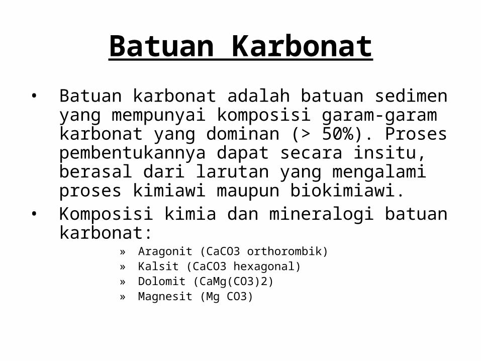
• Batuan karbonat adalah batuan sedimen yang mempunyai komposisi garam-garam karbonat yang dominan (> 50%). Proses pembentukannya dapat secara insitu, berasal dari larutan yang mengalami proses kimiawi maupun biokimiawi.
• Komposisi kimia dan mineralogi batuan karbonat:
» Aragonit (CaCO3 orthorombik)» Kalsit (CaCO3 hexagonal)» Dolomit (CaMg(CO3)2)» Magnesit (Mg CO3)
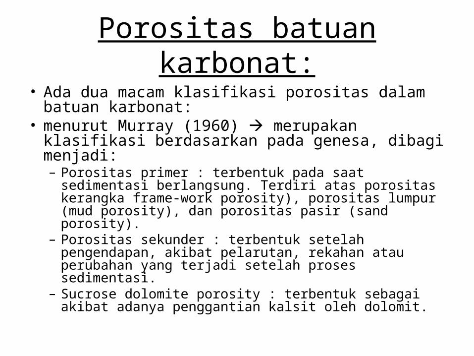
Porositas batuan karbonat:
• Ada dua macam klasifikasi porositas dalam batuan karbonat:
• menurut Murray (1960) merupakan klasifikasi berdasarkan pada genesa, dibagi menjadi:– Porositas primer : terbentuk pada saat sedimentasi
berlangsung. Terdiri atas porositas kerangka frame-work porosity), porositas lumpur (mud porosity), dan porositas pasir (sand porosity).
– Porositas sekunder : terbentuk setelah pengendapan, akibat pelarutan, rekahan atau perubahan yang terjadi setelah proses sedimentasi.
– Sucrose dolomite porosity : terbentuk sebagai akibat adanya penggantian kalsit oleh dolomit.
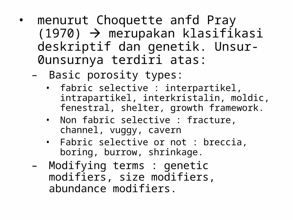
• menurut Choquette anfd Pray (1970) merupakan klasifikasi deskriptif dan genetik. Unsur-0unsurnya terdiri atas:
– Basic porosity types:• fabric selective : interpartikel, intrapartikel,
interkristalin, moldic, fenestral, shelter, growth framework.
• Non fabric selective : fracture, channel, vuggy, cavern
• Fabric selective or not : breccia, boring, burrow, shrinkage.
– Modifying terms : genetic modifiers, size modifiers, abundance modifiers.
Klasifikasi batuan karbonat
• Klasifikasi dalam batuan karbonat antara lain dikemukakan oleh Grabau (1913), Folk (1953), Pettijohn (1957), Dunham (1962), Embry and Klovan (1972), dll.
• Klasifikasi yang banyak digunakan dalam penggolongan batuan karbonat adalah klasifikasi menurut Dunham, dan Embry and Klovan, karena klasifikasi ini cukup sederhana dan mudah dalam pemnakaiannya.

Klasifikasi Dunham (1962)
• Klasifikasi ini didasarkan pada tekstur pengendapan (Gambar 17). Faktor yang penting dalam klasifikasi ini adalah:
• Butiran didukung lumpur (mud supported)• Butiran saling menyangga (grain
supported)• Sebagian butiran didukung lumpur,
sebagian butiran saling menyangga (parteil)

Klasifikasi Embry and Klovan (1972)
• Merupakan modifikasi dari klasifikasi Dunham, didasarkan pada terdapatnya lumpur diantara kerangka atau pecahan kerangka (Gambar 14).

Batuan Evaporit
• Merupakan batuan garam yang terbentuj jarena evaporasi air laut.. Mineral penyusunnya bersifat monomineralik, antara lain: garam (CaSO4 2H2O), anhidrit (CaSO4), dan halit (NaCl)

BATUAN METAMORF
• Batuan metamorf adalah batuan yang terbentuk akibat proses perubahan tekanan (P) dan temperatur (T) atau keduanya, dimana batuan memasuki kesetimbangan baru tanpa adanya perubahan komposisi kimia (isokimia) dan tanpa melalui fasa cair (dalam keadaan padat) dengan temperatur berkisar 200-800º C.

Perubahan yang terjadi dalam proses metamorfosa: perubahan tekstur dan struktur (yang merefleksikan sejarah pembentukkannya); dan asosiasi mineral.
Struktur batuan metamorf:• Struktur foliasi (schistosity) struktur paralel
yang ditimbulkan oleh mineral pipih/mineral prismatik, seringkali terjadi pada metamorfosa regional dan metamorfosa kataklastik.
• Struktur non foliasi struktur yang dibentuk oleh mineral-mineral yang equidimensional, seringkali terjadi pada metamorfosa termal.

Beberapa struktur batuan metamorf:
Yang bersifat foliasi:
• Slaty cleavage planar, dijumpai bidang belah batu sabak/slate.• Filitik rekristalisasi lebih kasar dari slaty cleavage.• Shistose struktur perulangan dari mineral pipih dan mineral
granular dimana mineral pipih orientasinya menerus (tidak terputus).• Gneisose struktur perulangan dari mineral pipih dan mineral
granular dimana mineral pipih orientasinya terputus, sering disebut close schistosity.
• Milonitik menunjukan goresan-goresan akibat penggerusan yang kuat.
• Filonitik gejala dan kenampakan sama dengan milonitik, hanya disini butirannya lebih halus.

Yang bersifat non foliasi:
• Granulose terdiri atas mineral granular• Hornfelsik identik dengan granoblastik, tapi mineral
equidimensional. Lepidoblastik terdiri atas mineral pipih/tabular
• Nematoblastik terdiri atas mineral prismatik• Granoblastik terdiri atas mineral granular• Homeoblastik terdiri atas satu tekstur saja• Heteroblastik terdiri atas beberapa tekstur• Relic (sisa) tekstur sisa yang terbentuk sebelum
metamorfosa• Kristaloblastik setiap tekstur yang terbentuk pada saat
metamorfosa• Awalan “meta” bila masih dikenali sifat batuan
asalnya, seperti metasedimen, metavolkanik, dll.

CONTINENTAL SEDIMENTARY ENVIRONMENTS Copyright 1998 Pamela J . W. Gore
ALLUVIAL FAN FLUVIAL LACUSTRINE DESERT (DUNES) PALUDAL
Rock Type Breccia, conglomerate, arkose
Conglomerate, sandstone, siltstone, shale
Siltstone, shale, limestone, or evaporites (gypsum)
Quartz arenite (sandstone) or gypsum
Peat, coal, black shale, siltstone
Composition Terrigenous Terrigenous Terrigenous, carbonate, or evaporite
Terrigenous or evaporite
Terrigenous
Color Brown or red Brown or red Black, brown, gray, green Yellow, red, tan, white
Black, gray, or brown
Grain Size Clay to gravel Clay to gravel (Fining upward)
Clay to silt or sand (Coarsening upward)
Sand Clay to silt
Grain Shape Angular Rounded to angular
--- Rounded ---
Sorting Poor Variable Variable Good Variable
Inorganic Sedimentary Structures
Cross-bedding and graded bedding
Asymmetrical ripples, cross-bedding, graded bedding, tool marks
Symmetrical ripples, lamination, cross-bedding, graded bedding, mudcracks, raindrop prints
Cross-bedding Laminated to massive
Organic or Biogenic Sedimentary Structures
--- Tracks, trails,burrows
Tracks, trails, burrows, rare stromatolites
Tracks, trails Root marks, burrows
Fossils --- Rare freshwater shells, bones, plant fragments
Freshwater shells, fish, bones, plant fragments
--- Plant fossils, rare freshwater shells, bones, fish

MARINE SEDIMENTARY ENVIRONMENTS Copyright 1998 Pamela J . W. Gore
REEF CONTINENTAL SHELF
CONTINENTAL SLOPE AND RISE
ABYSSAL PLAIN
Rock Type Fossiliferous limestone
Sandstone, shale, siltstone, fossiliferous limestone, oolitic limestone
Litharenite, siltstone, and shale (or limestone)
Shale, chert, micrite, chalk, diatomite
Composition Carbonate Terrigenous or carbonate
Terrigenous or carbonate Terrigenous or carbonate
Color Gray to white Gray to brown Gray, green, brown Black, white red
Grain Size Variable, frameworks, few to no grains
Clay to sand Clay to sand Clay
Grain Shape --- --- --- ---
Sorting --- Poor to good Poor Good
Inorganic Sedimentary Structures
--- Lamination, cross-bedding
Graded bedding, cross-bedding, lamination, flute marks, tool marks (turbidites)
Lamination
Organic or Biogenic Sedimentary Structures
--- Trails, burrows Trails, burrows Trails, burrows
Fossils Corals, marine shells
Marine shells Marine shells, rare plant fragments Marine shells (mostly microscopic)
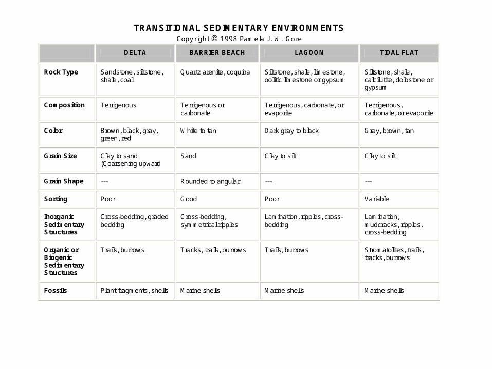
TRANSITIONAL SEDIMENTARY ENVIRONMENTS Copyright 1998 Pamela J . W. Gore
DELTA BARRIER BEACH LAGOON TIDAL FLAT
Rock Type Sandstone, siltstone, shale, coal
Quartz arenite, coquina Siltstone, shale, limestone, oolitic limestone or gypsum
Siltstone, shale, calcilutite, dolostone or gypsum
Composition Terrigenous Terrigenous or carbonate
Terrigenous, carbonate, or evaporite
Terrigenous, carbonate, or evaporite
Color Brown, black, gray, green, red
White to tan Dark gray to black Gray, brown, tan
Grain Size Clay to sand (Coarsening upward
Sand Clay to silt Clay to silt
Grain Shape --- Rounded to angular --- ---
Sorting Poor Good Poor Variable
Inorganic Sedimentary Structures
Cross-bedding, graded bedding
Cross-bedding, symmetrical ripples
Lamination, ripples, cross-bedding
Lamination, mudcracks, ripples, cross-bedding
Organic or Biogenic Sedimentary Structures
Trails, burrows Tracks, trails, burrows Trails, burrows Stromatolites, trails, tracks, burrows
Fossils Plant fragments, shells Marine shells Marine shells Marine shells


