61
KRM Alternatives Analysis EIS and Project Development Phase TRANSIT ORIENTED DEVELOPMENT Transit-Oriented Development Portfolio City of South Milwaukee Appendix
KRM Alternatives Analysis EEIISS aanndd PPrroojjeecctt DDeevveellooppmmeenntt PPhhaassee
TRANSIT ORIENTED DEVELOPMENT
Transit-Oriented Development PortfolioCity of South Milwaukee Appendix

KRM Alternatives Analysis EEIISS aanndd PPrroojjeecctt DDeevveellooppmmeenntt PPhhaassee
TRANSIT ORIENTED DEVELOPMENT
Stakeholder Interviews

KRM Alternatives Analysis EEIISS aanndd PPrroojjeecctt DDeevveellooppmmeenntt PPhhaassee
TRANSIT ORIENTED DEVELOPMENT SSttaakkeehhoollddeerr IInntteerrvviieewwss
Page 1 of 6
City of South Milwaukee: Stakeholder Interview’s Summary Below is a summary of comments received during Stakeholder Interviews conducted in the City of South Milwaukee on February 28, 2006. A listing of interviewees is included at the end of summary.
What are the areas assets and advantages?
• Two large employers in town: Bucyrus and Kyle Cooper; Bucyrus makes mining equipment; Kyle Cooper makes electrical transformers. Bucyrus has 950 employees at South Milwaukee plant; three shifts; employees come from South Milwaukee, Franklin, Oak Creek, and Cudahy
• Bucyrus Corporation working on a $30 million expansion north of the suggested station area
• Bucyrus currently leases the front end (office part) of their building; will relocate office space to new expansion site
• Metal Cut Corporation has recently expanded • More banks in town • Excellent schools; new high school which provides cultural opportunities for
community and has brought in new families • Income levels are rising • In recent years, property values have appreciated 5-8% • New younger residents in new condominiums • Recreational uses including South Milwaukee Yacht Club • The Lakefront • Grant Park-county park with public boat launch facilities; baseball fields, golf
course • Oak Creek Parkway • Local theater in town • Self contained city with city owned sewer and water utilities

KRM Alternatives Analysis EEIISS aanndd PPrroojjeecctt DDeevveellooppmmeenntt PPhhaassee
TRANSIT ORIENTED DEVELOPMENT SSttaakkeehhoollddeerr IInntteerrvviieewwss
Page 2 of 6
• Historic train depot-on National Register (1978) • Stable area; no mortgage defaults • The City easy to work with • Property taxes are lower as compared to surrounding communities • Housing prices are lower as compared to surrounding communities • Safe community • 15 minutes from downtown Milwaukee • Newer, post war development on the west side of the UP Railroad
What are the areas weaknesses and challenges ?
• South Milwaukee is a bedroom community • Average income around $35,000 • Aging residents • East side of the tracks, older, tired neighborhood—need for redevelopment • Former train station owned by private company-Benkowski Builders • Need to fill vacancies in downtown • Recommendations in Comprehensive Plan have not been implemented • South Milwaukee needs to establish itself as a “destination” • It is harder to attract higher end housing without attractions in Downtown • Residents would not support higher end/trendy retail or restaurants; very frugal • New retail and development is occurring in Franklin and Oak Creek • Need to leave town to shop • No one really spearheading redevelopment in the downtown • The downtown not a destination • City fairly conservative in looking at redevelopment opportunities • The City is largely developed; no large developments will happen
How has the area changed over time?
• There is some turnover with new families moving into town • New residents work in Milwaukee and other suburbs

KRM Alternatives Analysis EEIISS aanndd PPrroojjeecctt DDeevveellooppmmeenntt PPhhaassee
TRANSIT ORIENTED DEVELOPMENT SSttaakkeehhoollddeerr IInntteerrvviieewwss
Page 3 of 6
What businesses exist or are needed in the area? • Some successful businesses along Milwaukee Avenue, the primary downtown
street • South Milwaukee’s downtown has suffered from newer shopping malls in other
areas, including South Ridge Mall, 76th/Ramsey in Greendale; and the Oak Creek area
• There is a need to stimulate development in the downtown. There presently is no good retail
• On Milwaukee Avenue, between 8th and 11th Streets, and 12th-13th, area is mostly retail oriented with food, jewelry, martial arts stores; between 13th-14th, blocks are more neighborhood oriented
• The City should tear down the downtown and start over
What type(s) of housing are needed?
• A need infill housing • A need for higher end multi family residential • A need for higher end buy up single family
Are there any physical or urban design issues or opportunities? • The façade grant program for downtown businesses provide matching funds—
not many businesses have taken advantage of it • The City has implemented a streetscape program on Marquette Street with
planters, trees, benches, waste containers • City staff has tried to implement recommended design guidelines from the
Comprehensive Plan into the zoning code but revised code not yet adopted there is a lot of resistance for new regulations

KRM Alternatives Analysis EEIISS aanndd PPrroojjeecctt DDeevveellooppmmeenntt PPhhaassee
TRANSIT ORIENTED DEVELOPMENT SSttaakkeehhoollddeerr IInntteerrvviieewwss
Page 4 of 6
Are there any aspects of the community that make it difficult to attract new investment?
• Serious zoning problems • Nonprofit buildings along Milwaukee Avenue • Too many parking lots in the downtown owned by the Bucyrus Company • The City has policy against building on 30 foot lots; a real problem for infill
housing/development
Please Identify any planned or recommended improvements in the area within the next 10 years.
• Northeast of Bucyrus is a five acre vacant site by the creek; previously owned by Bucyrus; planned residential but environmental issues
• Three TIF districts are in place and a 4th is pending and would support the proposed Bucyrus Company expansion.
• Infill development appropriate for “lifestyle lodging” i.e. condominiums for either new buyers or empty nesters
• In the southeast side, Inland Development Partners constructing a condominium project north of the Cooper Kyle plant—side by side townhouses
• Madison Street is within the TIF district; old housing in this area, The City would like to purchase the site and put upgraded housing near the proposed train station
• Within TIF districts, the City initiates RFPs for development proposals, provides infrastructure, remediation, and demolition
• To the north of the downtown, the City has bought some property around College Avenue and would like to create a TIF district to redevelop area
• On Madison, between 10th and 11th, appropriate for new condo and townhouse development
• Former Line building in downtown—proposed mixed use; significant piece of property in the downtown; located between Milwaukee and Marquette Streets at

KRM Alternatives Analysis EEIISS aanndd PPrroojjeecctt DDeevveellooppmmeenntt PPhhaassee
TRANSIT ORIENTED DEVELOPMENT SSttaakkeehhoollddeerr IInntteerrvviieewwss
Page 5 of 6
the tracks; would need remediation; one tenant in building (fitness equipment representative).
• The Masonic Lodge building being redeveloped as condominiums • Vacant land to the northeast of the downtown is proposed for eight higher end
single family homes • Bucyrus needs more parking; planning on using their property on Chicago
Avenue which currently houses steel structures for new parking • The City could support additional condominium development in the $200,000
range • New single family development at Drexel Avenue and 18th Avenue-14 lot
subdivision; backs up to a natural area; houses in the $200,00-$350,000 range • Some feel that new development would occur along Milwaukee Avenue if there
were a commuter station • Area along College Avenue is a TIF district; potential for a mixed use
development • The former community center will be converted to a banquet facility and a
bowling alley • The north of Chicago Street at 10th on northeast side of Rawson, the City wants
to buy and convert a site to residential/mixed use; environmental remediation issues
• The parcel on the southeast side owned by Inland and within the TIF proposed by 32 unit condominium buildings; City gave financial incentives including remediation help and infrastructure improvements
• The building behind Marquette Manor owned by City; may turn it into residential lofts
Do you have any other general comments or observations ?
• A Community Development Authority has been in place for 6 years • South Milwaukee is a blue collar town; residents work at Coopers, Bucyrus,
Appleton Electric, Delphi in Oak Creek

KRM Alternatives Analysis EEIISS aanndd PPrroojjeecctt DDeevveellooppmmeenntt PPhhaassee
TRANSIT ORIENTED DEVELOPMENT SSttaakkeehhoollddeerr IInntteerrvviieewwss
Page 6 of 6
• Bucyrus is working with the county to provide employees with low interest homeowner loads
• Bucyrus does not use freight trains for any delivery • A freeway exit ramp is proposed on Drexel Avenue off of I-94 • A new Northwest Mutual Insurance Company campus proposed for 27th and
Drexel in Franklin
City of South Milwaukee Interviewees 1. John Lange, CDA, business owner 2. Jay Benkowski, Investment Property Owner, Historical Preservation Commission 3. Frank Bruno, Bucyrus International 4. Mike Koenen, Tri City National Bank 5. Gerald Klamrowski, developer 6. Karla Harris, Community Center Director, Police and Fire Commission 7. Jac Zader, City of Milwaukee Director of Planning and Inspections 8. Brett Briesemeister; Appraiser/Realtor, Plan Commission

KRM Alternatives Analysis EEIISS aanndd PPrroojjeecctt DDeevveellooppmmeenntt PPhhaassee
TRANSIT ORIENTED DEVELOPMENT
Community Area Workshops

KRM Alternatives Analysis EEIISS aanndd PPrroojjeecctt DDeevveellooppmmeenntt PPhhaassee
TRANSIT ORIENTED DEVELOPMENT CCoommmmuunniittyy AArreeaa WWoorrkksshhooppss
Page 1 of 6
South Milwaukee: Issues and Opportunities Workshop South Milwaukee City Administration Building 2424 15th Avenue Monday, March 20th, 2006 5:30 – 7:30 pm
Workshop Summary (19 completed questionnaires received) Note: Numbers in parentheses indicate multiple responses for a particular response.
1) List the five most important problems/ issues confronting the station area: General • Funding (6), state and federal funding • Adjacent property owners concerns, residential concerns (5) • Educating and communicating the project to taxpayers (2) • Resistance to change (2) • Attractions for outsiders (2) • Key city leaders not behind project • Limited household income • Older population • Getting local businesses to offer incentives to employees to take transit • Vehicle owners prefer the independence Station/ Service • Number of trains • Noise (4), start and end times of trains • Second set of tracks

KRM Alternatives Analysis EEIISS aanndd PPrroojjeecctt DDeevveellooppmmeenntt PPhhaassee
TRANSIT ORIENTED DEVELOPMENT CCoommmmuunniittyy AArreeaa WWoorrkksshhooppss
Page 2 of 6
• Ridership (2), usefulness of system Land Use / Development • Station location (2) – its ability to attract future economic development • Parking (14), need parking structure instead of a large parking lot • Presence of existing structures, existing factory building west of track (5) • Utilize existing old buildings to keep costs down and utilize vacant land for other
development (2) • Lack of available undeveloped property (3) • Land assembly given natural and man-made constraints • Do not own historic train station anymore • Lack of housing density (2) • Run-down housing stock, lack good design (2) • No areas for food concessions • Attract businesses (2), revitalize Milwaukee Avenue • Lack of pedestrian traffic in the CBD (2) • Proximity to CBD to help business traffic • Good design Transportation • Traffic management, traffic delays (5) • Access – current buildings block access (3) • Intermodal access - need increased transit service to the station – bus, cab service,
bike trails (3) • Bicycle and pedestrian safety (3) • Lack of east-west connection • Minimal north-south access • Railroad crossing on Milwaukee Avenue

KRM Alternatives Analysis EEIISS aanndd PPrroojjeecctt DDeevveellooppmmeenntt PPhhaassee
TRANSIT ORIENTED DEVELOPMENT CCoommmmuunniittyy AArreeaa WWoorrkksshhooppss
Page 3 of 6
2) Three most important issues mentioned thus far The issues are ranked in order of importance, the most important issue being number one.
1. Educating taxpayers regarding costs, support for station, community involvement (11)
2. Fit with larger picture of area transportation, plans for downtown revitalization (6) 3. Financial cost to South Milwaukee (5)
Other Responses • Traffic (4) • Existing factory buildings to the west (3) • Multimodal access (2) • Parking (2) • Leverage development potential from station location (2) • Usefulness • Cost effective /self sustaining • Economic development • Good design of station • Ridership • Noise, start and end times • Safety • Attractions within S. Milwaukee for visitors • Density • Opportunity for neighborhood redevelopment • Land Development • Business uses • East west access street system • Infrastructure

KRM Alternatives Analysis EEIISS aanndd PPrroojjeecctt DDeevveellooppmmeenntt PPhhaassee
TRANSIT ORIENTED DEVELOPMENT CCoommmmuunniittyy AArreeaa WWoorrkksshhooppss
Page 4 of 6
3) List three projects/ improvements would like to see made in the station area General • Surveillance • Outside funding for building station Land Use/ Development • Improved “first impression of community”, consistent signage, landscaping, building
facades (7) • Make the downtown a focal point (3) • Clean up and reduce blight (4), west of track • Pedestrian improvements (3) • Bigger station, façade improvement (2) • Development of underutilized properties (2) • Increased housing density (2) • Commercial development, restaurants (7), Milwaukee Avenue revitalization • Mixed use development (2) • Green space • Safe and ample parking (4) • Structured parking (2) • Shared parking between Bucyrus (major employer) and Metra Transportation • Improve multimodal access – bike/ ped access, trail, taxi service, other feeder
services (4) • Traffic flow, improve intersections (2) • Foot traffic • Snow removal from sidewalks and curbs • Better drop-off, pick-up area

KRM Alternatives Analysis EEIISS aanndd PPrroojjeecctt DDeevveellooppmmeenntt PPhhaassee
TRANSIT ORIENTED DEVELOPMENT CCoommmmuunniittyy AArreeaa WWoorrkksshhooppss
Page 5 of 6
• Drexel Boulevard crossing of railroad tracks • Improved east-west traffic
4) List the primary Assets and Advantages of the Station Area Station/ Service • Existing ridership base • Senior citizens who would take the train rather than drive Land Use/ Development • A classic crossroads downtown area (3) (downtown needs to be developed) • Started as a railroad community; station would regenerate the community (3) • “Small town feel” in the greater Milwaukee area • Grant Park/ Lake Michigan (7), bike trail • Residential and commercial density, major employer (4) • Proximity to two main business districts (2) – Milwaukee Avenue and Pick and Save
shopping center • Improvable and affordable housing stock • Underutilized property available for redevelopment (3), industrial building that can be
converted into a garage • Historic train station • Redevelopment proposal on Madison Avenue • Future of Marquette square – 10th Avenue and Marquette Avenue corner • On the wetland – disadvantage Transportation • Good east-west and north-south access • Bus lines • Tie in with the bike trail

KRM Alternatives Analysis EEIISS aanndd PPrroojjeecctt DDeevveellooppmmeenntt PPhhaassee
TRANSIT ORIENTED DEVELOPMENT CCoommmmuunniittyy AArreeaa WWoorrkksshhooppss
Page 6 of 6
Other Need to take a look at locating the station near Drexel Avenue behind the Grant Park Plaza

KRM Alternatives Analysis EEIISS aanndd PPrroojjeecctt DDeevveellooppmmeenntt PPhhaassee
TRANSIT ORIENTED DEVELOPMENT CCoommmmuunniittyy AArreeaa WWoorrkksshhooppss
Page 1 of 2
South Milwaukee: Preliminary Station Area Plans City Administration Building 2424 15th Avenue Wednesday, August 2, 2006 5:30 – 7:30 pm Workshop Summary (3 group comment sheets received) After a project presentation, the audience was asked to form small groups to discuss and make comments on the preliminary station area plans for future land use, access and circulation, and urban design. The following summarizes all group comments, which will be used to refine the preliminary station area plans. Preliminary Future Land Use • Put retail and restaurants along Milwaukee Avenue • Proposed station should be as close to Milwaukee Avenue as possible for visibility • Allow for public area to accommodate a Farmers Market and other festivals • Include multi-family residential in the downtown • Retain major industrial uses in the downtown • Higher densities and mixed use is appropriate along Milwaukee Avenue Preliminary Future Access and Circulation Pattern • Pedestrian crossings should be safe and inviting • New bike and pedestrian paths should connect to existing paths • There should be pedestrian connections to commercial centers • New bicycle and pedestrian connections are needed on the west side of tracks and
from south of the downtown • A pedestrian connection to the Oak Creek Parkway is needed from 8th Street

KRM Alternatives Analysis EEIISS aanndd PPrroojjeecctt DDeevveellooppmmeenntt PPhhaassee
TRANSIT ORIENTED DEVELOPMENT CCoommmmuunniittyy AArreeaa WWoorrkksshhooppss
Page 2 of 2
• Reconsider parking needs and parking locations for major employers • Provide secure bike storage facilities at station; allow bicycles on trains • Additional bus routes should be considered Preliminary Future Urban Design Framework • Streetscape along Milwaukee Avenue should be appropriate for both pedestrians
and vehicular traffic • Better sidewalks and lighting is needed along Marquette Avenue and other local
streets • New design elements should reflect a “quant village” theme • A major gateway on the east side of the downtown should be located at the start of
the proposed commercial land uses • Specialized streetscape should focus on the actual station area • Increased streetscape should be applied along Rawson Avenue, across the tracks

KRM Alternatives Analysis EEIISS aanndd PPrroojjeecctt DDeevveellooppmmeenntt PPhhaassee
TRANSIT ORIENTED DEVELOPMENT
Market Assessment Reports
KRM Alternatives Analysis EEIISS aanndd PPrroojjeecctt DDeevveellooppmmeenntt PPhhaassee
SOUTH MILWAUKEE MARKET ASSESSMENT
Page 1 of 41
Table of Contents
I. EXECUTIVE SUMMARY 3 Station Area Land Uses and Business Activity 3 Demographic and Economic Trends and Projections 3 Residential Development Potential 4 Retail Development Potential 4 Office Development Potential 5 Summary of Demand 6 II. METHODOLOGY 7 Residential Demand 7 Retail Demand 8 Office Demand 8 III. STATION AREA LAND USES AND BUSINESS ACTIVITY 9 Proposed Station Location 9 Half-Mile Study Area 9 Development Opportunity Sites 16 IV. DEMOGRAPHIC TRENDS AND FORECASTS 17 South Milwaukee Population and Household Trends 17 Employment Trends 18 Population and Household Projections – Half-Mile Station Area 19 V. RESIDENTIAL MARKET CONDITIONS AND STATION AREA OPPORTUNITIES 21 Housing Market Trends 21 Station Area Condominium and Townhouse Developments Actively
Marketing and Planned 23 New Condominiums Beyond Station Area 24

KRM Alternatives Analysis EEIISS aanndd PPrroojjeecctt DDeevveellooppmmeenntt PPhhaassee
SOUTH MILWAUKEE MARKET ASSESSMENT
Page 2 of 41
V. RESIDENTIAL MARKET CONDITIONS AND STATION AREA OPPORTUNITIES Residential Land Prices 24
Rental Apartment Market 26 Opportunities for Residential Development in the Station Area 27
VI. RETAIL MARKET CONDITIONS AND STATION AREA OPPORTUNITIES 29 Retail Sales and Sales Per Household 29 Expenditure Potential in 2005 29 Shopping Concentrations in or Near South Milwaukee 29 Retail/Commercial Land Prices 30 Future Retail Demand in the Station Area 31 VII. OFFICE MARKET CONDITIONS AND STATION AREA OPPORTUNITIES 33 Office Market Conditions 33 Office Demand 33 VIII. APPENDIX 35

KRM Alternatives Analysis EEIISS aanndd PPrroojjeecctt DDeevveellooppmmeenntt PPhhaassee
SOUTH MILWAUKEE MARKET ASSESSMENT
Page 3 of 41
I. EXECUTIVE SUMMARY Station Area Land Uses and Business Activity
The station area is characterized by high population density, a moderately high share of the population aged 65 and older and a median age of 36.1 years. Almost 60% of the housing units are owner-occupied, 45% of the population aged 25 and older has at least some college, and the median household income is $40,000, indicative of a middle income area. Within the half-mile station area are over 4,500 residents and 2,900 employees.
The immediate station area is within a TIF district. Immediately adjacent to the proposed station
are industrial uses (Bucyrus Erie plant), and an older suburban downtown with a bank, stores, small offices and some second story residences.
The City of South Milwaukee has been active in buying vacant or underutilized land, remediating
it where necessary, and selling it to developers or companies as a way of increasing the number of jobs and residents in the area.
Demographic and Economic Trends and Projections
As of 2000, the City of South Milwaukee had a population of 21,256 in 8,694 households. The 2005 estimate of population by the State Department of Administration indicates a modest increase in population and households over the past five years.
Projections to 2025 by the State Department of Administration show a 19.2% increase in
population and 25.8% increase in the number of households between 2000 and 2025. This equals 2,246 new households for the community.
The South Milwaukee zip code had 283 employers in 2003 with 4,368 employees. The largest
single employer is Bucyrus Erie, located downtown in the station area, with 950 blue collar and white collar employees. Bucyrus Erie has plans to expand its facilities in South Milwaukee and increase employment by 150-200 over time.

KRM Alternatives Analysis EEIISS aanndd PPrroojjeecctt DDeevveellooppmmeenntt PPhhaassee
SOUTH MILWAUKEE MARKET ASSESSMENT
Page 4 of 41
South Milwaukee’s employment base is primarily in manufacturing, construction, health care and social assistance, with a limited number of firms in the professional, financial and business services categories that generate the demand for new office space.
Residential Development Potential
The City issued 236 residential building permits between 2000 and 2005 for an annual average of 39 units. Of these, 142 units were for multi-family construction with one sizable project completed in 2001 and very little constructed in recent years.
The median price for condominiums and townhouses sold in South Milwaukee through Realtors
and reported in the Multiple Listing Service in 2005 was $154,450, ranging from $94,000 to $179,900.
One new townhouse and ranch-style condominium project at the south end of the station area is
marketing units from $169,900 for the townhouses to $184,900 for the ranch units.
Rail service offers the potential for capturing a higher share of future housing construction within the half-mile station area. While construction in the station area has been limited to date, the momentum exists for increased residential development.
Valerie S. Kretchmer Associates, Inc. (VSKA) estimates that there will be demand for 1,995 new
housing units in the City of South Milwaukee (133 per year on average) between 2005 and 2020. A total of 367 (24 per year on average) could be in the half-mile station area assuming commuter rail service. Without commuter rail, demand in the station area is estimated to be 299 units (20 per year on average.)
Retail Development Potential
South Milwaukee is currently underserved with retail space based on 2002 Census of Retail Trade statistics for the city compared to other communities in Milwaukee County. City residents are spending a significant amount of their sales dollars outside of the city.
KRM Alternatives Analysis EEIISS aanndd PPrroojjeecctt DDeevveellooppmmeenntt PPhhaassee
SOUTH MILWAUKEE MARKET ASSESSMENT
Page 5 of 41
The City’s Comprehensive Plan envisions a more compact, but stronger retail area along
Milwaukee Avenue, which means a potential decrease in the existing retail space at the fringes of downtown.
Bucyrus Erie occupies a significant portion of the area directly north of the proposed station
location, therefore there is more limited retail development potential north of Milwaukee Avenue.
Small scale retail development opportunities exist along Milwaukee Avenue in a free-standing building, small shopping center or as part of a mixed-use building. The rail station, in combination with additional residents living in the downtown area, will provide additional demand for the existing, underutilized, and in many cases vacant space in the downtown area along Milwaukee Avenue.
Therefore VSKA estimates demand for 40,000-55,000 square feet of new retail space in the half-
mile station area over the next 15 years.
Office Development Potential
There is limited demand for additional office space in the station area. A small amount of space could be absorbed in small free-standing single or multi-tenant office buildings, or as part of mixed-use buildings.
VSKA estimates that the half-mile station area could attract 25,000-40,000 square feet of new
office space over the next 15 years, some of which could be part of mixed-use buildings.
These demand figures are exclusive of any office expansion that might be done by Bucyrus Erie, which controls so much of the land in the station area.

KRM Alternatives Analysis EEIISS aanndd PPrroojjeecctt DDeevveellooppmmeenntt PPhhaassee
SOUTH MILWAUKEE MARKET ASSESSMENT
Page 6 of 41
Summary of Demand
STATION AREA DEVELOPMENT DEMAND 2005-2020
2005-2010 2010-2015 2015-2020 TOTAL Residential units 97 127 142 367 Retail (square feet) 10,000-15,000 15,000-20,000 15,000-20,000 40,000-55,000 Office (square feet) 5,000-10,000 10,000-15,000 10,000-15,000 25,000-40,000

KRM Alternatives Analysis EEIISS aanndd PPrroojjeecctt DDeevveellooppmmeenntt PPhhaassee
SOUTH MILWAUKEE MARKET ASSESSMENT
Page 7 of 41
II. METHODOLOGY Residential Demand To calculate demand for new housing units within the half-mile station area, Valerie S. Kretchmer Associates, Inc. (VSKA) started with the 2004 State of Wisconsin Department of Administration forecasts of population and households for the municipalities from 2005-2020. From this, VSKA estimated the share of new housing demand that would be within the half-mile station area without the commuter rail extension and then with the commuter rail extension. These calculations assume that expanded rail service is available around 2014. The projections assume that there will be an increase in development activity a few years prior to the opening of the rail line (2010) as people realize that the rail extension is a reality. The demand forecast assumes a 5% residential vacancy factor, which is a conservative estimate. This is also added to the demand generated by the number of new households forecast in the community. Assumptions are also made regarding the need to replace older housing units. The annual rate of replacement is based on one-half of 1% of housing units built prior to 1970, as reported in the 2000 Census. VSKA looked at the share of development recently completed, planned and under construction within the half-mile station area. VSKA then estimated the station area’s share of new development with and without the commuter rail extension given the availability of land and buildings here for new construction and rehabilitation. It should be noted that the 2003 City of South Milwaukee Comprehensive Plan 2020 estimated a lower level of population and household growth than the State’s figures done in 2004. The projections used in that document were based on State projections from 1993 and thus are not as current as the figures used by VSKA for this analysis.

KRM Alternatives Analysis EEIISS aanndd PPrroojjeecctt DDeevveellooppmmeenntt PPhhaassee
SOUTH MILWAUKEE MARKET ASSESSMENT
Page 8 of 41
Retail Demand VSKA assessed the availability of land in the station area, retail concentrations elsewhere in the community, and overall competitiveness of the station area for retail development. VSKA identified the type and scale of retail development that would be supportable at the station by assessing population density, area demographics, retail sales, level of competition and retail market conditions. The estimates of supportable retail space were based on the strength of this location and scale of retail development that the market can support. This assessment also incorporated recommendations in the City’s plans for the station area and for other competing areas in the community. Office Demand VSKA assessed the office potential at the station area by evaluating the existing office inventory in the community, vacancy and rental rates for office space in this area, office-prone employment trends, and the employment base in South Milwaukee. VSKA also assessed the availability of land in the station area and the scale and type of development that could be supported. This assessment also incorporated recommendations in the City’s plans for the station area and for other competing areas in the community.

KRM Alternatives Analysis EEIISS aanndd PPrroojjeecctt DDeevveellooppmmeenntt PPhhaassee
SOUTH MILWAUKEE MARKET ASSESSMENT
Page 9 of 41
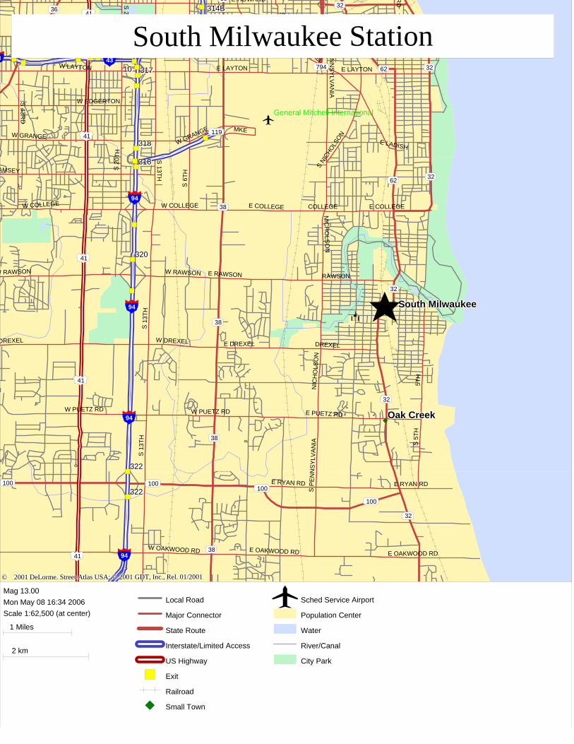
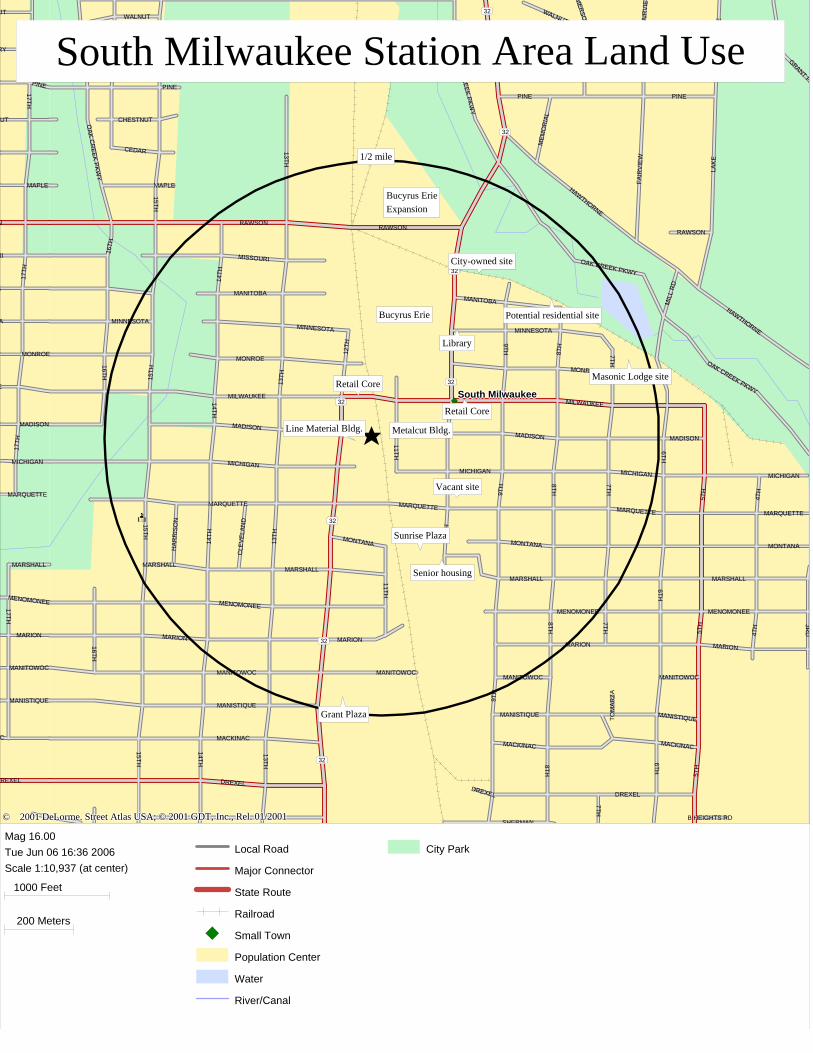
III. STATION AREA LAND USES AND BUSINESS ACTIVITY Proposed Station Location The station is proposed to be located south of Milwaukee Avenue just west of 11th Street in the historic downtown core of South Milwaukee. As currently proposed, the station will be on the west side of the railroad tracks. The map on the following page shows the station location. Half-Mile Study Area
The half-mile area surrounding the train station stretches from just north of Rawson Avenue on the north, to 6th Avenue on the east, Manistique on the south and 16th Avenue on the west. The map that follows shows the boundaries of the half-mile station area and the larger three mile radius from the station.
1. Study Area Land Use The half-mile study area contains a mix of residential, industrial, civic, retail and commercial use. The station area includes the downtown retail core, in addition to the office and industrial facilities of Bucyrus Erie Corporation. The company is located on the east side of the railroad tracks between Milwaukee Avenue and Rawson Road. It also owns a significant parcel of land on the north side of Rawson Road that will be used for future expansion. At present Bucyrus has approximately 350,000 square feet of space here which includes 150,000 square feet under roof, with the remainder used for yards and storage. An expansion on the north side of Rawson Road is planned that will add new office as well as manufacturing space. Bucyrus has been located in South Milwaukee since 1893 and employs 950 people and plans to increase employment by 150-200 people over time. Employment has been increasing since 2000 and the plant operates three shifts. Many of the employees live in South Milwaukee and are second and third generation employees of the company. However, employees do live all over the Milwaukee area and better transit will enable Bucyrus to attract qualified workers. Bucyrus manufactures equipment for the surface mining industry.
© 2001 DeLorme. Street Atlas USA; © 2001 GDT, Inc., Rel. 01/2001 © 2001 DeLorme. Street Atlas USA; © 2001 GDT, Inc., Rel. 01/2001 © 2001 DeLorme. Street Atlas USA; © 2001 GDT, Inc., Rel. 01/2001 © 2001 DeLorme. Street Atlas USA; © 2001 GDT, Inc., Rel. 01/2001 © 2001 DeLorme. Street Atlas USA; © 2001 GDT, Inc., Rel. 01/2001
119
38
38
38
794
3236
38
41
41
41
41
3 43
94
94
94
94
32
32
32
32
62
62
100100100
3841 94
32
100
South MilwaukeeSouth MilwaukeeSouth MilwaukeeSouth MilwaukeeSouth Milwaukee
Oak CreekOak CreekOak CreekOak CreekOak Creek
General Mitchell International
8A8A8A8A8A8A8A8A8A8A8A8A8A8A8A8A8A 99999999999999999 99999999999999999
322322322322322322322322322322322322322322322322322
320320320320320320320320320320320320320320320320320
318318318318318318318318318318318318318318318318318
318318318318318318318318318318318318318318318318318
3173173173173173173173173173173173173173173173173171010101010101010101010101010101010
314B314B314B314B314B314B314B314B314B314B314B314B314B314B314B314B314B
322322322322322322322322322322322322322322322322322
E DREXEL
E PUETZ RD
E RAWSON
NIC
HO
LSO
N
S 1
3TH
S 1
3TH
S P
EN
NS
YLV
AN
IA
W COLLEGE
W DREXELDREXEL
W PUETZ RD
W RAWSON
COLLEGE
DREXEL
E COLLEGE
E HOWARD
E LAYTON
MKE
NIC
HO
LSO
N
RAWSON
S 13T H
S 13T H
S 20T H
S 2
0TH
S 43R
D
S 6TH
S 6
TH
S C
LEM
EN
T
S NI
CHOLS
ON
S P
EN
NS
YLV
AN
IA
S WHITNALL
W BOLIVARW COLDSPRING RD
W COLLEGE
W EDGERTON
W GRANGEW GRANGE
W LAYTON
W PUETZ RD
AMSEY
W RAWSON
5TH
E COLLEGE
E LADISH
E LAYTON
S 5
TH
RD
E OAKWOOD RD
E RYAN RD
W OAKWOOD RD E OAKWOOD RD
E RYAN RD
© 2001 DeLorme. Street Atlas USA; © 2001 GDT, Inc., Rel. 01/2001 © 2001 DeLorme. Street Atlas USA; © 2001 GDT, Inc., Rel. 01/2001 © 2001 DeLorme. Street Atlas USA; © 2001 GDT, Inc., Rel. 01/2001 © 2001 DeLorme. Street Atlas USA; © 2001 GDT, Inc., Rel. 01/2001 © 2001 DeLorme. Street Atlas USA; © 2001 GDT, Inc., Rel. 01/2001
119
E DREXEL
E PUETZ RD
E RAWSON
NIC
HO
LSO
N
S 1
3TH
S 1
3TH
S P
EN
NS
YLV
AN
IA
W COLLEGE
W DREXELDREXEL
W PUETZ RD
W RAWSON
COLLEGE
DREXEL
E COLLEGE
E HOWARD
E LAYTON
MKE
NIC
HO
LSO
N
RAWSON
S 13T H
S 13T H
S 20T H
S 2
0TH
S 43R
D
S 6TH
S 6
TH
S C
LEM
EN
T
S NI
CHOLS
ON
S P
EN
NS
YLV
AN
IA
S WHITNALL
W BOLIVARW COLDSPRING RD
W COLLEGE
W EDGERTON
W GRANGEW GRANGE
W LAYTON
W PUETZ RD
AMSEY
W RAWSON
38
38
38
794
3236
38
41
41
41
41
3 43
94
94
94
94
5TH
E COLLEGE
E LADISH
E LAYTON
S 5
TH
RD
32
32
32
32
62
62
E OAKWOOD RD
E RYAN RD
W OAKWOOD RD
100100100
3841 94 E OAKWOOD RD
E RYAN RD
32
100
General Mitchell International
8A8A8A8A8A8A8A8A8A8A8A8A8A8A8A8A8A 99999999999999999 99999999999999999
322322322322322322322322322322322322322322322322322
320320320320320320320320320320320320320320320320320
318318318318318318318318318318318318318318318318318
318318318318318318318318318318318318318318318318318
3173173173173173173173173173173173173173173173173171010101010101010101010101010101010
314B314B314B314B314B314B314B314B314B314B314B314B314B314B314B314B314B
South MilwaukeeSouth MilwaukeeSouth MilwaukeeSouth MilwaukeeSouth Milwaukee
Oak CreekOak CreekOak CreekOak CreekOak Creek
322322322322322322322322322322322322322322322322322
Mag 13.00Mon May 08 16:34 2006Scale 1:62,500 (at center)
1 Miles
2 km
Local Road
Major Connector
State Route
Interstate/Limited Access
US Highway
Exit
Railroad
Small Town
Sched Service Airport
Population Center
Water
River/Canal
City Park
South Milwaukee StationSouth Milwaukee StationSouth Milwaukee StationSouth Milwaukee StationSouth Milwaukee Station

© 2001 DeLorme. Street Atlas USA; © 2001 GDT, Inc., Rel. 01/2001 © 2001 DeLorme. Street Atlas USA; © 2001 GDT, Inc., Rel. 01/2001 © 2001 DeLorme. Street Atlas USA; © 2001 GDT, Inc., Rel. 01/2001 © 2001 DeLorme. Street Atlas USA; © 2001 GDT, Inc., Rel. 01/2001 © 2001 DeLorme. Street Atlas USA; © 2001 GDT, Inc., Rel. 01/2001
119
38
38
38
794
32
38
62
3
43
94
94
94
94
32
32
32
32
62
62
100100
94
32
100
South MilwaukeeSouth MilwaukeeSouth MilwaukeeSouth MilwaukeeSouth Milwaukee
Oak CreekOak CreekOak CreekOak CreekOak Creek
General Mitchell International
322322322322322322322322322322322322322322322322322
320320320320320320320320320320320320320320320320320
318318318318318318318318318318318318318318318318318
318318318318318318318318318318318318318318318318318
3173173173173173173173173173173173173173173173173171010101010101010101010101010101010
314B314B314B314B314B314B314B314B314B314B314B314B314B314B314B314B314B
322322322322322322322322322322322322322322322322322
E DREXEL
E PUETZ RD
E RAWSON
NIC
HO
LSO
N
S 1
3TH
S 1
3TH
S P
EN
NS
YLV
AN
IAW COLLEGE
W DREXEL
W PUETZ RD
W RAWSON
COLLEGE
DREXEL
E COLLEGE
E HOWARD
E LAYTON
MKE
NIC
HO
LSO
N
RAWSON
S 13T H
S 20T H
S 2
0TH
S 6TH
S 6
TH
S C
LEM
EN
T
S NI
CHOLS
ON
S P
EN
NS
YLV
AN
IA
S WHITNALLW BOLIVAR
ERTON
W GRANGE
W HOWARD
W LAYTON
RD
SEY
5TH
E COLLEGE
E LADISH
E LAYTONE PLANKINTON
S 5
TH
PA
CK
AR
D
S WHITNALL
E OAKWOOD RD
E RYAN RD E RYAN RD
1/2 mile
3 miles
© 2001 DeLorme. Street Atlas USA; © 2001 GDT, Inc., Rel. 01/2001 © 2001 DeLorme. Street Atlas USA; © 2001 GDT, Inc., Rel. 01/2001 © 2001 DeLorme. Street Atlas USA; © 2001 GDT, Inc., Rel. 01/2001 © 2001 DeLorme. Street Atlas USA; © 2001 GDT, Inc., Rel. 01/2001 © 2001 DeLorme. Street Atlas USA; © 2001 GDT, Inc., Rel. 01/2001
119
E DREXEL
E PUETZ RD
E RAWSON
NIC
HO
LSO
N
S 1
3TH
S 1
3TH
S P
EN
NS
YLV
AN
IAW COLLEGE
W DREXEL
W PUETZ RD
W RAWSON
COLLEGE
DREXEL
E COLLEGE
E HOWARD
E LAYTON
MKE
NIC
HO
LSO
N
RAWSON
S 13T H
S 20T H
S 2
0TH
S 6TH
S 6
TH
S C
LEM
EN
T
S NI
CHOLS
ON
S P
EN
NS
YLV
AN
IA
S WHITNALLW BOLIVAR
ERTON
W GRANGE
W HOWARD
W LAYTON
RD
SEY
38
38
38
794
32
38
62
3
43
94
94
94
94
5TH
E COLLEGE
E LADISH
E LAYTONE PLANKINTON
S 5
TH
PA
CK
AR
D
S WHITNALL
32
32
32
32
62
62
E OAKWOOD RD
E RYAN RD100
100
94
E RYAN RD
32
100
General Mitchell International
322322322322322322322322322322322322322322322322322
320320320320320320320320320320320320320320320320320
318318318318318318318318318318318318318318318318318
318318318318318318318318318318318318318318318318318
3173173173173173173173173173173173173173173173173171010101010101010101010101010101010
314B314B314B314B314B314B314B314B314B314B314B314B314B314B314B314B314B
South MilwaukeeSouth MilwaukeeSouth MilwaukeeSouth MilwaukeeSouth Milwaukee
Oak CreekOak CreekOak CreekOak CreekOak Creek
322322322322322322322322322322322322322322322322322
1/2 mile
3 miles
Mag 13.00Mon May 08 16:43 2006Scale 1:62,500 (at center)
1 Miles
2 km
Local Road
Major Connector
State Route
Interstate/Limited Access
Exit
Railroad
Small Town
Sched Service Airport
Population Center
Water
River/Canal
City Park
South Milwaukee .5 and 3 Mile RadiiSouth Milwaukee .5 and 3 Mile RadiiSouth Milwaukee .5 and 3 Mile RadiiSouth Milwaukee .5 and 3 Mile RadiiSouth Milwaukee .5 and 3 Mile Radii

KRM Alternatives Analysis EEIISS aanndd PPrroojjeecctt DDeevveellooppmmeenntt PPhhaassee
SOUTH MILWAUKEE MARKET ASSESSMENT
Page 12 of 41
Along Milwaukee Avenue east and west of the railroad tracks and along Chicago Avenue (Route 32) north of Milwaukee Avenue and 10th Avenue (south of Milwaukee Avenue) is the downtown retail and office core of the city. While not as vibrant as it once was, Milwaukee, Chicago and 10th Avenues are home to a variety of restaurants, small businesses, financial institutions and some offices. These include the Tri-City National Bank, florist, jewelry store, carpet store, bakery, day spa, shoe store, cleaners, mortgage company, hair salon, martial arts center, driving school, photographer, barber shop, medical offices, and formalwear shop. A non-profit community center that has a bowling alley and banquet facility is west of the railroad tracks downtown. The downtown also has some upper level apartments above stores. The original train station, a National Register structure located at Madison and 11th Avenue one block south of Milwaukee Avenue, was renovated by a private developer and is being used for offices. Its parking lot is used by Bucyrus employees. The public library is located within the study area two blocks north of Milwaukee Avenue on Chicago Avenue. The post office is also within the study area on 10th Avenue (the southern extension of Chicago Avenue) and Michigan. The Sunrise Plaza shopping center, located at the southern end of 10th Avenue directly east of the railroad tracks has banks, hardware store, pharmacy, and family restaurant. The South Milwaukee Fire Station and City garage are also here, as are the relatively new senior citizen apartment buildings, Marquette Manor with 48 units and Sunrise with 32 units. Marquette Plaza, a small shopping center located at the corner of Marquette and Route 32 at the edge of the downtown, has a tobacco shop, Laundromat, espresso stand, Subway and Dollar General store. North of this intersection are auto-related businesses. Both east and west of the downtown core are well maintained, older single-family detached houses. At the far southern end of the study area along Route 32 is the Grant Plaza shopping center with a Pick ‘n Save grocery store, in addition to smaller commercial and retail buildings. The area on the west side of the railroad tracks between Milwaukee and Marquette Avenues is industrial and commercial in use. The Line Material Building is a very large, old industrial building that has one tenant, but most of the space is currently vacant. It is viewed as a future redevelopment site.
© 2001 DeLorme. Street Atlas USA; © 2001 GDT, Inc., Rel. 01/2001 © 2001 DeLorme. Street Atlas USA; © 2001 GDT, Inc., Rel. 01/2001 © 2001 DeLorme. Street Atlas USA; © 2001 GDT, Inc., Rel. 01/2001 © 2001 DeLorme. Street Atlas USA; © 2001 GDT, Inc., Rel. 01/2001 © 2001 DeLorme. Street Atlas USA; © 2001 GDT, Inc., Rel. 01/2001
32
32
32
32
32
32
32
32South MilwaukeeSouth MilwaukeeSouth MilwaukeeSouth MilwaukeeSouth Milwaukee
17TH
17TH
17TH
17TH
R
RY
UT
AC
MADISON
MANISTIQUE
A
MANITOWOC
MAPLE
MARION
MARQUETTE
MARSHALL
MENOMONEE
MICHIGAN
E
A
RI
MONROE
PINE
UT
REXEL
N
MEM
OR
IAL
10TH
11TH11TH
12TH
13TH
13TH
13TH
13TH
14TH
14TH
14TH
14TH
15TH15TH
15TH
15TH15TH
16TH
16TH
16TH
16TH
3RD
4TH
4TH
6TH6TH
6TH
7TH7TH
7TH7TH
8TH
8TH
8TH8TH
9TH
9TH
9TH
B HEIGHTS RD
CEDAR
CHERRY CHERRY CHERRY
CHESTNUT
CLE
VEL
AND
DREXELDREXEL
MER
SON
FAIR
VIE
WFA
IRV
IEW
GRANT PA
HA
RR
ISO
N
HAWTHORNE
HAWTHORNE
LAK
ELA
KE
MACKINACMACKINAC MACKINAC
MADISON MADISON
MADISON
MANISTIQUE MANISTIQUE
MANISTIQUE
MANITOBAMANITOBA
MANITOWOC MANITOWOCMANITOWOC MANITOWOC
MAPLE
MARIONMARIONMARION MARION
MARQUETTE MARQUETTE MARQUETTEMARQUETTE
MARSHALLMARSHALLMARSHALL
MARSHALL
MENOMONEEMENOMONEEMENOMONEE
MICHIGANMICHIGANMICHIGAN
MICHIGAN
MIL
L R
D
MILWAUKEE
MINNESOTAMINNESOTAMINNESOTA
MISSOURI
MONROE
MONROE
MONTANA MONTANA MONTANA
OAK CREEK PKWY
OAK C
REEK PKW
Y
OAK C
REEK PKW
Y
OAK CREEK PKWY
PINEPINEPINE
RAWSON
SHERMAN
TOM
ARZA
WALNUTWALNUT
5TH
5TH
5TH
DREXEL
MILWAUKEE
RAWSONRAWSON
1/2 mile
Bucyrus Erie
Bucyrus ErieExpansion
Sunrise Plaza
Senior housing
Grant Plaza
Line Material Bldg.
Vacant site
City-owned site
Masonic Lodge site
Potential residential site
Metalcut Bldg.
Retail Core
Retail Core
Library
© 2001 DeLorme. Street Atlas USA; © 2001 GDT, Inc., Rel. 01/2001 © 2001 DeLorme. Street Atlas USA; © 2001 GDT, Inc., Rel. 01/2001 © 2001 DeLorme. Street Atlas USA; © 2001 GDT, Inc., Rel. 01/2001 © 2001 DeLorme. Street Atlas USA; © 2001 GDT, Inc., Rel. 01/2001 © 2001 DeLorme. Street Atlas USA; © 2001 GDT, Inc., Rel. 01/2001
17TH
17TH
17TH
17TH
R
RY
UT
AC
MADISON
MANISTIQUE
A
MANITOWOC
MAPLE
MARION
MARQUETTE
MARSHALL
MENOMONEE
MICHIGAN
E
A
RI
MONROE
PINE
UT
REXEL
N
MEM
OR
IAL
10TH
11TH11TH
12TH
13TH
13TH
13TH
13TH
14TH
14TH
14TH
14TH
15TH15TH
15TH
15TH15TH
16TH
16TH
16TH
16TH
3RD
4TH
4TH
6TH6TH
6TH
7TH7TH
7TH7TH
8TH
8TH
8TH8TH
9TH
9TH
9TH
B HEIGHTS RD
CEDAR
CHERRY CHERRY CHERRY
CHESTNUT
CLE
VEL
AND
DREXELDREXEL
MER
SON
FAIR
VIE
WFA
IRV
IEW
GRANT PA
HA
RR
ISO
N
HAWTHORNE
HAWTHORNE
LAK
ELA
KE
MACKINACMACKINAC MACKINAC
MADISON MADISON
MADISON
MANISTIQUE MANISTIQUE
MANISTIQUE
MANITOBAMANITOBA
MANITOWOC MANITOWOCMANITOWOC MANITOWOC
MAPLE
MARIONMARIONMARION MARION
MARQUETTE MARQUETTE MARQUETTEMARQUETTE
MARSHALLMARSHALLMARSHALL
MARSHALL
MENOMONEEMENOMONEEMENOMONEE
MICHIGANMICHIGANMICHIGAN
MICHIGAN
MIL
L R
D
MILWAUKEE
MINNESOTAMINNESOTAMINNESOTA
MISSOURI
MONROE
MONROE
MONTANA MONTANA MONTANA
OAK CREEK PKWY
OAK C
REEK PKW
Y
OAK C
REEK PKW
Y
OAK CREEK PKWY
PINEPINEPINE
RAWSON
SHERMAN
TOM
ARZA
WALNUTWALNUT
5TH
5TH
5TH
DREXEL
MILWAUKEE
RAWSONRAWSON
32
32
32
32
32
32
32
32South MilwaukeeSouth MilwaukeeSouth MilwaukeeSouth MilwaukeeSouth Milwaukee
1/2 mile
Bucyrus Erie
Bucyrus ErieExpansion
Sunrise Plaza
Senior housing
Grant Plaza
Line Material Bldg.
Vacant site
City-owned site
Masonic Lodge site
Potential residential site
Metalcut Bldg.
Retail Core
Retail Core
Library
Mag 16.00Tue Jun 06 16:36 2006Scale 1:10,937 (at center)
1000 Feet
200 Meters
Local Road
Major Connector
State Route
Railroad
Small Town
Population Center
Water
River/Canal
City Park
South Milwaukee Station Area Land UseSouth Milwaukee Station Area Land UseSouth Milwaukee Station Area Land UseSouth Milwaukee Station Area Land UseSouth Milwaukee Station Area Land Use

KRM Alternatives Analysis EEIISS aanndd PPrroojjeecctt DDeevveellooppmmeenntt PPhhaassee
SOUTH MILWAUKEE MARKET ASSESSMENT
Page 14 of 41
2. Study Area Demographics According to estimates provided by Demographics Now (a national demographic data vendor) and shown in Table 1, the half-mile area has an estimated 2005 population of 4,578, with a density of 5,829 persons per square mile. Population density in this area is high with a similar density to Cudahy, though lower than the densities in Kenosha and Racine. There are almost 2,900 employees within the half-mile area as well. The median age of the population is 36.1 years, with almost 12% of the residents aged 65 and older. A high percentage of the households living near the train station do not have a motor vehicle (12.3%). Median household income is estimated to be $39,778. The owner occupancy rate is 57%. Slightly less than half of the residents aged 25 and older have at least some college education. Table 1 that follows compares the characteristics of the station area with a larger area within three miles. The larger area has an estimated population of 45,260, and the overall density is considerably lower due in large part to the presence of General Mitchell Field west of the city. The population of the three mile area is older, better educated and considerably more affluent (its median household income is $50,337). Its homeownership rate is also much higher at 68%. A lower percent of its households have no access to a private vehicle. Demographic maps in the Appendix show the median household income, population density and average household size by block group for the area surrounding the proposed South Milwaukee station. They show that the average household size is between 2 and 2.5 persons; population density is considerably higher in the neighborhoods east and west of the station than north and south with 7,500-10,000 people per square mile; and that median household incomes are higher closer to Lake Michigan.

KRM Alternatives Analysis EEIISS aanndd PPrroojjeecctt DDeevveellooppmmeenntt PPhhaassee
SOUTH MILWAUKEE MARKET ASSESSMENT
Page 15 of 41
Table 1
KEY DEMOGRAPHICS FOR 1/2 AND 3 MILE RADII
FROM THE PROPOSED SOUTH MILWAUKEE RAIL STATION
2005 1/2 Mile 3 Mile Population 4,578 45,260 Households 1,892 18,026 Population Density/Square Mile 5,829 1,601 Median Age 36.1 38.5 % of Population Aged 65+ 11.9% 13.6% Median Household Income $39,778 $50,337 % of Households with No Vehicle Available 12.3% 8.1% % of Population 25+ with at least some College 45.3% 51.3% Total Housing Units 2,073 19,249 % Vacant Housing Units 8.8% 6.4% % Owner-Occupied Housing Units 57.3% 67.7% Employment 2,897 14,847 Source: Demographics Now.

KRM Alternatives Analysis EEIISS aanndd PPrroojjeecctt DDeevveellooppmmeenntt PPhhaassee
SOUTH MILWAUKEE MARKET ASSESSMENT
Page 16 of 41
Development Opportunity Sites Within the half-mile radius of the station are several key development sites. The first is the site of the Line Material Building located directly west of the railroad tracks south of Milwaukee Avenue. The building is not in good condition and the City would like to see it torn down and redeveloped for residential, professional office or a mix of uses. It is viewed as the City’s prime transit-oriented development site. The Metalcut building along Madison between 10th and 11th Avenues east of the station location would also be appropriate for residential development. The City’s 2003 Comprehensive Plan recommends that viable industrial uses be retained and expanded, but that key underutilized or vacant sites be converted to higher and better uses. A currently vacant site on the northeast corner of 10th Avenue and Marquette is planned for a new residential building. Outside of the downtown, but within the half-mile study area is a 5-acre parcel east of Chicago Avenue and south of the Oak Creek Parkway. The City is planning to acquire this parcel which is currently used for boat storage. After environmental remediation, the site could be developed for housing. Directly to the east of this site is land along the lake spur railroad tracks, including the Masonic Lodge with 2.5 acres of land that could also be redeveloped into housing.

KRM Alternatives Analysis EEIISS aanndd PPrroojjeecctt DDeevveellooppmmeenntt PPhhaassee
SOUTH MILWAUKEE MARKET ASSESSMENT
Page 17 of 41
IV. DEMOGRAPHIC TRENDS AND FORECASTS South Milwaukee Population and Household Trends According to the Wisconsin Department of Administration, South Milwaukee’s population increased slightly between 2000 and 2005, though it is projected to grow by 19.2% by 2025. The number of households is estimated to have grown by 5.2% between 2000 and 2005 and is projected to grow by 25.8% with over 2,200 new households in the city over the 25 year period. Table 2 below shows these trends.
Table 2
SOUTH MILWAUKEE HOUSEHOLD AND POPULATION PROJECTIONS 2000-2025
Year Households Change Population Change # % Change # % Change 2000 8,694 21,256 2005 9,148 454 5.2% 21,313 57 0.3% 2010 9,607 459 5.0% 22,844 1,531 7.2% 2015 10,057 450 4.7% 23,764 920 4.0% 2020 10,577 520 5.2% 24,701 937 3.9% 2025 10,940 363 3.4% 25,336 635 2.6% Change 2000-2025 2,246 25.8% 4,080 19.2%
Source: Wisconsin Department of Administration.
KRM Alternatives Analysis EEIISS aanndd PPrroojjeecctt DDeevveellooppmmeenntt PPhhaassee
SOUTH MILWAUKEE MARKET ASSESSMENT
Page 18 of 41
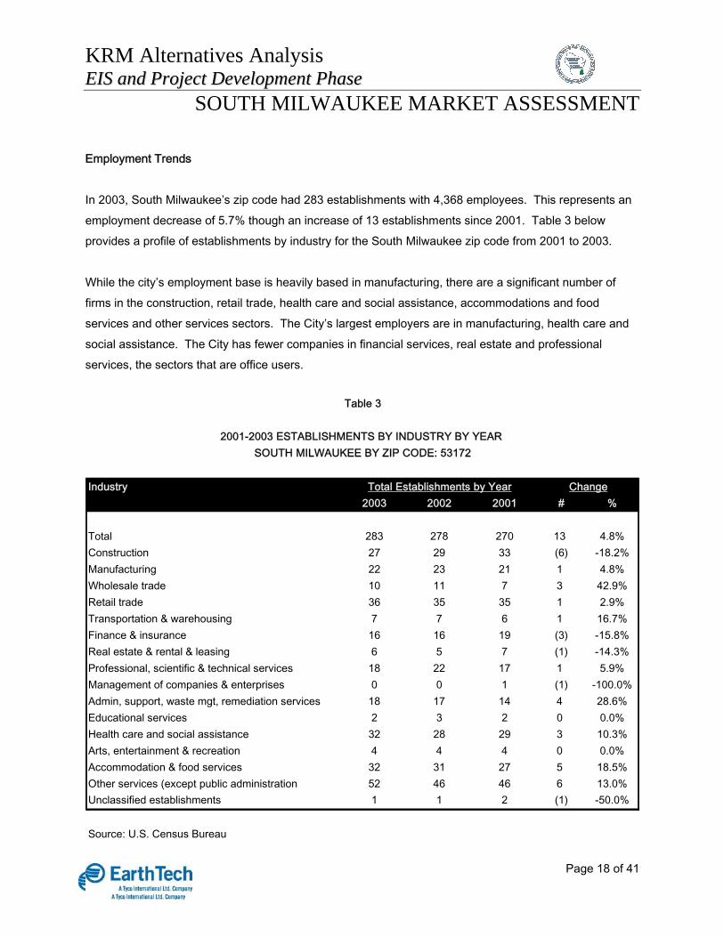
Employment Trends In 2003, South Milwaukee’s zip code had 283 establishments with 4,368 employees. This represents an employment decrease of 5.7% though an increase of 13 establishments since 2001. Table 3 below provides a profile of establishments by industry for the South Milwaukee zip code from 2001 to 2003. While the city’s employment base is heavily based in manufacturing, there are a significant number of firms in the construction, retail trade, health care and social assistance, accommodations and food services and other services sectors. The City’s largest employers are in manufacturing, health care and social assistance. The City has fewer companies in financial services, real estate and professional services, the sectors that are office users.
Industry 2003 2002 2001 # %
Total 283 278 270 13 4.8%Construction 27 29 33 (6) -18.2%Manufacturing 22 23 21 1 4.8%Wholesale trade 10 11 7 3 42.9%Retail trade 36 35 35 1 2.9%Transportation & warehousing 7 7 6 1 16.7%Finance & insurance 16 16 19 (3) -15.8%Real estate & rental & leasing 6 5 7 (1) -14.3%Professional, scientific & technical services 18 22 17 1 5.9%Management of companies & enterprises 0 0 1 (1) -100.0%Admin, support, waste mgt, remediation services 18 17 14 4 28.6%Educational services 2 3 2 0 0.0%Health care and social assistance 32 28 29 3 10.3%Arts, entertainment & recreation 4 4 4 0 0.0%Accommodation & food services 32 31 27 5 18.5%Other services (except public administration 52 46 46 6 13.0%Unclassified establishments 1 1 2 (1) -50.0%
Source: U.S. Census Bureau
Table 3
Total Establishments by Year Change
2001-2003 ESTABLISHMENTS BY INDUSTRY BY YEAR SOUTH MILWAUKEE BY ZIP CODE: 53172
KRM Alternatives Analysis EEIISS aanndd PPrroojjeecctt DDeevveellooppmmeenntt PPhhaassee
SOUTH MILWAUKEE MARKET ASSESSMENT
Page 19 of 41
Population and Household Projections – Half-Mile Station Area Table 4 on the following page presents population and household trends from 2000-2010 for the half-mile and three-mile areas around the South Milwaukee station, as estimated by Demographics Now, a national data vendor. The population of the half-mile area is projected to decline by 1.3% between 2005 and 2010, and the number of households by 2.0%. These projections show a slight increase in population (1.1%) and households (.1%) in the three mile area. These projections are more pessimistic than the State’s projections for the City of South Milwaukee which show a 7% increase in population and 5% increase in households during this time period. The three mile area encompasses parts of Cudahy and Oak Creek in addition to South Milwaukee.

KRM Alternatives Analysis EEIISS aanndd PPrroojjeecctt DDeevveellooppmmeenntt PPhhaassee
SOUTH MILWAUKEE MARKET ASSESSMENT
Page 20 of 41
Table 4
POPULATION AND HOUSEHOLD TRENDS .5 AND 3 MILE RADII FROM SOUTH MILWAUKEE STATION
Population Households 0.5 mile radius 2000 4,641 1,930 2005 4,578 1,892 Change 2000-2005 (63) (38) % change 2000-2005 -1.4% -2.0% 2010 4,520 1,855 Change 2005-2010 (58) (37) % change 2005-2010 -1.3% -2.0% 3 mile radius 2000 44,674 17,958 2005 45,260 18,026 Change 2000-2005 586 68 % change 2000-2005 1.3% 0.4% 2010 45,747 18,052 Change 2005-2010 487 26 % change 2005-2010 1.1% 0.1%
Source: Demographics Now

KRM Alternatives Analysis EEIISS aanndd PPrroojjeecctt DDeevveellooppmmeenntt PPhhaassee
SOUTH MILWAUKEE MARKET ASSESSMENT
Page 21 of 41
V. RESIDENTIAL MARKET CONDITIONS AND STATION AREA OPPORTUNITIES Housing Market Trends
1. Building Permits and Construction Activity South Milwaukee issued a total of 236 building permits for residential construction between 2000 and 2005, equal to an average of 39 units per year. During this period, 142 multi-family units were built, the largest number in 2001. A few small multi-family projects were built during this period in the half-mile study area; however most of the newer multi-family construction is on the north side of the city. The table below shows these trends.
Table 5
BUILDING PERMITS FOR SOUTH MILWAUKEE : 2000-2005
Year Single-Family 2-4 Units Multi-Family Total Units Units Units 2000 27 0 16 43 2001 9 8 120 137 2002 2 6 0 8 2003 5 8 0 13 2004 5 10 0 15 2005 8 6 6 20
Total 56 38 142 236 Average Annual 9 6 24 39
Source: U.S. Census

KRM Alternatives Analysis EEIISS aanndd PPrroojjeecctt DDeevveellooppmmeenntt PPhhaassee
SOUTH MILWAUKEE MARKET ASSESSMENT
Page 22 of 41
2. Condominium and Townhouse Sales and Prices According to data from Nicholson Realty, in 2005 there were a total of 20 condominium/ townhouse sales through the Multiple Listing Service in South Milwaukee. The median sales price was $154,450, with a range of $94,000 to $179,900. The table below shows a summary of the 2005 condominium sales in South Milwaukee.
Location# of Units
Sold Price Range Median Price
3333 5th Ave. 2 $94,000-$105,000 $99,500
3205 5th Ave. 1 $95,000 $95,000
1301 College Ave. 7 $129,500-$160,000 $152,000
221 Chicago Ave. 4 $139,900-$172,900 $156,400
229 Menomonee Ave. 1 $165,000 $165,000
1401A Milwaukee Ave. 1 $172,000 $172,000
1010-1016 Carrington Ave. 4 $179,900 $179,000
Total 20 $94,000-$179,900 $154,450
Source: Nicholson Realty.
2005 CONDO SALES IN SOUTH MILWAUKEE
Table 6

KRM Alternatives Analysis EEIISS aanndd PPrroojjeecctt DDeevveellooppmmeenntt PPhhaassee
SOUTH MILWAUKEE MARKET ASSESSMENT
Page 23 of 41
Station Area Condominium and Townhouse Developments Actively Marketing and Planned At this time there is one condominium project that is actively marketing units within the half-mile station area.
1. Heritage Reserve
Located at the south end of the station area on 9th Avenue, these 32 ranch-style and townhouse units have two bedrooms and two baths and range from 1,450-1,500 square feet. The property was a former industrial site. Prices range from $169,900 for the townhouses to $184,900 for the ranch units. Construction started in the spring of 2006 and a few units have been reserved. The development is targeted to empty nesters and seniors. The property is located in a residential neighborhood south of Sunrise Plaza shopping center and the City’s garage. 2. Northeast Corner of Marquette and 10th Avenue
A three story mixed-use building with ground floor commercial space and two floors of condominiums is planned for this small site. The site, a former gas station owned by the City, was remediated and the owner is awaiting approval from the state Department of Natural Resources before starting construction. Marketing has not yet started for this project. 3. Masonic Lodge Site
The site of the Masonic Lodge at 7th Avenue and Monroe at the northeast quadrant of the study area is planned for 24 2-story walk-up units. The property has not yet started marketing or construction. As indicated earlier, several additional parcels of land to the west of this site, east of Route 32 and south of the Oak Creek Parkway are likely to be developed for residential use. A portion of this land is railroad right-of-way, while additional land is owned by the City.

KRM Alternatives Analysis EEIISS aanndd PPrroojjeecctt DDeevveellooppmmeenntt PPhhaassee
SOUTH MILWAUKEE MARKET ASSESSMENT
Page 24 of 41
New Condominiums Beyond the Station Area
There are several small infill developments outside of the station area. Six units are under construction on Drexel and Nicholson at the southwest corner of the City. The City’s Comprehensive Plan recommends residential development at the northeast corner of Rawson and Nicholson on the northwest side of the City. The City would also like to see the 28-acre former Everbrite Electric factory site along the lakefront between Drexel and Marion Avenues redeveloped with residential use. At this time, there are no specific plans for the site. However, its lakefront location makes this a very desirable residential site once it is remediated. Residential Land Prices The City of South Milwaukee has sold land to developers for residential or mixed-use development at prices that do not reflect true market value in order to jump start redevelopment. The Masonic Lodge property sold for approximately $4.59 per square foot or $25,000 per residential unit according to a real estate appraiser active in the area. Single-family infill lots on the west side of the City are selling for $90,000-$105,000 per lot for lots in the 12,000-14,000 square foot range ($7.50 per square foot). Several small lots (7,200 square feet) in or near downtown that could be developed with 4 to 5 residential units were priced at under $30,000 or $4 per square foot. However, there are few such lots available as the City is built out.

© 2001 DeLorme. Street Atlas USA; © 2001 GDT, Inc., Rel. 01/2001 © 2001 DeLorme. Street Atlas USA; © 2001 GDT, Inc., Rel. 01/2001 © 2001 DeLorme. Street Atlas USA; © 2001 GDT, Inc., Rel. 01/2001 © 2001 DeLorme. Street Atlas USA; © 2001 GDT, Inc., Rel. 01/2001 © 2001 DeLorme. Street Atlas USA; © 2001 GDT, Inc., Rel. 01/2001
32
32 32
32
32
32
62
South MilwaukeeSouth MilwaukeeSouth MilwaukeeSouth MilwaukeeSouth Milwaukee
BLAKEAK RIDGE LN
SHERMAN
17TH
17TH
17TH
18TH
18TH
BEECH
CARROLL
CEDAR
CHERRY
CHESTNUT
CYPRESS
E ACE WORLDWIDE LN
E BIRCH
E CHESTNUT
E CODY
E DONALD
E EATON LN
E EXCALIBUR
E HICKORY
E JUNIPER
E KELLY LN
E MICHIGAN
E MONTANA
E NORWOOD
E OAK
E POPLAR
E SPRUCE
E VILLAGE
ELM
HICKORY
JUNIPER
LIN
DEN
MACKINAC
MANISTIQUE
MANITOBA
MANITOWOC
MAPLE
MARION
MARQUETTE
MARSHALL
MENOMONEE
MICHIGAN
MILWAUKEE
MINNESOTA
MISSOURI
MONROE
OAK
PARK
WAY
PINE
POPLAR
S ASH
S C
RAN
ES
CR
ANE
S DELAINE
S H
IGH
FIEL
D
S H
IGH
FIELD
S IN
DIA
NA
S JUN
IPERS KIN
G AR
THU
RS
S M
ADIS
ON
SPRUCE
TAMARACK
WALNUT
WILLO
W LN
WIL
LOW
LN
COLLEGE
DREXEL
E COLLEGEGE
EXEL
E RAWSON
NIC
HO
LSO
N
NIC
HO
LSON
NIC
HO
LSON
RAWSON
S PE
NN
SYLV
ANIA
13TH
14TH
15TH
MEM
OR
IAL
10TH
11TH
11TH
11TH12
TH
13TH
13TH
14TH
14TH
14TH
15TH
15TH15TH
16TH16TH
16TH16TH
3RD
4TH
6TH6TH
7TH
7TH
8TH
8TH
9TH
9TH
ASPEN
B HEIGHTS RD
BADGER
BLAKEBLAKE
BROOKDALECARRINGTON
CARROLL
CHERRY
CLE
VELA
ND
COLUMBIA
CR
EEKSID
E
DAVIS
DREXEL
E COLLEGE
E DONALD E KIMBERLY
E KLIEFORTH
E VAN EIMEREN
EDG
ARED
GAR
ELM
EMER
SON
EM
ER
SON
FAIR
VIE
WFA
IRVI
EW
GRANT PARK
GR
ANT
PAR
K
GRANT PARK
HAR
RIS
ON
HAWTHORNE
HAWTHORNE
HEMLOCK KIR
KWO
OD
LAK
ELA
KE
LAKE
SHO
RE
LAU
RE L LN
MACKINAC MACKINAC
MADISONMADISON
MANISTIQUEMANISTIQUE
MANITOBA
MANITOWOC MANITOWOC
MARINA RD
MARIONMARION
MARQUETTE
MARSHALLMARSHALL
MENOMONEE MENOMONEE
MICHIGANMICHIGAN
MIL
L R
D
MILWAUKEE
MINNESOTA
MISSOURI
MONROE
MONTANAMONTANA
OAK CREEK PKWY
OAK CREEK PKWY
OAK CREEK PKWY
OAK C
REEK PKW
Y
OAK C
REEK PKW
Y
OAK OAK
PARK
PARK
PARK
PINE
RAWSON
S BA
RLA
ND
S C
OR
Y
S C
RO
SS
S ELAI N
E
S ILLIN
OIS S
KIR
KWO
OD
S M
ERR
ILL
S R
OB E
RT
S SW
IF T
S TA
RBE
RT
HAM
MER
SAINT SYLVESTER
CE R
D
SHERMAN
SOUTHTOWNE
SYCAMORE
TOM
ARZA
WALNUT
5TH
5TH
COLLEGE
DREXEL
E COLLEGE
MILWAUKEE
RAWSON
1/2 Mile
1010-1016 Carrington
221 N Chicago1301 College Avenue South
3205-3333 5th Avenue South
229 Menomonee Avenue
1401A Milwaukee Avenue
Heritage Reserve
Marquette and 10th
Masonic Lodge Site
Drexel and Nicholson Everbrite Electric site
© 2001 DeLorme. Street Atlas USA; © 2001 GDT, Inc., Rel. 01/2001 © 2001 DeLorme. Street Atlas USA; © 2001 GDT, Inc., Rel. 01/2001 © 2001 DeLorme. Street Atlas USA; © 2001 GDT, Inc., Rel. 01/2001 © 2001 DeLorme. Street Atlas USA; © 2001 GDT, Inc., Rel. 01/2001 © 2001 DeLorme. Street Atlas USA; © 2001 GDT, Inc., Rel. 01/2001
BLAKEAK RIDGE LN
SHERMAN
17TH
17TH
17TH
18TH
18TH
BEECH
CARROLL
CEDAR
CHERRY
CHESTNUT
CYPRESS
E ACE WORLDWIDE LN
E BIRCH
E CHESTNUT
E CODY
E DONALD
E EATON LN
E EXCALIBUR
E HICKORY
E JUNIPER
E KELLY LN
E MICHIGAN
E MONTANA
E NORWOOD
E OAK
E POPLAR
E SPRUCE
E VILLAGE
ELM
HICKORY
JUNIPER
LIN
DEN
MACKINAC
MANISTIQUE
MANITOBA
MANITOWOC
MAPLE
MARION
MARQUETTE
MARSHALL
MENOMONEE
MICHIGAN
MILWAUKEE
MINNESOTA
MISSOURI
MONROE
OAK
PARK
WAY
PINE
POPLAR
S ASH
S C
RAN
ES
CR
ANE
S DELAINE
S H
IGH
FIEL
D
S H
IGH
FIELD
S IN
DIA
NA
S JUN
IPERS KIN
G AR
THU
RS
S M
ADIS
ON
SPRUCE
TAMARACK
WALNUT
WILLO
W LN
WIL
LOW
LN
COLLEGE
DREXEL
E COLLEGEGE
EXEL
E RAWSON
NIC
HO
LSO
N
NIC
HO
LSON
NIC
HO
LSON
RAWSON
S PE
NN
SYLV
ANIA
13TH
14TH
15TH
MEM
OR
IAL
10TH
11TH
11TH
11TH12
TH
13TH
13TH
14TH
14TH
14TH
15TH
15TH15TH
16TH16TH
16TH16TH
3RD
4TH
6TH6TH
7TH
7TH
8TH
8TH
9TH
9TH
ASPEN
B HEIGHTS RD
BADGER
BLAKEBLAKE
BROOKDALECARRINGTON
CARROLL
CHERRY
CLE
VELA
ND
COLUMBIA
CR
EEKSID
E
DAVIS
DREXEL
E COLLEGE
E DONALD E KIMBERLY
E KLIEFORTH
E VAN EIMEREN
EDG
ARED
GAR
ELM
EMER
SON
EM
ER
SON
FAIR
VIE
WFA
IRVI
EW
GRANT PARK
GR
ANT
PAR
K
GRANT PARK
HAR
RIS
ON
HAWTHORNE
HAWTHORNE
HEMLOCK KIR
KWO
OD
LAK
ELA
KE
LAKE
SHO
RE
LAU
RE L LN
MACKINAC MACKINAC
MADISONMADISON
MANISTIQUEMANISTIQUE
MANITOBA
MANITOWOC MANITOWOC
MARINA RD
MARIONMARION
MARQUETTE
MARSHALLMARSHALL
MENOMONEE MENOMONEE
MICHIGANMICHIGAN
MIL
L R
D
MILWAUKEE
MINNESOTA
MISSOURI
MONROE
MONTANAMONTANA
OAK CREEK PKWY
OAK CREEK PKWY
OAK CREEK PKWY
OAK C
REEK PKW
Y
OAK C
REEK PKW
Y
OAK OAK
PARK
PARK
PARK
PINE
RAWSON
S BA
RLA
ND
S C
OR
Y
S C
RO
SS
S ELAI N
E
S ILLIN
OIS S
KIR
KWO
OD
S M
ERR
ILL
S R
OB E
RT
S SW
IF T
S TA
RBE
RT
HAM
MER
SAINT SYLVESTER
CE R
D
SHERMAN
SOUTHTOWNE
SYCAMORE
TOM
ARZA
WALNUT
5TH
5TH
COLLEGE
DREXEL
E COLLEGE
MILWAUKEE
RAWSON
32
32 32
32
32
32
62
South MilwaukeeSouth MilwaukeeSouth MilwaukeeSouth MilwaukeeSouth Milwaukee
1/2 Mile
1010-1016 Carrington
221 N Chicago1301 College Avenue South
3205-3333 5th Avenue South
229 Menomonee Avenue
1401A Milwaukee Avenue
Heritage Reserve
Marquette and 10th
Masonic Lodge Site
Drexel and Nicholson Everbrite Electric site
Mag 15.00Tue Jun 06 16:50 2006Scale 1:18,750 (at center)
2000 Feet
500 Meters
Local Road
Major Connector
State Route
Railroad
Small Town
Population Center
Water
River/Canal
City Park
Condominium Sales and Development SitesCondominium Sales and Development SitesCondominium Sales and Development SitesCondominium Sales and Development SitesCondominium Sales and Development Sites

KRM Alternatives Analysis EEIISS aanndd PPrroojjeecctt DDeevveellooppmmeenntt PPhhaassee
SOUTH MILWAUKEE MARKET ASSESSMENT
Page 26 of 41
Rental Apartment Market There are few newer apartment buildings in South Milwaukee that are not restricted to senior citizens. Small, older apartment buildings are located along Chicago Avenue within the station area and on the south end of the City off of 5th Avenue. The area south of College Avenue at the north end of the City has some relatively new apartment buildings and condominiums. There are very few apartments listed for rent in local newspapers. Advertised apartments ranged in rent from $500-555 for one and two bedroom units in older buildings. No new rental projects are planned at this time. Newer rental properties in Cudahy are proximate to South Milwaukee and are representative of what better rentals can command. Buckhorn Station Apartments on Nicholson Avenue north of Layton, is approximately three miles north of the proposed station location. Developed in 1999, it has 64 units with rents ranging from $760 for a one bedroom apartment to $905 for the most expensive three bedroom unit. The development has many amenities including a pool and fitness center. The building is a Low-Income Housing Tax Credit project. A second development by the same developer as Buckhorn Station, Gorman and Company, is Cudahy Commons, located on the west side of the city off of Pennsylvania Avenue, also within three miles of the proposed South Milwaukee station site. It is also a Low-Income Housing Tax Credit property, with rents ranging from $625 for a one bedroom to $800 for the largest two bedroom apartment. The achievable rents are likely to be insufficient at this time to justify the higher costs of a mid-rise, market rate apartment building. In the future however, as the station area becomes more developed, a market rate apartment building could be financially feasible.

KRM Alternatives Analysis EEIISS aanndd PPrroojjeecctt DDeevveellooppmmeenntt PPhhaassee
SOUTH MILWAUKEE MARKET ASSESSMENT
Page 27 of 41
Opportunities for Residential Development in the Station Area 1. General Observations The City of South Milwaukee has been actively buying up property, remediating it and selling it to developers. This has resulted in several smaller developments in the station area. The City’s Comprehensive Plan identifies the area on the west side of the railroad tracks south of Milwaukee Avenue as a prime transit-oriented development site that should include a combination of higher density residential, retail and possibly office uses. To encourage redevelopment, the Plan recommended increasing density to allow 10-25 units per acre proximate to the transit station and employment nodes. Density near, but not in, the downtown core should be a maximum of 20 units per acre. The station area is located in one of the City’s 3 TIF districts, and in the past the City has been aggressive in using funds from the districts to spur economic development. Demand for condominiums and townhouses in the station area will come primarily from empty nesters, senior citizens and some younger people with connections to South Milwaukee who want to stay near their families. A high 13.6% of households within 3 miles of the station site are 65 years of age or older, indicating a strong base of potential buyers for a downtown condominium building. Single-family houses sell well at prices ranging from $92,000 to as much as $630,000 for homes on the Oak Creek Parkway. The 2005 median sales price for houses in South Milwaukee was $164,900. This means that new condominiums will need to be priced in the upper $100,000s to low $200,000s to be marketable in this area. 2. Future Demand The City’s Comprehensive Plan show 760 new housing units and 1,750 additional residents citywide by 2020. These projections were issued before the State’s 2004 population projections and were based on State projections from 1993. The State’s updated projections show a much higher rate of population and household growth for South Milwaukee. The more recent projections form the baseline for VSKA’s demand analysis. From 2005-2020, the projections indicate that there will be demand for 1,995 new housing units in South Milwaukee (133 per year on average). Valerie S. Kretchmer Associates, Inc. (VSKA) estimates that a total of 367 (24 per year on average) could be in the half-mile station area

KRM Alternatives Analysis EEIISS aanndd PPrroojjeecctt DDeevveellooppmmeenntt PPhhaassee
SOUTH MILWAUKEE MARKET ASSESSMENT
Page 28 of 41
assuming improved commuter rail service. Without the commuter rail, demand in the station area is estimated to be 299 units (20 per year on average). Table 7 below provides details.
Short term Medium term Long term Total Average2005-2010 2010-2015 2015-2020 15 years Annual
City of South Milwaukee Demand due to household growth (1) 459 450 520 1,429 95 Plus 5% vacancy allowance 23 23 26 71 5 Replacement demand (2) 165 165 165 494 33 Total City demand - baseline 647 637 711 1,995 133
Demand Alternatives Half mile station area - baseline (3) 97 96 107 299 20 Half mile station area - w/rail (4) 97 127 142 367 24
Notes:(1) From State of Wisconsin household projections(2) Assumes annual replacement demand equal to .5% of housing stock built prior to 1970 (as reported in the 2000 Census).(3) Baseline allocates 15% of City demand to half mile ring without commuter rail.(4) Rail alternative increases half mile ring demand to 20% after 2010.
Source: Valerie S. Kretchmer Associates, Inc.
SOUTH MILWAUKEE STATION AREA RESIDENTIAL DEMAND FROM 2005-2020Number of Housing Units
Table 7
KRM Alternatives Analysis EEIISS aanndd PPrroojjeecctt DDeevveellooppmmeenntt PPhhaassee
SOUTH MILWAUKEE MARKET ASSESSMENT
Page 29 of 41
VI. RETAIL MARKET CONDITIONS AND STATION AREA OPPORTUNITIES Retail Sales and Sales Per Household The 2002 Census of Retail Trade provides insight into retail sales activity in the City of South Milwaukee. A detailed table showing sales by category is included in the Appendix. The City had only 34 establishments and $44.6 million in sales in 2002 (the last year data are available). The City’s sales per household figure is very low at only $5,135 compared to the average sales of $23,433 per household in Milwaukee County. This means that residents of South Milwaukee are leaving the city for most of their shopping. There are many categories of stores that are not represented in South Milwaukee, some of which could be appropriate for the station area. Many residents are going to Oak Creek and Franklin for everyday shopping needs. Expenditure Potential in 2005 Based on its estimated average household income of $54,218 in 2005 and its household composition and age characteristics, Demographics Now estimates that South Milwaukee households have an aggregate retail expenditure potential of $192.9 million, or $22,709 per household. Of this, new car dealers account for 20.4% of household spending, grocery stores account for 15.5%, gasoline stations 10.2%, full service and limited service restaurants 9.6% and department stores (including discount stores) 7.5%. The Appendix provides additional details from Demographic Now regarding spending potential by store category for South Milwaukee’s households. While South Milwaukee’s spending potential per household is only 91% of the national average (a result of its income and age profile), there is a huge difference in the potential sales compared to the actual sales in the city as reported in the Census of Retail Trade. Thus, there is an opportunity to improve the retail offerings and capture some of the sales going out of the community now. Shopping Concentrations in or Near South Milwaukee The downtown area along Milwaukee and Chicago Avenues is the historic retail node for the city. However, as indicated earlier in this report, the downtown area has many vacancies now and is no longer

KRM Alternatives Analysis EEIISS aanndd PPrroojjeecctt DDeevveellooppmmeenntt PPhhaassee
SOUTH MILWAUKEE MARKET ASSESSMENT
Page 30 of 41
the prime shopping venue for city residents. Rent for older spaces downtown is very low at approximately $7 per square foot on a gross basis. Sunrise Plaza, with 70,540 square feet, is located within the half-mile station area and serves some of the convenience needs of area residents with a hardware store, pharmacy, banks and restaurant. The asking rent is $10 per square foot triple net (tenants pay their pro-rata share of real estate taxes, common area maintenance and insurance). The center is 16% vacant. The largest shopping center in the city is Grant Plaza located on 12th Avenue (Route 32) south of Manitowoc Avenue. The 138,000 square foot center is anchored by a new 59,000 square foot Pick ‘N Save grocery store (which replaced a shuttered Kohl’s) and Walgreens. Smaller tenants include restaurants, fitness center, hair and nail salon, child care center, Blockbuster Video and Family Dollar. The center was substantially upgraded and remodeled in 2005 with $3.5 million in TIF assistance from the City. It is now 80% leased with a median rent of $12 per square foot on a triple net basis During the renovation, some tenants were moved and the former Kohl’s building was demolished. There is no new retail space planned in South Milwaukee at this time, though the City is encouraging ground floor retail or commercial space in mixed-use projects. According to retail brokers, new small store space in the south suburbs can rent for as much as $18 per square foot on a triple net basis. Larger stores in the 10,000-15,000 square foot range will rent for $12-13 per square foot triple net. Retail/Commercial Land Prices There has been very little land sold in or near the station area for retail or commercial development. There have been sales in Cudahy that would be representative of prices for arms length transactions in South Milwaukee. According to the Cudahy City Assessor, retail and commercial land sales in the past few years in Cudahy have ranged from $1.92-$14.96 per square foot. The highest priced land was at the corner of Layton and Packard Avenues and was purchased by Walgreens, which is known to pay a premium for a desired corner parcel with 1-2 acres of land. Banks will also pay a premium for a specific corner location. A 4.5-acre site at Packard Avenue north of College Avenue in Cudahy with B-2 zoning sold for $9.41 per square foot. This was the only recent retail sale of a sizable parcel. Several parcels of 1 acre or less are

KRM Alternatives Analysis EEIISS aanndd PPrroojjeecctt DDeevveellooppmmeenntt PPhhaassee
SOUTH MILWAUKEE MARKET ASSESSMENT
Page 31 of 41
for sale along Packard Avenue at asking prices of $4-6 per square foot for vacant commercially zoned land. Future Retail Demand in the Station Area The expenditure categories that are most relevant for built-up areas immediately adjacent to commuter rail stations are convenience stores, specialty stores (including prepared food specialties), pharmacies, eating and drinking places, and personal services. Time-pressed commuters (especially those who are riding long distances possibly to Chicago suburbs) will use the station area to buy breakfast items, snacks, sandwiches, and prepared foods to take home after work. They will also need conveniences such as dry cleaners and personal care (beauty and barbershops), as well as easy-to-carry specialty items such as flowers and cards. Despite the proximity of the Bucyrus Erie plant to the station, the overwhelming majority of its employees are factory workers who only have ½ hour for lunch and typically bring their lunch. Salaried employees get 45 minutes for lunch but usually bring their lunch as well. The owner of the Subway franchise in South Milwaukee brings in food for employees to purchase. There is additional potential for restaurants in the station area that could also offer carry-in service to Bucyrus employees. There are redevelopment opportunities in the immediate station area and along Milwaukee Avenue that would be suitable for smaller scale retail development. This could be a free-standing retail building or small shopping center, or part of a mixed-use development, especially on the west side of the railroad tracks. The commuter rail station, in combination with additional residents living in the downtown area, will provide additional demand for the existing, underutilized and in many cases vacant spaces along Milwaukee Avenue. However, Bucyrus occupies such a significant amount of land in the half-mile station area and that is not expected to change in the foreseeable future. Thus there is limited retail development opportunity to the north of Milwaukee Avenue. The City’s Comprehensive Plan envisions a more compact, but stronger retail area along Milwaukee Avenue, which means a potential decrease in the existing retail space at the fringes. The table below shows the additional retail space that could be absorbed in the half-mile station area. This does not include a calculation of the improved retail offerings in existing downtown buildings that are

KRM Alternatives Analysis EEIISS aanndd PPrroojjeecctt DDeevveellooppmmeenntt PPhhaassee
SOUTH MILWAUKEE MARKET ASSESSMENT
Page 32 of 41
expected to occur as a result of the additional housing in the area. These estimates are dependent on the aforementioned development of new housing in the half-mile area.
Table 8
SOUTH MILWAUKEE STATION AREA RETAIL DEMAND FROM 2005-2020
2005-2010 (Square Feet)
2010-2015 (Square Feet)
2015-2020 (Square Feet)
Total (Square Feet)
10,000-15,000 15,000-20,000 15,000-20,000 40,000-55,000

KRM Alternatives Analysis EEIISS aanndd PPrroojjeecctt DDeevveellooppmmeenntt PPhhaassee
SOUTH MILWAUKEE MARKET ASSESSMENT
Page 33 of 41
VII. OFFICE MARKET CONDITIONS AND STATION AREA OPPORTUNITIES Office Market Conditions There is very little traditional office space in South Milwaukee. According to information from Grubb and Ellis, there is 87,349 square feet of non-owner occupied office space in 9 buildings. Most of the space is Class B in quality (medium quality buildings). There is very little space available now for rent (1.4%), which means that a limited amount of new space could be warranted. The newest building, Tri City South Milwaukee Bank Building, built in 2001, has a small amount of vacant space at an asking rent of $14.50 per square foot on a gross basis. Most of the buildings are small with none larger than 18,000 square feet and many less than 5,000 square feet. However, local brokers indicated that South Milwaukee is not a location for larger office buildings, as the employment base is not geared to professional, financial and other business services that typically occupy office space. It is on the back side of the airport which caters primarily to industrial and quasi-industrial users rather than office tenants, e.g., freight forwarders, trucking companies, food service. Office Demand Office brokers interviewed by VSKA were not optimistic about the potential for a significant amount of office space in the city overall or in the station area, and were cautious about the likelihood in the near term of any significant office development in the station area. However, there would be potential demand for new office space to house professionals who now have limited choices for quality space in small free-standing single or multi-tenant office buildings, or as part of a mixed-use building. Tenants would include medical professionals and allied health care practitioners, attorneys, accountants, financial services, insurance agents, etc. With rail service, more firms might find a downtown South Milwaukee location attractive. The table below suggests a modest amount of office space that might be absorbed in the station area over the next fifteen years. This does not include the potential for additional office space for Bucyrus Erie. That company is a large property owner downtown and is expanding. It is possible that they would build additional office space for their own use.

KRM Alternatives Analysis EEIISS aanndd PPrroojjeecctt DDeevveellooppmmeenntt PPhhaassee
SOUTH MILWAUKEE MARKET ASSESSMENT
Page 34 of 41
Table 9
SOUTH MILWAUKEE STATION AREA OFFICE DEMAND FROM 2005-2020
2005-2010 (Square Feet)
2010-2015 (Square Feet)
2015-2020 (Square Feet)
Total (Square Feet)
5,000-10,000 10,000-15,000 10,000-15,000 25,000-40,000

KRM Alternatives Analysis EEIISS aanndd PPrroojjeecctt DDeevveellooppmmeenntt PPhhaassee
SOUTH MILWAUKEE MARKET ASSESSMENT
Page 35 of 41
VIII. APPENDIX A. Demographic Maps
1. Median Household Income for ½ and 3 Mile Radii from the Proposed Station 2. Average Household Size for ½ and 3 Mile Radii from the Proposed Station 3. Population Density per Square Mile for ½ and 3 Mile Radii from the Proposed Station
B. 2002 Census of Retail Trade for the City of South Milwaukee C. Retail Expenditure Potential for City of South Milwaukee

Valerie S. Kretchmer Associates, Inc.
2005 Median Household Income for ½ and 3 Mile Radii from South Milwaukee Station
94
100
119
32
38
94
CudahyCudahyCudahyCudahyCudahy
Oak CreekOak CreekOak CreekOak CreekOak Creek
South MilwaukeeSouth MilwaukeeSouth MilwaukeeSouth MilwaukeeSouth Milwaukee
E Plankinton AveE Plankinton AveE Plankinton AveE Plankinton AveE Plankinton AveLayton AveLayton AveLayton AveLayton AveLayton Ave
College AveCollege AveCollege AveCollege AveCollege Ave
Nicholson Ave
Nichols on Av e
Nic holson A
v eN
ic holson Av eN
ic holson Av e
Rawson AveRawson AveRawson AveRawson AveRawson Ave
W Drexel AveW Drexel AveW Drexel AveW Drexel AveW Drexel Ave
S 5t
h Av
eS
5th
Ave
S 5t
h Av
eS
5th
Ave
S 5t
h Av
e
W Layton AveLayton AveW Layton AveW Layton AveW Layton Ave
MkeMkeMkeMkeMke
S 6
th S
tS
6th
St
S 6t
h S
tS
6th
St
S 6
th S
t
Grange AveGrange AveGrange AveGrange AveGrange Ave
W Rawson AveW Rawson AveW Rawson AveW Rawson AveW Rawson Ave
5th
Ave
5th
Ave
5th
Ave
5th
Ave
5th
Ave
E Ryan RdE Ryan RdE Ryan RdE Ryan RdE Ryan Rd
E Oakwood RdE Oakwood RdE Oakwood RdE Oakwood RdE Oakwood Rd
Drexel AveDrexel AveDrexel AveDrexel AveDrexel Ave
W Edgerton AveW Edgerton AveW Edgerton AveW Edgerton AveW Edgerton Ave
W Oakwood RdW Oakwood RdW Oakwood RdW Oakwood RdW Oakwood Rd
S 13
th S
tS
13th
St
S 1 3
th S
tS
13t
h St
S 1 3
th S
t
E Drexel AveE Drexel AveE Drexel AveE Drexel AveE Drexel Ave
W Puetz RdW Puetz RdW Puetz RdW Puetz RdW Puetz Rd W Puetz RdW Puetz RdW Puetz RdW Puetz RdW Puetz Rd E Puetz RdE Puetz RdE Puetz RdE Puetz RdE Puetz Rd
tnall Avetnall Avetnall Ave
nall Avetnall Ave
W Ramsey AveW Ramsey AveW Ramsey AveW Ramsey AveW Ramsey Ave
11TH AVE & MADISON AVE, S
MILWAUKEE, WI 53172 Legend
Block Groups Basic Variables (2005) Income:Household Income: Median Household Income
Above 100,000 75,000 to 100,000 50,000 to 75,000 25,000 to 50,000 Below 25,000 No Data
Subject Site 0.5,3 mile radii Block Group Bndry
Big City Ctr Medium City Ctr Small City Ctr
Prim. Hwy Secd. Hwy Maj. Rds Airports Parks Aerial Photo Coverage
Source: Applied Geographic Solutions © 2005. DemographicsNow is brought to you by SRC,
LLC. © 2005 All Rights Reserved
Date: 05/17/06

Valerie S. Kretchmer Associates, Inc.
2005 Average Household Size for ½ and 3 Mile Radii from South Milwaukee Station
94
100
119
32
38
94
CudahyCudahyCudahyCudahyCudahy
Oak CreekOak CreekOak CreekOak CreekOak Creek
South MilwaukeeSouth MilwaukeeSouth MilwaukeeSouth MilwaukeeSouth Milwaukee
E Plankinton AveE Plankinton AveE Plankinton AveE Plankinton AveE Plankinton AveLayton AveLayton AveLayton AveLayton AveLayton Ave
College AveCollege AveCollege AveCollege AveCollege Ave
Nicholson Ave
Nichols on Av e
Nic holson A
v eN
ic holson Av eN
ic holson Av e
Rawson AveRawson AveRawson AveRawson AveRawson Ave
W Drexel AveW Drexel AveW Drexel AveW Drexel AveW Drexel Ave
S 5t
h Av
eS
5th
Ave
S 5t
h Av
eS
5th
Ave
S 5t
h Av
e
W Layton AveLayton AveW Layton AveW Layton AveW Layton Ave
MkeMkeMkeMkeMke
S 6
th S
tS
6th
St
S 6t
h S
tS
6th
St
S 6
th S
t
Grange AveGrange AveGrange AveGrange AveGrange Ave
W Rawson AveW Rawson AveW Rawson AveW Rawson AveW Rawson Ave
5th
Ave
5th
Ave
5th
Ave
5th
Ave
5th
Ave
E Ryan RdE Ryan RdE Ryan RdE Ryan RdE Ryan Rd
E Oakwood RdE Oakwood RdE Oakwood RdE Oakwood RdE Oakwood Rd
Drexel AveDrexel AveDrexel AveDrexel AveDrexel Ave
W Edgerton AveW Edgerton AveW Edgerton AveW Edgerton AveW Edgerton Ave
W Oakwood RdW Oakwood RdW Oakwood RdW Oakwood RdW Oakwood Rd
S 13
th S
tS
13th
St
S 1 3
th S
tS
13t
h St
S 1 3
th S
t
E Drexel AveE Drexel AveE Drexel AveE Drexel AveE Drexel Ave
W Puetz RdW Puetz RdW Puetz RdW Puetz RdW Puetz Rd W Puetz RdW Puetz RdW Puetz RdW Puetz RdW Puetz Rd E Puetz RdE Puetz RdE Puetz RdE Puetz RdE Puetz Rd
tnall Avetnall Avetnall Ave
nall Avetnall Ave
W Ramsey AveW Ramsey AveW Ramsey AveW Ramsey AveW Ramsey Ave
11TH AVE & MADISON AVE, S
MILWAUKEE, WI 53172 Legend
Block Groups Basic Variables (2005) Average Household Size
Above 3 2.50 to 3 2 to 2.50 1.50 to 2 Below 1.50 No Data
Subject Site 0.5,3 mile radii Block Group Bndry
Big City Ctr Medium City Ctr Small City Ctr
Prim. Hwy Secd. Hwy Maj. Rds Airports Parks Aerial Photo Coverage
Source: Applied Geographic Solutions © 2005. DemographicsNow is brought to you by SRC,
LLC. © 2005 All Rights Reserved
Date: 05/17/06

Valerie S. Kretchmer Associates, Inc.
2005 Population Density Per Square Mile for ½ and 3 Mile Radii from South Milwaukee Station
94
100
119
32
38
94
CudahyCudahyCudahyCudahyCudahy
Oak CreekOak CreekOak CreekOak CreekOak Creek
South MilwaukeeSouth MilwaukeeSouth MilwaukeeSouth MilwaukeeSouth Milwaukee
E Plankinton AveE Plankinton AveE Plankinton AveE Plankinton AveE Plankinton AveLayton AveLayton AveLayton AveLayton AveLayton Ave
College AveCollege AveCollege AveCollege AveCollege Ave
Nicholson Ave
Nichols on Av e
Nic holson A
v eN
ic holson Av eN
ic holson Av e
Rawson AveRawson AveRawson AveRawson AveRawson Ave
W Drexel AveW Drexel AveW Drexel AveW Drexel AveW Drexel Ave
S 5t
h Av
eS
5th
Ave
S 5t
h Av
eS
5th
Ave
S 5t
h Av
e
W Layton AveLayton AveW Layton AveW Layton AveW Layton Ave
MkeMkeMkeMkeMke
S 6
th S
tS
6th
St
S 6t
h S
tS
6th
St
S 6
th S
t
Grange AveGrange AveGrange AveGrange AveGrange Ave
W Rawson AveW Rawson AveW Rawson AveW Rawson AveW Rawson Ave
5th
Ave
5th
Ave
5th
Ave
5th
Ave
5th
Ave
E Ryan RdE Ryan RdE Ryan RdE Ryan RdE Ryan Rd
E Oakwood RdE Oakwood RdE Oakwood RdE Oakwood RdE Oakwood Rd
Drexel AveDrexel AveDrexel AveDrexel AveDrexel Ave
W Edgerton AveW Edgerton AveW Edgerton AveW Edgerton AveW Edgerton Ave
W Oakwood RdW Oakwood RdW Oakwood RdW Oakwood RdW Oakwood Rd
S 13
th S
tS
13th
St
S 1 3
th S
tS
13t
h St
S 1 3
th S
t
E Drexel AveE Drexel AveE Drexel AveE Drexel AveE Drexel Ave
W Puetz RdW Puetz RdW Puetz RdW Puetz RdW Puetz Rd W Puetz RdW Puetz RdW Puetz RdW Puetz RdW Puetz Rd E Puetz RdE Puetz RdE Puetz RdE Puetz RdE Puetz Rd
tnall Avetnall Avetnall Ave
nall Avetnall Ave
W Ramsey AveW Ramsey AveW Ramsey AveW Ramsey AveW Ramsey Ave
11TH AVE & MADISON AVE, S
MILWAUKEE, WI 53172 Legend
Block Groups Basic Variables (2005) Population Density
Above 10,000 7,500 to 10,000 5,000 to 7,500 3,000 to 5,000 Below 3,000 No Data
Subject Site 0.5,3 mile radii Block Group Bndry
Big City Ctr Medium City Ctr Small City Ctr
Prim. Hwy Secd. Hwy Maj. Rds Airports Parks Aerial Photo Coverage
Source: Applied Geographic Solutions © 2005. DemographicsNow is brought to you by SRC,
LLC. © 2005 All Rights Reserved
Date: 05/17/06

KRM Alternatives Analysis EEIISS aanndd PPrroojjeecctt DDeevveellooppmmeenntt PPhhaassee
SOUTH MILWAUKEE MARKET ASSESSMENT
SIC Category Establishments Sales 2000 HouseholdsCode # $ South Milwaukee Milwaukee County
Total Households 8,694
441 Motor vehicle/parts dealers 4 NA NA 6,240442 Furniture/home furnishing stores 1 NA NA 797443 Electronics/appliance stores 1 NA NA 802444 Building material/garden equipment/supply stores 4 $1,622,000 $187 1,673445 Food/beverage stores 7 $11,317,000 $1,302 3,610446 Health/personal care stores 2 NA NA 2,019447 Gasoline Stations 4 NA NA 1,840448 Clothing/clothing accessories stores 4 $963,000 $111 1,302451 Sporting goods, hobby, book, music stores 1 NA NA 604452 General Merchandise stores 1 NA NA 3,195453 Miscellaneous stores 5 $1,359,000 $156 5674531 Florists NA NA NA 534532 Office supplies/stationery stores NA NA NA 2384533 Used merchandise stores NA NA NA 944539 Other miscellaneous store retailers NA NA NA 181454 Non-store retailers NA NA NA 783
Total Retail Sales 34 $44,641,000 $5,135 $23,433
NA Not Disclosed due to small number of establishments.Source: US Census, "2002 Census of Retail Trade"; "2000 Census".
Sales/Household
2002 SOUTH MILWAUKEE RETAIL SALES AND AVERAGE SALES PER HOUSEHOLD

KRM Alternatives Analysis EEIISS aanndd PPrroojjeecctt DDeevveellooppmmeenntt PPhhaassee
SOUTH MILWAUKEE MARKET ASSESSMENT
Index Base Average = 100 Index Base File: US
Total Population 20,924 Total Households 8,494 Median Income $48,824
% Male Population 48.90% Average Household Size 2.4 Per Capita Income $22,464
% Female Population 51.10%Household Growth from 1990 to 2000 5.80%
AveHousehold Income $54,218
Median Age 39.1% Owner Occupied Housing Units 60.90% Employees 4,944
Population Density 4,372.00% Renter Occupied Housing Units 32.10% Establishments 447
% Vacant Housing Units 7.00%
Current Year Annual Aggregate Dollars Average HouseholdDollars
% of Total Index
Appliances and Electronics Stores $2,878,789 $338.92 1.50% 91
Art Dealers $10,592 $1.25 0.00% 88
Auto Parts and Accessories $1,912,491 $225.16 1.00% 92
Book Stores $1,059,744 $124.76 0.60% 87
Camera and Photography Stores $285,434 $33.60 0.10% 91
Childrens' and Infant's Clothing Stores $599,127 $70.54 0.30% 89
Clothing Accessory Stores $116,627 $13.73 0.10% 88
Computer Stores $1,404,968 $165.41 0.70% 90
Convenience Stores $1,377,627 $162.19 0.70% 92
Costmetics and Beauty Stores $160,293 $18.87 0.10% 91
Department Stores $14,402,957 $1,695.66 7.50% 90
Drinking Places $728,722 $85.79 0.40% 90
Family Clothing Stores $2,928,528 $344.78 1.50% 90
Fish and Seafood Markets $91,676 $10.79 0.00% 92
Floor Covering Stores $569,603 $67.06 0.30% 85
Florists $154,462 $18.18 0.10% 89
Fruit and Vegetable Markets $180,007 $21.19 0.10% 92
Fuel Dealers $1,339,673 $157.72 0.70% 93
Full Service Restaurants $9,203,279 $1,083.50 4.80% 91
Furniture Stores $3,352,413 $394.68 1.70% 89
Gasoline Stations with Convenience Stores $13,556,981 $1,596.07 7.00% 92
Gasoline Stations without Convenience Stores $6,120,568 $720.58 3.20% 93
Gift and Souvenir Stores $364,700 $42.94 0.20% 89
Grocery Stores $29,827,674 $3,511.62 15.50% 92
Hardware Stores $1,756,455 $206.79 0.90% 89
Hobby, Toy, and Game Stores $860,288 $101.28 0.40% 91
Home Centers $3,780,680 $445.10 2.00% 90
Hotels and Other Travel Accomodations $1,348,408 $158.75 0.70% 90
Jewelry Stores $883,894 $104.06 0.50% 86
Limited Service Restaurants $9,252,151 $1,089.26 4.80% 91
Liquor Stores $1,262,399 $148.62 0.70% 90
Luggage Stores $95,410 $11.23 0.10% 90
Mail Order and Catalog Stores $4,258,013 $501.30 2.20% 90
Meat Markets $383,730 $45.18 0.20% 92
Men's Clothing Stores $600,556 $70.70 0.30% 90
Mobile Home Dealers $4,658 $0.55 0.00% 89
Motorcycle and Boat Dealers $1,615,374 $190.18 0.80% 91
Musical Instrument Stores $333,288 $39.24 0.20% 92
New Car Dealers $39,258,082 $4,621.86 20.40% 92
Nursery and Garden Stores $747,164 $87.96 0.40% 89
Office and Stationary Stores $356,772 $42.00 0.20% 89
Optical Goods Stores $922,788 $108.64 0.50% 94
Other Apparel Stores $453,855 $53.43 0.20% 90
Other Building Materials Stores $5,090,416 $599.30 2.60% 89
Other Direct Selling Establishments $854,130 $100.56 0.40% 91
South Milwaukee Retail Sales Potential Summary Report
Demographic Overview
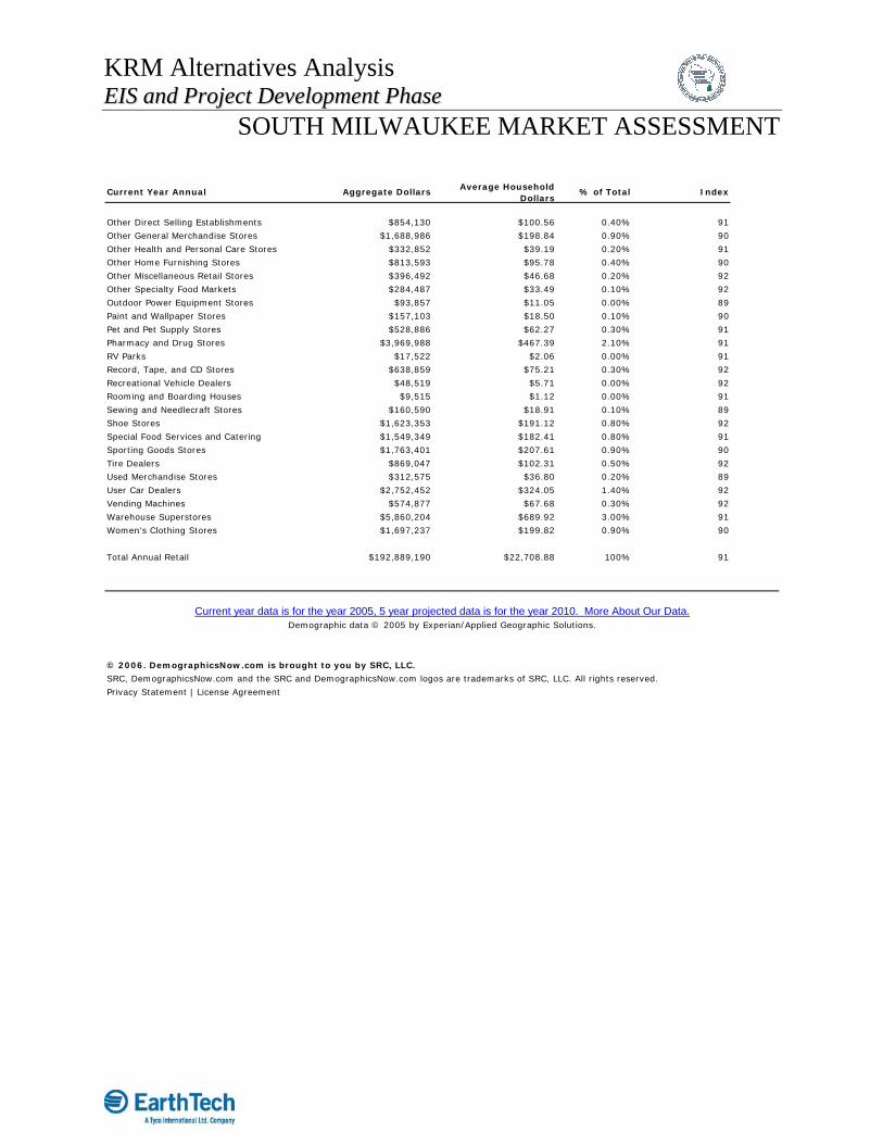
KRM Alternatives Analysis EEIISS aanndd PPrroojjeecctt DDeevveellooppmmeenntt PPhhaassee
SOUTH MILWAUKEE MARKET ASSESSMENT
Current Year Annual Aggregate Dollars Average HouseholdDollars
% of Total Index
Other Direct Selling Establishments $854,130 $100.56 0.40% 91
Other General Merchandise Stores $1,688,986 $198.84 0.90% 90
Other Health and Personal Care Stores $332,852 $39.19 0.20% 91
Other Home Furnishing Stores $813,593 $95.78 0.40% 90
Other Miscellaneous Retail Stores $396,492 $46.68 0.20% 92
Other Specialty Food Markets $284,487 $33.49 0.10% 92
Outdoor Power Equipment Stores $93,857 $11.05 0.00% 89
Paint and Wallpaper Stores $157,103 $18.50 0.10% 90
Pet and Pet Supply Stores $528,886 $62.27 0.30% 91
Pharmacy and Drug Stores $3,969,988 $467.39 2.10% 91
RV Parks $17,522 $2.06 0.00% 91
Record, Tape, and CD Stores $638,859 $75.21 0.30% 92
Recreational Vehicle Dealers $48,519 $5.71 0.00% 92
Rooming and Boarding Houses $9,515 $1.12 0.00% 91
Sewing and Needlecraft Stores $160,590 $18.91 0.10% 89
Shoe Stores $1,623,353 $191.12 0.80% 92
Special Food Services and Catering $1,549,349 $182.41 0.80% 91
Sporting Goods Stores $1,763,401 $207.61 0.90% 90
Tire Dealers $869,047 $102.31 0.50% 92
Used Merchandise Stores $312,575 $36.80 0.20% 89
User Car Dealers $2,752,452 $324.05 1.40% 92
Vending Machines $574,877 $67.68 0.30% 92
Warehouse Superstores $5,860,204 $689.92 3.00% 91
Women's Clothing Stores $1,697,237 $199.82 0.90% 90
Total Annual Retail $192,889,190 $22,708.88 100% 91
© 2006. DemographicsNow.com is brought to you by SRC, LLC.
SRC, DemographicsNow.com and the SRC and DemographicsNow.com logos are trademarks of SRC, LLC. All rights reserved.
Privacy Statement | License Agreement
Current year data is for the year 2005, 5 year projected data is for the year 2010. More About Our Data.Demographic data © 2005 by Experian/Applied Geographic Solutions.

KRM Alternatives Analysis EEIISS aanndd PPrroojjeecctt DDeevveellooppmmeenntt PPhhaassee
TRANSIT ORIENTED DEVELOPMENT
Station Layout Plans


