51

1986Copy 2
Vancouver. Planning Department
Mi seel 1aneous
•
L L/k
Planning Department
City of Vancouver
January 1986
City of Vancouver
Planning Department
LIBRARY

TABLE OF CONTENTS
Page
INTRODUCTION 1
DESCRIPTION OF THE COMMERCIAL AREAS
2.1
2.2
2.3
2.4
2.5
Overview
Davie Village
Denman/Davie
Robson
Georgia/Alberni
7
8
10
13
15
PLANNING ANALYSIS AND ISSUES 17
3.1 Development Control 193.2 Amount and Distribution of Commercial Space 203.3 Roles of the Commercial Areas 213.4 Character of the Retail/Service Areas 25
OBJECTIVES 27
4.1 Amount and Distribution of Commercial Space 29
4.2 Roles and Characters of the Commercial Areas 29
POLICIES 31
5.1 General Commercial Area Policies 335.2 West End Retail/Service Areas 365.3 Robson Mixed Use Area 415.4 Georgia/Alberni Area 43
IMPLEMENTATION 45
APPENDIX 49
7.1 Existing Commercial Areas Policies, Regulations 51
and Guidelines and Proposed Changes
7.2 Current Uses in Retail/Service Areas 56

1 INTRODUCTION
City Council in October 1984 authorized a planning program for the West
End. The objectives of this program were to:
(a) review the policies, plans, and guidelines adopted by Council in the
past and formulate new ones as desirable;
(b) define and address current West End issues; and(c) improve development control for clarity, consistency, and ease of
administration.
To date the following reports have been completed:
West End Planning Program: Issues and Work Program which outlines
current issues and a work program to address many of them and
West End Information Report which provides background data, chronologies,
and current planning policies as a reference package.
This report is about the commercial areas of the West End. It includes
information, objectives, policies and implementation steps to guide the
future of these areas. It does not address commercial activities within
the residential areas of the West End which are minor and not proposed to
be expanded. Nor does it address commercial development along the
Burrard Street boundary of the West End. The former will be considered
as part of future residential reports scheduled for 1986. The latter is
addressed by the Downtown District Official Development Plan. The
relationship of the residential area to the Burrard corridor will be
considered in the residential reports.
The policies, regulations and guidelines presently controlling
development are contained in Appendix 7.1. Adoption of this report by
Council will lead to policy, regulation, and guideline changes and public
improvements and services to:
(a) improve local retail/service areas along Davie, Denman and a portion
of Robson Street;
(b) improve a mixed use area along a portion of Robson Street;
(c) develop a use/design plan with a residential emphasis for the
Georgia/Alberni area; and
(d) replace a portion of the West End Official Development Plan with
District Schedules in the Zoning and Development Bylaw.
This report is organized into six sections. This, the first section,
introduces the plan. Section 2 describes the commercial areas from an
overall perspective and as individual character areas. Section 3
outlines the planning issues. Section 4 sets out objectives to provide
direction to the future of the commercial areas. Section 5 describes
policies to realize the objectives. Finally, Section 6 outlines an
implementation strategy to achieve the policies.
This report was prepared by the Planning Department in consultation with
the Social Planning and Engineering Departments and West End residents,
property owners, and merchants.


£HGL/SH
georgia/alberni -a;
!ROBSON
5]
n
DAVIE VILLAGE
m^x ?
mmmmm/rr
denman/davie =] c=] c==:]
Commercial Areas
0 (00 200 Map No.1

7
2 DESCRIPTION OF THE COMMERCIAL AREAS
2.1 OVERVIEW
The commercial areas consist of four character areas as shown on Map 1:
Davie Village, Denman/Davie, Robson, and Georgia/A!berni. These areas
were defined based upon their locations, current character, and the roles
which they play. In addition, the Jervis to Burrard section of Robson
Street, commonly referred to as "Robsonstrasse", serves West Enders. The
longest walking distance from a residence to a shopping area is
approximately 1300 feet (one-quarter mile) which is convenient for most
people.
To gain an understanding of the amount of retail space in the West End,
it may be compared on a per capita basis with the entire G.V.R.D. Retail
floor area for the G.V.R.D. includes all levels of retail from tourist
through regional to local. The West End retail floor area, on the other
hand, includes only local level retail plus uses such as restaurants
shared with non-residents. Therefore, accommodating per capita retail
space in the West End equal to the G.V.R.D. would provide ample retail
space to serve the West End. The existing amount of retail space in the
West End is approximately 1,265,200 square feet or thirty-four square
feet per person. This compares with forty-three square feet per person
in the G.V.R.D. The existing West End commercial areas, excluding the
Georgia/Alberni Area, can accommodate 1,730,700 sq. ft. of commercial
space or forty-three square feet per person based upon a population of
40,000. If the downtown portion of Robson Street, which is within
walking distance for West End shoppers, is considered this potential
rises to 2,180,300 sq. ft. or fifty-four square feet per person. The
West End, therefore, has ample commercial capacity and room for expansion
to serve its population based upon the existing floor space per capita
within the G.V.R.D.
With the exception of Denman Place Mall, commercial development is in
strip patterns along major roads. The City of Toronto Planning and
Development Department report Support for Retail Strips: General Policy
Proposals describes the characteristics of retail strips as follows:
"Retail strips are the City's traditional shopping districts - the
rows of stores and shops that are threaded throughout the City,
lining many of its major streets. The strip is an old retail form
which developed before the automobile was widely used for shopping
trips. People walked to stores or took the streetcar. The retail
strip's physical form reflects the importance of pedestrian access.Buildings are narrow, and little open space separates them from thesidewalk or their neighbours. The ground floor businesses usually
have doors and display windows along the sidewalk.
The strips developed as a result of many individual decisions and,
in this sense, are "unplanned". There is no central control or
management of the shopping environment other than that afforded by
the city government. Most of the businesses in retail strips are
independently owned as opposed to being members of corporate
chains. The store sizes tend to be small.
8
Most retail strips lie adjacent to residential neighbourhoods. Theyare the neighbourhoods' traditional centres for shopping activity,and serve as meeting places and community service centres.
Therefore, the amenity of the city's residential neighbourhoods isvery much affected by what goes on in the retail strips. The
physical form and appearance of the strips and the activities that
locate in them all influence neighbourhood life."
This description of characteristics 1s applicable to much of the West End
commercial area although variances occur particularily along a portion of
Robson Street and in the Georgia/Alberni area. The four commercial
character areas are described in the following sections.
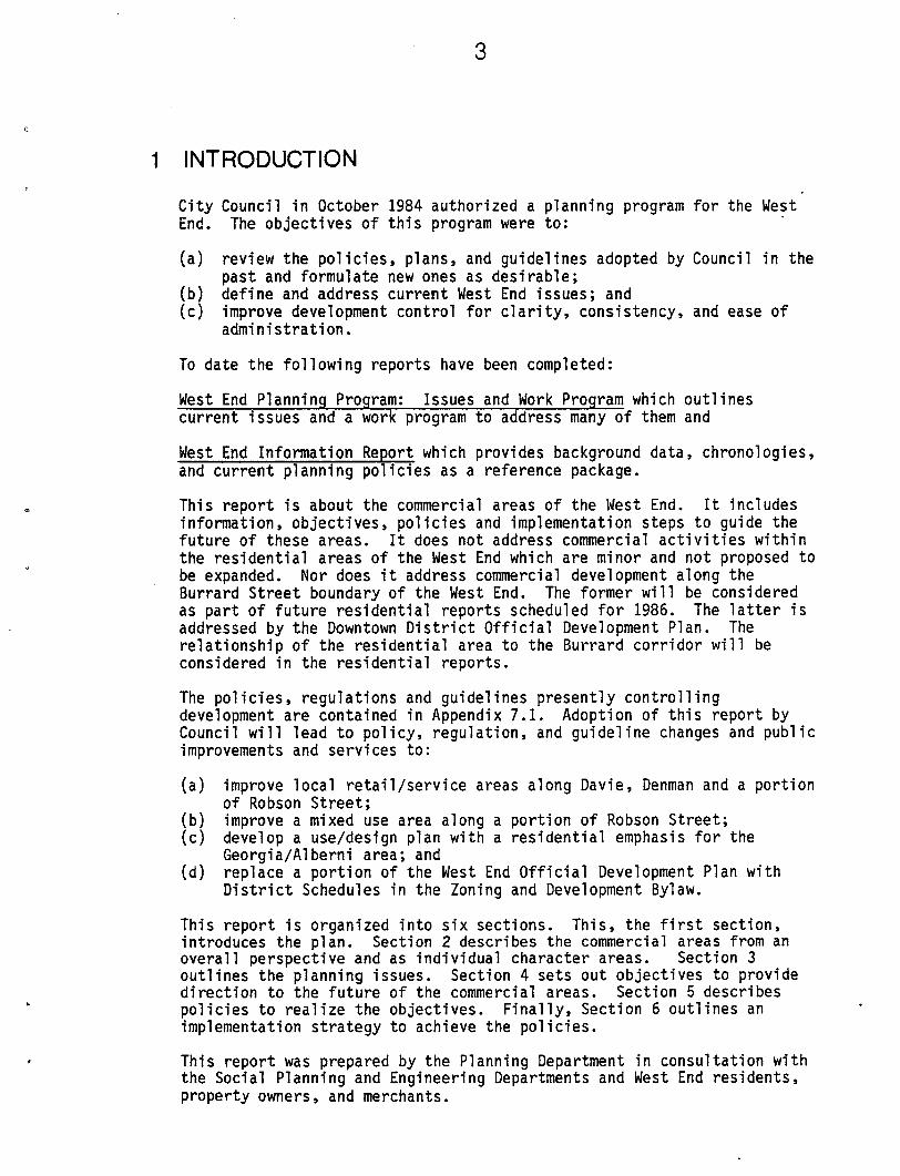
2.2 DAVIE VILLAGE
Davie Village is located at the crest of the hill which rises from Sunset
Beach, making access for the elderly or handicapped difficult from the
south1. The commercial area itself is relatively flat. The area issurrounded on three sides by apartment development of varying height with
a greater concentration of taller buildings to the south, down the
slope. To the north and east St. Paul's Hospital and low scale
commercial development extend along Burrard Street. To the west is a
three block residential strip along Davie between this area and the
Denman/Davie commercial area.
Davie Village character
1. In this report the cardinal directions are used as is typically done
by residents, e.g. "West of Denman", even though the street pattern
is 45° to the cardinal axis.

This area is primarily a retail/service area for local residents offering
a range of shops and services. It also contains general business offices
and entertainment, facilities, particularly at its eastern end adjacent to
downtown. Dominating single uses are a twenty-two storey hotel, a
supermarket, and a set back suburban style commercial plaza. The most
prevalent use in the area is restaurants which represent 24.5 percent of
the shops and services. A listing of shops and services is in Appendix
7.2. The predominant building height is two storeys although, in
addition to the hotel, there is a six storey and a twenty-four storey
residential building.
Davie Village
Land Use
EM3 Residential ^^ Office
Map No. 2
uto/Parking
The pedestrian character of this area is generally weak. There are
significant gaps in pedestrian interest caused by long blank facades,
parking areas, and office uses. Weather protection is minimal.
Pedestrian volumes decrease east of Thurlow. Signalized crossings of
Davie exist at Burrard, Thurlow, and Bute which facilitate pedestrian
crossings.
The subdivision pattern is varied with parcel widths ranging from
thirty-three feet to a full block. A number of parcels front the side
streets intersecting Davie which creates commercial frontages on thesestreets. This pattern creates parking, loading, and garbage container
locating problems and, to some degree, reduces shopping continuity along
Davie Street.
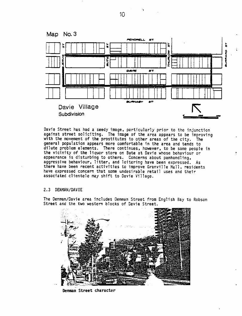
10
Map No. 3
Bumuimrr st
Davie Village
Subdivision
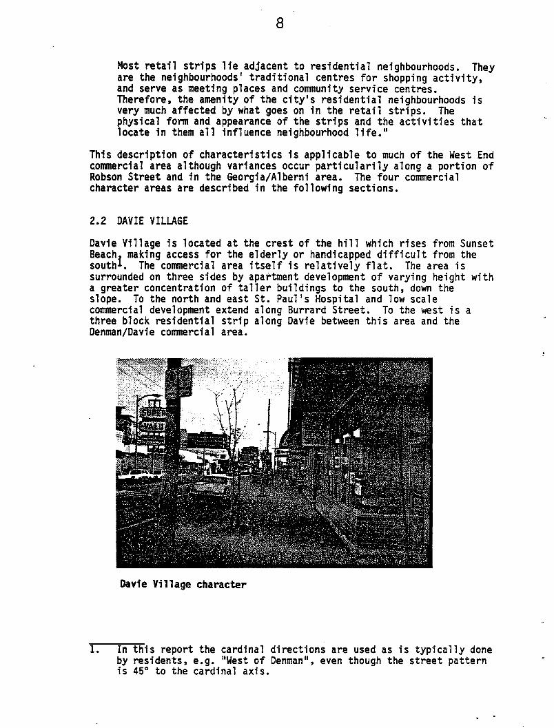
Davie Street has had a seedy image, particularly prior to the injunction
against street soliciting. The image of the area appears to be improving
with the movement of the prostitutes to other areas of the city. The
general population appears more comfortable in the area and tends to
dilute problem elements. There continues, however, to be some people inthe vicinity of the liquor store on Bute at Davie whose behaviour or
appearance is disturbing to others. Concerns about panhandling.,
aggressive behaviour, litter, and loitering have been expressed. As
there have been recent activities to improve Granville Mall, residents
have expressed concern that some undesirable retail uses and their
associated clientele may shift to Davie Village.
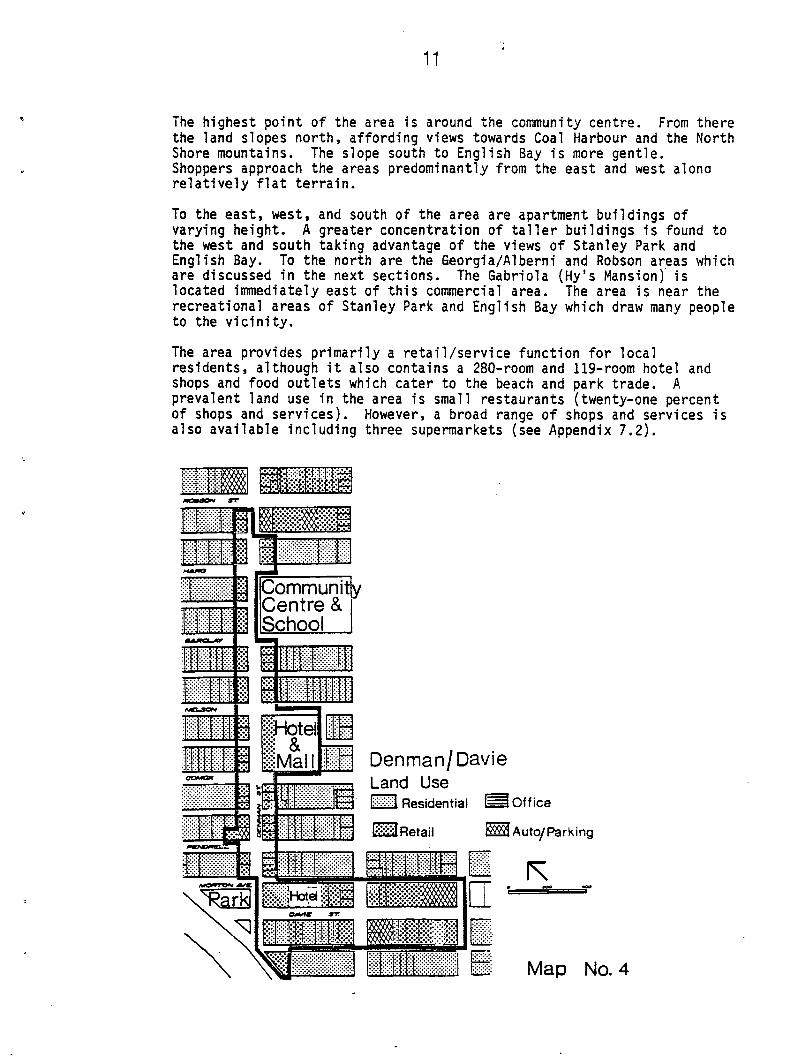
2.3 DENMAN/DAVIE
The Denman/Davie area includes Denman Street from English Bay to RobsonStreet and the two western blocks of Davie Street.
Denman Street character
11
The highest point of the area is around the community centre. From there
the land slopes north, affording views towards Coal Harbour and the North
Shore mountains. The slope south to English Bay is more gentle.
Shoppers approach the areas predominantly from the east and west along
relatively flat terrain.
To the east, west, and south of the area are apartment buildings of
varying height. A greater concentration of taller buildings is found to
the west and south taking advantage of the views of Stanley Park and
English Bay. To the north are the Georgia/Alberni and Robson areas which
are discussed in the next sections. The Gabriola (Hy's Mansion) is
located immediately east of this commercial area. The area is near the
recreational areas of Stanley Park and English Bay which draw many people
to the vicinity.
The area provides primarily a retail/service function for local
residents, although it also contains a 280-room and 119-room hotel and
shops and food outlets which cater to the beach and park trade. A
prevalent land use in the area is small restaurants (twenty-one percent
of shops and services). However, a broad range of shops and services isalso available including three supermarkets (see Appendix 7.2).
CommunitjyCentre &
School
SHotei
iMall Denman/Davie
Land Use
Residential ^M Office
I Auto/Parking
Map No. 4

12
The predominant building form is one and two storeys with small shops
oriented to the street. Significant exceptions are the hotels,
supermarkets, and residential towers on the south side of Davie.
The pedestrian character and activity of the area is mixed. The south
side of Davie with its residential, gas station and supermarket
development has little pedestrian interest. The pedestrian activity is
most intense along Denman between Barclay and Davie, particularly in the
summer when the sidewalks act as a promenade. Traffic signals exist at
Davie, Nelson, Haro and Robson. Crosswalks exist at all other
intersections.
The subdivision pattern and the shallow (66 ft.) depth of commercialzoning are deterrents to new development along Denman Street. The lack
of a lane to the rear of commercial properties creates service access,
parking access, and garbage container location problems. These
difficulties are particularly acute for parcels or shops which do not
flank a street or lane.
Iffi j
i !
Denman/Davie
Subdivision
Map No. 5

13
2.4 ROBSON
The Robson Area is relatively flat between Denman and Cardero where it
begins to rise seventy feet to Jervis. Cardero also marks a functionalchange along Robson between essentially a local shopping character to the
west and a mixed use character (offices, hotels, retail, residential and
restaurants) to the east.
To the south is the central residential area of the West End. Although
high rises exist in this area, the greatest proportion of buildings are
four storeys or less. The grades along the north-south streets leading
from the residential area to Robson are flat affording easy access. To
the north is the Georgia/Alberni area described in the following section
and downtown. To the east is the most active retail area of Robson--
Robsonstrasse.
The section of the area between Denman and Cardero performs primarily a
retail/service function for the local community. The area contains a
supermarket, liquor store and public market as well as numerous small
shops and services (see Appendix 7.2). As with the Davie Village andDenman/Davie areas, restaurants are a prevalent use (twenty percent ofshops and services). The Robson Office of the Health Department is also
located here to serve West End residents.
The section of the area between Cardero and Jervis performs a mixed role
without a strong local neighbourhood character. Hotels, offices, and
restaurants predominate although smaller shops and residential uses do
exist.
Robson Street east of Broughton
Buildings in the Denman-Cardero section are generally low with shop
fronts facing the street. Significant exceptions are two residential
buildings of nine and twenty-two storeys.
Buildings in the Cardero-Jervis section vary significantly in height and
density and provide no visual coherence.

14
sr
RobsonLand Use
fHH Residential
Map No. 6
[Office Retail I Auto/Parking dlVacant
The pedestrian character of the Denman-Cardero section is fairly strong.
However significant gaps in pedestrian interest exist caused by surface
parking, supermarket, and gas station uses. Weather protection is also
discontinuous.
Jhe pedestrian character of the Cardero-Jervis section is weak.
Pedestrian elements of visual interest, landscaping, and uses and
buildings with a pedestrian orientation are limited.
The subdivision pattern of the entire area is similar to the Davie
Village area with parcel widths varying from thirty-three feet to nearly
a full block. Some parcels front the side streets which intersect Robson
but most of these are consolidated as single development sites. Thus the
pattern neither presents special opportunities nor detriments to
development.
I nm\_m=f1l III IHIHIIII Illl
—
RobsonSubdivision
E
Map No. 7

15
2.5 GEORGIA/ALBERNI
The Georgia/Alberni Area slopes gently north to the city's most
important, prestigious and ceremonial street — Georgia Street. The area
has been called an "emerging area" — one which has not yet developed but
has great potential. The area is surrounded by great variety of land use
and form. To the north is Devonian Harbour Park, the Bayshore Inn, the
marinas of Coal Harbour and views of Burrard Inlet and the North Shore
mountains beyond. To the east is the Downtown office area which
additionally contains a number of significant residential buildings. To
the south is the Robson retail area and the residential area south of
Albemi Street. To the west is Stanley Park.
Georgia Street vacant sites
The area is characterized by a preponderance of vacant sites and older
underdeveloped one or two storey buildings containing what appears to be
relatively interim footloose retail uses. These conditions indicatethere is significant potential for redevelopment throughout the area.
The City recently purchased the motor vehicle testing station site. B.C.
Hydro owns and is currently marketing approximately 3/4 of the block to
the south across Alberni. These sites present significant development
opportunities. The most dominant new developments in the area of a
permanent nature are three prestigious high rise residential buildings on
the south side of Alberni. In summary this area presents the greatest
opportunity for redevelopment of all the commercial areas and, in fact,
of all the West End.

16
I
I
I
I ITOO iaoo
/I
GEORGIA ST
iiiiiiiiiiiiiiiiiiimiimiiimmiiii
j 1
J....LROBSON ST
Georgia AlberniLand Use
IHI Residential H=li Off ice
Map No. 8
lAuto/Parking CZIvacant
GEORGIA STiriH""MUMUUHUIIIItUlliMUUUUtUUIUI»MIIIIIIIMIIIIIIIMIIUUlUlllUIUIIIIUIIIIIIIIIMWIUIUUIIIIIIIIIItlllUIIUIUIIIIIIIIIIIim
n
8
u
I
Georgia Alberni
Subdivision
ST
U1MIIIII
ROBSON ST
!IIHUI UillllHI
Map No. 9


19
3 PLANNING ANALYSIS AND ISSUES
3.1 DEVELOPMENT CONTROL
The round of discussion and reports generated by the review of the City'sdevelopment control process and local concerns expressed about the
approval of Burger King Restaurant on Denman Street point out a desire
for greater clarity in development regulations and guidelines. Thisdesire is shared by community residents, developers and architects, and
City Council and staff. The work involved has been termed "review and
rationalization". It includes:
clarifying and standardizing development control documents;
updating policies, regulations and guidelines;
minimizing the need for discretion in the review of developments
where appropriate;
minimizing the amount of regulations.
The West End planning proposals and means of implementation contained
herein have been developed with this objective in mind.
Burger King restaurant on Denman

20
3.2 AMOUNT AND DISTRIBUTION OF COMMERCIAL SPACE
A fundamental decision is required as to the appropriate amount of
commercial space potential for the West End. Should an amount surplus to
West End residents' needs be provided to serve a regional market or
should space be balanced with local area needs?
Section 2 describes the current distribution and roles of the commercial
areas of the West End and shows that they are well distributed to serve
the community — each residential area being within easy walking distance
of a shopping area. Section 2 also notes that the existing zoned
potential for retail space is more than adequate to serve the population
of the West End and that there is some room for growth through
redevelopment. Because the commercial areas are well distributed and
adequate in floor space to serve the West End population, commercial
expansion, either through density increases or land area increases would
require drawing upon a larger market than the West End community. While
people from other communities currently use the West End shops and
services and vice versa, providing more commercial space, out of balance
with the local population, would increase non-local traffic and
exacerbate an already difficult parking problem. On the other hand more
commercial space could yield more choice for West End residents and the
regional market.
While we recognize that people from throughout the region will use some
of the West End's shops and services, we believe the commercial potential
should not be increased to depend upon a regional market. The negative
impacts would outweigh benefits. Ample opportunities for region serving
retail development exist nearby in Downtown.
While we do not support commercial expansion, two areas occasionally
suggested for expansion are the three block residential area on Davie
Street between the Davie Village and Denman/Davie commercial areas and an
increased depth of commercial zoning along Denman Street. In addition to
the reasons outlined above, these expansions are undesirable because both
areas contain valuable housing stock and the age and condition of much of
the housing is such that redevelopment would be slow. This slow pace
would yield a difficult transition period with a discontinuous retail
pattern which is disruptive to residents and undesirable for merchants.
Reasons supporting such expansions are the difficulty of developing along
Denman, partially due to the shallow parcel depth, and the acoustical
challenges posed for residential development along Davie Street. Other
solutions for Denman are suggested in Section 5. The residential reports
which will follow this commercial areas plan will address residential
development on major streets.

21
Davie Street apartments east of Denman
3.3 ROLES OF THE COMMERCIAL AREAS
As described in Section 2 and noted below, the commercial areas of the
West End presently have varying primary roles:
Davie Village:
Denman/Davie:
Robson:
local serving retail/services
local serving retail/services (with some regionaluse, particularily by beach and park users)
Denman to Cardero: local serving retail/services
Cardero to Jervis: mixed use (hotel, restaurant,
office)
Georgia/Alberni: undefined, underdeveloped with no strong role: an
emerging area
Each of these areas also have secondary roles including residential,
hotel, and entertainment functions, but the roles noted above are clearly
dominant. They evolved in response to site and area-specific
opportunities. The appropriate future roles of these areas are analyzed
on the following pages.

22
3.3.1 Retail/Service Areas
The local serving retail/service roles of Davie Village, Denman/Davie and
the western portion of Robson should be maintained and reinforced for thefollowing reasons:
they are well distributed to serve the residential areas;
the market appears responsive to building for this use;
the alternative commercial options of large region serving
commercial uses, hotels, and general and administrative offices are
inappropriate due to traffic and parking demand generation;
other uses would reduce the amount of land available for local
serving commercial uses, possibly to an amount below that needed to
serve the community;
other uses interspersed with pedestrian oriented shops and services
would disrupt the pedestrian continuity reducing the attractiveness
of these areas for shoppers;
in the case of the western portion of Robson, a local retail/service
role was recently affirmed by City Council when adopting the
Character Area Descriptions.
It would be undesirable if the three retail /service areas specialized to
the extent that they exclude desirable goods and services. In
particular, convenience goods and services such as groceries, personal
toiletries, banking, shoe repair, hair cutting, film processing, laundry
and dry cleaning, should be available to residents in each of the areas.
Residents require easy access to such goods and services in order to
satisfy their basic personal and household needs. Presently the three
retail/service areas are well distributed and provide the needed goods
and services.
Concern has been raised by some residents that the range of commercial
uses is being threatened by the number of restaurants outbidding other
uses for commercial space. Twenty to twenty-four percent of the shops
and services in each of the areas are restaurants. Many of these serve a
broader than local market, in particular, along Denman Street, the beach
and park visitors. Review of the lists of shops and services contained
in Appendix 7.2 suggests a wide range continues to be found in the three
areas with these percentages of restaurants. While it is not possible torequire uneconomic uses to remain, it may be possible to limit the number
of restaurants by placing a ceiling on the percentage of a given
commercial frontage which may be occupied by restaurants (San Francisco
uses twenty-five percent in some districts). Setting aside legal,
administrative and property owner concerns which may arise, such a
ceiling is not proposed at this stage because restaurants do not appear
to be excluding other desirable goods and services. On the other hand,
over time this could become a concern. We therefore intend to monitor
the range of uses and report with suggested actions if legitmate concerns
do arise.

23
The essential character of the retail service areas should be maintained
by encouraging uses which are compatible in scale and type with the areas
in which they are located. However, they also should be allowed to
evolve over time in response to changes in the neighbourhoods they serve
and changes in consumer tastes and preferences. Our approach is not to
steer the areas in particular directions but rather to provide
opportunities for a broad range of uses while at the same time excluding
noxious or disruptive uses.
3.3.2 Robson Mixed Use Area
As noted, the role of the Robson area between Cardero and Jervis is
mixed. It acts as a transitional area between the West End and Downtown
in terms of density and land use. The area does not have a strong local
neighbourhood character evident in built form or land use. Given the
current state of development with substantial non-retail buildings, many
of which are well over the currently allowable density, requiring the
continuous ground floor street related retail expected in the retail/
service areas does not seem practical or desirable. As suggested in the
recently approved Character Area Descriptions document, the area would
best continue to develop with a mixed use character having particular
regard, with land use and design, to compatibility with the residential
community to the south and pedestrian interest along Robson Street.
3.3.3 Georgia/Alberni Area
Presently the Georgia/Alberni area is of indeterminate character. The
preponderence of vacant sites, older one or two storey buildings, and
footloose uses indicate that the area is underdeveloped with significant
potential for redevelopment. Traffic and public realm development issues
including the Chilco bus loop, park roadway realignment, the connection
of Georgia to Alberni, and the street landscaping concept are yet to be
resolved which makes a detailed development concept difficult to propose.
The Official Development Plan designates this area as 'C'and 'CH'
permitting hotels and a range of "small-scale commercial uses catering
primarily to the needs of West End residents" in addition to residential
uses. Non-local commercial uses such as general and administrative
offices are not permitted. No hotels have been developed. Retailing in
this area is divorced from the West End residential areas and is surplus
to the community's retail space requirements. The retailing activity
which does occur fronting Georgia Street tends to have a commuter rather
than a West End orientation.
Opportunities for residential development in this area have beenconsidered for a number of years. The Greening Downtown study suggested
a significant residential component would be suited to this area. The
Character Area Descriptions which arose from extensive committee analysis
of this study also suggested a residential component. The predominant
new buildings in this area are high quality, high rise residential.
Current floor space ratio and units/acre maxima coupled with a lack of
interest in commercial development in this area have yielded yery large
suite sizes in these buildings.

24
The high level of amenity in this area, inherent compatibility with
existing residential use, residential development interest, and general
oversupply of commercial space combine to make residential development of
the Seorgia/Alberni area an attractive option. The major impediment to
residential development is existing and potential traffic impacts.
Because the major traffic and public realm design issues are unresolved
at this time and because the potential for a significant residential
component in this area needs further exploration (particularily in lightof Council's preference for a connection of Georgia to Alberni at Chilco
Street) analysis of this area will be continued and reported concurrently
with the residential component of the West End Program in 1986.
Residential development on Alberni Street

25
3.4 CHARACTER OF THE RETAIL/SERVICE AREAS
The primary role of each of the retail/service areas is to provide
neighbourhood servicing goods and services. To achieve this function
while reducing the need for automobile use and increasing the convenience
and comfort of shopping, the pedestrian orientation of these areas should
be maintained and enhanced. Building design and public improvements
should contribute to this orientation through an overall urban design
concept. Variances among the areas' characters' will evolve due to their
varying locations, localized markets, subdivision patterns and existing
development.
Presently, as noted in Section 2 there are numerous gaps in pedestrian
interest and weather protection. Other aspects of importance to the
convenience, pleasantness, and success of these areas are: parking which
suits local demand, efficient shop servicing (loading, garbage storage
and pickup), public realm improvements, litter containers and clean up,and building design considerations to achieve compatibility with nearby
residences, suitable street scale, sunlight access and view retention.
An additional issue affecting the comfort of these areas frequently
raised is concern about panhandling, aggressive behavior, and loitering.
In addition to issues which are common to the local retail/service areas,
the character areas have specific issues as noted below.
Davie Village
Reinforcing the local retail/service role and image through building
design and public improvements is particularly important. The area
is on the edge of Downtown, lacks a strong identity, and could
easily become just another Downtown commercial street.
The relationship of development along Davie Street to that on
Burrard Street at Davie requires study to achieve scale and
pedestrian compatibility.
Commercial frontages along side streets which intersect Davie Street
require consideration related to servicing, appearance, parking, andshopping continuity.
Robson-Denman to Cardero
Pedestrian continuity is particularly weak in this area.
Penman/Davie
This area is in the heart of the West End and has a feeling distinct
from the Downtown. It is a focus of community activity containing
the community centre, library, high school, and two movie theatres.
While not diminishing the importance of serving general community
needs, secondary use orientation can evolve to serve seniors who
form a sizable portion of local residents and beach and park users.
Parking, loading, garbage storage and residential interface issues
caused by the subdivision pattern, depth of commercial development
and lack of lanes parallel to Denman Street require resolution.


29
4 OBJECTIVES
The following Objectives have been established to form the basis for
development and improvements in the West End commercial areas. The
Objectives respond to the existing area characters and issues described
in Sections 2 and 3.
4.1 AMOUNT AND DISTRIBUTION OF COMMERCIAL SPACE
4.1.1 To maintain a commercial space potential which is in balance
with the size of the current West End population and allows
modest opportunity for growth to accommodate changing
population size and consumer trends.
4.1.2 To maintain a distribution of commercial space such that
each residence is within a comfortable walking distance of a
retail/service area.
4.2 ROLES AND CHARACTERS OF THE COMMERCIAL AREAS
4.2.1 To maintain and strengthen the local retail/service roles of
Davie Village, Denman/Davie, and the Denman to Cardero
section of Robson by developing quality, pedestrian oriented
urban design characters and maintaining a broad range of
goods and services.
4.2.2 To maintain and strengthen the mixed use role of the Robson
Area between Cardero and Jervis, having particular regard,
with land use and design, to compatibility with the
residential neighbourhood to the south and pedestrian
interest along Robson Street.
4.2.3 To emphasize residential development, view retention, the
dominant prestigious, ceremonial image and character of
Georgia Street, and the other development objectives
outlined in the Georgia Street Character Area Description in
the Georgia/Alberni area.
(Note: The residential emphasis noted in this objective
will vary with the location of the future Georgia/Alberni
connection. However, residential opportunities will be
maximized based upon the constraints and opportunities
afforded by each option.)

32
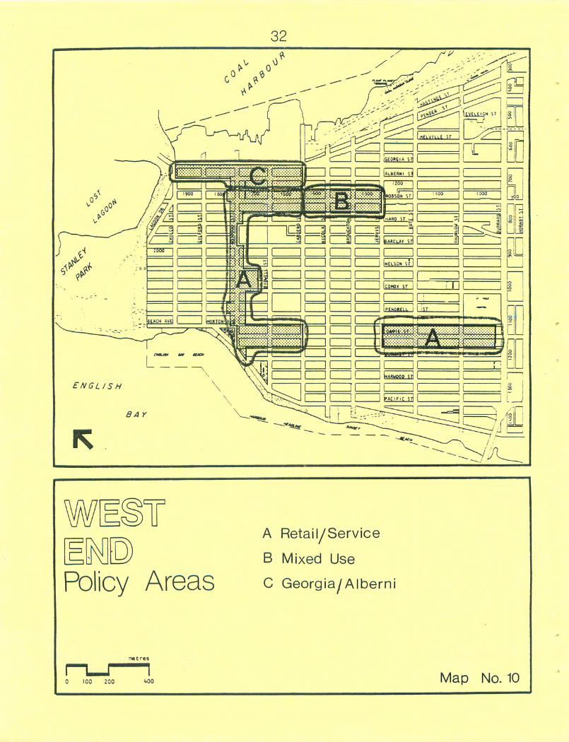
ENGLISH
BA Y
D
Policy Areas
A Retail/Service
B Mixed Use
C Georgia/Alberni
0 100 200 (.00 Map No. 10
33
5 POLICIES
The following Policies are based upon the Objectives listed in Section 4
and provide specific guidance with respect to development, improvements
and services in the West End commercial areas shown on Map 10. These
Policies supercede the currently approved policies listed in Section
7.1.2 of the Appendix. They are organized into four sections:
5.1 General Commercial Area Policies
5.2 West End Retail/Service Areas
5.3 Robson Mixed Use Area
5.4 Georgia/A!berni Area
5.1 GENERAL COMMERCIAL AREA POLICIES
The Policies in this section apply to all the West End commercial areas
except Georgia/Alberni which is subject to the separate review of Policy
5.4.1. They are intended to provide an appropriate amount and
distribution of commercial space, complementary ancillary services,
residential development opportunities, and needed public improvements and
programs.
Policy 5.1.1 Maintain the existing extent and density of commercial
development potential.
Implementation:
Do not change in new zoning district schedules.
Discussion:
The current amount of commercial development potential is ample to
serve the present needs of the West End and provides reasonable
opportunity for growth. Increasing this potential would require
drawing upon a larger market than that which exists in the West End
thereby increasing non-local traffic and exacerbating an already
difficult parking problem. While increasing the potential may also
increase consumer choice, we believe the negative effects outweigh
possible benefits.
34
Policy 5.1.2 Maintain the existing distribution of local serving
retail/service areas.
Implementation:
Develop zoning boundaries corresponding to the existing commercial
area designation.
Discussion:
The current distribution of local retail/service areas, which is
shown on Map 10, is such that each resident is within one-quarter
mile of a residential area which is a comfortable walking distance
for most people.
Policy 5.1.3 Encourage residential development which, through its design,
density and location, is compatible with commercial uses and
surrounding residential development.
Implementation:
Include opportunities for residential development in the new zoning
district schedules.
Discussion:
The commercial areas already contain a significant number of
residences. This opportunity should be continued. A mixed
commercial/residential character makes retail areas more diverse and
active and strengthens their social and community functions.
Residential use also increases street surveillance and safety. In
the local retail/service areas residential use is not desirable at
grade fronting the shopping streets because it interferes with the
continuity of shopping. In those areas it is proposed for the upper
floors. Regulations and guidelines would be developed to achieve
acceptable livability standards and compatibility with commercial
development.
Policy 5.1.4 Require efficient and unobtrusive ancillary commercial
facilities including garbage storage, parking, loading, and
mechanical venting.
Implementation:
Include appropriate regulations in new zoning district schedules.
Discussion:
It is these ancillary commercial facilities which can have the
greatest negative impact on nearby residents. These facilities are
generally located at the rear or sides of commercial buildings
overlooked from residences.
The zoning district schedules will include standards governing the
location and screening of garbage containers. The development
standards of parking and loading facilities will be achieved through
Section 12 of the Zoning and Development Bylaw. Standards of
mechanical venting will be reviewed with the Health Department to
achieve a suitable standard to reduce noxious odours. Screening of
rooftop mechanical equipment will be controlled by the new zoning
district schedules.

35
Policy 5.1.5 Improve the safety, attractiveness and pedestrian
orientation of the public realm through an overall urban
design and maintenance program which includes:
(a) providing attractive and strategically located litter
receptacles.
(b) encouraging merchants to help keep the streets cleanand if necessary promoting increased street cleaning
services, as is done in certain other commercial areas
of the city.
(c) increasing sidewalk width by eliminating difficult tomaintain boulevards.
(d) reviewing potential for landscaping in boulevard areaswhere it would not conflict with on-street parking or
traffic safety.
(e) filling gaps in street tree planting along Robson andDavie Streets.
Implementation:
Request the City Engineer and the Director of Planning to report
back within three months on the cost, feasibility and method of
achieving these projects.
Discussion:
Public realm urban design improvements and maintenance should be
undertaken to achieve a strong, attractive physical identity and to
complement the standards expected of private development. In public
meetings the maintenance and cleaning of the streets and sidewalks
was a frequently raised concern. An additional concern raised is
the appearance of lanes which intersect Denman Street. The design
and location of litter receptacles will be assessed. Street
cleaning programs will be discussed with merchants.
Davie Village public realm

36
5.2 WEST END RETAIL/SERVICE AREAS
In addition to the Policies listed in Section 5.1, the following Policies
apply to the retail/service areas shown on the map below.
ENGLISH
BAY
West End Retail/Service Areas
Map No. 11
These Policies are intended to encourage a local serving, pedestrianorientation for these areas and improve their interfaces with the nearbyresidential areas. Together with the Policies of Section 5.1, they
achieve Objective 4.2.1.

37
Policy 5.2.1 Provide for a range of retail and service uses catering to
the needs of the West End and compatible with its primarily
residential character.
Implementation:
Include appropriate uses in new zoning district schedule and exclude
uses which are incompatible with the area's residential character.
Include frontage regulations to control shop size.
Discussion:
The current criterion for judging the suitability of a commercial
use is that the use must "cater primarily to the needs of West End
residents". This causes problems. A population of close to 40,000
needs virtually ewery commercial use, yet some of these uses are
clearly problematic and are better located in non-residential
areas. On the other hand, some uses, such as specialty shops, need
a larger market than 40,000 people. Such shops are not soley "local
serving" yet they can be perfectly compatible with the local
shopping areas in terms of scale, form, pedestrian interest, and
parking and traffic generation. Therefore, the local/non local
serving distinction is not a practical means to assess the
appropriateness of a use.
The following principles will be used in drafting the regulations
and guidelines controlling uses in the local retail/service areas:
(a) The size of shop or service should generally fit the localmarket, recognizing that small specialty shops may serve a
larger area and individual uses may vary in size (a
supermarket may require a larger floor area than a shoe
repair shop in order to serve the same market area). Shop
• sizes will be controlled in most cases by a maximum frontage
requirements (current guideline is twenty-five feet). Anydesirable exceptions (e.g. supermarkets, gas stations) canbe specified in the zoning schedule or guidelines.
(b) Some uses are objectionable or inappropriate in aresidential area and should be specifically excluded in the
zoning schedule, for example, drive-in restaurants and the
sale or rent of sex-oriented products. The current
regulations prohibiting the sale of sex-oriented productswas quashed by the Court of Appeal. The Legal Department is
exploring alternatives and proposes to report on these laterthis year.

38
Policy 5.2.2 Maintain and enhance the pedestrian orientation of theretail/service areas through an urban design concept which:
(a) limits shop front widths for most uses;
(b) provides pedestrian interest to any wide shop frontagesthrough display windows, planting, facade articulation,etc.;
(c) requires continuous retail/service use at grade fronting theshopping streets;
(d) locates auto-oriented facilities to minimize pedestrianinterference;
(e) achieves continuous but individualized weather protectionalong shop fronts;
(f) establishes building height limits which allow sunlightaccess to opposite sidewalks at noon on the equinox,
preserves important public and private views, and achieves a
suitable street scale.
Implementation:
Include provisions in new zoning district schedule and guidelines.
Discussion:
The intent of these proposals is to improve the convenience,
comfort, and interest of these areas for the pedestrian. These
proposals are currently achieved with guidelines. Where practicalthey will be incorporated in the new district schedule as
regulations.
Policy 5.2.3 Improve the commercial/residential interface and access to
parking, loading, and garbage storage along Denman Street
where there is not an intervening lane by:
(a) encouraging site consolidation with adjacent residentialproperties for mixed use development;
(b) encouraging site consolidation along Denman Street betweenstreets and lanes which intersect Denman to achieve laneaccess for each shop for servicing and parking.
Implementation:
Reference to concerns with small sites would be made in the zoning
district schedule or guidelines. Negotiations to encourage
consolidation would be undertaken because redevelopment of small
sites would require relaxation of parking, loading and garbage
container locating requirements.

39
Discussion:
The lack of a lane behind commercial development on both sides ofDenman Street creates problems for loading, garbage storage, and
parking access. This is especially acute for properties without
flankages on a street or lane as shown on Diagram A.
Street Street Street
■■■■■I
c
CO
co
Q
c
03
E
ILane
rLane Lane
B
c
CO
£co
Q
r
It is not practical to create lanes parallel to Denman Street. The
commercial properties are too shallow to dedicate and retain reasonable
development potential. There is no incentive for residential properties
to dedicate. Purchase of residential properties would be very costly for
the benefit achieved. The most practical means to achieve efficient
servicing and parking is through consolidation as shown on Diagrams B and
C.
Consolidation Option B is preferred because the residential/commercial
interface can be handled on the one development site. However, this is
practicable on only three of sixteen sites due to recent or substantial
adjacent residential development. If Option B were achieved, the
commercial floor space would be calculated on the currently designated
commercial area (i.e. one lot depth off Denman). Variety and pedestrian
interest would.continue to be achieved through the provisons of Policy
5.2.2., that is, even though the site is consolidated, small
individualized shop frontages would be developed along Denman.
Consolidations similar to Option C currently exist in four of the sixteen
sites with an additional three subdivided sites currently in common
ownership. On consolidated sites, parking and servicing can occur from
the lane. As in Option B, variety and pedestrian interest would be
achieved through the provisions of Policy 5.2.2.
In all of the above situations, there is no increase in the existing
commercial FSR potential, nor is there an
into the residential area.
'expansion1 of commercial uses
40
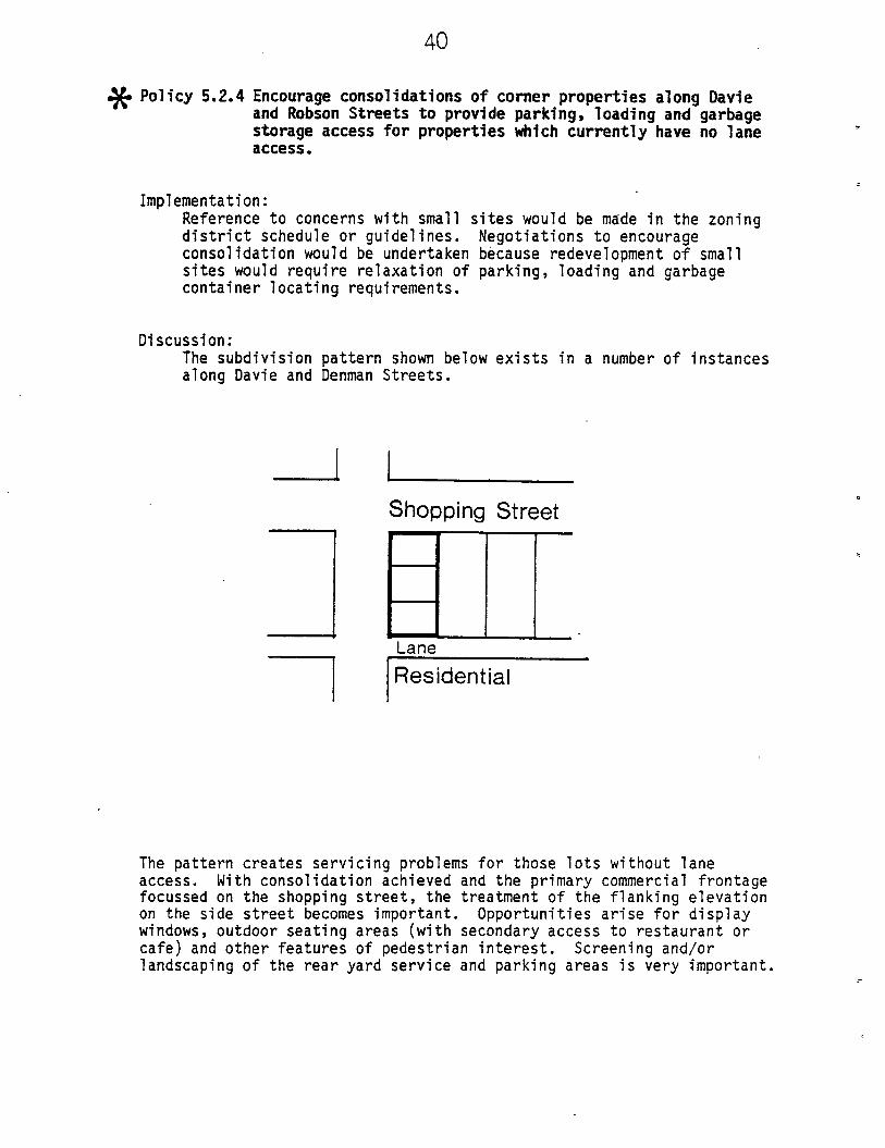
Policy 5.2.4 Encourage consolidations of corner properties along Davie
and Robson Streets to provide parking* loading and garbage
storage access for properties which currently have no lane
access.
Implementation:
Reference to concerns with small sites would be made in the zoning
district schedule or guidelines. Negotiations to encourage
consolidation would be undertaken because redevelopment of small
sites would require relaxation of parking, loading and garbage
container locating requirements.
Discussion:
The subdivision pattern shown below exists in a number of instances
along Davie and Denman Streets.
Shopping Street
Lane
Residential
The pattern creates servicing problems for those lots without lane
access. With consolidation achieved and the primary commercial frontage
focussed on the shopping street, the treatment of the flanking elevation
on the side street becomes important. Opportunities arise for display
windows, outdoor seating areas (with secondary access to restaurant orcafe) and other features of pedestrian interest. Screening and/orlandscaping of the rear yard service and parking areas is very important.

41
5.3 ROBSON MIXED USE AREA
In addition to the Policies listed in Section 5.1, the following Policies
apply to the Robson Mixed Use Area shown on the map below.
I 31 31 31 3C^T3
Map No. 12
Together with the Policies of Section 5.1, these Policies are intended to
achieve Objective 4.2.2.
Policy 5.3.1 Provide for a density and range of uses which achieves a
transition between the West End and Downtown having
particular regard to the interface with the residential area
to the south. Such uses would include, in addition to those
permitted in the retail/services areas, hotels, general
offices, and residential as a principal use.
Implementation:
Include provisions in new zoning district schedule and guidelines.
Discussion:
This area provides a transition in density, and mix of uses betweenthe West End and Downtown. It also is a linkage along Robson Street
between the Robsonstrasse area and the Robson retail/service areaproposed to the west. Given the current state of development with
several hotels and offices it does not seem feasible or desirable torequire continuous street-related retail uses, although such usesshould certainly be permitted. Offices and residential buildings
are additional suitable uses in keeping with the area's transitional
role and current use mix. Design regulations and guidelines will be
established to achieve compatibility with the residential area to
the south and pedestrian interest along Robson Street. While hotels
are an acceptable transitional use between the residential area and
Downtown, ancillary facilities such as large beer parlours cause
disruption in the abutting neighbourhood and should be excluded.

42
Policy 5.3.2 Provide pedestrian Interest at street level by:
(a) restricting auto-oriented facilities
(b) achieving continuous but Individualized weather
. protection
(c) applying the "Street Definition and Visual Interest" and
"Pedestrian" sections of Robson Street Character Area
Guidelines as adopted by Council
(d) establishing building height limits which allow adequatesunlight access to opposite sidewalks at noon on the
equinox, preserve Important public and private views,
and achieve suitable street scale.
Implementation:
Include provisions in new zoning district schedule and guidelines.
Discussion:
This section of Robson between Jervis and Cardero is a link between
the Robson Downtown and Robson West End shopping areas. As noted in
the Robson Street Character Area Guidelines, the pedestrian
character of Robson is important and should be enhanced through this
area. As the area is not primarily intended as a shopping street,
the continuity of shopping is not critical. Other means of
maintaining pedestrian interest, such as planting, are equally
appropriate.
Robson looking east from Cardero

43
5.4 GEORGIA/ALBERNI AREA
The following Policy involves the preparation of a plan for the
Georgia/Alberni area. Until such a plan is completed the current
regulations and guidelines of the West End District Official DevelopmentPlan will continue to apply to this area.
U1IMI \\
IJOO1
n 1MUM ITl
I1OO
Map No. 13
Policy 5.4.1 Formulate a Plan for the Georgia/Alberni area which achievesObjective 4.2.3 contained in this report.
Implementation:
The Planning Department will develop such a plan.
Discussion:
As noted in Section 3.2.3 the land use emphasis of this area shouldbe residential. The preparation of a detailed development conceptshould proceed concurrently with the resolution of the trafficpatterns in this general area and with a review of the residential
area to the south. This work is programmed for 1986 as a separate
study to be reported to Council.

0.)

47
6 IMPLEMENTATION
Upon adoption, the Objectives and Policies contained in Sections 4 and 5
would replace the Policies listed in Appendix 7.1.2. Policies 5.1.5 and
5.4.1 involve reports back from the City Engineer and Director of
Planning. It is intended that these reports include any desirable
implementation steps. The remaining policies will be implemented through
new district schedules and guidelines for the commercial areas of the
West End which would replace portions of the West End District Official
Development Plan. However, the West End District Official Development
Plan will remain in effect for the residential areas and Georgia/Alberni
area until reviews of these areas are completed. It is intended that the
new commercial zoning district schedules be considered at public
information meetings and a Public Hearing in the spring of 1986. All
implementation will involve further consultation with residents,
merchants, and property owners.
In addition, issues of panhandling, loitering, and street safety concerns
were noted in the description and analysis sections of this Plan.
Representatives of the Police Department have agreed to meet with West
End residents at a public meeting to discuss current crime levels,
policing issues related to the West End, and crime prevention and
enforcement programs. Such a meeting may lead to further work or reports
to Council.
New Robson Public Market

1
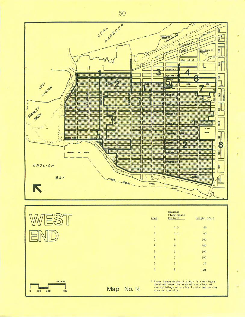
50
f'■''■'■j^-'l'-j
an
ENGLISH
8 A Y
Area
1
7
3
*
5
6
7
a
- Floor
H3XImun
Floor
Ratio
I,
2.
0
9
3
.
3
6
Space Rat
Space
*
5
2
io [F.S.R.
Heiqht (ft.l
60
60
300
1.^0
300
300
70
300
is the rigun
100 200 1-00 Map No. 14
obtained v.hen che area of the floor of
Che buildings on a site is divided by Che
area of the site.

51
7 APPENDIX
7.1 EXISTING COMMERCIAL AREAS POLICIES, REGULATIONS AND GUIDELINES AND
PROPOSED CHANGES
Following are excerpts from the West End Official Development Plan and
Council approved policies and guidelines which apply to the West End
commercial areas. Map 14 shows permitted densities and heights in the
West End commercial areas and surrounding areas.
The changes proposed by this Plan are noted in italics after each
section. These will be developed in detail at the implementation stage.
An important aspect of this Plan is the development of explicit
objectives and policies. Additional components not noted in this
appendix are the proposed follow-up urban design, engineering services
and police work.
7.1.1 West End Official Development Plan
The following uses are permitted in the commercial areas:
(a) Residential uses
(b) The following "small scale commercial uses catering primarily to
the needs of West End residents"
Bowling Alley;
Gasoline Service and Self-Service Stations;
Veterinary Hospital for the training or boarding of dogs or
cats;
- Offices;
Restaurant (excluding a drive-in);
Retail store or business;
School (business or commercial);
Theatre (excluding a drive-in);
Temporary Parking Area (public);
Uses of a similar character to the above.
(c) Hotels - only on the south side of Georgia Street between Chilco
and Cardero Streets, on Robson between Cardero and Jervis
Streets, and on the Sylvia Hotel site.
Residential uses would not be permitted at grade along the local
shopping streets. Commercial uses would be denoted with standard
by-law terms in a complete listing of outright and conditional
uses.
The maximum permitted floor space ratio is 2.2 with the maximum
floor space ratio for commercial uses being 1.2. The maximum floor
space ratio where hotels are permitted is 2.5.

52
Commercial use "shall not include the sale or rent of sex-orientedproducts". (Note: This clause was quashed by the Court of Appeal.)
Appropriate provisions would be provided based upon the upcoming
report from the Director of Legal Services.
The maximum permitted dwelling unit density within the 'C areas
shall be 70 units/acre. There is no maximum listed for the 'CH'areas.
The height of buildings shall not exceed sixty feet and a building
envelope. This maximum may be relaxed to 210 feet subject to impactanalysis.
This height provision would remain pending a review of heights
covering the entire Vest End.
Parking and loading requirements: "have regard to section 12 of the
Zoning and Development Bylaw".
Wording would be amended to reflect standard by-law.
"Exclusion from Floor Space Ratio
The following amenities and facilities are excluded from the floor
space ratio limitation provided that the area of such excluded
facilities contained in this section does not exceed 20 percent of
allowable floor space ratio or 10,000 square feet whichever is the
lesser. Such facilities will be excluded from the floor sapce ratio
provided that the areas are open to and primarily for the use of
residents, tenants and employees.
List of Excluded Uses:
(i) saunas;(ii) tennis courts;(iii) swimming pools;(iv) squash courts;(v) gymnasiums and workout rooms;(vi) games rooms and hobby rooms;(vii) other similar related indoor uses of a social or
recreational nature which in the opinion of the Development
Permit Board are of a type which contribute to social
amenity.
Wording would be amended to reflect standard by-law.

53
Off-street Parking:
No off-street parking spaces shall be provided in excess of the
number of employees on any one working shift (for included areas)
This phrase would be deleted and parking would be required inaccordance with Section 12.
Bonuses for Provision of Social and Recreational Amenities:
Where a need for any public, social, or recreational facility hasbeen demonstrated to the satisfaction of the Development Permit
Board, the Board may authorize for any building which includes one
or more of such facilities, an increase in the permitted floor space
ratio or density of a building, subject to prior approval by City
Council.
In determining the Increase 1n floor area or density that may be
authorized, the Development Permit Board shall consider:
(a) the construction cost of the facility;(b) any costs to the developer of continuing maintenance required
for the facility;
(c) the rental value of the Increased floor area;(d) the value of any authorized relaxation of other restrictions.
If appropriate such facilities shall be preserved in the public
domain by way of a registered agreement and operated by the city or
its delegates."
This section would be revised upon adoption of revised amenitypolicies.
7.1.2 West End Planning Policies (adopted by Council May 13, 1975;prior to adopting O.D.P.)
"Reduce permitted commercial densities of Davie Street, Denman
Street, and the 1600 and 1700 blocks of Robson Street."
"Encourage continuous retail or service use frontage on the groundfloor of shopping streets, and arcades on other pedestrian routes toadjacent streets."
"Encourage outdoor restaurants and other similar outdoor commercialuses of pedestrian interest."
"The number of service stations should not be Increased."
These policies would be deleted and replaced by the Objectives and
Policies contained in Sections 4 and S of this Plan.
54
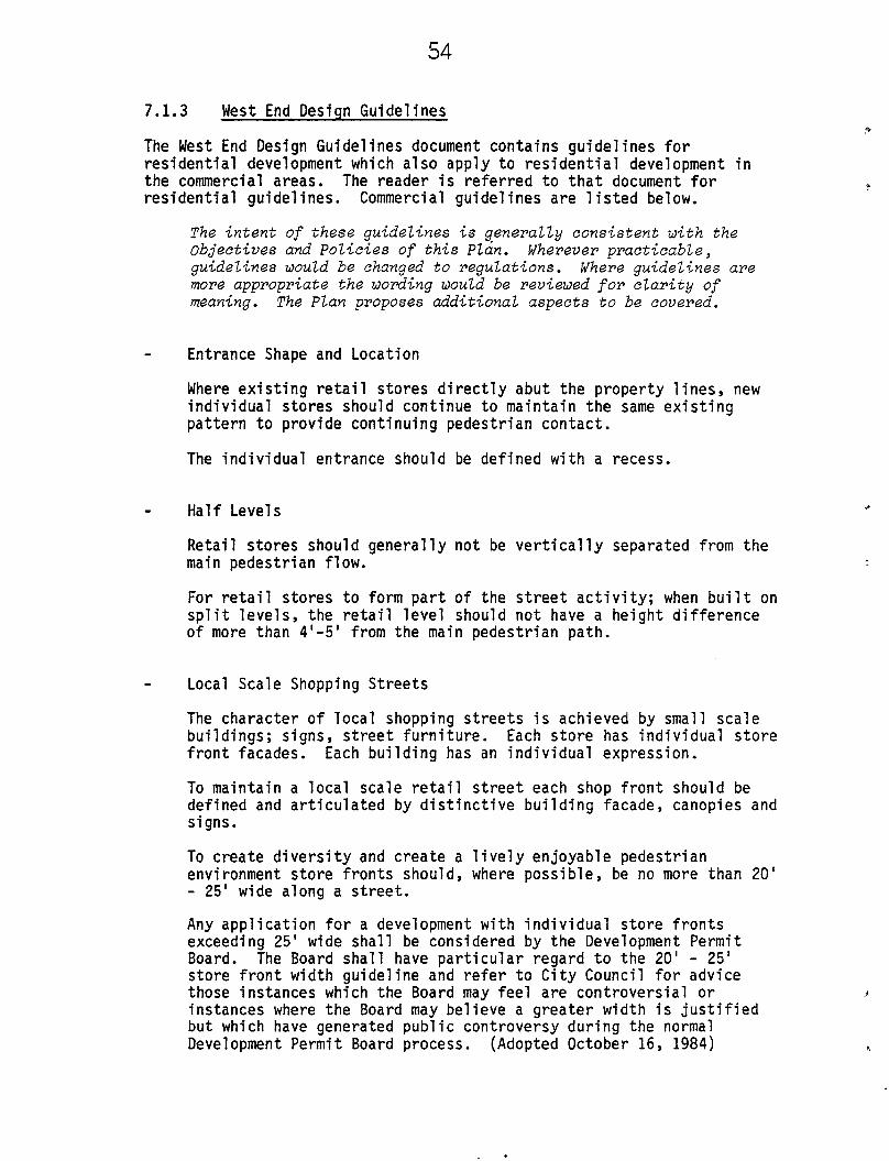
7.1.3 West End Design Guidelines
The West End Design Guidelines document contains guidelines for
residential development which also apply to residential development in
the commercial areas. The reader is referred to that document for
residential guidelines. Commercial guidelines are listed below.
The intent of these guidelines is generally consistent with the
Objectives and Policies of this Plan. Wherever practicable,
guidelines would be changed to regulations. Where guidelines are
more appropriate the wording would be reviewed for clarity of
meaning. The Plan proposes additional aspects to be covered.
Entrance Shape and Location
Where existing retail stores directly abut the property lines, new
individual stores should continue to maintain the same existing
pattern to provide continuing pedestrian contact.
The individual entrance should be defined with a recess.
Half Levels
Retail stores should generally not be vertically separated from the
main pedestrian flow.
For retail stores to form part of the street activity; when built on
split levels, the retail level should not have a height difference
of more than 4'-5' from the main pedestrian path.
Local Scale Shopping Streets
The character of local shopping streets is achieved by small scale
buildings; signs, street furniture. Each store has individual store
front facades. Each building has an individual expression.
To maintain a local scale retail street each shop front should be
defined and articulated by distinctive building facade, canopies and
signs.
To create diversity and create a lively enjoyable pedestrian
environment store fronts should, where possible, be no more than 20'
- 25' wide along a street.
Any application for a development with individual store fronts
exceeding 25' wide shall be considered by the Development Permit
Board. The Board shall have particular regard to the 20' - 25'
store front width guideline and refer to City Council for advice
those instances which the Board may feel are controversial or
instances where the Board may believe a greater width is justified
but which have generated public controversy during the normal
Development Permit Board process. (Adopted October 16, 1984)

55
Weather Protection*
To make streets more pleasant in all weathers, canopies should be
provided that are not too small nor set back from the main
pedestrian path.
Shelters must be provided and designed to afford continuous rain
protection but not shut out any available direct sunshine.
The shelter must be located to protect the common pedestrian path.
The shelter can be of varied form, and canopies could be
convertible.
*See also Central Area Weather Protection (1979), approved by City
Council December 12, 1978
Outdoor Cafes
Outdoor cafes, including use of street space, will be encouraged.
As the sun is an important component in the comfort and use of this
outdoor space, buildings along the north sides of streets will be
encourged to have 15 feet (approximately) recessses to provideoutdoor restaurant seating space.
This space should be separately defined from the public space by special
paving, texture or treatments.
Buildings along the south sides of streets should maintain street facade
continuity and the outdoor space be convertible to indoor space in
inclement weather.
Outdoor dining would be permitted. Guidelines suggesting setbacks
would be deleted in favour of continuous retail frontage.
Additional guidelines convering Georgia, Alberni, and Robson Streets
are contained in the Downtown, West End, HA-1 and HA-2 Character
Area Descriptions. The reader is referred to those documents.
For convenience, the guidelines applicable to the West End would
be included in the West End Commercial Areas guidelines.

56
7.2 RETAIL/SERVICE AREAS CURRENT USES
The following are lists of current uses found in each of the
retail/service areas.
7.2.1 Davie Village Retail/Service Areas
Restaurant
Convenience Store
Laundry/Dry Cleaner
Office
Hair Stylist or Barber
Financial Institution
Clothing
Personal Care
Gas Station
Night Club
Bakery
Health Foods
Deli
Jewellry
Take-Out Food
Art/Poster
Sex
TV/Video
Hotel
Supermarket
Drug Store
Butcher
Liquor
Sporting Goods
Optical
Shoe Repair
Travel
Plants
23 (24% of shops) Stationary10 Photo
9 Auto Repair
5 Pet Supplies
4
3
3 TOTAL NO. OF
3
2
2
2
2
2
2
2
2
2
2
1
1
1
1
1
1
1
1
1
1
57
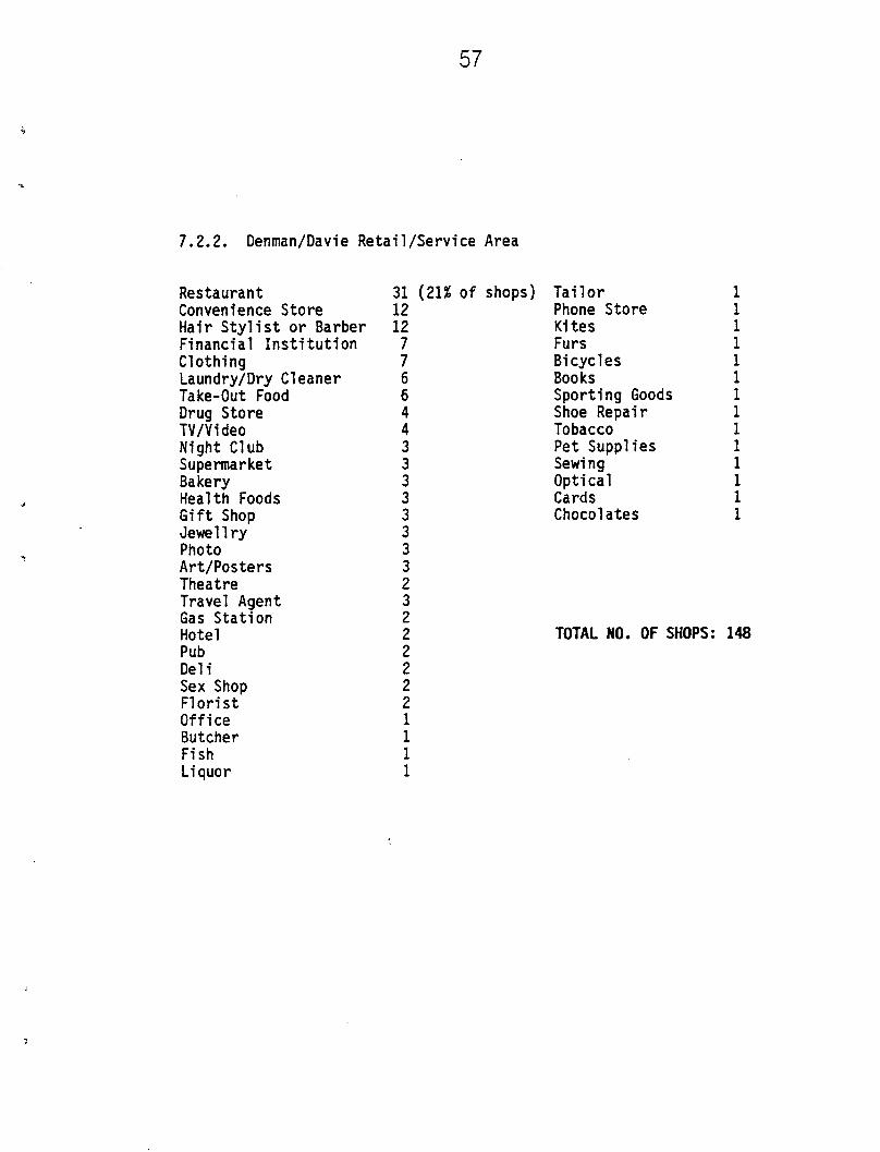
7.2.2. Denman/Davie Retail/Service Area
Restaurant
Convenience Store
Hair Stylist or Barber
Financial Institution
Clothing
Laundry/Dry Cleaner
Take-Out Food
Drug Store
TV/Video
Night Club
Supermarket
Bakery
Health Foods
Gift Shop
Jewellry
Photo
Art/Posters
Theatre
Travel Agent
Gas Station
Hotel
Pub
Deli
Sex Shop
Florist
Office
Butcher
Fish
Liquor
31 (21% of shops)12
12
7
7
6
6
4
4
3
3
3
3
3
3
3
3
2
3
2
2
2
2
2
2
1
1
1
1
Tailor
Phone Store
Kites
Furs
Bicycles
Books
Sporting Goods
Shoe Repair
Tobacco
Pet Supplies
Sewing
Optical
Cards
Chocolates
TOTAL NO. OF SHOPS:
1
1
1
1
1
1
1
1
1
1
1
1
1
1
14

58
7.2.3. Robson Retail/Service Area
Restaurant
Convenience Store
Hair Stylist or Barber
Laundry/Dry Cleaner
Office
Supermarket and Public Market
TV/Video
Clothing
Bakery
Liquor Store
Gas Station
Drug Store
Deli
Photo
Vacuum
Books
Shoe Repair
Personal Care
Art
Sports
Gifts
8 (20% of shops)
3
3
3
3
2
2
2
2
1
1
1
1
1
1
1
1
1
1
1
1
TOTAL NO. OF SHOPS 40
CBR:ds
1986 01
CBR
21


