La Gloria Road Curve Correction On State Route 25 in San Benito County between 4.6 miles north of Highway 146 and 0.20 miles north of La Gloria Road 05-SBT-25-25.9/26.3 EA: 05-1C260 Project ID: 0512000108 Initial Study with Proposed Mitigated Negative Declaration Prepared by the State of California Department of Transportation February 2016
Transcript
La Gloria Road Curve Correction
On State Route 25 in San Benito County between 4.6 miles north of Highway 146 and 0.20 miles north of La Gloria Road
05-SBT-25-25.9/26.3 EA: 05-1C260
Project ID: 0512000108
Initial Study with Proposed Mitigated Negative Declaration
Prepared by the
State of California Department of Transportation
February 2016
General Information About This Document
Please read this Initial Study. Additional copies of this document are available for review at the Caltrans district office at the Caltrans District 5 office at 50 Higuera Street, San Luis Obispo, CA 93401; the Soledad Branch Library, 401 Gabilan Drive, Soledad, CA 93960; and the San Benito County Library, 470 Fifth Street, Hollister, CA 95023.
The document can also be accessed electronically at the following website: http://www.dot.ca.gov/dist05/projects/ After comments are received from the public and reviewing agencies, Caltrans may 1) give environmental approval to the proposed project, 2) do additional environmental studies, or 3) abandon the project. If the project is given environmental approval and funding is appropriated, Caltrans could design and build all or part of the project.
For individuals with sensory disabilities, this document is available in Braille, in large print, on audiocassette, or on computer disk. To obtain a copy in one of these alternate formats, please call or write to Caltrans, Attn: Scott Smith, Senior Environmental Planner, Central Sierra Environmental Analysis Branch, 855 M Street, Suite 200, Fresno, CA 93721; (559) 445-6172, or use California Relay Service 1 (800) 735-2929 (TTY), 1 (800) 735-2929 (Voice), or 711.
Proposed Mitigated Negative Declaration Pursuant to: Division 13, Public Resources Code
Project Description The California Department of Transportation (Caltrans) proposes to reduce the quantity and severity of roadway collisions in the project area by realigning the highway to improve the vertical and horizontal sight distances near Hollister, from 0.1 mile south of La Gloria Road to 0.2 miles north of La Gloria Road in San Benito County, California
Determination This proposed Mitigated Negative Declaration is included to give notice to interested agencies and the public that it is Caltrans’ intent to adopt a Mitigated Negative Declaration for this project. This does not mean that Caltrans’ decision on the project is final. This Mitigated Negative Declaration is subject to change based on comments received by interested agencies and the public.
Caltrans has prepared an Initial Study for this project and, pending public review, expects to determine from this study that the proposed project would not have a significant effect on the environment for the following reasons:
The proposed project would have no effect on Air Quality, Plant Species, Geology and Soils, Greenhouse Gas Emissions, Hazardous Waste, Hydrology and Water Quality, Land Use and Planning, Noise, Paleontology, Mineral Resources, Population and Housing, Public Services, Recreation, Utilities and Service Systems.
In addition, the proposed project would have no significant effect on Aesthetics, Agriculture, and Transportation/Traffic.
In addition, the proposed project would have no significantly adverse effect on biology and cultural resources because the following mitigation measures would reduce potential effects to insignificance:
• Establish Environmentally Sensitive Areas for biological resources and cultural resources.
• Replacement planting and monitoring to compensate for oak tree removal, including a three-year plant establishment period.
• Purchase mitigation land to compensate for permanent and temporary impacts to California tiger salamander upland habitat.
______________________________ _______________ Scott Smith Date Senior Environmental Planner California Department of Transportation
La Gloria Road Curve Correction 5
Project Description and Background
Project Title La Gloria Road Curve Correction
Description of Project Caltrans proposes to improve safety on State Route 25 by reducing the quantity and severity of roadway departure collisions from post miles 25.9 to 26.3 in San Benito County. The project would correct deficiencies in the non-standard curve radius, realign the highway, widen shoulders, construct rumble strip, and extend one culvert. Approximately 2.14 acres of right-of-way is required.
Surrounding Lands Uses and Setting The project is located in a rural and residential area in San Benito County on State Route 25. The east entrance into Pinnacles National Park on State Route 146 is located approximately 5 miles south of the project area. State Route 25, also known as Airline Highway, winds its way along the west side of the San Andreas Rift Valley. This section of the valley is known as Bear Valley. The environment is characterized by mountainous rolling terrain spotted with oaks growing on the slopes above the highway corridor. Vegetation in the project area is mostly limited to grasses, due to the heavy grazing by cattle.
Other Public Agencies Whose Approval is Required
Agency Permit/Approval California Department of Fish and
Wildlife Section 2081 Incidental Take Permit
California Department of Fish and Wildlife
1602 Streambed Alteration Agreement
State Regional Water Quality Control Board
Clean Water Act Section 401 Certification
U.S. Army Corps of Engineers Clean Water Act Section 404 Nationwide Permit #14
(San Joaquin kit fox, California tiger salamander)
La Gloria Road Curve Correction 6
La Gloria Road Curve Correction 7
Project Vicinity Map
La Gloria Road Curve Correction 8
La Gloria Road Curve Correction 9
Project Location
La Gloria Road Curve Correction 10
La Gloria Road Curve Correction 11
CEQA Environmental Checklist This checklist identifies physical, biological, social and economic factors that might be affected by the proposed project. In many cases, background studies performed in connection with the projects indicated no impacts. A NO IMPACT answer in the last column reflects this determination. Where a clarifying discussion is needed, the discussion either follows the applicable section in the checklist or is placed within the body of the environmental document itself. The words “significant” and “significance” used throughout the following checklist are related to CEQA—not NEPA—impacts. The questions in this form are intended to encourage the thoughtful assessment of impacts and do not represent thresholds of significance. Potentially
Significant Impact
Less Than Significant with Mitigation
Less Than Significant Impact
No Impact
I. AESTHETICS: Would the project:
a) Have a substantial adverse effect on a scenic vista?
b) Substantially damage scenic resources, including, but not limited to, trees, rock outcroppings, and historic buildings within a state scenic highway?
c) Substantially degrade the existing visual character or quality of the site and its surroundings?
d) Create a new source of substantial light or glare which would adversely affect day or nighttime views in the area?
II. AGRICULTURE AND FOREST RESOURCES: In determining whether impacts to agricultural resources are significant environmental effects, lead agencies may refer to the California Agricultural Land Evaluation and Site Assessment Model (1997) prepared by the California Department of Conservation as an optional model to use in assessing impacts on agriculture and farmland. In determining whether impacts to forest resources, including timberland, are significant environmental effects, lead agencies may refer to information compiled by the California Department of Forestry and Fire Protection regarding the state’s inventory of forest land, including the Forest and Range Assessment Project, Forest Legacy Assessment Project, and the forest carbon measurement methodology provided in Forest Protocols adopted by the California Air Resources Board.
Would the project:
a) Convert Prime Farmland, Unique Farmland, or Farmland of Statewide Importance (Farmland), as shown on the maps prepared pursuant to the Farmland Mapping and Monitoring Program of the California Resources Agency, to non-agricultural use?
La Gloria Road Curve Correction 12
b) Conflict with existing zoning for agricultural use, or a Williamson Act contract?
c) Conflict with existing zoning for, or cause rezoning of, forest land (as defined in Public Resources Code section 12220(g)), timberland (as defined by Public Resources Code section 4526), or timberland zoned Timberland Production (as defined by Government Code section 51104(g))?
d) Result in the loss of forest land or conversion of forest land to non-forest use?
e) Involve other changes in the existing environment which, due to their location or nature, could result in conversion of Farmland, to non-agricultural use or conversion of forest land to non-forest use?
III. AIR QUALITY: Where available, the significance criteria established by the applicable air quality management or air pollution control district may be relied upon to make the following determinations. Would the project:
a) Conflict with or obstruct implementation of the applicable air quality plan?
b) Violate any air quality standard or contribute substantially to an existing or projected air quality violation?
c) Result in a cumulatively considerable net increase of any criteria pollutant for which the project region is non- attainment under an applicable federal or state ambient air quality standard (including releasing emissions which exceed quantitative thresholds for ozone precursors)?
d) Expose sensitive receptors to substantial pollutant concentrations?
e) Create objectionable odors affecting a substantial number of people?
IV. BIOLOGICAL RESOURCES: Would the project:
a) Have a substantial adverse effect, either directly or through habitat modifications, on any species identified as a candidate, sensitive, or special status species in local or regional plans, policies, or regulations, or by the California Department of Fish and Wildlife or U.S. Fish and Wildlife Service?
b) Have a substantial adverse effect on any riparian habitat or other sensitive natural community identified in local or regional plans, policies, regulations or by the California Department of Fish and Wildlife or U.S. Fish and Wildlife Service?
La Gloria Road Curve Correction 13
c) Have a substantial adverse effect on federally protected wetlands as defined by Section 404 of the Clean Water Act (including, but not limited to, marsh, vernal pool, coastal, etc.) through direct removal, filling, hydrological interruption, or other means?
d) Interfere substantially with the movement of any native resident or migratory fish or wildlife species or with established native resident or migratory wildlife corridors, or impede the use of native wildlife nursery sites?
e) Conflict with any local policies or ordinances protecting biological resources, such as a tree preservation policy or ordinance?
f) Conflict with the provisions of an adopted Habitat Conservation Plan, Natural Community Conservation Plan, or other approved local, regional, or state habitat conservation plan?
V. CULTURAL RESOURCES: Would the project:
a) Cause a substantial adverse change in the significance of a historical resource as defined in §15064.5?
b) Cause a substantial adverse change in the significance of an archaeological resource pursuant to §15064.5?
c) Directly or indirectly destroy a unique paleontological resource or site or unique geologic feature?
d) Disturb any human remains, including those interred outside of formal cemeteries?
VI. GEOLOGY AND SOILS: Would the project:
a) Expose people or structures to potential substantial adverse effects, including the risk of loss, injury, or death involving:
i) Rupture of a known earthquake fault, as delineated on the most recent Alquist-Priolo Earthquake Fault Zoning Map issued by the State Geologist for the area or based on other substantial evidence of a known fault? Refer to Division of Mines and Geology Special Publication 42?
ii) Strong seismic ground shaking?
iii) Seismic-related ground failure, including liquefaction?
iv) Landslides?
b) Result in substantial soil erosion or the loss of topsoil?
La Gloria Road Curve Correction 14
c) Be located on a geologic unit or soil that is unstable, or that would become unstable as a result of the project, and potentially result in on- or off-site landslide, lateral spreading, subsidence, liquefaction or collapse?
d) Be located on expansive soil, as defined in Table 18-1-B of the Uniform Building Code (1994), creating substantial risks to life or property?
e) Have soils incapable of adequately supporting the use of septic tanks or alternative waste water disposal systems where sewers are not available for the disposal of waste water?
VII. GREENHOUSE GAS EMISSIONS: Would the project:
a) Generate greenhouse gas emissions, either directly or indirectly, that may have a significant impact on the environment?
While Caltrans has included this good faith effort in order to provide the public and decision-makers as much information as possible about the project, it is Caltrans’ determination that in the absence of further regulatory or scientific information related to greenhouse gas emissions and CEQA significance, it is too speculative to make a significance determination regarding the project’s direct and indirect impact with respect to climate change. Caltrans does remain firmly committed to implementing measures to help reduce the potential effects of the project.
b) Conflict with an applicable plan, policy or regulation adopted for the purpose of reducing the emissions of greenhouse gases?
VIII. HAZARDS AND HAZARDOUS MATERIALS: Would the project:
a) Create a significant hazard to the public or the environment through the routine transport, use, or disposal of hazardous materials?
b) Create a significant hazard to the public or the environment through reasonably foreseeable upset and accident conditions involving the release of hazardous materials into the environment?
c) Emit hazardous emissions or handle hazardous or acutely hazardous materials, substances, or waste within one-quarter mile of an existing or proposed school?
d) Be located on a site which is included on a list of hazardous materials sites compiled pursuant to Government Code Section 65962.5 and, as a result, would it create a significant hazard to the public or the environment?
La Gloria Road Curve Correction 15
e) For a project located within an airport land use plan or, where such a plan has not been adopted, within two miles of a public airport or public use airport, would the project result in a safety hazard for people residing or working in the project area?
f) For a project within the vicinity of a private airstrip, would the project result in a safety hazard for people residing or working in the project area?
g) Impair implementation of or physically interfere with an adopted emergency response plan or emergency evacuation plan?
h) Expose people or structures to a significant risk of loss, injury or death involving wildland fires, including where wildlands are adjacent to urbanized areas or where residences are intermixed with wildlands?
IX. HYDROLOGY AND WATER QUALITY: Would the project:
a) Violate any water quality standards or waste discharge requirements?
b) Substantially deplete groundwater supplies or interfere substantially with groundwater recharge such that there would be a net deficit in aquifer volume or a lowering of the local groundwater table level (e.g., the production rate of pre-existing nearby wells would drop to a level which would not support existing land uses or planned uses for which permits have been granted)?
c) Substantially alter the existing drainage pattern of the site or area, including through the alteration of the course of a stream or river, in a manner which would result in substantial erosion or siltation on- or off-site?
d) Substantially alter the existing drainage pattern of the site or area, including through the alteration of the course of a stream or river, or substantially increase the rate or amount of surface runoff in a manner which would result in flooding on- or off-site?
e) Create or contribute runoff water which would exceed the capacity of existing or planned storm water drainage systems or provide substantial additional sources of polluted runoff?
f) Otherwise substantially degrade water quality?
g) Place housing within a 100-year flood hazard area as mapped on a federal Flood Hazard Boundary or Flood Insurance Rate Map or other flood hazard delineation map?
h) Place within a 100-year flood hazard area structures which would impede or redirect flood flows?
i) Expose people or structures to a significant risk of loss, injury or death involving flooding, including flooding as a result of the failure of a levee or dam?
j) Inundation by seiche, tsunami, or mudflow?
La Gloria Road Curve Correction 16
X. LAND USE AND PLANNING: Would the project:
a) Physically divide an established community?
b)Conflict with any applicable land use plan, policy, or regulation of an agency with jurisdiction over the project (including, but not limited to the general plan, specific plan, local coastal program, or zoning ordinance) adopted for the purpose of avoiding or mitigating an environmental effect?
c) Conflict with any applicable habitat conservation plan or natural community conservation plan?
XI. MINERAL RESOURCES: Would the project:
a) Result in the loss of availability of a known mineral resource that would be of value to the region and the residents of the state?
b) Result in the loss of availability of a locally important mineral resource recovery site delineated on a local general plan, specific plan or other land use plan?
XII. NOISE: Would the project result in:
a) Exposure of persons to or generation of noise levels in excess of standards established in the local general plan or noise ordinance, or applicable standards of other agencies?
b) Exposure of persons to or generation of excessive groundborne vibration or groundborne noise levels?
c) A substantial permanent increase in ambient noise levels in the project vicinity above levels existing without the project?
d) A substantial temporary or periodic increase in ambient noise levels in the project vicinity above levels existing without the project?
e) For a project located within an airport land use plan or, where such a plan has not been adopted, within two miles of a public airport or public use airport, would the project expose people residing or working in the project area to excessive noise levels?
f) For a project within the vicinity of a private airstrip, would the project expose people residing or working in the project area to excessive noise levels?
La Gloria Road Curve Correction 17
XIII. POPULATION AND HOUSING: Would the project:
a) Induce substantial population growth in an area, either directly (for example, by proposing new homes and businesses) or indirectly (for example, through extension of roads or other infrastructure)?
b) Displace substantial numbers of existing housing, necessitating the construction of replacement housing elsewhere?
c) Displace substantial numbers of people, necessitating the construction of replacement housing elsewhere?
XIV. PUBLIC SERVICES:
a) Would the project result in substantial adverse physical impacts associated with the provision of new or physically altered governmental facilities, need for new or physically altered governmental facilities, the construction of which could cause significant environmental impacts, in order to maintain acceptable service ratios, response times or other performance objectives for any of the public services:
Fire protection?
Police protection?
Schools?
Parks?
Other public facilities?
XV. RECREATION:
a) Would the project increase the use of existing neighborhood and regional parks or other recreational facilities such that substantial physical deterioration of the facility would occur or be accelerated?
b) Does the project include recreational facilities or require the construction or expansion of recreational facilities which might have an adverse physical effect on the environment?
La Gloria Road Curve Correction 18
XVI. TRANSPORTATION/TRAFFIC: Would the project:
a) Conflict with an applicable plan, ordinance or policy establishing measures of effectiveness for the performance of the circulation system, taking into account all modes of transportation including mass transit and non-motorized travel and relevant components of the circulation system, including but not limited to intersections, streets, highways and freeways, pedestrian and bicycle paths, and mass transit?
b) Conflict with an applicable congestion management program, including, but not limited to level of service standards and travel demand measures, or other standards established by the county congestion management agency for designated roads or highways?
c) Result in a change in air traffic patterns, including either an increase in traffic levels or a change in location that results in substantial safety risks?
d) Substantially increase hazards due to a design feature (e.g., sharp curves or dangerous intersections) or incompatible uses (e.g., farm equipment)?
e) Result in inadequate emergency access?
f) Conflict with adopted policies, plans or programs regarding public transit, bicycle, or pedestrian facilities, or otherwise decrease the performance or safety of such facilities?
XVII. UTILITIES AND SERVICE SYSTEMS: Would the project:
a) Exceed wastewater treatment requirements of the applicable Regional Water Quality Control Board?
b) Require or result in the construction of new water or wastewater treatment facilities or expansion of existing facilities, the construction of which could cause significant environmental effects?
c) Require or result in the construction of new storm water drainage facilities or expansion of existing facilities, the construction of which could cause significant environmental effects?
d) Have sufficient water supplies available to serve the project from existing entitlements and resources, or are new or expanded entitlements needed?
e) Result in a determination by the wastewater treatment provider which serves or may serve the project that it has adequate capacity to serve the project’s projected demand in addition to the provider’s existing commitments?
f) Be served by a landfill with sufficient permitted capacity to accommodate the project’s solid waste disposal needs?
g) Comply with federal, state, and local statutes and regulations related to solid waste?
La Gloria Road Curve Correction 19
XVIII. MANDATORY FINDINGS OF SIGNIFICANCE
a) Does the project have the potential to degrade the quality of the environment, substantially reduce the habitat of a fish or wildlife species, cause a fish or wildlife population to drop below self-sustaining levels, threaten to eliminate a plant or animal community, substantially reduce the number or restrict the range of a rare or endangered plant or animal or eliminate important examples of the major periods of California history or prehistory?
b) Does the project have impacts that are individually limited, but cumulatively considerable? ("Cumulatively considerable" means that the incremental effects of a project are considerable when viewed in connection with the effects of past projects, the effects of other current projects, and the effects of probable future projects)?
c) Does the project have environmental effects which will cause substantial adverse effects on human beings, either directly or indirectly?
La Gloria Road Curve Correction 20
La Gloria Road Curve Correction 21
Additional Explanations for Questions in the Impacts Checklist IV. Biological Resources (checklist questions a, b and d) A Natural Environmental Study was prepared in February 2016. A query of the California Department of Fish and Wildlife California Natural Diversity Database was updated on December 9, 2015 for the U.S. Geological Survey quadrangle encompassing the project site (San Benito) and the eight surrounding quadrangles (CNDDB 2015). The California Natural Diversity Database list of special-status plants, animals, and sensitive natural communities documented to occur within the queried quadrangles is included as Appendix B. A request was made for an official U.S. Fish and Wildlife Service species list from the Ventura Fish and Wildlife Service Office on November 4, 2014 and updated on November 3, 2015 via the U.S. Fish and Wildlife Service Information, Planning, and Conservation System website and is included as Appendix A.
Studies conducted for this project included general biological field surveys, a wetland delineation, an Early Evaluation for San Joaquin kit fox, and botanical surveys for sensitive plant species from December 2014 through October 2015. The botanical surveys were floristic (conducted when target species would be flowering and identifiable) following the guidelines of U.S. Fish and Wildlife Service (2000) and California Department of Fish and Wildlife (2009). For the purposes of this document, the Area of Potential Impact and Biological Study Area are not the same. The Area of Potential Impact is the project direct temporary and permanent impacts. The Biological Study Area, a larger study area, is the area that may be directly, indirectly, temporarily, or permanently impacted by construction and construction-related activities.
Natural Communities Affected Environment Non-native grassland The non-native grassland community is used to graze livestock in the area. Dominant species include brome grasses and foxtail barley. Various annual forbs also occur as associate species, such as silver puffs, blow wives, redstem filaree, and burclover. Ruderal/disturbed habitat Ruderal/disturbed habitat occurs along the roadway edges within Caltrans right-of-way. Plants growing in this habitat are dominated by non-native weedy and/or invasive species tolerant of disturbed conditions (e.g., compacted soils, maintained roadsides) Representative species include common sow thistle and brome grasses. Blue oak trees Approximately 64 blue oak trees were surveyed within the Biological Study Area. Seven blue oak trees occur within the project Area of Potential Impact. The
La Gloria Road Curve Correction 22
Biological Study Area and the Area of Potential Impact do not contain oak woodlands. Environmental Consequences Non-native grassland and Ruderal/disturbed habitat Permanent impacts would primarily consist of the areas encompassing the new road alignment, which would result in the loss of non-native annual grassland habitat, ruderal/disturbed habitat. Temporary impacts would primarily consist of temporary staging and construction activities within the Area of Potential Impact. Sources of impacts would be primarily from the use of construction equipment such as trucks, compactors, asphalt concrete rollers, scrapers, pavers, water trucks, sweepers, and associate worker foot-traffic. Blue oak trees Seven blue oak trees ranging in size from 10 to 27 inches diameter at breast height would be removed. One of the blue oaks lies within the riparian area of the intermittent stream, which is within California Department of Fish and Wildlife jurisdiction, and has a diameter at breast height of 19 inches. These impacts would not only affect individual oak trees but the wildlife species that may use these trees as foraging, nesting, roosting, and/or denning habitat. The table below summarizes temporary and permanent impacts to natural communities.
Temporary and Permanent Impacts to Natural Communities
Non-native Annual Grassland 0.48 acre 1.21 acres Ruderal/Disturbed 0.25 acre 0.61 acre Blue Oak Trees (min. 6” diameter at breast height) 7 trees removed N/A
USACE Jurisdictional Other waters 0.006 acre 0.009 acre
RWQCB/CDFW Jurisdiction 0.015 acre 0.017 acre California red-legged frog Critical Habitat; and California Tiger Salamander upland habitat
0.73 acre 1.82 acres
La Gloria Road Curve Correction 23
Avoidance, Minimization, and/or Mitigation Measures Non-native grassland and Ruderal/disturbed habitat Construction equipment would be temporarily staged in roadside turnouts, the edges of State Route 25, or in other already disturbed areas. Blue oak trees Caltrans proposes to implement the following avoidance and minimization measures for oak trees:
1. Trees to be removed would be noted on design plans. Prior to any ground disturbing activities, Environmentally Sensitive Area fencing would be installed around the dripline of trees to be protected within project limits.
2. Replacement plantings would be achieved by replanting 20 blue oak trees within Caltrans right-of-way.
3. Monitoring and a three-year plant establishment period would be required. Oak tree replacement areas would be delineated on project plans.
Wetlands and Other Waters of the U.S.
Affected Environment A U.S. Army Corps of Engineers jurisdictional other waters was observed on topographic maps and during the biological surveys within the Biological Study Area. This "other waters" is an intermittent stream that flows approximately 78 feet through the Area of Potential Impact with an substrate composed predominately of clay/silt with a low number of gravel and cobbles. The headwater of the intermittent stream begins approximately 0.75 mile west along La Gloria Road. The active stream channel which feeds into the reinforced concrete box culvert is approximately 3 feet wide and flows east. There is a weir (barrier) that is approximately 60 feet upstream of the current reinforced concrete box culvert and will be approximately 23 feet upstream when the reinforced concrete box culvert is extended with this project. The vegetation that occurs along this reach of the intermittent stream includes non-native grassland and scattered remnant oak trees.
Environmental Consequences Estimates of impacts to potential jurisdictional waters and riparian habitat were determined by overlaying the project Area of Potential Impact with the preliminary jurisdictional determination map. See table above.
The proposed project is anticipated to have approximately 0.006 acre of permanent impacts and 0.009 acre of temporary impacts for U.S. Army Corps of Engineers jurisdictional waters. The proposed project will also have 0.015 acre of permanent impacts and 0.017 acre of temporary impacts for California Department of Fish and
La Gloria Road Curve Correction 24
Wildlife and Regional Water Quality Control Board jurisdiction. These impacts are associated with the 37 foot extension of the reinforced concrete box culvert and the road realignment over the intermittent stream. It is approximated that there will be 227 cubic yards of dirt required to fill the reinforced concrete box culvert back in place and 40 cubic yards of concrete to fill the reinforced concrete box culvert and the wing wall at its opening on the west side.
Avoidance, Minimization, and/or Mitigation Measures Caltrans proposes to implement the following avoidance and minimization measures for U.S. Army Corps of Engineers jurisdictional other waters and California Department of Fish and Wildlife/Regional Water Quality Control Board riparian habitat:
1. Prior to construction, Caltrans shall obtain a Section 404 Nationwide Permit from U. S. Army Corps of Engineers, a Section 401 Water Quality Certification from Regional Water Quality Control Board, and a Section 1602 Streambed Alteration Agreement from California Department of Fish and Wildlife.
2. Prior to construction, Caltrans shall prepare a Mitigation and Monitoring Plan to mitigate impacts to vegetation and natural habitats. The Mitigation and Monitoring Plan shall be consistent with federal and state regulatory requirements and will be amended with any regulatory permit conditions, as required. Caltrans shall implement the Mitigation and Monitoring Plan as necessary during construction and immediately following project completion.
3. Prior to any ground-disturbing activities, Environmentally Sensitive Area fencing shall be installed around jurisdictional waters and the dripline of trees to be protected within project limits. Caltrans-defined Environmentally Sensitive Areas shall be noted on design plans and delineated in the field prior to the start of construction activities.
4. Construction activities within the intermittent drainage in the Area if Potential
Impact shall be timed to occur between June 1 and October 30 in any given year, or as otherwise directed by the regulatory agencies, when the surface water is likely to be dry or at seasonal minimum. Deviations from this work window will only be made with permission from the relevant regulatory agencies.
5. During construction, all project-related hazardous materials spills within the project site shall be cleaned up immediately. Readily accessible spill prevention and cleanup materials shall be kept by the contractor on-site at all times during construction.
6. During construction, erosion control measures shall be implemented. Silt
fencing, fiber rolls, and barriers shall be installed as needed between the
La Gloria Road Curve Correction 25
project site and jurisdictional other waters and riparian habitat. At a minimum, erosion controls shall be maintained by the contractor on a daily basis throughout the construction period.
7. During construction, the cleaning and refueling of equipment and vehicles shall occur only within a designated staging area and at least 60 ft. from other waters or other aquatic areas. The staging areas shall conform to Best Management Practices applicable to attaining zero discharge of stormwater runoff. At a minimum, all equipment and vehicles shall be checked and maintained by the contractor on a daily basis to ensure proper operation and avoid potential leaks or spills.
8. Stream contours shall be restored as close as possible to their original condition.
Special Status Animal Species Affected Environment The following California Species of Special Concern have the potential to be present and/or impacted by the proposed project:
California Species of Special Concern
Species Status
Amphibian Western spadefoot (Spea hammondii)
California Species of Special Concern
Reptile San Joaquin whipsnake (Masticophis flagellum ruddocki)
Mammals Western red bat (Lasiurus blossevillii) Western mastiff bat (Eumops perotis californicus) Western small-footed myotis (Myotis ciliolabrum) Long-eared myotis
Environmental Consequences Western spadefoot No western spadefoot adults, juveniles, larvae, or eggs were observed during biological surveys. The nearest California Natural Diversity Database occurrence record for western spadefoot is 7.5 miles to the south east of the Biological Study Area along State Route 25 where one adult was observed in April 1999. The presence of western spadefoot is inferred based on the presence of suitable breeding habitat in the pond within the Biological Study Area, and suitable surrounding upland habitat. Similar to the impacts described previously for California tiger salamander, this activity could result in the injury or mortality (via accidental crushing by equipment) of western spadefoot toads residing in small mammal burrows within upland habitat in the Biological Study Area. Western spadefoot toads could also be entombed in small mammal burrows collapsed by construction activities, which could result in injury or mortality. Impacts to the pond within the Biological Study Area will be avoided; therefore, there will be no impacts to breeding habitat. Finally, the potential need to capture and relocate western spadefoot toads could subject these animals to stresses that could result in adverse effects.
San Joaquin whipsnake No San Joaquin whipsnakes were observed during biological surveys. Similar to the impacts described for western spadefoot, project construction could result in the injury or mortality (via accidental crushing by equipment) of San Joaquin whipsnakes residing in small mammal burrows within upland habitat in the Biological Study Area. They could also be entombed in small mammal burrows collapsed by construction activities, which could result in injury or mortality. The need to capture and relocate San Joaquin whipsnakes could subject these animals to stresses that could result in adverse effects. These impacts are anticipated to be low due to no observations of the species with the Biological Study Area during surveys and none no California Natural Diversity Database (2015) occurrences for the species.
Cooper’s hawk and Sharp-shinned hawk, white-tailed kite The removal of vegetation could directly impact active bird nests and any eggs or young residing in nests. Indirect impacts could also result from noise and disturbance associated with construction, which could alter perching, foraging, and/or nesting behaviors. While loss of vegetation supporting potential nesting habitat would result from trimming or removal, this would be mitigated by planting new trees and habitat restoration. The implementation of the avoidance and minimization measures such as
La Gloria Road Curve Correction 27
appropriate timing of vegetation removal, preconstruction surveys, and exclusion zones will reduce the potential for adverse effects to nesting bird species.
Bats - Western red bat, Western mastiff bat, Western small-footed myotis, Long-eared myotis, Fringed myotis, Yuma myotis Although no bat roosts were observed during reconnaissance surveys, there is a marginal potential that bats could establish new roosts in trees within the API with the passage of time before they are removed. Direct impacts to bats could result during removal of vegetation if bats are found to be roosting in these areas. These direct effects could result in the injury or mortality of bats or harassment that could alter roosting behaviors. Indirect impacts could also result from noise and disturbance associated with construction, which could also alter roosting behaviors. The implementation of preconstruction surveys and exclusion zones will reduce the potential for adverse effects to roosting bat species.
American badger Impacts from project construction could result in the injury or mortality (via accidental crushing by equipment) of American badgers in dry, friable soil habitats within the Biological Study Area. American badgers could also be entombed in burrows collapsed by construction activities, which could result in injury or mortality. Finally, the potential need to capture and relocate American badgers could subject these animals to stresses that could result in adverse effects. The potential for these impacts is anticipated to be low due to no observations of the species within the Biological Study Area during surveys and no nearby California Natural Diversity Database (2015) occurrences for the species.
Avoidance, Minimization, and/or Mitigation Measures Western spadefoot The measures discussed in this document for California tiger salamander and California red-legged frog are also applicable to western spadefoot to avoid or minimize impacts to the species. In addition, the following measure applying specifically to western spadefoot is recommended.
1. Prior to construction, a biologist determined qualified by Caltrans shall capture and relocate any western spadefoot (if present) or other special-status species to suitable habitat outside of Area of Potential Impact. Observations of California Species of Special Concern or other special-status species shall be documented on California Natural Diversity Database forms and submitted to California Department of Fish and Wildlife upon project completion.
San Joaquin whipsnake Caltrans proposes to implement the following avoidance and minimization measures for San Joaquin whipsnake (if present):
1. Prior to construction, a biologist determined qualified by Caltrans shall captures and relocate any San Joaquin whipsnakes (if present) or other special-status species to suitable habitat outside of the Area of Potential
La Gloria Road Curve Correction 28
Impact. Observations of California Species of Special Concern or other special-status species shall be documented on California Natural Diversity Database forms and submitted to California Department of Fish and Wildlife upon project completion.
Cooper’s hawk and Sharp-shinned hawk, white-tailed kite Caltrans proposes to implement the following avoidance and minimization measures for birds protected under the federal Migratory Bird Treaty Act and California Fish and Game Code:
1. Tree removal shall be scheduled to occur from September 2 to February 14, outside of the typical nesting bird season if possible, to avoid potential impacts to nesting birds and cavity nesters. If construction activities are proposed to occur within 100 feet of potential bird nesting habitat during the nesting season (February 15 to September 1) within the Biological Study Area, a nesting bird survey shall be conducted by a biologist determined qualified by Caltrans at least two weeks prior to construction.
2. Active bird nests shall not be disturbed and eggs or young of birds covered by the MBTA and California Fish and Game Code shall not be killed, destroyed, injured, or harassed at any time. Readily visible exclusion zones where nests must be avoided shall be established by a biologist determined qualified by Caltrans using Environmentally Sensitive Area fencing.
3. All clearing/grubbing and vegetation removal of annual grassland habitat and oak trees shall be monitored and documented by the biological monitor(s) regardless of time of year.
Bats - Western red bat, Western mastiff bat, Western small-footed myotis, Long-eared myotis, Fringed myotis, Yuma myotis Caltrans proposes to implement the following avoidance and minimization measures for bats:
1. Tree removal shall be scheduled to occur from September 2 to February 14, outside of the typical bat maternity roosting season if possible, to avoid potential impacts to roosting bats. If any tree removal activities are proposed to occur within the work area during the typical maternity bat roosting season (February 15 to September 1), an additional bat roost survey shall be conducted by a biologist determined qualified by Caltrans at least two weeks prior to tree removal to determine presence/absence of roosting bats.
2. No more than two weeks prior to tree removal, a bat roost survey shall be conducted by a biologist determined qualified by Caltrans to determine presence/absence of roosting bats. The biologist(s) conducting the preconstruction surveys will also identify the nature of the bat utilization (i.e., no roosting, night roost, day roost and determine if passive bat exclusion will be necessary and feasible.
La Gloria Road Curve Correction 29
3. If a biologist qualified by Caltrans determines that bat exclusion is necessary and feasible, a qualified/licensed individual or firm shall implement passive exclusion (e.g., netting) in areas where bats are roosting within the Area of Potential Impact.
4. If bats are found to be maternity roosting from (February 15 to September 1), active bat maternity roosts shall not be disturbed or destroyed at any time until a qualified biologist has determined that maternity roosting activity has ceased.
5. Readily-visible exclusion zones shall be established in areas where roosts (if present) must be avoided using Environmentally Sensitive Area fencing.
American badger Caltrans proposes to implement the following avoidance and minimization measures for American badgers (if present):
1. Prior to construction, a biologist determined qualified by Caltrans shall capture and relocate any American badgers (if present) or other special-status species to suitable habitat outside of the Area of Potential Impact. Observations of California Species of Special Concern or other special-status species shall be documented on the California Natural Diversity Database forms and submitted to California Department of Fish and Wildlife upon project completion.
Threatened and Endangered Species This section discusses plant and animal species that are either state- or federally-listed as threatened or endangered, or are currently proposed for such listing.
Affected Environment Habitat exists in the project area for the following species:
Threatened and Endangered Species
Species Status
California red-legged frog (rana draytonii)
Federally threatened California Species of Special Concern
California tiger salamander (ambystoma californiense)
Federally threatened State threatened California Species of Special Concern
San Joaquin kit fox (vulpes macrotis mutica)
Federally endangered State threatened
La Gloria Road Curve Correction 30
Golden eagle (Aquila chrysaetos)
Federal Bald and Golden Eagle Protected California Fully-Protected species
Environmental Consequences California red-legged frog Although no California red-legged frogs were observed during biological surveys, breeding habitat is present in a small berm pond in the Biological Study Area. There was one California red-legged frog California Natural Diversity Database occurrence record 5 miles south of the project site in 2015. Three adult California red-legged frog adults were observed in 1994, therefore, the presence of this species is inferred within the Biological Study Area. Construction activities could result in red-legged frogs being trapped or injured or killed (from accidental crushing by construction equipment) residing in small mammal burrows within the upland habitat of the Biological Study Area. Federal Endangered Species Act Section 7 effects determination is that the project may affect, and is likely to adversely affect California red-legged frog Critical Habitat.
California tiger salamander California tiger salamander presence is inferred based on the nearby occurrence record and the presence of suitable aquatic and upland habitat. Approximately 0.73 acre (permanent) and 1.82 acres (temporary of non-native annual grassland upland and ruderal/disturbed dispersal habitat (2.55 acres total) would be impacted by grading and vegetation removal to accommodate the curve realignment of State Route 25. These construction activities could result in the injury or mortality (by accidental crushing by equipment) of an unknown number of California tiger salamanders residing in small burrows within upland habitat in the Biological Study Area. Federal Endangered Species Act Section 7 effects determination is that the project may affect, and is likely to adversely affect California tiger salamander and a California Department of Fish and Wildlife Section 2081 Incidental Take Permit will be acquired for the proposed project.
San Joaquin kit fox Although no potential San Joaquin kit fox dens were observed during the biological surveys, the project area supports non-native annual grassland, ruderal/disturbed habitat in gently sloped to hilly terrain. The habitat suitability of the site for this species can be characterized as fair, but is fragmented by State Route 25, hilly terrain, the Gabilan Range, and periodic disturbances such as rural residential use and grazing which is suitable for this species. Some small mammal burrows were observed, however, none had openings large enough to be used by San Joaquin kit fox. The project site is located 11.5 miles north and 21 miles west of California Department of Fish and Wildlife’s range map for this species. The nearest confirmed sighting reported in California Natural Diversity Database is approximately 6.25 miles to the north of the Biological Study area and is over 41 years old. The project site is subjected to periodic disturbance from grazing, rural residential use. The proposed project would impact potential kit fox habitat immediately adjacent to State Route 25,
La Gloria Road Curve Correction 31
where the potential for kit fox presence and denning activity is estimated to be low. The proposed project would permanently impact approximately 0.48 acre and temporarily impact approximately 1.21 acres of non-native annual grassland habitat. Permanent impacts would consist of grading, vegetation removal, ground disturbance and removal of trees. If present, denning kit foxes could accidently be entombed during grading or injured by construction equipment, resulting in the adverse effects of injury or mortality. Noise disturbance associated with construction could adversely affect foraging and dispersal behaviors; however, this would be unlikely as construction activities would likely occur during daylight hours when kit foxes are typically inactive and residing in dens. Federal Endangered Species Act Section 7 effects determination is that the project may affect, but is not likely to adversely affect San Joaquin kit fox.
Golden eagle Potential nesting habitat for golden eagle occurs in the oak trees within the Biological Study area. No active or inactive nests were observed during surveys. The removal of vegetation could directly impact active bird nests and any eggs or young residing in the nests. Indirect impacts could also result from noise and disturbance associated with construction, which could alter perching, foraging, and/or nesting behaviors. The golden eagle is protected by the federal Bald and Golden Eagle Protection Act and is recognized as a State of California Fully Protected species. Its Fully Protected status means no take authorization can be granted by the State of California for the species, other than for scientific purposes; therefore, take must be completely avoided.
Avoidance, Minimization, and/or Mitigation Measures California red-legged frog The Programmatic Biological Opinion includes the following measures for this species:
1. Only U.S. Fish and Wildlife Service-approved biologists would participate in activities associated with the capture, handling, and monitoring of the species.
2. Ground disturbance shall not begin until written approval is received from the U.S. Fish and Wildlife Service that the biologist is qualified to conduct the work.
3. A U.S. Fish and Wildlife Service-approved biologist shall survey the project area no more than 48 hours before the onset of work activities. If any life stage of the California red-legged frog is found and these individuals are likely to be killed or injured by work activities, the approved biologist shall be allowed sufficient time to move them from the site before work activities begin. The U.S. Fish and Wildlife Service-approved biologist shall relocate the California red-legged frogs the shortest distance possible to a location that contains suitable habitat and will not be affected by the activities associated with the project. The U.S. Fish and Wildlife Service approved biologist shall maintain detailed records of any individuals that are moved (e.g., size,
La Gloria Road Curve Correction 32
coloration, any distinguishing features, photographs) to assist him or her in determining whether translocated animals are returning to the point of capture.
4. Before any activities begin on a project, a U.S. Fish and Wildlife Service-approved biologist shall conduct a training session for all construction personnel. At a minimum, the training shall include a description of the California red-legged frog and its habitat, the specific measures that are being implemented to conserve the California red-legged frog for the current project, and the boundaries within which the project may be accomplished.
5. A U.S. Fish and Wildlife Service-approved biologist shall be present at the work site until all California red-legged frogs have been removed, workers have been instructed, and disturbance of the habitat has been completed. After this time, Caltrans shall designate a person to monitor on-site compliance with all minimization measures. The U.S. Fish and Wildlife Service-approved biologist shall ensure that this monitor receives the training outlined in measure 4 above and in the identification of California red-legged frogs. If the monitor or the U.S. Fish and Wildlife Service-approved biologist recommends that work be stopped because California red-legged frogs would be affected, they shall notify the resident engineer immediately. The resident engineer shall resolve the situation by requiring that all actions that are causing these effects be halted. When work is stopped, the U.S. Fish and Wildlife Service shall be notified as soon as possible.
6. During project activities, all trash that may attract predators or scavengers shall be properly contained, removed from the work site, and disposed of regularly. Following construction, all trash and construction debris shall be removed from work areas.
7. All refueling, maintenance and staging of equipment and vehicles shall occur at least 60 feet from the riparian habitat or water bodies and not in a location from where a spill would drain directly toward aquatic habitat. The monitor shall ensure contamination of habitat does not occur during such operations. Prior to the onset of work, Caltrans shall ensure that a plan is in place for prompt and effective response to any accidental spills. All workers shall be informed of the importance of preventing spills and of the appropriate measures to take should a spill occur.
8. Project areas shall be revegetated with an assemblage of native upland vegetation suitable for the area (no native riparian or wetland areas will be affected by this particular project). Locally collected plant materials shall be used to the extent practicable. Invasive, exotic plants shall be controlled to the maximum extent practicable.
9. Habitat contours shall be returned to a natural configuration at the end of the project activities. This measure shall be implemented in all areas disturbed by
La Gloria Road Curve Correction 33
activities associated with the project, where feasible and not harmful to California red-legged frog.
10. The number of access routes, size of staging areas, and the total area of activity shall be limited to the minimum necessary to achieve the project. Environmentally Sensitive Areas shall be established to confine access routes and construction areas to the minimum area necessary to complete construction, and minimize the impact to California red-legged frog habitat.
11. Work would be scheduled for times of the year when impacts to the California red-legged frog would be minimal. Habitat assessments, surveys, and technical assistance between Caltrans and the U.S. Fish and Wildlife Service during project planning shall be used to assist in scheduling work activities to avoid sensitive habitats during key times of year.
12. The U.S. Fish and Wildlife Service-approved biologist shall be responsible for ensuring his or her activities are in compliance with the California Fish and Wildlife Code.
California tiger salamander Based on U.S. Fish and Wildlife Programmatic Biological Opinion and California Department of Fish and Wildlife Section 2081 Incidental Take Permit terms and conditions for comparable Caltrans District 5 construction projects, the following avoidance and minimization measures are recommended for California tiger salamander:
1. Caltrans shall obtain U.S. Fish and Wildlife Service and California Department of Fish and Wildlife approval of Designated Biologist(s) and Designated Monitor(s) prior to project-related activities that may result in impacts to the California tiger salamander. The Designated Biologist(s) shall be knowledgeable and experienced in the biology, natural history, collecting and handling of the Covered Species. The Designated Biologist(s) shall be responsible for monitoring Covered Activities to help minimize and fully mitigate or avoid incidental take of individual Covered Species' habitat Permittee shall obtain California Department of Fish and Wildlife approval of the Designated Biologist(s) in writing before starting Covered Activities, and shall also obtain approval in advance in writing if the Designated Biologist must be changed. The Designated Biologist(s) may be assisted by approved biologists identified as Designated Monitors that have Covered Species experience but do not meet the qualifications to be a Designated Biologist. Designated Monitors shall be approved in writing by California Department of Fish and Wildlife.
2. The Designated Biologist with the active permits must be present at all surveys and during all initial ground disturbing activities in areas of potential California tiger salamander habitat to help minimize or avoid impact to the California tiger salamander and to minimize disturbance of habitat.
La Gloria Road Curve Correction 34
Designated Biologists and/or Designated Monitors who handle California tiger salamanders shall ensure that their activities do not transmit diseases or pathogens harmful to amphibians, such as chytrid fungus (Batrachochytrium dendrobatidis), by following the fieldwork code of practice developed by the Declining Amphibians Task Force. Designated Monitors may monitor project activities after initial ground disturbing activities have been completed provided the Designated Biologist with the active permits can be contacted should the need arise to relocate a California tiger salamander. Work that could potentially harm the California tiger salamander would have to be stopped until the Designated Biologist arrived to relocate the California tiger salamander to the pre-approved location. If the Designated Biologist or Designated Monitor recommends that work be stopped they shall notify the resident engineer immediately. The resident engineer shall resolve the situation by requiring that all actions that are causing these effects be halted. When work is stopped, the U.S. Fish and Wildlife Service shall be notified as soon as possible.
3. The Designated Biologist shall conduct an education program for all persons employed or otherwise working on the project site prior to performing any work on-site. The program shall include a discussion of the biology of the California tiger salamander and project-specific avoidance and minimizations measures. Upon completion of the program, employees shall sign a form stating they attended the program and understand all protection measures.
4. Prior to ground-disturbance activities, the Designated Biologist shall be present to perform pre-construction surveys for California tiger salamander, and shall remain on-site until temporary exclusion fencing has been installed to preclude Covered Species from entering the work area.
5. Prior to any ground disturbance within Project Area, the Designated Biologist(s) shall flag all potential California tiger salamander habitat within 50 feet of the project area to alert biological and work crews to their presence. Where feasible an avoidance buffer of 50 feet or greater around habitat shall be maintained.
6. Small mammal burrows within the proposed areas of permanent impact shall be hand-excavated by a U.S. Fish and Wildlife Service/California Department of Fish and Wildlife-approved biologist prior to construction. All small mammal burrows present within the portion of the project area to be disturbed shall be fully excavated by hand by the Designated Biologist(s), and then collapsed. Any California tiger salamanders salvaged during burrow excavation shall be relocated as per a California Department of Fish and Wildlife-approved Relocation Plan.
Following hand excavation, Environmentally Sensitive Area/animal exclusion fencing shall be established around the proposed areas of disturbance and maintained through construction, to ensure no California tiger salamanders or
La Gloria Road Curve Correction 35
other special-status amphibians enter the work area. Caltrans shall establish Environmentally Sensitive Area fencing along the outer limits of proposed disturbance to preserve small mammal burrows in upland areas outside of the limits of disturbance to the maximum extent feasible. Caltrans proposes to install fencing that would exclude salamanders from the work area. Fencing shall be buried to a depth of 6 inches and shall be a minimum of 3.3 feet tall following installation. Exclusionary fencing shall be monitored daily, prior to the start of construction activities each day, to evaluate its effectiveness and ensure that no California tiger salamanders become trapped in the fencing. If a California tiger salamander is found along the fence, a U.S. Fish and Wildlife Service/California Department of Fish and Wildlife-approved biologist shall relocate the animal to an approved location, which would be avoided by project-related activities. All fencing shall be maintained for the duration of construction and removed on project completion.
7. Effects to California tiger salamanders shall be minimized during rainy weather and at night. Between November 1 and June 14, the project site shall be surveyed nightly by the Designated Biologist or a Designated Monitor prior to any night work. When the chance of rainfall within 24 hours is predicted to be 70 percent or greater, only critical project activities will be allowed at night within potential California tiger salamander habitat, until no further rain is forecast.
8. Designated Biologists/Monitors shall inspect all open trenches, auger holes, and other excavations that may trap California tiger salamander prior to any work in or around these features and before they are back filled.
9. The Designated Biologist shall maintain a construction-monitoring notebook on-site throughout the construction period, which shall include a copy of the ITP with attachments and a list of signatures of all personnel who have successfully completed the education program. The Permittee shall ensure a copy of the construction-monitoring notebook is available for review at the Project site upon request from California Department of Fish and Wildlife. Copies of all relevant agreements/permits (e.g., Biological Opinion, Section 2081 Incidental Take Permit) shall be maintained at the worksite.
Compensatory Mitigation for California tiger salamander A condition of the Section 2081 Incidental Take Permit (to be acquired) under the California Endangered Species Act is to fully mitigate impacts of take of covered species (California tiger salamander) that will result from implementation of the proposed project. Caltrans anticipates that California Department of Fish and Wildlife will require compensatory habitat permanent protection and perpetual management of up to 2.19 acres for permanent impacts to potential California tiger salamander upland habitat (up to a 3:1 compensatory mitigation ratio for 0.73 acre of permanent impact) and up to 2 acres for temporary impacts to potential California tiger salamander upland habitat (up to a 1.1:1 compensatory mitigation ratio for 1.82 acre of temporary impact), resulting in an anticipated compensatory mitigation lands total
La Gloria Road Curve Correction 36
of 4.19 acres. It is possible that California Department of Fish and Wildlife may require lower mitigation ratios if they determine that the impacted area is less than high quality habitat.
Prior to the completion of construction of the proposed project, Caltrans shall satisfy the requirement to provide an anticipated 4.19 acres of California tiger salamander habitat by complying with one of the following:
1. Purchase credits equivalent of up to 4.19 acres at a California Endangered Species Act-certified and California Department of Fish and Wildlife-approved Conservation Bank (in a location to be determined) authorized to sell credits for California tiger salamander; or,
2. Acquire, permanently preserve, and perpetually manage up to 4.19 acres of Habitat Management Lands.
The selection and implementation of one of these two options and the exact amount of mitigation required will be detailed during the Section 2081 permitting process.
San Joaquin kit fox Caltrans proposes to implement conservation/mitigation measures adapted from the U.S. Fish and Wildlife Service Standardized Recommendations for Protection of the San Joaquin Kit Fox Prior to or During Ground Disturbance (USFWS 2011b):
1. No less than 14 days and no more than 30 days prior to any construction activities or any project activity likely to impact the San Joaquin kit fox, a preconstruction survey shall be conducted for San Joaquin kit fox. The survey shall identify kit fox habitat features on the project site, evaluate use by kit fox and, if possible, assess the potential impacts to the kit fox by the proposed activity. The status of all dens should be determined and mapped. Known dens, if found occurring within the footprint of the activity, shall be monitored for three days with tracking medium to determine the current use. If no kit fox activity is observed during this period, the den shall be destroyed immediately to preclude subsequent use. If kit fox activity is observed at the den during this period, the den shall be monitored for at least five consecutive days from the time of the observation to allow any resident animal to move to another den during its normal activity. Only when the den is determined to be unoccupied shall the den be excavated under the direction of the biologist.
2. Written results of the preconstruction survey will be submitted to the U.S. Fish and Wildlife Service within five days after survey completion and prior to the start of ground disturbance and/or construction activities. If the preconstruction survey reveals an active natal pupping den or new information regarding kit fox presence within 200 feet of the project boundary, the U.S. Fish and Wildlife Service shall be immediately notified.
La Gloria Road Curve Correction 37
3. Prior to ground breaking, the Caltrans or U.S. Fish and Wildlife Service-approved biologist shall conduct an environmental education and training session for all construction personnel.
4. Project employees shall be directed to exercise caution when driving within the project area. A 20-mph speed limit shall be strongly encouraged within the project site. Cross-country travel by vehicles shall be prohibited outside of the proposed areas of disturbance, unless authorized by U.S. Fish and Wildlife Service. Project employees shall be provided with written guidance governing vehicle use, speed limits on unpaved roads, fire prevention, and other hazards. Construction activity shall be confined within the project site, which may include temporary access roads and staging areas specifically designated and marked for these purposes.
5. A litter control program shall be instituted at each project site. No canine or feline pets or firearms (except for law enforcement officers and security personnel) shall be permitted on construction sites in order to avoid harassment, killing, or injuring of kit fox.
6. Maintenance and construction excavations greater than 2feet deep shall be covered (e.g., with plywood, sturdy plastic, steel plates, or equivalent), filled in at the end of each working day, or have earthen escape ramps no greater than 200 feet apart to prevent trapping kit fox.
7. The resident engineer or their designee shall be responsible for implementing these conservation measures and shall be the point of contact.
8. All grindings and asphaltic-concrete waste shall be stored within previously disturbed areas absent of habitat and at a minimum of 150 feet from any culvert, wash, pond, vernal pool, or stream crossing.
9. Restoration and revegetation work associated with temporary impacts shall be done using California endemic plants appropriate for the location. To the maximum extent practicable, topsoil shall be removed, cached, and returned to the site according to successful restoration protocols. Loss of soil from run-off or erosion shall be prevented with straw bales, straw wattles, or similar means provided they do not entangle or block escape or dispersal routes of kit fox.
10. The project construction area shall be delineated with high visibility temporary fencing, flagging, or other barrier to prevent encroachment of construction personnel and equipment onto any sensitive areas during project work activities. Such fencing shall be inspected and maintained daily until completion of the project and will be removed only when all construction equipment is removed from the site. No project activities shall occur outside the delineated project area.
La Gloria Road Curve Correction 38
Compensatory Mitigation for San Joaquin kit fox The compensatory mitigation discussed earlier in this chapter to offset permanent losses of upland annual grassland habitat for California tiger salamander will also be suitable to mitigate for San Joaquin kit fox.
Golden eagle The following measures apply to the bird species previously discussed and all other birds protected by the Migratory Bird Treaty Act and California Fish and Game Code. The list of birds protected by these regulatory laws is extensive, and not all birds protected by these laws. There are no formal survey protocols for most of these species, but California Department of Fish and Wildlife typically requires pre-construction nesting bird surveys and avoidance of impacts to active bird nests.
1. Tree removal shall be scheduled to occur from September 2 to February 14, outside of the typical nesting bird season if possible, to avoid potential impacts to nesting birds and cavity nesters. If construction activities are proposed to occur within 100 feet of potential bird nesting habitat during the nesting season (February 15 to September 1) within the Biological Study Area, a nesting bird survey shall be conducted by a biologist determined qualified by Caltrans at least two weeks prior to construction.
2. Active bird nests shall not be disturbed and eggs or young of birds covered by the Migratory Bird Treaty Act and California Fish and Game Code shall not be killed, destroyed, injured, or harassed at any time. Readily visible exclusion zones where nests must be avoided shall be established by a biologist determined qualified by Caltrans using Environmentally Sensitive Area fencing.
3. All clearing/grubbing and vegetation removal of annual grassland habitat and oak trees shall be monitored and documented by the biological monitor(s) regardless of time of year.
Compensatory Mitigation for Golden Eagle Impacts to native oak trees greater than six inches diameter at breast height would be offset with replacement plantings (with monitoring, success criteria, etc.) within Caltrans right-of-way and within the project limits, which would provide nesting habitat.
La Gloria Road Curve Correction 39
Invasive Species Affected Environment A total of 11 invasive plant taxa as identified by the online California Invasive Plant Council Database (2015) were observed within the Biological Study Area.
California Invasive Plant Council Invasive Plan Inventory in Biological Study Area
Environmental Consequences One exotic plant species with an invasiveness rating of High were observed in the Biological Study Area: red brome. This species is not observed to be invasive or otherwise common within the Biological Study Area. Five plant species were observed within the Biological Study Area with a California Invasive Plant Council invasiveness rating of Moderate and five species were observed with an invasiveness rating of Limited. The distribution of invasive plant species is scattered throughout the Biological Study Area and most common in ruderal/disturbed areas, with no notable dense concentrations of invasive species. Species with moderate density distributed throughout the Biological Study Area are primarily Mediterranean annual grasses and associated forbs, which are characteristic of the non-native annual grasslands found throughout California.
Avoidance, Minimization, and/or Mitigation Measures Caltrans proposes to implement the following avoidance and minimization measures to reduce the spread of invasive plant species:
1. During construction, Caltrans would ensure that the spread or introduction of invasive exotic plant species will be avoided to the maximum extent possible.
2. Construction equipment shall be certified as “soil-free” by Caltrans before
entering the construction site.
La Gloria Road Curve Correction 40
3. Inclusion of any species that occurs on the California Invasive Plant Council-
Invasive Plant Inventory in the Caltrans erosion control seed mix or landscaping plans for the project shall be avoided.
V. Cultural Resources (checklist questions a and b)
Affected Environment A Historical Property Survey Report was prepared in July 2015. One cultural resource is within the project’s Area of Potential Effects that would be considered eligible for inclusion in the National Register of Historic Places.
Environmental Consequences There is no potential for indirect impacts from project. Construction activities and staging would occur within close proximity to the cultural resource.
Avoidance, Minimization, and/or Mitigation Measures Caltrans requested approval from the Cultural Studies Office to assume eligibility for inclusion in the National Register of Historic Places of the cultural resource for this project. The request was in compliance with Section VIII.C.4 of the January 2014 First Amended Programmatic Agreement Among the Federal Highway Administration, the Advisory Council on Historic Preservation, the California State Historic Preservation Officer, and the California Department of Transportation Regarding compliance with Section 106 of the National Historic Preservation Act, as it Pertains to the Administration of the Federal-Aid Highway Program in California. The approval was issued by the Cultural Studies on June 26, 2015.
Caltrans determined a finding of no adverse effect with Standard Conditions – Environmentally Sensitive Area for this project. Cultural resources would be mitigated to below a level of significance pursuant to CEQA Guidelines §15064.5(b). An Environmentally Sensitive Area would be established for one cultural site.
The following measures would be implemented:
• Prior to the project start date, the Environmentally Sensitive Area would be established by the way of Environmentally Sensitive Area fencing prior to construction activities through depiction on project plans. Temporary fence would be placed along the boundary of the existing right-of-way and the proposed new right-of-way adjacent to the cultural resource. The Environmentally Sensitive Area fencing shall not block any access from State Route 25.
• No project-related activities (maintenance, equipment parking, construction staging, etc.) shall take place within the Environmentally Sensitive Area.
La Gloria Road Curve Correction 41
• The Caltrans Architectural Historian would be responsible for providing the Resident Engineer with the information contained in the Environmentally Sensitive Area Action Plan, and details of the conditions indicated in the plans.
• The Resident Engineer would be responsible for contacting the Caltrans Architectural Historian to provide notification of pre-construction meeting times and dates in order for the Caltrans Architectural Historian to discuss with others responsible parties the Environmentally Sensitive Area, the non-renewable nature of cultural resources and that violation of provisions provided in the Standard Special Provisions constitutes a breach of contract.
• The Caltrans Architectural Historian in consultation with the Resident Engineer would be responsible for delineating the Environmentally Sensitive Area location prior to the project start date.
La Gloria Road Curve Correction 42
La Gloria Road Curve Correction 43
Appendix A U.S. Fish and Wildlife Service Species List
La Gloria Road Curve Correction 44
La Gloria Road Curve Correction 45
La Gloria Road Curve Correction 46
La Gloria Road Curve Correction 47
La Gloria Road Curve Correction 48
La Gloria Road Curve Correction 49
La Gloria Road Curve Correction 50
La Gloria Road Curve Correction 51
Appendix B California Department of Fish and Wildlife - California Natural Diversity Database
Selected Elements by Common Name California Department of Fish and Wildlife California Natural Diversity Database BICKMORE CANYON, CHERRY PEAK, MOUNT JOHNSON, NORTH CHALONE PEAK, PAICINES, PANOCHE PASS, SAN BENITO, SOLEDAD, TOPO VALLEY American badger Taxidea taxus AMAJF04010 None None G5 S3 SC American peregrine falcon Falco peregrinus anatum ABNKD06071 Delisted Delisted G4T4 S3S4 FP bank swallow Riparia riparia ABPAU08010 None Threatened G5 S2 big-eared kangaroo rat Dipodomys venustus elephantinus AMAFD03041 None None G4T2 S2 SC burrowing owl Athene cunicularia ABNSB10010 None None G4 S3 SC California condor Gymnogyps californianus ABNKA03010 Endangered Endangered G1 S1 California red-legged frog Rana draytonii AAABH01022 Threatened None G2G3 S2S3 SC California tiger salamander Ambystoma californiense AAAAA01180 Threatened Threatened G2G3 S2S3 SC chaparral harebell Campanula exigua PDCAM020A0 None None G2 S2 1B.2 chaparral ragwort Senecio aphanactis PDAST8H060 None None G3? S2 2B.2 coast horned lizard Phrynosoma blainvillii ARACF12100 None None G3G4 S3S4 SC Congdon's tarplant Centromadia parryi ssp. congdonii PDAST4R0P1 None None G3T2 S2 1B.1 Cooper's hawk Accipiter cooperii ABNKC12040 None None G5 S4 Crotch bumble bee Bombus crotchii IIHYM24480 None None G3G4 S1S2 Diablo Range hare-leaf Lagophylla diabolensis PDAST5J060 None None G2G3 S2S3 1B.2 fringed myotis Myotis thysanodes AMACC01090 None None G4 S3 Gabilan Mountains manzanita Arctostaphylos gabilanensis PDERI042X0 None None G1 S1 1B.2 Species Federal Status Rare Plant Rank/CDFW
La Gloria Road Curve Correction 52
Element Code State Status Global Rank State Rank SSC or FP Report Printed on December 9, 2015 Page 1 of 4 golden eagle Aquila chrysaetos ABNKC22010 None None G5 S3 FP hoary bat Lasiurus cinereus AMACC05030 None None G5 S4 hooked popcornflower Plagiobothrys uncinatus PDBOR0V170 None None G2 S2 1B.2 Hospital Canyon larkspur Delphinium californicum ssp. interius PDRAN0B0A2 None None G3T3 S3 1B.2 Indian Valley bush-mallow Malacothamnus aboriginum PDMAL0Q020 None None G3 S3 1B.2 Jolon clarkia Clarkia jolonensis PDONA050L0 None None G2 S2 1B.2 least Bell's vireo Vireo bellii pusillus ABPBW01114 Endangered Endangered G5T2 S2 Lemmon's jewelflower Caulanthus lemmonii PDBRA0M0E0 None None G3 S3 1B.2 long-eared myotis Myotis evotis AMACC01070 None None G5 S3 long-eared owl Asio otus ABNSB13010 None None G5 S3? SC Monterey spineflower Chorizanthe pungens var. pungens PDPGN040M2 Threatened None G2T2 S2 1B.2 Nelson's antelope squirrel Ammospermophilus nelsoni AMAFB04040 None Threatened G2 S2 North Central Coast Drainage Sacramento Sucker/Roach River North Central Coast Drainage Sacramento Sucker/Roach River CARA2623CA None None GNR SNR obscure bumble bee Bombus caliginosus IIHYM24380 None None G4? S1S2 pale-yellow layia Layia heterotricha PDAST5N070 None None G2 S2 1B.1 pallid bat Antrozous pallidus AMACC10010 None None G5 S3 SC Pinnacles buckwheat Eriogonum nortonii PDPGN08470 None None G2 S2 1B.3 Pinnacles optioservus riffle beetle Optioservus canus IICOL5E020 None None G1 S1 Pinnacles shieldback katydid Idiostatus kathleenae IIORT31020 None None G1G2 S1S2 prairie falcon Falco mexicanus ABNKD06090 None None G5 S4 Species Federal Status Rare Plant Rank/CDFW
La Gloria Road Curve Correction 53
Element Code State Status Global Rank State Rank SSC or FP Report Printed on December 9, 2015 Page 2 of 4 Robbins' nemacladus Nemacladus secundiflorus var. robbinsii PDCAM0F0B2 None None G3T2 S2 1B.2 round-leaved filaree California macrophylla PDGER01070 None None G3? S3? 1B.2 Salinas pocket mouse Perognathus inornatus psammophilus AMAFD01062 None None G4T2? S2? SC San Benito harvestman Calicina arida ILARAU8010 None None G1 S1 San Joaquin kit fox Vulpes macrotis mutica AMAJA03041 Endangered Threatened G4T2 S2 San Joaquin whipsnake Masticophis flagellum ruddocki ARADB21021 None None G5T2T3 S2? SC Santa Lucia dwarf rush Juncus luciensis PMJUN013J0 None None G3 S3 1B.2 sharp-shinned hawk Accipiter striatus ABNKC12020 None None G5 S4 shining navarretia Navarretia nigelliformis ssp. radians PDPLM0C0J2 None None G4T2 S2 1B.2 showy golden madia Madia radiata PDAST650E0 None None G2 S2 1B.1 Swainson's hawk Buteo swainsoni ABNKC19070 None Threatened G5 S3 Townsend's big-eared bat Corynorhinus townsendii None Candidate Threatened AMACC08010 G3G4 S2 SC tricolored blackbird Agelaius tricolor ABPBXB0020 None None G2G3 S1S2 SC vernal pool fairy shrimp Branchinecta lynchi ICBRA03030 Threatened None G3 S3 western mastiff bat Eumops perotis californicus AMACD02011 None None G5T4 S3S4 SC western pond turtle Emys marmorata ARAAD02030 None None G3G4 S3 SC western red bat Lasiurus blossevillii AMACC05060 None None G5 S3 SC western small-footed myotis Myotis ciliolabrum AMACC01140 None None G5 S3 western spadefoot Spea hammondii AAABF02020 None None G3 S3 SC western yellow-billed cuckoo Coccyzus americanus occidentalis ABNRB02022 Threatened Endangered G5T2T3 S1 Species Federal Status Rare Plant
La Gloria Road Curve Correction 54
Rank/CDFW Element Code State Status Global Rank State Rank SSC or FP Report Printed on December 9, 2015 Page 3 of 4 white-tailed kite Elanus leucurus ABNKC06010 None None G5 S3S4 FP woven-spored lichen Texosporium sancti-jacobi NLTEST7980 None None G3 S1 3 yellow-breasted chat Icteria virens ABPBX24010 None None G5 S3 SC Yuma myotis Myotis yumanensis AMACC01020 None None G5 S4 Record Count: 61 Species Federal Status Rare Plant Rank/CDFW Element Code State Status Global Rank State Rank SSC or FP Report Printed on December 9, 2015 Page 4 of 4
La Gloria Road Curve Correction 55
Appendix C Jurisdictional Waters Map
La Gloria Road Curve Correction 56
La Gloria Road Curve Correction 57
Appendix D Technical Studies Available Separately
Natural Environmental Study (February 2016)
Visual Impact Assessment (July 2013)
Air Quality and Noise Report (June 2015)
Hazardous Waste Scoping Report (February 2015)
Water Quality Scoping Assessment (February 2015)
Paleontology Scoping Review (April 2013)
The following technical study has been removed due to confidentiality:
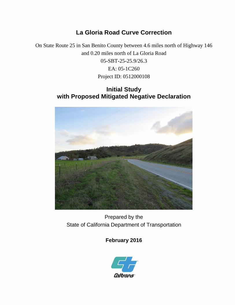


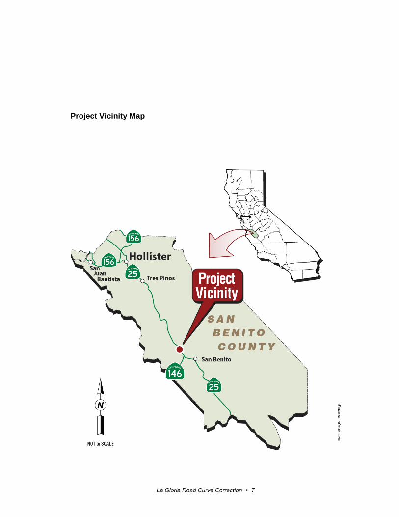

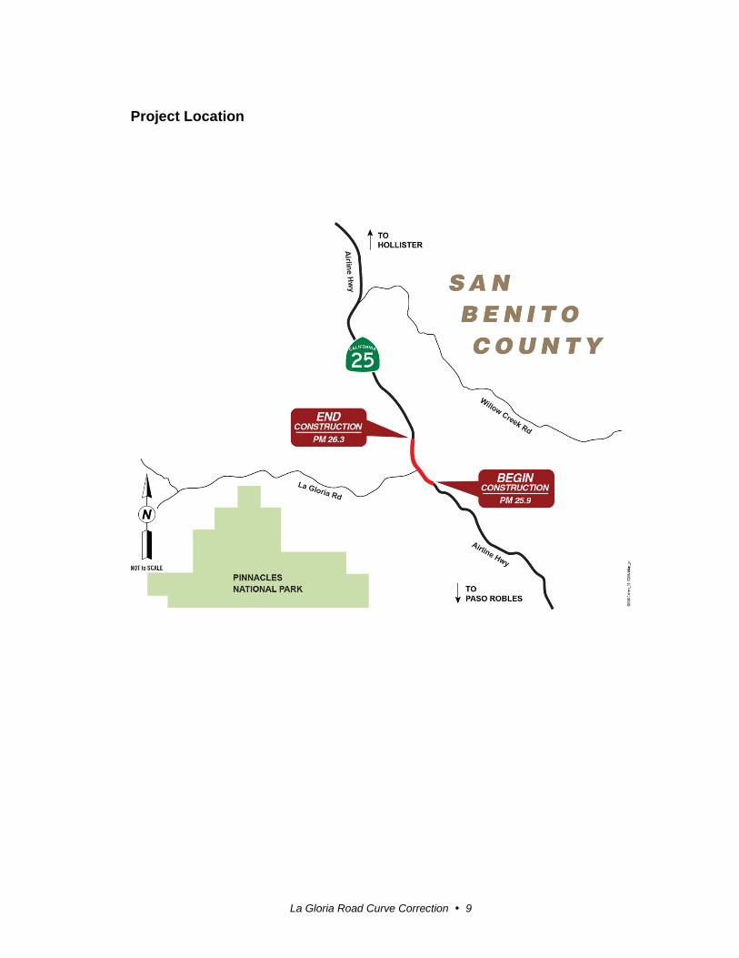


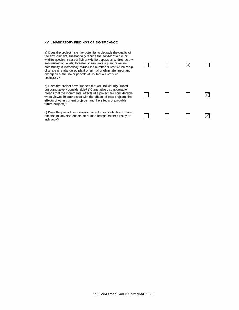


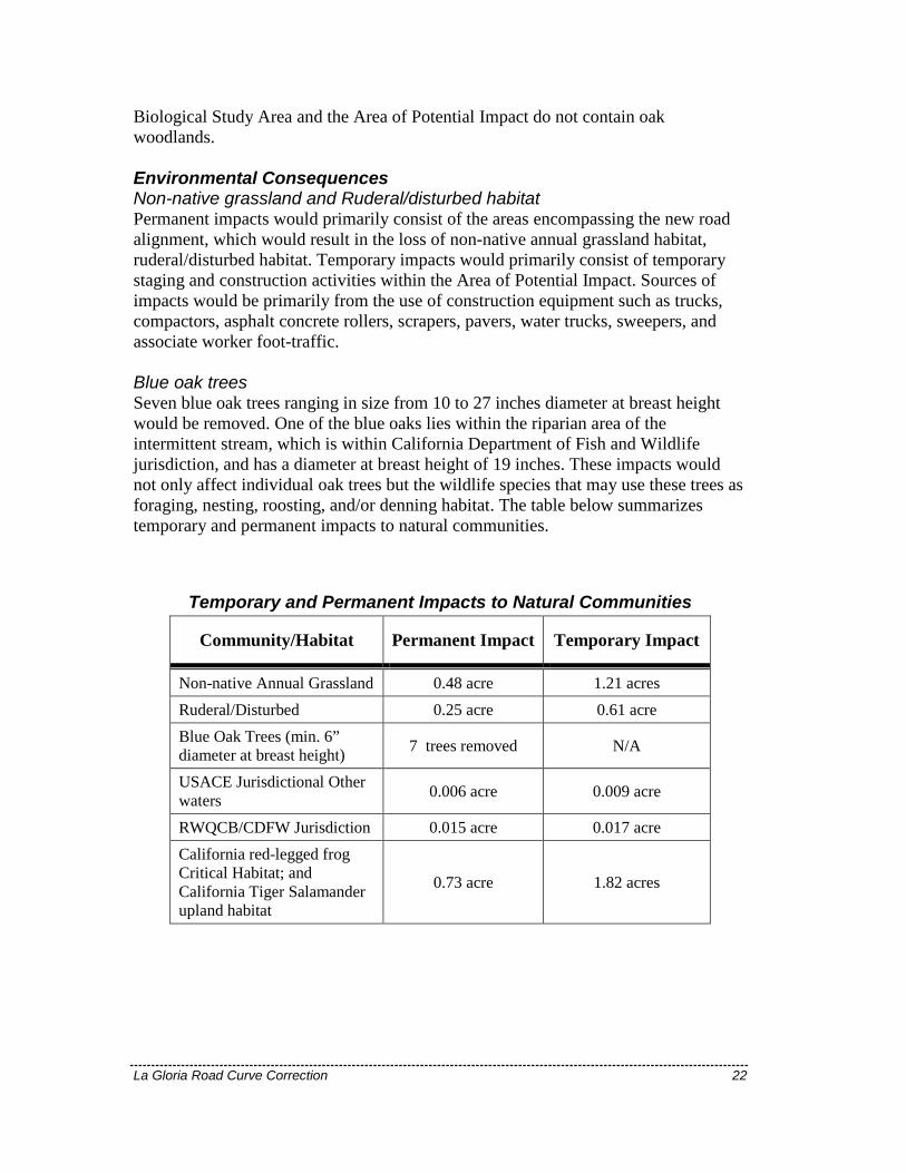


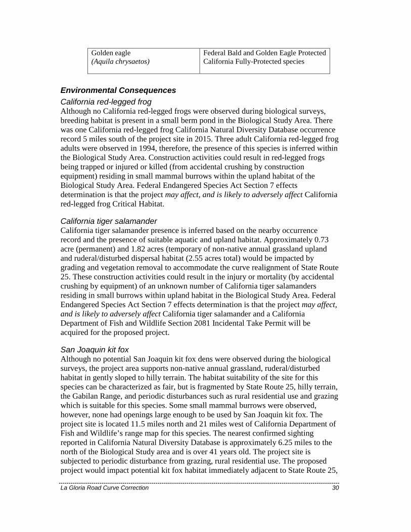


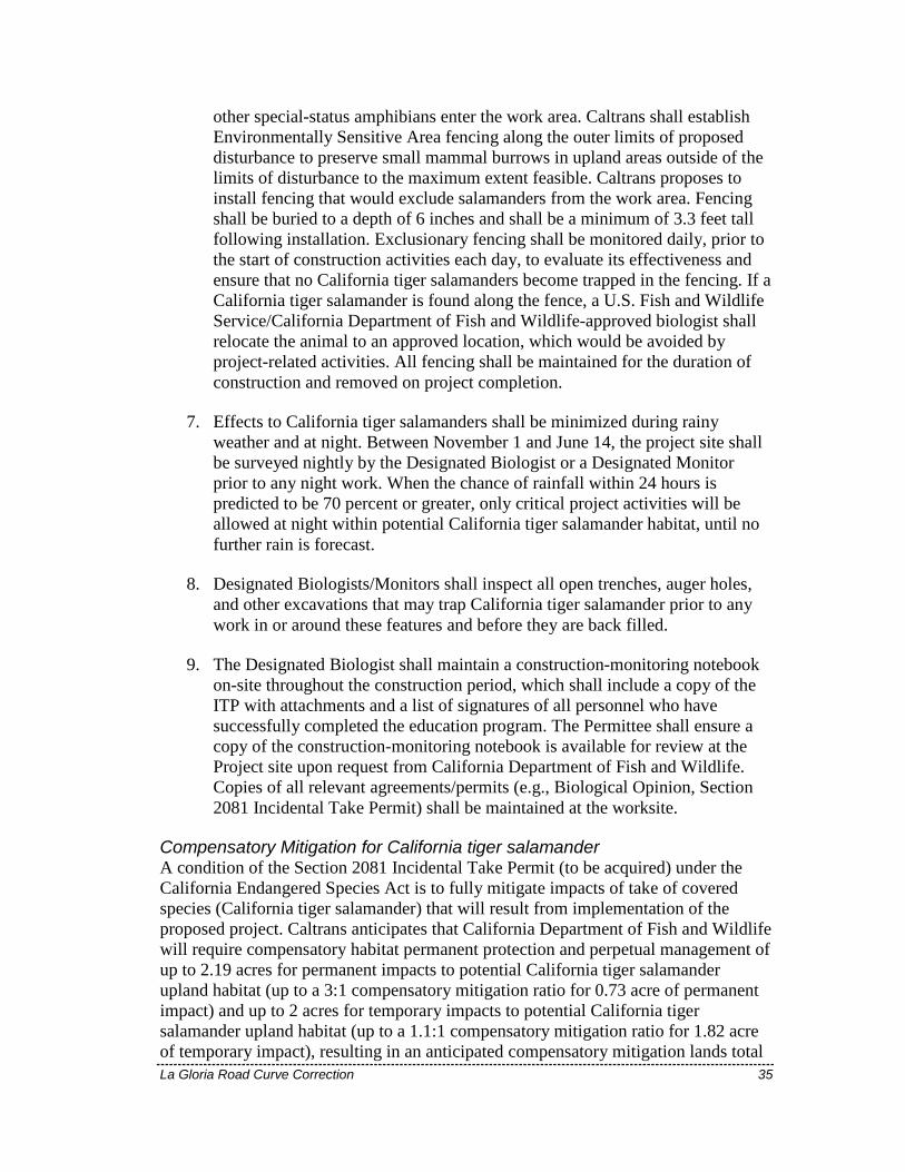

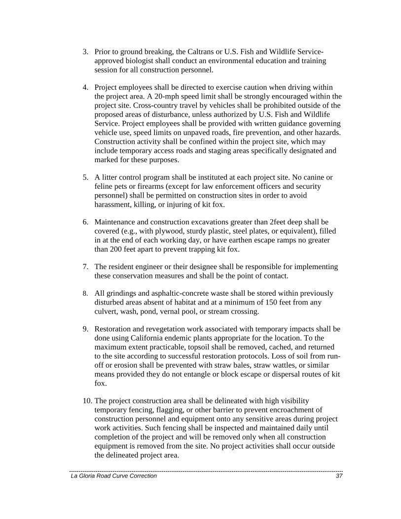
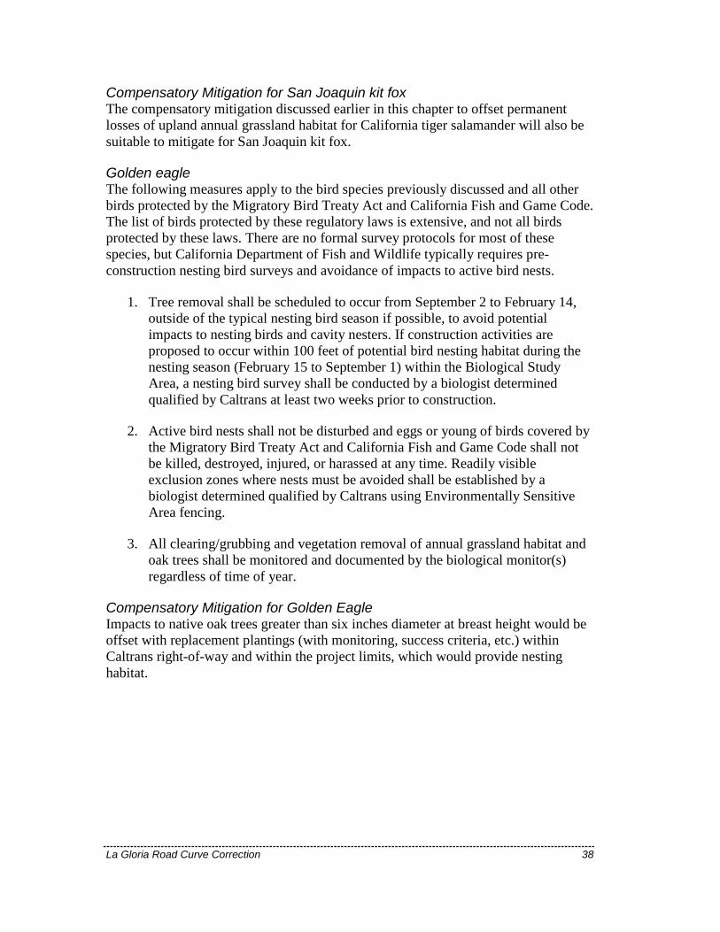
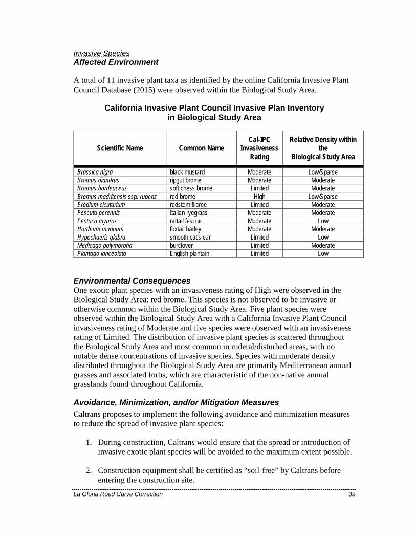


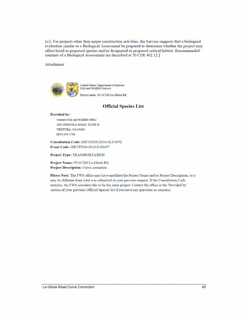


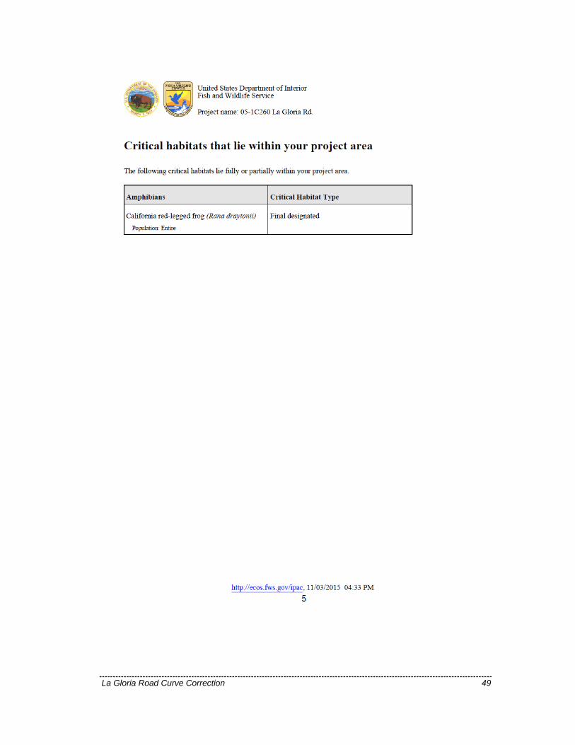


![· PDF fileangle curve grade u nknown end to-rear 2- rear- ... (correction or addition to ... loll] abb address, city, state,](https://static.documents.pub/doc/80x56/5ab8268b7f8b9aa6018c4e9f/curve-grade-u-nknown-end-to-rear-2-rear-correction-or-addition-to-loll.jpg)


