11/19/2012 1 Losing Ground Land Loss in Coastal Land Loss in Coastal WFS 340 - Nov. 20 Louisiana Louisiana Jesse Troxler-Graduate Research Assistant Population demographics of black bears in coastal Louisiana 3 year mark-recapture study St. Mary & Iberia Parish, LA Southern Louisiana is home to 40% of the wetlands in the lower 48 states. “The Mississippi Delta is one of the richest wetland communities on planet Earth” –John Fitzpatrick Cornell Lab of Ornithology The magnificent Mississippi River Delta ecosystem in Louisiana supports 100 million migratory, nesting and wintering birds. –audobon.org
Transcript
11/19/2012
1
Losing Ground
Land Loss in Coastal Land Loss in Coastal
WFS 340 - Nov. 20
LouisianaLouisiana
Jesse Troxler-Graduate Research Assistant
Population demographics of black bears in coastal Louisiana
3 year mark-recapture study
St. Mary & Iberia Parish, LA
Southern Louisiana is home to 40% of the wetlands in the lower 48 states.
“The Mississippi Delta is one of the richest wetland communities on planet Earth” –John FitzpatrickCornell Lab of Ornithology
The magnificent Mississippi River Delta ecosystem in Louisiana supports 100 million migratory, nesting and wintering birds. –audobon.org
11/19/2012
2
Louisiana’s Coast
- Coastal Fisheries: Top Fisheries Producer in Lower 48, Over $3 Billion Annually
- Coastal Energy: Top Producer of Domestic Oil, Over $70 Billion Annually
- Coastal Ports: Largest Port Complex in the World, $35 Billion Annually & nearly 300,000 jobs
• Coastal Population: over 2 Million Residents
• Louisiana’s Unique Heritage and Culture – No $$$
Ecosystem Services $12-47 billion/year
• Estimated value: $330 billion - $1.3 trillion
• Hurricane protection
• Water supply/quality
• Climate stability
• Food production
• Fur and alligator production
• Recreation
• Habitat
• Waste treatment-Earth Economics
Scientists estimate that approximately 2.7 miles of wetlands are capable of absorbing one foot of storm surge. –crcl.org
Louisiana’s coastline has retreated 30 miles in some places.
11/19/2012
3
Land Loss
Louisiana loses an average of 25 square miles of land aof 25 square miles of land a year, a football field every hour. -Couvillion et al. 2011
Since the 1930s, nearly 1,900 square miles of marsh, swamp and
Land Loss
swamp and barrier islands have disintegrated into open water.-Audobon.org
By 2050, Louisiana is projected to lose
Land Loss
approximately 640,000 acres of coastal marshes, swamps and barrier islands. –restoreorretreat.org
WHY?
11/19/2012
4
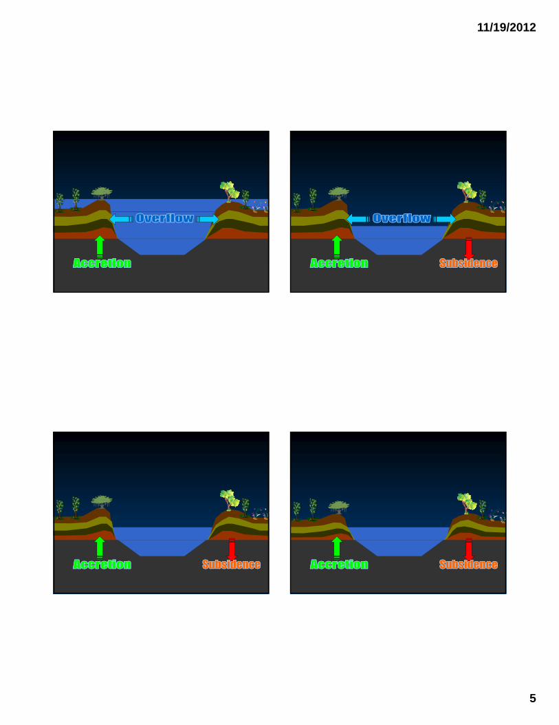
Causes
• Natural Subsidence
• Levees
• Canals
• Hurricanes
• Invasives
• Sea level rise
• Basin drains 41% of the 48 conterminous United States
• Yearly mean discharge of ~ 580 km3 of water and 200,000,000 metric tons of suspended sediment to
Mississippi River
the Gulf of Mexico
• ½ mile across
• 200 ft deep
• 600,000 cfs
History LessonMississippi River
• Atchafalaya River a distributary of the Mississippi
• Mississippi River changing course in early 1900’s
• Old River Control Structure completed in 1964
• 70:30 split
11/19/2012
5
11/19/2012
6
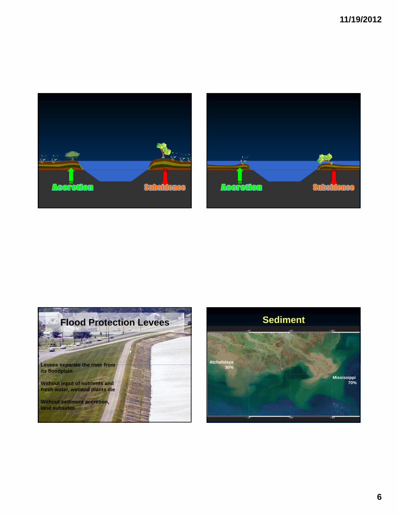
Flood Protection Levees
Levees separate the river fromLevees separate the river from its floodplain
Without input of nutrients and fresh water, wetland plants die
Without sediment accretion, land subsides
Sediment
Atchafalaya30%
Mississippi70%
11/19/2012
7
Subsidence
DeMarco, et al. 2012
Canals
Since the 1950s engineers have cut more than 8,000 miles of canals through the marsh for petroleum
exploration and ship traffic. -National Geographic
• Canals allow saltwater to enter marshes and swamps.
Canals
• Salt water kills plants
• Wave action erodes soil
• Storm surges travel unimpeded
Coastal wetlands flooding in southeast Louisiana, pre- and post-Katrina. August 9, 2005 September 4, 2005
The net reduction in land from 2004 to 2008 (849.5 km2) exceeded that from 1978 to 2004 (743.3 km2) -USGS
The net reduction in land from 2004 to 2008 (849.5 km2) exceeded that from 1978 to 2004 (743.3 km2) -USGS
Hurricanes Invasive Nutria•Introduced from South America in 1930’s•Promoted as biological control for aquatic weeds in 1940’s•Fur market declined in mid 1980’s
Sea Level Rise
•Sea level rise accelerating•1 meter by 2100 –LA Coastal Protection and Restoration Authority•DeMarco, et al. 2012
DeMarco, et al. 2012
SO WHAT?SO WHAT?
11/19/2012
9
Wildlife Values
• Wetland habitats are the most biologically productive on earth
• ApproximatelyApproximately 735 species of birds, finfish, shellfish, reptiles, amphibians, and mammals spend all or part of their life cycle in the estuary. –btnep.org
• Mottled Duck • Brown Pelican • Little Blue Heron • Reddish Egret • Swallow-tailed Kite • Clapper Rail • Snowy Plover
Brown Pelican
Swallow-tailed kite
y• Wilson's Plover • Piping Plover • American Oystercatcher
• Ruddy Turnstone
• Red Knot
• Sanderling
• Western Sandpiper
• Short-billed Dowitcher Reddish Egret
5 million migratory birds using Mississippi and Central flyways winter here. –lacoast.gov
“supports up to 40% of the nations waterfowl during the winter and 40% of the nation’s raptors, shorebirds, and waterfowl during migration.”-Melanie Driscoll, Audobon
The location of this region along the central gulf coast provides a "jumping off point" for many migrants crossing the gulf on their way south during winter migration and "returning point" for those coming back in the spring -btnep orgin the spring. btnep.org
11/19/2012
10
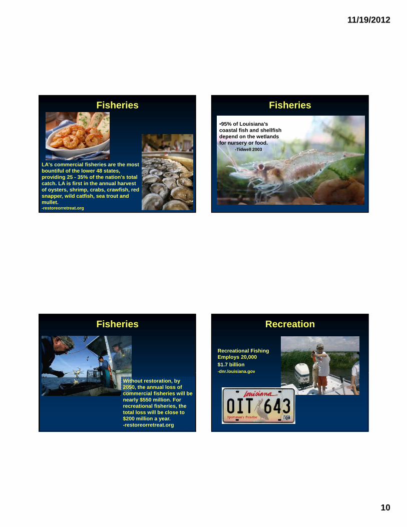
Fisheries
LA's commercial fisheries are the most bountiful of the lower 48 states, providing 25 - 35% of the nation's total catch. LA is first in the annual harvest of oysters, shrimp, crabs, crawfish, red snapper, wild catfish, sea trout and mullet.-restoreorretreat.org
Fisheries
•95% of Louisiana’s coastal fish and shellfish depend on the wetlands for nursery or food.
-Tidwell 2003
Fisheries
Without restoration, by 2050, the annual loss of commercial fisheries will be nearly $550 million. For recreational fisheries, the total loss will be close to $200 million a year. -restoreorretreat.org
Recreational Fishing Employs 20,000
$1.7 billion-dnr.louisiana.gov
Recreation
dnr.louisiana.gov
11/19/2012
11
Recreation
Hunting:$975 million
Wildlife Watching: $517 million
Fur and Alligator Harvest: $111 million
Water Quality
• wetlands and shallow water bottoms with anaerobic sediments are natural sinks for nitrate–nitrogen
Water Quality
“wetlands and shallow water bottoms with anaerobic sediments are natural sinks for nitrate–nitrogen” (Mitsch et al. 2001)
Carbon
Degraded marsh 4.5 tons CO2/acre/year
Healthy marsh 11 tons CO2/acre/yr
Wetland forests 10 tons CO2/acre/year
-Earth Economics
earthtimes.org/climate/blue-carbon/2021/
11/19/2012
12
Shipping
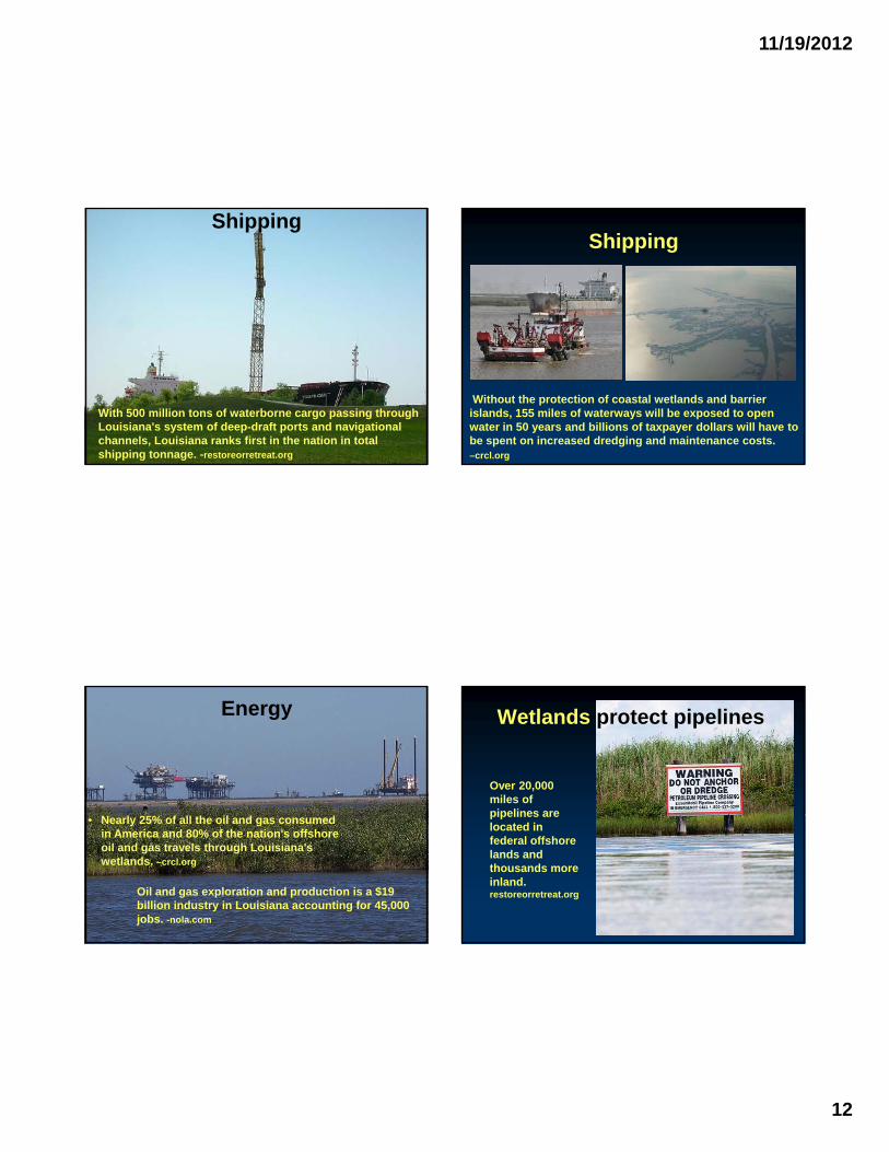
With 500 million tons of waterborne cargo passing through Louisiana's system of deep-draft ports and navigational channels, Louisiana ranks first in the nation in total shipping tonnage. -restoreorretreat.org
Shipping
Without the protection of coastal wetlands and barrier islands, 155 miles of waterways will be exposed to open water in 50 years and billions of taxpayer dollars will have to be spent on increased dredging and maintenance costs. –crcl.org
Energy
• Nearly 25% of all the oil and gas consumed in America and 80% of the nation's offshore oil and gas travels through Louisiana's wetlands. –crcl.org
Oil and gas exploration and production is a $19 billion industry in Louisiana accounting for 45,000 jobs. -nola.com
Wetlands protect pipelines
Over 20,000 miles of pipelines arepipelines are located in federal offshore lands and thousands more inland.restoreorretreat.org
11/19/2012
13
Energy
• Over 20,000 miles of pipelines exposed to:
Skip O'Rourke, AP
• Ship strikes
• Storms
• Corrosion
Culture
Culture Hurricane Protection
• Warming oceans
• Predicted increased in frequency, intensity, duration of hurricanes
• Five hurricanes in last sevenFive hurricanes in last seven years:
New Orleans “The storm hit Breton Sound with the fury of a nuclear warhead, pushing a deadly storm surge into Lake Pontchartrain. The water crept to the top of the massive berm that holds back the lake and then spilled over. Nearly 80 percent of New Orleans lies below sea level—more than eight feet below in places—so the water poured in… As it reached 25 feet over parts of the city, people climbed onto roofs to escape it.
Thousands drowned in the murky brew that was soon contaminated by sewage and industrial waste. Thousands more who survived the flood later perished from dehydration and disease as they waited to be p y yrescued. It took two months to pump the city dry, and by then the Big Easy was buried under a blanket of putrid sediment, a million people were homeless, and 50,000 were dead. It was the worst natural disaster in the history of the United States.
When did this calamity happen? It hasn’t—yet. But the doomsday scenario is not far-fetched. The Federal Emergency Management Agency lists a hurricane strike on New Orleans as one of the most dire threats to the nation.”
Joel K. Bourne, Jr. National Geographic October 2004
Hurricane Katrina, August 29, 2005
Highest storm surge ever recorded on the U.S. coast.27.8 feet at Pass Christian, Mississippi.14-18 feet in New Orleans.
•1,815 deaths in Louisiana and Mississippi•705 people still deemed missing•Estimated two million people displaced•$200 billion in property damage -Earth Economics
11/19/2012
15
At current land-loss rates…
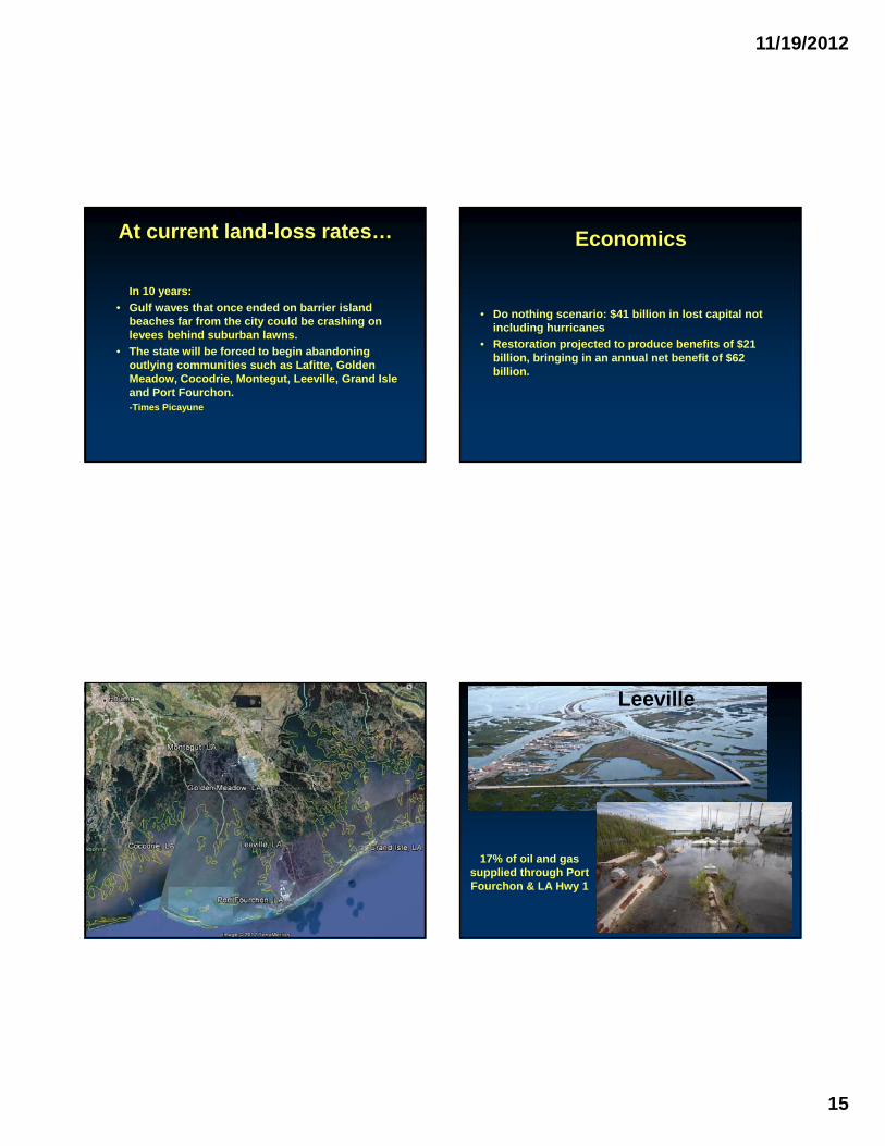
In 10 years:
• Gulf waves that once ended on barrier island beaches far from the city could be crashing on levees behind suburban lawnslevees behind suburban lawns.
• The state will be forced to begin abandoning outlying communities such as Lafitte, Golden Meadow, Cocodrie, Montegut, Leeville, Grand Isle and Port Fourchon. -Times Picayune
Economics
• Do nothing scenario: $41 billion in lost capital not including hurricanes
• Restoration projected to produce benefits of $21 billion, bringing in an annual net benefit of $62 billion.
Leeville
17% of oil and gas supplied through Port Fourchon & LA Hwy 1
11/19/2012
16
Restoring Sustainability to the Mississippi River Delta
• Barrier Shoreline Restoration
• Marsh Restoration with Dredged Material
• Land Building Diversions• Land Building Diversions
• Land Sustaining Diversions
• Hydraulic Restoration
• Shoreline Stabilization
• Closure of the Mississippi River Gulf Outlet
Barrier Shoreline Restoration
• Habitat for birds, threatened, and endangered species
• 1st line of defense againstdefense against wave energy and storm surge
• Sediment is dredged, pumped, and revegetated with native dune and marsh species.
Barrier Shoreline Restoration Marsh Restoration with Dredged Material
• Containment dike
• Cutterhead stirs up sediment
• Slurry piped
• Dewatering• Dewatering
• Planting
11/19/2012
17
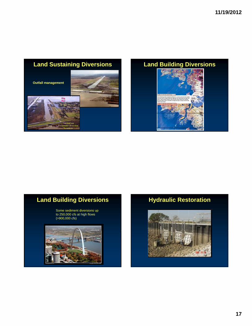
Land Sustaining Diversions
Outfall management
Land Building Diversions
Land Building Diversions
Some sediment diversions up to 250,000 cfs at high flows (>900,000 cfs)
Hydraulic Restoration
11/19/2012
18
Shoreline Stabilization Closure of the Mississippi River Gulf Outlet
1960
•Junction with Intracoastal WW•Shortcut to Gulf•Funnel effect
1989
Restoration Legislation• CWPPRA-1990
• 2012 MASTER PLAN
• RESTORE ACT
11/19/2012
19
CWPPRA 1990Coastal
Wetlands
Planning
Protection &
Restoration
Act
• AKA the Breaux Act
• 91 feasability and demonstration projects
• Since 1990, CWPPRA has protected, created, or restored 112,000 acres. 550,000 enhanced.
2012 Master Plan
• 109 projects over 50 years
• More land gained than lost by 2042
• 859 square miles built by 2061
• Net average 2.5 square miles/year
• $50 Billion
• BP fines, congressional appropriations, offshore oil
• Mitsch et al. 2001. Reducing Nitrogen Loading to the Gulf of Mexico from the Mississippi River Basin: Strategies to Counter a Persistent Ecological Problem BioScience 51(5):373-388. D. Batker et al. 2010. Gaining Ground -Wetlands, Hurricanes, and the Economy: The Value of Restoring the Mississippi River Delta. Earth Economics. Tacoma, WA
• Barras, John A. 2009. Land Area Change and Overview of Major Hurricane Impacts in Coastal Louisiana, 2004-08. USGS
• Couvillion, B.R., Barras, J.A., Steyer, G.D., Sleavin, W., Fischer, M., Beck, H., Trahan, N., Griffin, B., and D. Heckman. 2011, Land area change in coastal Louisiana from 1932 to 2010: U.S. Geological Survey Scientific Investigations Map 3164, scale 1:265,000, 12 p. pamphlet.
• DeMarco, K., Mouton, J., and J. Pahl. 2012. Recommendations for anticipating sea-level rise impacts on Louisiana coastal resources during project planning and design. Summary of the technical report for coastal managers. Coastal protection and restoration authority.