Page 1
LABOUR, CLIMATE PERCEPTIONS AND SOILS IN THE IRRIGATION SYSTEMS OF SIBOU, KENYA & ENGARUKA, TANZANIA
Martina Angela Caretta, Lars-Ove Westerberg, Lowe Börjeson, Wilhelm Östberg
This booklet presents the results of a 4 years project (2011-2015) by four geograph-ers from the university of Stockholm. This research took place in two small villages: Sibou, Kenya and Engaruka, Tanzania. The overall project looks at three variables: soil, climate and labor. These aspects can give an indication of the type of changes that happened in these irrigation systems and what have been the triggers behind them. In this booklet results are presented according to location and focus on: agricultural practices, women´s and men´s labor tasks, soil and water characteris-tics, adaptation weather variability and how all of these aspects have changed over time. The same booklet is also available in Kiswahili ISBN 978-91-87355-17-2 and Marak-wet ISBN 978-91-87355-16-5
ISBN 978-91-87355-15-8
Department of Human Geography
Stockholm 2015
Department of Human GeographyStockholms universitet 106 91 Stockholm www.humangeo.su.se
Page 2
L A B O U R , C L I M A T E P E R C E P T I O N S A N D S O I L S
I N T H E I R R I G A T I O N S Y S T E M S O F S I B O U , K E N -
Y A & E N G A R U K A , T A N Z A N I A
Martina Angela Caretta, Lars-Ove Westerberg,
Lowe Börjeson, Wilhelm Östberg
ISBN 978-91-87355-15-8
This booklet presents the results of a 4 years project (2011-2015) as a popu-
lar science publication directed towards, informants, participants and local
authorities of the study sites: Sibou, Kenya and Engaruka, Tanzania. This
English version has been translated into Swahili and Marakwet to be distrib-
uted on site during a field trip in January 2015.
Page 4
LABOUR, CLIMATE
PERCEPTIONS AND SOILS
IN THE IRRIGATION SYSTEMS
OF SIBOU, KENYA
& ENGARUKA, TANZANIA
Martina Angela Caretta, Lars-Ove Westerberg,
Lowe Börjeson, Wilhelm Östberg
Page 5
©Caretta, M.A. Westerberg, L.O. Börjeson, L. Östberg, W.
Stockholm University 2014
ISBN 978-91-87355-15-8
Printed in Sweden by US AB, Stockholm 2014
Distributor: Human Geography Department
Page 6
5
Introduction
Canal irrigation is defined as stream water descending from highlands and
diverted through canals that eventually become small furrows – i.e. ploughed
trenches - which distribute water, thanks to gravity, to fields where rainfall is
usually insufficient to raise a crop.
In Eastern Africa there are three groups of locations with indigenous irri-
gation systems):
1. the Kerio valley located in western Kenya along the Rift Valley in the
counties of West Pokot, Baringo and Marakwet;
2. around Kilimanjaro, located in south-eastern Kenya and north-eastern
Tanzania are the irrigation systems of of Taita Hills, Taveta, Pare mountains
and Usambara mountains;
3. Sonjo located around Lake Natron in northern Tanzania;
4. Engaruka, south of Sonjo and Pagasi in Kenya.
Page 7
6
Figure 1. Smallholder irrigation farming in Eastern Africa (Tagseth,
2008:62)
The aim of this study was to understand the current conditions
and recent developments of these two irrigation systems, which both have
history that date several hundred years back. This objective is important in
light of the investments that governments and international organizations are
undertaking to increase and improve irrigation in the two countries, as a way
to develop the agricultural sector and produce more crops. As part of such
strategies to modernize and improve irrigation systems, indigenous local
irrigation systems are commonly described as traditional and less productive,
Page 8
7
implying that they should be changed and turned into modern and more pro-
ductive systems.
We do not agree with this picture. As irrigation agriculture
have been practiced for several hundred years in both Sibou and Engaruka
(as well as many other places in East Africa), we suggest that it is important
to study these systems as examples of areas where irrigation have been prac-
ticed in a sustainable way, and to learn directly from the farmers in these
areas about problems and opportunities for the future. Another important
thing to note is that irrigation in these areas has not looked the same over
time, as farming practices, crops etc. has changed, not least recently. In this
report, we describe how the irrigation systems are managed by the local
farming communities and how the work with carrying out irrigation and
farming is organized and shared between women and men, and what farmers
(both men and women) in Sibou and Engaruka think about changes in the
local climate. We also describe the soils of the two areas and discuss how
these are changed by irrigation and cultivation.
Page 9
8
Sibou – Tot
The village of Sibou, in Tot Division of Elgeyo-Marakwet County, occu-
pies 20.6 km2 on the slopes of the Kerio Valley escarpment and valley floor,
and is situated at an altitude between 1000 and 1600 meters above sea level.
Sibou is situated by Tot, the market and administrative centre established in
1949 by the colonial government. Dry-land conditions with <1000 mm/yr
rainfall and sporadic droughts characterize the environment of Kerio Valley.
According to the 2009 national census, the population of Sibou was 2453
people, for a total number of 660 households (KNBS 2009). The settlement
is located on a bowl-shaped hill, and one of its natural borders on the north-
ern side is the Embobut River.
Figure 2. The study area around Tot Centre and the different ecological
zones. Map by S. Ene and P. Hennerdal, 2014.
The vast majority of the inhabitants of Endo are Marakwet, a Kalenjin
speaking people. Most Marakwet villages are made up of several patrilineal
Page 10
9
clan groups, each consisting of one or several lineages. There are four patri-
lineal clan groups in Sibou, Kaapisyooy, Syapan, Kaapsireen,
Kaachēēpsoom (listed in accordance to their respective sizes).
Marakwet villages have no formal leaders or governing committees. Instead
decision making is based on local meetings, kok, summoned as a specific
issue needs to be solved, and where all initiated men can participate on equal
terms. Women can attend, and will do so if they consider an issue to be dis-
cussed is of direct concern to them. They are, however, given a subordinate
role at the meetings. Water distribution is organised at special meetings for
those who control a particular canal, the pik ab per (people of water).
Farming in the dry Kerio Valley depends on an extensive system of irri-
gation canals leading water down the steep escarpment to the cultivated
fields on the valley floor. Canals depart from Embobut river and are then led
down the escarpment. There is one canal for each clan, the most important
ones being Syapan and Kaapisyooy.
Page 11
10
Figure 3. Canals are directly dug into the soil and countoured with boulders.
On the escarpment they are frequently reinforced with concrete.
Figure 4. When reaching Keew, canals are mostly dug into the soil. There
are some old cement sluice gates built by the Kerio Valley Development
Agency which are partially used nowadays.
Sibou has three distinct land use areas, with different topographic and en-
vironment characteristics. The valley floor and the Kerio River, in the east, is
termed Keew. Here land is communally held and farming collectively orga-
nized to manage the major work to lead irrigation water to the land. Farms
are cleared and fenced by a community cultivating a particular land, while
the cultivated plots inside this area are managed by individual households.
Page 12
11
Livestock graze in Keew. On the slopes of the escarpment towards the west
is the residential area, Lakam, with home gardens and where also the sites
for ceremonies are located. Further up the escarpment, in Māsoop, agricul-
ture is rainfed with maize and beans as the most common crops. Here also
good grazing areas are found and timber and firewood are collected in the
forests.
Sibou in the 1970s and now
Life in Sibou has changed considerably during the last few decades. We will
briefly describe what the area looked like in the mid-1970s and compare
with how it is today.
Figure 5.Flash-back to the mid-1970s: At that time people lived in home-
steads, which typically consisted of two round thatched houses facing each
other, grain stores, and a shelter for the goats. If the household consisted of
Page 13
12
more than one wife, or if an adult son or a relative lived in the compound,
extra houses were built behind one of the houses or adjacent to the com-
pound. Compounds of this type remain common in Lakam also today and
are usually occupied by elderly people, single mothers and families whose
livelihood is based on subsistence farming. Families with two wives living in
the same compound are now rare, and non-existent among those below forty
years of age.
Currently at least half of the houses in Lakam have a rectangular shape, and
are equipped with a tin metal roof. Adjacent to these houses there are usually
round huts, used as kitchen and granaries. These are normally kept under
lock to avoid theft. Granaries are elevated from the ground to allow the
grains to keep dry while also providing shelter for chickens and lambs dur-
ing rains or when a bird of prey is hovering in the sky.
The furniture in the houses in the mid-1970s was simple: sleeping skins, a
couple of stools, clay and aluminium pots, gourds, skin bags, enamel cups,
plates and bowls (but also eating skins). Some households had a radio, bed
Page 14
13
and mattress, a table and chairs. Today the residential areas in the hill sides
are more densely populated. Housing has improved considerably, and fruit
and shade trees are far more common than forty years ago. A number of
salaried people have equipped their houses with solar panels to get light to
their houses at night and they cook with gas indoors. Moreover, they can get
an extra income by charging cell phones at 10 KSH. Some have TV-set,
armchairs, sofas and decorative posters with Christian motives. Virtually all
adults in Tot have a cell phone connected to the money transfer system M-
pesa. This constitutes a very major change compared to the 1970s. People
are able to stay in touch with relatives living outside the area, and the mo-
biles ease everyday activities.
Figure 7. Market takes place at Tot centre every Saturday and Wednesday.
Marakwet women sell agricultural produce and it is mostly women also buy-
ing. Pokot women come walking from East Pokot to sell milk in their typical
jug.
Page 15
14
The valley was not served by public transport in the 1970s, and the number
of traders who came from the urban centres to buy farm produce was small.
Things have changed: nowadays a matatu (collective taxi carrying about a
dozen people) depart from Tot at 2 am and arrive at Eldoret at 7 am and
reaches Tot again at around 11 am. Another matatu departs from Tot at 4 am
reaching Kapsowar at 7am; it then starts the journey back at around 11 am,
reaching Tot at 2pm.There are furthermore now numerous motorcycles fer-
rying persons between the different centres in the valley. However, the road
still remains a problem, needing constant maintenance, especially during the
rain period. Nevertheless, it is considerably improved compared to the 1970s
and trucks reach Tot from Eldoret and from Piretwo daily during the mango
harvesting season. Politicians have during election campaigns promised tar-
macked roads, and an all-weather road from Tot is listed in the County Inte-
grated Development Plan 2013-2017, but all this is yet to happen.
Agriculture – 1970s
The Marakwet has as long back as people remember grown finger millet and
sorghum. First trials with maize in the valley were initiated by the British in
1918, a short stemmed fast maturing variety, which initially did not attract
much interest. However, with time it gained in popularity and in the 1970s
most households had a maize field, and hybrid varieties were available. Par-
ticularly the sorghum variety Serena gained in popularity.
The colonial agricultural service had introduced cassava, which most fami-
lies grew in the 1970s. It constituted a valuable back up if the cereals did not
do well. Bananas and sweet potatoes had long been popular and other suc-
cessful introductions were groundnuts, cowpeas, sweet potatoes, sugar cane,
chilli pepper and mangoes. None, however, was a commercial success. The
markets were far away and with a miserable road connection. This meant
that cash crops did not take off, and lowland Marakwet remained basically a
subsistence economy. Very few people had salaried incomes.
Page 16
15
Figure 8. All farm work in the 1970s was by hand, as it is today. Fields were
cleared using a machete and an axe, thorns gathered with large wooden
forks, and burnt in the fields. Some were used for fencing, as it is nowadays.
Finger millet and sorghum was sown by broadcasting, and women hoed the
seed into the ground using a short hafted and acutely angled hoe. Women
used the same implement when they later weeded the crop, normally only
ones during the life of the crop. Men irrigated the land by moving water with
the help of long shafted hoes, to all corners of the field. Fertility manage-
ment was limited to fallowing while manure could be added to the more
permanently cultivated fields on the slopes of the escarpment, and here soil
conservation measures like terraces could also be encountered.
Grains were mainly for home consumption (with the exception of maize
which had a good local market) and cash was derived from other sources:
selling animals, fruits, vegetables, tobacco, hides and skins, honey and hand-
Page 17
16
icraft, home-brewed beer, remittances from family members living outside
the valley, and day-labouring.
Figure 9. Bananas were and are a steady provider of petty cash but was also
exchanged, as was cassava, for maize and beans (in the highlands) or milk
(from the Pokot). Some families tried to establish two households, one in
Keew and one in Māsoop to benefit from the different cropping regimes in
the different ecological zones. Agricultural produce was carried up and down
the escarpment integrating the economies of highland and lowland
Marakwet.
In the 1970s some families had fruit trees, particularly bananas, and vegeta-
bles (collard greens, cabbage, onions, peppers, tomatoes, etc.). About half
the men kept beehives and honey was an important local product. It was
common to have about 20 beehives but not that unusual to have 30-50. This
is a major change compared to today when honey is usually bought from
East Pokot.
Most households kept poultry and had a flock of goats. Some also had sheep
and a few cows. Keeping livestock in addition to farming was considered
Page 18
17
part of a Marakwet way of life but recurrent raiding from neighbouring
groups held back livestock keeping. Trypanosomiasis was another inhibiting
factor.
Cattle raiding has a long history in the Kerio Valley and the period 1975-77,
for instance, was characterized by extensive raiding by the Pokot. In the
1990s the situation turned very bad and the valley could be described as a
war zone. People were forced to abandon the cultivations on the valley floor,
and to retreat high up in the hills. Schools and health facilities in the valley
closed. Trade came to a standstill. By 2002 peace was restored and people
returned to the valley.
Agriculture – 2010s
In 2013 all the farmers interviewed had one or two plots in Lakam, not nec-
essarily around their home, and one or two plots in the Keew. The majority
still live in Lakam, but in the last five years some families have started to
move down into the Keew.
Page 19
18
Figure 10. Nowadays, land in Lakam is not sufficient for all and some farm-
ers have taken up permanent fields on the valley floor besides having shares
in the communal lands that are cultivated for a couple of years at a time.
Some of them, in most cases younger couples, have also moved to Keew,
building their house there. For decades the administration has urged people
to do this, with little success, but now the process has definitely started.
There are advantages with moving down from the escarpment. The fields
are no longer two to three hours’ walk away from home, the pastures are
better, and good sanitary conditions are more easily arranged for. The shops
at Tot centre are closer as are the schools. There are currently two primary
schools in the Tot area (one private and one public) and two public second-
ary schools. Tot has a health centre but it often lacks basic medicines and
many use the health centre in Chesongoch (about seven kilometres to the
south), supported by the Catholic Church, which is better equipped, especial-
ly for child birth. For emergencies there is an old ambulance at the Tot
Health Centre, but people have to pay for it and it is rarely used. A new op-
eration theatre at the Tot Health Centre, with planned x-ray facilities, was
built in 2007, but the new premises have not yet opened.
The rains are concentrated to April–June and July-August. Preparation for
cultivation, including clearing canals and fields and fencing, takes place
between February and March.
Page 20
19
Figure 11. At the outset of the cultivation season a group of kinsmen will
agree on cultivating a particular area of the communal lands on the valley
floor, clear and fence the land together, and take water to the land. Internally,
these large fields are divided between the participating lineages, or age-
groups if the land is located at the far eastern part of the village land close to
the Kerio River, and, in both cases in the next phase, between the house-
holds. Identifying land to be cultivated is a process involving both agro-
technical and socio-cultural assessments. Once the decision has been made
land is cleared and fenced, and water led from the main canal to the selected
farming area.
Page 21
20
Figure 12. Along the river good harvests of maize are expected. In 2011 a
group of ten male farmers started growing tomatoes and watermelons close
to the banks of Embobut River with good results. Similar fields are also
found along the banks of the Kerio River. The soil is replenished every rainy
season when the river floods the fields. As the plots lie higher than the river,
a generator, pump and pipes are required to water the crops.
Figure 13. Cropping calendar (Fischer 2012, 37).
Page 22
21
All farmers in Sibou grow cash crops. Two harvests are taken every year:
Grains are grown between March and September and beans between March
and July, while cash crops such as cowpeas, green gram, black beans,
groundnuts are grown between July and October-November taking ad-
vantage of the late rains. In addition to growing nitrogen-fixing crops farm-
ers also incorporate leftovers from weeding into the soil, after irrigation.
Some add cow and goat manure to the soil. Adding ash produced by burning
harvest leftovers is another way to improve soil quality.
Grains are mostly for home consumption, as are sukuma wiki and cassava.
Cassava, bananas, green gram and groundnuts are sold in the neighbouring
markets of Kolowa (in East Pokot) on Thursday and Chesogon on Sunday.
Most farmers do at least one harvest of cowpeas and groundnuts a year.
Short-term cash crops such as green gram, cowpeas, tomatoes and water-
melon that do not require much rain are planted in correspondence of short
rainy periods and harvested after an average of three months.
Page 23
22
Figure 14. Watermelon is a pure cash crop that was promoted in the early
2000s by the Kerio Valley Development Authority and has been taken up by
some young farmers since then. Seeds can be bought in shops by Tot centre.
The quality is deemed good and traders from Eldoret go with pick-up trucks
directly to the plots to pick up the produce. Vast extensions of mangoes have
been planted in the valley since the 1980s which has changed the landscape.
Figure 15. Almost all farmers own mango trees and sell the fruits to trucks
coming from Eldoret during the harvest season of January and February. The
traders provide them with nets for picking mangoes and for transport to Tot
centre where nets are weighted and farmers paid on the spot. All family
members are involved in the harvest as this is the most remunerative mo-
ment of the year. Children sometimes stay home from school to climb the
trees and pick mangoes and women, who traditionally were not expected to
climb trees (“women should not be above men”) also participate in the har-
vest. In 2011 the price was between 250 and 200 KSH a net. A net contains
between 90 and 150 pieces. A big tree will produce up to 10 nets a year. The
Page 24
23
price is held down by the poor road, which discourages many traders from
reaching Tot, and not all the harvest can be sold.
Table 1. Average output in 90kgs sacks for one acre in 1974 and 2011- 13.
Soil and water
Farmers describe the soils on the valley floor as black, soft, ashy and re-
taining water for several days before drying out completely. They note how
nutrients from the hills are washed down the slopes and also transported to
Keew through the irrigation canals.
The soils in Marakwet are formed by on the breakdown of granitic rocks.
The minerals in these rocks contain low amounts of nutrients, and as a result
also the soils are relatively poor. However, the dry climate in Kerio Valley
help to preserve soil nutrients that are available to crops, which makes the
soils better for agriculture. There is, however, a lack of two of the most im-
portant nutrients, nitrogen and phosphorous, whereas sufficient levels of
potassium are available as are nutrients of secondary importance, such as
calcium and magnesium. Nitrogen levels may be improved by adding ma-
nure, or by cultivating nitrogen fixing plants, such as peas, beans and lentils,
in the crop rotation. In addition to this, a continuous addition of phosphate
Page 25
24
fertilizers would be necessary for improved yields. The levels of phospho-
rous show an interesting pattern, where fields on the plain (Keew) appear to
have higher phosphorous levels than fields on the slopes (Lakam) of the
escarpment. A possible, but not yet confirmed explanation is that irrigation
water picks up phosphorous during its passage through inhabited areas,
thereby feeding the lower fields with this important nutrient.
Generally the amount of organic matter is very low. This is an undesirable
condition, as organic matter greatly improves both the physical and chemical
status of soils. This is of special concern as the soil type in this part of
Marakwet is characterized by a topsoil which is comparatively poor in clay
and rich in sand. Without organic matter that helps soil particles to stick
together to form a good lumpy structure, the topsoil is sensitive to erosion.
Also, as clay is the kind of soil particles that have the greatest potential to
retain and release nutrients, a clay-poor topsoil will need the nutrients pro-
vided and retained by organic matter. Adding organic matter to the soil, in
the form of manure, compost and crop residues, is therefore a measure that
can improve the soil greatly.
The effect of running water is that soil material is washed down from
higher to lower parts of the landscape. In this transport, fine-grained materi-
al, such as clay and silt, is transported the farthest. Coarser material, such as
sand and gravel, is not transported as far, and this results in a grading of
material, from relatively coarse-grained uphill, to relatively fine-grained
downhill. As the fine-grained material contains more nutrients, the soils on
the plain below the escarpment is more favourable for agriculture than the
soil on the slopes of the escarpment. However, on the plain lack of water is a
problem, and without irrigation these soils cannot be cultivated except dur-
ing short periods in the rain season.
Page 26
25
Lastly, it should be mentioned that the soil analyses indicate that saliniza-
tion is not a problem in Marakwet. Dry-land irrigated agriculture is notori-
ously known to be affected by increased salt levels in the soil. In Marakwet,
however, the water supplied to the fields does not appear to rise the ground-
water level to the extent that saline groundwater affects the topsoil.
Labour organization
Men and women in Sibou have different roles. Men clear land, fence
fields and are responsible for irrigating the land. They grow cash crops while
not necessarily undertaking all the work involved in them. For instance,
women weed also cash crops. Women sow, cultivate and weed subsistence
crops. Both men and women are involved in harvest.
Figure 18. Women are not supposed to irrigate and women-headed house-
holds must rely on male relatives or sons to undertake irrigation work. If a
woman enters a canal to wash clothes or bathe or if she breaks a canal to
Page 27
26
lead water to her field, it is said that the canal will dry up. The woman would
need to undergo a cleansing ceremony carried out by male elders. If there are
no male relatives or sons who can assist widows or single women, they have
to pay a man to break the canal. To afford this service, these women sell a
goat or pull resources from petty trading or daily contract farming. Normally
male relatives or sons will make sure that women are allocated their time
slots to irrigate. Once the canal has been broken by a man, women can
spread the water in their fields.
Men participate in the water management group meetings on behalf of
these women and subsequently irrigate for them. Men are in charge of the
construction, reparation and maintenance of the canals. They work together
when the canals break for instance. Women facilitate and complement the
work of men for instance by carrying cement on their backs for reparation
work and during construction of new canals. In the past they walked up the
escarpment bending under the weight of grass and sand – which they had the
role of mixing – as well as wood. Moreover, by working constantly in the
fields women are the first to notice the breakage of a canal. Hence, even
though men are considered “canal makers”, this work would not be possible
without the material help of women.
Page 28
27
Figure 19. Women cooperate to sow, weed and harvest. Women often weed
and harvest cash crops, which are sold by their husbands. While men and
women collaborate in sowing and harvesting green gram and cowpeas and in
the harvest of mangoes in February, tomatoes and watermelon are strictly a
men’s venture. These new cash crops are labour intensive and have added an
extra burden on women: before the mid-1980s they sowed, weeded and har-
vested food crops, but in the last three decades they have also begun per-
forming these practices on cash crops that are sold by their husbands, who
often use part of the profit for their own leisure and comfort.
Page 29
28
Figure 20. Women distinguish at least six different types of millets (short-
term millet (between two and three months to maturity) kuptuganis, kuptot,
and America; long-term millet (approximately four months to maturity) ku-
luu, cherongo, and kumuino), three types of cassava, four types of maize,
and four types of sorghum (long – term sorghum, short-term sorghum called
Serena, Queen and Sereto; Serena is the most commonly used). They store
the seeds, know their characteristics, and share this knowledge among them-
selves. Women routinely cooperate during sowing, weeding and harvesting
as men often cooperate for clearing and fencing.
Page 30
29
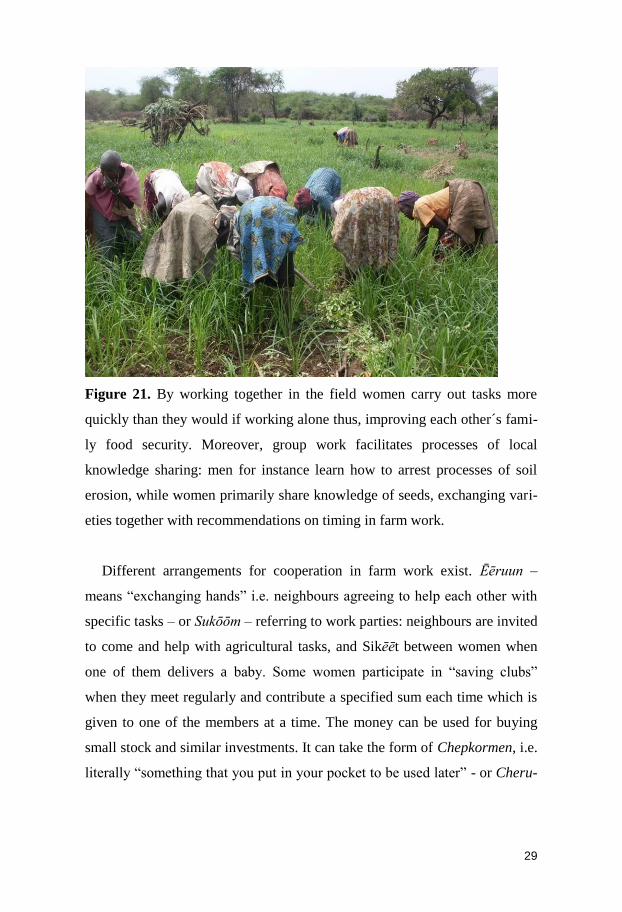
Figure 21. By working together in the field women carry out tasks more
quickly than they would if working alone thus, improving each other´s fami-
ly food security. Moreover, group work facilitates processes of local
knowledge sharing: men for instance learn how to arrest processes of soil
erosion, while women primarily share knowledge of seeds, exchanging vari-
eties together with recommendations on timing in farm work.
Different arrangements for cooperation in farm work exist. Ēēruun –
means “exchanging hands” i.e. neighbours agreeing to help each other with
specific tasks – or Sukōōm – referring to work parties: neighbours are invited
to come and help with agricultural tasks, and Sikēēt between women when
one of them delivers a baby. Some women participate in “saving clubs”
when they meet regularly and contribute a specified sum each time which is
given to one of the members at a time. The money can be used for buying
small stock and similar investments. It can take the form of Chepkormen, i.e.
literally “something that you put in your pocket to be used later” - or Cheru-
Page 31
30
toyo, i.e. literally “visiting one another” – when meetings take place in dif-
ferent people´s home.
Figure 22. There are also Harambees which consist in money collection to
pay school fees for children, to buy tools for agriculture or for house im-
provements or, if they are petty traders, to increase their stock. There is a big
group of women meeting every other Sunday afternoon doing Harambees in
Tot. While the host keeps on cooking and serving dozens of women who are
stopping by to leave a small sum and to eat, another woman is in charge of
writing down the name of the contributors and the sums donated. Not all the
women would show up every month, but this does not break the mutual sup-
port bond among them. Also women who are better off and do not need to
call for a Harambee will still participate because they were helped in the past
and they might need assistance in the future.
Page 32
31
Figure 22. Summary of men´s and women´s task in Sibou.
Adaptation to weather variability
Because women and men have different roles and cultivate different crops,
they also deal differently with weather variability.
Figure 23. Droughts happen in Marakwet, while other years show higher
than normal rainfall. Farmers reported that in some years between 1984 and
2009 their harvest failed (red) and in other years they got bumper harvests
(blue).
A strategy used to adapt to the changing weather and to improve soil
moisture and fertility is the intercropping of maize with beans and cowpeas.
Such intercropping is done mainly by women. Cash crops which are mainly
cultivated by men are not intercropped. These crops require irrigation and
Men / Wanaume Women/Wanawake
Page 33
32
will survive also during the dry season. If they were intercropped or exposed
to excessive rains the harvest would be not as high as for a single crop. Fur-
thermore, mixing different crops means increased development to pests.
The introduction in the last decade of cash crops triggered fundamental
changes in the village; whereas the predominant narrative is that men are
mainly concerned with herding, irrigation management, and field prepara-
tions, in the last decades they have also started playing an important role in
agriculture, by producing cash crops.
Development projects 1970s- 2010s
In the course of the last forty years mainly three organizations have initi-
ated projects aimed at boosting agricultural productivity in the valley: the
Ministry of Agriculture, through its resident extension staff, the Kerio Valley
Development Authority and most recently the Red Cross. Their activities are
briefly presented in this section.
Agricultural extension
In the mid-1970s two agricultural extension workers and an animal health
assistant were posted to Tot. The Catholic mission at Chesongoch had hired
an agriculturalist for a three year period who came to initiate demonstration
plots, provision of agricultural inputs, educational programmes, tree nurse-
ries and a host of other activities all over the Marakwet lowlands.
Currently there are four extension officers at Tot. They advise farmers and
sell improved seeds (green gram, beans, cowpeas and improved varieties of
sorghum). Fertilizers are available but farmers find them too expensive.
Page 34
33
Figure 24. Tomato seedlings and watermelon seeds are bought at shops and
so are pesticides. These crops are sprayed every time it rains to avoid the
development of pests, which would nullify the investment in cash crops
made by farmers.
Kerio Valley Development Authority
The Kerio Valley Development Authority was established in 1979. Over
the years a number of projects have not reached the set goals. The hostilities
in the valley, particularly during the 1990s, forced the KVDA to discontinue
its activities for long periods. One project has been a lasting success: the
establishment in 1986 of a tree nursery. Here, seedlings of grafted mangoes,
3 types of citrus and also papaya are sold to farmers at 60 KSH each.
Other projects that have been carried out during the years include:
20 acres planted with maize by the Health Centre in Tot, but the pro-
ject was interrupted in 2005 after only two seasons. Farmers claim
that soils are no longer fertile following application of inorganic fer-
tilizers.
Page 35
34
In 2007 47 Kaapsireen families were given plots on the KVDA-farm in
the Kaachēēpsoom section of Sibou village to grow sugar cane. The
project came to a halt because transportation to urban areas did not
work.
In 2008 a sizeable patch of bush, 45 minutes’ walk from Tot centre,
was cleared in Keew, on land controlled by the Kaapisyooy section
of Sibou village. Fertilizers were applied and maize planted the fol-
lowing season to produce seeds for Kenya Seeds Co. However,
KVDA could not irrigate the plots and the maize dried up. The fol-
lowing year the land was divided into 90 equal portions among
farmers from the Kaapisyooy clan, who led water from their main
canal to the land and cultivated the roughly 125 acres.
In 2011 rice was planted along the Embobut river banks and KVDA
invested in a shelling facility by Tot centre. In 2013 the facility was
not utilized and no one in Sibou cultivated rice.
Red Cross
In 2012 the Canadian Red Cross in collaboration with the Kenyan Red
Cross initiated an irrigation project. The Kenyan contribution was financed
through the 2011 SMS-based drought fundraising campaign “Ken-
ya4Kenyans”. This project is also a peace building initiative between the
Marakwet and the East Pokot communities. The land to be irrigated is situat-
ed on both the Marakwet and the East Pokot sides of the Kerio River.
By July 2013 the size of the project had been halved to 250 acres in
Marakwet and 250 acres in East Pokot. Water is to be piped from the Embo-
but River in Marakwet and distributed through sprinklers. On the Marakwet
side Kaapisyooy communal land is used. A committee was formed in 2012
among the land-owners who worked 3 half days every week for three
months to clear the land to be cultivated. Late October 2012 the project was
formally launched, in the presence of the Director General of the Kenyan
Page 36
35
Red Cross. In July 2013, one bulldozer was in action in East Pokot but the
project was not yet operational. The Red Cross management asserts that
when the project will be operational farmers will no longer have to rely on
rains: they will be cultivating profitable cash crops – onions, green gram,
cowpeas – all year around. Farmers will be requested to form a cooperative,
which will be assisted by the Red Cross to market the produce in Eldoret.
The Red Cross will provide hybrid seeds, agrochemicals and fertilizers to
residents of Sibou for two years. In late 2014,as we write this, there are no
sprinklers in place but farmers have grown some crops which are irrigated
with very little and competitive piped water.
Page 37
36
Engaruka
Engaruka´s irrigation system has been studied by archaeologists as it is
considered the most extensive archaeological site of this type in Eastern
Africa. On the other hand, the characteristics of the current system, its man-
agement and its ongoing development have not been investigated yet.
Figure 25. Location of Engaruka (Hennerdal, 2014)
Engaruka is located on the foothill of the Rift Valley escarpment. Admin-
istratively Engaruka Ward is within the Monduli District which is part of
Arusha Region. The location is framed by four volcanos – Lolmalasin,
Kerimasi, Kitumbeine and Ol Doinyo Lengai – of which only the latter is
still active. When Ol Doinyo Lengai last erupted in 2008, ash and lapilli
Page 38
37
reached Engaruka negatively affecting agriculture, according to farmers. On
a clear day Mount Meru and Kilimanjaro can been also seen from Engaruka.
Figure 26. Between 1972 and 1982 during the Ujamaa the current villages
of Engaruka Juu and Chini the latter being circa 2.5 km towards Engaruka
basin were created. Here houses are within compounds consisting normally
of: 1) a rectangular house made by a wooden structure and with a tin roof
where the household members sleep, 2) a smaller house with a thatched roof
which serves as a kitchen and 3) an enclosure for goats. Few houses are
made of bricks and have a latrine. There are several small settlements in the
surrounding of Engaruka Juu and Chini – the biggest being Olemelepo to the
south and Neng´alah to the southeast – comprising one or several bomas.
The inhabitants of Engaruka are a mix of Kisongo Maasai and Arusha.
The total population of Engaruka ward is 11,121 consisting of 2,171
households with an average size of 5.1 individuals (NBS, 2012). Polygamy
Page 39
38
is not unusual among Maasai living in Engaruka and households with five or
more children are not infrequent. There is a preference towards first sons in
schooling and the practice of early marriage for daughters.
Figure 27. Both Engaruka Juu and Chini have a madukani – market. Market
in Chini is on Thursday afternoon and is divided in two sectors: one for cat-
tle, managed by men, and one for beads, vegetables, clothing, firewood,
sugar, tobacco and general petty trading, run prevalently by women. Whole-
salers come from the neighbouring towns of Babati and Karatu to buy black
beans. Engaruka Chini is a busy weekly gathering for farmers and pastoral-
ists living in the surrounding villages and bomas. Market in Engaruka Juu
takes place Tuesday and Saturday morning and consists mostly of women
who sell small amounts of vegetables from their gardens.
The Engaruka Express – a small bus for up to 30 people, but always over-
loaded – leaves Engaruka Chini at dawn and returns from Mto wa Mbu at
Page 40
39
dusk. This bus is the only daily guaranteed communication from and to
Engaruka. Stopping in Selela, the bus reaches Mto wa Mbu after roughly
four hours. Most importantly, while cellphone networks have spread around
the whole African continent, Engaruka ward remains one of the few sites
where there is no phone network.
Even though Engaruka Chini is on a somewhat trafficked route, there are
just a couple of kiosks and a mill at its entrance. Most shops are located in
Engaruka Juu, which is a relatively older settlement. In the madukani of Juu,
school, kitchen – i.e. thermos, cooking fat, sugar – and agricultural supplies
– i.e. pesticides, seeds – can be bought. A kiosk and a mill are also found
here.
In Engaruka there are four schools: two primary schools, one in each vil-
lage, with the one in Engaruka Juu being a boarding school which receives
the assistance of the World Food Program to feed its 1000 plus students. On
the road from Chini to Mto wa Mbu there is the only secondary school of the
area going from Selela to Lake Natron. On the path between Juu and Chini
there is a kindergarten and nearby the only dispensary catering to the people
of Engaruka. Two nurses and one doctor work in this dispensary dealing
mainly on children´s vaccinations – which are often administered with the
assistance of Western medical students doing their traineeship in Tanzania –
and on health concerns curable on the spot i.e. malaria and minor wounds.
Medicines are provided to the sick upon payment. If these are not effective,
sick people are referred to the closest hospital in Karatu which they have to
reach on their own using the Engaruka Express.
Page 41
40
Water management
Engaruka has a bi-modal rainfall pattern with rain seasons between Octo-
ber and January and between March and May. Farming is viable thanks to
the permanent Engaruka River – Olkeju Leng´aruka i.e. “the river of leech-
es” – and two seasonal streams: Olemelepo – meaning “river with no water”
according to locals – to the south, and Makuyuni to the north.
The irrigation system depends on all these rivers, but particularly on
Engaruka River, its stream being permanent, yet with varying water level.
Engaruka River is diverted in two main branches as it leaves the escarpment
west of Engaruka Juu. One of these branches is directed towards the sub-
location of Olemelepo, while the second runs through Engaruka Juu itself
and continues towards Engaruka Chini.
Canals are dug into the soil and are commonly less than half a meter deep.
Sometimes, due to soil erosion, water opens up gullies and is subsequently
rechanneled somewhere else. Long handled hoes are used by men to dig
furrows and canals. Stones can be used to stabilize the banks and avoid
breakage due to water flow.
Page 42
41
Figure 28. Irrigation is conducted by hoeing the furrow and applying water
in succession through a series of small basins.
Although most of the irrigation system in Engaruka ward is dug into the
soil, a few improvements to limit water loss have been made in recent years.
Page 43
42
Figure 29. Cement ditches have been constructed between Engaruka Juu and
Olemelepo and between Engaruka Juu and Engaruka Chini.
Irrigation water is divided between Engaruka Juu and Engaruka Chini in
12 hours shifts: from 2am to 2pm for Chini and from 2pm to 2am for Juu.
The irrigation system is managed by the Kamati ya Maji – literally commit-
tee of the water, i.e. water users` association. The kamati of Juu is composed
by 11 members: a head, a secretary and nine people working as mgawa maji.
The members are elected by locals every five years. This role of “water di-
vider” is central to the management of water in Engaruka. In fact, he/she is
in charge of controlling the irrigation operations and most importantly, keeps
track of time, in order for everyone to get sufficient access to water in the
respective sublocations thereby avoiding conflicts among farmers.
Figure 30. Sub-locations in Engaruka. (Hennerdal, 2014)
Page 44
43
Board meetings take place every two weeks or whenever needed. In case
of breakage of a canal or need for general maintenance work, the board
summons farmers to participate in the operations. No monetary contribution
is asked for as maintenance work requires only man power. Failure to coop-
erate equates with water theft and is punished with a fine of 100,000 Tsh
(circa 60 $USD).
Irrigation in Engaruka is carried out throughout the year according to
three different schedules, which are under the supervision of a mgawa maji,
depending on the crops planted and on their water requirements:
1. ratiba ya mazao – schedule for the crops, i.e. maize and beans –
three hours every 24th to 34th day;
2. ratiba ya mboga mboga – schedule for vegetables – one hour every
3rd day from to 2pm to 3pm;
3. ratiba ya ndizi – schedule for bananas – one to two hours twice a
week.
The most common crops in Engaruka are are in the group of the first
schedule: maize and beans. Everyone who owns a plot, independently of
being a man, a widow or a single mother, is entitled to three hours of water
to irrigate every 24th or 34th day. Scheduling is done according to sub-
locations and dry or rainy season.
Page 45
44
Table 2. Irrigation schedule in Engaruka Juu.
Because of the larger amount of water available during rainy season –
which commonly consists of intense but rather short afternoon showers for a
period of one up to two and a half months – each sub-location is given more
time to irrigate fields. This cycle is ten days shorter during the dry season,
when farmers are advised by the water users´ association board to reduce the
size of the field that they plant and farm as close to the river as they can, if
their plot is along the river, to eventually withdraw water directly with buck-
ets.
In case of drought, as observed in September 2011, branches and trees are
cut to let cattle and goats eat them to keep alive. Goats are central to the
survival of the people of Engaruka. Farmers say that the timing of the rainy
season has changed both in terms of length and start and end. According to
participants, every decade from the 1980s onwards has been characterized by
increased weather variability: droughts (e.g. 1989, 1997, 1996, 2003, 2004)
Page 46
45
have alternated with bumper harvests (e.g. 1983, 1998, 2001, 2002, 2007).
Farmers report that during droughts cattle died and relief assistance was
received from the government.
Labour organization
Women in Engaruka can irrigate without the supervision or assistance by
men and are members of the water management group. For example, the
important post of mgawa maji was occupied by a woman in 2012. During
repeated and prolonged field visits Martina never witnessed a woman irrigat-
ing or carrying a long handled hoe, which is the tool needed to break the
furrows and spread the water in the plots.
Figure 32. While the use of oxen for plowing and herding are exclusively
men’s tasks, women use the short-handle hoe and are therefore equally in-
volved in the management – that is, the hoeing, weeding and harvesting – of
the three main staple crops, maize, beans and bananas.
Page 47
46
When men are occupied with cleaning and digging the canals, women are
cooking and bringing food and drinks to the men. A considerable amount of
women’s time each day is indeed spent in long strenuous walks to fetch sev-
eral 20 L jugs or hundreds of kilos of fuel wood which they carry on their
backs and on their donkeys’ backs.
Women´s life course, characterized by lack of schooling and child mar-
riage, is decided by their fathers. These circumstances contribute to women’s
lack of self-confidence, which hinders their capability of expressing them-
selves in mixed focus groups and which makes them doubt their own agri-
cultural knowledge, when interviewed individually.
Women are the majority of petty traders during the popular Tuesday mar-
ket in Engaruka. They sell kitchenware, Maasai beads, blankets and agricul-
tural products, which they either produce themselves (milk, tomatoes, on-
ions, bananas) or they buy (tea, tobacco, sugar and beans from the highlands)
from nearby towns and markets and retail in small quantities. Additionally,
they sell fuel wood, which they collect in groups in the surrounding high-
lands. Men trade goats, a much more valuable item in the local economy.
Men / Wanaume Women/Wanawake
Page 48
47
Figure 33. A summary of men´s and women´s activities in Engaruka.
Farmers, men or women, do not work together in the fields. Several inter-
viewees said that they did not see the point of sharing information about
agriculture with other farmers.
Figure 34. There is one women group in Engaruka, named Nasero (help)
which has functioned for five years. Women participating in this saving
group – a practice called Eng´ibati among the Maasai – and labour pooling
during harvest time discuss how to sell maize and black beans, which they
produce, but also how to make most profit from sugar and tomatoes which
they buy from someone else.
Several groups in the past failed due to male members running away with
the money. Groups were required to register to the village leaders which
implied the participation of men in these groups. For this reasons, current
groups do not include any men. Most of these groups tend to be seasonal as
Page 49
48
women can only acquire small sum of money during the harvest season (Au-
gust – November and January-March) when they sell some of their produce.
Crops
Maize and beans intercropped are the most spread cultivation mix in the
whole of Engaruka. Maize is sowed from January to March and takes four
months to be harvested. After March the rainy season begins again and a
new batch of maize is sowed and subsequently harvested between September
and October. While maize is cultivated twice a year, black beans are grown
between April and October. Between October and January the land is left
fallow for three months. Black beans are not only for self-subsistence, but
are also purchased by wholesalers coming from the southern town of Babati.
A sack of 120kg is reportedly sold for 80,000Tsh (48USD$) which is
enough to pay primary school fees.
Figure 35. There are at least ten farmers who start to adopt new cultivation
routines. They are all men either specialized in agriculture in secondary
Page 50
49
school or have attended workshop given by agricultural NGOs as Mviwata
i.e. the Tanzanian network of farmers´ groups.
A relatively recent crop is banana. It was first planted in Engaruka in the
´1980s, according to farmers. Bananas are mostly for sale and few partici-
pants are cultivating it. Observation has however shown that given the nota-
ble amount of greenery left on site after bunches are harvested, mulching is
constant in banana gardens which are characterized by the darkest and soft-
est soils in Engaruka.
Figure 36. Location of vegetable plots in Engaruka. (Hennerdal, 2014)
Page 51
50
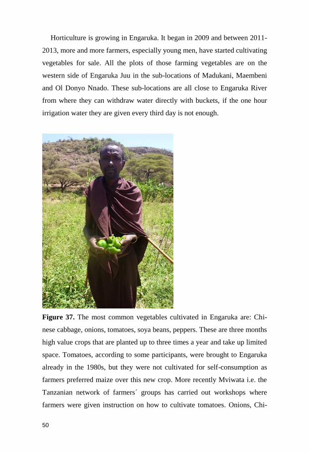
Horticulture is growing in Engaruka. It began in 2009 and between 2011-
2013, more and more farmers, especially young men, have started cultivating
vegetables for sale. All the plots of those farming vegetables are on the
western side of Engaruka Juu in the sub-locations of Madukani, Maembeni
and Ol Donyo Nnado. These sub-locations are all close to Engaruka River
from where they can withdraw water directly with buckets, if the one hour
irrigation water they are given every third day is not enough.
Figure 37. The most common vegetables cultivated in Engaruka are: Chi-
nese cabbage, onions, tomatoes, soya beans, peppers. These are three months
high value crops that are planted up to three times a year and take up limited
space. Tomatoes, according to some participants, were brought to Engaruka
already in the 1980s, but they were not cultivated for self-consumption as
farmers preferred maize over this new crop. More recently Mviwata i.e. the
Tanzanian network of farmers´ groups has carried out workshops where
farmers were given instruction on how to cultivate tomatoes. Onions, Chi-
Page 52
51
nese cabbage and peppers need to be weeded twice in the three months peri-
od they are growing, and they need to be sprayed with pesticides, especially
if it rains often, because they can quickly develop pests.
Some drought resistant crops, such as sweet potatoes, cassava, groundnuts
and cowpeas, are also cultivated, though to a much lesser extent. All these
horticultural produce is planted in different plots every year. For instance, a
plot is cultivated two seasons with the traditional crop mix maize and beans
and the following year it is again planted with vegetables. Wholesalers from
Karatu and Sokoku (central market) in Arusha drive their lorries directly to
Engaruka to collect the produce.
Agricultural practices
The Kisongo Maasai and Arusha living in Engaruka say that agriculture is
their most important livelihood. This is the cycle of practices used for maize
between March and August.
Fencing keeps cattle and goats off the crop. Contouring, promoted by ex-
ternal NGOs in the last decade and done twice a year after the rainy seasons,
prevents water erosion as it maintains the soil on site and preserves soil
moisture. Farmers say it takes longer for the soil to dry out if contours are in
place. Tilling facilitates water absorption and farmers describe the soil be-
coming softer. After weeding, greenery leftovers are left on the spot and
after irrigation it becomes mulch. After harvesting, greenery is left for cattle
and goats to eat. Intercropping is a preferred choice of cultivation because if
a crop fails, the other remains to be harvested. Additionally, more crop resi-
dues are produced to feed animals. Some point out that grazing is a problem
because nutrients are removed from the soil, but they assert that sometimes
they have to take their cattle too far to feed them.
Page 53
52
Soil
The soils in Engaruka are of volcanic origin as they are based on the
breakdown of volcanic rocks and minerals, which are rich in nutrients. This
means that the soils in Engaruka are naturally fertile. However, in the dry
climate the soils can come to their full potential only if water is added. Apart
from being a basis for plant growth, water help to break down rock minerals,
which in turn releases nutrients that can be picked up by the plants. To ena-
ble such breakdown single rain showers are not enough. Soils must be kept
moist for longer time than so, which is why the irrigation in Engaruka is so
important for the formation of good agricultural soils. In fact irrigation is an
absolute necessity to maintain agriculture during longer time than that the
relatively short rain periods may support. Water is not enough, however.
Although water help in improving both the physical and chemical status of
soils, the best effect on soil structure is from organic matter. By helping soil
particles to stick together, organic matter forms lumps of soil that improves
the rooting of plants, facilitates drainage of excess water, and protects the
soil from being eroded. It also helps to retain the soil nutrients, thereby pro-
tecting them from being washed away by water. Finally, organic matter con-
tains nutrients that improves the quality of the soil as the organic matter de-
composes.
As we have described above, the soils in Engaruka are generally fertile,
but there are some important nutrients that are available only in low levels.
This is especially evident for nitrogen and phosphorous, two of the most
important nutrients for plant growth. Nitrogen levels may be improved by
adding manure, or by cultivating nitrogen fixing (leguminous) plants, such
as peas, beans and lentils, in the crop rotation. In addition to this, a continu-
ous addition of phosphate fertilizers would be necessary for improved yields.
Interestingly, plots in which the soil contains a higher than normal content of
organic matter, especially banana plots which are characterized by the rich-
Page 54
53
ness of organic matter in the soil, also have higher than normal levels of
phosphorous. This is an indication of the importance of organic matter for
soil improvement. Also in non-cultivated land, such as in a forested area in
Neng´alah, phosphorous levels are higher than what is normal for cultivated
land. A continuous addition of organic matter, and the formation of a fa-
vourable shady environment, such as under banana plants, are important
measures of soil improvement. The shade from banana plants, decreases soil
temperatures, reduces the rate of decomposition, and hence leads to the ac-
cumulation of organic matter.
The agriculture carried out today at Engaruka, typically occurs on the
lower slopes, where conditions are favourable because of the high amount of
fine-grained soil particles (silt and clay). Such favourable characteristics
include nutrients released by weathering of the silt and clay, and the fact that
especially clay particles retain nutrients on their surfaces, protecting the nu-
trients from leaching and releasing them to plants through interaction be-
tween the plant roots and the soil. This is exemplified by the fact that there is
a distinct difference between plots located in the Engaruka heartland (Enga-
ruka Juu) and the agricultural areas established during the last decades (e.g.
in Neng’alah, southeast of Engaruka Juu and south of Engaruka Chini; see
next chapter). In the areas that have been recently cleared for cultivation,
soils are richer in nutrients then the soil in the older fields located in Enga-
ruka Juu, and need only water to come to its full potential as a highly valua-
ble agricultural soil. It is likely that this is a result of nutrient loss from natu-
ral processes and crop outtake in the older fields. But as the newer fields also
contain more clay, their potential for cultivation is higher as a general.
Bringing water to these fields, which are located far from the escarpment, is
therefore a viable strategy for the improvement and increased yields of agri-
culture in Engaruka.
Page 55
54
Lastly, it should be mentioned that the soil analyses indicate that saliniza-
tion is not a problem in Engaruka. Dry-land agriculture is notoriously known
to be affected by increased salt levels in the soil. In Engaruka, however, the
water supplied to the fields does not appear to rise the groundwater level to
the extent that saline groundwater affects the topsoil.
Cultivation extension
In the last ten to fifteen years, cultivation in Olemelepo has expanded to-
wards the west, closer to the permanent canal and the temporary Olemelepo
River. Plots which had been left fallow and were part of the old southern
fields (cultivated before 1900), whose stone lines can still be seen, have been
taken up again and cultivated.
Figure 39. Development of cultivation in Olemelepo. (Hennerdal, 2014)
Many Engaruka farmers also have plots in Ndimi: a vast rangeland area ex-
tending from Selela to Engaruka. The part of Ndimi closest to Engaruka is
called Neng´alah. Cultivation in Neng´alah started in 1983. Before 1991 no
irrigation was possible in Neng´alah and cultivation of maize was carried out
only during the main rain season (April–September). However, in 1991 a
canal connecting Neng´alah to Engaruka River and drawing water from
Page 56
55
Engaruka Chini was built. From that year on, cultivation in Neng´alah has
been periodically expanding.
Figure 40. Development of cultivation in Neng´alah. The area marked as
“opportunistic” cannot be reached by the irrigation canal, and cultivation
there is possible only during unusually wet rain seasons. (Hennerdal, 2014)
The easternmost part of Neng´alah started being farmed in 1998 when the
abundant rains of El Niño made it possible to clear and cultivate more plots.
Following that year, this sector of Neng´alah has been farmed only during
those years when rains have been copious and irrigation water could reach
Page 57
56
the westernmost tip of these hamlets. Hence, it is not a permanent type of
expansion, but rather it is completely dependent on the weather. Reportedly,
the last rainy season that witnessed the cultivation in the easternmost fields
was in 2008.
Farmers in Neng´alah, as in Engaruka Juu, cultivate maize twice a year
(November–January; April–August) and intercrop with black beans, which
are harvested once a year (April–October). Neng´alah is one sub-location of
Engaruka Chini in regards to the irrigation schedule. It gets four days of
water during dry season and five days during rainy season as it can count on
the water discharge of Olemelepo river too. Only six farmers in Neng´alah
have a banana plantation. As in Engaruka Juu, banana cultivators can benefit
from a special irrigation schedule which gives them two hours of irrigation
every second week. Water for irrigation can be insufficient at times, and
during the dry season farmers have to limit their cultivation to half an acre.
Water for household consumption is not available in Neng´alah, and once a
day women go to collect water roughly six km away, taking it back to the
bomas on their heads and on the backs of donkeys.
Given the difficult environmental and living conditions, Maasai residing
in Neng´alah state, as opposed to the ones living in Engaruka, that herding is
still the most important livelihood for them as it ensures their subsistence
even in times when the weather is unreliable and cultivation is not viable.
Baraka is another place where cultivation has expanded. It consists of a
handful of bomas roughly ten km south of Engaruka Chini. It takes about
one hour and a half walking to Baraka from Engaruka River, which is the
nearest source of water. The first farmers started clearing plots in this area
following the bumper harvest of 1983. However, what made cultivation ex-
pand substantially were the 1998 El Niño rains. Since that year, those living
in the bomas surrounding the agricultural area of Baraka have formed a Ka-
Page 58
57
mati ya Ardhi literally “the soil board/committee” which is in charge of
keeping track of new plots that are being cleared in order to avoid that graz-
ing land is not reduced to a minimum. In fact, the area surrounding the culti-
vated area of Baraka is characterized by trees and shrubs where goats and
cattle of the inhabitants of the whole Engaruka ward graze.
According to interviewees, when the Kamati ya Ardhi was established in
1998, 23 farmers had started farming in Baraka. The area of cultivation ex-
panded during the 2000s, and as of August 2013, when interviewees were
carried out, 88 farmers were known to the Kamati ya Ardhi having a one
acre plot each and farming in Baraka.
Figure 41. Cultivation expansion in Baraka. (Hennerdal, 2014)
Page 59
58
These 88 farmers make use of three canals called Oltulelei, Oleletaiku and
Olelaigwanani which they have dug to collect the water coming from the
Ngongoro escarpment during rain season. Hence, they can cultivate only
during the main rain season (April-September) and they farm purely maize.
They report that the land is very fertile and that it is enough to irrigate maize
twice in the course of four months to have a successful harvest.
Page 60
59
Methods
Information was gathered between 2011 and 2013 for a total of seven
months’ fieldwork (Jan-Feb and June-August) to study farming practices
during different seasons. Interviews and groups gathering were conducted in
Kiswahili and KiMaasai in Engaruka and in Marakwet language in Sibou
with the help of research assistants. Interviews were recorded and tran-
scribed with the help of assistants.
Figure 42. In Engaruka 39 interviews were conducted, 20 with men and 19
with women, and each interviewee was interviewed at least three times. All
interviewees are active farmers, between the age of 25 and 65. In addition,
16 focus group sessions were carried out with a number of participants rang-
ing from 5 to 10. A total of 118 persons were in this way consulted.
Page 61
60
In Sibou 11 gender- and age-specific focus groups – each with 8 participants
on average – and 43 interviews were carried out.
During focus groups we discussed: 1) women´s and men´s work; 2) agri-
cultural practices and the agricultural calendar; 3) perceived weather changes
in the last three decades, and 4) water management. The last topic was inves-
tigated through participatory mapping: meaning that participants were asked
to find their plots and the irrigation canals on aerial photographs.
A survey of agricultural practices conducted every three months during two
years by local field assistants in eight agricultural plots in Engaruka and
seven plots in Sibou. Selected plots were situated in different locations, had
been cultivated for a varying number of years and were subjected to different
agricultural practices. Survey questions covered weather, agricultural prac-
tices, crop productivity and gender division of labour. The survey was inter-
rupted after one year and a half because some farmers did not want to partic-
ipate anymore and some others were questioning the assistants and claiming
they were taking pictures of their plot to sell the photos. Even though the
objective of the survey had been explained to all farmers at the beginning,
some expected to get a substantial remuneration by the end of the survey,
which Martina had never promised to anyone.
Page 62
61
Figure 43. A pamphlet written in Swahili and in Marakwet, including nu-
merous pictures and summarizing previous findings, was presented to partic-
ipants to stimulate comments on the ongoing study, check whether data was
correct and encourage further discussion. The pamphlet served also to clarify
whether Martina´s understanding of the previous interviews was correct or
not. Moreover, the pamphlet was distributed in schools and to the local au-
thorities (village leaders and local development agencies whether present
e.g. KVDA) and helped to make Martina known in the respective communi-
ties.
Figure 44. Pit dug for soil profile description and soil sampling in Sibou
In both Marakwet and Engaruka we mainly took samples of topsoil. We also
dug a few soil pits to describe the different layers of the soil (the soil pro-
files). Since agriculture is in focus, we have analysed characteristics of the
soil that are of importance to crop yields. Such characteristics include nutri-
ent status, grain-size and structure. We have sampled soil in different set-
tings in the landscape, from fields on the slopes to fields on the plain, and we
Page 63
62
have also sampled fields under different management practices, such as ba-
nana plots, maize and sorghum plots, fields under fallow and land which has
not been cultivated for a long time. All analyses were carried out by the
Kenyan Agricultural Research Institute (KARI) in Nairobi.
Also water has been sampled, following the irrigation furrows from the orig-
inal streams to the fields. The study of water quality is still ongoing, and
only preliminary results from the study are available. Water is analysed with
respect to nutrient content and the soil particles that are carried by the water
to the fields.
Page 64
63
Comparison and Conclusion
In this section we summarize similarities and differences between Sibou and
Engaruka in relation to the four aspects we studied:
- Labour organization between men and women: men and women have
different tasks both in Engaruka and in Sibou. While women in Tot
cannot irrigate, women in Engaruka can participate in the water
management meeting and irrigate autonomously, but Martina rarely
saw them doing it. Women and men in Tot and Engaruka are en-
gaged in agriculture. In Tot, men tend to work mostly with crops
that are for sale: watermelon, tomatoes, cowpeas, mangoes. Weed-
ing remains in the hands of women, also in relation to crops that are
for sale. While women are knowledgeable about food crops as sor-
ghum, maize and millet. In Engaruka all farmers cultivate maize and
beans. Women are responsible for sowing, weeding and harvesting,
while men till the land with the ox-plough. A common characteristic
of farming is that men, both in Tot and Engaruka, farm standing us-
ing the long handled hoe, while women farm bending using the short
handled hoe.
- Organization and management of the irrigation systems: both in Tot
and in Engaruka water management is formally in the hands of men
who participate in water management meetings and are in charge of
construction and maintenances of the canals. Women in Engaruka
can participate in meetings, but rarely do so. Distribution of water is
regulated through sub-locations in Engaruka and through clans’ ca-
nals in Tot. Farmers get a variable amount of irrigation water de-
pending on the season. During rainy season in Engaruka farmers get
3 hours of irrigation water, while in Tot there is no formal distribu-
Page 65
64
tion of water: it is up to single farmers to lead the water from the
main canal to their plot. During dry season in Engaruka farmers get
2 hours of irrigation water, while in Tot they get 3 hours and there is
a fixed schedule which is repeated roughly once a month.
- Perception of climate variability: there is a general agreement among
farmers of Tot and Engaruka that weather has become more unrelia-
ble in the last thirty years. The beginning of the rain season and its
length have become more difficult to predict. While in Engaruka
men and women both farm maize and beans mainly and are in
agreement about which years have been the worst and the best in
terms of agricultural production, the case is not the same in Tot.
Women indeed consistently contended that 2010 was a much better
year than 2011: they said that it rained too much in 2011 and the
sorghum went rotten. On the other hand men, who are mostly con-
cerned with crops for sale, looked positively at the 2011 rain be-
cause it allowed them to plant and harvest green gram three times
instead of two.
- Soil characteristics: the soils in Sibou and Engaruka differ markedly,
owing to their different origin – granitic, nutrient-poor bedrock in
Sibou and volcanic, nutrient-rich bedrock in Engaruka. In both Si-
bou and Engaruka soils contain adequate levels of many important
nutrients. However, soils in both places do not contain enough levels
of nitrogen and phosphorous for agriculture to be more productive.
Water is an absolute prerequisite for agriculture, and the irrigation is
the key to successful agriculture in both places. In fact, water is a
more important feature in the agricultural landscapes of both loca-
tions than the varying levels of nutrients, although active phospho-
rous fertilization are likely to increase the yields. Noteworthy is the
influence of organic matter on soil quality. Helping the soil to retain
Page 66
65
nutrients and providing a good soil structure, the organic matter in-
creases yields and protects the soil against erosion by wind and wa-
ter. Protecting the soil organic matter, and increasing the input of
crop residues, manure and household wastes on the fields would
most certainly benefit the viability of agriculture. The impressive
water management in both places is of course vital. Not only be-
cause plants need water, but also because furrow water provides
fresh sediment and nutrients to the fields. Care should be taken,
however, not to increase the amount of water to the extent that the
groundwater level influences the topsoil. Should groundwater reach
the topsoil, salinity problems may arise.
Our study show that it is important to listen to the local knowledge that
farmers have and that collaboration between local farmers and researchers
can be mutually beneficial. We have learnt a lot from the people of Sibou
and Engaruka and with this pamphlet we want to show what we have learnt.
International organizations currently recommend governments to invest in
irrigation to ensure food security and to adapt to changing and drier weather
conditions. Our study show that before putting in place grand plans it is fun-
damental to take into account the local context. By researching the local
context we can understand which agricultural practices are carried out and
by whom. In this way we will know who holds specific knowledge and what
can be learnt from them.
Farmers in Sibou and Engaruka are knowledgeable and they are the ones
with the best experience of the agricultural conditions of their particular
locations. Hence, their experience must be taken into account when planning
for any further irrigation development or for any adaptation to weather
changes. Such plans cannot be successful without knowing how work is
done and how tasks are divided between men and women.
Page 67
66
Acknowledgements
This study was carried out thanks to the financial support of the Swedish
International Cooperation Agency (SWE2009-210). We would like to thank
all the participants to the study, both in Sibou and in Engaruka, who devoted
their time to answer to our questions. Special thanks go to those who agreed
to participate in the survey and have their soil sampled. We felt very wel-
come in both communities. We are indebted towards our research assistants
– Florence, Helena, Kipkeyo, Luka, Catherine and Israel – who made this
study possible. Without their patience, help, availability, organization and
kindness, fieldwork and data collection would have been impracticable. A
facilitating role was also played by partners institutions in situ: our appre-
ciation goes to the drivers and administrators at the British Institute in East-
ern Africa, to Matthew Davies who first invited us to Sibou, and to Prof.
David Mburu from Jomo Kenyatta University of Agriculture and Technolo-
gy, who shared his experience of soil and water management in Marakwet
and who made soil and water analysis possible. Thanks to Pontus Hennerdal
and Stefan Ene at the department of Human Geography at Stockholm Uni-
versity for designing the maps. Finally, thanks to the governments of Tanza-
nia (PF/IRA.15) and Kenya (NCST/RDC/10/013/16) that awarded us with
research permits, and to the local authorities who allowed us to carry out our
investigation on the sites.
Page 68
67
Notes on contributors
Martina Angela Caretta is a doctoral
student at the Department of Human Geog-
raphy at the University of Stockholm. Her
doctoral dissertation investigates gender
contracts in small holder irrigation farming
systems in Kenya and Tanzania, which is
presented in this booklet. Martina has been
carrying out extensive research in Kenya
and Tanzania since 2010.
Lars-Ove Westerberg is Associate Profes-
sor in Physical Geography at Stockholm
University. His research focuses on geo-
morphology and soil science in tropical
environments, notably Kenya, Tanzania and
Mozambique. He has carried out field work
in Kenya and Tanzania since 1985 and has
spent several periods doing research on
environmental aspects of the pre-colonial
land use systems of Engaruka and
Marakwet.
Page 69
68
Lars-Ove Westerberg is
Wilhelm Östberg is Associate Professor in
Social Anthropology, and currently an affili-
ated researcher at the Department of Human
Geography, Stockholm University. He did
field work in Marakwet 1973-75, and has
since been back to the area a number of
times, most recently in December 2013.
Lowe Börjeson is a lecturer at the Depart-
ment of Human Geography, Stockholm Uni-
versity. His research is concerned with histor-
ical and current processes of landscape and
agricultural change in different localities in
Africa. He is engaged in a number of inter-
disciplinary research projects and has pub-
lished articles on agricultural landscape
change at both local and regional scales.
Page 70
69
Further readings
Adams, W. M. (1989). Definition and development in African indigenous
irrigation. AZANIA: Journal of the British Institute in Eastern Africa, 24(1),
21–27.
Adams, W. M., & Anderson, D. M. (1988). Irrigation before Development:
Indigenous and Induced Change in Agricultural Water Management in East
Africa. African Affairs, 87(349), 519–535. doi:10.2307/722892
Adams, W. M., & Watson, E. E. (2003). Soil erosion, indigenous irrigation
and environmental sustainability, Marakwet, Kenya. Land Degradation &
Development, 14(1), 109–122. doi:10.1002/ldr.528
Adams, W. M., Potkanski, T., & Sutton, J. E. G. (1994). Indigenous Farmer-
Managed Irrigation in Sonjo, Tanzania. The Geographical Journal, 160(1),
17–32. doi:10.2307/3060138
Adams, W., Watson, E., & Mutiso, S. (1997). Water, Rules and Gender:
Water Rights in an Indigenous Irrigation System, Marakwet, Kenya. Devel-
opment and Change, 28(4), 707–730. doi:10.1111/1467-7660.00061
Årlin, C., Börjeson, L. and Östberg, W. In press. Participatory Checking and
the Temporality of Landscapes: Increasing Trust and Relevance in Qualita-
tive Research. In Handbook of Historical Ecology and Applied Archaeology,
(Eds.) by D. Stump and C. Isendahl. Oxford: Oxford University Press
Caretta M A (2014) Situated knowledge in cross-cultural, cross-language
research. A collaborative reflexive analysis of researcher, assistant and par-
ticipant subjectivities. Qualitative Research
doi: 10.1177/1468794114543404
Caretta, M. A. (2014). Hydropatriarchies and landesque capital: a local gen-
der contract analysis of two smallholder irrigation systems in East Africa.
The Geographical Journal. doi:10.1111/geoj.12102
Caretta, M. A., & Börjeson, L. (2014). Local gender contract and adaptive
capacity in smallholder irrigation farming: a case study from the Kenyan
drylands. Gender, Place & Culture, 0(0), 1–18.
doi:10.1080/0966369X.2014.885888
Page 71
70
Davies, M. (2008). The irrigation system of the Pokot, northwest Kenya.
Azania: Archaeological Research in Africa, 43(1), 50–76.
doi:10.1080/00672700809480459
Davies, M. I. J. (2010). From platforms to people: rethinking population
estimates for the abandoned agricultural settlement at Engaruka, northern
Tanzania. Azania: Archaeological Research in Africa, 45(2), 203–213.
doi:10.1080/00672700903346569
Davies, Matthew, and Henrietta Moore. (2011). Marakwet Community Her-
itage Mapping Project, Kenya. Report on the first season of fieldwork,
April–September 2011. Unpublished. File at BIEA.
Enfors, E.I., Gordon, L.J., 2008. Dealing with drought: The challenge of
using water system technologies to break dryland poverty traps. Global En-
vironmental Change, Local evidence on vulnerabilities and adaptations to
global environmental change 18, 607–616.
doi:10.1016/j.gloenvcha.2008.07.006
Fleuret, P. (1985). the social organization of water control in the Taita Hills,
Kenya. American Ethnologist, 12(1), 103–118.
doi:10.1525/ae.1985.12.1.02a00060
Laulumaa, V., 2006. Estimation of the population of ancient Engaruka—a
new approach. Azania: Archaeological Research in Africa 41, 95–102.
doi:10.1080/00672700609480436
Moore, H. L. (1986). Space, Text, and Gender: Anthropological Study of the
Marakwet of Kenya, An. Guilford Press.
Mul, M. L., J. S. Kemerink, N. F. Vyagusa, M. G. Mshana, P. van der Zaag,
and H. Makurira. 2011. Water Allocation Practices among Smallholder
Farmers in the South Pare Mountains, Tanzania: The Issue of Scale. Agricul-
tural Water Management, 98, 1752–60. doi:10.1016/j.agwat.2010.02.014.
Östberg W (2004) The expansion of Marakwet hill-furrow irrigation in the
Keryo Valley of Kenya in Widgren M and Sutton JEG eds Islands of Inten-
sive Agriculture Ohio University Press
Östberg W (2014) Irrigated fields are wives: indigenous irrigation in
Marakwet, Kenya in N T Håkansson and Widgren M eds Landesque Capi-
tal: The Historical Ecology of Enduring Landscape Modifications. Left
Coast Press, Walnut Creek CA
Page 72
71
Potkanski, T., & Adams, W. M. (1998). Water scarcity, property regimes
and irrigation management in Sonjo, Tanzania. Journal of Development
Studies, 34(4), 86–116. doi:10.1080/00220389808422530
Robertshaw, P., (1986). Engaruka Revisited: Excavations of 1982. Azania:
Archaeological Research in Africa 21, 1–26.
doi:10.1080/00672708609511365
Sassoon, H., (1967). New Views on Engaruka, Northern Tanzania. The
Journal of African History 8, 201–217. doi:10.1017/S0021853700007027
Sheridan, M. J. (2002). An irrigation intake is like a uterus: culture and agri-
culture in precolonial North Pare, Tanzania. American Anthropologist,
104(1), 79.
Stump, D., (2006). The development and expansion of the field and irriga-
tion systems at Engaruka, Tanzania. Azania: Archaeological Research in
Africa 41, 69–94. doi:10.1080/00672700609480435
Sutton, J. E.G. (1984) Irrigation and Soil-Conservation in African Agricul-
tural History. The Journal of African History 25(01): 25–41.
Sutton, J.E., (2004). Engaruka: The success and abandonment of an integrat-
ed irrigation system in an arid part of the Rift Valley, c. 15th to 17th centu-
ries. Islands of intensive agriculture in Eastern Africa 114–132.
Sutton, J.E.G., (1978). Engaruka and its Waters. Azania: Archaeological
Research in Africa 13, 37–70. doi:10.1080/00672707809511631
Sutton, J.E.G., (1986). The Irrigation and Manuring of the Engaruka Field
System. Azania: Archaeological Research in Africa 21, 27–51.
doi:10.1080/00672708609511366
Tagseth M (2008) Oral history and the development of indigenous irrigation
methods and examples from Kilimanjaro Tanzania Norsk Geografisk
Tidsskrift - Norwegian Journal of Geography 62 9–22
doi:10.1080/00291950701864898
Watson E E (2009) Living terraces in Ethiopia: Konso landscape, culture
and development James Currey, Woodbridge UK
Watson, E. E., Adams, W. M., & Mutiso, S. K. (1998). Indigenous Irriga-
tion, Agriculture and Development, Marakwet, Kenya. The Geographical
Journal, 164(1), 67–84. doi:10.2307/3060546
Page 73
72
Westerberg, L.-O., Holmgren, K., Börjeson, L., Håkansson, N. T., Lau-
lumaa, V., Ryner, M., & Öberg, H. (2010). The development of the ancient
irrigation system at Engaruka, northern Tanzania: physical and societal fac-
tors. Geographical Journal, 176(4), 304–318. doi:10.1111/j.1475-
4959.2010.00370.x
Widgren, M. (2004). Towards a historical geography of intensive farming in
eastern Africa. Islands of Intensive Agriculture in Eastern Africa, 1–18.
Widgren, M. and S. J. Sutton. (2004). Islands of intensive agriculture in
Eastern Africa: past & present. James Currey.
Contact
If you wish receive an extra copy or to send your comments, please contact:
Martina Angela Caretta
Kulturgeografiska institutionen
Stockholms Universitet
106 91 Stockholm
[email protected]