Lake Manitou Aquatic Vegetation Management Plan Prepared for the Lake Manitou Association 1618 Bessmore Park Road Rochester, IN 46975 Prepared By: Jim Donahoe David Keister Aquatic Weed Control P. O. Box 325 Syracuse, IN 46567 Funded by the Lake and River Enhancement (LARE) program and the Lake Manitou Association.
Transcript
Lake Manitou Aquatic Vegetation Management Plan
Prepared for the Lake Manitou Association 1618 Bessmore Park Road
Rochester, IN 46975
Prepared By:
Jim Donahoe David Keister
Aquatic Weed Control
P. O. Box 325 Syracuse, IN 46567
Funded by the Lake and River Enhancement (LARE) program and the Lake Manitou Association.
2
Executive Summary
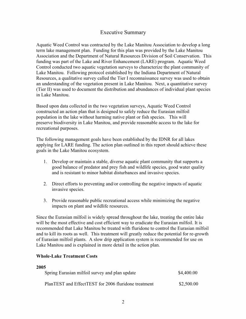
Aquatic Weed Control was contracted by the Lake Manitou Association to develop a long term lake management plan. Funding for this plan was provided by the Lake Manitou Association and the Department of Natural Resources Division of Soil Conservation. This funding was part of the Lake and River Enhancement (LARE) program. Aquatic Weed Control conducted two aquatic vegetation surveys to characterize the plant community of Lake Manitou. Following protocol established by the Indiana Department of Natural Resources, a qualitative survey called the Tier I reconnaissance survey was used to obtain an understanding of the vegetation present in Lake Manitou. Next, a quantitative survey (Tier II) was used to document the distribution and abundances of individual plant species in Lake Manitou. Based upon data collected in the two vegetation surveys, Aquatic Weed Control constructed an action plan that is designed to safely reduce the Eurasian milfoil population in the lake without harming native plant or fish species. This will preserve biodiversity in Lake Manitou, and provide reasonable access to the lake for recreational purposes. The following management goals have been established by the IDNR for all lakes applying for LARE funding. The action plan outlined in this report should achieve these goals in the Lake Manitou ecosystem.
1. Develop or maintain a stable, diverse aquatic plant community that supports a good balance of predator and prey fish and wildlife species, good water quality and is resistant to minor habitat disturbances and invasive species.
2. Direct efforts to preventing and/or controlling the negative impacts of aquatic
invasive species.
3. Provide reasonable public recreational access while minimizing the negative impacts on plant and wildlife resources.
Since the Eurasian milfoil is widely spread throughout the lake, treating the entire lake will be the most effective and cost efficient way to eradicate the Eurasian milfoil. It is recommended that Lake Manitou be treated with fluridone to control the Eurasian milfoil and to kill its roots as well. This treatment will greatly reduce the potential for re-growth of Eurasian milfoil plants. A slow drip application system is recommended for use on Lake Manitou and is explained in more detail in the action plan. Whole-Lake Treatment Costs 2005 Spring Eurasian milfoil survey and plan update $4,400.00 PlanTEST and EffectTEST for 2006 fluridone treatment $2,500.00
3
2006 Herbicide and application costs, Sonar concentration tests $95,000.00 2007 Aquatic vegetation survey (required by IDNR), and action plan update $3,200.00 *The lake will not be treated in 2007. (IDNR requirement) 2008 Chemically treat areas of Eurasian milfoil re-growth $8,000.00 Areas of Eurasian milfoil re-growth will be treated with 2, 4-D or Renovate. These are root control herbicides that can be contained in small treatment areas. Residents might want to consider spraying any dense beds of natives with contact herbicides around their piers and shorelines. 2009 Chemically treat areas of Eurasian milfoil re-growth $8,000.00 Aquatic vegetation survey (IDNR requirement), action plan update $3,200.00 Residents might want to consider spraying any dense beds areas of natives with contact herbicides around piers and shorelines. Mt. Zion Treatment Costs 2006 Herbicide and application costs, Sonar concentration tests $2,100.00
4
Acknowledgements
Aquatic vegetation surveys conducted on Lake Manitou were made possible by funding from the Indiana Department of Natural Resources and the Lake Manitou Association. Aquatic Weed Control would like to extend special thanks to Indiana Department of Natural Resources (IDNR) District 3 biologist Jed Pearson for providing procedural training for both Tier I and Tier II aquatic vegetation surveys. Cecil Rich, aquatic biologist for the IDNR Division of Soil Conservation provided valuable consultation regarding the requirements and objectives of this lake management plan. Brad Fink, assistant fisheries biologist, also provided assistance and training for data analysis computer programs. Jim Donahoe and David Keister of Aquatic Weed Control performed the aquatic vegetation sampling and are the authors of this report. Aquatic Weed Control would also like to thank the members of the Lake Manitou Association for their commitment to improving this lake and for valuable discussion and input brought forward at the informational meeting held on November 18, 2004.
5
Table of Contents
Introduction....................................................................................................................... 8 Problem Statement............................................................................................................ 8 Management Goals ........................................................................................................... 9 Watershed and Water Body Characteristics................................................................ 10 Lake Manitou Fisheries .................................................................................................. 11 Present Water Body Uses ............................................................................................... 13 Characterization of the Plant Community ................................................................... 13 Manitou Lake Tier I Survey Methods .......................................................................... 15 Tier I Major Plant Bed Summary ................................................................................. 16 Tier I Survey Summary.................................................................................................. 17 Materials and Methods: Tier II Random Sampling ................................................... 17 Manitou Lake Tier II Survey Results ........................................................................... 21 Mt. Zion Pond Tier II Survey ........................................................................................ 22 Species Diversity and Species Dominance .................................................................... 26 Threatened and Endangered Species ............................................................................ 27 Public Involvement and Education ............................................................................... 27 Monitoring and Evaluation of the Action Plan ............................................................ 27 Aquatic Management Plan............................................................................................. 28 Action Plan ...................................................................................................................... 30 LARE Program Update 3/3/05 ...................................................................................... 31 Whole-Lake Treatment Costs ........................................................................................ 32 Mt. Zion Treatment Costs .............................................................................................. 33 Alternative Action Plan .................................................................................................. 33 References ........................................................................................................................ 34 Appendix A: Aquatic Vegetation of Manitou Lake .................................................... 35 Appendix B: Tier II Data Sheets ................................................................................... 37
6
List of Figures
Figure 1: Land Use Around Lake Manitou ................................................. 11 Figure 2: Tier I Plant Bed Locations ............................................................ 14 Figure 3: All Sample Sites for the Lake Mantiou Tier II Survey................ 20 Figure 4: Sites Where Eelgrass was Collected ............................................. 23 Figure 5: Sites Where Eurasian Milfoil was Collected ................................ 24 Figure 6: Sites Where Coontail was Collected ............................................. 25
7
List of Tables
Table 1: IDNR Fisheries Survey of Lake Manitou 6/10/98 ...................... 12 Table 2: Number of Sample Sites Based on Lake Size ............................... 18 Table 3: Tier II Survey Results Summarized .............................................. 21 Table 4: Mt. Zion Pond Tier II Survey Results ............................................ 22 Table 5: Tier II Data Analysis ...................................................................... 26 Table 6: Tier II Survey Data Sheets ............................................................ 37
8
Introduction Aquatic Weed Control was contracted by the Lake Manitou Association to develop a long term lake management plan. Funding for this plan was provided by the Lake Manitou Association and the Department of Natural Resources Division of Soil Conservation. This funding was part of the Lake and River Enhancement (LARE). When a person registers a boat within the state of Indiana a lake enhancement fee is included in the cost of registry. One third of this money is then used to provide funding for projects designed to improve the quality of Indiana lakes by controlling invasive plant species. The surveys included in this report, as well as the management plan, are required by the state to receive funding to treat the lake for exotic aquatic vegetation. Should a lake be selected for LARE funding, up to $100,000 can be given for a whole-lake treatment with a cumulative 3-year maintenance total of an additional $20,000 dollars. If the whole lake is not treated, up to $20,000 dollars can be available annually for up to three years. Requests for funding are reviewed by the Indiana Soil Conservation Board, and funds will be distributed at their discretion. This project was initiated to take a more aggressive and long term approach to controlling the Eurasian milfoil in Lake Manitou. Problem Statement Lake Manitou, located near the town of Rochester in Fulton County, is in need of intervention to maintain a healthy plant community, enhance recreational opportunities, and control the distribution and abundance of Eurasian milfoil. Eurasian milfoil, an invasive aquatic species, grows abundantly in the littoral zone of Lake Manitou, causing numerous ecological and recreational problems. Eurasian milfoil is of primary concern because of its aggressive nature and its destructive effects on lake ecosystems. This nuisance species grows and spreads rapidly, forming dense weed beds that rob native plants of the light and nutrients they need to survive. In lakes where Eurasian milfoil is left unchecked, well-diversified plant communities can be decimated and replaced by a single species. Eurasian milfoil has the ability to overwinter, giving it a distinct growth advantage over many native plants. The milfoil lies dormant during the winter months instead of dying completely. As spring arrives, the dormant milfoil plants have a head start on many native plants and reach the surface faster, shading out the natives. Eurasian milfoil grows profusely, provides poor fish habitat, inhibits boat navigation, and causes annoyances and even serious health hazards to skiers, swimmers, and other members of the public wishing to enjoy the lake. The increasing abundance of Eurasian milfoil in Lake Manitou is alarming because the adverse effects of this plant are well documented. Over the past five years, specific areas of the lake have been treated sporadically with contact herbicides during mid-June and early July. These treatments have provided some short-term relief from the milfoil, but the invader still dominates large portions of the lake throughout the summer months.
9
Management Goals The following management goals have been established by the IDNR for all lakes applying for LARE funding.
1. Develop or maintain a stable, diverse aquatic plant community that supports a good balance of predator and prey fish and wildlife species, good water quality and is resistant to minor habitat disturbances and invasive species.
2. Direct efforts to preventing and/or controlling the negative impacts of aquatic
invasive species.
3. Provide reasonable public recreational access while minimizing the negative impacts on plant and wildlife resources.
Specific Objectives To achieve management goals for Lake Manitou, the following objectives are recommended.
1. The first priority will be to stop the milfoil from spreading to new areas of
the lake. This is of primary importance to the native plant community in Lake Manitou. Since native plants do not compete well with milfoil, containing the spread of milfoil is the best strategy to stop the loss of native plants.
2. The existing areas affected by the milfoil must be treated to maintain a
reasonable level of control. Reducing the population of Eurasian milfoil in areas where it has already gained a foothold will provide multiple benefits. Recreational activities like swimming, fishing, skiing and boating will all be enhanced by reducing the Eurasian milfoil population. It is also important to note that reducing existing beds of milfoil may provide an opportunity for native plants to reclaim areas where they have been excluded for years. The hope is that the beneficial native plants will gradually replace the invasive milfoil.
3. Reconnaissance surveys should be conducted to evaluate the effectiveness of
the management plan. After one year, Lake Manitou should be surveyed for Eurasian milfoil to document any noticeable change in its population. Further surveys can be conducted on an “as needed” basis to maintain a proper level of control.
Until this point, management strategies have been geared to provide short-term relief from the milfoil on a yearly basis. While chemical treatments over the past five years have succeeded in giving some relief from the milfoil, this management plan will focus on stopping the spread of this invader, while reducing the amount of yearly maintenance needed to keep the Eurasian milfoil in check. While completely eradicating milfoil may
10
not be feasible, reducing its abundance can provide long-term ecological, recreational and economical benefits. Watershed and Water Body Characteristics Lake Manitou, located near the town of Rochester, IN, is a man-made impoundment that was formed in 1827, when a gristmill was built along Rain Creek. The creek was dammed, and five smaller lakes were impounded, forming one larger lake. Lake Manitou has 713 surface acres with a maximum depth of 47 feet and an average depth of 13 feet (IDNR Lake Survey, 1998). Although no recent diagnostic studies have been completed describing the watershed, the area around the lake is subject to heavy agricultural use. Large amounts of agricultural activity in this watershed make Lake Manitou prone to heavy sediment loading. Nearly 80% of the shoreline of Lake Manitou is developed, which can also cause complications in the form of sewage, storm water, and fertilizers entering the lake (Kalff, 2002). Municipal activities in the town of Rochester (located at the west end of the lake) may also contribute to nutrient loading in the lake. Secchi disk readings are approximately 5.0 ft and phosphorus levels are very high. Phosphorus loading is of great concern in this lake. Lake Manitou has many inlets by which nutrients are transported to the lake. Mastellar Ditch, Whitenberger-Eller Ditch and Rain Creek all enter the lake from the south, while Graham Ditch brings nutrients from the east portion of the watershed. In short, agricultural activity, multiple inlets, and Manitou’s close proximity to the town of Rochester cause significant complications for the lake’s plant community because they facilitate phosphorus loading. A relatively new lake wide sewer system has been installed that does help to reduce the amount of nutrients entering the lake. At the south end of Lake Manitou is one of the largest wetland areas in the state of Indiana. Wetlands are becoming increasingly threatened, and large, unbroken wetlands are rare. This gives the water shed of Lake Manitou even more biological significance. Every effort should be made to protect this wetland area from the effects of invasive plant species. This report is not designed to be water shed plan but a plan to manage the exotic aquatic plants. However, it is best to mention some of these water shed characteristics since an integrated lake management plan is desired. Figure 1 shows land use around Lake Manitou.
11
Figure 1: Land Use Around Lake Manitou
Lake Manitou Fisheries The following fisheries survey was conducted by The Indiana Department of Natural Resources and took place on June 10, 1998. Data was obtained by using electro-fishing and gill nets to collect, count, measure, and then release fish. A total of 16 species of fish were collected, many of which were valuable game fish (Tyllia, 2002). 2,281 fingerling Northern pike were stocked in Lake Manitou in 1995. These large predators often help reduce overabundant pan fish populations and provide a highly valued fishery for anglers. However, only 1 northern pike was collected during the 1998 fisheries survey. Bluegills and yellow perch dominated the latest survey of Lake Manitou with 128 total bluegills and 123 yellow perch being collected. Bluegill and yellow perch sizes were considered small when compared to many area lakes. Overabundant escape cover
12
created by aquatic vegetation may contribute to overpopulation and stunting of these species (IDNR Fisheries Survey, 1995). Gizzard shad were once a major problem in Lake Manitou. In 1971, the IDNR started an eradication program to eliminate this destructive species. Gizzard shad can have harmful effects on many game fish populations, especially those who are dependent upon plankton for survival. Gizzard shad are very efficient planktivores, and compete with young-of-the-year fish for food. They reproduce even faster than other proliferate species such as crappies and bluegills. In some situations they can quickly take over an ecosystem and rob other fish of valuable food sources. An upside to a large gizzard shad population is that they provide an excellent food source for game fish such as largemouth bass, white bass and crappies. 5,000 Largemouth Bass fingerlings were also stocked in 1971 for predation of any gizzard shad not killed by the eradication process. Today, the gizzard shad population is small, with only 12 shad being collected in the 1998 survey. Largemouth bass numbers were boosted by the 1971 stocking, and were present in good numbers in 1998, although only 10 % of the bass collected were of harvestable size. A table summarizing the latest fisheries summary is listed below. Table 1: IDNR Fisheries Survey of Lake Manitou 6/10/98 Species Total # Collected Percentage Size Range (in.)
Bluegill 128 27.1 1.5-7.8 Yellow Perch 123 26.1 3.4-9.4 Black Crappie 74 15.7 4.9-10.8 Largemouth Bass 51 10.8 5.7-18.5 Gizzard Shad 21 4.4 7.3-13.8 Golden Shiner 19 4.0 6.5-9.0 Species Total # Collected Percentage Size Range (in.)
Spotted Gar 15 3.2 16.1-32.9 Warmouth 10 2.1 5.4-8.2 Brown Bullhead 9 1.9 11.2-13.2 Rock Bass 8 1.7 3.0-7.4 Carp 4 0.8 15.0-17.2 Yellow Bullhead 4 0.8 6.7-10.8 Redear Sunfish 2 0.4 7.6-7.8 White Crappie 2 0.4 4.3-7.7 Northern Pike 1 0.2 31.8 Smallmouth Bass 1 0.2 17.8 At the time of this survey many healthy populations of game fish were documented. Unfortunately, the spread of Eurasian milfoil in Lake Manitou poses a serious and
13
significant threat to these populations. Eurasian milfoil can shade out many native plants and take over lakes quickly. Eurasian milfoil reduces the abundance of beneficial native species that provide excellent fish habitat. The result is a poorly diversified plant community, composed mainly of Eurasian milfoil, which provides extremely poor fish habitat. Controlling the Eurasian milfoil is very important to help protect the fishery of Lake Manitou. Present Water Body Uses Today, Lake Manitou is highly valued to many stakeholders for a number of reasons. This is a relatively large lake for this area, and the lake has no speed limit restrictions. These factors make this lake ideal for speedboats, water-skiing, jet skis, and other fast moving forms of recreation. A ski course is located near the south end of the lake, making it a favorite destination for water skiers. In addition to these activities, Lake Manitou has an excellent fishery, harboring good populations of many popular game fish like largemouth bass, black crappies, bluegills, yellow perch, and even some large northern pike. It is a very popular fishing destination, both in the summer and the winter. The public access site along the north shore of Lake Manitou opens this lake to thousands of citizens in the surrounding area. These facilities are well maintained and feature a handicapped accessible fishing pier. However, the overabundance of Eurasian milfoil makes fishing from these piers extremely challenging. The residents living on Lake Manitou share this lake with the general public. Any management practices implemented on Lake Manitou will benefit both the lake residents and a large number of stakeholders who visit the lake on a regular basis. The size, location and accessibility of Lake Manitou make it an excellent site to implement management strategies that will save a valued ecosystem and benefit a large number of people. Characterization of the Plant Community An extremely important note is that Eurasian milfoil may occur at greater frequencies and at higher densities than indicated by these surveys. Any chemical treatments prior to the surveys will kill out milfoil beds that would have otherwise appeared in the Tier I and Tier II plant surveys. Poor water clarity and previous chemical applications may result in an underestimation of the true distribution and abundance of Eurasian milfoil in Lake Manitou. Also, blue-green algae blooms due to high phosphorus levels also affect milfoil abundance. These blooms can be so intense that milfoil plants become shaded out by the algae (Kalff, 2000). This can make the abundance of Eurasian milfoil fluctuate from year to year, depending on the intensity and the timing of the algae blooms. Figure 2 shows the distribution of the major plant beds within Lake Manitou.
14
Figure 2: Tier I Plant Bed Locations
15
Lake Manitou Tier I Survey Methods
The Tier I reconnaissance survey is designed to identify the major plant beds present in a body of water. This is a qualitative survey designed to give an overview of the aquatic vegetation present in a lake. It identifies and documents problem areas that can be targeted when management practices are implemented. Major submersed plant beds are found visually from a boat. Each bed is given a reference number that is recorded on Tier I data sheets. The general location of these beds are recorded on a bathymetric map of the lake, and more precise locations are recorded on Tier I data sheets with the help of a WAAS enabled GPS unit. When a major plant bed is identified, each species of plant found in that bed is recorded. Canopy ratings are given to each plant bed based on the types of plants present in that bed. The four major types of plants to be identified in this study are as follows: submersed plants, emergent plants, non-rooted floating plants and rooted floating plants. The following scale is used to describe these four types of plants based on the percentage of the plant bed canopy they occupy: Canopy Rating 1 = <2% of canopy 2 = 2-20% 3 = 21-60% 4 = >60% of canopy In addition to the canopy rating, another abundance rating is given to each individual species found in a particular plant bed. This abundance rating is based on the percentage of the entire bed area that species appears to occupy. The scale for this abundance rating is the same as the canopy rating scale. The difference is that this scale identifies the abundance of individual species in the bed:
Species Abundance Rating 1 = < 2% of the bed 2 = 2-20% 3 = 21-60% 4 = >60% of the bed Since this is a visual survey, results are dependent upon the surveyor’s ability to locate plants below the water’s surface. Tier I surveys are much less effective in lakes with low secchi disk readings. Polarized glasses were used to reduce glare from the sun and enable the surveyors to see more easily into the water. Even with the aid of polarized glasses, the Tier I survey should not be considered an exhaustive survey of aquatic vegetation. The Tier I survey is a tool that helps to provide an overall picture of an aquatic plant community when coupled with the Tier II quantitative survey.
16
Tier I Major Plant Bed Summary Plant Bed #1 This plant bed was extremely large with an approximate size of 12 acres. Only two species of plants were found in this bed. Eurasian milfoil had an abundance rating of 4, while eelgrass had an abundance rating of 2. Plant Bed #2 This plant bed had an approximate size of 8 acres and also contained only two plant species. Eurasian milfoil and eelgrass both had abundance ratings of 2 in this bed. Plant Bed #3 This plant bed had an approximate size of 10 acres and contained 3 plant species. Naiad was present with an abundance rating of 1, Eurasian milfoil had an abundance rating of 2, and eelgrass had an abundance rating of 3. Plant Bed #4 This plant bed had an approximate size of 4 acres and contained only Eurasian milfoil and eelgrass. Eurasian milfoil had an abundance rating of 3, while eelgrass had an abundance rating of 2. Plant Bed #5 This plant bed’s approximate size was not recorded although GPS points were taken to document its location. Coontail was the only species present in this bed, and had an abundance rating of 3. Plant Bed #6 This plant bed had an approximate size of 4 acres and also contained only coontail. In this bed, coontail had an abundance rating of 3. Plant Bed #7 This plant bed had an approximate size of ½ acre and contained 2 plant species. Coontail had an abundance rating of 2, while eelgrass had an abundance rating of 3. Plant Bed #8 This plant bed had an approximate size of 8 acres and contained 4 plant species. Naiad, sago pondweed and Eurasian milfoil each had abundance ratings of 1, while eelgrass had an abundance rating of 3. Plant Bed #9 This plant bed had an approximate size of 6 acres and also contained 4 plant species. Illinois pondweed, Eurasian milfoil, and eelgrass all each had abundance ratings of 2, while sago pondweed had an abundance rating of 3.
17
Plant Bed #10 This plant bed had an approximate size of 4 acres and contained 3 plant species. Sago pondweed had an abundance rating of 2, while eelgrass and Eurasian milfoil had abundance ratings of 3. Plant Bed #11 This plant bed had an approximate size of 7 acres and contained 3 plant species. Eurasian milfoil had an abundance rating of 1, sago pondweed had an abundance rating of 2, and eelgrass had an abundance rating of 3. Tier I Survey Summary The eleven major plant beds identified in Lake Manitou contained one to four plant species and covered over sixty-one acres of the lake. Eelgrass and Eurasian milfoil were the dominant plants in this survey occurring frequently with high average abundance scores. The number of species observed in this visual survey is very low compared to other area lakes. Poor water clarity caused by nutrient loading and algae blooms makes visual surveys on Lake Manitou very challenging. Chara, and sago pondweed were collected in the Tier II survey but were not observed in the Tier I survey. Chara grows close to the lake bottom, and poor water clarity makes it extremely difficult or impossible to see from above the water’s surface. This underscores the importance of the Tier II sampling process in order to gain an accurate representation of the aquatic plant community. Materials and Methods: Tier II Random Sampling Summary: A Tier II quantitative survey of Lake Manitou was conducted on August 30, 2004. The purpose of this survey was to document the distribution and abundance of submersed and floating-leaved aquatic vegetation throughout the lake (IDNR, 2004). A specific number of sample sites were selected based on the amount of surface acreage the lake possessed. Once sample sites were determined, sampling was accomplished using an aquatic vegetation sampling rake constructed according to the guidelines of the 2004 Tier II random sampling procedure manual. Aquatic vegetation collected at each sample site was sorted according to species, and given a value to represent its abundance at that site. These values were immediately recorded on data sheets distributed by the IDNR. These records were used for data analysis that served to characterize the aquatic vegetation community of Lake Manitou.
18
Random Sampling: The IDNR issued the following chart to help determine the number of sample sites needed to accurately describe the aquatic plant community in a lake. Table 2: Number of Sample Sites Based on Lake Size
Size of Water body Number of Sample Sites
1-100 acres 40
101-300 acres 60
Greater than 300 acres Add 10 sites/100 acres
Based on Lake Manitou’s 713 surface acres, 100 sample sites were needed to accurately needed to describe this plant community. Aerial photographs and bathymetric maps were used to evenly space the 100 sample sites throughout the lake. The littoral zone of the lake was divided into four quadrants of equal length. During the vegetation collection process, an effort was made to collect plants from 25 sites in each quadrant to ensure that the entire littoral zone was surveyed adequately and that random sample sites distributed evenly throughout the lake. Ten additional sample sites were chosen in the Mt. Zion wetland area at the south end of the lake. When sampling the littoral zone of the lake, a pattern was used that also helped to ensure an accurate description of the plant community. The littoral zone was divided into three sections based on depth and sample sites alternated between each of these three zones. For example, collection site 1 would be taken in shallow water very close to shore. Collection site 2 would be taken further down the shoreline, but in slightly deeper water. Collection site 3 would be taken further down the shoreline, but in even deeper water, close to the border of the littoral and pelagic (open water) zone. This sampling strategy was recommended by District 3 fisheries biologist Jed Pearson. This strategy not only helps to accurately describe the plants in the littoral zone, but it also aids in determining the maximum depth at which plants can grow in particular lake. Aquatic Vegetation Sampling Rake: A double-headed garden rake was used to sample aquatic vegetation. This rake design is approved and used by IDNR fisheries biologists in vegetation surveys on many Indiana lakes. It consists of two garden rake heads welded together back to back so that rake teeth are protruding from two sides. The dimensions of the rake are to be 13.5 inches wide with 2.25-inch long teeth spaced 0.75 inches apart (IDNR, 2004).
19
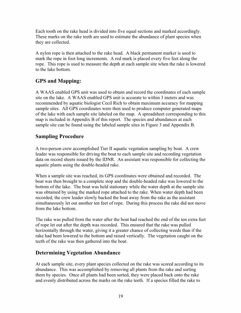
Each tooth on the rake head is divided into five equal sections and marked accordingly. These marks on the rake teeth are used to estimate the abundance of plant species when they are collected. A nylon rope is then attached to the rake head. A black permanent marker is used to mark the rope in foot long increments. A red mark is placed every five feet along the rope. This rope is used to measure the depth at each sample site when the rake is lowered to the lake bottom. GPS and Mapping: A WAAS enabled GPS unit was used to obtain and record the coordinates of each sample site on the lake. A WAAS enabled GPS unit is accurate to within 3 meters and was recommended by aquatic biologist Cecil Rich to obtain maximum accuracy for mapping sample sites. All GPS coordinates were then used to produce computer generated maps of the lake with each sample site labeled on the map. A spreadsheet corresponding to this map is included in Appendix B of this report. The species and abundances at each sample site can be found using the labeled sample sites in Figure 3 and Appendix B. Sampling Procedure A two-person crew accomplished Tier II aquatic vegetation sampling by boat. A crew leader was responsible for driving the boat to each sample site and recording vegetation data on record sheets issued by the IDNR. An assistant was responsible for collecting the aquatic plants using the double-headed rake. When a sample site was reached, its GPS coordinates were obtained and recorded. The boat was then brought to a complete stop and the double-headed rake was lowered to the bottom of the lake. The boat was held stationary while the water depth at the sample site was obtained by using the marked rope attached to the rake. When water depth had been recorded, the crew leader slowly backed the boat away from the rake as the assistant simultaneously let out another ten feet of rope. During this process the rake did not move from the lake bottom. The rake was pulled from the water after the boat had reached the end of the ten extra feet of rope let out after the depth was recorded. This ensured that the rake was pulled horizontally through the water, giving it a greater chance of collecting weeds than if the rake had been lowered to the bottom and raised vertically. The vegetation caught on the teeth of the rake was then gathered into the boat. Determining Vegetation Abundance At each sample site, every plant species collected on the rake was scored according to its abundance. This was accomplished by removing all plants from the rake and sorting them by species. Once all plants had been sorted, they were placed back onto the rake and evenly distributed across the marks on the rake teeth. If a species filled the rake to
20
the first mark on the teeth, that species was given a score of 1 on the abundance data sheet. If it filled the rake teeth to the second mark, it was given a score of 2, and so on to a maximum abundance of five. In many instances it was not necessary to place each species back onto the rake. Many species would fill the rake completely (an abundance of 5) and some species would only have one plant on the rake (an abundance of 1). In addition to abundance scores for individual species, each rake toss was given an overall abundance score, describing how much total vegetation was collected on the rake.
Figure 3: All Sample Sites for the Lake Manitou Tier II Survey
21
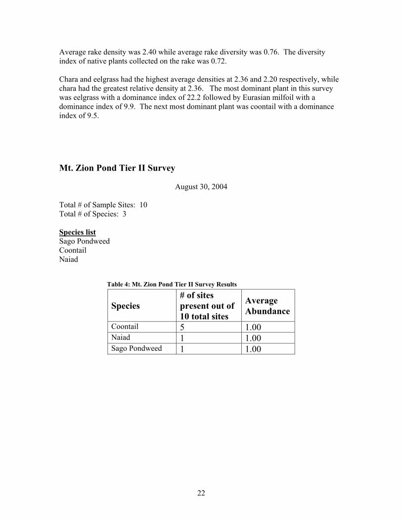
Lake Manitou Tier II Survey Results August 30, 2004
Total # of Sample Sites: 100 Total # of Species: 7 Species List Eurasian Milfoil Coontail Eel Grass Sago Pondweed Chara Naiad Illinois Pondweed Table 3: Tier II Survey Results Summarized
Species # of Sites Present out of 100 total
sites
Average Abundance
Eel Grass 61 2.34
Eurasian Milfoil 30 1.67
Naiad 23 1.43
Sago Pondweed 16 1.25
Coontail 11 1.36
Chara 10 2.8
Illinois Pondweed 2 1.00
Secchi depth was taken prior to the survey and determined to be approximately 2.5 feet. A total of seven species of aquatic plants were collected during the Tier II survey. Of these species, one (Eurasian milfoil) was an exotic species. The average number of total species collected at each sample site was 1.43 while the average number of native species collected at each site was 1.15. The species diversity index for Lake Manitou was 0.78 while the native plant diversity index was 0.72.
22
Average rake density was 2.40 while average rake diversity was 0.76. The diversity index of native plants collected on the rake was 0.72. Chara and eelgrass had the highest average densities at 2.36 and 2.20 respectively, while chara had the greatest relative density at 2.36. The most dominant plant in this survey was eelgrass with a dominance index of 22.2 followed by Eurasian milfoil with a dominance index of 9.9. The next most dominant plant was coontail with a dominance index of 9.5. Mt. Zion Pond Tier II Survey
August 30, 2004
Total # of Sample Sites: 10 Total # of Species: 3 Species list Sago Pondweed Coontail Naiad Table 4: Mt. Zion Pond Tier II Survey Results
Species # of sites present out of 10 total sites
Average Abundance
Coontail 5 1.00 Naiad 1 1.00 Sago Pondweed 1 1.00
23
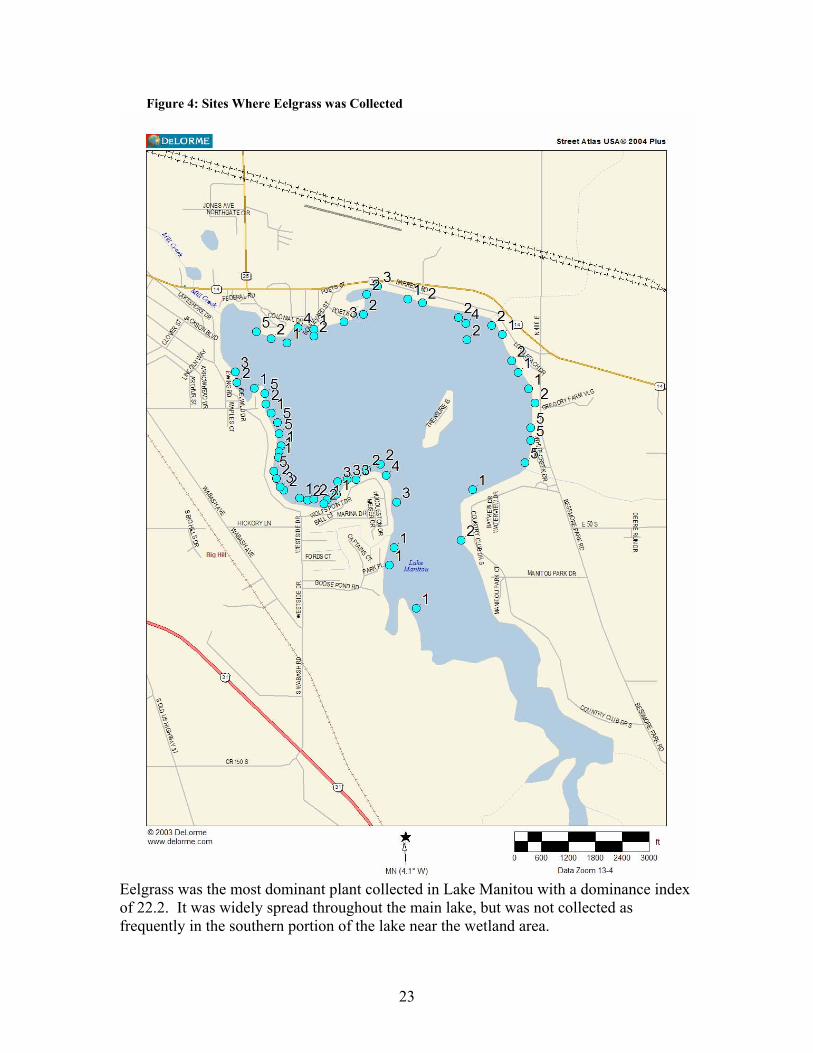
Figure 4: Sites Where Eelgrass was Collected
Eelgrass was the most dominant plant collected in Lake Manitou with a dominance index of 22.2. It was widely spread throughout the main lake, but was not collected as frequently in the southern portion of the lake near the wetland area.
24
Figure 5: Sites Where Eurasian Milfoil was Collected
Eurasian milfoil was the second most dominant plant in Lake Manitou, with a dominance index of 9.5. It was especially common in the northwest section of the lake near the public access site. However, it was collected at various sites throughout the lake.
25
Figure 6: Sites Where Coontail was Collected
Coontail was collected almost exclusively in the southern bay of Lake Manitou. It is interesting to note that coontail was only found in areas where Eurasian milfoil was not collected frequently.
26
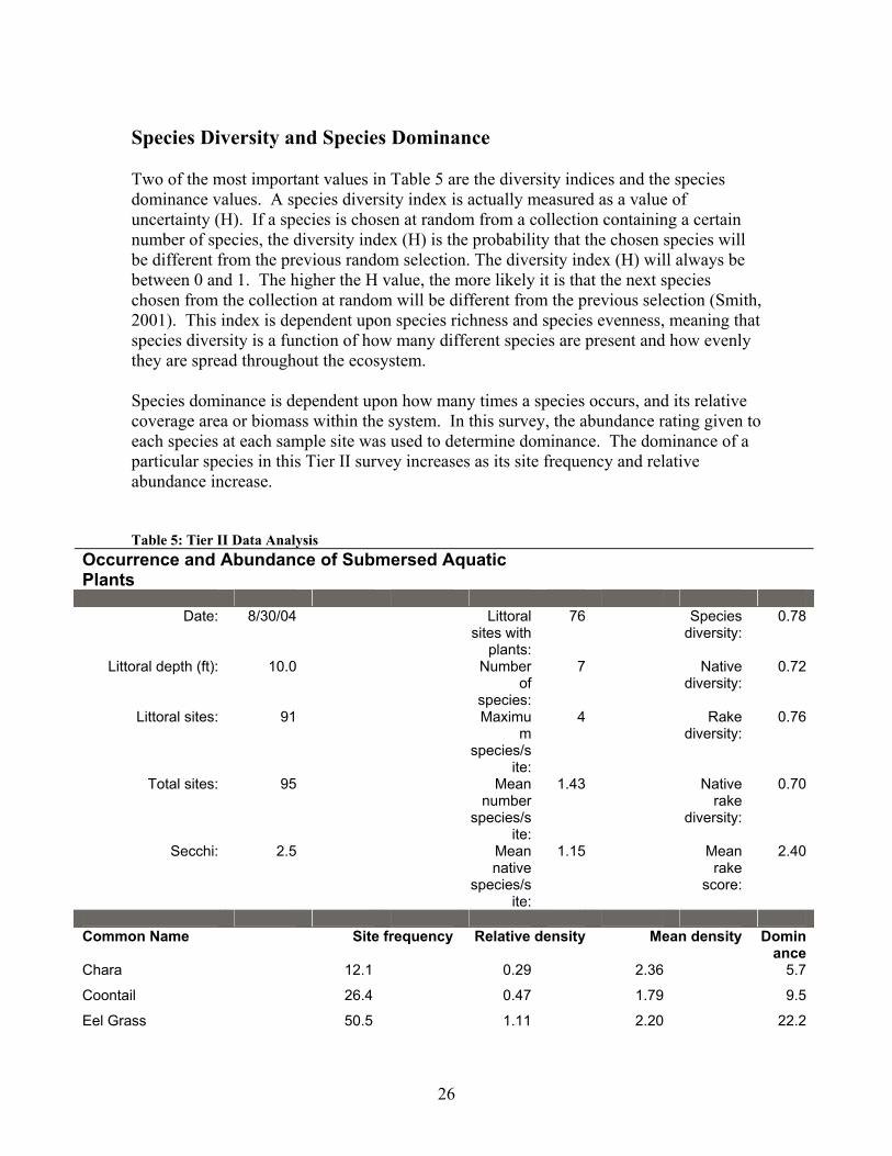
Species Diversity and Species Dominance Two of the most important values in Table 5 are the diversity indices and the species dominance values. A species diversity index is actually measured as a value of uncertainty (H). If a species is chosen at random from a collection containing a certain number of species, the diversity index (H) is the probability that the chosen species will be different from the previous random selection. The diversity index (H) will always be between 0 and 1. The higher the H value, the more likely it is that the next species chosen from the collection at random will be different from the previous selection (Smith, 2001). This index is dependent upon species richness and species evenness, meaning that species diversity is a function of how many different species are present and how evenly they are spread throughout the ecosystem. Species dominance is dependent upon how many times a species occurs, and its relative coverage area or biomass within the system. In this survey, the abundance rating given to each species at each sample site was used to determine dominance. The dominance of a particular species in this Tier II survey increases as its site frequency and relative abundance increase. Table 5: Tier II Data Analysis
Occurrence and Abundance of Submersed Aquatic Plants
Date: 8/30/04 Littoral
sites with plants:
76 Species diversity:
0.78
Littoral depth (ft): 10.0 Number of
species:
7 Native diversity:
0.72
Littoral sites: 91 Maximum
species/site:
4 Rake diversity:
0.76
Total sites: 95 Mean number
species/site:
1.43 Native rake
diversity:
0.70
Secchi: 2.5 Mean native
species/site:
1.15 Mean rake
score:
2.40
Common Name Site frequency Relative density Mean density Domin
anceChara 12.1 0.29 2.36 5.7
Coontail 26.4 0.47 1.79 9.5
Eel Grass 50.5 1.11 2.20 22.2
27
Eurasian Watermilfoil
27.5 0.49 1.80 9.9
Illinois Pondweed 1.1 0.01 1.00 0.2
Sago Pondweed 14.3 0.23 1.62 4.6
Naiad sp 11.0 0.21 1.90 4.2
Threatened and Endangered Species No threatened or endangered species were found during the Tier I or the Tier II survey. Relatively poor water quality and an abundance of invasive plants are not conducive to the survival of these species (Smith and Smith, 2001). Controlling the Eurasian milfoil would promote a more diverse ecosystem with greater species richness. This should provide a better opportunity for threatened plants to gain a foothold in this body of water. However, increased water quality may also be essential to promoting the growth of fragile, less common, aquatic species. Public Involvement and Education An informational meeting was held by the Lake Manitou Association on November 18, 2004. This meeting was held to inform the public about the problems facing Lake Manitou, especially about the threat that Eurasian milfoil poses to both the ecology and the utility of the lake. Potential solutions to these problems were discussed and Jim Donahoe of Aquatic Weed Control offered potential management strategies that could be used to control the Eurasian milfoil and reclaim Lake Manitou, both for ecological and recreational purposes. Another informational meeting was held on March 3, 2005 to further discuss the action plan. It is important that information about management practices on Lake Manitou be made available to the public. Lake association meetings and newsletters are excellent avenues through which this information can be distributed. Informational signs could also be posted at the public boat landing and any other lake access areas. Also, a summary of management practices funded by the LARE program would made an excellent addition to the annual fishing regulations guide and other IDNR publications. Additional information on aquatic management can be found at the following web sites: www.mapms.org www.aquatic.org www.apms.org www.nalms.org. Monitoring and Evaluation of the Action Plan As the action plan is implemented, a pretreatment vegetation survey will help to monitor the effectiveness of the management strategy. The abundance and distribution of
28
Eurasian milfoil will be recorded using the same protocols included in this report. The new data sheets and data analysis files will be added to the current lake management plan. This will provide applicators, property owners, and the IDNR with detailed records describing the changes in the plant community of Lake Manitou. After one year, additional surveys can be conducted to determine the distribution and abundance of Eurasian milfoil, as well as native plants. This will determine if the management strategy has been effective in reducing the Eurasian milfoil population from one year to the next. In the years that follow, additional surveys should be conducted to determine how the Eurasian milfoil population is reacting to the management strategy over a long period of time. These surveys will provide a basis for evaluation of the management strategy and can be presented to the public should the need arise to modify the management strategy. They will also serve to keep the public interested and informed about management practices at Lake Manitou so they will be motivated and equipped to actively participate in the conservation of the Lake of the Woods ecosystem. Aquatic Management Plan Lake Manitou is heavily infested with Eurasian milfoil. Eurasian milfoil is believed to have arrived in North America in the mid-1940’s and has spread throughout the east coast to northern Florida and the Midwest. It is present in about 75 % of the areas currently treated by Aquatic Weed Control. Eurasian milfoil spreads by fragmentation and seeds, and has the ability to over winter from year to year. Once it is in a lake it generally becomes the dominant plant species because it forms dense canopies on the water which shade out the native more beneficial weed species below. There is also increasing evidence that mat forming species like Eurasian milfoil exert significant negative impacts on a broad range of aquatic organisms (Pullman, 1998). No Action and Other Alternatives. If no action is taken the Eurasian milfoil will only get worse since Eurasian milfoil grows by fragmentation. Fragmentation means that if the plant is cut, the fragment has the ability to re-grow. Eurasian milfoil also over winters as an adult plant so new generations are spawned every season, therefore the Eurasian milfoil beds become denser if left untreated due to fragmentation and seed production. Mechanical Harvesting Mechanical harvesting uses a machine to cut the weeds. These machines pick up the cut weeds but will still leave small fragments that will have the ability to re-grow. Also, after an area is harvested the Eurasian milfoil generally re-grows first causing the native plants to be shaded out again. Mechanical harvesting is not selective in its control. The harvesting will cut the native weed species as well as the exotics if both are present in the same area. For the above reasons, mechanical harvesting is not recommended.
29
Harvesting can be accomplished by individual owners around their dock areas. A lake property owner can legally harvest a 625 square foot area. (25 feet by 25 feet). Biological Control The milfoil weevil is a native North American insect that consumes Eurasian milfoil and northern milfoil. The weevil was discovered after a decline in the Eurasian milfoil population was observed in Brownington Pond, Vermont (Creed and Sheldon, 1993). The milfoil weevil burrows down into the stem of the plant and consumes the tissue of the plant. Holes where the larvae burrow in allow disease to get established and the holes also release the plants’ gases causing the plants to lose buoyancy and sink (Creed et. Al. 1992). The problem with using the milfoil weevil is that they have not yielded consistent results. Why they work in one lake and not another is still not well documented. In 2003 Scribailo and Alix conducted a weevil test on Round Lake in Indiana and found no conclusive evidence that the Eurasian milfoil populations were reduced. Environmental Manipulation Draw down of the lake level is another way to control the Eurasian milfoil problem in the lake. Lower water levels expose the Eurasian milfoil to freezing and thawing. However, this plan is not selective as it will control the natives as well. Also, this will cause the Eurasian milfoil to grow in deeper water. For these above reasons draw down is not recommended for Lake Manitou. Chemical Control Aquatic chemicals come in two types. There are contact and systemic herbicides. Systemic herbicides kill the roots of the plants. Examples of systemic herbicides are Sonar and Avast (active ingredient: fluridone) and Navigate, Aqua Kleen, DMA4 (active ingredient 2,4-D) and Renovate (trichlophyr active ingredient). All of these chemicals are effective in killing the Eurasian milfoil by the roots. Based on the author’s experience and other lake managers in the Midwest, whole lake treatments of fluridone are the best at controlling Eurasian water milfoil provided the current population in a lake warrants this type of treatment. Fluridone can be applied at low rates to control the Eurasian milfoil and not control the majority of the native weed species present in the lake. 2, 4-D and trichlophyr are both root control herbicides which have the ability to be used in small areas where Eurasian milfoil is present. If fluridone is used, the whole lake needs to be treated. The major difference between 2, 4-D and trichlophyr is that trichlophyr is showing that it may have the ability to control the Eurasian milfoil in select areas longer than 2,4-D. Please remember that Renovate has only been available for use for the past two seasons. The ability of Renovate to provide more long term control of Eurasian
30
milfoil than 2, 4-D in spot treatment situations is still being documented. 2, 4-D is less expensive to use but if Trichophyr continues to show better long term control in treated areas it will be a better investment in the long run. Contact herbicides are used best to control the majority of the weeds around people’s piers and in man-made channels. Contact herbicides are the not the best choice to reduce the Eurasian milfoil problem in Lake Manitou since they are not selective and do not control the weeds by the roots. Examples of contact herbicides are Reward (active ingredient Piquet), and Aquathal (active ingredient endothal). The public’s primary concern with the use of chemicals is safety. Every chemical registered for aquatic applications has undergone extensive testing prior to a being delivered to the market. These tests demonstrate that the chemical is safe for the environment and will not have adverse effects on humans or the animal population in a lake when used properly. Action Plan Since the Eurasian milfoil is widely distributed throughout Lake Manitou, it is recommended that the entire lake be treated with fluridone to control the Eurasian milfoil and kill its roots as well. This treatment strategy has been discussed with Bob Robertson (IDNR biologist for Lake Manitou) and a permit would be issued as long as Manitou is not treated in the following year (2006). The approval of the IDNR Wetland Division would also be needed for this treatment because there is a significant wetland area at the south end of Lake Manitou. The low herbicide concentrations used for this treatment should have no adverse effects on wetland plants. A large amount of water flows through Lake,Manitou so it is recommended that a drip system be implemented to apply the fluridone over a 45 day period. An initial fluridone application will be conducted by boat, and the drip system will be in place to keep an effective concentration of fluridone in the water column in the weeks that follow. The effective concentration of Sonar (active ingredient: fluridone) needed to control Eurasian milfoil in Lake Manitou was estimated based on water flow, surface acreage, and the average depth of Lake Manitou. Similar chemical applications are common throughout Florida in flowing canals and reservoirs and are highly successful. A drip treatment system would be loaned to Aquatic Weed Control and the Lake Manitou Association by the SePRO Corporation (manufacturer of Sonar). Don Arvin, of the United States Geological Service in Indianapolis, was contacted to determine the average flow rate of water leaving Lake Manitou over Mill Creek Dam. Arvin stated that there are no metering stations to record water flow down-stream of Lake Manitou in Mill Creek. However, current flow rate estimates are believed to be correct, and SePRO will issue a written guarantee to the Lake Manitou Association and Aquatic Weed Control that if 80% Eurasian milfoil control is not achieved, the additional Sonar needed to achieve 80% control will be supplied free of charge. Also, if 80% Eurasian milfoil control is not achieved, Aquatic Weed Control will donate any additional labor to
31
ensure 80% control. Water tests would be taken throughout this process to aid in monitoring the concentration of Sonar in the water. During this chemical application, there would be no irrigation restrictions for lake residents because the concentrations of fluridone used would not damage lawns or other plants. Sonar also has no post-treatment fishing or swimming restrictions. The initial fluridone application would take place in late April or early May and would take between 90 and 120 days to achieve control. Using these low fluridone concentrations would not harm fish or native plant populations. Stress imposed upon fish would be greatly reduced since Eurasian milfoil would die out over the course of 90 to 120 days. This extended die off period protects against dramatic fluctuations of dissolved oxygen which could be harmful to fish. It would also be helpful for the Lake Manitou Association to appoint a local representative to monitor the drip system and take water samples on the appropriate days. These samples would then be shipped to Indianapolis for testing. Any minor training for this representative would be supplied by SePRO and Aquatic Weed Control. Mt. Zion Pond Mt. Zion pond flows into Lake Manitou over the Mt. Zion Dam. As stated previously in the report, it is suspected that Eurasian milfoil is present in the pond. The Lake Manitou Association might consider treating the pond at the same time that Lake Manitou is treated since Eurasian milfoil could enter the lake via Mt. Zion Pond through fragmentation. LARE Program Update 3/3/05 The LARE program staff and IDNR have many questions in reference to a whole lake treatment of Lake Manitou. Prior to treating the whole lake, a spring survey would be required to determine the distribution and abundance of Eurasian milfoil. The spring survey would be done in May to early June when the Eurasian milfoil is actively growing. Since this survey must take place later in the growing season, a whole-lake fluridone treatment will not be possible in 2005. It would be best to gather the information requested by the IDNR in 2005 and apply for funding to treat the entire lake in 2006. Using root control herbicides to spot-treat dense beds of Eurasian milfoil may help to suppress this plant until funding is available to treat the entire lake with fluridone. The following questions and concerns have been expressed by LARE staff and the IDNR. 1. What is Sepro's guarantee on whole -lake treatments? 2. What will be done to protect against vandalism of the drip system? 3. Does the drip system have a metering system that would adjust for increased water
32
flow or shut off? 4. Is any testing planned to determine what levels of fluridone are required to control the Eurasian milfoil? (These tests are referred to as the EffectTEST and the PlanTEST) The following treatment costs are estimated based on lake size, average lake depth, flow rates, chemical and application costs, and LARE funding requirements. Costs estimates were made using 2005 fluridone prices. Whole-Lake Treatment Costs 2005 Spring Eurasian milfoil survey and plan update $4,400.00 PlanTEST and EffectTEST for 2006 fluridone treatment $2,500.00 2006 Herbicide and application costs, Sonar concentration tests $95,000.00 2007 Aquatic vegetation survey (required by IDNR), and action plan update $3,200.00 *The lake will not be treated in 2007. (IDNR requirement) 2008 Chemically treat areas of Eurasian milfoil re-growth $8,000.00 Areas of Eurasian milfoil re-growth will be treated with 2, 4-D or Renovate. These are root control herbicides that can be contained in small treatment areas. Residents might want to consider spraying any dense beds of natives with contact herbicides around their piers and shorelines. 2009 Chemically treat areas of Eurasian milfoil re-growth $8,000.00 Aquatic vegetation survey (IDNR requirement), action plan update $3,200.00 Residents might want to consider spraying any dense beds areas of natives with contact herbicides around piers and shorelines.
33
Mt. Zion Treatment Costs 2006 Herbicide and application costs, Sonar concentration tests $2,100.00 *It is recommended that the Manitou Lake Association begin to raise funding in 2005 even if LARE funding for a whole-lake treatment is not available. Alternative Action Plan #1: 2005 Spot-Treatments Using Renovate Should funding be unavailable for a whole-lake fluridone treatment in 2005, it is recommended that dense beds of Eurasian milfoil be treated with Renovate to prevent the further spread of this invasive species and facilitate more effective future control. Dense beds located in heavily used areas of the lake should be targeted to achieve the LARE program management goals outlined in this report. The areas of Lake Manitou between sample sites 2 and 37, as well as between sites 85 and 100 in Figure 3 should be treated for Eurasian milfoil. These areas cover approximately 70 acres and will be treated at an estimated cost of $70,000. *Areas in bold are tentative costs 2005 Pretreatment aquatic vegetation survey, action plan $4,400.00 update, PlanTEST sample gathering, address IDNR questions Chemically treat dense milfoil beds with Renovate $70,000.00 PlanTest sampling and analysis for 2006 fluridone treatment $2,500.00 2006 Herbicide and application cost, fluridone concentration tests $95,000.00 EffectTEST during 2006 Spring treatment $2500.00 2007 Aquatic vegetation survey and plan update $3,200.00 *No chemical treatment will be conducted in 2007. 2008 Chemically treat areas of Eurasian milfoil re-growth. $8,000.00 These areas would be treated with chemicals suitable for for small spot-treatments ( 2, 4-D or Renovate).
34
Residents might want to consider spraying any heavy areas of natives with contact herbicides around piers and shorelines. 2009 Pretreatment aquatic vegetation survey $3,200.00 Chemically treat areas of Eurasian milfoil re-growth $8,000.00 *Residents might want to consider treating dense areas of natives with contact herbicides around piers and shorelines. Mt. Zion Treatment Cost 2006 Herbicide and application cost, Sonar water tests. $2,100.00 Alternative Action Plan #2: Spot Treatments Using 2, 4-D As an alternative management strategy to a whole-lake fluridone treatment in 2005, 2, 4-D could be applied to areas of high recreational use. It is recommended that the area between flags 2 and 37 as well as the area between flags 85 and 100 be treated for the root control of Eurasian milfoil. Using 2, 4-D, the Eurasian milfoil in these areas could be controlled for an estimated cost of $14,500.
References IDNR 2004. Procedure Manual for Surveying Aquatic Vegetation: Tier I Reconnaissance Surveys. IN Department of Natural Resources, Division of Soil Conservation.
IDNR. 2004. Procedure Manual for Surveying Aquatic Vegetation: Tier II Reconnaissance Surveys. IN Department of Natural Resources, Division of Soil Conservation. Kalff, J. 2002. Limnology: Inland Water Ecosystems. Prentice Hall. Upper Saddle River, New Jersey. 592 pp. Kannenburg, J. R., and Schmidt, J. C. 1998. How to Identify and Control Water Weeds and Algae: 5th edition. Applied Biochemists. Milwaukee, Wisconsin. 128pp. Lembi, C. 1997. Aquatic Pest Control: Category 5. Department of Botany and Plant Pathology: Purdue University. West Lafayette, Indiana. 58pp.
35
Pearson, J. 2004. A proposed sampling method to assess occurrence, abundance and Distribution of submersed aquatic plants in Indiana lakes. IN Department of Natural Resources. Division of Fish & Wildlife. Pullman, D.G. 1998. The Lake Association Leaders Aquatic Vegetation Management Guidance Manual. Scribalio, R. W. Ph.D. & Alix, M. S. 2003. Final Report on the Weevil Release Study for Indiana Lakes. Department of Botany and Plant Pathology. Purdue University. West Lafayette, IN. Smith, R. L. and Smith, T. M. 2001. Ecology and Field Biology. Addison Wesley Longman, Inc. San Francisco, California. 771 pp. Stern, K. R. 2000. Introductory Plant Biology. MgGraw Hill. Madison, Wisconsin. 557 pp. Tyllia, J. 2000. Northeastern Indiana Fishing Map Guide. Superior, Wisconsin. 184 pp.
Appendix A: Aquatic Vegetation of Manitou Lake The following appendix was compiled using information found in the 5th edition of How to Identify Water Weeds and Algae, edited by James C. Schmidt and James R. Kannenberg.
1. Eel Grass (Wild Celery) Scientific name: Vallisneria americana Classification: Native to Indiana Distribution: Found from the Great Plains to the East Coast of the U.S. Presence in Manitou Lake: Collected at 61 of the 100 sample sites. Description: Eel grass has tufts of ribbon-like leaves with a horizontal stem embedded
in the sediment connecting each tuft. This native plant grows thick weed beds anchored in the mud by roots. These dense beds often shade out other forms of weeds and provide excellent escape cover for small fish. The flowers of this plant are visible in late summer and sit on the top of a coiled structure protruding to the surface. This plant is found in both lakes and river, but is seldom found in stagnant systems. It is considered an extremely valuable plant to aquatic ecosystems.
2. Eurasian Milfoil Scientific Name: Microphyllum spicatum Classification: Exotic in Indiana Distribution: Common in the Midwest and Eastern U.S. Also spreading along the Pacific coast
Presence in Manitou Lake: Collected at 30 of the 100 sample sites.
36
Description: This extremely aggressive and extremely destructive plant has leaves in
whorls of 4 around a reddish stalk. This plant grows rapidly and can reach lengths of over 10 feet. This plant has the ability to over winter, meaning it can lie dormant during the winter months instead of dying out completely each year. This gives it a distinct advantage over many native species, as it competes for sunlight in early spring. The dormant milfoil plants reach the surface much faster than the native plants sprouting from the lake bottom. This enables the Eurasian milfoil to shade out other plants and form the dense beds that choke the littoral zone of many lakes.
A reproductive process called fragmentation aids the rapid dispersion of Eurasian milfoil. If a milfoil plant is damaged and some fragments are removed from the macrophyte, each small piece of the plant has the ability to grow roots and create a new milfoil plant. Eurasian milfoil is considered one of the most dangerous aquatic nuisance species because of its ability to rapidly disrupt and destroy lake ecosystems.
3. Naiad
Scientific name: Najas minor (brittle naiad) Classification: Native to Indiana Distribution: Common throughout the U.S.
Presence in Manitou Lake: collected at 23 of 100 sample sites
Description: The leaves of naiad plants are usually widest at the base and gradually become thinner near the tip of the leaf. Plants are extremely leafy and appear bush-like when viewed from above the surface of the water. Many species of naiad are very common in this area. Plant structure often resembles chara, but the absence of calcium deposits on the surface of the plant help in identification. The leaves of brittle naiad have multiple spines along the margins that are visible to the naked eye.
4. Sago Pondweed Scientific name: Potemogeton pectinatus Classification: Native to Indiana Distribution: Found throughout the U.S., Common in the northern 2/3 of IN. Presence in Manitou Lake: Collected at 16 of the 100 sample sites.
Description: Sago Pondweed has a bushy appearance with narrow, thread-like leaves that spread out to resemble a fan. Leaves are usually 1/16 of an inch wide and 1 to 6 inches long. Nutlets are formed on a string-like structure and protrude from the surface of the water. While sago pondweed can form dense beds, many times it is found in sparse, loosely distributed arrangements.
Classification: Native to Indiana Distribution: Common throughout the U.S., usually in hard water.
37
Presence in Manitou Lake: Collected at 11 of the 100 sample sites. Description: Coontail plants are submersed and have no roots, though they appear to be attached to the lake bottom when viewed from above the surface of the water. The free-floating nature of coontail allows it to colonize new areas of a lake quickly, and it often times forms extremely dense weed beds where sufficient light and nutrients are available. Coontail has dark green leaves arranged in whorls around the stem and usually grows in long, bushy strands resembling evergreen trees beneath the surface of the water. Coontail’s structure is very similar to Eurasian milfoil but coontail has forked leaves, which distinguishes it from the feather-like projections of milfoil leaves.
6. Chara Scientific name: Chara sp. Classification: Native to Indiana Distribution: Extremely common worldwide. Found in hard water. Presence in Manitou Lake: Collected at 10 of 100 sample sites
Description: Chara is often mistaken for a vascular plant, but it is actually an advanced form of algae. It can be gray, green or yellow in color and is usually forms extremely dense beds that may cover an entire lake. It can be identified by its distinct musky odor and calcium deposits on the algae’s surface make it feel bristly to the touch. It possesses leaf-like structures that are whorled around the hollow stem, and it attaches its self to the lake bottom, although it has no actual roots. It usually grows in shallow, clear water.
7. Illinois Pondweed Scientific name: Potamogeton illinoensis Classification: Native to Indiana Distribution: Very widespread and very common throughout the U.S Presence in Manitou Lake: Collected at 2 of the 100 sample sites.
Appendix B: Tier II Data Sheets
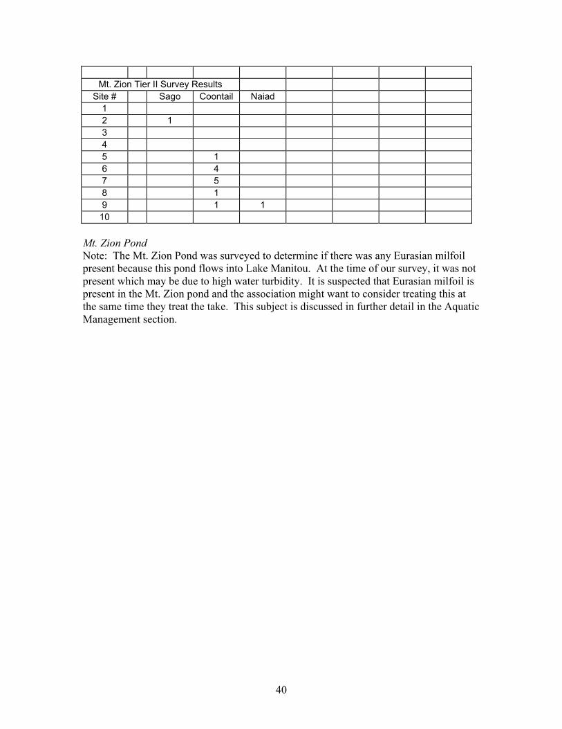
Table 6: Tier II Survey Data Sheets Lake Manitou Tier II Survey Results
Mt. Zion Pond Note: The Mt. Zion Pond was surveyed to determine if there was any Eurasian milfoil present because this pond flows into Lake Manitou. At the time of our survey, it was not present which may be due to high water turbidity. It is suspected that Eurasian milfoil is present in the Mt. Zion pond and the association might want to consider treating this at the same time they treat the take. This subject is discussed in further detail in the Aquatic Management section.