Grant No. G1000027 Ordinances No. 856 & 889 Lake Stevens 2013 Shoreline Master Program ECOLOGY APPROVED – May 31, 2013 (Effective Date: June 14, 2013) Prepared by: City of Lake Stevens Planning and Community Development Department 1812 Main Street Lake Stevens, WA 98258 1904 3 rd Ave, Suite 725 Seattle, Washington 98101 750 6th Street South Kirkland, WA 98033 This report was funded in part through a grant from the Washington Department of Ecology.
Transcript
Grant No. G1000027 Ordinances No. 856 & 889
Lake Stevens 2013 Shoreline Master Program ECOLOGY APPROVED – May 31, 2013 (Effective Date: June 14, 2013) Prepared by:
City of Lake Stevens Planning and Community Development Department 1812 Main Street Lake Stevens, WA 98258
1904 3rd Ave, Suite 725 Seattle, Washington 98101
750 6th Street South Kirkland, WA 98033
This report was funded in part through a grant from the Washington Department of Ecology.
This page intentionally left blank
Table of Contents i
Table of Contents Table of Contents ............................................................................................................ i
List of Figures ................................................................................................................ v
Chapter 1 ………………………………………………………………………………………1
Introduction to the SMP ................................................................................................ 1
A. What is the Shoreline Master Program? ..................................................................... 1 1. Applicable Documents ................................................................................................. 1 2. Related Documents ...................................................................................................... 2
B. History of the SMA ...................................................................................................... 2
C. Implementation of the SMA ........................................................................................ 4
Permitted uses in the shorelines of the state shall be designed and conducted in a manner to minimize, insofar as practical, any resultant damage to the ecology and environment of the shoreline area and any interference with the public's use of the water.” ......................................................................................................................... 5
D. Geographic Applications of the SMA .......................................................................... 5 1. Applicable Area............................................................................................................. 6
E. How the Shoreline Master Program is Used ............................................................... 7 1. When Is a Permit Required? ........................................................................................ 7 2. The Permit Process ...................................................................................................... 8 3. The Shoreline Permits .................................................................................................. 8 4. Relationship of this Shoreline Master Program to Other Plans................................. 9
F. Public Process for SMP Adoption ............................................................................... 9 1. Shoreline Citizen Advisory Committee (CAC) ............................................................ 9 2. Early Public Review .................................................................................................... 10 3. Local Adoption Process ............................................................................................. 10 4. Ecology’s Final Review and Adoption Process ........................................................ 12
Shoreline Use Provisions ........................................................................................... 67
A. Introduction .............................................................................................................. 67
B. Shoreline Use and Development Standards Matrices .............................................. 67
C. Shoreline Use Policies and Regulations ................................................................... 71 1. General Policies and Regulations .............................................................................. 71 2. Agriculture ................................................................................................................... 72 3. Boating Facilities......................................................................................................... 73
Table of Contents iii
4. Commercial Development .......................................................................................... 76 5. Industry ....................................................................................................................... 77 6. In-Stream Structures .................................................................................................. 78 7. Recreational Development ......................................................................................... 79 8. Residential Development ........................................................................................... 81 9. Transportation ............................................................................................................ 88 10. Utilities ........................................................................................................................ 90
A. Purpose and Applicability ....................................................................................... 113
B. Shoreline Permits ................................................................................................... 113
C. Substantial Development Permits and Exemptions ................................................ 115 1. Exemptions from a Substantial Development Permit .................................................. 115 2. Shoreline Substantial Development Permits ............................................................... 117 3. Substantial Development Permit Decision Criteria ...................................................... 119 4. Appeals - Shorelines Hearings Board ......................................................................... 120
D. Conditional Use Permits ......................................................................................... 120 1. Shoreline Conditional Use Permits ............................................................................. 120 2. Shoreline Conditional Use Permit Criteria ................................................................... 121
F. Revisions to Permits ............................................................................................... 123
G. Existing Structures and Development ..................................................................... 125
H. Nonconforming Uses and Lots ............................................................................... 126
I. Documentation of Project Review Actions and Changing Conditions in Shoreline Areas ...................................................................................................... 127
J. Amendments to This Shoreline Master Program .................................................... 127
K. Severability ............................................................................................................. 128
L. Enforcement ........................................................................................................... 128 1. Violations .................................................................................................................... 128 2. Duty to Enforce ........................................................................................................... 128 3. Investigation and Notice of Violation ........................................................................... 129
iv Lake Stevens 2013 Shoreline Master Program
Appendices: A. Shoreline Environment Designation Maps B. Critical Areas Regulations Within Shoreline Jurisdiction
Table of Contents v
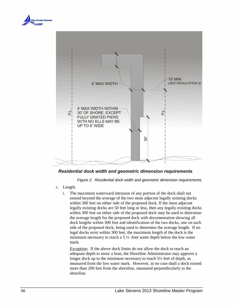
List of Figures Figure 1. Pier approach length. (See regulation 4.C.3.c.23.) .................................................... 55
Figure 2. Residential dock width and geometric dimension requirements. ................................ 56
Figure 3. Allowable length of new docks. (See regulation 4.C.3.c.23.a.i.) ............................... 57
Figure 4. Dock length measurement......................................................................................... 57
Figure 5. Illustration of maximum impervious surface. ............................................................ 84
Figure 6. Waterfront deck bonus for lots with no bulkhead or if bulkhead is removed. ............. 85
Figure 7. Standards for new development on previously undeveloped lots. ..... Error! Bookmark not defined.90
Chapter 1 - Introduction to the SMP 1
CHAPTER 1
Introduction to the SMP The Shoreline Master Program Update (SMP) replaces the 1974 Shoreline Master Program. This document regulates new, repaired, replaced and modified shoreline uses and development. Shoreline uses and structures legally existing at the time of adoption of the SMP are not affected by the new regulations. If a use or structure does not meet all the new regulations, it is considered an existing use or development and conforming to the SMP. Existing uses and structures may be maintained, repaired and replaced without meeting all new regulations pursuant to Chapter 7, Section G. However, some restrictions may occur based on the existing conditions of a site, the type of proposed action, or whether a use or structure was legally created.
Lake Stevens is an urban lake with the main land use on the shore of single-family residential. The City’s vision is to retain the residential use around the lake. The SMP does not modify the existing land use and will not be used to remove existing single-family homes. The SMP provides a guide for future uses and development on the lake whether new or existing to retain the current character and ecological functions of the lake and shoreline. Structures or uses not legally permitted could be required to be removed or brought into compliance with new regulations if a change to the structure or use is requested.
The conclusion of the Cumulative Impacts Analysis is that implementation of this SMP is anticipated to achieve no net loss of ecological functions in the City of Lake Stevens’ shorelines. Therefore, development and uses meeting the provisions of this SMP are expected to achieve no net loss of ecological functions when cumulatively viewed across the City’s entire shoreline.
In implementation of the SMP, the terms "shall," "must," and "are required" and the imperative voice, mean a mandate; the action is required; the term "should" means that the particular action is required unless there is a demonstrated, compelling reason, based on a policy of the Shoreline Management Act and this chapter, for not taking the action; and the term "may" indicates that the action is within discretion and authority, provided it satisfies all other provisions in this chapter. (WAC 173-26-191(2))
A. What is the Shoreline Master Program? The City of Lake Stevens Shoreline Master Program (SMP) is a planning document that outlines goals and policies for the shorelines of the City, and also establishes regulations for development occurring within shoreline jurisdiction.
1. Applicable Documents The Shoreline Master Program includes the SMP and related documents. The following documents are considered part of the SMP:
Shoreline Master Program (SMP);
Shoreline Environment Designations Map (Appendix A); and
Critical Areas Regulations Within Shoreline Jurisdiction (Appendix B).
2 Lake Stevens 2013 Shoreline Master Program
2. Related Documents There are many documents adopted by the City of Lake Stevens that are not a part of the SMP, but should be consulted when developing or making a land use action within shoreline jurisdiction. The SMP is the document regulating properties within shoreline jurisdiction, however, more general development regulations on the overall project application process, drainage requirements, roads, etc., are found in the Lake Stevens Municipal Code or adopted plans, policies, or programs. If there is a conflict between the SMP and a related document, the more restrictive requirements should be followed.
The following list of related documents is not exhaustive, but a guide to the users of the SMP:
Shoreline Analysis Report for the City of Lake Stevens Shorelines: Lake Stevens, Catherine Creek and Little Pilchuck Creek (The Watershed Company and Makers 2010)
Cumulative Impacts Analysis for the City of Lake Stevens Shorelines: Lake Stevens, Catherine Creek and Little Pilchuck Creek (The Watershed Company and Makers 2011)
Shoreline Restoration Plan for the City of Lake Stevens Shorelines: Lake Stevens, Catherine Creek and Little Pilchuck Creek (The Watershed Company and Makers 2010)
No Net Loss Report (The Watershed Company and Makers 2011)
City of Lake Stevens Comprehensive Plan (Adopted July 2006, as amended)
Title 14 of the Lake Stevens Municipal Code, in particular, the following topics: Administration and Procedures Types of Land Use Review Land Use Actions, Permits and Determinations – Decision Criteria and Standards Density and Dimensional Regulations Streets and Sidewalks Utilities Parking Screening and Trees Floodways, Floodplains, Drainage and Erosion Signs Building and Construction Fire Code
City’s Lake Level Management Plan
City’s Surface Water Management Program
City’s Stormwater Management Plan
National Flood Insurance Program and adopted Flood Insurance Rate Maps
B. History of the SMA In 1969, the Washington State Supreme Court decided in the case of Wilbour v. Gallagher (77 Wn.2d 306), commonly known as the "Lake Chelan Case," that certain activities along shorelines were contrary to the public interest. The court findings required that the public interest be represented in the proper forum for determining the use of shoreline properties. The ramifications
Chapter 1 - Introduction to the SMP 3
of this decision were significant in that developers, environmentalists, and other interested parties began to recognize—although probably for different reasons—the need for a comprehensive planning and regulatory program for shorelines.
Wilbour v. Gallagher was a case primarily involving navigable waters. It was decided at a time of heightened environmental awareness. At the same time, Congress was considering environmental legislation and subsequently passed a number of laws relating to protection of the environment including the National Environmental Policy Act (1969) and the Coastal Zone Management Act (1972). Voters of the state, seeing the failure of the Seacoast Management Bill in the state legislature, validated an initiative petition commonly titled the "Shoreline Protection Act." The state legislature, choosing between adoption of the people’s initiative petition or its own alternative, passed into law the "Shoreline Management Act of 1971" (SMA) effective June 1, 1971, which contained the provision for both statutes to be deferred to the electorate in the November 1972 election. The election issue required that voters respond to two questions: (1) Did they favor shoreline management? and (2) Which alternative management program did they prefer? Most Washington voters favored both shoreline management and the legislature's alternative (providing greater local control), by an approximately 2-to-1 margin. It is important to keep in mind that the SMA was a response to a people’s initiative and was ratified by the voters, giving the SMA a populist foundation as well as an environmental justification.
The SMA's paramount objectives are to protect and restore the valuable natural resources that shorelines represent and to plan for and foster all "reasonable and appropriate uses" that are dependent upon a waterfront location or that offer opportunities for the public to enjoy the state's shorelines. With this clear mandate, the SMA established a planning and regulatory program to be initiated at the local level under State guidance.
This cooperative effort balances local and state-wide interests in the management and development of shoreline areas by requiring local governments to plan (via shoreline master programs) and regulate (via permits) shoreline development within SMA jurisdiction. (See “Geographic Applications of the SMA” below.) Local government actions are monitored by the Washington Department of Ecology (Ecology), which approves new or amended shoreline master programs (SMPs), reviews substantial development permits, and approves conditional use permits and variances.
After the SMA’s passage in 1971, Ecology adopted Chapter 173-18 WAC to serve as a standard for the implementation of the SMA and to provide direction to local governments and Ecology in preparing SMPs. Two hundred forty-seven cities and counties have prepared SMPs based on that WAC chapter. Over the years, local governments, with the help of Ecology, developed a set of practices and methodologies, the best of which were collected and described in the 1994 Shoreline Management Guidebook.
In 1995, the state legislature passed Engrossed Substitute House Bill 1724, which included several statutory amendments to better integrate the Growth Management Act (GMA), the Shoreline Management Act, and the State Environmental Policy Act (SEPA). The bill also directed Ecology to review and update the state SMA guidelines every five years. In response, Ecology undertook a primarily in-house process to prepare a new WAC chapter (also referred to in this SMP as the “Guidelines”). After meeting with a series of advisory committees and producing a number of informal drafts, Ecology formally proposed a new WAC rule for the SMA in April 1999. Subsequently, in 2003, the Legislature further clarified the integration of the SMA and GMA.
4 Lake Stevens 2013 Shoreline Master Program
The rule was appealed and then-Governor Gary Locke and former Attorney General Christine Gregoire cosponsored a year-long mediation effort in 2002 that culminated in a third draft, which was issued for public comment in July 2002. That proposal had the endorsement of the Association of Washington Business, the Washington Aggregates & Concrete Association, the Washington Environmental Council (WEC) and other environmental organizations – all of whom were parties to the lawsuit.
Ecology received about 300 comments on the version proposed in 2003. Seventeen changes were made in response to those comments, to clarify language and to delete obsolete or duplicative references. The final version was adopted December 17, 2003.
The City adopted Snohomish County’s Shoreline Master Program in 1974, and has not subsequently updated the document other than minor revisions to the administrative provisions found separately in Chapter 14.92 (Shoreline Management) of the Lake Stevens Municipal Code (LSMC). The City’s Comprehensive Plan (Critical Areas Element) contains a few shoreline goals and policies. Regulations applicable to critical areas which are located within shoreline jurisdiction underwent a comprehensive updated in 2008, consistent with Growth Management Act requirements for use of “best available science.” In those regulations, the City specified a stream shoreline buffer of 150 feet, applicable to Catherine Creek and Little Pilchuck Creek.
Most of the uses, developments, and activities regulated under the Critical Areas Regulations are also subject to the City’s Comprehensive Plan, the Lake Stevens Municipal Code, the International Building Code, and various other provisions of City, state and federal laws. Any applicant must comply with all applicable laws prior to commencing any use, development, or activity. Lake Stevens will ensure consistency between the SMP and other City codes, plans and programs by reviewing each for consistency during periodic updates of the City’s Comprehensive Plan as required by State statute.
C. Implementation of the SMA RCW 90.58.020 clearly states how the Shoreline Management Act shall be implemented in the following statement:
“The legislature finds that the shorelines of the state are among the most valuable and fragile of its natural resources and that there is great concern throughout the state relating to their utilization, protection, restoration, and preservation. In addition it finds that ever increasing pressures of additional uses are being placed on the shorelines necessitating increased coordination in the management and development of the shorelines of the state. The legislature further finds that much of the shorelines of the state and the uplands adjacent thereto are in private ownership; that unrestricted construction on the privately owned or publicly owned shorelines of the state is not in the best public interest; and therefore, coordinated planning is necessary in order to protect the public interest associated with the shorelines of the state while, at the same time, recognizing and protecting private property rights consistent with the public interest. There is, therefore, a clear and urgent demand for a planned, rational, and concerted effort, jointly performed by federal, state, and local governments, to prevent the inherent harm in an uncoordinated and piecemeal development of the state's shorelines.
It is the policy of the state to provide for the management of the shorelines of the state by planning for and fostering all reasonable and appropriate uses. This policy is designed to insure the
Chapter 1 - Introduction to the SMP 5
development of these shorelines in a manner which, while allowing for limited reduction of rights of the public in the navigable waters, will promote and enhance the public interest. This policy contemplates protecting against adverse effects to the public health, the land and its vegetation and wildlife, and the waters of the state and their aquatic life, while protecting generally public rights of navigation and corollary rights incidental thereto.
The legislature declares that the interest of all of the people shall be paramount in the management of shorelines of statewide significance. The department, in adopting guidelines for shorelines of statewide significance, and local government, in developing master programs for shorelines of statewide significance, shall give preference to uses in the following order of preference which:
1. Recognize and protect the statewide interest over local interest;
2. Preserve the natural character of the shoreline;
3. Result in long term over short term benefit;
4. Protect the resources and ecology of the shoreline;
5. Increase public access to publicly owned areas of the shorelines;
6. Increase recreational opportunities for the public in the shoreline;
7. Provide for any other element as defined in RCW 90.58.100 deemed appropriate or necessary.
In the implementation of this policy the public's opportunity to enjoy the physical and aesthetic qualities of natural shorelines of the state shall be preserved to the greatest extent feasible consistent with the overall best interest of the state and the people generally. To this end uses shall be preferred which are consistent with control of pollution and prevention of damage to the natural environment, or are unique to or dependent upon use of the state's shoreline. Alterations of the natural condition of the shorelines of the state, in those limited instances when authorized, shall be given priority for single-family residences and their appurtenant structures, ports, shoreline recreational uses including but not limited to parks, marinas, piers, and other improvements facilitating public access to shorelines of the state, industrial and commercial developments which are particularly dependent on their location on or use of the shorelines of the state and other development that will provide an opportunity for substantial numbers of the people to enjoy the shorelines of the state. Alterations of the natural condition of the shorelines and shorelands of the state shall be recognized by the department. Shorelines and shorelands of the state shall be appropriately classified and these classifications shall be revised when circumstances warrant regardless of whether the change in circumstances occurs through man-made causes or natural causes. Any areas resulting from alterations of the natural condition of the shorelines and shorelands of the state no longer meeting the definition of ’shorelines of the state’ shall not be subject to the provisions of chapter 90.58 RCW.
Permitted uses in the shorelines of the state shall be designed and conducted in a manner to minimize, insofar as practical, any resultant damage to the ecology and environment of the shoreline area and any interference with the public's use of the water.”
D. Geographic Applications of the SMA As defined by the Shoreline Management Act of 1971, shorelines include certain waters of the state plus their associated “shorelands.” At a minimum, the waterbodies designated as shorelines of the state are streams whose mean annual flow is 20 cubic feet per second (cfs) or greater and lakes whose area is greater than 20 acres. RCW 90.58.030(2)(d) defines shorelands as:
“[T]hose lands extending landward for two hundred feet in all directions as measured on a horizontal plane from the ordinary high water mark; floodways and contiguous floodplain areas landward 200 feet from such floodways; and all wetlands and river deltas associated with the streams, lakes, and tidal waters which are subject to the provisions of this chapter the same to be designated as to location by the department of ecology.
(i) Any county or city may determine that portion of a one-hundred-year-floodplain to be included in its master program as long as such portion includes, as a minimum, the floodway and the adjacent land extending landward two hundred feet therefrom.
(ii) Any city or county may also include in its master program land necessary for buffers for critical areas as defined in Chapter 36.70A RCW, that occur within shorelines of the state.”
In addition, rivers with a mean annual cfs of 1,000 or more are considered shorelines of statewide significance.
The lateral extent of the shoreline jurisdiction shall be determined for specific cases based on the location of the ordinary high water mark (OHWM), floodway, and presence of associated wetlands.
Lake Stevens is 1,014 acres, and is therefore included in a classification of unique shorelines known as Shorelines of Statewide Significance. The City’s shoreline planning area has grown extensively due to multiple annexations around Lake Stevens, and eastward to also encompass the shorelines of Catherine Creek and Little Pilchuck Creek. The 20 cfs cutoff point for Catherine Creek is located at Hartford Drive NE in the City limits. The 20 cfs cutoff point for Little Pilchuck Creek is some distance upstream of the City and the UGA, and wanders in and out of the UGA along the eastern City boundary. Careful consideration of the hydrologic associations of known wetlands around Lake Stevens also resulted in significant expansions of shoreline jurisdiction from what had previously been understood.
1. Applicable Area The City of Lake Stevens and its Urban Growth Area (UGA) is located in Snohomish County, WA. The City is bordered nearly on all sides by unincorporated Snohomish County jurisdiction, with a small shared border with Marysville along the northwest portion of the City. The City of Everett is located generally west and the City of Snohomish is located to the south. All of Lake Stevens is in the City’s shoreline jurisdiction, either in City limits or the UGA. Catherine Creek is likewise split between City limits and the UGA, while Little Pilchuck Creek is entirely within the UGA. The City encompasses approximately 9 square miles. The Shoreline Environment Designation Map in Appendix A indentifies the areas
Chapter 1 - Introduction to the SMP 7
known to be within shoreline jurisdiction; additional areas may be determined on a site-specific basis if there are associated wetlands with a connection to the shoreline. The total area subject to the City’s updated SMP, not including aquatic area, is approximately 362 acres (0.57 square mile), and encompasses approximately 9.2 miles of shoreline. (See Appendix A)
E. How the Shoreline Master Program is Used The City of Lake Stevens Shoreline Master Program is a planning document that outlines goals and policies for the shorelines of the City, and also establishes regulations for development occurring within shoreline jurisdiction.
In order to preserve and enhance the shorelines of the City of Lake Stevens, it is important that all development proposals relating to the shoreline are evaluated in terms of the City’s Shoreline Master Program, and the City Shoreline Administrator is consulted. The Shoreline Administrator for the City of Lake Stevens is the Planning Director or his/her designee.
The Shoreline Management Act (SMA) defines for local jurisdictions the content and goals that should be represented in the Shoreline Master Programs developed by each community; within these guidelines, it is left to each community to develop the specific regulations appropriate to that community. Pursuant to the Guidelines, shorelines of the state that meet the criteria established in WAC 173-26-211 are given a shoreline environment designation. The purpose of the shoreline designation system is to ensure that land use, development, or other activity occurring within the designated shoreline jurisdiction is appropriate for that area and that consideration is given to the special requirements of that environment.
The Lake Stevens Shoreline Master Program addresses a broad range of uses that could be proposed in the shoreline area. This breadth is intended to ensure that the Lake Stevens shoreline area is protected from activities and uses that, if unmonitored, could be developed inappropriately and could cause damage to the ecological system of the shoreline, displace “preferred uses” as identified in Chapter 90.58 RCW, or cause the degradation of shoreline aesthetic values. The Lake Stevens Shoreline Master Program provides the regulatory parameters within which development may occur. In addition, it identifies those uses deemed unacceptable within Lake Stevens shoreline jurisdiction, as well as those uses which may be considered through a discretionary permit such as a Conditional Use Permit or Shoreline Variance.
Policies are used to: (1) develop regulations and standards, and (2) provide guidance and clarity where there is question or uncertainty about how to apply a specific regulation.
1. When Is a Permit Required? A Shoreline Substantial Development Permit is required when a development or activity meets the definition of “substantial development” contained within Chapter 6 of this SMP. Substantial development is discussed in more detail in Chapter 7 Section C of this SMP. A development or activity is exempt if it meets the criteria listed in WAC 173-27-040. Some development may require a Shoreline Conditional Use Permit, if listed as such in the Use Tables contained in Chapter 5 Section B of this SMP; or a Shoreline Variance. Shoreline Conditional Use Permits and Shoreline Variances are discussed in more detail in Chapter 7 Sections D and E, respectively. However, ALL new development, uses, and activities must
8 Lake Stevens 2013 Shoreline Master Program
comply with the policies and regulations set forth in the City of Lake Stevens Shoreline Master Program, including those developments, uses, and activities that are exempt from permits. Review under the State Environmental Policy Act (SEPA) may also be required.
“Development,” is defined by the Shoreline Management Act of 1971 as:
A use consisting of the construction or exterior alteration of structures; dredging, drilling; dumping; filling; removal or any sand, gravel, or minerals; bulkheading; driving of piling; placing of obstructions; or any project of a permanent or temporary nature which interferes with the normal public use of the surface of the waters of the state subject to Chapter 90.58 RCW at any state of water level (RCW 90.58.030(3)(a)).
Projects that are identified as “developments,” but not “substantial developments,” do not require a Shoreline Substantial Development Permit; however, they must still comply with all applicable regulations in the City’s Shoreline Master Program, including Appendix B - Critical Areas Regulations Within Shoreline Jurisdiction. In addition, some developments may require a Shoreline Conditional Use Permit or Shoreline Variance from the Shoreline Master Program’s provisions, although they do not meet the definition of “substantial development.”
“Substantial development” is any “development” where the total cost or fair market value exceeds five thousand seven hundred eighteen dollars ($5,718), as adjusted for inflation by the Office of Financial Management every five years, or any development that materially interferes with the normal public use of the water or shoreline of the state. The five thousand seven hundred eighteen dollar ($5,718) threshold will be adjusted for inflation by the office of financial management every five years, beginning July 1, 2007, based upon changes in the consumer price index during that time period. A dock is not considered substantial development if the fair market value of the dock does not exceed ten thousand dollars ($10,000), as adjusted for inflation by the Office of Financial Management every five years. If subsequent construction having a fair market value exceeding two thousand five hundred dollars ($2,500) occurs within five years of completion of the prior construction, the subsequent construction shall be considered a substantial development.
Under the Shoreline Management Act, some types of development are exempt from the requirement to apply for and receive a permit before beginning work per RCW 90.58.030(3)(e). A complete list of developments and uses that are not considered “substantial development” as per WAC 173-27-040, is included at Chapter 7 Section C.1.
2. The Permit Process The Shoreline Administrator can help determine if a project is classified as a substantial development, determine if a permit is necessary or if a project is exempt from permit requirements, and identify which regulations in the SMP may apply to the proposed project. The Administrator can also provide information on the permit application process and how the SMP process relates to, and can coordinate with, the State Environmental Policy Act (SEPA) process.
3. The Shoreline Permits There are three types of permits: the Shoreline Substantial Development Permit, the Shoreline Conditional Use Permit, and the Shoreline Variance. All of these permits use the same
Chapter 1 - Introduction to the SMP 9
application form; however, they are processed slightly differently and have different criteria for approval. Shoreline Exemptions require City review to determine whether the proposal is indeed exempt from shoreline permits, and whether the proposal meets the policies and regulations of the Shoreline Master Program. Requests for Shoreline Exemption are made on a separate application form.
Requests for a Shoreline Exemption and Shoreline Substantial Development Permit are reviewed by the Shoreline Administrator. Requests for a Shoreline Variance or Shoreline Conditional Use Permit require review by the City of Lake Stevens Hearing Examiner. There may be instances where a Shoreline Conditional Use Permit or Shoreline Variance may be approved without the need for a Shoreline Substantial Development Permit. The Hearing Examiner will hold a public hearing on the proposal and approve, approve with conditions, or deny the application. The Hearing Examiner’s decision is final, unless an appeal is filed pursuant to the procedures described in Chapter 7 Section C.4. Requests for Shoreline Conditional Use Permits and Shoreline Variances require final approval by DOE.
A map of the shoreline jurisdiction is presented in Appendix A and descriptions of the various shoreline designations are presented in Chapter 2 of this SMP.
4. Relationship of this Shoreline Master Program to Other Plans In addition to compliance with the provisions of the Shoreline Management Act of 1971, the Lake Stevens Shoreline Master Program (SMP) must be mutually consistent with local plans and policy documents, specifically, the Lake Stevens Comprehensive Plan and the Lake Stevens Municipal Code. The Lake Stevens SMP must also be mutually consistent with the regulations developed by the City to implement its plans, such as the zoning code and subdivision code, as well as building construction and safety requirements.
Submitting an application for a shoreline development, use, or activity does not exempt an applicant from complying with any other local, county, state, regional, or federal statutes or regulations, which may also be applicable to such development or use.
F. Public Process for SMP Adoption The City of Lake Stevens involved the public and solicited feedback throughout the update process of this Shoreline Master Program. The City notified and solicited input from all relevant organizations and agencies at the beginning and throughout the local adoption process of the SMP update.
1. Shoreline Citizen Advisory Committee (CAC) City staff and consultants worked closely with a Shoreline Citizen Advisory Committee throughout the update process. The CAC included seven Lake Stevens residents (City Council Representative, Planning Commission Representative, two Park Board Members, two shoreline property owners and one non-shoreline resident). Six meetings were held from March to December 2010. The CAC provide in-depth and structured input on draft policies and regulations, assisted in the outreach to various constituencies and interest groups, and helped to ensure that a broad spectrum of interests and considerations were incorporated into the SMP update.
10 Lake Stevens 2013 Shoreline Master Program
2. Early Public Review The City held a total of three public open houses during the writing phase of the SMP to solicit public input. For each open house, approximately 380 shoreline property owners and other property owners within shoreline jurisdiction were invited by a mailed postcard. The meetings were also advertised in the Lake Stevens Journal and/or Everett Herald. Each open house consisted of opportunities to talk with staff and consultants about proposed updates to the SMP, a presentation reviewing the SMP update and proposed changes, and opportunities to provide written feedback.
• Open House #1 (April 15, 2010) - ~70 people attended to provide meaningful feedback through a brainstorming exercise and by filling out questionnaires.
• Open House #2 (June 24, 2010) - ~24 people attended to provide feedback on a questionnaire.
• Open House #3 (November 18, 2010) - ~13 people attended to provide comments on the proposed SMP.
3. Local Adoption Process The local adoption process began on April 4, 2011 with submittal of draft documents to the Washington Department of Commerce for the required 60-day review and ended with adoption of a resolution by the City Council on November 28, 2011 for approval of the final draft Shoreline Master Program documents and direction to staff to forward them to the Washington Department of Ecology for formal review and approval.
The City received numerous phone calls, emails and office visits from residents and property owners after sending the notice of the public hearings and during the public hearing process. Formal written submittals are included in the Responsiveness Summary. Public testimony from the Council Hearings is included in the General Testimony reports.
A summary of the local adoption process is provided below:
• April 5, 2011 – Draft Shoreline Master Program and associated documents submitted to Washington Department of Commerce for 60-day review of Comprehensive Plan amendments and Development Regulations, including SMP documents.
• April 12, 2011 – Postcard notice for the SEPA Determination of Non-Significance and Public Meetings mailed to 2,080 shoreline property owners or within 300 feet.
• April 13, 2011 – Notice of Planning Commission Public Hearing on May 4 published in Lake Stevens Journal.
• April 15, 2011 – Issued SEPA Determination of Non-Significance (DNS) and published in the Everett Herald.
• April 19, 2011 – Final Draft Shoreline Master Program documents completed.
• April 20, 2011 – Notice of Planning Commission Public Hearing on May 4 published in Lake Stevens Journal. Final documents uploaded to City of Lake Stevens website.
• April 29, 2011 – Comment period ends for SEPA DNS.
Chapter 1 - Introduction to the SMP 11
• May 4, 2011 – Planning Commission Public Hearing on the SMP documents. Attendance: 25.
• May 4 & 11, 2011 – Notice of City Council Public Hearings on May 23 and June 13 published in Lake Stevens Journal.
• May 6, 2011 – Appeal period ends for SEPA DNS.
• May 11, 2011 – Notice of City Council Public Hearings on May 23 and June 13 published in Lake Stevens Journal.
• May 18, 2011 – Continuation of Planning Commission Public Hearing on the SMP documents and code amendments, and recommendation to City Council. Attendance: 9.
• May 23, 2011 – City Council Public Hearing and First Reading of Resolution to adopt Final Draft SMP documents. Attendance: 61.
• May 31, 2011 – City Council Workshop. Attendance: 60.
• June 6, 2011 – City Council Workshop with Ecology, Fish & Wildlife, and Consultants. Attendance: 33.
• June 6, 2011 – 60-day Washington Department of Commerce review complete.
• June 13, 2011 – City Council Public Hearing and Second Reading of Resolution to adopt Final Draft SMP documents. Attendance: 71.
• July 11, 2011 – City Council Public Hearing and Third & Final Reading of Resolution to adopt Final Draft SMP documents. Attendance: 28. Council Subcommittee designated to meet with citizen group and their representatives.
• August 16, 2011 – Council Subcommittee Meeting #1 with staff and citizen group and their representatives met to discuss the major topics. Decision to propose supplemental work program to Council. Attendance: 11.
• September 12, 2011 – City Council adopts Supplemental Work Program for staff and consultants to research major issues and report back to Council Subcommittee.
• October 27, 2011 – Council Subcommittee Meeting #2 with staff and citizen group and their representatives.
• October 31, 2011 – Council Subcommittee Meeting #3 with staff and citizen group and their representatives.
• November 14, 2011 – City Council Workshop to discuss Subcommittee recommendations and other proposed revisions to the proposed SMP. Ecology was present to answer Council questions.
• November 17, 2011 – Council Subcommittee Meeting #4 with staff and citizen group and their representatives.
• November 21, 2011 – Fourth Public Hearing and Adoption. Attendance: ~30.
12 Lake Stevens 2013 Shoreline Master Program
• November 28, 2011 – Fifth and Final Public Hearing and Adoption of Final Draft SMP and associated documents and direction to staff to forward them to the Washington Department of Ecology for formal review and approval. Attendance: ~32.
• December 9, 2011 – Submittal of City Council Approved Final Draft for Ecology Review SMP documents to the Washington Department of Ecology for formal review and approval.
4. Ecology’s Final Review and Adoption Process Ecology’s final review and adoption process began with the submittal of City Council approved Final Draft Shoreline Master Program and associated documents.
A summary of Ecology’s final review adoption process is provided below:
• February 27, 2012 – SMP amendment package verified as complete by Ecology.
• April 10, 2012 – Notice of the state comment period distributed to state interested parties as well as local interested parties identified by the City.
• April 19, 2011 – Ecology public hearing to solicit input on the City proposed amendments.
• April 19 to May 21, 2012 – State comment period. Eleven individuals or organizations provided either formal testimony at the public hearing or submitted written comments.
• January 4, 2013 – Washington Department of Ecology Letter of Conditional Approval to City.
• January 4 to February 4, 2013 – Thirty day period for City response to Conditional Approval.
• January 28, 2013 – City request for extension to the 30-day response until April 30, 2013.
• April 30, 2013 – City response to Conditional Approval agreeing to most of Ecology’s recommended changes, proposing alternative language for two required changes, and proposing eight additional minor clarifications.
• May 31, 2013 – Final Ecology approval of the City of Lake Stevens Shoreline Master Program Comprehensive Update.
• June 14, 2013 – Effective date of approved Shoreline Master Program.
Chapter 2 - Environment Designation Provisions 13
CHAPTER 2
Environment Designation Provisions
A. Introduction The Shoreline Management Act (Chapter 90.58 RCW) and Shoreline Guidelines (Chapter 173-26 WAC) provide for shoreline environment designations to serve as a tool for applying and tailoring the general policies of the SMA to local shorelines. Shoreline environment designations provide a means of adapting broad policies to shoreline sub-units while recognizing different conditions and valuable shoreline resources, and a way to integrate comprehensive planning into SMP regulations. In accordance with WAC 173-26-211, the following shoreline environment designation provisions apply; including purpose, designation criteria, and management policies. Where there is a contradiction between the matrices and another SMP text provision, the text provision shall apply.
All areas not specifically assigned a shoreline environment designation shall be designated “Urban Conservancy” (UC).
B. Shoreline Environment Designation Maps The Shoreline Environment Designation Maps can be found in Appendix A. Pursuant to WAC 173-26-211, the maps illustrate the shoreline environment designations that apply to all shorelines of the state within the City of Lake Stevens’ jurisdiction. The lateral extent of the shoreline jurisdiction shall be determined for specific cases based on the location of the ordinary high water mark (OHWM), effective floodway, and presence of associated wetlands. The maps should be used in conjunction with the Environment Designation tables in Section C below. In the event of a mapping error, the City will rely upon the boundary descriptions and the criteria in Section C below.
C. Policies and Regulations 1. "Natural" (N) Environment
a. Purpose The purpose of the "Natural" environment is to protect and restore all wetlands associated with shoreline areas by applying the City of Lake Stevens Critical Areas Regulations Within Shoreline Jurisdiction in Appendix B. These systems require development restrictions to maintain the ecological functions and ecosystem-wide processes.
b. Designation Criteria A "Natural" environment designation will be assigned to those wetland complexes in shoreline jurisdiction. Identified wetlands include those associated with Stevens Creek, Stitch Lake, Lundeen Creek, and Lake Stevens. For the “Natural” areas that extend
14 Lake Stevens 2013 Shoreline Master Program
beyond 200 feet from OHWM, the exact location of the wetland boundary will be determined with a wetland delineation at the time of project application.
c. Management Policies
1. Any use that would substantially degrade the ecological functions or natural character of the designated wetland area should be prohibited.
Uses
2. New land division, development or shoreline modification that would reduce the capability of the wetlands to perform normal ecological functions should not be allowed.
3. Uses that are consumptive of physical, visual, and biological resources should be prohibited.
4. Access may be permitted for scientific, historical, cultural, educational, and low-intensity water-oriented recreational purposes such as nature study that do not impact ecological functions, provided that no significant ecological impact on the area will result.
Access and Improvements
5. Physical alterations should only be considered when they serve to protect or enhance a significant, unique, or highly valued feature that might otherwise be degraded or destroyed or for public access where no significant ecological impacts would occur.
6. The ecological resources, including associated wetlands, in the “Natural” environment should be protected through the provisions in the Critical Areas section of this SMP.
Implementing Regulations
2. "High-Intensity" (H-I) Environment a. Purpose
The purpose of the "High-Intensity" environment is to provide for high-intensity water-oriented commercial, transportation, and industrial uses while protecting existing ecological functions and restoring ecological functions in areas that have been previously degraded.
b. Designation Criteria A "High-Intensity" environment designation will be assigned to shorelands designated for commercial or industrial use in the Comprehensive Plan if they currently support or are suitable and planned for high-intensity commercial, industrial, or institutional uses that either include, or do not detract from the potential for water-oriented uses, shoreline restoration and/or public access.
Chapter 2 - Environment Designation Provisions 15
c. Management Policies
1. In regulating uses in the "High-Intensity" environment, first priority should be given to water-dependent uses. Second priority should be given to water-related and water-enjoyment uses.
Uses
The Shoreline Administrator will consider the provisions of this SMP and determine the applicability and extent of ecological restoration and/or public access required. The extent of ecological restoration shall be that which is reasonable given the specific circumstances of development in the “High-Intensity” environment.
2. Developments in the “High-Intensity” environment should be managed so that they enhance and maintain the shorelines for a variety of urban uses, with priority given to water-dependent, water-related, and water-enjoyment uses.
3. Because Little Pilchuck Creek and Catherine Creek are non-navigable waterways, new nonwater-oriented development should be allowed in the High Intensity environment if ecological restoration is provided as a significant public benefit.
4. Existing public access ways should not be blocked or diminished.
Public Access
5. In order to make maximum use of the available shoreline resource and to accommodate future water-oriented uses, shoreline restoration and/or public access, the redevelopment and renewal of substandard, degraded, obsolete urban shoreline areas should be encouraged.
6. Aesthetic objectives should be actively implemented by means such as sign control regulations, appropriate development siting, screening and architectural standards, and maintenance of natural vegetative buffers. These objectives may be implemented either through this SMP or other City ordinances.
Aesthetics
d. Specific Environment Designations The following table (Table 1) assigns areas within shoreline jurisdiction as a “High Intensity” environment. See attached Shoreline Environment Designation Maps (Appendix A).
3. "Urban Conservancy" (UC) Environment a. Purpose
The purpose of the “Urban Conservancy" environment is to protect and “restore”, as defined in this SMP, ecological functions in urban and developed settings, while allowing public access and a variety of park and recreation uses.
16 Lake Stevens 2013 Shoreline Master Program
Table 1. High Intensity Environment Designation Descriptions
Environment Designation Sub-Unit Begins
(parcel No.) Ends
(parcel No.) High Intensity Lake Stevens
Residential 29051200400200 29051200400100
High Intensity Little Pilchuck Creek – UGA
Sliver of parcel 29060400301000
High Intensity Little Pilchuck Creek – UGA
Portion of parcel 29060900200800
High Intensity Little Pilchuck Creek – UGA
Portion of parcel 29060900206500
High Intensity Little Pilchuck Creek – UGA
Portions of N Machias Rd in Shoreline Jurisdiction
High Intensity Little Pilchuck Creek – UGA
Northeast corner or parcel 29060500402000
High Intensity Little Pilchuck Creek – UGA
Northern portion of Machias Rd at the intersection with SR 92
High Intensity Catherine Creek – City
SW portion of 00562200001801
Western portion of 29060800103000
High Intensity Catherine Creek – City
00660100000101 29060800103400
High Intensity Catherine Creek – City
29060900300900, 29060900301000
Southwest portion 29060900304400
High Intensity Catherine Creek – UGA
Portion of 29060900304600
b. Designation Criteria An "Urban Conservancy" environment designation will be assigned to shorelands that are within public and private parks and natural resource areas, including park lands on Lake Stevens and Catherine Creek. Lands planned for park uses or resource conservation areas and lands with no other existing or planned commercial or residential land uses should also be designated “Urban Conservancy.”
c. Management Policies
1. Water-oriented recreational uses should be given priority over nonwater-oriented uses. Water-dependent recreational uses should be given highest priority.
Uses
2. Commercial activities enhancing ecological functions or the public’s enjoyment of publically accessible shorelines may be appropriate.
Chapter 2 - Environment Designation Provisions 17
3. Water-dependent and water-enjoyment recreation facilities that do not deplete the resource over time, such as boating facilities, angling, wildlife viewing trails, and swimming beaches, are preferred uses, provided significant ecological impacts to the shoreline are avoided or mitigated.
4. Development that hinders natural channel movement in channel migration zones should not be allowed.
5. During development and redevelopment, all reasonable efforts, as determined by the City, should be taken to restore ecological functions.
Ecological Restoration and Public Access
6. Standards should be established for shoreline stabilization measures, vegetation conservation, water quality, and shoreline modifications within the "Urban Conservancy" designation to ensure that new development does not further degrade the shoreline and is consistent with an overall goal to improve ecological functions and habitat.
7. Public access and public recreation objectives should be implemented whenever feasible and significant ecological impacts can be mitigated.
d. Specific Environment Designations The following table (Table 2) assigns areas within shoreline jurisdiction as an “Urban Conservancy” environment. See also the attached maps.
4. "Shoreline Residential" (SR) Environment a. Purpose
The purpose of the "Shoreline Residential" environment is to accommodate residential development and appurtenant structures that are consistent with this SMP. An additional purpose is to provide appropriate community access and recreational uses.
b. Designation Criteria A "Shoreline Residential" environment designation will be assigned to City of Lake Stevens’ shorelands if they are predominantly single-family or multifamily residential development or are planned for residential development.
c. Management Policies
1. Water-oriented recreational uses should be allowed.
Uses
2. New residential development should be supported by adequate land area and services.
3. Land division and development should be permitted only 1) when adequate setbacks or buffers are provided to protect ecological functions and 2) where there is adequate access, water, sewage disposal, and utilities systems, and public services available and 3) where the environment can support the proposed use in a manner which protects or restores the ecological functions.
Urban Conservancy Lake Stevens Residential – City Limits
29060700200800
Urban Conservancy Lake Stevens Residential – City Limits
00493300900101
Urban Conservancy Lake Stevens Residential – City Limits
00553800002000
Urban Conservancy Lake Stevens Residential – City Limits
00553800001602 00553800001500
Urban Conservancy Lake Stevens Residential – City Limits
29060800303400
Urban Conservancy Lake Stevens Residential – UGA
00533400001500
Urban Conservancy Little Pilchuck Creek - UGA
29060900303300
Urban Conservancy Little Pilchuck Creek - UGA
29060900302400
Urban Conservancy Little Pilchuck Creek – UGA
Eastern portion of 29060400301000
Urban Conservancy Catherine Creek – City Eastern portion of 29060800400100
00828600099900
4. Development standards for setbacks or buffers, shoreline stabilization, vegetation conservation, critical area protection, and water quality should be established to protect and, where significant ecological degradation has occurred, restore ecological functions over time.
5. New multi-family development and new subdivisions of land into more than four parcels shall provide public access, which could include benches for viewing in a public right of way, community access, or similar types of public access.
6. New residential development should be located and designed so that future shoreline stabilization is not needed.
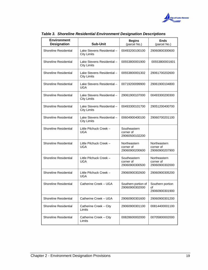
d. Specific Environment Designations The following table (Table 3) assigns areas within shoreline jurisdiction as a “Shoreline Residential” environment. See also the attached maps.
Shoreline Residential Lake Stevens Residential – City Limits
00493200100100 29060800300600
Shoreline Residential Lake Stevens Residential – City Limits
00553800001900 00553800001601
Shoreline Residential Lake Stevens Residential – City Limits
00553800001302 29061700202600
Shoreline Residential Lake Stevens Residential – UGA
00719200099900 29061900104800
Shoreline Residential Lake Stevens Residential – City Limits
29061900107000 00493300200300
Shoreline Residential Lake Stevens Residential – City Limits
00493300101700 29051200400700
Shoreline Residential Lake Stevens Residential – City Limits
00604900400100 29060700201100
Shoreline Residential Little Pilchuck Creek – UGA
Southeastern corner of 29060500102200
Shoreline Residential Little Pilchuck Creek – UGA
Northeastern corner of 29060900200600
Northeastern corner of 29060900207900
Shoreline Residential Little Pilchuck Creek – UGA
Southeastern corner of 29060900300500
Northeastern corner of 29060900302000
Shoreline Residential Little Pilchuck Creek – UGA
29060900302600 29060900305200
Shoreline Residential Catherine Creek – UGA Southern portion of 29060900302000
Southern portion of 29060900301900
Shoreline Residential Catherine Creek – UGA 29060900301600 29060900301200
Shoreline Residential Catherine Creek – City Limits
29060900301100 00814400001100
Shoreline Residential Catherine Creek – City Limits
00828600002000 00705800002000
20 Lake Stevens 2013 Shoreline Master Program
5. "Aquatic" Environment a. Purpose
The purpose of the "Aquatic" environment is to protect, restore, and manage the unique characteristics and resources of the areas waterward of the ordinary high water mark.
b. Designation Criteria An "Aquatic" environment designation will be assigned to shoreline areas waterward of the ordinary high-water mark.
c. Management Policies 1. New over-water structures should be prohibited except for water-dependent uses,
public access, or ecological restoration.
2. The size of new over-water structures should be limited to the minimum necessary to support the structure's intended use.
3. In order to reduce the impacts of shoreline development and increase effective use of water resources, multiple uses of over-water facilities should be encouraged.
4. Provisions for the “Aquatic” environment should be directed towards maintaining and restoring habitat for aquatic species.
5. Uses that cause significant ecological impacts to critical freshwater habitats should not be allowed except where necessary to achieve Shoreline Management Act objectives (RCW 90.58.020), and then only when their impacts are mitigated according to the sequence described in WAC 173-26-201(2)(e) and restated in Chapter 3 Section B.4, as necessary to assume no net loss of ecological functions.
6. Shoreline uses and modifications should be designed and managed to prevent degradation of water quality and alteration of natural hydrographic conditions.
7. Abandoned and neglected structures that cause adverse visual impacts or are a hazard to public health, safety, and welfare should be removed or restored to a usable condition consistent with this SMP.
Chapter 3 - General Provisions 21
CHAPTER 3
General Provisions
A. Introduction General policies and regulations are applicable to all uses and activities (regardless of shoreline environment designation) that may occur along the City's shorelines.
This chapter is divided into twelve different topic headings and is arranged alphabetically. Each topic begins with a discussion of background SMP issues and considerations, followed by general policy statements and regulations. The intent of these provisions is to be inclusive, making them applicable over a wide range of environments as well as particular uses and activities.
B. Policies and Regulations 1. Universally Applicable Policies and Regulations
a. Applicability 1. The following regulations describe the requirements for all shoreline uses and
modifications in all shoreline environment designations.
2. Within shoreline jurisdiction, the purpose of a variance permit is strictly limited to granting relief from specific bulk, dimensional or performance standards set forth in the SMP where there are extraordinary circumstances relating to the physical character or configuration of property such that the strict implementation of the SMP will impose unnecessary hardships on the applicant or thwart the policies set forth in RCW 90.58.020. Specifically, LSMC14.16C.115 shall not apply. Variance procedures and criteria have been established in this SMP, Chapter 7 Section E and in Washington Administrative Code (WAC) 173-27-200 and 173-27-170, respectively.
b. Policies 1. The City should periodically review conditions on the shoreline and conduct
appropriate analysis to determine whether or not other actions are necessary to protect and restore the ecology to ensure no net loss of ecological functions, protect human health and safety, upgrade the visual qualities, and enhance residential and recreational uses on the City’s shorelines. Specific issues to address in such evaluations include, but are not limited to:
a. Water quality.
b. Conservation of aquatic vegetation (control of noxious weeds and enhancement of vegetation that supports more desirable ecological and recreational conditions).
c. Upland vegetation.
22 Lake Stevens 2013 Shoreline Master Program
d. Changing visual character as a result of new residential development, including additions, and individual vegetation conservation practices.
e. Shoreline stabilization and modifications.
2. The City should keep records of all project review actions within shoreline jurisdiction, including shoreline permits and letters of exemption.
3. Where appropriate, the City should pursue the policies of this SMP in other land use, development permitting, public construction, and public health and safety activities. Specifically, such activities include, but are not limited to:
a. Water quality and stormwater management activities, including those outside shoreline jurisdiction but affecting the shorelines of the state.
b. Aquatic vegetation management.
c. Health and safety activities, especially those related to sanitary sewage.
d. Public works and utilities development.
4. The City should involve affected federal, state, and tribal governments in the review process of shoreline applications.
c. Regulations 1. All proposed shoreline uses and development, including those that do not require a
shoreline permit, must conform to the Shoreline Management Act, Chapter 90.58 RCW, and to the policies and regulations of this SMP.
2. All new shoreline modifications must be in support of an allowable shoreline use that conforms to the provisions of this SMP. Except as otherwise noted, all shoreline modifications not associated with a legally existing or an approved shoreline use are prohibited.
3. Shoreline uses, modifications, and conditions listed as "prohibited" shall not be eligible for consideration as a shoreline variance or shoreline conditional use permit. See Chapter 5 for Shoreline Use Regulations, including exemptions, variances, conditional uses, and nonconforming uses.
4. The "policies" listed in this SMP will provide broad guidance and direction and will be used by the City in applying the "regulations." The policies, taken together, constitute the Shoreline Element of the Lake Stevens Comprehensive Plan.
5. Where provisions of this SMP conflict, the provisions most directly implementing the objectives of the Shoreline Management Act, as determined by the City, shall apply unless specifically stated otherwise.
6. The regulations of Chapters 2, 4, 5 and sections 2, and 4 through 12 of Chapter 3 in this SMP shall not apply to those land areas that are outside shoreline jurisdiction as of the date of adoption of this SMP but which do fall within shoreline jurisdiction due solely to a human-constructed shoreline restoration project, pursuant to the provisions of Washington State House Bill 2199 Chapter 405, 2009 Laws. That is, if a shoreline restoration project causes the expansion of shoreline jurisdiction onto a neighboring property or portion of the subject property, then SMP regulations noted above do not apply to the area of expanded jurisdiction. However, if the area newly falling into
Chapter 3 - General Provisions 23
shoreline jurisdiction is a critical area, then the critical area provisions of this SMP do apply.
7. The regulations in Appendix B: Critical Areas Regulations Within Shoreline Jurisdiction are fully enforceable and considered part of the SMP regulations.
2. Archaeological and Historic Resources a. Applicability
The following provisions apply to archaeological and historic resources that are either recorded at the State Historic Preservation Office and/or by local jurisdictions or have been inadvertently uncovered. Archaeological sites located both in and outside shoreline jurisdiction are subject to Chapter 27.44 RCW (Indian Graves and Records) and Chapter 27.53 RCW (Archaeological Sites and Resources) and shall comply with Chapter 25-48 WAC (Archaeological Excavations and Removal Permit) as well as the provisions of this chapter.
b. Policies 1. Due to the limited and irreplaceable nature of the resource, public or private uses,
activities, and development should be prevented from destroying or damaging any site having historic, cultural, scientific or educational value as identified by the appropriate authorities and deemed worthy of protection and preservation.
c. Regulations 1. All shoreline permits shall contain provisions which require developers to
immediately stop work and notify the City, the state office of archaeology and historic preservation, and affected Indian tribes if any phenomena of possible archaeological value are uncovered during excavations. In such cases, the developer shall be required to provide for a site inspection and evaluation by a professional archaeologist to ensure that all possible valuable archaeological data are properly salvaged or mapped.
2. Permits issued in areas known to contain archaeological artifacts and data shall include a requirement that the developer provide for a site inspection and evaluation by a professional archaeologist in coordination with affected Indian tribes. The permit shall require approval by the City before work can begin on a project following inspection. Significant archaeological data or artifacts shall be recovered before work begins or resumes on a project.
3. Significant archaeological and historic resources shall be permanently preserved for scientific study, education and public observation. When the City determines that a site has significant archaeological, natural, scientific or historical value, a Substantial Development Permit shall not be issued which would pose a threat to the site. The City may require that development be postponed in such areas to allow investigation of public acquisition potential and/or retrieval and preservation of significant artifacts.
4. In the event that unforeseen factors constituting an emergency as defined in RCW 90.58.030 necessitate rapid action to retrieve or preserve artifacts or data identified above, the project may be exempted from the permit requirement of these regulations. The City shall notify the State Department of Ecology, the State
24 Lake Stevens 2013 Shoreline Master Program
Attorney General's Office and the State Historic Preservation Office of such a waiver in a timely manner.
5. Archaeological sites located both in and outside the shoreline jurisdiction are subject to Chapter 27.44 RCW (Indian Graves and Records) and Chapter 27.53 RCW (Archaeological Sites and Resources) and shall comply with Chapter 25-48 WAC (Archaeological Excavation and Removal Permit) as well as the provisions of this SMP.
6. Archaeological excavations may be permitted subject to the provisions of this program.
7. Identified historical or archaeological resources shall be included in park, open space, public access and site planning, with access to such areas designed and managed so as to give maximum protection to the resource and surrounding environment.
8. Clear interpretation of historical and archaeological features and natural areas shall be provided when appropriate.
9. The City will work with affected tribes and other agencies to protect Native American artifacts and sites of significance and other archaeological and cultural resources as mandated by Chapter 27.53 RCW.
3. Critical Areas Critical areas in shoreline jurisdiction are regulated by Appendix B of this SMP. The regulations in Appendix B: Critical Areas Regulations Within Shoreline Jurisdiction are fully enforceable and considered part of the SMP regulations. The provisions of the Critical Areas Regulations do not extend shoreline jurisdiction beyond the limits specified in this SMP. Critical areas outside shoreline jurisdiction are regulated by the City’s Critical Areas Regulations, Chapter 14.88 LSMC (Ordinance 741 effective May 8, 2007 and amended by Ordinance 773 effective April 21, 2008).
4. Environmental Impacts a. Applicability
The following policies and regulations apply to all uses and development in shoreline jurisdiction that are not within the jurisdiction of the Critical Areas Regulations as addressed in Section B.3 above.
b. Policies 1. In implementing this SMP, the City should take necessary steps to ensure compliance
with Chapter 43.21C RCW, the Washington State Environmental Policy Act of 1971, and its implementing guidelines.
2. All significant adverse impacts to the shoreline should be avoided or, if that is not possible, minimized to the extent feasible and provide mitigation to ensure no net loss of ecological function.
Chapter 3 - General Provisions 25
c. Regulations 1. All project proposals, including those for which a shoreline permit is not required,
shall comply with Chapter 43.21C RCW, the Washington State Environmental Policy Act.
2. Projects that cause significant ecological impacts, as defined in Definitions, are not allowed unless mitigated according to the sequence in subsection c. 4 below to avoid reduction or damage to ecosystem-wide processes and ecological functions.
3. Projects that cause significant adverse impacts, other than significant ecological impacts, shall be mitigated according to the sequence in subsection c.4 below.
4. The City will set mitigation requirements or permit conditions based on impacts identified per this SMP. In order to determine acceptable mitigation, the City Shoreline Administrator may require the applicant to provide the necessary environmental information and analysis, including a description of existing conditions/ecological functions and anticipated shoreline impacts, along with a mitigation plan outlining restoration, if applicable and how proposed mitigation measures would result in no net loss of shoreline ecological functions.
When applying mitigation to avoid or minimize significant adverse effects and significant ecological impacts, the City will apply the following sequence of steps in order of priority, with (a) being top priority:
a. Avoiding the impact altogether by not taking a certain action or parts of an action;
b. Minimizing impacts by limiting the degree or magnitude of the action and its implementation by using appropriate technology or by taking affirmative steps to avoid or reduce impacts;
c. Rectifying the impact by repairing, rehabilitating, or restoring the affected environment;
d. Reducing or eliminating the impact over time by preservation and maintenance operations;
e. Compensating for the impact by replacing, enhancing, or providing substitute resources or environments; and
f. Monitoring the impact and the compensation projects (from subsection (e) above) and taking appropriate corrective measures.
5. Exception to the sequencing noted above: The City may provide for or allow mitigation of an environmental impact through a comprehensive mitigation program such as a mitigation banking program if such mitigation measures will result in a greater benefit in terms of ecological functions and values. Such a program must be based on a comprehensive analysis of ecological systems such as provided by the analysis and restoration plan accomplished as part of this SMP.
Mitigation measures shall be accomplished at locations in the following order of preference:
a. On the site where impacts occur (first preference).
b. If (a) is not feasible or beneficial in terms of ecological functions, then within or adjacent to the same water body.
26 Lake Stevens 2013 Shoreline Master Program
c. If (b) is not feasible or beneficial in terms of ecological functions, then within the City of Lake Stevens.
d. If (c) is not feasible or beneficial in terms of ecological functions, then within the UGA.
6. All shoreline development shall be located and constructed to avoid locally-specific significant adverse impacts to human health and safety.
5. Flood Hazard Reduction and River Corridor Management a. Applicability
The provisions in this section apply to those areas within shoreline jurisdiction lying along a floodplain corridor, including lakes, rivers, streams, associated wetlands in the floodplain, and river deltas.
The provisions in this section are intended to address two concerns especially relevant to river shorelines:
1. Protecting human safety and minimizing flood hazard to human activities and development.
2. Protecting and contributing to the restoration of ecosystem-wide processes and ecological functions found in the applicable watershed or sub-basin.
b. Policies 1. The City should implement a comprehensive program to manage the City’s riparian
corridors that integrates the following City ordinances and activities:
a. Regulations in this SMP.
b. The City’s zoning code (Title 14 LSMC).
c. The City’s Surface Water Management Program, Stormwater Management Plan, and implementing regulations.
d. The City’s participation in the National Flood Insurance Program and compliance with the State’s floodplain management law at Chapter 86.16. RCW.
e. The construction or improvement of new public facilities, including roads, dikes, utilities, bridges, and other structures.
f. The ecological restoration of selected shoreline areas.
2. In regulating development on shorelines within SMA jurisdiction, the City should endeavor to achieve the following:
a. Maintenance of human safety.
b. Protection and, where appropriate, the restoration of the physical integrity of the ecological system processes, including water and sediment transport and natural channel movement.
c. Protection of water quality and natural groundwater movement.
d. Protection of fish, vegetation, and other life forms and their habitat vital to the aquatic food chain.
Chapter 3 - General Provisions 27
e. Protection of existing legal uses and legal development of property (including nonconforming development) unless the City determines relocation or abandonment of a use or structure is the only feasible option or that there is a compelling reason to the contrary based on public concern and the provisions of the SMA.
f. Protection of recreation resources and aesthetic values, such as point and channel bars, islands, and other shore features and scenery.
g. When consistent with the provisions (a) through (f) above, provide for public access and recreation, consistent with Chapter 3 Section B.7.
3. The City should undertake flood hazard planning, where practical, in a coordinated manner among affected property owners and public agencies and consider entire drainage systems or sizable stretches of rivers or lakes. This planning should consider the off-site erosion and accretion or flood damage that might occur as a result of stabilization or protection structures or activities. Flood hazard management planning should fully employ nonstructural approaches to minimizing flood hazard to the extent feasible.
4. The City should give preference to and use nonstructural solutions over structural flood control devices wherever feasible, including prohibiting or limiting development in historically flood-prone areas, regulating structural design and limiting increases in peak stormwater runoff from new upland development, public education, and land acquisition for additional flood storage. Structural solutions to reduce shoreline hazard should be allowed only after it is demonstrated that nonstructural solutions would not be able to reduce the hazard.
Where structural solutions are rebuilt, fish-friendly structures such as setback levees should be used.
5. In designing publicly financed or subsidized works, the City should provide public pedestrian access to the shoreline for low-impact outdoor recreation.
6. The City should encourage the removal or breaching of dikes to provide greater wetland area for flood water storage and habitat; provided, such an action does not increase the risk of flood damage to existing human development.
c. Regulations 1. New development must be consistent with (a) through (d) below in addition to the
provisions of this SMP. In cases of inconsistency, the provisions most protective of shoreline ecological functions and processes shall apply:
a. The City’s development regulations related to floodways, floodplains, drainage, and erosion regulations.
b. “The Flood Insurance Study for Snohomish County, Washington and Incorporated Areas,” dated November 8, 1999 in accordance with Chapter 86.16 RCW and the National Flood Insurance Program.
c. The City’s Storm Water Management Utility Regulations.
d. Conditions of Hydraulic Project Approval, issued by Washington State Department of Fish and Wildlife, which may be incorporated into permits issued for flood protection.
28 Lake Stevens 2013 Shoreline Master Program
2. New structural flood hazard reduction measures, including dikes, levees, and overflow channels, may be allowed only when consistent with development regulations related to floodways and floodplains and all of the following can be demonstrated:
a. The project does not further restrict natural channel movement, except that flood hazard reduction measures that protect an existing building, roadway, bridge, or utility line may be installed, provided the measure is placed as close to the existing structure as possible;
b. Other, nonstructural measures would not be feasible or adequate;
c. The measures are necessary to protect existing development or new public development, such as a roadway, that cannot be located further from the stream channel; and
d. Shoreline vegetation necessary to provide ecological functions is protected or restored.
3. New flood hazard reduction measures, including dikes and levees, may be constructed to protect properties as part of a shoreline environmental restoration project, such as the breaching of a dike to create additional wetlands. Also refer to Chapter 3, Sections B.3 (Critical Areas), B.4 (Environmental Impacts), B.11 (Vegetation Conservation), and B.12 Water Quality and Quantity); Chapter 4, Section C.6 (Shoreline Restoration and Ecological Enhancement); and the Restoration Plan (specifically Chapter 3 Restoration Goals and Objectives).
4. Otherwise allowed shoreline modifications in the 100-year floodplain and flood hazard reduction measures shall employ the type of construction or measure that causes the least significant ecological impacts. When authorizing development within the 100-year floodplain, the City will require that the construction method with the least negative significant ecological impacts be used. For example, the City will not allow rock revetments to be used for erosion control if a “softer” approach using vegetation plantings and engineered woody debris placement is possible.
5. Existing hydrological connections into and between water bodies, such as streams, tributaries, wetlands, and dry channels, shall be maintained. Also refer to Chapter 3, Sections B.3 (Critical Areas), B.4 (Environmental Impacts), B.11 (Vegetation Conservation), and B.12 Water Quality and Quantity); Chapter 4, Section C.6 (Shoreline Restoration and Ecological Enhancement); and the Restoration Plan (specifically Chapter 3 Restoration Goals and Objectives).
6. Re-establishment of native vegetation waterward of a new structure on Catherine Creek and Little Pilchuck Creek is required where feasible. The City Shoreline Administrator may require re-establishment of vegetation on and landward of the structure if it determines such vegetation is necessary to protect and restore ecological functions.
7. Designs for flood hazard reduction measures and shoreline stabilization measures in river corridors must be prepared by qualified professional engineers (or geologists or hydrologists) who have expertise in local riverine processes.
8. Public structural flood hazard reduction projects that are continuous in nature, such as dikes or levees, shall provide for public access unless the City determines that such
Chapter 3 - General Provisions 29
access is not feasible or desirable according to the criteria in Chapter 3 Section B.7 Public Access.
9. Shoreline modification and development standards shall be as outlined in the matrices in Chapter 4 and Chapter 5 for allowable uses and modification and development standards such as setbacks and clearing and grading within each shoreline environment designation.
10. Bridges, culverts, and other river, stream, and waterway crossings shall be designed and constructed so they do not restrict flood flows such that flood elevations are increased. Where a bridge, culvert, or other waterway crossing replaces an existing crossing, the replacement structure shall not increase flood heights over those caused by the original structure.
11. The removal of gravel for flood control may be allowed only if a biological and geomorphological study demonstrates a long-term benefit to flood hazard reduction, no net loss of ecological functions, and extraction is part of a comprehensive flood management solution.
6. Parking (Accessory) a. Applicability
Parking is the temporary storage of automobiles or other motorized vehicles. Except as noted, the following provisions apply only to parking that is "accessory" to a permitted shoreline use. Parking as a "primary" use and parking which serves a use not permitted in the shoreline jurisdiction is prohibited. Garages and parking areas for single-family homes are required to meet the regulations in Chapter 5 Section C.8.c.4.
b. Policies 1. Where feasible, parking for shoreline uses should be provided in areas outside
shoreline jurisdiction.
2. Parking should be planned to achieve optimum use. Where possible, parking should serve more than one use (e.g. serving recreational use on weekends, commercial uses on weekdays).
c. Regulations 1. Parking in shoreline jurisdiction must directly serve a permitted shoreline use.
2. Parking as a primary use or that serves a use not permitted in the applicable shoreline environment designation shall be prohibited over water and within shoreline jurisdiction.
3. Parking facilities shall be designed and landscaped to minimize adverse impacts upon the adjacent shoreline and abutting properties. A minimum of 15 feet of Type B landscaping, as defined below, shall be provided between the parking and the shoreline unless there is a building between the parking and the shoreline. Landscaping shall consist of native vegetation and plant materials approved by the City Shoreline Administrator and shall be planted before completion of the parking area in such a manner that plantings provide effective screening between parking and the water body within five years of project completion. The City Shoreline
30 Lake Stevens 2013 Shoreline Master Program
Administrator may modify landscaping requirements to account for reasonable safety and security concerns.
Type B, semi-opaque screen with buffer. A screen that is opaque from the ground to a height of three feet, with intermittent visual obstruction from above the opaque portion to a height of at least 20 feet. The semi-opaque screen is intended to partially block visual contact between uses and to create a strong impression of the separation of spaces. At maturity, the portion of intermittent visual obstructions should not contain any completely unobstructed openings more than 10 feet wide. In addition, a Type B screen includes a minimum five-foot-wide landscaped planting strip parallel and adjacent to the property line where the screening is required.
4. Parking facilities serving individual buildings on the shoreline shall be located landward, if feasible, to minimize adverse impacts on the shoreline.
5. Parking facilities for shoreline activities shall provide safe and convenient pedestrian circulation within the parking area and to the shorelines.
6. Parking facilities shall provide adequate facilities to prevent surface water runoff from contaminating water bodies, as per the most recent edition of the City of Lake Stevens Surface Water Management Plan.
7. Lighting associated with parking lots shall be beamed, hooded, or directed to minimize and avoid illumination of the water, setback areas, wetlands, and other wildlife habitat areas.
8. See Chapter 5 Section B Development Standards Matrix, for setback requirements.
7. Public Access a. Applicability
Shoreline public access is the physical ability of the general public to reach and touch the water's edge and the ability to have a view of the water and the shoreline from upland locations. Public access facilities may include picnic areas, pathways and trails, floats and docks, promenades, viewing towers, bridges, boat launches, and improved street ends.
The City provides a number of public access and recreation sites along its shorelines, but should continue to improve existing sites and pursue opportunities to add new public access and recreation sites. The City should continue to work on opportunities for providing public access and recreation on Lake Stevens, particularly in the recently annexed portion of the lake and eventually in the UGA portion of the lake, which are underserved compared to the rest of the lake. Because the great majority of Lake Stevens shorelines are occupied by single-family residences, additional public access will most effectively be provided by land acquisition rather than SMP requirements.
Catherine Creek has a park that provides public access, but it is currently leased by the City and is owned by the School District. The City should work to ensure that this property continues to provide public access and recreational opportunities by securing a long‐term lease or purchasing the site.
Little Pilchuck Creek does not currently have public access or recreation sites within the City’s shoreline jurisdiction.
Chapter 3 - General Provisions 31
In addition to the above examples, comprehensive documentation of existing parks and recreation facilities, public access points and trails are identified and mapped in detail in the Parks & Recreation Element of the City’s Comprehensive Plan. This element also identifies future park acquisition and development needs. Similarly, Chapter 4 of the Shoreline Inventory & Analysis Report identifies existing and potential public access sites for each of the City’s shoreline waterbodies. The City’s public access planning process provided by these documents provides more effective public access than individual project requirements for public access, as provided for in WAC 173-26-221(4)(d)(iii)(A).
b. Policies 1. Public access shall be considered in the review of all private and public developments
with impacts on public access and related to the size of the impacts and with the exception of the following:
a. Single-family residential including one- and two-family dwelling units and residential subdivisions of four lots or less and their accessory structures (e.g., docks, garages, shoreline modification, etc.); or
b. Where deemed inappropriate due to health, safety and environmental concerns or constitutional limitations.
2. Developments, uses, and activities on or near the shoreline should not impair or detract from the public's access to the water or the rights of navigation.
3. Public access should be provided as close as possible to the water's edge without causing significant ecological impacts and should be designed in accordance with the Americans with Disabilities Act.
4. Opportunities for public access should be identified on publicly owned shorelines. Public access afforded by shoreline street ends, public utilities and rights-of-way should be preserved, maintained and enhanced.
5. Public access should be designed to provide for public safety and comfort and to minimize potential impacts to private property and individual privacy. There should be a physical separation or other means of clearly delineating public and private space in order to avoid unnecessary user conflict.
6. Views from public shoreline upland areas should be enhanced and preserved. Enhancement of views should not be construed to mean excessive removal of existing native vegetation that partially impairs views.
7. Public access and interpretive displays should be provided as part of publicly funded restoration projects where significant ecological impacts can be avoided.
8. City parks, trails and public access facilities adjacent to shorelines should be maintained and enhanced in accordance with City and County plans.
9. Commercial and industrial waterfront development should be encouraged to provide a means for visual and pedestrian access to the shoreline area, wherever feasible.
10. The acquisition of suitable upland shoreline properties to provide access to publicly owned shorelands should be encouraged.
11. The City should acquire and develop waterfront property in the recently annexed portion of Lake Stevens to provide additional public access to the shoreline.
32 Lake Stevens 2013 Shoreline Master Program
12. The City should work with the School District to ensure that Catherine Creek Park will continue to provide public access to Catherine Creek for future generations.
c. Regulations 1. Public access is required for the following development unless the conditions stated
in Section c.2, immediately below, apply.
a. Land division into more than four lots and PRDs
b. Nonwater-oriented uses
c. Water related and water oriented commercial uses
d. Development by public entities or on public land, including the City and public utility districts
e. Development or use that will interfere with an existing public access way. Impacts to public access may include blocking access or discouraging use of existing on-site or nearby accesses.
2. Public access is not required as part of development if any of the following conditions apply:
a. The development is a single family residence not part of a development planned for more than 4 parcels or the development is accessory to a single family residence (e.g., docks, garages, shoreline modifications, etc.).
b. Public access is demonstrated to be infeasible or undesirable due to reasons of incompatible uses, safety, security or impact to the shoreline environment. In determining infeasibility or undesirability, the City will consider alternative means of providing public access such as off-site improvements, separation of uses, and restricting the hours of public access to avoid conflicts.
c. Where constitutional or legal limitations apply.
d. On properties (including public properties) adjacent to Little Pilchuck Creek or Catherine Creek where there is no other connecting trail or route to a public ROW. Provision 2.b regarding safety and security of public access sites shall apply. (The intent of this provision is to avoid isolated and unsafe access features, especially since development must be set back at least 160 feet from the OHWM of these water bodies.) Exception: Public access shall be maintained on public properties in the Urban Conservancy environment on Catherine Creek and Little Pilchuck Creek.
e. Where the City determines that more effective public access can be provided through public access planning and other compensatory off-site public access improvements provided as part of the development.
3. The shoreline permit shall describe the impact, the required public access conditions, and how the conditions address the impact. Mitigation for public access impacts shall be in accordance with the definition of mitigation and mitigation sequencing in Chapter 3 Section B.4.
Where public access is required as part of development, the City may allow payment in lieu of site access, where access at the public site would be dangerous or
Chapter 3 - General Provisions 33
undesirable. The City will use the payment for public access improvements elsewhere.
4. Shoreline substantial development (including land division into more than four lots and PRDs) or conditional uses shall minimize impact to public views of shoreline waterbodies from public land or substantial numbers of residences.
5. Public access provided by shoreline street ends, public utilities and rights-of-way shall not be diminished (This is a requirement of RCW 35.79.035).
6. Public access sites shall be connected directly to the nearest public street or public right-of-way and shall include provisions for physically impaired persons, where feasible.
7. Required public access sites shall be fully developed and available for public use at the time of occupancy of the use or activity.
8. Public access easements and permit conditions shall be recorded as a covenant against the title and/or on the face of a plat or short plat as a condition running contemporaneous with the authorized land use. Said recording with the County Assessor’s Office shall occur prior to permit approval (RCW 58.17.110).
9. Minimum width of public access easements shall be sufficient to provide clear, safe access to the shoreline. The Shoreline Administrator may require that the proposed public access improvements be modified to take advantage of special opportunities or to prevent impacts to adjacent sites (especially single-family residences).
10. The standard state approved logo or other approved signs that indicate the public's right of access and hours of access shall be constructed, installed and maintained by the applicant in conspicuous locations at public access sites. Signs may control or restrict public access as a condition of permit approval.
11. Future actions by the applicant, successors in interest, or other parties shall not diminish the usefulness or value of the public access provided.
12. Public access facilities may be developed over water provided that all ecological impacts are mitigated to achieve no net loss of ecological functions.
8. Shorelines of State-Wide Significance a. Applicability
The Shoreline Management Act of 1971 designated certain shoreline areas as shorelines of state-wide significance. Within the City of Lake Stevens jurisdiction, Lake Stevens is a shoreline of state-wide significance. Shorelines thus designated are important to the entire state. Because these shorelines are major resources from which all people in the state derive benefit, this jurisdiction gives preference to uses which favor long-range goals and support the overall public interest.
b. Policies In implementing the objectives of RCW 90.58.020 for shorelines of statewide significance, the City will base decisions in preparing and administering this SMP on the following policies in order of priority, 1 being the highest and 6 being lowest.
1. Recognize and protect the state-wide interest over local interest.
34 Lake Stevens 2013 Shoreline Master Program
a. Solicit comments and opinions from groups and individuals representing state-wide interests by circulating the SMP, and any proposed amendments affecting shorelines of state-wide significance, to state agencies, adjacent jurisdictions, citizen's advisory committees and local officials and state-wide interest groups.
b. Recognize and take into account state agencies' policies, programs and recommendations in developing and administering use regulations and in approving shoreline permits.
c. Solicit comments, opinions and advice from individuals with expertise in ecology and other scientific fields pertinent to shoreline management.
2. Preserve the natural character of the shoreline.
a. Designate and administer shoreline environments and use regulations to protect and restore the ecology and environment of the shoreline as a result of man-made intrusions on shorelines.
b. Upgrade and redevelop those areas where intensive development already exists in order to reduce adverse impact on the environment and to accommodate future growth rather than allowing high intensity uses to extend into low-intensity use or underdeveloped areas.
c. Protect and restore existing diversity of vegetation and habitat values, wetlands and riparian corridors associated with shoreline areas.
d. Protect and restore habitats for State-listed “priority species.”
3. Support actions that result in long-term benefits over short-term benefits.
a. Evaluate the short-term economic gain or convenience of developments relative to the long-term and potentially costly impairments to the natural shoreline.
b. In general, preserve resources and values of shorelines of state-wide significance for future generations and restrict or prohibit development that would irretrievably damage shoreline resources.
4. Protect the resources and ecology of the shoreline.
a. All shoreline development should be located, designed, constructed and managed to avoid disturbance of and minimize adverse impacts to wildlife resources, including spawning, nesting, rearing and habitat areas and migratory routes.
b. Actively promote aesthetic considerations when contemplating new development, redevelopment of existing facilities or general enhancement of shoreline areas.
c. Shoreline development should be managed to ensure no net loss of ecological functions.
5. Increase public access to publicly owned areas of the shoreline.
a. Give priority to developing paths and trails to shoreline areas, to provide linear access along the shorelines.
b. Locate development landward of the ordinary high water mark so that access is enhanced.
Chapter 3 - General Provisions 35
6. Increase recreational opportunities for the public on the shoreline by planning for and encouraging development of facilities for recreational use of the shoreline.
9. Signage a. Applicability
A sign is defined as a device of any material or medium, including structural component parts, which is used or intended to be used to attract attention to the subject matter for advertising, identification or informative purposes. The following provisions apply to any commercial or advertising sign located within shoreline jurisdiction that directs attention to a business, professional service, community, site, facility, or entertainment, conducted or sold either on or off premises.
Signs in shoreline jurisdiction shall also adhere to all sign regulations in Chapter 14.68 LSMC. In the case of overlapping or conflicting regulations, the most stringent regulation shall apply.
b. Policies 1. Signs should be designed and placed so that they are compatible with the aesthetic
quality of the existing shoreline and adjacent land and water uses.
2. Signs should not block or otherwise interfere with visual access to the water or shorelands.
c. Regulations 1. Prohibited Signs: The following types of signs are prohibited:
a. Off-premises detached outdoor advertising signs.
b. Commercial signs for products, services, or facilities located off-site.
c. Spinners, streamers, pennants, flashing lights and other animated signs used for commercial purposes. Highway and railroad signs are exceptions.
d. Signs placed on trees or other natural features, unless the Shoreline Administrator finds that these signs are necessary for public safety reasons.
2. Allowable Signs: The following types of signs may be allowed in all shoreline environments:
a. Water navigational signs, and highway and railroad signs necessary for operation, safety and direction.
b. Public information signs directly relating to a shoreline use or activity. Public information signs shall include public park signs, public access identification signs, and warning signs.
c. Off-premise, free-standing signs for community identification, information, or directional purposes.
d. National, site and institutional flags or temporary decorations customary for special holidays and similar events of a public nature.
e. Temporary directional signs to public or quasi-public events if removed within 10 days following the event.
36 Lake Stevens 2013 Shoreline Master Program
3. All signs shall be located and designed to avoid interference with vistas, viewpoints and visual access to the shoreline.
4. Over-water signs, signs on floats or pilings, and signs for goods, services, or businesses not located directly on the site proposed for a sign are prohibited.
5. Lighted signs shall be hooded, shaded, or aimed so that direct light will not result in glare when viewed from surrounding properties or watercourses.
6. Signs shall not exceed 32 square feet in surface area. On-site freestanding signs shall not exceed 6 feet in height. When feasible, signs shall be flush-mounted against existing buildings.
7. Temporary or obsolete signs shall be removed within timeframes pursuant to LSMC 14.68.030. Examples of temporary signs include: real estate signs, directions to events, political advertisements, event or holiday signs, construction signs, and signs advertising a sale or promotional event.
8. Signs that do not meet the policies and regulations of this section B.9 shall be removed or shall conform within two years of the adoption of this SMP.
9. No signs shall be placed in a required view corridor.
10. Utilities (Accessory) a. Applicability
Accessory utilities are on-site utility features serving a primary use, such as a water, sewer or gas line connecting to a residence or business. Accessory utilities do not carry significant capacity to serve other users and are considered a part of the primary use. They are addressed in this section because they concern all types of development and have the potential to impact the quality of the shoreline and its waters.
b. Policies 1. Accessory utilities should be properly installed so as to protect the shoreline and
water from contamination and degradation to ensure no net loss of ecological functions.
2. Accessory utility facilities and rights-of-way should be located outside of the shoreline setback to the maximum extent possible. When accessory utility lines require a shoreline location, they should be placed underground.
3. Accessory utility facilities should be designed and located in a manner which preserves the natural landscape and shoreline ecological processes and functions and minimizes conflicts with present and planned land uses.
c. Regulations 1. In shoreline areas, accessory utility transmission lines, pipelines and cables shall be
placed underground unless demonstrated to be infeasible. Further, such lines shall utilize existing rights-of-way and/or bridge crossings whenever possible. Proposals for new corridors in shoreline areas involving water crossings must fully substantiate the infeasibility of existing routes.
Chapter 3 - General Provisions 37
2. Accessory utility development shall, through coordination with government agencies, provide for compatible multiple uses of sites and rights-of-way. Such uses include shoreline access points, trails and other forms of recreation and transportation systems, providing such uses will not unduly interfere with utility operations or endanger public health and safety.
3. Sites disturbed for accessory utility installation shall be stabilized during and following construction to avoid adverse impacts from erosion and, where feasible, restored to pre-project configuration and replanted with native vegetation.
4. Accessory utility discharges and outfalls shall be located, designed, constructed, and operated in accordance with best management practices to ensure degradation to water quality is kept to a minimum.
5. Accessory utilities that need water crossings shall be placed deep enough to avoid the need for bank stabilization and stream/riverbed filling both during construction and in the future due to flooding and bank erosion that may occur over time. Boring is a preferred method of utility water crossing over open trenching.
6. Stormwater management systems shall conform to applicable Lake Stevens' stormwater regulations. Any conveyance pipes, detention tanks, or retention facilities shall be placed as far upland away from the shoreline as is feasible.
11. Vegetation Conservation a. Applicability
The following provisions apply to any activity that results in the removal of or impact to shoreline vegetation, whether or not that activity requires a shoreline permit. Such activities include clearing, grading, grubbing, and trimming of vegetation. These provisions also apply to vegetation protection and enhancement activities. They do not apply to forest practices managed under the Washington State Forest Practices Act. See Chapter 6 for definitions of “significant vegetation removal,” “ecological functions,” “clearing,” “grading,” and “restore.”
b. Policies 1. Vegetation within the City shoreline areas should be enhanced over time to provide a
greater level of ecological functions, human safety, and property protection. To this end, shoreline management activities, including the provisions and implementation of this SMP, should be based on a comprehensive approach that considers the ecological functions currently and potentially provided by vegetation on different sections of the shoreline, as described in Chapter 5 of the February 2010 City of Lake Stevens Draft Shoreline Inventory and Analysis Report.
2. This SMP in conjunction with other City development regulations should establish a coordinated and effective set of provisions and programs to protect and restore those functions provided by shoreline vegetation.
3. Aquatic weed management should stress prevention first. Where active removal or destruction is necessary, it should be the minimum to allow water-dependent activities to continue, minimize negative impacts to native plant communities, and include appropriate handling or disposal of weed materials.
38 Lake Stevens 2013 Shoreline Master Program
4. The removal of invasive or noxious weeds and replacement with native vegetation should be encouraged. Removal of noxious or invasive weeds should be conducted using the least-impacting method feasible, with a preference for mechanical rather than chemical means.
c. Regulations
1. In order to create a new lot partially or wholly within shoreline jurisdiction, the applicant must demonstrate that development can be accomplished without significant vegetation removal within the required SMP setback area. The Shoreline Administrator may make exceptions to this standard for water-dependent development and for development in the High-Intensity environment only.
For All Shoreline Environments:
2. New development, including clearing and grading, shall minimize significant vegetation removal in shoreline jurisdiction to the extent feasible. In order to implement this regulation, applicants proposing development that includes significant vegetation removal, clearing, or grading within shoreline jurisdiction must provide, as a part of a substantial development permit or a letter of exemption application, a site plan, drawn to scale, indicating the extent of proposed clearing and/or grading. The Shoreline Administrator may require that the proposed development or extent of clearing and grading be modified to reduce the impacts to ecological functions.
3. Vegetation restoration of any shoreline that has been disturbed or degraded shall use native plant materials with a diversity and type similar to that which occurs naturally on undeveloped lots unless the Shoreline Administrator finds that native plant materials are inappropriate or not hardy in the particular situation.
4. In addressing impacts from significant vegetation removal, the Shoreline Administrator will apply the mitigation sequence described in Chapter 3 Section B.4.
5. Where shoreline restoration is required, the vegetation plantings shall adhere to the following specifications, unless the Shoreline Administrator finds that another method is more appropriate:
Property owners must prepare, and agree to adhere to, a shoreline vegetation management plan prepared by a qualified professional and approved by the Shoreline Administrator that:
a. Requires the preparation of a revegetation plan;
b. Requires the native vegetation to consist of a mixture of trees, shrubs and groundcover and be designed to improve habitat functions;
c. Includes appropriate limitations on the use of fertilizer, herbicides and pesticides as needed to protect water quality; and
d. Includes a monitoring and maintenance program.
This plan shall be recorded with the Snohomish County Assessor’s Office as a covenant against the real property and a copy shall be provided to the Shoreline Administrator.
Where new vegetation would block significant views from a public right-of-way or two residential properties, the Shoreline Administrator may allow the planting of
Chapter 3 - General Provisions 39
trees and shrubs with a shorter mature height; provided the trees provide the applicable ecological functions.
6. A condition of all development shall be that those areas within the required SMP setback area that have been cleared or where significant vegetation removal has occurred and that are not otherwise occupied by approved structures or uses shall be revegetated with native vegetation. The Shoreline Administrator may require replanting of previously cleared areas or removal of invasive or noxious weeds and replanting with native vegetation as part of mitigation of ecological impacts.
7. Snags and living trees (i.e., large cottonwoods) shall not be removed within the required SMP setback area unless an arborist determines them to be extreme hazards and likely to fall into a park use area, or unless removal is part of an approved development that includes mitigation for impacts to ecological functions. Snags and living trees within the setback which do not present an extreme hazard shall be retained. Selective pruning of trees for safety and view protection is allowed. The City may make exceptions to this standard for water dependent development and for development in the High Intensity environment, or where the City determines that the removal of such vegetation is in the public interest and is consistent with the goals of the Shoreline Management Act as stated in section RCW 90.58.020.
8. Shorelines in the natural environment are critical areas and managed under those provisions. See Section 3.B.3.
For Shorelines in the Natural Environment
9. For properties within areas planned for residential development within the Urban Conservancy environment, new development that will cause significant vegetation removal within the required setbacks specified in Chapter 5 Sections B and C.8 shall not be allowed. In cases where the dimensions of existing lots or parcels are not sufficient to accommodate permitted primary residential structures outside of the vegetation conservation area or where the denial of reasonable use would result in a taking, the applicant shall apply for a Shoreline Variance.
For Shorelines in the Urban Conservancy Environment
10. The enhancement of vegetation shall be a condition of all nonwater-dependent development, dike or levee construction, and shoreline modifications in the Urban Conservancy environments, except where the Shoreline Administrator finds that:
a. Vegetation enhancement is not feasible on the project site. In these cases the Shoreline Administrator may require off-site vegetation enhancement that performs the same ecological functions. Enhancement opportunities on the same waterbody shall be explored first, prior to consideration of enhancement opportunities in the same basin or watershed.
b. The restoration of ecological processes and functions can be better achieved through other measures such as the removal of channel constraints.
c. Sufficient native vegetation already exists.
11. Minor vegetation removal may be done to provide for development and maintenance of public access and trails on public property provided impacts are mitigated.
40 Lake Stevens 2013 Shoreline Master Program
12. The impacts due to significant vegetation removal shall be mitigated according to the sequence described in Chapter 3 Section B.4.
For Shorelines in the High-Intensity Environment
13. A condition of all development shall be that those shorelands on the site not occupied by structures, shoreline uses, or human activities shall be revegetated, in accordance with subsection c.5 above. Vegetation within the required setbacks specified in Chapter 5 Section B and C.8 of the shoreline, to the extent the setback extends onto the subject development site, must be native vegetation or species approved by the Shoreline Administrator.
14. Development is subject to requirements in Chapter 5 Section C.8 Residential Development.
For Shorelines in the Shoreline Residential Environment
15. Aquatic weed control shall only occur when native plant communities and associated habitats are threatened or where an existing water dependent use is restricted by the presence of weeds. Aquatic weed control shall occur in compliance with all other applicable laws and standards.
For Shorelines in the Aquatic Environment
16. The control of aquatic weeds by hand pulling, mechanical harvesting, or placement of aqua screens, if proposed to maintain existing water depth for navigation, shall be considered normal maintenance and repair and therefore exempt from the requirement to obtain a shoreline substantial development permit.
17. The control of aquatic weeds by derooting, rotovating or other method which disturbs the bottom sediment or benthos shall be considered development for which a substantial development permit is required, unless it will maintain existing water depth for navigation in an area covered by a previous permit for such activity, in which case it shall be considered normal maintenance and repair and therefore exempt from the requirement to obtain a substantial development permit.
18. Where large quantities of plant material are generated by control measures, they shall be collected and disposed of in an appropriate, identified upland location.
19. Use of herbicides to control aquatic weeds shall be prohibited except for those chemicals specifically approved by the Department of Ecology for use in aquatic situations and where no reasonable alternative exists and weed control is demonstrated to be in the public's interest. Application of herbicides for the control of aquatic weeds requires approval from the Department of Ecology. The Shoreline Administrator must be notified of all herbicide usage in aquatic areas and supplied with proof of approval from the Department of Ecology. Additionally, all herbicides shall be applied by a licensed professional.
12. Water Quality and Quantity a. Applicability
The following section applies to all development and uses in shoreline jurisdiction that affect water quality, as defined below.
Chapter 3 - General Provisions 41
1. As used in this SMP, “water quality” means the physical characteristics of water within shoreline jurisdiction, including water quantity and hydrological, physical, chemical, aesthetic, recreation-related, and biological characteristics.
2. Where used in this SMP, the term “water quantity” refers only to development and uses regulated under this chapter and affecting water quantity, such as impermeable surfaces and stormwater handling practices. Water quantity, for purposes of this SMP, does not mean the withdrawal of groundwater or diversion of surface water pursuant to RCW 90.03.250 through 90.03.340.
Because the policies of this SMP are also policies of the City’s Comprehensive Plan, the policies also apply to activities outside shoreline jurisdiction that affect water quality within shoreline jurisdiction, as determined by the Shoreline Administrator. However, the regulations apply only within shoreline jurisdiction.
b. Policies 1. All shoreline uses and activities should be located, designed, constructed, and
maintained to avoid significant ecological impacts that alter water quality, quantity, or hydrology.
2. The City should require reasonable setbacks, buffers, and stormwater storage basins and encourage low-impact development techniques and materials to achieve the objective of lessening negative impacts on water quality.
3. All measures for controlling erosion, stream flow rates, or flood waters through the use of stream control works should be located, designed, constructed, and maintained so that net off-site impacts related to water do not degrade the existing water quality and quantity.
4. As a general policy, the City should seek to improve water quality, quantity (the amount of water in a given system, with the objective of providing for ecological functions and human use), and flow characteristics in order to protect and restore ecological functions and ecosystem-wide processes of shorelines within Shoreline Management Act jurisdiction. The City should implement this policy through the regulation of development and activities, through the design of new public works, such as roads, drainage, and water treatment facilities, and through coordination with other local, state, and federal water quality regulations and programs. The City should implement the City of Lake Stevens Surface Water Management Plan, as updated and adopted by City ordinance.
5. All measures to treat runoff in order to maintain or improve water quality should be conducted on-site before shoreline development creates impacts to water.
6. Shoreline use and development should minimize the need for chemical fertilizers, pesticides or other similar chemical treatments to prevent contamination of surface and groundwater and/or soils, and adverse effects on shoreline ecological functions and values.
7. The City should create a public education campaign to educate shoreline property owners and local stores about best management practices for shorelines. This could include specific information about fertilizers, herbicides, and pesticides.
42 Lake Stevens 2013 Shoreline Master Program
c. Regulations 1. All shoreline development, both during and after construction, shall avoid or
minimize significant ecological impacts, including any increase in surface runoff, through control, treatment, and release of surface water runoff so that water quality and quantity are not adversely affected. Control measures include, but are not limited to, low impact development techniques, dikes, catch basins or settling ponds, oil interceptor drains, grassy swales, planted buffers, and fugitive dust controls.
2. All development shall conform to local, state, and federal water quality regulations, provided the regulations do not conflict with this SMP.
3. Uses and development that require the application of pesticides, herbicides, fertilizers and other chemicals that could adversely affect water quality (except for those chemicals specifically approved by the Department of Ecology for use in aquatic situations) are prohibited in shoreline jurisdiction.
4. The application of pesticides or herbicides in shoreline jurisdiction is prohibited except for those products specifically approved for use by the Department of Ecology in aquatic situations, and then only if used according to approved methods of and standards for application.
Chapter 4 - Shoreline Modification Provisions 43
CHAPTER 4
Shoreline Modification Provisions
A. Introduction and Applicability Shoreline modifications are structures or actions which permanently change the physical configuration or quality of the shoreline, particularly at the point where land and water meet. Shoreline modification activities include, but are not limited to, structures such as revetments, bulkheads, levees, breakwaters, docks, and floats. Actions such as clearing, grading, landfilling, and dredging are also considered shoreline modifications. The terms “clearing and grading” are not intended to include normal landscaping and maintenance such as mowing or planting of a garden performed routinely by property owners. However, there are State Environmental Protection Act (SEPA) thresholds where clearing and grading do require a land use permit and could become a shoreline modification requiring a shoreline permit.
Generally, shoreline modification activities are undertaken for the following reasons:
1. To prepare a site for a shoreline use
2. To provide shoreline stabilization or shoreline protection
3. To support an upland use
The policies and regulations in this chapter are intended to prevent or mitigate the adverse environmental impacts of proposed shoreline modifications. General provisions, which apply to all shoreline modification activities, are followed by provisions tailored to specific shoreline modification activities. This chapter provides policies and regulations for shoreline modification features including shoreline stabilization measures and docks and floats.
If a shoreline development entails more than one shoreline modification, then all of the regulations pertaining to each type of modification apply.
Even though a shoreline modification may not require a shoreline substantial development permit, it must still conform to the regulations and standards in this SMP. The City requires that a property owner contemplating a shoreline modification contact the Shoreline Administrator and apply for a “letter of exemption” or a shoreline permit. No shoreline modification shall be undertaken without either a shoreline permit or a letter of exemption.
B. Shoreline Modification Matrix The following matrix (Table 4) is the shoreline modification matrix. The matrix provides the permitted, conditional, and prohibited uses in all shoreline environmental designations. A permitted modification does not mean the modification is exempt from a shoreline permit. All proposed shoreline modifications require application to the City for a shoreline exemption or shoreline permit and application to the Washington Department of Fish and Wildlife for a Joint Aquatic Resources Permit Application (JARPA). In addition, all shoreline modifications are
44 Lake Stevens 2013 Shoreline Master Program
subject to other provisions in this SMP and any other applicable federal, state and local rules and regulations. See especially, Section C “Policies and Regulations” below. The numbers in the matrix refer to footnotes which may be found immediately following the matrix. These footnotes provide additional clarification or conditions applicable to the associated modification. Where there is a conflict between the matrix and the written provisions in this chapter, the written provisions shall apply.
Table 4. Shoreline Modification Matrix
P = May be permitted C = May be permitted as a conditional use
only X = Prohibited; the use is not eligible for a
variance or conditional use permit
N/A = Not applicable
N
atur
al
Hig
h-In
tens
ity
Urb
an C
onse
rvan
cy
Shor
elin
e R
esid
entia
l
Aqu
atic
4
Shoreline stabilization: Environmental restoration/enhancement P P P P P Bioengineering C P P P C/P5 Revetments X P C P C/P5 Bulkheads X P C P C/P5 Breakwaters/jetties/rock weirs/groins X X X X X Dikes/levees X C C C C
Clearing and Grading X P P P N/A Dredging N/A N/A N/A N/A C Hazardous waste cleanup P P P P P Fill1 X P P P C2
Piers/docks/mooring piles and buoys3,6 X P P P P Covered Moorage (no sides) X X X P P Permanent swim floats/platforms X X X X X Boardwalks, public C P P P X
Shoreline Modification Matrix Notes: 1. Fill in the floodplain must meet all federal, state, and local flood hazard reduction regulations. 2. Fill in aquatic areas for the purposes of shoreline ecological restoration may be allowed as a
permitted use if the Shoreline Administrator determines that there will be an increase in desired ecological functions.
3. New non-public piers and docks are prohibited on Little Pilchuck Creek and Catherine Creek. 4. A shoreline modification may be allowed in the Aquatic Environment if the chart indicates that
it is allowed in both the Aquatic Environment and the adjacent upland environment.
5. New shoreline stabilization structures are not allowed in the Aquatic Designation. Replacement walls or bulkheads shall not encroach waterward of the OHWM or existing structure unless the residence was occupied prior to January 1, 1992, and there are overriding safety or
Chapter 4 - Shoreline Modification Provisions 45
environmental concerns. In such cases, the replacement structure shall abut the existing shoreline stabilization structure (WAC 173-26-231(3)(a)(iii)(C)). All other shoreline stabilization structures in the Aquatic Designation require a conditional use permit.
6. A maximum of two private mooring piles or buoys per dock in lieu of fingers or ells are allowed only within the envelope of the dock and no farther waterward than the end of the dock pursuant to LSMC 10.16.070. Also a maximum of two private piles or buoys are allowed in lieu of dock if it includes markings for navigational safety where it shall be colored white and shall have a horizontal blue band around the circumference of the buoy centered midway between the top of the buoy and the water line (WAC 352-66-100) and LSMC 10.16.070(d). “Envelope of the dock” is defined as the area measured 30 feet from shore and only as far from the side of the dock as required for the size of the boat to be moored at the dock. Mooring buoys or piles do require review by the Washington Department of Fish and Wildlife to determine if an HPA is required.
C. Policies and Regulations 1. General Policies and Regulations
a. Applicability The following provisions apply to all shoreline modification activities whether such proposals address a single property or multiple properties.
b. Policies 1. Structural shoreline modifications should be allowed only where they are
demonstrated to be necessary:
a. To support or protect an allowed primary structure or a legally existing shoreline use that is in danger of loss or substantial damage; or
b. For reconfiguration of the shoreline to mitigate impacts or enhance the shoreline ecology.
2. The adverse effects of shoreline modifications should be reduced, as much as possible, and shoreline modifications should be limited in number and extent.
3. Allowed shoreline modifications should be appropriate to the specific type of shoreline and environmental conditions in which they are proposed.
4. The City should take steps to assure that shoreline modifications individually and cumulatively do not result in a net loss of ecological functions, as stated in WAC 173-26-231. This is to be achieved by preventing unnecessary shoreline modifications, by giving preference to those types of shoreline modifications that have a lesser impact on ecological functions, and by requiring mitigation of identified impacts resulting from shoreline modifications.
5. Where applicable, the City should base decisions on available scientific and technical information and a comprehensive analysis of site-specific conditions provided by the applicant, as stated in WAC 173-26-231.
6. Impaired ecological functions should be enhanced where feasible and appropriate while accommodating permitted uses, as stated in WAC 173-26-231. As shoreline modifications occur, the City will incorporate all feasible measures to protect ecological shoreline functions and ecosystem-wide processes.
46 Lake Stevens 2013 Shoreline Master Program
7. In reviewing shoreline permits, the City should require steps to reduce significant ecological impacts according to the mitigation sequence in WAC 173-26-201(2)(e).
c. Regulations 1. All shoreline modification activities must be in support of a permitted shoreline use
or to provide for human health and safety. Shoreline modification activities which do not support a permitted shoreline use are considered “speculative” and are prohibited by this SMP, unless it can be demonstrated that such activities are necessary to protect human health and safety, ecological functions, and the public interest.
2. Structural shoreline modification measures shall be permitted only if nonstructural measures are unable to achieve the same purpose or are not feasible. See Chapter 6 for definition of “feasible”. Nonstructural measures considered shall include alternative site designs, increased setbacks, drainage improvements, relocation of proposed structures, and vegetation enhancement.
3. Shoreline modifications in flood-prone areas identified by FEMA on the Flood Rate Insurance Map shall comply with adopted floodplain regulations.
4. Stream channel modification (i.e., realignment) shall be prohibited as a means of shoreline stabilization or shoreline protection, unless it is the only feasible alternative and includes environmental enhancement.
5. All new shoreline development shall be located and designed to prevent or minimize the need for shoreline modification activities.
6. Proponents of shoreline modification projects shall obtain all applicable federal and state permits and shall meet all permit requirements.
7. Shoreline modification materials shall be only those approved by the City and applicable state agencies. No toxic (e.g., creosote) or quickly degradable materials (e.g., plastic or fiberglass that deteriorates under ultraviolet exposure) shall be used.
8. In channel migration zones, natural geomorphic and hydrologic processes shall not be limited and new development shall not be established where future shoreline modifications will be required and shall include appropriate protection of ecological function.
2. Shoreline Stabilization (Including Bulkheads) a. Applicability
Shoreline stabilization includes structural or nonstructural actions taken to address erosion impacts to property, dwellings, businesses, or essential structures caused by processes, such as current, flood, wind, or wave action. Pursuant to WAC 173-26-231, new structural stabilization measures shall not be allowed except when necessity is demonstrated to protect existing primary structures; in support of new nonwater-dependent development, including single-family residences, in support of water-dependent development or to protect projects for the restoration of ecological functions or hazardous substance remediation projects, when all conditions listed in WAC 173-26-231(3)(a)(iii)(B)(II), (III) or (IV), respectively, are met. Replacement of an existing shoreline stabilization structure may be replaced with a similar structure if
Chapter 4 - Shoreline Modification Provisions 47
there is a demonstrated need to protect principal uses or structures from erosion caused by currents, tidal action or waves, pursuant to WAC 173-26-231(3)(a)(iii)(C).
Nonstructural methods include building setbacks, relocation of the structure to be protected, erosion and groundwater management, shoreline restoration/enhancement efforts, planning and regulatory measures to avoid the need for structural stabilization.
Structural methods include “hard,” “soft” or “hybrid” structural stabilization measures.
Hard Structural Shoreline Stabilization means erosion control practices using hardened structures that armor and stabilize the shoreline from further erosion. Hard structural shoreline stabilization typically uses concrete, boulders, dimensional lumber or other materials to construct linear, vertical or near-vertical faces. These include bulkheads, rip-rap, groins, and similar structures.
Soft Structural Shoreline Stabilization means erosion control and restoration practices that contribute to restoration, protection or enhancement of shoreline ecological functions. Soft shoreline stabilization typically includes a mix of gravels, cobbles, boulders, logs and native vegetation placed to provide stability in a non-linear, sloping arrangement. On lakes such as Lake Stevens, non-structural and soft structural stabilization measures can be cost-effective and practicable solutions.
Hybrid Structural Shoreline Stabilization
Generally, the harder the construction measure, the greater the impact on shoreline processes, including sediment transport, geomorphology, and biological functions.
means a structural stabilization practice that includes soft and hard structural components, including, but not limited to, those identified above.
Maintenance, Repair, and Replacement
Pursuant to WAC 173-26-231(3)(a)(iii)(C), replacement means the construction of a new structure to perform a shoreline stabilization function of an existing structure which can no longer adequately serve its purpose. Additions to or increases in size of existing shoreline stabilization measures shall be considered new structures.
WAC 173-27-040(2)(b) defines normal maintenance and repair of existing structures and notes that many maintenance and repair activities are exempt from the requirement for a shoreline substantial development permit. Pursuant to WAC 173-27-040(1) regarding application and interpretation of exemptions, exemptions shall be construed narrowly, any exempt project must still be carried out in compliance with policies and standards of the SMA and the local SMP, and the proof of exemption is on the applicant. If one portion of a project is not exempt, then the entire project is not exempt. Conditional use and variance permits may also still be required even though the activity does not need a substantial development permit.
b. Policies 1. Non-structural stabilization measures are preferred over soft structural measures.
Soft stabilization measures are strongly preferred over hybrid measures and hybrid structural shoreline stabilization measures are strongly preferred over hard structural shoreline stabilization. Proposals for hard , hybrid and soft structural solutions, including bulkheads, should be allowed only when it is demonstrated that to be necessary to protect an existing primary structure or a legally existing shoreline use that is in danger of loss or substantial damage or are necessary for reconfiguration
48 Lake Stevens 2013 Shoreline Master Program
of the shoreline for mitigation or enhancement purposes. Hard structural shoreline stabilization measures should be allowed only when it is demonstrated that soft or hybrid structural measures would not provide support or protection for an existing primary structure or a legally existing shoreline use.
2. Bulkheads and other structural stabilizations should be located, designed, and constructed primarily to prevent damage to existing primary structures and minimize adverse impacts to ecological functions.
3. New development requiring bulkheads and/or similar protection to protect a primary structure should not be allowed. Shoreline uses should be located in a manner so that bulkheads and other structural stabilization are not likely to become necessary in the future.
4. Shoreline modifications individually and cumulatively shall not result in a net loss of ecological functions. This is to be achieved by giving preference to those types of shoreline modifications that have a lesser impact on ecological functions and requiring mitigation of identified impacts resulting from shoreline modifications.
c. Regulations
1. New primary structures shall, where feasible, be located and designed to eliminate the need for concurrent or future shoreline stabilization. New non-water dependent primary structures that would require shoreline stabilization that would cause significant adverse impacts to adjacent or down-current properties or restrict channel migration in Channel Migration Zones is prohibited.
New Development
2. New primary structures, including single-family residences, which include structural shoreline stabilization, will not be allowed unless all of the conditions below are met:
a. The need to protect the primary structure from damage due to erosion caused by natural processes, such as currents, waves, and by manmade processes such as boat wakes, is demonstrated through a geotechnical report.
b. The erosion is not being caused by upland conditions, such as loss of vegetation and drainage.
c. Nonstructural measures, such as placing the primary structure farther from the shoreline, planting vegetation, low impact development measures, or installing on-site drainage improvements, are not feasible or not sufficient.
d. The structure will not result in a net loss of shoreline ecological functions.
3. New primary structures on steep slopes or bluffs shall be set back sufficiently to ensure that shoreline stabilization will not be needed during the life of the structure, as demonstrated by a geotechnical analysis by a geotechnical engineer or related professional licensed and in good standing in the State of Washington.
4. New stabilization measures are not allowed except to protect or support an existing primary structure, as necessary for human safety, for the restoration of ecological functions, or for hazardous substance remediation pursuant to Chapter 70.105D RCW. The construction of a bulkhead for the primary purpose of retaining or
New or expanded shoreline stabilization measures
Chapter 4 - Shoreline Modification Provisions 49
creating dry land that is not specifically authorized as a part of the permit is prohibited.
5. New or replacement structural shoreline stabilization measures are allowed on Catherine Creek and Little Pilchuck Creek shorelines for necessary flood hazard reduction provided that all feasible steps are taken to minimize adverse impacts to the natural environment. The structures must be in conformance with a City-approved flood hazard reduction program.
6. New or enlarged (e.g., increase in height, width, length or depth) structural shoreline stabilization measures for a primary structure or residence shall not be allowed unless there is conclusive evidence, documented by a geotechnical analysis (see definition in Chapter 6), that the structure is in danger from shoreline erosion caused by currents, waves, or boat wakes. Normal sloughing, erosion of steep bluffs, or shoreline erosion itself, without a scientific or geotechnical analysis by a licensed geotechnical engineer or related licensed professional, is not demonstration of need. The geotechnical report must demonstrate that erosion rates projected within three years would result in damage to an existing primary structure. The report must also evaluate on-site drainage issues and address drainage problems away from the shoreline edge before considering structural shoreline stabilization. The project design and analysis must also evaluate vegetation enhancement and low impact development measures as a means of reducing undesirable erosion.
7. Hard structural shoreline stabilization measures, such as bulkheads, are not allowed unless the applicant can demonstrate through a geotechnical analysis that soft structural measures such as vegetation or beach enhancement, or nonstructural measures, such as additional building setbacks, are not feasible.
8. Where structural shoreline stabilization measures are demonstrated to be necessary, as described in subsections c.6 and 7 above, the size of stabilization measures shall be limited to the minimum necessary. The Shoreline Administrator may require that the proposed structure be altered in size or design or impacts otherwise mitigated. Impacts to sediment transport shall be avoided or minimized.
9. The Shoreline Administrator shall require mitigation of adverse impacts to shoreline functions in accordance with the mitigation sequence defined in Chapter 3 Section B.4 of the General Provisions. The Shoreline Administrator may require the inclusion of vegetation conservation, as described in Chapter 3 Section B.11, as part of shoreline stabilization, where feasible. Any mitigation required shall be proportional to the impact of the proposed development. In order to determine acceptable mitigation, the Shoreline Administrator may require the applicant to provide necessary environmental information and analysis, including a description of existing conditions/ecological functions and anticipated shoreline impacts, along with a restoration plan outlining how proposed mitigation measures would result in no net loss of shoreline ecological functions.
10. Shoreline stabilization measures that incorporate ecological restoration through the placement of rocks, gravel or sand, and native shoreline vegetation may be allowed. Soft shoreline stabilization that restores ecological functions may be permitted waterward of the OHWM as long as the overriding intent is not to create dry land. Where the ecological restoration includes placement of new substrates, measures shall be taken to ensure that these substrates do not erode and reduce water depth of neighboring properties.
50 Lake Stevens 2013 Shoreline Master Program
11. Following completion of shoreline modification activities, disturbed shoreline areas shall be restored to pre-project conditions or conditions set by the Shoreline Administrator. Vegetation conservation measures, including the planting of native vegetation along the shoreline, may be required. Plantings shall consist of native grasses, shrubs, and trees as approved by the Shoreline Administrator in keeping with preexisting or typical naturally occurring bank vegetation. Vegetation shall be fully reestablished within three years. All revegetation projects shall include a program for monitoring and maintenance. Areas which fail to adequately reestablish vegetation shall be replanted with approved plants and/or vegetation until the plantings/vegetation is successfully reestablished.
12. Existing hard, hybrid or soft structural stabilization may be repaired, maintained and replaced if there is a demonstrated need to protect an existing primary structure from erosion caused by currents, tidal action and/or waves. If the repair, maintenance or replacement activity changes the location of the stabilization or alters any dimension of the stabilization by more than 10 percent, it shall be treated as a new stabilization and the City may require mitigation in accordance with this Program.
Repair, Maintenance and Replacement
a. The replacement structure should be designed, located, sized, and constructed to assure no net loss of ecological functions.
b. Replacement walls or bulkheads shall not encroach waterward of the ordinary high-water mark or existing structure unless the residence was occupied prior to January 1, 1992, and there are overriding safety or environmental concerns. In such cases, the replacement structure shall abut the existing shoreline stabilization structure.
c. Soft shoreline stabilization measures that provide restoration of shoreline ecological functions may be permitted waterward of the ordinary high-water mark.
13. Bulkhead design and development shall conform to all other applicable City and state agency policies and regulations, including the Washington State Department of Fish and Wildlife criteria governing the design of bulkheads.
Design of Shoreline Stabilization Measures
14. Gabions (wire mesh filled with concrete or rocks) are prohibited, except as a conditional use where it is determined that gabions are the least environmentally disruptive method of shoreline stabilization.
15. Stairs and other allowed structures may be built as integral to a bulkhead but shall not extend waterward of the bulkhead or structure unless it is necessary to access the shoreline or a use or structure is otherwise allowed over water.
16. Bulkheads shall be designed to permit the passage of surface water or groundwater without causing ponding or over-saturation of retained soil/materials of lands above the OHWM.
17. Adequate toe protection and proper footings shall be provided to ensure bulkhead stability without relying on additional riprap.
18. Materials and dimensional standards:
Chapter 4 - Shoreline Modification Provisions 51
a. New bulkheads and other shoreline stabilization structures shall not be constructed higher than 24 inches above the OHWM or, if the bulkhead is set back from the shoreline, 24 inches above grade at the base of the bulkhead or structure. On steep slopes, new bulkheads may be built taller than 24 inches high if necessary to meet the existing slope. Replacement bulkheads may be built to the height of the original bulkhead.
Exception
b. While structural materials are not the preferred method of shoreline stabilization, if structural shoreline measures are allowed according to subsections c.6, 7 and 12 above, the following are examples of acceptable materials for shoreline stabilization structures, listed in order of preference from top to bottom:
: The Shoreline Administrator may waive this provision for flood hazard minimization measures conforming to this SMP.
i. Large stones, with vegetation planted in the gaps. Stones should not be stacked steeper than 2 horizontal to 1 vertical slope.
ii. Timbers or logs. Note the prohibition against toxic wood treatments. iii. Stacked masonry units (e.g., interlocking cinder block wall units). iv. Cast-in-place reinforced concrete.
c. The following materials are not acceptable for shoreline stabilization structures: i. Degradable plastics and other nonpermanent synthetic materials. ii. Sheet materials, including metal, plywood, fiberglass, or plastic. iii. Broken concrete, asphalt, or rubble. iv. Car bodies, tires or discarded equipment. v. Other materials deemed inappropriate by the Shoreline Administrator.
19. Fill behind bulkheads shall be limited to an average of 1 cubic yard per running foot of bulkhead. Any filling in excess of this amount shall be considered landfill and shall be subject to the provisions for landfill and the requirement for obtaining a shoreline substantial development permit.
20. Bioengineering projects shall use native trees, shrubs, and grasses and/or ground cover, unless such an approach is not feasible.
Bioengineering
21. All bioengineering projects shall include a program for monitoring and maintenance.
3. Over-Water Structures - Including Piers and Docks, Floats, and Boardwalks a. Applicability
Over-water structures for moorage, boat-related, float plane-related, and other direct water-dependent uses or development, including docks, piers, boat launches, and swimming/diving platforms, inflatable recreational equipment, as well as public access boardwalks, fishing piers, and viewpoints, in shoreline areas shall be subject to the following policies and regulations. All over-water structures shall also conform to all applicable state and federal requirements.
52 Lake Stevens 2013 Shoreline Master Program
b. Policies 1. Moorage associated with a single-family residence is considered a water-dependent
use provided that it is designed and used as a facility to access watercraft (including float planes).
2. New moorage, excluding docks accessory to single-family residences, should be permitted only when the applicant/proponent has demonstrated that a specific need exists to support the intended water-dependent or public access use. To demonstrate “need”, the applicant shall provide a statement that clearly shows the intent to provide for a water-dependent or public access use as well as the provision of all other services and support (e.g. utilities, access, etc.) needed for the intended use.
3. To minimize continued proliferation of individual private moorage, reduce the amount of over-water and in-water structures, and reduce potential long-term impacts associated with those structures, shared moorage facilities are preferred over single-user moorage. New subdivisions of more than two (2) lots and new multi-family development of more than two (2) dwelling units should provide shared moorage.
4. Docks, piers, and other water-dependent use developments including those accessory to single-family residences, should be sited and designed to avoid adversely impacting shoreline ecological functions or processes, and should mitigate for any unavoidable impacts to ecological functions.
5. Moorage and other water-dependent use developments should be spaced and oriented in a manner that minimizes hazards and obstructions to public navigation rights and corollary rights thereto such as, but not limited to, fishing, swimming and pleasure boating.
6. Moorage and other water-dependent use developments should be restricted to the minimum size necessary to meet the needs of the proposed use. The length, width and height of over-water structures and other developments regulated by this section should be no greater than that required for safety and practicality for the primary use.
7. Moorage and other water-dependent use developments should be constructed of materials that will not adversely affect water quality or aquatic plants and animals in the long term.
c. Regulations
1. All new, reconstructed, repaired, or modified over-water structures shall be allowed only in support of an allowed water-dependent use and must comply with all other regulations as stipulated by State and Federal agencies. Non-water-dependent uses may use a dock constructed for a water-dependent use as long as they do not impede the water-dependent use. Over-water structures built solely for the purpose of a non-water-dependent use are prohibited.
General Regulations for Private and Public Structures
2. All moorage and other over-water structures shall be designed and located so as not to constitute a hazard to navigation or other public uses of the water.
3. Proposed private over-water structures which do not comply with the dimensional standards contained in this chapter may only be approved if they obtain a shoreline variance. (See Chapter 7 Section E.)
Chapter 4 - Shoreline Modification Provisions 53
4. No portion of the deck of a pier shall, during the course of the normal fluctuations of the elevation of the waterbody, protrude more than three (3) feet above the OHWM. Temporary cabanas without a permanent frame may be allowed. Temporary structures are allowed for only five months of the year (May 1 – September 30).
5. Docks, piers, and other developments for water-dependent uses shall be located at least ten (10) feet from the extended side property lines (extended at the same angle as the property line on shore), except for joint use structures. Where a ten (10) foot setback is not feasible, as determined by the Shoreline Administrator, a five (5) foot setback from the side property line may be permitted. All over-water structures shall be configured to minimize interference with rights of navigation.
6. No residential use may occur over water, including houseboats, live-aboards, or other single- or multi-family dwelling units.
7. All floats, ells, fingers, and lifts must be at least 30 feet waterward of the OHWM.
Exception
8. All pier and dock dimensions shall be minimized to the maximum extent feasible. The proposed length must be the minimum necessary to support the intended use.
: For docks shorter than 50 feet, the Shoreline Administrator may make an administrative exception to allow lifts within the first 30 feet if the applicant submits a specific request, reason for the request and documentation of the dock dimensions and proposed locations for lifts.
9. Skirting that extends to the water is not permitted on any structure except to contain or protect floatation material.
10. All piers, docks, and similar structures shall at no time rest on the lake substrate.
11. All over-water structures and other water-dependent use developments shall be constructed and maintained in a safe and sound condition. Abandoned or unsafe structures shall be removed or repaired promptly by the owner.
12. Lighting associated with over-water structures shall be beamed, hooded or directed to avoid causing glare on adjacent properties or waterbodies except for motion-detector lights. Illumination levels shall be the minimum necessary for safety. All lights, except motion-detector lights, shall be shielded and light directed to prevent directly lighting the water surface and light shining toward the uplands.
13. Any paint, stain or preservative applied on components of an overwater or in-water structure must be leach-resistant, completely dried or cured prior to installation. All materials that may come in contact with water shall be constructed of materials, such as untreated wood, concrete, approved plastic composites or steel, that will not adversely affect water quality or aquatic plants or animals. Materials shall not be treated with pentachlorophenol, creosote, chromate copper arsenate (CCA), or comparably toxic compounds as outlined in the latest edition of the Western Wood Preservers Institute Best Management Practices for the Use of Treated Wood in Aquatic and Sensitive Areas. Structures may also use other materials approved by applicable state agencies for contact with water to avoid discharge of pollutants from wave or boat wake splash, rain or runoff.
14. Temporary moorages shall be permitted for vessels used in the construction of shoreline facilities. The design and construction of temporary moorages shall be such that upon termination of the project, the aquatic habitat in the affected area can
54 Lake Stevens 2013 Shoreline Master Program
be returned to its original (pre-construction) condition within one (1) year at no cost to the environment or the public.
15. New boathouses or other walled covered moorage are prohibited. Covered boat lifts and covered moorage with no sides in conformance with other provisions in this section may be allowed. The nonconforming use clause in Chapter 7 Section H shall apply to existing enclosed moorage structures.
16. If a dock is provided with a safety railing, such railing shall not exceed 36 inches in height and shall be an open framework that does not unreasonably interfere with shoreline views of adjoining properties.
17. Moorage facilities shall be marked with reflectors, or otherwise identified to prevent unnecessarily hazardous conditions for water surface users during the day or night. Exterior finish shall be generally non-reflective.
18. Public boardwalks are allowed for public access in shoreline areas.
19. The Shoreline Administrator has flexibility in dock dimensional standards to a maximum width of 6 feet to accommodate disability (ADA) needs for single-family homeowners when the house is accessible to ADA standards (including an accessible entry and bathroom) and there is an ADA accessible pathway to the dock.
20. Alternative Design. The City shall approve new, replaced or additions to docks different from the standards below subject to Washington Department of Fish and Wildlife approval of an alternate project design limited o the following features: size of pilings, replacement area, and/or different decking requirements subject to a Hydraulic Permit Approval. With submittal of a building permit, the applicant shall provide documentation that the Washington Department of Fish and Wildlife has approved the alternative proposal design.
New Private, Non-Commercial Piers
Regulations 21 – 32 below apply specifically to residential and private recreational properties not used for commercial purposes.
21. A new private pier or dock may be permitted on lots owned for residential or for private recreational use, provided:
a. The applicant has demonstrated a need for moorage.
Exception: Docks accessory to a single-family residence are allowed without requiring a demonstrated need (WAC 173-26-231(3)(b))).
b. No more than one (1) pier is permitted for each single-family residence or private recreational lot not used for commercial purposes.
c. On waterfront lots subdivided to create additional waterfront lots, upland lots with waterfront access rights, or lots with waterfront multi-family development, joint-use piers shall be required.
22. A new, joint-use pier may be permitted on a community recreation lot shared by a number of waterfront or upland lots provided the applicant has demonstrated a need for moorage or other allowed water-dependent use or in the case of single-family residences, no demonstrated need is required.
Chapter 4 - Shoreline Modification Provisions 55
23. New floating docks located within the first 30 feet of shoreline, measured waterward of the OHWM, are prohibited except where the float is located in water at least six (6) feet in depth, measured from the OHWM. Piers that terminate in a waterward float are allowed; provided that the landward edge of the float is over water with a depth of six (6) feet or more, measured from the OHWM, or is at least 30 feet waterward of the OHWM. All float tubs shall be fully encapsulated.
24. Development Standards for New Docks
a. Decking: All new docks require decking with a minimum of 40 percent open space within 30 feet of the shoreline. See regulations C.3.c.28 to 32 for dock repair requirements.
b. Piles. Piles shall be either steel, PVC, or untreated wood and shall be spaced a minimum of 12 feet apart, except when shown not to be feasible for site-specific engineering or design considerations.
Figure 1. Pier approach length. (See regulation 4.C.3.c.23.)
56 Lake Stevens 2013 Shoreline Master Program
Figure 2. Residential dock width and geometric dimension requirements.
c. Length. i. The maximum waterward intrusion of any portion of the dock shall not
extend beyond the average of the two most adjacent legally existing docks within 300 feet on either side of the proposed dock. If the most adjacent legally existing docks are 50 feet long or less, then any legally existing docks within 300 feet on either side of the proposed dock may be used to determine the average length for the proposed dock with documentation showing all dock lengths within 300 feet and identification of the two docks, one on each side of the proposed dock, being used to determine the average length. If no legal docks exist within 300 feet, the maximum length of the dock is the minimum necessary to reach a 5 ½ -foot water depth below the low water mark. Exception: If the above dock limits do not allow the dock to reach an adequate depth to moor a boat, the Shoreline Administrator may approve a longer dock up to the minimum necessary to reach 5½ feet of depth, as measured from the low water mark. However, in no case shall a dock extend more than 200 feet from the shoreline, measured perpendicularly to the shoreline.
Chapter 4 - Shoreline Modification Provisions 57
Figure 3. Allowable length of new docks. (See regulation 4.C.3.c.23.a.i.)
Figure 4. Dock length measurement.
ii. The maximum length of ells, fingers, and floats is 20 feet.
d. Width. i. The maximum width of a dock walkway is 4 feet for the first 30 feet from
shore and up to 6 feet for portions of walkways which extend more than 30 feet from the shore.
ii. The maximum width of ells and floats is 6 feet. Ells and floats shall be positioned beyond 30 feet from shore.
iii. Any additional fingers must be no wider than 4 feet if beyond 30 feet from shore.
58 Lake Stevens 2013 Shoreline Master Program
iv. The maximum width of a ramp connecting a dock to a float is 4 feet.
Replacement of Existing Private Pier or Dock
25. Proposals involving replacement of the entire private pier or dock, or 50 percent or more of the pier-support piles can be replaced up to 100% of the area (square footage) of the existing pier or dock and shall comply with the following standards:
a. Decking: All replacement piers must include decking with a minimum of 40 percent open space as described in subsection c.24.a. above.
b. Replacement piles must be sized as described above under subsection 24.b, and must achieve the minimum 12-foot spacing to the extent allowed by site-specific engineering or design considerations.
c. Width shall comply with “New Private, Non-Commercial Piers” standards (see Chapter 4 Section C.3.c.24.d).
Additions to Private Pier or Dock
26. Additions to existing, legally conforming piers or docks may be permitted up to the size allowed for new piers as described in subsection c.24 above provided any additions in the nearshore 30 feet consists of decking allowing for a minimum of 40 percent open space. If the existing dock’s dimensions are nonconforming, additions are prohibited.
27. When proposed additions to a private residential pier result in a pier that exceeds the maximum total length or width allowances for new docks as described in c.24 above, the addition may be proposed under a Variance application and subject to the following provisions:
a. The applicant must remove any in-water structures rendered obsolete by the addition;
b. The additional length of walkway must be no wider than 4 feet within the first 30 feet from shore and up to 6 feet for walkway sections located more than 30 feet from shore;
c. The decking of all new pier elements include decking with a minimum of 40 percent open space as described in subsection c.24.a. above; and
d. Any proposed new piles must comply with standards under subsection c.24.b. above.
Repair of Existing Private Pier or Dock
28. Repair proposals which replace less than 50 percent of the existing pier-support piles must comply with the following:
a. If the width of pier element is wider than 6 feet in the area where the piles will be replaced, the decking that would be removed in order to replace the piles shall be replaced with decking with a minimum of 40 percent open space as described in subsection c.24.a. above.
b. Replacement piles must be sized as described under subsection c.24.b. above, and must achieve the minimum 12-foot spacing to the extent allowed by site-
Chapter 4 - Shoreline Modification Provisions 59
specific engineering or design considerations. Pilings may be repaired by splicing.
29. Repair proposals which replace 50 percent or more of the decking on any pier element (i.e., pier walkway, ell, etc.) greater than 6 feet wide must use decking with 40 percent open space for the entire portion of that element that is wider than 6 feet as described in subsection c.24.a. above.
30. If the cumulative repair proposed over a three-year period exceeds thresholds established in subsection c.25 above, the current repair proposal shall be reviewed under subsection c.25 above.
31. Other repairs to existing legally established moorage facilities where the nature of the repair is not described in the above subsections shall be considered minor repairs and are permitted, consistent with all other applicable codes and regulations.
32. If a single-family residence has two or more existing docks and one requires replacement or repair as described in subsections c.25 to .29 above, then one dock must be removed as a condition of the repair. The remaining dock may be improved to the same dimensions as either existing dock.
Watercraft Lifts, Lift Canopies, and Covered Moorage (see also regulation C.3.c.5)
33. Watercraft lifts and associated canopies may be permitted as an accessory to residential development provided that:
a. Watercraft lifts are movable equipment employed to temporarily lift watercraft above the water for protection and storage and are allowed only as an accessory to a dock and not as a separate structure.
b. Residential piers may have a maximum of three watercraft lifts per single-family lot having legal use of the structure.
c. All lifts are placed at least 30 feet waterward from the ordinary high water mark and within the limits of the dimensional standards for docks in this chapter.
d. Lift canopies (covers over the raised craft) must not be constructed of permanent structural material. The bottom of a lift canopy is elevated above the lift to the maximum extent practicable, the lowest edge of the canopy must be at least 4 feet above the ordinary high water mark, and the top of the canopy must not extend more than 8½ feet above the adjacent pier.
e. Lift canopies must be made of fabric material.
f. Any platform lifts are fully grated or open allowing light to penetrate below the lift.
g. The lifts and canopies comply with all other regulations as stipulated by State and Federal agencies.
34. Covered moorage with no sides may be permitted as an accessory to residential development provided that:
a. Only one per dock;
b. Dimensions no larger than a total of 240 square feet;
c. Maximum height of roof at 8 1/2 feet above dock;
60 Lake Stevens 2013 Shoreline Master Program
d. Structure shall be located at least 30 feet waterward from the OHWM; and
e. Flat roofs are prohibited.
Boat Launching Facilities
35. The maximum waterward intrusion of any portion of any launching ramp or lift station shall be the point where the water depth is six (6) feet below the ordinary high water mark.
36. Boat ramps are only permitted for public access, public or joint recreational uses, and emergency access. Any asphalt or concrete launch that solidly covers the substrate below the ordinary high water mark are not permitted accessory to private residential uses.
37. Launching rails are prohibited.
Recreational Floats/Swim Platforms
38. New recreational floats and swimming platforms for private properties are prohibited. Temporary inflatable recreational equipment (e.g., floating trampolines) is allowed from May 1 through September 30. Temporary inflatable recreational equipment shall be located a maximum of ten feet waterward from the end of the associated dock. If there is no associated dock, the temporary inflatable recreational equipment shall be located a maximum of ten feet waterward from the average of the two most adjacent legally existing docks.
Public, Community and Commercial Over-Water Structures – including Docks, Piers and Boardwalks
39. Existing public, community and commercial over-water structures such as docks, piers, or boardwalks may be repaired and/or replaced in the same location as the existing structure.
40. Public, community and commercial over-water structures may be expanded in size subject to the following:
a. The existing structure is not large enough to support the intended use.
b. The applicant must remove any in-water structures rendered obsolete by the expansion (e.g., portions of an existing dock that are no longer needed must be removed).
c. Piles. Piles shall be either PVC, steel, or untreated wood and shall be spaced a minimum of 12 feet apart except when shown not to be feasible for site-specific engineering or design considerations.
d. At no point shall any new portion of the pier exceed 12 feet in width.
e. All new dock portions shall consist of decking allowing for a minimum of 40 percent open space.
f. The length of the pier is the minimum necessary to accommodate the intended public usage of the pier.
41. New public docks or piers may be permitted if increased public usage of existing structures has required the need for additional over-water cover. For new public
Chapter 4 - Shoreline Modification Provisions 61
docks or piers, floating piers located in the first 30 feet may be allowed as a conditional use if it is found to be necessary to support the launching of small watercraft (such as canoes, kayaks, or rowing shells).
42. One new commercial dock or pier may be permitted per commercial waterfront lot, provided it is in support of a water-oriented use.
43. New public, community and commercial over-water structures shall be subject to the standards under 39.c through f above.
44. Parcels for community docks may be allowed more than one dock, if stated in the originating covenants of the development and approved prior to the effective date of this Shoreline Master Program, up to one moorage space per residential lot. The slips are for residents only and not for rent or sale to nonresidents.
4. Fill a. Applicability
Fill is the addition of soil, sand, rock, gravel, sediment, earth retaining structure, or other material to an area waterward of the OHWM, in wetlands, or on shorelands in a manner that raises the elevation or creates dry land. Any fill activity conducted within shoreline jurisdiction must comply with the following provisions.
b. Policies 1. Fills waterward of OHWM should be allowed only when necessary to support
allowed water-dependent or public access uses, cleanup and disposal of contaminated sediments, and other water-dependent uses that are consistent with this SMP.
2. Shoreline fill should be designed and located so there will be no significant ecological impacts and no alteration of local currents, surface water drainage, channel migration, or flood waters which would result in a hazard to adjacent life, property, and natural resource systems.
c. Regulations 1. Fill waterward of OHWM requires a conditional use permit and may be permitted
only when:
a. In conjunction with a water-dependent or public use permitted by this SMP;
b. In conjunction with a levee, bridge, or navigational structure for which there is a demonstrated public need and where no feasible upland sites, design solutions, or routes exist; or
c. As part of an approved shoreline restoration project.
2. Waterward of OHWM, pile or pier supports shall be utilized whenever feasible in preference to fills. Fills for approved road development in floodways or wetlands shall be permitted only if pile or pier supports are proven not feasible.
3. Fill prohibited in floodplains where the fill would alter the hydrologic characteristics, flood storage capacity, or inhibit channel migration that would, in turn, increase flood hazard or other damage to life or property. Fill prohibited in floodway, except when approved by conditional use permit and where required in
62 Lake Stevens 2013 Shoreline Master Program
conjunction with a proposed water-dependent or other use specified in subsection 4.c.2 above.
4. Fill shall be permitted only where it is demonstrated that the proposed action will not:
a. Result in significant ecological damage to water quality, fish, shellfish, and/or wildlife habitat; or
b. Adversely alter natural drainage and circulation patterns, currents, river flows or significantly reduce floodwater capacities.
c. Alter channel migration, geomorphic, or hydrologic processes.
5. Environmental cleanup action involving excavation/fill, as authorized by the Shoreline Administrator, may be permitted.
6. Sanitary fills shall not be located in shoreline jurisdiction.
7. Fill waterward of the ordinary high water mark that is for the purpose of restoring ecological functions is a permitted use and does not require a conditional use permit.
5. Dredging and Disposal a. Applicability
Dredging is the removal or displacement of earth or sediment (e.g., gravel, sand, mud, silt and/or other material or debris) from a stream, river, lake, marine water body, or associated marsh, bog or swamp. Activities which may require dredging include the construction and maintenance of navigation channels, levee construction, recreation facilities, boat access, and ecological restoration.
Dredge material disposal is the depositing of dredged materials on land or into water bodies for the purpose of either creating new or additional lands for other uses or disposing of the by-products of dredging.
b. Exemptions Pursuant to WAC 173-27-040, dredging or dredge disposal actions may be exempt from the requirement for a shoreline substantial development permit, but may still require a conditional use or variance permit.
c. Policies 1. Dredging operations should be planned and conducted to minimize interference with
navigation and adverse impacts to other shoreline uses, properties, and values.
2. When allowed, dredging and dredge material disposal should be limited to the minimum amount necessary.
3. Disposal of dredge material within a channel migration zone shall be discouraged.
d. Regulations General
1. Dredging and dredge disposal shall be permitted only where it is demonstrated that the proposed actions will not:
Chapter 4 - Shoreline Modification Provisions 63
a. Result in significant or ongoing damage to water quality, fish, and shoreline habitat;
b. Adversely alter natural drainage and circulation patterns, currents, river flows, channel migration processes or significantly reduce floodwater capacities; or
c. Cause other significant ecological impacts.
2. Proposals for dredging and dredge disposal shall include all feasible mitigating measures to protect marine habitats and to minimize adverse impacts such as turbidity, release of nutrients, heavy metals, sulfides, organic material or toxic substances, dissolved oxygen depletion, disruption of food chains, loss of benthic productivity and disturbance of fish runs and important localized biological communities.
3. Dredging and dredge disposal shall not occur in wetlands, except as authorized by conditional use permit as a shoreline restoration project.
4. Dredging and dredge disposal shall be carefully scheduled to protect ecological function (e.g., fish runs, spawning, benthic productivity, etc.) and to minimize interference with fishing activities.
5. Dredging and dredge disposal shall be prohibited on or in archaeological sites that are listed on the Washington State Register of Historic Places until such time that they have been released by the State Archaeologist.
6. Dredging shall utilize techniques which cause minimum dispersal and broadcast of bottom material.
7. Dredging shall be permitted only:
a. For navigation or navigational access and recreational access;
b. In conjunction with a water-dependent use of water bodies or adjacent shorelands;
c. As part of an approved habitat improvement project;
d. To improve water quality;
e. In conjunction with a bridge, navigational structure or wastewater treatment facility for which there is a documented public need and where other feasible sites or routes do not exist;
f. To improve water flow or manage flooding only when consistent with an approved flood/stormwater comprehensive management plan; or
g. To clean up contaminated sediments.
8. When dredging is permitted, the dredging shall be the minimum necessary to accommodate the proposed use.
9. New dredging activity is prohibited:
a. In shoreline areas with bottom materials which are prone to significant sloughing and refilling due to currents, resulting in the need for continual maintenance dredging, except by conditional use permit; and
b. In habitats identified as critical to the life cycle of officially designated or protected fish, shellfish or wildlife.
64 Lake Stevens 2013 Shoreline Master Program
10. Dredging for the primary purpose of obtaining material for landfill is prohibited.
11. New development shall be located and designed to avoid or minimize the need for new or maintenance dredging where feasible.
12. Maintenance dredging of established navigation channels, public access facilities and basins is restricted to maintaining previously dredged and/or existing authorized location, depth, and width.
Regulations - Dredge Material Disposal
13. Depositing clean dredge materials in water areas shall be allowed only by conditional use permit for one or more of the following reasons:
a. For wildlife habitat improvement or shoreline restoration; or
b. To correct problems of material distribution adversely affecting fish and wildlife resources.
14. Where the Shoreline Administrator requires, revegetation of land disposal sites shall occur as soon as feasible in order to retard wind and water erosion and to restore the wildlife habitat value of the site. Native species and other compatible plants shall be used in the revegetation.
15. Proposals for disposal in shoreline jurisdiction must show that the site will ultimately be suitable for a use permitted by this SMP.
16. The Shoreline Administrator may impose reasonable limitations on dredge disposal operating periods and hours and may require provision for buffers at land disposal or transfer sites in order to protect the public safety and other lawful interests from unnecessary adverse impacts.
17. Disposal of dredge material within a channel migration zone shall require a conditional use permit.
6. Shoreline Restoration and Ecological Enhancement a. Applicability
Shoreline restoration and ecological enhancement are the improvement of the natural characteristics of upland or submerged shoreline using native materials. The materials used are dependent on the intended use of the restored or enhanced shoreline area. An Ecological Restoration Plan accompanies this SMP and recommends ecological enhancement and restoration measures.
b. Policies 1. The City should consider shoreline enhancement as an alternative to structural
shoreline stabilization and protection measures where feasible.
2. All shoreline enhancement projects should protect the integrity of adjacent natural resources including aquatic habitats and water quality.
3. Where possible, shoreline restoration should use maintenance-free or low-maintenance designs.
Chapter 4 - Shoreline Modification Provisions 65
4. The City should pursue the recommendations in the shoreline restoration plan prepared as part of this SMP update. The City should give priority to projects consistent with this plan.
5. Shoreline restoration and enhancement should not extend waterward more than necessary to achieve the intended results.
c. Regulations 1. Shoreline enhancement may be permitted if the project proponent demonstrates that
no significant change to sediment transport or river current will result and that the enhancement will not adversely affect ecological processes, properties, or habitat.
2. Shoreline restoration and enhancement projects shall use best available science and best management practices.
3. Shoreline restoration and enhancement shall not significantly interfere with the normal public use of the navigable waters of the state without appropriate mitigation.
4. Shoreline restoration and ecological enhancement projects may be permitted in all shoreline environments, provided:
a. The project’s purpose is the restoration of natural character and ecological functions of the shoreline, and
b. It is consistent with the implementation of a comprehensive restoration plan approved by the Shoreline Administrator, or the Shoreline Administrator finds that the project provides an ecological benefit and is consistent with this SMP.
7. Dikes and Levees a. Applicability
Dikes and levees are manmade earthen embankments utilized for the purpose of flood control, water impoundment projects, or settling basins.
b. Policies 1. Dikes and levees should be constructed or reconstructed only as part of a
comprehensive flood hazard reduction program.
2. Environmental enhancement measures should be a part of levee improvements.
c. Regulations 1. Dikes and levees shall be designed, constructed, and maintained in accordance with
Washington State Department of Fish and Wildlife Hydraulic Project Approval, federal levee criteria, and in consideration of resource agency recommendations.
2. Dikes and levees shall protect the natural processes and resource values associated with streamways and deltas, including, but not limited to, wildlife habitat.
3. Dikes and levees shall be limited in size to the minimum height required to protect adjacent lands from the projected flood stage.
4. Dikes and levees shall not be placed in the floodway, except for current deflectors necessary for protection of bridges and roads.
66 Lake Stevens 2013 Shoreline Master Program
5. Public access to shorelines should be an integral component of all levee improvement projects. Public access shall be provided in accordance with public access policies and regulations contained herein.
6. Dikes and levees shall only be authorized by conditional use permit and shall be consistent with “The Flood Insurance Study for Snohomish County, Washington and Incorporated Areas,” dated September 16, 2005, as amended.
7. Dikes and levees shall be set back at convex (inside) bends to allow streams to maintain point bars and associated aquatic habitat through normal accretion, if feasible.
8. Proper diversion of surface discharge shall be provided to maintain the integrity of the natural streams, wetlands, and drainages.
9. Underground springs and aquifers shall be identified and protected.
10. Where feasible, the construction, repair, or reconstruction of dikes or levees shall include environmental restoration. The Lake Stevens Restoration Plan accompanying this SMP provides guidance the Shoreline Administrator will use in determining the amount and type of restoration required.
Chapter 5 - Shoreline Use Provisions 67
CHAPTER 5
Shoreline Use Provisions
A. Introduction The provisions in this section apply to specific common uses and types of development to the extent they occur within shoreline jurisdiction.
B. Shoreline Use and Development Standards Matrices The following matrices (Table 5 and Table 6) indicate the allowable uses and some of the standards applicable to those uses and modifications. A permitted use does not mean the use is exempt from a shoreline permit. All proposed shoreline uses require application to the City for a shoreline exemption or shoreline permit and application to the Washington Department of Fish and Wildlife for a Joint Aquatic Resources Permit Application (JARPA). In addition, all shoreline uses are subject to other provisions in this SMP. See especially, Section C “Policies and Regulations” below.
Where there is a conflict between the matrices and the written provisions in Chapters 3, 4, or 5 of this SMP, the written provisions shall apply. The numbers in the matrices refer to footnotes which may be found immediately following the matrix. These footnotes provide additional clarification or conditions applicable to the associated use or shoreline environment designation.
Table 5. Shoreline Use Matrix
P = May be permitted C = May be permitted as a conditional
use only X = Prohibited; the use is not eligible for a
variance or conditional use permit10
N/A = Not applicable SHORELINE USE
Nat
ural
Hig
h-In
tens
ity
Urb
an C
onse
rvan
cy 11
Shor
elin
e R
esid
entia
l
Aqu
atic
12
Agriculture C9 X P X X Aquaculture X X X X X Boating facilities14 X P P P P Commercial:
Water-dependent X P P1 X X Water-related, water-enjoyment X P P1 X X Nonwater-oriented X C4 X X X
Flood hazard management X P P P C Forest practices X X X P8 X
68 Lake Stevens 2013 Shoreline Master Program
P = May be permitted C = May be permitted as a conditional
use only X = Prohibited; the use is not eligible for a
variance or conditional use permit10
N/A = Not applicable SHORELINE USE
Nat
ural
Hig
h-In
tens
ity
Urb
an C
onse
rvan
cy 11
Shor
elin
e R
esid
entia
l
Aqu
atic
12
Industrial: Water-dependent X P X X X Water-related, water-enjoyment X P X X X Nonwater-oriented X P4 X X X
In-stream structures C C C C C Mining X X X X X Parking (accessory) X P2 P2 P2 X Parking (primary, including paid) X X X X X Recreation:
Water-dependent P3 P P P P Water-enjoyment P3 P P P X Nonwater-oriented X P4 P4 P X
Single-family residential X X X P X Multi-family residential X P C13 P X Land subdivision P P P5 P X Signs:
On premise X P P6 X X Off premise X X X X X Public, highway X P P X X
Solid waste disposal X X X X X Transportation:
Water-dependent X P P C P Nonwater-dependent X P C C C7 Roads, railroads C7 P P7 P C7 Private non-commercial float plane landing and mooring facilities on Lake Stevens X X X X P
Utilities (primary) C7 P15 P7 P7 C7, 16 Uses not otherwise listed C C C C C
Use Matrix Notes: 1. Park concessions, such as small food stands, cafes, and restaurants with views and seating
oriented to the water, and uses that enhance the opportunity to enjoy publicly accessible shorelines are allowed.
2. Accessory parking is allowed in shoreline jurisdiction only if there is no other feasible option, as determined by the Shoreline Administrator.
Chapter 5 - Shoreline Use Provisions 69
3. Passive activities, such as nature watching and trails, that require little development with no significant adverse impacts may be allowed.
4. Nonwater-oriented uses may be allowed as a permitted use where the Shoreline Administrator determines that water-dependent or water-enjoyment use of the shoreline is not feasible due to the configuration of the shoreline and water body or due to the underlying land use classification in the comprehensive plan.
5. Land division is only allowed where the Shoreline Administrator determines that it is for a public purpose.
6. Signs are allowed for public facilities only. 7. Roadways and public utilities are allowed if there is no other feasible alternative, as
determined by the Shoreline Administrator, and all significant adverse impacts are mitigated. 8. Forest practices for Class IV Conversion is allowed pursuant to Chapter 76.09 RCW Forest
Practices. 9. Agricultural activities existing at the time of adoption of this SMP only. 10. For the treatment of existing nonconforming development, see Chapter 7 Section G. 11. Development in channel migration zones is allowed only by conditional use permit where it
can be shown that such development would not prevent natural channel migration. 12. Except for the water-dependent uses, uses noted as allowed in the Aquatic environment are
allowed only if allowed in the adjacent upland environment. 13. Multifamily residences may be allowed as part of a mix of uses, provided public access and
ecological restoration are included as part of the project. 14. No new marinas allowed. See Chapter 5 Section C.3 for specific boating facilities regulations. 15. See Chapter 5 Section C.10 for specific regulations for utilities. 16. Publicly owned and operated aerators are allowed in the aquatic environment without a
conditional use permit.
70 Lake Stevens 2013 Shoreline Master Program
Table 6. Shoreline Development Standards Matrix3
DEVELOPMENT STANDARDS3, 4 (See also section cited in parentheses) N
Water-dependent park structures setback N/A 60’ 60’ N/A N/A Water-related, water enjoyment park structures setback N/A 60’ 60’ N/A N/A
Nonwater-oriented park structures setback (Ch. 5 Sec. C.7.c.4)
N/A 60’1 60’1 N/A ?
Miscellaneous New agricultural activities setback (Ch. 5 Sec. C.2.c.4) N/A N/A 20’1 N/A N/A
Residential Development2
Other provisions in this SMP also apply. Development Standards Matrix Notes: 1. The Shoreline Administrator may reduce this dimension if it determines that the type of
development allowed within this SMP and other municipal, state, and federal codes cannot be accommodated within the allowed site development area by reconfiguring, relocating, or
Chapter 5 - Shoreline Use Provisions 71
resizing the proposed development. Where the Shoreline Administrator reduces a requirement, compensatory mitigation, such as vegetation enhancement or shoreline armoring removal, must be provided as determined by the Shoreline Administrator.
2. See regulation 5.C.8.c for residential development standards. 3. The maximum height of structures in shoreline jurisdiction is 35 feet above grade measured as
called for in the City’s zoning code and with exceptions as noted in the City’s zoning code. 4. Setbacks from the shoreline do not apply to development separated from the shoreline by a
public roadway.
C. Shoreline Use Policies and Regulations 1. General Policies and Regulations
a. Applicability The following provisions apply to all uses in shoreline jurisdiction.
b. Policy 1. The City should give preference to those uses that are consistent with the control of
pollution and prevention of damage to the natural environment, or are unique to or dependent upon uses of the state's shoreline areas.
2. The City should ensure that all proposed shoreline development will not diminish the public health, safety, and welfare, as well as the land or its vegetation and wildlife, and should endeavor to protect property rights while implementing the policies of the Shoreline Management Act.
3. The City should reduce use conflicts by prohibiting or applying special conditions to those uses which are not consistent with the control of pollution and prevention of damage to the natural environment or are not unique to or dependent upon use of the state's shoreline. In implementing this provision, preference should be given first to water-dependent uses, then to water-related uses and water-enjoyment uses.
4. The City should encourage the full use of existing urban areas before expansion of intensive development is allowed.
c. Regulations 1. Developments that include a mix of water-oriented and nonwater-oriented uses may
be considered water-oriented provided the Shoreline Administrator finds that the proposed development does give preference to those uses that are consistent with the control of pollution and prevention of damage to the natural environment, are dependent on a shoreline location, or enhance the public’s ability to enjoy the shoreline.
2. All uses not explicitly addressed in the shoreline use matrix require a conditional use permit. The Shoreline Administrator should impose conditions to ensure that the proposed development meets the policies of this SMP.
3. All development and uses must conform to all of the applicable provisions in the SMP.
72 Lake Stevens 2013 Shoreline Master Program
4. All development and uses shall conform to the shoreline use matrix and the development standards matrix in Section B of this chapter unless otherwise stated in this chapter.
5. In channel migration zones, natural geomorphic and hydrologic processes shall not be limited and new development shall not be established where future stabilization would be required to protect the development. (Refer to the Channel Migration Zone Map, Figure No. 10.2 in the June 9, 2009 Final Shoreline Inventory and Analysis Report).
6. As described in WAC 173-26-221(3)(c), appropriate development may be allowed in areas landward of roads because the road prevents active channel movement and flooding. This area is therefore not within a channel migration zone (refer to Channel Migration Zone Map, Figure No. 10.2 in the Inventory and Analysis Report).
7. Development of uses in flood-prone areas identified by FEMA on the Flood Rate Insurance Map shall comply with adopted floodplain regulations.
2. Agriculture a. Applicability
Agriculture includes, but is not limited to, the commercial production of: horticultural, viticultural, floricultural, dairy, apiary, vegetable, or animal products or of berries, grain, hay, straw, turf, or seed; Christmas trees not subject to the excise tax imposed by Chapter 84.33. RCW; finfish in upland hatcheries; or livestock.
Uses and shoreline modifications associated with agriculture that are identified as separate use activities in this program, such as industry, shoreline stabilization, and flood hazard management, are subject to the regulations established for those uses in addition to the standards established in this section for agriculture.
b. Policies 1. The creation of new agricultural lands by diking, draining, or filling marshes, channel
migration zones, and associated marshes, bogs, and swamps should be prohibited.
2. A vegetative buffer should be maintained between agricultural lands and water bodies or wetlands in order to reduce harmful bank erosion and resulting sedimentation, enhance water quality, reduce flood hazard, and maintain habitat for fish and wildlife.
3. Animal feeding operations, retention and storage ponds, and feedlot waste and manure storage should be located out of shoreline jurisdiction and constructed to prevent contamination of water bodies and degradation of the adjacent shoreline environment.
4. Appropriate farm management techniques should be utilized to prevent contamination of nearby water bodies and adverse effects on valuable plant, fish, and animal life from fertilizer and pesticide use and application.
5. Where ecological functions have been degraded, new agricultural development should be conditioned with the requirement for ecological restoration to ensure no net loss of ecological functions.
Chapter 5 - Shoreline Use Provisions 73
The Shoreline Administrator will consult the provisions of this SMP and determine the applicability and extent of ecological restoration. The extent of ecological restoration shall be proportionate to the impact of the new agricultural development.
c. Regulations 1. Agricultural development shall conform to applicable state and federal policies and
regulations, provided they are consistent with the Shoreline Management Act and this SMP to ensure no net loss of ecological function.
2. New manure lagoons, confinement lots, feeding operations, lot wastes, stockpiles of manure solids, aerial spraying, and storage of noxious chemicals are prohibited within shoreline jurisdiction.
3. A buffer of natural or planted permanent native vegetation not less than 20 feet in width, measured perpendicular to the shoreline, shall be maintained between areas of new development for crops, grazing, or other agricultural activity and adjacent waters, channel migration zones, and marshes, bogs, and swamps. The Shoreline Administrator shall determine the extent and composition of the buffer when the applicant applies for a permit or letter of exemption.
4. Stream banks and water bodies shall be protected from damage caused by concentration and overgrazing of livestock. Provide fencing or other grazing controls to prevent bank compaction, bank erosion, or the overgrazing of or damage to buffer vegetation. Provide suitable bridges, culverts, or ramps for stock crossing.
5. Agricultural practices shall prevent and control erosion of soils and bank materials within shoreline areas and minimize siltation, turbidity, pollution, and other environmental degradation of watercourses and wetlands.
6. Existing and ongoing agricultural uses may be allowed within a channel migration zone or floodway provided that no new restrictions to channel movement occur.
7. See Chapter 3 Section B.12.c.3-4 for water quality regulations related to the use of pesticides, herbicides, and fertilizers.
8. Agriculture in the natural environment is limited to those activities existing at the date of adoption of this SMP.
3. Boating Facilities a. Applicability
Boating facilities include marinas, both dry storage and wet-moorage types; boat launch ramps; covered moorage; mooring buoys; and marine travel lifts.
A marina is a water-dependent use that consists of a system of piers, buoys, or floats to provide moorage for four or more boats. For regulatory purposes, commercial and community moorage facilities, yacht club facilities, and camp or resort moorage areas would also be reviewed as marinas. Publicly owned docks for transient moorage or small craft rental are not considered marinas. Boat launch facilities and supplies and services for small commercial and/or pleasure craft may be associated with marinas.
Accessory uses in support of boating facilities may include fuel docks and storage, boating equipment sales and rental, wash-down facilities, fish cleaning stations, repair
74 Lake Stevens 2013 Shoreline Master Program
services, public launching, bait and tackle shops, potable water, waste disposal, administration, parking, groceries, and dry goods.
There are uses and activities associated with boating facilities that are identified in this section as separate uses (e.g., Commercial Development and Industrial Development, including ship and boat building, repair yards, utilities, and transportation facilities) or as separate shoreline modifications (e.g., piers, docks, bulkheads, breakwaters, jetties and groins, dredging, and fill). These uses are subject to the regulations established for those uses and modifications in addition to the standards for boating facilities established in this section.
This section does not apply to residential moorage serving an individual single-family residence, including piers, docks, landing ramps, boat houses, float plane moorage, and moorage buoys serving a single-family residence. See Chapter 4 Section C.3 regarding single-family residential moorage facilities.
b. Policies 1. Boating facilities should be located, designed, and operated to provide maximum
feasible protection and restoration of ecological processes and functions and all forms of aquatic, littoral, or terrestrial life—including animals, fish, shellfish, birds, and plants—and their habitats and migratory routes. To the extent possible, boating facilities should be located in areas of low ecological function.
2. Boating facilities should be located and designed so their structures and operations will be aesthetically compatible with the area visually affected and will not unreasonably impair shoreline views. However, the need to protect and restore ecological functions and to provide for water-dependent uses carries higher priority than protection of views.
3. Boat launch facilities should be provided at appropriate public access sites.
4. Existing public moorage and launching facilities should be maintained.
c. Regulations 1. It is the applicant’s responsibility to comply with all other applicable state agency
policies and regulations, including, but not limited to the following: the Department of Fish and Wildlife criteria for the design of bulkheads and landfills; Federal Marine Sanitation standards (EPA 1972) requiring water quality certification from the U.S. Army Corps of Engineers (Section 10); U.S. Army Corps of Engineers dredging standards (Section 404); and state and federal standards for the storage of fuels and toxic materials.
2. New boating facilities shall not significantly impact the rights of navigation on the waters of the state.
3. Accessory uses that support boating facilities, such as fuel service, pump out stations, or potable water stations, are allowed provided they meet all health and safety regulations.
4. Live aboard vessels, crafts and/or structures are prohibited.
Chapter 5 - Shoreline Use Provisions 75
Location
5. Boating facilities shall not be located where their development would reduce the quantity or quality of critical aquatic habitat or where significant ecological impacts would necessarily occur.
6. Accessory uses associated with a boating facility that require a building or structure, such as a marina office, grocery, cafe or restaurant, or boating rental or sales, shall be located as far landward as is feasible, with a minimum setback of 30 feet.
Design/Renovation/Expansion
7. Boating facilities shall be designed to avoid or minimize significant ecological impacts. The Shoreline Administrator shall apply the mitigation sequence defined in Chapter 3 Section B.4 in the review of boating facility proposals. On degraded shorelines, the Shoreline Administrator may require ecological restoration measures to account for new environmental impacts and risks to the ecology to ensure no net loss of ecological function.
The Shoreline Administrator will consult the provisions of this SMP and determine the applicability and extent of ecological restoration required. The extent of ecological restoration shall be proportionate to the impact of the new or expanded proposed boating facility.
8. Boating facility design shall:
a. Provide thorough flushing of all enclosed water areas and shall not restrict the movement of aquatic life requiring shallow water habitat.
b. Minimize interference with geohydraulic processes and disruption of existing shoreline ecological functions.
9. Dry moorage shall require a conditional use permit.
10. The perimeter of parking, dry moorage, and other storage areas shall be landscaped to provide a visual and noise buffer between adjoining dissimilar uses or scenic areas. See Chapter 14.76 LSMC for specific landscape requirements.
11. Moorage of floating homes is prohibited.
12. New covered moorage is prohibited except non-walled structures pursuant to Chapter 4 Section C.3.c.34.
Boat Launches
13. Launch ramps shall, where feasible, be located where:
a. There are stable, non-erosional banks, where no or a minimum number of current deflectors or other stabilization structures will be necessary.
b. Water depths are adequate to eliminate or minimize the need for offshore channel construction dredging, maintenance dredging, spoil disposal, filling, beach enhancement, and other river, lake, harbor, and channel maintenance activities.
c. There is adequate water mixing and flushing, and the facility is designed so as not to retard or negatively influence flushing characteristics.
76 Lake Stevens 2013 Shoreline Master Program
14. Boat ramps shall be placed and kept as flush as possible with the foreshore slope to permit launch and retrieval and to minimize the interruption of hydrologic processes.
4. Commercial Development a. Applicability
Commercial development means those uses that are involved in wholesale, retail, service, and business trade. Examples include hotels, motels, grocery markets, shopping centers, restaurants, shops, offices, and private or public indoor recreation facilities. Commercial nonwater-dependent recreational facilities, such as sports clubs and amusement parks, are also considered commercial uses. This category also applies to institutional and public uses such as hospitals, libraries, schools, churches and government facilities.
Uses and activities associated with commercial development that are identified as separate uses in this program include Mining, Industry, Boating Facilities, Transportation Facilities, Utilities (accessory), and Solid Waste Disposal. Piers and docks, bulkheads, shoreline stabilization, flood protection, and other shoreline modifications are sometimes associated with commercial development and are subject to those shoreline modification regulations in Chapter 4 in addition to the standards for commercial development established herein.
b. Policies 1. Multi-use commercial projects that include some combination of ecological
restoration, public access, open space, and recreation should be encouraged in the High-Intensity Environment consistent with the City’s Comprehensive Plan.
2. Where possible, commercial developments are encouraged to incorporate low impact development techniques into new and existing projects.
c. Regulations 1. Water-oriented commercial developments may be permitted as indicated in Chapter 5
Section B, “Shoreline Use and Development Standards Matrices.”
2. Nonwater-oriented commercial developments may be permitted only where they are either separated from the shoreline and there is no opportunity for water-oriented uses or where all three (3) of the following can be demonstrated:
a. A water-oriented use is not reasonably expected to locate on the proposed site due to topography, incompatible surrounding land uses, physical features, or the site’s separation from the water.
b. The proposed development does not usurp or displace land currently occupied by a water-oriented use and will not interfere with adjacent water-oriented uses.
c. The proposed development will be of appreciable public benefit by increasing ecological functions together with public use of or access to the shoreline.
3. Nonwater-oriented uses may be allowed as part of a mixed-use facility that includes water-dependent uses.
4. Commercial development shall be designed to avoid or minimize ecological impacts, to protect human health and safety, and to avoid significant adverse impacts to
Chapter 5 - Shoreline Use Provisions 77
surrounding uses and the shoreline’s visual qualities, such as views to the waterfront and the natural appearance of the shoreline. To this end, the Shoreline Administrator may adjust the project dimensions and setbacks (so long as they are not relaxed below minimum standards without a shoreline variance permit) or prescribe operation intensity and screening standards as deemed appropriate.
5. All new commercial development proposals will be reviewed by the Shoreline Administrator for ecological restoration and public access requirements consistent with Chapter 3 Section B.7. When restoration or public access plans indicate opportunities exist, the Shoreline Administrator may require that those opportunities are either implemented as part of the development project or that the project design be altered so that those opportunities are not diminished.
All new water-related and water-enjoyment development shall be conditioned with the requirement for ecological restoration and public access unless those activities are demonstrated to be not feasible.
All new nonwater-oriented development, where allowed, shall be conditioned with the requirement to provide ecological restoration and public access.
The Shoreline Administrator will consult the provisions of this SMP and determine the applicability and extent of ecological restoration and/or public access required. The extent of ecological restoration shall be that which is reasonable given the specific circumstances of a commercial development.
6. All commercial loading and service areas shall be located or screened to minimize adverse impacts to the shoreline environment.
7. Commercial development and accessory uses must conform to the setback and height standards established in Section B “Development Standards Matrix” in this Chapter.
8. Low impact development (LID) techniques shall be incorporated where appropriate.
5. Industry a. Applicability
Industrial developments and uses are facilities for processing, manufacturing, and storing of finished or semi-finished goods and include, but are not limited to such activities as log storage, log rafting, petroleum storage, hazardous waste generation, transport and storage, ship building, concrete and asphalt batching, construction, manufacturing, and warehousing. Excluded from this category and covered under other sections of the SMP are boating facilities, piers and docks, mining (including on-site processing of raw materials), utilities, solid waste disposal, and transportation facilities.
Shoreline modifications and other uses associated with industrial development are described separately in this SMP. These include dredging, fill, transportation facilities, utilities, piers and docks, bulkheads, breakwaters, jetties and groins, shoreline stabilization and flood protection, and signs. They are subject to their own regulations in Chapter 4 in addition to the provisions in this chapter.
78 Lake Stevens 2013 Shoreline Master Program
b. Policies 1. Because Little Pilchuck Creek and Catherine Creek are non-navigable waterways,
new nonwater-oriented industrial development should be allowed if ecological restoration is provided as a significant public benefit.
2. Where possible, industrial developments are encouraged to incorporate low impact development techniques into new and existing projects.
c. Regulations 1. The amount of impervious surface shall be the minimum necessary to provide for the
intended use. The remaining land area shall be landscaped with native plants according to Chapter 3 Section B.11.c.5.
2. Water-dependent industry shall be located and designed to minimize the need for initial and/or continual dredging, filling, spoil disposal, and other harbor and channel maintenance activities.
3. Storage and disposal of industrial wastes is prohibited within shoreline jurisdiction; provided, that wastewater treatment systems may be allowed in shoreline jurisdiction if alternate, inland areas have been adequately proven infeasible.
4. At new or expanded industrial developments, the best available facilities practices and procedures shall be employed for the safe handling of fuels and toxic or hazardous materials to prevent them from entering the water, and optimum means shall be employed for prompt and effective cleanup of those spills that do occur. The Shoreline Administrator may require specific facilities to support those activities as well as demonstration of a cleanup/spill prevention program.
5. Display and other exterior lighting shall be designed, shielded, and operated to avoid illuminating the water surface.
6. All industrial loading and service areas shall be located or screened to minimize adverse impacts to the shoreline environment (including visual impacts) and public access facilities.
7. Low impact development (LID) techniques shall be incorporated where appropriate.
8. Ship and boat building and repair yards shall employ best management practices (BMPs) concerning the various services and activities they perform and their impacts on the surrounding water quality. Standards for BMPs are found in the City of Lake Stevens Surface Water Management Plan.
9. All nonwater-oriented industrial development shall provide ecological restoration sufficient to mitigate for any impacts to ecological function as a result of the development.
6. In-Stream Structures a. Applicability
In-stream structures are constructed waterward of the OHWM and either cause or have the potential to cause water impoundment or diversion, obstruction, or modification of water flow. They typically are constructed for hydroelectric generation and transmission (including both public and private facilities), flood control, irrigation, water supply (both domestic and industrial), recreational, or fisheries enhancement.
Chapter 5 - Shoreline Use Provisions 79
b. Policies 1. In-stream structures should provide for the protection, preservation, and restoration
of ecosystem-wide processes, ecological functions, and cultural resources, including, but not limited to, fish and fish passage, wildlife and water resources, shoreline critical areas, hydrogeological processes, and/or natural scenic vistas. Within the City of Lake Stevens, in-stream structures should be allowed only for the purposes of environmental restoration, maintenance of water levels, or water quality treatment.
c. Regulations 1. In-stream structures are permitted only for the purposes of environmental restoration,
water quality management, or maintenance of water levels.
2. The Shoreline Administrator may require that projects with in-stream structures include public access, provided public access improvements do not create adverse environmental impacts or create a safety hazard.
7. Recreational Development a. Applicability
Recreational development includes public and commercial facilities for recreational activities such as hiking, photography, viewing, fishing, boating, swimming, bicycling, picnicking, and playing. It also includes facilities for active or more intensive uses, such as parks, campgrounds, golf courses, and other outdoor recreation areas. This section applies to both publicly and privately owned shoreline facilities intended for use by the public or a private club, group, association or individual.
Recreational uses and development can be part of a larger mixed-use project. For example, a resort will probably contain characteristics of, and be reviewed under, both the Commercial Development and the Recreational Development sections. Primary activities such as boating facilities, resorts, subdivisions, and hotels are addressed in separate categories in this chapter in sections C.3, C.4 and C.8.
Uses and activities associated with recreational developments that are identified as separate use activities in this SMP, such as boating facilities, piers and docks, residential development, and commercial development, are subject to the regulations established for those uses in addition to the standards for recreation established in this section.
Commercial indoor nonwater-oriented recreation facilities, such as bowling alleys and fitness clubs, are addressed as commercial uses.
b. Policies 1. The coordination of local, state, and federal recreation planning should be
encouraged to satisfy recreational needs. Shoreline recreational developments should be consistent with all adopted park, recreation, and open space plans.
2. Recreational developments and plans should promote the conservation of the shoreline’s natural character, ecological functions, and processes.
3. A variety of compatible recreational experiences and activities should be encouraged to satisfy diverse recreational needs.
80 Lake Stevens 2013 Shoreline Master Program
4. Water-dependent recreational uses, such as angling, boating, and swimming, should have priority over water-enjoyment uses, such as picnicking and golf. Water-enjoyment uses should have priority over nonwater-oriented recreational uses, such as field sports.
5. Recreation facilities should be integrated and linked with linear systems, such as hiking paths, bicycle paths, easements, and scenic drives.
6. Where appropriate, nonintensive recreational uses may be permitted in floodplain areas. Nonintensive recreational uses include those that do not do any of the following:
a. Adversely affect the natural hydrology of aquatic systems.
b. Create any flood hazards.
c. Damage the shoreline environment through modifications such as structural shoreline stabilization or vegetation removal.
7. Opportunities to expand the public’s ability to enjoy the shoreline in public parks through dining or other water-enjoyment activities should be pursued.
c. Regulations 1. Water-oriented recreational developments and mixed-use developments with water-
oriented recreational activities may be permitted as indicated in Chapter 5 Section B, “Shoreline Use and Development Standard Matrices.” In accordance with the shoreline use matrix and other provisions of this SMP, nonwater-oriented recreational developments may be permitted only where it can be demonstrated that all of the following apply:
a. A water-oriented use is not reasonably expected to locate on the proposed site due to topography, surrounding land uses, physical features, or the site’s separation from the water.
b. The proposed use does not usurp or displace land currently occupied by a water-oriented use and will not interfere with adjacent water-oriented uses.
c. The proposed use and development will appreciably increase ecological functions or, in the case of public projects, public access.
2. Accessory parking shall not be located in shoreline jurisdiction unless all of the following conditions are met:
a. The Shoreline Administrator determines there is no other feasible option.
b. The parking supports a water-oriented use.
c. All adverse impacts from the parking in the shoreline jurisdiction are mitigated.
3. All new recreational development proposals will be reviewed by the Shoreline Administrator for ecological restoration and public access opportunities. When restoration or public access plans indicate opportunities exist for these improvements, the Shoreline Administrator may require that those opportunities are either implemented as part of the development project or that the project design be altered so that those opportunities are not diminished.
Chapter 5 - Shoreline Use Provisions 81
All new nonwater-oriented recreational development, where allowed, shall be conditioned with the requirement to provide ecological restoration and, in the case of public developments, public access. The Shoreline Administrator shall consult the provisions of this SMP and determine the applicability and extent of ecological restoration and public access required.
4. Nonwater-oriented structures, such as restrooms, recreation halls and gymnasiums, recreational buildings and fields, access roads, and parking areas, shall be set back from the OHWM at least 70 feet unless it can be shown that there is no feasible alternative.
5. See Chapter 3 Section 12.c.6-7 for water quality regulations related to the use of pesticides, herbicides, and fertilizers.
8. Residential Development a. Applicability
Residential development means one or more buildings or structures, which are designed for and used or intended to be used to provide a place of abode, including single-family residences, duplexes, multi-family residences, mobile home parks, residential subdivisions, residential short subdivisions, and planned residential development, together with normal appurtenances common to a single-family residence pursuant to WAC 173-27-040(2)(g). Residential development does not include hotels, motels, or any other type of overnight or transient housing or camping facilities.
b. Policies 1. Single-family residences are the most common form of shoreline development and
are identified as a priority use when developed in a manner consistent with control of pollution and prevention of damage to the natural environment. Without proper management, single-family residential use can cause significant damage to the shoreline area through cumulative impacts from shoreline armoring, storm water runoff, septic systems, introduction of pollutants, and vegetation modification and removal. Residential development also includes multifamily development and the creation of new residential lots through land division. (WAC 173-26-241(3)(j)).
2. Residential development should be prohibited in critical areas including, but not limited to wetlands, steep slopes, floodways, and buffers.
3. The overall density of development, lot coverage, and height of structures should be appropriate to the physical capabilities of the site and consistent with the comprehensive plan.
4. Recognizing the single-purpose, irreversible, and space consumptive nature of shoreline residential development, new development should provide adequate setbacks or open space from the water to provide space for community use of the shoreline and the water, to provide space for outdoor recreation, to protect or restore ecological functions and ecosystem-wide processes, to preserve views, to preserve shoreline aesthetic characteristics, to protect the privacy of nearby residences, and to minimize use conflicts.
82 Lake Stevens 2013 Shoreline Master Program
5. Adequate provisions should be made for protection of groundwater supplies, erosion control, stormwater drainage systems, aquatic and wildlife habitat, ecosystem-wide processes, and open space.
6. Sewage disposal facilities, as well as water supply facilities, shall be provided in accordance with appropriate state and local health regulations.
7. New residences should be designed and located so that shoreline armoring will not be necessary to protect the structure. The creation of new residential lots should not be allowed unless it is demonstrated the lots can be developed without:
a. Constructing shoreline stabilization structures (such as bulkheads).
b. Causing significant erosion or slope instability.
c. Removing existing native vegetation within 20 feet of the shoreline.
c. Regulations Properties within Shoreline Jurisdiction on Lakes
1. A summary of regulations for residential properties within shoreline jurisdiction is presented in Table 7 below. Refer to written provisions within this section for exceptions and more detailed explanations. See also Chapter 3 Section B.11 for vegetation conservation provisions.
Table 7. Shoreline Regulations for Residential Properties on Lakes
Regulation:
Standard Minimum Building Setback from OHWM 50 ft lake setback + 10 ft building setback 1
Standard Minimum Deck Setback from OHWM 50 feet
Maximum Impervious Surface of Lot Area Above OHWM 40%2 1 As an alternative to the above standard lake and building setbacks, these
setbacks for existing development may be established as set forth in subsection 3.a.ii below.
2See exception in subsection C.8.c.3.b for lots smaller than half the minimum size.
2. Legally-constructed single-family residences and appurtenant structures used for a conforming use, but that do not meet the regulations of this SMP for setbacks, buffers, yards, areas, bulk, height, or density shall be considered conforming structures and shall be subject to the provisions in Chapter 7, Section G.
3. New residential development, including new structures, new pavement, and additions, within shoreline jurisdiction on lakes shall adhere to the following standards:
a. Setbacks: i. New buildings: Set back all covered or enclosed structures with a minimum
setback of 60 feet from the OHWM (consisting of 50 feet from the OHWM plus an additional 10 foot building setback).
ii. Existing buildings: The setback is at the face of the existing single-family residence if less than the standard setback. The footprint of the existing
Chapter 5 - Shoreline Use Provisions 83
structure may be expanded up to 600 square feet within the area between the standard setback and the face of the structure, pursuant to mitigation sequencing in Chapter 3 Section B.4.c.4, and including mitigation proportional (1:1) to the setback area impacted through planting of vegetation or low impact development techniques on the shore and up to 20 feet landward and in conformance with all other regulations including side setbacks and impervious surface requirements. Additional expansion may occur landward of the standard setback in conformance with all other regulations.
iii. Building overhangs are allowed to extend no more than 18 inches into the building setback.
iv. Patios and decks: Uncovered patios made with porous materials or above grade decks may extend a maximum of 10 feet into the building setback, up to within 50 feet of the OHWM. See Section d below for exception to this requirement.
b. Maximum amount of impervious surface: The maximum amount of impervious surface for each lot, including structures and pavement shall be no greater than 40 percent of the total lot area above OHWM.
In calculating impervious surface, pavers on a sand bed may be counted as 50 percent impervious and wood decks with gaps between deck boards may be counted as permeable if over bare soil or loose gravel (such as pea gravel). Pervious concrete and asphalt should be designed and constructed to 2005 Stormwater Manual, as amended, and Puget Sound Partnership Low Impact Development Manual, as amended. To calculate the net impervious surface, multiply the area of the pavement by the percentage of imperviousness.
The City may determine the percentage of imperviousness for pavements that are not specified here.
EXCEPTION: Lots with total lot area above the OHWM at 50 percent or less than the minimum lot size may develop up to 50 percent impervious surface. These same lots may develop up to 60 percent impervious surface with the incentive in subsection 3.c below to provide shoreline vegetation.
84 Lake Stevens 2013 Shoreline Master Program
Figure 5. Illustration of maximum impervious surface.
c. Incentives to provide shoreline vegetation. The maximum amount of impervious surface area can be increased if native vegetation, including trees and shrubs, is included along the shoreline. For every five feet of vegetation depth (measured perpendicular to the shoreline) added along the OHWM, the percentage of total impervious surface area can increase by 2 percent, up to a maximum of 50 percent for total impervious surface area, with the exception that properties developing under the small lot exception in subsection 3.b above can increase impervious surface area up to 60 percent using this same incentive. Twenty-five percent of the native vegetated area may be left open for views and access. The vegetation provided cannot also be counted toward the incentive in d. below. If the property owner wants to take advantage of both incentives, the vegetation cannot be double counted.
All property owners who obtain approval for increase in the impervious surface cover in exchange for planting native vegetation must prepare, and agree to adhere to, a shoreline vegetation management plan prepared by a qualified professional and approved by the Shoreline Administrator that: i. Requires the native vegetation to consist of a mixture of trees, shrubs and
groundcover and be designed to improve habitat functions, ii. Includes appropriate limitations on the use of fertilizer, herbicides and
pesticides as needed to protect lake water quality, and iii. Includes a monitoring and maintenance program.
This plan shall be recorded as a covenant against the property after approval by the Shoreline Administrator. A copy of the recorded covenant shall be provided to the Shoreline Administrator.
d. If there is no bulkhead, or if a bulkhead is removed, a small waterfront deck or patio can be placed within the shoreline setback provided the property owner agrees to not construct a bulkhead or install any hard shoreline stabilization to protect the deck in the future, and: i. Waterfront deck or patio covers less than 25 percent of the shoreline frontage
(width of lot measured along shoreline) and native vegetation covers a
Chapter 5 - Shoreline Use Provisions 85
minimum of 75 percent of the shoreline frontage. The waterfront deck would count toward total impervious surface calculations.
ii. Within 25 feet of the shoreline, for every 1 square foot of waterfront deck or patio, 3 square feet of native vegetated area (not lawn) shall be provided along the shoreline. The vegetation provided cannot also be counted toward the incentive in c. above. If the property owner wants to take advantage of both incentives, the vegetation cannot be double counted.
iii. The total area of the waterfront deck or patio along the shoreline shall not exceed 400 square feet.
iv. The deck or patio is set back 5 feet from the OHWM. v. The deck or patio is no more than 2 feet above grade and is not covered. vi. There are no permanent structures above the level of the deck within 20 feet
of the property line.
e. All property owners who obtain approval for a waterfront deck or patio in exchange for removing a bulkhead and retaining or planting native vegetation must prepare, and agree to not construct a bulkhead or install hard shoreline stabilization to protect the deck in the future, and adhere to, a shoreline vegetation management plan prepared by a qualified professional and approved by the Shoreline Administrator that: i. Requires the preparation of a revegetation plan, ii. Requires the native vegetation to consist of a mixture of trees, shrubs and
groundcover and be designed to improve habitat functions, iii. Includes appropriate limitations on the use of fertilizer, herbicides and
pesticides as needed to protect lake water quality, and iv. Includes a monitoring and maintenance program.
This plan shall be recorded as a covenant against the property after approval by the Shoreline Administrator. A copy of the recorded covenant shall be provided to the Shoreline Administrator.
Figure 6. Waterfront deck bonus for lots with no bulkhead or if bulkhead is removed.
86 Lake Stevens 2013 Shoreline Master Program
4. Non-enclosed garages and pavements for motorized vehicles (drives and parking areas) shall be set back at least 60 feet from the OHWM, unless the applicant demonstrates that such a configuration is not feasible.
5. Accessory uses and appurtenant structures not addressed in the regulations above shall be subject to the same conditions as primary residences.
6. The creation of new residential lots within shoreline jurisdiction on lakes shall be prohibited unless the applicant demonstrates that all of the provisions of this SMP, including setback and size restrictions, can be met on the proposed lot. Specifically, it must be demonstrated that:
a. The residence can be built in conformance with all applicable setbacks and development standards in this SMP.
b. Adequate water, sewer, road access, and utilities can be provided.
c. The intensity of development is consistent with the City’s Comprehensive Plan.
d. The development will not cause flood or geological hazard to itself or other properties.
e. Land-division creating four or more new parcels shall provide Public Access (see Chapter 2 Section 4.c.5. and Chapter 3 Section B.7.).
In addition, new residential development on new lots that contain intact native vegetation shall conform to the vegetation conservation standards in Chapter 3 Section B.11.
7. The stormwater runoff for all new or expanded pavements or other impervious surfaces shall be directed to infiltration systems in accordance with the City of Lake Stevens Surface Water Management Plan.
8. See the Chapter 3 Section B.11 for regulations related to clearing, grading, and conservation of vegetation.
Residential Properties within Shoreline Jurisdiction on Rivers and Streams
9. Table 8 below is a summary of regulations for residential properties within shoreline jurisdiction on rivers or streams:
Table 8. Regulations for Residential Properties within Shoreline Jurisdiction on Rivers or Streams
Regulation:
Standard Minimum Building Setback
Catherine Creek
150 ft stream setback + 10
ft building setback
Little Pilchuck Creek
150 ft stream setback + 10
ft building setback
Chapter 5 - Shoreline Use Provisions 87
10. New residential development within shoreline jurisdiction on rivers and streams shall adhere to the following standards:
a. Setbacks: i. Buildings on Catherine Creek and Little Pilchuck Creek: All covered or
enclosed structures shall be set back a minimum of 160 feet. The Shoreline Administrator may revise this setback in accordance with levee reconstruction design. See Chapter 3 Section B.5.c.7.
ii. Patios and decks: Uncovered patios or decks no higher than 2 feet above grade may encroach into the building setback.
b. Maximum amount of impervious surface: In single-family zones, maximum impervious surface shall not exceed 40 percent of the lot for single-family and duplex residential developments. Other zones do not have a maximum impervious surface requirement.
c. Height: See Chapter 14.48 LSMC, Table 14.48-I for maximum height limitations within each zone.
11. Also see regulations for Shoreline Stabilization and Docks and Floats in Chapter 4 for those structures.
12. For the purposes of maintaining visual access to the waterfront, the following standards apply to accessory uses, structures, and appurtenances for new and existing residences.
a. Fences: All streams shall have a wildlife-passable fence installed at the edge of the required SMP setback. Fencing shall consist of split rail cedar fencing (or other nonpressure treated materials approved by the Shoreline Administrator). The fencing shall also include sensitive area signage at a rate of one (1) sign per lot, or one (1) sign per one hundred (100) feet and along public right-of-way, whichever is greater.
b. Detached garages and vehicle (motorized and recreational) parking areas shall be set back at least 200 feet from the OHWM. If the Shoreline Administrator determines that the property is not sufficiently deep (measured perpendicularly from the shoreline) to allow construction of garages or parking areas outside of shoreline jurisdiction then (s)he may allow such elements to be built closer to the water, provided that the garage or parking area is set back from the water as far as physically possible.
13. The stormwater runoff for all new or expanded pavements or other impervious surfaces shall be directed to infiltration systems in accordance with the City of Lake Stevens Surface Water Management Plan.
14. The creation of new residential lots within shoreline jurisdiction on rivers and streams shall be prohibited unless the applicant demonstrates that all of the provisions of this SMP, including setback and size restrictions, can be met on the proposed lot. Specifically, it must be demonstrated that:
a. The residence can be built in conformance with all applicable setbacks and development standards in this SMP.
b. Adequate water, sewer, road access, and utilities can be provided.
c. The intensity of development is consistent with the City’s Comprehensive Plan.
88 Lake Stevens 2013 Shoreline Master Program
d. The development will not cause flood or geological hazard to itself or other properties.
In addition, new residential development on new lots that contain intact native vegetation shall conform to the regulations of c.3 above. See also Chapter 3 Section B.11.
15. See Chapter 3 Section B.11 for regulations related to clearing, grading, and conservation of vegetation.
9. Transportation a. Applicability
Transportation facilities are those structures and developments that aid in land and water surface movement of people, goods, and services. They include roads and highways, bridges and causeways, bikeways, trails, railroad facilities, airports, heliports, float plane moorage, and other related facilities.
The various transport facilities that can impact the shoreline cut across all environmental designations and all specific use categories. The policies and regulations identified in this section pertain to any project, within any environment, that is effecting some change in present transportation facilities.
b. Policies 1. Circulation system planning on shorelands should include systems for pedestrian,
bicycle, and public transportation where appropriate. Circulation planning and projects should support existing and proposed shoreline uses that are consistent with the SMP.
2. Trail and bicycle paths should be encouraged along shorelines and should be constructed in a manner compatible with the natural character, resources, and ecology of the shoreline.
3. When existing transportation corridors are abandoned, they should be reused for water-dependent use or public access.
c. Regulations General
1. Development of all new and expanded transportation facilities in shoreline jurisdiction shall be consistent with the City’s Comprehensive Plan and applicable capital improvement plans.
2. All development of new and expanded transportation facilities shall be conditioned with the requirement to mitigate significant adverse impacts consistent with Chapter 3 Section B.4 of this SMP. Development of new or expanded transportation facilities that cause significant ecological impacts shall not be allowed unless the development includes shoreline mitigation/restoration that increases the ecological functions being impacted to the point where:
a. Significant short- and long-term risks to the shoreline ecology from the development are eliminated.
Chapter 5 - Shoreline Use Provisions 89
b. Long-term opportunities to increase the natural ecological functions and processes are not diminished.
If physically feasible, the mitigation/restoration shall be in place and functioning prior to project impacts. The mitigation/restoration shall include a monitoring and adaptive management program that describes monitoring and enhancement measures to ensure the viability of the mitigation over time.
Float Plane Facilities
3. Use of a private, non-commercial dock for private float plane access or moorage on Lake Stevens shall be allowed for one float plane per residential lot.
4. Moorage for float planes shall meet all dock regulations in Chapter 4 Section C.3.
5. Float plane facilities and operation shall comply with FAA standards, including standards for fueling, oil spill cleanup, firefighting equipment, and vehicle and pedestrian separation.
Location
6. New nonwater-dependent transportation facilities shall be located outside shoreline jurisdiction, if feasible.
7. New transportation facilities shall be located and designed to prevent or to minimize the need for shoreline protective measures such as riprap or other bank stabilization, fill, bulkheads, groins, jetties, or substantial site grading. Transportation facilities allowed to cross over water bodies and wetlands shall utilize elevated, open pile, or pier structures whenever feasible. All bridges must be built high enough to allow the passage of debris and provide three feet of freeboard above the 100-year flood level.
8. Roads and railroads shall be located to minimize the need for routing surface waters into and through culverts. Culverts and similar devices shall be designed with regard to the 100-year storm frequencies and allow continuous fish passage. Culverts shall be located so as to avoid relocation of the stream channel.
9. Bridge abutments and necessary approach fills shall be located landward of wetlands or the OHWM for water bodies without wetlands; provided, bridge piers may be permitted in a water body or wetland as a conditional use.
Design/Construction/Maintenance
10. All roads and railroads, if permitted parallel to shoreline areas, shall provide buffer areas of compatible, self-sustaining vegetation. Shoreline scenic drives and viewpoints may provide breaks periodically in the vegetative buffer to allow open views of the water.
11. Development of new and expanded transportation facilities shall include provisions for pedestrian, bicycle, and public transportation where appropriate as determined by the Shoreline Administrator. Circulation planning and projects shall support existing and proposed shoreline uses that are consistent with the SMP.
12. Transportation and primary utility facilities shall be required to make joint use of rights-of-way and to consolidate crossings of water bodies if feasible, where adverse impact to the shoreline can be minimized by doing so.
90 Lake Stevens 2013 Shoreline Master Program
13. Fill for development of transportation facilities is prohibited in water bodies and wetlands; except, such fill may be permitted as a conditional use when all structural and upland alternatives have been proven infeasible and the transportation facilities are necessary to support uses consistent with this SMP.
14. Development of new and expanded transportation facilities shall not diminish but may modify public access to the shoreline.
15. Waterway crossings shall be designed to provide minimal disturbance to banks.
16. All transportation facilities shall be designed, constructed, and maintained to contain and control all debris, overburden, runoff, erosion, and sediment generated from the affected areas. Relief culverts and diversion ditches shall not discharge onto erodible soils, fills, or sidecast materials without appropriate BMPs, as determined by the Shoreline Administrator.
17. All shoreline areas disturbed by construction and maintenance of transportation facilities shall be replanted and stabilized with native, drought-tolerant, self-sustaining vegetation by seeding, mulching, or other effective means immediately upon completion of the construction or maintenance activity. Such vegetation shall be maintained by the agency or developer constructing or maintaining the road until established. The vegetation restoration/replanting plans shall be as approved by the Shoreline Administrator.
10. Utilities a. Applicability
Utilities are services and facilities that produce, transmit, carry, store, process, or dispose of electric power, gas, water, sewage, communications, oil, and the like. The provisions in this section apply to primary uses and activities, such as solid waste handling and disposal, sewage treatment plants, pipelines and outfalls, public high-tension utility lines on public property or easements, power generating or transfer facilities, and gas distribution lines and storage facilities. See Chapter 3 Section B.10, "Utilities (Accessory)," for on-site accessory use utilities.
Solid waste disposal means the discharge, deposit, injection, dumping, spilling, leaking, and/or placing of any solid or hazardous waste on any land area or in the water.
Solid waste includes solid and semisolid wastes, including garbage, rubbish, ashes, industrial wastes, wood wastes and sort yard wastes associated with commercial logging activities, swill, demolition and construction wastes, abandoned vehicles and parts of vehicles, household appliances and other discarded commodities. Solid waste does not include sewage, dredge material, agricultural wastes, auto wrecking yards with salvage and reuse activities, or wastes not specifically listed above.
b. Policies 1. New utility facilities should be located so as not to require extensive shoreline
protection works.
2. Utility facilities and corridors should be located so as to protect scenic views. Whenever possible, such facilities should be placed underground, or alongside or under bridges.
Chapter 5 - Shoreline Use Provisions 91
3. Utility facilities and rights-of-way should be designed to preserve the natural landscape and to minimize conflicts with present and planned land uses.
c. Regulations 1. All utility facilities shall be designed and located to minimize harm to shoreline
ecological functions, preserve the natural landscape, and minimize conflicts with present and planned land and shoreline uses while meeting the needs of future populations in areas planned to accommodate growth. The Shoreline Administrator may require the relocation or redesign of proposed utility development in order to avoid significant ecological impacts.
2. Utility production and processing facilities, such as power plants or parts of those facilities that are nonwater-oriented shall not be allowed in shoreline areas unless it can be demonstrated that no other feasible option is available. In such cases, significant ecological impacts shall be avoided.
3. Transmission facilities for the conveyance of services, such as power lines, cables, and pipelines, shall be located to cause minimum harm to the shoreline and shall be located outside of the shoreline area where feasible. Utilities shall be located in existing rights-of-way and utility easements whenever possible.
4. Development of pipelines and cables on shorelines, particularly those running roughly parallel to the shoreline, and development of facilities that may require periodic maintenance or that cause significant ecological impacts shall not be allowed unless no other feasible option exists. When permitted, those facilities shall include adequate provisions to protect against significant ecological impacts.
5. Restoration of ecological functions shall be a condition of new and expanded nonwater-dependent utility facilities.
The Shoreline Administrator will consult the provisions of this SMP and determine the applicability and extent of ecological restoration required. The extent of ecological restoration shall be that which is reasonable given the specific circumstances of utility development.
6. On Lake Stevens, utility development shall, through coordination with local government agencies, provide for compatible, multiple uses of sites and rights-of-way. Such uses include shoreline access points, trail systems and other forms of recreation and transportation, providing such uses will not unduly interfere with utility operations, endanger public health and safety or create a significant liability for the owner. On Little Pilchuck and Catherine Creek, connections to existing trails or access sites shall be provided, but new public access shall not be required.
7. New solid waste disposal sites and facilities are prohibited. Existing solid waste disposal and transfer facilities in shoreline jurisdiction shall not be expanded, added to or substantially reconstructed.
8. New electricity, communications and fuel lines shall be located underground, except where the presence of bedrock or other obstructions make such placement infeasible or if it is demonstrated that aboveground lines would have a lesser impact. Existing aboveground lines shall be moved underground during normal replacement processes.
92 Lake Stevens 2013 Shoreline Master Program
9. Transmission and distribution facilities shall cross areas of shoreline jurisdiction by the shortest, most direct route feasible, unless such route would cause significant environmental damage.
10. Utility developments shall be located and designated so as to avoid or minimize the use of any structural or artificial shoreline stabilization or flood protection works.
11. Utility production and processing facilities shall be located outside shoreline jurisdiction unless no other feasible option exists. Where major facilities must be placed in a shoreline area, the location and design shall be chosen so as not to destroy or obstruct scenic views, and shall avoid significant ecological impacts.
12. All underwater pipelines transporting liquids intrinsically harmful to aquatic life or potentially injurious to water quality are prohibited, unless no other feasible alternative exists. In those limited instances when permitted by conditional use, automatic shut-off valves shall be provided on both sides of the water body.
13. Filling in shoreline jurisdiction for development of utility facility or line purposes is prohibited, except where no other feasible option exists and the proposal would avoid or minimize adverse impacts more completely than other methods. Permitted crossings shall utilize pier or open pile techniques.
14. Power-generating facilities shall require a conditional use permit.
15. Clearing of vegetation for the installation or maintenance of utilities shall be kept to a minimum and upon project completion any disturbed areas shall be restored to their pre-project condition.
16. Telecommunication towers, such as radio and cell phone towers, are specifically prohibited in shoreline jurisdiction.
17. Utilities that need water crossings shall be placed deep enough to avoid the need for bank stabilization and stream/riverbed filling both during construction and in the future due to flooding and bank erosion that may occur over time. Boring, rather than open trenching, is the preferred method of utility water crossing.
18. Publicly owned and operated aerators are allowed in the aquatic environment for water quality purposes.
Chapter 6 – Definitions 93
CHAPTER 6
Definitions These definitions are only for use with the Shoreline Master Program and associated documents and for the shoreline-related land use codes in Title 14 of the Lake Stevens Municipal Code.
Accessory use. Any structure or use incidental and subordinate to a primary use or development. Adjacent lands. Lands adjacent to the shorelines of the state (outside of shoreline jurisdiction).
Administrator. See Shoreline Administrator.
Agriculture land. Land used for commercial production (as shown by record of any income) of horticultural, viticultural, floricultural, dairy, apiary, or animal products, or of vegetables, Christmas trees, berries, grain, hay, straw, turf, seed, or livestock, and that has long-term (six years or longer) commercial significance for agricultural production.
Alteration. Any human-induced action which impacts the existing condition of a critical area. Alterations include but are not limited to grading; filling; dredging; draining; channelizing; cutting, pruning, limbing or topping, clearing, relocating or removing vegetation; applying herbicides or pesticides or any hazardous or toxic substance; discharging pollutants; grazing domestic animals; paving, construction, application of gravel; modifying for surface water management purposes; or any other human activity that impacts the existing vegetation, hydrology, wildlife or wildlife habitat. Alteration does not include walking, passive recreation, fishing or other similar activities.
Anadromous. Fish species, such as salmon, which are born in fresh water, spend a large part of their lives in the sea, and return to freshwater rivers and streams to spawn.
Appurtenance. A structure or development which is necessarily connected to the use and enjoyment of a single-family residence and is located landward of the ordinary high water mark and also of the perimeter of any wetland. On a state-wide basis, normal appurtenances include a garage, deck, driveway, utilities, fences and grading which does not exceed two hundred fifty cubic yards and which does not involve placement of fill in any wetland or waterward of the ordinary high water mark. (WAC 173-27-040(2)(g))
Aquatic. Pertaining to those areas waterward of the ordinary high water mark.
Aquaculture. The cultivation of fish, shellfish, and other aquatic animals or plants, including the incidental preparation of these products for human use.
Aquifer recharge area. Geological formations with recharging areas having an effect on aquifers used for potable water where essential source of drinking water is vulnerable to contamination.
Archaeological. Having to do with the scientific study of material remains of past human life and activities.
Associated Wetlands. Wetlands that are in proximity to and either influence, or are influenced by tidal waters or a lake or stream subject to the Shoreline Management Act. Refer to WAC 173-22-030(1).
Average grade level. See “base elevation.”
94 Lake Stevens 2013 Shoreline Master Program
Base elevation. The average elevation of the approved topography of a parcel at the midpoint on each of the four sides of the smallest rectangle that will enclose the proposed structure, excluding eaves and decks.
Beach. The zone of unconsolidated material that is moved by waves and wind currents, extending landward to the shoreline.
Beach enhancement/restoration. Process of restoring a beach to a state more closely resembling a natural beach, using beach feeding, vegetation, drift sills and other nonintrusive means as applicable.
Berm. A linear mound or series of mounds of sand and/or gravel generally paralleling the water at or landward of the ordinary high water mark. Also, a linear mound used to screen an adjacent activity, such as a parking lot, from transmitting excess noise and glare.
Best available science. Current scientific information, which is used to designate, regulate, protect, or restore critical areas and which is derived from a valid scientific process as set forth in WAC 365-195-900 through 365-195-925 and Section 14.88.235.
Best management practices (BMPs). The best available conservation practices or systems of practices and management measures that:
a. Control soil loss and protect water quality from degradation caused by nutrients, animal waste, toxins, and sediment; and
b. Minimize adverse impacts to surface water and groundwater flow, circulation patterns, and to the chemical, physical, and biological characteristics of critical areas.
Bioengineering. The use of biological elements, such as the planting of vegetation, often in conjunction with engineered systems, to provide a structural shoreline stabilization measure with minimal negative impact to the shoreline ecology.
Biofiltration system. A stormwater or other drainage treatment system that utilizes as a primary feature the ability of plant life to screen out and metabolize sediment and pollutants. Typically, biofiltration systems are designed to include grassy swales, retention ponds and other vegetative features.
Boathouse or Boat shelter. An over-water structure specifically designed or used for storage of boats with permanent walls and/or roofs. Boathouses have a roof and three solid walls and may include a large door on the waterward side to fully enclose the boathouse. Boat shelters have a roof and possibly one or two walls, but are not fully enclosed on three sides. Bog.
• Shoreline Definition – A wet, spongy, poorly drained area which is usually rich in very specialized plants, contains a high percentage of organic remnants and residues, and frequently is associated with a spring, seepage area, or other subsurface water source. A bog sometimes represents the final stage of the natural process of eutrophication by which lakes and other bodies of water are very slowly transformed into land areas.
• Critical Areas Definition – A wetland with limited drainage and generally characterized by extensive peat deposits and acidic waters. Vegetation can include, but is not limited to, sedges, sphagnum moss, eriogonums, shrubs, and trees.
Buffer or buffer area. Areas that are contiguous to and protect a critical area and are required for continued maintenance, functioning, and/or structural stability of a critical area.
Buffer management. An activity proposed by a public agency, public utility, or private entity, and approved by the Planning and Community Development Director, within a buffer required by this title, that is proposed to:
(1) Reduce or eliminate a verified public safety hazard; (2) Maintain or enhance wildlife habitat diversity; or (3) Maintain or enhance a fishery or other function of stream, wetland, or terrestrial ecosystems.
Building height. The vertical distance measured from the mean elevation of the finished grade around the perimeter of the building to the highest point of the building.
Building Setback. An area in which structures, including but not limited to sheds, homes, buildings, and awnings shall not be permitted within, or allowed to project into. It is measured horizontally upland from and perpendicular to the ordinary high water mark.
Bulkhead. A solid wall erected generally parallel to and near the ordinary high water mark for the purpose of protecting adjacent uplands from waves or current action.
Buoy. An anchored float for the purpose of mooring vessels.
Channel. An open conduit for water, either naturally or artificially created; does not include artificially created irrigation, return flow, or stock watering channels.
Channel Migration Zone (CMZ). The area along a river within which the channel(s) can be reasonably predicted to migrate over time as a result of natural and normally occurring hydrological and related processes when considered with the characteristics of the river and its surroundings. For locations of CMZ, refer to the Channel Migration Zone Map, Figure No. 10.2 in the June 9, 2009 Final Shoreline Inventory and Analysis Report.
City. The City of Lake Stevens, Washington.
Classes, wetland. The wetland taxonomic classification system of the United States Fish and Wildlife Service (Cowardin, et al. 1978).
Clearing. The destruction or removal of vegetation groundcover, shrubs and trees including root material removal and topsoil removal.
Community Access. A physical or visual approach to the shoreline available only to authorized users of a development, not the general public.
Community Dock. A shared over-water structure built for a residential subdivision or multi-family development to provide water-dependent activities, including multiple slips for moorage of one boat per resident. More than one dock may be allowed if stated in the originating covenants of the development. The slips are for residents only and not for rent or sale to non residents.
Compensation. Replacement, enhancement, or creation of an undevelopable critical area equivalent in functions, values and size to those being altered by or lost to development.
Compensatory mitigation. Mitigation which compensates for the impact by replacing, enhancing, or providing substitute resources or environments.
96 Lake Stevens 2013 Shoreline Master Program
Comprehensive Plan. The document, including maps, prepared under the Growth Management Act and adopted by the City Council, that outlines the City’s goals and policies related to management of growth, and prepared in accordance with Chapter 36.70A RCW. The term also includes adopted subarea plans prepared in accordance with Chapter 36.70A RCW.
Conditional use. A use, development, or substantial development which is classified as a conditional use; or a use development, or substantial development that is not specifically classified within the SMP and is therefore treated as a conditional use.
Covered moorage. Boat moorage, with or without walls, that has a roof to protect the vessel.
Creation, wetland mitigation. Manipulation of the physical, chemical, or biological characteristics present to develop a wetland on an upland or deepwater site, where a wetland did not previously exist. Activities typically involve excavation of upland soils to elevation that will produce a wetland hydroperiod, create hydric soils, and support the growth of hydrophytic plant species. Establishment results in a gain in wetland acres.
Critical areas. Areas of the City that are subject to natural hazards or any landform feature that carries, holds, or purifies water and/or supports unique, fragile or valuable natural resources including fish, wildlife, and other organisms and their habitat. Critical areas include the following features: geologically hazardous areas, wetlands, streams, frequently flooded hazard areas, fish and wildlife conservation areas, aquifer recharge areas, and groundwater discharge areas.
Critical Areas Regulations, Non-Shoreline Jurisdiction. Refers to the City of Lake Stevens’s Critical Areas Regulations, Chapter 14.88 LSMC (Ordinance 741 effective May 8, 2007 and updated by Ordinance 773 effective April 21, 2008).
Critical habitat. Habitat necessary for the survival of endangered, threatened, sensitive species as listed by the Federal Government or the State of Washington. Habitat for species listed on the candidate list, or monitored species as listed by the Federal Government or the State of Washington, may be considered critical habitat.
Current deflector. An angled stub-dike, groin, or sheet-pile structure which projects into a stream channel to divert flood currents from specific areas, or to control downstream current alignment.
Degraded wetland. A wetland in which the vegetation, soils, and/or hydrology have been adversely altered, resulting in lost or reduced functions and values.
Decking. Material used on the top of piers, docks, floats, or other overwater structures. Examples include boards and grating. Other materials that meet the 40 percent open space requirements would be comparable and useable if approved by Fish and Wildlife.
Department of Ecology. The Washington State Department of Ecology.
Developable area. Land outside of critical areas, their setback, and buffers.
Development. A use consisting of the construction or exterior alteration of structures; dredging; drilling; dumping; filling; removal of any sand, gravel, or minerals; bulkheading; driving of piling; placing of obstructions; or any project of a permanent or temporary nature which interferes with the normal public use of the surface of the waters of the state subject to Chapter 90.58 RCW at any stage of water level. (RCW 90.58.030(3)(d)).
Chapter 6 – Definitions 97
Development regulations. The controls in Title 14 LSMC placed on development or land uses by the City of Lake Stevens, including, but not limited to, zoning ordinances, Critical Areas Regulations, and all portions of a shoreline master program other than goals and policies approved or adopted under Chapter 90.58 RCW, together with any amendments thereto.
Dock. A structure which abuts the shoreline and is used as a landing or moorage place for craft. A dock may be built either on a fixed platform or float on the water. See also “development” and “substantial development.”
Dredging. Excavation or displacement of the bottom or shoreline of a water body.
Ecological functions (or shoreline functions). The work performed or role played by the physical, chemical, and biological processes that contribute to the maintenance of the aquatic and terrestrial environments that constitute the shoreline’s natural ecosystem.
Ecosystem-wide processes. The suite of naturally occurring physical and geologic processes of erosion, transport, and deposition and specific chemical processes that shape landforms within a specific shoreline ecosystem and determine both the types of habitat and the associated ecological functions.
Edge. Boundary of a wetland as delineated based on the criteria contained in this Shoreline Master Program.
EIS. Environmental Impact Statement.
Emergency. • Shoreline Definition – An unanticipated and imminent threat to public health, safety, or the
environment which requires immediate action within a time too short to allow full compliance with the SMP. Emergency construction is construed narrowly as that which is necessary to protect property and facilities from the elements. Emergency construction does not include development of new permanent protective structures where none previously existed. Where new protective structures are deemed by the Shoreline Administrator to be the appropriate means to address the emergency situation, upon abatement of the emergency situation the new structure shall be removed or any permit which would have been required, absent an emergency, pursuant to Chapter 90.58 RCW or this SMP, shall be obtained. All emergency construction shall be consistent with the policies of Chapter 90.58 RCW and this SMP. As a general matter, flooding or seasonal events that can be anticipated and may occur but that are not imminent are not an emergency. (RCW 90.58.030(3)(e)(iii)).
• Critical Areas Definition – An action that must be undertaken immediately or within a time frame too short to allow full compliance with Chapter 14.88 LSMC, in order to avoid an immediate threat to public health or safety, to prevent a imminent danger to public or private property, or to prevent an imminent threat of serious environmental degradation.
Emergent wetland. A wetland with at least 30 percent of its surface covered by erect, rooted, herbaceous vegetation at the uppermost vegetative strata.
Enhancement. Alteration of an existing resource to improve or increase its characteristics, functions, or processes without degrading other existing ecological functions.
Enhancement, wetland mitigation. Manipulation of the physical, chemical or biological characteristics of a wetland site, in order to heighten, intensify or improve functions or to change the growth stage or
98 Lake Stevens 2013 Shoreline Master Program
composition of the vegetation present. Enhancement is undertaken for specified purposes such as water quality improvement, flood water retention or habitat improvement. Activities typically consist of planting vegetation, controlling non-native or invasive species, modifying the site elevation or the proportion of open water to influence hydroperiods, or some combination of these activities. Enhancement results in a benefit to some wetland functions and can lead to a decline in other wetland functions but does not result in a gain in wetland acres. Activities typically consist of planting vegetation, controlling non-native or invasive species, modifying site elevations or the proportion of open water to influence hydroperiods, or some combination of these activities.
Environment designation(s). See “shoreline environment designation(s).”
Erosion. The wearing away of land by the action of natural forces.
Erosion hazard areas. Lands or areas that, based on a combination of slope inclination and the characteristics of the underlying soils, are susceptible to varying degrees of risk of erosion.
Exemption. Certain specific developments listed in WAC 173-27-040 are exempt from the definition of substantial developments and are therefore exempt from the substantial development permit process of the SMA. An activity that is exempt from the substantial development provisions of the SMA must still be carried out in compliance with policies and standards of the SMA and the local SMP. Conditional use and variance permits may also still be required even though the activity does not need a substantial development permit. (RCW 90.58.030(3)(e); WAC 173-27-040) See also “development” and “substantial development.”
Existing Development. Shoreline development which was lawfully constructed or established prior to the effective date of the Shoreline Management Act or the Shoreline Master Program (SMP), or amendments thereto, but which is not consistent with at least one of the present regulations or standards of this SMP. See definition of “development.”
Exotic species. Plants or animals that are not native to the Puget Sound Lowlands region.
Extraordinary hardship. Prevention of all reasonable economic use of the parcel due to strict application of this chapter and/or programs adopted to implement this Shoreline Master Program.
Fair market value. The open market bid price for conducting the work, using the equipment and facilities, and purchase of the goods, services, and materials necessary to accomplish the development. This would normally equate to the cost of hiring a contractor to undertake the development from start to finish, including the cost of labor, materials, equipment and facility usage, transportation, and contractor overhead and profit. The fair market value of the development shall include the fair market value of any donated, contributed, or found labor, equipment, or materials.
Feasible. An action, such as a development project, mitigation, or preservation requirement, is feasible when it meets all of the following conditions:
a. The action can be accomplished with technologies and methods that have been used in the past, or studies or tests have demonstrated that such approaches are currently available and likely to achieve the intended results.
b. The action provides a reasonable likelihood of achieving its intended purpose. c. The action does not physically preclude achieving the project's primary intended use.
Chapter 6 – Definitions 99
In cases where these regulations require certain actions unless they are infeasible, the burden of proving infeasibility is on the applicant.
In determining an action's infeasibility, the City may weigh the action's relative public costs and public benefits, considered in the short- and long-term time frames.
Fill. The addition of soil, sand, rock, gravel, sediment, earth retaining structure, or other material to an area waterward of the ordinary high water mark, in wetlands, or on shorelands in a manner that raises the elevation or creates dry land.
Fish and wildlife habitats (of local importance). A seasonal range or habitat element with which a given species has a primary association, and which, if altered, may reduce the likelihood that the species will maintain and reproduce over the long-term. These might include areas of relative density or species richness, breeding habitat, winter range, and movement corridors. These also include habitats of limited availability or high vulnerability to alteration, such as cliffs and wetlands.
Floats. An anchored, buoyed object.
Floodplain. Any land area susceptible to be inundated by water from a flood.
Floodway. The channel of a stream or other watercourse and the adjacent land areas that must be reserved in order to discharge the base flood without cumulatively increasing the water surface elevation more than one foot at any point. As used in this title, the term refers to that area designated as a floodway on the Flood Insurance Rate Map prepared by the U.S. Federal Emergency Management Agency, a copy of which is on file in the Planning and Community Development Department.
Forested wetland. Wetlands with at least 20 percent of the surface area covered by woody vegetation greater than 30 feet in height.
Forest land. Land used for growing trees, not including Christmas trees, for commercial purposes (as shown by record of any income) that has long-term (six years or more) commercial significance. Frequently flooded areas. Lands indicated on the most current FEMA map to be within the 100-year floodplain. These areas include, but are not limited to, streams, lakes, coastal areas, and wetlands.
Functions and values. Beneficial roles served by critical areas including, but not limited to, water quality protection and enhancement, fish and wildlife habitat, food chain support, flood storage, conveyance and attenuation, groundwater recharge and discharge, erosion control, wave attenuation, aesthetic value protection, and recreation. These roles are not listed in order of priority.
Gabions. Structures composed of masses of rocks, rubble or masonry held tightly together usually by wire mesh so as to form blocks or walls. Sometimes used on heavy erosion areas to retard wave action or as foundations for breakwaters or jetties. Geologically hazardous areas. Lands or areas characterized by geologic, hydrologic, and topographic conditions that render them susceptible to varying degrees of potential risk of landslides, erosion, or seismic or volcanic activity; and areas characterized by geologic and hydrologic conditions that make them vulnerable to contamination of groundwater supplies through infiltration of contaminants to aquifers. They may pose a threat to the health and safety of citizens when used as sites for incompatible commercial, residential or industrial development.
100 Lake Stevens 2013 Shoreline Master Program
Geotechnical report (or geotechnical analysis). A scientific study or evaluation conducted by a qualified expert that includes a description of the ground and surface hydrology and geology, the affected land form and its susceptibility to mass wasting, erosion, and other geologic hazards or processes, conclusions and recommendations regarding the effect of the proposed development on geologic conditions, the adequacy of the site to be developed, the impacts of the proposed development, alternative approaches to the proposed development, and measures to mitigate potential site-specific and cumulative impacts of the proposed development, including the potential adverse impacts to adjacent and down-current properties. Geotechnical reports shall conform to accepted technical standards and must be prepared by qualified engineers or geologists who are knowledgeable about the regional and local shoreline geology and processes. If the project is in a Channel Migration Zone, then the report must be prepared by a professional with specialized experience in fluvial geomorphology in addition to a professional engineer. (Refer to the Channel Migration Zone Map, Figure No. 10.2 in the June 9, 2009 Final Shoreline Inventory and Analysis Report).
Grade. See “base elevation.”
Grading. The movement or redistribution of the soil, sand, rock, gravel, sediment, or other material on a site in a manner that alters the natural contour of the land.
Grassy Swale. A vegetated drainage channel that is designed to remove various pollutants from stormwater runoff through biofiltration.
Guidelines. Those standards adopted by the Department of Ecology into the Washington Administrative Code (WAC) to implement the policy of Chapter 90.58 RCW for regulation of use of the shorelines of the state prior to adoption of shoreline master programs. Such standards also provide criteria for local governments and the Department of Ecology in developing and amending shoreline master programs. The Guidelines may be found under WAC 173-26 Part III.
Habitat. The place or type of site where a plant or animal naturally or normally lives and grows.
Height. See “building height.”
Hydric soil. Soil that is saturated, flooded, or ponded long enough during the growing season to develop anaerobic conditions in the upper part. The presence of hydric soil shall be determined following the methods described in the Washington State Wetlands Identification and Delineation Manual 1997, or as amended hereafter.
Hydrological. Referring to the science related to the waters of the earth including surface and groundwater movement, evaporation and precipitation. Hydrological functions in shoreline include, water movement, storage, flow variability, channel movement and reconfiguration, recruitment and transport of sediment and large wood, and nutrient and pollutant transport, removal and deposition.
Landslide hazard areas. Areas that, due to a combination of slope inclination and relative soil permeability, are susceptible to varying degrees of risk of landsliding.
Land uses, high intensity. Land uses which are associated with moderate or high levels of human disturbance or substantial impacts including, but not limited to, a zone classification allowing four or more dwelling units per acre, active recreation, and commercial and industrial land uses.
Chapter 6 – Definitions 101
Land uses, low intensity. Land uses which are associated with low levels of human disturbance or low habitat impacts, including, but not limited to, passive recreation and open space.
Letter of exemption. A letter or other official certificate issued by the City to indicate that a proposed development is exempted from the requirement to obtain a shoreline permit as provided in WAC 173-27-050. Letters of exemption may include conditions or other provisions placed on the proposal in order to ensure consistency with the Shoreline Management Act and this SMP.
Littoral. Living on, or occurring on, the shore.
Littoral drift. The mud, sand, or gravel material moved parallel to the shoreline in the nearshore zone by waves and currents.
Low Impact Development (LID) technique. A stormwater management and land development strategy applied at the parcel and subdivision scale that emphasizes conservation and use of on-site natural features integrated with engineered, small-scale hydrologic controls to more closely mimic pre-development hydrologic functions. Additional information may be found in the City of Lake Stevens Surface Water Management Plan in addition to the 2005 State Department of Ecology Storm Water Management Manual for Western Washington, as amended by Sections 1 through 6 of Appendix 1 of the NPDES Phase II Municipal Stormwater Permit, as now or hereafter amended.
Low water mark. The lowest water level of Lake Stevens recorded by the City of Lake Stevens or Snohomish County over the previous three years.
LSMC. Lake Stevens Municipal Code, including any amendments thereto.
Marina. A system of piers, buoys, or floats to provide moorage for four or more boats.
May. Indicates the action is within discretion and authority, provided they conform to the provisions of this SMP and the SMA. (WAC 173-26-191(2))
Mineral resource lands. Lands primarily devoted to the extraction of gravel, sand, other construction materials, or valuable metallic or mineral substances.
Mitigation (or mitigation sequencing). The process of avoiding, reducing, or compensating for the environmental impact(s) of a proposal or adverse impacts to critical areas or sensitive resources, including the following, which are listed in the order of sequence priority, with (a) being top priority.
a. Avoiding the impact altogether by not taking a certain action or parts of an action. b. Minimizing impacts by limiting the degree or magnitude of the action and its implementation by
using appropriate technology or by taking affirmative steps to avoid or reduce impacts. c. Rectifying the impact by repairing, rehabilitating, or restoring the affected environment. d. Reducing or eliminating the impact over time by preservation and maintenance operations. e. Compensating for the impact by replacing, enhancing, or providing substitute resources or
environments. f. Monitoring the impact and the compensation projects and taking appropriate corrective measures.
Moorage facility. Any device or structure used to secure a boat, float plane or a vessel, including piers, docks, piles, lift stations or buoys.
102 Lake Stevens 2013 Shoreline Master Program
Moorage pile. A permanent mooring generally located in open waters in which the vessel is tied up to a vertical column to prevent it from swinging with change of wind.
Multi-family dwelling (or residence). A building containing three or more dwelling units, including but not limited to townhouses, apartments and condominiums.
Must. A mandate; the action is required.
Native growth protection areas (NGPA). Areas where native vegetation is permanently preserved for the purpose of preventing harm to property and the environment, including, but not limited to, controlling surface water runoff and erosion, maintaining slope stability, buffering and protecting plants and animal habitat. Native plants or native vegetation. These are plant species indigenous to the Puget Sound region that could occur or could have occurred naturally on the site, which are or were indigenous to the area in question. Natural resource lands. Agriculture, forest, and mineral resource lands as defined in this chapter.
Nonconforming development. A shoreline use or structure which was lawfully constructed or established prior to the effective date of this SMP provision, and which no longer conforms to the applicable shoreline provisions.
Nonpoint pollution. Pollution that enters any waters of the state from any dispersed land-based or water-based activities, including, but not limited to, atmospheric deposition, surface water runoff from agricultural lands, urban areas, or forest lands, subsurface or underground sources, or discharges from boats or marine vessels not otherwise regulated under the National Pollutant Discharge Elimination System program.
Nonwater-oriented uses. Those uses that are not water-dependent, water-related, or water-enjoyment.
Normal maintenance. Those usual acts to prevent a decline, lapse, or cessation from a lawfully established condition. See also “normal repair.”
Normal protective bulkhead. Those structural and nonstructural developments installed at or near, and parallel to, the ordinary high water mark for the sole purpose of protecting an existing single-family residence and appurtenant structures from loss or damage by erosion.
Normal repair. To restore a development to a state comparable to its original condition, including, but not limited to, its size, shape, configuration, location, and external appearance, within a reasonable period after decay or partial destruction, except where repair causes substantial adverse effects to shoreline resource or environment. (WAC 173-27-040) See also “normal maintenance” and “development.”
Off-site replacement. To replace wetlands or other shoreline environmental resources away from the site on which a resource has been impacted by a regulated activity.
OHWM. See “ordinary high water mark.”
Open space. Areas of varied size which contain distinctive geologic, botanic, zoologic, historic, scenic or other critical area or natural resource land features.
Chapter 6 – Definitions 103
Ordinary high water mark (OHWM). That mark that will be found by examining the bed and banks and ascertaining where the presence and action of waters are so common and usual, and so long continued in all ordinary years, as to mark upon the soil a character distinct from that of the abutting upland, in respect to vegetation as that condition exists on June 1, 1971, as it may naturally change thereafter, or as it may change thereafter in accordance with permits issued by the City or the Department of Ecology. Any area where the ordinary high water mark cannot be found, the ordinary high water mark shall be the line of mean high water. (RCW 90.58.030(2)(b) and (c))
Periodic. Occurring at regular intervals.
Person. An individual, partnership, corporation, association, organization, cooperative, public or municipal corporation, or agency of the state or local governmental unit however designated. (RCW 90.58.030(1)(e))
Pesticide management plan. A guidance document for the prevention, evaluation, and mitigation for occurrences of pesticides or pesticide breakdown products in ground and surface waters.
Pier. An over-water structure, generally used to moor vessels or for public access, that is supported by piles and sits above the OHWM. A pier may be all or a portion of a dock.
Pier element. Sections of a pier including the pier walkway, the pier float, the ell, etc.
Practicable alternative. An alternative that is available and capable of being carried out after taking into consideration cost, existing technology, and logistics in light of overall project purposes, and having less impacts to critical areas. It may include an area not owned by the applicant which can reasonably be obtained, utilized, expanded, or managed in order to fulfill the basic purpose of the proposed activity.
Primary Structure. A structure that is central to the fundamental use of the property and is not accessory to the use of another structure on the property. Examples include a single-family home, multi-family housing or commercial building.
Priority habitats. Areas that support diverse, unique, and/or abundant communities of fish and wildlife, as determined by the Washington Department of Fish and Wildlife Map Products 2006.
Priority species. Wildlife species of concern due to their population status and their sensitivity to habitat alteration.
Provisions. Policies, regulations, standards, guideline criteria or designations.
Public access. Public access is the ability of the general public to reach, touch, and enjoy the water’s edge, to travel on the waters of the state, and to view the water and the shoreline from adjacent locations. (WAC 173-26-221(4))
Public interest. The interest shared by the citizens of the state or community at large in the affairs of government, or some interest by which their rights or liabilities are affected such as an effect on public property or on health, safety, or general welfare resulting from a use or development. Public water system. A water system that serves two or more connections.
RCW. Revised Code of Washington.
104 Lake Stevens 2013 Shoreline Master Program
Re-establishment, wetland mitigation. The manipulation of the physical, chemical, or biological characteristics of a site with the goal of returning natural or historic functions to a former wetland. Activities could include removing fill material, plugging ditches, or breaking drain tiles. Re-establishment results in a gain in wetland acres.
Regulated wetlands. Wetlands, including their submerged aquatic beds, and those lands defined as wetlands under the 1989 Federal Clean Water Act, 33 USC Section 251, et seq., and rules promulgated pursuant thereto and shall be those areas that are inundated or saturated by surface or groundwater at a frequency and duration sufficient to support, and that under normal circumstances do support, a prevalence of vegetation typically adapted for life in saturated soil conditions. Regulated wetlands generally include swamps, bogs, and similar areas. Wetlands created as mitigation and wetlands modified for approved land use activities shall be considered as regulated wetlands. Regulated wetlands do not include those constructed wetlands intentionally created from nonwetland sites, including, but not limited to, irrigation and drainage ditches, grass-lined swales, canals, detention/retention facilities, wastewater treatment facilities, farm ponds, and landscape amenities or those wetlands created after July 1, 1990, that were unintentionally created as a result of the construction of a road, street, or highway.
Rehabilitation, wetland mitigation. The manipulation of the physical, chemical, or biological characteristics of a site with the goal of repairing natural or historic function of a degraded wetland. Activities could involve breaching a dike or reconnecting wetland to a floodplain or returning tidal influence to a wetland. Rehabilitation results in a gain in wetland function but does not result in a gain in wetland acres
Repair or maintenance activities. An action to restore the character, size, or scope of a project only to the previously authorized condition.
Residential development. Development which is primarily devoted to or designed for use as a dwelling(s).
Restore. To significantly re-establish or upgrade shoreline ecological functions through measures such as revegetation, removal of intrusive shoreline structures, and removal or treatment of toxic sediments. To restore does not mean returning the shoreline area to aboriginal or pre-European settlement condition.
Revetment. Facing of stone, concrete, etc., built to protect a scarp, embankment, or shore structure against erosion by waves or currents.
Riparian. Of, on, or pertaining to the banks of a river.
Riparian area. A transitional area between terrestrial and aquatic ecosystems and which is distinguished by gradients in biophysical conditions, ecological processes, and biota.
Riparian habitat. An ecosystem that borders a stream which is occasionally flooded and periodically supports predominantly hydrophytes.
Riparian zone. A transitional area between aquatic ecosystems (lakes, streams, and wetlands) and upland terrestrial habitats.
Riprap. A layer, facing, or protective mound of stones placed to prevent erosion, scour, or sloughing of a structure or embankment; also, the stone so used.
Chapter 6 – Definitions 105
Riverbank. The upland areas immediately adjacent to the floodway, which confine and conduct flowing water during non-flooding events. The riverbank, together with the floodway, represents the river channel capacity at any given point along the river.
Runoff. Water that is not absorbed into the soil but rather flows along the ground surface following the topography. Scrub-shrub wetland. A wetland with at least 30 percent of its surface area covered with woody vegetation less than 20 feet in height.
Sediment. The fine grained material deposited by water or wind.
Seismic hazard areas. Areas that, due to a combination of soil and groundwater conditions, are subject to severe risk of ground shaking, subsidence or liquefaction of soils during earthquakes.
SEPA (State Environmental Policy Act). SEPA requires state agencies, local governments and other lead agencies to consider environmental factors when making most types of permit decisions, especially for development proposals of a significant scale. As part of the SEPA process an EIS may be required to be prepared and public comments solicited.
Setback. A required open space, specified in this SMP, measured horizontally upland from and perpendicular to the ordinary high water mark. Setbacks are protective buffers which provide a margin of safety through protection of slope stability, attenuation of surface water flows, and landslide hazards reasonably necessary to minimize risk to the public from loss of life or well-being or property damage resulting from natural disasters; or an area which is an integral part of a stream or wetland ecosystem and which provides shading, input of organic debris and coarse sediments, room for variation in stream or wetland edge, habitat for wildlife and protection from harmful intrusion necessary to protect the public from losses suffered when the functions and values of aquatic resources are degraded.
Shall. A mandate; the action must be done. (WAC 173-26-191(2))
Shorelands. Those lands extending landward for 200 feet in all directions as measured on a horizontal plane from the ordinary high water mark; floodways and contiguous floodplain areas landward 200 feet from such floodways; and all wetlands and river deltas associated with the streams, lakes, and tidal waters which are subject to the provisions of this chapter; the same to be designated as to location by the Department of Ecology. (RCW 90.58.030(2)(d))
Shoreline Administrator. City of Lake Stevens Planning Director or his/her designee charged with the responsibility of administering the Shoreline Master Program.
Shoreline areas (and shoreline jurisdiction). The same as "shorelines of the state" and "shorelands" as defined in RCW 90.58.030.
Shoreline environment designation(s). The categories of shorelines established to provide a uniform basis for applying policies and use regulations within distinctively different shoreline areas. Shoreline environment designations include: Aquatic, High Intensity, Urban Conservancy, Natural, and Shoreline Residential.
Shoreline functions. See “ecological functions.”
106 Lake Stevens 2013 Shoreline Master Program
Shoreline jurisdiction. The term describing all of the geographic areas covered by the SMA, related rules and this SMP. See definitions of "shorelines", "shorelines of the state", "shorelines of state-wide significance" and "wetlands." See also the “Shoreline Management Act Scope” section in the “Introduction” of this SMP.
Shoreline Management Act (SMA). The Shoreline Management Act of 1971, Chapter 90.58 RCW, as amended.
Shoreline master program, master program, or SMP. This Shoreline Master Program as adopted by the City of Lake Stevens and approved by the Washington Department of Ecology.
Shoreline modifications. Those actions that modify the physical configuration or qualities of the shoreline area, usually through the construction of a physical element such as a dike, breakwater, dock, weir, dredged basin, fill, bulkhead, or other shoreline structures. They can include other actions, such as clearing, grading, or application of chemicals.
Shoreline permit. A substantial development, conditional use, revision, or variance permit or any combination thereof.
Shoreline property. An individual property wholly or partially within shoreline jurisdiction.
Shoreline restoration or ecological restoration. The re-establishment or upgrading of impaired ecological shoreline processes or functions. This may be accomplished through measures including, but not limited to, revegetation, removal of intrusive shoreline structures, and removal or treatment of toxic materials. Shoreline restoration does not imply a requirement for returning the shoreline area to aboriginal or pre-European settlement conditions.
Shoreline sub-unit. An area of the shoreline that is defined by distinct beginning points and end points by parcel number or other legal description. These sub-units are assigned environment designations to recognize different conditions and resources along the shoreline.
Shorelines. All of the water areas of the state, including reservoirs, and their associated shorelands, together with the lands underlying them; except (i) shorelines of state-wide significance; (ii) shorelines on areas of streams upstream of a point where the mean annual flow is twenty cubic feet per second or less and the wetlands associated with such upstream areas; and (iii) shorelines on lakes less than twenty acres in size and wetlands associated with such small lakes. (RCW 90.58.030(2)(e))
Shorelines of the state. The total of all “shorelines” and “shorelines of state-wide significance” within the state.
Shorelines Hearings Board (SHB). A six member quasi-judicial body, created by the SMA, which hears appeals by any aggrieved party on the issuance of a shoreline permit, enforcement penalty and appeals by local government or Department of Ecology approval of shoreline master programs, rules, regulations, guidelines or designations under the SMA.
Shorelines of state-wide significance. A select category of shorelines of the state, defined in RCW 90.58.030(2)(e), where special policies apply.
Should. The particular action is required unless there is a demonstrated, compelling reason, based on policy of the Shoreline Management Act and this SMP, against taking the action. (WAC 173-26-191(2))
Chapter 6 – Definitions 107
Sign. A board or other display containing words and/or symbols used to identify or advertise a place of business or to convey information. Excluded from this definition are signs required by law and the flags of national and state governments.
Significant ecological impact. An effect or consequence of an action if any of the following apply: a. The action measurably or noticeably reduces or harms an ecological function or ecosystem-wide
process. b. Scientific evidence or objective analysis indicates the action could cause reduction or harm to
those ecological functions or ecosystem-wide processes described in (a) of this subsection under foreseeable conditions.
c. Scientific evidence indicates the action could contribute to a measurable or noticeable reduction or harm to ecological functions or ecosystem-wide processes described in (a) of this subsection as part of cumulative impacts, due to similar actions that are occurring or are likely to occur.
Significant vegetation removal. The removal or alteration of native trees, shrubs, or ground cover by clearing, grading, cutting, burning, chemical means, or other activity that causes significant ecological impacts to functions provided by such vegetation. The removal of invasive, non-native, or noxious weeds does not constitute significant vegetation removal. Tree pruning, not including tree topping, where it does not affect ecological functions, does not constitute significant vegetation removal.
Single-family dwelling or residence. A detached dwelling designed for and occupied by one family or duplex for two families including those structures and developments within a contiguous ownership which are a normal appurtenance.
SMA. The Shoreline Management Act of 1971, Chapter 90.58 RCW, as amended.
Sphagnum. Any of a large genus of mosses that grow only in wet acidic soils and whose remains become compacted with other plant debris to form peat.
Stormwater. That portion of precipitation that does not normally percolate into the ground or evaporate but flows via overland flow, interflow, channels, or pipes into a defined surface water channel or constructed infiltration facility.
Stream. A naturally occurring body of periodic or continuously flowing water where: a) the mean annual flow is greater than twenty cubic feet per second and b) the water is contained within a channel. See also “channel.” Streams are classified according to a locally appropriate stream classification system based on WAC 222-16-030. Streams also include open natural watercourses modified by man. Streams do not include irrigation ditches, waste ways, drains, outfalls, operational spillways, channels, stormwater runoff facilities or other wholly artificial watercourses, except those that directly result from the modification to a natural watercourse. Streams are further characterized as S, F, Np, or Ns.
Structure. That which is built or constructed, or an edifice or building of any kind or any piece of work composed of parts joined together in some definite manner, and includes posts for fences and signs, but does not include mounds of earth or debris.
Subdivision. The division or redivision of land, including short subdivision for the purpose of sale, lease or conveyance.
Substantial development. Any development which meets the criteria of RCW 90.58.030(3)(e). See also definition of "development" and "exemption".
Substantially degrade. To cause damage or harm to an area's ecological functions. An action is considered to substantially degrade the environment if:
a. The damaged ecological function or functions significantly affect other related functions or the viability of the larger ecosystem; or
b. The degrading action may cause damage or harm to shoreline ecological functions under foreseeable conditions; or
c. Scientific evidence indicates the action may contribute to damage or harm to ecological functions as part of cumulative impacts.
Sub-unit. For the purposes of this SMP, a sub-unit is defined as an area of the shoreline that is defined by distinct beginning points and end points by parcel number or other legal description. These sub-units are assigned environment designations to recognize different conditions and resources along the shoreline.
Swamp. • Shoreline Definition – A depressed area flooded most of the year to a depth greater than that of a
marsh and characterized by areas of open water amid soft, wetland masses vegetated with trees and shrubs. Extensive grass vegetation is not characteristic.
• Critical Areas Definition – A wetland whose dominant vegetation is composed of woody plants and trees.
Temporary cabana. A temporary fabric covered shelter that is less than 10’ x 10’.
Terrestrial. Of or relating to land as distinct from air or water.
Transportation facilities. A structure or development(s), which aids in the movement of people, goods or cargo by land, water, air or rail. They include but are not limited to highways, bridges, causeways, bikeways, trails, railroad facilities, ferry terminals, float plane – airport or heliport terminals, and other related facilities.
Unavoidable and necessary impacts. Impacts that remain after a person proposing to alter critical areas has demonstrated that no practicable alternative exists for the proposed project.
Upland. Generally described as the dry land area above and landward of the ordinary high water mark.
Utility. A public or private agency which provides a service that is utilized or available to the general public (or a locationally specific population thereof). Such services may include, but are not limited to, stormwater detention and management, sewer, water, telecommunications, cable, electricity, and natural gas.
Utilities (Accessory). Accessory utilities are on-site utility features serving a primary use, such as a water, sewer or gas line connecting to a residence. Accessory utilities do not carry significant capacity to serve other users.
Variance. A means to grant relief from the specific bulk, dimensional, or performance standards set forth in this SMP and not a means to vary a use of a shoreline. Variance permits must be specifically approved, approved with conditions, or denied by the City’s Hearing Examiner and the Department of Ecology.
Chapter 6 – Definitions 109
Vessel. Ships, boats, barges, or any other floating craft which are designed and used for navigation and do not interfere with normal public use of the water.
Visual access. Access with improvements that provide a view of the shoreline or water, but do not allow physical access to the shoreline.
WAC. Washington Administrative Code.
Watercraft. A motorized or non-motorized recreational water vehicle that the rider rides in or stands on. Examples include but are not limited to motor boats, kayaks, canoes, jet skies, rowboats, rowing shells, sailboats, and paddle boats
Water-dependent use. A use or a portion of a use which cannot exist in any other location and is dependent on the water by reason of the intrinsic nature of its operations. Examples of water-dependent uses may include fishing, boat launching, swimming, float planes, and stormwater discharges.
Water-enjoyment use. A recreational use or other use that facilitates public access to the shoreline as a primary characteristic of the use; or a use that provides for recreational use or aesthetic enjoyment of the shoreline for a substantial number of people as a general characteristic of the use and which through location, design, and operation ensures the public's ability to enjoy the physical and aesthetic qualities of the shoreline. In order to qualify as a water-enjoyment use, the use must be open to the general public and the shoreline-oriented space within the project must be devoted to the specific aspects of the use that fosters shoreline enjoyment. Primary water-enjoyment uses may include, but are not limited to:
• Parks with activities enhanced by proximity to the water. • Docks, trails, and other improvements that facilitate public access to shorelines of the state. • Restaurants with water views and public access improvements. • Museums with an orientation to shoreline topics. • Scientific/ecological reserves. • Resorts with uses open to the public and public access to the shoreline; and • Any combination of those uses listed above.
Water-oriented use. A use that is water-dependent, water-related, or water-enjoyment, or a combination of such uses.
Water quality. The physical characteristics of water within shoreline jurisdiction, including water quantity, hydrological, physical, chemical, aesthetic, recreation-related, and biological characteristics. Where used in this SMP, the term "water quantity" refers only to development and uses regulated under SMA and affecting water quantity, such as impervious surfaces and stormwater handling practices. Water quantity, for purposes of this SMP, does not mean the withdrawal of groundwater or diversion of surface water pursuant to RCW 90.03.250 through 90.03.340.
Water-related use. A use or portion of a use which is not intrinsically dependent on a waterfront location but whose economic viability is dependent upon a waterfront location because:
a. The use has a functional requirement for a waterfront location such as the arrival or shipment of materials by water or the need for large quantities of water; or
b. The use provides a necessary service supportive of the water-dependent uses and the proximity of the use to its customers makes its services less expensive and/or more convenient.
110 Lake Stevens 2013 Shoreline Master Program
Watershed restoration plan. A plan, developed or sponsored by the department of fish and wildlife, the department of ecology, the department of natural resources, the department of transportation, a federally recognized Indian tribe acting within and pursuant to its authority, a city, a county, or a conservation district that provides a general program and implementation measures or actions for the preservation, restoration, re-creation, or enhancement of the natural resources, character, and ecology of a stream, stream segment, drainage area, or watershed for which agency and public review has been conducted pursuant to Chapter 43.21C RCW, the State Environmental Policy Act. (WAC 173-27-040(o)(ii))
Watershed restoration project. A public or private project authorized by the sponsor of a watershed restoration plan that implements the plan or a part of the plan and consists of one or more of the following activities:
a. A project that involves less than ten miles of stream reach, in which less than twenty-five cubic yards of sand, gravel, or soil is removed, imported, disturbed or discharged, and in which no existing vegetation is removed except as minimally necessary to facilitate additional plantings;
b. A project for the restoration of an eroded or unstable stream bank that employs the principles of bioengineering, including limited use of rock as a stabilization only at the toe of the bank, and with primary emphasis on using native vegetation to control the erosive forces of flowing water; or
c. A project primarily designed to improve fish and wildlife habitat, remove or reduce impediments to migration of fish, or enhance the fishery resource available for use by all of the citizens of the state, provided that any structure, other than a bridge or culvert or instream habitat enhancement structure associated with the project, is less than two hundred square feet in floor area and is located above the ordinary high water mark of the stream. (WAC 173-27-040(o)(i))
Waters of the state: Wherever the words "waters of the state" shall be used in this chapter, they shall be construed to include lakes, rivers, ponds, streams, inland waters, underground waters, salt waters and all other surface waters and watercourses within the jurisdiction of the state of Washington. (RCW 90.48.020)
Weir: A structure generally built perpendicular to the shoreline for the purpose of diverting water or trapping sediment or other moving objects transported by water.
Wetland or wetlands. Areas that are inundated or saturated by surface water or groundwater at a frequency and duration sufficient to support, and that under normal circumstances do support, a prevalence of vegetation typically adapted for life in saturated soil conditions. Wetlands generally include swamps, bogs, marshes, and similar areas. Wetlands do not include those artificial wetlands intentionally created from nonwetland sites, including but not limited to, irrigation and drainage ditches, grass-lined swales, canals, detention facilities, wastewater treatment facilities, farm ponds, and landscape amenities or those wetlands created after July 1, 1990, that were unintentionally created as a result of the construction of a road, street, or highway, However, wetlands include those artificial wetlands intentionally created to mitigate conversion of wetlands. See the Washington State Wetlands Identification and Delineation Manual.
Wetland category. See Appendix B Critical Areas Regulations Within Shoreline Jurisdiction.
Wetland delineation. See Appendix B Critical Areas Regulations Within Shoreline Jurisdiction.
Wetland mitigation bank. A site where wetlands and buffers are restored, created, enhanced, or in exceptional circumstances, preserved expressly for the purpose of providing compensatory mitigation in advance of authorized impacts to similar resources.
Wetlands rating system. See Appendix B Critical Areas Regulations Within Shoreline Jurisdiction.
Zoning. The system of land use and development regulations and related provisions of the Lake Stevens City Code, codified under Title 14 LSMC.
In addition, the definitions and concepts set forth in RCW 90.58.030, as amended, and implementing rules shall also apply as used herein.
112 Lake Stevens 2013 Shoreline Master Program
This page intentionally left blank
Chapter 7 – Administrative Provisions 113
CHAPTER 7
Administrative Provisions
A. Purpose and Applicability 1. The purpose of this chapter is to establish an administrative system designed to assign
responsibilities for implementation of this SMP and to outline the process for review of proposals and project applications.
2. All proposed shoreline uses and development, including those that do not require a shoreline permit, must conform to the Shoreline Management Act (SMA) (Chapter 90.58 Revised Code of Washington (RCW)) and to the policies and regulations of this SMP. Where inconsistencies or conflicts with other sections of the Lake Stevens Municipal Code (LSMC) occur, this section shall apply.
When considering development proposals on properties within shoreline jurisdiction, the City shall use a process designed to ensure that proposed regulatory or administrative actions do not unconstitutionally infringe upon private property rights.
B. Shoreline Permits The procedures and requirements for development within specified areas implementing the Shoreline Management Act is summarized below including shoreline exemptions, shoreline substantial development permits, shoreline conditional use permits and shoreline variances. Supplemental application requirements for a shoreline substantial development permit are included in 7.C.1 below. Hearing procedures, effective dates and permit expirations are also summarized below.
The following is a summary of the procedures for shoreline permits:
1. Applicants shall apply for shoreline substantial development, variance, and conditional use permits on forms provided by the City.
2. Shoreline exemptions are a Type I Administrative Decisions without Public Notice review process and shall be processed and subject to the applicable regulations. Shoreline substantial development permits are a Type II Administrative Decisions With Public Notice review process and shall be processed and subject to the applicable regulations. Shoreline conditional use permits and variances are classified as Type III Quasi-Judicial, Hearing Examiner Decision review process and shall be subject to the applicable regulations.
All applications, including exemptions, shall comply with WAC 173-27-140 Review Criteria for All Development, as amended:
a. No authorization to undertake use or development on shorelines of the state shall be granted by the local government unless upon review the use or development is determined to be consistent with the policy and provisions of the Shoreline Management Act and the master program.
b. No permit shall be issued for any new or expanded building or structure of more than thirty-five feet above average grade level on shorelines of the state that will obstruct the view of a substantial number of residences on areas adjoining such shorelines except where a master program does not prohibit the same and then only when overriding considerations of the public interest will be served.
3. Public notice. A notice of application shall be issued for all shoreline permit applications with a Type II or Type III review, excepting that the public comment period for the notice of application for a shoreline permit shall be not less than thirty (30) days, per WAC 173-27-1 10(2)(e).
4. Application review. The Administrator shall make decisions on applications for shoreline exemptions and substantial development permits, and recommendations to the Hearing Examiner on applications for conditional use and variance permits based upon the policies and procedures of the Shoreline Management Act, and related sections of the Washington Administrative Code, and this SMP.
5. Hearing Examiner action. The Hearing Examiner shall review applications for a shoreline conditional use and shoreline variance permit and make decisions based upon:
a. This SMP;
b. The policies and procedures of the Shoreline Management Act and related sections of the Washington Administrative Code;
c. Written and oral comments from interested persons;
d. Reports from the Administrator; and
e. City regulations for the Hearing Examiner’s Office.
6. Filing with Department of Ecology. All applications for an exemption, permit or permit revision shall be submitted to the Department of Ecology upon final decision by local government, as required by WAC 173-27-130 or as subsequently amended. Final decision by local government shall mean the order or ruling, whether it be an approval or denial, which is established after all local administrative appeals related to the permit have concluded or the opportunity to initiate such appeals have lapsed.
After City approval of a shoreline conditional use or variance permit, the City shall submit the permit to the Department of Ecology for the Department’s approval, approval with conditions, or denial, as provided in WAC 173-27-200. The Department shall transmit its final decision to the City and the applicant within thirty (30) calendar days of the date of submittal by the City.
When a substantial development permit and a conditional use or variance permit are required for a development, the submittal on the permits shall be made concurrently.
7. Hold on construction. Each permit issued by the City shall contain a provision that construction pursuant to the permit shall not begin and is not authorized until twenty-one (21) days from the date of filing with the Department of Ecology, per WAC 173-27-190 or as subsequently amended. “Date of filing” of the City’s final decision on substantial development permits differs from date of filing for a conditional use permit or variance. In the case of a substantial development permit, the date of filing is the date the City transmits its decision on the permit to the Department of Ecology. In the case of a variance or conditional use permit, the “date of filing” means the date the Department of Ecology’s final order on the permit is transmitted to the City.
Chapter 7 – Administrative Provisions 115
8. Duration of permits. Construction, or the use or activity, shall commence within two (2) years after approval of the permits. Authorization to conduct development activities shall terminate within five (5) years after the effective date of a shoreline permit. The Administrator may authorize a single extension before the end of either of these time periods, with prior notice to parties of record and the Department of Ecology, for up to one (1) year based on reasonable factors.
9. Compliance with permit conditions. When permit approval includes conditions, such conditions shall be satisfied prior to occupancy or use of a structure or prior to commencement of a nonstructural activity.
C. Substantial Development Permits and Exemptions
1. Exemptions from a Substantial Development Permit Certain developments are exempt from the requirement to obtain a substantial development permit pursuant to WAC 173-27-040. An exempt development is only exempt from a shoreline permit, but is still subject to other provisions in this SMP and any other applicable federal, state and local rules and regulations. The process for review of shoreline exemptions is a Type I review Administrative Review Without Public Notice. The process begins with a complete application, followed by decision by the appropriate department. The administrative approval body is the department director. Appeals of the Director’s decision on a Type I Shoreline permit are made to Superior Court under Chapter 36.70C RCW. The department director action is the final City decision on a Type I application.
Such developments still may require a variance or conditional use permit, and all development within the shoreline is subject to the requirements of this SMP, regardless of whether a substantial development permit is required. Developments which are exempt from requirement for a substantial development permit are identified in WAC 173-27-040 or as subsequently amended.
For the purposes of this chapter, the terms “development” and “substantial development” are as defined in RCW 90.58.030 or as subsequently amended.
The following is a short summary of the types of developments which do not require substantial development permits (see WAC 173-27-040 for detailed descriptions):
a. Any development of which the total cost or fair market value, whichever is higher, does not exceed five thousand dollars, if such development does not materially interfere with the normal public use of the water or shorelines of the state. For purposes of determining whether or not a permit is required, the total cost or fair market value shall be based on the value of development that is occurring on shorelines of the state as defined in RCW 90.58.030(2)(c). The total cost or fair market value of the development shall include the fair market value of any donated, contributed or found labor, equipment or materials;
b. Normal maintenance or repair of existing structures or developments, including damage by accident, fire or elements. "Normal maintenance" includes those usual acts to prevent a decline, lapse, or cessation from a lawfully established condition. "Normal repair" means to restore a development to a state comparable to its original condition, including
but not limited to its size, shape, configuration, location and external appearance, within a reasonable period after decay or partial destruction, except where repair causes substantial adverse effects to shoreline resource or environment;
c. Construction of the normal protective bulkhead common to single-family residences. A "normal protective" bulkhead includes those structural, hybrid and nonstructural developments installed at or near, and parallel to, the ordinary high water mark for the sole purpose of protecting an existing single-family residence and appurtenant structures from loss or damage by erosion. A normal protective bulkhead is not exempt if constructed for the purpose of creating dry land;
d. Emergency construction necessary to protect property from damage by the elements. An "emergency" is an unanticipated and imminent threat to public health, safety, or the environment which requires immediate action within a time too short to allow full compliance with this chapter. Emergency construction does not include development of new permanent protective structures where none previously existed. As a general matter, flooding or other seasonal events that can be anticipated and may occur but that are not imminent are not an emergency;
e. Construction and practices normal or necessary for farming, irrigation, and ranching activities, including agricultural service roads and utilities on shorelands, construction of a barn or similar agricultural structure, and the construction and maintenance of irrigation structures including but not limited to head gates, pumping facilities, and irrigation channels;
f. Construction or modification of navigational aids such as channel markers and anchor buoys;
g. Construction on shorelands by an owner, lessee or contract purchaser of a single-family residence for their own use or for the use of their family, which residence does not exceed a height of thirty-five feet above average grade level and which meets all requirements of the state agency or local government having jurisdiction thereof, other than requirements imposed pursuant to Chapter 90.58 RCW. Construction authorized under this exemption shall be located landward of the ordinary high water mark;
h. Construction of a dock, including a community dock, designed for pleasure craft only, for the private noncommercial use of the owner, lessee, or contract purchaser of single-family and multiple-family residences. A dock is a landing and moorage facility for watercraft and does not include recreational decks, storage facilities or other appurtenances. This exception in fresh waters the fair market value of the dock does not exceed ten thousand dollars, but if subsequent construction having a fair market value exceeding two thousand five hundred dollars occurs within five years of completion of the prior construction, the subsequent construction shall be considered a substantial development for the purpose of this chapter;
i. Operation, maintenance, or construction of canals, waterways, drains, reservoirs, or other facilities that now exist or are hereafter created or developed as a part of an irrigation system for the primary purpose of making use of system waters, including return flow and artificially stored groundwater from the irrigation of lands;
j. The marking of property lines or corners on state-owned lands, when such marking does not significantly interfere with normal public use of the surface of the water;
k. Operation and maintenance of any system of dikes, ditches, drains, or other facilities existing on September 8, 1975, which were created, developed or utilized primarily as a part of an agricultural drainage or diking system;
l. Any project with a certification from the governor pursuant to Chapter 80.50 RCW;
m. Site exploration and investigation activities that are prerequisite to preparation of an application for development authorization under this chapter, if specific provisions are met;
n. The process of removing or controlling aquatic noxious weeds, as defined in RCW 17.26.020, through the use of an herbicide or other treatment methods applicable to weed control that are recommended by a final environmental impact statement published by the Department of Agriculture or the Department of Ecology jointly with other state agencies under Chapter 43.21C RCW;
o. Watershed restoration projects as defined in WAC 173-27-040(o) and included in Chapter 6 of this SMP. Local government shall review the projects for consistency with the shoreline master program in an expeditious manner and shall issue its decision along with any conditions within forty-five days of receiving all materials necessary to review the request for exemption from the applicant. No fee may be charged for accepting and processing requests for exemption for watershed restoration projects as used in this section; or
p. A public or private project that is designed to improve fish or wildlife habitat or fish passage, when specific provisions apply.
2. Shoreline Substantial Development Permits Any person wishing to undertake substantial development within the shoreline shall submit materials as required for a Type II review and specific supplemental materials described below and shall apply to the Administrator for a shoreline permit, as required in this chapter and Chapter 90.58 RCW.
Supplemental Application Requirements for a Shoreline Development Permit (WAC 173-27-180)
In addition to the application requirements of the specified submittal checklist, any person applying for a shoreline substantial development permit shall submit with their application the following information:
a. The name, address and phone number of the applicant, applicant’s representative and property owner;
b. The location and legal description of the proposed shoreline substantial development;
c, Name of the shoreline (water body) associated with proposal;
d. A general description of the vicinity of the project (at least 400 feet) including adjacent uses, structures and improvements, intensity of development and physical characteristics;
e. The present and intended use of the property and a description of the proposed shoreline substantial development project including proposed use(s) and activities necessary to accomplish the project.
f. A site development plan consisting of maps and elevation drawings, drawn to an appropriate scale to depict clearly all required information and including photos or text, as required. The following information will be provided on a site plan map: i. Land contours, using five foot contour intervals; if project includes grading, filling
or other alteration of contours, then either:
(a) Show both existing and proposed contours on a single map, clearly indicating which is which, and include subsections (f)(ii) through (xiii) of this section; or
(b) Provide two or more maps, one showing existing contours, including subsection s (f)(ii) through (vi) of this section, and the other showing proposed contours, including subsections (f)(vii) through (xiii) of this section;
ii. Dimensions, including height, size and location of existing and proposed structures and improvements, including but not limited to buildings, paved or gravel areas, roads, utilities, septic tanks and drainfields, material stockpiles or surcharge, and stormwater management facilities;
iii. Ordinary high water mark; iv. Beach type: sand, mud, gravel, etc.; v. Width of setback, side yards; vi. Delineate all critical areas including lakes, streams and wetland areas and their
buffers and identify those to be altered or used as part of the development; vii. General indication of character of vegetation found on the site; viii. Proposed temporary and permanent fill areas (state quantity, source and
composition of fill); ix. Proposed excavated or dredged areas (state quantity, composition and destination
of material); x. A landscaping plan for the project, if applicable; xi. Plans for mitigation on or off the site for impacts associated with project, if
applicable; xii. A depiction of impacts to views from existing residential uses and public areas,
where applicable; and xiii. For variances, clearly show on plans where development could occur without
approval of variance, the physical features and circumstances on the property that provide a basis for request and location of adjacent structures and uses.
g. Total value of all construction and finishing work for which the permit will be issued, including all permanent equipment to be installed on the premises;
h. Approximate dates of construction initiation and completion;
i. Short statement explaining why this project needs a shoreline location and how the proposed development is consistent with the policies of the Shoreline Management Act of 1971;
Chapter 7 – Administrative Provisions 119
j. Listing of any other permits for this project from State, Federal or local government agencies for which the applicant has applied or will apply;
k. Any additional material or comments concerning the application which the applicant wishes to submit may be attached to the application on additional sheets; and
l. Owners of record within 300 feet of project site in electronic table format.
Substantial development permits require a Type II review Administrative Decision with Public Notice. The process begins with a complete application, followed by decision by the appropriate department. The administrative approval body is the department director. Appeals of the Director’s decision on a Type II Shoreline permit are made to the State Shorelines Hearings Board. The department director action is the final City decision on a Type II application.
3. Substantial Development Permit Decision Criteria Shoreline substantial development permit applications shall be reviewed pursuant to WAC 173-27-150 and the following shoreline policies:
a. A permit shall be granted only when the proposed development is consistent with the Lake Stevens Shoreline Master Program.
b. A permit shall be granted only when the proposed development is consistent with the policy of RCW 90.58.020.
c. Surface drilling for oil and gas is prohibited in the waters of Lake Stevens on all lands within 1,000 feet landward from the ordinary high water mark.
d. A permit shall be denied if the proposed development is not consistent with the above enumerated policies.
e. The granting of any shoreline substantial development permit by the City shall be subject to the conditions imposed by the Shorelines Hearings Board.
The following is from WAC 173-27-150 Review Criteria for Substantial Development Permits.
f. A substantial development permit shall be granted only when the development proposed is consistent with: i. The policies and procedures of the act; ii. The provisions of this regulation; and iii. The applicable master program adopted or approved for the area. Provided, that
where no master program has been approved for an area, the development shall be reviewed for consistency with the provisions of Chapter 173-26 WAC, and to the extent feasible, any draft or approved master program which can be reasonably ascertained as representing the policy of the local government.
g. Local government may attach conditions to the approval of permits as necessary to assure consistency of the project with the act and the local master program.
4. Appeals - Shorelines Hearings Board Any decision made by the Administrator on a shoreline exemption or substantial development permit or by the Hearing Examiner on a conditional use or variance permit shall be final unless an appeal is made. Persons aggrieved by the grant, denial, rescission or modification of a permit may file a request for review by the Shorelines Hearings Board in accordance with the review process established by RCW 90.58.180 or as subsequently amended, and with the regulations of the Shorelines Hearings Board contained in Chapter 461-08 WAC or as subsequently amended. Pursuant to RCW 90.58.180, the request for review must be filed with the Hearings Board within twenty-one (21) days of the date of receipt of the decision as provided for in RCW 90.58.140(6).
D. Conditional Use Permits 1. Shoreline Conditional Use Permits
a. Purpose. The purpose of a conditional use permit is to allow greater flexibility in varying the application of the use regulations of this SMP in a manner consistent with the policies of RCW 90.58.020. In authorizing a conditional use, special conditions may be attached to the permit by the City or the Department of Ecology to prevent undesirable effects of the proposed use and/or to assure consistency of the project with the Shoreline Management Act and this SMP. Uses which are specifically prohibited by this SMP may not be authorized pursuant to WAC 173-27-160.
b. Process and Application. Shoreline conditional use permits are a Type III review Quasi-Judicial, Hearing Examiner Decision. This process begins with a complete application, followed by notice to the public of the application and a public comment period, during which time an informational meeting may be held. If required by the State Environmental Policy Act, a threshold determination will be issued by the SEPA Responsible Official. The threshold determination shall be issued prior to the issuance of staff’s or Design Review Board’s recommendation on the application. Following issuance of the Design Review Board recommendation, if applicable, a public hearing will be held before the city Hearing Examiner. The decision of the Hearing Examiner on a Type III Shoreline Permit application is appealable to the State Shorelines Hearings Board. The Hearing Examiner action deciding the appeal and approving, approving with modifications, or denying a project is the final City decision on a Type III application.
c. Uses are classified as conditional uses if they are (1) specifically designated as conditional uses elsewhere in this SMP, or (2) are not specifically classified as a permitted or conditional use in this SMP but the applicant is able to demonstrate consistency with the requirements of WAC 173-27-160 and the requirements for conditional uses in section D.2 below.
d. In the granting of all conditional use permits, consideration shall be given to the cumulative impact of additional requests for like actions in the area. For example, if conditional use permits were granted to other developments in the area where similar circumstances exist, the total of the conditional uses shall also remain consistent with the policies of the Shoreline Management Act and shall not produce substantial adverse effects to the shoreline environment.
Chapter 7 – Administrative Provisions 121
2. Shoreline Conditional Use Permit Criteria Shoreline conditional use permits may be granted, provided the applicant can satisfy the criteria for granting conditional use permits as set forth in WAC 173-27-160 or as subsequently amended.
The following is from WAC 173-27-160 Review Criteria for Conditional Use Permits.
The purpose of a conditional use permit is to provide a system within the master program which allows flexibility in the application of use regulations in a manner consistent with the policies of RCW 90.58.020. In authorizing a conditional use, special conditions may be attached to the permit by local government or the department to prevent undesirable effects of the proposed use and/or assure consistency of the project with the act and the local master program.
a. Uses which are classified or set forth in the applicable master program as conditional uses may be authorized provided that the applicant demonstrates all of the following: i. That the proposed use is consistent with the policies of RCW 90.58.020 and the
master program; ii. That the proposed use will not interfere with the normal public use of public
shorelines; iii. That the proposed use of the site and design of the project is compatible with other
authorized uses within the area and with uses planned for the area under the comprehensive plan and shoreline master program;
iv. That the proposed use will cause no significant adverse effects to the shoreline environment in which it is to be located; and
v. That the public interest suffers no substantial detrimental effect.
b. In the granting of all conditional use permits, consideration shall be given to the cumulative impact of additional requests for like actions in the area. For example, if conditional use permits were granted for other developments in the area where similar circumstances exist, the total of the conditional uses shall also remain consistent with the policies of RCW 90.58.020 and shall not produce substantial adverse effects to the shoreline environment.
c. Other uses which are not classified or set forth in the applicable master program may be authorized as conditional uses provided the applicant can demonstrate consistency with the requirements of this section and the requirements for conditional uses contained in the master program.
d. Uses which are specifically prohibited by the master program may not be authorized pursuant to either subsection (a) or (b) of this section.
E. Variances 1. Shoreline Variances
a. Purpose. The purpose of a variance permit is strictly limited to granting relief from specific bulk, dimensional, or performance standards set forth in this SMP and where there are extraordinary circumstances relating to the physical character or configuration
122 Lake Stevens 2013 Shoreline Master Program
of property such that the strict implementation of this SMP would impose unnecessary hardships on the applicant or thwart the Shoreline Management Act policies as stated in RCW 90.58.020. In all instances where a variance is granted, extraordinary circumstances shall be shown and the public interest shall suffer no substantial detrimental effect. Variances from the use regulations of this SMP are prohibited.
b. Application. Shoreline variances are a Type III review Quasi-Judicial, Hearing Examiner Decision. This process begins with a complete application, followed by notice to the public of the application and a public comment period, during which time an informational meeting may be held. If required by the State Environmental Policy Act, a threshold determination will be issued by the SEPA Responsible Official. The threshold determination shall be issued prior to the issuance of staff’s or Design Review Board’s recommendation on the application. Following issuance of the Design Review Board recommendation, if applicable, a public hearing will be held before the city Hearing Examiner. The decision of the Hearing Examiner on a Type III Shoreline Permit application is appealable to the State Shorelines Hearings Board. The Hearing Examiner action deciding the appeal and approving, approving with modifications, or denying a project is the final City decision on a Type III application.
2. Shoreline Variance Criteria Shoreline variance permits may be authorized, provided the applicant can demonstrate satisfaction of the criteria for granting shoreline variances as set forth in WAC 173-27-170 or as amended.
The following is from WAC 173-27-170 Review Criteria for Variance Permits.
The purpose of a variance permit is strictly limited to granting relief from specific bulk, dimensional or performance standards set forth in the applicable master program where there are extraordinary circumstances relating to the physical character or configuration of property such that the strict implementation of the master program will impose unnecessary hardships on the applicant or thwart the policies set forth in RCW 90.58.020.
a. Variance permits should be granted in circumstances where denial of the permit would result in a thwarting of the policy enumerated in RCW 90.58.020. In all instances the applicant must demonstrate that extraordinary circumstances shall be shown and the public interest shall suffer no substantial detrimental effect.
b. Variance permits for development and/or uses that will be located landward of the ordinary high water mark (OHWM), as defined in RCW 90.58.030(2)(b), and/or landward of any wetland as defined in RCW 90.58.030(2)(h), may be authorized provided the applicant can demonstrate all of the following: i. That the strict application of the bulk, dimensional or performance standards set forth
in the applicable master program precludes, or significantly interferes with, reasonable use of the property;
ii. That the hardship described in (i) of this subsection is specifically related to the property, and is the result of unique conditions such as irregular lot shape, size, or natural features and the application of the master program, and not for example, from deed restrictions or the applicants own actions;
Chapter 7 – Administrative Provisions 123
iii. That the design of the project is compatible with other authorized uses within the area and with uses planned for the area under the comprehensive plan and shoreline master program and will not cause adverse impacts to the shoreline environment;
iv. That the variance will not constitute a grant of special privilege not enjoyed by the other properties in the area;
v. That the variance requested is the minimum necessary to afford relief; and vi. That the public interest will suffer no substantial detrimental effect.
c. Variance permits for development and/or uses that will be located waterward of the ordinary high water mark (OHWM), as defined in RCW 90.58.030(2)(b), or within any wetland as defined in RCW 90.58.030(2)(h), may be authorized provided the applicant can demonstrate all of the following: i. That the strict application of the bulk, dimensional or performance standards set forth
in the applicable master program precludes all reasonable use of the property; ii. That the proposal is consistent with the criteria established under subsection (b)(ii)
through (vi) of this section; and iii. That the public rights of navigation and use of the shorelines will not be adversely
affected.
d. In the granting of all variance permits, consideration shall be given to the cumulative impact of additional requests for like actions in the area. For example, if variances were granted to other developments and/or uses in the area where similar circumstances exist the total of the variances shall also remain consistent with the policies of RCW 90.58.020 and shall not cause substantial adverse effects to the shoreline environment.
e. Variances from the use regulations of the master program are prohibited.
F. Revisions to Permits When an applicant seeks to revise a shoreline substantial development, conditional use, or variance permit, the City shall request from the applicant detailed plans and text describing the proposed changes in the permit. If the Administrator determines that the proposed changes are within the scope and intent of the original permit, the revision may be approved, provided it is consistent with Chapter 173-27 WAC, the Shoreline Management Act (SMA), and this SMP. “Within the scope and intent of the original permit” means the following:
1. No additional over-water construction will be involved except that pier, dock, or float construction may be increased by five hundred square feet or ten percent from the provisions of the original permit, whichever is less.
2. Lot coverage and height may be increased a maximum of 10 percent from provisions of the original permit, provided that revisions involving new structures not shown on the original site plan shall require a new permit.
3. Landscaping may be added to a project without necessitating an application for a new permit if consistent with the conditions attached to the original permit and with this SMP.
4. The use authorized pursuant to the original permit is not changed.
5. No additional significant adverse environmental impact will be caused by the project revision.
124 Lake Stevens 2013 Shoreline Master Program
6. The revised permit shall not authorize development to exceed height, lot coverage, setback, or any other requirements of this SMP except as authorized under a variance granted as the original permit or a part thereof.
If the revision, or the sum of the revision and any previously approved revisions, will violate the criteria specified above, the City shall require the applicant to apply for a new substantial development, conditional use, or variance permit, as appropriate, in the manner provided for herein.
The following is from WAC 173-27-100 Revisions to Permits.
A permit revision is required whenever the applicant proposes substantive changes to the design, terms or conditions of a project from that which is approved in the permit. Changes are substantive if they materially alter the project in a manner that relates to its conformance to the terms and conditions of the permit, the master program and/or the policies and provisions of Chapter 90.58 RCW. Changes which are not substantive in effect do not require approval of a revision.
When an applicant seeks to revise a permit, local government shall request from the applicant detailed plans and text describing the proposed changes.
7. If local government determines that the proposed changes are within the scope and intent of the original permit, and are consistent with the applicable master program and the act, local government may approve a revision.
8. "Within the scope and intent of the original permit" means all of the following:
a. No additional over water construction is involved except that pier, dock, or float construction may be increased by five hundred square feet or ten percent from the provisions of the original permit, whichever is less;
b. Ground area coverage and height may be increased a maximum of ten percent from the provisions of the original permit;
c. The revised permit does not authorize development to exceed height, lot coverage, setback, or any other requirements of the applicable master program except as authorized under a variance granted as the original permit or a part thereof;
d. Additional or revised landscaping is consistent with any conditions attached to the original permit and with the applicable master program;
e. The use authorized pursuant to the original permit is not changed; and
f. No adverse environmental impact will be caused by the project revision.
9. Revisions to permits may be authorized after original permit authorization has expired under RCW 90.58.143. The purpose of such revisions shall be limited to authorization of changes which are consistent with this section and which would not require a permit for the development or change proposed under the terms of Chapter 90.58 RCW, this regulation and the local master program. If the proposed change constitutes substantial development then a new permit is required. Provided, this subsection shall not be used to extend the time requirements or to authorize substantial development beyond the time limits of the original permit.
10. If the sum of the revision and any previously approved revisions under former WAC 173-14-064 or this section violate the provisions in subsection (2) of this section, local government shall require that the applicant apply for a new permit.
11. The revision approval, including the revised site plans and text consistent with the provisions of WAC 173-27-180 as necessary to clearly indicate the authorized changes, and the final ruling on consistency with this section shall be filed with the department. In addition, local government shall notify parties of record of their action.
12. If the revision to the original permit involves a conditional use or variance, local government shall submit the revision to the department for the department's approval, approval with conditions, or denial, and shall indicate that the revision is being submitted under the requirements of this subsection. The department shall render and transmit to local government and the applicant its final decision within fifteen days of the date of the department's receipt of the submittal from local government. Local government shall notify parties of record of the department's final decision.
13. The revised permit is effective immediately upon final decision by local government or, when appropriate under subsection (6) of this section, upon final action by the department.
14. Appeals shall be in accordance with RCW 90.58.180 and shall be filed within twenty-one days from the date of receipt of the local government's action by the department or, when appropriate under subsection (6) of this section, the date the department's final decision is transmitted to local government and the applicant. Appeals shall be based only upon contentions of noncompliance with the provisions of subsection (2) of this section. Construction undertaken pursuant to that portion of a revised permit not authorized under the original permit is at the applicant's own risk until the expiration of the appeals deadline. If an appeal is successful in proving that a revision is not within the scope and intent of the original permit, the decision shall have no bearing on the original permit.
G. Existing Structures and Development Existing single-family homes, other structures, existing uses and appurtenances that were legally established prior to the effective date of this SMP are considered to be conforming to the SMP. Additions, expansion or reconstruction to these structures, uses and appurtenances must meet the provisions of this SMP.
1. "Existing structure or development" means a shoreline structure or development which was lawfully constructed or established prior to the effective date of the Shoreline Management Act or the Shoreline Master Program (SMP), or amendments thereto, but which is not consistent with present regulations or standards of this SMP.
2. Existing structures that were legally established and are used for a legal use but which do not meet the regulations for setbacks, buffers or yards; area; bulk; height or density may be maintained and repaired and may be enlarged or expanded provided that said enlargement does not increase the extent of noncompliance with the regulations by further encroaching upon or extending into areas where construction or use would not be allowed for new development or uses.
3. Existing developments that were legally established and are not consistent with regard to the use regulations of the master program may continue as legal existing uses. Such uses shall not
be enlarged or expanded, except that existing single-family residences that are located landward of the ordinary high water mark may be enlarged or expanded in compliance with applicable bulk and dimensional standards by the addition of space to the main structure or by the addition of normal appurtenances as defined in WAC 173-27-040(2)(g).
4. An existing structure for which a variance has been issued shall be considered a legal existing structure and the requirements of this section shall apply as they apply to existing structures.
5. An existing structure which is moved any distance must be brought into conformance with the regulations for setbacks, buffers or yards and other applicable regulations for new development and uses.
6. If an existing development is damaged to the extent that reconstruction/replacement is warranted, it may be reconstructed/replaced to those configurations existing immediately prior to the time the development was damaged. In order for this reconstruction/replacement to occur, application must be made for all necessary permits within twenty-four months of the date the damage occurred, and all reconstruction/replacement must be completed within two years of permit issuance.
H. Nonconforming Uses and Lots Continuance: Any legally established use nonconforming to the shoreline regulations in this document is permitted to remain in the form and location in which it existed on the effective date of nonconformance.
The following is from WAC 173-27-080 Nonconforming Use Standards.
1. "Nonconforming use" means a shoreline use which was lawfully constructed or established prior to the effective date of the Shoreline Management Act or the Shoreline Master Program, or amendments thereto, but which does not conform to present regulations or standards of this SMP.
2. Uses that were legally established and are nonconforming with regard to the use regulations of the master program may continue as legal nonconforming uses. Such uses shall not be enlarged or expanded, except that nonconforming single-family residences that are located landward of the ordinary high water mark may be enlarged or expanded in conformance with applicable bulk and dimensional standards by the addition of space to the main structure or by the addition of normal appurtenances as defined in WAC 173-27-040(2)(g).
3. A use which is listed as a conditional use but which existed prior to adoption or applicability of this SMP or any relevant amendment and for which a conditional use permit has not been obtained shall be considered a nonconforming use. 4. A structure which is being or has been used for a nonconforming use may be used for a different nonconforming use only upon the approval of a conditional use permit. A conditional use permit may be approved only upon a finding that:
a. No reasonable alternative conforming use is practical; and
b. The proposed use will be at least as consistent with the policies and provisions of the Shoreline Management Act and this SMP and as compatible with the uses in the area as the preexisting use.
In addition such conditions may be attached to the permit as are deemed necessary to assure compliance with the above findings, the requirements of this SMP and the Shoreline Management Act and to assure that the use will not become a nuisance or a hazard.
4. If a nonconforming use is discontinued for twelve consecutive months or for twelve months during any two-year period, the nonconforming rights shall expire and any subsequent use shall be conforming. A use authorized pursuant to subsection (4) of this section shall be considered a conforming use for purposes of this section.
5. An undeveloped lot, tract, parcel, site, or division of land located landward of the ordinary high water mark which was established in accordance with local and state subdivision requirements prior to the effective date of the act or this SMP but which does not conform to the present lot size standards may be developed if permitted by other land use regulations of the local government and so long as such development conforms to all other requirements of the applicable master program and the act.
I. Documentation of Project Review Actions and Changing Conditions in Shoreline Areas The City will keep on file documentation of all project review actions, including applicant submissions and records of decisions, relating to shoreline management provisions in this SMP. In addition, as stated in the Restoration Plan, the City will track information using the City’s permit system or a separate spreadsheet as activities occur (development, conservation, restoration and mitigation). The information that will be tracked includes:
New shoreline development
Shoreline variances and the nature of the variance
Compliance issues
New impervious surface areas
Number of pilings
Removal of fill
Vegetation retention/loss
Bulkheads/armoring
The City may require project proponents to monitor as part of project mitigation, which may be incorporated into this process. This information will assist the City in monitoring shoreline conditions to determine whether both project specific and SMP overall goals are being achieved.
J. Amendments to This Shoreline Master Program If the City or Department of Ecology determines it necessary, the City will review shoreline conditions and update this SMP within seven years of its adoption.
128 Lake Stevens 2013 Shoreline Master Program
K. Severability If any provision of this SMP, or its application to any person, legal entity, parcel of land, or circumstance is held invalid, the remainder of this SMP, or its application to other persons, legal entities, parcels of land, or circumstances shall not be affected.
L. Enforcement 1. Violations
a. It is a violation of this SMP for any person to initiate or maintain or cause to be initiated or maintained the use of any structure, land or property within the shorelines of the City without first obtaining the permits or authorizations required for the use by this Chapter.
b. It is a violation of this SMP for any person to use, construct, locate, or demolish any structure, land or property within shorelines of the City in any manner that is not permitted by the terms of any permit or authorization issued pursuant to this SMP, provided that the terms or conditions are explicitly stated on the permit or the approved plans.
c. It is a violation of this SMP to remove or deface any sign, notice, or order required by or posted in accordance with this SMP.
d. It is a violation of this SMP to misrepresent any material fact in any application, plans or other information submitted to obtain any shoreline use or development authorization.
e. It is a violation of this SMP for anyone to fail to comply with any other requirement of this SMP.
2. Duty to Enforce a. It shall be the duty of the Administrator to enforce this Chapter. The Administrator may
call upon the police, fire, health, or other appropriate City departments to assist in enforcement.
b. Upon presentation of proper credentials, the Administrator or duly authorized representative of the Administrator may, with the consent of the owner or occupier of a building or premises, or pursuant to lawfully issued inspection warrant, enter at reasonable times any building or premises subject to the consent or warrant to perform the duties imposed by this SMP.
c. This SMP shall be enforced for the benefit of the health, safety and welfare of the general public, and not for the benefit of any particular person or class of persons.
d. It is the intent of this SMP to place the obligation of complying with its requirements upon the owner, occupier or other person responsible for the condition of the land and buildings within the scope of this SMP.
e. No provision of or term used in the SMP is intended to impose any duty upon the City or any of its officers or employees which would subject them to damages in a civil action.
Chapter 7 – Administrative Provisions 129
3. Investigation and Notice of Violation a. The Administrator or his/her representative shall investigate any structure, premises or
use which the Administrator reasonably believes does not comply with the standards and requirements of this SMP.
b. If after investigation the Administrator determines that the SMP’s standards or requirements have been violated, the Administrator shall follow the procedures for enforcement action and penalties shall be as specified in WAC 173-27-240 through 173-27-310, which are hereby adopted by this reference.
130 Lake Stevens 2013 Shoreline Master Program
This page intentionally left blank
Appendices 131
Appendix A: Shoreline Environment Designation Map
132 Lake Stevens 2013 Shoreline Master Program
This page intentionally left blank
Appendices 133
134 Lake Stevens 2013 Shoreline Master Program
This page intentionally left blank
Appendices 135
Appendix B: Critical Areas Regulations Within Shoreline Jurisdiction The regulations in Appendix B: Critical Areas Regulations Within Shoreline Jurisdiction are fully enforceable and considered part of the SMP regulations.
Sections: Part 1. Purpose and Intent
1.A Purpose and Intent
Part 2. General Provisions
2.A Applicability 2.B Regulated Activities 2.C Allowed Activities 2.D Classification as a Critical Area 2.E Submittal Requirements 2.F Site/Resource-Specific Reports 2.G Mitigation/Enhancement Plan Requirements 2.H Mitigation Monitoring 2.I Bonding (Security Mechanism) 2.J Pesticide Management 2.K Building Setbacks 2.L Fencing and Signage 2.M Dedication of Open Space/Native Growth Protection Area 2.N Permanent Protection for Streams, Wetlands and Buffers 2.O Density Transfers on Sites Less than Five Acres 2.P Innovative Development Design 2.Q Dedication of Land and/or Easements in Lieu of Park Mitigation 2.R Assessment Relief
Part 3. Fish and Wildlife Conservation Areas
3.A Classification 3.B Determination of Boundary 3.C Allowed Activities
The purpose of this appendix is to designate, classify, and protect the critical areas within shoreline jurisdiction of the Lake Stevens community by establishing regulations and standards for development and use of properties which contain or adjoin shoreline jurisdictional critical areas for protection of the public health, safety, and welfare. The purpose and intent of this appendix is also to ensure that there is no net loss of the acreage or functions and values of shoreline jurisdictional critical areas regulated by this appendix. The regulations in this appendix are fully enforceable and considered part of the SMP.
(a) A project proponent shall make all reasonable efforts to avoid and minimize impacts to shoreline jurisdictional critical areas and buffers in the following sequential order of preference (WAC 173-26-201(2)(e)):
(1) Avoiding impacts altogether by not taking a certain action or parts of an action; or
(2) When avoidance is not possible, minimizing impacts by limiting the degree or magnitude of the action and its implementation, using appropriate technology, or by taking affirmative steps, such as project redesign, relocations, or timing, to avoid or reduce impacts and mitigating for the affected functions and values of the shoreline jurisdictional critical area; and
(3) Rectifying the impact by repairing, rehabilitating, or restoring the affected environment.
(4) Reducing or eliminating impacts over time by preservation and maintenance operations during the life of the action.
(5) Compensating for unavoidable impacts by replacing, enhancing or providing substitute resources or environments.
(6) Monitoring the impact and the compensation projects and taking appropriate corrective measures (see WAC 173-26-201(2)(e)(i)(F) for more details).
(b) Protect the public from personal injury, loss of life, or property damage due to flooding, erosion, landslides, seismic events, or soil subsidence.
(c) Protect against publicly financed expenditures due to the misuse of shoreline jurisdictional critical areas which cause:
(1) Unnecessary maintenance and replacement of public facilities;
(2) Publicly funded mitigation of avoidable impacts;
(3) Cost for public emergency rescue and relief operations where the causes are avoidable;
(4) Degradation of the natural environment.
(d) Protect aquatic resources.
(e) Protect unique, fragile, and valuable elements of the environment, including wildlife and its habitat.
(f) Alert appraisers, assessors, owners, potential buyers, or lessees to the development limitations of environmentally sensitive areas.
(g) Provide City officials with sufficient information to adequately protect shoreline jurisdictional critical areas when approving, conditioning, or denying public or private development proposals.
(h) Give guidance to the development of Comprehensive Plan policies in regard to the natural systems and environment of the Lake Stevens Watershed.
138 Lake Stevens 2011 Shoreline Master Program City Council Final Draft for Local Adoption – November 28, 2011
(i) Provide property owners and developers with succinct information regarding the City’s requirements for property development.
1.B Definitions.
For the purposes of this appendix, the definitions in Chapter 6 of this Shoreline Master Program shall apply.
Part 2. General Provisions
2.A Applicability.
The provisions of this appendix apply to all lands, land uses and development activity in areas of shoreline jurisdiction within the City. No action shall be taken by any person which results in any alteration of any shoreline jurisdictional critical areas except as consistent with the purposes, objectives, and goals of this SMP.
2.B Regulated Activities.
Land use and development activities in shoreline jurisdictional critical areas shall ensure no net loss of critical area and functions. Regulated activities include, but are not limited to, the following activities consistent with WAC 173-26-221(2)(c)(i)(A):
(a) The removal, excavation, grading, or dredging of soil, sand, gravel, minerals, organic matter, or material of any kind.
(b) The dumping, discharging, or filling with any material, including discharges of storm water and domestic, commercial, or industrial wastewater.
(c) The draining, flooding, or disturbing of the water level, duration of inundation, or water table.
(d) The driving of pilings.
(e) The placing of obstructions.
(f) The construction, reconstruction, demolition, or expansion of any structure.
(g) The destruction or alteration of vegetation in a critical area through clearing, harvesting, shading, intentional burning, or planting of vegetation that would alter the character of a critical area; provided, that these activities are not part of a forest practice governed under Chapter 76.09 RCW and its rules.
(h) Activities that result in a significant change of water temperature, a significant change of physical or chemical characteristics of water sources, including quantity, or the introduction of pollutants.
(i) Other uses or development that results in a significant ecological impact to the physical, chemical, or biological characteristics of wetlands, lakes or streams.
(j) Activities reducing the functions of buffers.
2.C Allowed Activities.
Unless specifically prohibited elsewhere in this appendix or SMP, the following uses are allowed in any shoreline jurisdictional critical area; provided, that site/resource-specific reports prepared to describe the environmental limitations of and proposed mitigation for the site, and show how no net loss of area and functions, including lost time when the critical area does not perform the function. The report shall be submitted, reviewed, and approved by the City prior to permit issuance or land use approval. In addition, a Hydraulic Project Approval may be required from the Department of Fish and Wildlife before any activity takes place in the critical area:
(a) Education, scientific research, and construction and use of nature trails; provided, that they are proposed only within the outer 25 percent of the wetland buffers, except that trails may be located within the remainder of the critical area buffer when it is demonstrated through the site/resource-specific report that:
(1) No other alternative for the trail location exists which would provide the same educational and/or scientific research opportunities; and
(2) The critical area functions and values will not be diminished as a result of the trail; and
(3) The materials used to construct the trail will not harm the critical area; and
(4) Land disturbance is minimized to the greatest extent possible; and
(5) Where possible, the number of trails allowed in critical area buffers shall be limited.
(b) Navigation aids and boundary markers.
(c) Site investigative work necessary for land use application submittals such as surveys, soil logs, percolation tests and other related activities. In every case, impacts shall be minimized and disturbed areas shall be immediately restored.
(d) Normal maintenance, repair, or operation of existing structures, facilities, or improved areas.
(e) Drilling for utilities/utility corridors (e.g., installation or construction of City road right-of-way; or installation, replacement, operation, repair, alteration, or relocation of all water, natural gas, cable communication, telephone, or other utility lines, pipes, mains, equipment or appurtenances, not including substations or other buildings) under a wetland, with entrance/exit portals located completely outside of
140 Lake Stevens 2011 Shoreline Master Program City Council Final Draft for Local Adoption – November 28, 2011
the wetland buffer is preferred, provided that the drilling doe s not interrupt the groundwater connection to the wetland or percolation of surface water down through the soil column. Specific studies by a hydrologist are necessary to determine whether the groundwater connection to the wetland or percolation of surface water down through the soil column will be disturbed. If not determined to be feasible due to any reason other than disturbing groundwater connection or surface water through the soil column, a shoreline variance must be requested and a detailed report/mitigation plan submitted, reviewed, and approved by the City prior to permit issuance or land use approval and all other agency approvals have been issued.
(f) Minor expansion of uses or structures existing at the time of adoption of this code, and which are in compliance with all development regulations; provided, that the applicant obtains all required local, State, and Federal permits, which may include, but not limited, to a Department of Fish and Wildlife Hydraulic Permit and a Clean Water Act 404 Permit and the expansion does not create a loss of wetland area and functions nor pose a significant threat to water quality. A site/resource-specific report and mitigation plan shall be prepared to describe the wetland area, function, and water quality and submitted to the City for review and approval prior to permit issuance. For the purposes of this subsection, “minor expansion” refers to an addition to or alteration of a use or structure and shall be limited to a maximum of 1,000 square feet of impervious area.
(g) Stormwater Management Facilities. Stormwater management facilities are limited to stormwater dispersion outfalls and bioswales. Stormwater management facilities are not allowed in buffers of Category I wetlands. They may be allowed within the outer 25 percent of the buffer of Category II, III or IV wetlands only, provided:
(1) No other location is feasible, and
(2) The location of such facilities will not degrade the function or values of the wetland.
(h) Emergency Activities. Those activities that are necessary to prevent an immediate threat to public health, safety, or welfare or pose an immediate risk of damage to a primary structure, and that require remedial or preventative action in a time frame too short to allow for compliance with the requirements of this chapter.
2.D Classification as a Critical Area.
Critical areas include fish and wildlife conservation areas, frequently flooded areas, geologically hazardous areas, and associated wetlands. Criteria for classification as a critical area will be listed under the applicable sections of this appendix.
2.E Submittal Requirements.
To enable the City to determine compliance with this appendix, at the time of application submittal, the applicant shall file a SEPA Environmental Checklist (if use is subject to SEPA), a critical area checklist, site/resource-specific reports as specified in Section 2.F, all supplemental application requirements for a
Appendices 141
shoreline permit described in Chapter 7 of this SMP, and any other pertinent information requested by the Department of Planning and Community Development.
2.F Site/Resource-Specific Reports.
Unless waived per Section 2.E, all applications for land use or development permits proposed on properties containing or adjacent to shoreline jurisdictional critical areas or their defined setbacks or buffers shall include site/resource-specific reports prepared to describe the environmental limitations of the site. These reports shall conform in format and content to guidelines prepared by the Department of Planning and Community Development, which is hereby authorized to do so. The report shall be prepared by a qualified professional who is a biologist or a geotechnical engineer as applicable with experience preparing reports for the relevant type of critical area. The report and conclusions present in the shoreline jurisdictional critical area report shall be based on best available science.
2.G Mitigation/Enhancement Plan Requirements.
In the event that mitigation and/or enhancement is required, the Department of Planning and Community Development shall require the applicant to provide a mitigation plan for approval and a performance and maintenance bond in a form and amount acceptable to the City in accordance with Section 2.I. The plan shall provide information on land acquisition, construction, maintenance and monitoring of the replaced shoreline jurisdictional critical area that creates a no-net-loss area in function of the original area in terms of acreage, function, geographic location and setting. The plan shall also include critical areas and buffer impacts and critical areas and proposed buffer areas. All mitigation plans shall include the following items, which shall be submitted by the applicant or a qualified biologist, civil or geotechnical engineer:
(a) Data collected and synthesized for the critical area and/or the newly restored site;
(b) Specific goals and objectives describing site function, target species, selection criteria and measures to avoid and minimize impacts which shall include:
(1) Avoiding the impact altogether.
(2) Reducing or eliminating the impact over time by preservation and maintenance operations.
(3) Compensating for the impact by replacing, enhancing, or providing substitute resources or environments.
(4) Enhancing significantly degraded wetlands in combination with restoration or creation. Such enhancement should be part of a mitigation package that includes replacing the impacted area by meeting appropriate ratio requirements.
(5) Unless it is demonstrated that a higher level of ecological functioning would result from an alternate approach, compensatory mitigation for ecological functions shall be either in-kind and on
142 Lake Stevens 2011 Shoreline Master Program City Council Final Draft for Local Adoption – November 28, 2011
site, or in-kind and within the same stream reach, subbasin, or drift cell. Mitigation actions shall be conducted within the same subdrainage basin and on the same site as the alteration except as specifically provided for in Sections 3.E and 6.E;
(c) Performance standards which shall include criteria for assessing goals and objectives;
(d) Contingency plans which clearly define the course of action or corrective measures needed if performance standards are not met;
(e) A legal description and a survey prepared by a licensed surveyor of the proposed development site and location of the critical area(s) on the site;
(f) A scaled plot plan that indicates the proposed construction in relation to zoning setback requirements and sequence of construction phases including cross-sectional details, topographic survey data (including percent slope, existing and finished grade elevations noted at two-foot intervals or less), mitigation area, and water table elevation with sufficient detail to explain, illustrate and provide for:
(1) Soil and substrate conditions, topographic elevations, scope of grading and excavation proposal, erosion and sediment treatment and source controls needed for critical area construction and maintenance;
(2) Planting plans specifying plant species, types, quantities, location, size, spacing, or density. The planting season or timing, watering schedule, and nutrient requirements for planting, and where appropriate, measures to protect plants from destruction; and
(3) Contingency or mid-course corrections plan and a minimum five-year monitoring and replacement plan establishing responsibility for removal of exotic and nuisance vegetation and permanent establishment of the critical area and all component parts. The monitoring plan is subject to the provisions of Sections 2.H and 2.I;
(g) A clearly defined approach to assess progress of the project, including the measurement of the success of a mitigation project by the presence of native species and an increase in the coverage of native plants over the course of the monitoring period;
(h) The plan must indicate ownership, size, type, and complete ecological assessment including flora, fauna, hydrology, functions, etc., of the critical area being restored or created; and
(i) The plan must also provide information on the natural suitability of the proposed site for establishing the replaced critical area, including water source and drainage patterns, topographic position, wildlife habitat opportunities, and value of existing area to be converted.
(a) All compensatory mitigation projects shall be monitored for the period necessary to establish that performance standards have been met, but in no event for a period less than five years for emergent communities and ten years for scrub-shrub and forested communities following the acceptance of the installation/construction by the Shoreline Administrator.
(b) Monitoring reports on the current status of the mitigation project shall be submitted to the Planning Department. The reports shall be prepared by a qualified consultant and shall include monitoring information on wildlife, vegetation, water quality, water flow, stormwater storage and conveyance, and existing or potential degradation. Reports shall be submitted in accordance with the following schedule:
(1) At the time of construction;
(2) Thirty days after planting;
(3) Early in the growing season of the first year;
(4) End of the growing season of the first year;
(5) Twice the second year (at the beginning and end of the growing season); and
(6) Annually thereafter, to cover a total monitoring period of at least five growing seasons.
(c) The Shoreline Administrator shall have the authority to extend the monitoring and surety period and require additional monitoring reports and maintenance activities beyond the initial five-year monitoring period for any project does not meet the performance standards identified in the mitigation plan, does not provide adequate replacement for the functions and values of the impacted critical area, or otherwise warrants additional monitoring.
2.I Bonding (Security Mechanism).
(a) If the development proposal is subject to compensatory mitigation, the applicant shall enter into an agreement with the City to complete the mitigation plan approved by the City and shall post a mitigation surety to ensure mitigation is fully functional.
(b) The surety shall be in the amount of 150 percent of the estimated cost of the uncompleted actions or the estimated cost of restoring the functions and values of the critical area that are at risk, whichever is greater. The surety shall be based on a detailed, itemized cost estimate of the mitigation activity including clearing and grading, plant materials, plant installation, irrigation, weed management, and all other costs.
(c) The surety shall be in the form of an assignment of funds, bond, security device, or other means acceptable to the City Finance Director in consultation with the City Attorney.
144 Lake Stevens 2011 Shoreline Master Program City Council Final Draft for Local Adoption – November 28, 2011
(d) The performance surety authorized by this section shall remain in effect until the City determines, in writing, that the standards bonded for have been met. Once the mitigation installation has been accepted by the Shoreline Administrator, the bond may be reduced to 20 percent of the original mitigation cost estimate and shall become a maintenance surety. Said maintenance surety shall generally be held by the City for a period of five years to ensure that the required mitigation has been fully implemented and demonstrated to function, and may be held for longer periods under Section 2.H(c).
(e) Depletion, failure, or collection of surety funds shall not discharge the obligation of an applicant to complete required mitigation, maintenance, monitoring, or restoration.
(f) Public development proposals shall be relieved from having to comply with the bonding requirements of this section if public funds have previously been committed for mitigation, maintenance, monitoring, or restoration.
(g) Any failure to satisfy critical area requirements established by law or condition including, but not limited to, the failure to provide a monitoring report within 30 days after it is due or comply with other provisions of an approved mitigation plan shall constitute a default. Upon notice of any default, the City may demand immediate payment of any financial guarantees or require other action authorized by the City code or any other law.
(h) Any funds paid or recovered pursuant to this section shall be used to complete the required mitigation or other authorized action.
(i) The Shoreline Administrator may authorize a one-time temporary delay, up to 120 days, in completing mitigation activities when environmental conditions could produce a high probability of failure or significant construction difficulties. The delay shall not create or perpetuate hazardous conditions or environmental damage or degradation. The request for the temporary delay shall include a written justification documenting the environmental constraints that preclude implementation of the mitigation plan and shall include a financial guarantee. The justification shall be verified by the City before approval of any delay.
(j) The provisions of LSMC 14.16A.180 (Security Mechanisms) shall also apply if necessary to ensure adequate protection of the public interest.
2.J Pesticide Management.
Pesticide use is not allowed in critical areas, including critical area buffers, unless it is determined by the Shoreline Administrator that there is no alternative to controlling invasive species. If pest control is being proposed as mitigation measures to control invasive species, a pesticide management plan must be submitted to the Planning and Community Development Department. The pesticide management plan must be part of the critical areas report required in Section 2.F for any development proposal, and shall include why there is no other alternative to pesticide use, mitigation of pesticide use, planned application
schedules, types of pesticides proposed for use, and a means to prevent or reduce pesticide movement to groundwater and surface water. The report shall be prepared by a qualified specialist.
2.K Building Setbacks.
Unless otherwise provided, buildings and other structures shall be set back a distance of 10 feet from the edges of all critical area buffers or from the edges of all critical areas, if no buffers are required. The following may be allowed in the building setback area:
(a) Uncovered decks;
(b) Building overhangs, if such overhangs do not extend more than 18 inches into the setback area; and
(c) Impervious ground surfaces, such as driveways and patios; provided that such improvements may be subject to water quality regulations as adopted.
2.L Fencing and Signage.
Wetland fencing and signage adjacent to a regulated wetland or stream corridor shall be required.
(a) Fencing shall be smooth wire or an alternative approved by the Shoreline Administrator.
(1) Fencing must be a permanent structure installed in a manner that allows continuous wildlife habitat corridors along critical fish and wildlife areas with a minimum gap of one and one-half feet at the bottom of the fence, and maximum height of three and one-half feet at the top;
(2) The fence shall be designed and constructed to clearly demarcate the buffer from the developed portion of the site and to limit access of landscaping equipment, vehicles, or other human disturbances; and
(3) No pressure treated posts and rails will be used for signage or fencing.
(b) Signs designating the presence of a critical area shall be posted along the buffer boundary. The signs shall be posted at a minimum rate of one every 100 lineal feet. Standard details for signage shall be kept on file at the Planning and Community Development Department.
2.M Dedication of Open Space/Native Growth Protection Area.
(a) In order to protect critical areas, open space easements or tracts, referred to as a native growth protection area, where proposed as mitigation, shall be dedicated to the City.
(b) Anyone may offer to dedicate a critical area easement or tract and its buffer to the City even if not proposed as mitigation. The Shoreline Administrator shall make a determination regarding the City’s
146 Lake Stevens 2011 Shoreline Master Program City Council Final Draft for Local Adoption – November 28, 2011
acceptance of such a dedication, based on consistency with the goals and policies of the adopted Comprehensive Plan.
(c) Such easements or tracts shall cover the critical area as delineated by its defined boundaries and buffers.
2.N Permanent Protection for Streams, Wetlands and Buffers.
All streams, wetlands and mitigation sites under this SMP and their required buffers shall be permanently protected by designating them as native growth protection areas (NGPAs) in accordance with Section 2.M. NGPAs are to be left permanently undisturbed in a substantially or environmentally enhanced natural state. No clearing, grading, filling, building construction or placement, or road construction is allowed except the following:
(a) On a case by case basis when supported by a critical areas assessment study, crossings for underground utility lines which utilize the shortest alignment possible and for which no alignment that would avoid such a crossing is feasible;
(b) Removal of hazardous trees by the property owner, when based on a recommendation by a qualified arborist and an assessment of hazardous tree risk study and when approved by the City.
Existing legally (on-going) established structures, and non-native or ornamental landscaping, including, but not necessarily limited to, gardens, yards, pastures, and orchards, are not required to be designated as NGPAs.
2.O Density Transfers on Sites Less than Five Acres.
On-site density transfers on sites less than five acres may be permitted when shoreline jurisdictional critical areas are located on the property subject to the following provisions:
(a) Only the area contained in critical area buffers of the following wetlands is eligible to be used in the density transfer calculation:
(1) Category II and III wetlands with a habitat score of less than 20; and
(2) Category IV wetlands.
(b) The development must be proposed to connect to sewer service and sewer service must be available.
(c) The base density shall be consistent with the densities set forth in Chapter 14.36 of the Lake Stevens Municipal Code for the zoning districts. The site density shall be calculated using the area of the subject property divided by the minimum lot size of the applicable zone.
(d) The overall density of the proposed site may be transferred from the undevelopable portion to the developable part of the site.
(e) The development shall meet applicable policies, setbacks and other standards of the City except:
(1) Lot widths of Chapter 14.48 Table V of the Lake Stevens Municipal Code may be modified to not less than 40 feet in the SR and UR zones and not less than 30 feet in the HUR zone;
(2) Lot sizes may be modified to not less than 4,000 square feet in the SR and UR zones and not less than 3,000 square feet in the HUR zone;
(3) Setbacks of the zone as specified in Chapter 14.48 Table V of the Lake Stevens Municipal Code may not be modified when using the density transfer provision;
(4) The proposed development must be compatible with the character of the area and adjacent uses; and
(5) The area to which density is transferred must not be constrained by other critical areas.
2.P Innovative Development Design.
A project permit applicant may request approval of an innovative design, which addresses wetland, fish and wildlife habitat conservation area or buffer treatment in a manner that deviates from the standards set forth in Sections 3.A through 3.E, Fish and Wildlife Conservation Areas, and Sections 6.A through 6.E, Wetlands under a shoreline variance process.
(a) An innovative development design will be considered in conjunction with the primary land use project approval or building permit approval. An applicant may include the innovative development design proposal in the project pre-application review packet for review. The Shoreline Administrator shall give preliminary findings on the pre-application and shall only issue a final decision for the design with the project or building permit approval, whichever occurs first.
(b) The applicant shall demonstrate in a site/resource-specific report required pursuant to Section 2.F how the innovative development design complies with the following requirements:
(1) The innovative development design will achieve protection equivalent to or better than the treatment of the functions and values of the critical areas that would be obtained by applying the standard prescriptive measures contained in this appendix and SMP;
(2) Applicants for innovative development design are encouraged to consider measures prescribed in guidance documents, such as watershed conservation plans or other similar conservation plans, and low impact stormwater management strategies which address wetlands, fish and wildlife habitat conservation areas or buffer protection consistent with this appendix and SMP;
148 Lake Stevens 2011 Shoreline Master Program City Council Final Draft for Local Adoption – November 28, 2011
(3) The innovative development design will not be materially detrimental to the public health, safety or welfare or injurious to other properties or improvements located outside of the subject property; and
(4) Applicants for innovative development design are encouraged to consider measures prescribed in the Puget Sound Action Team 2005 Technical Guidance Manual for Low Impact Development.
2.Q Dedication of Land and/or Easements in Lieu of Park Mitigation.
The dedication of critical areas and their buffers as open space may not be used for satisfying park mitigation requirements. Park land must be dedicated or fees in lieu of dedication must be paid as set forth in this title. However, if an applicant provides recreation amenities (e.g., trails, bench for wildlife viewing, etc.) in buffers as allowed under this appendix, the cost of those amenities may be subtracted from the total park mitigation calculated for a given project with prior approval of the Shoreline Administrator.
2.R Assessment Relief.
The Snohomish County Assessor’s office considers critical area regulations in determining the fair market value of land. Any owner of an undeveloped critical area who has dedicated an easement or entered into a perpetual conservation restriction with the City of Lake Stevens or a nonprofit organization to permanently control some or all regulated activities in that portion of land assessed consistent with these restrictions shall be considered for exemption from special assessments to defray the cost of municipal improvements such as sanitary sewers, storm sewers, and water mains.
Part 3. Fish and Wildlife Conservation Areas
Lake Stevens is a Fish and Wildlife Conservation Area. The shoreline setback in Chapter 5, Section 8.c.3.a shall be used in place of any buffer required for a Fish and Wildlife Conservation Area in all environment designations except the “Natural” designation. Parcels in the “Natural” designation shall use the Fish and Wildlife Conservation Area buffers in this appendix.
3.A Classification.
Fish and wildlife conservation areas include:
(a) Lands containing priority habitats and species, including plant and/or animal species listed on Federal or State threatened or endangered species lists.
(b) Naturally occurring ponds under 20 acres and their submerged aquatic beds that provide fish or wildlife habitat. These do not include ponds deliberately designed and created from dry sites such as canals, detention facilities, waste-water treatment facilities, farm ponds, temporary construction ponds (of less than three years duration), and landscape amenities. However, naturally occurring ponds may include
Appendices 149
those artificial ponds intentionally created from dry areas in order to mitigate conversion of ponds, if permitted by a regulatory authority.
(c) Waters of the State shall be classified using the system in WAC 222-16-030. In classifying waters of the State as fish and wildlife habitats the following shall be used:
(1) Species are present which are endangered, threatened or sensitive;
(2) Existing surrounding land uses are incompatible with salmonid and other game fish habitat;
(3) Presence and size of riparian ecosystem;
(4) Existing water rights.
(d) Lakes, ponds, and streams planted with game fish (defined at RCW 77.08.020), including those planted under the auspices of Federal, State, local, or tribal programs, or which support priority fish species as identified by the Department of Fish and Wildlife.
(e) State natural area preserves and natural resource conservation areas.
(f) Streams shall be classified according to the stream type system as provided in WAC 222-16-030, Stream Classification System, as amended.
(1) Type S Stream. Those streams, within their ordinary high water mark, as inventoried as shorelines of the State under Chapter 90.58 RCW and the rules promulgated pursuant thereto.
(2) Type F Stream. Those stream segments within the ordinary high water mark that are not Type S streams, and which are demonstrated or provisionally presumed to be used by fish. Stream segments which have a width of two feet or greater at the ordinary high water mark and have a gradient of 16 percent or less for basins less than or equal to 50 acres in size, or have a gradient of 20 percent or less for basins greater than 50 acres in size, are provisionally presumed to be used by fish. A provisional presumption of fish use may be refuted at the discretion of the Shoreline Administrator where any of the following conditions are met:
(i) It is demonstrated to the satisfaction of the City that the stream segment in question is upstream of a complete, permanent, natural fish passage barrier, above which no stream section exhibits perennial flow;
(ii) It is demonstrated to the satisfaction of the City that the stream segment in question has confirmed, long-term, naturally occurring water quality parameters incapable of supporting fish;
150 Lake Stevens 2011 Shoreline Master Program City Council Final Draft for Local Adoption – November 28, 2011
(iii) Sufficient information about a geomorphic region is available to support a departure from the characteristics described above for the presumption of fish use, as determined in consultation with the Washington Department of Fish and Wildlife, the Department of Ecology, affected tribes, or others;
(iv) The Washington Department of Fish and Wildlife has issued a hydraulic project approval, pursuant to RCW 77.55.100, which includes a determination that the stream segment in question is not used by fish;
(v) No fish are discovered in the stream segment in question during a stream survey conducted according to the protocol provided in the Washington Forest Practices Board Manual, Section 13, Guidelines for Determining Fish Use for the Purpose of Typing waters under WAC 222-16-031; provided, that no unnatural fish passage barriers have been present downstream of said stream segment over a period of at least two years.
(3) Type Np Stream. Those stream segments within the ordinary high water mark that are perennial and are not Type S or Type F streams. However, for the purpose of classification, Type Np streams include intermittent dry portions of the channel below the uppermost point of perennial flow. If the uppermost point of perennial flow cannot be identified with simple, nontechnical observations (see Washington Forest Practices Board Manual, Section 23), then said point shall be determined by a qualified professional selected or approved by the City.
(4) Type Ns Stream. Those stream segments within the ordinary high water mark that are not Type S, Type F, or Type Np streams. These include seasonal streams in which surface flow is not present for at least some portion of a year of normal rainfall that are not located downstream from any Type Np stream segment.
3.B Determination of Boundary.
(a) The boundaries of fish and wildlife conservation areas shall be determined by the Shoreline Administrator, who may rely on a Departmental approved biological resources survey prepared by a qualified wildlife biologist per the Department’s Biological Resources Survey Guidelines. Such a report would be supplied by the applicant of a permit.
(b) The boundary of the creek, stream, river, lake, or other surface water shall be determined by the Shoreline Administrator, relying on a delineation by a licensed surveyor or other comparable expert. Such boundary shall be contiguous with the 100-year floodplain designations as adopted by the City, or where such a designation has not been adopted by the City, the 100-year floodplain designation of the Federal Emergency Management Agency (FEMA) and the National Flood Insurance Program where it has been delineated (shown on Flood Insurance Rate Maps (FIRM)). Where this information does not exist, the boundary determination shall be made by a licensed surveyor and based upon the same criteria used by FEMA. This determination shall be confirmed by the City Engineer.
Except where regulated by other sections of this or any other title or law, the following uses shall be allowed within fish and wildlife conservation areas when the requirements of Section 3.D have been met and mitigation adequate to alleviate any other impacts has been proposed:
(a) Those activities listed in this SMP.
(b) Activities consistent with the species located there and all applicable State and Federal regulations regarding the species, as determined by the Shoreline Administrator, who may consult with other resource agencies as to their recommendations.
(c) Bridges and other crossings over streams for public and private rights-of-way.
3.D Requirements.
(a) Except as provided in this subsection, a 50-foot buffer shall be required for all regulated activities adjacent to fish and wildlife conservation areas. All buffers shall be measured from the fish and wildlife conservation area boundary as surveyed in the field. The width of the buffer may be increased depending on the habitat value and the proposed land use.
(b) Buffer widths may be increased based on recommendations by the Department of Fish and Wildlife based on their Management Recommendations for Priority Habitats and Species.
(c) To retain the natural functions of streams and stream corridors, the following streamside buffers shall be maintained:
(1) For ravines with banks greater than 10 feet in depth, maintain the existing or native vegetation within the ravine and a strip 25 feet from the top of the bank;
(2) Where there is no ravine or the bank is less than 10 feet in depth, maintain existing or native vegetation on both sides of the stream as measured from the ordinary high water mark (OHWM), in accordance with Table 3-1, which sets forth the required buffer widths based on classification of stream types:
152 Lake Stevens 2011 Shoreline Master Program City Council Final Draft for Local Adoption – November 28, 2011
Np 50 feet
Ns 50 feet
(d) Widths shall be measured outward in each direction, on the horizontal plane, from the ordinary high water mark, or from the top of the bank if the ordinary high water mark cannot be identified, or from the outer edge of the channel migration zone when present.
(e) The Shoreline Administrator may modify the buffer widths in the above table in accordance with the following:
(1) Buffer widths may be increased as necessary to fully protect riparian functions. For example, the buffer may be extended to the outer edge of the floodplain or windward into an area of high tree blow-down potential as determined by an arborist.
(2) Buffer widths may be reduced in exchange for restoration and enhancement of degraded areas in accordance with an approved plan.
(3) If the stream enters an underground culvert or pipe, and is unlikely to ever be restored aboveground, the Shoreline Administrator may waive the buffer along the undergrounded stream; provided, that where the stream enters and emerges from the pipe the opposite outer edges of the buffer shall be joined by a radius equal to the buffer width, with said radius projecting over the piped stream.
(4) Buffer widths may be modified if the subject property is separated from the stream channel by pre-existing, intervening, and lawfully created structures, public roads, or other substantial pre-existing intervening improvements. The intervening structures, public roads, or other substantial improvements must separate the subject upland property from the stream channel by height or width, preventing or impairing the delivery of buffer functions to the steam channel. In such cases, the reduced buffer width shall reflect the buffer functions that can be delivered to the stream channel.
(g) To protect the natural functions and aesthetic qualities of a stream and stream buffer, a detailed temporary erosion control plan which identifies the specific mitigating measures to be implemented during construction to protect the water from erosion, siltation, landslides and hazardous construction materials shall be required. The City shall review the plan with the appropriate State, Federal and tribal agencies and any adjacent jurisdiction.
3.E Mitigation.
In order to avoid significant environmental impacts, the applicant for a land use or development permit may consider performing the following actions, listed in order of preference. What is considered adequate
Appendices 153
mitigation will depend on the nature and magnitude of the potential impact as determined in accordance with Section 2.G.
(a) Dedicate an exclusive open space easement for the protection of wildlife and/or habitat, creeks, streams, rivers, lakes, or other surface water over the creeks, streams, rivers, lakes, or other surface water and a buffer consistent with the standards listed in Section 3.D. Where such mitigation leads to, or would in the opinion of the Shoreline Administrator lead to a court finding of a taking, the below listed mitigation may be considered.
(b) Where on-site protection is not possible, dedicate an exclusive easement for the protection of an equivalent (in type and value) waterway over the waterway and a 50-foot buffer on an off-site waterway at a 2:1 ratio. The location of any off-site waterway shall be located as near to the site as possible, in accordance with the following preferred order:
(1) Contiguous to the impacted waterway;
(2) Within the same drainage basin;
(3) Elsewhere within the City;
(4) Within the Lake Stevens UGA;
(5) Within the region.
Part 4. Frequently Flooded Areas
4.A Classification.
Classification for flood zones shall be consistent with the 100-year floodway and floodplain designations as adopted by the City, or where such a designation has not been adopted by the City, by the 100-year flood zone designation of the Federal Emergency Management Agency and the National Flood Insurance Program. Any such designations adopted by the City shall consider the following criteria if and when designating and classifying these areas:
(a) Flooding impact to human health, safety, and welfare and to public facilities and services; and
(b) Documentation including Federal, State and local laws, regulations and programs, local maps and federally subsidized flood insurance programs; and
(c) The future floodplain defined as a channel of the stream and that portion of the adjoining floodplain which is necessary to contain and discharge the base flood flow at build-out without any measurable increase in flood heights.
154 Lake Stevens 2011 Shoreline Master Program City Council Final Draft for Local Adoption – November 28, 2011
The boundary of a flood zone shall be contiguous with the 100-year floodway and floodplain designations as adopted by the City, or where such a designation has not been adopted by the City, the 100-year floodplain designation of the Federal Emergency Management Agency (FEMA) and the National Flood Insurance Program where it has been delineated (shown on Flood Insurance Rate Maps (FIRM)). Where this information does not exist, the boundary determination shall be made by a licensed engineer and based upon the same criteria used by FEMA. This determination shall be confirmed by the City Engineer.
4.C Allowed Activities.
Except where regulated by other sections of this or any other title or law, the following uses shall be allowed within floodways or floodplains when the requirements of Section 4.D have been met and mitigation adequate to alleviate any other impacts has been proposed:
All land uses and development proposals shall comply with the SMP and development regulations adopted by the City of Lake Stevens for general and specific flood hazard protection. Development shall not reduce the effective base flood storage volume. Reduction of the flood water storage volume effectiveness due to grading, construction, or other regulated activities shall be compensated for by creating on- or off-site detention and/or retention ponds. Effective storage capacity must be maintained. Base flood data and flood hazard notes shall be on the face of any recorded plat or site plan including, but not limited to, base flood elevations, flood protection elevation, boundary of floodplain and zero-rise floodway.
4.E Mitigation.
If potential flooding impacts cannot be avoided by design or by providing on- or off-site detention and/or retention ponds, other forms of mitigation may be considered in order to avoid significant environmental impacts. Applicants must provide mitigation plans exploring and analyzing any proposed mitigation measures.
(a) Geologically hazardous areas include areas susceptible to erosion, sliding, earthquakes, liquefaction, or other geological events. Geologically hazardous areas shall be classified based upon the history or existence of landslides, unstable soils, steep slopes, high erosion potential or seismic hazards. In determining the significance of a geologically hazardous area the following criteria shall be used:
(1) Potential economic, health, and safety impact related to construction in the area;
(2) Soil type, slope, vegetative cover, and climate of the area;
(3) Available documentation of history of soil movement, the presence of mass wastage, debris flow, rapid stream incision, stream bank erosion or undercutting by wave action, or the presence of an alluvial fan which may be subject to inundation, debris flows, or deposition of stream-transported sediments.
(b) The different types of geologically hazardous areas are defined as follows:
(1) Erosion hazard areas are as defined by the USDA Soil Conservation Service, United States Geologic Survey, or by the Department of Ecology Coastal Zone Atlas. The following classes are high erosion hazard areas.
(i) Class 3, class U (unstable) includes severe erosion hazards and rapid surface runoff areas;
(ii) Class 4, class UOS (unstable old slides) includes areas having severe limitations due to slope; and
(iii) Class 5, class URS (unstable recent slides).
(2) Landslide hazard areas shall include areas subject to severe risk of landslide based on a combination of geologic, topographic and hydrologic factors. Some of these areas may be identified in the Department of Ecology Coastal Zone Atlas, or through site-specific criteria. Landslide hazard areas include the following:
(i) Areas characterized by slopes greater than 15 percent; and impermeable soils (typically silt and clay) frequently interbedded with permeable granular soils (predominantly sand and gravel) or impermeable soils overlain with permeable soils; and springs or groundwater seepage;
156 Lake Stevens 2011 Shoreline Master Program City Council Final Draft for Local Adoption – November 28, 2011
(ii) Any area which has exhibited movement during the Holocene epoch (from 10,000 years ago to present) or which is underlain by mass wastage debris of that epoch;
(iii) Any area potentially unstable due to rapid stream incision, stream bank erosion or undercutting by wave action;
(iv) Any area located on an alluvial fan presently subject to or potentially subject to inundation by debris flows or deposition of stream-transported sediments;
(v) Any area with a slope of 40 percent or greater and with a vertical relief of 10 or more feet except areas composed of consolidated rock;
(vi) Any area with slope defined by the United States Department of Agriculture Soil Conservation Service as having a severe limitation for building site development; and
(vii) Any shoreline designated or mapped as class U, UOS, or URS by the Department of Ecology Coastal Zone Atlas.
(3) Slopes.
(i) Moderate slopes shall include any slope greater than or equal to 15 percent and less than 40 percent.
(ii) Steep slopes shall include any slope greater than or equal to 40 percent.
(4) Seismic hazard areas shall include areas subject to severe risk of earthquake damage as a result of seismic induced settlement, shaking, slope failure or soil liquefaction. These conditions occur in areas underlain by cohesionless soils of low density usually in association with a shallow groundwater table.
5.B Determination of Boundary.
Determination of a boundary of a geologically hazardous area shall be made by the Shoreline Administrator, relying on a geotechnical or similar technical report and other information where available and pertinent. Such reports or information shall be provided by an applicant for an activity or permit at the request of the City.
5.C Allowed Activities.
Except where regulated by other sections of this or any other title or law, the following uses shall be allowed within geologically hazardous areas when the requirements of Section 5.D have been met and mitigation adequate to alleviate any other impacts has been proposed:
(b) Any other use allowed per the environment designation; provided, that it meets the requirements of Section 5.D and will not have a detrimental impact on the health, safety, and welfare of the public, or will not negatively impact neighboring properties.
(c) No new development or creation of new lots is allowed that would cause foreseeable risk from geological conditions to people or improvements during the life of the development (WAC 173-26-221(2)(c)(ii)(B)).
(d) No new development is allowed that would require structural shoreline stabilization over the life of the development. Exceptions may be made for the limited instances where stabilization is necessary to protect allowed uses where no alternative locations are available and no net loss of ecological functions will result. (WAC 173-26-221(2)(c)(ii)(C)).
5.D Geological Assessment Requirements.
Development proposals on or within 200 feet of any areas which are designated as geologically hazardous, or which the City has reason to believe are geologically hazardous based on site-specific field investigation, shall be required to submit a geological assessment.
(a) The geological assessment shall be submitted with the minimum required content as set forth in subsection (d) of this section and in the format established by the Shoreline Administrator, and shall be consistent with the following:
(1) A geotechnical letter is required when the geologist finds that no active geological hazard area exists on or within 200 feet of the site.
(2) A geotechnical report is required when the geologist finds that an active geological hazard area exists on or within 200 feet of the proposed project area.
(b) The Department shall review the geological assessment and either accept or reject the assessment and require revisions or additional information. When the geological assessment has been accepted, the Department shall issue a decision on the land use permit application.
(c) A geological assessment for a specific site may be valid for a period of up to five years when the proposed land use activity and site conditions affecting the site are unchanged. However, if any surface and subsurface conditions associated with the site change during the five-year period or if there is new information about a geological hazard, the applicant may be required to submit an amendment to the geological assessment.
(d) A geological assessment shall include the following minimum information and analysis:
158 Lake Stevens 2011 Shoreline Master Program City Council Final Draft for Local Adoption – November 28, 2011
(1) A field investigation that may include the use of historical air photo analysis, review of public records and documentation, and interviews with adjacent property owners or others knowledgeable about the area, etc.
(2) An evaluation of any areas on the site or within 200 feet of the site that are geologically hazardous as set forth in Section 5.A.
(3) An analysis of the potential impacts of the proposed development activity on any potential geological hazard that could result from the proposed development either on site or off site. For landslide hazard areas, the analysis shall consider the run-out hazard of landslide debris to the proposed development that starts upslope whether the slope is part of the subject property or starts off site.
(4) Identification of any mitigation measures required to eliminate potentially significant geological hazards both on the proposed development site and any potentially impacted off-site properties. When hazard mitigation is required, the mitigation plan shall specifically address how the proposed activity maintains or reduces the pre-existing level of risk to the site and adjacent properties on a long term basis. The mitigation plan shall include recommendations regarding any long term maintenance activities that may be required to mitigate potential hazards.
(5) The geological assessment shall document the field investigations, published data and references, data and conclusions from past geological assessments, or geotechnical investigations of the site, site-specific measurements, tests, investigations, or studies, as well as the methods of data analysis and calculations that support the results, conclusions, and recommendations.
(6) The geological assessment shall contain a summary of any other information the geologist identifies as relevant to the assessment and mitigation of geological hazards.
(e) Geological assessments shall be prepared under the responsible charge of a geologist, and shall be signed, sealed, and dated by the geologist.
5.E Setback Buffer Requirements.
(a) The setback buffer width shall be based upon information contained in a geological assessment, and shall be measured on a horizontal plane from a vertical line established at the edge of the geologically hazardous area limits (both from the top and toe of slope). In the event that a specific setback buffer is not included in the recommendation of the geological assessment, the setback buffer shall be based upon the standards contained in Chapter 18 of the International Building Code (IBC), or as the IBC is updated and amended.
(1) If the geological assessment recommends setback buffers that are less than the standard buffers that would result from application of Chapter 18 of the IBC, the specific rationale and basis for the reduced buffers shall be clearly articulated in the geological assessment.
(2) The City may require increased setback buffer widths under any of the following circumstances:
(i) The land is susceptible to severe erosion and erosion control measures will not effectively prevent adverse impacts.
(ii) The area has a severe risk of slope failure or downslope stormwater drainage impacts.
(iii) The increased buffer is necessary to protect public health, safety and welfare based upon findings and recommendations of geological assessment.
(b) Unless otherwise permitted as part of an approved alteration, the setback buffers required by this subsection shall be maintained in native vegetation to provide additional soil stability and erosion control. If the buffer area has been cleared, it shall be replanted with native vegetation in conjunction with any proposed development activity.
(c) The City may impose seasonal restrictions on clearing and grading within 200 feet of any geologically hazardous areas.
5.F Allowed Alterations.
Unless associated with another critical area, the alterations of an area may be allowed if identified as a geologically hazardous area or the setback buffers specified in the IBC if an approved geotechnical report demonstrates the following and the request is made through a shoreline variance process:
(a) The proposed development will not create a hazard to the subject property, surrounding properties or rights-of-way, or erosion or sedimentation to off-site properties or bodies of water;
(b) The proposal addresses the existing geological constraints of the site, including an assessment of soils and hydrology;
(c) The proposed method of construction will reduce erosion potential, landslide and seismic hazard potential, and will improve or not adversely affect the stability of slopes;
(d) The proposal uses construction techniques which minimize disruption of existing topography and natural vegetation;
(e) The proposal is consistent with the purposes and provisions of this appendix and mitigates any permitted impacts to critical areas in the vicinity of the proposal;
(f) The proposal mitigates all impacts identified in the geotechnical letter or geotechnical report;
(g) All utilities and access roads or driveways to and within the site are located so as to require the minimum amount of modification to slopes, vegetation or geologically hazardous areas; and
160 Lake Stevens 2011 Shoreline Master Program City Council Final Draft for Local Adoption – November 28, 2011
(h) The improvements are certified as safe as designed and under anticipated conditions by a geologist.
5.G Prohibited Alterations.
Modification of geologically hazardous areas shall be prohibited under the following circumstances:
(a) Where geologically hazardous slopes are located in a stream, wetland, and/or a fish and wildlife habitat conservation area or their required buffers, alterations of the slopes are not permitted, except as allowed in Section 2.C. The required buffer for such slopes shall be determined through the site-specific geological assessment, but in no case shall be less than 25 feet from the top of slopes of 25 percent and greater.
(b) Any proposed alteration that would result in the creation of, or which would increase or exacerbate existing geological hazards, or which would result in substantial unmitigated geological hazards either on or off site shall be prohibited.
5.H Mitigation.
(a) In addition to the other requirements of this SMP, as part of any approval of development on or adjacent to geologically hazardous areas or within the setback buffers required by this section:
(1) The City shall require:
(i) Geologically hazardous areas not approved for alteration and their buffers shall be placed in a native growth protection area as set forth in Section 2.M.
(ii) Any geologically hazardous area or required setback buffer that is allowed to be altered subject to the provisions of this appendix shall be subject to a covenant of notification and indemnification/hold harmless agreement in a form acceptable to the City Attorney. Such document shall identify any limitation placed on the approved alterations.
(2) The City may require:
(i) The presence of a geologist on the site to supervise during clearing, grading, filling, and construction activities which may affect geologically hazardous areas, and provide the City with certification that the construction is in compliance with the geologist’s recommendations and has met approval of the geologist, and other relevant information concerning the geologically hazardous conditions of the site.
(ii) Vegetation and other soil stabilizing structures or materials be retained or provided.
(iii) Long term maintenance of slopes and on-site drainage systems.
(b) If potential geologic impacts cannot be avoided by adhering to the above requirements and the other requirements of this appendix, other forms of mitigation may be considered. Applicants must provide
mitigation plans exploring and analyzing any proposed mitigation measures. What is considered adequate mitigation will depend on the nature and magnitude of the potential impact. For example, some potential risk due to construction in geologically hazardous areas may be reduced through structural engineering design.
Part 6. Wetlands
6.A Classification.
Wetlands shall be classified as Category I, II, III, or IV using the Washington State Department of Ecology’s Wetland Rating System for Western Washington, Publication No. 04-06-025, or as amended hereafter. Wetland delineations shall be determined in accordance with WAC 173-22-035.
(a) Sources used to identify designated wetlands include, but are not limited to:
(1) United States Department of the Interior, Fish and Wildlife Service, National Wetlands Inventory.
(2) Areas identified as hydric soils, soils with significant soil inclusions and wet spots with the United States Department of Agriculture/Soil Conservation Service Soil Survey for Snohomish County.
(3) Washington State Department of Natural Resources, Geographic Information System, Hydrography and Soils Survey Layers.
(4) City of Lake Stevens Critical Areas Inventory Maps.
(b) Category I Criteria.
(1) Wetlands that represent a unique or rare wetland type; or
(2) Are more sensitive to disturbance than most wetlands; or
(3) Are relatively undisturbed and contain ecological attributes that are impossible to replace within a human lifetime; or
(4) Provide a high level of functions.
(5) Category I wetlands include:
(i) Natural heritage wetlands as identified by the Natural Heritage Program of the Natural Resources.
(ii) Bogs.
162 Lake Stevens 2011 Shoreline Master Program City Council Final Draft for Local Adoption – November 28, 2011
(iii) Mature and old-growth forested wetlands over one acre in area.
(iv) Wetlands that score 70 or more points out of 100 using the Western Washington Rating System.
(c) Category II Criteria.
(1) Category II wetlands are difficult though not impossible to replace and provide high levels of some functions.
(2) Category II wetlands criteria. Wetlands that score between 51 and 69 points out of 100 on the Western Washington Rating System.
(d) Category III Criteria. Wetlands with a moderate level of functions and with rating system scores between 30 and 50 points out of 100.
(e) Category IV Criteria. Wetlands with a low level of functions and with rating system scores less than 30 points out of 100.
6.B Determination of Boundary.
(a) The Shoreline Administrator, relying on a field investigation supplied by an applicant and applying the wetland definition provided in this SMP, shall determine the location of the wetland boundary. Qualified professional and technical scientists shall perform wetland delineations as part of a wetland identification report in accordance with WAC 173-22-035. Criteria to be included in a required wetland identification report may be found in Section 2.G, Mitigation/Enhancement Plan Requirements. The applicant is required to show the location of the wetland boundary on a scaled drawing as a part of the permit application.
(b) When the applicant has provided a delineation of the wetland boundary, the Shoreline Administrator shall verify the accuracy of, and may render adjustments to, the boundary delineation. In the event the adjusted boundary delineation is contested by the applicant, the Shoreline Administrator shall, at the applicant’s expense, obtain expert services to render a final delineation.
(c) The Shoreline Administrator, when requested by the applicant, may waive the delineation of boundary requirement for the applicant and, in lieu of delineation by the applicant, perform the delineation. The Shoreline Administrator shall consult with qualified professional scientists and technical experts or other experts as needed to perform the delineation. The applicant will be charged for the costs incurred. Where the Shoreline Administrator performs a wetland delineation at the request of the applicant, such delineation shall be considered a final determination.
Except where regulated by other sections of this appendix, SMP or any other title or law, and provided they are conducted using best management practices, the following uses and activities shall be allowed and regulated within wetlands and their buffers when the requirements of Sections 6.D and 6.E have been met and mitigation adequate to alleviate any other impacts has been proposed:
(a) Those uses listed in Section 2.C.
(b) In Category IV wetlands only, access to developable portions of legal lots using the shoreline variance process, where:
(1) There is no other reasonable method of accessing the property;
(2) Altering the terrain would not cause drainage impacts to neighboring properties; and
(3) Not more than 2,500 square feet of wetland is impacted.
6.D Requirements.
(a) Buffers. Wetland buffers shall be required for all regulated activities adjacent to regulated wetlands as provided in Table 6-1, unless modified per subsection (b) or (c) of this section. Any wetland created, restored, or enhanced as compensation for approved wetland alterations shall also include the standard buffer required for the category of the created, restored, or enhanced wetland. All buffers shall be measured from the wetland boundary as surveyed in the field. The width of the wetland buffer zone shall be determined according to wetland category and the proposed land use.
(1) These buffers require the implementation of the measures in Table 6.2, where applicable, to minimize the impacts of the adjacent uses.
(2) If an applicant chooses not to apply the mitigation measures in Table 6.2, then a 33 percent increase in the width of all buffers is required.
164 Lake Stevens 2011 Shoreline Master Program City Council Final Draft for Local Adoption – November 28, 2011
Forested 225 165 105
II 225 165 105
III 60 165 105
IV 40 40 40
Appendices 165
Table 6-2: Required Measures to Minimize Impacts to Wetlands
Disturbance Required Measures to Minimize Impacts
Lights • Direct lights away from wetland
Noise • Locate activity that generates notice away from wetland • If warranted, enhance existing buffer with native vegetation
plantings adjacent to noise source • For activities that generate relatively continuous, potentially
disruptive noise, such as certain heavy industry or mining, establish an additional 10 foot heavily vegetated wetland buffer strip immediately adjacent to the outer wetland buffer
Toxic runoff • Route all new, untreated runoff away from wetland while ensuring
wetland is not dewatered • Establish covenants limiting use of pesticides within 150 feet of
wetland • Apply integrated pest management
Stormwater runoff • Retrofit stormwater detention and treatment for roads and existing
adjacent development • Prevent channelized flow from lawns that directly enters the buffer • Use Low Impact Development techniques, where applicable
Change in water regime
• Infiltrate or treat, detain and disperse into buffer new runoff from impervious surfaces and new lawns
Pets and humans • Use privacy fencing OR plant dense vegetation to delineate buffer
edge and to discourage disturbance using vegetation appropriate for the ecoregion
• Place wetland and its buffer in a separate tract or protect with a conservation easement
Dust • Use best management practices to control dust
Disruption of corridors or connections
• Maintain connections to offsite areas that are undisturbed • Restore corridors or connections to offsite habitats by replanting
166 Lake Stevens 2011 Shoreline Master Program City Council Final Draft for Local Adoption – November 28, 2011
(b) Increased Wetland Buffer Widths. The Shoreline Administrator shall require increased standard buffer zone widths on a case-by-case basis when a larger buffer is necessary to protect wetland functions and values based on local conditions. This determination shall be supported by appropriate documentation showing that it is reasonably related to protection of the functions and values of the regulated wetland. Such determination shall be attached as a permit condition and shall demonstrate that:
(1) A larger buffer is necessary to maintain viable populations of existing species; or
(2) The wetland is used by species proposed or listed by the Federal Government or the State as endangered, threatened, sensitive, critical or outstanding potential habitat for those species or has unusual nesting or resting sites such as heron rookeries or raptor nesting trees. An applicant must consult with the State Department of Fish and Wildlife to confirm any special recommendations for candidate or monitor species as listed for approval by the Shoreline Administrator; or
(3) The adjacent land is susceptible to severe erosion and erosion control measures will not effectively prevent adverse wetland impacts, or the adjacent land has minimal vegetative cover or slopes greater than 15 percent; or
(4) The larger buffer is required to meet no net loss of habitat function.
(c) Wetland Buffer Width Averaging. Wetland buffer widths may be modified by averaging with the shoreline variance process. In no instance shall the buffer width be reduced by more than 25 percent of the standard buffer. Wetland buffer width averaging shall be allowed only where the applicant demonstrates all of the following:
(1) The averaging will not impair or reduce the habitat, water quality purification and enhancement, stormwater detention, groundwater recharge, shoreline protection, erosion protection, and other functions and values of the wetland and buffer;
(2) The total area contained within the wetland buffer after averaging is no less than that contained within the standard buffer prior to averaging; and
(3) The averaging ensures no net loss of habitat function.
(d) Buffer Conditions. Except as otherwise specified, wetland buffers shall be retained in their natural condition. Where buffer disturbance has occurred outside of the development footprint during construction, revegetation with native wetland vegetation shall be required.
(e) Permitted Uses in a Wetland Buffer. Regulated activities shall not be allowed in a buffer zone except for the following:
(1) Activities having minimal adverse impacts on buffers and no adverse impacts on regulated wetlands. These may include low intensity, passive recreational activities such as pervious trails,
Appendices 167
nonpermanent wildlife watching blinds, short-term scientific or educational activities, and sports fishing or hunting;
(2) Stormwater management facilities are limited to stormwater dispersion outfalls and bioswales. They may be allowed within the outer twenty-five percent of the buffer of Category II, III or IV wetlands only, provided that:
(i) No other location is feasible,
(ii) The location of such facilities will not degrade the function or values or the wetland and
(iii) Stormwater management facilities are not allowed in buffers of Category I wetlands.
(3) The subject property is separated from the wetland by pre-existing, intervening, and lawfully created structures, public roads, or other substantial improvements. The pre-existing improvements must be found to separate the subject upland property from the wetland by height or width that prevents or impairs the delivery of buffer functions to the wetland. In such cases, the reduced buffer width shall reflect the buffer functions that can be delivered to the wetland. This section applies to existing legally (on-going) established structures, and non-native or ornamental landscaping, including, but not necessarily limited to, gardens and yards, which are allowed to continue provided no further expansion or encroachment is permitted within the buffer limits. Designation of the buffer as an NGPA is not required.
6.E Mitigation.
The mitigation sequence set forth in WAC 173-26-201(2)(e) should be applied after impact avoidance and minimization measures have been taken. Compensatory mitigation for alterations to wetlands shall be used only for impacts that cannot be avoided or minimized and shall achieve equivalent or greater biologic functions. The design for the compensatory mitigation project needs to be appropriate for its location (i.e., position in the landscape). Therefore, compensatory mitigation should not result in the creation, restoration, or enhancement of an atypical wetland. An atypical wetland refers to a compensation wetland (e.g., created or enhanced) that does not match the type of existing wetland that would be found in the geomorphic setting of the site (i.e., the water source(s) and hydroperiod proposed for the mitigation site are not typical for the geomorphic setting).
(a) Location and Timing of Mitigation.
(1) Restoration, creation, or enhancement actions should be undertaken on or adjacent to the site. If this is shown in the critical areas report not to be feasible, restoration, creation, or enhancement may occur within the same watershed, but preferably as close to the existing wetland as possible. In-kind replacement of the impacted wetland is preferred for creation, restoration, or enhancement actions. The City may accept or recommend restoration, creation, or enhancement which is off site, if the applicant can demonstrate that on-site or in-kind restoration, creation, or enhancement is
168 Lake Stevens 2011 Shoreline Master Program City Council Final Draft for Local Adoption – November 28, 2011
unfeasible due to constraints such as parcel size or wetland type, or that a wetland of a different type or location is justified based on regional needs or functions. A watershed plan must be submitted if off-site mitigation is proposed;
(2) Whether occurring on site or off site, the mitigation project shall occur near an adequate water supply with a hydrologic connection to the wetland to ensure a successful wetlands development or restoration;
(3) Any approved mitigation proposal shall be completed before initiation of other permitted activities, unless a phased or concurrent schedule has also been approved by the Shoreline Administrator;
(4) Wetland acreage replacement ratios shall be as specified in Table 6-3;
(5) Credits from a wetland mitigation bank may be approved for use as compensation for unavoidable impacts to wetlands.
(i) This provision may be used when:
a. The bank is certified under Chapter 173-700 WAC;
b. The Shoreline Administrator determines that the wetland mitigation bank provides appropriate compensation for the authorized impacts; and
c. The proposed use of credits is consistent with the terms and conditions of the bank’s certification.
(ii) Replacement ratios for projects using bank credits shall be consistent with replacement ratios specified in the bank’s certification.
(iii) Credits from a certified wetland mitigation bank may be used to compensate for impacts located within the service area specified in the bank’s certification. In some cases, the service area of the bank may include portions of more than one adjacent drainage basin for specific wetland functions.
(6) Fees are paid to an approved in-lieu fee program to compensate for the impacts.
(b) Mitigation Performance Standards.
(1) All reasonable measures shall be taken to avoid and reduce impacts. When such avoidance and reduction is not reasonable, adverse impacts to wetland functions and values shall be mitigated. Mitigation actions shall be implemented in the preferred sequence identified in Section 1.A(a). Proposals which include less preferred or compensatory mitigation shall demonstrate that:
(i) All reasonable measures will be taken to reduce impacts and losses to the original wetland;
(ii) No overall net loss will occur in wetland functions, values and acreage; and
(iii) The restored, created or enhanced wetland will be as persistent and sustainable as the wetland it replaces.
(c) Wetland Replacement Ratios.
(1) Where wetland alterations are permitted by this appendix and SMP, the applicant shall restore or create equivalent areas of wetlands in order to compensate for wetland losses. Equivalent areas shall be determined according to size, function, category, location, timing factors, and projected success of restoration or creation.
(2) Where wetland creation is proposed, all required buffers for the creation site shall be located on the proposed creation site. Properties adjacent to or abutting wetland creation projects shall not be responsible for providing any additional buffer requirements.
(3) Mitigation ratios for the replacement of impacted wetlands shall be as listed in Table 6-3. The Shoreline Administrator may vary these standards if the applicant can demonstrate in the wetlands report and the Shoreline Administrator agrees that the variation will provide adequate compensation for lost wetland area, functions and values, or if other circumstances as determined by the Shoreline Administrator justify the variation. The shoreline variance process shall be used to review any changes in recommended replacement ratios
(4) The qualified scientific professional in the wetlands report may, where feasible, recommend that restored or created wetlands shall be a higher wetland category than the altered wetland.
(d) The Shoreline Administrator may increase the ratios under the following circumstances:
(1) Uncertainty exists as to the probable success of the proposed restoration or creation; or
(2) A significant period of time will elapse between impact and replication of wetland functions.
(e) All wetland restoration, creation and/or enhancement projects required pursuant to this appendix shall follow a mitigation plan prepared in conformance to the requirements of Section 2.G, Mitigation/Enhancement Plan Requirements.
(f) Mitigation ratios for the replacement of impacted wetlands shall be as listed in Table 6-3.
170 Lake Stevens 2011 Shoreline Master Program City Council Final Draft for Local Adoption – November 28, 2011
6-3: Wetland Mitigation Ratios
Affected Wetland
Mitigation Type and Ratio
Category
Re-establishment or Wetland
Creation
Rehabilitation Re-establishment or Creation (R/C) and Enhancement (E)