135
Lake Street Midtown Greenway Corridor Framework Plan
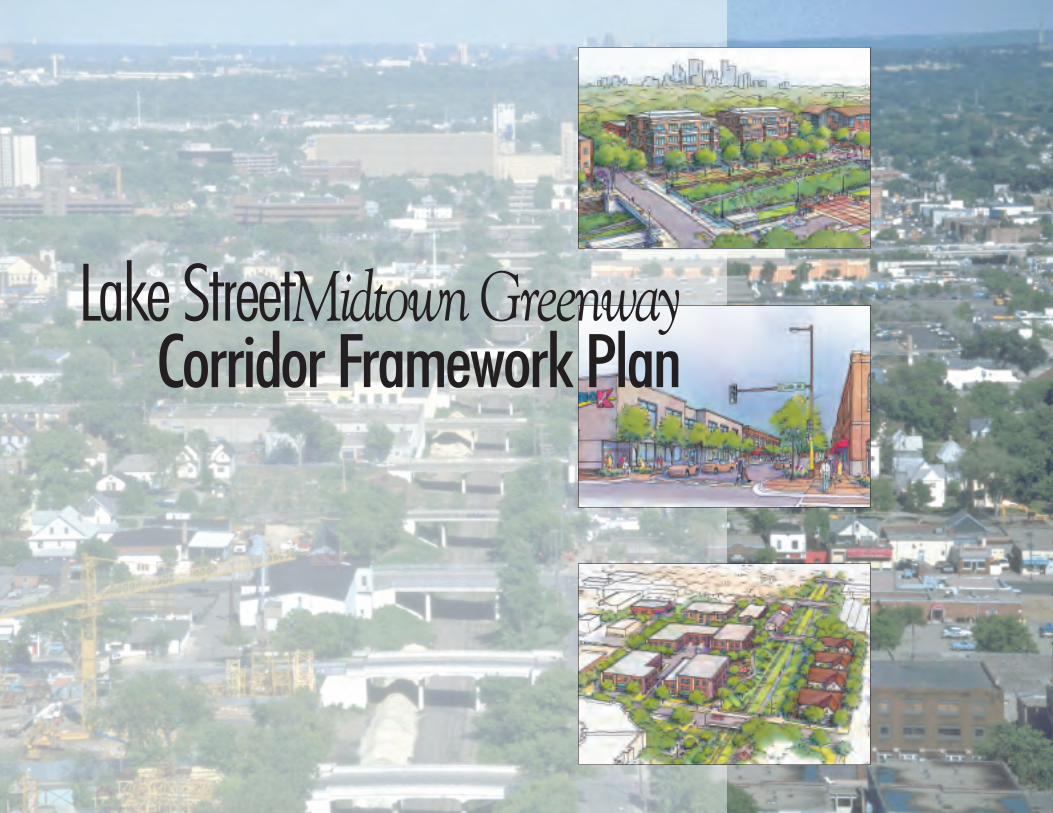
Lake StreetMidtown GreenwayCorridor Framework Plan

Lake Street Midtown Greenway Framework PlanPlacemaking and Connectionsii
Lake Street Midtown Greenway Framework PlanPlacemaking and Connections
iii
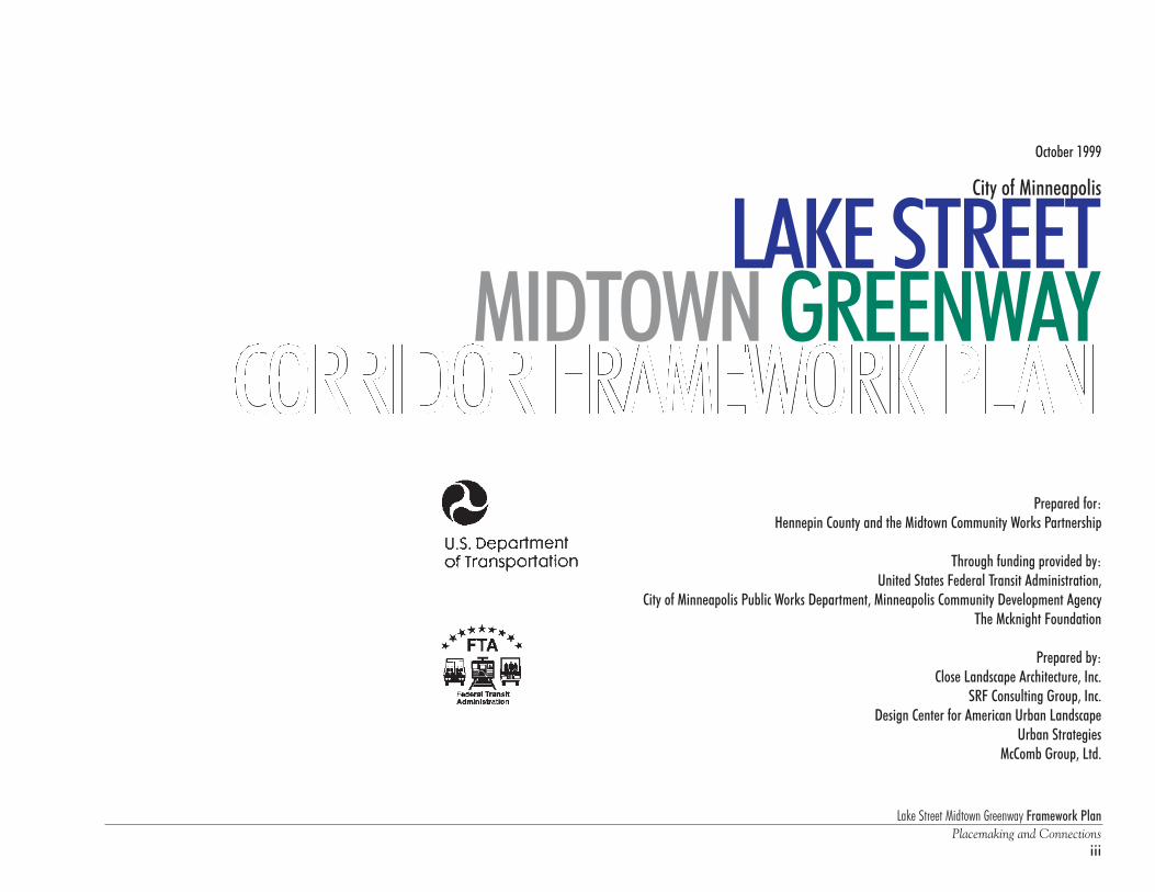
City of Minneapolis
LAKE STREETMIDTOWN GREENWAY
Prepared for:Hennepin County and the Midtown Community Works Partnership
Through funding provided by:United States Federal Transit Administration,
City of Minneapolis Public Works Department, Minneapolis Community Development AgencyThe Mcknight Foundation
Prepared by:Close Landscape Architecture, Inc.
SRF Consulting Group, Inc.Design Center for American Urban Landscape
Urban StrategiesMcComb Group, Ltd.
October 1999

Lake Street Midtown Greenway Framework PlanPlacemaking and Connectionsiv
Lake Street Midtown Greenway Framework PlanPlacemaking and Connections
v
Table of ContentsLake Street Midtown Greenway Corridor Framework Plan
Acknowledgements and Framework Overview
Chapter 1 The Lake Street Midtown Greenway Corridor
Chapter 2 A Bridge to Marketplaces, Neighborhoods and Nature
Chapter 3 Planning Principles and Design Guidelines
Chapter 4 Placemaking: Focus Area Recommendations
Chapter 5 Connections: Transit, Infrastructure and Open Space
Chapter 6 Implementation: Getting Things Done!
Appendix
Hennepin CountyCity of MinneapolisMidtown Community Works Partnership
The Midtown Community Works Technical Advisory Committee
Private Sector Business/Institutional LeadersNeighborhood Groups
• West Calhoun Neighborhood Council• Whittier Alliance - South Whittier Redevelopment Task Force• Phillips Community Development Corporation and District One• Central Neighborhood Improvement Association• Corcoran Neighborhood Association• Longfellow Community Council• Powderhorn Park Neighborhood Association
Locally Based Groups• Lake Street Partners• Lake Street Council• Midtown Greenway Coalition• FORECAST Public Artworks• Urban Ventures
Consultant Team• Dewar & Associates, Inc.• Smith Parker, PLLP• George Sutton
Framework Study Team• Close Landscape Architecture• SRF Consulting Group, Inc.• Design Center for American Urban Landscape• Urban Strategies, Inc.• McComb Group, Ltd.
Layout and Production• Anne Rykken
Corridor Illustrations (Chapter 4)• Janet Lawson
Lake Street Midtown Greenway Framework PlanPlacemaking and Connectionsvi
AcknowledgementsWe gratefully acknowledge the assistance of the following agencies, groups and individuals in the preparation of this document:
Hennepin County CommissionersCommissioner Randy Johnson, ChairCommissioner Peter McLaughlinCommissioner Gail DorfmanMayor of MinneapolisMayor Sharon Sayles BeltonMinneapolis City Council mem-bersCouncil Member Brian HerronCouncil Member Lisa McDonaldCouncil Member Jim NilandCouncil Member Kathy ThurberMetropolitan CouncilTed Mondale, ChairAllina Health SystemGordon Sprenger, Executive OfficerDayton HudsonNate Garvis, Vice PresidentGovernment AffairsFannie MaeGloria Bostrum, Director
Minnesota Partnership OfficeHoneywellGlenn Skovholt, Vice PresidentLISCPaul Williams, Senior Program DirectorMpls. St. Paul Magazine Burt Cohen, President and PublisherNorwest BankJim Campbell, Chair and CEON S PTom Micheletti, Vice PresidentReliant Energy MinnegascoGary Cerny, President and CEOTCFWilliam Dove, Vice PresidentTCF Financial CorporationUS BankRobert Sznewajs, Vice ChairmanWCCO-TVJan McDaniel, General Manager
Hennepin CountyLarry BlackstadGary EricksonCarol LezotteDean Michalko
M C D ARobert ChongSteve Cramer
Midtown Greenway CoalitionTim Springer
Minneapolis Planning DepartmentChuck BallentineAmy TibbsMinneapolis Department of PublicWorksJohn HotvedtJon WertjesMinneapolis Mayor’s OfficeRon Thaniel
Metropolitan CouncilCraig Rapp
Lake Street Midtown Greenway Framework PlanPlacemaking and Connections
vii
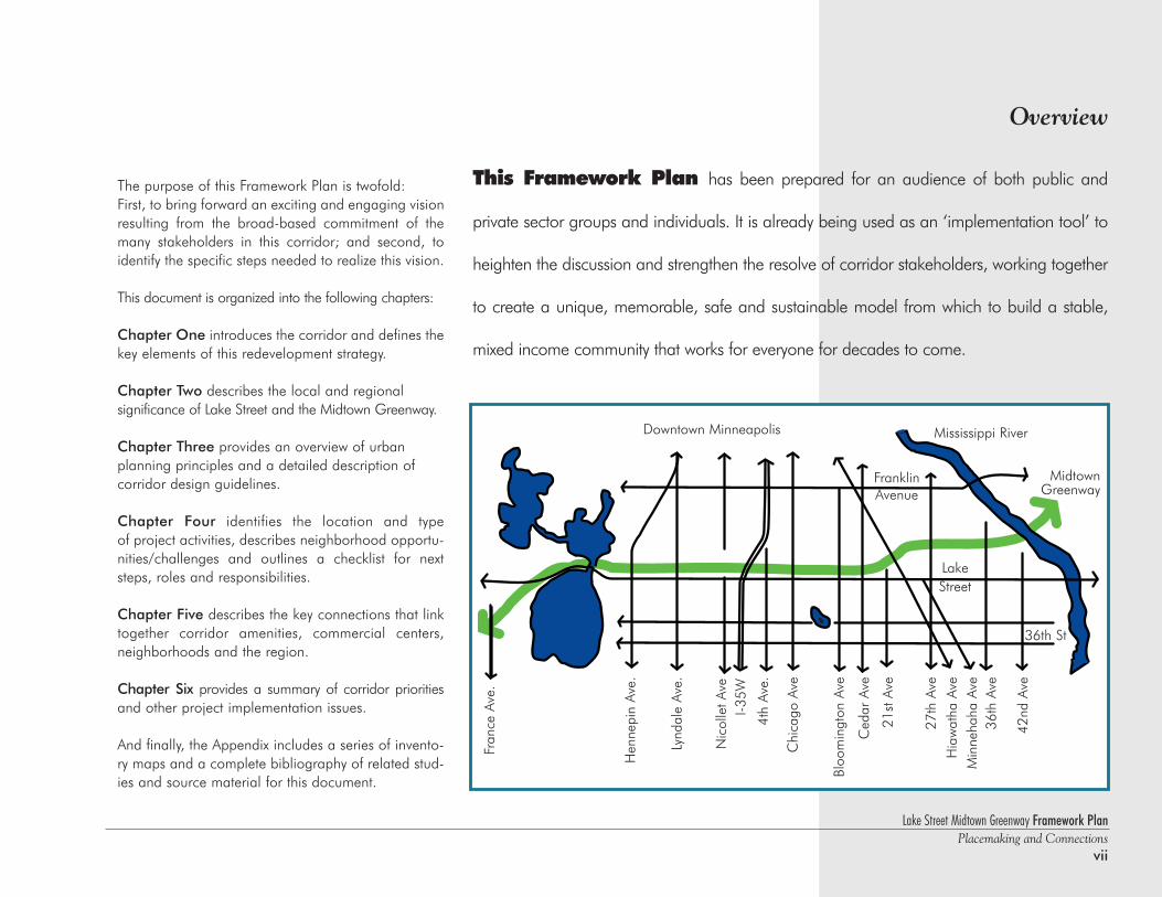
The purpose of this Framework Plan is twofold:First, to bring forward an exciting and engaging visionresulting from the broad-based commitment of themany stakeholders in this corridor; and second, toidentify the specific steps needed to realize this vision.
This document is organized into the following chapters:
Chapter One introduces the corridor and defines thekey elements of this redevelopment strategy.
Chapter Two describes the local and regional significance of Lake Street and the Midtown Greenway.
Chapter Three provides an overview of urban planning principles and a detailed description of corridor design guidelines.
Chapter Four identifies the location and type of project activities, describes neighborhood opportu-nities/challenges and outlines a checklist for nextsteps, roles and responsibilities.
Chapter Five describes the key connections that linktogether corridor amenities, commercial centers,neighborhoods and the region.
Chapter Six provides a summary of corridor prioritiesand other project implementation issues.
And finally, the Appendix includes a series of invento-ry maps and a complete bibliography of related stud-ies and source material for this document.
Fran
ce A
ve.
Hen
nepi
n Av
e.
Lynd
ale
Ave.
Nic
olle
t Ave
I-35W
4th
Ave.
Chi
cago
Ave
Bloo
min
gton
Ave
Ced
ar A
ve
21st
Ave
27th
Ave
Hia
wat
ha A
veM
inne
haha
Ave
36th
Ave
42nd
Ave
Downtown Minneapolis
36th St
Lake Street
FranklinAvenue
Mississippi River
MidtownGreenway
This Framework Plan has been prepared for an audience of both public and
private sector groups and individuals. It is already being used as an ‘implementation tool’ to
heighten the discussion and strengthen the resolve of corridor stakeholders, working together
to create a unique, memorable, safe and sustainable model from which to build a stable,
mixed income community that works for everyone for decades to come.
Overview
Lake Street Midtown Greenway Framework PlanPlacemaking and Connectionsviii
frame•work \Ifram-Iwerk\ n(1644) 1 a: abasic conceptual structure (as of ideas)<the ~ of the constitution> b: a skeletal,openwork, or structural frame 2:FRAME OFREFERENCE 3: the larger branches of a treethat determine its shape
Lake Street Midtown Greenway Framework PlanPlacemaking and Connections
1
Chapter 1The Lake Street Midtown Greenway Corridor
IntroductionThe vision for the Lake Street Midtown Greenway Corridor articulated in this Framework is one of opportunity andreinvestment - revitalizing this once thriving commercial/business center into a major neighborhood and regionalamenity.
At the core of this revitalization effort is the significance of ‘place.’ Most people recognize the beauty andvalue of the Chain of Lakes and the Mississippi River as places of inspiration, recreation and celebration. But manyare unaware of the rich history of Lake Street and the abandoned rail corridor that runs parallel to it. People mayvisit Uptown or the shops and restaurants at Lyndale and Lake, but the huge potential and unique character of therest of the corridor have gone largely unnoticed . . . until recently!
This Framework serves to vocalize and catalyze a shared vision for development within and around thiscorridor. Building on the efforts of political and business leadership along with numerous neighborhood groupsand organizations who are pursuing a variety of ongoing project initiatives, this opportunity is too great to miss.With the newly formed Midtown Community Works Partnership (initiated in January 1998), composed of electedofficials from City and County government joined by CEO's from many major corporations and institutions, a clarity of purpose and a plan for action is emerging. But the challenge is in how to tell this story, how to reach awide and very mixed audience - how to capture the imagination, energy and commitment needed to turn plansinto projects and dreams into reality.
This Framework Plan recognizes and incorporates the conclusions and recommendations contained inthe many existing planning studies already completed as the foundation for the work ahead. From anurban design perspective, we can look back into the past to understand what made cities great and then reachinto the future to embrace new technologies and the creative partnerships needed to get things done. By applyingwhat we learn, we can build safe communities in which to raise families, find a living wage job and develop placesfor recreation and recharge.
The focus of this work is on ‘placemaking and connections’ . . . to provide an environment for both existingneighborhoods and new development opportunities that attaches a high value on the public realm. It is about creating places that are unique, identifiable and memorable - places that are worthy of our affection - encouraginga strong sense of community, a pride of ownership and responsibility to be carried forward for future generations.
Lake Street Midtown Greenway Framework PlanPlacemaking and Connections2
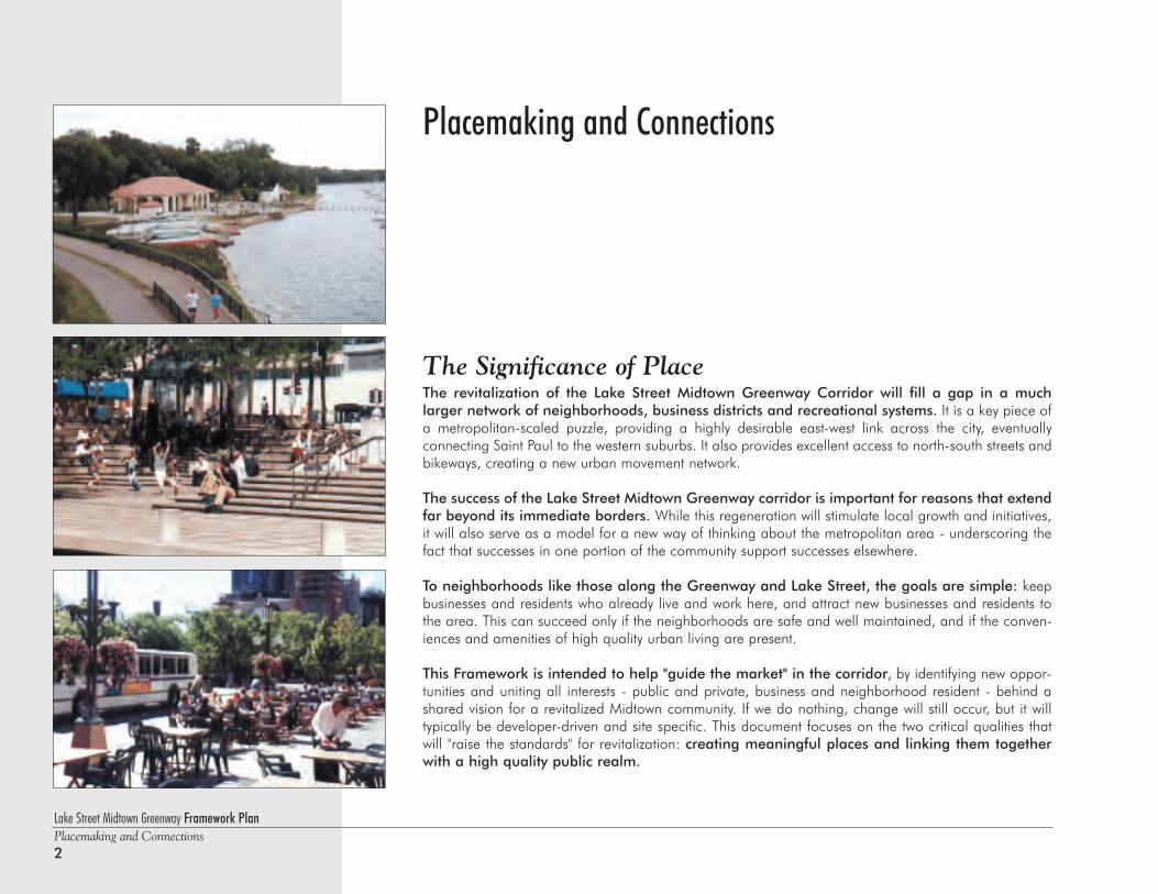
Placemaking and Connections
The Significance of PlaceThe revitalization of the Lake Street Midtown Greenway Corridor will fill a gap in a much larger network of neighborhoods, business districts and recreational systems. It is a key piece ofa metropolitan-scaled puzzle, providing a highly desirable east-west link across the city, eventuallyconnecting Saint Paul to the western suburbs. It also provides excellent access to north-south streets andbikeways, creating a new urban movement network.
The success of the Lake Street Midtown Greenway corridor is important for reasons that extendfar beyond its immediate borders. While this regeneration will stimulate local growth and initiatives,it will also serve as a model for a new way of thinking about the metropolitan area - underscoring thefact that successes in one portion of the community support successes elsewhere.
To neighborhoods like those along the Greenway and Lake Street, the goals are simple: keepbusinesses and residents who already live and work here, and attract new businesses and residents tothe area. This can succeed only if the neighborhoods are safe and well maintained, and if the conven-iences and amenities of high quality urban living are present.
This Framework is intended to help "guide the market" in the corridor, by identifying new oppor-tunities and uniting all interests - public and private, business and neighborhood resident - behind ashared vision for a revitalized Midtown community. If we do nothing, change will still occur, but it willtypically be developer-driven and site specific. This document focuses on the two critical qualities thatwill "raise the standards" for revitalization: creating meaningful places and linking them togetherwith a high quality public realm.
Lake Street Midtown Greenway Framework PlanPlacemaking and Connections
3
Hennepin Avenue Lyndale AvenueNicollet Avenue
Activity Node
Commercial Center
29th Street
Commercial Center
Greenway Access
Activity Node
Adjacent Neighborhoods Adjacent Neighborhoods
Adjacent Neighborhoods Adjacent Neighborhoods
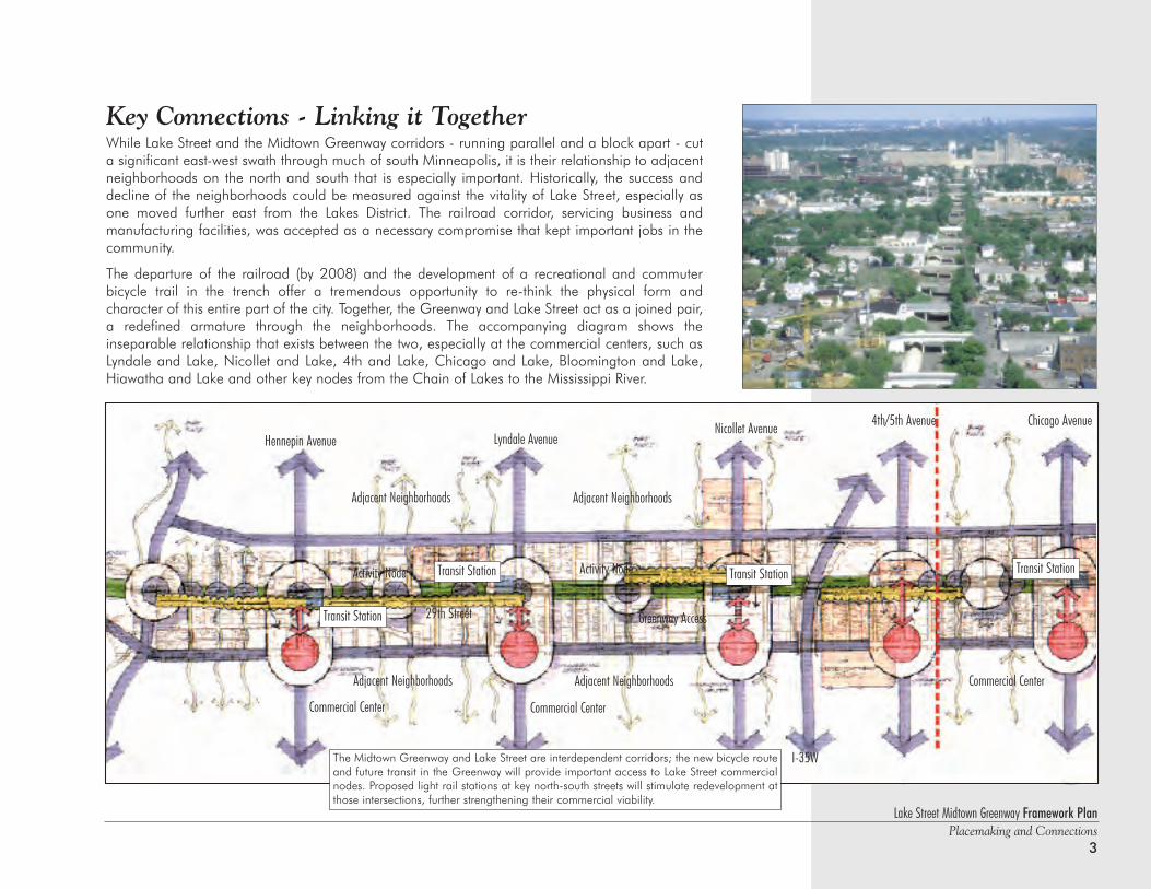
Key Connections - Linking it TogetherWhile Lake Street and the Midtown Greenway corridors - running parallel and a block apart - cuta significant east-west swath through much of south Minneapolis, it is their relationship to adjacentneighborhoods on the north and south that is especially important. Historically, the success anddecline of the neighborhoods could be measured against the vitality of Lake Street, especially asone moved further east from the Lakes District. The railroad corridor, servicing business and manufacturing facilities, was accepted as a necessary compromise that kept important jobs in thecommunity.
The departure of the railroad (by 2008) and the development of a recreational and commuter bicycle trail in the trench offer a tremendous opportunity to re-think the physical form and character of this entire part of the city. Together, the Greenway and Lake Street act as a joined pair,a redefined armature through the neighborhoods. The accompanying diagram shows the inseparable relationship that exists between the two, especially at the commercial centers, such asLyndale and Lake, Nicollet and Lake, 4th and Lake, Chicago and Lake, Bloomington and Lake,Hiawatha and Lake and other key nodes from the Chain of Lakes to the Mississippi River.
4th/5th Avenue Chicago Avenue
I-35W
Commercial Center
Transit Station
The Midtown Greenway and Lake Street are interdependent corridors; the new bicycle routeand future transit in the Greenway will provide important access to Lake Street commercialnodes. Proposed light rail stations at key north-south streets will stimulate redevelopment atthose intersections, further strengthening their commercial viability.
Transit Station Transit Station Transit Station
Lake Street Midtown Greenway Framework PlanPlacemaking and Connections4
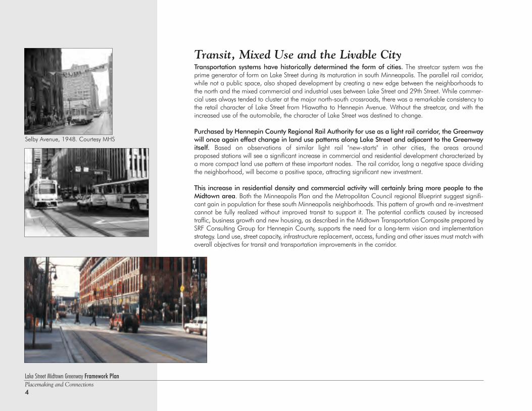
Transit, Mixed Use and the Livable CityTransportation systems have historically determined the form of cities. The streetcar system was theprime generator of form on Lake Street during its maturation in south Minneapolis. The parallel rail corridor,while not a public space, also shaped development by creating a new edge between the neighborhoods tothe north and the mixed commercial and industrial uses between Lake Street and 29th Street. While commer-cial uses always tended to cluster at the major north-south crossroads, there was a remarkable consistency tothe retail character of Lake Street from Hiawatha to Hennepin Avenue. Without the streetcar, and with theincreased use of the automobile, the character of Lake Street was destined to change.
Purchased by Hennepin County Regional Rail Authority for use as a light rail corridor, the Greenwaywill once again effect change in land use patterns along Lake Street and adjacent to the Greenwayitself. Based on observations of similar light rail "new-starts" in other cities, the areas around proposed stations will see a significant increase in commercial and residential development characterized bya more compact land use pattern at these important nodes. The rail corridor, long a negative space dividingthe neighborhood, will become a positive space, attracting significant new investment.
This increase in residential density and commercial activity will certainly bring more people to theMidtown area. Both the Minneapolis Plan and the Metropolitan Council regional Blueprint suggest signifi-cant gain in population for these south Minneapolis neighborhoods. This pattern of growth and re-investmentcannot be fully realized without improved transit to support it. The potential conflicts caused by increased traffic, business growth and new housing, as described in the Midtown Transportation Composite prepared bySRF Consulting Group for Hennepin County, supports the need for a long-term vision and implementationstrategy. Land use, street capacity, infrastructure replacement, access, funding and other issues must match withoverall objectives for transit and transportation improvements in the corridor.
Selby Avenue, 1948. Courtesy MHS
Lake Street Midtown Greenway Framework PlanPlacemaking and Connections
5
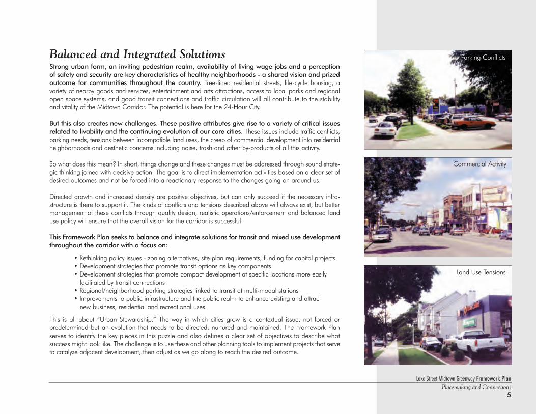
Balanced and Integrated SolutionsStrong urban form, an inviting pedestrian realm, availability of living wage jobs and a perceptionof safety and security are key characteristics of healthy neighborhoods - a shared vision and prizedoutcome for communities throughout the country. Tree-lined residential streets, life-cycle housing, a variety of nearby goods and services, entertainment and arts attractions, access to local parks and regionalopen space systems, and good transit connections and traffic circulation will all contribute to the stability and vitality of the Midtown Corridor. The potential is here for the 24-Hour City.
But this also creates new challenges. These positive attributes give rise to a variety of critical issuesrelated to livability and the continuing evolution of our core cities. These issues include traffic conflicts,parking needs, tensions between incompatible land uses, the creep of commercial development into residentialneighborhoods and aesthetic concerns including noise, trash and other by-products of all this activity.
So what does this mean? In short, things change and these changes must be addressed through sound strate-gic thinking joined with decisive action. The goal is to direct implementation activities based on a clear set ofdesired outcomes and not be forced into a reactionary response to the changes going on around us.
Directed growth and increased density are positive objectives, but can only succeed if the necessary infra-structure is there to support it. The kinds of conflicts and tensions described above will always exist, but bettermanagement of these conflicts through quality design, realistic operations/enforcement and balanced landuse policy will ensure that the overall vision for the corridor is successful.
This Framework Plan seeks to balance and integrate solutions for transit and mixed use developmentthroughout the corridor with a focus on:
• Rethinking policy issues - zoning alternatives, site plan requirements, funding for capital projects• Development strategies that promote transit options as key components• Development strategies that promote compact development at specific locations more easily
facilitated by transit connections• Regional/neighborhood parking strategies linked to transit at multi-modal stations• Improvements to public infrastructure and the public realm to enhance existing and attract
new business, residential and recreational uses.
This is all about “Urban Stewardship.” The way in which cities grow is a contextual issue, not forced or predetermined but an evolution that needs to be directed, nurtured and maintained. The Framework Planserves to identify the key pieces in this puzzle and also defines a clear set of objectives to describe whatsuccess might look like. The challenge is to use these and other planning tools to implement projects that serveto catalyze adjacent development, then adjust as we go along to reach the desired outcome.
Parking Conflicts
Commercial Activity
Land Use Tensions
Lake Street Midtown Greenway Framework PlanPlacemaking and Connections6
Courtesy Hennepin County Historical Society
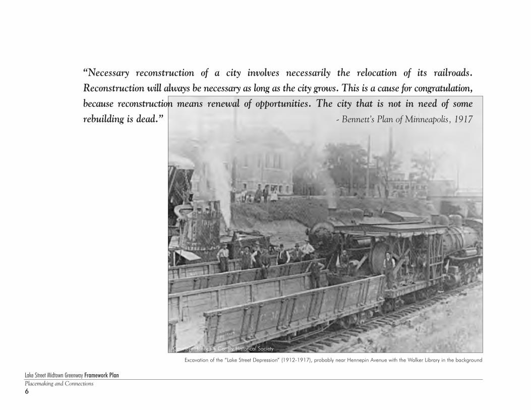
Excavation of the “Lake Street Depression” (1912-1917), probably near Hennepin Avenue with the Walker Library in the background
“Necessary reconstruction of a city involves necessarily the relocation of its railroads.Reconstruction will always be necessary as long as the city grows. This is a cause for congratulation,because reconstruction means renewal of opportunities. The city that is not in need of somerebuilding is dead.” - Bennett’s Plan of Minneapolis, 1917
Lake Street Midtown Greenway Framework PlanPlacemaking and Connections
7
IntroductionThe magic of the Lake Street Midtown Greenway lies in its transformationfrom a utilitarian linear service district and railroad line into an activepublic space and recreational amenity. This remarkable change creates newmarketplaces, enhanced central city neighborhoods and enriched natural systems while bridging across two critical scales of community:
• Locally, the Greenway will stimulate neighborhood economic, social and environmental revitalization.
• On the metropolitan scale, this rejuvenated section of the city will provide a new regional marketplace, as well as residential options and amenities.
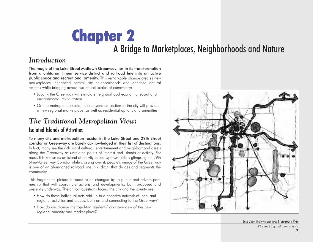
The Traditional Metropolitan View: Isolated Islands of ActivitiesTo many city and metropolitan residents, the Lake Street and 29th Street corridor or Greenway are barely acknowledged in their list of destinations.In fact, many see the rich list of cultural, entertainment and neighborhood assetsalong the Greenway as unrelated points of interest and islands of activity. Formost, it is known as an island of activity called Uptown. Briefly glimpsing the 29thStreet/Greenway Corridor while crossing over it, people’s image of the Greenwayis one of an abandoned railroad line in a ditch, that divides and segments thecommunity.
This fragmented picture is about to be changed by a public and private part-nership that will coordinate actions and developments, both proposed andpresently underway. The critical questions facing the city and the county are:
• How do these individual acts add up to a cohesive network of local and regional activities and places, both on and connecting to the Greenway?
• How do we change metropolitan residents’ cognitive view of this new regional amenity and market place?
A Bridge to Marketplaces, Neighborhoods and NatureChapter 2
Lake Street Midtown Greenway Framework PlanPlacemaking and Connections8
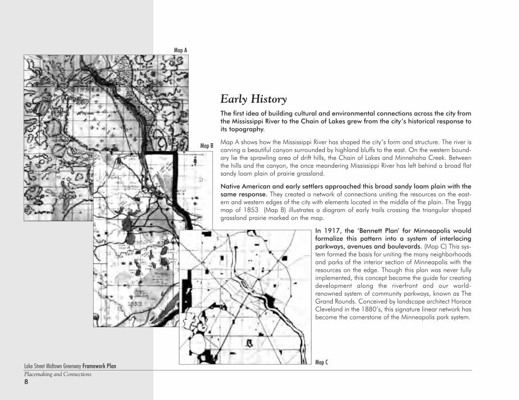
Early HistoryThe first idea of building cultural and environmental connections across the city fromthe Mississippi River to the Chain of Lakes grew from the city’s historical response toits topography.
Map A shows how the Mississippi River has shaped the city’s form and structure. The river iscarving a beautiful canyon surrounded by highland bluffs to the east. On the western bound-ary lie the sprawling area of drift hills, the Chain of Lakes and Minnehaha Creek. Betweenthe hills and the canyon, the once meandering Mississippi River has left behind a broad flatsandy loam plain of prairie grassland.
Native American and early settlers approached this broad sandy loam plain with thesame response. They created a network of connections uniting the resources on the east-ern and western edges of the city with elements located in the middle of the plain. The Tryggmap of 1853 (Map B) illustrates a diagram of early trails crossing the triangular shapedgrassland prairie marked on the map.
In 1917, the ‘Bennett Plan’ for Minneapolis wouldformalize this pattern into a system of interlacingparkways, avenues and boulevards. (Map C) This sys-tem formed the basis for uniting the many neighborhoodsand parks of the interior section of Minneapolis with theresources on the edge. Though this plan was never fullyimplemented, this concept became the guide for creatingdevelopment along the riverfront and our world-renowned system of community parkways, known as TheGrand Rounds. Conceived by landscape architect HoraceCleveland in the 1880’s, this signature linear network hasbecome the cornerstone of the Minneapolis park system.
Map A
Map C
Map B
Lake Street Midtown Greenway Framework PlanPlacemaking and Connections
9
Emerging Metropolitan Views
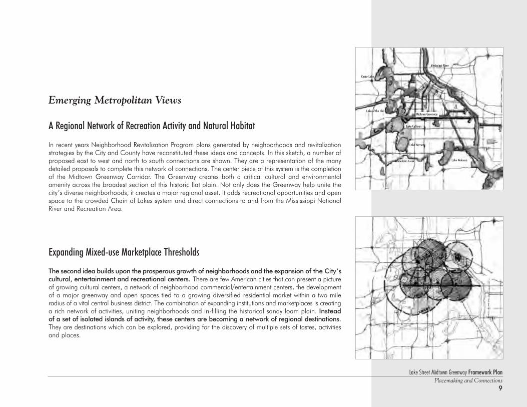
A Regional Network of Recreation Activity and Natural Habitat
In recent years Neighborhood Revitalization Program plans generated by neighborhoods and revitalizationstrategies by the City and County have reconstituted these ideas and concepts. In this sketch, a number ofproposed east to west and north to south connections are shown. They are a representation of the manydetailed proposals to complete this network of connections. The center piece of this system is the completionof the Midtown Greenway Corridor. The Greenway creates both a critical cultural and environmentalamenity across the broadest section of this historic flat plain. Not only does the Greenway help unite thecity’s diverse neighborhoods, it creates a major regional asset. It adds recreational opportunities and openspace to the crowded Chain of Lakes system and direct connections to and from the Mississippi NationalRiver and Recreation Area.
Expanding Mixed-use Marketplace Thresholds
The second idea builds upon the prosperous growth of neighborhoods and the expansion of the City’scultural, entertainment and recreational centers. There are few American cities that can present a pictureof growing cultural centers, a network of neighborhood commercial/entertainment centers, the developmentof a major greenway and open spaces tied to a growing diversified residential market within a two mileradius of a vital central business district. The combination of expanding institutions and marketplaces is creatinga rich network of activities, uniting neighborhoods and in-filling the historical sandy loam plain. Insteadof a set of isolated islands of activity, these centers are becoming a network of regional destinations.They are destinations which can be explored, providing for the discovery of multiple sets of tastes, activitiesand places.
Cedar Lake
Lake of the Isles
Lake NokomisMinnehaha Creek
Lake Harriet
Mississippi River
Midtown Greenway
Lake Calhoun
Lake Street Midtown Greenway Framework PlanPlacemaking and Connections10
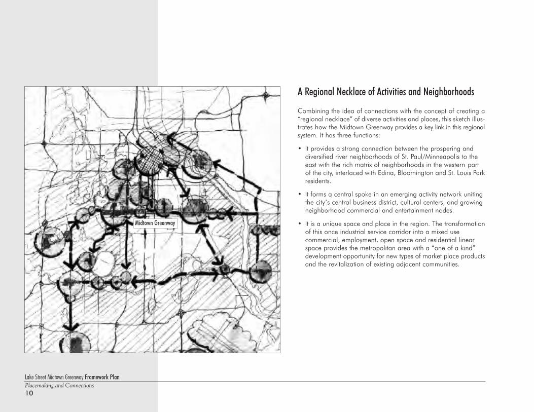
A Regional Necklace of Activities and Neighborhoods
Combining the idea of connections with the concept of creating a“regional necklace” of diverse activities and places, this sketch illus-trates how the Midtown Greenway provides a key link in this regionalsystem. It has three functions:
• It provides a strong connection between the prospering and diversified river neighborhoods of St. Paul/Minneapolis to the east with the rich matrix of neighborhoods in the western part of the city, interlaced with Edina, Bloomington and St. Louis Parkresidents.
• It forms a central spoke in an emerging activity network uniting the city’s central business district, cultural centers, and growing neighborhood commercial and entertainment nodes.
• It is a unique space and place in the region. The transformationof this once industrial service corridor into a mixed use commercial, employment, open space and residential linear space provides the metropolitan area with a “one of a kind” development opportunity for new types of market place productsand the revitalization of existing adjacent communities.
Midtown Greenway
Lake Street Midtown Greenway Framework PlanPlacemaking and Connections
11
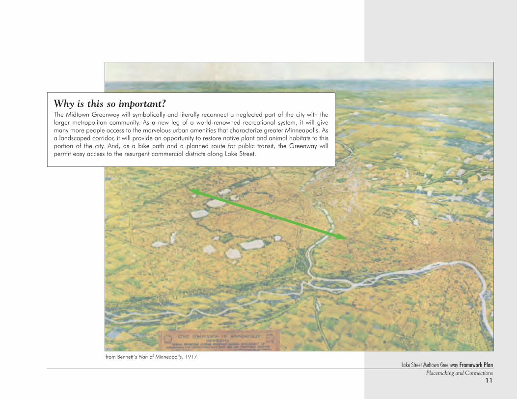
Why is this so important?The Midtown Greenway will symbolically and literally reconnect a neglected part of the city with thelarger metropolitan community. As a new leg of a world-renowned recreational system, it will givemany more people access to the marvelous urban amenities that characterize greater Minneapolis. Asa landscaped corridor, it will provide an opportunity to restore native plant and animal habitats to thisportion of the city. And, as a bike path and a planned route for public transit, the Greenway will permit easy access to the resurgent commercial districts along Lake Street.
from Bennett’s Plan of Minneapolis, 1917
Lake Street Midtown Greenway Framework PlanPlacemaking and Connections12
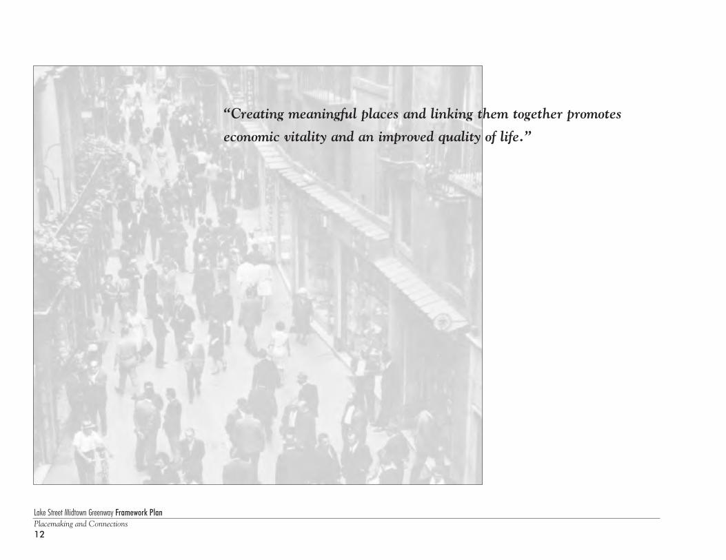
“Creating meaningful places and linking them together promotes
economic vitality and an improved quality of life.”
Lake Street Midtown Greenway Framework PlanPlacemaking and Connections
13
Introduction - The Framework PlanPlanning is a process, not a product. A "master plan" is a snapshot in time, and if too prescriptive, it quickly finds its way to the bookshelf. This document isintended to be a flexible “framework” to help civic and political leaders, developers and stakeholders form educated, appropriate decisions about how thisurban corridor can and should be enhanced and redeveloped.
The Framework Plan is intended to educate and inform people about the qualities that contribute to good urban places. It seeks to bring focus tothe unique opportunities that exist throughout the Lake Street Midtown Greenway Corridor. It also identifies the primary obstacles to successful redevelopment and sets forth a series of guidelines specific to these linked south-side neighborhoods. Above all, it stresses the importance of connecting individual projects together with a high quality public realm to expand the impact of each investment and to strengthen the quality and livability of the entirecommunity.
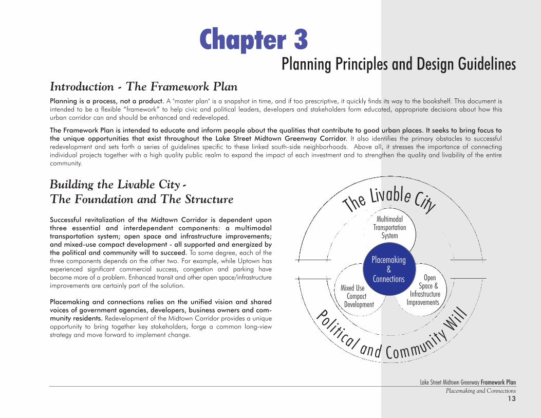
Building the Livable City - The Foundation and The Structure
Successful revitalization of the Midtown Corridor is dependent uponthree essential and interdependent components: a multimodal transportation system; open space and infrastructure improvements;and mixed-use compact development - all supported and energized bythe political and community will to succeed. To some degree, each of thethree components depends on the other two. For example, while Uptown hasexperienced significant commercial success, congestion and parking havebecome more of a problem. Enhanced transit and other open space/infrastructureimprovements are certainly part of the solution.
Placemaking and connections relies on the unified vision and sharedvoices of government agencies, developers, business owners and com-munity residents. Redevelopment of the Midtown Corridor provides a uniqueopportunity to bring together key stakeholders, forge a common long-viewstrategy and move forward to implement change.
Chapter 3Planning Principles and Design Guidelines
The Livable City
Pol i t i ca l and Community
Wi l l
MultimodalTransportation
System
Mixed Use Compact
Development
OpenSpace &
InfrastructureImprovements
Placemaking &
Connections
Lake Street Midtown Greenway Framework PlanPlacemaking and Connections14
Urban Planning Principles - Economic Vitality and Quality of LifeFor several decades portions of the Midtown Corridor have been perceived as places in decline,suffering from disconnection and disinvestment. This reputation lowered land values, which eventu-ally lured new pioneers to invest in the community and brought new - if modest - stability to the area. As is com-mon with the evolution of urban neighborhoods, those areas experiencing the greatest crisis are often thesame areas where dramatic change can occur. It is sometimes as simple as changing perceptions.
The following guiding principles were developed early in this planning process, providing afoundation for the Framework Plan:
Reinforce safe environments Providing an engaging and safe place for people to live, work, shop and play is essential to this entireeffort and requires the transformation of real and perceived negatives - physical, economic and social - into positives.
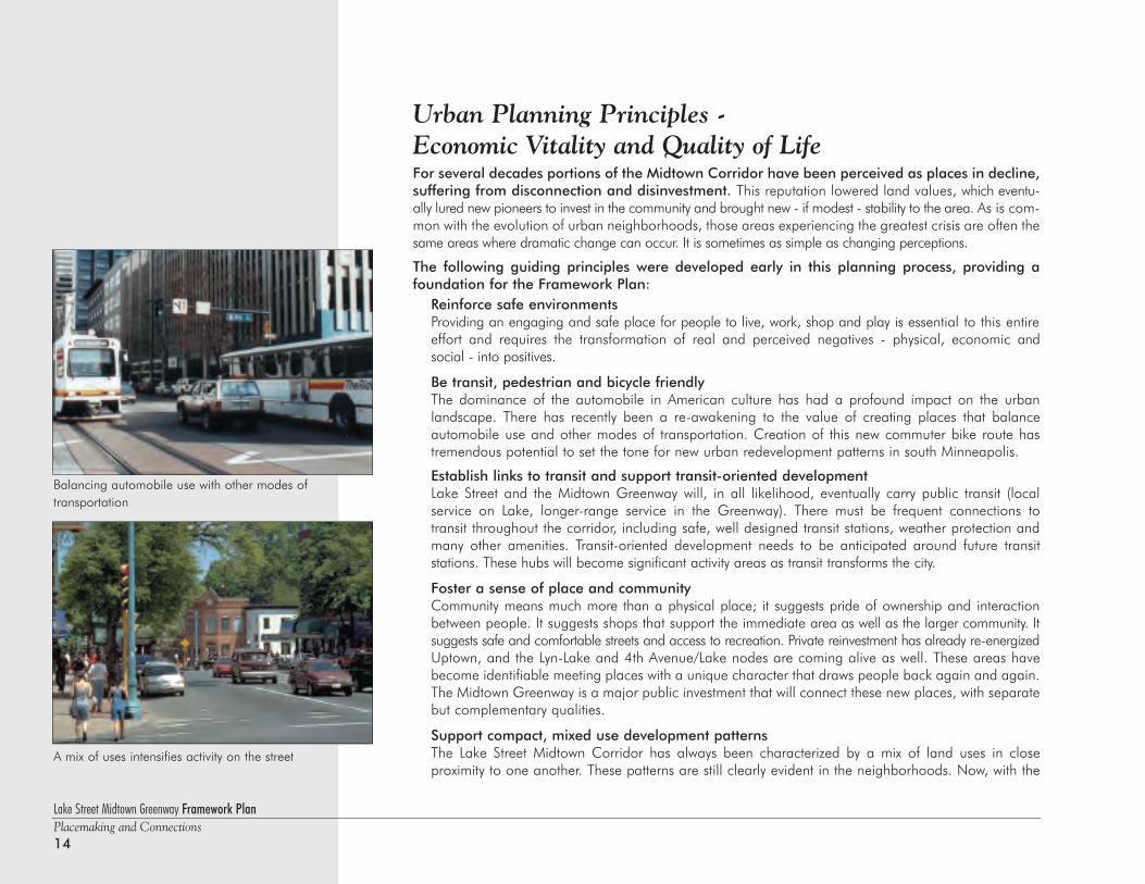
Be transit, pedestrian and bicycle friendlyThe dominance of the automobile in American culture has had a profound impact on the urban landscape. There has recently been a re-awakening to the value of creating places that balance automobile use and other modes of transportation. Creation of this new commuter bike route hastremendous potential to set the tone for new urban redevelopment patterns in south Minneapolis.
Establish links to transit and support transit-oriented developmentLake Street and the Midtown Greenway will, in all likelihood, eventually carry public transit (local service on Lake, longer-range service in the Greenway). There must be frequent connections to transit throughout the corridor, including safe, well designed transit stations, weather protection andmany other amenities. Transit-oriented development needs to be anticipated around future transit stations. These hubs will become significant activity areas as transit transforms the city.
Foster a sense of place and community Community means much more than a physical place; it suggests pride of ownership and interactionbetween people. It suggests shops that support the immediate area as well as the larger community. Itsuggests safe and comfortable streets and access to recreation. Private reinvestment has already re-energizedUptown, and the Lyn-Lake and 4th Avenue/Lake nodes are coming alive as well. These areas havebecome identifiable meeting places with a unique character that draws people back again and again.The Midtown Greenway is a major public investment that will connect these new places, with separatebut complementary qualities.
Support compact, mixed use development patternsThe Lake Street Midtown Corridor has always been characterized by a mix of land uses in close proximity to one another. These patterns are still clearly evident in the neighborhoods. Now, with the
A mix of uses intensifies activity on the street
Balancing automobile use with other modes of transportation
Lake Street Midtown Greenway Framework PlanPlacemaking and Connections
15
consolidation of commercial uses at the major nodes and the promotion of 29th Street andthe Greenway as a front door rather than a service door, the patterns of use will change. Still,the mix of uses should be strengthened and, over time, intensified. This should be most apparentwith new compact development, including mixed income and multi-family housing and business growth between Lake Street and the Greenway.
Respect architectural form, scale and contextMany traditional architectural forms remain along Lake Street and in the neighborhoods. Twoto three story commercial buildings give Lake Street its sense of containment and character.Old, three story walk-up apartments and turn of the century housing reflect the familiarMinneapolis patterns. While it need not replicate older models, new architecture should echothe scale and character of the traditional neighborhoods.
Incorporate environmentally sustainable practicesAll matters of sustainability, from stormwater management to the use of recycled materials andthe development of “healthy homes" and "green architecture," should be practiced in the corridor to further the area as a model for appropriate contemporary urban revitalization.
Support ‘greening’ as a key component of corridor development projectsAll development and infrastructure improvements should incorporate a strong greening/publicrealm component. A linked network of open space and dedicated public parks will contributeimmeasurably to the quality of life for residents, businesses and visitors in adjacent neighborhoods.The revitalization of this corridor must also provide improved access and connections to the Greenway, to existing parks and to regional recreational systems throughoutthe Twin Cities.
Balance economic vitality with quality of lifeSuccessful urban environments consist of a mix of land uses, housing options, job opportunitiesand transit. Economic vitality must be reinforced throughout the corridor by promoting a balance of life-cycle housing, business development and recreational and “greening” opportunities, co-existing in close proximity to create thriving, safe and stable neighborhoods.
Target strategic public improvements to leverage private investmentSignificant public investment has been targeted toward this corridor including infrastructureand streetscape improvements, environmental clean-up, and land assembly activities. Privatedevelopment often follows the lead of these public improvement projects. It is crucial that theCity and County continue to join forces with private investors to more effectively identify keydevelopment sites and other opportunities to maximize investment decisions in support of thedevelopment strategies outlined in this framework plan.
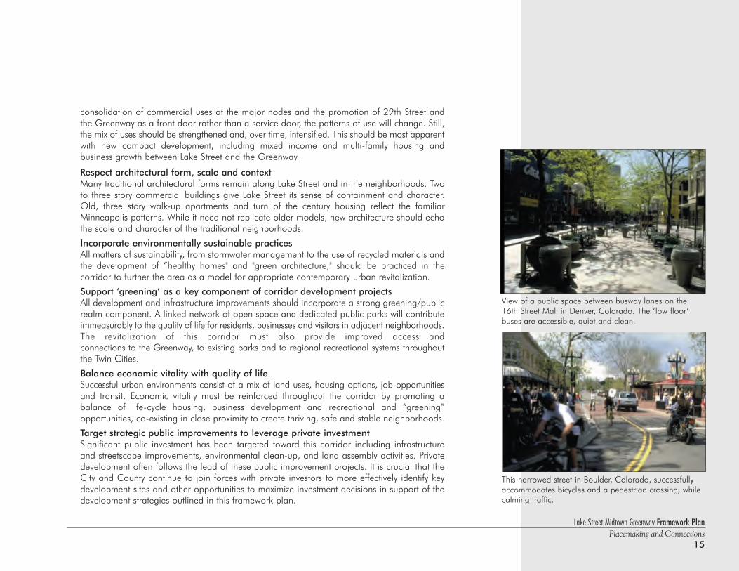
This narrowed street in Boulder, Colorado, successfullyaccommodates bicycles and a pedestrian crossing, whilecalming traffic.
View of a public space between busway lanes on the16th Street Mall in Denver, Colorado. The ‘low floor’buses are accessible, quiet and clean.
Lake Street Midtown Greenway Framework PlanPlacemaking and Connections16
Corridor Design Guidelines - Promoting Placemaking and ConnectionsThe guidelines that follow were developed in response to the specific issues that face theseurban neighborhoods as redevelopment occurs. They call for a new vision for the corridor and adja-cent areas, but reflect an understanding of the deeply ingrained development patterns that exist adjacentto the Greenway. First and foremost, they support the concepts of placemaking and connection, whichare the building blocks for successful revitalization of the corridor.
The Guidelines:1 Promote an integrated relationship between new development and the Greenway edge. Make the
corridor “Greenway friendly.”
2 Promote opportunities for additional public green space, dedicated parks and trail connections along the Greenway edge.
3 Develop a premier public edge along both sides of the greenway, including 29th Street on the south side and a public promenade on the north.
4 Promote development that reinforces and relates to adjacent land uses and appropriate architectural scale, particularly along Lake and Lagoon Streets and at commercial nodes.
5 Locate front doors on the street, (including 29th Street and the Greenway) and relocate service doors,away from the public realm.
6 Promote safe, calmed streets with widened sidewalks. Focus investments toward developing an enlivened pedestrian environment and an improved public realm.
7 Integrate transit with all redevelopment projects, including safe and visually appealing transit stops for future light rail or busways.
8 Support compact development and promote mixed use in the corridor. Create a more vibrant and diverse urban environment.
9 Locate parking either on the street or behind/between buildings along the block. Consolidate parking in structures or municipal lots.
10 Promote opportunities for art in public places.
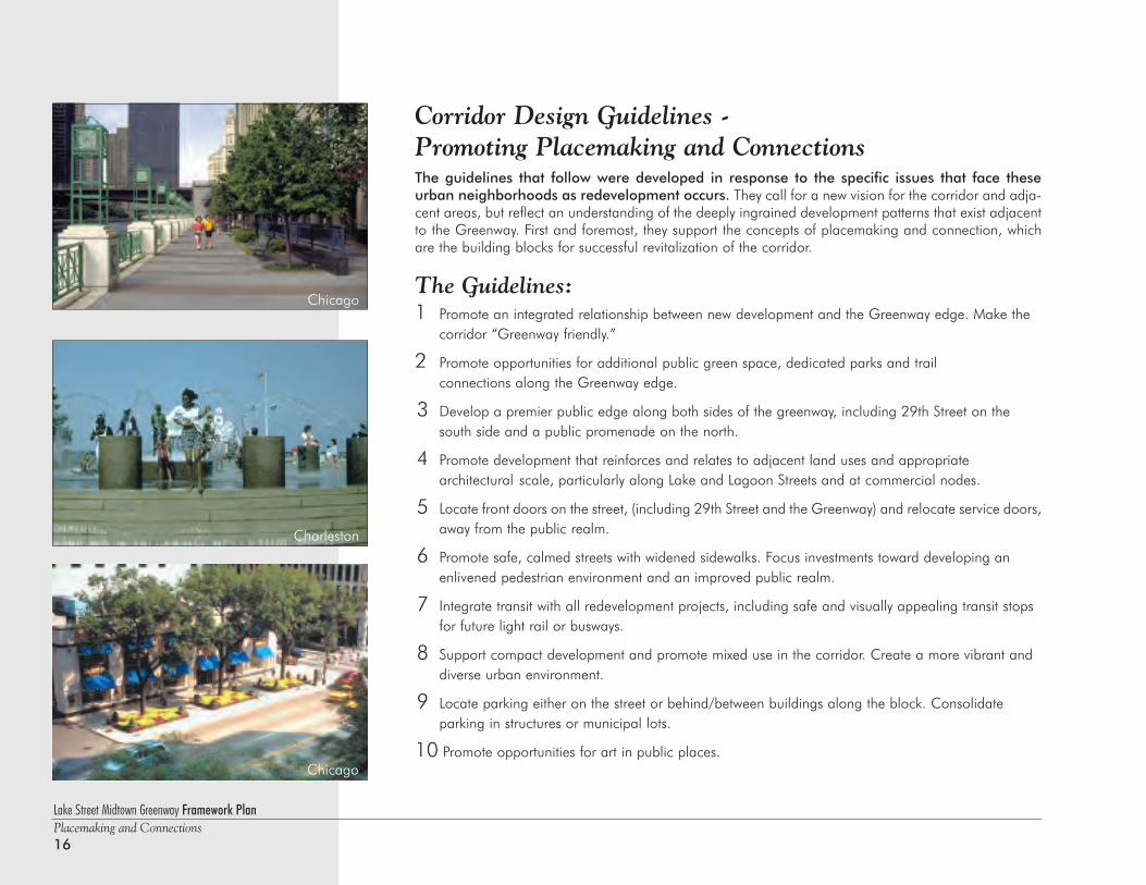
Chicago
Chicago
Charleston
Lake Street Midtown Greenway Framework PlanPlacemaking and Connections
17
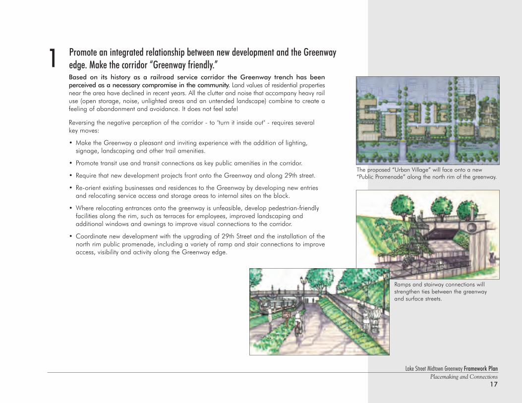
Promote an integrated relationship between new development and the Greenway edge. Make the corridor “Greenway friendly.”Based on its history as a railroad service corridor the Greenway trench has been perceived as a necessary compromise in the community. Land values of residential propertiesnear the area have declined in recent years. All the clutter and noise that accompany heavy railuse (open storage, noise, unlighted areas and an untended landscape) combine to create afeeling of abandonment and avoidance. It does not feel safe!
Reversing the negative perception of the corridor - to "turn it inside out" - requires severalkey moves:
• Make the Greenway a pleasant and inviting experience with the addition of lighting, signage, landscaping and other trail amenities.
• Promote transit use and transit connections as key public amenities in the corridor.
• Require that new development projects front onto the Greenway and along 29th street.
• Re-orient existing businesses and residences to the Greenway by developing new entries and relocating service access and storage areas to internal sites on the block.
• Where relocating entrances onto the greenway is unfeasible, develop pedestrian-friendlyfacilities along the rim, such as terraces for employees, improved landscaping and additional windows and awnings to improve visual connections to the corridor.
• Coordinate new development with the upgrading of 29th Street and the installation of thenorth rim public promenade, including a variety of ramp and stair connections to improveaccess, visibility and activity along the Greenway edge.
1
The proposed “Urban Village” will face onto a new“Public Promenade” along the north rim of the greenway.
Ramps and stairway connections willstrengthen ties between the greenwayand surface streets.
Lake Street Midtown Greenway Framework PlanPlacemaking and Connections18
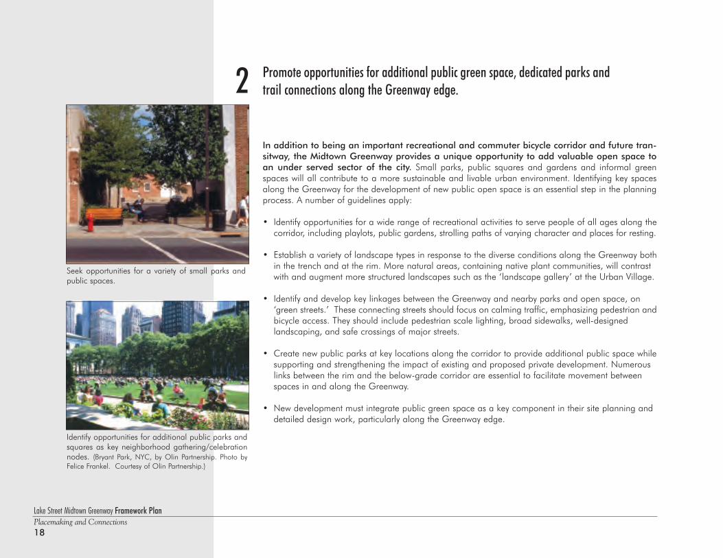
2 Promote opportunities for additional public green space, dedicated parks andtrail connections along the Greenway edge.
In addition to being an important recreational and commuter bicycle corridor and future tran-sitway, the Midtown Greenway provides a unique opportunity to add valuable open space toan under served sector of the city. Small parks, public squares and gardens and informal greenspaces will all contribute to a more sustainable and livable urban environment. Identifying key spacesalong the Greenway for the development of new public open space is an essential step in the planningprocess. A number of guidelines apply:
• Identify opportunities for a wide range of recreational activities to serve people of all ages along the corridor, including playlots, public gardens, strolling paths of varying character and places for resting.
• Establish a variety of landscape types in response to the diverse conditions along the Greenway bothin the trench and at the rim. More natural areas, containing native plant communities, will contrast with and augment more structured landscapes such as the ‘landscape gallery’ at the Urban Village.
• Identify and develop key linkages between the Greenway and nearby parks and open space, on ‘green streets.’ These connecting streets should focus on calming traffic, emphasizing pedestrian andbicycle access. They should include pedestrian scale lighting, broad sidewalks, well-designed landscaping, and safe crossings of major streets.
• Create new public parks at key locations along the corridor to provide additional public space whilesupporting and strengthening the impact of existing and proposed private development. Numerous links between the rim and the below-grade corridor are essential to facilitate movement between spaces in and along the Greenway.
• New development must integrate public green space as a key component in their site planning and detailed design work, particularly along the Greenway edge.
Identify opportunities for additional public parks andsquares as key neighborhood gathering/celebrationnodes. (Bryant Park, NYC, by Olin Partnership. Photo byFelice Frankel. Courtesy of Olin Partnership.)
Seek opportunities for a variety of small parks andpublic spaces.
Lake Street Midtown Greenway Framework PlanPlacemaking and Connections
19
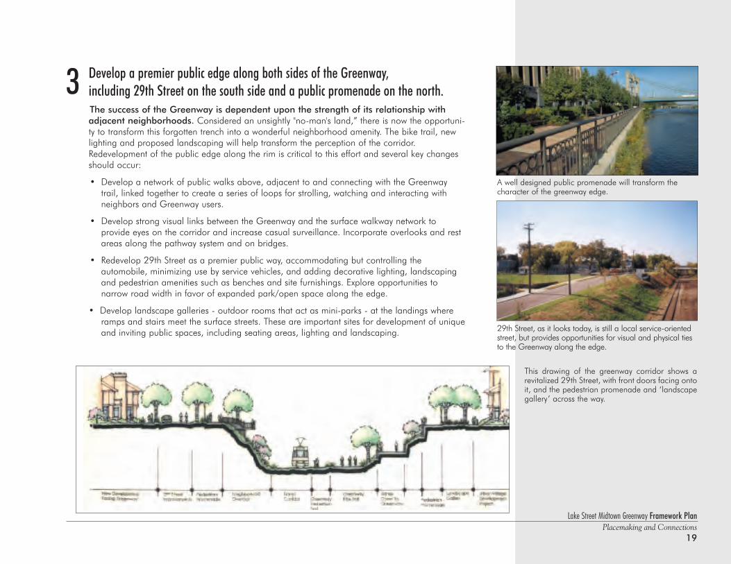
3
29th Street, as it looks today, is still a local service-orientedstreet, but provides opportunities for visual and physical tiesto the Greenway along the edge.
This drawing of the greenway corridor shows arevitalized 29th Street, with front doors facing ontoit, and the pedestrian promenade and ‘landscapegallery’ across the way.
Develop a premier public edge along both sides of the Greenway, including 29th Street on the south side and a public promenade on the north.The success of the Greenway is dependent upon the strength of its relationship withadjacent neighborhoods. Considered an unsightly "no-man's land,” there is now the opportuni-ty to transform this forgotten trench into a wonderful neighborhood amenity. The bike trail, newlighting and proposed landscaping will help transform the perception of the corridor.Redevelopment of the public edge along the rim is critical to this effort and several key changesshould occur:
• Develop a network of public walks above, adjacent to and connecting with the Greenway trail, linked together to create a series of loops for strolling, watching and interacting with neighbors and Greenway users.
• Develop strong visual links between the Greenway and the surface walkway network to provide eyes on the corridor and increase casual surveillance. Incorporate overlooks and rest areas along the pathway system and on bridges.
• Redevelop 29th Street as a premier public way, accommodating but controlling the automobile, minimizing use by service vehicles, and adding decorative lighting, landscaping and pedestrian amenities such as benches and site furnishings. Explore opportunities to narrow road width in favor of expanded park/open space along the edge.
• Develop landscape galleries - outdoor rooms that act as mini-parks - at the landings where ramps and stairs meet the surface streets. These are important sites for development of uniqueand inviting public spaces, including seating areas, lighting and landscaping.
A well designed public promenade will transform thecharacter of the greenway edge.
Lake Street Midtown Greenway Framework PlanPlacemaking and Connections20
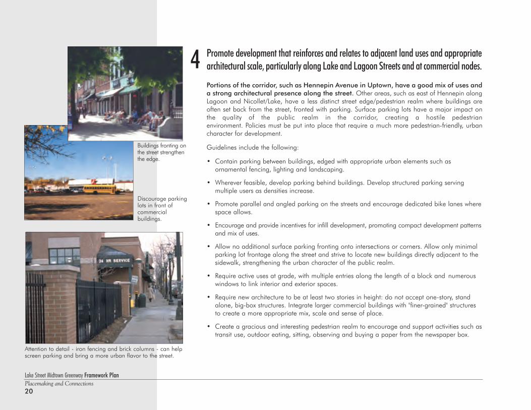
Promote development that reinforces and relates to adjacent land uses and appropriatearchitectural scale, particularly along Lake and Lagoon Streets and at commercial nodes.
Portions of the corridor, such as Hennepin Avenue in Uptown, have a good mix of uses anda strong architectural presence along the street. Other areas, such as east of Hennepin alongLagoon and Nicollet/Lake, have a less distinct street edge/pedestrian realm where buildings areoften set back from the street, fronted with parking. Surface parking lots have a major impact onthe quality of the public realm in the corridor, creating a hostile pedestrian environment. Policies must be put into place that require a much more pedestrian-friendly, urbancharacter for development.
Guidelines include the following:
• Contain parking between buildings, edged with appropriate urban elements such as ornamental fencing, lighting and landscaping.
• Wherever feasible, develop parking behind buildings. Develop structured parking serving multiple users as densities increase.
• Promote parallel and angled parking on the streets and encourage dedicated bike lanes wherespace allows.
• Encourage and provide incentives for infill development, promoting compact development patternsand mix of uses.
• Allow no additional surface parking fronting onto intersections or corners. Allow only minimal parking lot frontage along the street and strive to locate new buildings directly adjacent to thesidewalk, strengthening the urban character of the public realm.
• Require active uses at grade, with multiple entries along the length of a block and numerous windows to link interior and exterior spaces.
• Require new architecture to be at least two stories in height: do not accept one-story, stand alone, big-box structures. Integrate larger commercial buildings with "finer-grained" structures to create a more appropriate mix, scale and sense of place.
• Create a gracious and interesting pedestrian realm to encourage and support activities such astransit use, outdoor eating, sitting, observing and buying a paper from the newspaper box.
4
Buildings fronting onthe street strengthenthe edge.
Discourage parkinglots in front ofcommercial buildings.
Attention to detail - iron fencing and brick columns - can helpscreen parking and bring a more urban flavor to the street.
Lake Street Midtown Greenway Framework PlanPlacemaking and Connections
21
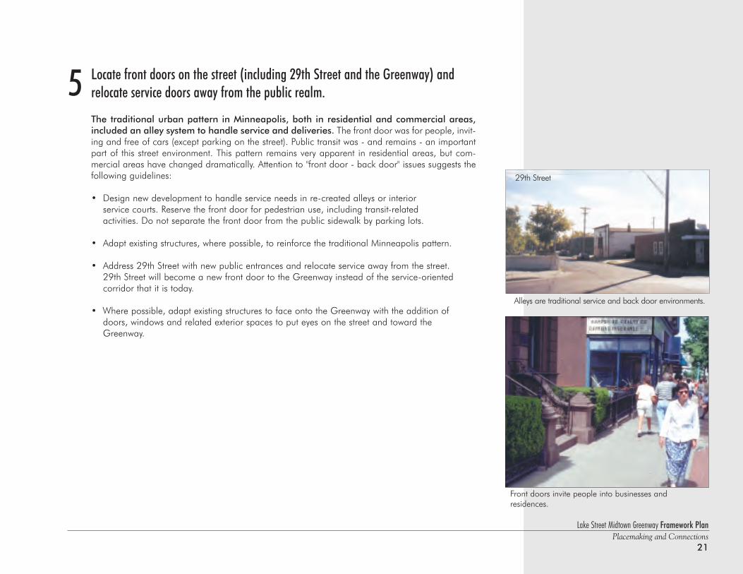
Locate front doors on the street (including 29th Street and the Greenway) and relocate service doors away from the public realm.
The traditional urban pattern in Minneapolis, both in residential and commercial areas,included an alley system to handle service and deliveries. The front door was for people, invit-ing and free of cars (except parking on the street). Public transit was - and remains - an importantpart of this street environment. This pattern remains very apparent in residential areas, but com-mercial areas have changed dramatically. Attention to "front door - back door" issues suggests thefollowing guidelines:
• Design new development to handle service needs in re-created alleys or interior service courts. Reserve the front door for pedestrian use, including transit-related activities. Do not separate the front door from the public sidewalk by parking lots.
• Adapt existing structures, where possible, to reinforce the traditional Minneapolis pattern.
• Address 29th Street with new public entrances and relocate service away from the street.29th Street will become a new front door to the Greenway instead of the service-oriented corridor that it is today.
• Where possible, adapt existing structures to face onto the Greenway with the addition of doors, windows and related exterior spaces to put eyes on the street and toward the Greenway.
5
Alleys are traditional service and back door environments.
Front doors invite people into businesses and residences.
29th Street
Lake Street Midtown Greenway Framework PlanPlacemaking and Connections22
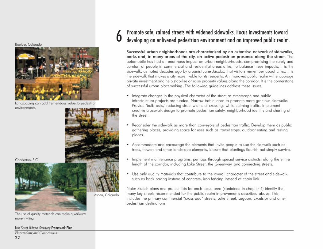
Promote safe, calmed streets with widened sidewalks. Focus investments towarddeveloping an enlivened pedestrian environment and an improved public realm.
Successful urban neighborhoods are characterized by an extensive network of sidewalks,parks and, in many areas of the city, an active pedestrian presence along the street. Theautomobile has had an enormous impact on urban neighborhoods, compromising the safety andcomfort of people in commercial and residential areas alike. To balance these impacts, it is thesidewalk, as noted decades ago by urbanist Jane Jacobs, that visitors remember about cities; it isthe sidewalk that makes a city more livable for its residents. An improved public realm will encourageprivate investment and help stabilize or raise property values along the corridor. It is the cornerstoneof successful urban placemaking. The following guidelines address these issues:
• Integrate changes in the physical character of the street as streetscape and public infrastructure projects are funded. Narrow traffic lanes to promote more gracious sidewalks. Provide "bulb-outs," reducing street widths at crossings while calming traffic. Implement creative crosswalk design to promote pedestrian safety, neighborhood identity and sharing ofthe street.
• Reconsider the sidewalk as more than conveyors of pedestrian traffic. Develop them as public gathering places, providing space for uses such as transit stops, outdoor eating and resting places.
• Accommodate and encourage the elements that invite people to use the sidewalk such as trees, flowers and other landscape elements. Ensure that plantings flourish not simply survive.
• Implement maintenance programs, perhaps through special service districts, along the entire length of the corridor, including Lake Street, the Greenway, and connecting streets.
• Use only quality materials that contribute to the overall character of the street and sidewalk, such as brick paving instead of concrete, iron fencing instead of chain link.
Note: Sketch plans and project lists for each focus area (contained in chapter 4) identify themany key streets recommended for the public realm improvements described above. Thisincludes the primary commercial “crossroad” streets, Lake Street, Lagoon, Excelsior and otherpedestrian destinations.
6
Landscaping can add tremendous value to pedestrianenvironments.
The use of quality materials can make a walkwaymore inviting.
Boulder, Colorado
Charleston, S.C.
Aspen, Colorado
Lake Street Midtown Greenway Framework PlanPlacemaking and Connections
23
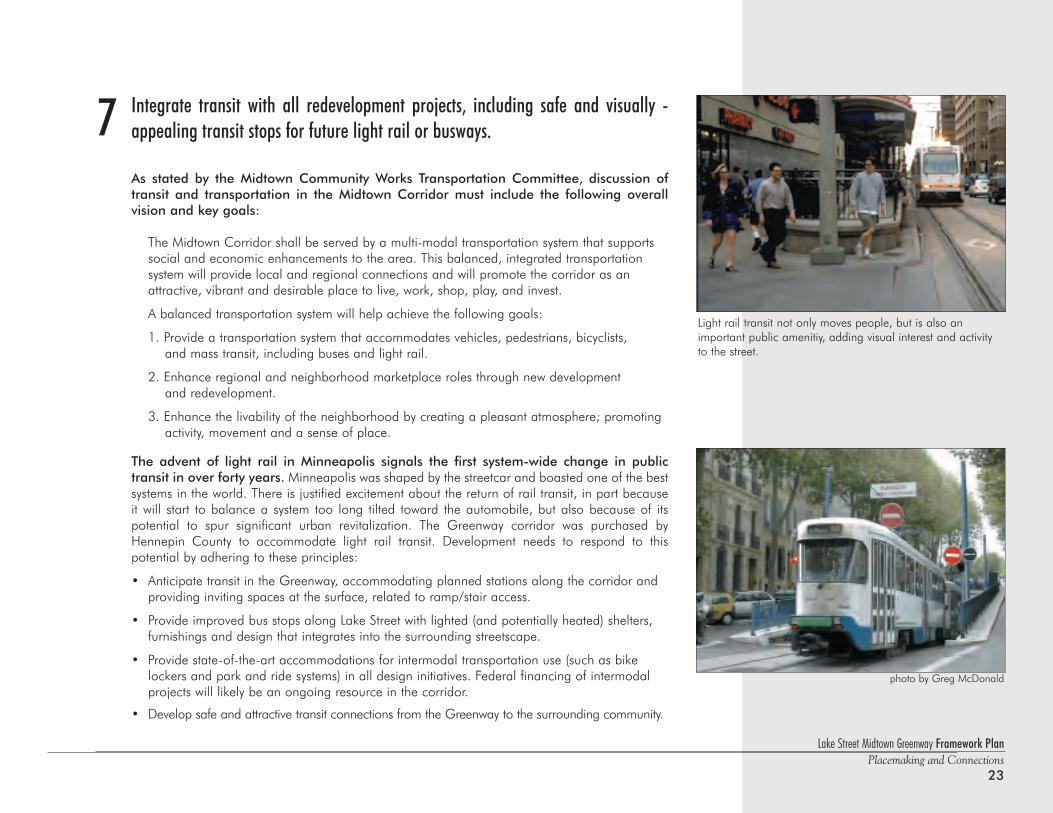
Integrate transit with all redevelopment projects, including safe and visually -appealing transit stops for future light rail or busways.
As stated by the Midtown Community Works Transportation Committee, discussion oftransit and transportation in the Midtown Corridor must include the following overallvision and key goals:
The Midtown Corridor shall be served by a multi-modal transportation system that supports social and economic enhancements to the area. This balanced, integrated transportation system will provide local and regional connections and will promote the corridor as an attractive, vibrant and desirable place to live, work, shop, play, and invest.
A balanced transportation system will help achieve the following goals:
1. Provide a transportation system that accommodates vehicles, pedestrians, bicyclists, and mass transit, including buses and light rail.
2. Enhance regional and neighborhood marketplace roles through new development and redevelopment.
3. Enhance the livability of the neighborhood by creating a pleasant atmosphere; promotingactivity, movement and a sense of place.
The advent of light rail in Minneapolis signals the first system-wide change in public transit in over forty years. Minneapolis was shaped by the streetcar and boasted one of the bestsystems in the world. There is justified excitement about the return of rail transit, in part becauseit will start to balance a system too long tilted toward the automobile, but also because of its potential to spur significant urban revitalization. The Greenway corridor was purchased byHennepin County to accommodate light rail transit. Development needs to respond to this potential by adhering to these principles:
• Anticipate transit in the Greenway, accommodating planned stations along the corridor and providing inviting spaces at the surface, related to ramp/stair access.
• Provide improved bus stops along Lake Street with lighted (and potentially heated) shelters, furnishings and design that integrates into the surrounding streetscape.
• Provide state-of-the-art accommodations for intermodal transportation use (such as bike lockers and park and ride systems) in all design initiatives. Federal financing of intermodal projects will likely be an ongoing resource in the corridor.
• Develop safe and attractive transit connections from the Greenway to the surrounding community.
7
Light rail transit not only moves people, but is also an important public amenitiy, adding visual interest and activityto the street.
photo by Greg McDonald
Lake Street Midtown Greenway Framework PlanPlacemaking and Connections24
Support compact development and promote mixed use in the corridor. Create a morevibrant and diverse urban environment.
A standard tenet of the new paradigm for urban revitalization recognizes the inherent valuethat mixed-use development brings to a community. The separation of land uses into discreetplaces to work, shop, recreate and reside evolved for a variety of reasons over many years, but thebenefits of creating 24-hour communities, where land uses and activities mix, is once again being rec-ognized as a major contributor to urban vitality. Ironically, this corridor was an excellent example of asuccessful mixed-use district before the interstate highway system and the loss of the streetcar beganto disassemble and denigrate the community. Several guidelines should be followed for redevelopment:
• Density is not a four-letter word! Create incentives for neighborhoods and developers alike to allow and accept higher densities, through a more compact development pattern in both residential and commercial areas. An educational component is an essential part of this process.
• Modify existing policies using such approaches as an overlay zoning district to allow andencourage mixed-use development along and near the corridor.
• Concentrate commercial uses at the nodes (Lyndale and Lake, Nicollet and Lake, 4th and Lake), developing complementary uses such as mixed-use infill between the commercial nodes.
• Support and accommodate a mix of uses, mixed incomes and increased densities on the north-south streets, with an emphasis on residential use (mostly multi-family) on all but the arterial streets.
Increased density in both commercial and residential uses should be promoted in those areas of theCorridor most able to support it. The diagram on page 13 illustrates this idea that compact developmentmust be supported by improved transit and public infrastructure to be successful.
8
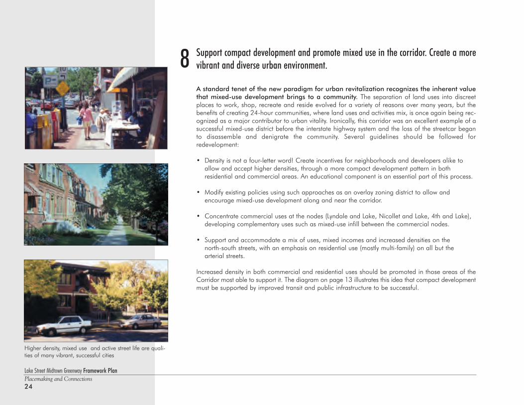
Higher density, mixed use and active street life are quali-ties of many vibrant, successful cities
Lake Street Midtown Greenway Framework PlanPlacemaking and Connections
25
Locate parking either on the street or behind and between buildings alongthe block. Consolidate parking in structures or municipal lots.
Parking continues to be a primary issue and a key component in any redevelopmentstrategy for this corridor. The intent is to find balance between the quantity of spacesrequired to support the existing and proposed land use mix while at the same time addressingthe visual character of necessary facilities. There is also a direct relationship amongexpanding transit systems, transit users and the availability of parking that together supportincreased density, job growth and other corridor activities and events. Actions to improveparking include:
• Promote strategies for shared parking, such as commercial uses during the day and residential at night.
• Support changes in zoning regulations that would allow fewer spaces per square foot of development based on transit projections for ridership and other key factors.
• Encourage innovative concepts for 'district parking,' including the development of ramps and decks to reduce the negative visual impact of surface parking and the size of footprint required for housing cars.
• Design parking structures to integrate with the character of the surrounding neighborhood, using quality materials and the design elements of nearby structures.
• Provide as much on-street parking as possible, reducing the area required for off-street lots or ramps.
• Where absolutely necessary, locate surface lots away from the street, to ameliorate the impact of parking on the character and urban vitality of commercial nodes.
9
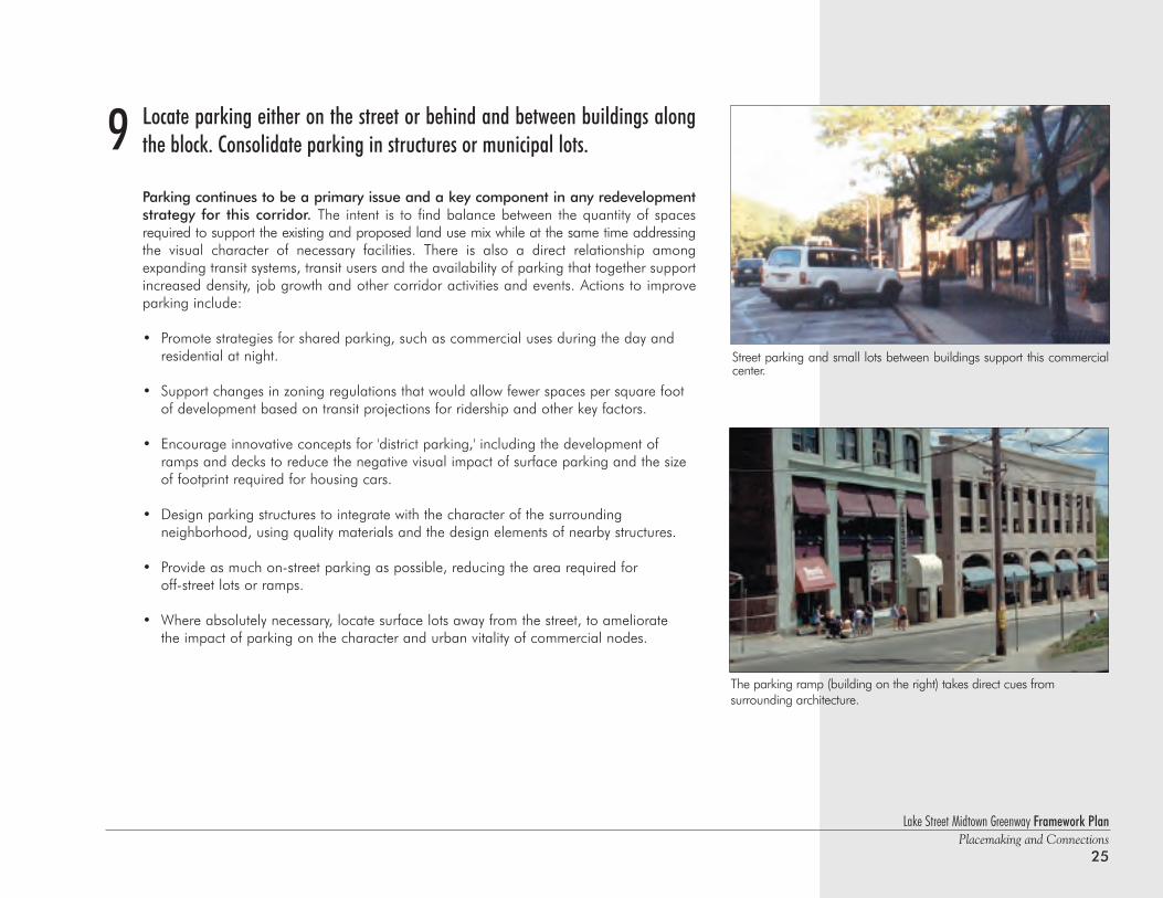
The parking ramp (building on the right) takes direct cues from surrounding architecture.
Street parking and small lots between buildings support this commercialcenter.
Promote opportunities for art in public places.
Public art has long been recognized as a major contributor to the urban environment. It has tradition-ally set great cities apart from average ones. There are innumerable opportunities for public art to takea significant role in the character and function of the area. Specifically, public art should be appliedas follows:
• Use art as a vehicle for placemaking at transit stations or bus stops, and along the Greenway corridor itself, including bridges, at commercial nodes on Lake Street and as neighborhood identifiers.
• Use public art to bring whimsy and delight to the corridor, linking neighborhoods together while acknowledging their diversity.
• Use public art to celebrate the cultural diversity of the neighborhoods along the corridor.
• Create locations for performance art and ephemeral works as key components of the Public Art and Public Greenspace Master Plan.
• Integrate art with infrastructure improvement projects.
10
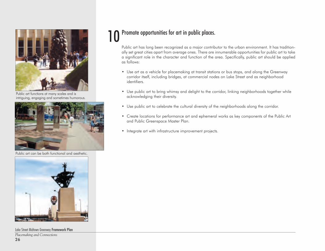
Public art functions at many scales and is intriguing, engaging and sometimes humorous.
Public art can be both functional and aesthetic.
Lake Street Midtown Greenway Framework PlanPlacemaking and Connections26
Lake Street Midtown Greenway Framework PlanPlacemaking and Connections
27
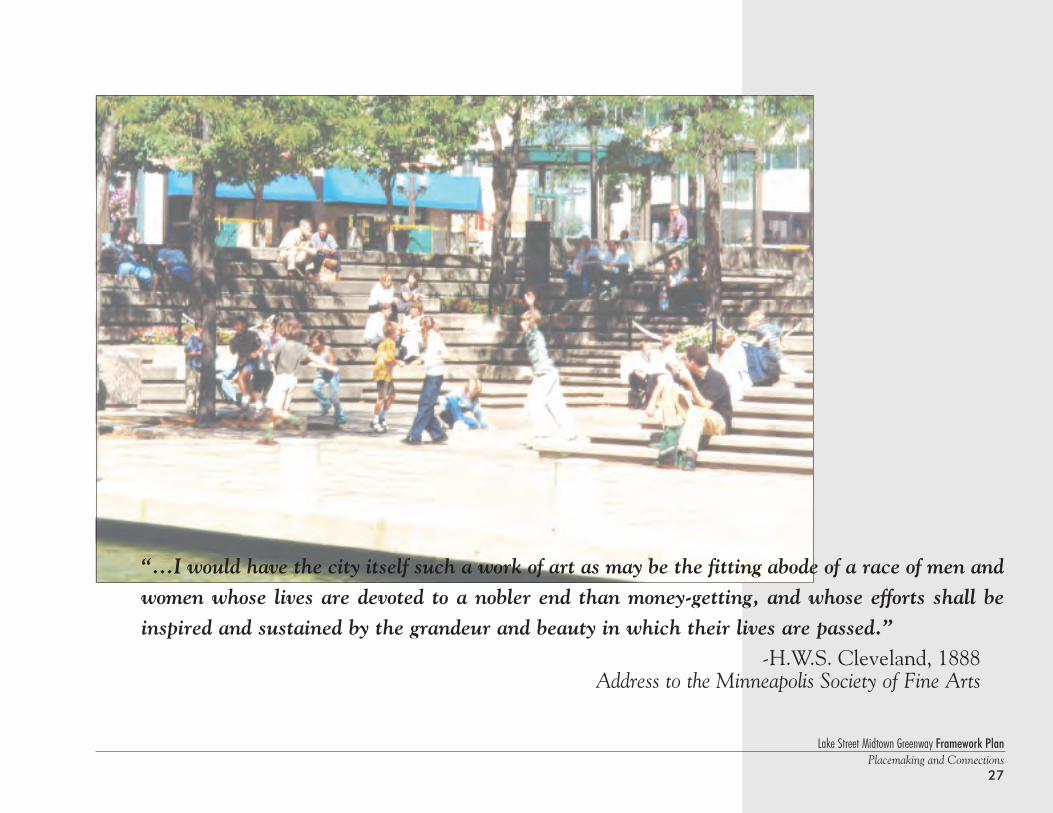
“...I would have the city itself such a work of art as may be the fitting abode of a race of men andwomen whose lives are devoted to a nobler end than money-getting, and whose efforts shall beinspired and sustained by the grandeur and beauty in which their lives are passed.”
-H.W.S. Cleveland, 1888 Address to the Minneapolis Society of Fine Arts
Lake Street Midtown Greenway Framework PlanPlacemaking and Connections28
Henn
epin
Lynd
ale
Fran
ce
Nic
olle
t
Chi
cago
Blo
omin
gton
Ced
ar
Hiaw
atha
36th
Aven
ue
5th
Aven
ueI-3
5W
Bry
ant
Excels
ior
Lake Lake
Min
neha
ha
2833
32
31
27
25
21
NIC
OLL
ETAV
E.&
K-M
AR
T
I-35W
AC
CES
S
LAK
EST
REE
TB
USI
NES
SIN
FILL
GR
EAT
LAK
ESC
OM
M'L
CTR
CO
NN
ECTI
ON
STO
POW
DER
HO
RN
PAR
K
OM
ING
TON
/LA
KE
BU
SIN
ESS
INFI
LL
CEM
ETER
YPU
BLI
CA
CC
ESS
CED
AR
/LA
KE
BU
SIN
ESS
INFI
LL
HIA
WAT
HA
/LA
KE
RA
NSI
TO
RIE
NTE
DD
EVEL
OPM
ENT
EAST
GAT
EWAY
LAG
OO
NA
REA
PLA
NTI
NG
PRO
JEC
T
HEN
NEP
INAV
ENU
ETR
AN
SIT
STAT
ION
ELR
OY
SITE
UR
BA
NVI
LLA
GE
SOO
LIN
EG
AR
DEN
S
NO
RTH
GR
EEN
WAY
EDG
EIN
FILL
PUB
LIC
OPE
NSP
AC
E
PUB
LIC
OPE
NSP
AC
E
PUB
LIC
OPE
NSP
AC
E
UR
BA
NVE
NTU
RES
GR
EEN
WAY
RES
IDEN
TIA
LIN
FILL
GR
EEN
WAY
RES
IDEN
TIA
LIN
FILL
GR
EEN
WAY
RES
IDEN
TIA
LIN
FILL
MIN
NEH
AH
A/L
AK
EB
USI
NES
SIN
FILL
BR
AC
KET
TPA
RK
AC
CES
S
VILL
AG
EC
ENTE
R
LAG
OO
N/L
AK
ER
EDEV
ELO
PMEN
TA
REA
MIX
EDU
SE&
UN
ICIP
AL
PAR
KIN
GLA
KE
STR
EET
BU
SIN
ESS
INFI
LL
36th
AVEN
UE
TRA
NSI
TH
UB
EAST
TRA
ILH
EAD
GR
EEN
WAY
CO
NN
ECTI
ON
MIS
SISS
IPPI
RIV
ERG
OR
GE
PRO
JEC
T
LON
GFE
LLO
WLA
KE
STR
EET
LAN
DU
SEC
OM
MER
CIA
LN
OD
EST
UD
Y
4th & Lake Street 29th Street Public Edge
Hiawatha & Lake Street Transit-Oriented DevelopmentUrban Village Landscape Gallery/Pedestrian Promenade
East Gateway Mixed-Use Infill Development
West Calhoun Gateway Park Connection to Village Center
Great Lake Center Mixed Use Development
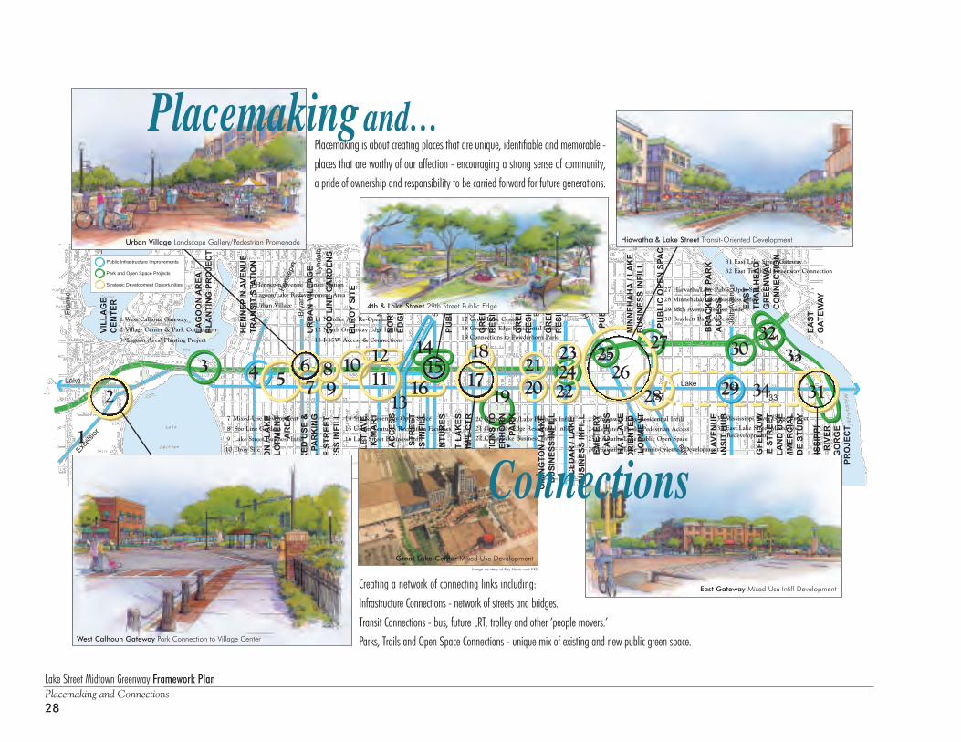
Placemaking and…
Connections
Placemaking is about creating places that are unique, identifiable and memorable -places that are worthy of our affection - encouraging a strong sense of community,a pride of ownership and responsibility to be carried forward for future generations.
Creating a network of connecting links including: Infrastructure Connections - network of streets and bridges.Transit Connections - bus, future LRT, trolley and other ‘people movers.’ Parks, Trails and Open Space Connections - unique mix of existing and new public green space.
2
1
1211
1098
76
543
13
1415
16 17
18
19 222423
2120
2625
27
28 29 3134
3032
33
Park and Open Space Projects
Strategic Development Opportunities
Public Infrastructure Improvements
L
18 Greenway Edge Residential Infill
21 Greenway Edge Residential Infill
23 Greenway Edge Residential Infill
26 Hiawatha/Lake Transit-Oriented Development
25 Hiawatha/Lake Public Open Space
27 Hiawatha/Lake Public Open Space
30 Brackett Park Access
32 East Trailhead Greenway Connection
22 Cedar/Lake Business Infill
20 Bloomington/Lake Business Infill
28 Minnehaha/Lake Business Infill
24 Cemetery Public/Pedestrian Access
19 Connections to Powderhorn Park
17 Great Lake Center
34 East Lake Street Mixed-UseRedevelopment
29 36th Avenue Transit Node
33 Mississippi River Gorge Project
31 East Lake Street Gateway
Image courtesy of Ray Harris and KKE
7 Mixed-Use Development
8 Soo Line Gardens
9 Lake Street Business Infill
10 Elroy Site
1 West Calhoun Gateway
2 Village Center & Park Connection
3 ‘Lagoon Area’ Planting Project
4 Hennepin Avenue Transit Station
5 Lagoon/Lake Redevelopment Area
6 Urban Village
11 Nicollet Ave Re-Opening
12 North Greenway Edge Infill
13 I-35W Access & Connections
14 5th & Greenway Open Space
15 Urban Ventures Recreation Facilities
16 Lake Street Business Infill
Hen
nepi
n
Lynd
ale
Fran
ce
Nic
olle
t
Chi
cago
Blo
omin
gton
Ced
ar
Hiawatha
36th
Aven
ue
River Road
5th
Aven
ueI-3
5W
I-35W
Bry
ant
Excels
ior
Lake Street
Minnehaha
P H A S E O N E P H A S E T W O P H A S E T H R E E
FranceAvenue
5thAvenue
Hiwatha Avenue
MississippiRiver
AND"V
ILLAGE
CENTER"
MIXED
USEDEVELO
PMENT
MIXED
INCOME
HOUSING
ELROY,
SOO-LINE
K-MART
GREAT LAKE
COMMERCIAL CENTER
HONEYWELL
SITE
COMMERCIAL CENTER
TRANSITORIE
NTEDDEVELO
PMENT
MISSIS
SIPP RIV
ER
WEST CALH
OUNGATEWAY
HENNEPINTRANSIT
STATIO
N
URBANVILL
AGE
WHITTIE
RREDEVELO
PMENT PLAN
NICOLL
ET / LAKE
4thAVENUE
/ LAKE
CHICAGO
/ LAKE
BLOOMIN
GTON/ L
AKE
HIWATHA / L
AKE
EAST GATEWAY
LONGFELL
OWCOMMERCIA
L
NODESTUDY
1 23
4
5 6
7
8
910
11
2 3
4
56
7 8
910
11
1
Lake Street Midtown Greenway Framework PlanPlacemaking and Connections
29
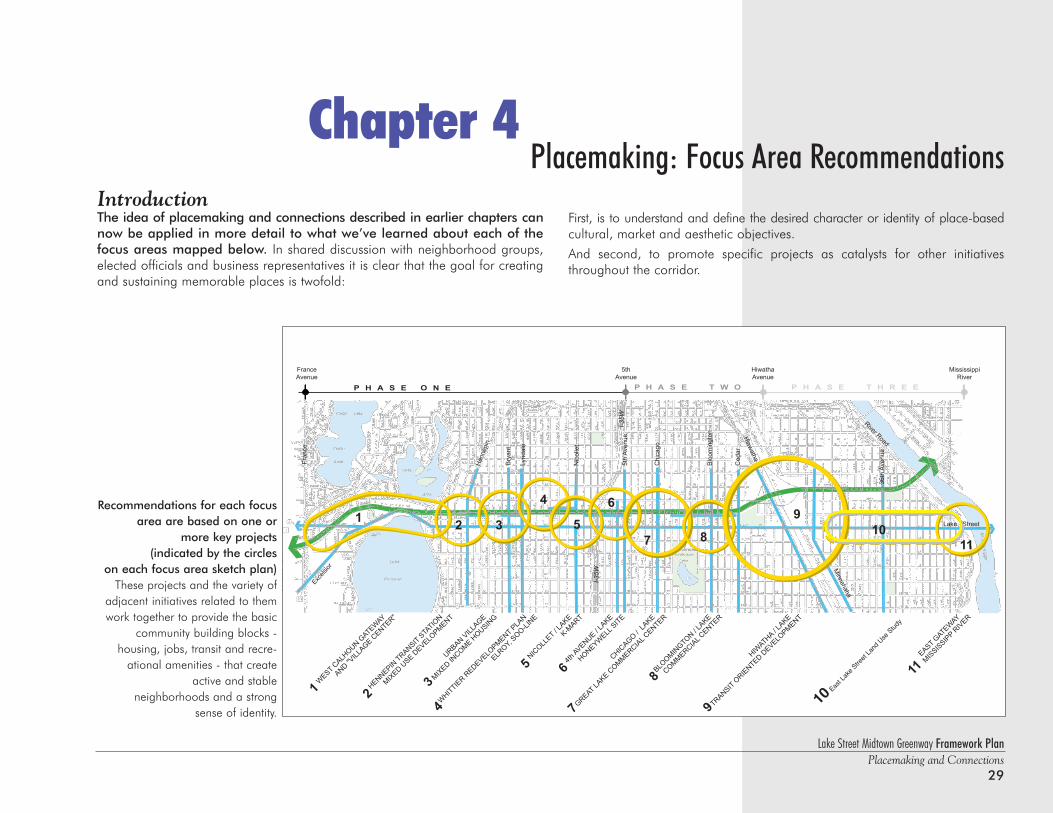
IntroductionThe idea of placemaking and connections described in earlier chapters cannow be applied in more detail to what we’ve learned about each of thefocus areas mapped below. In shared discussion with neighborhood groups,elected officials and business representatives it is clear that the goal for creatingand sustaining memorable places is twofold:
Placemaking: Focus Area RecommendationsChapter 4
Recommendations for each focusarea are based on one or
more key projects (indicated by the circles
on each focus area sketch plan)These projects and the variety of
adjacent initiatives related to themwork together to provide the basic
community building blocks - housing, jobs, transit and recre-
ational amenities - that createactive and stable
neighborhoods and a strong sense of identity.
First, is to understand and define the desired character or identity of place-basedcultural, market and aesthetic objectives.
And second, to promote specific projects as catalysts for other initiativesthroughout the corridor.
10Eas
t Lak
e Stre
et L
and
Use S
tudy
Lake Street Midtown Greenway Framework PlanPlacemaking and Connections30
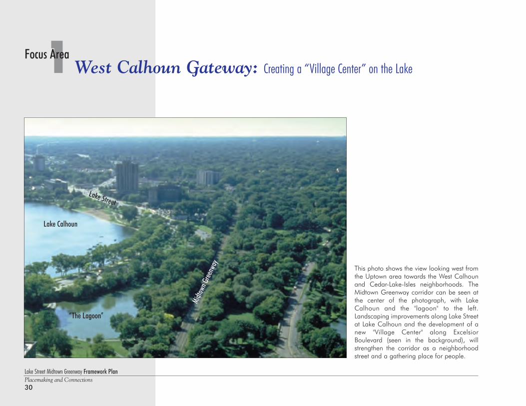
This photo shows the view looking west fromthe Uptown area towards the West Calhounand Cedar-Lake-Isles neighborhoods. TheMidtown Greenway corridor can be seen atthe center of the photograph, with LakeCalhoun and the "lagoon" to the left.Landscaping improvements along Lake Streetat Lake Calhoun and the development of anew "Village Center" along ExcelsiorBoulevard (seen in the background), willstrengthen the corridor as a neighborhoodstreet and a gathering place for people.
1 West Calhoun Gateway: Creating a “Village Center” on the LakeFocus Area
Lake Calhoun
Lake Street
“The Lagoon”
Midto
wn G
reenw
ay
Lake Street Midtown Greenway Framework PlanPlacemaking and Connections
31
1Focus AreaWest Calhoun Gateway: Creating a “Village Center” on the Lake
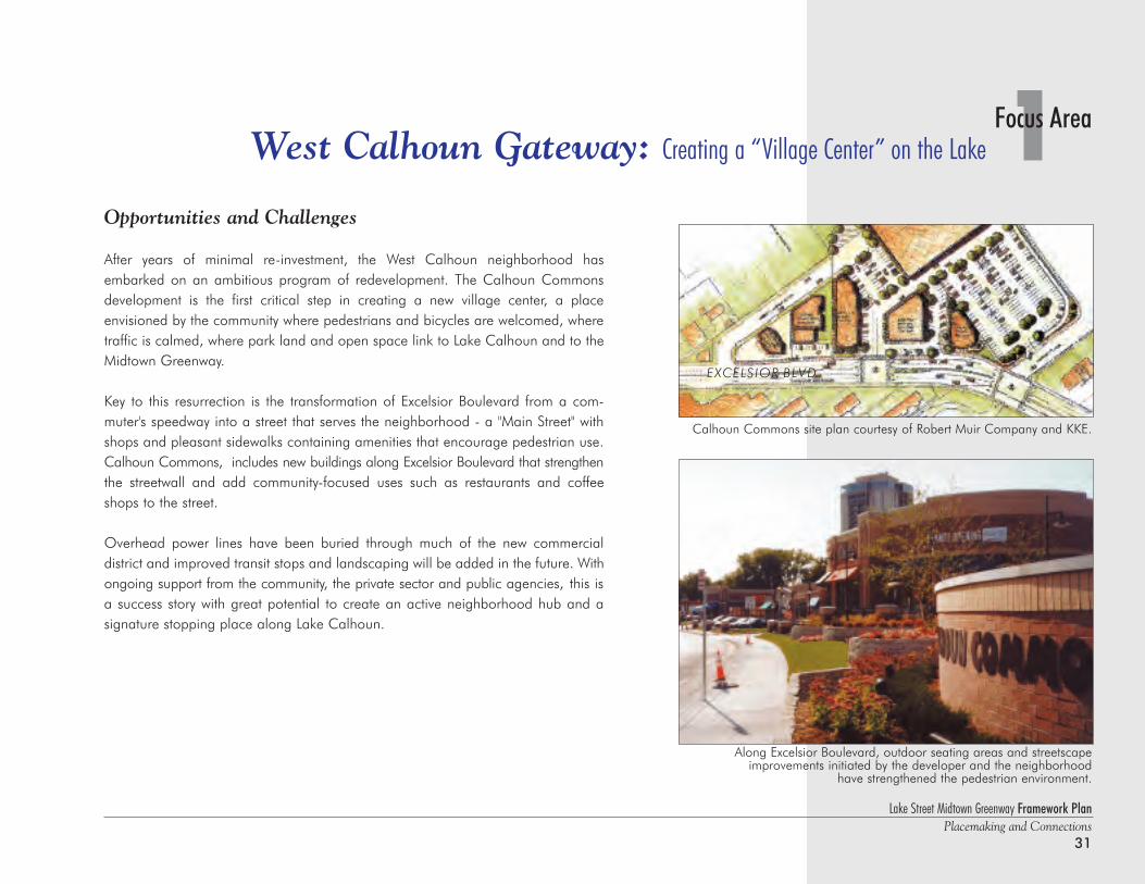
Opportunities and Challenges
After years of minimal re-investment, the West Calhoun neighborhood hasembarked on an ambitious program of redevelopment. The Calhoun Commonsdevelopment is the first critical step in creating a new village center, a place envisioned by the community where pedestrians and bicycles are welcomed, wheretraffic is calmed, where park land and open space link to Lake Calhoun and to theMidtown Greenway.
Key to this resurrection is the transformation of Excelsior Boulevard from a com-muter's speedway into a street that serves the neighborhood - a "Main Street" withshops and pleasant sidewalks containing amenities that encourage pedestrian use.Calhoun Commons, includes new buildings along Excelsior Boulevard that strengthenthe streetwall and add community-focused uses such as restaurants and coffeeshops to the street.
Overhead power lines have been buried through much of the new commercial district and improved transit stops and landscaping will be added in the future. Withongoing support from the community, the private sector and public agencies, this isa success story with great potential to create an active neighborhood hub and a signature stopping place along Lake Calhoun.
Calhoun Commons site plan courtesy of Robert Muir Company and KKE.
Along Excelsior Boulevard, outdoor seating areas and streetscapeimprovements initiated by the developer and the neighborhood
have strengthened the pedestrian environment.
EXCELSIOR BLVD
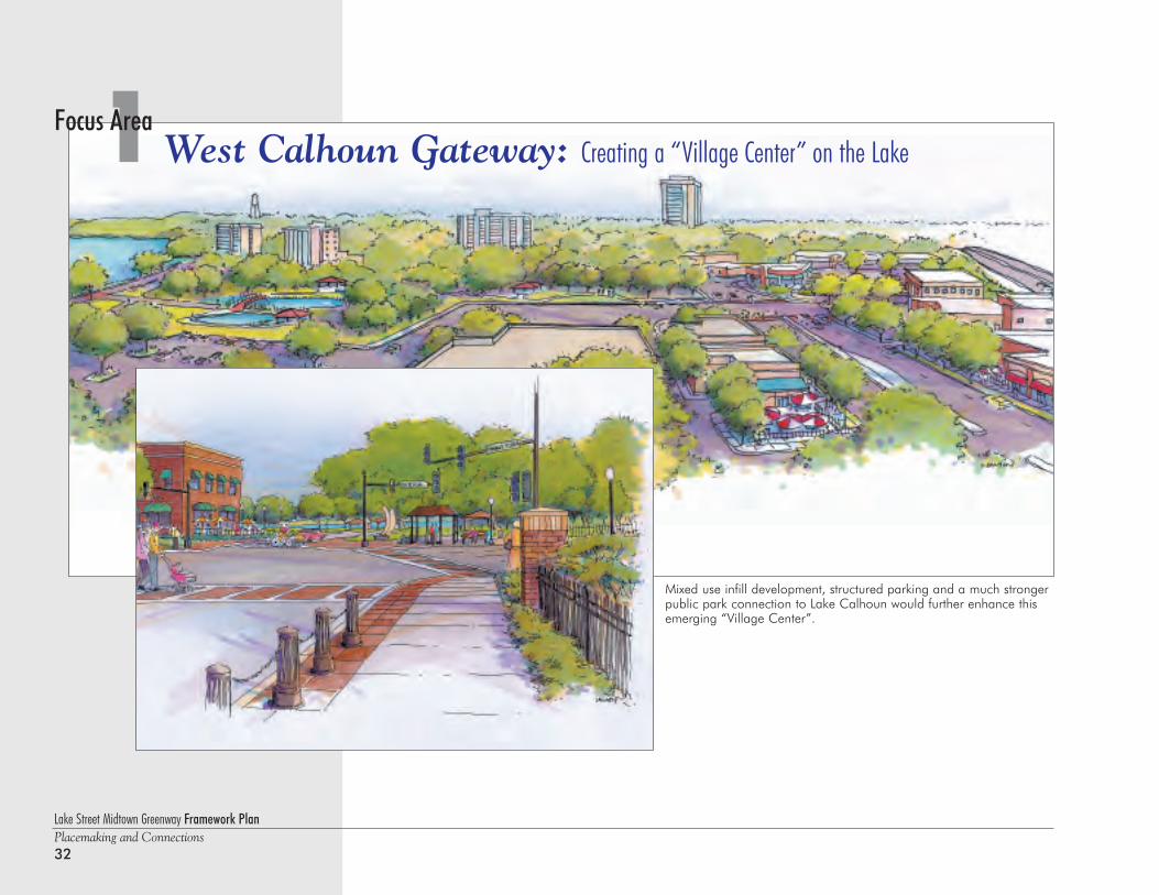
Mixed use infill development, structured parking and a much strongerpublic park connection to Lake Calhoun would further enhance thisemerging “Village Center”.
Lake Street Midtown Greenway Framework PlanPlacemaking and Connections32
1 West Calhoun Gateway: Creating a “Village Center” on the LakeFocus Area
Lake Street Midtown Greenway Framework PlanPlacemaking and Connections
33
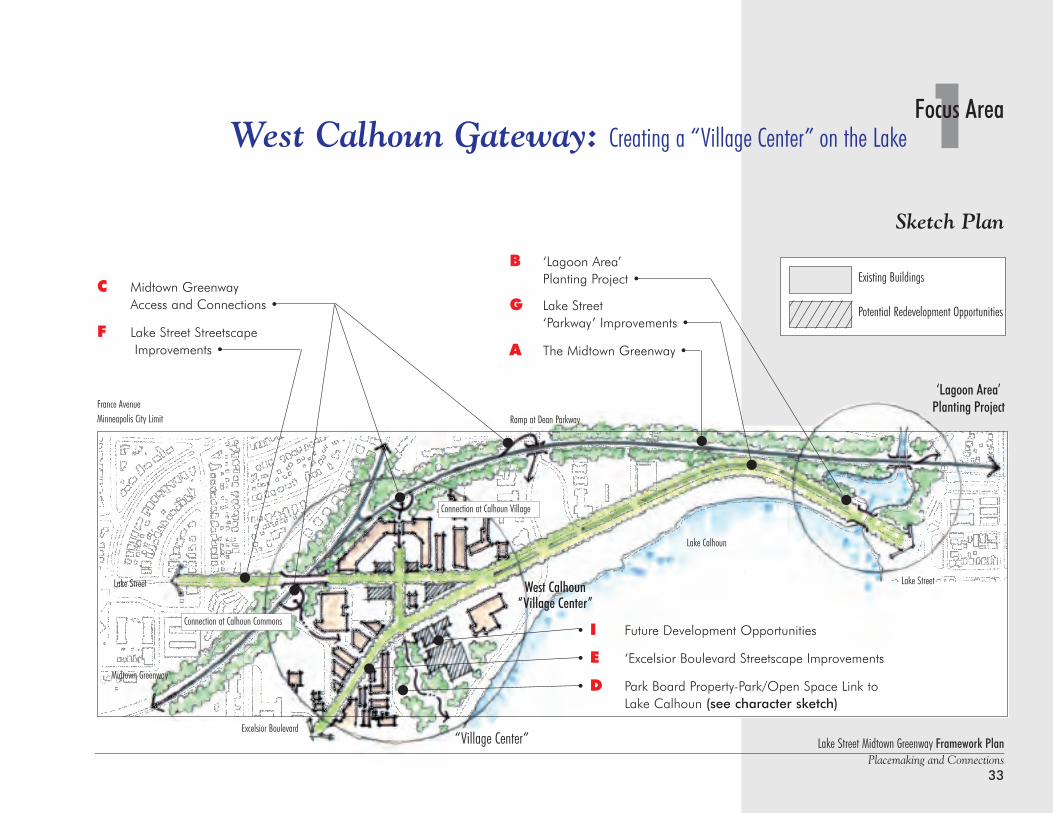
1Focus AreaWest Calhoun Gateway: Creating a “Village Center” on the Lake
C Midtown Greenway Access and Connections •
F Lake Street StreetscapeImprovements •
Sketch Plan
Lake Calhoun
Lake Street
Midtown Greenway
Excelsior Boulevard
Ramp at Dean Parkway
Lake Street
B ‘Lagoon Area’ Planting Project •
G Lake Street ‘Parkway’ Improvements •
A The Midtown Greenway •
• I Future Development Opportunities
• E ‘Excelsior Boulevard Streetscape Improvements
• D Park Board Property-Park/Open Space Link to Lake Calhoun (see character sketch)
Existing Buildings
Potential Redevelopment Opportunities
“Village Center”
France AvenueMinneapolis City Limit
‘Lagoon Area’ Planting Project
Connection at Calhoun Village
Connection at Calhoun Commons
West Calhoun“Village Center”
Lake Street Midtown Greenway Framework PlanPlacemaking and Connections34
1 West Calhoun Gateway: Creating a “Village Center” on the LakeFocus Area
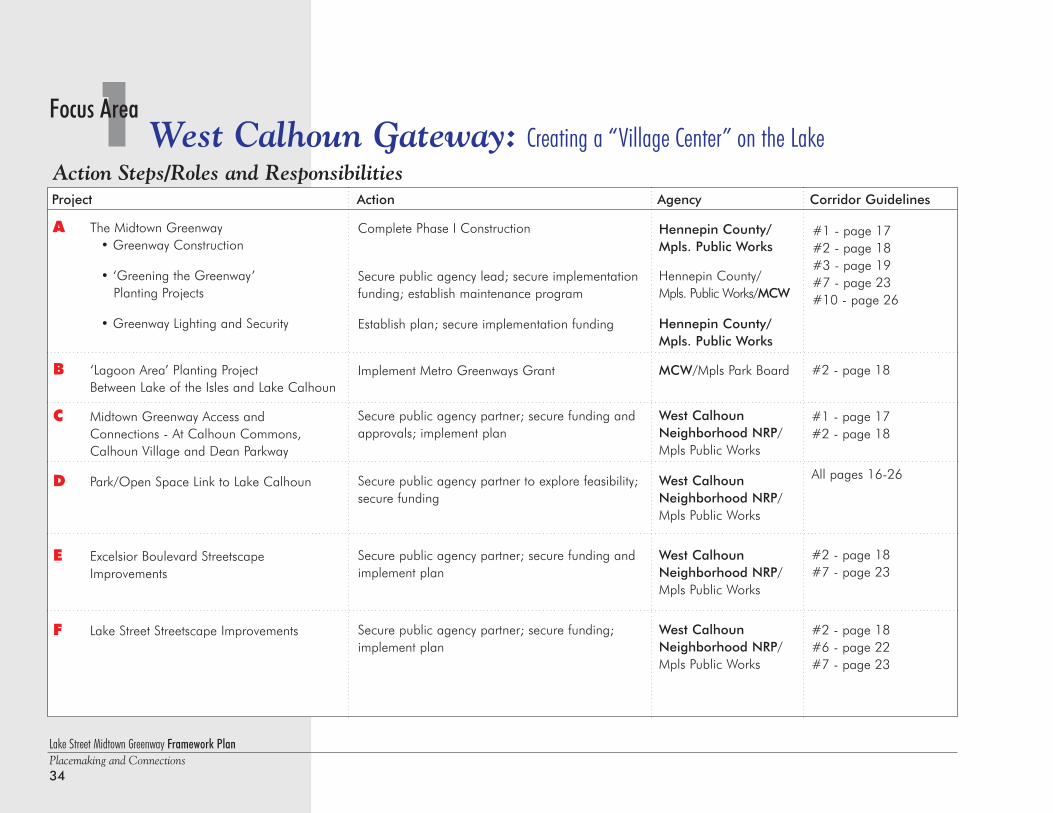
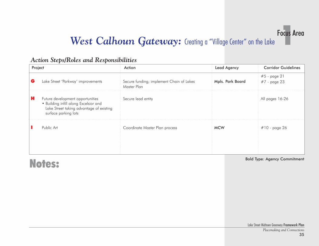
Action Steps/Roles and ResponsibilitiesProject Action Agency Corridor Guidelines
A The Midtown Greenway• Greenway Construction
• ‘Greening the Greenway’ Planting Projects
• Greenway Lighting and Security
B ‘Lagoon Area’ Planting Project Between Lake of the Isles and Lake Calhoun
C Midtown Greenway Access and Connections - At Calhoun Commons, Calhoun Village and Dean Parkway
D Park/Open Space Link to Lake Calhoun
E Excelsior Boulevard Streetscape Improvements
F Lake Street Streetscape Improvements
Complete Phase I Construction
Secure public agency lead; secure implementationfunding; establish maintenance program
Establish plan; secure implementation funding
Implement Metro Greenways Grant
Secure public agency partner; secure funding andapprovals; implement plan
Secure public agency partner to explore feasibility;secure funding
Secure public agency partner; secure funding andimplement plan
Secure public agency partner; secure funding;implement plan
#1 - page 17#2 - page 18#3 - page 19#7 - page 23#10 - page 26
Hennepin County/Mpls. Public Works
Hennepin County/Mpls. Public Works/MCW
Hennepin County/Mpls. Public Works
MCW/Mpls Park Board
West CalhounNeighborhood NRP/Mpls Public Works
West CalhounNeighborhood NRP/Mpls Public Works
West CalhounNeighborhood NRP/Mpls Public Works
West CalhounNeighborhood NRP/Mpls Public Works
#2 - page 18
#1 - page 17#2 - page 18
All pages 16-26
#2 - page 18#7 - page 23
#2 - page 18#6 - page 22#7 - page 23
Lake Street Midtown Greenway Framework PlanPlacemaking and Connections
35
1Focus AreaWest Calhoun Gateway: Creating a “Village Center” on the Lake
Notes:
Action Steps/Roles and ResponsibilitiesProject Action Lead Agency Corridor Guidelines
G Lake Street ‘Parkway’ improvements
H Future development opportunities• Building infill along Excelsior and
Lake Street taking advantage of existing surface parking lots
I Public Art
Secure funding; implement Chain of Lakes Master Plan
Secure lead entity
Coordinate Master Plan process
#5 - page 21#7 - page 23
All pages 16-26
#10 - page 26
Mpls. Park Board
MCW
Bold Type: Agency Commitment
Lake Street Midtown Greenway Framework PlanPlacemaking and Connections36
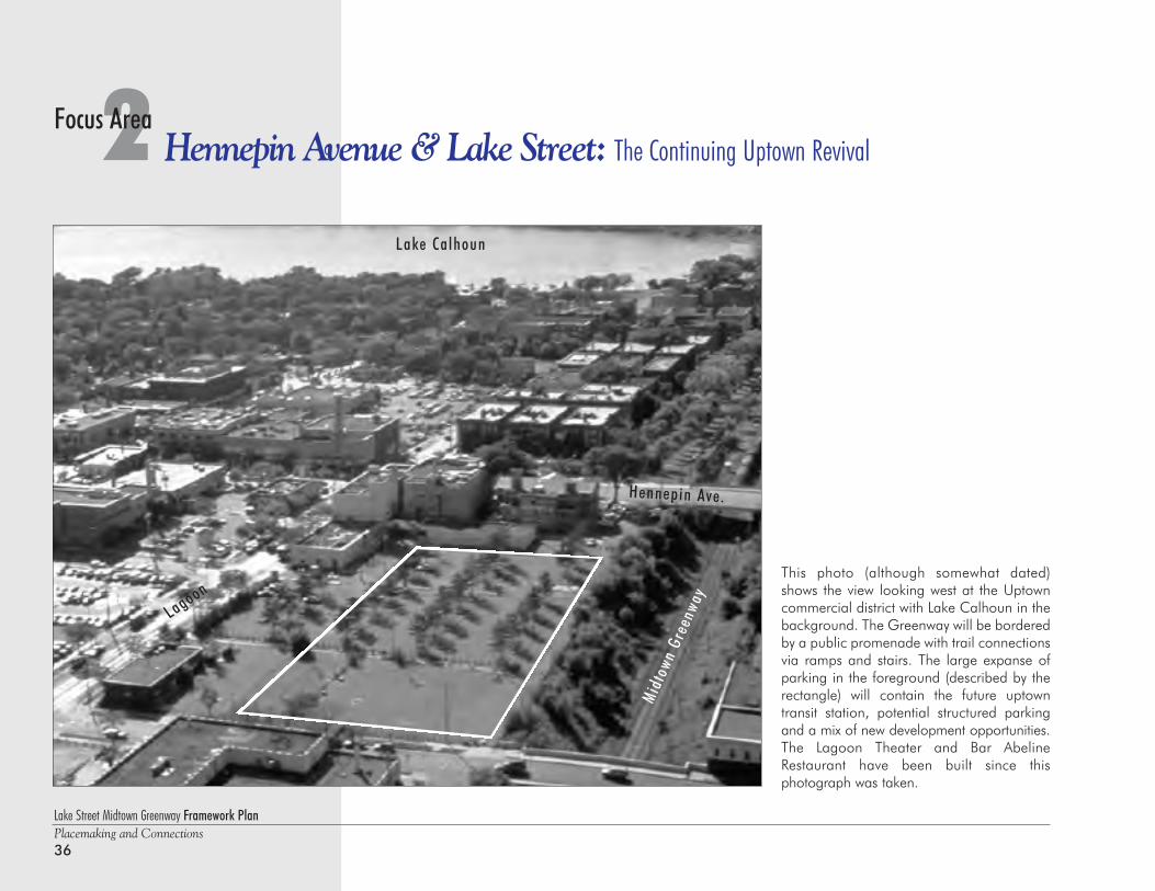
This photo (although somewhat dated)shows the view looking west at the Uptowncommercial district with Lake Calhoun in thebackground. The Greenway will be borderedby a public promenade with trail connectionsvia ramps and stairs. The large expanse ofparking in the foreground (described by therectangle) will contain the future uptowntransit station, potential structured parkingand a mix of new development opportunities.The Lagoon Theater and Bar AbelineRestaurant have been built since this photograph was taken.
2 Hennepin Avenue & Lake Street: The Continuing Uptown RevivalFocus Area
Lagoon
Hennepin Ave.
Midt
own
Gree
nway
Lake Calhoun
Midtown Greenway
Hen
nepi
n
A
venu
e
Lake Street Midtown Greenway Framework PlanPlacemaking and Connections
37
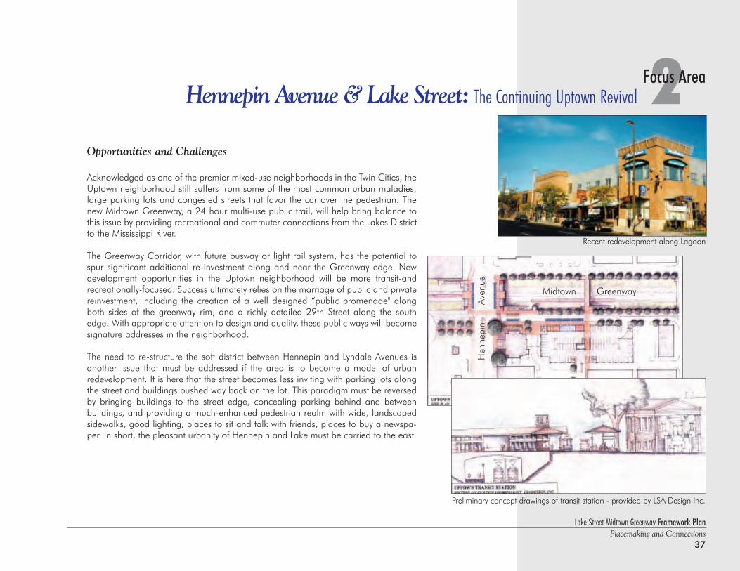
2Focus AreaHennepin Avenue & Lake Street: The Continuing Uptown Revival
Opportunities and Challenges
Acknowledged as one of the premier mixed-use neighborhoods in the Twin Cities, theUptown neighborhood still suffers from some of the most common urban maladies:large parking lots and congested streets that favor the car over the pedestrian. Thenew Midtown Greenway, a 24 hour multi-use public trail, will help bring balance tothis issue by providing recreational and commuter connections from the Lakes Districtto the Mississippi River.
The Greenway Corridor, with future busway or light rail system, has the potential tospur significant additional re-investment along and near the Greenway edge. Newdevelopment opportunities in the Uptown neighborhood will be more transit-andrecreationally-focused. Success ultimately relies on the marriage of public and privatereinvestment, including the creation of a well designed “public promenade" alongboth sides of the greenway rim, and a richly detailed 29th Street along the southedge. With appropriate attention to design and quality, these public ways will becomesignature addresses in the neighborhood.
The need to re-structure the soft district between Hennepin and Lyndale Avenues isanother issue that must be addressed if the area is to become a model of urban redevelopment. It is here that the street becomes less inviting with parking lots alongthe street and buildings pushed way back on the lot. This paradigm must be reversedby bringing buildings to the street edge, concealing parking behind and betweenbuildings, and providing a much-enhanced pedestrian realm with wide, landscapedsidewalks, good lighting, places to sit and talk with friends, places to buy a newspa-per. In short, the pleasant urbanity of Hennepin and Lake must be carried to the east.
Preliminary concept drawings of transit station - provided by LSA Design Inc.
Recent redevelopment along Lagoon
Lake Street Midtown Greenway Framework PlanPlacemaking and Connections38
2 Hennepin Avenue & Lake Street: The Continuing Uptown RevivalFocus Area
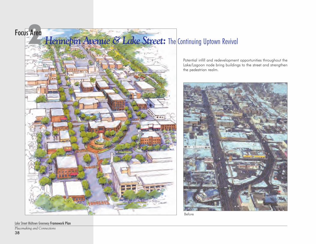
Before
Potential infill and redevelopment opportunities throughout theLake/Lagoon node bring buildings to the street and strengthenthe pedestrian realm.
Lake Street Midtown Greenway Framework PlanPlacemaking and Connections
39
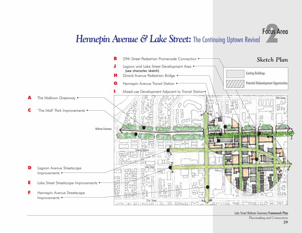
2Focus AreaHennepin Avenue & Lake Street: The Continuing Uptown Revival
B 29th Street Pedestrian Promenade Connection •
J Lagoon and Lake Street Development Area •(see character sketch)
H Girard Avenue Pedestrian Bridge •
G Hennepin Avenue Transit Station •
I Mixed-use Development Adjacent to Transit Station•
A The Midtown Greenway •
C ‘The Mall’ Park Improvements •
D Lagoon Avenue StreetscapeImprovements •
E Lake Street Streetscape Improvements •
F Hennepin Avenue Streetscape Improvements •
Henn
epin
Aven
ue
Midtown Greenway
Lake Street
28th Street
31st Street
Lagoon Avenue
Sketch Plan
Existing Buildings
Potential Redevelopment Opportunities
Lake Street Midtown Greenway Framework PlanPlacemaking and Connections40
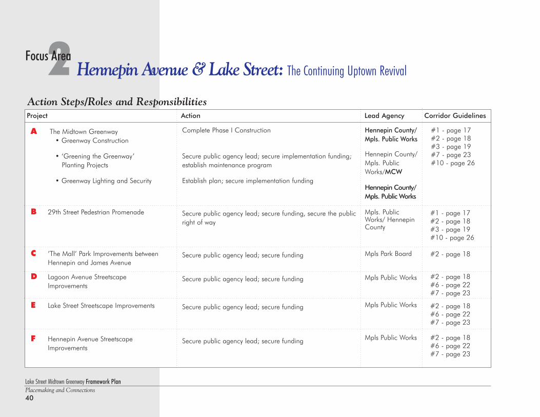
2 Hennepin Avenue & Lake Street: The Continuing Uptown RevivalFocus Area
Action Steps/Roles and ResponsibilitiesProject Action Lead Agency Corridor Guidelines
Complete Phase I Construction
Secure public agency lead; secure implementation funding;establish maintenance program
Establish plan; secure implementation funding
Secure public agency lead; secure funding, secure the publicright of way
Secure public agency lead; secure funding
Secure public agency lead; secure funding
Secure public agency lead; secure funding
Secure public agency lead; secure funding
Hennepin County/Mpls. Public Works
Hennepin County/Mpls. PublicWorks/MCW
Hennepin County/Mpls. Public Works
Mpls. PublicWorks/ HennepinCounty
Mpls Park Board
Mpls Public Works
Mpls Public Works
Mpls Public Works
#1 - page 17#2 - page 18#3 - page 19#7 - page 23#10 - page 26
A The Midtown Greenway• Greenway Construction
• ‘Greening the Greenway’ Planting Projects
• Greenway Lighting and Security
B 29th Street Pedestrian Promenade
C ’The Mall’ Park Improvements between Hennepin and James Avenue
D Lagoon Avenue Streetscape Improvements
E Lake Street Streetscape Improvements
F Hennepin Avenue StreetscapeImprovements
#1 - page 17#2 - page 18#3 - page 19#10 - page 26
#2 - page 18
#2 - page 18#6 - page 22#7 - page 23
#2 - page 18#6 - page 22#7 - page 23
#2 - page 18#6 - page 22#7 - page 23
Lake Street Midtown Greenway Framework PlanPlacemaking and Connections
41
2Focus AreaHennepin Avenue & Lake Street: The Continuing Uptown Revival
Notes:
Project Action Lead Agency Corridor Guidelines
G Hennepin Avenue Transit Station
H Girard Avenue Pedestrian Bridge
I Mixed-use Development adjacent to transit station
J Lagoon and Lake Street development area
K Public Art
Implement the construction
Secure public agency lead; secure funding
Secure lead entity to establish proactive businessdevelopment strategy and provide marketing/technical assistance
Secure public agency lead to determine feasibility of designated ‘Development Area;’ recruit investor/developer interest
Coordinate Master Plan process
#1 - page 17#2 - page 18
Metro Transit
Mpls Public Works
MCW
All Pages 17-26
All pages 17-26
#10 - page 26
Bold Type: Agency Commitment
All pages 17-26
Action Steps/Roles and Responsibilities
Lake Street Midtown Greenway Framework PlanPlacemaking and Connections42
This photo shows the view looking west alongthe Greenway corridor: Lyndale Avenuecrosses in the foreground, and the UrbanVillage site occupies the three contiguousblocks along the north rim of the greenwayindicated by the rectangle. 29th Street, in thepast a service-focused street, can be seenadjacent to the south rim of the greenway. It'stransformation into a premier urban street iskey to the success of the Greenway.
3 Urban Village: Innovative Mixed Income HousingFocus Area
Lyndale Avenue So.
Midt
own
Gree
nway
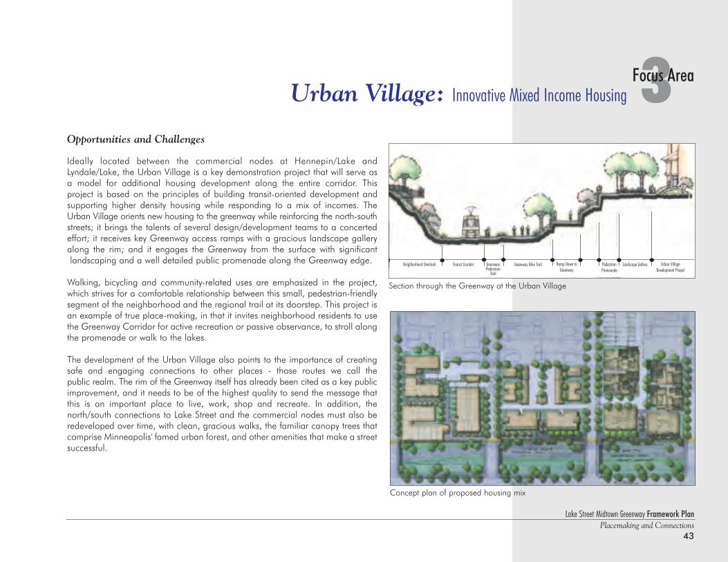
Lake Street Midtown Greenway Framework PlanPlacemaking and Connections
43
3Focus AreaUrban Village: Innovative Mixed Income Housing
Concept plan of proposed housing mix
Opportunities and Challenges
Ideally located between the commercial nodes at Hennepin/Lake andLyndale/Lake, the Urban Village is a key demonstration project that will serve asa model for additional housing development along the entire corridor. This project is based on the principles of building transit-oriented development andsupporting higher density housing while responding to a mix of incomes. TheUrban Village orients new housing to the greenway while reinforcing the north-southstreets; it brings the talents of several design/development teams to a concertedeffort; it receives key Greenway access ramps with a gracious landscape galleryalong the rim; and it engages the Greenway from the surface with significantlandscaping and a well detailed public promenade along the Greenway edge.
Walking, bicycling and community-related uses are emphasized in the project,which strives for a comfortable relationship between this small, pedestrian-friendlysegment of the neighborhood and the regional trail at its doorstep. This project isan example of true place-making, in that it invites neighborhood residents to usethe Greenway Corridor for active recreation or passive observance, to stroll alongthe promenade or walk to the lakes.
The development of the Urban Village also points to the importance of creatingsafe and engaging connections to other places - those routes we call the public realm. The rim of the Greenway itself has already been cited as a key publicimprovement, and it needs to be of the highest quality to send the message thatthis is an important place to live, work, shop and recreate. In addition, thenorth/south connections to Lake Street and the commercial nodes must also beredeveloped over time, with clean, gracious walks, the familiar canopy trees thatcomprise Minneapolis' famed urban forest, and other amenities that make a streetsuccessful.
Neighborhood Overlook Transit Corridor Greenway Pedestrian
Trail
Greenway Bike Trail Ramp Down toGreenway
PedestrianPromenade
Landscape Gallery Urban VillageDevelopment Project
Section through the Greenway at the Urban Village
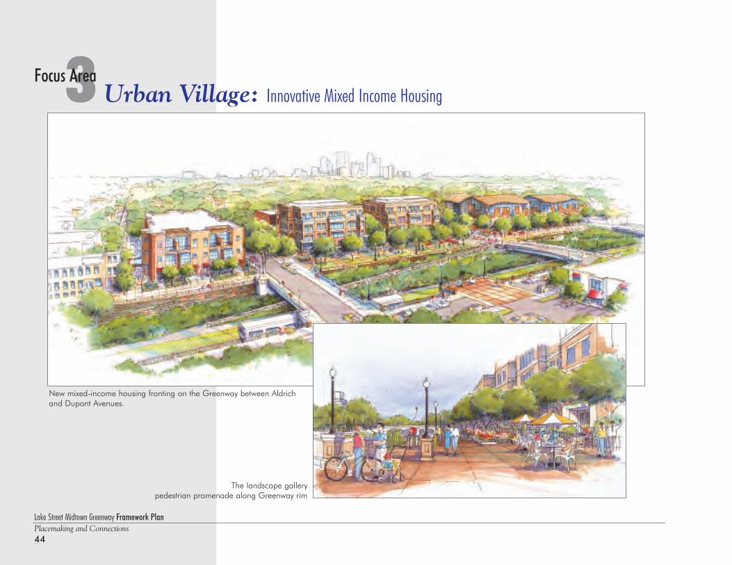
Lake Street Midtown Greenway Framework PlanPlacemaking and Connections44
3 Urban Village: Innovative Mixed Income HousingFocus Area
New mixed-income housing fronting on the Greenway between Aldrichand Dupont Avenues.
The landscape gallerypedestrian promenade along Greenway rim
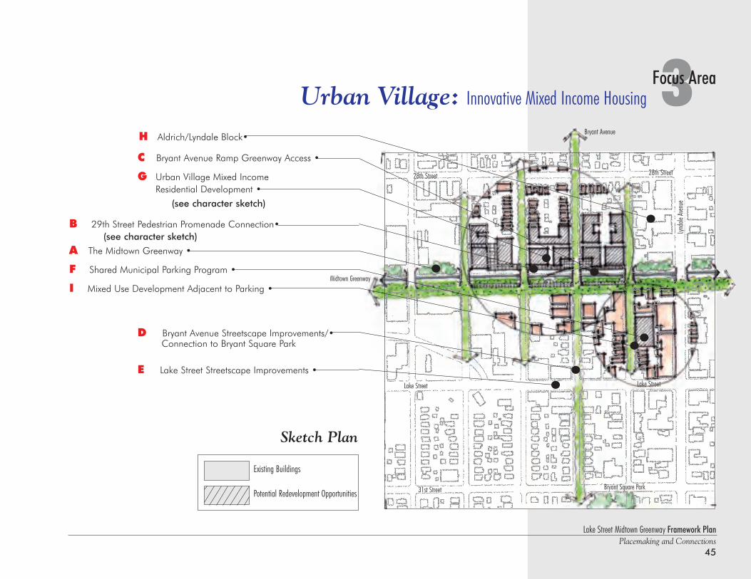
Lake Street Midtown Greenway Framework PlanPlacemaking and Connections
45
3Focus AreaUrban Village: Innovative Mixed Income Housing
C Bryant Avenue Ramp Greenway Access •
G Urban Village Mixed Income Residential Development •
(see character sketch)
B 29th Street Pedestrian Promenade Connection•(see character sketch)
A The Midtown Greenway •
F Shared Municipal Parking Program •
I Mixed Use Development Adjacent to Parking •
D Bryant Avenue Streetscape Improvements/•Connection to Bryant Square Park
E Lake Street Streetscape Improvements •
H Aldrich/Lyndale Block•
Lake Street
Lynda
le Av
enue
Lake Street
Midtown Greenway
Bryant Avenue
28th Street28th Street
31st Street
Sketch Plan
Bryant Square Park
Existing Buildings
Potential Redevelopment Opportunities
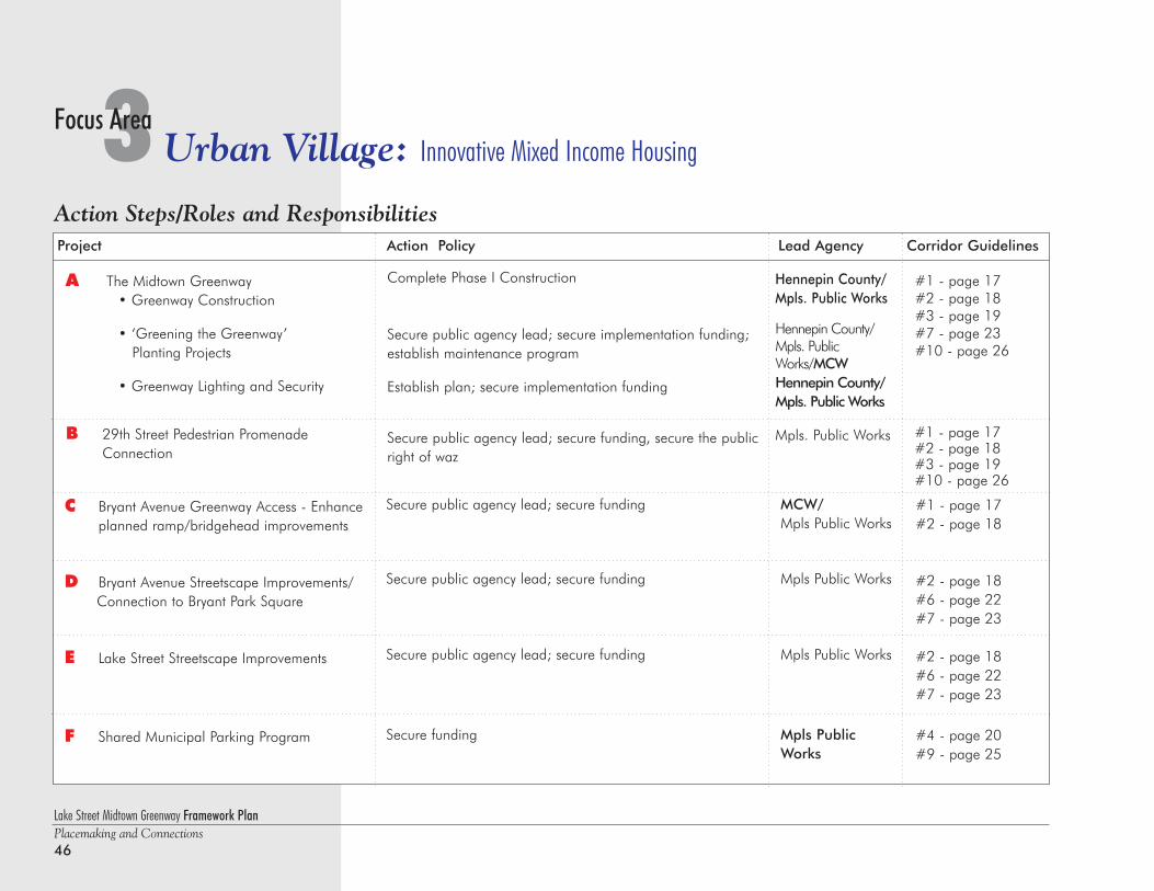
Lake Street Midtown Greenway Framework PlanPlacemaking and Connections46
3 Urban Village: Innovative Mixed Income HousingFocus Area
Project Action Policy Lead Agency Corridor Guidelines
C Bryant Avenue Greenway Access - Enhanceplanned ramp/bridgehead improvements
D Bryant Avenue Streetscape Improvements/Connection to Bryant Park Square
E Lake Street Streetscape Improvements
F Shared Municipal Parking Program
MCW/Mpls Public Works
Mpls Public Works
Mpls Public Works
Mpls PublicWorks
#1 - page 17#2 - page 18
#2 - page 18#6 - page 22#7 - page 23
#2 - page 18#6 - page 22#7 - page 23
#4 - page 20#9 - page 25
Secure public agency lead; secure funding
Secure public agency lead; secure funding
Secure public agency lead; secure funding
Secure funding
A The Midtown Greenway• Greenway Construction
• ‘Greening the Greenway’ Planting Projects
• Greenway Lighting and Security
B 29th Street Pedestrian Promenade Connection
Complete Phase I Construction
Secure public agency lead; secure implementation funding;establish maintenance program
Establish plan; secure implementation funding
Secure public agency lead; secure funding, secure the publicright of waz
Hennepin County/Mpls. Public Works
Hennepin County/Mpls. PublicWorks/MCWHennepin County/Mpls. Public Works
Mpls. Public Works
#1 - page 17#2 - page 18#3 - page 19#7 - page 23#10 - page 26
#1 - page 17#2 - page 18#3 - page 19#10 - page 26
Action Steps/Roles and Responsibilities
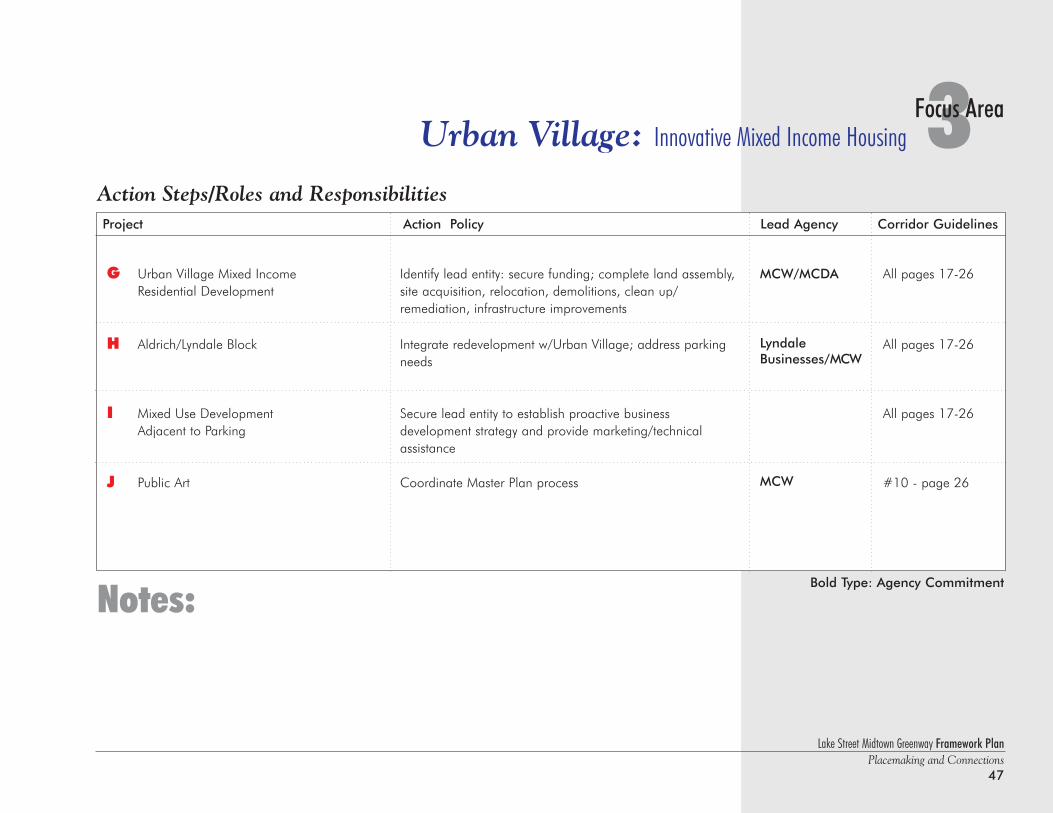
Lake Street Midtown Greenway Framework PlanPlacemaking and Connections
47
3Focus AreaUrban Village: Innovative Mixed Income Housing
Notes:
Project Action Policy Lead Agency Corridor Guidelines
G Urban Village Mixed Income Residential Development
H Aldrich/Lyndale Block
I Mixed Use DevelopmentAdjacent to Parking
J Public Art
MCW/MCDA
LyndaleBusinesses/MCW
MCW
All pages 17-26
All pages 17-26
All pages 17-26
#10 - page 26
Identify lead entity: secure funding; complete land assembly,site acquisition, relocation, demolitions, clean up/remediation, infrastructure improvements
Integrate redevelopment w/Urban Village; address parkingneeds
Secure lead entity to establish proactive business development strategy and provide marketing/technical assistance
Coordinate Master Plan process
Bold Type: Agency Commitment
Action Steps/Roles and Responsibilities
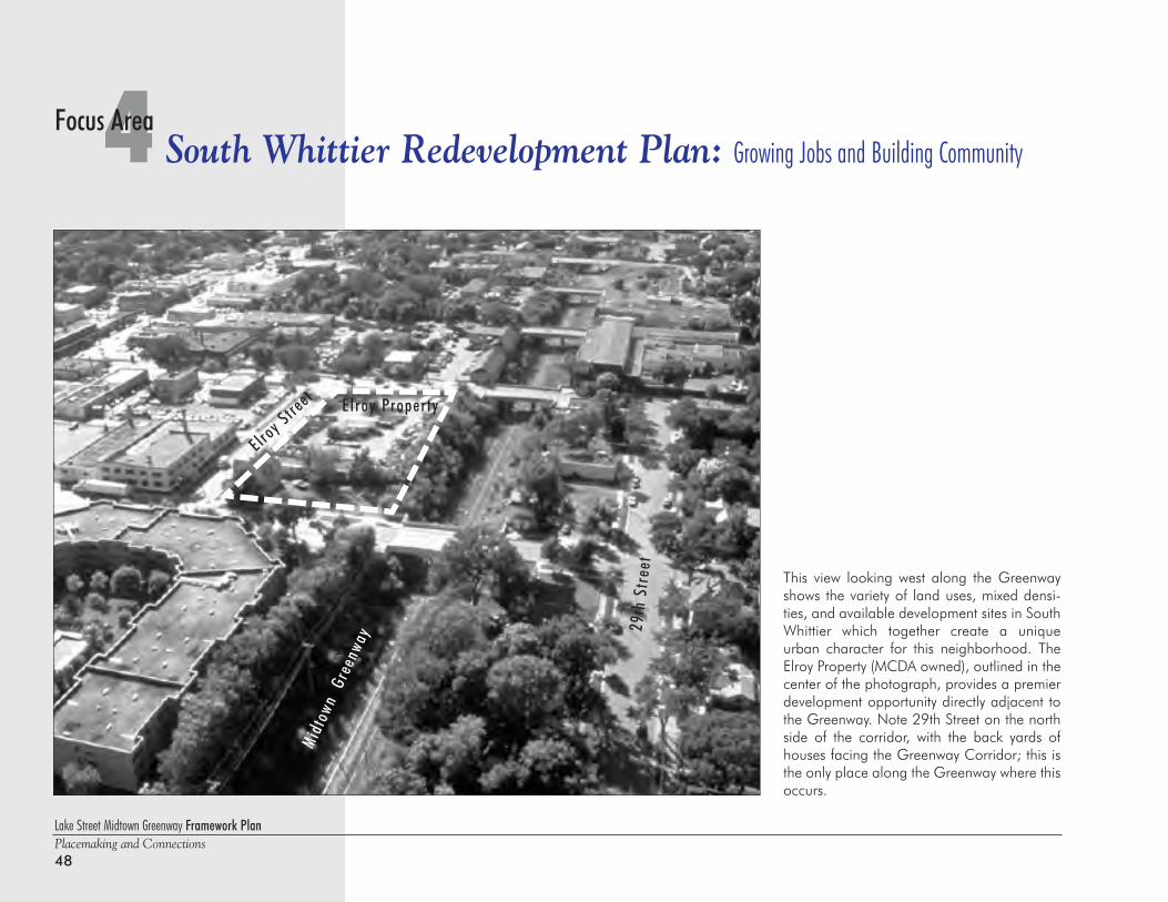
Lake Street Midtown Greenway Framework PlanPlacemaking and Connections48
4 South Whittier Redevelopment Plan: Growing Jobs and Building CommunityFocus Area
Midt
own
Gre
enwa
y
E lroy Stre
et E lroy Property
29th
Str
eet
This view looking west along the Greenwayshows the variety of land uses, mixed densi-ties, and available development sites in SouthWhittier which together create a uniqueurban character for this neighborhood. TheElroy Property (MCDA owned), outlined in thecenter of the photograph, provides a premierdevelopment opportunity directly adjacent tothe Greenway. Note 29th Street on the northside of the corridor, with the back yards ofhouses facing the Greenway Corridor; this isthe only place along the Greenway where thisoccurs.
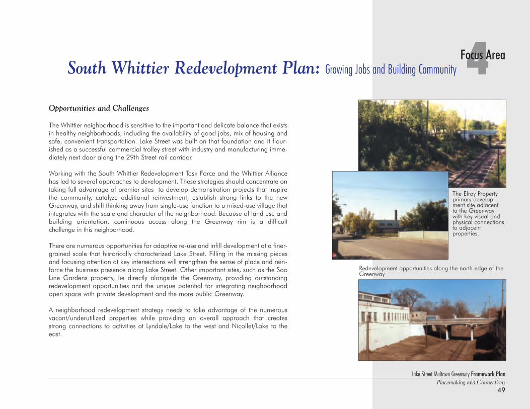
Lake Street Midtown Greenway Framework PlanPlacemaking and Connections
49
4Focus AreaSouth Whittier Redevelopment Plan: Growing Jobs and Building Community
Opportunities and Challenges
The Whittier neighborhood is sensitive to the important and delicate balance that existsin healthy neighborhoods, including the availability of good jobs, mix of housing andsafe, convenient transportation. Lake Street was built on that foundation and it flour-ished as a successful commercial trolley street with industry and manufacturing imme-diately next door along the 29th Street rail corridor.
Working with the South Whittier Redevelopment Task Force and the Whittier Alliancehas led to several approaches to development. These strategies should concentrate ontaking full advantage of premier sites to develop demonstration projects that inspirethe community, catalyze additional reinvestment, establish strong links to the newGreenway, and shift thinking away from single-use function to a mixed-use village thatintegrates with the scale and character of the neighborhood. Because of land use andbuilding orientation, continuous access along the Greenway rim is a difficult challenge in this neighborhood.
There are numerous opportunities for adaptive re-use and infill development at a finer-grained scale that historically characterized Lake Street. Filling in the missing piecesand focusing attention at key intersections will strengthen the sense of place and rein-force the business presence along Lake Street. Other important sites, such as the SooLine Gardens property, lie directly alongside the Greenway, providing outstandingredevelopment opportunities and the unique potential for integrating neighborhoodopen space with private development and the more public Greenway.
A neighborhood redevelopment strategy needs to take advantage of the numerousvacant/underutilized properties while providing an overall approach that createsstrong connections to activities at Lyndale/Lake to the west and Nicollet/Lake to theeast.
The Elroy Propertyprimary develop-ment site adjacent to the Greenwaywith key visual and physical connectionsto adjacent properties.
Redevelopment opportunities along the north edge of theGreenway
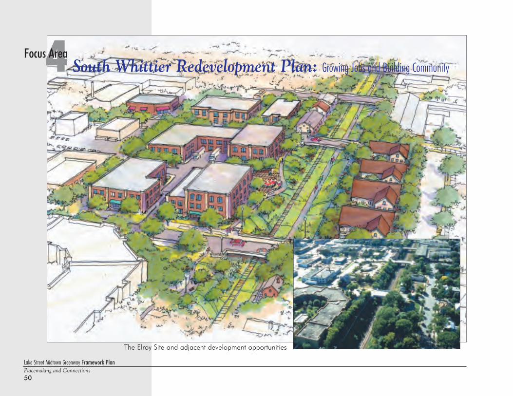
Lake Street Midtown Greenway Framework PlanPlacemaking and Connections50
4 South Whittier Redevelopment Plan: Growing Jobs and Building CommunityFocus Area
The Elroy Site and adjacent development opportunities
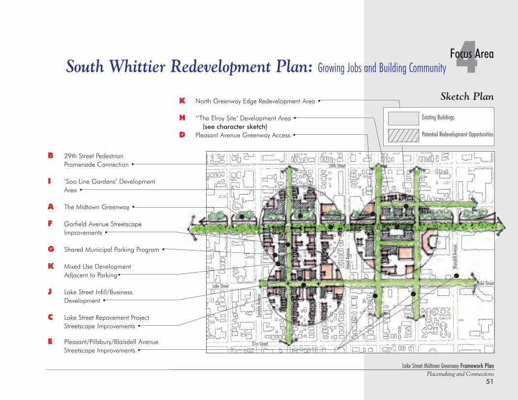
Lake Street Midtown Greenway Framework PlanPlacemaking and Connections
51
B 29th Street Pedestrian Promenade Connection •
I ‘Soo Line Gardens’ Development Area •
A The Midtown Greenway •
F Garfield Avenue StreetscapeImprovements •
G Shared Municipal Parking Program •
K Mixed Use Development Adjacent to Parking•
J Lake Street Infill/Business Development •
C Lake Street Repavement Project Streetscape Improvements •
E Pleasant/Pillsbury/Blaisdell Avenue Streetscape Improvements •
K North Greenway Edge Redevelopment Area •
H ‘’The Elroy Site’ Development Area • (see character sketch)
D Pleasant Avenue Greenway Access •
4Focus AreaSouth Whittier Redevelopment Plan: Growing Jobs and Building Community
Lake Street
Lynda
le Av
enue
Lake Street
31st Street
28th Street
Grand
Aven
ue
Blaisd
ell Av
enue
Sketch Plan
Existing Buildings
Potential Redevelopment Opportunities
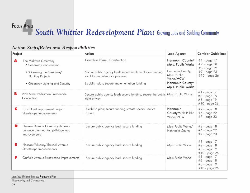
Lake Street Midtown Greenway Framework PlanPlacemaking and Connections52
4 South Whittier Redevelopment Plan: Growing Jobs and Building CommunityFocus Area
Project Action Lead Agency Corridor Guidelines
Establish plan; secure funding; create special service district
Secure public agency lead; secure funding
Secure public agency lead; secure funding
Secure public agency lead; secure funding
HennepinCounty/Mpls PublicWorks/MCW
Mpls Public Works/Hennepin County
Mpls Public Works
Mpls Public Works
#2 - page 18#6 - page 22#7 - page 23
#2 - page 18#6 - page 22#7 - page 23
#1 - page 17#2 - page 18#3 - page 19#10 - page 26#1 - page 17#2 - page 18#3 - page 19#10 - page 26
C Lake Street Repavement Project Streetscape Improvements
D Pleasant Avenue Greenway Access -Enhance planned Ramp/Bridgehead Improvements
E Pleasant/Pillsbury/Blaisdell Avenue Streetscape Improvements
F Garfield Avenue Streetscape Improvements
A The Midtown Greenway• Greenway Construction
• ‘Greening the Greenway’ Planting Projects
• Greenway Lighting and Security
B 29th Street Pedestrian Promenade Connection
Complete Phase I Construction
Secure public agency lead; secure implementation funding;establish maintenance program
Establish plan; secure implementation funding
Secure public agency lead; secure funding, secure the publicright of way
Hennepin County/Mpls. Public Works
Hennepin County/Mpls. PublicWorks/MCWHennepin County/Mpls. Public Works
Mpls. Public Works
#1 - page 17#2 - page 18#3 - page 19#7 - page 23#10 - page 26
#1 - page 17#2 - page 18#3 - page 19#10 - page 26
Action Steps/Roles and Responsibilities
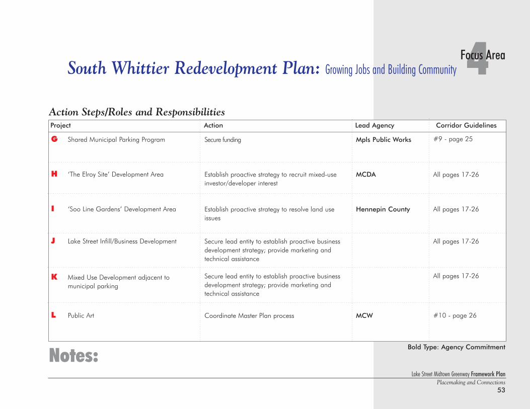
Lake Street Midtown Greenway Framework PlanPlacemaking and Connections
53
Secure funding
Establish proactive strategy to recruit mixed-useinvestor/developer interest
Establish proactive strategy to resolve land useissues
Secure lead entity to establish proactive businessdevelopment strategy; provide marketing and technical assistance
Secure lead entity to establish proactive businessdevelopment strategy; provide marketing andtechnical assistance
Coordinate Master Plan process
#9 - page 25
All pages 17-26
All pages 17-26
All pages 17-26
All pages 17-26
#10 - page 26
Mpls Public Works
MCDA
Hennepin County
MCW
4Focus AreaSouth Whittier Redevelopment Plan: Growing Jobs and Building Community
Notes:
Project Action Lead Agency Corridor Guidelines
G Shared Municipal Parking Program
H ‘The Elroy Site’ Development Area
I ‘Soo Line Gardens’ Development Area
J Lake Street Infill/Business Development
K Mixed Use Development adjacent tomunicipal parking
L Public Art
Bold Type: Agency Commitment
Action Steps/Roles and Responsibilities
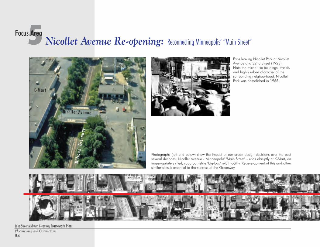
Lake Street Midtown Greenway Framework PlanPlacemaking and Connections54
5 Nicollet Avenue Re-opening: Reconnecting Minneapolis’ “Main Street”Focus Area
Photographs (left and below) show the impact of our urban design decisions over the pastseveral decades: Nicollet Avenue - Minneapolis' "Main Street" - ends abruptly at K-Mart, aninappropriately sited, suburban-style "big-box" retail facility. Redevelopment of this and othersimilar sites is essential to the success of the Greenway.
Mid
town
Gre
enwa
y
K-Mart
Nicol let Avenue
FFrraa
nnkkll
iinn
AAvvee
nnuu
ee
Fans leaving Nicollet Park at NicolletAvenue and 32nd Street (1923).Note the mixed-use buildings, transit,and highly urban character of thesurrounding neighborhood. NicolletPark was demolished in 1955.
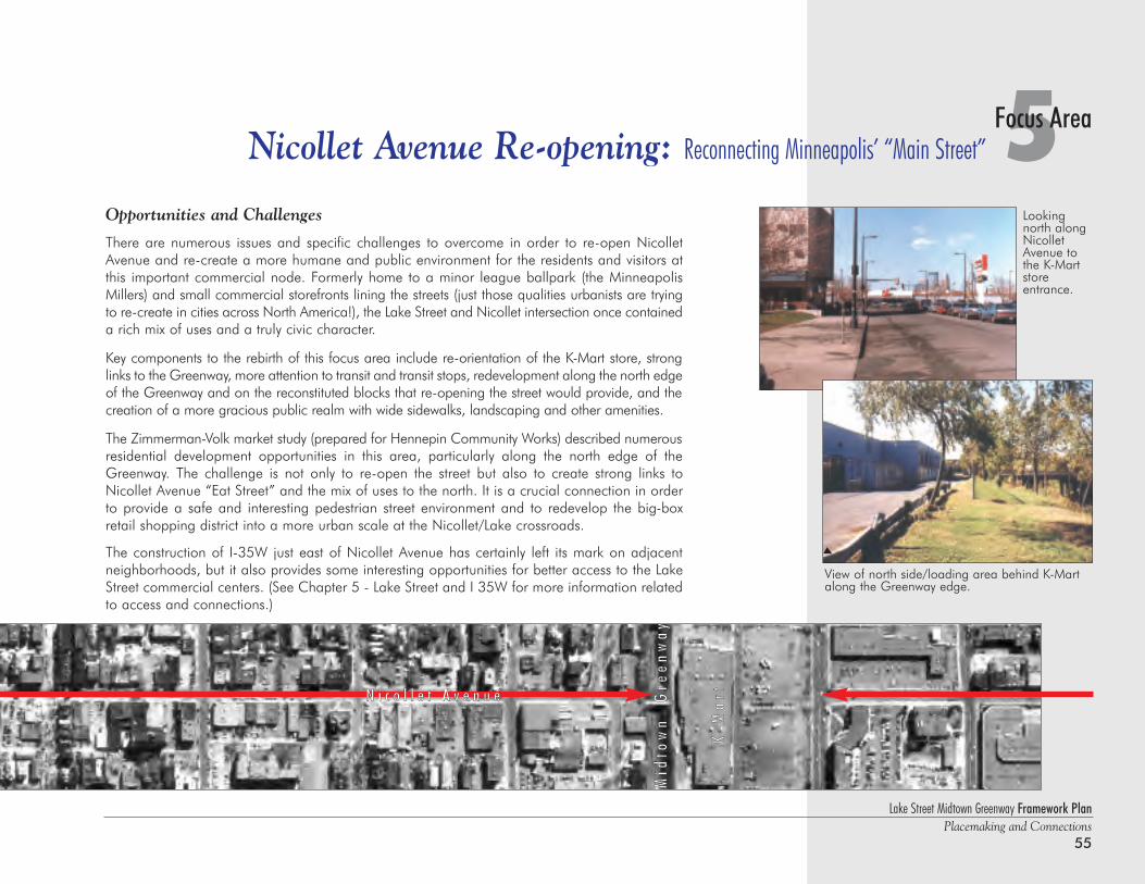
Opportunities and Challenges
There are numerous issues and specific challenges to overcome in order to re-open NicolletAvenue and re-create a more humane and public environment for the residents and visitors atthis important commercial node. Formerly home to a minor league ballpark (the MinneapolisMillers) and small commercial storefronts lining the streets (just those qualities urbanists are tryingto re-create in cities across North America!), the Lake Street and Nicollet intersection once containeda rich mix of uses and a truly civic character.
Key components to the rebirth of this focus area include re-orientation of the K-Mart store, stronglinks to the Greenway, more attention to transit and transit stops, redevelopment along the north edgeof the Greenway and on the reconstituted blocks that re-opening the street would provide, and thecreation of a more gracious public realm with wide sidewalks, landscaping and other amenities.
The Zimmerman-Volk market study (prepared for Hennepin Community Works) described numerousresidential development opportunities in this area, particularly along the north edge of theGreenway. The challenge is not only to re-open the street but also to create strong links toNicollet Avenue “Eat Street” and the mix of uses to the north. It is a crucial connection in orderto provide a safe and interesting pedestrian street environment and to redevelop the big-boxretail shopping district into a more urban scale at the Nicollet/Lake crossroads.
The construction of I-35W just east of Nicollet Avenue has certainly left its mark on adjacentneighborhoods, but it also provides some interesting opportunities for better access to the LakeStreet commercial centers. (See Chapter 5 - Lake Street and I 35W for more information relatedto access and connections.)
Lake Street Midtown Greenway Framework PlanPlacemaking and Connections
55
5Focus AreaNicollet Avenue Re-opening: Reconnecting Minneapolis’ “Main Street”
Lookingnorth alongNicolletAvenue tothe K-Martstoreentrance.
View of north side/loading area behind K-Martalong the Greenway edge.
MMiidd
ttooww
nn
GGrree
eennww
aayy
KK--MM
aarrttNN ii cc oo ll ll ee tt AA vv ee nn uu ee
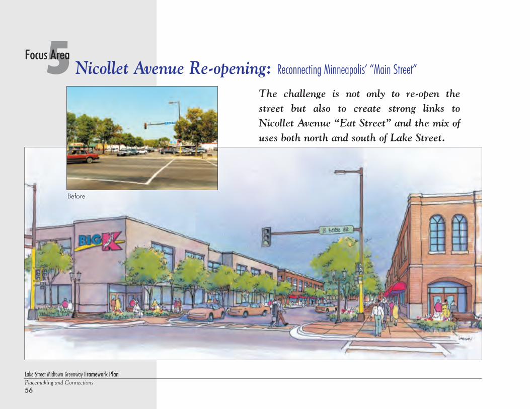
Lake Street Midtown Greenway Framework PlanPlacemaking and Connections56
5 Nicollet Avenue Re-opening: Reconnecting Minneapolis’ “Main Street”Focus Area
Before
The challenge is not only to re-open thestreet but also to create strong links toNicollet Avenue “Eat Street” and the mix ofuses both north and south of Lake Street.
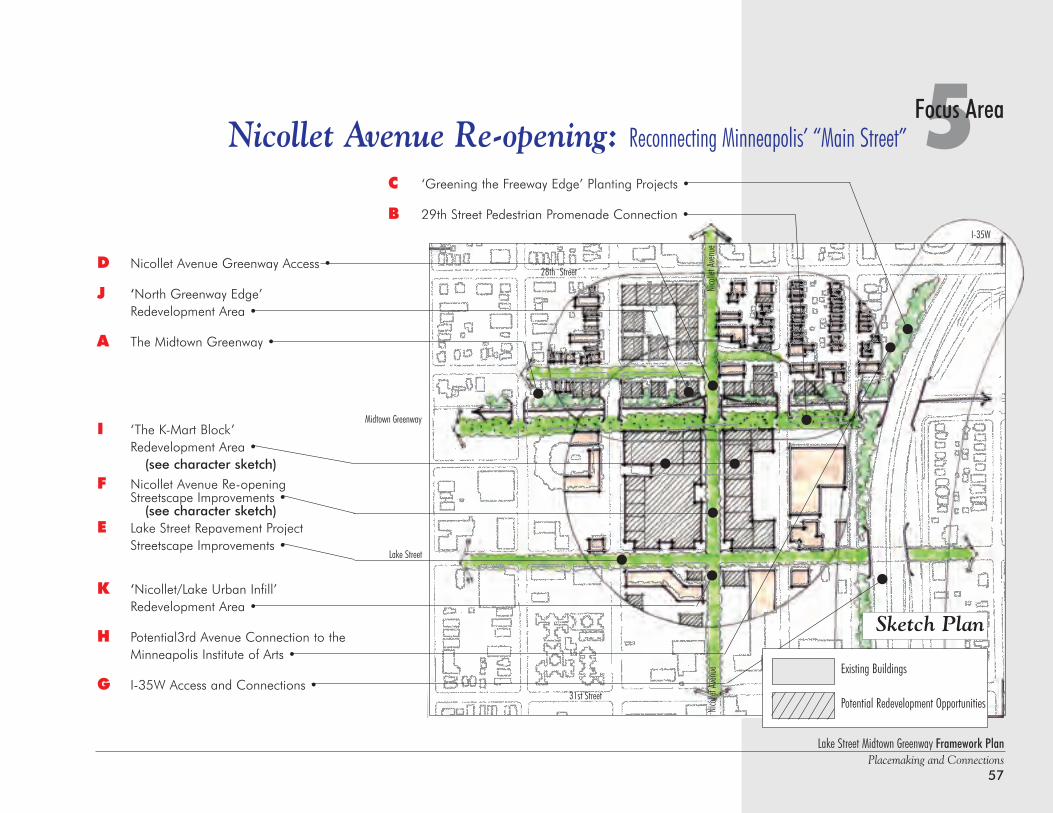
D Nicollet Avenue Greenway Access •
J ‘North Greenway Edge’Redevelopment Area •
A The Midtown Greenway •
I ‘The K-Mart Block’ Redevelopment Area •
(see character sketch)
F Nicollet Avenue Re-openingStreetscape Improvements •
(see character sketch)E Lake Street Repavement Project
Streetscape Improvements •
K ‘Nicollet/Lake Urban Infill’ Redevelopment Area •
H Potential3rd Avenue Connection to the Minneapolis Institute of Arts •
G I-35W Access and Connections •
Lake Street Midtown Greenway Framework PlanPlacemaking and Connections
57
C ‘Greening the Freeway Edge’ Planting Projects •
B 29th Street Pedestrian Promenade Connection •
5Focus AreaNicollet Avenue Re-opening: Reconnecting Minneapolis’ “Main Street”
Sketch Plan
Lake Street
Nico
llet A
venu
e
Midtown Greenway
I-35W
31st Street
28th Street
Nico
llet A
venu
e
Existing Buildings
Potential Redevelopment Opportunities
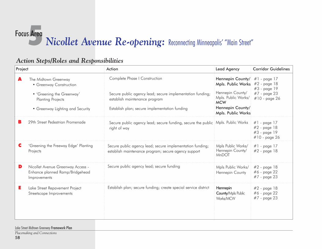
Lake Street Midtown Greenway Framework PlanPlacemaking and Connections58
5 Nicollet Avenue Re-opening: Reconnecting Minneapolis’ “Main Street”Focus Area
Action Steps/Roles and ResponsibilitiesProject Action Lead Agency Corridor Guidelines
Secure public agency lead; secure implementation funding;establish maintenance program; secure agency support
Secure public agency lead; secure funding
Establish plan; secure funding; create special service district
Mpls Public Works/Hennepin County/MnDOT
Mpls Public Works/Hennepin County
HennepinCounty/Mpls PublicWorks/MCW
#1 - page 17#2 - page 18
#2 - page 18#6 - page 22#7 - page 23
#2 - page 18#6 - page 22#7 - page 23
C ‘Greening the Freeway Edge’ Planting Projects
D Nicollet Avenue Greenway Access -Enhance planned Ramp/Bridgehead Improvements
E Lake Street Repavement ProjectStreetscape Improvements
A The Midtown Greenway• Greenway Construction
• ‘Greening the Greenway’ Planting Projects
• Greenway Lighting and Security
B 29th Street Pedestrian Promenade
Complete Phase I Construction
Secure public agency lead; secure implementation funding;establish maintenance program
Establish plan; secure implementation funding
Secure public agency lead; secure funding, secure the publicright of way
Hennepin County/Mpls. Public Works
Hennepin County/Mpls. Public Works/MCWHennepin County/Mpls. Public Works
Mpls. Public Works
#1 - page 17#2 - page 18#3 - page 19#7 - page 23#10 - page 26
#1 - page 17#2 - page 18#3 - page 19#10 - page 26
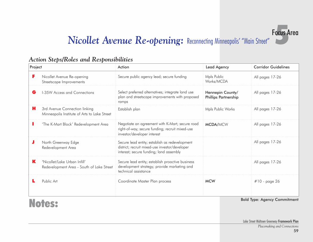
Lake Street Midtown Greenway Framework PlanPlacemaking and Connections
59
5Focus AreaNicollet Avenue Re-opening: Reconnecting Minneapolis’ “Main Street”
Project Action Lead Agency Corridor Guidelines
Secure public agency lead; secure funding
Select preferred alternatives; integrate land useplan and streetscape improvements with proposedramps
Establish plan
Negotiate an agreement with K-Mart; secure roadright-of-way; secure funding; recruit mixed-use investor/developer interest
Secure lead entity; establish as redevelopment district; recruit mixed-use investor/developer interest; secure funding; land assembly
Secure lead entity; establish proactive businessdevelopment strategy; provide marketing andtechnical assistance
Coordinate Master Plan process
Mpls PublicWorks/MCDA
Hennepin County/Phillips Partnership
Mpls Public Works
MCDA/MCW
MCW
All pages 17-26
All pages 17-26
All pages 17-26
All pages 17-26
All pages 17-26
All pages 17-26
#10 - page 26
F Nicollet Avenue Re-openingStreetscape Improvements
G I-35W Access and Connections
H 3rd Avenue Connection linking Minneapolis Institute of Arts to Lake Street
I ‘The K-Mart Block’ Redevelopment Area
J North Greenway Edge Redevelopment Area
K ‘Nicollet/Lake Urban Infill’Redevelopment Area - South of Lake Street
L Public Art
Notes: Bold Type: Agency Commitment
Action Steps/Roles and Responsibilities

Lake Street Midtown Greenway Framework PlanPlacemaking and Connections60
6 4th & Lake Street Development Plan: Linking Opportunities to Strengthen CommunityFocus Area
This photo, looking east along Lake Streetwith Fourth Avenue in the middle fore-ground, shows the varied patterns of landuse that characterize significant lengths ofthe road. Commercial buildings range fromolder, unimproved structures to renovatedbuildings and newer, fast food restaurants.Expanding commercial uses and parking lotshave steadily encroached on residentialareas, as is evidenced by the sparseness ofthe tree canopy. The Greenway corridor canbe seen at the left side of the image, with theGreat Lake Center (formerly Sears) in thebackground.
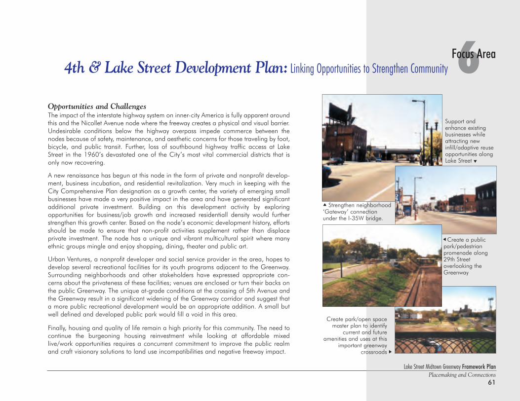
6Focus Area4th & Lake Street Development Plan: Linking Opportunities to Strengthen Community
Lake Street Midtown Greenway Framework PlanPlacemaking and Connections
61
Support andenhance existingbusinesses whileattracting newinfill/adaptive reuseopportunities alongLake Street
Create park/open spacemaster plan to identify
current and future amenities and uses at this
important greenwaycrossroads
Create a publicpark/pedestrian promenade along29th Street overlooking theGreenway
Opportunities and ChallengesThe impact of the interstate highway system on inner-city America is fully apparent aroundthis and the Nicollet Avenue node where the freeway creates a physical and visual barrier.Undesirable conditions below the highway overpass impede commerce between thenodes because of safety, maintenance, and aesthetic concerns for those traveling by foot,bicycle, and public transit. Further, loss of southbound highway traffic access at LakeStreet in the 1960’s devastated one of the City’s most vital commercial districts that isonly now recovering.
A new renaissance has begun at this node in the form of private and nonprofit develop-ment, business incubation, and residential revitalization. Very much in keeping with theCity Comprehensive Plan designation as a growth center, the variety of emerging smallbusinesses have made a very positive impact in the area and have generated significantadditional private investment. Building on this development activity by exploring opportunities for business/job growth and increased residentiall density would furtherstrengthen this growth center. Based on the node’s economic development history, effortsshould be made to ensure that non-profit activities supplement rather than displace private investment. The node has a unique and vibrant multicultural spirit where manyethnic groups mingle and enjoy shopping, dining, theater and public art.
Urban Ventures, a nonprofit developer and social service provider in the area, hopes todevelop several recreational facilities for its youth programs adjacent to the Greenway.Surrounding neighborhoods and other stakeholders have expressed appropriate con-cerns about the privateness of these facilities; venues are enclosed or turn their backs onthe public Greenway. The unique at-grade conditions at the crossing of 5th Avenue andthe Greenway result in a significant widening of the Greenway corridor and suggest thata more public recreational development would be an appropriate addition. A small butwell defined and developed public park would fill a void in this area.
Finally, housing and quality of life remain a high priority for this community. The need tocontinue the burgeoning housing reinvestment while looking at affordable mixedlive/work opportunities requires a concurrent commitment to improve the public realmand craft visionary solutions to land use incompatibilities and negative freeway impact.
Strengthen neighborhood‘Gateway’ connectionunder the I-35W bridge.
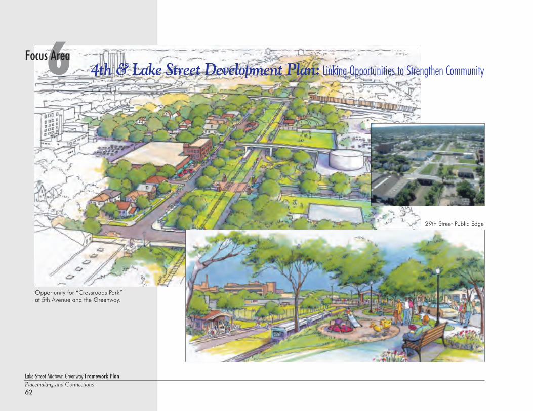
Lake Street Midtown Greenway Framework PlanPlacemaking and Connections62
6 4th & Lake Street Development Plan: Linking Opportunities to Strengthen CommunityFocus Area
Opportunity for “Crossroads Park” at 5th Avenue and the Greenway.
29th Street Public Edge
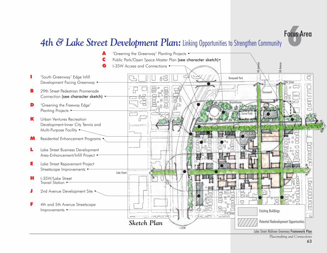
A ‘Greening the Greenway’ Planting Projects •
C Public Park/Open Space Master Plan (see character sketch)•
G I-35W Access and Connections •
Lake Street Midtown Greenway Framework PlanPlacemaking and Connections
63
6Focus Area4th & Lake Street Development Plan: Linking Opportunities to Strengthen Community
I ‘South Greenway’ Edge Infill Development Facing Greenway •
B 29th Street Pedestrian Promenade Connection (see character sketch) •
D ‘Greening the Freeway Edge’ Planting Projects •
K Urban Ventures Recreation Development-Inner City Tennis and Multi-Purpose Facility •
M Residential Enhancement Programs •
L Lake Street Business Development Area-Enhancement/Infill Project •
E Lake Street Repavement ProjectStreetscape Improvements •
H I-35W/Lake Street Transit Station •
J 2nd Avenue Development Site •
F 4th and 5th Avenue StreetscapeImprovements •
Honeywell Park
Honeywell
Lake Street
I-35WSketch Plan
4th Av
enue
5th Av
enue
Amphitheater
Soccer Field
Park Overlooks
31st Street
28th Street
Existing Buildings
Potential Redevelopment Opportunities
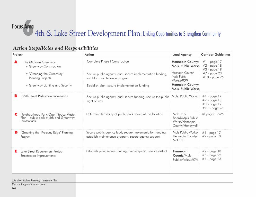
Lake Street Midtown Greenway Framework PlanPlacemaking and Connections64
6 4th & Lake Street Development Plan: Linking Opportunities to Strengthen CommunityFocus Area
Action Steps/Roles and ResponsibilitiesProject Action Lead Agency Corridor Guidelines
Determine feasibility of public park space at this location
Secure public agency lead; secure implementation funding;establish maintenance program; secure agency support
Establish plan; secure funding; create special service district
Mpls ParkBoard/Mpls PublicWorks/HennepinCounty/Honeywell
Mpls Public Works/Hennepin County/MnDOT
HennepinCounty/MplsPublicWorks/MCW
All pages 17-26
#1 - page 17#2 - page 18
#2 - page 18#6 - page 22#7 - page 23
C Neighborhood Park/Open Space Master Plan - public park at 5th and Greenway ‘crossroads’
D ‘Greening the Freeway Edge’ Planting Project
E Lake Street Repavement ProjectStreetscape Improvements
A The Midtown Greenway• Greenway Construction
• ‘Greening the Greenway’ Planting Projects
• Greenway Lighting and Security
B 29th Street Pedestrian Promenade
Complete Phase I Construction
Secure public agency lead; secure implementation funding;establish maintenance program
Establish plan; secure implementation funding
Secure public agency lead; secure funding, secure the publicright of way
Hennepin County/Mpls. Public Works
Hennepin County/Mpls. PublicWorks/MCWHennepin County/Mpls. Public Works
Mpls. Public Works
#1 - page 17#2 - page 18#3 - page 19#7 - page 23#10 - page 26
#1 - page 17#2 - page 18#3 - page 19#10 - page 26
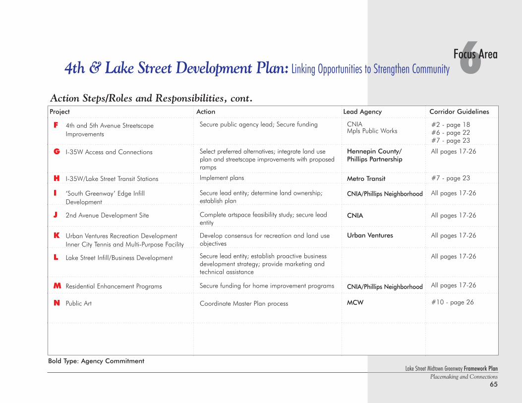
6Focus Area4th & Lake Street Development Plan: Linking Opportunities to Strengthen Community
Action Steps/Roles and Responsibilities, cont.Project Action Lead Agency Corridor Guidelines
Secure public agency lead; Secure funding
Select preferred alternatives; integrate land useplan and streetscape improvements with proposedramps
Implement plans
Secure lead entity; determine land ownership;establish plan
Complete artspace feasibility study; secure leadentity
Develop consensus for recreation and land useobjectives
Secure lead entity; establish proactive businessdevelopment strategy; provide marketing andtechnical assistance
Secure funding for home improvement programs
Coordinate Master Plan process
CNIAMpls Public Works
Hennepin County/Phillips Partnership
Metro Transit
CNIA/Phillips Neighborhood
CNIA
Urban Ventures
CNIA/Phillips Neighborhood
MCW
#2 - page 18#6 - page 22#7 - page 23
All pages 17-26
#7 - page 23
All pages 17-26
All pages 17-26
All pages 17-26
All pages 17-26
All pages 17-26
#10 - page 26
F 4th and 5th Avenue StreetscapeImprovements
G I-35W Access and Connections
H I-35W/Lake Street Transit Stations
I ‘South Greenway’ Edge Infill Development
J 2nd Avenue Development Site
K Urban Ventures Recreation Development Inner City Tennis and Multi-Purpose Facility
L Lake Street Infill/Business Development
M Residential Enhancement Programs
N Public Art
Lake Street Midtown Greenway Framework PlanPlacemaking and Connections
65
Bold Type: Agency Commitment
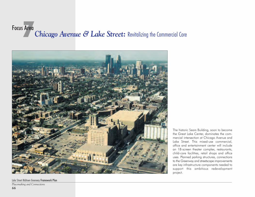
Lake Street Midtown Greenway Framework PlanPlacemaking and Connections66
7Chicago Avenue & Lake Street: Revitalizing the Commercial CoreFocus Area
The historic Sears Building, soon to becomethe Great Lake Center, dominates the com-mercial intersection at Chicago Avenue andLake Street. This mixed-use commercial,office and entertainment center will includean 18-screen theater complex, restaurants,child-care facilities, retail shops and officeuses. Planned parking structures, connectionsto the Greenway and streetscape improvementsare key infrastructure components needed tosupport this ambitious redevelopment project.
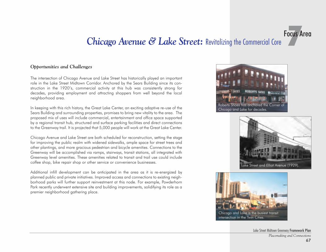
Lake Street Midtown Greenway Framework PlanPlacemaking and Connections
67
7Focus AreaChicago Avenue & Lake Street: Revitalizing the Commercial Core
Opportunities and Challenges
The intersection of Chicago Avenue and Lake Street has historically played an importantrole in the Lake Street Midtown Corridor. Anchored by the Sears Building since its con-struction in the 1920’s, commercial activity at this hub was consistently strong fordecades, providing employment and attracting shoppers from well beyond the localneighborhood area.
In keeping with this rich history, the Great Lake Center, an exciting adaptive re-use of theSears Building and surrounding properties, promises to bring new vitality to the area. Theproposed mix of uses will include commercial, entertainment and office space supportedby a regional transit hub, structured and surface parking facilities and direct connectionsto the Greenway trail. It is projected that 5,000 people will work at the Great Lake Center.
Chicago Avenue and Lake Street are both scheduled for reconstruction, setting the stagefor improving the public realm with widened sidewalks, ample space for street trees andother plantings, and more gracious pedestrian and bicycle amenities. Connections to theGreenway will be accomplished via ramps, stairways, transit stations, all integrated withGreenway level amenities. These amenities related to transit and trail use could includecoffee shop, bike repair shop or other service or convenience businesses.
Additional infill development can be anticipated in the area as it is re-energized byplanned public and private initiatives. Improved access and connections to existing neigh-borhood parks will further support reinvestment at this node. For example, PowderhornPark recently underwent extensive site and building improvements, solidifying its role as apremier neighborhood gathering place.
Lake Street and Elliot Avenue (1929).
Roberts Shoes has anchored the Corner ofChicago and Lake for decades.
Chicago and Lake is the busiest transitintersection in the Twin Cities.
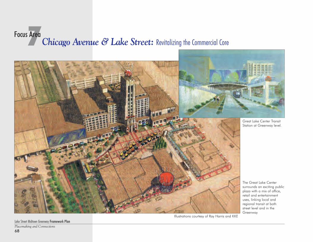
Lake Street Midtown Greenway Framework PlanPlacemaking and Connections68
7Chicago Avenue & Lake Street: Revitalizing the Commercial CoreFocus Area
Great Lake Center TransitStation at Greenway level.
The Great Lake Center surrounds an exciting publicplaza with a mix of office,retail and entertainmentuses, linking local andregional transit at bothstreet level and in theGreenway
Illustrations courtesy of Ray Harris and KKE
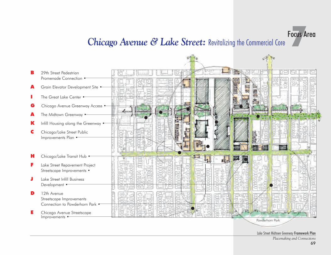
Lake Street Midtown Greenway Framework PlanPlacemaking and Connections
69
7Focus AreaChicago Avenue & Lake Street: Revitalizing the Commercial Core
B 29th Street PedestrianPromenade Connection •
A Grain Elevator Development Site •
I The Great Lake Center •
G Chicago Avenue Greenway Access •
A The Midtown Greenway •
K Infill Housing along the Greenway •
C Chicago/Lake Street Public Improvements Plan •
H Chicago/Lake Transit Hub •
F Lake Street Repavement ProjectStreetscape Improvements •
J Lake Street Infill Business Development •
D 12th AvenueStreetscape ImprovementsConnection to Powderhorn Park •
E Chicago Avenue Streetscape Improvements •
Powderhorn Park
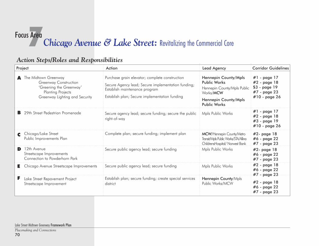
Lake Street Midtown Greenway Framework PlanPlacemaking and Connections70
7Chicago Avenue & Lake Street: Revitalizing the Commercial CoreFocus Area
Action Steps/Roles and ResponsibilitiesProject Action Lead Agency Corridor Guidelines
The Midtown GreenwayGreenway Construction‘Greening the Greenway’
Planting ProjectsGreenway Lighting and Security
29th Street Pedestrian Promenade
Chicago/Lake StreetPublic Improvements Plan
12th AvenueStreetscape ImprovementsConnection to Powderhorn Park
Chicago Avenue Streetscape Improvements
Lake Street Repavement ProjectStreetscape Improvement
Purchase grain elevator; complete construction
Secure Agency lead; Secure implementation funding;Establish maintenance program
Establish plan; Secure implementation funding
Secure agency lead; secure funding; secure the publicright-of-way
Complete plan; secure funding; implement plan
Secure public agency lead; secure funding
Secure public agency lead; secure funding
Establish plan; secure funding; create special servicesdistrict
Hennepin County/MplsPublic WorksHennepin County/Mpls PublicWorks/MCW
Hennepin County/MplsPublic Works
Mpls Public Works
MCW/Hennepin County/MetroTransit/Mpls Public Works/STA/AllinaChildrensHospital/ Norwest BankMpls Public Works
Mpls Public Works
Hennepin County/MplsPublic Works/MCW
A
B
C
D
E
F
#1 - page 17#2 - page 18$3 - page 19#7 - page 23#10 - page 26
#1 - page 17#2 - page 18#3 - page 19#10 - page 26
#2- page 18#6 - page 22#7 - page 23
#2- page 18#6 - page 22#7 - page 23#2 - page 18#6 - page 22#7 - page 23
#2 - page 18#6 - page 22#7 - page 23
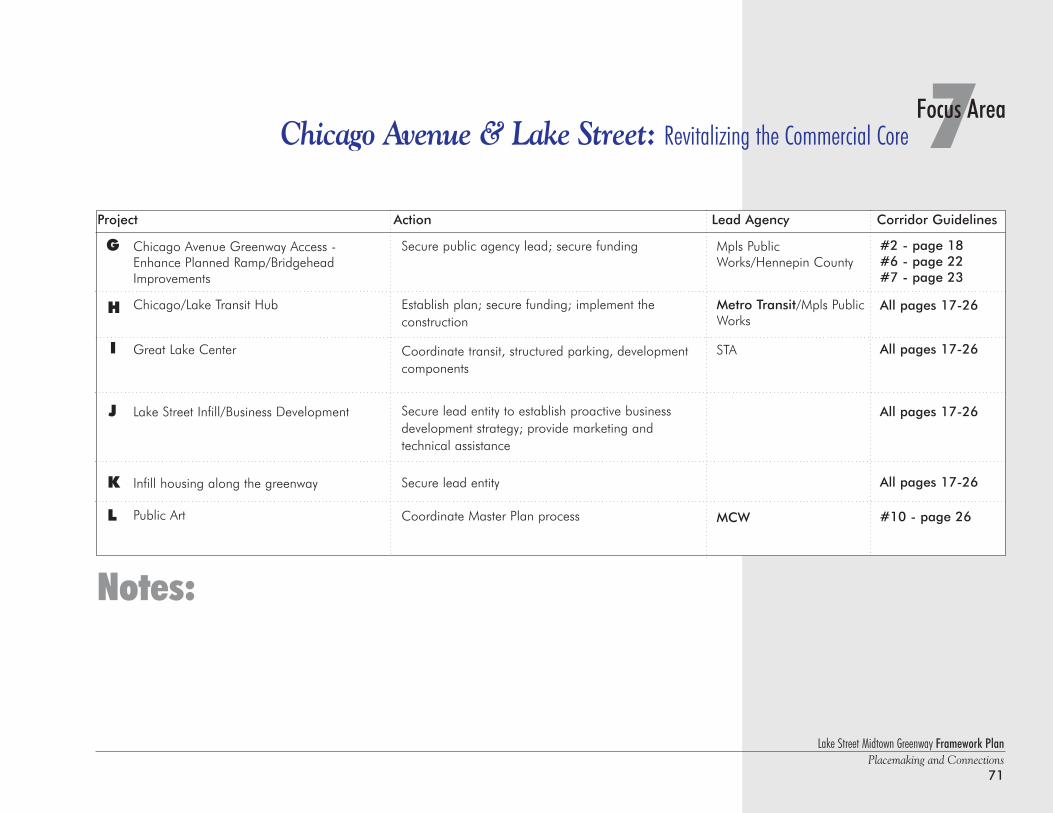
Lake Street Midtown Greenway Framework PlanPlacemaking and Connections
71
7Focus AreaChicago Avenue & Lake Street: Revitalizing the Commercial Core
Chicago Avenue Greenway Access -Enhance Planned Ramp/Bridgehead Improvements
Chicago/Lake Transit Hub
Great Lake Center
Lake Street Infill/Business Development
Infill housing along the greenway
Public Art
G
H
I
J
K
Secure public agency lead; secure funding
Establish plan; secure funding; implement the construction
Coordinate transit, structured parking, development components
Secure lead entity to establish proactive business development strategy; provide marketing and technical assistance
Secure lead entity
Coordinate Master Plan process
Mpls PublicWorks/Hennepin County
Metro Transit/Mpls PublicWorks
STA
MCW
Notes:
Project Action Lead Agency Corridor Guidelines
#2 - page 18#6 - page 22#7 - page 23
All pages 17-26
All pages 17-26
All pages 17-26
All pages 17-26
#10 - page 26L
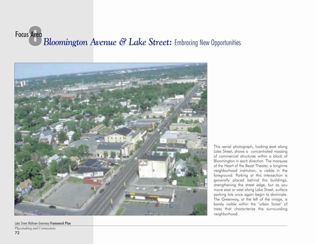
Lake Street Midtown Greenway Framework PlanPlacemaking and Connections72
8Bloomington Avenue & Lake Street: Embracing New OpportunitiesFocus Area
This aerial photograph, looking east alongLake Street, shows a concentrated massingof commercial structures within a block ofBloomington in each direction. The marqueeof the Heart of the Beast Theater, a longtimeneighborhood institution, is visible in theforeground. Parking at this intersection isgenerally placed behind the buildings,strengthening the street edge, but as youmove east or west along Lake Street, surfaceparking lots once again begin to dominate.The Greenway, at the left of the image, isbarely visible within the ‘urban forest’ oftrees that characterize the surroundingneighborhood.
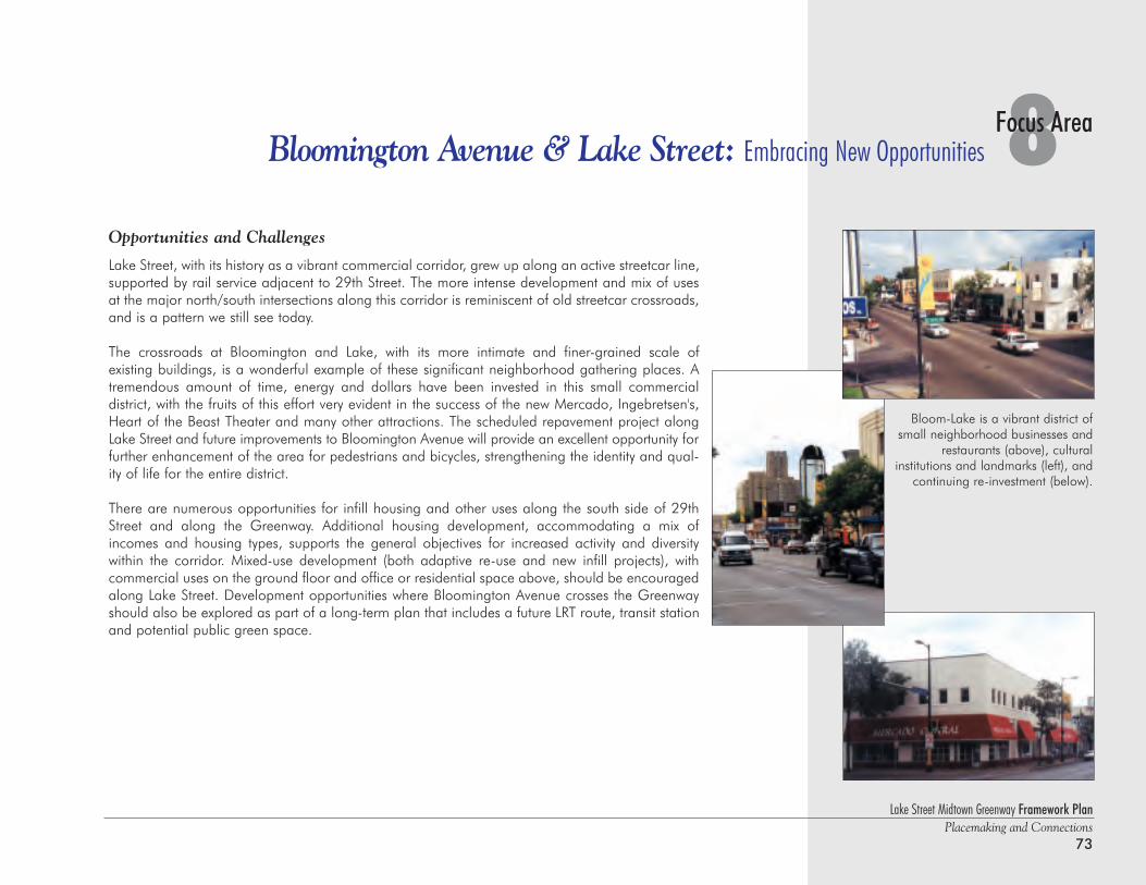
Lake Street Midtown Greenway Framework PlanPlacemaking and Connections
73
8Focus AreaBloomington Avenue & Lake Street: Embracing New Opportunities
Opportunities and Challenges
Lake Street, with its history as a vibrant commercial corridor, grew up along an active streetcar line,supported by rail service adjacent to 29th Street. The more intense development and mix of usesat the major north/south intersections along this corridor is reminiscent of old streetcar crossroads,and is a pattern we still see today.
The crossroads at Bloomington and Lake, with its more intimate and finer-grained scale of existing buildings, is a wonderful example of these significant neighborhood gathering places. Atremendous amount of time, energy and dollars have been invested in this small commercial district, with the fruits of this effort very evident in the success of the new Mercado, Ingebretsen's,Heart of the Beast Theater and many other attractions. The scheduled repavement project alongLake Street and future improvements to Bloomington Avenue will provide an excellent opportunity forfurther enhancement of the area for pedestrians and bicycles, strengthening the identity and qual-ity of life for the entire district.
There are numerous opportunities for infill housing and other uses along the south side of 29thStreet and along the Greenway. Additional housing development, accommodating a mix ofincomes and housing types, supports the general objectives for increased activity and diversity within the corridor. Mixed-use development (both adaptive re-use and new infill projects), with commercial uses on the ground floor and office or residential space above, should be encouragedalong Lake Street. Development opportunities where Bloomington Avenue crosses the Greenwayshould also be explored as part of a long-term plan that includes a future LRT route, transit stationand potential public green space.
Bloom-Lake is a vibrant district ofsmall neighborhood businesses and
restaurants (above), cultural institutions and landmarks (left), and
continuing re-investment (below).
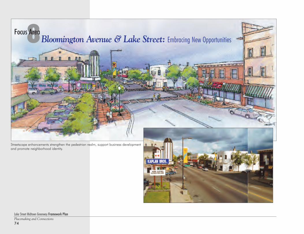
8Bloomington Avenue & Lake Street: Embracing New OpportunitiesFocus Area
Lake Street Midtown Greenway Framework PlanPlacemaking and Connections74
Streetscape enhancements strengthen the pedestrian realm, support business developmentand promote neighborhood identity.
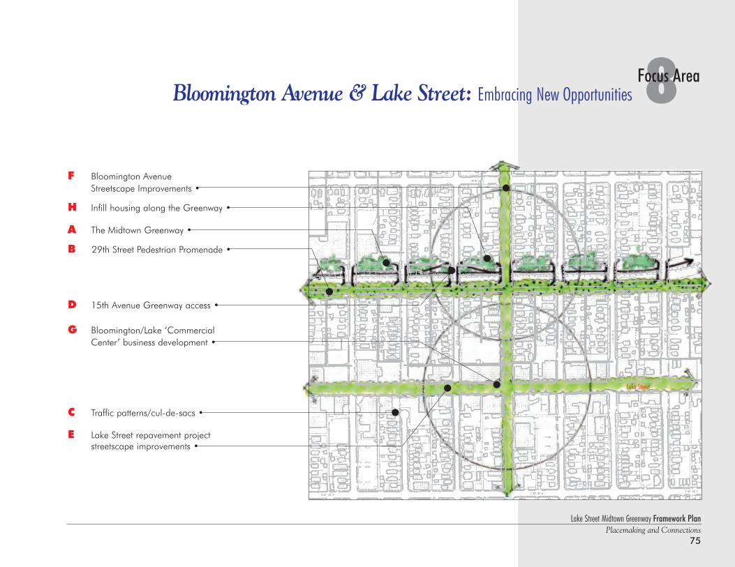
Lake Street Midtown Greenway Framework PlanPlacemaking and Connections
75
8Focus AreaBloomington Avenue & Lake Street: Embracing New Opportunities
Lake Street
F Bloomington Avenue Streetscape Improvements •
H Infill housing along the Greenway •
A The Midtown Greenway •
B 29th Street Pedestrian Promenade •
D 15th Avenue Greenway access •
G Bloomington/Lake ‘Commercial Center’ business development •
C Traffic patterns/cul-de-sacs •
E Lake Street repavement project streetscape improvements •
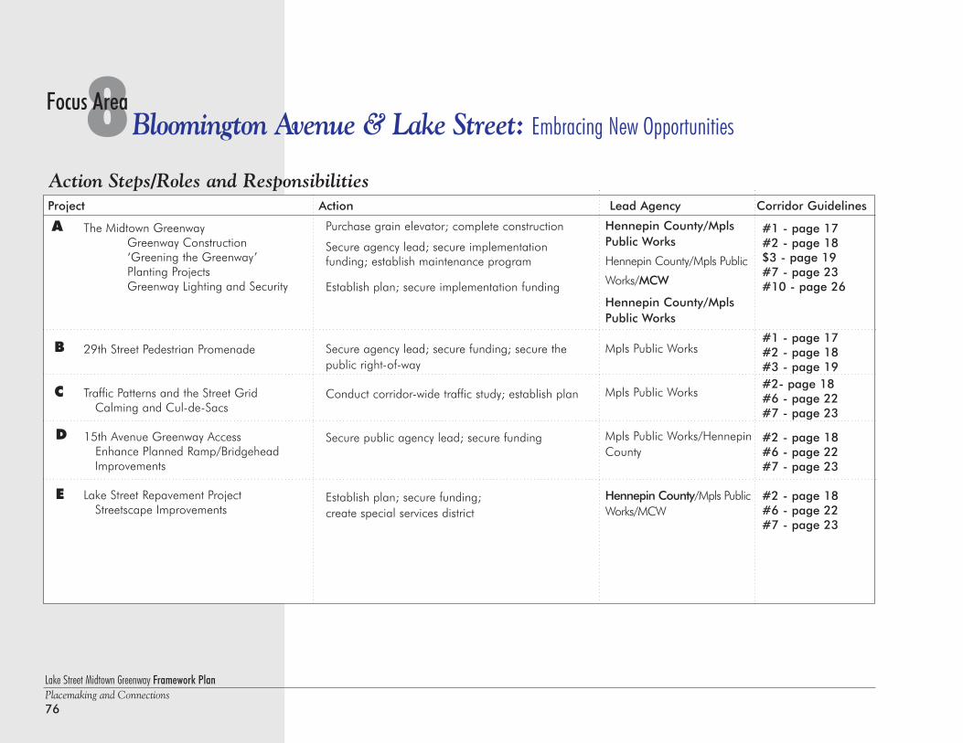
Lake Street Midtown Greenway Framework PlanPlacemaking and Connections76
8Bloomington Avenue & Lake Street: Embracing New OpportunitiesFocus Area
Action Steps/Roles and ResponsibilitiesProject Action Lead Agency Corridor Guidelines
Purchase grain elevator; complete construction
Secure agency lead; secure implementation funding; establish maintenance program
Establish plan; secure implementation funding
Secure agency lead; secure funding; secure thepublic right-of-way
Conduct corridor-wide traffic study; establish plan
Secure public agency lead; secure funding
Establish plan; secure funding; create special services district
Hennepin County/MplsPublic Works
Hennepin County/Mpls Public
Works/MCW
Hennepin County/MplsPublic Works
Mpls Public Works
Mpls Public Works
Mpls Public Works/HennepinCounty
Hennepin County/Mpls PublicWorks/MCW
The Midtown GreenwayGreenway Construction‘Greening the Greenway’Planting ProjectsGreenway Lighting and Security
29th Street Pedestrian Promenade
Traffic Patterns and the Street GridCalming and Cul-de-Sacs
15th Avenue Greenway AccessEnhance Planned Ramp/Bridgehead Improvements
Lake Street Repavement ProjectStreetscape Improvements
A
B
C
D
E
#1 - page 17#2 - page 18$3 - page 19#7 - page 23#10 - page 26
#1 - page 17#2 - page 18#3 - page 19#2- page 18#6 - page 22#7 - page 23
#2 - page 18#6 - page 22#7 - page 23
#2 - page 18#6 - page 22#7 - page 23
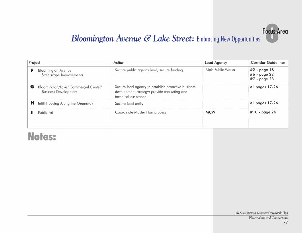
Bloomington AvenueStreetscape Improvements
Bloomington/Lake ‘Commercial Center’Business Development
Infill Housing Along the Greenway
Public Art
F
G
H
I
Secure public agency lead; secure funding
Secure lead agency to establish proactive businessdevelopment strategy; provide marketing and technical assistance
Secure lead entity
Coordinate Master Plan process
Mpls Public Works
MCW
Notes:
Lake Street Midtown Greenway Framework PlanPlacemaking and Connections
77
8Focus AreaBloomington Avenue & Lake Street: Embracing New Opportunities
Project Action Lead Agency Corridor Guidelines
#2 - page 18#6 - page 22#7 - page 23
All pages 17-26
All pages 17-26
#10 - page 26
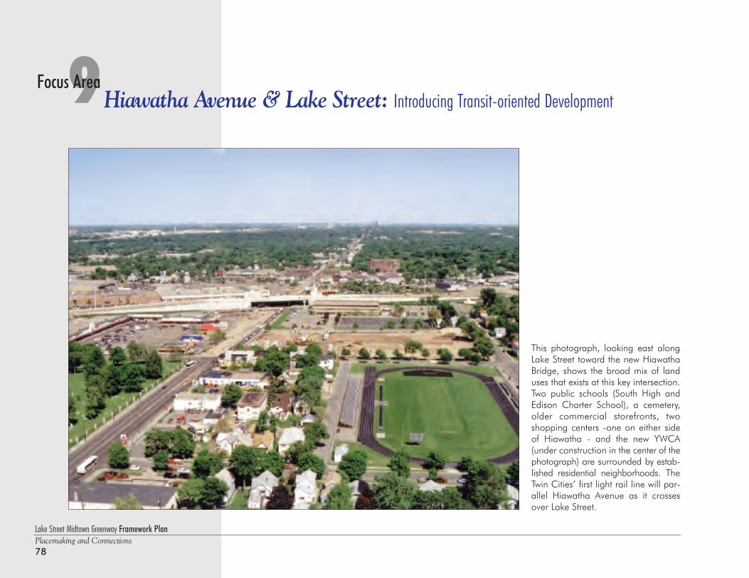
Lake Street Midtown Greenway Framework PlanPlacemaking and Connections78
9Hiawatha Avenue & Lake Street: Introducing Transit-oriented DevelopmentFocus Area
This photograph, looking east alongLake Street toward the new HiawathaBridge, shows the broad mix of landuses that exists at this key intersection.Two public schools (South High andEdison Charter School), a cemetery,older commercial storefronts, twoshopping centers -one on either sideof Hiawatha - and the new YWCA(under construction in the center of thephotograph) are surrounded by estab-lished residential neighborhoods. TheTwin Cities’ first light rail line will par-allel Hiawatha Avenue as it crossesover Lake Street.
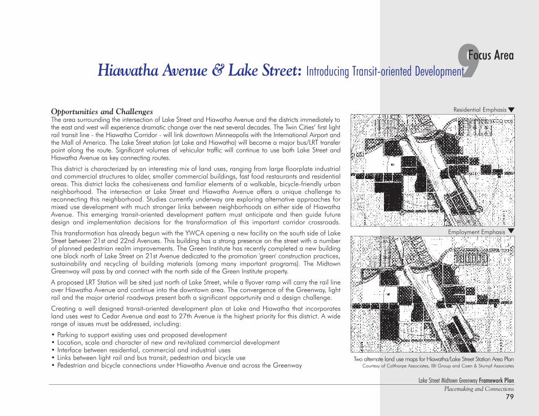
Lake Street Midtown Greenway Framework PlanPlacemaking and Connections
79
9Focus AreaHiawatha Avenue & Lake Street: Introducing Transit-oriented Development
Opportunities and ChallengesThe area surrounding the intersection of Lake Street and Hiawatha Avenue and the districts immediately tothe east and west will experience dramatic change over the next several decades. The Twin Cities’ first lightrail transit line - the Hiawatha Corridor - will link downtown Minneapolis with the International Airport andthe Mall of America. The Lake Street station (at Lake and Hiawatha) will become a major bus/LRT transferpoint along the route. Significant volumes of vehicular traffic will continue to use both Lake Street andHiawatha Avenue as key connecting routes.
This district is characterized by an interesting mix of land uses, ranging from large floorplate industrialand commercial structures to older, smaller commercial buildings, fast food restaurants and residentialareas. This district lacks the cohesiveness and familiar elements of a walkable, bicycle-friendly urbanneighborhood. The intersection at Lake Street and Hiawatha Avenue offers a unique challenge toreconnecting this neighborhood. Studies currently underway are exploring alternative approaches formixed use development with much stronger links between neighborhoods on either side of HiawathaAvenue. This emerging transit-oriented development pattern must anticipate and then guide futuredesign and implementation decisions for the transformation of this important corridor crossroads.
This transformation has already begun with the YWCA opening a new facility on the south side of LakeStreet between 21st and 22nd Avenues. This building has a strong presence on the street with a numberof planned pedestrian realm improvements. The Green Institute has recently completed a new buildingone block north of Lake Street on 21st Avenue dedicated to the promotion 'green' construction practices,sustainability and recycling of building materials (among many important programs). The MidtownGreenway will pass by and connect with the north side of the Green Institute property.
A proposed LRT Station will be sited just north of Lake Street, while a flyover ramp will carry the rail lineover Hiawatha Avenue and continue into the downtown area. The convergence of the Greenway, lightrail and the major arterial roadways present both a significant opportunity and a design challenge.
Creating a well designed transit-oriented development plan at Lake and Hiawatha that incorporatesland uses west to Cedar Avenue and east to 27th Avenue is the highest priority for this district. A widerange of issues must be addressed, including:
• Parking to support existing uses and proposed development• Location, scale and character of new and revitalized commercial development • Interface between residential, commercial and industrial uses • Links between light rail and bus transit, pedestrian and bicycle use• Pedestrian and bicycle connections under Hiawatha Avenue and across the Greenway
Two alternate land use maps for Hiawatha/Lake Street Station Area PlanCourtesy of Calthorpe Associates, IBI Group and Coen & Stumpf Associates
Residential Emphasis
Employment Emphasis
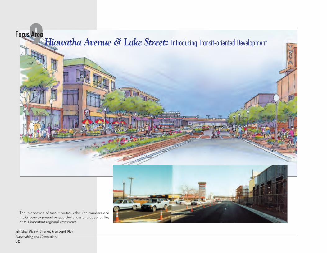
Lake Street Midtown Greenway Framework PlanPlacemaking and Connections80
9Hiawatha Avenue & Lake Street: Introducing Transit-oriented DevelopmentFocus Area
The intersection of transit routes. vehicular corridors andthe Greenway present unique challenges and opportunitiesat this important regional crossroads.
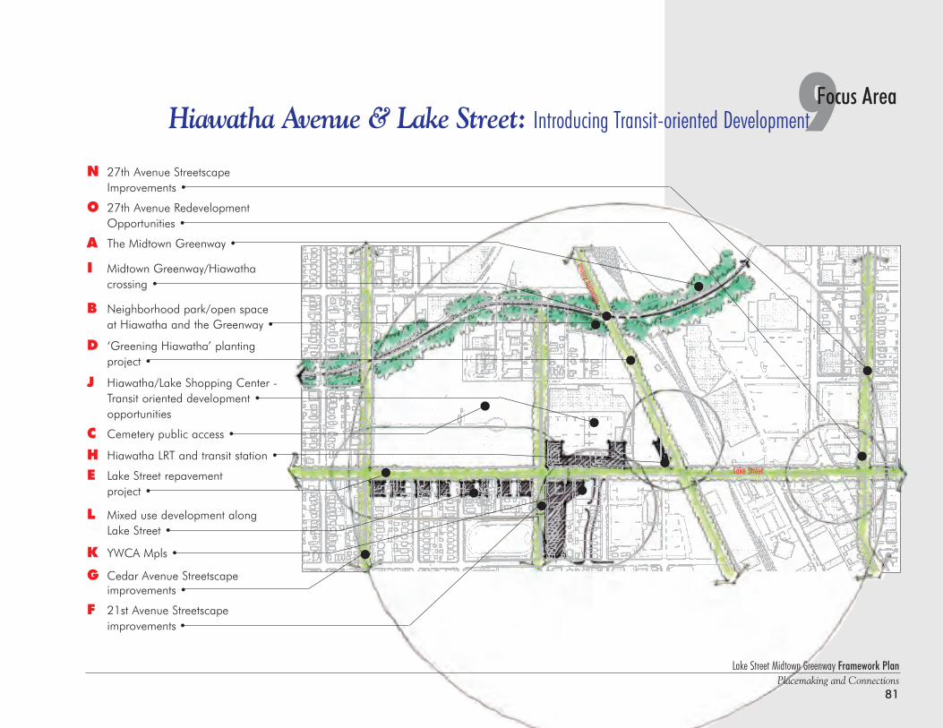
N 27th Avenue Streetscape Improvements •
O 27th Avenue Redevelopment Opportunities •
A The Midtown Greenway •
I Midtown Greenway/Hiawatha crossing •
B Neighborhood park/open space at Hiawatha and the Greenway •
D ‘Greening Hiawatha’ planting project •
J Hiawatha/Lake Shopping Center -Transit oriented development •opportunities
C Cemetery public access •
H Hiawatha LRT and transit station •
E Lake Street repavement project •
L Mixed use development along Lake Street •
K YWCA Mpls •
G Cedar Avenue Streetscape improvements •
F 21st Avenue Streetscape improvements •
Lake Street Midtown Greenway Framework PlanPlacemaking and Connections
81
9Focus AreaHiawatha Avenue & Lake Street: Introducing Transit-oriented Development
Hiawa
tha Av
enue
Lake Street
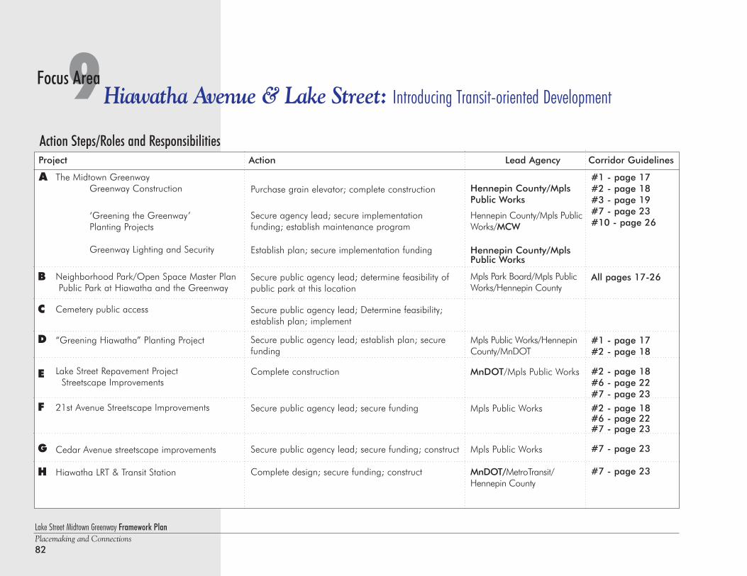
Lake Street Midtown Greenway Framework PlanPlacemaking and Connections82
9Hiawatha Avenue & Lake Street: Introducing Transit-oriented DevelopmentFocus Area
Action Steps/Roles and ResponsibilitiesProject Action Lead Agency Corridor Guidelines
Purchase grain elevator; complete construction
Secure agency lead; secure implementation funding; establish maintenance program
Establish plan; secure implementation funding
Secure public agency lead; determine feasibility ofpublic park at this location
Secure public agency lead; Determine feasibility;establish plan; implement
Secure public agency lead; establish plan; securefunding
Complete construction
Secure public agency lead; secure funding
Secure public agency lead; secure funding; construct
Complete design; secure funding; construct
Hennepin County/MplsPublic Works
Hennepin County/Mpls PublicWorks/MCW
Hennepin County/MplsPublic Works
Mpls Park Board/Mpls PublicWorks/Hennepin County
Mpls Public Works/HennepinCounty/MnDOT
MnDOT/Mpls Public Works
Mpls Public Works
Mpls Public Works
MnDOT/MetroTransit/Hennepin County
The Midtown GreenwayGreenway Construction
‘Greening the Greenway’Planting Projects
Greenway Lighting and Security
Neighborhood Park/Open Space Master PlanPublic Park at Hiawatha and the Greenway
Cemetery public access
“Greening Hiawatha” Planting Project
Lake Street Repavement ProjectStreetscape Improvements
21st Avenue Streetscape Improvements
Cedar Avenue streetscape improvements
Hiawatha LRT & Transit Station
A
B
C
D
E
F
G
#1 - page 17#2 - page 18#3 - page 19#7 - page 23#10 - page 26
All pages 17-26
#1 - page 17#2 - page 18
#2 - page 18#6 - page 22#7 - page 23
#2 - page 18#6 - page 22#7 - page 23
#7 - page 23
#7 - page 23H
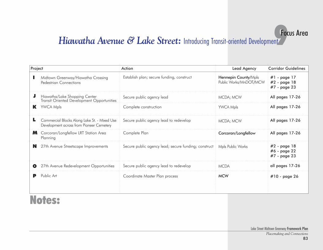
Lake Street Midtown Greenway Framework PlanPlacemaking and Connections
83
9Focus AreaHiawatha Avenue & Lake Street: Introducing Transit-oriented Development
Midtown Greenway/Hiawatha CrossingPedestrian Connections
Hiawatha/Lake Shopping CenterTransit Oriented Development Opportunities
YWCA Mpls
Commercial Blocks Along Lake St. - Mixed UseDevelopment across from Pioneer Cemetery
Corcoran/Longfellow LRT Station AreaPlanning
27th Avenue Streetscape Improvements
27th Avenue Redevelopment Opportunities
Public Art
I
J
Establish plan; secure funding, construct
Secure public agency lead
Complete construction
Secure public agency lead to redevelop
Complete Plan
Secure public agency lead; secure funding; construct
Secure public agency lead to redevelop
Coordinate Master Plan process
Hennepin County/MplsPublic Works/MnDOT/MCW
MCDA; MCW
YWCA Mpls
MCDA; MCW
Corcoran/Longfellow
Mpls Public Works
MCDA
MCW
Notes:
K
L
M
Project Action Lead Agency Corridor Guidelines
#1 - page 17#2 - page 18#7 - page 23
All pages 17-26
All pages 17-26
All pages 17-26
All pages 17-26
#2 - page 18#6 - page 22#7 - page 23
all pages 17-26
#10 - page 26
N
O
P
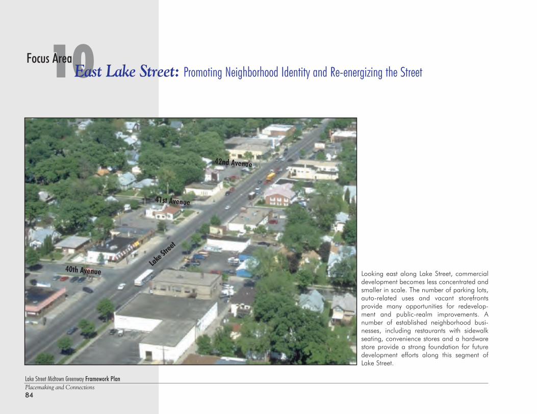
Lake Street Midtown Greenway Framework PlanPlacemaking and Connections84
10East Lake Street: Promoting Neighborhood Identity and Re-energizing the StreetFocus Area
Looking east along Lake Street, commercialdevelopment becomes less concentrated andsmaller in scale. The number of parking lots,auto-related uses and vacant storefronts provide many opportunities for redevelop-ment and public-realm improvements. Anumber of established neighborhood busi-nesses, including restaurants with sidewalkseating, convenience stores and a hardwarestore provide a strong foundation for futuredevelopment efforts along this segment ofLake Street.
Lake Str
eet
40th Avenue
41st Avenue
42nd Avenue
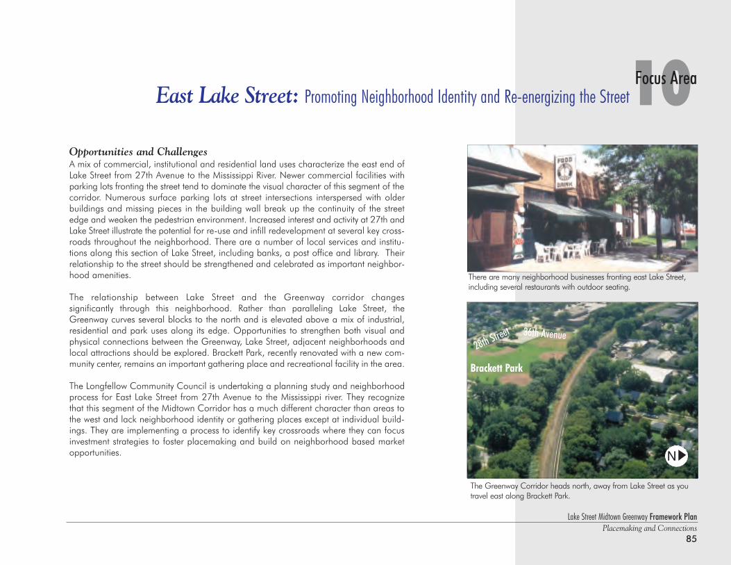
Lake Street Midtown Greenway Framework PlanPlacemaking and Connections
85
10Focus AreaEast Lake Street: Promoting Neighborhood Identity and Re-energizing the Street
Opportunities and ChallengesA mix of commercial, institutional and residential land uses characterize the east end ofLake Street from 27th Avenue to the Mississippi River. Newer commercial facilities withparking lots fronting the street tend to dominate the visual character of this segment of thecorridor. Numerous surface parking lots at street intersections interspersed with olderbuildings and missing pieces in the building wall break up the continuity of the streetedge and weaken the pedestrian environment. Increased interest and activity at 27th andLake Street illustrate the potential for re-use and infill redevelopment at several key cross-roads throughout the neighborhood. There are a number of local services and institu-tions along this section of Lake Street, including banks, a post office and library. Theirrelationship to the street should be strengthened and celebrated as important neighbor-hood amenities.
The relationship between Lake Street and the Greenway corridor changes significantly through this neighborhood. Rather than paralleling Lake Street, theGreenway curves several blocks to the north and is elevated above a mix of industrial,residential and park uses along its edge. Opportunities to strengthen both visual andphysical connections between the Greenway, Lake Street, adjacent neighborhoods andlocal attractions should be explored. Brackett Park, recently renovated with a new com-munity center, remains an important gathering place and recreational facility in the area.
The Longfellow Community Council is undertaking a planning study and neighborhoodprocess for East Lake Street from 27th Avenue to the Mississippi river. They recognizethat this segment of the Midtown Corridor has a much different character than areas tothe west and lack neighborhood identity or gathering places except at individual build-ings. They are implementing a process to identify key crossroads where they can focusinvestment strategies to foster placemaking and build on neighborhood based marketopportunities.
The Greenway Corridor heads north, away from Lake Street as you travel east along Brackett Park.
Brackett Park
There are many neighborhood businesses fronting east Lake Street,including several restaurants with outdoor seating.
36th Avenue28th Street
N
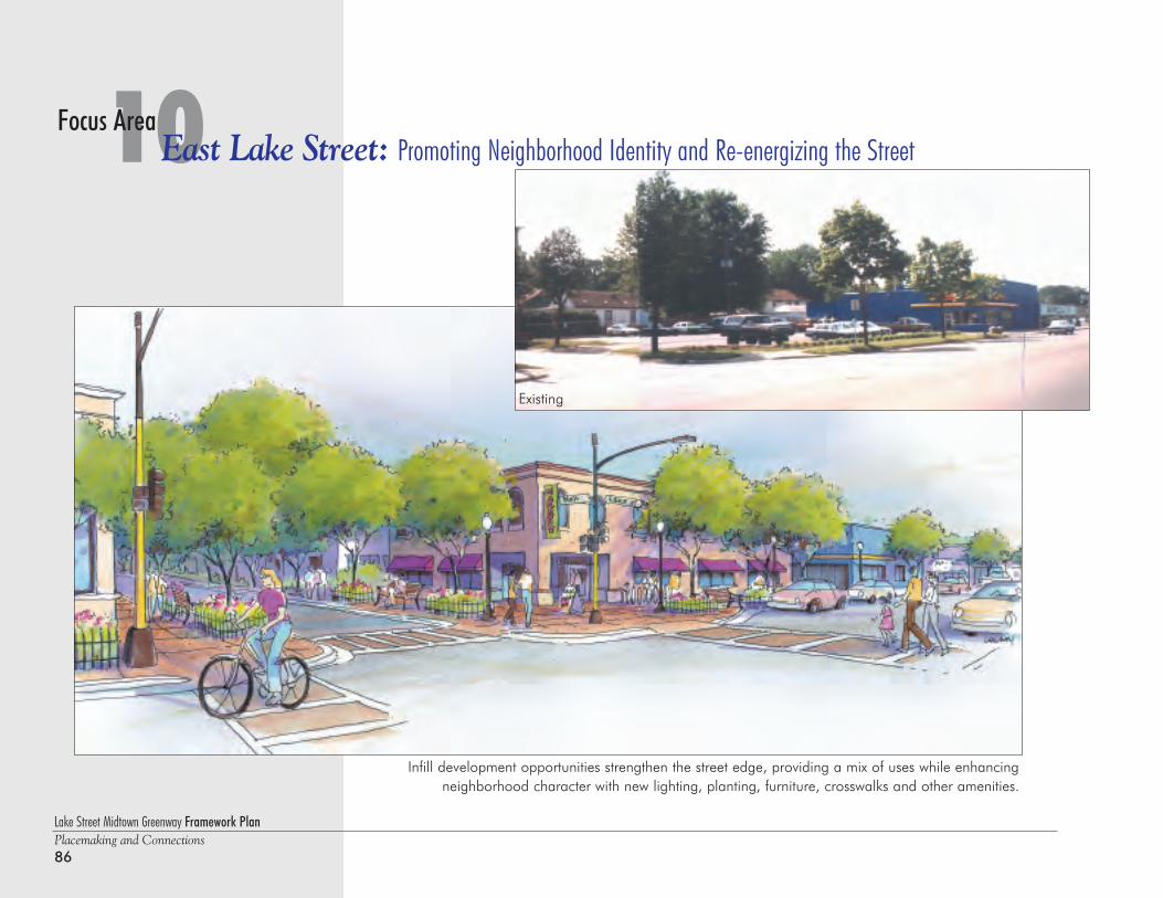
Existing
Lake Street Midtown Greenway Framework PlanPlacemaking and Connections86
10East Lake Street: Promoting Neighborhood Identity and Re-energizing the StreetFocus Area
Infill development opportunities strengthen the street edge, providing a mix of uses while enhancingneighborhood character with new lighting, planting, furniture, crosswalks and other amenities.
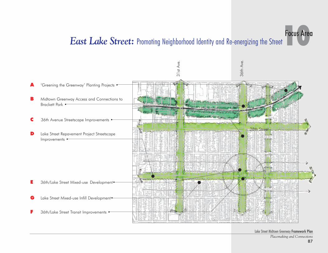
Lake Street Midtown Greenway Framework PlanPlacemaking and Connections
87
10Focus AreaEast Lake Street: Promoting Neighborhood Identity and Re-energizing the Street
A ‘Greening the Greenway’ Planting Projects •
B Midtown Greenway Access and Connections to Brackett Park •
C 36th Avenue Streetscape Improvements •
D Lake Street Repavement Project Streetscape Improvements •
E 36th/Lake Street Mixed-use Development•
G Lake Street Mixed-use Infill Development•
F 36th/Lake Street Transit Improvements •
31st
Ave
.
36th
Ave
.
28th Street
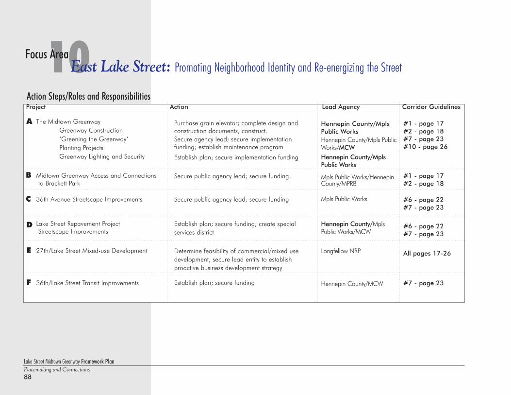
Lake Street Midtown Greenway Framework PlanPlacemaking and Connections88
10East Lake Street: Promoting Neighborhood Identity and Re-energizing the StreetFocus Area
Action Steps/Roles and ResponsibilitiesProject Action Lead Agency Corridor Guidelines
Purchase grain elevator; complete design and construction documents, construct.Secure agency lead; secure implementation funding; establish maintenance program
Establish plan; secure implementation funding
Secure public agency lead; secure funding
Secure public agency lead; secure funding
Establish plan; secure funding; create special services district
Determine feasibility of commercial/mixed usedevelopment; secure lead entity to establish proactive business development strategy
Establish plan; secure funding
Hennepin County/MplsPublic WorksHennepin County/Mpls PublicWorks/MCWHennepin County/MplsPublic Works
Mpls Public Works/HennepinCounty/MPRB
Mpls Public Works
Hennepin County/MplsPublic Works/MCW
Longfellow NRP
Hennepin County/MCW
The Midtown GreenwayGreenway Construction‘Greening the Greenway’Planting ProjectsGreenway Lighting and Security
Midtown Greenway Access and Connectionsto Brackett Park
36th Avenue Streetscape Improvements
Lake Street Repavement ProjectStreetscape Improvements
27th/Lake Street Mixed-use Development
36th/Lake Street Transit Improvements
A
B
D
E
F
#1 - page 17#2 - page 18#7 - page 23#10 - page 26
#1 - page 17#2 - page 18
#6 - page 22#7 - page 23
#6 - page 22#7 - page 23
All pages 17-26
#7 - page 23
C
Lake Street Midtown Greenway Framework PlanPlacemaking and Connections
89
10Focus AreaEast Lake Street: Promoting Neighborhood Identity and Re-energizing the Street
Lake Street Mixed-use Infill DevelopmentCommercial Center/Node Study
Public Art
G
H
Determine feasibility of commercial/mixed use development; secure lead entity to establish proactive business development strategy
Coordinate Master Plan process
Longfellow NRP
MCW
Notes:
Project Action Lead Agency Corridor Guidelines
All pages 17-26
#10 - page 26
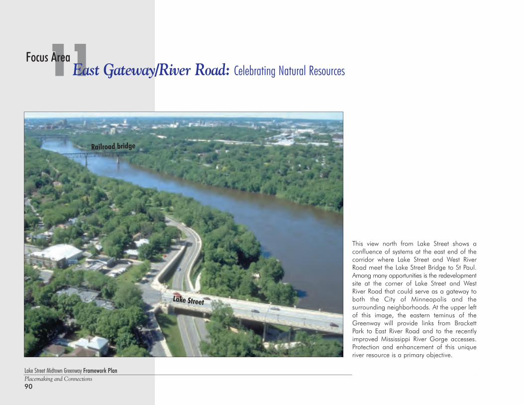
Lake Street Midtown Greenway Framework PlanPlacemaking and Connections90
11East Gateway/River Road: Celebrating Natural ResourcesFocus Area
This view north from Lake Street shows aconfluence of systems at the east end of thecorridor where Lake Street and West RiverRoad meet the Lake Street Bridge to St Paul.Among many opportunities is the redevelopmentsite at the corner of Lake Street and WestRiver Road that could serve as a gateway toboth the City of Minneapolis and the surrounding neighborhoods. At the upper leftof this image, the eastern teminus of theGreenway will provide links from BrackettPark to East River Road and to the recentlyimproved Mississippi River Gorge accesses.Protection and enhancement of this uniqueriver resource is a primary objective.
Lake Street
Railroad bridge
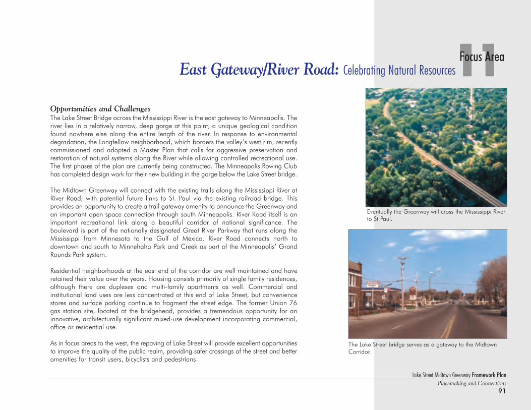
Lake Street Midtown Greenway Framework PlanPlacemaking and Connections
91
11Focus AreaEast Gateway/River Road: Celebrating Natural Resources
Opportunities and ChallengesThe Lake Street Bridge across the Mississippi River is the east gateway to Minneapolis. Theriver lies in a relatively narrow, deep gorge at this point, a unique geological conditionfound nowhere else along the entire length of the river. In response to environmentaldegradation, the Longfellow neighborhood, which borders the valley’s west rim, recentlycommissioned and adopted a Master Plan that calls for aggressive preservation andrestoration of natural systems along the River while allowing controlled recreational use.The first phases of the plan are currently being constructed. The Minneapolis Rowing Clubhas completed design work for their new building in the gorge below the Lake Street bridge.
The Midtown Greenway will connect with the existing trails along the Mississippi River atRiver Road; with potential future links to St. Paul via the existing railroad bridge. This provides an opportunity to create a trail gateway amenity to announce the Greenway andan important open space connection through south Minneapolis. River Road itself is animportant recreational link along a beautiful corridor of national significance. The boulevard is part of the nationally designated Great River Parkway that runs along theMississippi from Minnesota to the Gulf of Mexico. River Road connects north to downtown and south to Minnehaha Park and Creek as part of the Minneapolis’ GrandRounds Park system.
Residential neighborhoods at the east end of the corridor are well maintained and haveretained their value over the years. Housing consists primarily of single family residences,although there are duplexes and multi-family apartments as well. Commercial and institutional land uses are less concentrated at this end of Lake Street, but conveniencestores and surface parking continue to fragment the street edge. The former Union 76gas station site, located at the bridgehead, provides a tremendous opportunity for aninnovative, architecturally significant mixed-use development incorporating commercial,office or residential use.
As in focus areas to the west, the repaving of Lake Street will provide excellent opportunitiesto improve the quality of the public realm, providing safer crossings of the street and betteramenities for transit users, bicyclists and pedestrians.
The Lake Street bridge serves as a gateway to the MidtownCorridor.
Eventually the Greenway will cross the Mississippi Riverto St Paul.
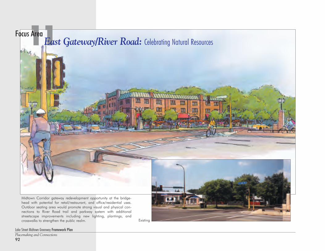
Lake Street Midtown Greenway Framework PlanPlacemaking and Connections92
11East Gateway/River Road: Celebrating Natural ResourcesFocus Area
Existing
Midtown Corridor gateway redevelopment opportunity at the bridge-head with potential for retail/restaurant, and office/residential uses.Outdoor seating area would promote strong visual and physical con-nections to River Road trail and parkway system with additionalstreetscape improvements including new lighting, plantings, and crosswalks to strengthen the public realm.
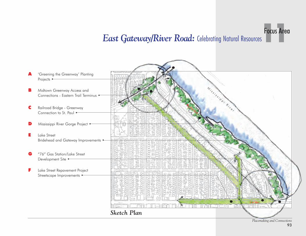
Placemaking and Connections93
11Focus AreaEast Gateway/River Road: Celebrating Natural Resources
Lake Street
West River Road
A ‘Greening the Greenway’ Planting Projects •
B Midtown Greenway Access and Connections - Eastern Trail Terminus •
C Railroad Bridge - Greenway Connection to St. Paul •
D Mississippi River Gorge Project •
E Lake StreetBridehead and Gateway Improvements •
G “76” Gas Station/Lake StreetDevelopment Site •
F Lake Street Repavement ProjectStreetscape Improvements •
Mi s s i s s i p p i R i v e r
Sketch Plan
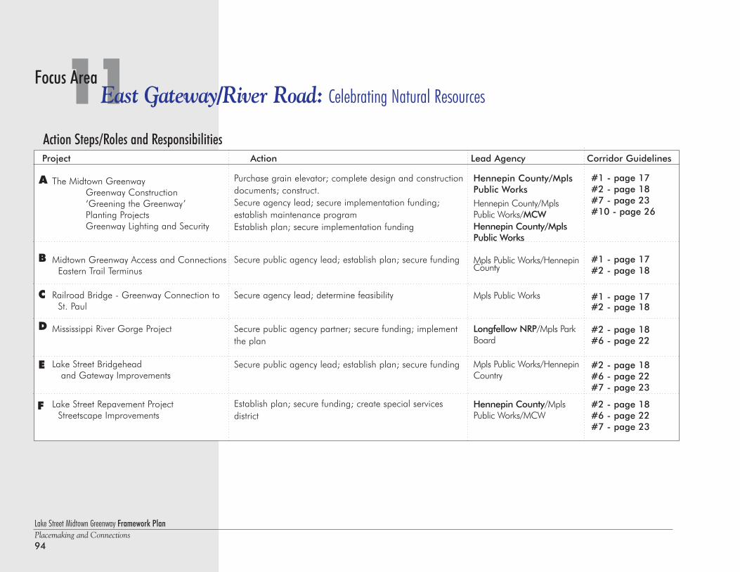
Lake Street Midtown Greenway Framework PlanPlacemaking and Connections94
11East Gateway/River Road: Celebrating Natural ResourcesFocus Area
Action Steps/Roles and ResponsibilitiesProject Action Lead Agency Corridor Guidelines
Purchase grain elevator; complete design and constructiondocuments; construct.Secure agency lead; secure implementation funding; establish maintenance programEstablish plan; secure implementation funding
Secure public agency lead; establish plan; secure funding
Secure agency lead; determine feasibility
Secure public agency partner; secure funding; implementthe plan
Secure public agency lead; establish plan; secure funding
Establish plan; secure funding; create special services district
Hennepin County/MplsPublic WorksHennepin County/MplsPublic Works/MCWHennepin County/MplsPublic Works
Mpls Public Works/HennepinCounty
Mpls Public Works
Longfellow NRP/Mpls ParkBoard
Mpls Public Works/HennepinCountry
Hennepin County/MplsPublic Works/MCW
The Midtown GreenwayGreenway Construction‘Greening the Greenway’Planting ProjectsGreenway Lighting and Security
Midtown Greenway Access and ConnectionsEastern Trail Terminus
Railroad Bridge - Greenway Connection to St. Paul
Mississippi River Gorge Project
Lake Street Bridgeheadand Gateway Improvements
Lake Street Repavement ProjectStreetscape Improvements
A
B
C
D
E
#1 - page 17#2 - page 18#7 - page 23#10 - page 26
#1 - page 17#2 - page 18
#1 - page 17#2 - page 18
#2 - page 18#6 - page 22
#2 - page 18#6 - page 22#7 - page 23
#2 - page 18#6 - page 22#7 - page 23
F
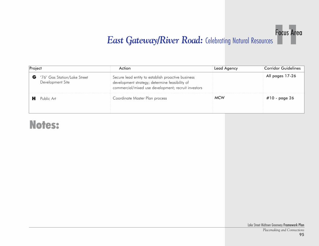
Lake Street Midtown Greenway Framework PlanPlacemaking and Connections
95
11Focus AreaEast Gateway/River Road: Celebrating Natural Resources
‘76’ Gas Station/Lake StreetDevelopment Site
Public Art
G
H
Secure lead entity to establish proactive business development strategy; determine feasibility of commercial/mixed use development; recruit investors
Coordinate Master Plan process MCW
Notes:
Project Action Lead Agency Corridor Guidelines
All pages 17-26
#10 - page 26
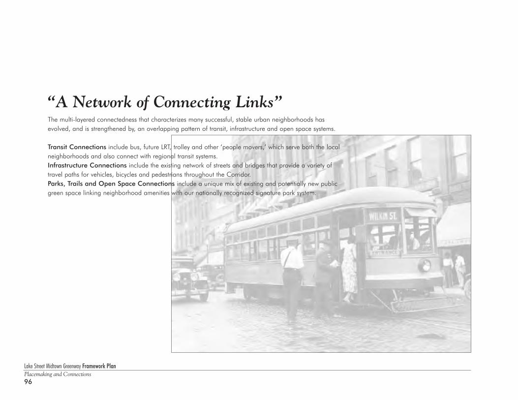
Lake Street Midtown Greenway Framework PlanPlacemaking and Connections96
“A Network of Connecting Links”The multi-layered connectedness that characterizes many successful, stable urban neighborhoods hasevolved, and is strengthened by, an overlapping pattern of transit, infrastructure and open space systems.
Transit Connections include bus, future LRT, trolley and other ‘people movers,’ which serve both the localneighborhoods and also connect with regional transit systems.Infrastructure Connections include the existing network of streets and bridges that provide a variety oftravel paths for vehicles, bicycles and pedestrians throughout the Corridor.Parks, Trails and Open Space Connections include a unique mix of existing and potentially new publicgreen space linking neighborhood amenities with our nationally recognized signature park system.
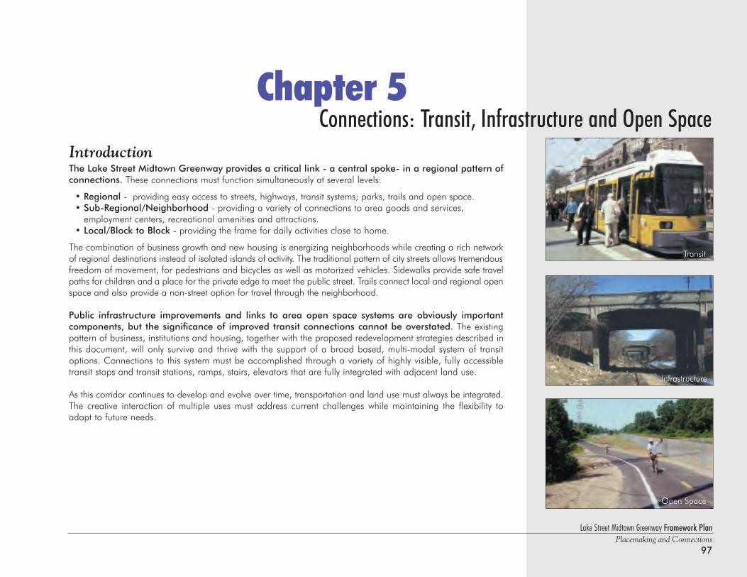
Lake Street Midtown Greenway Framework PlanPlacemaking and Connections
97
Chapter 5Connections: Transit, Infrastructure and Open Space
IntroductionThe Lake Street Midtown Greenway provides a critical link - a central spoke- in a regional pattern ofconnections. These connections must function simultaneously at several levels:
• Regional - providing easy access to streets, highways, transit systems; parks, trails and open space.• Sub-Regional/Neighborhood - providing a variety of connections to area goods and services,
employment centers, recreational amenities and attractions.• Local/Block to Block - providing the frame for daily activities close to home.
The combination of business growth and new housing is energizing neighborhoods while creating a rich networkof regional destinations instead of isolated islands of activity. The traditional pattern of city streets allows tremendousfreedom of movement, for pedestrians and bicycles as well as motorized vehicles. Sidewalks provide safe travelpaths for children and a place for the private edge to meet the public street. Trails connect local and regional openspace and also provide a non-street option for travel through the neighborhood.
Public infrastructure improvements and links to area open space systems are obviously importantcomponents, but the significance of improved transit connections cannot be overstated. The existingpattern of business, institutions and housing, together with the proposed redevelopment strategies described inthis document, will only survive and thrive with the support of a broad based, multi-modal system of transitoptions. Connections to this system must be accomplished through a variety of highly visible, fully accessibletransit stops and transit stations, ramps, stairs, elevators that are fully integrated with adjacent land use.
As this corridor continues to develop and evolve over time, transportation and land use must always be integrated.The creative interaction of multiple uses must address current challenges while maintaining the flexibility toadapt to future needs.
Transit
Open Space
Infrastructure
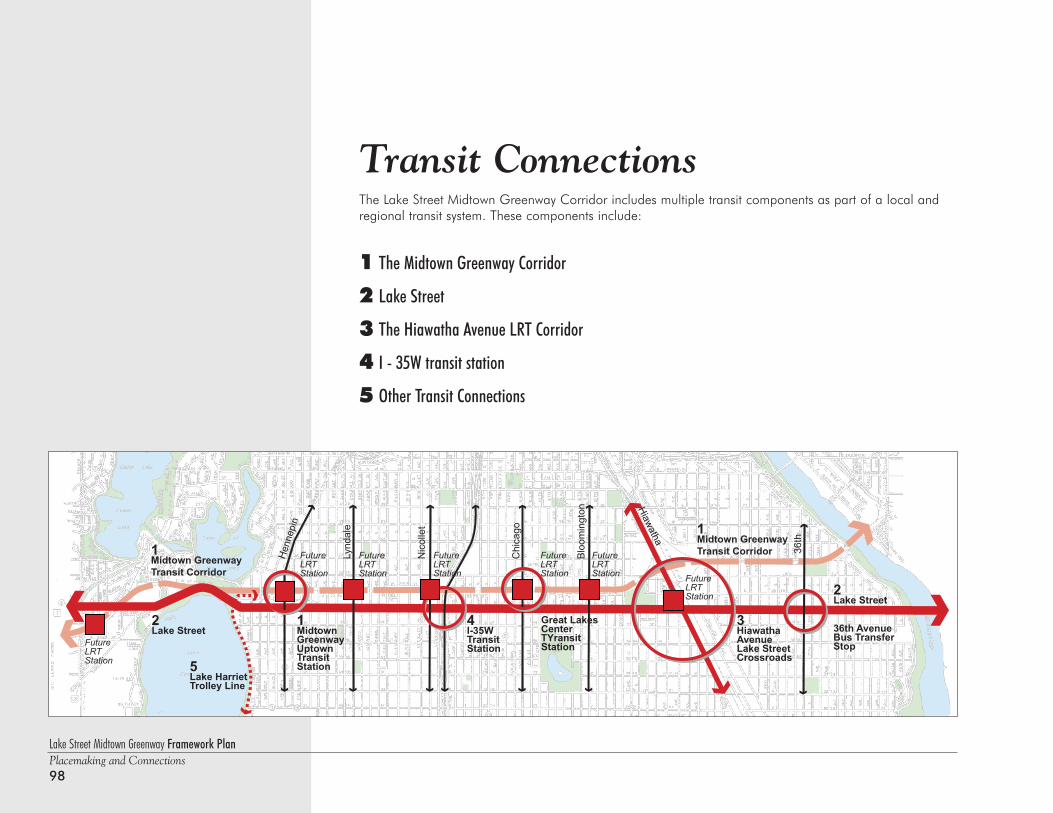
Lake Street Midtown Greenway Framework PlanPlacemaking and Connections98
Transit Connections The Lake Street Midtown Greenway Corridor includes multiple transit components as part of a local andregional transit system. These components include:
1 The Midtown Greenway Corridor
2 Lake Street
3 The Hiawatha Avenue LRT Corridor
4 I - 35W transit station
5 Other Transit Connections
Transit Connections
1Midtown GreenwayTransit Corridor
2Lake Street
2Lake Street
4I-35WTransit Station
1Midtown GreenwayUptownTransitStation
3HiawathaAvenueLake StreetCrossroads
Great LakesCenterTYransitStation
36th Avenue Bus TransferStop
5Lake HarrietTrolley Line
1Midtown GreenwayTransit Corridor
Lynd
ale
Nic
olle
t
Chi
cago
Blo
omin
gton
36th
Hiawatha
Hen
nepi
n
Future LRT Station
Future LRT Station
Future LRT Station
Future LRT Station
Future LRT Station
Future LRT Station Future
LRT Station
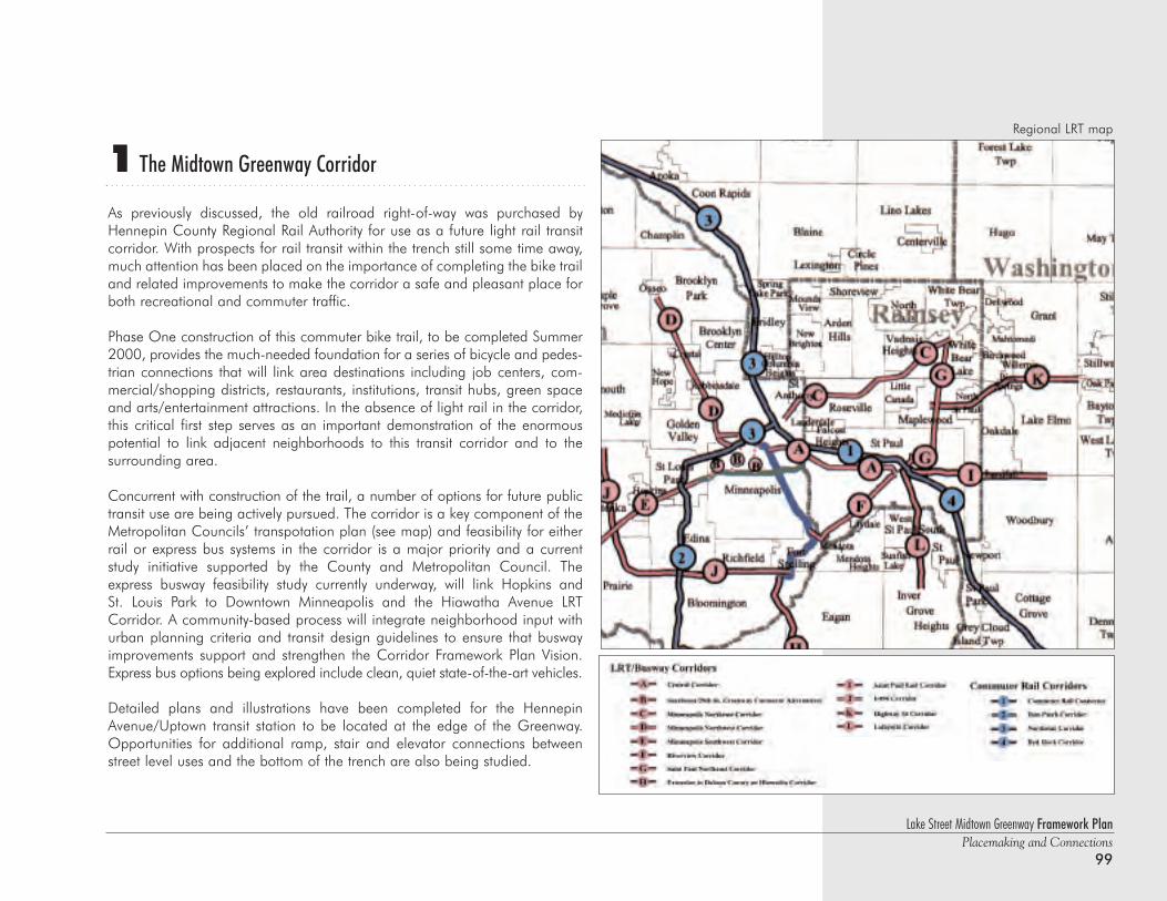
1 The Midtown Greenway Corridor
As previously discussed, the old railroad right-of-way was purchased byHennepin County Regional Rail Authority for use as a future light rail transitcorridor. With prospects for rail transit within the trench still some time away,much attention has been placed on the importance of completing the bike trailand related improvements to make the corridor a safe and pleasant place forboth recreational and commuter traffic.
Phase One construction of this commuter bike trail, to be completed Summer2000, provides the much-needed foundation for a series of bicycle and pedes-trian connections that will link area destinations including job centers, com-mercial/shopping districts, restaurants, institutions, transit hubs, green spaceand arts/entertainment attractions. In the absence of light rail in the corridor,this critical first step serves as an important demonstration of the enormouspotential to link adjacent neighborhoods to this transit corridor and to the surrounding area.
Concurrent with construction of the trail, a number of options for future publictransit use are being actively pursued. The corridor is a key component of theMetropolitan Councils’ transpotation plan (see map) and feasibility for eitherrail or express bus systems in the corridor is a major priority and a currentstudy initiative supported by the County and Metropolitan Council. Theexpress busway feasibility study currently underway, will link Hopkins and St. Louis Park to Downtown Minneapolis and the Hiawatha Avenue LRTCorridor. A community-based process will integrate neighborhood input withurban planning criteria and transit design guidelines to ensure that buswayimprovements support and strengthen the Corridor Framework Plan Vision.Express bus options being explored include clean, quiet state-of-the-art vehicles.
Detailed plans and illustrations have been completed for the HennepinAvenue/Uptown transit station to be located at the edge of the Greenway.Opportunities for additional ramp, stair and elevator connections betweenstreet level uses and the bottom of the trench are also being studied.
Lake Street Midtown Greenway Framework PlanPlacemaking and Connections
99
Regional LRT map
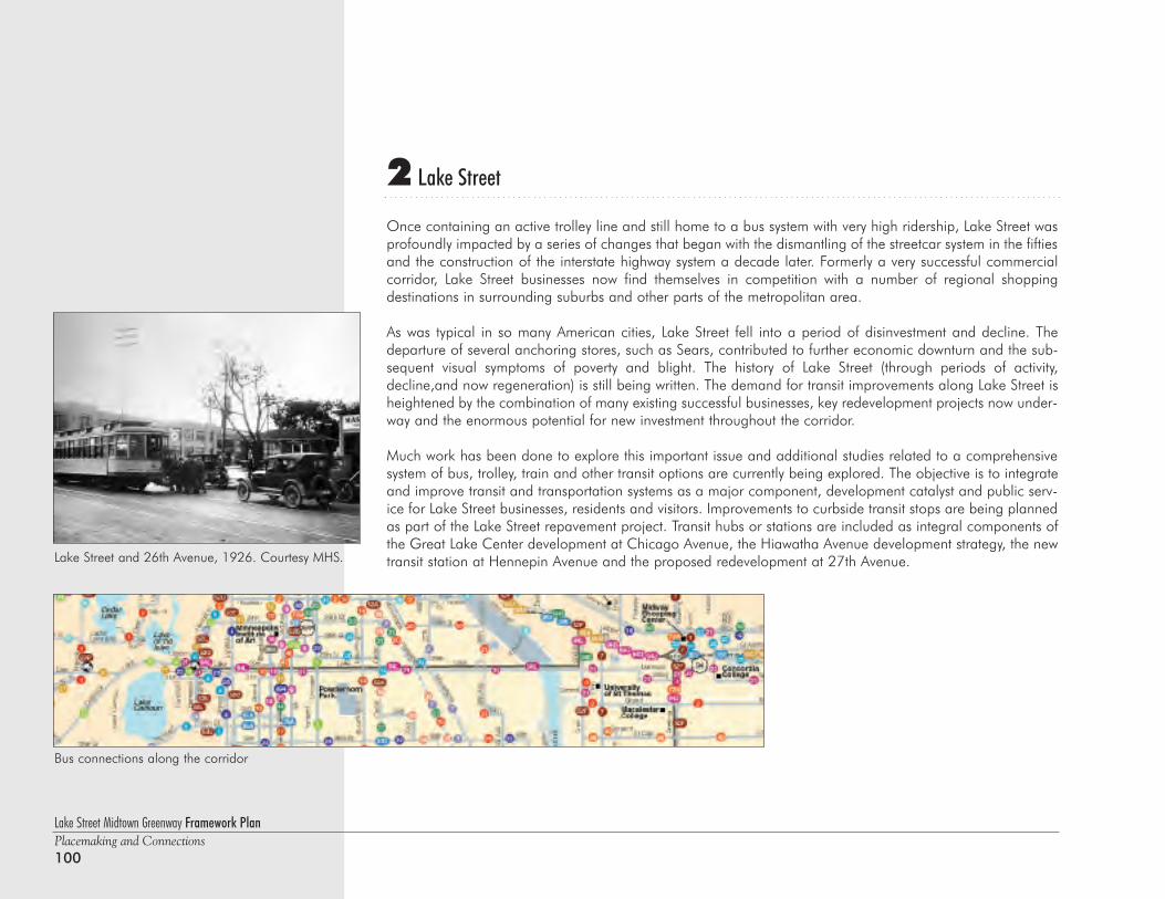
Lake Street Midtown Greenway Framework PlanPlacemaking and Connections100
2 Lake Street
Once containing an active trolley line and still home to a bus system with very high ridership, Lake Street wasprofoundly impacted by a series of changes that began with the dismantling of the streetcar system in the fiftiesand the construction of the interstate highway system a decade later. Formerly a very successful commercialcorridor, Lake Street businesses now find themselves in competition with a number of regional shopping destinations in surrounding suburbs and other parts of the metropolitan area.
As was typical in so many American cities, Lake Street fell into a period of disinvestment and decline. Thedeparture of several anchoring stores, such as Sears, contributed to further economic downturn and the sub-sequent visual symptoms of poverty and blight. The history of Lake Street (through periods of activity,decline,and now regeneration) is still being written. The demand for transit improvements along Lake Street isheightened by the combination of many existing successful businesses, key redevelopment projects now under-way and the enormous potential for new investment throughout the corridor.
Much work has been done to explore this important issue and additional studies related to a comprehensivesystem of bus, trolley, train and other transit options are currently being explored. The objective is to integrateand improve transit and transportation systems as a major component, development catalyst and public serv-ice for Lake Street businesses, residents and visitors. Improvements to curbside transit stops are being plannedas part of the Lake Street repavement project. Transit hubs or stations are included as integral components ofthe Great Lake Center development at Chicago Avenue, the Hiawatha Avenue development strategy, the newtransit station at Hennepin Avenue and the proposed redevelopment at 27th Avenue.Lake Street and 26th Avenue, 1926. Courtesy MHS.
Bus connections along the corridor
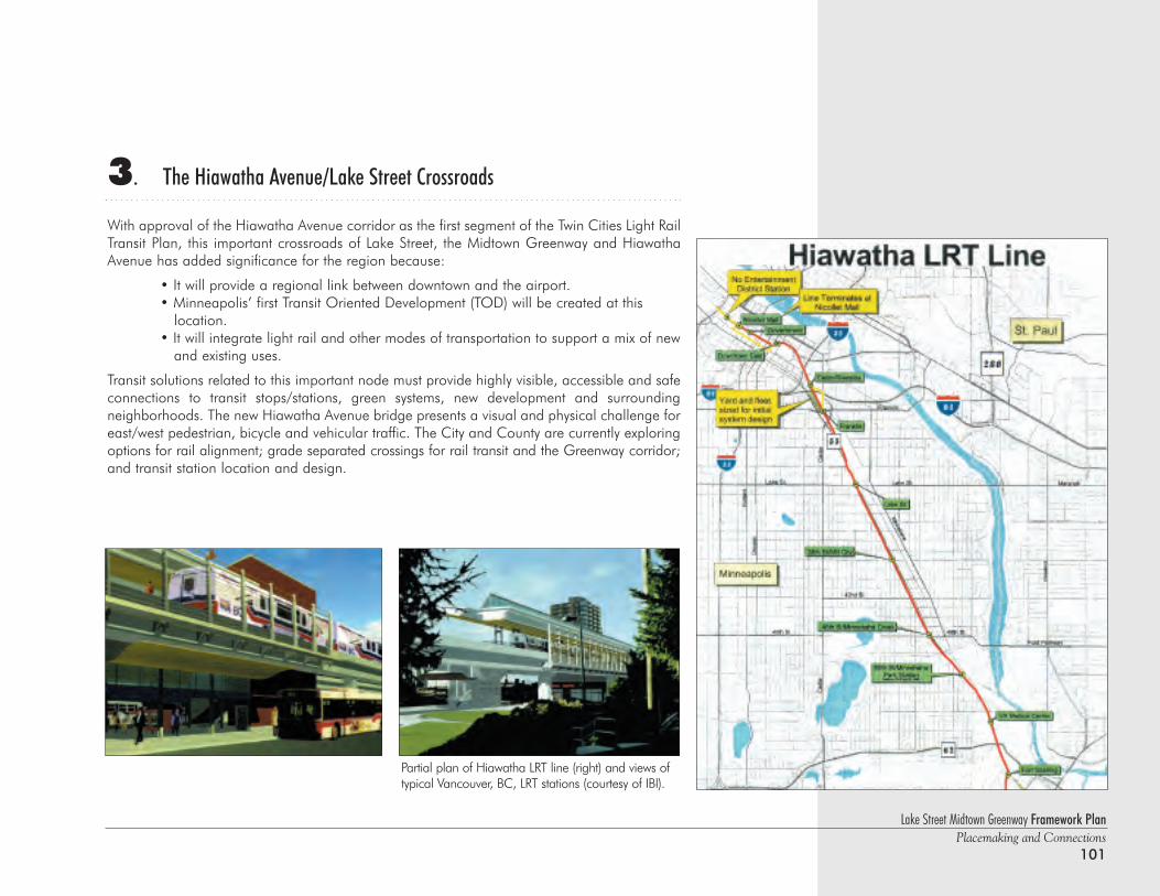
3. The Hiawatha Avenue/Lake Street Crossroads
With approval of the Hiawatha Avenue corridor as the first segment of the Twin Cities Light RailTransit Plan, this important crossroads of Lake Street, the Midtown Greenway and HiawathaAvenue has added significance for the region because:
• It will provide a regional link between downtown and the airport.• Minneapolis’ first Transit Oriented Development (TOD) will be created at this
location. • It will integrate light rail and other modes of transportation to support a mix of new
and existing uses.
Transit solutions related to this important node must provide highly visible, accessible and safeconnections to transit stops/stations, green systems, new development and surrounding neighborhoods. The new Hiawatha Avenue bridge presents a visual and physical challenge foreast/west pedestrian, bicycle and vehicular traffic. The City and County are currently exploringoptions for rail alignment; grade separated crossings for rail transit and the Greenway corridor;and transit station location and design.
Lake Street Midtown Greenway Framework PlanPlacemaking and Connections
101
Partial plan of Hiawatha LRT line (right) and views oftypical Vancouver, BC, LRT stations (courtesy of IBI).
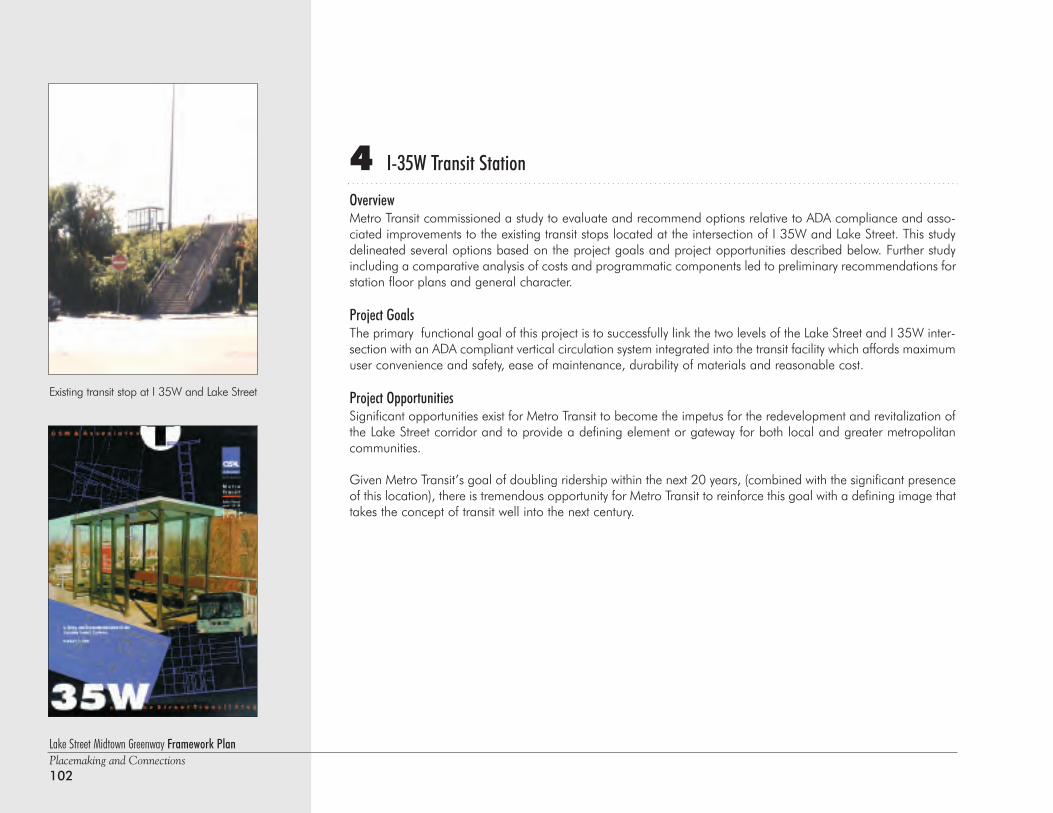
4 I-35W Transit Station
OverviewMetro Transit commissioned a study to evaluate and recommend options relative to ADA compliance and asso-ciated improvements to the existing transit stops located at the intersection of I 35W and Lake Street. This studydelineated several options based on the project goals and project opportunities described below. Further studyincluding a comparative analysis of costs and programmatic components led to preliminary recommendations forstation floor plans and general character.
Project GoalsThe primary functional goal of this project is to successfully link the two levels of the Lake Street and I 35W inter-section with an ADA compliant vertical circulation system integrated into the transit facility which affords maximumuser convenience and safety, ease of maintenance, durability of materials and reasonable cost.
Project OpportunitiesSignificant opportunities exist for Metro Transit to become the impetus for the redevelopment and revitalization ofthe Lake Street corridor and to provide a defining element or gateway for both local and greater metropolitancommunities.
Given Metro Transit’s goal of doubling ridership within the next 20 years, (combined with the significant presenceof this location), there is tremendous opportunity for Metro Transit to reinforce this goal with a defining image thattakes the concept of transit well into the next century.
Lake Street Midtown Greenway Framework PlanPlacemaking and Connections102
Existing transit stop at I 35W and Lake Street
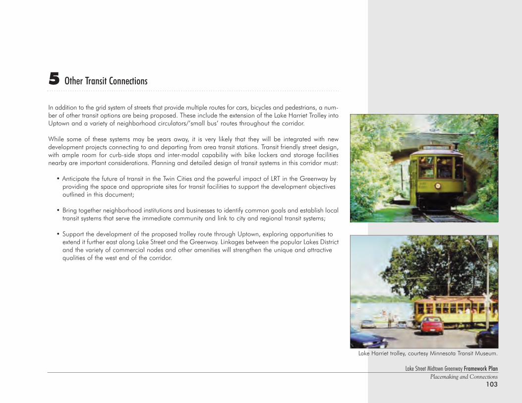
5 Other Transit Connections
In addition to the grid system of streets that provide multiple routes for cars, bicycles and pedestrians, a num-ber of other transit options are being proposed. These include the extension of the Lake Harriet Trolley intoUptown and a variety of neighborhood circulators/’small bus’ routes throughout the corridor.
While some of these systems may be years away, it is very likely that they will be integrated with new development projects connecting to and departing from area transit stations. Transit friendly street design,with ample room for curb-side stops and inter-modal capability with bike lockers and storage facilitiesnearby are important considerations. Planning and detailed design of transit systems in this corridor must:
• Anticipate the future of transit in the Twin Cities and the powerful impact of LRT in the Greenway by providing the space and appropriate sites for transit facilities to support the development objectives outlined in this document;
• Bring together neighborhood institutions and businesses to identify common goals and establish local transit systems that serve the immediate community and link to city and regional transit systems;
• Support the development of the proposed trolley route through Uptown, exploring opportunities to extend it further east along Lake Street and the Greenway. Linkages between the popular Lakes Districtand the variety of commercial nodes and other amenities will strengthen the unique and attractive qualities of the west end of the corridor.
Lake Street Midtown Greenway Framework PlanPlacemaking and Connections
103
Lake Harriet trolley, courtesy Minnesota Transit Museum.
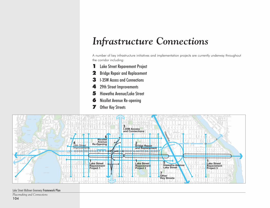
Lake Street Midtown Greenway Framework PlanPlacemaking and Connections104
Infrastructure ConnectionsA number of key infrastructure initiatives and implementation projects are currently underway throughoutthe corridor including:
1 Lake Street Repavement Project2 Bridge Repair and Replacement3 I-35W Access and Connections4 29th Street Improvements5 Hiawatha Avenue/Lake Street6 Nicollet Avenue Re-opening7 Other Key Streets
Infrastructure Connections
Hiawatha
1Lake StreetRepavement Project 3
1Lake StreetRepavement Project 2
2Bridge Repair and Replacement
3I-35W Accessand Connections
1Lake StreetRepavement Project 1
7OtherKey Streets
429th StreetImprovements
6NicolletAvenue
Re-Opening
5Hiawatha AvenueLake Street
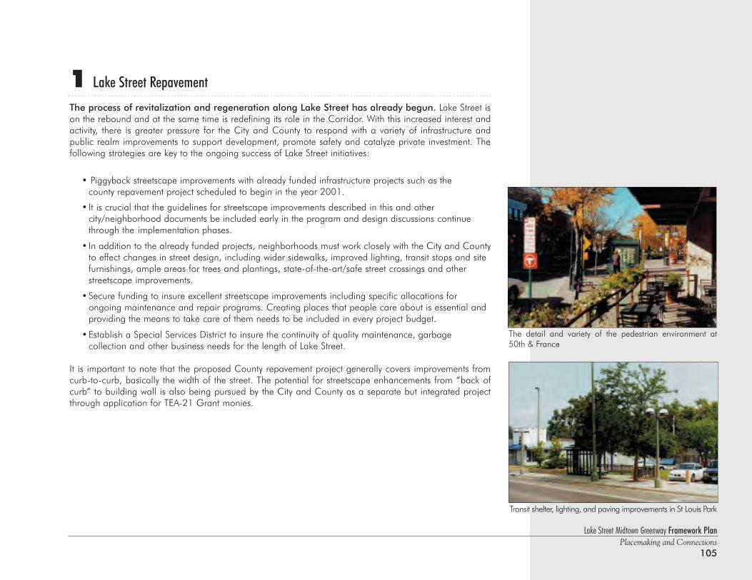
Lake Street Midtown Greenway Framework PlanPlacemaking and Connections
105
1 Lake Street Repavement
The process of revitalization and regeneration along Lake Street has already begun. Lake Street ison the rebound and at the same time is redefining its role in the Corridor. With this increased interest andactivity, there is greater pressure for the City and County to respond with a variety of infrastructure and public realm improvements to support development, promote safety and catalyze private investment. The following strategies are key to the ongoing success of Lake Street initiatives:
• Piggyback streetscape improvements with already funded infrastructure projects such as the county repavement project scheduled to begin in the year 2001.
• It is crucial that the guidelines for streetscape improvements described in this and other city/neighborhood documents be included early in the program and design discussions continue through the implementation phases.
• In addition to the already funded projects, neighborhoods must work closely with the City and Countyto effect changes in street design, including wider sidewalks, improved lighting, transit stops and site furnishings, ample areas for trees and plantings, state-of-the-art/safe street crossings and other streetscape improvements.
•Secure funding to insure excellent streetscape improvements including specific allocations for ongoing maintenance and repair programs. Creating places that people care about is essential and providing the means to take care of them needs to be included in every project budget.
•Establish a Special Services District to insure the continuity of quality maintenance, garbage collection and other business needs for the length of Lake Street.
It is important to note that the proposed County repavement project generally covers improvements fromcurb-to-curb, basically the width of the street. The potential for streetscape enhancements from “back ofcurb” to building wall is also being pursued by the City and County as a separate but integrated projectthrough application for TEA-21 Grant monies.
Transit shelter, lighting, and paving improvements in St Louis Park
The detail and variety of the pedestrian environment at50th & France
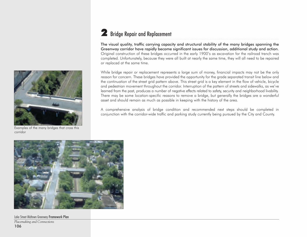
Lake Street Midtown Greenway Framework PlanPlacemaking and Connections106
2 Bridge Repair and Replacement
The visual quality, traffic carrying capacity and structural stability of the many bridges spanning theGreenway corridor have rapidly become significant issues for discussion, additional study and action.Original construction of these bridges occurred in the early 1900’s as excavation for the railroad trench wascompleted. Unfortunately, because they were all built at nearly the same time, they will all need to be repairedor replaced at the same time.
While bridge repair or replacement represents a large sum of money, financial impacts may not be the onlyreason for concern. These bridges have provided the opportunity for the grade separated transit line below andthe continuation of the street grid pattern above. This street grid is a key element in the flow of vehicle, bicycleand pedestrian movement throughout the corridor. Interruption of the pattern of streets and sidewalks, as we’velearned from the past, produces a number of negative effects related to safety, security and neighborhood livability.There may be some location-specific reasons to remove a bridge, but generally the bridges are a wonderfulasset and should remain as much as possible in keeping with the history of the area.
A comprehensive analysis of bridge condition and recommended next steps should be completed in conjunction with the corridor-wide traffic and parking study currently being pursued by the City and County.
Examples of the many bridges that cross thiscorridor
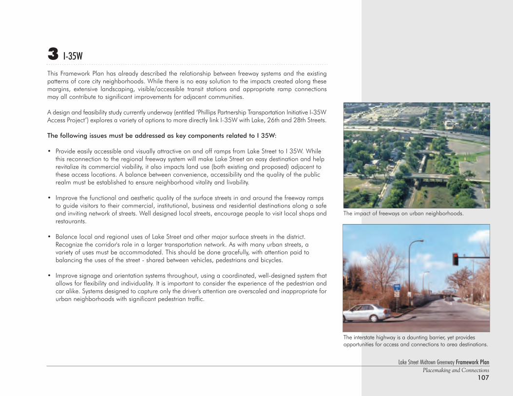
Lake Street Midtown Greenway Framework PlanPlacemaking and Connections
107
3 I-35W
This Framework Plan has already described the relationship between freeway systems and the existingpatterns of core city neighborhoods. While there is no easy solution to the impacts created along thesemargins, extensive landscaping, visible/accessible transit stations and appropriate ramp connectionsmay all contribute to significant improvements for adjacent communities.
A design and feasibility study currently underway (entitled ‘Phillips Partnership Transportation Initiative I-35WAccess Project’) explores a variety of options to more directly link I-35W with Lake, 26th and 28th Streets.
The following issues must be addressed as key components related to I 35W:
• Provide easily accessible and visually attractive on and off ramps from Lake Street to I 35W. While this reconnection to the regional freeway system will make Lake Street an easy destination and help revitalize its commercial viability, it also impacts land use (both existing and proposed) adjacent to these access locations. A balance between convenience, accessibility and the quality of the public realm must be established to ensure neighborhood vitality and livability.
• Improve the functional and aesthetic quality of the surface streets in and around the freeway ramps to guide visitors to their commercial, institutional, business and residential destinations along a safeand inviting network of streets. Well designed local streets, encourage people to visit local shops andrestaurants.
• Balance local and regional uses of Lake Street and other major surface streets in the district. Recognize the corridor's role in a larger transportation network. As with many urban streets, a variety of uses must be accommodated. This should be done gracefully, with attention paid to balancing the uses of the street - shared between vehicles, pedestrians and bicycles.
• Improve signage and orientation systems throughout, using a coordinated, well-designed system thatallows for flexibility and individuality. It is important to consider the experience of the pedestrian andcar alike. Systems designed to capture only the driver's attention are overscaled and inappropriate forurban neighborhoods with significant pedestrian traffic.
The impact of freeways on urban neighborhoods.
The interstate highway is a daunting barrier, yet provides opportunities for access and connections to area destinations.
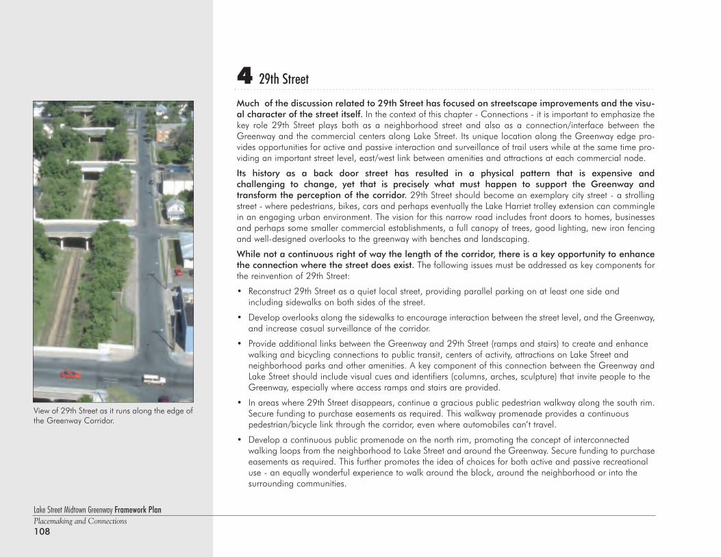
4 29th Street
Much of the discussion related to 29th Street has focused on streetscape improvements and the visu-al character of the street itself. In the context of this chapter - Connections - it is important to emphasize thekey role 29th Street plays both as a neighborhood street and also as a connection/interface between theGreenway and the commercial centers along Lake Street. Its unique location along the Greenway edge pro-vides opportunities for active and passive interaction and surveillance of trail users while at the same time pro-viding an important street level, east/west link between amenities and attractions at each commercial node.
Its history as a back door street has resulted in a physical pattern that is expensive and challenging to change, yet that is precisely what must happen to support the Greenway and transform the perception of the corridor. 29th Street should become an exemplary city street - a strollingstreet - where pedestrians, bikes, cars and perhaps eventually the Lake Harriet trolley extension can comminglein an engaging urban environment. The vision for this narrow road includes front doors to homes, businessesand perhaps some smaller commercial establishments, a full canopy of trees, good lighting, new iron fencingand well-designed overlooks to the greenway with benches and landscaping.
While not a continuous right of way the length of the corridor, there is a key opportunity to enhancethe connection where the street does exist. The following issues must be addressed as key components forthe reinvention of 29th Street:
• Reconstruct 29th Street as a quiet local street, providing parallel parking on at least one side and including sidewalks on both sides of the street.
• Develop overlooks along the sidewalks to encourage interaction between the street level, and the Greenway,and increase casual surveillance of the corridor.
• Provide additional links between the Greenway and 29th Street (ramps and stairs) to create and enhance walking and bicycling connections to public transit, centers of activity, attractions on Lake Street andneighborhood parks and other amenities. A key component of this connection between the Greenway andLake Street should include visual cues and identifiers (columns, arches, sculpture) that invite people to the Greenway, especially where access ramps and stairs are provided.
• In areas where 29th Street disappears, continue a gracious public pedestrian walkway along the south rim.Secure funding to purchase easements as required. This walkway promenade provides a continuous pedestrian/bicycle link through the corridor, even where automobiles can’t travel.
• Develop a continuous public promenade on the north rim, promoting the concept of interconnected walking loops from the neighborhood to Lake Street and around the Greenway. Secure funding to purchaseeasements as required. This further promotes the idea of choices for both active and passive recreational use - an equally wonderful experience to walk around the block, around the neighborhood or into the surrounding communities.
Lake Street Midtown Greenway Framework PlanPlacemaking and Connections108
View of 29th Street as it runs along the edge ofthe Greenway Corridor.
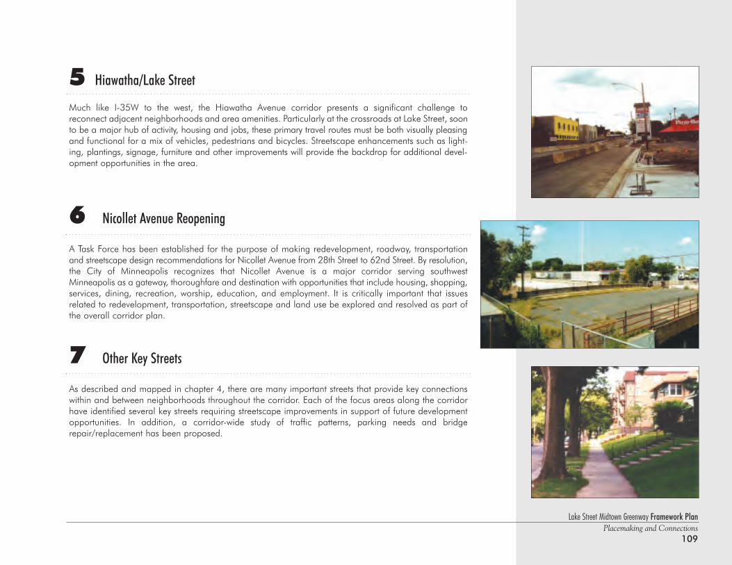
5 Hiawatha/Lake Street
Much like I-35W to the west, the Hiawatha Avenue corridor presents a significant challenge to reconnect adjacent neighborhoods and area amenities. Particularly at the crossroads at Lake Street, soonto be a major hub of activity, housing and jobs, these primary travel routes must be both visually pleasingand functional for a mix of vehicles, pedestrians and bicycles. Streetscape enhancements such as light-ing, plantings, signage, furniture and other improvements will provide the backdrop for additional devel-opment opportunities in the area.
6 Nicollet Avenue Reopening
A Task Force has been established for the purpose of making redevelopment, roadway, transportationand streetscape design recommendations for Nicollet Avenue from 28th Street to 62nd Street. By resolution,the City of Minneapolis recognizes that Nicollet Avenue is a major corridor serving southwestMinneapolis as a gateway, thoroughfare and destination with opportunities that include housing, shopping,services, dining, recreation, worship, education, and employment. It is critically important that issuesrelated to redevelopment, transportation, streetscape and land use be explored and resolved as part ofthe overall corridor plan.
7 Other Key Streets
As described and mapped in chapter 4, there are many important streets that provide key connectionswithin and between neighborhoods throughout the corridor. Each of the focus areas along the corridorhave identified several key streets requiring streetscape improvements in support of future developmentopportunities. In addition, a corridor-wide study of traffic patterns, parking needs and bridgerepair/replacement has been proposed.
Lake Street Midtown Greenway Framework PlanPlacemaking and Connections
109
Lake Street Midtown Greenway Framework PlanPlacemaking and Connections110
Parks, Trails & Open Space ConnectionsA number of key parks, trails and open space initiatives and implementation projects are currently underwaythroughout the corridor including:
1 The Midtown Greenway
2 Proposed Dedicated Park Opportunities
3 Proposed Public Green Space Integrated with Development
4 Green Streets - Links to Existing Parks
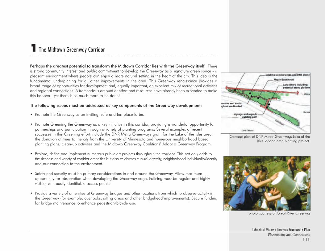
Lake Street Midtown Greenway Framework PlanPlacemaking and Connections
111
1 The Midtown Greenway Corridor
Perhaps the greatest potential to transform the Midtown Corridor lies with the Greenway itself. Thereis strong community interest and public commitment to develop the Greenway as a signature green space - apleasant environment where people can enjoy a more natural setting in the heart of the city. This idea is thefundamental underpinning for all other improvements in the area. This Greenway renaissance provides abroad range of opportunities for development and, equally important, an excellent mix of recreational activitiesand regional connections. A tremendous amount of effort and resources have already been expended to makethis happen - yet there is so much more to be done!
The following issues must be addressed as key components of the Greenway development:
• Promote the Greenway as an inviting, safe and fun place to be.
• Promote Greening the Greenway as a key initiative in this corridor, providing a wonderful opportunity for partnerships and participation through a variety of planting programs. Several examples of recent successes in this Greening effort include the DNR Metro Greenways grant for the Lake of the Isles area, the donation of trees to the city from the University of Minnesota and numerous neighborhood based planting plans, clean-up activities and the Midtown Greenway Coalitions’ Adopt a Greenway Program.
• Explore, define and implement numerous public art projects throughout the corridor. This not only adds to the richness and variety of corridor amenities but also celebrates cultural diversity, neighborhood individuality/identityand our connection to the environment.
• Safety and security must be primary considerations in and around the Greenway. Allow maximum opportunity for observation when developing the Greenway edge. Policing must be regular and highly visible, with easily identifiable access points.
• Provide a variety of amenities at Greenway bridges and other locations from which to observe activity in the Greenway (for example, overlooks, sitting areas and other bridgehead improvements). Secure fundingfor bridge maintenance to enhance pedestrian/bicycle use.
Concept plan of DNR Metro Greenways Lake of theIsles lagoon area planting project.
photo courtesy of Great River Greening
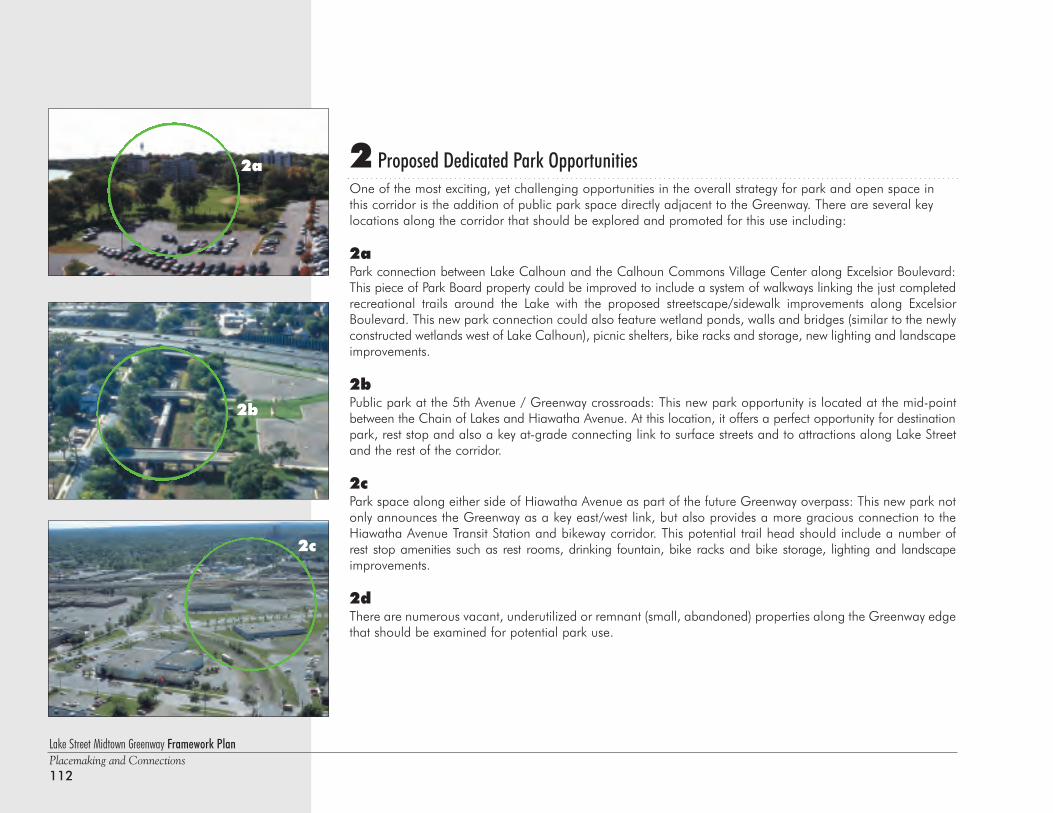
2 Proposed Dedicated Park OpportunitiesOne of the most exciting, yet challenging opportunities in the overall strategy for park and open space inthis corridor is the addition of public park space directly adjacent to the Greenway. There are several keylocations along the corridor that should be explored and promoted for this use including:
2a Park connection between Lake Calhoun and the Calhoun Commons Village Center along Excelsior Boulevard:This piece of Park Board property could be improved to include a system of walkways linking the just completedrecreational trails around the Lake with the proposed streetscape/sidewalk improvements along ExcelsiorBoulevard. This new park connection could also feature wetland ponds, walls and bridges (similar to the newlyconstructed wetlands west of Lake Calhoun), picnic shelters, bike racks and storage, new lighting and landscapeimprovements.
2b Public park at the 5th Avenue / Greenway crossroads: This new park opportunity is located at the mid-pointbetween the Chain of Lakes and Hiawatha Avenue. At this location, it offers a perfect opportunity for destinationpark, rest stop and also a key at-grade connecting link to surface streets and to attractions along Lake Streetand the rest of the corridor.
2c Park space along either side of Hiawatha Avenue as part of the future Greenway overpass: This new park notonly announces the Greenway as a key east/west link, but also provides a more gracious connection to theHiawatha Avenue Transit Station and bikeway corridor. This potential trail head should include a number ofrest stop amenities such as rest rooms, drinking fountain, bike racks and bike storage, lighting and landscapeimprovements.
2d There are numerous vacant, underutilized or remnant (small, abandoned) properties along the Greenway edgethat should be examined for potential park use.
Lake Street Midtown Greenway Framework PlanPlacemaking and Connections112
2a
2b
2c
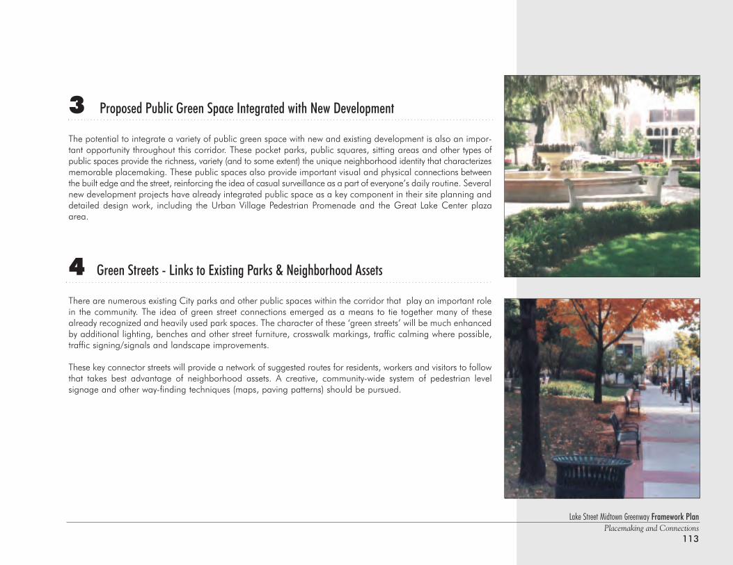
Lake Street Midtown Greenway Framework PlanPlacemaking and Connections
113
3 Proposed Public Green Space Integrated with New Development
The potential to integrate a variety of public green space with new and existing development is also an impor-tant opportunity throughout this corridor. These pocket parks, public squares, sitting areas and other types ofpublic spaces provide the richness, variety (and to some extent) the unique neighborhood identity that characterizesmemorable placemaking. These public spaces also provide important visual and physical connections betweenthe built edge and the street, reinforcing the idea of casual surveillance as a part of everyone’s daily routine. Severalnew development projects have already integrated public space as a key component in their site planning anddetailed design work, including the Urban Village Pedestrian Promenade and the Great Lake Center plazaarea.
4 Green Streets - Links to Existing Parks & Neighborhood Assets
There are numerous existing City parks and other public spaces within the corridor that play an important rolein the community. The idea of green street connections emerged as a means to tie together many of thesealready recognized and heavily used park spaces. The character of these ‘green streets’ will be much enhancedby additional lighting, benches and other street furniture, crosswalk markings, traffic calming where possible,traffic signing/signals and landscape improvements.
These key connector streets will provide a network of suggested routes for residents, workers and visitors to followthat takes best advantage of neighborhood assets. A creative, community-wide system of pedestrian level signage and other way-finding techniques (maps, paving patterns) should be pursued.
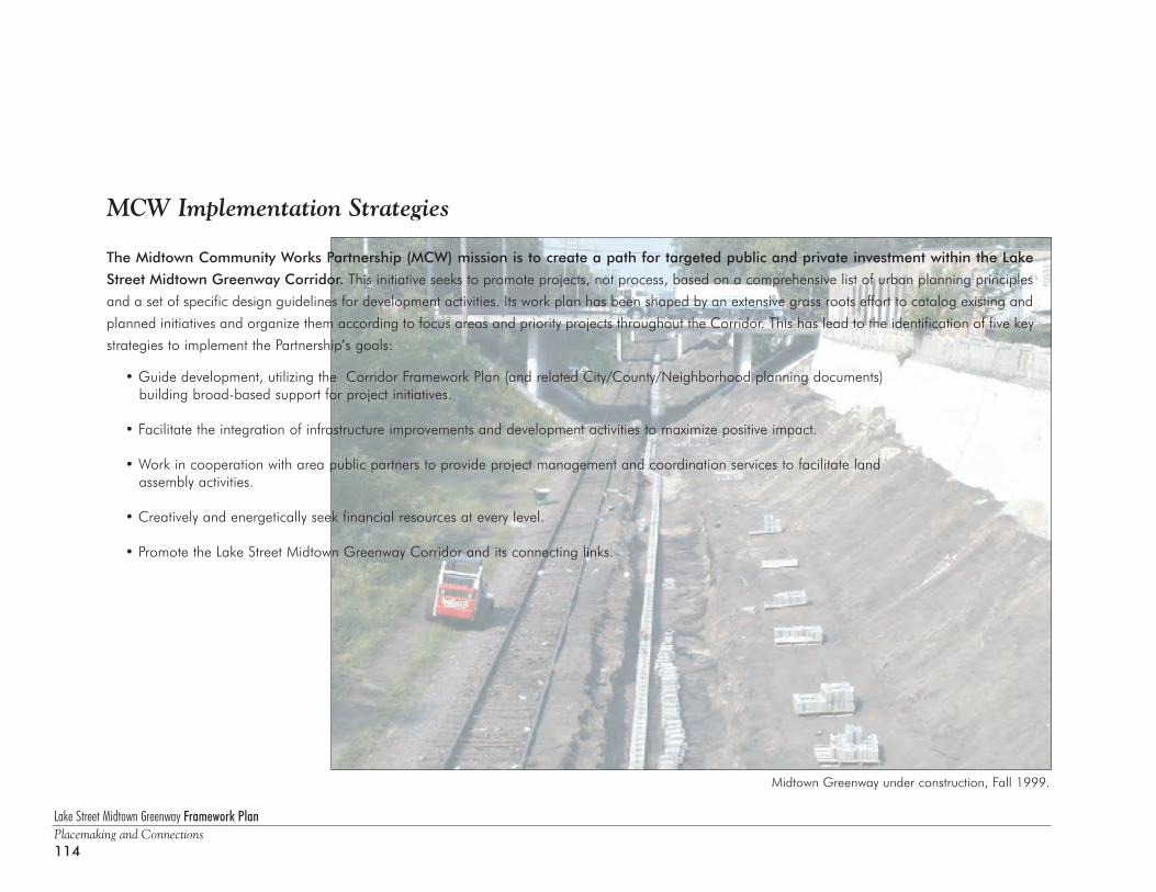
Lake Street Midtown Greenway Framework PlanPlacemaking and Connections114
MCW Implementation Strategies
The Midtown Community Works Partnership (MCW) mission is to create a path for targeted public and private investment within the Lake
Street Midtown Greenway Corridor. This initiative seeks to promote projects, not process, based on a comprehensive list of urban planning principles
and a set of specific design guidelines for development activities. Its work plan has been shaped by an extensive grass roots effort to catalog existing and
planned initiatives and organize them according to focus areas and priority projects throughout the Corridor. This has lead to the identification of five key
strategies to implement the Partnership’s goals:
• Guide development, utilizing the Corridor Framework Plan (and related City/County/Neighborhood planning documents) building broad-based support for project initiatives.
• Facilitate the integration of infrastructure improvements and development activities to maximize positive impact.
• Work in cooperation with area public partners to provide project management and coordination services to facilitate landassembly activities.
• Creatively and energetically seek financial resources at every level.
• Promote the Lake Street Midtown Greenway Corridor and its connecting links.
Midtown Greenway under construction, Fall 1999.
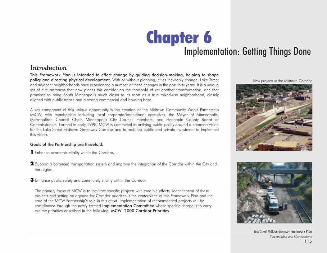
Lake Street Midtown Greenway Framework PlanPlacemaking and Connections
115
Implementation: Getting Things DoneChapter 6
IntroductionThis Framework Plan is intended to effect change by guiding decision-making, helping to shape policy and directing physical development. With or without planning, cities inevitably change. Lake Streetand adjacent neighborhoods have experienced a number of these changes in the past forty years. It is a uniqueset of circumstances that now places this corridor on the threshold of yet another transformation, one thatpromises to bring South Minneapolis much closer to its roots as a true mixed-use neighborhood, closelyaligned with public transit and a strong commercial and housing base.
A key component of this unique opportunity is the creation of the Midtown Community Works Partnership(MCW) with membership including local corporate/institutional executives, the Mayor of Minneapolis,Metropolitan Council Chair, Minneapolis City Council members, and Hennepin County Board ofCommissioners. Formed in early 1998, MCW is committed to unifying public policy around a common visionfor the Lake Street Midtown Greenway Corridor and to mobilize public and private investment to implementthis vision.
Goals of the Partnership are threefold;
1 Enhance economic vitality within the Corridor,
2 Support a balanced transportation system and improve the integration of the Corridor within the City and the region,
3 Enhance public safety and community vitality within the Corridor.
The primary focus of MCW is to facilitate specific projects with tangible effects. Identification of theseprojects and setting an agenda for Corridor priorities is the centerpiece of this Framework Plan and the core of the MCW Partnership’s role in this effort. Implementation of recommended projects will becoordinated through the newly formed Implementation Committee whose specific charge is to carry out the priorities described in the following: MCW 2000 Corridor Priorities.
New projects in the Midtown Corridor
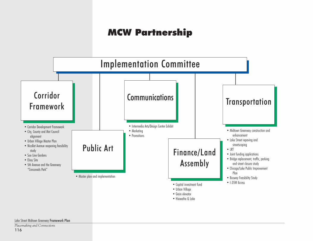
Lake Street Midtown Greenway Framework PlanPlacemaking and Connections116
MCW Partnership
CorridorFramework
Communications Transportation
Public Art Finance/LandAssembly
Implementation Committee
• Master plan and implementation
• Corridor Development Framework• City, County and Met Council
alignment• Urban Village Master Plan• Nicollet Avenue reopening feasibility
study• Soo Line Gardens• Elroy Site• 5th Avenue and the Greenway
“Crossroads Park”
• Intermedia Arts/Design Center Exhibit• Marketing• Promotions
• Capital investment fund• Urban Village• Grain elevator• Hiawatha & Lake
• Midtown Greenway construction andenhancement
• Lake Street repaving and streetscaping
• LRT• Joint funding applications• Bridge replacement, traffic, parking
and street closure study• Chicago/Lake Public Improvement
Plan• Busway Feasibility Study• I-35W Access
Lake Street Midtown Greenway Framework PlanPlacemaking and Connections
117
The MCW Implementation CommitteeOverviewThe Implementation Committee was formed to carry out the priorities of the MCW Partnership. Its membersinclude key staff from each public agency and representatives of the private partners. It meets monthly to coor-dinate public/private project implementation, share information and problem solve. It is guided by the MCW2000-Corridor Priorities Chart which identifies each project, its cost, funding source, funding submission dead-lines and projected implementation schedule. In addition, the progress of each subcommittee is reviewed anditems are acted on as needed. Subcommittees include:
Corridor Framework
This Corridor Framework Plan was developed to foster a unified vision and implementation strategy for the LakeStreet Midtown Greenway Corridor. The Framework was shaped through an extensive community process, hasthe buy-in of our public partners and is market-based. It identifies overall corridor planning principles anddesign guidelines and is focused on building economically vital, livable places and strong connections to thesurrounding community and the region. It will be adopted by the City of Minneapolis and Hennepin Countyand will direct development, policy and capital improvements.
Several projects are underway that are being guided by the Framework principles including:• Design and construction of the Midtown Greenway• Lake Street Improvements• Feasibility study for reopening Nicollet Avenue• Variety of development projects
Public Art Committee
MCW was awarded a grant from the Bush Foundation to develop a master plan and implementation strategyfor public art in the Midtown Greenway. The Freeman/Whitehurst Group was selected as the project consultantswith work beginning in early 2000.
Lake Street Midtown Greenway Framework PlanPlacemaking and Connections118
Communications Committee
A strong communications strategy is essential to promote the Midtown Corridor Vision. MCW’sCommunications Committee is working to develop communication materials, events and partnerships to pro-mote the corridor vision and the many projects and initiatives already underway. In addition, Intermedia Artsand the Design Center are planning an exhibit that will showcase artists’ vision for the Corridor. A stunningphoto essay by artist Wing Young Huie featuring photos all along Lake Street will be implemented in the spring,2000.
The Framework Plan, monthly updates and the MCW brochure are intended to inform and educate corridorstakeholders. A comprehensive 5 year marketing and public relations plan is also being developed. Marketingincludes everything you do, say or visually communicate to obtain the desired results. This strategic plan willrecommend specific strategies and tactics to achieve these results.
Finance/Land Assembly Committee
The MCW Partnership established a Finance and Land Assembly Committee to assist new projects with ‘bridge’financing, making funds available for up-front development costs ultimately repaid through tax incrementfinancing. Representatives from Norwest Bank, Fannie Mae, Hennepin County, the Metropolitan Council, theCity Finance Director and the Executive Director of the Minneapolis Community Development Agency havedeveloped a new model to provide this bridge financing through an investment fund approach.
The MCW Investment Fund initially envisions ten initial investors providing $1 million each. This fund will estab-lish a working model, using the proposed Urban Village development as a demonstration, with hopes that thisprocess can be replicated for subsequent projects. Investors could be repaid within 3-4 years when the City’sbonds are sold, or they could allow their investment to be utilized again for another project offering. The suc-cess of the fund will depend in large measure on the success of the individual development projects. Thus theMCW Finance Committee will pay careful attention to the real market potential of individual projects.
The initial offering for the MCW Investment Fund is planned for early 2000, and funds will be available byApril, 2000.
Transportation Task Force
The Transportation Task Force’s purpose is to monitor the construction of the Midtown Greenway, assist withthe Lake Street Repaving and Streetscaping Project, support construction of the Hiawatha LRT, facilitate joint fund-ing applications, oversee the bridge replacement, traffic, parking and street closure study and align transportation capital improvement projects.
Lake Street Midtown Greenway Framework PlanPlacemaking and Connections
119
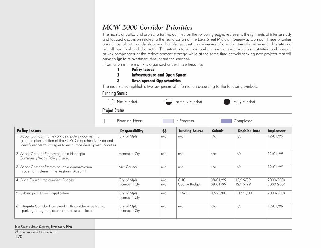
1. Adopt Corridor Framework as a policy document to City of Mpls n/a n/a n/a n/a 12/01/99guide Implementation of the City’s Comprehensive Plan and identify near-term strategies to encourage development priorities.
2. Adopt Corridor Framework as a Hennepin Hennepin Cty n/a n/a n/a n/a 12/01/99Community Works Policy Guide.
3. Adopt Corridor Framework as a demonstration Met Council n/a n/a n/a n/a 12/01/99model to Implement the Regional Blueprint
4. Align Capital Improvement Budgets. City of Mpls n/a CLIC 08/01/99 12/15/99 2000-2004Hennepin Cty n/a County Budget 08/01/99 12/15/99 2000-2004
5. Submit joint TEA-21 application City of Mpls n/a TEA-21 09/20/00 01/31/00 2000-2004Hennepin Cty
6. Integrate Corridor Framework with corridor-wide traffic, City of Mpls n/a n/a n/a n/a 12/01/99parking, bridge replacement, and street closure. Hennepin Cty
Policy Issues Responsibility $$ Funding Source Submit Decision Date Implement
Lake Street Midtown Greenway Framework PlanPlacemaking and Connections120
MCW 2000 Corridor Priorities The matrix of policy and project priorities outlined on the following pages represents the synthesis of intense studyand focused discussion related to the revitalization of the Lake Street Midtown Greenway Corridor. These prioritiesare not just about new development, but also suggest an awareness of corridor strengths, wonderful diversity andoverall neighborhood character. The intent is to support and enhance existing business, institution and housingas key components of the redevelopment strategy, while at the same time actively seeking new projects that willserve to ignite reinvestment throughout the corridor.Information in the matrix is organized under three headings:
1 Policy Issues2 Infrastructure and Open Space3 Development Opportunities
The matrix also highlights two key pieces of information according to the following symbols:
Funding Status
Not Funded Partially Funded Fully Funded
Project Status
Planning Phase In Progress Completed
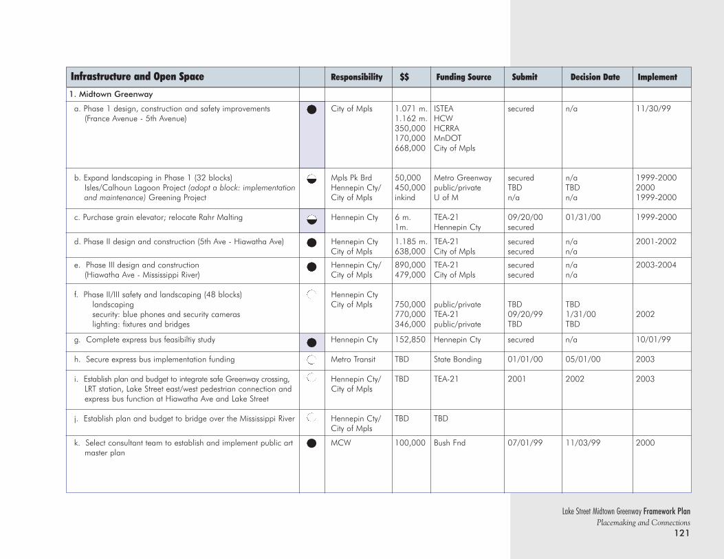
Lake Street Midtown Greenway Framework PlanPlacemaking and Connections
121
Infrastructure and Open Space Responsibility $$ Funding Source Submit Decision Date Implement
1. Midtown Greenway
a. Phase 1 design, construction and safety improvements City of Mpls 1.071 m. ISTEA secured n/a 11/30/99(France Avenue - 5th Avenue) 1.162 m. HCW
350,000 HCRRA170,000 MnDOT668,000 City of Mpls
b. Expand landscaping in Phase 1 (32 blocks) Mpls Pk Brd 50,000 Metro Greenway secured n/a 1999-2000Isles/Calhoun Lagoon Project (adopt a block: implementation Hennepin Cty/ 450,000 public/private TBD TBD 2000and maintenance) Greening Project City of Mpls inkind U of M n/a n/a 1999-2000
c. Purchase grain elevator; relocate Rahr Malting Hennepin Cty 6 m. TEA-21 09/20/00 01/31/00 1999-20001m. Hennepin Cty secured
d. Phase II design and construction (5th Ave - Hiawatha Ave) Hennepin Cty 1.185 m. TEA-21 secured n/a 2001-2002City of Mpls 638,000 City of Mpls secured n/a
e. Phase III design and construction Hennepin Cty/ 890,000 TEA-21 secured n/a 2003-2004(Hiawatha Ave - Mississippi River) City of Mpls 479,000 City of Mpls secured n/a
f. Phase II/III safety and landscaping (48 blocks) Hennepin Ctylandscaping City of Mpls 750,000 public/private TBD TBDsecurity: blue phones and security cameras 770,000 TEA-21 09/20/99 1/31/00 2002lighting: fixtures and bridges 346,000 public/private TBD TBD
g. Complete express bus feasibiltiy study Hennepin Cty 152,850 Hennepin Cty secured n/a 10/01/99
h. Secure express bus implementation funding Metro Transit TBD State Bonding 01/01/00 05/01/00 2003
i. Establish plan and budget to integrate safe Greenway crossing, Hennepin Cty/ TBD TEA-21 2001 2002 2003LRT station, Lake Street east/west pedestrian connection and City of Mplsexpress bus function at Hiawatha Ave and Lake Street
j. Establish plan and budget to bridge over the Mississippi River Hennepin Cty/ TBD TBDCity of Mpls
k. Select consultant team to establish and implement public art MCW 100,000 Bush Fnd 07/01/99 11/03/99 2000master plan
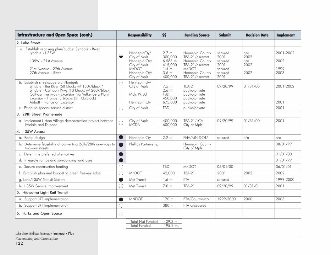
2. Lake Street
a. Establish repaving plan/budget (Lyndale - River)Lyndale - I 35W HennepinCty/ 2.7 m. Hennepin County secured n/a 2001-2002
City of Mpls 300,000 TEA-21/asesmnt 2001 2002I 35W - 21st Avenue Hennepin Cty/ 6.585 m. Hennepin County secured n/a 2002
City of Mpls 415,000 TEA-21/asesmnt 2001 200221st Avenue - 27th Avenue MnDOT 1.4 m. MnDOT secured 199927th Avenue - River Hennepin Cty/ 3.6 m Hennepin County secured 2002 2003
City of Mpls 400,000 TEA-21/asesmnt 2001
b. Establish streetscape plan/budget: Hennepin cty/Lyndale - the River (50 blocks @ 150k/block)* City of Mpls 7.5 m. TEA-21 09/20/99 01/31/00 2001-2002Lyndale - Calhoun Pkwy (13 blocks @ 200k/block) 2.6 m. public/privateCalhoun Parkway - Excelsior (VanValkenberg Plan) Mpls Pk Bd TBD public/privateExcelsior - France (3 blocks @ 10k/block) 450,000 public/privateAbbott - France on Excelsior Hennepin Cty 675,000 public/private 2001
c. Establish special service district City of Mpls TBD public/private 2001
3. 29th Street Promenade
a. Implement Urban Village demonstration project between City of Mpls 400,000 TEA-21/LCA 09/20/99 01/31/00 2001Lyndale and Dupont MCDA 600,000 City of Mpls
4. I 35W Access
a. Ramp design Hennepin Cty 2.2 m. FHA/MN DOT/ secured n/a n/a
b. Determine feasibility of converting 26th/28th one-ways to Phillips Partnership Hennepin County 08/01/99two-way streets City of Mpls
c. Determine preferred alternatives 01/01/00
d. Integrate ramps and surrounding land uses 01/01/99
e. Secure construction funding TBD MnDOT 05/01/00 06/01/01
f. Establish plan and budget to green freeway edge MnDOT 42,000 TEA-21 2001 2002 2002
g. Lake/I 35W Transit Station Met Transit 1.6 m. FTA secured 1999-2000
h. I 35W Service Improvement Met Transit 7.0 m. TEA-21 09/20/99 01/31/0 2001
5. Hiawatha Light Rail Transit
a. Support LRT implementation MNDOT 170 m. FTA/County/MN 1999-2000 2000 2003
b. Support LRT implementation 380 m. FTA unsecured
6. Parks and Open Space
Lake Street Midtown Greenway Framework PlanPlacemaking and Connections122
Infrastructure and Open Space (cont.) Responsibility $$ Funding Source Submit Decision Date Implement
Total Not Funded 409.3 m. Total Funded 195.9 m.
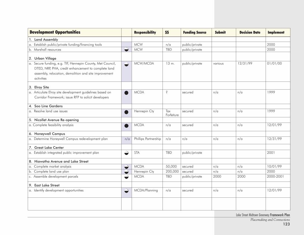
1. Land Assemblya. Establish public/private funding/financing tools MCW n/a public/private 2000b. Marshall resources MCW TBD public/private 2000
2. Urban Villagea. Secure funding, e.g. TIF, Hennepin County, Met Council, MCW/MCDA 13 m. public/private various 12/31/99 01/01/00
DTED, NRP, PHA, credit enhancement to complete land assembly, relocation, demolition and site improvement activities
3. Elroy Sitea. Articulate Elroy site development guidelines based on MCDA ? secured n/a n/a 1999
Corridor Framework; issue RFP to solicit developers
4. Soo Line Gardensa. Resolve land use issues Hennepin Cty Tax secured n/a n/a 1999
Forfeiture5. Nicollet Avenue Re-openinga. Complete feasibility analysis MCDA n/a secured n/a n/a 12/01/99
6. Honeywell Campusa. Determine Honeywell Campus redevelopment plan Phillips Partnership n/a n/a n/a n/a 12/31/99
7. Great Lake Centera. Establish integrated public improvement plan STA TBD public/private 2001
8. Hiawatha Avenue and Lake Streeta. Complete market analysis MCDA 50,000 secured n/a n/a 10/01/99b. Complete land use plan Hennepin Cty 200,000 secured n/a n/a 2000c. Assemble development parcels MCDA TBD public/private 2000 2000 2000-2001
9. East Lake Streeta. Identify development opportunities MCDA/Planning n/a secured n/a n/a 12/01/99
Lake Street Midtown Greenway Framework PlanPlacemaking and Connections
123
Development Opportunities Responsibility $$ Funding Source Submit Decision Date Implement
n/a
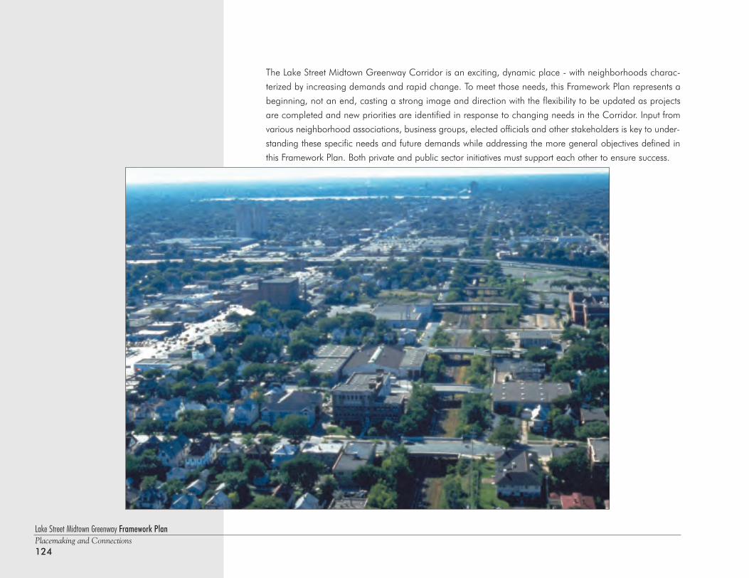
Lake Street Midtown Greenway Framework PlanPlacemaking and Connections124
The Lake Street Midtown Greenway Corridor is an exciting, dynamic place - with neighborhoods charac-
terized by increasing demands and rapid change. To meet those needs, this Framework Plan represents a
beginning, not an end, casting a strong image and direction with the flexibility to be updated as projects
are completed and new priorities are identified in response to changing needs in the Corridor. Input from
various neighborhood associations, business groups, elected officials and other stakeholders is key to under-
standing these specific needs and future demands while addressing the more general objectives defined in
this Framework Plan. Both private and public sector initiatives must support each other to ensure success.
Lake Street Midtown Greenway Framework PlanPlacemaking and Connections
125
Resource List/BibliographyThe Minneapolis Plan; City of Minneapolis; Minneapolis Planning Department; Fianl Draft; June 1998
Hennepin Community Works; An Employment, Public Works and Tax Base Development Program; Final Report;Parks and Public Works Commission; June 1994
Midtown Community Works Partnership Notebook; Mission Statement, Goals and Objectives; April 1998
Lake Street at the Crossroads; The Ackerberg Group; Presented to the Lake Street Project Team; August 1996
Creating Transit-oriented Development for Livable Communities and a Sustainable Region: A Handbook;the Metroplitan Council; Draft, September 1999
Making Housing Home; A Design Guide for Site Planning Quality Housing; University of Minnesota; DesignCenter for American Urban Landscape; 1996
Planning to Stay; Learning to See the Physical Features of Your Neighborhood; Design Center for AmericanUrban Landscape; 1996
Defining Community: A Neighborhood Perspective; Community Connections Project; Design Center forAmerican Urban Landscape; 1996
Public Art Review; A Program of Forecast Public Artworks; Semi-annual publication
29th Street Midtown Greenway Master Plan; Hennepin County Regional Railroad Authority and City ofMinneapolis Department of Public Works; Prepared by SRF Consulting Group, Inc; July 1996
Midtown Greenway - Phase III Corridor Master Plan; Hennepin Community Works; Prepared by SRFConsulting Group, Inc.; November 1997
Midtown Greenway - Personal and Physical Safety Final Report; City of Minneapolis and MinnesotaGuidestar; Prepared by SRF Consulting Group, Inc.; January 1998
Midtown Transportation Composite; Hennepin County and Hennepin Community Works; prepared by SRFConsulting Group, Inc.; December 1998

Lake Street Midtown Greenway Framework PlanPlacemaking and Connections126

Lake Street Midtown Greenway Framework PlanPlacemaking and Connections
127


